tsunami damage reduction performance of a … here for full article tsunami damage reduction...
TRANSCRIPT
ClickHere
for
FullArticle
Tsunami damage reduction performance of amangrove forest in Banda Aceh, Indonesia inferredfrom field data and a numerical model
H. Yanagisawa,1 S. Koshimura,2 T. Miyagi,3 and F. Imamura2
Received 20 June 2009; revised 4 December 2009; accepted 18 December 2009; published 30 June 2010.
[1] Since the 26 December 2004 Indian Ocean tsunami, the role of mangrove forests asnatural defenses protecting coastal communities from tsunami disaster has beenhighlighted. However, some mangrove forests were destroyed by that tsunami. They areexpected to have lost their protective functions. In this study, we develop a fragilityfunction to assess the mangrove trees’ vulnerability, expressed as the damage probabilityof mangrove trees, based on field surveys and numerical modeling of the 2004 IndianOcean tsunami in Banda Aceh, Indonesia. Based on the fragility function, we reconstruct anumerical model of tsunami inundation including the performance of mangrove forests interms of reducing tsunami damage. The model reveals that a 10 year old mangrove forestin a 500 m wide area can reduce a tsunami’s hydrodynamic force by approximately70% for an incident wave of 3.0 m inundation depth and a wave period of 40 min at theshoreline. The model also shows, for a tsunami inundation depth of greater than 4 m, that a10 year old mangrove forest would be mostly destroyed and that it would lose itsforce reduction capacity. Moreover, approximately 80% of a 30 year old mangrove forestwould survive a 5 m tsunami and absorb 50% of the tsunami’s hydrodynamic force.
Citation: Yanagisawa, H., S. Koshimura, T. Miyagi, and F. Imamura (2010), Tsunami damage reduction performance of amangrove forest in Banda Aceh, Indonesia inferred from field data and a numerical model, J. Geophys. Res., 115, C06032,doi:10.1029/2009JC005587.
1. Introduction
[2] Mangroves are believed to be one of the world’s mostproductive types of vegetation, providing considerableeconomic and ecological service to local people [e.g.,Saenger, 2002; Mann, 2000]. Mangroves densely vegetateat the confluence of land and sea in tropical and subtropicalareas, where they play a special role in protecting human lifeand property from natural disasters such as storm surges,coastal erosion, and tsunamis [Mazda et al., 1997; Saenger,2002; Wolanski, 2007]. However, mangrove ecosystems arethreatened by deforestation for economic development:globally, one‐third of mangrove habitats have disappearedover the last 50 years [Alongi, 2002].[3] Since the 2004 Indian Ocean tsunami, which caused
the most catastrophic tsunami disaster in recorded history,several observations of mangrove forests’ role in protectinghuman lives from the disaster have been reported[Danielson et al., 2005; Kathiresan and Rajendran, 2005;Iverson and Prasad, 2007]. Accordingly, governments’recognition of the role of mangrove forests as coastal pro-
tection and its attendant benefits is increasing; mangroveplantations have become an important part of disastermanagement planning [Japan International CooperationAgency (JICA), 2005; Walton et al., 2006; Check, 2005].Although tsunami mitigation effects of mangrove foresthave been emphasized, some studies have indicated ana-lytical weaknesses of the preliminary reports of mangroveforests’ protective role in the 2004 tsunami [Kerr et al.,2006; Vermaat and Thampanya, 2006a; Kerr and Baird,2007; Bhalla, 2007; Baird and Kerr, 2008; Feagin et al.,2008; Srinivas et al., 2008]. Those studies showed that therole of other coastal features, in particular, bathymetry,ground elevation, topographic profile and distance from thecoast, must be considered as variables to explain tsunamidamage reduction behind mangrove forests. Furthermore,some researchers have reported that the massive tsunamiseverely damaged mangrove habitats and that they have losttheir protective functions [Dahdouh‐Guebas, 2006;Wolanski,2007; Yanagisawa et al., 2009a]. Consequently, the vulner-ability of mangrove forests to tsunamis has been raised as aproblem of assessment of its functions and limitations in useas coastal protection [Kerr et al., 2006; Wolanski, 2007;Asano, 2008; Yanagisawa et al., 2009a]. Since mangroveforests’ protective role has been reported, considerable con-troversy has arisen surrounding its tsunami defense functions[e.g., Kathiresan and Rajendran, 2005; Kerr et al., 2006;Vermaat and Thampanya, 2006a, 2006b]. To explore these
1Tokyo Electric Power Services Co., Ltd.,Tokyo, Japan.2Graduate School of Engineering, Tohoku University, Sendai, Japan.3Department of Regional Management, Tohoku Gakuin University,
Sendai, Japan.
Copyright 2010 by the American Geophysical Union.0148‐0227/10/2009JC005587
JOURNAL OF GEOPHYSICAL RESEARCH, VOL. 115, C06032, doi:10.1029/2009JC005587, 2010
C06032 1 of 11
important debates, a quantitative approach must be taken toassess mangrove forests’ protective capabilities with partic-ular consideration of prior damage to the forests.[4] Field measurements have been done in some studies
by uprooting of trees (not mangroves) around river channelsor coasts to determine the strength of trees against uprootingforce [Imai and Suzuki, 2005; Asano, 2008]. Yanagisawa etal. [2009a] recently proposed a fragility function to estimatethe damage probability of mangrove trees associated withbending stress caused by tsunami flow, using observeddamage data for Pakarang Cape, Thailand and numericalmodeling of the tsunami. Especially in earthquake engi-neering studies, to estimate the performance of structuresagainst strong ground motion [e.g., Shinozuka et al., 2000],development of vulnerability information in the form of afragility function is a widely practiced approach whennumerous uncertain factors such as the tree characteristics,floating debris, and local behavior of the tsunami flow areinvolved [Koshimura et al., 2009]. However, these uncer-tain effects related to the fragility function are not quantifiedand might differ among regions and be affected by siteconditions. For that reason, a comparative study investi-gating the vulnerability of mangrove trees among regionsshould be undertaken to assess damage probability and toconfirm the model’s applicability.
[5] This study specifically assesses the performance ofmangrove forest in reducing tsunami hazard and mangroveforests’ vulnerability against tsunamis using field surveysand numerical modeling of the 2004 Indian Ocean tsunamiin Banda Aceh, Indonesia. Based on field data of mangrovedamage and numerical model results, we develop a fragilityfunction of mangrove trees and compare it with previousstudy to examine interregional differences. Finally, weassess the tsunami damage reduction performance of man-grove forests using a numerical model including the pro-posed fragility function, which can simulate tsunami flowunder arbitrary conditions of coastal features such asbathymetry, ground elevation, topographic profile, distancefrom the coast and presence of mangrove forests.
2. Study Area
[6] We conducted a field investigation of a mangroveforest and numerical modeling of tsunami at Banda Aceh,Indonesia (Figure 1). Although the Banda Aceh coast hadbeen widely covered by a mangrove forest in previousdecades [Parish and Yiew, 2005], large areas of mangroveforest were exploited for aquaculture as shrimp or fishponds. Consequently, only small and scattered patches ofmangrove forest remained by the time of the 2004 tsunami.
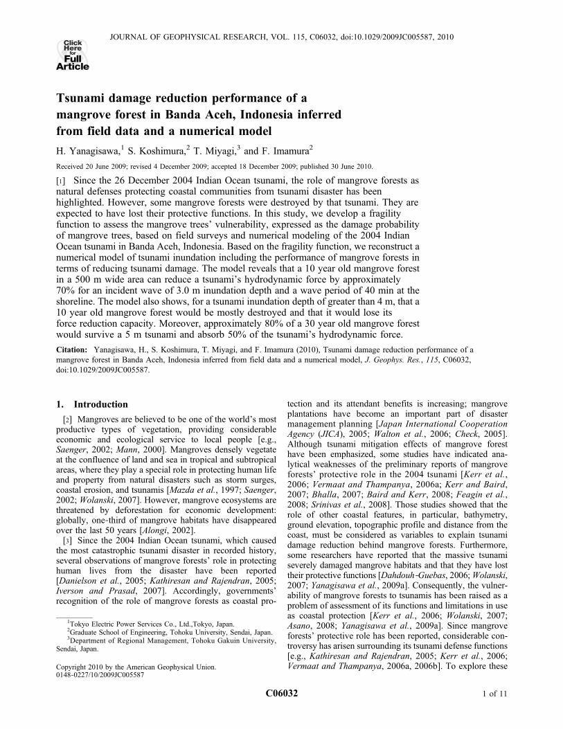
Figure 1. (a) The epicenter and rupture area of the 2004 Indian Ocean tsunami [Chlieh et al., 2007].(b) Map of study sites in Banda Aceh with measured tsunami height [Borrero, 2005; Tsuji et al., 2006].Satellite images of the coast of Banda Aceh (IKONOS) (c) before and (d) after the 2004 tsunami (18 June2004 and 29 December 2004, respectively). White dotted lines in Figures 1c and 1d mark the mangrovearea before the tsunami event.
YANAGISAWA ET AL.: TSUNAMI REDUCTION EFFECTS OF MANGROVES C06032C06032
2 of 11
Unfortunately, the massive tsunami on 26 December 2004caused serious damage not only to the delicate mangroveecosystems but also to the residential areas inland. Thetsunami inundated 4 km inland, causing human damageestimated at more than 70,000 in Banda Aceh [JICA, 2005].Tsunami heights above tide level when the tsunami attackedBanda Aceh around this area were estimated to have beenapproximately 3–12 m (Figure 1b) [Borrero, 2005; Tsuji etal., 2006].
3. Methodology to Investigate Mangrove Damageand Hydrodynamic Features of Tsunami
3.1. Field Survey
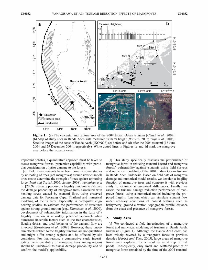
[7] Field surveys of the mangrove forest were conductedduring 12–16 Dec 2006. We selected five study sites of man-grove forests, which were mainly dominated by Rhizophora
sp. with dense prop root structures (Figure 2a). To investi-gate the specific dimensions of mangrove trees and thedamage by the 2004 tsunami, we measured the stem diam-eter at breast height (DBH; approximately 1.3 m above thetop of the roots), stem diameter at the top of roots, and theposition of each tree using a Global Positioning System(GPS) device for adult trees whose DBH was greater than5 cm. In this study, we defined surviving trees as those thatwithstood the tsunami and which did not suffer severedamage such as breakage or washing away. In all, 697 treeswere sampled throughout the mangrove forest; various stemdiameters and locations were selected.
3.2. Modeling of the 2004 Indian Ocean Tsunami
[8] Recent developments of numerical models of a tsu-nami enable us to determine detailed hydrodynamic featuresof tsunami flow [Koshimura and Yanagisawa, 2007].
Figure 2. (a) Sketch of a Rhizophora tree with dense prop root structures. The stem diameter is mea-sured at breast height (DBH; approximately 1.3 m above the top of roots). (b) Mangrove area interpretedfrom posttsunami satellite imagery (190 ha). Mangrove trees photographed at (c) study site 2, (d) studysite 4, and (e) study site 5 (Figure 1b). Figure 2c shows surviving trees with more than 20 cm DBH.Figure 2d shows surviving and destroyed trees; although two mangrove trees in Figure 2d exhibited asimilar condition (e.g. tree characteristics, location, and ground condition), one had survived and the otherhad been destroyed. Figure 2e shows the completely destroyed mangrove area.
YANAGISAWA ET AL.: TSUNAMI REDUCTION EFFECTS OF MANGROVES C06032C06032
3 of 11
Synolakis and Bernard [2006], for example, modeled the1993 Okushiri tsunami in Japan using Method of SplittingTsunami (MOST) code based on the nonlinear shallowwater wave equation. To examine the hydrodynamic fea-tures of tsunami inundation flow in mangrove forest, weperformed numerical modeling of the 2004 Indian Oceantsunami. We used a nested model to integrate two differenttsunami codes: for transoceanic propagation (linear shallowwater wave equation) and for nearshore propagation andcoastal inundation (nonlinear shallow water wave equation)[Goto et al., 1997]. The coastal inundation model includesthe bottom friction term in the form of Manning’s roughnessformula [Goto et al., 1997].
@�
@tþ @M
@xþ @N
@y¼ 0; ð1Þ
@M
@tþ @
@x
M2
D
� �þ @
@y
MN
D
� �þ gD
@�
@xþ gn2
D7=3M
ffiffiffiffiffiffiffiffiffiffiffiffiffiffiffiffiffiffiM 2 þ N 2
p¼ 0;
ð2Þ
@N
@tþ @
@y
N2
D
� �þ @
@x
NM
D
� �þ gD
@�
@yþ gn2
D7=3N
ffiffiffiffiffiffiffiffiffiffiffiffiffiffiffiffiffiffiM2 þ N2
p¼ 0:
ð3Þ
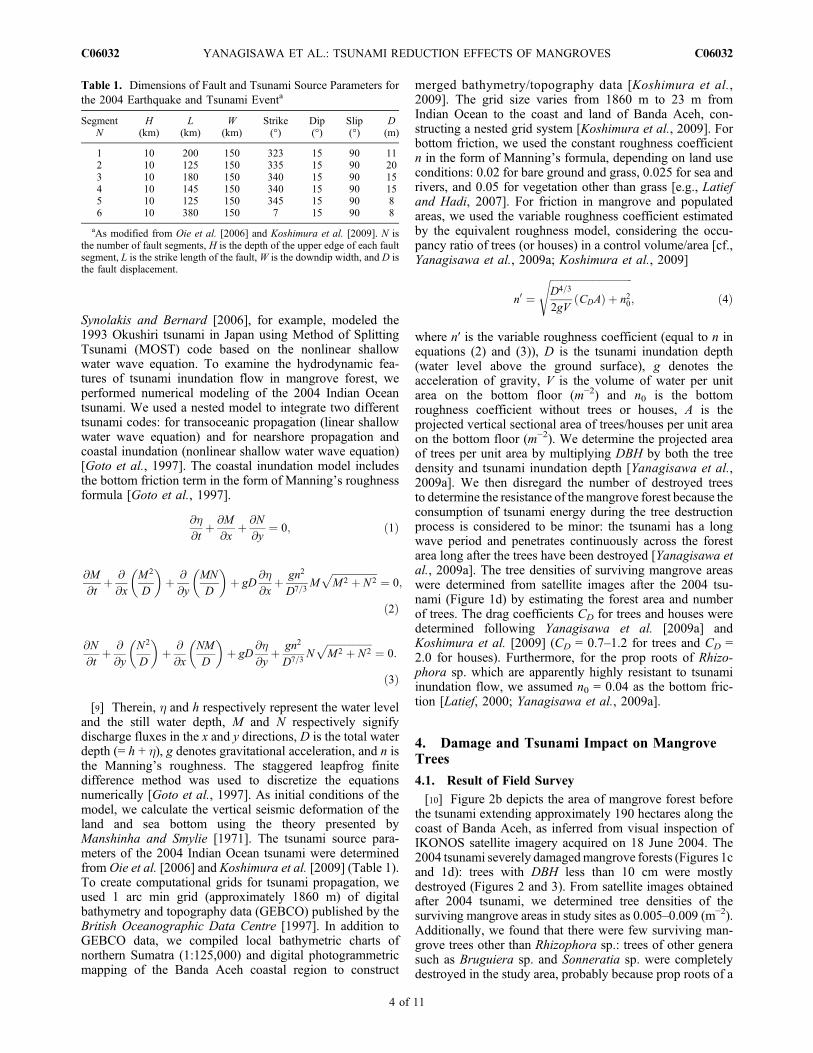
[9] Therein, h and h respectively represent the water leveland the still water depth, M and N respectively signifydischarge fluxes in the x and y directions, D is the total waterdepth (= h + h), g denotes gravitational acceleration, and n isthe Manning’s roughness. The staggered leapfrog finitedifference method was used to discretize the equationsnumerically [Goto et al., 1997]. As initial conditions of themodel, we calculate the vertical seismic deformation of theland and sea bottom using the theory presented byManshinha and Smylie [1971]. The tsunami source para-meters of the 2004 Indian Ocean tsunami were determinedfrom Oie et al. [2006] and Koshimura et al. [2009] (Table 1).To create computational grids for tsunami propagation, weused 1 arc min grid (approximately 1860 m) of digitalbathymetry and topography data (GEBCO) published by theBritish Oceanographic Data Centre [1997]. In addition toGEBCO data, we compiled local bathymetric charts ofnorthern Sumatra (1:125,000) and digital photogrammetricmapping of the Banda Aceh coastal region to construct
merged bathymetry/topography data [Koshimura et al.,2009]. The grid size varies from 1860 m to 23 m fromIndian Ocean to the coast and land of Banda Aceh, con-structing a nested grid system [Koshimura et al., 2009]. Forbottom friction, we used the constant roughness coefficientn in the form of Manning’s formula, depending on land useconditions: 0.02 for bare ground and grass, 0.025 for sea andrivers, and 0.05 for vegetation other than grass [e.g., Latiefand Hadi, 2007]. For friction in mangrove and populatedareas, we used the variable roughness coefficient estimatedby the equivalent roughness model, considering the occu-pancy ratio of trees (or houses) in a control volume/area [cf.,Yanagisawa et al., 2009a; Koshimura et al., 2009]
n0 ¼ffiffiffiffiffiffiffiffiffiffiffiffiffiffiffiffiffiffiffiffiffiffiffiffiffiffiffiffiffiffiffiffiffiD4=3
2gVCDAð Þ þ n20
s; ð4Þ
where n′ is the variable roughness coefficient (equal to n inequations (2) and (3)), D is the tsunami inundation depth(water level above the ground surface), g denotes theacceleration of gravity, V is the volume of water per unitarea on the bottom floor (m−2) and n0 is the bottomroughness coefficient without trees or houses, A is theprojected vertical sectional area of trees/houses per unit areaon the bottom floor (m−2). We determine the projected areaof trees per unit area by multiplying DBH by both the treedensity and tsunami inundation depth [Yanagisawa et al.,2009a]. We then disregard the number of destroyed treesto determine the resistance of themangrove forest because theconsumption of tsunami energy during the tree destructionprocess is considered to be minor: the tsunami has a longwave period and penetrates continuously across the forestarea long after the trees have been destroyed [Yanagisawa etal., 2009a]. The tree densities of surviving mangrove areaswere determined from satellite images after the 2004 tsu-nami (Figure 1d) by estimating the forest area and numberof trees. The drag coefficients CD for trees and houses weredetermined following Yanagisawa et al. [2009a] andKoshimura et al. [2009] (CD = 0.7–1.2 for trees and CD =2.0 for houses). Furthermore, for the prop roots of Rhizo-phora sp. which are apparently highly resistant to tsunamiinundation flow, we assumed n0 = 0.04 as the bottom fric-tion [Latief, 2000; Yanagisawa et al., 2009a].
4. Damage and Tsunami Impact on MangroveTrees
4.1. Result of Field Survey
[10] Figure 2b depicts the area of mangrove forest beforethe tsunami extending approximately 190 hectares along thecoast of Banda Aceh, as inferred from visual inspection ofIKONOS satellite imagery acquired on 18 June 2004. The2004 tsunami severely damagedmangrove forests (Figures 1cand 1d): trees with DBH less than 10 cm were mostlydestroyed (Figures 2 and 3). From satellite images obtainedafter 2004 tsunami, we determined tree densities of thesurviving mangrove areas in study sites as 0.005–0.009 (m−2).Additionally, we found that there were few surviving man-grove trees other than Rhizophora sp.: trees of other generasuch as Bruguiera sp. and Sonneratia sp. were completelydestroyed in the study area, probably because prop roots of a
Table 1. Dimensions of Fault and Tsunami Source Parameters forthe 2004 Earthquake and Tsunami Eventa
SegmentN
H(km)
L(km)
W(km)
Strike(°)
Dip(°)
Slip(°)
D(m)
1 10 200 150 323 15 90 112 10 125 150 335 15 90 203 10 180 150 340 15 90 154 10 145 150 340 15 90 155 10 125 150 345 15 90 86 10 380 150 7 15 90 8
aAs modified from Oie et al. [2006] and Koshimura et al. [2009]. N isthe number of fault segments, H is the depth of the upper edge of each faultsegment, L is the strike length of the fault,W is the downdip width, and D isthe fault displacement.
YANAGISAWA ET AL.: TSUNAMI REDUCTION EFFECTS OF MANGROVES C06032C06032
4 of 11
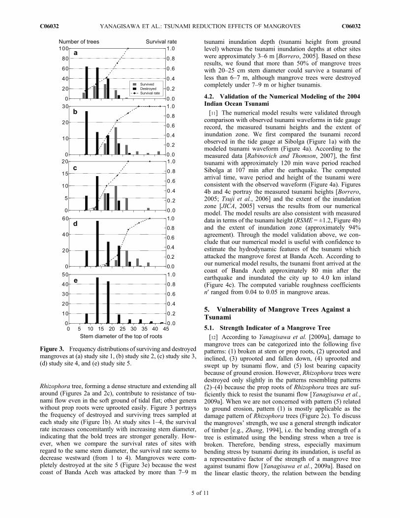
Rhizophora tree, forming a dense structure and extending allaround (Figures 2a and 2c), contribute to resistance of tsu-nami flow even in the soft ground of tidal flat; other generawithout prop roots were uprooted easily. Figure 3 portraysthe frequency of destroyed and surviving trees sampled ateach study site (Figure 1b). At study sites 1–4, the survivalrate increases concomitantly with increasing stem diameter,indicating that the bold trees are stronger generally. How-ever, when we compare the survival rates of sites withregard to the same stem diameter, the survival rate seems todecrease westward (from 1 to 4). Mangroves were com-pletely destroyed at the site 5 (Figure 3e) because the westcoast of Banda Aceh was attacked by more than 7–9 m
tsunami inundation depth (tsunami height from groundlevel) whereas the tsunami inundation depths at other siteswere approximately 3–6 m [Borrero, 2005]. Based on theseresults, we found that more than 50% of mangrove treeswith 20–25 cm stem diameter could survive a tsunami ofless than 6–7 m, although mangrove trees were destroyedcompletely under 7–9 m or higher tsunamis.
4.2. Validation of the Numerical Modeling of the 2004Indian Ocean Tsunami
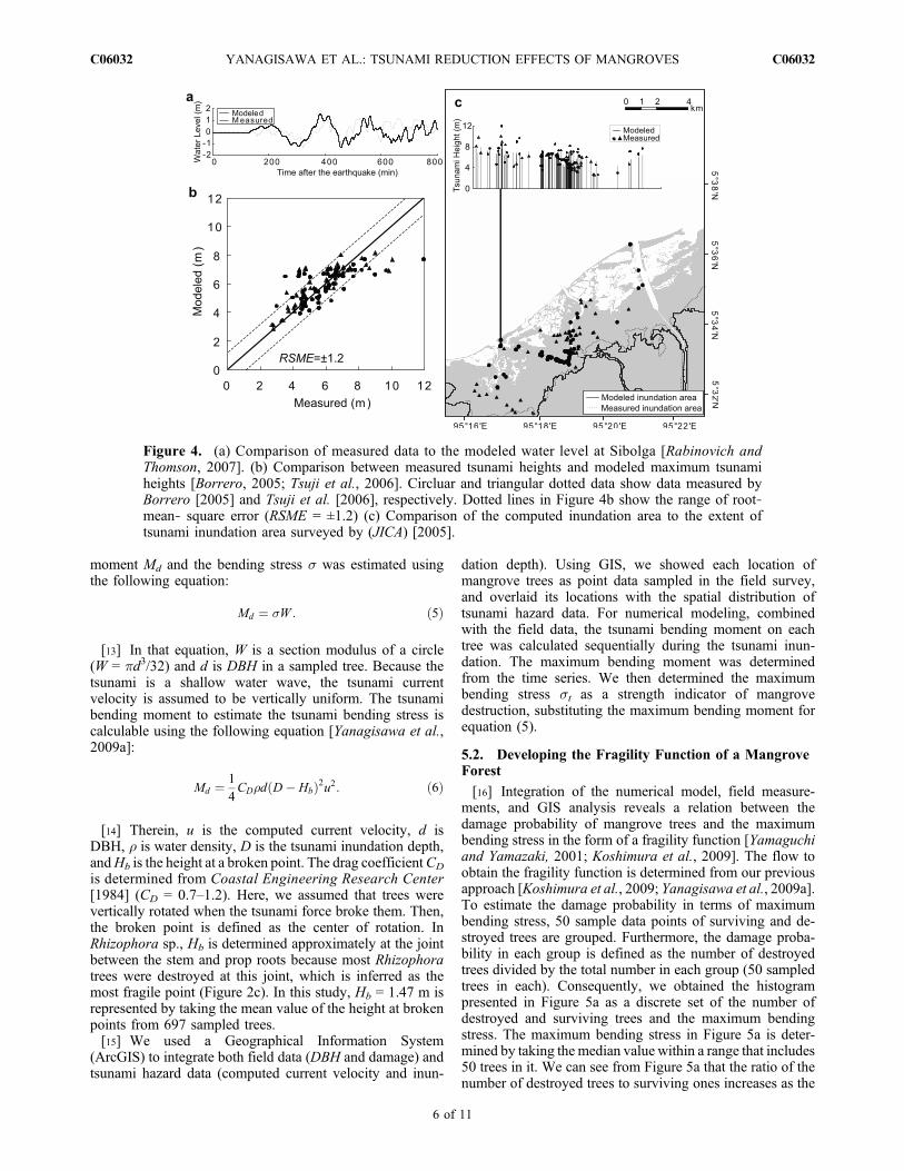
[11] The numerical model results were validated throughcomparison with observed tsunami waveforms in tide gaugerecord, the measured tsunami heights and the extent ofinundation zone. We first compared the tsunami recordobserved in the tide gauge at Sibolga (Figure 1a) with themodeled tsunami waveform (Figure 4a). According to themeasured data [Rabinovich and Thomson, 2007], the firsttsunami with approximately 120 min wave period reachedSibolga at 107 min after the earthquake. The computedarrival time, wave period and height of the tsunami wereconsistent with the observed waveform (Figure 4a). Figures4b and 4c portray the measured tsunami heights [Borrero,2005; Tsuji et al., 2006] and the extent of the inundationzone [JICA, 2005] versus the results from our numericalmodel. The model results are also consistent with measureddata in terms of the tsunami height (RSME = ±1.2, Figure 4b)and the extent of inundation zone (approximately 94%agreement). Through the model validation above, we con-clude that our numerical model is useful with confidence toestimate the hydrodynamic features of the tsunami whichattacked the mangrove forest at Banda Aceh. According toour numerical model results, the tsunami front arrived at thecoast of Banda Aceh approximately 80 min after theearthquake and inundated the city up to 4.0 km inland(Figure 4c). The computed variable roughness coefficientsn′ ranged from 0.04 to 0.05 in mangrove areas.
5. Vulnerability of Mangrove Trees Against aTsunami
5.1. Strength Indicator of a Mangrove Tree
[12] According to Yanagisawa et al. [2009a], damage tomangrove trees can be categorized into the following fivepatterns: (1) broken at stem or prop roots, (2) uprooted andinclined, (3) uprooted and fallen down, (4) uprooted andswept up by tsunami flow, and (5) lost bearing capacitybecause of ground erosion. However, Rhizophora trees weredestroyed only slightly in the patterns resembling patterns(2)–(4) because the prop roots of Rhizophora trees are suf-ficiently thick to resist the tsunami flow [Yanagisawa et al.,2009a]. When we are not concerned with pattern (5) relatedto ground erosion, pattern (1) is mostly applicable as thedamage pattern of Rhizophora trees (Figure 2c). To discussthe mangroves’ strength, we use a general strength indicatorof timber [e.g., Zhang, 1994], i.e. the bending strength of atree is estimated using the bending stress when a tree isbroken. Therefore, bending stress, especially maximumbending stress by tsunami during its inundation, is useful asa representative factor of the strength of a mangrove treeagainst tsunami flow [Yanagisawa et al., 2009a]. Based onthe linear elastic theory, the relation between the bending
Figure 3. Frequency distributions of surviving and destroyedmangroves at (a) study site 1, (b) study site 2, (c) study site 3,(d) study site 4, and (e) study site 5.
YANAGISAWA ET AL.: TSUNAMI REDUCTION EFFECTS OF MANGROVES C06032C06032
5 of 11
moment Md and the bending stress s was estimated usingthe following equation:
Md ¼ �W : ð5Þ
[13] In that equation, W is a section modulus of a circle(W = pd3/32) and d is DBH in a sampled tree. Because thetsunami is a shallow water wave, the tsunami currentvelocity is assumed to be vertically uniform. The tsunamibending moment to estimate the tsunami bending stress iscalculable using the following equation [Yanagisawa et al.,2009a]:
Md ¼ 1
4CD�d D� Hbð Þ2u2: ð6Þ
[14] Therein, u is the computed current velocity, d isDBH, r is water density, D is the tsunami inundation depth,andHb is the height at a broken point. The drag coefficientCD
is determined from Coastal Engineering Research Center[1984] (CD = 0.7–1.2). Here, we assumed that trees werevertically rotated when the tsunami force broke them. Then,the broken point is defined as the center of rotation. InRhizophora sp., Hb is determined approximately at the jointbetween the stem and prop roots because most Rhizophoratrees were destroyed at this joint, which is inferred as themost fragile point (Figure 2c). In this study, Hb = 1.47 m isrepresented by taking the mean value of the height at brokenpoints from 697 sampled trees.[15] We used a Geographical Information System
(ArcGIS) to integrate both field data (DBH and damage) andtsunami hazard data (computed current velocity and inun-
dation depth). Using GIS, we showed each location ofmangrove trees as point data sampled in the field survey,and overlaid its locations with the spatial distribution oftsunami hazard data. For numerical modeling, combinedwith the field data, the tsunami bending moment on eachtree was calculated sequentially during the tsunami inun-dation. The maximum bending moment was determinedfrom the time series. We then determined the maximumbending stress st as a strength indicator of mangrovedestruction, substituting the maximum bending moment forequation (5).
5.2. Developing the Fragility Function of a MangroveForest
[16] Integration of the numerical model, field measure-ments, and GIS analysis reveals a relation between thedamage probability of mangrove trees and the maximumbending stress in the form of a fragility function [Yamaguchiand Yamazaki, 2001; Koshimura et al., 2009]. The flow toobtain the fragility function is determined from our previousapproach [Koshimura et al., 2009; Yanagisawa et al., 2009a].To estimate the damage probability in terms of maximumbending stress, 50 sample data points of surviving and de-stroyed trees are grouped. Furthermore, the damage proba-bility in each group is defined as the number of destroyedtrees divided by the total number in each group (50 sampledtrees in each). Consequently, we obtained the histogrampresented in Figure 5a as a discrete set of the number ofdestroyed and surviving trees and the maximum bendingstress. The maximum bending stress in Figure 5a is deter-mined by taking the median value within a range that includes50 trees in it. We can see from Figure 5a that the ratio of thenumber of destroyed trees to surviving ones increases as the
Figure 4. (a) Comparison of measured data to the modeled water level at Sibolga [Rabinovich andThomson, 2007]. (b) Comparison between measured tsunami heights and modeled maximum tsunamiheights [Borrero, 2005; Tsuji et al., 2006]. Circluar and triangular dotted data show data measured byBorrero [2005] and Tsuji et al. [2006], respectively. Dotted lines in Figure 4b show the range of root‐mean‐ square error (RSME = ±1.2) (c) Comparison of the computed inundation area to the extent oftsunami inundation area surveyed by (JICA) [2005].
YANAGISAWA ET AL.: TSUNAMI REDUCTION EFFECTS OF MANGROVES C06032C06032
6 of 11
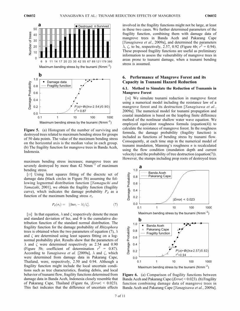
maximum bending stress increases; mangrove trees areseverely destroyed by more than 42 Nmm−2 of maximumbending stress.[17] Using least squares fitting of the discrete set of
damage data (black circles in Figure 5b) assuming the fol-lowing lognormal distribution function [Yamaguchi andYamazaki, 2001], we obtain the fragility function (fragilitycurve), which indicates the damage probability Pd as afunction of the maximum bending stress st
Pd �tð Þ ¼ � ln�t � �ð Þ=�½ �: ð7Þ
[18] In that equation, l and z respectively denote the meanand standard deviation of lnx, and F is the cumulative dis-tribution function of the standard normal distribution. Thefragility function for the damage probability of Rhizophoratrees is obtained when the two parameters of equation (7), land z are determined using least squares fitting on a log-normal probability plot. Results show that the parameters ofl and z were determined respectively as 2.54 and 0.90(Figure 5b; coefficient of determination r2 = 0.87).According to Yanagisawa et al. [2009a], l and z, whichwere determined from damage data in Pakarang Cape,Thailand, were, respectively, 2.50 and 0.94. Although afragility function might include the local uncertain condi-tions such as tree characteristics, floating debris, and localbehavior of tsunami flow, fragility functions determined fromdamage data in Banda Aceh, Indonesia closely resemble thatof Pakarang Cape, Thailand (Figure 6a, |Error| < 0.023).This fact indicates that the difference of uncertain effects
involved in the fragility functions might not be large, at leastin these two cases. We further determined parameters of thefragility function, combining them with damage data ofmangrove trees in Banda Aceh and Pakarang Cape[Yanagisawa et al., 2009a], and determined the parametersl, z, to be, respectively, 2.57, 0.92 (Figure 6b; r2 = 0.94).These proposed fragility functions are useful as preliminaryinformation to assess the vulnerability of mangrove trees inareas prone to tsunami damage, when a tsunami bendingstress is assumed.
6. Performance of Mangrove Forest and itsCapacity in Tsunami Hazard Reduction
6.1. Method to Simulate the Reduction of Tsunamis inMangrove Forest
[19] We simulate tsunami reduction in mangrove forestusing a numerical model including the resistance law of amangrove forest and its destruction [Yanagisawa et al.,2009a]. The numerical model for tsunami propagation andcoastal inundation is based on the leapfrog finite differencemethod of the nonlinear shallow water wave equation. Weemployed equivalent roughness formula (equation(4)) tocalculate the resistance of mangrove forest. In the roughnessformula, the damage probability (fragility function) isincluded as functions of bending stress by tsunami flow.Consequently, at each time step in the numerical model oftsunami inundation, Manning’s roughness n is recalculatedusing the flow condition (inundation depth and currentvelocity) and the probability of tree destruction (equation(7)).However, the stumps including prop roots of destroyed trees
Figure 5. (a) Histogram of the number of surviving anddestroyed trees related to maximum bending stress for groupsof 50 data points. The value of the maximum bending stresson the horizontal axis is the median value in each group.(b) The fragility function for mangrove trees in Banda Aceh,Indonesia.
Figure 6. (a) Comparison of fragility functions betweenBanda Aceh and Pakarang Cape (|Error| < 0.023). (b) Fragilityfunction combining damage data of mangrove trees inBanda Aceh and Pakarang Cape [Yanagisawa et al., 2009a].
YANAGISAWA ET AL.: TSUNAMI REDUCTION EFFECTS OF MANGROVES C06032C06032
7 of 11
remained after the tsunami in the study areas (Figure 2c). Wetherefore assumed that the friction of prop roots (n = 0.04)has remained even if mangrove trees had been broken by thetsunami flow. This numerical model can simulate tsunamireduction effects of mangrove forest and their limitationsunder arbitrary conditions of coastal features such asbathymetry, ground elevation, topographic profile, and dis-tance from the coast.[20] The tsunami reduction effect of mangrove forest is
estimated using the numerical model results of two modelscenarios, i.e. with or without the mangrove forest, in termsof the following reduction index:
Rd ¼ a0 � a
a0: ð8Þ
In the above equation, a is the value of tsunami inundationdepth D or hydrodynamic force with the mangrove forestconsidering its destruction, and a′ is the value of tsunamiinundation depth or hydrodynamic force without the man-
grove forest. Here, we define the simplified form ofhydrodynamic force [e.g., Hatori, 1964] as an indicator
F ¼ u2D: ð9Þ
[21] The constant parts are deducted from drag force F
F ¼ 1=2�CDu2A: ð10Þ
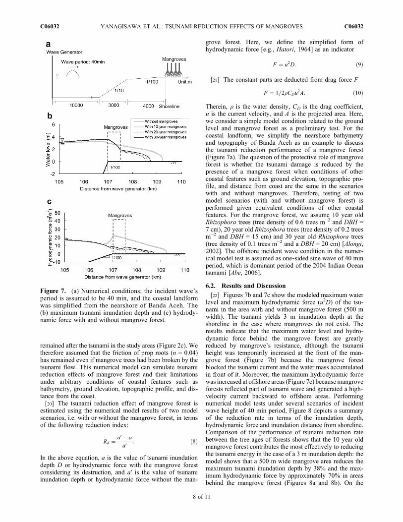
Therein, r is the water density, CD is the drag coefficient,u is the current velocity, and A is the projected area. Here,we consider a simple model condition related to the groundlevel and mangrove forest as a preliminary test. For thecoastal landform, we simplify the nearshore bathymetryand topography of Banda Aceh as an example to discussthe tsunami reduction performance of a mangrove forest(Figure 7a). The question of the protective role of mangroveforest is whether the tsunami damage is reduced by thepresence of a mangrove forest when conditions of othercoastal features such as ground elevation, topographic pro-file, and distance from coast are the same in the scenarioswith and without mangroves. Therefore, testing of twomodel scenarios (with and without mangrove forest) isperformed given equivalent conditions of other coastalfeatures. For the mangrove forest, we assume 10 year oldRhizophora trees (tree density of 0.6 trees m−2 and DBH =7 cm), 20 year old Rhizophora trees (tree density of 0.2 treesm−2 and DBH = 15 cm) and 30 year old Rhizophora trees(tree density of 0.1 trees m−2 and a DBH = 20 cm) [Alongi,2002]. The offshore incident wave condition in the numer-ical model test is assumed as one‐sided sine wave of 40 minperiod, which is dominant period of the 2004 Indian Oceantsunami [Abe, 2006].
6.2. Results and Discussion
[22] Figures 7b and 7c show the modeled maximum waterlevel and maximum hydrodynamic force (u2D) of the tsu-nami in the area with and without mangrove forest (500 mwidth). The tsunami yields 3 m inundation depth at theshoreline in the case where mangroves do not exist. Theresults indicate that the maximum water level and hydro-dynamic force behind the mangrove forest are greatlyreduced by mangrove’s resistance, although the tsunamiheight was temporarily increased at the front of the man-grove forest (Figure 7b) because the mangrove forestblocked the tsunami current and the water mass accumulatedin front of it. Moreover, the maximum hydrodynamic forcewas increased at offshore areas (Figure 7c) becausemangroveforests reflected part of tsunami wave and generated a high‐velocity current backward to offshore areas. Performingnumerical model tests under several scenarios of incidentwave height of 40 min period, Figure 8 depicts a summaryof the reduction rate in terms of the inundation depth,hydrodynamic force and inundation distance from shoreline.Comparison of the performance of tsunami reduction ratebetween the tree ages of forests shows that the 10 year oldmangrove forest contributes the most effectively to reducingthe tsunami energy in the case of a 3 m inundation depth: themodel shows that a 500 m wide mangrove area reduces themaximum tsunami inundation depth by 38% and the max-imum hydrodynamic force by approximately 70% in areasbehind the mangrove forest (Figures 8a and 8b). On the
Figure 7. (a) Numerical conditions; the incident wave’speriod is assumed to be 40 min, and the coastal landformwas simplified from the nearshore of Banda Aceh. The(b) maximum tsunami inundation depth and (c) hydrody-namic force with and without mangrove forest.
YANAGISAWA ET AL.: TSUNAMI REDUCTION EFFECTS OF MANGROVES C06032C06032
8 of 11
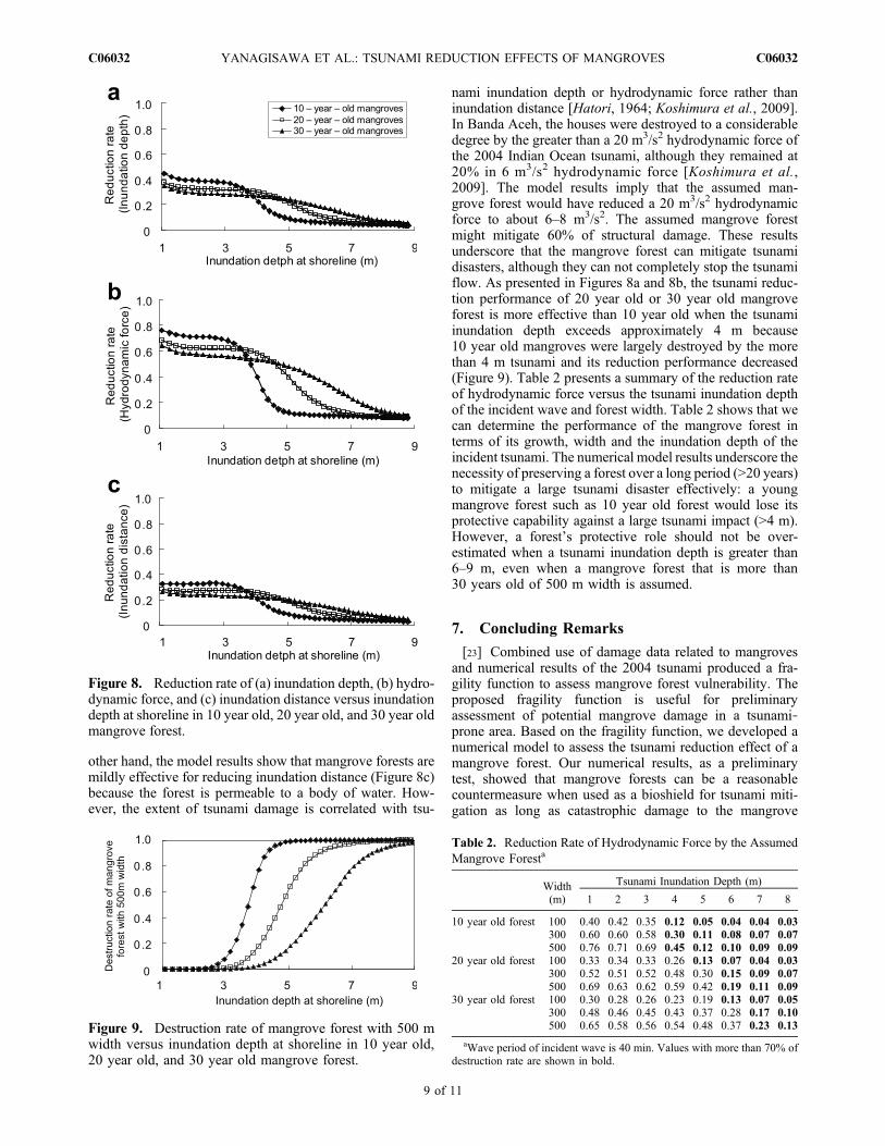
other hand, the model results show that mangrove forests aremildly effective for reducing inundation distance (Figure 8c)because the forest is permeable to a body of water. How-ever, the extent of tsunami damage is correlated with tsu-
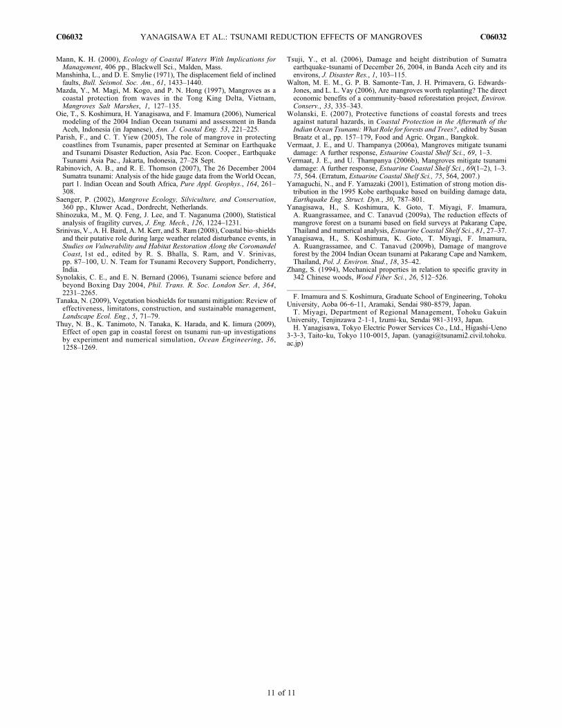
nami inundation depth or hydrodynamic force rather thaninundation distance [Hatori, 1964; Koshimura et al., 2009].In Banda Aceh, the houses were destroyed to a considerabledegree by the greater than a 20 m3/s2 hydrodynamic force ofthe 2004 Indian Ocean tsunami, although they remained at20% in 6 m3/s2 hydrodynamic force [Koshimura et al.,2009]. The model results imply that the assumed man-grove forest would have reduced a 20 m3/s2 hydrodynamicforce to about 6–8 m3/s2. The assumed mangrove forestmight mitigate 60% of structural damage. These resultsunderscore that the mangrove forest can mitigate tsunamidisasters, although they can not completely stop the tsunamiflow. As presented in Figures 8a and 8b, the tsunami reduc-tion performance of 20 year old or 30 year old mangroveforest is more effective than 10 year old when the tsunamiinundation depth exceeds approximately 4 m because10 year old mangroves were largely destroyed by the morethan 4 m tsunami and its reduction performance decreased(Figure 9). Table 2 presents a summary of the reduction rateof hydrodynamic force versus the tsunami inundation depthof the incident wave and forest width. Table 2 shows that wecan determine the performance of the mangrove forest interms of its growth, width and the inundation depth of theincident tsunami. The numerical model results underscore thenecessity of preserving a forest over a long period (>20 years)to mitigate a large tsunami disaster effectively: a youngmangrove forest such as 10 year old forest would lose itsprotective capability against a large tsunami impact (>4 m).However, a forest’s protective role should not be over-estimated when a tsunami inundation depth is greater than6–9 m, even when a mangrove forest that is more than30 years old of 500 m width is assumed.
7. Concluding Remarks
[23] Combined use of damage data related to mangrovesand numerical results of the 2004 tsunami produced a fra-gility function to assess mangrove forest vulnerability. Theproposed fragility function is useful for preliminaryassessment of potential mangrove damage in a tsunami‐prone area. Based on the fragility function, we developed anumerical model to assess the tsunami reduction effect of amangrove forest. Our numerical results, as a preliminarytest, showed that mangrove forests can be a reasonablecountermeasure when used as a bioshield for tsunami miti-gation as long as catastrophic damage to the mangrove
Figure 9. Destruction rate of mangrove forest with 500 mwidth versus inundation depth at shoreline in 10 year old,20 year old, and 30 year old mangrove forest.
Table 2. Reduction Rate of Hydrodynamic Force by the AssumedMangrove Foresta
Width(m)
Tsunami Inundation Depth (m)
1 2 3 4 5 6 7 8
10 year old forest 100 0.40 0.42 0.35 0.12 0.05 0.04 0.04 0.03300 0.60 0.60 0.58 0.30 0.11 0.08 0.07 0.07500 0.76 0.71 0.69 0.45 0.12 0.10 0.09 0.09
20 year old forest 100 0.33 0.34 0.33 0.26 0.13 0.07 0.04 0.03300 0.52 0.51 0.52 0.48 0.30 0.15 0.09 0.07500 0.69 0.63 0.62 0.59 0.42 0.19 0.11 0.09
30 year old forest 100 0.30 0.28 0.26 0.23 0.19 0.13 0.07 0.05300 0.48 0.46 0.45 0.43 0.37 0.28 0.17 0.10500 0.65 0.58 0.56 0.54 0.48 0.37 0.23 0.13
aWave period of incident wave is 40 min. Values with more than 70% ofdestruction rate are shown in bold.
Figure 8. Reduction rate of (a) inundation depth, (b) hydro-dynamic force, and (c) inundation distance versus inundationdepth at shoreline in 10 year old, 20 year old, and 30 year oldmangrove forest.
YANAGISAWA ET AL.: TSUNAMI REDUCTION EFFECTS OF MANGROVES C06032C06032
9 of 11

forest does not occur beyond its threshold level. Conse-quently, reforesting or preserving mangrove forests indeforested areas such as Banda Aceh might mitigate futuretsunami disasters. However, it is important to note thatmangrove barriers can not completely halt tsunami flow. Forthat reason, it is necessary to integrate several counter-measures such as warning systems, education for disasterprevention, and mangrove forests to prevent a widespreadtsunami disaster.[24] The protective role of coastal trees as a tsunami
defense has been discussed for more than 100 years [e.g.,Tanaka, 2009], with detailed preliminary reports appearingafter the 2004 tsunami [e.g., Danielson et al., 2005;Kathiresan and Rajendran, 2005; Iverson and Prasad, 2007].However, the effectiveness of coastal trees observed in thefield survey might be affected by the role of other coastalfeatures such as bathymetry, ground elevation, and distancefrom the coast [e.g., Kerr et al., 2006]. There is littleempirical support for the protective role of coastal treesbased on field observations. Therefore, our proposednumerical model can play a role in exploring the consider-able controversy surrounding the protective capacity ofcoastal trees, in particular, mangrove forests. Additionalstudies are necessary to verify mangrove forests’ protectiverole, as reported in a preliminary report, using a quantitativeapproach such as our proposed model. However, our studyrequires the following improvements.[25] First, this study was performed in local areas, which
might mean that the proposed fragility functions are notuniversal measures to assess the vulnerability of mangroveforests, although the fragility functions between BandaAceh, Indonesia and Pakarang Cape, Thailand are almostidentical. As described above, the fragility function shouldinclude numerous uncertain effects, which might be influ-enced by interregional conditions such as tree character-istics, local tsunami behavior, and floating materials.Therefore, future studies must be undertaken to support awider investigation of the vulnerability of mangrove forestsand to examine differences between fragility functions invarious cases.[26] Second, the capacity of mangroves as a tsunami
defense could differ depending on local conditions such asthe wave period, bathymetry and mangrove forest condi-tions, although this study examined the reduction effect ofmangrove forest under simple conditions. In particular, thetsunami wave period might influence the capacity of man-groves as a tsunami defense because the tsunami with a longwave period tends to penetrate mangrove forests [Haradaand Kawata, 2004]. Moreover, tsunami flows at a gapbetween two mangrove forests become faster as the gapbecomes smaller [Thuy et al., 2009]. Especially, mangrovetrees are prone to be damaged at gaps such as small channels[Yanagisawa et al., 2009b], possibly because of highertsunami current velocity in the gap. Therefore, additionalstudies must be undertaken to examine the reduction effectof mangrove forests under various conditions in the modelto conduct detailed estimation of the capacity of mangroveforest for tsunami defense.
[27] Acknowledgments. The authors gratefully acknowledge M. Affan,J. Takashima, and H. Sato for the support they provided during our field
survey and K. Goto and H. Nakamura for providing usuful comments. Thisstudy was financially supported by a Grants‐in‐Aid for Scientific Researchfrom the Japan Society for the Promotion of Science (18201033 and19681019) and Industrial Technology Research Grant Program in 2008(08E52010a) from the New Energy and Industrial Technology DevelopmentOrganization (NEDO) and International Society for Mangrove Ecosystems(ISME).
ReferencesAbe, K. (2006), Dominat periods of the 2004 Sumatra tsunami and theestimated source size, Earth Planets Space, 58, 217–221.
Alongi, D. M. (2002), Present state and future of the world’s mangroveforests, Environ. Conserv., 29, 331–349.
Asano, T. (2008), Time varying tsunami attenuation ability of coastal forestsbased on forest growth models, Coastal Eng., 50, 325–348.
Baird, A. H., andA.M.Kerr (2008), Landscape analysis and tsunami damagein Aceh: Comment on Iverson and Prasad (2007), Landscape Ecol., 23,3–5.
Bhalla, R. S. (2007), Do bio‐shields affect tsunami inundation?, Curr. Sci.,93, 831–833.
Borrero, J. (2005), Field survey of northern Sumatra and Banda Aceh,Indonesia after the tsunami and earthquake of 26 December 2004, Seismol.Res. Lett., 76, 309–318.
British Oceanographic Data Centre (1997), The Centenary Edition of theGEBCO Digital Atlas [CD‐ROM], Liverpool, U. K.
Check, E. (2005), Natural disasters: Roots of recovery, Nature, 438, 910–911.
Chlieh, M., et al. (2007), Coseismic slip and afterslip of the great Mw 9.15Sumatra‐Andaman earthquake of 2004, Bull. Seismol. Soc. Am., 97, 152–173, doi: 10.1785/0120050631.
Coastal Engineering Research Center (Eds.) (1984), Structural design:Physical factores, in Shore Protection Manual, vol. 2, chapt. 7, pp. 100–242, Dep. of the Army, Washington, D. C.
Dahdouh‐Guebas, F. (2006), Mangrove forests and tsunami protection, inMcGraw‐Hill 2006 Yearbook of Science and Technology, edited byMcGraw‐Hill editors, pp. 187–191, McGraw‐Hill, New York.
Danielson, F., et al. (2005), The Asian tsunami: A protective role forcoastal vegetation, Science, 310, 643.
Feagin, A. R., et al. (2008), Vegetation’s role in coastal protection, Science,320, 176–177.
Goto, C., Y. Ogawa, N. Shuto, and F. Imamura (1997), Numerical method oftsunami simulation with the leap‐frog scheme, IUGG/IOC Time ProjectManuals Guides 35, 35 pp., U. N. Educ. Sci. and Cult. Organ., Paris.
Harada, K., and Y. Kawata (2004), Study on the effect of coastal forest totsunami reduction, Ann. Disaster Prev. Inst. Kyoto Univ., 48C, 161–166.
Hatori, T. (1964), A study of the damage to houses due to a tsunami, Bull.Earthquake Res. Inst., 42, 181–191.
Imai, K., and A. Suzuki (2005), A method based on the pipe model for esti-mating the surface area and volume of coastal forest trees, and their lodg-ing resistance (in Japanese with English abstract), Ann. J. Hydraul. Eng.,49, 859–864.
Iverson, L. R., and A. M. Prasad (2007), Using landscape analysis to assessand model tsunami damage in Aceh province, Sumatra, Landscape Ecol.,22, 323–331.
Japan International Cooperation Agency (JICA) (2005), The study of theurgent rehabilitation and reconstruction support program for Aceh prov-ince and affected areas in north Sumatra, final report.
Kathiresan, K., and N. Rajendran (2005), Coastal mangrove forests miti-gated tsunami, Estuarine Coastal Shelf Sci., 65, 601–606.
Kerr, A. M., and A. H. Baird (2007), Natural barriers to natural disasters,Bioscience, 57, 102–103.
Kerr, A. M., A. H. Baird, and S. J. Campbell (2006), Comments on“Coastal mangrove forests mitigated tsunami” by K. Kathiresan andN. Rajendran, Estuarine Coastal Shelf Sci., 67, 539–541.
Koshimura, S., and H. Yanagisawa (2007), Developing fragility functionsfor tsunami damage estimation using the numerical model and satelliteimagery, paper presented at 5th International Workshop on RemoteSensing for Post Disaster Response, Multidiscip. Cent. for EarthquakeEng. Res., Washington, D. C., 10–12 Sept.
Koshimura, S., T. Oie, H. Yanagisawa, and F. Imamura (2009), Developingfragility functions for tsunami damage estimation using numerical modeland post‐tsunami data from Banda Aceh, Indonesia, Coastal Eng., 51,243–273.
Latief, H. (2000), Study of tsunamis and their mitigation using a green beltin Indonesia, Ph.D. thesis, 110 pp., Tohoku Univ., Sendai, Japan.
Latief, H., and S. Hadi (2007), The role of forests and trees in protectingcoastal areas against tsunamis, in Coastal Protection in the Aftermathof the Indian Ocean Tsunami: What Role for forests and Trees?, editedby Susan Braatz et al., pp. 5–35, Food and Agric. Organ., Bangkok.
YANAGISAWA ET AL.: TSUNAMI REDUCTION EFFECTS OF MANGROVES C06032C06032
10 of 11
Mann, K. H. (2000), Ecology of Coastal Waters With Implications forManagement, 406 pp., Blackwell Sci., Malden, Mass.
Manshinha, L., and D. E. Smylie (1971), The displacement field of inclinedfaults, Bull. Seismol. Soc. Am., 61, 1433–1440.
Mazda, Y., M. Magi, M. Kogo, and P. N. Hong (1997), Mangroves as acoastal protection from waves in the Tong King Delta, Vietnam,Mangroves Salt Marshes, 1, 127–135.
Oie, T., S. Koshimura, H. Yanagisawa, and F. Imamura (2006), Numericalmodeling of the 2004 Indian Ocean tsunami and assessment in BandaAceh, Indonesia (in Japanese), Ann. J. Coastal Eng. 53, 221–225.
Parish, F., and C. T. Yiew (2005), The role of mangrove in protectingcoastlines from Tsunamis, paper presented at Seminar on Earthquakeand Tsunami Disaster Reduction, Asia Pac. Econ. Cooper., EarthquakeTsunami Asia Pac., Jakarta, Indonesia, 27–28 Sept.
Rabinovich, A. B., and R. E. Thomson (2007), The 26 December 2004Sumatra tsunami: Analysis of the hide gauge data from the World Ocean,part 1. Indian Ocean and South Africa, Pure Appl. Geophys., 164, 261–308.
Saenger, P. (2002), Mangrove Ecology, Silviculture, and Conservation,360 pp., Kluwer Acad., Dordrecht, Netherlands.
Shinozuka, M., M. Q. Feng, J. Lee, and T. Naganuma (2000), Statisticalanalysis of fragility curves, J. Eng. Mech., 126, 1224–1231.
Srinivas, V., A. H. Baird, A.M. Kerr, and S. Ram (2008), Coastal bio‐shieldsand their putative role during large weather related disturbance events, inStudies on Vulnerability and Habitat Restoration Along the CoromandelCoast, 1st ed., edited by R. S. Bhalla, S. Ram, and V. Srinivas,pp. 87–100, U. N. Team for Tsunami Recovery Support, Pondicherry,India.
Synolakis, C. E., and E. N. Bernard (2006), Tsunami science before andbeyond Boxing Day 2004, Phil. Trans. R. Soc. London Ser. A, 364,2231–2265.
Tanaka, N. (2009), Vegetation bioshields for tsunami mitigation: Review ofeffectiveness, limitatons, construction, and sustainable management,Landscape Ecol. Eng., 5, 71–79.
Thuy, N. B., K. Tanimoto, N. Tanaka, K. Harada, and K. Iimura (2009),Effect of open gap in coastal forest on tsunami run‐up investigationsby experiment and numerical simulation, Ocean Engineering, 36,1258–1269.
Tsuji, Y., et al. (2006), Damage and height distribution of Sumatraearthquake‐tsunami of December 26, 2004, in Banda Aceh city and itsenvirons, J. Disaster Res., 1, 103–115.
Walton, M. E. M., G. P. B. Samonte‐Tan, J. H. Primavera, G. Edwards‐Jones, and L. L. Vay (2006), Are mangroves worth replanting? The directeconomic benefits of a community‐based reforestation project, Environ.Conserv., 33, 335–343.
Wolanski, E. (2007), Protective functions of coastal forests and treesagainst natural hazards, in Coastal Protection in the Aftermath of theIndian Ocean Tsunami: What Role for forests and Trees?, edited by SusanBraatz et al., pp. 157–179, Food and Agric. Organ., Bangkok.
Vermaat, J. E., and U. Thampanya (2006a), Mangroves mitigate tsunamidamage: A further response, Estuarine Coastal Shelf Sci., 69, 1–3.
Vermaat, J. E., and U. Thampanya (2006b), Mangroves mitigate tsunamidamage: A further response, Estuarine Coastal Shelf Sci., 69(1–2), 1–3.75, 564. (Erratum, Estuarine Coastal Shelf Sci., 75, 564, 2007.)
Yamaguchi, N., and F. Yamazaki (2001), Estimation of strong motion dis-tribution in the 1995 Kobe earthquake based on building damage data,Earthquake Eng. Struct. Dyn., 30, 787–801.
Yanagisawa, H., S. Koshimura, K. Goto, T. Miyagi, F. Imamura,A. Ruangrassamee, and C. Tanavud (2009a), The reduction effects ofmangrove forest on a tsunami based on field surveys at Pakarang Cape,Thailand and numerical analysis, Estuarine Coastal Shelf Sci., 81, 27–37.
Yanagisawa, H., S. Koshimura, K. Goto, T. Miyagi, F. Imamura,A. Ruangrassamee, and C. Tanavud (2009b), Damage of mangroveforest by the 2004 Indian Ocean tsunami at Pakarang Cape and Namkem,Thailand, Pol. J. Environ. Stud., 18, 35–42.
Zhang, S. (1994), Mechanical properties in relation to specific gravity in342 Chinese woods, Wood Fiber Sci., 26, 512–526.
F. Imamura and S. Koshimura, Graduate School of Engineering, TohokuUniversity, Aoba 06‐6‐11, Aramaki, Sendai 980‐8579, Japan.T. Miyagi, Department of Regional Management, Tohoku Gakuin
University, Tenjinzawa 2‐1‐1, Izumi‐ku, Sendai 981‐3193, Japan.H. Yanagisawa, Tokyo Electric Power Services Co., Ltd., Higashi‐Ueno
3‐3‐3, Taito‐ku, Tokyo 110‐0015, Japan. ([email protected])
YANAGISAWA ET AL.: TSUNAMI REDUCTION EFFECTS OF MANGROVES C06032C06032
11 of 11