true-azimuth surface multiple elimination library/tame...true azimuth surface multiple elimination...
TRANSCRIPT
True azimuth surface multiple elimination
Jun Cai, Manhong Guo, Shuqian Dong, Roy Camp, Greg Abarr, and Bin Wang, TGS Summary A data driven 3D true azimuth surface related multiple elimination (SRME) technique can be quite effective in removing surface related multiples for both narrow azimuth (NAZ) surveys as well as wide azimuth (WAZ) surveys. To achieve the true azimuth multiple prediction, azimuth information should be preserved in both data preparation/interpolation, as well as during the multiple prediction. Examples show true azimuth 3D SRME effectively attenuate the surface multiples including the diffracted multiples generated from rugose water bottom. Combining WAZ with NAZ surveys could further improve the SRME multiple prediction quality. It also improves the final RTM images. Introduction 3D surface related multiple elimination (SRME) (Verschuur et al, 1992) has become as a common technique for removing surface related multiples. In order to further improve the prediction model quality, azimuth preserving becomes an important aspect. This is particularly true for WAZ surveys; because within each super-shot, the azimuth variation is much larger than NAZ surveys. Azimuth variation is especially large for the near receivers of each cable. Many publications have addressed the azimuth issues for 3D SRME (Aaron et al., 2008, Dragoset et al., 2008) To produce the true azimuth multiple eliminate (TAME), the azimuth preservation should be kept in mind starting from the data input reconditioning/interpolation stage (Cai et al., 2009) and carried on during the multiple prediction. Methodology In practice, 3D SRME predicts the multiples by convolving input data traces within a user defined aperture
∑ ⊗•=aperture
DDFM
where D is the input data, is the filter to correct the phase and amplitude distortion caused by sparse spatial sampling and the directivity of the source signature of the input data. To gain the efficiency, normally the convolution is performed in the frequency domain for a user defined frequency range.
F
For TAME, to preserve the azimuth information for each of the receivers, we define the aperture along the azimuth
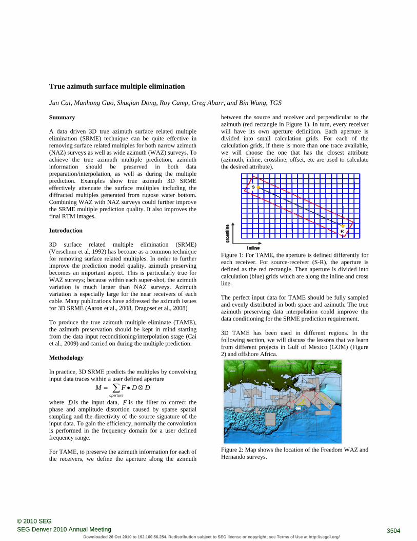
between the source and receiver and perpendicular to the azimuth (red rectangle in Figure 1). In turn, every receiver will have its own aperture definition. Each aperture is divided into small calculation grids. For each of the calculation grids, if there is more than one trace available, we will choose the one that has the closest attribute (azimuth, inline, crossline, offset, etc are used to calculate the desired attribute).
Figure 1: For TAME, the aperture is defined differently for each receiver. For source-receiver (S-R), the aperture is defined as the red rectangle. Then aperture is divided into calculation (blue) grids which are along the inline and cross line. The perfect input data for TAME should be fully sampled and evenly distributed in both space and azimuth. The true azimuth preserving data interpolation could improve the data conditioning for the SRME prediction requirement. 3D TAME has been used in different regions. In the following section, we will discuss the lessons that we learn from different projects in Gulf of Mexico (GOM) (Figure 2) and offshore Africa.
Figure 2: Map shows the location of the Freedom WAZ and Hernando surveys.
3504SEG Denver 2010 Annual Meeting© 2010 SEG
Downloaded 26 Oct 2010 to 192.160.56.254. Redistribution subject to SEG license or copyright; see Terms of Use at http://segdl.org/
True azimuth surface multiple elimination
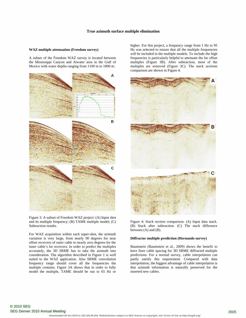
WAZ multiple attenuation (Freedom survey)
exico with water depths ranging from 1100 m to 1800 m.
A subset of the Freedom WAZ survey is located between the Mississippi Canyon and Atwater area in the Gulf of M
Figure 3: A subset of Freedom WAZ project: (A) Input shot and its multiple frequency; (B) TAME multiple model; (C)
ubtraction results.
). The stack sections mparison are shown in Figure 4.
S For WAZ acquisition within each super-shot, the azimuth variation is very large, from nearly 90 degrees for near offset receivers of outer cable to nearly zero degrees for the inner cable’s far receivers. In order to predict the multiples accurately, the 3D SRME has to take the azimuth into consideration. The algorithm described in Figure 1 is well suited to the WAZ application. Also SRME convolution frequency range should cover all the frequencies the multiple contains. Figure 3A shows that in order to fully model the multiple, TAME should be run to 65 Hz or
higher. For this project, a frequency range from 1 Hz to 95 Hz was selected to ensure that all the multiple frequencies will be included in the multiple models. To include the high frequencies is particularly helpful to attenuate the far offset multiples (Figure 3B). After subtraction, most of the multiples are removed (Figure 3Cco
Figure 4: Stack section comparison. (A) Input data stack. (B) Stack after subtraction. (C) The stack difference etween (A) and (B).
iffractor multiple prediction (Hernando survey)
ation is naturally preserved for the serted new cables.
b D Baumstein (Baumstein et al., 2009) shows the benefit to have finer cable spacing for 3D SRME diffracted multiple predictions. For a normal survey, cable interpolation can partly satisfy this requirement. Compared with data interpolation, the biggest advantage of cable interpolation is that azimuth informin
3505SEG Denver 2010 Annual Meeting© 2010 SEG
Downloaded 26 Oct 2010 to 192.160.56.254. Redistribution subject to SEG license or copyright; see Terms of Use at http://segdl.org/
True azimuth surface multiple elimination
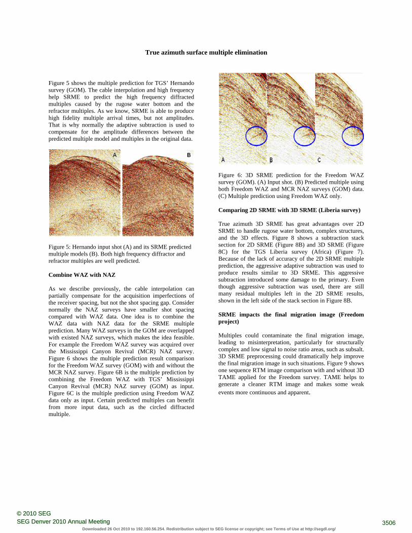
Figure 5 shows the multiple prediction for TGS’ Hernando survey (GOM). The cable interpolation and high frequency help SRME to predict the high frequency diffracted multiples caused by the rugose water bottom and the refractor multiples. As we know, SRME is able to produce high fidelity multiple arrival times, but not amplitudes. That is why normally the adaptive subtraction is used to compensate for the amplitude differences between the predicted multiple model and multiples in the original data.
Figure 5: Hernando input shot (A) and its SRME predictemultiple models (B). Both high frequen
d cy diffractor and
fractor multiples are well predicted.
ombine WAZ with NAZ
e input data, such as the circled diffracted ultiple.
re C As we describe previously, the cable interpolation can partially compensate for the acquisition imperfections of the receiver spacing, but not the shot spacing gap. Consider normally the NAZ surveys have smaller shot spacing compared with WAZ data. One idea is to combine the WAZ data with NAZ data for the SRME multiple prediction. Many WAZ surveys in the GOM are overlapped with existed NAZ surveys, which makes the idea feasible. For example the Freedom WAZ survey was acquired over the Mississippi Canyon Revival (MCR) NAZ survey. Figure 6 shows the multiple prediction result comparison for the Freedom WAZ survey (GOM) with and without the MCR NAZ survey. Figure 6B is the multiple prediction by combining the Freedom WAZ with TGS’ Mississippi Canyon Revival (MCR) NAZ survey (GOM) as input. Figure 6C is the multiple prediction using Freedom WAZ data only as input. Certain predicted multiples can benefit from morm
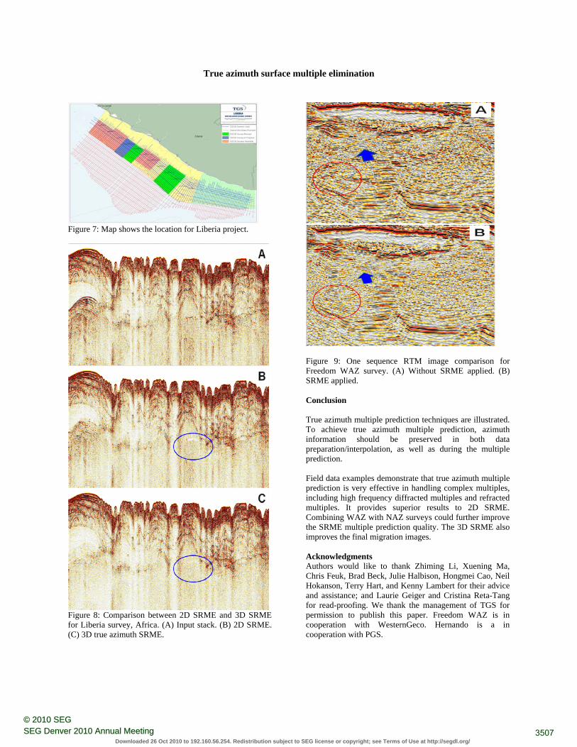
Figure 6: 3D SRME prediction for the Freedom WAZ survey (GOM). (A) Input shot. (B) Predicted multiple using both Freedom WAZ and MCR NAZ surveys (GOM) data. (C) Multiple prediction using Freedom WAZ only. Comparing 2D SRME with 3D SRME (Liberia survey) True azimuth 3D SRME has great advantages over 2D SRME to handle rugose water bottom, complex structures, and the 3D effects. Figure 8 shows a subtraction stack section for 2D SRME (Figure 8B) and 3D SRME (Figure 8C) for the TGS Liberia survey (Africa) (Figure 7). Because of the lack of accuracy of the 2D SRME multiple prediction, the aggressive adaptive subtraction was used to produce results similar to 3D SRME. This aggressive subtraction introduced some damage to the primary. Even though aggressive subtraction was used, there are still many residual multiples left in the 2D SRME results, shown in the left side of the stack section in Figure 8B. SRME impacts the final migration image (Freedom project) Multiples could contaminate the final migration image, leading to misinterpretation, particularly for structurally complex and low signal to noise ratio areas, such as subsalt. 3D SRME preprocessing could dramatically help improve the final migration image in such situations. Figure 9 shows one sequence RTM image comparison with and without 3D TAME applied for the Freedom survey. TAME helps to generate a cleaner RTM image and makes some weak events more continuous and apparent.
3506SEG Denver 2010 Annual Meeting© 2010 SEG
Downloaded 26 Oct 2010 to 192.160.56.254. Redistribution subject to SEG license or copyright; see Terms of Use at http://segdl.org/
True azimuth surface multiple elimination
Figure 7: Map shows the location for Liberia project.
Figure 9: One sequence RTM image comparison for Freedom WAZ survey. (A) Without SRME applied. (B) SRME applied.
Conclusion True azimuth multiple prediction techniques are illustrated. To achieve true azimuth multiple prediction, azimuth information should be preserved in both data preparation/interpolation, as well as during the multiple prediction. Field data examples demonstrate that true azimuth multiple prediction is very effective in handling complex multiples, including high frequency diffracted multiples and refracted multiples. It provides superior results to 2D SRME. Combining WAZ with NAZ surveys could further improve the SRME multiple prediction quality. The 3D SRME also improves the final migration images.
Acknowledgments Authors would like to thank Zhiming Li, Xuening Ma, Chris Feuk, Brad Beck, Julie Halbison, Hongmei Cao, Neil Hokanson, Terry Hart, and Kenny Lambert for their advice and assistance; and Laurie Geiger and Cristina Reta-Tang for read-proofing. We thank the management of TGS for permission to publish this paper. Freedom WAZ is in cooperation with WesternGeco. Hernando is a in cooperation with PGS.
Figure 8: Comparison between 2D SRME and 3D SRME for Liberia survey, Africa. (A) Input stack. (B) 2D SRME. (C) 3D true azimuth SRME.
3507SEG Denver 2010 Annual Meeting© 2010 SEG
Downloaded 26 Oct 2010 to 192.160.56.254. Redistribution subject to SEG license or copyright; see Terms of Use at http://segdl.org/
EDITED REFERENCES Note: This reference list is a copy-edited version of the reference list submitted by the author. Reference lists for the 2010 SEG Technical Program Expanded Abstracts have been copy edited so that references provided with the online metadata for each paper will achieve a high degree of linking to cited sources that appear on the Web. REFERENCES
Aaron, P., R. Toole, S. Barnes, R. Hegge, and R. Borselen, 2008, True-azimuth versus zero-azimuth 3-D multiple prediction in WATS processing: 78th Annual Meeting, SEG, Expanded Abstracts: 2431-2435.
Baumstein, A., R. Neelamani, D. Hinkley, K. Andersen, and T. Farrington, 2009, Optimizing survey design for diffracted multiple attenuation with 3D SRME: First Break, 27, 65–71.
Cai, J., S. Dong, M. Guo, S. Sen, J. Ji, B. Wang, and Z. Li, 2009, Some aspects on data interpolation: multiple prediction and imaging: 79th SEG meeting expanded abstracts: 3178-3182.
Dragoset, B., I. Moore, M. Yu, and W. Zhao, 2008, 3D general surface multiple prediction: An algorithm for all surveys : 78th SEG meeting expanded abstracts: 2426-2430.
Verschuur, D. J., A. J. Berkhout, and C. P. A. Wapenaar, 1992, Adaptive surface-related multiple elimination: Geophysics, 57, 1166–1177, doi:10.1190/1.1443330.
3508SEG Denver 2010 Annual Meeting© 2010 SEG
Downloaded 26 Oct 2010 to 192.160.56.254. Redistribution subject to SEG license or copyright; see Terms of Use at http://segdl.org/