tropical cyclones afwa’s role in the tropical cyclone analysis process for jtwc & nhc
TRANSCRIPT

Tropical CyclonesTropical CyclonesAFWA’s role in the AFWA’s role in the
Tropical Cyclone analysisTropical Cyclone analysisprocess for JTWC & NHCprocess for JTWC & NHC

Storm Track/ForecastStorm Track/Forecast
Definition:Definition:
A “FIX” is an estimate of Tropical Cyclone (TC) weather features
Consists of:
• Position (latitude and longitude) of Low Level Circulation Center (LLCC) • Intensity (maximum sustained winds)

Storm Track/ForecastStorm Track/Forecast
Typical methods of obtaining a fix:
• Meteorological Satellite (METSAT)• RADAR (Example:WSR-88D)• Aircraft Reconnaissance (Hurricane Hunters)• Synoptic Weather Observations

Storm Track/ForecastStorm Track/Forecast
“Why does AFWA perform Tropical Cyclone fixes?
NHC and JTWC are already doing this!”

Storm Track/ForecastStorm Track/Forecast
Reasons for additional fixes by AFWA:
• Unique AFWA capabilities Unique AFWA capabilities • World-wide DMSP data access/sensor capabilitiesWorld-wide DMSP data access/sensor capabilities
• Replaces spotty aircraft recon availabilityReplaces spotty aircraft recon availability• No aircraft in WESTPAC since 1987No aircraft in WESTPAC since 1987• No aircraft reconnaissance in Indian OceanNo aircraft reconnaissance in Indian Ocean• Limited recon in Atlantic/EastPac/CentPacLimited recon in Atlantic/EastPac/CentPac

Storm Track/ForecastStorm Track/Forecast
Reasons for additional fixes by AFWA: … …(continued)…(continued)…
•No ground truth - high subjectivityNo ground truth - high subjectivity• Large impact on final forecastLarge impact on final forecast
• Formally requested by NHC/JTWCFormally requested by NHC/JTWC• Requirements validated Requirements validated
• Backup Role for JTWCBackup Role for JTWC

Storm Track/ForecastStorm Track/ForecastThe importance of an accurate fix:The importance of an accurate fix:
“But Tropical Cyclone fixesare easily done, right?”
“They all haveeyes…….just like Hurricane Mitch did here”

Storm Track/ForecastStorm Track/ForecastThe importance of an accurate fix:The importance of an accurate fix:
Even Hurricane Mitch (1998) exhibited an eye feature for merelymerely25%25% of its life-cycle.
Many TC’s NEVER show anEYE!
No, not really.

Storm Track/ForecastStorm Track/ForecastThe importance of an accurate fix:The importance of an accurate fix:
TD 19WTD 19W21Aug 00 10Z21Aug 00 10Z
Here are someHere are somemore typicalmore typicalexamples.examples.

CLOUD CANOPYCLOUD CANOPY OBSCURES CENTER OBSCURES CENTER
< 25 % of < 25 % of systems tracked systems tracked display eyesdisplay eyes
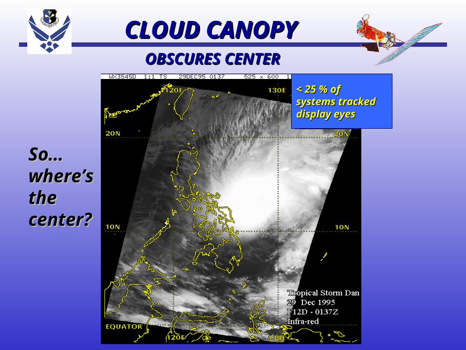
CLOUD CANOPYCLOUD CANOPY OBSCURES CENTER OBSCURES CENTER
< 25 % of < 25 % of systems tracked systems tracked display eyesdisplay eyes
So…So…where’swhere’sthe the center?center?

Storm Track/ForecastStorm Track/Forecast
Unique AFWA capabilitiesUnique AFWA capabilities
DMSP SatellitesDMSP Satellites
• Operational Linescan SystemOperational Linescan System• Special Sensor Microwave ImagerSpecial Sensor Microwave Imager• Superior Data access to worldwideSuperior Data access to worldwide locations locations

Hurricane Jeanne 23 Sep 1998
F14 IR
Infrared - Cloud Canopy SSM/I - Canopy see-through
Hurricane Jeanne 23 Sep 1998F14 SSM/I
Infra-Red vs Microwave ImagerInfra-Red vs Microwave Imager

Hurricane Jeanne 23 Sep 1998
F14 IR
Infrared - Cloud Canopy SSM/I - Canopy see-through
Hurricane Jeanne 23 Sep 1998F14 SSM/I
Infra-Red vs Microwave ImagerInfra-Red vs Microwave Imager
Infrared - Cloud Canopy is notcleat-cut …...
SSM/I shows aneye that is more clearly defined
NHC/JTWC does not receive this data world-wide…… … butbut AFWA does! AFWA does!

DMSP DMSP Low-Light Visual CapabilityLow-Light Visual Capability
1.5 NMDMSPThermalSmoothInfra-red
There is a Tropical Cyclone in thisimage (really). Where is it?

NOTE: Photo-Multiplier Tube (PMT) resolution is 1.5 NM.
DMSP DMSP Low-Light Visual CapabilityLow-Light Visual Capability
1.5 NMDMSPLightSmooth

NOTE: Photo-Multiplier Tube (PMT) resolution is 1.5 NM.
DMSP DMSP Low-Light Visual CapabilityLow-Light Visual Capability
1.5 NMDMSPLightSmooth
DMSP night-time imagery - uses moonlight
Center

NOTE: Photo-Multiplier Tube (PMT) resolution is 1.5 NM.
DMSP DMSP Low-Light Visual CapabilityLow-Light Visual Capability
1.5 NMDMSPLightSmooth
NHC/JTWC does not receive this data world-wide…… … but but AFWA does!AFWA does!

Hurricane Jeanne Hurricane Jeanne 23 Sep 199823 Sep 1998DMSP F14DMSP F14
DMSP SSM/IDMSP SSM/I Surface WindsSurface Winds

Hurricane Jeanne Hurricane Jeanne 23 Sep 199823 Sep 1998DMSP F14DMSP F14
DMSP SSM/IDMSP SSM/I Surface WindsSurface Winds
Gale Gale forceforcewinds winds are inare in RedRed

U.S. Tropical Cyclone U.S. Tropical Cyclone Warning Centers AORsWarning Centers AORs
CPHCCPHC NHCNHC
180 140
EQ
NHCNHC
JTWCJTWC
Metsat Analysis Bltns (5244)
73 % 27 % 5 Dec

U.S. Tropical Cyclone U.S. Tropical Cyclone Warning Centers AORsWarning Centers AORs
CPHCCPHC NHCNHC
180 140
EQ
NHCNHC
JTWCJTWC
Metsat Analysis Bltns (5244)
73 % 27 % 5 Dec
No Effective DMSP data access for JTWC in these No Effective DMSP data access for JTWC in these areas (green)! AFWA provides coverage here.areas (green)! AFWA provides coverage here.

Storm Track/ForecastStorm Track/ForecastThe importance of an accurate fix:The importance of an accurate fix:
But the NHC has aircraft But the NHC has aircraft reconnaissance in the reconnaissance in the
Atlantic, right? Atlantic, right?
Why is AFWA doing Why is AFWA doing fixes there?fixes there?

Storm Track/ForecastStorm Track/ForecastThe importance of an accurate fix:The importance of an accurate fix:
Here’s NHC’s AOR - at the busiest point of the season…..
Graphic - courtesy Weather Channel

Storm Track/ForecastStorm Track/ForecastThe importance of an accurate fix:The importance of an accurate fix:
Here’s the approx. area covered by aircraft RECON - nearly half their storms are not covered.
Graphic - courtesy Weather Channel Aircraft RECONCoverage

Storm Track/ForecastStorm Track/ForecastThe importance of an accurate fix:The importance of an accurate fix:
NO AIRCRAFT
COVERAGE
HERE!
Graphic - courtesy Weather Channel

Storm Track/ForecastStorm Track/ForecastThe importance of an accurate fix:The importance of an accurate fix:
Also, Notice how the Eastern Pacific is
essentially not covered at all…...
Graphic - courtesy Weather Channel

U.S. Tropical Cyclone U.S. Tropical Cyclone Warning Centers AORsWarning Centers AORs
CPHCCPHC NHCNHC
180 140
EQ
NHCNHC
JTWCJTWC
Metsat Analysis Bltns (5244)
73 % 27 % 5 Dec
No Aircraft RECON in these areas! AFWA fixes No Aircraft RECON in these areas! AFWA fixes help offset this loss for JTWC.help offset this loss for JTWC.

U.S. Tropical Cyclone U.S. Tropical Cyclone Warning Centers AORsWarning Centers AORs
CPHCCPHC NHCNHC
180 140
EQ
NHCNHC
JTWCJTWC
Metsat Analysis Bltns (5244)
73 % 27 % 5 Dec
Very Limited Aircraft Very Limited Aircraft RECON in these areas! RECON in these areas!
AFWA fixes help offset AFWA fixes help offset this loss for NHC/CPHC.this loss for NHC/CPHC.

Storm Track/ForecastStorm Track/ForecastThe importance of an accurate fix:The importance of an accurate fix:

Storm Track/ForecastStorm Track/ForecastThe importance of an accurate fix:The importance of an accurate fix:
So - where’s the aircraft? RADAR? SFC OBS?So - where’s the aircraft? RADAR? SFC OBS?

Storm Track/ForecastStorm Track/ForecastThe importance of an accurate fix:The importance of an accurate fix:
Aircraft recon - discontinued in WestPac 1987Aircraft recon - discontinued in WestPac 1987

Storm Track/ForecastStorm Track/ForecastThe importance of an accurate fix:The importance of an accurate fix:
RADAR - 240nm from GUAM and Kadena onlyRADAR - 240nm from GUAM and Kadena only
WSR-88DWSR-88D

Storm Track/ForecastStorm Track/ForecastThe importance of an accurate fix:The importance of an accurate fix:
Surface Obs - very limited in WestPac AOR.Surface Obs - very limited in WestPac AOR.
WSR-88DWSR-88D

Storm Track/ForecastStorm Track/ForecastThe importance of an accurate fix:The importance of an accurate fix:
So - all that’s left - all too often - is two So - all that’s left - all too often - is two opinions about the location of the LLCCopinions about the location of the LLCC

Storm Track/ForecastStorm Track/ForecastThe importance of an accurate fix:The importance of an accurate fix:
Which two opinions? JTWC and AFWA!Which two opinions? JTWC and AFWA!

Storm Track/ForecastStorm Track/ForecastThe importance of an accurate fix:The importance of an accurate fix:
If you pick “A”, Guamis threatened in 24 hrs...
But not if you pick “B”

Storm Track/ForecastStorm Track/ForecastThe importance of an accurate fix:The importance of an accurate fix:
Gale winds here in green

Storm Track/ForecastStorm Track/ForecastThe importance of an accurate fix:The importance of an accurate fix:
This could be the difference between getting aircraft & ships sortied (evacuated) on-time or too late!
So the choice matters!

Storm Track/ForecastStorm Track/ForecastThe importance of an accurate fix:The importance of an accurate fix:
This could be the difference between getting aircraft & ships sortied (evacuated) on-time or too late!
The overall confidence in a single fix is never high - unless it’s an EYE.

Storm Track/ForecastStorm Track/ForecastThe importance of an accurate fix:The importance of an accurate fix:
This could be the difference between getting aircraft & ships sortied (evacuated) on-time or too late!
If we selected a position in-between the two subjective position estimates….

Storm Track/ForecastStorm Track/ForecastThe importance of an accurate fix:The importance of an accurate fix:
….then we have a higher probability ofbeing correct…….

Storm Track/ForecastStorm Track/ForecastThe importance of an accurate fix:The importance of an accurate fix:
….or at least not too too far off…....

Storm Track/ForecastStorm Track/ForecastThe importance of an accurate fix:The importance of an accurate fix:
….when compared to the other two forecasts.
Most Likely

Storm Track/ForecastStorm Track/ForecastThe importance of an accurate fix:The importance of an accurate fix:
….when compared to the other two forecasts.
EXTREME
EXTREME
Most Likely

Storm Track/ForecastStorm Track/ForecastFormalized RequirementsFormalized Requirements

Storm Track/ForecastStorm Track/ForecastFormalized RequirementsFormalized Requirements
TYPE OF SUPPORT REQUESTED: {JTWC}
a. Tropical cyclone center (position) fixes, including positions using Special Sensor Microwave/Imager (SSM/I) and Tropical Rainfall Measurement Mission (TRMM) data for systems 25 knots and/or meeting a minimum Dvorak current intensity of T1.0. Tropical cyclone intensity and SSM/I 35-knot wind radii, as appropriate, from all meteorological satellite imagery in the Global Satellite database to include high-resolution geostationary images…..
b. Tropical cyclone center (position) fix bulletins from SSM/I-only DMSP or TRMM-only for known systems 25 knots and/or meeting a minimum Dvorak current intensity of T1.0.

Storm Track/ForecastStorm Track/ForecastFormalized RequirementsFormalized Requirements {JTWC - Continued}
c. Upon telephone request by the JTWC Typhoon Duty Officer (TDO) or the JTWC METSAT analyst, provide position fixes for tropical disturbances less than Dvorak T1.0. For these systems:
Indicate the latitude/longitude of the center positionEnter "X.X" for the final-T and explain in remarks that the system does not meet Dvorak classification requirementsThe "INIT OBS" remark will not be issued until a Dvorak intensity of T1.0 is reached; at this time commence normal Dvorak rulesIf a system has previously been classified using Dvorak rules and a center position can no longer be defined, enter "X.X" for the final-T and hold the current intensity of the system up according to Dvorak rules and constraints. This will alleviate the "early killing" of systems associated
with undetermined positions on nighttime infrared imagery.

Storm Track/ForecastStorm Track/ForecastFormalized RequirementsFormalized Requirements
d. METEOSAT, GMS and GOES tropical cyclone metwatch over the Indian and Pacific Oceans using all available imagery. Suspect areas must be aggressively identified where convection persists for 12 hours or where low-level circulation centers can be observed or inferred. Notification of suspect areas will be made via tropical cyclone fix bulletins and telecon with JTWC.
{JTWC - Continued}

Storm Track/ForecastStorm Track/ForecastFormalized RequirementsFormalized Requirements

Storm Track/ForecastStorm Track/ForecastFormalized RequirementsFormalized Requirements
6.4. Air Force Support and the Defense Meteorological Satellite Program (DMSP).
“Data covering the National Hurricane Operations Plan areas of interest are received centrally at the Air Force Weather Agency (AFWA) and locally at several direct readout sites. The USAF uses all available meteorological satellite data when providing fix and intensity information to NWS hurricane forecasters. The DOD will provide DMSP coverage of tropical and subtropical cycloneswhenever possible.”
{National Hurricane Center - NHC }
Storm Track/ForecastStorm Track/ForecastFormalized RequirementsFormalized Requirements
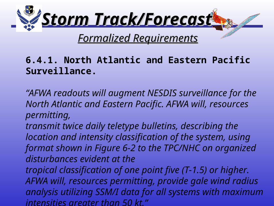
6.4.1. North Atlantic and Eastern Pacific Surveillance.
“AFWA readouts will augment NESDIS surveillance for the North Atlantic and Eastern Pacific. AFWA will, resources permitting,transmit twice daily teletype bulletins, describing the location and intensity classification of the system, using format shown in Figure 6-2 to the TPC/NHC on organized disturbances evident at thetropical classification of one point five (T-1.5) or higher. AFWA will, resources permitting, provide gale wind radius analysis utilizing SSM/I data for all systems with maximum intensities greater than 50 kt.”

Storm Track/ForecastStorm Track/ForecastFormalized RequirementsFormalized Requirements
6.4.2. Central Pacific Surveillance.
“AFWA will maintain the capability to provide surveillance support cited in para 6.4.1 to the CPHC. Detachment 1, PACAF Air Operations Squadron (Joint Typhoon Warning Center Satellite Operations) will provide fix and intensity information to the CPHC on systems upon request.”

JTWC SATOPS BACKUPJTWC SATOPS BACKUP

JTWC SATOPS BACKUPJTWC SATOPS BACKUP

JTWC SATOPS BACKUPJTWC SATOPS BACKUP

Storm Track/ForecastStorm Track/Forecast

Storm Track/ForecastStorm Track/Forecast

Background:
On 15 Feb 2001, TC 09S (Vincent) was nearing land along the NW coast of Australia.
Issue:
The 15/1340Z fix from KGWC and 15/1430Z fix from PGTW were over 230 nm apart.
This slide show will show the reasoning behind the KGWC fix.

TC 09S
(Vincent)
WRNG
#7

Legend: Fixes
KGWC -Blue
PGTW-Yellow
KWBC-Green


TPXS10 KGWC 151500A. TROPICAL CYCLONE 09S (VINCENT) - RELOCATED B. 15/1340Z (09) C. 17.7S/5 D. 122.7E/2 E. FIVE/DMSPF. T2.0/2.5/S0.0 24HRS -15/1131Z- G. WX6549/06092/ATS-EIR-MI/N
41/ PBO CONVECTIVE CURVATURE ON 85H DATA.
H. CENTER WAS 2.5DEGREES EAST OF NADIR.
I. GALE WIND RADIUS ANAL - N/A
DRCTN DSTC-NM LAT LONG
1. N 2. NE 3. E 4. SE 5. S 6. SW 7. W 8. NW
ROACHE< SENT AT 15:01:32

SFC OBS: 15/1500Z
BEST TRACK

SFC OBS: 15/1500Z
BEST TRACK
230nm

The Main points of concern:
• LLCC was consistently located to the east of the CNVCTN thru the last 2 days.
• AFWA position is consistent with the above thought
•Also, SFC obs from Broome, Derby,and Koolan (at 15/15Z) support our position.
• The next few slides show the storm over yesterday and today:

14 Feb 2001, 0600Z
LLCC fully exposed,
located east of CNVCTN

15 Feb 2001, 0700Z

This low level cloud
line convinced us as to the
location of the LLCC.

15 Feb 2001, 0800Z

15 Feb 2001, 0800Z
PGTWPGTWKGWCKGWC
These surface obsThese surface obs
concerned us -concerned us -
not consistent withnot consistent with
westward locationwestward location
of LLCC (they are of LLCC (they are
180 degrees out)180 degrees out)

It does appear as though a secondary LLCC is near the coast ( see obs at Bedout Island and Port Hedland) at 1500Z.


LLCC’s

The DMSP 85H (which follows) appears to show a better defined (though poor) LLCC near Broome.


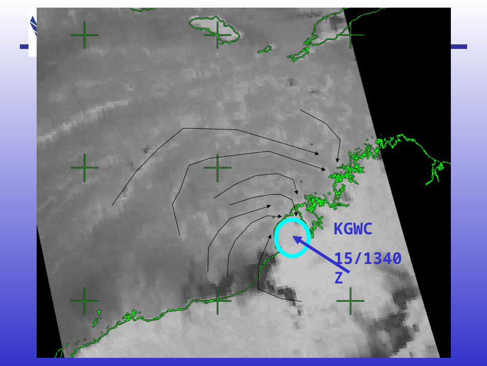
KGWC
15/1340Z

TPXS10 KGWC 151828A. TROPICAL CYCLONE 09S (VINCENT) B. 15/1731Z (09) C. 17.9S/7 D. 123.2E/8 E. SIX/SATELLITE F. T2.0/2.5/S0.0 24HRS -15/1731Z- G. IR/EIR
38A/ PBO SBC/ANMTN. LLCC HAS MOVED OVER LAND NEAR BROOME. BAND OF CONVECTION SW OF LLCC HAS INCREASED OVER THE LAST 6 HOURS. CNVCTN WRAPS .35 ON LOG10 SPIRAL. FINAL T BASED ON DT. PT AND MET AGREE.
ROACHE/KRAMER
< SENT AT 18:32:56

Summary:Summary:• This was a difficult storm to position, This was a difficult storm to position, with two LLCC’s likely. with two LLCC’s likely.
• Based on continuity, SFC obs, past Based on continuity, SFC obs, past behavior of the system, we feel that main behavior of the system, we feel that main LLCC made landfall near Broome. A LLCC made landfall near Broome. A secondary LLCC most likely made secondary LLCC most likely made landfall near Port Hedland.landfall near Port Hedland.

IMPACTIMPACT

WTXS31 PGTW 1521001. TROPICAL CYCLONE 09S (VINCENT) WARNING NR 008A RELOCATED 01 ACTIVE TROPICAL CYCLONE IN SOUTHERN HEMISPHERE MAX SUSTAINED WINDS BASED ON ONE-MINUTE AVERAGE --- WARNING POSITION: 151800Z5 --- NEAR 19.5S5 122.2E7 MOVEMENT PAST SIX HOURS - 135 DEGREES AT 10 KTS POSITION ACCURATE TO WITHIN 070 NM POSITION BASED ON CENTER LOCATED BY A COMBINATION OF SATELLITE , RADAR, AND SYNOPTIC DATA PRESENT WIND DISTRIBUTION: MAX SUSTAINED WINDS - 030 KT, GUSTS 040 KT DISSIPATING AS A SIGNIFICANT TROPICAL CYCLONE OVER LAND REPEAT POSIT: 19.5S5 122.2E7 --- FORECASTS: 12 HRS, VALID AT: 160600Z3 --- 21.1S4 123.1E7 MAX SUSTAINED WINDS - 020 KT, GUSTS 030 KT DISSIPATED AS A SIGNIFICANT TROPICAL CYCLONE OVER LAND ---REMARKS:152100Z9 POSITION NEAR 19.9S9 122.4E9.TROPICAL CYCLONE (TC) 09S (VINCENT), LOCATED APPROXIMATELY 200 NMEAST OF PORT HEDLAND, AUSTRALIA, WAS RELOCATED FURTHER SOUTH THANPREVIOUSLY ANALYZED, AND HAS MOVED OVER LAND. THE WARNING POSITIONIS BASED ON 151800Z5 SYNOPTIC DATA, 151730Z7 INFRARED SATELLITEIMAGERY, AND RADAR. THE WARNING INTENSITY IS BASED ON CURRENTINTENSITY ESTIMATES OF 30 KTS AND SYNOPTIC REPORTS OF 25 KNOTS. TC09S IS FORECAST TO CONTINUE TO TRACK SOUTHWARD UNDER THE STEERINGINFLUENCE OF THE SUBTROPICAL RIDGE TO THE EAST-SOUTHEAST. ANAPPROACHING MID-LATITUDE TROUGH WILL SERVE TO FURTHER ENHANCE THESOUTHWARD MOVEMENT. TC 09S WILL CONTINUE TO WEAKEN OVER LAND ANDCOMPLETELY DISSIPATE BY THE 12 HOUR FORECAST PERIOD. THIS IS THEFINAL WARNING ON THIS SYSTEM BY THE JOINT TYPHOON WARNING CENTER(NAVPACMETOCCEN). THE SYSTEM WILL BE CLOSELY MONITORED FOR SIGNS OFREGENERATION.//

WTXS31 PGTW 1521001. TROPICAL CYCLONE 09S (VINCENT) WARNING NR 008A RELOCATED 01 ACTIVE TROPICAL CYCLONE IN SOUTHERN HEMISPHERE MAX SUSTAINED WINDS BASED ON ONE-MINUTE AVERAGE --- WARNING POSITION: 151800Z5 --- NEAR 19.5S5 122.2E7 MOVEMENT PAST SIX HOURS - 135 DEGREES AT 10 KTS POSITION ACCURATE TO WITHIN 070 NM POSITION BASED ON CENTER LOCATED BY A COMBINATION OF SATELLITE , RADAR, AND SYNOPTIC DATA PRESENT WIND DISTRIBUTION: MAX SUSTAINED WINDS - 030 KT, GUSTS 040 KT DISSIPATING AS A SIGNIFICANT TROPICAL CYCLONE OVER LAND REPEAT POSIT: 19.5S5 122.2E7 --- FORECASTS: 12 HRS, VALID AT: 160600Z3 --- 21.1S4 123.1E7 MAX SUSTAINED WINDS - 020 KT, GUSTS 030 KT DISSIPATED AS A SIGNIFICANT TROPICAL CYCLONE OVER LAND ---REMARKS:152100Z9 POSITION NEAR 19.9S9 122.4E9.TROPICAL CYCLONE (TC) 09S (VINCENT), LOCATED APPROXIMATELY 200 NMEAST OF PORT HEDLAND, AUSTRALIA, WAS RELOCATED FURTHER SOUTH THANPREVIOUSLY ANALYZED, AND HAS MOVED OVER LAND. THE WARNING POSITIONIS BASED ON 151800Z5 SYNOPTIC DATA, 151730Z7 INFRARED SATELLITEIMAGERY, AND RADAR. THE WARNING INTENSITY IS BASED ON CURRENTINTENSITY ESTIMATES OF 30 KTS AND SYNOPTIC REPORTS OF 25 KNOTS. TC09S IS FORECAST TO CONTINUE TO TRACK SOUTHWARD UNDER THE STEERINGINFLUENCE OF THE SUBTROPICAL RIDGE TO THE EAST-SOUTHEAST. ANAPPROACHING MID-LATITUDE TROUGH WILL SERVE TO FURTHER ENHANCE THESOUTHWARD MOVEMENT. TC 09S WILL CONTINUE TO WEAKEN OVER LAND ANDCOMPLETELY DISSIPATE BY THE 12 HOUR FORECAST PERIOD. THIS IS THEFINAL WARNING ON THIS SYSTEM BY THE JOINT TYPHOON WARNING CENTER(NAVPACMETOCCEN). THE SYSTEM WILL BE CLOSELY MONITORED FOR SIGNS OFREGENERATION.//

WTXS31 PGTW 152100
1. TROPICAL CYCLONE 09S (VINCENT) WARNING NR 008A RELOCATEDRELOCATED 01 ACTIVE TROPICAL CYCLONE IN SOUTHERN HEMISPHERE MAX SUSTAINED WINDS BASED ON ONE-MINUTE AVERAGE --- WARNING POSITION:
151800Z5 --- NEAR 19.5S5 122.2E7

WRNG 8

WRNG 7 WRNG 8

WRNG 8WRNG 7
1506Z