triton minerals ltd substantial graphitic mineralisation
TRANSCRIPT

1
ASX ANNOUNCEMENT
18 September 2015
Triton Minerals Ltd
ASX: TON
ABN: 99 126 042 215
Street address: Ground Floor Unit 1 256 Stirling Highway Claremont Western Australia 6010
Postal address: PO Box 1518 West Perth Western Australia 6872
Tel: +61 8 6489 2555
Fax: +61 8 9388 1252
Email: [email protected]
Web: www.tritonmineralsltd.com.au
Projects: Mozambique
Balama North Graphite-Vanadium
Ancuabe Graphite
Balama South Graphite
Holder of the world’s largest known
resource.
SUBSTANTIAL GRAPHITIC MINERALISATION CONFIRMED AT ANCUABE
HIGHLIGHTS
Initial exploratory diamond drilling intersects significant visual graphitic mineralisation
Initial drilling confirms mineralisation is continuous over a strike length of over 550m within a 2.5km target strike length
Multiple mineable zones of large and jumbo flake graphite intersected
Reverse circulation (RC) rig activated on infill resource definition program
Environment Impact Assessment (EIA) continues on schedule
DUAT applications on schedule
Initial feasibility study commenced
Early works commenced with a 15km all-weather access road to sealed highway completed to T12 site
Triton confident of establishing a world class and world leading graphite project
Triton Minerals Limited (ASX: TON, Triton or Company) is pleased to provide an update on exploration and drilling activities at the Ancuabe project in Mozambique.
Triton’s Managing Director & CEO Brad Boyle said: “The intersection of this
large graphitic mineralisation zone at Ancuabe is a very exciting
development for Triton, as it creates more development opportunities.
The identification of multiple visual zones of large and jumbo flake graphite
over considerable distances is once again verifying the world class nature of
the Ancuabe location and the accuracy of the VTEM data. Triton is now
aiming to define a JORC complaint resource at T12 by the end of 2015.
This most recent discovery of high quality graphitic mineralisation puts
Triton in the unique position to customise TMG products to suit a very
diverse market end users, by providing the best range flake graphite sizes.”
2
Triton’s Technical Director Alfred Gillman stated: “Given the great reverence with which “Ancuabe graphite” has within the global graphite industry, the T12 greenfields discovery is a truly exciting development and is the culmination of Triton’s carefully considered exploration efforts and development strategy combined with the Company’s demonstrated expertise in the graphite business. Achieving the world’s best flake graphite results from initial metallurgical scouting test work earlier this year was the trigger for committing to the Ancuabe program. The visual observations from our first round of drilling are well beyond even our own expectations and we anticipate further positive outcomes as exploration and project development continues”
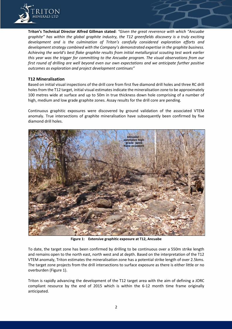
T12 Mineralisation Based on initial visual inspections of the drill core from first five diamond drill holes and three RC drill holes from the T12 target, initial visual estimates indicate the mineralisation zone to be approximately 100 metres wide at surface and up to 50m in true thickness down hole comprising of a number of high, medium and low grade graphite zones. Assay results for the drill core are pending. Continuous graphitic exposures were discovered by ground validation of the associated VTEM anomaly. True intersections of graphite mineralisation have subsequently been confirmed by five diamond drill holes.
Figure 1: Extensive graphitic exposure at T12, Ancuabe
To date, the target zone has been confirmed by drilling to be continuous over a 550m strike length and remains open to the north east, north west and at depth. Based on the interpretation of the T12 VTEM anomaly, Triton estimates the mineralisation zone has a potential strike length of over 2.5kms. The target zone projects from the drill intersections to surface exposure as there is either little or no overburden (Figure 1). Triton is rapidly advancing the development of the T12 target area with the aim of defining a JORC compliant resource by the end of 2015 which is within the 6-12 month time frame originally anticipated.

3
Further extensional exploration, likely to commence in 2016 as originally anticipated, will continue
over several additional large targets located further to the east. Road access is currently being
established to these sites.
Triton confirms that the EIA continues to progress well and is on track for completion by June 2016.
DUAT applications (land use license) have commenced together with the initial feasibility study.
In order to streamline and minimise the development timeline and associated costs Triton is planning
to utilise the established infrastructure and strategic alliances. However, a 15km all-weather access
road connecting the T12 site to the sealed highway has been completed and will provide a more direct
access route to nearby Pemba.
Figure 2: T12 Location Plan
CONCLUSIONS The identification of significant graphite mineralisation provides Triton greater confidence in being able to demonstrate economic quantities of large and jumbo flake graphite at the Ancuabe project in the near term. In addition to the recently discovered P66 zone at Nicanda Hill, the T12 graphite discovery could complement the Triton Minerals Graphite (TMG) products range and provide the Company with the potential to produce large volumes of high grade (high value) graphite in the full range of flake sizes, thereby accommodating a wider range of end-user requirements.

4
Triton continues working towards establishing TMG as a new global graphite-industry benchmark, by aiming to offer the world's lowest cost and most diversified graphite product range together with the longevity of a reliable supply of high quality flake graphite.
Regards
Brad Boyle CEO & Managing Director Triton Minerals Ltd
Holder of the world’s largest known combined graphite-vanadium resource Vision Led by a highly experienced Board and Management team, Triton’s primary vision is to grow shareholders value through discovery and development of graphite, gold and other precious, base and industrial minerals deposits. Further, Triton will explore vertical integration opportunities to supplement its core business and to create valued revenue streams to ultimately benefit Triton’s shareholders. TMG and beyond Triton hopes to establish Triton Mozambique graphite, produced from its Mozambique graphite projects (TMG) as the global graphite-industry benchmark by aiming to offer the world’s lowest cost and most diversified graphite product range, together with the longevity of a reliable supply of high quality flake graphite. Triton hopes to establish Triton Mozambique graphite, produced from its Mozambique graphite projects (TMG) as the global graphite-industry benchmark. Triton is also actively pursuing vertical integration opportunities to be involved in all aspects of the graphite supply chain, which Triton believes will add significant value to the Company and its shareholders in the long term.

5
For further information, please contact:
Brad Boyle
CEO & Managing Director
Tel: + 61 8 6489 2555
Email: [email protected]
Competent Person’s Statement The information in this report that relates to Exploration Results on the Ancuabe project is based on, and fairly represents,
information and supporting documentation prepared by Mr. Alfred Gillman, who is a Fellow of Australian Institute of Mining
and Metallurgy (CP Geol). Mr. Gillman is an Executive Director of the Company. Mr. Gillman has sufficient experience which
is relevant to the style of mineralisation and type of deposit under consideration and to the activity which he is undertaking
to qualify as a Competent Person as defined in the 2012 Edition of the ‘Australasian Code for Reporting of Mineral Resources
and Ore Reserves (the JORC Code)’. Mr. Gillman consents to the inclusion in this report the exploration results and the
supporting information in the form and context as it appears.
Forward-Looking Statements This document may include forward-looking statements. Forward-looking statements include, but are not necessarily limited to, statements concerning Triton Minerals Limited’s planned exploration program and other statements that are not historic facts. When used in this document, the words such as “could”, “plan”, “estimate” “expect”, “intend”, “may”, “potential”, “should” and similar expressions are forward-looking statements. Although Triton Minerals Limited believes that its expectations reflected in these are reasonable, such statements involve risks and uncertainties, and no assurance can be given that actual results will be consistent with these forward-looking statements.

6
Appendix 1: Ancuabe Project (License 5336). Operated under agreement between Triton Minerals and Grafex Lda. Information pertaining to drill data and field exploration results
JORC Table 1 - Section 1 Sampling Techniques and Data
Criteria JORC Code explanation Commentary
Sampling techniques
Nature and quality of sampling (e.g. cut channels, random chips, or specific specialised industry standard measurement tools appropriate to the minerals under investigation, such as down hole gamma sondes, or handheld XRF instruments, etc). These examples should not be taken as limiting the broad meaning of sampling.
The new drill results included in this report were obtained from diamond drilling. The nominal hole spacing of the current program is 50m on lines ranging from 100m to 200m spacing. Diamond drill holes were drilled to provide qualitative information on structure and physical properties of the mineralisation. Holes were drilled vertically to optimally intersect the flat dipping mineralised zones.
Include reference to measures taken to ensure sample representivity and the appropriate calibration of any measurement tools or systems used
Drillhole locations were picked up by NavCom Land-Pak SF-3040 differential GPS (with nominal error of +- < 0.5 metres) and reported using the World Geodetic System (1984 Spheroid and Datum; Zone 37 South). Downhole surveys of the drillholes were measured using a Reflex EZ-Shot single shot downhole survey tool. The collar surveys were validated with the use of a compass and inclinometer.
Aspects of the determination of mineralisation that are Material to the Public Report. In cases where ‘industry standard’ work has been done this would be relatively simple (e.g. ‘reverse circulation drilling was used to obtain 1 m samples from which 3 kg was pulverised to produce a 30 g charge for fire assay’). In other cases more explanation may be required, such as where there is coarse gold that has inherent sampling problems. Unusual commodities or mineralisation types (e.g. submarine nodules) may warrant disclosure of detailed information
The diamond drill core samples were cut into quarter core using a diamond impregnated blade core saw. Samples were defined on the basis of geological contacts and range from 1.5 to 3m, averaging 2m in length.
Graphite content by volume is estimated visually comparing the amount of visible graphite flakes against a standard reference set. Further, the estimates are compared against Triton’s database of results obtained from previous drill core, rock chip samples and assay results sourced from both the Nicanda Hill, Balama South and Ancuabe projects.
Drilling techniques Drill type (e.g. core, reverse circulation, open-hole hammer, rotary air blast, auger, Bangka, sonic, etc.) and details (e.g. core diameter, triple or standard tube, depth of diamond tails, face-sampling bit or other type, whether core is oriented and if so, by what method, etc.).
The diamond drill holes were drilled with a PQ core size collar (typically around 30m deep) and HQ3 (61.1mm diameter) core size to the end of hole. Core is oriented using the Reflex ACTII RD digital device. Quoted accuracy is better than 10 from 0 to +-880 dip
Drill sample recovery
Method of recording and assessing core and chip sample recoveries and results assessed
Generally drill core recovery is above 95% below the base of oxidation. Core recovery is measured and compared directly with drill depths to determine sample recoveries.
Measures taken to maximise sample recovery and ensure representative nature of the samples
Diamond core is reconstructed into continuous runs on an angle iron cradle for orientation marking. Depths are checked against the depth given on the core blocks and rod counts are routinely carried out by the drillers.
Whether a relationship exists between sample recovery and grade and whether sample bias may have occurred due to preferential loss/gain of fine/coarse material.
no assay results quoted
7
Criteria JORC Code explanation Commentary
Logging
Whether core and chip samples have been geologically and geotechnically logged to a level of detail to support appropriate Mineral Resource estimation, mining studies and metallurgical studies.
Geological logging is carried out to record the mineral assemblage identified in hand specimen, in addition to texture, structure and estimates of graphite flake content and size.
Geotechnical logging is carried out on all diamond drillholes for recovery, RQD and number of defects (per interval). Information on structure type, dip, dip direction, alpha angle, beta angle, texture, shape, roughness and fill material is stored in the structure table of the database.
The mineralogy, textures and structures are recorded by the geologist into a digital data file at the drill site, which are regularly submitted to the Perth office for compilation and validation.
Whether logging is qualitative or quantitative in nature. Core (or costean, channel, etc) photography.
Logging of Diamond drill holes includes recording of lithology, mineralogy, mineralisation, weathering, colour and other features of the samples. Diamond core trays are photographed. Geological descriptions of the mineral volume abundances and assemblages are semi-quantitative.
The total length and percentage of the relevant intersections logged
All drillholes are logged in full.
Sub-sampling techniques and sample preparation
If core, whether cut or sawn and whether quarter, half or all core taken.
Diamond core (HQ3) is cut into quarter core onsite using a diamond impregnated blade on a brick saw. Quarter core samples (generally 2 metres or less in core length) were submitted to the lab labelled with a single sample name. Each sample is crushed and a 300g split is taken for pulverisation. Sample intervals are generally defined according to geological boundaries. Duplicate quarter core samples are routinely submitted to the same lab (on a ratio of 5 per 100 samples).
If non-core, whether riffled, tube sampled, rotary split, etc and whether sampled wet or dry.
No RC based results are quoted
For all sample types, the nature, quality and appropriateness of the sample preparation technique.
The sample preparation of the diamond core samples follows industry best practice in sample preparation involving oven drying (105oC), coarse crushing of the diamond core sample down to ~2 mm, split (300g) and pulverising to a grind size of 85% passing 75 micron. The sample preparation for RC samples is identical, without the coarse crush stage. No assay results have yet been reported.
Quality control procedures adopted for all sub-sampling stages to maximise representivity of samples.
Field QC procedures involve the use of four certified reference material assay standards, along with certified blanks, and insertion of field duplicates.
Certified standards are inserted at a rate of 1 in 25 (DD, RC and rock chip samples), duplicates were inserted at a rate of 1 in 20 and blanks are inserted at a rate of 1 in 50. QAQC samples are submitted with the rock chip samples.
Measures taken to ensure that the sampling is representative of the in situ material collected, including for instance results for field duplicate/second-half sampling.
Field duplicates are taken on 2m composites for RC, using a riffle splitter, and as quarter core splits for diamond core.

8
Criteria JORC Code explanation Commentary
Whether sample sizes are appropriate to the grain size of the material being sampled.
The drill sample sizes are considered to be appropriate to correctly represent mineralisation at the Ancuabe project based on the style of mineralisation, the thickness and consistency of the intersections, the sampling methodology and percent value assay ranges for the primary elements.
Quality of assay data and laboratory tests
The nature, quality and appropriateness of the assaying and laboratory procedures used and whether the technique is considered partial or total.
No assay results are quoted in this report. However future assaying will incorporate the following procedures:
Samples were analysed for Graphitic Carbon, Total Sulphur, and Total Carbon on a Leco Combustion Infrared Detection instrument. Detection limits for these analyses are considered appropriate for the reported assay grades.
In addition, selected drill samples were analysed for multi-element abundances using a fused disc digested in a four acid digest with ICP/OES or ICP/MS finish. The acids used are hydrofluoric, nitric, perchloric and hydrochloric acid, suitable for silica based samples. The method approaches total dissolution of most minerals.
For geophysical tools, spectrometers, handheld XRF instruments, etc, the parameters used in determining the analysis including instrument make and model, reading times, calibrations factors applied and their derivation, etc.
No geophysical tools were used to determine any element concentrations.
Nature of quality control procedures adopted (e.g. standards, blanks, duplicates, external laboratory checks) and whether acceptable levels of accuracy (i.e. lack of bias) and precision have been established.
Not applicable as no assay results are quoted in this report
Verification of sampling and assaying
The verification of significant intersections by either independent or alternative company personnel.
Not applicable as no assay results are quoted in this report
The use of twinned holes. Not applicable as no assay results are quoted in this report
Documentation of primary data, data entry procedures, data verification, data storage (physical and electronic) protocols.
Not applicable as no assay results are quoted in this report
Discuss any adjustment to assay data. Not applicable as no assay results are quoted in this report

9
Criteria JORC Code explanation Commentary
Location of data points
Accuracy and quality of surveys used to locate drillholes (collar and down-hole surveys), trenches, mine workings and other locations used in Mineral Resource estimation.
Collar locations for all holes were surveyed with a Nav-Com Land-Pak differential GPS.
Drill holes were oriented at the collar using sighting pegs installed with the use of a magnetic compass and GPS.
The dip and azimuth of all DD holes is measured by the drill company using a Reflex EZ-Shot single shot downhole survey tool. Readings were taken at the completion of the hole at an interval spacing of 30 m on the diamond holes, and at the collar and end of hole on the RC holes. Stated accuracy of the tool is +-0.50 azimuth and +-0.20 dip. Downhole survey measurements considered to be poor quality are coded as ‘Priority 2’ and are e excluded from the drill location calculations.
Specification of the grid system used.
The grid system for Ancuabe Project area is World Geodetic System (1984 Spheroid and Datum; Zone 37 South).
Quality and adequacy of topographic control.
The topographic surface is based on differential GPS coordinates of the drill hole collars at Ancuabe.
Data spacing and distribution Data spacing for reporting of Exploration Results.
The nominal drillhole spacing is 50 m on drill lines spaced from 100m to 200m apart. The drill lines have a bearing of 1800 (UTM grid north-south).
Whether the data spacing and distribution is sufficient to establish the degree of geological and grade continuity appropriate for the Mineral Resource and Ore Reserve estimation procedure(s) and classifications applied.
Not applicable as no assay results are quoted in this report
Whether sample compositing has been applied.
Samples have been composited to a maximum of two metres for RC samples. Most diamond core is sampled in approximately 2m intervals of quarter core, with a few samples of up to 3m in zones of either less visible graphite or gneissic intervals. Diamond core sample intervals correspond to geological boundaries.
Orientation of data in relation to geological structure
Whether the orientation of sampling achieves unbiased sampling of possible structures and the extent to which this is known, considering the deposit type.
The deposit is drilled with vertical holes to intersect the mineralised zones approximately orthogonal to the interpreted dip and strike of the geological units. The correlation of geological units defined by characteristic mineralogy provides a high degree of confidence in the attitude and orientation of the graphite mineralisation. Near continuous sampling of all geological units bearing graphite is routinely undertaken.
If the relationship between the drilling orientation and the orientation of key mineralised structures is considered to have introduced a sampling bias, this should be assessed and reported if material.
No relationships between drill orientation and key mineralised structures have been observed. The current drilling is not expected to produce any biased samples.
Sample security The measures taken to ensure sample security.
Chain of custody is managed by Triton. Samples are stored at a secure yard on the project prior to shipping to Intertek/Genalysis in Perth, WA. Any visible signs of tampering of the samples are reported by the lab. A chain of custody has been maintained for the shipment of the samples to Australia.

10
Criteria JORC Code explanation Commentary
Audits or reviews The results of any audits or reviews of sampling techniques and data.
A QAQC analysis of the sampling data from the drill holes at Ancuabe will be carried out by Maxwell Geosciences, who manage Triton’s drillhole database. The QAQC samples are inserted with the reported RC chip and diamond core samples at a ratio of 1:16 (field duplicates), 1:9 (lab pulp checks), and 1:80 (umpire samples).
Two CRM standards (GGC01 and GGC05) and two blank material standards (AMIS0405 and AMIS0439) were used
JORC Table 1 - Section 2 Reporting Of Exploration Results
Criteria JORC Code explanation Commentary
Mineral tenement and land tenure status
Type, reference name/number, location and ownership including agreements or material issues with third parties such as joint ventures, partnerships, overriding royalties, native title interests, historical sites, wilderness or national park and environmental settings.
Results from Ancuabe fall with Exploration Licence EL5336. Triton Minerals entered into a Joint Venture (JV) agreement in December 2012 with Grafex to earn up to an 80% interest in Grafex’s portfolio of graphite projects. In late 2013 Triton increased their holding in the projects to 60% by taking a direct equity interest in Grafex.
The security of the tenure held at the time of reporting along with any known impediments to obtaining a licence to operate in the area.
All statutory approvals have been acquired to conduct exploration and Triton Minerals has established a good working relationship with local stakeholders
Exploration done by other parties
Acknowledgment and appraisal of exploration by other parties.
Prior to 2102 no previous systematic exploration has been undertaken at Ancuabe.
Geology
Deposit type, geological setting and style of mineralisation.
The Ancuabe graphite deposit is hosted within Neoproterozoic rocks of the Xixano Complex in north-eastern Mozambique. The Xixano complex is composed dominantly of mafic to intermediate orthogneiss with intercalations of paragneiss, meta-arkose, quartzite, tremolite-rich marble and graphitic schist. Graphite mineralisation is hosted within fine grained graphitic schists underlain and overlain by felsic gneiss rock types. Mineralisation occurs as series of multiple stacked tabular northeast-southwest striking lodes moderately dipping to the northwest. Graphite mineralisation outcrops at surfaces and has been intersection at down hole depths of up to 100m below surface

11
Criteria JORC Code explanation Commentary
Drill hole Information
A summary of all information material to the understanding of the exploration results including a tabulation of the following information for all Material drill holes:
easting and northing of the drill hole collar
elevation or RL (Reduced Level – elevation above sea level in metres) of the drill hole collar
dip and azimuth of the hole
down hole length and interception depth
hole length.
Lithology log
Refer to Appendix 1 and 2 below.
Data aggregation methods
In reporting Exploration Results, weighting averaging techniques, maximum and/or minimum grade truncations (e.g. cutting of high grades) and cut-off grades are usually Material and should be stated.
Not applicable as no assay results are quoted in this report
Where aggregate intercepts incorporate short lengths of high grade results and longer lengths of low grade results, the procedure used for such aggregation should be stated and some typical examples of such aggregations should be shown in detail.
Not applicable as no assay results are quoted in this report
The assumptions used for any reporting of metal equivalent values should be clearly stated.
Not applicable as no assay results are quoted in this report
Relationship between mineralisation widths and intercept lengths
These relationships are particularly important in the reporting of Exploration Results.
If the geometry of the mineralisation with respect to the drill hole angle is known, its nature should be reported.
If it is not known and only the down hole lengths are reported, there should be a clear statement to this effect (e.g. ‘down hole length, true width not known’).
The tonalite gneiss units dip moderately northwest based on outcrop exposures and measured structure in the oriented diamond drill holes. All drill holes are inclined -600 to the southeast to intersect the mineralised zones approximately orthogonal to the interpreted dip and strike of the geological boundaries. The reported intersections are considered to be near to true intercept widths.
Diagrams Appropriate maps and sections (with scales) and tabulations of intercepts should be included for any significant discovery being reported These should include, but not be limited to a plan view of drill hole collar locations and appropriate sectional views.
Refer to Figure 1 and Appendix 3
12
Criteria JORC Code explanation Commentary
Balanced reporting Where comprehensive reporting of all Exploration Results is not practicable, representative reporting of both low and high grades and/or widths should be practiced to avoid misleading reporting of Exploration Results.
Triton ensures that balanced reporting of exploration take place.
Other substantive exploration data
Other exploration data, if meaningful and material, should be reported including (but not limited to): geological observations; geophysical survey results; geochemical survey results; bulk samples – size and method of treatment; metallurgical test results; bulk density, groundwater, geotechnical and rock characteristics; potential deleterious or contaminating substances.
Exploration results quoted for Ancuabe relate to expert geological observations.
Regional scale mapping has been carried out in the area to identify outcrop of graphitic material. This mapping is ongoing.
Further work The nature and scale of planned further work (e.g. tests for lateral extensions or depth extensions or large-scale step-out drilling).
Diagrams clearly highlighting the areas of possible extensions, including the main geological interpretations and future drilling areas, provided this information is not commercially sensitive
Drill testing using reverse circulation and diamond drilling is continuing on the Ancuabe prospect. Samples are in preparation for submission to Intertek/Genalysis Laboratories in Perth, WA.
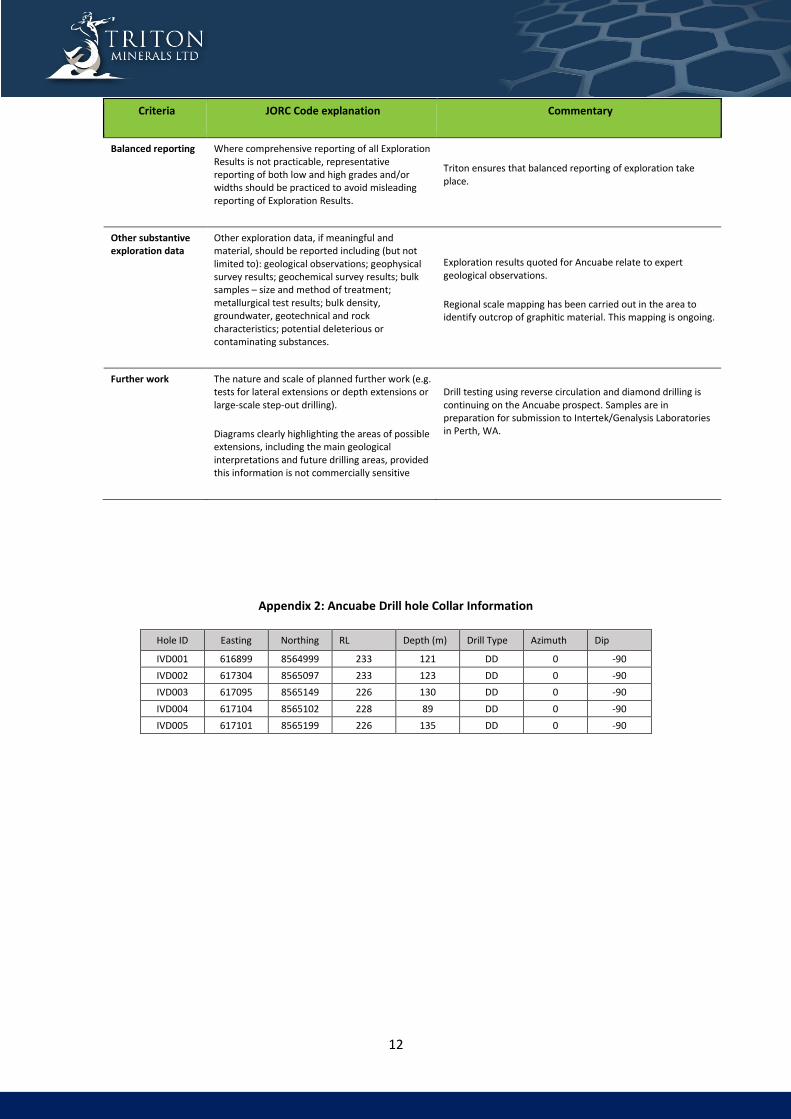
Appendix 2: Ancuabe Drill hole Collar Information
Hole ID Easting Northing RL Depth (m) Drill Type Azimuth Dip
IVD001 616899 8564999 233 121 DD 0 -90
IVD002 617304 8565097 233 123 DD 0 -90
IVD003 617095 8565149 226 130 DD 0 -90
IVD004 617104 8565102 228 89 DD 0 -90
IVD005 617101 8565199 226 135 DD 0 -90

13
Appendix 3: Visual Estimates of Intersected Graphite Mineralisation
HOLE-ID From (m) To(m) Interval (m)
Visual graphite concentration
(% volume)
IVD001 1.47 4.02 2.55 3
IVD001 10.00 10.80 0.80 3
IVD001 12.80 14.87 2.07 6
IVD001 21.28 28.19 6.91 12
IVD001 41.95 52.24 10.29 0.4
IVD001 104.53 105.50 0.97 8
IVD002 0.00 4.08 4.08 5
IVD002 4.08 6.50 2.42 4
IVD002 20.65 26.18 5.53 12
IVD002 29.86 42.45 12.59 9
IVD002 48.80 51.80 3.00 8
IVD002 61.71 72.76 11.05 9
IVD002 76.19 88.00 11.81 9
IVD002 91.00 92.57 1.57 6
IVD003 16.30 36.78 20.48 1.5
IVD003 36.78 62.13 25.35 14
IVD003 72.96 77.94 4.98 15
IVD003 81.09 95.27 14.18 13
IVD003 97.10 103.38 6.28 7
IVD004 22.00 22.80 0.80 5
IVD004 27.57 33.94 6.37 4
IVD004 33.94 42.14 8.20 10
IVD004 47.10 69.17 22.07 12
IVD005 16.79 23.03 6.24 6
IVD005 33.35 36.14 2.79 12
IVD005 55.18 69.52 14.34 10
IVD005 71.86 77.27 5.41 7
IVD005 77.27 117.00 39.73 18