transportation 8 - city of alexandria, vaalexandriava.gov/uploadedfiles/beauregardsapadopted… ·...
TRANSCRIPT

8TRANSPORTATION

120 TransportationBEAUREGARD SMALL AREA PLAN
TRANSPORTATION
The transportation strategy has been designed to maximize the use of transit, pedestrian, and
bicycle amenities, to encourage a shift – from private autos to alternative, more sustainable modes of
transportation, consistent with the City’s Transportation Master Plan. As set out in the City’s Eco-City
Plan as well as the Urban Ecology - Sustainability Chapter (Chapter 6), transportation plays a key role
as the Plan area redevelops and as residents, and visitors are offered a number of mode choices with
which to travel.
The geography that gives Beauregard its special character – also somewhat constrains traditional
roadway street-grid connectivity. The topography, I-395, existing roadways, developed parcels,
and existing parks limit some opportunities for additional east-west streets. However, the Plan
recommends a significant increase in the existing street network through the provision of the
required street grid. In addition, the transportation network is required to include a dedicated high
capacity transit corridor, buses, shuttles, car sharing, pedestrian amenities, and bicycle facilities. An
aggressive Transportation Management Plan (TMP) will be required and parking will be managed,
shared, priced, and designed to minimize car trips. The Plan is designed to allow employees
and residents access to commercial and transit services within a traditional 1/4 mile walk-shed.
Recommendations include strategies to manage transportation demand, expansion of the street grid
and connectivity, provide additional transit capacity, incorporate an expansive bicycle and pedestrian
network and create a culture of people first in a complete streets context.
A. TRANSPORTATION NETWORK:
The transportation network builds on the existing network of primary and local streets, by
developing a new street grid to the extent possible, within the Plan area, to distribute vehicular
traffic, improve traffic flow, and increase pedestrian and bicycle connectivity (Figure 49A). As part of

Transportation 121BEAUREGARD SMALL AREA PLAN
the transportation analysis, a number of transportation network improvements were determined
to be needed. The improvements described below, as well as other proposed transportation
improvements needed by 2035 are further described in Figure 50 and Table 6.
An Ellipse at the intersection of Seminary Road
and Beauregard Street will improve the traffic flow. The Ellipse will eliminate left turns from both
directions along Seminary Road, and redirect those movements in a configuration similar to a
traffic circle in a more efficient manner as right turns.
The primary benefit of the Ellipse is that its configuration reduces potential conflict points due to
the elimination of the left turn movements along Seminary Road. It also provides more capacity for
vehicle storage and therefore improves overall traffic operations along Seminary Road and North
Beauregard Street. Other benefits of the Ellipse include improved pedestrian and bicycle access
across Seminary Road, and improved aesthetics and opportunities for a better urban design as
compared to today’s street configuration.
The Plan provides a coordinated opportunity to construct the Ellipse which benefits multiple
properties. Due to its scale and cost, and required coordination, construction of the Ellipse would
not be possible without the Plan and the roadway network would be overburdened.
The new road will be parallel to Beauregard Street from Sanger
Avenue in the south, to Mark Center Drive. It will be a collector type of roadway serving more
localized traffic of the Plan area.
The transitway in the Plan area will connect to the Van Dorn Metrorail station,
using Beauregard Street (with a short diversion through Southern Towers and Mark Center),
Sanger Avenue and Van Dorn Street. The transitway is consistent with the City Council approved
transitway location. This rapid transit service will also connect to Shirlington and the Pentagon.
The transitway will provide access for high capacity transit in a dedicated guideway along most
Transportation Improvements at Ellipse
Potential signal to protect buses entering and exiting Southern Towers
Vehicular movements
Pedestrian movements
Crosswalk
Hilton Hotel
Southern TowersDevelopment
Hekemian Development

122 TransportationBEAUREGARD SMALL AREA PLAN
Figure 49A: Roadway Classifications

Transportation 123BEAUREGARD SMALL AREA PLAN
of its length, and include elements such as larger stations with real-time information, wayfinding,
improved transit headways, and rapid transit vehicles with greater capacity than a typical local bus.
The Transitway has been designed to incorporate enhanced landscaping.
A series of road improvements
and pedestrian improvements will be constructed in the vicinity of Seminary Road at Interstate
395, as well as at Beauregard Street and Seminary Road, primarily to help mitigate the recently
constructed Washington Headquarters Service BRAC-133 Building.
A more interconnected grid of streets will be built to provide pedestrian,
cyclist and vehicular connectivity within and adjacent to the Plan area.
New High Occupancy Vehicle (HOV) Ramp—The traffic analysis assumes the proposed new HOV
ramp to and from the south at the I-395/Seminary Road interchange. This ramp will be used by
high occupancy vehicles, including transit, vanpools and carpools. The need for, and design of the
ramp will be fully determined after the pending environmental analysis is complete.
Relocated Sanger Avenue —The segment of existing Sanger Avenue between Sheffield Court and
Beauregard Street will be relocated to intersect with Beauregard Street approximately 400 feet
north of the existing Sanger Avenue intersection and connect to the new road west of, and parallel
to Beauregard Street (Figure 49A). Figure 49B: North Beauregard Street

124 TransportationBEAUREGARD SMALL AREA PLAN
Figure 50: Proposed Transportation Improvements
Note: All other streets, sidewalks, and paths depicted as part of the plan
will be required as part of the zoning and development process.

Transportation 125BEAUREGARD SMALL AREA PLAN
Table 6: Proposed Transportation Improvements
A Southern Towers New road and rapid transitway through Southern Towers
B Beauregard at Seminary Ellipse at Seminary Road and Beauregard Street
C Beauregard north of Southern Towers Transitway Improvements for Bus Rapid Transit
D Beauregard between Mark Center Drive and Existing Sanger Provide necessary right of way and widen Beauregard Street and construct a transitway
E Beauregard between Fillmore Avenue and Holmes Run Build Multi-use trail (For bicycles and pedestrians)
F Mark Center Drive (Beauregard to Seminary) Transitway Improvements for Bus Rapid Transit
G Mark Center Drive (Beauregard to Seminary) Provide on-street bicycle facilities
H Seminary Road from Fairbanks Avenue to Library Lane Construct multi-use trail on north side of road
I Relocated Kenmore Avenue and Library Lane Realign Kenmore Road to align with intersection of Seminary Road at Library Lane; Improve pedestrian crossing across Seminary Road
J Beauregard Street at Mark Center Drive Add northbound right turn lane
Reconfigure westbound approach as 3 lanes - 1 left, 1 thru and 1 right turn lane
Reconfigure Sanger Avenue approaches to consist of a one left turn lane and a shared thru/right lane in the eastbound direction, and a right turn lane in the westbound direction.
K Beauregard St at Existing Sanger Avenue Provide permissive left-turn phasing for the Sanger Ave left turns
Provide permissive right turn phasing for westbound Sanger Ave
L Seminary Road at Heritage Lane Add westbound left turn lane
M Seminary Road at Mark Center Drive Widen Mark Center Dr. to allow for southbound dual left turn lanes.
N Van Dorn Street at Braddock Road Northbound and Southbound Lane Approach improvements (One Left, one Thru and one Shared Thru/Right in each direction)
O Van Dorn Street at Sanger Ave / Richenbacher Ave Restriping and widen sidewalk on north side under I-395 bridge
Restripe westbound approach to have a left, and a shared thru/right turn lane
P New Parallel Road to Beauregard Street Construct new parallel road west of Beauregard between Mark Center Drive and relocated Sanger Avenue
Q Relocated Sanger Avenue
Construct new Sanger Avenue
Construct transitway and construct multi-use-trail
R New Local Streets Parallel to Relocated Sanger Avenue Construct new local streets
S Seminary Road at I-395 VDOT Near / Mid Term improvements (Associated with BRAC-133)
T Seminary Road at I-395 VDOT Long Term improvements (Transit/HOV ramp to and from the south)
LOCATIONREF. IMPROVEMENT
126 TransportationBEAUREGARD SMALL AREA PLAN
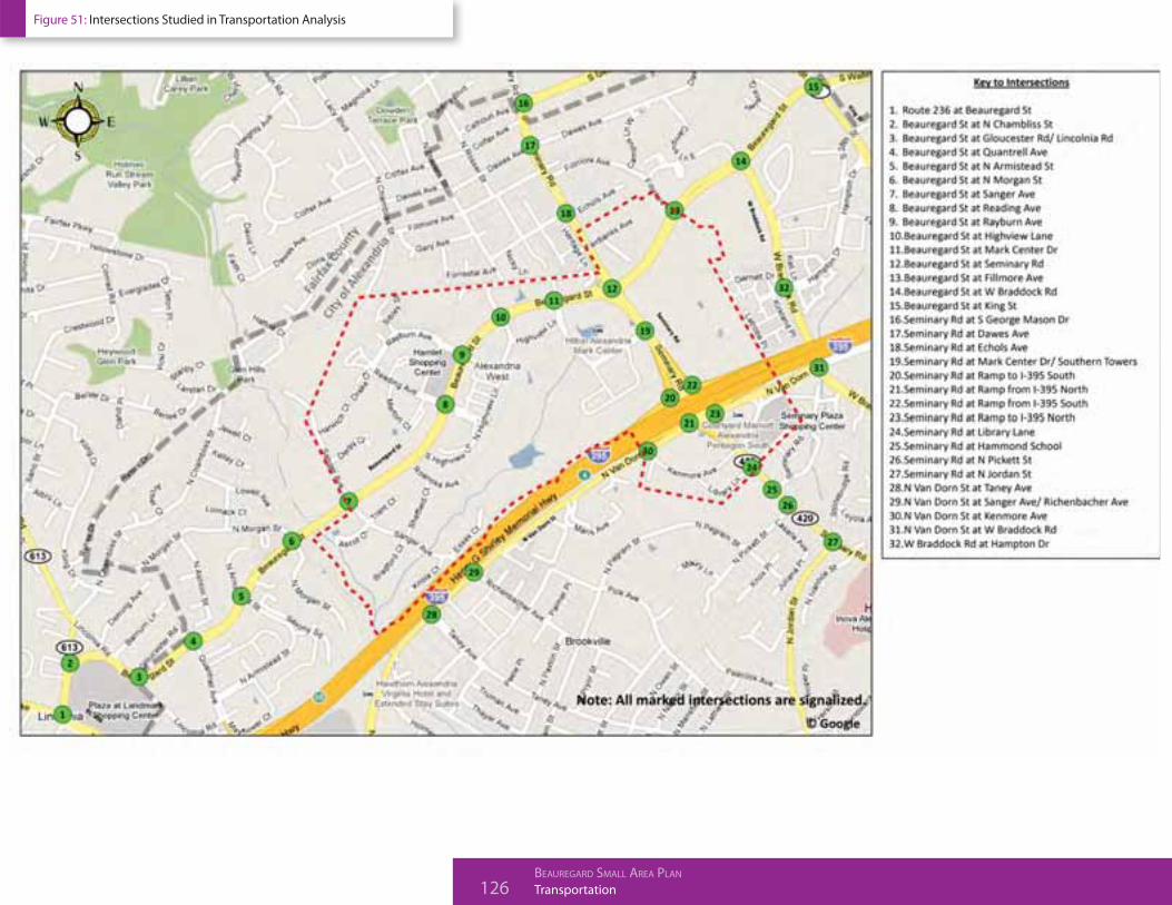
Figure 51: Intersections Studied in Transportation Analysis

Transportation 127BEAUREGARD SMALL AREA PLAN
Pedestrian and Bicycle Network—Streets within the Plan area will include
pedestrian facilities with varying sidewalk or path widths in context of the
surrounding uses. Off-street bicycle facilities will be built along Beauregard
Street, Seminary Road, and Sanger Avenue (Figure 52). There will be improved
pedestrian and bicycle access to commercial, recreational and transit within
the Plan area, and connectivity to adjacent neighborhoods and schools.
B. TRANSPORTATION ANALYSIS:
The comprehensive transportation study undertaken in the development of this
Plan examined the transportation impacts within the defined Plan area, as well
as the surrounding area (Figure 51) and coordinated studies/analysis completed
for Virginia Department of Transportation (VDOT), Department of Defense (DOD),
and Federal Highway Administration (FHWA) initiatives. The transportation study
area for the transportation study extended beyond the Plan boundaries and
included 32 intersections that were studied during both the AM and PM peak
hours (Figure 51).
The transportation analysis performed for the Plan is a planning-level study that
evaluates the impacts associated with the Plan. The study assumed a 25 year build-
out period and assumes changes in regional traffic patterns over that period. All
future redevelopment applications associated with the Plan will require additional
traffic studies to analyze specific impacts based on specific development plans for
each site and will include additional transportation data available at that time
and more refined development information. The studies will also update the traffic
impacts associated with specific development and refine the recommended
improvements to the transportation.
The proposed redevelopment within the Plan area assumed a horizon year of
2035 for purposes of the transportation analysis. Three scenarios were analyzed:
2010 Existing Conditions
Assumes existing development and transportation network.
2035 Baseline Scenario
Assumes regional growth through 2035;
Approved and unbuilt development in Alexandria;
Transitway;
Roadway improvements associated with BRAC-133; and
Transit/HOV ramp to and from the south at I-395 and Seminary Road.
2035 Development Scenario
Assumptions from Baseline Scenario;
Development build-out in the Plan area; and
Additional roadway improvements, such as the Ellipse, needed to support
2035 development.
The analysis assumes increases in traffic attributed to regional growth
including approved development in the Plan area and planned development
in neighboring jurisdictions for future (2035) scenarios. The Plan provides
new roadway connectivity and enhanced transit facilities in and through the
Plan area which provides travel choices in terms of route and mode. The study
showed that with the construction of all the recommended roadway and transit
improvements, the transportation network operates more efficiently in the 2035
Development Scenario than the 2035 Baseline Scenario. This is largely due
to the construction of the Ellipse.

128 TransportationBEAUREGARD SMALL AREA PLAN
A number of factors contribute to improved traffic operations under the 2035
development scenario. These include:
There is a shift of some regional trips to roadways outside of the Plan area;
The interconnected roadway network and mix of land uses result in a greater
shift to other modes such as walking and using transit; and
The transportation improvements, including the ellipse and transitway
improve mobility and traffic operations.
The analysis showed that each of the analyzed intersections within the Plan area
would operate at an overall Level of Service (LOS) E or better during the AM or PM
peak hours in the 2035 Development Scenario with all of the roadway network
enhancements in place. However, there are several intersections within the Plan
area that have individual turning movements that would perform at LOS “F”
during one or both peak hours. These intersections are as follows:
Beauregard Street at Seminary Road;
Beauregard Street at King Street; and
North Van Dorn Street at Sanger Avenue.
C. TRANSPORTATION INFRASTRUCTURE PHASING:
An interim (2020) year analysis was conducted in order to develop a phasing
plan for transportation improvements. The analysis showed that all of the
recommended improvements were needed by 2020 based on 3 million sq. ft. of
additional development, with the exception of the parallel road to Beauregard
Street, and the relocated Sanger Avenue.
2020 Interim Year Development Scenario
a. Assumes regional growth through 2020;
b. Approved and unbuilt development in Alexandria;
c. Proposed Beauregard development (land uses) planned through 2020;
d. High Capacity Transitway;
e. Roadway improvements associated with BRAC-133;
f. Transit/HOV ramp to and from the south at I-395 and Seminary Road; and
g. Road improvements needed to support 2020 development.
Construction of the Ellipse and other transportation infrastructure will be phased
to ensure that adequate transportation infrastructure is in place to support each
phase of development. The Ellipse must be constructed by 2.4 million sq. ft. of
development. Phasing of transitway improvements and contributions are out-
lined in the Implementation Chapter.
D. STREETS AND CONNECTIVITY:
Within the Plan area, there are opportunities to build on the existing street
network to improve connectivity. New streets will be built in a grid pattern to
improve vehicular and non-motorized connections to activity centers, transit
and land uses. In addition, there are opportunities to provide non-motorized
connections to adjacent neighborhoods. This will enable connectivity from
surrounding areas to schools, parks and recreation facilities, commercial and
mixed-use land uses, and transit facilities.
Transportation 129BEAUREGARD SMALL AREA PLAN
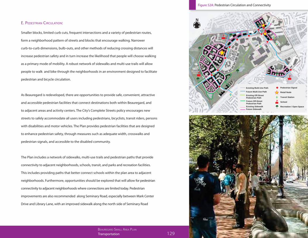
E. PEDESTRIAN CIRCULATION:
Smaller blocks, limited curb cuts, frequent intersections and a variety of pedestrian routes,
form a neighborhood pattern of streets and blocks that encourage walking. Narrower
curb-to-curb dimensions, bulb-outs, and other methods of reducing crossing distances will
increase pedestrian safety and in turn increase the likelihood that people will choose walking
as a primary mode of mobility. A robust network of sidewalks and multi-use trails will allow
people to walk and bike through the neighborhoods in an environment designed to facilitate
pedestrian and bicycle circulation.
As Beauregard is redeveloped, there are opportunities to provide safe, convenient, attractive
and accessible pedestrian facilities that connect destinations both within Beauregard, and
to adjacent areas and activity centers. The City’s Complete Streets policy encourages new
streets to safely accommodate all users including pedestrians, bicyclists, transit riders, persons
with disabilities and motor vehicles. The Plan provides pedestrian facilities that are designed
to enhance pedestrian safety, through measures such as adequate width, crosswalks and
pedestrian signals, and accessible to the disabled community.
The Plan includes a network of sidewalks, multi-use trails and pedestrian paths that provide
connectivity to adjacent neighborhoods, schools, transit, and parks and recreation facilities.
This includes providing paths that better connect schools within the plan area to adjacent
neighborhoods. Furthermore, opportunities should be explored that will allow for pedestrian
connectivity to adjacent neighborhoods where connections are limited today. Pedestrian
improvements are also recommended along Seminary Road, especially between Mark Center
Drive and Library Lane, with an improved sidewalk along the north side of Seminary Road
BEAUREGARD CORRIDOR PLAN | CITY OF ALEXANDRIA, VA
Future Multi-Use Path
Future Off-Street Pedestrian PathExisting Sidewalk
Retail Node
Transit Station
School
Recreation / Open Space
Pedestrian Signal Existing Multi-Use Path
Existing Off-Street Pedestrian Path
Future Sidewalk
N
Figure 52A: Pedestrian Circulation and Connectivity

130 TransportationBEAUREGARD SMALL AREA PLAN
over I-395. Improved pedestrian crossings across Seminary Road are also recommended. These
improvements will help to ensure multi-modal connectivity within the Beauregard area, the
surrounding areas, and thereby help to reduce reliance on the automobile.
F. BICYCLE CIRCULATION:
The Plan creates a network to encourage bicycling as a viable alternative mode to driving. (Figure
52B). When approaching the Plan area from the south, the primary bicycle route is the Holmes
Run Trail. Trail improvements are currently programmed for the Holmes Run Trail, including the
installation of a trail crossing at North Chambliss Street, improvement to the trail tunnels at
I-395 and Van Dorn Street, and the crossing at North Ripley Street. A trail underpass was recently
completed where the Holmes Run Trail/Eisenhower Trail crosses Eisenhower Avenue. Currently this
trail lacks accessible connections to the Plan area. An off-street multi-use trail system will provide for
primary north-south and east-west bicycle connectivity both within the Plan area, and to adjacent
neighborhoods. A north-south trail will be built along Beauregard Street, with a connection to the
Holmes Run trail at the south end of the Plan area. To the north, the trail would eventually connect
to an existing trail within Arlington that provides a connection to Four Mile Run. East-west trails will
be built along Seminary Road, and Sanger Avenue. The trail along Sanger Avenue would connect to
future bike lanes planned along Van Dorn Street. Additional multi-use trails will provide connections
to the adjoining schools, such as John Adams Elementary School, Francis Hammond Middle School,
William Ramsey Elementary School and surrounding neighborhoods.
The slower design speed and urban context of the streets will encourage cyclists to “take the
lane” on all streets where appropriate. However, on-street bicycle facilities on certain streets will
include bicycle lanes to improve bicycle safety and provide a sense of security. This includes an
on-street facility that will be built through the Town Center neighborhood of the Plan area. Roadway
crossings are critical to the connectivity of the bicycle network and intersections will be designed to

Transportation 131BEAUREGARD SMALL AREA PLAN
street the convenience, safety and comfort of cycling. Providing adequate end-of-trip facilities is a
critical component of any bicycle network and especially in transit-oriented developments. The Plan
considers bicycle parking in a number of contexts:
Bicycle parking in connection with public transportation and at major stops along the Transitway;
At homes and at workplaces;
At shops and retail centers; and
On public streets.
To encourage the use of the bicycle as means of transportation, off-street bike parking will be
incorporated in the redevelopment. Bicycle parking areas are recommended to be located on
the ground floors of buildings, close to activity to provide convenience and increase security. A
combination of Class I and Class II spaces should be provided to meet this bicycle parking supply
requirements. Class I bicycle parking facilities provide secure long-bicycle storage by protecting
the entire bicycle, including its components and accessories against theft and inclement weather.
Examples include lockers, check-in facilities, monitored bicycle parking, restricted access bicycle
parking and personal storage. Class II bicycle parking facilities provide short-term bicycle parking
and include bicycle racks at permit the lacking of a bicycle frame and one wheel and support the
bicycle in a stable position without damage to wheels, frame or components. Class I bicycle parking
is required to be provided at residential buildings, and a combination of Class I and Class II parking
is required to be provided at retail and professional services uses at the school and at the fitness/
community center.

132 TransportationBEAUREGARD SMALL AREA PLAN
Figure 52B: Bicycle and Trail Networks
(Multi-use trail)
(Holmes Run trail)

Transportation 133BEAUREGARD SMALL AREA PLAN
G. BIKESHARE:
Bikesharing is a program that allows users to rent a bicycle for short periods of time. Bicycles are
“checked out’ at one station and returned to any station within the system. Members pay based on
the length of time they use the bicycle, thus reducing the costs associated with the personal bicycle
ownership. With stations dispersed throughout the Plan area, these bicycles are meant to be used for
short time periods only and checked in and checked out at the start and end of each trip.
The City will be launching a pilot Bikeshare program in 2012 as part of the regional bikeshare
network. The Plan encourages exploring future expansion to the Plan area.
H. CARSHARE:
Car sharing provides an effective incentive for participants to forego car ownership and rely on transit
as primary mode of travel because they know that a car is readily available when they need one. The
growth and success of these programs in the City and other urban areas throughout the country has
shown their effectiveness in reducing auto dependency. Members pay based on how much they
drive, thus reducing the fixed costs associated with private automobile ownership. Typically, carshare
members are able to reserve a vehicle at each established carshare hub. The Plan encourages as part
of the redevelopment, that the new developments establish carsharing in each building and/or
neighborhood.
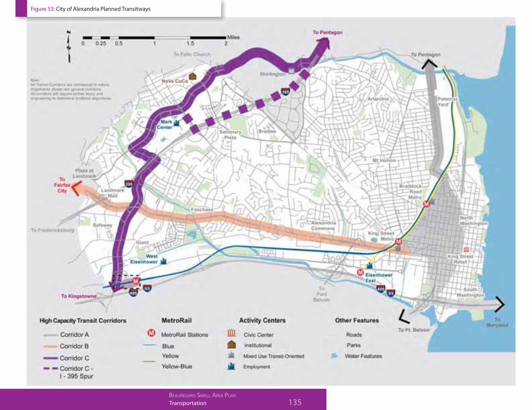
I. HIGH CAPACITY RAPID TRANSITWAY:
A Rapid Transitway will be built to provide high capacity transit service between the Pentagon and
the Van Dorn Metrorail Station, consistent with the City’s 2008 Transportation Master Plan (Figure
53 & 54). This Transitway will include dedicated transit guideways along most of its running way within
Alexandria. The service will operate as a Rapid Transit (RT) system, but the facility will be designed so as to
not preclude future consideration of service as a streetcar. Rapid Transit is a term applied to a variety of public
transportation systems using special rapid transit vehicles to provide faster, frequent, and more efficient
134 TransportationBEAUREGARD SMALL AREA PLAN
service than an ordinary bus line. Often this is achieved by making improvements to existing infrastructure,
vehicles and scheduling. The goal of these systems is to approach the service quality of rail transit while
still enjoying the cost savings and flexibility of bus transit. The City’s DASH transit service, WMATA service
and potential new circulators will be integrated with the Rapid Transitway system, providing access to all
residents who are not located in direct proximity of the newly designated transit corridors.
Within the Plan area, high quality high capacity Rapid Transit stations will be located in both
directions of the Transitway at approximately the following locations (Figure 54):
Van Dorn Street near Sanger Avenue*
Beauregard Street near Sanger Avenue
Beauregard Street near Rayburn Avenue
Mark Center Transit Center
Southern Towers
The Rapid Transit service is anticipated to operate with frequent service, especially during weekday
peak periods. The City has allocated funding in its 10-Year Transportation Improvement Program
toward the design and construction of the Transitway. In addition, the future development is
required to contribute toward the cost of constructing the Transitway and associated elements.
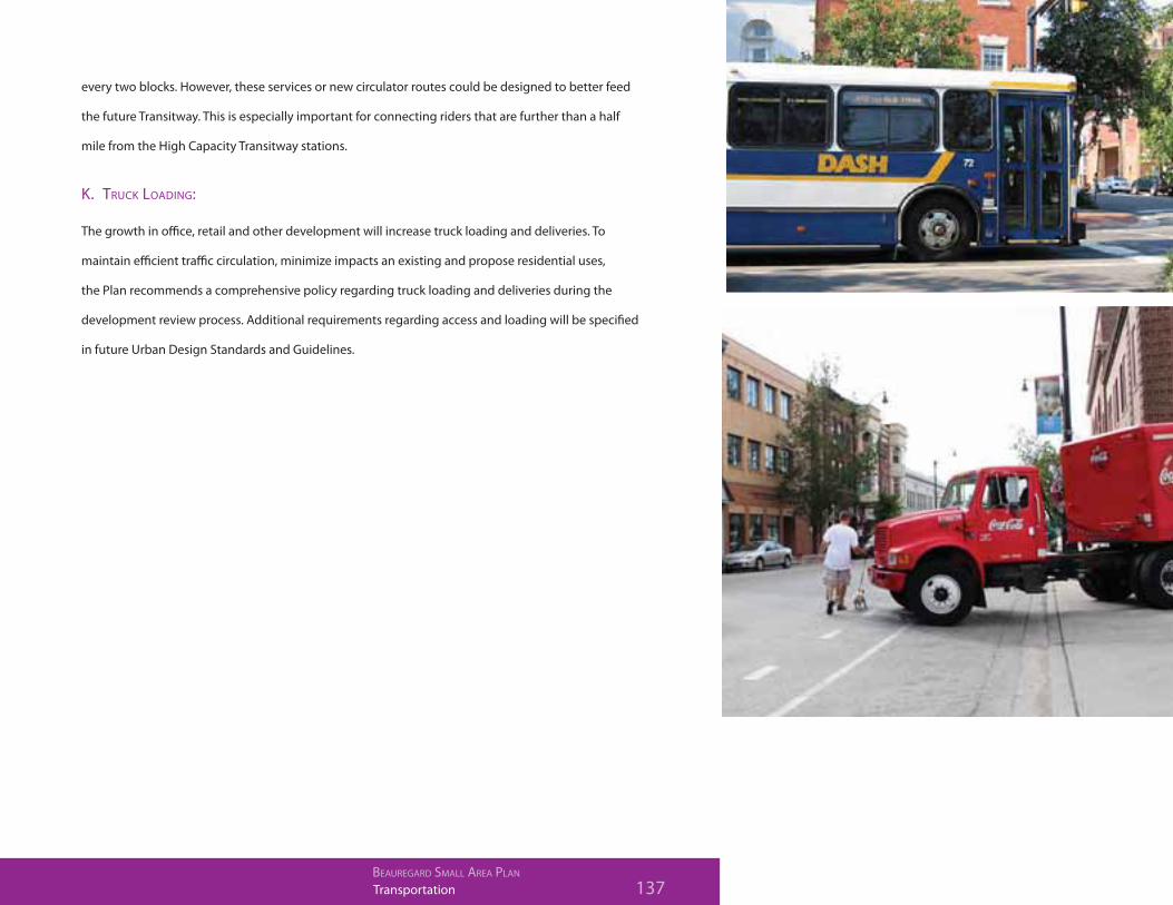
J. LOCAL AND CIRCULATOR TRANSIT SERVICE:
While the Rapid Transitway service is a critical element, other modes of transit will also be provided.
These are local buses operated by DASH and Metrobus that provide valuable connections between
neighborhoods in the City. It is anticipated that the current transit routes, such as Routes AT1 and AT2
and the Metrobus Route 7 series will continue to provide service within the Plan area. Local buses will
most likely continue to operate in the curb lane on Beauregard to serve local stops that are spaced
*Note: This is outside the Plan area
Transportation 135BEAUREGARD SMALL AREA PLAN
Figure 53: City of Alexandria Planned Transitways

136 TransportationBEAUREGARD SMALL AREA PLAN
Figure 54: High Capacity Transitway and Proposed Stops
Transportation 137BEAUREGARD SMALL AREA PLAN
every two blocks. However, these services or new circulator routes could be designed to better feed
the future Transitway. This is especially important for connecting riders that are further than a half
mile from the High Capacity Transitway stations.
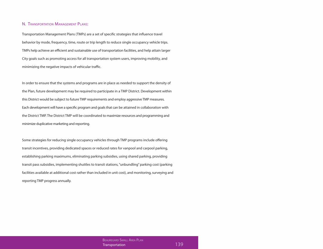
K. TRUCK LOADING:
The growth in office, retail and other development will increase truck loading and deliveries. To
maintain efficient traffic circulation, minimize impacts an existing and propose residential uses,
the Plan recommends a comprehensive policy regarding truck loading and deliveries during the
development review process. Additional requirements regarding access and loading will be specified
in future Urban Design Standards and Guidelines.

138 TransportationBEAUREGARD SMALL AREA PLAN
L. PARKING MANAGEMENT:
Management of on-street and on-site parking is a critical feature of any transportation system
and should be carefully coordinated with the other transportation components of the Plan. On-
street parking spaces will be required to be efficiently managed to maximize turnover of spaces
and encourage garage parking for longer stays. On-street parking spaces may be required to be
metered and be part of a performance parking program to efficiently manage the on- street parking
resources.
Parking garages should employ smart parking technologies including variable pricing and available
parking space technologies. In order to increase parking efficiency and support other parking and
mobility management programs, parking should be unbundled in residential and mixed use garages.
Wayfinding signage should be employed to efficiently direct drivers to parking garages and clearly
indicated price and availability of parking. Parking garage entrance widths should be minimized.
Market rate parking for all uses will be required including the unbundling of parking in residential
development. Parking technologies should be integrated into all new parking structures.
M. ELECTRIC VEHICLES / CHARGING STATIONS:
Electric vehicle (EV) charging stations will become ever more important as drivers consider the switch to
vehicles that reduce fuel use and emissions contributing to global warming. Charging stations should be
installed at key locations to serve drivers using plug-in hybrid vehicles so they can “top off” their batteries and
ensure a round trip. These key locations may include residential, commercial and office parking areas, or
within a parking structure.
Transportation 139BEAUREGARD SMALL AREA PLAN
N. TRANSPORTATION MANAGEMENT PLANS:
Transportation Management Plans (TMPs) are a set of specific strategies that influence travel
behavior by mode, frequency, time, route or trip length to reduce single occupancy vehicle trips.
TMPs help achieve an efficient and sustainable use of transportation facilities, and help attain larger
City goals such as promoting access for all transportation system users, improving mobility, and
minimizing the negative impacts of vehicular traffic.
In order to ensure that the systems and programs are in place as needed to support the density of
the Plan, future development may be required to participate in a TMP District. Development within
this District would be subject to future TMP requirements and employ aggressive TMP measures.
Each development will have a specific program and goals that can be attained in collaboration with
the District TMP. The District TMP will be coordinated to maximize resources and programming and
minimize duplicative marketing and reporting.
Some strategies for reducing single occupancy vehicles through TMP programs include offering
transit incentives, providing dedicated spaces or reduced rates for vanpool and carpool parking,
establishing parking maximums, eliminating parking subsidies, using shared parking, providing
transit pass subsidies, implementing shuttles to transit stations, “unbundling” parking cost (parking
facilities available at additional cost rather than included in unit cost), and monitoring, surveying and
reporting TMP progress annually.

140 TransportationBEAUREGARD SMALL AREA PLAN
TRANSPORTATION REQUIREMENTS
A. Transportation Network
8.1 The transportation network should be designed to mitigate traffic
impacts associated with the Plan and to encourage non-single
occupant vehicle (SOV) modes of transportation.
8.2 To the extent possible, within the BSAP, a grid system of streets
should be designed to distribute vehicular traffic, improve
traffic flow, and increase pedestrian and bicycle accessibility to
residences, businesses, and recreation and open spaces, and
transit facilities.
8.3 The street network should be designed in a manner to encourage
walking, bicycling and transit usage to mitigate traffic issues.
8.4 Consistent with the City’s Complete Streets policy, consider all
users in the future design of streets and streetscapes (i.e. vehicles,
transit, pedestrians, bicyclists).
8.5 Interior traffic circulation patterns should be designed so as to
maximize vehicular, pedestrian and bicycle safety and movement.
8.6 To the extent possible, the street pattern or grid should follow the
natural terrain, minimizing alterations to the natural landscape.
8.7 During the application for Development Special Use Permit
(DSUP) staff shall evaluate additional options for the Beauregard-
Seminary Road intersection to ensure that other options might
be considered in terms of efficiency and level of service (LOS).
While the ellipse configuration shows promise, this option
should be evaluated along with other planned transportation
improvements associated with BRAC and other alternatives
identified in the DSUP process.
B. Transportation Phasing
Prior to the approval of any rezoning for the Plan area, a
transportation infrastructure phasing plan will be approved by
the City and will include all of the transportation improvements
outlined in the Plan (Table 6). All transportation infrastructure
required in the each of the phases of the Plan will be constructed
and operational prior to the certificate of occupancy for that
phase of development. The transportation infrastructure phasing
plan must reflect the following:
Construction of the Ellipse must be completed prior to
issuance of a certificate of occupancy for 2,400,000 square
feet of development.
Construction of the transitway and any cash contributions
shall be constructed and/or contributed according to the
phasing plan outlined in the implementation chapter.
Transportation improvements on property frontages must be
constructed prior to certificate of occupancy for those blocks.
Prior to granting any final densities (DSUP) considered in this
plan, the transportation infrastructure projects described as
well as any refinements to them should be found to address
the goals laid out in this plan and should have a clear and
reliable implementation plan.
C. Streets & Connectivity
8.8 Streets
(a) Consistent with City of Alexandria policy, streets should
be designed as complete streets to accommodate vehicles,
pedestrians on both sides of the street, existing and future transit

Transportation 141BEAUREGARD SMALL AREA PLAN
and bicyclists. Sidewalks and pathways should be developed as
an integral, aesthetic part of the community, that are much more
than simply functional, but that feel like a part of the design plan.
(b) All streets, including North Beauregard Street and Seminary
Road should be walkable (i.e. adequate sidewalks, landscape
buffers, lighting).
(c) To the extent possible, all collector and local streets should
have on-street parking and provide pedestrian refuges, as well
as landscaping, be designed to reduce vehicular speed and
promote pedestrian safety. Pedestrian bulb-outs, crosswalks and
countdown signals should be provided where appropriate to
improve pedestrian safety, visibility and minimize street crossing
lengths.
(d) Streets should be dedicated to the City, with the goal that all
streets be public.
(e) Adequate transportation infrastructure should take into
consideration features within the planning area, including
provision of a transportation hub, as well as connected
infrastructure outside the planning area, such as the
implementation plans for all of the Corridor C transit system.
8.9 Connectivity & Accessibility
(a) All new neighborhoods in the Plan area need to be connected
to the street network within the Plan area; no neighborhood
should be totally self-contained or functionally isolated.
(b) Pedestrian facilities should be designed at an appropriate
width for the context in which they are located (i.e. wider in
commercial and transit station areas) and be compliant with the
Americans with Disabilities Act (ADA).
(c) Appropriately sized landscaped strips or tree wells with trees
and/or plantings should be incorporated to provide an adequate
buffer between the sidewalk and adjacent streets and parking
spaces.
(d) Integrated systems of walking streets or trails should be
established that connect the built environment and natural areas
and open spaces within the Plan area.
8.10 Street Furnishings & Lighting
(a) Streetscape appearances within the Plan area should be
improved to include new sidewalks, street trees, landscaping,
decorative streetlights, benches, trash receptacles, signage, bike
racks etc.
(b) Lighting should be attractive, be pedestrian scale and
promote pedestrian, bicycle and vehicular safety.
D. Transit and Transportation Improvements
8.11 Require dedication of right-of-way to accommodate the high-
capacity transitway as approved by City Council and other
needed transportation improvements as part of a rezoning and
Coordinated Development District Concept Plan.
8.12 The transitway alignment should be consistent with the concept
approved by the City Council on September 17, 2011.
8.13 Explore options to incorporate green technologies into the design
of the dedicated transitway and associated stations.
142 TransportationBEAUREGARD SMALL AREA PLAN
8.14 Transit stations should be attractive, compatible with
neighborhood design, protect riders from the elements and be
designed to include real-time transit information, innovative
display technologies and rider information including route maps,
schedules, and local and regional information.
8.15 Locate high-capacity transit stations to maximize accessibility
and ridership, be operationally efficient and connect to other
modes, including pedestrian and bicycle facilities, local and
regional transit. DSUP applications shall not be approved unless
the approval authorities have reviewed and made a finding that
in their judgment Corridor C is proceeding as planned.
8.16 Rezoning of the properties is contingent upon the City and the
landowners agreeing to a financial plan funding the transitway
and other needed and identified transportation improvements.
8.17 Examine the need to reconfigure existing transit service to better
serve the neighborhood and connect to stops along the future
transitway, and consider a potential transit circulator service
within the Plan area.
E. Bicycles and Pedestrians
8.18 Provide adequate pedestrian and bicycle facilities to provide
viable alternatives to motorized travel within the community.
8.19 Incorporate a comprehensive and connected on and off-street
bicycle network and signage within the Plan area, consistent with
the proposed bicycle system (Figure 52).
8.20 Provide improved pedestrian connectivity along the north side
of Seminary Road across I-395 (between Mark Center Drive and
Library Lane, as part of the VDOT ramp improvements.
8.21 Intersections by schools will be designed to minimize crossing
distances for pedestrians. Non-motorized connectivity, with
sidewalks and shared-use paths, will be provided between schools
and adjacent neighborhoods.
8.22 Ensure that adequate bicycle parking (Class I and Class II), in
compliance with Alexandria’s Bicycle Parking Standards, is
provided within public and private uses, including residential,
commercial, recreational, office and transit areas, to serve all
bicyclists’ needs. Provide centralized, long and short term bicycle
storage facilities, in visible locations near public recreation and
open space, retail, office and other commercial uses, and transit
facilities.
8.23 Provide pedestrian improvements along Seminary Road over
I-395.
8.24 The shared use paths should be designed to enhance pedestrian
and bicycle safety, especially at driveways, street intersections
and across the proposed ellipse. Shared use paths will be a
minimum of 10 feet wide.
8.25 Locations for future bike share facilities should be designated at
key strategic locations within the Plan area, such as near the Mark
Center Transit Center, the future transitway stations, and at major
commercial or mixed use nodes.
8.26 Commuter and recreational bicycle information should be
available to residents, workers and visitors.
8.27 Crosswalks should be designed so that slow moving pedestrians
(such as the elderly, disabled and parents with young children)
are not deterred from walking by fear of crossing streets.
Transportation 143BEAUREGARD SMALL AREA PLAN
8.28 Amenities in the form of rest areas, benches, points of interest,
public art and the like should enhance the walking experience
and encourage people to stop/pause and interact with one
another.
8.29 Consider bike sharing program in new developments.
F. Transportation Demand Management
8.30 Require participation in an area wide Transportation
Management Plan (TMP) as part of any Development Special Use
Permit (DSUP) application, consistent with the City’s revised TMP
ordinance.
8.31 Explore additional local-serving transit routes or circulators to
connect locations within the BSAP to nearby communities and
destinations.
G. Truck Loading
8.32 Each development will be required to submit a comprehensive
approach and policy regarding truck loading and deliveries as
part of the development review process.
(a) Dumpsters/trash areas must be well screened from public
view to the extent possible and practicable;
(b) There should be defined hours during which dumpsters can
be emptied;
(c) Ensure adequately sized loading docks based upon use; and
(d) Incorporate measures to mitigate potential noise impacts
associated with truck loading.
H. Parking Strategy
8.33 Evaluate, and if staff finds appropriate, require the installation of
real-time parking occupancy technologies in new shared parking
facilities in the Plan area to monitor and manage parking demand
and to reduce traffic congestion.
8.34 Evaluate, and if staff finds appropriate, require the unbundling of
parking.
8.35 Provide infrastructure for accommodating the use of electrical
vehicles.
Reference Chapter 4 - Land Use recommendations for additional
Parking Strategy recommendations.
