transport, access and mobility · 2015-09-23 · gta consultants undertook traffic movement counts...
TRANSCRIPT
1 Beryl Avenue
Oakleigh South
Transport, Access and Mobility
Statement
Client // Sim Development Pty Ltd
Office // VIC
Reference // 14M2157000
Date // 22/06/15
© GTA Consultants (GTA Consultants (VIC) Pty Ltd) 2014
The information contained in this document is confidential and
intended solely for the use of the client for the purpose for which it has
been prepared and no representation is made or is to be implied as
being made to any third party. Use or copying of this document in
whole or in part without the written permission of GTA Consultants
constitutes an infringement of copyright. The intellectual property
contained in this document remains the property of GTA Consultants.
Bla
nk R
ep
ort
140829 v
7.9
)
1 Beryl Avenue
Oakleigh South
Transport, Access and Mobility Statement
Issue: C 22/06/15
Client: Sim Development Pty Ltd
Reference: 14M2157000
GTA Consultants Office: VIC
Quality Record
Issue Date Description Prepared By Checked By Approved By Signed
A 27/10/14 Final Marcus Bennett Ben Simpson Simon Davies Original Signed
B 19/06/15 Final for Submission Andrew Hamer
& Ben Simpson Ben Simpson Simon Davies Original Signed
C 22/06/15 Final – Minor
Amendments
Andrew Hamer
& Ben Simpson Ben Simpson Simon Davies
14M2157000 // 22/06/15
Transport, Access and Mobility Statement // Issue: C
1 Beryl Avenue, Oakleigh South
Table of Contents
1. Introduction 1
1.1 Background 1
1.2 Purpose of this Report 1
1.3 References 2
2. Existing Conditions 3
2.1 Subject Site 3
2.2 Road Network 4
2.3 Sustainable Transport Infrastructure 7
2.4 SmartRoads Policy 9
3. Proposed Subdivision 11
3.1 Land Uses 11
3.2 Site Access 12
4. Traffic Considerations 13
4.1 Traffic Generation 13
4.2 Traffic Impact– Peak Hour 15
4.3 Traffic Impact – Daily 18
5. Access and Mobility Management 20
5.1 Preamble 20
5.2 Walking & Cycling 20
5.3 Public Transport Integration 21
5.4 Neighbourhood Street Network 22
5.5 Other Matters 22
6. Conclusion 24
Appendices
A: SIDRA Intersection Assessment – Existing Conditions
B: SIDRA Intersection Assessment – Post Development Conditions
C: AutoTURN Swept Path Assessment
Figures
Figure 2.1: Subject Site and its Environs 3
Figure 2.2: Land Use Zoning Map 4
14M2157000 // 22/06/15
Transport, Access and Mobility Statement // Issue: C
1 Beryl Avenue, Oakleigh South
Figure 2.3: Beryl Avenue (Adjacent tSite, looking east) 5
Figure 2.4: Beryl Avenue (Adjacent to Site, looking west) 5
Figure 2.5: Golf Road (Adjacent to Site, looking north) 5
Figure 2.6: Golf Road (Adjacent to Site, looking south) 5
Figure 2.7: Existing AM Peak Hour Traffic Volumes 6
Figure 2.8: Existing PM Peak Hour Traffic Volumes 7
Figure 2.9: Nearby Public Transport Map 8
Figure 2.10: Nearby Cycling Routes 9
Figure 2.11: VicRoads SmartRoads Network Operating Plan - Monash 10
Figure 3.1: Proposed Site Layout Plan (Madisson Projects) 11
Figure 3.2: Proposed Site Access Arrangements 12
Figure 4.1: Adopted Distribution – Site Generated Traffic 14
Figure 4.2: Anticipated AM Peak Hour Site Generated Traffic Volumes 14
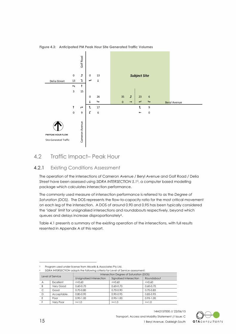
Figure 4.3: Anticipated PM Peak Hour Site Generated Traffic Volumes 15
Figure 4.4: Post-Development Traffic Volumes - AM Peak Hour 16
Figure 4.5: Post-Development Traffic Volumes - PM Peak Hour 17
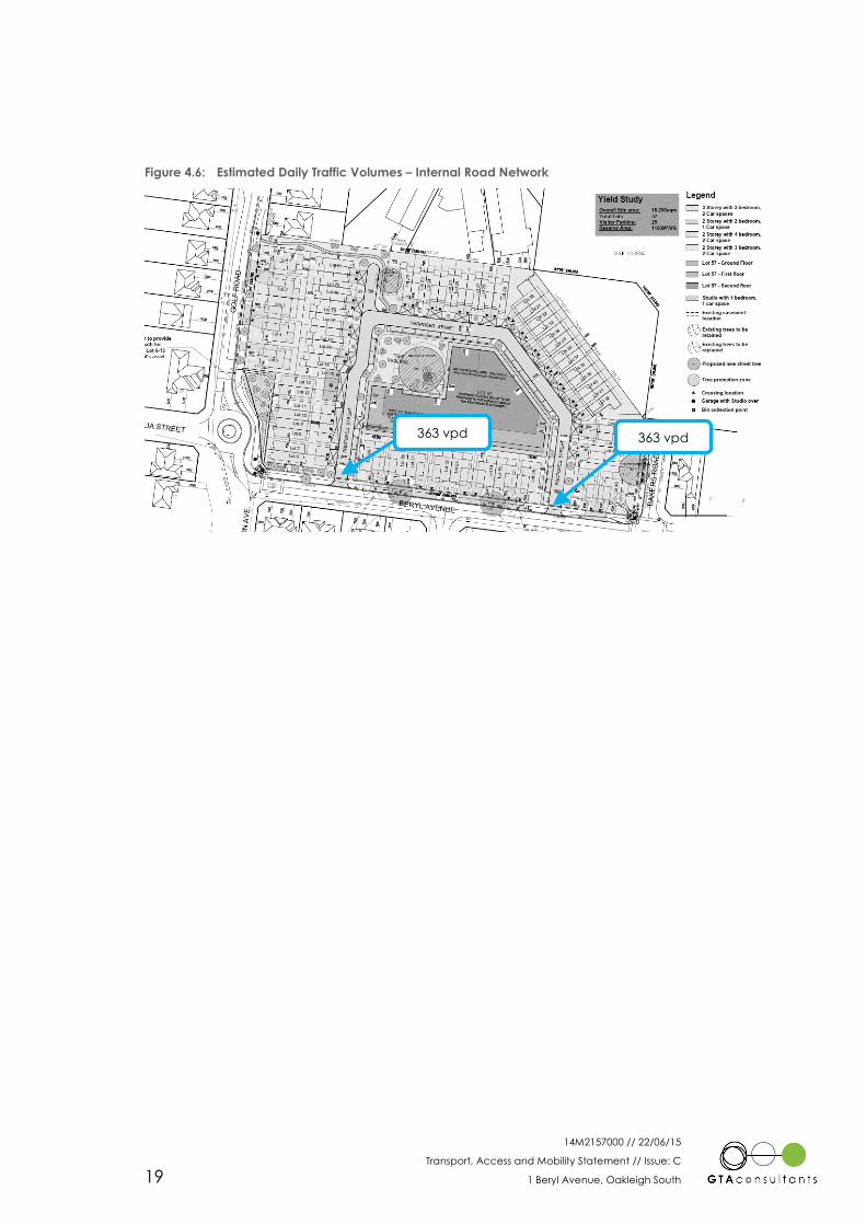
Figure 4.6: Estimated Daily Traffic Volumes – Internal Road Network 19
Tables
Table 2.1: Road Based Public Transport Provision 8
Table 4.1: Nearby Intersections – Existing Operating Conditions 16
Table 4.2: Nearby Intersections – Immediate Post-Development Operating Conditions 17
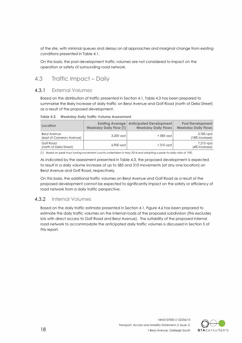
Table 4.3: Weekday Daily Traffic Volume Assessment 18

14M2157000 // 22/06/15
Transport, Access and Mobility Statement // Issue: C
1 Beryl Avenue, Oakleigh South 1
1. Introduction
1.1 Background
GTA Consultant’s completed a Transport Impact Assessment Report for previous development
scheme for a residential development on land located at 1 Beryl Avenue in Oakleigh South.
Following discussions with Council and a preliminary Request for Information (RFI) from Council,
the development plan has been amended to address a number of issues.
The residential development currently comprises a total of 56 dwellings and an apartment lot
ultimately anticipated to yield in the order of 60-65 dwellings (Lot 57). Access is proposed via two
intersections to Beryl Avenue, with dwellings abutting Beryl Avenue and Golf Road having direct
road access via separate crossovers.
The residential development comprises:
1 x single bedroom studio (over garage) with one (1) garage car space
8 x 2 bedroom dwellings with one (1) garage car space
32 x 3 bedroom dwellings with two (2) garage car spaces
15 x 4 bedroom dwellings with two (2) garage car spaces
60-65 apartment dwellings (Lot 57) with basement parking (or otherwise approved by
the Responsible Authority).
GTA Consultants (GTA) was originally commissioned by Sim Development Pty Ltd in May 2014 to
undertake a transport, access and mobility assessment of the proposed development.
1.2 Purpose of this Report
This report sets out an assessment of the anticipated traffic and transport implications of the
proposed subdivision, including consideration of:
i the existing street network and traffic conditions surrounding the site
ii the adequacy of the proposed pedestrian, bicycle and public transport access
arrangements to the site
iii the road hierarchy within the subdivision
iv the proposed access arrangements for the subdivision
v the acceptability of the traffic impacts of the proposed subdivision, including the need
for mitigating road works and appropriate vehicular access.
Noting that the internal loop road is proposed to be vested with Council, the assessment also
compares the development against the relevant sections of Clause 56 of the Monash Planning
Scheme, which includes a number of provisions comprising objectives and standards for
implementation within the design of new subdivision. The Clause states the following in respect to
objectives and standards:
“Objectives. An objective describes the desired outcome to be achieved in the
completed subdivision.
Standards. A standard contains the requirements to meet the objective.
A standard should normally be met. However, if the responsible authority is satisfied
that an application for an alternative design solution meets the objective, the
alternative design solution may be considered.”
1
14M2157000 // 22/06/15
Transport, Access and Mobility Statement // Issue: C
1 Beryl Avenue, Oakleigh South 2
The relevant traffic and access areas of Clause 56 that will be considered within this report are
included within the following sub clauses:
Clause 56.06 – Access and Mobility Management.
It is noted that some areas of Clause 56.06 are not within the realms of the expertise of traffic
engineers or possible to be considered at the planning permit stage of the development, and
therefore would be assessed by the relevant consultants at the appropriate time.
Further to the above, Schedule 5 to the Development Plan Overlay (DPO5) under the Monash
Planning Scheme necessitates that a Traffic Management Report is required for submission as
part of the development plan. DPO5 more specifically nominates:
“A traffic management report and car parking plan which includes:
Identification of roads, pedestrian, cyclist and vehicle access locations, including
parking areas, both internal and external to the site.
Traffic management measures, where required
Location and linkages to public transport.
Car parking rates for all uses, including visitor parking.
Provision for bicycle facilities.”
1.3 References
In preparing this report, reference has been made to the following:
plans for the proposed amended development prepared by Madisson Projects, dated
20/04/15
Monash Planning Scheme
Australian Standard / New Zealand Standard, Parking Facilities (AS2890)
VicRoads Access Management Policies May 2006 Version 1.02 (Guidelines to Transport
Impact Assessment Reports For major land use and development proposals)
traffic surveys undertaken by GTA as referenced in the context of this report
an inspection of the site and its surrounds
other documents as nominated.

14M2157000 // 22/06/15
Transport, Access and Mobility Statement // Issue: C
1 Beryl Avenue, Oakleigh South 3
2. Existing Conditions
2.1 Subject Site
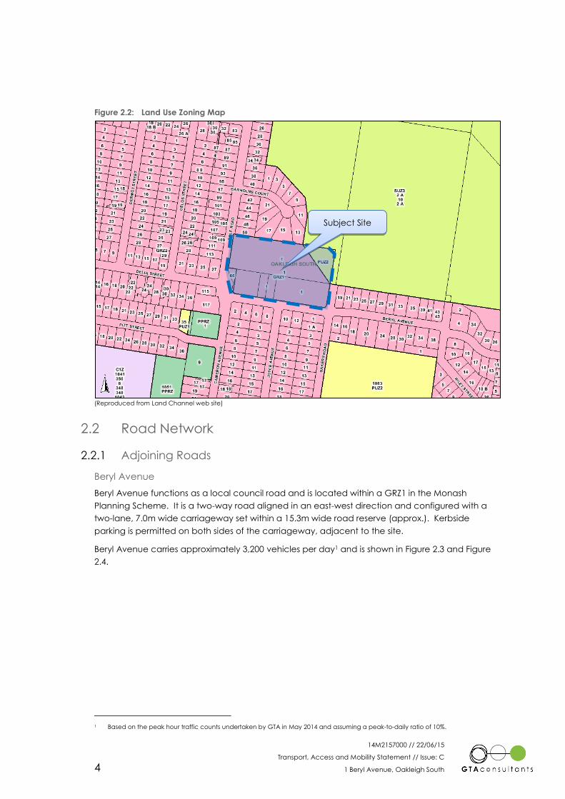
The subject site is located at 1 Beryl Avenue in Oakleigh South. The site of approximately
18,250sqm has a western frontage of 110m to Golf Road and a southern frontage of 170m to Beryl
Avenue.
The site is located within a General Residential Zone 1 (GRZ1) and is currently unoccupied. The
surrounding properties are predominantly residential in nature. The notable exceptions include
the Huntingdale Golf Course located to the north-east of the site and South Oakleigh Secondary
College to the southeast of the site.
The location of the subject site and the surrounding environs is shown in Figure 2.1, and the land
zoning is shown in Figure 2.2.
Figure 2.1: Subject Site and its Environs
(Reproduced with Permission from Melway Publishing Pty Ltd)
Subject Site
2
14M2157000 // 22/06/15
Transport, Access and Mobility Statement // Issue: C
1 Beryl Avenue, Oakleigh South 4
Figure 2.2: Land Use Zoning Map
(Reproduced from Land Channel web site)
2.2 Road Network
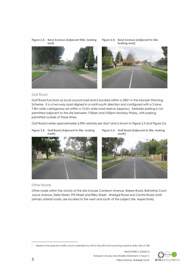
Adjoining Roads 2.2.1
Beryl Avenue
Beryl Avenue functions as a local council road and is located within a GRZ1 in the Monash
Planning Scheme. It is a two-way road aligned in an east-west direction and configured with a
two-lane, 7.0m wide carriageway set within a 15.3m wide road reserve (approx.). Kerbside
parking is permitted on both sides of the carriageway, adjacent to the site.
Beryl Avenue carries approximately 3,200 vehicles per day1 and is shown in Figure 2.3 and Figure
2.4.
1 Based on the peak hour traffic counts undertaken by GTA in May 2014 and assuming a peak-to-daily ratio of 10%.
Subject Site
14M2157000 // 22/06/15
Transport, Access and Mobility Statement // Issue: C
1 Beryl Avenue, Oakleigh South 5
Figure 2.3: Beryl Avenue (Adjacent tSite, looking
east)
Figure 2.4: Beryl Avenue (Adjacent to Site,
looking west)
Golf Road
Golf Road functions as local council road and is located within a GRZ1 in the Monash Planning
Scheme. It is a two-way road aligned in a north-south direction and configured with a 2-lane,
7.8m wide carriageway set within a 15.5m wide road reserve (approx.). Kerbside parking is not
permitted adjacent to the site between 7:00am and 5:00pm Monday-Friday, with parking
permitted outside of these times.
Golf Road carries approximately 6,900 vehicles per day2 and is shown in Figure 2.5 and Figure 2.6.
Figure 2.5: Golf Road (Adjacent to Site, looking
north)
Figure 2.6: Golf Road (Adjacent to Site, looking
south)
Other Roads
Other roads within the vicinity of the site include Cameron Avenue, Bakers Road, Barholme Court,
Joyce Avenue, Delia Street, Pitt Street and Riley Street. Warrigal Road and Centre Road, both
primary arterial roads, are located to the west and south of the subject site, respectively.
2 Based on the peak hour traffic counts undertaken by GTA in May 2014 and assuming a peak-to-daily ratio of 10%.
14M2157000 // 22/06/15
Transport, Access and Mobility Statement // Issue: C
1 Beryl Avenue, Oakleigh South 6
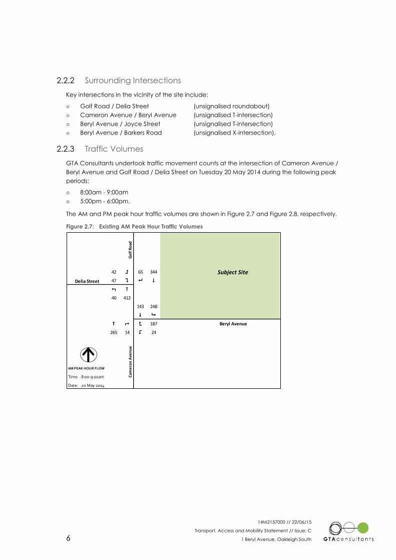
Surrounding Intersections 2.2.2
Key intersections in the vicinity of the site include:
Golf Road / Delia Street (unsignalised roundabout)
Cameron Avenue / Beryl Avenue (unsignalised T-intersection)
Beryl Avenue / Joyce Street (unsignalised T-intersection)
Beryl Avenue / Barkers Road (unsignalised X-intersection).
Traffic Volumes 2.2.3
GTA Consultants undertook traffic movement counts at the intersection of Cameron Avenue /
Beryl Avenue and Golf Road / Delia Street on Tuesday 20 May 2014 during the following peak
periods:
8:00am - 9:00am
5:00pm - 6:00pm.
The AM and PM peak hour traffic volumes are shown in Figure 2.7 and Figure 2.8, respectively.
Figure 2.7: Existing AM Peak Hour Traffic Volumes
42 = 65 344
Delia Street 47 ? 8 $
: #
40 412
143 248
$ 9
# ; < 187 Beryl Avenue
265 14 > 24
AM PEAK HOUR FLOW
Time: 8:00-9:00am
Date: 20 May 2014
Subject Site
Cam
ero
n A
ven
ue
Go
lf R
oad

14M2157000 // 22/06/15
Transport, Access and Mobility Statement // Issue: C
1 Beryl Avenue, Oakleigh South 7
Figure 2.8: Existing PM Peak Hour Traffic Volumes
Accident History 2.2.4
A review of the reported casualty accident history for the roads and intersections adjoining the
subject site has been sourced from VicRoads CrashStats accident database. This database
records all accidents causing injury that have occurred in Victoria since 1987 (as recorded by
Victorian Police).
A review of the accidents in the vicinity of the site for the last available five year period (1
January 2009 till 31 December 2013) indicates that no recorded accidents occurred in the vicinity
of the subject site.
2.3 Sustainable Transport Infrastructure
Public Transport 2.3.1
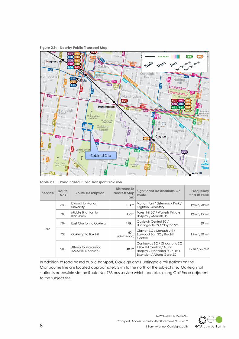
Figure 2.9 shows the subject site in relation to existing public transport routes within its vicinity whilst
Table 2.1 summarises the road based routes and major destinations that can be reached using
these services.
16 = 65 183
Delia Street 13 ? 8 $
: #
25 259
129 67
$ 9
# ; < 78 Beryl Avenue
206 5 > 8
PM PEAK HOUR FLOW
Time: 5:00-6:00pm
Date: 20 May 2014
Cam
ero
n A
ven
ue
Go
lf R
oad
Subject Site
14M2157000 // 22/06/15
Transport, Access and Mobility Statement // Issue: C
1 Beryl Avenue, Oakleigh South 8
Figure 2.9: Nearby Public Transport Map
Table 2.1: Road Based Public Transport Provision
Service Route
Nos Route Description
Distance to
Nearest Stop
(m)
Significant Destinations On
Route
Frequency
On/Off Peak
Bus
630 Elwood to Monash
University 1.1km
Monash Uni / Elsternwick Park /
Brighton Cemetery 12min/20min
703 Middle Brighton to
Blackburn 450m
Forest Hill SC / Waverly Private
Hospital / Monash Uni 12min/15min
704 East Clayton to Oakleigh 1.8km Oakleigh Central SC /
Huntingdale PS / Clayton SC 60min
733 Oakleigh to Box Hill 60m
(Golf Road)
Clayton SC / Monash Uni /
Burwood East SC / Box Hill
Central
15min/30min
903 Altona to Mordialloc
(SMARTBUS Service) 480m
Centreway SC / Chadstone SC
/ Box Hill Central / Austin
Hospital / Northland SC / DFO
Essendon / Altona Gate SC
12 min/25 min
In addition to road based public transport, Oakleigh and Huntingdale rail stations on the
Cranbourne line are located approximately 2km to the north of the subject site. Oakleigh rail
station is accessible via the Route No. 733 bus service which operates along Golf Road adjacent
to the subject site.
Subject Site
14M2157000 // 22/06/15
Transport, Access and Mobility Statement // Issue: C
1 Beryl Avenue, Oakleigh South 9
Pedestrian Infrastructure 2.3.2
Sealed pedestrian footpaths are located along both sides of Beryl Avenue and Golf Road in the
vicinity of the subject site, providing access to nearby bus services and connections to nearby
arterial roads via Delia Street and Cameron Avenue. The sealed footpath widens along the
eastern side of Golf Road to provide a shared pedestrian / cycling facility.
A flagged school crossing is located on Golf Road, immediately north of Delia Street.
Cycling Infrastructure 2.3.3
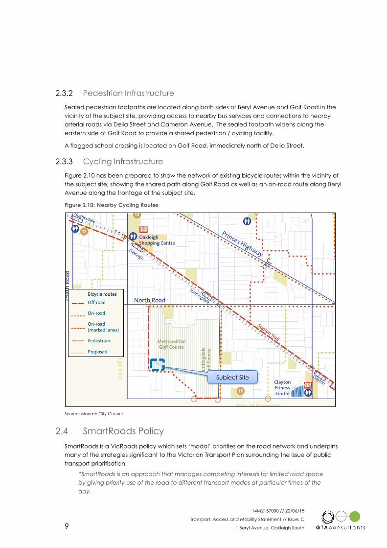
Figure 2.10 has been prepared to show the network of existing bicycle routes within the vicinity of
the subject site, showing the shared path along Golf Road as well as an on-road route along Beryl
Avenue along the frontage of the subject site.
Figure 2.10: Nearby Cycling Routes
Source: Monash City Council
2.4 SmartRoads Policy
SmartRoads is a VicRoads policy which sets ‘modal’ priorities on the road network and underpins
many of the strategies significant to the Victorian Transport Plan surrounding the issue of public
transport prioritisation.
“SmartRoads is an approach that manages competing interests for limited road space
by giving priority use of the road to different transport modes at particular times of the
day.
Subject Site

14M2157000 // 22/06/15
Transport, Access and Mobility Statement // Issue: C
1 Beryl Avenue, Oakleigh South 10
All road users will continue to have access to all roads. However, certain routes will be
managed to work better for cars while others will be managed for public transport,
cyclists and pedestrians.”3
The VicRoads SmartRoads Network Operating Plan for the area surrounding the subject site has
been reproduced in Figure 2.11.
Figure 2.11: VicRoads SmartRoads Network Operating Plan - Monash
Figure 2.11 illustrates that Gold Road and Cameron Avenue (as well as sections of Huntingdale
Road and North Road in the vicinity of the subject site) are nominated bicycle priority routes. No
internal precinct roads are nominated for modal priority.
In addition, Centre Road, Warrigal Road and North Road are all nominated as bus priority routes.
3 Sourced from VicRoads
Subject Site

14M2157000 // 22/06/15
Transport, Access and Mobility Statement // Issue: C
1 Beryl Avenue, Oakleigh South 11
3. Proposed Subdivision
3.1 Land Uses
The master plan prepared by Madisson Projects contemplates the development of a total of 56
dwellings and 60-65 apartment dwellings (i.e. Lot 57). The development proposal application
comprises the following:
1 x single bedroom studio (over garage) with one (1) garage car space
8 x 2 bedroom dwellings with one (1) garage car space
32 x 3 bedroom dwellings with two (2) garage car spaces
15 x 4 bedroom dwellings with two (2) garage car spaces
60-65 apartment dwellings (i.e. within lot 57) with resident and visitor basement parking
(or otherwise approved by the Responsible Authority).
It is proposed to provide car parking spaces in accordance with (or greater than) Monash
Planning Scheme quantum requirements, including 103 private garage spaces and 20 on-street
visitor spaces. Parking for the apartment building (Lot 57) is to be provided in the basement for
both residents and visitors.
The master plan for the subject site is reproduced in Figure 3.1 for reference.
Figure 3.1: Proposed Site Layout Plan (Madisson Projects)
3
14M2157000 // 22/06/15
Transport, Access and Mobility Statement // Issue: C
1 Beryl Avenue, Oakleigh South 12
3.2 Site Access
Vehicle access is primarily proposed via two intersections to Beryl Avenue. Dwellings with Beryl
Avenue or Golf Road frontages have direct vehicle crossover access (15 dwellings in total and 8
single/double crossovers).
Pedestrian access will be provided via two connections to Beryl Avenue, as well as a single
connection to the existing shared path located along Golf Road at the north-western corner of
the site.
Proposed access arrangements for the subject site are shown in Figure 3.2.
Figure 3.2: Proposed Site Access Arrangements
The internal loop road is proposed to be vested with Council and generally comprises:
a 14.0m wide reserve with a 6.0m carriageway
2.3m wide indented parking
1.2m wide pedestrian path on one side of the road.
Vehicular access
Private driveway
Pedestrian / cycle access
14M2157000 // 22/06/15
Transport, Access and Mobility Statement // Issue: C
1 Beryl Avenue, Oakleigh South 13
4. Traffic Considerations
4.1 Traffic Generation
Design Rates 4.1.1
A single house on a standard lot in an outer metropolitan area will typically generate up to 1 trip
in the peak hour and 8 to 10 trips per day. Medium density dwellings generally exhibit a lower
traffic generation rate. In the outer metropolitan areas, where public transport accessibility is
relatively low, the rate for medium density units is typically in the order of 6 to 8 trips per day.
Closer to the Melbourne CAD the rate reduces to in the order of 3 to 6 trips per day depending
on dwelling size, parking provisions and accessibility to public transport and local amenities,
among other things. Peak hour rates are typically 10–12% of daily rates.
In addition, reference has also been made to the Victorian Integrated Survey of Travel Activity
(VISTA) 2009/10. For the municipality of Monash, this database suggests a generation rate of 5.1
vehicle trips per household per day.
On the basis of the above, and in order to present a conservative assessment on the high side, a
generation rate of 0.6 and 6 vehicle movements per dwelling has been adopted for the per peak
hour and daily assessment periods, respectively.
Application of the above design rates suggests that the proposed subdivision (121 dwellings4) will
generate the following vehicle movements:
Weekday AM & PM peak hour: 73 vph
Daily: 726 vpd
Distribution and Assignment 4.1.2
Distribution and assignment will be influenced by a number of factors, including the:
i configuration of the internal road network
ii location of vehicle access points to the site
iii surrounding local and arterial road network
iv surrounding employment and attraction centres in relation to the site.
Having consideration to the above, for the purposes of estimating vehicle movements, it has
been assumed that traffic will
Beryl Avenue West (80%) – distributed as follows:
o North (Golf Road): 60%
o South (Cameron Avenue): 20%
Beryl Avenue East (20%) – accessing Centre Road via either Bakers Road or Riley Street.
For reference, the adopted distribution to/from the subject site is shown in Figure 4.1. For
assessment purposes, all access to/from the subject site is depicted as a single point on Beryl
Avenue (conservatively including lots which have direct access to Beryl Avenue and Golf Road).
4 56 dwellings + up to 65 apartment dwellings.
4

14M2157000 // 22/06/15
Transport, Access and Mobility Statement // Issue: C
1 Beryl Avenue, Oakleigh South 14
Figure 4.1: Adopted Distribution – Site Generated Traffic
In addition to the above, the following directional distributions have been adopted:
AM Peak Hour: 20% Inbound, 80% Outbound
PM Peak Hour: 60% Inbound, 40% Outbound.
Based on the above, Figure 4.2 and Figure 4.3 have been prepared to show the estimated
increase in turning movements in the immediate vicinity of the subject site following full site
development during the weekday AM and PM peak hour periods, respectively.
Figure 4.2: Anticipated AM Peak Hour Site Generated Traffic Volumes
0% = 0% 30%
Delia Street 30% ? 8 $
: #
10% 50%
0% 60% 80% = 80% 20%
$ 9 8 9 Beryl Avenue
# ; < 60% < 20%
0% 20% > 20%
Outbound movements
Inbound movements
Go
lf R
oad
Subject SiteC
amer
on
Ave
nu
e
0 = 0 5
Delia Street 5 ? 8 $
: #
6 29
0 9 12 = 46 12
$ 9 0 " 8 9 Beryl Avenue
# ; < 35 < 3
0 3 > 12 ! 0
AM PEAK HOUR FLOW
Site-Generated Traffic
Go
lf R
oad
Subject Site
Cam
ero
n A
ven
ue
14M2157000 // 22/06/15
Transport, Access and Mobility Statement // Issue: C
1 Beryl Avenue, Oakleigh South 15
Figure 4.3: Anticipated PM Peak Hour Site Generated Traffic Volumes
4.2 Traffic Impact– Peak Hour
Existing Conditions Assessment 4.2.1
The operation of the intersections of Cameron Avenue / Beryl Avenue and Golf Road / Delia
Street have been assessed using SIDRA INTERSECTION 5.15, a computer based modelling
package which calculates intersection performance.
The commonly used measure of intersection performance is referred to as the Degree of
Saturation (DOS). The DOS represents the flow-to-capacity ratio for the most critical movement
on each leg of the intersection. A DOS of around 0.90 and 0.95 has been typically considered
the ‘ideal’ limit for unsignalised intersections and roundabouts respectively, beyond which
queues and delays increase disproportionately6.
Table 4.1 presents a summary of the existing operation of the intersections, with full results
resented in Appendix A of this report.
5 Program used under license from Akcelik & Associates Pty Ltd.
6 SIDRA INTERSECTION adopts the following criteria for Level of Service assessment:
Level of Service Intersection Degree of Saturation (DOS)
Unsignalised Intersection Signalised Intersection Roundabout
A Excellent <=0.60 <=0.60 <=0.60
B Very Good 0.60-0.70 0.60-0.70 0.60-0.70
C Good 0.70-0.80 0.70-0.90 0.70-0.85
D Acceptable 0.80-0.90 0.90-0.95 0.85-0.95
E Poor 0.90-1.00 0.95-1.00 0.95-1.00
F Very Poor >=1.0 >=1.0 >=1.0
0 = 0 13
Delia Street 13 ? 8 $
: #
3 15
0 26 35 = 23 6
$ 9 0 " 8 9 Beryl Avenue
# ; < 17 < 9
0 9 > 6 ! 0
PM PEAK HOUR FLOW
Site-Generated Traffic
Cam
ero
n A
ven
ue
Go
lf R
oad
Subject Site

14M2157000 // 22/06/15
Transport, Access and Mobility Statement // Issue: C
1 Beryl Avenue, Oakleigh South 16
Table 4.1: Nearby Intersections – Existing Operating Conditions
Intersection Peak
Hour Approach DOS
Average Delay
(sec)
95th Percentile
Queue (m)
Cameron
Avenue /
Beryl Avenue
/ Golf Road
AM
Cameron Avenue (South) 0.17 2 sec 9 m
Beryl Avenue (East) # 0.45 14 sec 16 m
Golf Road (North) 0.23 4 sec 0 m
PM
Cameron Avenue (South) 0.11 1 sec 5 m
Beryl Avenue (East) # 0.13 9 sec 3 m
Golf Road (North) 0.11 2 sec 0 m
Golf Road /
Delia Street
AM
Cameron Avenue (South) # 0.35 6 sec 17 m
Golf Road (North) 0.31 6 sec 15 m
Delia Street (West) 0.11 10 sec 4 m
PM
Cameron Avenue (South) # 0.23 5 sec 9 m
Golf Road (North) 0.17 6 sec 7 m
Delia Street (West) 0.03 9 sec 1 m
DOS – Degree of Saturation, # - Intersection DOS
As shown in Table 4.1, the calculated DOS suggest that the two assessed intersections can be
expected to operate satisfactorily (with an “excellent” level of service) following full development
of the site, with minimal queues and delays on all approaches.
Post-Development Traffic Volumes 4.2.2
On the basis of the anticipated site-generated traffic volumes and the existing traffic volumes,
the post-development traffic volumes at the Cameron Avenue / Beryl Avenue and Golf Road /
Delia Street intersection are shown in Figure 4.4 and Figure 4.5 for the weekday AM and PM peak
hours, respectively.
Figure 4.4: Post-Development Traffic Volumes - AM Peak Hour
42 = 65 349
Delia Street 52 ? 8 $
: #
46 441
143 257 12 = 46 12
$ 9 262 " 8 9 Beryl Avenue
# ; < 222 < 3
265 17 > 36 ! 212
AM PEAK HOUR FLOW
Post - Development
Go
lf R
oad
Subject Site
Cam
ero
n A
ven
ue

14M2157000 // 22/06/15
Transport, Access and Mobility Statement // Issue: C
1 Beryl Avenue, Oakleigh South 17
Figure 4.5: Post-Development Traffic Volumes - PM Peak Hour
Post Development Assessment 4.2.3
The operation of the intersections of Cameron Avenue / Beryl Avenue and Golf Road / Delia
Street have been assessed using SIDRA INTERSECTION 5.17, under a post-development scenario
adopting the traffic volumes shown in Figure 4.4 and Figure 4.5.
Table 4.2 presents a summary of the post-development operation of the intersections, with full
results resented in Appendix B of this report.
Table 4.2: Nearby Intersections – Immediate Post-Development Operating Conditions
Intersection Peak
Hour Approach DOS
Average Delay
(sec)
95th Percentile
Queue (m)
Cameron
Avenue /
Beryl Avenue
/ Golf Road
AM
Cameron Avenue (South) 0.17 2 sec 9 m
Beryl Avenue (East) #0.55 15 sec 23 m
Golf Road (North) 0.24 4 sec 0 m
PM
Cameron Avenue (South) 0.12 1 sec 5 m
Beryl Avenue (East) #0.17 10 sec 4 m
Golf Road (North) 0.13 3 sec 0 m
Golf Road /
Delia Street
AM
Cameron Avenue (South) #0.39 6 sec 20 m
Golf Road (North) 0.33 6 sec 17 m
Delia Street (West) 0.12 10 sec 5 m
PM
Cameron Avenue (South) #0.24 5 sec 10 m
Golf Road (North) 0.19 6 sec 8 m
Delia Street (West) 0.04 9 sec 2 m
DOS – Degree of Saturation, # - Intersection DOS
As shown in Table 4.2, the calculated DOS suggest that the two assessed intersections can be
expected to continue to operate with an “excellent” level of service following full development
7 Program used under license from Akcelik & Associates Pty Ltd.
16 = 65 196
Delia Street 26 ? 8 $
: #
28 274
129 93 35 = 23 6
$ 9 72 " 8 9 Beryl Avenue
# ; < 95 < 9
206 14 > 14 ! 86
PM PEAK HOUR FLOW
Post - Development
Cam
ero
n A
ven
ue
Go
lf R
oad
Subject Site
14M2157000 // 22/06/15
Transport, Access and Mobility Statement // Issue: C
1 Beryl Avenue, Oakleigh South 18
of the site, with minimal queues and delays on all approaches and marginal change from existing
conditions presented in Table 4.1.
On this basis, the post-development traffic volumes are not considered to impact on the
operation or safety of surrounding road network.
4.3 Traffic Impact – Daily
External Volumes 4.3.1
Based on the distribution of traffic presented in Section 4.1, Table 4.3 has been prepared to
summarise the likely increase of daily traffic on Beryl Avenue and Golf Road (north of Delia Street)
as a result of the proposed development.
Table 4.3: Weekday Daily Traffic Volume Assessment
Location Existing Average
Weekday Daily Flow [1]
Anticipated Development
Weekday Daily Flows
Post Development
Weekday Daily Flows
Beryl Avenue
(east of Cameron Avenue) 3,200 vpd + 585 vpd
3,785 vpd
(18% increase)
Golf Road
(north of Delia Street) 6,900 vpd + 310 vpd
7,210 vpd
(4% increase)
[1] Based on peak hour turning movement counts undertaken in May 2014 and adopting a peak-to-daily ratio of 10%.
As indicated by the assessment presented in Table 4.3, the proposed development is expected
to result in a daily volume increase of up to 585 and 310 movements (at any one location) on
Beryl Avenue and Golf Road, respectively.
On this basis, the additional traffic volumes on Beryl Avenue and Golf Road as a result of the
proposed development cannot be expected to significantly impact on the safety or efficiency of
road network from a daily traffic perspective.
Internal Volumes 4.3.2
Based on the daily traffic estimate presented in Section 4.1, Figure 4.6 has been prepared to
estimate the daily traffic volumes on the internal roads of the proposed subdivision (this excludes
lots with direct access to Golf Road and Beryl Avenue). The suitability of the proposed internal
road network to accommodate the anticipated daily traffic volumes is discussed in Section 5 of
this report.
14M2157000 // 22/06/15
Transport, Access and Mobility Statement // Issue: C
1 Beryl Avenue, Oakleigh South 19
Figure 4.6: Estimated Daily Traffic Volumes – Internal Road Network
363 vpd 363 vpd

14M2157000 // 22/06/15
Transport, Access and Mobility Statement // Issue: C
1 Beryl Avenue, Oakleigh South 20
5. Access and Mobility Management
5.1 Preamble
Clause 56 of the Monash Planning Scheme sets out various standards and objectives for
residential subdivision to provide urban structure with integrated transport networks, catering for
walking, cycling, public transport, and private motor vehicles.
Standard C14 of Clause 56 requires that planning applications for a residential subdivision must
include a neighbourhood plan which meets the objectives of:
“Clause 56.06-2 Walking and cycling network.
Clause 56.06-3 Public transport network.
Clause 56.06-4 Neighbourhood street network.”
Further discussion on each Clause is presented in the following sections of this report.
5.2 Walking & Cycling
Planning Scheme Requirements 5.2.1
The walking and cycling network and detailed objectives are set out within Clause 56.06-2 and
56.06-5 respectively that state the following:
Clause 56.06-2
“To contribute to community health and well-being by encouraging walking and
cycling as part of the daily lives of residents, employees and visitors.
To provide safe and direct movement through and between neighbourhoods by
pedestrian and cyclists.
To reduce car use, greenhouse gas emissions and air pollution.”
Clause 56.06-5
“To design and construct footpaths, shared cycle path networks that are safe,
comfortably, well-constructed and accessible for people with disabilities.
To design footpaths to accommodate wheelchairs, prams, scooters and other footpath
vehicles.”
Further to the above, Section 3 of DPO5 states that the development plan prepared for the
whole site must:
“Create opportunities for improved local permeability through provision of new pedestrian/cycle
pathways or new local street networks where appropriate.”
As discussed in Section 5.4, the proposed subdivision provides road reservations which are
sufficient to provide footpaths and accommodate on-road cycling in line with the requirements
specified within Table C1 of the Clause 56 with all streets (“Access Place”) provided with shared
cycle facilities on-street and dedicated 1.2m footpaths along one side of the internal roads.
It is recommended that the internal paths be amended to include 1.5m footpaths to accord with
the requirements of Clause 56.06 of the Monash Planning Scheme.
5

14M2157000 // 22/06/15
Transport, Access and Mobility Statement // Issue: C
1 Beryl Avenue, Oakleigh South 21
The proposed pedestrian network will connect to existing facilities on abutting roads (Beryl
Avenue and Golf Road) to provide “safe and direct movement” to the surrounding
neighbourhood, including public transport services.
On the basis of the above and subject to widening of pedestrian paths to 1.5m, the proposed
subdivision will satisfy the objectives of Clause 56.06-2 and 56.06-5 of the Planning Scheme, as well
as the requirements of DPO5.
5.3 Public Transport Integration
Planning Scheme Design Requirements 5.3.1
Clause 56.06-3 and 56.06-6 set out the public transport network and detailed objectives for
subdivisions.
Clause 56.06.3
“To provide an arterial road and neighbourhood street network that supports a direct, efficient
and safe public transport system.
To encourage maximum use of public transport.”
Clause 56.06.6
“To provide for the safe, efficient operation of public transport and the comfort and convenience
of public transport users.
To provide public transport stops that are accessible to people with disabilities.”
Standards C16 and C19 set out a number of design requirements that should be met to achieve
the aims of Clause 56.06-3 and Clause 56.06-6.
Compliance with the Planning Scheme 5.3.2
The proposed subdivision is not proposed to accommodate a bus route, noting that an existing
bus service operates along Golf Road at the western frontage of the subject site. In this regard,
there are existing bus stops located on Golf Road approximately 60m from the site associated
with bus route no. 733.
With reference to the (then) Department of Transport’s “Public Transport Guidelines for Land Use
and Development”, a target for 95% of lots to be located within 400m of public transport services
has previously been identified. Given the existing bus route operating along Golf Road (and the
location of the nearby bus stops) and the depth of the subject site is some 170m from Golf Road,
it is clear that 100% of residential dwellings within the proposed subdivision will be located within
comfortable walking distance of a public transport service.
The provision of sealed pedestrian footpaths both internally and connecting to existing facilities in
Golf Road provide safe and convenient access to the existing bus service.
Furthermore, it is noted that bus route no. 733 provides a direct connection to Oakleigh rail
station.
On the basis of the above, the proposed subdivision will satisfy the objectives of Clause 56.06-3
and 56.06-6 of the Planning Scheme.

14M2157000 // 22/06/15
Transport, Access and Mobility Statement // Issue: C
1 Beryl Avenue, Oakleigh South 22
5.4 Neighbourhood Street Network
Planning Scheme Design Requirements 5.4.1
The proposed subdivision has been reviewed against the Monash Planning Scheme guidelines.
Clause 56.06.4 and 56.06-7 sets out the neighbourhood street network and detail objectives and
aims as follows:
Clause 56.06.4
“Provide for a direct, safe and easy movement through and between neighbourhoods for
pedestrians, cyclists, public transport and other motor vehicles using the neighbourhood street
network.”
Clause 56.06.7
“To design and construct street carriageways and verges so that the geometry and traffic speeds
provide an accessible and safe neighbourhood street system for all users.”
Standards C17 and C20 set out a number of design requirements that should be met to achieve
the aims of Clause 56.06-4 and Clause 56.06-7.
Proposed Provision 5.4.2
The proposed subdivision would connect into the existing street network via a direct vehicle
connection to Beryl Avenue and direct pedestrian/cyclist connections to Beryl Avenue and Golf
Road. This arrangement provides easy and efficient movement from the subdivision to existing
neighbourhoods and road network in the area.
The internal loop road of the proposed subdivision is proposed to be vested with Council. The
proposed street features a cross-section most comparable to that of an “Access Place” under
Clause 56 of the Planning Scheme, with a 6.0m carriageway, 2.3m wide indented car parking
and a footpath on one side, situated within a 14.0m wide road reserve. For an Access Place,
Table C1 at Clause 56.06-8 indicates a daily traffic volume threshold of up to 1,000 vehicle
movements per day.
On the basis of the above, the proposed road network is considered to satisfy the design
requirements of Clause 56 and is suitable to accommodate the anticipated vehicle movement
and pedestrian / cycling access requirements associated with the development proposal.
5.5 Other Matters
Road Layout and Design 5.5.1
The proposed road configuration and hierarchy is consistent with the minimum requirements of
Standard C21 of Clause 56 of the Monash Planning Scheme. Subject to Monash Engineering
Department approval, it is therefore considered that the proposed Access Street is satisfactory
and may be vested with Council.
Car Parking 5.5.2
As described earlier, the development incorporates a total 56 dwellings and a 60-65 apartment
dwellings. Parking for the 56 dwellings is proposed to include 103 garage car spaces and 20 on-
street visitor car spaces (123 spaces), as follows:

14M2157000 // 22/06/15
Transport, Access and Mobility Statement // Issue: C
1 Beryl Avenue, Oakleigh South 23
1 x single bedroom studio (over garage) with one (1) garage car space
8 x 2 bedroom dwellings with one (1) garage car space
32 x 3 bedroom dwellings with two (2) garage car spaces
15 x 4 bedroom dwellings with two (2) garage car spaces
20 on-street visitor car spaces
With reference to Clause 52.06 of the Monash Planning Scheme, the 56 dwelling component of
the proposal generates a statutory requirement of 114 car parking spaces, including 103 resident
and 11 residential visitor car spaces.
On the above basis, the proposed on-site car parking provision of 123 spaces for the 56 dwelling
component of the proposal exceeds the statutory car parking requirement.
Basement parking for the 60-65 apartment dwellings (i.e. Lot 57) is proposed to include both
resident and visitor spaces in accordance with Clause 52.06 of the Monash Planning Scheme (or
as otherwise approved by the Responsible Authority).
Local Traffic Management 5.5.3
Due to the design of the proposed road layout for the site (and the modest internal road lengths,
which are less than the street block lengths of 240m that would require local traffic management
treatments as set out within Standard C20 of the Planning Scheme), the development is considered to
provide a self-regulating, low speed environment, while allowing all road users to proceed without
unreasonable inconvenience or delay.
As such, no additional local area traffic management treatments are considered to be required
to be implemented into the design of the road layout for the proposed development.
Melbourne Fire & Emergency Services Board (MFB) Requirements 5.5.4
With reference to the MFB’s “Planning Guidelines for Emergency Vehicle Access and Minimum
Water Supplies within the Metropolitan Fire District” (April 2009), the proposed neighbourhood road
network satisfies the access requirements to allow emergency vehicle access, which are generally
consistent with the cross-sectional requirements specified in Table C1 of the Planning Scheme.
Waste Collection 5.5.5
A Waste Management Plan (WMP) has been prepared by SLR Consulting Australia Pty Ltd. It is
understood that waste collection for the proposed subdivision will be undertaken kerbside as part of
Council’s weekly collection schedule. Pick-up will occur via a combination of Golf Road and Beryl
Avenue (for dwellings fronting these roads) and the internal loop road.
To this end, a swept path assessment undertaken using AutoTURN for Monash City Council’s refuse
collection vehicle indicates that the internal loop road within the subdivision is capable of
accommodating Councils’ waste collection truck as shown in Appendix C.
14M2157000 // 22/06/15
Transport, Access and Mobility Statement // Issue: C
1 Beryl Avenue, Oakleigh South 24
6. Conclusion
Based on the analysis and discussions presented within this report, the following conclusions are
made:
i The proposed residential development (including the medium density site, i.e. a total of
up to 121 dwellings) would generate approximately 726 vehicle movements per day
and 73 vehicle movements per hour in the peak periods, respectively.
ii Vehicle access to the site is proposed via two intersections to Beryl Avenue as well as
eight single/double crossovers to both Beryl Avenue and Gold Road.
iii The surrounding road network is anticipated to be capable of accommodating the
additional (and redistributed) traffic generated by the proposed subdivision.
iv It is anticipated that traffic volumes would remain well below the 1,000 vehicle per day
threshold on internal roads.
v The proposed development is considered to be generally consistent with the objectives
of the Monash Planning Scheme in relation to walking, cycling and public transport.
vi The proposed car parking provision exceeds the requirements of Clause 52.06 of the
Monash Planning Scheme and is therefore considered to be satisfactory.
vii Subject to the recommended widening of pedestrian paths to 1.5m, the proposed road
network is generally consistent with the requirements of Clause 56 of the Monash
Planning Scheme, with roads effectively classified as an ‘Access Place’ with the ability
to accommodate a theoretical capacity of up to 1,000 vehicles per day.
viii A swept path assessment for Monash City Council’s refuse collection vehicle indicates
that the internal loop road within the development is capable of accommodating
Councils’ waste collection truck.
6
14M2157000 // 22/06/15
Transport, Access and Mobility Statement // Issue: C
1 Beryl Avenue, Oakleigh South
Appendix A
SIDRA Intersection Assessment – Existing Conditions
Ap
pe
nd
ix A

MOVEMENT SUMMARY Site: PM Peak - Cameron Avenue/Delia Street/GolfRoad (Existing
Conditions)
Cameron Avenue & Delia Street & Golf Road RoundaboutRoundabout
Movement Performance - Vehicles
95% Back of QueueMov ID Turn
DemandFlow HV
Deg.Satn
AverageDelay
Level ofService
Prop. Queued
Effective Stop Rate
AverageSpeed Vehicles Distance
veh/h % v/c sec veh m per veh km/hSouth: Cameron Avenue
1 L 26 3.0 0.225 6.3 LOS A 1.2 8.9 0.22 0.58 43.1
2 T 267 3.0 0.225 5.3 LOS A 1.2 8.9 0.22 0.48 43.7
Approach 293 3.0 0.225 5.4 LOS A 1.2 8.9 0.22 0.49 43.6
North: Golf Road
8 T 189 3.0 0.170 5.0 LOS A 1.0 7.1 0.09 0.45 44.3
9 R 67 3.0 0.170 9.0 LOS A 1.0 7.1 0.09 0.79 41.2
Approach 256 3.0 0.170 6.1 LOS A 1.0 7.1 0.09 0.54 43.4
West: Delia Street
10 L 16 3.0 0.030 7.3 LOS A 0.1 1.0 0.41 0.57 42.1
12 R 13 3.0 0.030 10.3 LOS B 0.1 1.0 0.41 0.68 40.4
Approach 30 3.0 0.030 8.6 LOS A 0.1 1.0 0.41 0.62 41.3
All Vehicles 578 3.0 0.225 5.9 LOS A 1.2 8.9 0.17 0.52 43.4
Level of Service (LOS) Method: Delay (HCM 2000).
Roundabout LOS Method: Same as Signalised Intersections.
Vehicle movement LOS values are based on average delay per movement
Intersection and Approach LOS values are based on average delay for all vehicle movements.
Roundabout Capacity Model: SIDRA Standard.
SIDRA Standard Delay Model used.
Processed: Thursday, 4 September 2014 12:13:36 PMSIDRA INTERSECTION 5.1.13.2093
Copyright © 2000-2011 Akcelik and Associates Pty Ltdwww.sidrasolutions.com
Project: P:\14M2100-2199\14M2157000 1 Beryl Avenue, Oakleigh South\Modelling\SIDRA\140904sid-14M2157000-Sidra Modelling.sip8000056, GTA CONSULTANTS, ENTERPRISE

MOVEMENT SUMMARY Site: PM Peak - Cameron Avenue/Beryl Avenue (Existing
Conditions)
Cameron Avenue & Beryl Avenue IntersectionGiveway / Yield (Two-Way)
Movement Performance - Vehicles
95% Back of QueueMov ID Turn
DemandFlow HV
Deg.Satn
AverageDelay
Level ofService
Prop. Queued
Effective Stop Rate
AverageSpeed Vehicles Distance
veh/h % v/c sec veh m per veh km/hSouth: Cameron Avenue (South Approach)
2 T 212 3.0 0.114 0.7 LOS A 0.7 5.0 0.33 0.00 46.0
3 R 5 3.0 0.114 7.5 LOS A 0.7 5.0 0.33 0.88 43.0
Approach 218 3.0 0.114 0.9 NA 0.7 5.0 0.33 0.02 45.9
East: Beryl Avenue (East Approach)
4 L 8 3.0 0.129 9.1 LOS A 0.5 3.3 0.43 0.58 40.9
6 R 80 3.0 0.129 9.5 LOS A 0.5 3.3 0.43 0.75 40.8
Approach 89 3.0 0.129 9.4 LOS A 0.5 3.3 0.43 0.73 40.8
North: Cameron Avenue (North Approach)
7 L 69 3.0 0.108 6.5 LOS A 0.0 0.0 0.00 0.78 43.3
8 T 133 3.0 0.108 0.0 LOS A 0.0 0.0 0.00 0.00 50.0
Approach 202 3.0 0.108 2.2 NA 0.0 0.0 0.00 0.27 47.5
All Vehicles 508 3.0 0.129 2.9 NA 0.7 5.0 0.22 0.24 45.5
Level of Service (LOS) Method: Delay (HCM 2000).
Vehicle movement LOS values are based on average delay per movement
Minor Road Approach LOS values are based on average delay for all vehicle movements.
NA: Intersection LOS and Major Road Approach LOS values are Not Applicable for two-way sign control since the average delay is not a good LOS measure due to zero delays associated with major road movements.
SIDRA Standard Delay Model used.
Processed: Thursday, 4 September 2014 12:13:35 PMSIDRA INTERSECTION 5.1.13.2093
Copyright © 2000-2011 Akcelik and Associates Pty Ltdwww.sidrasolutions.com
Project: P:\14M2100-2199\14M2157000 1 Beryl Avenue, Oakleigh South\Modelling\SIDRA\140904sid-14M2157000-Sidra Modelling.sip8000056, GTA CONSULTANTS, ENTERPRISE
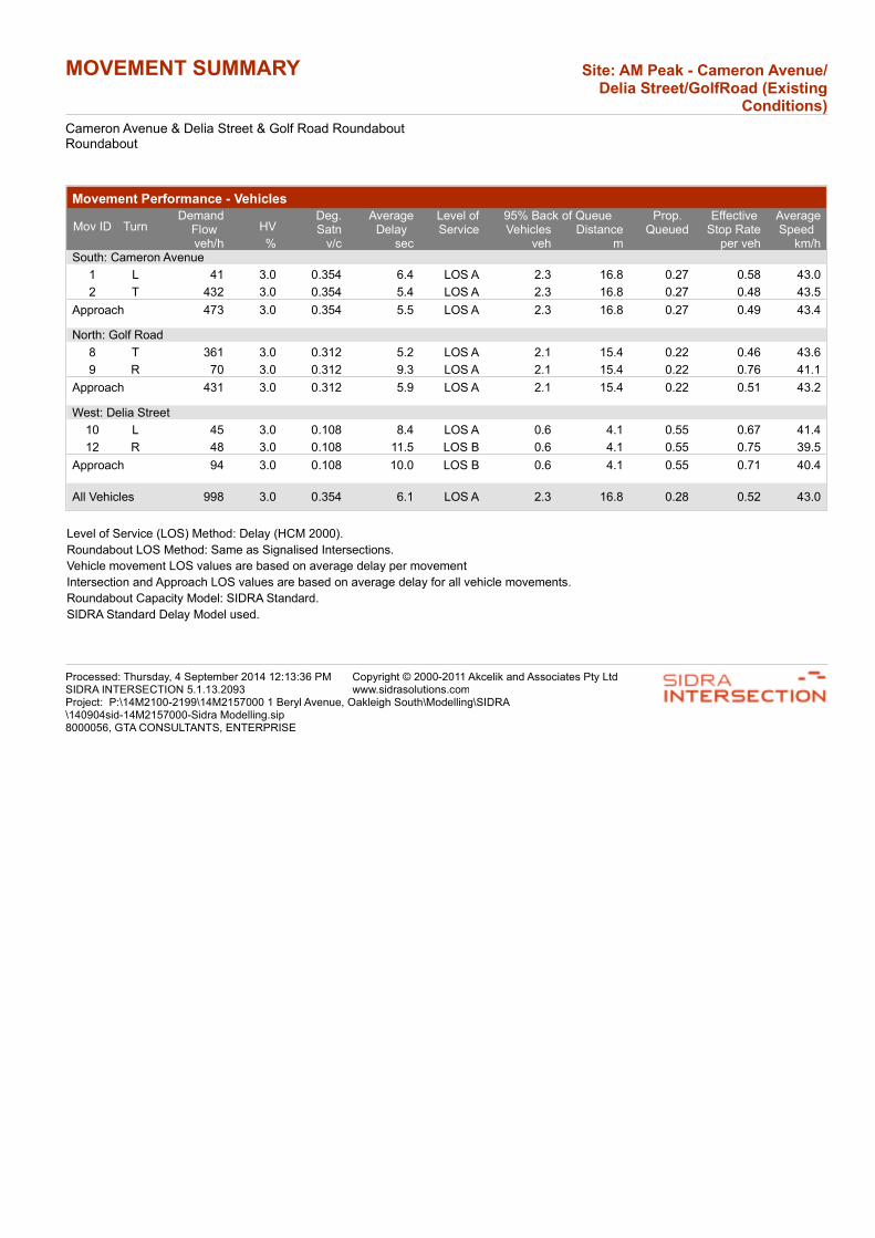
MOVEMENT SUMMARY Site: AM Peak - Cameron Avenue/Delia Street/GolfRoad (Existing
Conditions)
Cameron Avenue & Delia Street & Golf Road RoundaboutRoundabout
Movement Performance - Vehicles
95% Back of QueueMov ID Turn
DemandFlow HV
Deg.Satn
AverageDelay
Level ofService
Prop. Queued
Effective Stop Rate
AverageSpeed Vehicles Distance
veh/h % v/c sec veh m per veh km/hSouth: Cameron Avenue
1 L 41 3.0 0.354 6.4 LOS A 2.3 16.8 0.27 0.58 43.0
2 T 432 3.0 0.354 5.4 LOS A 2.3 16.8 0.27 0.48 43.5
Approach 473 3.0 0.354 5.5 LOS A 2.3 16.8 0.27 0.49 43.4
North: Golf Road
8 T 361 3.0 0.312 5.2 LOS A 2.1 15.4 0.22 0.46 43.6
9 R 70 3.0 0.312 9.3 LOS A 2.1 15.4 0.22 0.76 41.1
Approach 431 3.0 0.312 5.9 LOS A 2.1 15.4 0.22 0.51 43.2
West: Delia Street
10 L 45 3.0 0.108 8.4 LOS A 0.6 4.1 0.55 0.67 41.4
12 R 48 3.0 0.108 11.5 LOS B 0.6 4.1 0.55 0.75 39.5
Approach 94 3.0 0.108 10.0 LOS B 0.6 4.1 0.55 0.71 40.4
All Vehicles 998 3.0 0.354 6.1 LOS A 2.3 16.8 0.28 0.52 43.0
Level of Service (LOS) Method: Delay (HCM 2000).
Roundabout LOS Method: Same as Signalised Intersections.
Vehicle movement LOS values are based on average delay per movement
Intersection and Approach LOS values are based on average delay for all vehicle movements.
Roundabout Capacity Model: SIDRA Standard.
SIDRA Standard Delay Model used.
Processed: Thursday, 4 September 2014 12:13:36 PMSIDRA INTERSECTION 5.1.13.2093
Copyright © 2000-2011 Akcelik and Associates Pty Ltdwww.sidrasolutions.com
Project: P:\14M2100-2199\14M2157000 1 Beryl Avenue, Oakleigh South\Modelling\SIDRA\140904sid-14M2157000-Sidra Modelling.sip8000056, GTA CONSULTANTS, ENTERPRISE

MOVEMENT SUMMARY Site: AM Peak - Cameron Avenue/Beryl Avenue (Existing
Conditions)
Cameron Avenue & Beryl Avenue IntersectionGiveway / Yield (Two-Way)
Movement Performance - Vehicles
95% Back of QueueMov ID Turn
DemandFlow HV
Deg.Satn
AverageDelay
Level ofService
Prop. Queued
Effective Stop Rate
AverageSpeed Vehicles Distance
veh/h % v/c sec veh m per veh km/hSouth: Cameron Avenue (South Approach)
2 T 291 3.0 0.165 1.9 LOS A 1.2 8.9 0.53 0.00 43.9
3 R 15 3.0 0.165 8.8 LOS A 1.2 8.9 0.53 0.90 42.9
Approach 307 3.0 0.165 2.2 NA 1.2 8.9 0.53 0.05 43.8
East: Beryl Avenue (East Approach)
4 L 26 3.0 0.447 13.8 LOS B 2.3 16.4 0.63 0.84 37.4
6 R 205 3.0 0.447 14.1 LOS B 2.3 16.4 0.63 0.97 37.3
Approach 232 3.0 0.447 14.1 LOS B 2.3 16.4 0.63 0.96 37.3
North: Cameron Avenue (North Approach)
7 L 273 3.0 0.232 6.5 LOS A 0.0 0.0 0.00 0.70 43.3
8 T 157 3.0 0.232 0.0 LOS A 0.0 0.0 0.00 0.00 50.0
Approach 430 3.0 0.232 4.1 NA 0.0 0.0 0.00 0.44 45.5
All Vehicles 968 3.0 0.447 5.9 NA 2.3 16.4 0.32 0.44 42.8
Level of Service (LOS) Method: Delay (HCM 2000).
Vehicle movement LOS values are based on average delay per movement
Minor Road Approach LOS values are based on average delay for all vehicle movements.
NA: Intersection LOS and Major Road Approach LOS values are Not Applicable for two-way sign control since the average delay is not a good LOS measure due to zero delays associated with major road movements.
SIDRA Standard Delay Model used.
Processed: Thursday, 4 September 2014 12:13:35 PMSIDRA INTERSECTION 5.1.13.2093
Copyright © 2000-2011 Akcelik and Associates Pty Ltdwww.sidrasolutions.com
Project: P:\14M2100-2199\14M2157000 1 Beryl Avenue, Oakleigh South\Modelling\SIDRA\140904sid-14M2157000-Sidra Modelling.sip8000056, GTA CONSULTANTS, ENTERPRISE
14M2157000 // 22/06/15
Transport, Access and Mobility Statement // Issue: C
1 Beryl Avenue, Oakleigh South
Appendix B
SIDRA Intersection Assessment – Post Development
Conditions
Ap
pe
nd
ix B
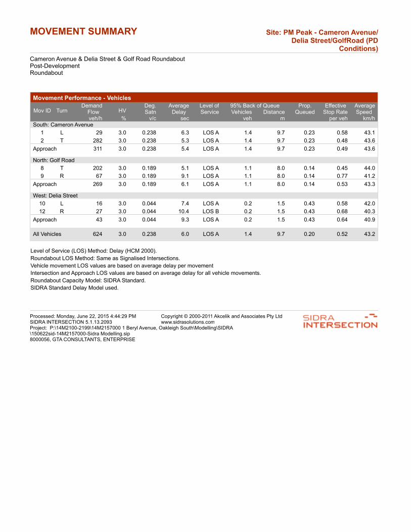
MOVEMENT SUMMARY Site: PM Peak - Cameron Avenue/Delia Street/GolfRoad (PD
Conditions)
Cameron Avenue & Delia Street & Golf Road RoundaboutPost-DevelopmentRoundabout
Movement Performance - Vehicles
95% Back of QueueMov ID Turn
DemandFlow HV
Deg.Satn
AverageDelay
Level ofService
Prop. Queued
Effective Stop Rate
AverageSpeed Vehicles Distance
veh/h % v/c sec veh m per veh km/hSouth: Cameron Avenue
1 L 29 3.0 0.238 6.3 LOS A 1.4 9.7 0.23 0.58 43.1
2 T 282 3.0 0.238 5.3 LOS A 1.4 9.7 0.23 0.48 43.6
Approach 311 3.0 0.238 5.4 LOS A 1.4 9.7 0.23 0.49 43.6
North: Golf Road
8 T 202 3.0 0.189 5.1 LOS A 1.1 8.0 0.14 0.45 44.0
9 R 67 3.0 0.189 9.1 LOS A 1.1 8.0 0.14 0.77 41.2
Approach 269 3.0 0.189 6.1 LOS A 1.1 8.0 0.14 0.53 43.3
West: Delia Street
10 L 16 3.0 0.044 7.4 LOS A 0.2 1.5 0.43 0.58 42.0
12 R 27 3.0 0.044 10.4 LOS B 0.2 1.5 0.43 0.68 40.3
Approach 43 3.0 0.044 9.3 LOS A 0.2 1.5 0.43 0.64 40.9
All Vehicles 624 3.0 0.238 6.0 LOS A 1.4 9.7 0.20 0.52 43.2
Level of Service (LOS) Method: Delay (HCM 2000).
Roundabout LOS Method: Same as Signalised Intersections.
Vehicle movement LOS values are based on average delay per movement
Intersection and Approach LOS values are based on average delay for all vehicle movements.
Roundabout Capacity Model: SIDRA Standard.
SIDRA Standard Delay Model used.
Processed: Monday, June 22, 2015 4:44:29 PMSIDRA INTERSECTION 5.1.13.2093
Copyright © 2000-2011 Akcelik and Associates Pty Ltdwww.sidrasolutions.com
Project: P:\14M2100-2199\14M2157000 1 Beryl Avenue, Oakleigh South\Modelling\SIDRA\150622sid-14M2157000-Sidra Modelling.sip8000056, GTA CONSULTANTS, ENTERPRISE

MOVEMENT SUMMARY Site: AM Peak - Cameron Avenue/Delia Street/GolfRoad (PD
Conditions)
Cameron Avenue & Delia Street & Golf Road RoundaboutPost-DevelopmentRoundabout
Movement Performance - Vehicles
95% Back of QueueMov ID Turn
DemandFlow HV
Deg.Satn
AverageDelay
Level ofService
Prop. Queued
Effective Stop Rate
AverageSpeed Vehicles Distance
veh/h % v/c sec veh m per veh km/hSouth: Cameron Avenue
1 L 49 3.0 0.390 6.4 LOS A 2.7 19.5 0.28 0.58 42.9
2 T 474 3.0 0.390 5.4 LOS A 2.7 19.5 0.28 0.48 43.4
Approach 524 3.0 0.390 5.5 LOS A 2.7 19.5 0.28 0.49 43.4
North: Golf Road
8 T 375 3.0 0.327 5.3 LOS A 2.3 16.5 0.25 0.46 43.5
9 R 70 3.0 0.327 9.3 LOS A 2.3 16.5 0.25 0.75 41.1
Approach 445 3.0 0.327 5.9 LOS A 2.3 16.5 0.25 0.51 43.1
West: Delia Street
10 L 45 3.0 0.121 8.7 LOS A 0.6 4.6 0.58 0.69 41.2
12 R 56 3.0 0.121 11.8 LOS B 0.6 4.6 0.58 0.76 39.3
Approach 101 3.0 0.121 10.4 LOS B 0.6 4.6 0.58 0.73 40.1
All Vehicles 1070 3.0 0.390 6.1 LOS A 2.7 19.5 0.30 0.52 42.9
Level of Service (LOS) Method: Delay (HCM 2000).
Roundabout LOS Method: Same as Signalised Intersections.
Vehicle movement LOS values are based on average delay per movement
Intersection and Approach LOS values are based on average delay for all vehicle movements.
Roundabout Capacity Model: SIDRA Standard.
SIDRA Standard Delay Model used.
Processed: Monday, June 22, 2015 4:44:28 PMSIDRA INTERSECTION 5.1.13.2093
Copyright © 2000-2011 Akcelik and Associates Pty Ltdwww.sidrasolutions.com
Project: P:\14M2100-2199\14M2157000 1 Beryl Avenue, Oakleigh South\Modelling\SIDRA\150622sid-14M2157000-Sidra Modelling.sip8000056, GTA CONSULTANTS, ENTERPRISE

MOVEMENT SUMMARY Site: PM Peak - Cameron Avenue/Beryl Avenue (PD Conditions)
Cameron Avenue & Beryl Avenue IntersectionPost-DevelopmentGiveway / Yield (Two-Way)
Movement Performance - Vehicles
95% Back of QueueMov ID Turn
DemandFlow HV
Deg.Satn
AverageDelay
Level ofService
Prop. Queued
Effective Stop Rate
AverageSpeed Vehicles Distance
veh/h % v/c sec veh m per veh km/hSouth: Cameron Avenue (South Approach)
2 T 212 3.0 0.121 0.8 LOS A 0.7 5.3 0.36 0.00 45.6
3 R 14 3.0 0.121 7.7 LOS A 0.7 5.3 0.36 0.86 43.0
Approach 227 3.0 0.121 1.3 NA 0.7 5.3 0.36 0.05 45.4
East: Beryl Avenue (East Approach)
4 L 14 3.0 0.166 9.3 LOS A 0.6 4.3 0.45 0.59 40.7
6 R 98 3.0 0.166 9.7 LOS A 0.6 4.3 0.45 0.77 40.6
Approach 112 3.0 0.166 9.6 LOS A 0.6 4.3 0.45 0.75 40.6
North: Cameron Avenue (North Approach)
7 L 101 3.0 0.125 6.5 LOS A 0.0 0.0 0.00 0.75 43.3
8 T 133 3.0 0.125 0.0 LOS A 0.0 0.0 0.00 0.00 50.0
Approach 234 3.0 0.125 2.8 NA 0.0 0.0 0.00 0.33 46.9
All Vehicles 573 3.0 0.166 3.5 NA 0.7 5.3 0.23 0.30 44.9
Level of Service (LOS) Method: Delay (HCM 2000).
Vehicle movement LOS values are based on average delay per movement
Minor Road Approach LOS values are based on average delay for all vehicle movements.
NA: Intersection LOS and Major Road Approach LOS values are Not Applicable for two-way sign control since the average delay is not a good LOS measure due to zero delays associated with major road movements.
SIDRA Standard Delay Model used.
Processed: Monday, June 22, 2015 4:44:28 PMSIDRA INTERSECTION 5.1.13.2093
Copyright © 2000-2011 Akcelik and Associates Pty Ltdwww.sidrasolutions.com
Project: P:\14M2100-2199\14M2157000 1 Beryl Avenue, Oakleigh South\Modelling\SIDRA\150622sid-14M2157000-Sidra Modelling.sip8000056, GTA CONSULTANTS, ENTERPRISE

MOVEMENT SUMMARY Site: AM Peak - Cameron Avenue/Beryl Avenue (PD Conditions)
Cameron Avenue & Beryl Avenue IntersectionPost-DevelopmentGiveway / Yield (Two-Way)
Movement Performance - Vehicles
95% Back of QueueMov ID Turn
DemandFlow HV
Deg.Satn
AverageDelay
Level ofService
Prop. Queued
Effective Stop Rate
AverageSpeed Vehicles Distance
veh/h % v/c sec veh m per veh km/hSouth: Cameron Avenue (South Approach)
2 T 291 3.0 0.168 2.0 LOS A 1.3 9.1 0.53 0.00 43.8
3 R 19 3.0 0.168 8.8 LOS A 1.3 9.1 0.53 0.90 42.9
Approach 310 3.0 0.168 2.4 NA 1.3 9.1 0.53 0.05 43.8
East: Beryl Avenue (East Approach)
4 L 40 3.0 0.545 15.0 LOS C 3.2 23.2 0.67 0.93 36.6
6 R 244 3.0 0.545 15.4 LOS C 3.2 23.2 0.67 1.04 36.5
Approach 284 3.0 0.545 15.3 LOS C 3.2 23.2 0.67 1.02 36.5
North: Cameron Avenue (North Approach)
7 L 282 3.0 0.237 6.5 LOS A 0.0 0.0 0.00 0.69 43.3
8 T 157 3.0 0.237 0.0 LOS A 0.0 0.0 0.00 0.00 50.0
Approach 440 3.0 0.237 4.2 NA 0.0 0.0 0.00 0.45 45.5
All Vehicles 1033 3.0 0.545 6.7 NA 3.2 23.2 0.34 0.49 42.1
Level of Service (LOS) Method: Delay (HCM 2000).
Vehicle movement LOS values are based on average delay per movement
Minor Road Approach LOS values are based on average delay for all vehicle movements.
NA: Intersection LOS and Major Road Approach LOS values are Not Applicable for two-way sign control since the average delay is not a good LOS measure due to zero delays associated with major road movements.
SIDRA Standard Delay Model used.
Processed: Monday, June 22, 2015 4:44:28 PMSIDRA INTERSECTION 5.1.13.2093
Copyright © 2000-2011 Akcelik and Associates Pty Ltdwww.sidrasolutions.com
Project: P:\14M2100-2199\14M2157000 1 Beryl Avenue, Oakleigh South\Modelling\SIDRA\150622sid-14M2157000-Sidra Modelling.sip8000056, GTA CONSULTANTS, ENTERPRISE
14M2157000 // 22/06/15
Transport, Access and Mobility Statement // Issue: C
1 Beryl Avenue, Oakleigh South
Appendix C
AutoTURN Swept Path Assessment
Ap
pe
nd
ix C

232^36’
PROPOSED STREET
PR
OP
OS
ED S
TR
EE
T
PR
OP
OS
ED S
TR
EE
T
277°36’ (169.77)
JO
YC
E A
VE.
14000
14000
10.50
1890
3000
6000
30.00
12.50 12.50
4000
1050
1050
1890
9900
2200
1000
1000
1000
1000
1000
Lot 3
8
Lot 9
Lot 6
Lot 8
Lot 7
Lot 11
Lot 12
Lot 10
Lot 13
Lot 20
Lot 19
Lot 17
Lot 18
Lot 15
Lot 16
Lot 14
Lot 3
0
Lot 3
1
Lot 3
2
Lot 3
3
Lot 3
4
Lot 3
5
Lot 3
6
Lot 4
0
Lot 3
7
Lot 3
9
Lot 4
1
Lot 4
2
Lot 49
Lot 50
Lot 51
Lot 52
Lot 53
Lot 43
Lot 44
Lot 45
8200
5110
3000
3000
4670
1050
6000
5000
4405
7135
3000
Lot 48
5500
MAXIMUM HEIGHT OF 3 STOREYS
SUBJECT TO A SEPARATE APPLICATION.
FUTURE DEVELOPMENT.
3000
4080
6000
6000
PALIN
G FEN
CE
19
12108642
LIP OF CONCRETE KERBLIP OF CONCRETE KERB
HUMP
SPEED
88.5
5
143^40’40"
0.08
4.3
11.2
70.4
7
42.6
7187^36’
KERB AND CHANNELCONCRETE
322^36’ WIRE FENCEMESH(169.77)
277^36’
7
FENCING 1500
Lot 54
Lot 55
Lot 56
Lot 23
Lot 24
Lot 25
Lot 26
Lot 27
Lot 28
Lot 29
5000
6000
5000
BERYL AVENUE
4660
U/
FL
OO
R
4000
U/
FL
OO
R
4000
U/
FL
OO
R
4000
U/
FL
OO
R
4000
6000
6000
7600
7000
7600
7300
7300
7800
7800
7800
14300
4200
13300
12300
2700
10700
9100
10700
1800
4100
8000
8900
1500
3800
6000
14000
6000
4550
Lot 22
Lot 46
Lot 47
#30
#3
TREE PROTECTION ZONE
TREE PROTECTION ZONE
MO
NA
SH
CC
GTA-
VIC
(c)
2014
Tra
nsoft
Soluti
ons, In
c.
All rights re
serv
ed.
MONASH CCGTA-VIC
(c) 2014 Transoft Solutions, Inc. All rights reserved.
MONASH CCGTA-VIC
(c) 2014 Transoft Solutions, Inc. All rights reserved.
MO
NA
SH
CC
GTA-
VIC
(c)
2014
Tra
nsoft
Soluti
ons, In
c.
All rights re
serv
ed.
MONASH CCGTA-VIC
(c) 2014 Transoft Solutions, Inc. All rights reserved.
MO
NA
SH
CC
GT
A-
VIC
(c)
2014
Tra
nsoft
Soluti
ons, In
c.
All rights re
serv
ed.
MO
NASH CC
GTA-VIC
(c) 2014 Transoft Solutions, Inc. All rights reserved.
MONASH CCGTA-VIC
(c) 2014 Transoft Solutions, Inc. All rights reserved.
MONASH CCGTA-VIC
(c) 2014 Transoft Solutions, Inc. All rights reserved.
MO
NAS
H CC
GTA-VIC
(c) 2014 Transoft Solutions, Inc. All rights reserved.
MONASH CC
GTA-VIC(c) 2014
Transoft Solutio
ns, Inc. All rights
reserved.
MO
NA
SH
CC
GT
A-
VIC
(c)
2014
Tra
nsoft
Soluti
ons, In
c.
All rights re
serv
ed.
PL
OTTE
D B
Y :
Drafting.H
otdesk
ON
19/06/2015
AT
11:4
6:34
AM
GTA onsultantsc
www.gta.com.au
DRAWING NO.
SCALEDATE
DESIGNER
PRELIMINARY PLAN
WITHOUT NOTIFICATION
ONLY SUBJECT TO CHANGE
FOR DISCUSSION PURPOSES
MELWAY REF
14M2157000-AT01-01P5
19 JUNE 2015
B.JAYSINGHE
1:250 @ A3 78/F1
SWEPT PATH KEY
FROM VEHICLE BODY300mm CLEARANCE
VEHICLE BODY PATH
VEHICLE TYRE PATH
VEHICLE CENTRE LINE
ASSUMED SPEED 5km/h
Lock to Lock Time
Track
Width
:
:
:
metersMONASH CC
6.0
2.50
2.50
5.501.80
9.20
Steering Angle 39.0:
1 BERYL AVENUE, OAKLEIGH SOUTH
MONASH CC TRUCK SWEPT PATH ASSESSMENT

Melbourne
A Level 25, 55 Collins Street
PO Box 24055
MELBOURNE VIC 3000
P +613 9851 9600
Brisbane
A Level 4, 283 Elizabeth Street
BRISBANE QLD 4000
GPO Box 115
BRISBANE QLD 4001
P +617 3113 5000
Adelaide
A Suite 4, Level 1, 136 The Parade
PO Box 3421
NORWOOD SA 5067
P +618 8334 3600
Townsville
A Level 1, 25 Sturt Street
PO Box 1064
TOWNSVILLE QLD 4810
P +617 4722 2765
Sydney
A Level 6, 15 Help Street
CHATSWOOD NSW 2067
PO Box 5254
WEST CHATSWOOD NSW 1515
P +612 8448 1800
Canberra
A Unit 4, Level 1, Sparta Building,
55 Woolley Street
PO Box 62
DICKSON ACT 2602
P +612 6243 4826
Gold Coast
A Level 9, Corporate Centre 2
Box 37, 1 Corporate Court
BUNDALL QLD 4217
P +617 5510 4800
F +617 5510 4814
Perth
A Level 27, 44 St Georges Terrace
PERTH WA 6000
P +618 6361 4634
www.gta.com.au www.gta.com.au