transnational pilot river basin -...
TRANSCRIPT

Transnational Pilot River Basin Lusatian Neisse
Lužická Nisa (CEC) Lausitzer Neiße (GER) Nysa Łużycka (POL)
Testing of CIS Guidance Documents
Final Report Phase I
Transnational Pilot River Basin Lusatian Neisse Lužická Nisa (CEC) Lausitzer Neiße (GER) Nysa Łużycka (POL)
Testing of CIS Guidance Documents
Final Report Phase I
Partner: Scientific Coordinator
Staatliches Umweltfachamt BautzenDr. Bernd Fritzsche (Coordinator), Silvina Gondlach, Heiko SonntagPostfach 134302603 BautzenPhone: +49 3591/273-130 Email: [email protected]
Sponsor UmweltbundesamtFederal Environmental AgencyDr. HeidemeierPostfach 33002214191 BerlinPhone: +49 (0)30 8903-0
Partner Ministry of the Environment of the Czech RepublicMr. Oldrich NovickyVršovická 65100 10 Praha 10Phone: +420 267 122 313Email: [email protected]
Consultants umweltbüro essen (ube)Martin Halle, Dr. Petra PodrazaRellinghauser Str. 334 f 45136 EssenPhone: +49 2 01 / 86 [email protected]
RZGW – Wrocławdr inż. Halina Szymańskaul. Norwida 3450-950 Wroclaw 2Phone: +48 71 328 3030Email: [email protected]
Ingenieurgesellschaft Prof.Dr. Sieker mbH (IPS)Dr. Heiko SiekerRennbahnallee 109 A 15366 HoppegartenPhone: +49 33 42 / 35 95-15Email: [email protected]
Institute of Meteorology and Water Management Wrocław Branch, Dr. Jan Błachuta ul. Parkowa 30, 51-616 Wrocław Phone (71) 32 00 161 [email protected]
T. G. Masaryk Water Research Institute Branch Ostrava, Ing. Jan Sviták Podbabská 30, Praha 6, 160 62 Phone: +420 220 197 111 Email: [email protected]

PRB Lusatian Neisse 3
CONTENT
CONTENT................................................................................................................................3
1 Introduction......................................................................................................................8
1.1 Pilot River Basins ........................................................................................................8 1.2 Purpose of the PRB Neisse project.............................................................................9 1.3 Partners.....................................................................................................................10
1.3.1 Germany .......................................................................................................................... 10 1.3.2 Poland.............................................................................................................................. 11 1.3.3 Czech Republic................................................................................................................ 11
2 Catchment Characterization .........................................................................................13
2.1 General description ...................................................................................................13 2.2 Specific characterizations of the Czech part of the catchment..................................15 2.3 Specific characterizations of the Polish part of the catchment ..................................16
2.3.1 Identification of significant changes in morphology of water bodies................................ 17 2.3.2 Surface waters ................................................................................................................. 18 2.3.3 Ground waters ................................................................................................................. 18
2.4 Specific characterizations of the German part of the catchment...............................19
3 Identification of water bodies .......................................................................................20
3.1 Czech strategy for water bodies delineation .............................................................20 3.2 Polish strategy for water body delineation.................................................................25
3.2.1 Characteristics of water types.......................................................................................... 25 3.2.2 Identification of water bodies [WB] and artificial water bodies [AWB] ............................. 25 3.2.3 Identification of heavily modified water bodies ................................................................ 28
3.3 German strategy for water bodies delineation...........................................................30 3.3.1 Categories of water bodies .............................................................................................. 30 3.3.2 Typology .......................................................................................................................... 31 3.3.3 Significant natural physical features ................................................................................ 32 3.3.4 Other criteria .................................................................................................................... 33 3.3.5 Results for the Saxonian part of the Neisse Basin .......................................................... 37
3.4 Common map for water bodies .................................................................................38 3.4.1 Ground water bodies ....................................................................................................... 38 3.4.2 Surface Water Bodies...................................................................................................... 39
3.5 ToR-Answers on water bodies delineation................................................................40
4 Classification of surface water status and reference conditions (REFCOND) ........44
4.1 Czech strategy for classification of surface water status and reference conditions ..44 4.2 Polish strategy for classification of surface water status and reference conditions...44
4.2.1 Classification of reference conditions .............................................................................. 44 4.2.2 Comparison of water bodies with reference conditions................................................... 46 4.2.3 Description of the results of classification........................................................................ 48
4.3 German strategy for classification of surface water status and reference conditions49 4.3.1 Lakes ............................................................................................................................... 49 4.3.2 Rivers............................................................................................................................... 50 4.3.3 Steckbriefe der deutschen Fließgewässertypen.............................................................. 52

PRB Lusatian Neisse 4
4.4 Common REFCOND results .....................................................................................52 4.5 ToR-Answers on REFCOND.....................................................................................53
5 Analysis of pressures and impacts (IMPRESS)..........................................................54
5.1 Czech strategy for pressures and impacts analysis ..................................................54 5.2 Polish strategy for pressures and impacts analysis ..................................................56
5.2.1 Identification of pressures on surface waters .................................................................. 56 5.2.2 Evaluation of pressures ................................................................................................... 57 5.2.3 Description of causes of pressures.................................................................................. 58 5.2.4 Pressures forecast........................................................................................................... 65
5.3 German strategy for pressures and impacts analysis ...............................................66 5.3.1 Driving forces ................................................................................................................... 67 5.3.2 Pressures......................................................................................................................... 68 5.3.3 State................................................................................................................................. 79 5.3.4 Impacts ............................................................................................................................ 80
5.4 Common results of pressures and impacts analysis .................................................81 5.4.1 Mandau-Catchment ......................................................................................................... 81 5.4.2 Polish-Catchment Czerwona Woda River ....................................................................... 86
5.5 Risk Assessment for the surface water bodies .........................................................91 5.6 ToR-Answers on pressures and impacts analysis ....................................................93
6 Monitoring (MONITORING). ..........................................................................................94
6.1 Czech strategy for monitoring ...................................................................................94 6.2 Polish strategy for monitoring....................................................................................95
6.2.1 Description of the monitoring of surface water ................................................................ 95 6.2.2 Surveillance monitoring ................................................................................................... 96 6.2.3 Operational monitoring of surface water.......................................................................... 98 6.2.4 Investigative Monitoring of surface water ........................................................................ 98 6.2.5 Quality assurance/Quality control .................................................................................... 99
6.3 German strategy for monitoring.................................................................................99 6.4 Common monitoring results ....................................................................................100
7 Transboundary experiences.......................................................................................103
7.1 Project coordination.................................................................................................103 7.2 Workshops on EU-level and public relations work ..................................................103
8 Summary ......................................................................................................................105
9 Literatur ........................................................................................................................106
Annex ..................................................................................................................................107
Profiles of German Stream Types.....................................................................................107

PRB Lusatian Neisse 5
FIGURES Figure 1: Common Implementation Strategy for the EU-WFD (D'Eugenio, 2001) ...................8 Figure 2: Pilot River Basins in Europe for WFD-Testing ..........................................................9 Figure 3: PRB Neisse: catchment and relief ..........................................................................13 Figure 4: Landuse ..................................................................................................................14 Figure 5: Landuse in the German part of the catchment (SMUL, 2004) ................................19 Figure 6: Water body delineation in the Czech part of Lužická Nisa catchment ....................24 Figure 7: Water body delineation in the Polish part of the catchment ....................................26 Figure 8: water body identification following the horizontal CIS-guidance document ............30 Figure 9: Surface waters in the Saxonian part of the Lausitzer Neisse Basin (DGM 100). ....31 Figure 10: Stream types in the Saxonian part of the Lausitzer Neisse Basin ........................33 Figure 11: Water quality of the Mandau-System ....................................................................35 Figure 12: Morphological status of the Mandau-System ........................................................35 Figure 13: FFH-areas in the Mandau-catchment ...................................................................36 Figure 14: Landuse in the Mandau-catchment.......................................................................36 Figure 15: Transnational surface water bodies PRB Neisse Phase I.....................................40 Figure 16: Distribution of barriers along Nysa Łużycka River ................................................63 Figure 17: Urban areas in the Saxonian part of the Neisse-catchment..................................68 Figure 18: Zoning plan of Zittau .............................................................................................69 Figure 19: Sewer system in Zittau..........................................................................................70 Figure 20: Conceptual model for the sewer system in Zittau using STORM..........................70 Figure 21: Land use distribution in the Saxonian part of the Neisse-catchment ....................72 Figure 22: Sector of the forest habitat map ............................................................................73 Figure 23: Waste water treatment plants in the Saxonian part of the Neisse catchment.......74 Figure 24: Industrial discharges .............................................................................................76 Figure 25: Flow regulation and permitted abstractions in the German/Polish........................77 Figure 26: Discharges from „urban“ sources..........................................................................78 Figure 27: Emissions from „urban“ sources ...........................................................................78 Figure 28: Longitudinal section of water quality in the Neisse from 1993 to 1999 .................79 Figure 29: Saprobic index and German habitat survey ..........................................................80 Figure 30: Location of the Mandau catchment .......................................................................82 Figure 31: Topography in the Mandu Catchment...................................................................82 Figure 32: Land use in the Mandau Catchment (Source: LfUG) ............................................83 Figure 33: Water Quality in the Mandau Catchment (CZ and D) ...........................................84 Figure 34: : Photo of the Mandau in the area of Zittau...........................................................85 Figure 35: Photo of the Mandau in the area of Mittelherwigsdorf...........................................85

PRB Lusatian Neisse 6
Figure 36: Water-net in the sub-basin of Czerwona Woda River. ..........................................87 Figure 37: Land-use and point sources in the sub-basin of Czerwona Woda River. .............87 Figure 38: Types and water bodies (WB) identified in Czerwona Woda River sub-basin. .....88 Figure 39: Morphological status of water bodies identified in Czerwona Woda sub-basin.....89 Figure 40: Risk assessment of failing the WFD objectives in Czerwona Woda sub-basin.....90 Figure 41: Risk Assessment for the surface water bodies .....................................................91 Figure 42: Flow-chart showing the German strategy for monitoring ......................................99 Figure 43: Surveillance monitoring sites ..............................................................................101 Figure 44: Operational und investigative monitoring site .....................................................102 Figure 45: Internal meetings.................................................................................................103 Figure 46: Poster for the meeting of water directors in June 2004.......................................104
TABLES Table 1: Catchment size.........................................................................................................13 Table 2: Characteristics of Czech part of the catchment........................................................15 Table 3: Criteria for identification of significant changes in morphology in Poland ................17 Table 4: Particular rivers, studied in the period of 1997-2002, obtained following valuation:.17 Table 5: hydrologic characteristics of the Lausitzer Neiße (SMUL, 2004) .............................19 Table 6: Surface water bodies in the Czech part of the catchment........................................21 Table 7: Dials for surface water bodies in the Czech Republic ..............................................23 Table 8: WBs and AWBs in particular sub-basins in the Polish part of the catchment ..........27 Table 9: Water bodies in the Polish part of the catchment.....................................................28 Table 10: Typologie................................................................................................................32 Table 11: Quality classes .......................................................................................................34 Table 12: Results of water body delineation for the Saxonian part of the Neisse Basin ........37 Table 13: LAWA-Stream types in the Lausitzer Neisse basin (Saxony) ................................41 Table 14: River types .............................................................................................................45 Table 15: Comparison of water bodies with reference conditions..........................................47 Table 16: relevant pressures in the Czech part of the catchment ..........................................54 Table 17: Impacts in the Czech part of the catchment ...........................................................55 Table 18: Total area loads of nitrogen and phosphorus.........................................................57 Table 19: Criteria for pressures in Poland..............................................................................57 Table 20: Deposition from the atmosphere in Polsih part of the Catchment ..........................59 Table 21: Abstraction for industry in the Polish part of the catchment ...................................61 Table 22: Abstraction for fish farms in the Polish part of the catchment ................................61 Table 23: Parameters and distribution of barriers ..................................................................63

PRB Lusatian Neisse 7
Table 24: Driving forces in the German part of the PRB Neisse. ...........................................67 Table 25: Mean concentration in stormwater runoff (BROMBACH/FUCHS, 2002) ...............71 Table 26: Emission from CSO’s in the Saxonian part of the Neisse catchment.....................71 Table 27: Stormwater related emissions in the Neisse Catchment........................................71 Table 28: Waste water treatment plants in the Saxonian part of the Neisse catchment ........75 Table 29: Major abstractions in the Saxonian part of the catchment .....................................77 Table 30: Water bodies in the Czerwona Woda River sub-basin...........................................88 Table 31: Pressures in Czerwona Woda River sub-basin......................................................89 Table 32: Risk Assessment for the surface water bodies ......................................................92 Table 33: Czech proposal for monitoring sites .......................................................................94 Table 34: Polish proposal for monitoring parameters.............................................................97 Table 35: Monitoring sites in the German part of the catchment..........................................100

PRB Lusatian Neisse 8
1 Introduction
1.1 Pilot River Basins
In 2000/2001, working groups with delegates from the member states and candidate countries, national experts and staff of the European Commission worked out several guidelines (Guidance Documents, GD) to assure a Common Implementation Strategy (CIS, see Figure 1) for the European Water Framework Directive (WFD).
Figure 1: Common Implementation Strategy for the EU-WFD (D'Eugenio, 2001)
To test the Guidance Documents a network with 15 Pilot River Basins (PRB) has been established. The Pilot River Basins are a good representation of the diverse climatic, technical and political conditions of the European Union and candidate countries.
• Scheldt (B, F, NL)
• Moselle-Sarre/Mosel-Saar (D, F, Lux)
• Marne (France)
• Shannon (Ireland)
• Ribble (United Kingdom)
• Odense (Denmark)
• Oulujoki (Finland)
• Norway
• Guadiana (Portugal)
• Júcar (Spain)
• Pinios (Greece)
• Tevere (Italy)
• Cecina (Italy)
• Somos (HU/ROM)
• Neiße (PL, CZ, D)

PRB Lusatian Neisse 9
Figure 2: Pilot River Basins in Europe for WFD-Testing
1.2 Purpose of the PRB Neisse project
The catchment of the Lusatian Neisse has been selected by the water directors as one of the 15 Pilot River Basin (see Figure 2).
The three partner countries which share the catchment of the Lusatian Neisse – Poland, Czech Republic, Germany – agreed with the EU Commission to test the following CIS-guidance documents:

PRB Lusatian Neisse 10
• Horizontal guidance document ‘Identification of water bodies’
• Guidance on the analysis of pressures and impacts (IMPRESS),
• Guidance on the classification of inland surface water status and reference conditions (REFCOND),
• Guidance on monitoring (MONITORING).
In accordance with the general PRB activities, the objective is a review of the coherence, practicability and efficiency of the previously listed guidelines. Concrete suggestions for improvement should come from the example of the Lausatian Neisse River Basin.
An experience-oriented contribution for further developing the CIS Guidance Documents as a complete work for implementing the WRRL should be acheived with the project. In accordance with the international character of the river basin, special attention will be given to transnational aspects of implementing the EU-WRRL.
Moreover, concrete results shall be compiled for implementing the EU-WRRL and the basic principles will be set for a trusting cooperation in this international river basin.
This report documents the tasks between July 2003 and November 2004.
1.3 Partners
The following partners are involved in the PRB Neisse project.
1.3.1 Germany
The regional authority Staatliches Umweltfachamt Bautzen (StUFA Bautzen) is responsible for the German Activities. StUFA Bautzen is also coordinating the PRB Lusatian Neisse.
• Staatliches Umweltfachamt Bautzen, scientific coordinator Dr. Bernd Fritzsche (Coordinator), Silvina Gondlach, Heiko Sonntag Phone: +49 3591/273-130 Email: [email protected]
For assistance StUFA Bautzen referred to consultants:
• Umweltbüro Essen (ube), Consultant Martin Halle, Dr. Petra Podraza Rellinghauser Str. 334 f, 45136 Essen Phone: +49 2 01 / 86 061-0 Email: [email protected]
• Ingenieurgesellschaft Prof. Dr. Sieker mbH (IPS) , Consultant Dr. Heiko Sieker Rennbahnallee 109 A, 15366 Hoppegarten Phone: +49 33 42 / 35 95-15 Email: [email protected]

PRB Lusatian Neisse 11
The German activities within the PRB Neisse are supported by the German Environmental Protection Agency (Umweltbundesamt, UBA).
• Contact person at Umweltbundesamt: Herr Dr. Heidemeier Postbox 330022, 14191 Berlin Phone: +49 (0)30 8903-0
1.3.2 Poland
The RZGW (Regional Water Development Authority) acts on the basis of regulations of The Water Law Act of 18.07.2001. (Dz. U. Nr 115, journal entry 1229 with further changes), the ordinance of Minister of the Environment of the 10.12.2002. (Dz. U. Nr 232, journal entry 1953) as the independent government administration organ proper for the water management in the Water Region of the Middle Odra River.
• RZGW – Wrocław dr inż. Halina Szymańska, ul. Norwida 34, 50-950 Wroclaw 2 Phone: +48 71 328 3030 Email: [email protected]
• Institute of Meteorology and Water Management Wrocław Branch (Consultant)
Dr. Jan Błachuta, M. Sc, Eng. Rafalina Korol
The Institute of Meteorology and Water Management works as a consultant for testing the EU Guidance 2.1., 2.3. and 2.7.
1.3.3 Czech Republic
In the Czech Republic two ministries are involved in the PRB Neisse project
• Ministry of the Environment of the Czech Republic Mr. Oldrich Novicky Vršovická 65, 100 10 Praha 10 Phone: +420 267 122 313 Email: [email protected]
• The Ministry of Agriculture Mr. Tomáš Navrátil, Mr. Libor Ansorge Těšnov 17, 117 05, Praha 1 Phone: +420 221 811 111, Fax: +420 224 810 478 E-mail: [email protected]

PRB Lusatian Neisse 12
The scientific work is coordinated by
• T.G.M. Water Research Institute RNDr. Josef K. Fuksa, RNDr. Štěpán Hřebík, Ing. Luděk Trdlica (Office Ostrava) Podbabska 30, 160 62 Praha 6 Phone: +420220197111 E-mail: [email protected]
Cooperating institutions and data providers are
• Povodí Labe, state enterprise, Hradec Králové
• Povodí Ohře,state enterprise, Terezín
• Agricultural Water Management Authority, Brno
• Forests of the Czech Republic, state enterprise, Teplice
• Czech Hydrometeorological Institute, Hydrology Division, Praha4

PRB Lusatian Neisse 13
2 Catchment Characterization
2.1 General description
The Lausitzer Neisse basin is part of the Odra catchment. The river has its source in the Czech Republic near the city of Liberec at a height of 785 m+NN. After flowing approx. 50 km through the Czech republic with a mean slope of 1%, it crosses the border to Germany and Poland (see Figure 3).
For the following 300 km until flowing into the Odra, the Neisse forms the borderline between Germany and Poland. The mean slope is approx. 0.1%
Total catchment size is approx. 4.400 km² whereof about 50% belongs to Poland, 30% to Germany and 20% to the Czech Republic (see Table 1).
Figure 3: PRB Neisse: catchment and relief
Table 1: Catchment size
Czech Republic Germany Poland Sum
Catchment size 455 km² 1.411 km² 2.537 km² 4.403 km²
Length of river Neisse 55,6 km 199 km 254,6 km
Total length of tributaries
1.229 km

PRB Lusatian Neisse 14
Figure 4: Landuse
PRB Lusatian Neisse 15
2.2 Specific characterizations of the Czech part of the catchment
The Czech part of the Lužická Nisa (Lausitzer Neisse) Basin consists of four sub-basins, which leave the Czech territory as independent streams (groups of small streams) to join the main Lužická Nisa channel after some passage through territory of Poland or Germany. A substantial part forms the Lužická Nisa and its right side tributaries having sources in the Jizerské hory (Iser Mountains), with the highest point 1124 m (Smrk/Tafelfichte). A smaller part forms the Czech segments of Mandava, Lužnička and some small brooks with sources in the Lužické hory (Lausitzer Mountains) on the west side of the Nisa channel (left side tributaries). Basic data for the Czech stretches and sub-basins are summarized in the table:
Table 2: Characteristics of Czech part of the catchment1
Sub-basin: Area km2: Q-mean m3/s:
Q355: Discharges to:
1. Lužická Nisa 376 5,5 0,75 Germany/PL
2. Smědá 318 3,6 0,53 PL (Witka)
3. Lužické hory (Lausitzer Mountains):
Mandava a Lužnička
138 - - Germany
4. Jizerské hory (Iser Mountains):
Small catchments
38 - PL (to Lužická Nisa)
Summary: 870 < 9,5
1. Lužická Nisa (Lausitzer Neisse, Nysa Luzycka) is the main river leaving the Czech territory as the border between Poland and Germany. There are 16 municipalities in the basin with total population of 170000 people, including a big city of Liberec. The area had traditionally a high level of industry (textile, machinery, food and glass industry), and also a high level of pollution. The situation had much improved after building a common wastewater treatment plant (WWTP) for cities of Liberec and Jablonec in 1994. Now problems in water quality are connected only with higher ammonia concentrations in winter (low denitrification effect of the Liberec / Jablonec WWTP) and under extreme situations.
2. Smědá (in Poland Witka) after leaving the Czech territory joins Lužická Nisa after a short passage through the Witka reservoir in Poland. The main source of pollution is the city of Frydlant. In general Smědá is a not very damaged clean mountain stream, hard embankment is the most important antropogenic impact.
1 Data on areas were derived from the digital map of the river network of the T.G.M. Water Research Institute, Prague. Data on discharges were provided by the Povodi Labe,state enterprise., Hradec Kralové.

PRB Lusatian Neisse 16
3. Mandava (Mandau) and Lužnička coming from the Lausitzer Mountains, draining an area with many small and medium municipalities and local industry. It joins the Nisa from the left side after significant passage through the German territory.
4. Small streams / basins in the Iser Mountains draining the area between Lužická Nisa and Smědá basins (south-west, joining the Lužická Nisa). They have no significant effect on the system, neither by discharge, nor by pollution.
From the pollution point of view the Lužická Nisa still brings some pollution, especially the ammonia nitrogen in the winter period. Other parts of the basin do not have a significant effect. Some influence of heavy acidification of the area in last 30 years could still be of importance.
The position of state borders in the area would demand a more international attitude to solving the problem of WFD principles application.
2.3 Specific characterizations of the Polish part of the catchment
The catchment area of the Polish part of Nysa Łużycka River sub-basin equals 2,586.3 km2. There are 9,979 different permanent or periodical water courses of the total length 4,453 km, and near 900 stagnant waters of the surface area from 0.0007 to 1.67 km2, taking in total 15.69 km2. There are 188 rivers, of the total length 1.160 km. The water net is mostly developed in the northern part of the sub-basin. The biggest river within the sub-basin is Nysa Łużycka River, and its major tributaries are: Miedzianka, Witka, Czerwona Woda, Jędrzychowicki Potok, Żarecki Potok, Bielawka, Żółta Woda, Skroda, Wodra and Lubsza (Map 2.1., 2.2., 2.3.).
The sub-basin area takes 28.5% of the Lubuskie province area and 71.5% of the Lower Silesia province area, and covers in total 7 counties with 31 communes. The number of communes in the counties is as follows: Żary (12), Zgorzelec (8), Lubań (4), Krosno (3), Bolesławiec (1) and Zielona Góra (1). Administrative division among the particular provinces and land use are shown in Map 2.4., 2.5.
Near 179.500 people live on the sub-basin territory, which is correspondent to the average population density ca. 71 residents/km2. The population density is in this region lower than the average value for the Odra basin and for Poland as a whole too (Map 2.6.).
Among major towns are: Zgorzelec with the population of 35 thousand residents (average population density 2.237 res./km2), Bogatynia – 27.000 residents (average population density 2.237 res./ km2), Gubin – ca. 18.000 residents (888 res./km2) and Lubsko – ca. 15.000 residents (average population 1.234 res./km2) (Map 2.7.).
The largest part, ca. 48.5% of Nysa Łużycka sub-basin area is covered by forests and forest lands, agricultural lands take ca. 40%, including ca. 27% arable land, and 11.5% are idle land and other grounds (Map 2.8., 2.9., 2.10.).
At present, in the Polish part of Nysa Łużycka River sub-basin, there are no considerable regulation of water flow and water transfer, and no substantial changes in direction of flow, which could influence general characteristics of outflow and water balance.

PRB Lusatian Neisse 17
2.3.1 Identification of significant changes in morphology of water bodies
Table 3: Criteria for identification of significant changes in morphology in Poland
Description Valuation
Water-course regulated along the whole length, river-bed and/or scarps fastened by concrete or other artificial units at long sections, with water structures that dam up water above 1 m, with embankments of narrow inter-ridge on both sides
1
Water-course regulated along the whole length, straight or broken, with damming up water structures
2
Water course regulated at a significant part of its length, route diversified 3
Water-course only partly regulated, without water structures (damming up) 4
Water-course not regulated or regulated along very short sections, without water structures
5
Table 4: Particular rivers, studied in the period of 1997-2002, obtained following valuation:
River - section Valuation
Nysa Łużycka to Pliessnitz 3
Nysa Łużycka: Pliessnitz – Żarecki Potok 2
Nysa Łużycka: Żarecki Potok – electric power plant Gubin 3
Nysa Łużycka: electric power plant Gubin - Odra 4
Miedzianka 2
Witka with Koci Potok 4
Czerwona Woda to Włosiennica with Wlosiennica 4
Czerwona Woda: Włosiennica – Nysa Łużycka 3
Jędrzychowicki Potok 3
Żarecki Potok to a tributary from Łękocin 2
Żarecki Potok from a tributary from Łękocin 3
Łaźnik 4
Bielawka 3
Żółta Woda 4
Cieklina 4
Skroda to Skródka 3
Skroda: Skródka – Nysa Łużycka 4
Skrodzica 4
Lubsza to Śmiernia 2
Lubsza: Śmiernia – Nysa Łużycka 3
Pstrąg 4
The remaining rivers and its tributaries were not valued because of lack of sufficient data.

PRB Lusatian Neisse 18
In the Polish part of Nysa Łużycka River sub-basin, other anthropogenic impacts on the status of surface waters have not been detected.
2.3.2 Surface waters
Significant water yield for communal, industrial and agricultural purposes has been evaluated and identified, based on available data. Seasonal changeability of the yield as well as the annual volume required have been considered according to waterworks legal permission. Information about quality of taken water has been specified. The record consists of 13 users drawing surface water (14 water intake points), including communal users drawing water at the quantity of not less than 10 m3/24 hrs. and others – not less than 0.001 m3/s (86.4 m3/24 hrs.). Three users draw water for communal purposes, 1 for industrial purposes (2 water intake points), and 9 users for agricultural purposes (breeding). The above mentioned are all currently identified water intake points (Map 2.11.).
The largest quantities of water, over 25.500 thousand m3/year, are consumed by "Turów" Power Plant for industrial purposes. About 105 thousand m3/year of surface water is taken for communal purposes. The remaining ca. 10.700 thousand m3/year is taken for agricultural and breeding purposes. The greatest quantities of water is consumed in the period between February and May, and equals 100.061 thousand m3/year in May to 161.914 thousand m3/year in March.
In the available records, no data regarding water yield for agricultural purposes has been found.
2.3.3 Ground waters
Based on the analysis of available data, groundwater draw-off points currently in use have been located, and actual yield volume, water intake according to waterworks legal permission and predominant water quality have been determined (Map 2.11.).
55 groundwater intake points have been identified, including 54 for communal purposes and 1 for industrial purposes. The basic criterion for identification of water draw-off points for communal water supply purposes was the volume of taken water not lower than 10 m3/24 hrs., and for industrial purposes – not less than 0.001 m3/s (86.4 m3/24 hrs.).
In Nysa Łużycka sub-basin, 8.395.5 thousand m3 of ground water is consumed every year, including 7.890.9 thousand m3/year for communal purposes and 504.6 thousand m3/year for industrial ones. The greatest quantities of underground water are consumed by “PEKOM” Communal Services in Sieniawa Żarska – 2.283.7 thousand m3/year and Water Supply and Sewage Works “Nysa” in Zgorzelec – 2.172.2 thousand m3/year. The water consumption of the remaining users does not exceed 590 thousand m3/year. For 7 users, actual water draw-off volume has not been identified. Out of all identified ground water users, only 19 are legal waterworks permission holders.

PRB Lusatian Neisse 19
2.4 Specific characterizations of the German part of the catchment
In Germany the major part of the catchment is located in Saxony (840 km²) and the minor in Brandenburg (570 km²). Major tributaries are the Mandau (catchment area 297 km², length: 27,43 km) and the Pließnitz (catchment area: 164 km², length: 29,34 km). Some hydrologic characteristics are shown in Table 5. Relevant lakes (> 50 ha) are the Olbersdorfer See und the Berzdorfer See, both artificial resulting from mining activities.
Table 5: hydrologic characteristics of the Lausitzer Neiße (SMUL, 2004)
Pegel Gewässer Einzugsgebietsgröße
[km²]
Abfluss-reihe
NNQ (Tag)[m³/s]
MNQ[m³/s]
MQ [m³/s]
MHQ [m³/s]
HQ (Tag) [m³/s]
Hartau Laus. Neiße
375,5 1958-2000 0,6(16.10.1959)
1,67 6,03 63,9 330(4.7.1958)
Zittau 1 Laus. Neiße
686,3 1956-2000 1,00(14.1.1963)
2,30 9,06 119 400(4.7.1958)
Görlitz Laus. Neiße
1621 1913-2000 1,25(24.8.1963)
5,04 17,5 176 743,0(21.7.1981)
Klein-Bade-meusel
Laus. Neiße
2765 1956-1996 3,7(28.8.1976)
8,36 23,8 153 546(22.7.1981)
Guben 2 Laus. Neiße
4125 1971-1996 6,9(9.9.1990)
11,1 29,8 181 597(23.7.1981)
Climate conditions are continental. Precipitation varies between 600 und 800 mm/a. A distribution of land use in the German part of the catchment is shown in Figure 5. Larger cities are Görlitz with 59.800 Inhabitants, Zittau (26.700 Inhabitants), Guben (24.200 Inhabitants) and Forst (23.800 Inhabitants).
Landuse
11%
46%
43%
0% 0%
0%
Urban area
AgricultureForest and meadows
Swampy areas
Water bodiesother
Figure 5: Landuse in the German part of the catchment (SMUL, 2004)

PRB Lusatian Neisse 20
3 Identification of water bodies
3.1 Czech strategy for water bodies delineation
The Water Framework Directive (WFD) uses two basic geographic categories: River Basin District (RBD) and Water Body. The case of RBD is clear – the Czech Republic contains parts of international RBDs of Elbe, Danube and Odra rivers.
For water bodies two objectives are important:
• Water body is a basic unit for formulation of environmental objectives, ecological state/potential assessment, reporting, measures etc., or (said by the Horizontal Guidance on Water bodies by Common Implementation Strategy),
• it should be a coherent sub-unit in the RBD to which environmental objectives of the directive must apply. Hence, the main purpose of identifying “water bodies” is to enable the status to be accurately described and compared to environmental objectives.
In January 2003 the Czech Government approved the document “Implementation Plan of the Framework Directive in the Czech Republic”, which is the basic documents for setting terms etc. The plan deals separately with “policy and organisation” items and with physical or ecological items, which are object of this information. According to the Implementation plan the first designation of water bodies in the Czech Republic covering the whole state was finished in May 2004 by the T.G.Masaryk Water Research Institute. Principles of identification:
• Surface water bodies system is based on the River Structural Model and Strahler Order concept,
• Groundwater bodies system is based on the Hydrogelogical rayons (103 units defined in the CR). In the Czech part of the Lužická Nisa basin no important groundwater structures or problems are considered.
Definition: Water body of running water (river, stream etc.) covers all waters in a territory, defined as a basin (subbasin). Stagnant waters should be defined as a separate water body (lake, area < 0,5 km2 and retention time < 5 days etc.), or as a part of a river system (anthropogenic pressure). (There are no stagnant water bodies in the Czech part of the Lužická Nisa basin).
The Czech system works with two types of “river” water bodies:
• Upper WBs: Basins of 1 – 4th order rivers/streams. Approx. number is 650 in the Czech Republic.
• Lower WBs: Parts of 5th and higher order rivers. This category needs a special attitude as tributaries of lower orders (<4) should be included into the water bodies only in limited cases (same ecological state etc.), important impacts should be a reason for dividing river stretches etc.

PRB Lusatian Neisse 21
All steps are considered as part of “iterative process” approaching production of River Basin Management Plans for entire River Basin Districts (and their national parts) in 2009.
Consequent steps contain delineation of water bodies, preparing the typology, selection of type reference conditions and intercalibration sites, preparation of monitoring demands and programmes, methodology of obtaining characteristics needed, methodology of assessment and quantification of the ecologic state/potential.
For the Lužická Nisa basin, 18 water bodies were identified, 14 upper ones and 4 lower ones. There is a typical problem of a frontier area, as the natural hydrological boundaries do not copy the state frontiers. So, we have some small basins discharging to other Odra tributaries (Kwisa) and substantial parts of some rivers flow through territories of Poland (Smědá/Witka) or Germany (Mandava/Mandau) before their confluences with the Lužická Nisa. Together with the water bodies system also basic typology based on the Appendix II will be elaborated. Typology system is using the “B” system, compatible with the “A” system categories. Main components of the typology are: Area, altitude, Strahler order, geology, ecoregion (9 – Central Highlands or Hercynicum rof the L. Nisa basin).
Table 6: Surface water bodies in the Czech part of the catchment
WB ID of the
body Body name
ID of the flow on which the
shut-off profile lays Flow name
ID hydrological
basin River basin
RTYP_ID
Code of the body type
Code of body group
ID of the linking up
body
CZ_04 2073000
Lužická Nisa po soutok s tokem (till confluence
with) Doubský potok 2,072E+11 Lužická Nisa 204070090 2 42114 64 2073600
CZ_03 2073100
Doubský potok po ústí do toku (till mouth to)
Lužická Nisa 2,073E+11 Doubský potok 204070100 2 42114 64 2073600
CZ_05 2073500
Harcovský potok po ústí do toku (till mouth
to) Lužická Nisa 2,074E+11 Harcovský
potok 204070140 2 42114 64 2073600
CZ_16 2073600
Lužická Nisa po soutok s tokem (till confluence
with) Černá Nisa 2,072E+11 Lužická Nisa 204070150 2 42125 A 2075800
CZ_06 2073700
Černá Nisa po soutok s tokem (till confluence with) Radčický potok 2,074E+11 Černá Nisa 204070160 2 42114 64 2073900
CZ_07 2073800
Radčický potok po ústí do toku (till mouth to)
Černá Nisa 2,074E+11 Radčický
potok 204070170 2 42114 64 2073900
CZ_17 2073900
Černá Nisa po ústí do (till mouth to) toku
Lužická Nisa 2,074E+11 Černá Nisa 204070180 2 42115 A 2075800

PRB Lusatian Neisse 22
WB ID of the
body Body name
ID of the flow on which the
shut-off profile lays Flow name
ID hydrological
basin River basin
RTYP_ID
Code of the body type
Code of body group
ID of the linking up
body
CZ_08 2075500
Jeřice po ústí do toku (till mouth to) Lužická
Nisa 2,075E+11 Jeřice 204070340 2 42114 64 2075800
CZ_18 2075800
Lužická Nisa od Černé Nisy po státní hranici (between Črná Nisa and boundary line) 2,072E+11 Lužická Nisa 204070370 2 42126 A
CZ_09 2077500
Oleška po státní hranici (to boundary
line) 2,077E+11 Oleška 204090050 2 42114 64
CZ_11 2078500
Smědá po soutok s tokem (till confluence with) Sloupský potok
(Č. Štolpich) 2,078E+11 Smědá 204100070 2 42114 64 2080700
CZ_10 2078800
Sloupský potok (Č. Štolpich) po ústí do toku (till mouth to)
Smědá 2,079E+11
Sloupský potok (Č. Štolpich) 204100100 2 42114 64 2080700
CZ_12 2079600
Lomnice po ústí do toku (till mouth to)
Smědá 2,079E+11 Lomnice 204100180 2 42114 64 2080700
CZ_13 2079800
Řasnice po ústí do toku (till mouth to)
Smědá 2,08E+11 Řasnice 204100200 2 42114 64 2080700
CZ_19 2080700
Smědá po státní hranici To boundary
line) 2,078E+11 Smědá 204100290 2 42125 A
CZ_14 2081000
Kočičí potok po státní hranici (to boudary
line) 2,081E+11 Kočičí potok 204100320 2 42114 A
CZ_01 2076400
Mandava po státní hranici (to boundary
line) 2,076E+11 Mandava 204080050 2 42114 65
CZ_02 2077000
Lužnička po státní hranici (to boundary
line) 2,077E+11 Lužnička 204080110 2 42114 65
Code of the flowing surface water body type RTYP_ID is composed from the codes of single characteristics which determine the body type, in the following order:
(1) REGION_ID, (2) KTG_KOTA, (3) KTG_GEOL, (4) KTG_HLGPX, (5) STRAHLER,
Example: Code of the type 13214 represents the body (see the dials below) with the river basin size < 100 km2, on the level above sea 500-800 m, flow order 4 according to Strahler in shut-off profile, of prevailing calcareous type in the ecoregion Východní plošiny

PRB Lusatian Neisse 23
Table 7: Dials for surface water bodies in the Czech Republic
POVODI_ID Povodí (River basin) 1 Labe 2 Odra 4 Dunaj
OBLAST_ID Oblast povodí (River basin district) 1 Vltava 2 Ohře a Dolní Labe 3 Odra 4 Morava 5 Horní a střední Labe
REGION_ID Ekoregion (Ecoregion) 1 Východní plošiny 2 Karpaty 3 Maďarská nížina 4 Centrální vysočina
KTG_KOTA Kategorie podle nadmořské výšky (“Above sea level” category)
1 <200 m 2 200-500 m 3 500-800 m 4 >800 m
KTG_HLGPX Kategorie podle velikosti plochy povodí (“Catchment area” category)
1 <100 km2
2 100-1000 km2 3 1000-10000 km2 4 >10000 km2
KTG_GEOL Kategorie podle geologie (Geology) 1 Křemitý (siliceous) 2 Vápnitý (calcic)

PRB Lusatian Neisse 24
Figure 6: Water body delineation in the Czech part of Lužická Nisa catchment

PRB Lusatian Neisse 25
3.2 Polish strategy for water body delineation
3.2.1 Characteristics of water types
In the Polish part of Nysa Łużycka River sub-basin, 3 categories of waters have been identified: rivers, lakes and artificial waters [AWB] (1 reservoir, 4 artificial watercourses). Among rivers, 18 of them have sub-basins of at least 10 km2 area.
Within the studied sub-basin, 7 types of rivers and 2 types of lakes have been distinguished. The second lake type has been stated only to compare one AWB – ANL03 Witka Reservoir (Niedów). Distribution of water types is presented on Figure 7, while particular types are listed below:
River types
- sub-mountain siliceous stream
- medium sub-mountain siliceous river
- large sub-mountain river
- lowland sandy stream
- sandy clayey lowland river
- lowland gravely stream
- lowland gravely river
Lake types
- lowland stratified lake, rich in calcium
- sub-mountain lake with large sub-basin.
3.2.2 Identification of water bodies [WB] and artificial water bodies [AWB]
In the Polish part of Nysa Łużycka River sub-basin, 53 water bodies [WB] and 5 artificial water bodies [AWB] were identified. Identified WB and AWB in particular sub-basins of the II order (Nysa Łużycka) and of the III order (direct tributaries of Nysa Łużycka) together with basic characteristic features are presented below, while the full list of identified WB is included in Appendix 1, and the localities are shown on Figure 7.

PRB Lusatian Neisse 26
Figure 7: Water body delineation in the Polish part of the catchment

PRB Lusatian Neisse 27
Table 8: WBs and AWBs in particular sub-basins in the Polish part of the catchment
River Number of WB
Number of AWB
Size of WB
Range
Size of WB Average
Nysa Łużycka 9 - 2,4/* – 73,1 km 23,72 km
Nowa Biedrzychówka - 1 5,4 km -
Tributary from Turów mining area - 1 2,5 km -
Miedzianka 1 - 10,9 km -
Witka 3 - 2,9/* – 13,6 km 6,69 km
Witka Reservoir (Witka sub-basin) - 1 162 ha -
Czerwona Woda 3 - 15,5 – 25,5 km 20,34 km
Jędrzychowicki Potok 2 - 14,9 – 26,3 km 20,60 km
Żarecki Potok 2 - 7,4 – 10,6 km 8,98 km
Łaźnik 1 - 8,6 km -
Bielawka 1 - 27,9 km -
Żółta Woda 2 - 8,7 – 23,2 km 16,00 km
Świerczynka 1 - 5,6 km -
Skroda 6 - 4,5 – 27,1 km 14,91 km
Chwaliszówka 1 - 8,1 km -
Trzebna 1 - 8,8 km -
Mała Młynówka 1 - 10,5 km -
Młynica - 1 8,4 km -
Ładzica 1 - 8,3 km -
Tributary from Węgliny - 1 4,2 km -
Wodra 2 - 10,3 – 33,1 km 21,70 km
Brodzkie lake (Wodra sub-basin) 1 51,6 ha -
Lubsza 13 - 7,9 – 36,6 km 21,59 km
Jańsko lake (Lubsza sub-basin) 1 97,4 ha -
Rząska 1 - 7,4 km -
Total of WB on rivers 51 - 2,4/* – 73,1 km 17,56 km
Total of WB on lakes 2 - 51,6 – 97,4 ha 74,50 ha
Total of AWB on water-courses - 4 2,5 – 8,4 km 5,15 km
Total of AWB on lakes - 1 162 ha -
/* only along the state border

PRB Lusatian Neisse 28
3.2.3 Identification of heavily modified water bodies
At the stage of initial identification of water bodies in the Polish part of Nysa Łużycka River sub-basin, none of the identified WB have been initially qualified as a heavily modified water body [HMWB]. Taking into account the criteria for identification of HMWB, the bare fact of breaking the continuity of rivers by barriers settled on the main river of the sub-basin – Nysa Łużycka, requires identification of all water parts as HMWB. Nevertheless, at this stage of the work such criteria of identification will not be applied, since it is possible to set criteria, which will allow to abandon such valuation, at least for some of the WB identified on rivers, in which there are no naturally favourable conditions for migrating fish anyway.
Identified water bodies and their affiliation to a particular type is presented below.
Table 9: Water bodies in the Polish part of the catchment
River type Water bodies [WB] included to type
Siliceous sub-mountain stream NL09 Miedzianka
NL12 Koci Potok
NL13 Czerwona Woda to Włosiennica
NL15 Włosiennica to Lipa
NL16 Jędrzychowicki Potok to Trojnica
NL18 Żarecki Potok to tributary from Łękocin
In this type are also 2 AWB compared:
ANL01 Bierdzychówka
ANL02 Tributary from Turoszów mining area
Siliceous medium-sized sub-mountain river NL00 Nysa Łużycka to Mandau
NL01 Nysa Łużycka: Mandau-Miedzianka
NL02 Nysa Łużycka: Miedzianka-Pliessnitz
NL10 Witka to Witka (Niedów) reservoir
NL11 Witka od zbiornika Witka
Large sub-mountain river NL03 Nysa Łużycka: Pliessnitz-Żarecki Potok
Sandy lowland stream NL20 Łaźnik
NL22 Żółta Woda
NL23 Cieklina
NL24 Świerczynka
NL25 Skroda to Skródka
NL27 Skrodzica
NL28 Brusiennica
NL29 Skródka
NL30 Gęsiniec
NL31 Chwaliszówka
NL32 Trzebna
NL33 Mała Młynówka (Ilna)

PRB Lusatian Neisse 29
NL34 Ładzica
NL35 Wodra to Brodzkie Lake
NL37 Wodra: Brodzkie Lake-Nysa Łużycka
NL38 Lubsza to Śmiernia
NL39 Lubsza: Śmiernia-Uklejna
NL42 Makówka
NL43 Kanał Młyński to Szyszyna
NL44 Kanał Młyński: Szyszyna-Lubsza
NL45 Szyszyna
NL47 Kurka: Jańsko Lake-Lubsza
NL48 Tymnica
NL49 Pstrąg
NL50 Golec
NL51 Wełnica (Młynna)
NL52 Rząska (Budorądzanka)
In this type are also 2 AWB compared:
ANL04 Młynica
ANL05 Tributary from Węgliny
Sandy-loamy river NL26 Skroda: Skródka-Nysa Łużycka
NL40 Lubsza: Uklejna-Pstrąg
NL41 Lubsza: Pstrąg-Nysa Łużycka
Gravely lowland stream NL17 Jędrzychowicki Potok: Trojnica-Nysa Łużycka
NL19 Żarecki Potok: trib. from Łękocin-Nysa Łużycka
NL21 Bielawka
Gravely lowland river NL04 Nysa Łużycka: Żarecki Potok-Żółta Woda
NL0 Nysa Łużycka: Żółta Woda-Skroda
NL06 Nysa Łużycka: Skroda-Chwaliszówka
NL07 Nysa Łużycka: Chwaliszówka-Gubin PS
NL08 Nysa Łużycka: Gubin PS-Odra
NL15 Czerwona Woda: Włosiennica-Nysa Łużycka
Lake type Water bodies [WB] included to type
Lowland stratified lake, rich in calcium NL36 Brodzkie Lake
NL46 Jańsko Lake
Sub-mountain lake on large sub-basin size In this type are also 1 AWB compared:
ANL03 Witka (Niedów) reservoir

PRB Lusatian Neisse 30
3.3 German strategy for water bodies delineation
Differing from the method of identifying water bodies realized by the federal state of Saxony, the German consulting team tried to follow the guidelines of the ‘Horizontal guidance document’ on the application of the term „water body“, using the flowchart (), presenting a proposal on water body identification. The ground water body identification was already done by the federal states of Saxony and Brandenburg and will be used in this project on CIS guidance document testing.
Figure 8: water body identification following the horizontal CIS-guidance document
3.3.1 Categories of water bodies
a) Lakes
In the Saxonian Lausitzer Neisse Basin, there are two lakes with a surface area > 0.5 km²: Berzdorfer See (8.3 km2) and Olbersdorfer See (0.7 km2). Smaller lakes like fish ponds or retention basins are not considered here.
b) Rivers
In the Saxonian part of the Neisse basin all rivers are natural, not man-made "artificial water bodies". Although there are impoundments in the Lausitzer Neisse and its tributaries, the stagnant water upstream the weir is smaller than 0.5 km², so they are not considered as a new water body of a different category (no heavily modified water body due to change in category).

PRB Lusatian Neisse 31
Figure 9: Surface waters in the Saxonian part of the Lausitzer Neisse Basin (DGM 100).
3.3.2 Typology
a) Lakes
Both lakes should be designated as "artificial water bodies", because there originate from open cast brown coal mining, flooded after brown coal mining abandoned at these locations. To assess the ecological potential of these artificial lakes, they can be compared to natural lakes of the lake type: siliceous stratified Lake in the mountainous region (lake typology following the German LAWA lake typology system) completed with information on the resulting aquatic communities.
b) Rivers
In Germany there is a stream typology system with a stream type map covering the whole country. This system was used identifying the water bodies. The German stream typology uses elements of system A as well as elements of system B. The German stream type system is basing on a landscape system defined by Dr. Briem considering important hydromorphological and geochemical parameters, describing near-natural (potentially natural) conditions and the resulting aquatic community. The major parameters used, are:

PRB Lusatian Neisse 32
ecoregion, catchment size, shape of the valley, slope, meandering form, stream bed substrate, hydrology, hydraulic regime, vegetation, and geochemistry. In the German Lausitzer Neisse basin 8 different stream types out of 23 stream types defined for the German basins can be identified. Figure 10 shows the stream types in the Saxonian part of the Lausitzer Neisse Basin.
Table 10: Typologie
Types in the mountainous region
Type 5: brooks in siliceous mountainous region (s) Type 9: mid-sized stream in siliceous mountainous region (s)
Type 9.2: large river in siliceous mountainous region (k)
Types in the lowland area of northern Germany
Type 14: sandy lowland brooks (s, k)
Type 15: lowland mid-sized stream characterized by sand and clay (k)
Type 16: lowland brooks with gravel (s, k)
Types, not depending on ecoregion
Type 11: brooks with organic streambed (bog, moor, swamp) (o)
Type 19: stream in the broad river valley (k)
3.3.3 Significant natural physical features
a) Lakes
With a surface area of 8.3 km² and 0.7 km² both lakes are too small to be divided into more then one water body (e.g. separation of bays). On the other hand they are too different and clearly separated to be aggregated to one water body group.
b) Rivers
Although there are several tributaries of the Lausitzer Neisse with a catchment area larger than 10 km², only the tributaries Mandau River and River Pließnitz are considered as significant and individual tributary subdivided in several water bodies. The other tributaries of the River Neisse, Mandau River, and River Pließnitz with catchment areas larger than 10 km² are aggregated to 44 water body groups. In this first delineation step the tributaries with catchment areas smaller than 10 km² were neglected and if necessary regarded as point sources of pollution comparable to industrial discharges. (In Germany the map DGM 100 used for WFD implementation only includes rivers with catchment areas > 10 km² and lakes larger than 0.5 km²). Exception: the tributary (< 10 km² or > 10 km²) is significantly affected by human activity. (This will be decided after the detailed pressure and impact analysis). In this case the tributary will be identified preliminary as a single water body with no good ecological and or chemical status. After realizing the measures to reach the good ecological and chemical status, the water body will be deleted and the tributary will be ignored again

PRB Lusatian Neisse 33
(because of small size and minor importance) or it will part of the water body group again (=> iterative process in water body identification)
Figure 10: Stream types in the Saxonian part of the Lausitzer Neisse Basin
After the first risk assessment and the development of the monitoring program we will decide if it is useful and necessary also to consider the small brooks < 10 km² with no adverse effect on the ecological status of the following water body. Doing so, we will have the problem of definition: we can't merge nor aggregate these small brooks together to one single water body, because they are not contiguous. And we can't aggregate them to a water body group because every single brook is too small to be regarded as a water body.
Though both Mandau River and River Pließnitz don't have significant sub-tributaries only the confluence of these rivers with the Lausitzer Neisse are used for separating water bodies.
3.3.4 Other criteria
The German consulting team IPS & ube uses criteria of the "pressure and impact analysis" as well as information on natural reserves (e.g. FFH areas) as "other criteria" separating water bodies. This was only done for the water bodies of category "river". Though in Germany most of the rivers are assessed by their saprobic status, indicating organic pollution, this criterion was one of the additional criteria used. The German river habitat survey, indicating the morphological status of the rivers, is also available for most of the German rivers. Both assessment systems base on a classification system with 7 different classes, visualized in a map by different color stripes along the rivers.

PRB Lusatian Neisse 34
Table 11: Quality classes
Quality class
Saprobic System River Habitat Survey Status in accordance with the WFD
Color
I 1 dark blue
I-II 2 high
bright blue
II 3 good dark green
II-III 4 moderate bright green
III 5 poor yellow
III-IV 6 orange
IV 7 bad
red
Land use in the catchment was also used as additional criteria for water body identification. To use this parameter, we aggregated the detailed information on land use to the following utilization parameters:
• forest
• grassland
• field
• urban area
• industry
• mining area
• water
The results of both assessment systems in the Saxonian part of the Lausitzer Neisse Basin are shown in Figure 11 and Figure 12. Figure 13 shows the FFH reserves in the Saxonian part of the Neisse Basin used for water body identification. Figure 14 shows the land use classes in the Neisse Basin.

PRB Lusatian Neisse 35
Figure 11: Water quality of the Mandau-System
Figure 12: Morphological status of the Mandau-System

PRB Lusatian Neisse 36
Figure 13: FFH-areas in the Mandau-catchment
Figure 14: Landuse in the Mandau-catchment
PRB Lusatian Neisse 37
Using all these information a delineation of the River Neisse Basin into many very small water bodies would be possible. Not to get too small water bodies, which could not be managed in future, we summarized neighbouring reasons for water body identification by selecting the most important reason. This was necessary because of very local changes in land use and morphological structure (=> German habitat survey with information in 100 m scale). The decision on the hierarchy of reasons for water body identification wasn't done automatically but by expert judgment. We aim to define water bodies as homogenous as possible, but in most cases they are not smaller than 4 km (never < 2 km). In general we conclude: the larger the river is, the larger should be the water body. Reason: a water body should be homogenous in its ecological status, indicated by the given biological parameters. Minor differences in impact intensities (point sources of pollution, morphological structure) won't affect the biological communities in large rivers. In contrast the same differences in impact intensities will cause severe changes in the ecological status of small rivers. => water bodies being homogenous in the quality of the biological communities (but not always homogenous in impacts) can be larger in large rivers than in small ones.
3.3.5 Results for the Saxonian part of the Neisse Basin
Table 12: Results of water body delineation for the Saxonian part of the Neisse Basin
Watershed Neiße
(excl. Mandau & Pließnitz)
Watershed Mandau Watershed Pließnitz
Number of water bodies
23 12 9
Means size of water bodies
7,3 km 6,0 km 6,5 km
max. size of water bodies
> 40,0 km 13,5 km 20,0 km
min. size of water bodies
2,4 km 2,0 km 2,1 km
Compared to the practice of water bodies identification in most German federal states the stringent application of the "horizontal guidance document" - as done in the German pilot river basin of the L. Neisse - produces significant more and smaller water bodies in the first iteration state of the whole identification process. Whether this is a problem or an advantage has to be proved when the following steps are completed. In any case it shall be stressed that - according to the "horizontal guidance document" - following iteration steps still allow the aggregation of water bodies if the first delineations won't prove useful.
PRB Lusatian Neisse 38
3.4 Common map for water bodies
In each case initially, national methods for identifying water bodies were developed, presented and discussed in terms of the Neisse Catchment. Next, acceptable water body delineations were conducted for all sides, when possible, independently from national or other administrative borders. This goal was pursued and reached relatively extensively for groundwater bodies as well as for surface water bodies.
A requirement for this was to establish the fundamentals for a common GIS map, in three country-specific projections and based on different stream network principles that had to be adjusted to one another in the frontier regions.
3.4.1 Ground water bodies
A concrete suggestion for common water body delineation was developed, portrayed in a map (see figure 14) and presented by the Environmental Agency Office in Essen to all the participants for agreement.
Figure 14: Suggested groundwater body delineation (as of 17.11.2004)
Subsequently, there developed an intensive exchange between the experts (members of the task force AH3 Groundwater of the IKSO) from all three countries.
Result:
Four transborder water bodies (concerning Poland and Germany) were able to be delineated, which form the largest part of the catchment. Because of the different estimations in the three countries of the meanings and effects of the lignite mine relating to the

PRB Lusatian Neisse 39
neighbouring groundwater areas, and due to nationally varied ways of approaching the need to account for several groundwater layers, no permanent agreement about transborder water bodies could be settled in the southern part of the catchment within the project period of PRB Project Phase I. Therefore it was agreed that the discussion should be completed during a Phase II of the project or within the task group AH3. Until then, the preliminary national water bodies in the areas being debated remain (see figure 15).
Figure 15: Preliminary results of groundwater body delineation
3.4.2 Surface Water Bodies
As with the Groundwater, there were also different starting points in all three countries with surface water body delineation, so the project philosophy of transborder water bodies could not be realised on a basis of a single and common systematics. Instead of this, the delineation of common water bodies was conducted on the basis of expert knowledge after an intense exchange of data and arguments in consensus with all participants. In part, it also occurred while delineating the border-forming Neisse that the larger water body delineation of one country was assumed and the smaller portion of the other country was shown as a „sub-waterbody.“

PRB Lusatian Neisse 40
Result: Figure 15 shows the common national and transnational water bodies of all three countries in the Lausatian Neisse Catchment.
Figure 15: Transnational surface water bodies PRB Neisse Phase I
3.5 ToR-Answers on water bodies delineation
ToR 2.0-1: Does the Water bodies identified permit you to provide an accurate description of the status of aquatic ecosystems in your river basin?
Selecting the criteria used for water body identification we intend to be able defining the ecological status of the aquatic ecosystem in future. Actually basing on the macroinvertebrate community only the saprobic status is classified.

PRB Lusatian Neisse 41
ToR 2.0-2: How many water bodies have you identified?
Lausitzer Neiße (Saxony): 8 WB + major tributaries: Mandau (4 WB), Pließnitz (5 WB) => Σ 17 WB in Saxony
ToR 2.0-3: Which is the minimum size you have identified?
Minimum size: 2,1 km (only Saxony considered)
ToR 2.0-4: Which is the maximum size you have identified?
Maximum size: 46 km (only Saxony considered)
ToR 2.0-5: Which approach have you taken for very small water bodies?
Following the ‘Horizontal guidance document on the application of the term „water body“ in the context of the Water Framework Directive’ small tributaries were regarded as a part of the major water body. Exception: the tributary (> 10 km²) is significantly effected by human activity.
ToR 2.0-6: Is your typology process finalized? How many Water bodies have you identified regarding this typology?
In Germany there is a stream typology system with a stream type map covering the whole country. This system was used identifying the water bodies. The German stream typology uses elements of system A as well as elements of system B. The German stream type system is basing on a landscape system defined by Dr. Briem considering important hydromorphological and geochemical parameters, describing near-natural (potentially natural) conditions and the resulting aquatic community. The major parameters used, are: ecoregion, shape of the valley, slope, meandering form, stream bed substrate, hydrology, hydraulic regime, vegetation, and geochemistry.
Table 13: LAWA-Stream types in the Lausitzer Neisse basin (Saxony)Types in the mountainous region
Type 5: brooks in siliceous mountainous region (s)
Type 9: mid-sized stream in siliceous mountainous region (s)
Type 9.2: large river in siliceous mountainous region (k)
Types in the lowland area of northern Germany
Type 14: sandy lowland brooks (s, k)
Type 15: lowland mid-sized stream characterized by sand and clay (k)
Type 16: lowland brooks with gravel (s, k)
Types, not depending on ecoregion
Type 11: brooks with organic streambed (bog, moor, swamp) (o)
Type 19: stream in the broad river valley (k)

PRB Lusatian Neisse 42
ToR 2.0-7: Which problems/uncertainties have you identified?
Following step 4 of the horizontal guidance paper (subdivide physical divisions) we mainly used data on land utilization, results from the German river habitat survey, and data on the saprobic status. Not to get too small water bodies, which could not be managed in future, we tried to aggregate the data to classes and we summarized neighbouring reasons for water body identification by selecting the most important reason. This was necessary because of very local changes in land utilization and morphological structure (=> German habitat survey). We aim to define water bodies as homogenous as possible, but in most cases not smaller than 4 km (never < 2 km). In general we conclude: the larger the river is, the larger also should be the water body. In case following the procedure described above, significant parameters changed in a water body, we divided into sub-water-bodies. After pressures and impacts analysis more subdivision s into sub-bodies are possible.
ToR 2.0-8: Will you review the water bodies identification following the article 5 analysis or after the establishment of the monitoring programme?
We believe that it will be necessary to review the water bodies identification following the article 5 analysis as well as after the establishment of the monitoring programme.
ToR 2.0-9: Have you identified water bodies with pristine waters?
In the River Basin of the Lausitzer Neisse there are no natural region, which can be used as reference. So we used the stream type definition of the German stream type system as reference and scale for assessment. So we don‘t have water bodies with reference conditions. Information on the definition of reference conditions, see 2.3.6.
ToR 2.0-10: Does the Water bodies identified permit you to provide an accurate description of the status of aquatic ecosystems in your river basin?
See Question 1). Preliminary information on the ecological status of the water body are given by the saprobic status. The assessment system using 7 saprobic classes must be transfered to the WFD classification system using 5 classes and it was adapted to the specific stream type conditions. (Research project: ‚Entwicklung eines leitbildorientierten Saprobienindexes für die biologische Fließgewässerbewertung’; UBA 2003; Forschungsvorhaben 20024227).
ToR 2.0-11: Which criteria have you applied when aggregating water bodies?
ToR 2.0-12: How have you considered sub-division and which criteria have you used?
After analysing pressures and impacts a water body may be subdivided into sub-water-bodies. Also small tributaries belonging to the water body of the main stream can be defined as sub-water-body, but should not be subdivided any more. We also believe, that several tributaries should not be summarized to one sub-water-body.
ToR 2.0-13: Which physical (geographical and hydromorphological) features have you used when identifying discrete elements of surface water bodies?
Separating categories (GIS):

PRB Lusatian Neisse 43
• River and lake shape (Saxony);
• Stream types: German stream type shape (Saxony);
• Major tributaries: DLM 1000 W;
• Additional criteria: German habitat survey, saprobic status, land utilization (Saxony)
ToR 2.0-14: How have you considered protected areas (e.g. Natura sites, or drinking water sources)?
FFH-areas were considered. Smaller natural reserves and protection areas were ignored.
ToR 2.0-15: Have you considered wetlands associated to your water bodies? How have you considered the relationship?
Wetlands were not considered.
ToR 2.0-16: How many water bodies have you identified?
5 ground water bodies.
ToR 2.0-17: Which is the minimum size you have identified?
Minimum size: 24 km²
ToR 2.0-18: Which is the maximum size you have identified?
Maximum size: 557 km²
ToR 2.0-24: Which local and regional circumstances have you considered when identifying water bodies?. How have you done it?
The national frontier is also a criteria for separating water bodies.
ToR 2.0-25: Which general problems/experiences/recommendations have you encountered when identifying water bodies in your river basin?
Following the guidance-papers the results may be different depending on the person using it, because in these papers a wide scale of interpretation is possible. The results are also depending on the data available. Also following different strategies in identifying water bodies we hope that the results will be comparable at the end.
In the PRB Lausitzer Neisse we have the problem of a catchment belonging to three different states (Czech Republic, Poland, Germany) with the frontiers defining the boarders of the water bodies.

PRB Lusatian Neisse 44
4 Classification of surface water status and reference conditions (REFCOND)
4.1 Czech strategy for classification of surface water status and reference conditions
In this phase, the reference conditions for the purpose of the pilot project were set out by qualified estimation and the validation was not carried out.
Preliminary evaluation of water bodies was based on the evaluation of components of biological quality, physically-chemical quality and hydro-morphological quality. Heavily modified water bodies (HMWB) were identified (proposed) preliminarily only in cases when the given evaluation of hydromorphological quality signalized the significant pressures.In this regard from all WB identified only some were identified as HMWB.
The practical criteria of the pressures according to REFCOND – Guidance Document (Table No. 2, section 3.4.) were used only partially (sources of pollution, morphology and water sampling), in consideration of biological pressures only the evaluation according to the saprobity index was used. It is supposed that the list is qualified for setting of reference conditions. threshold values and ecological quality, however, the setting of the threshold values of ecological classes will have to be accomplished.
With the respect to the fact that the methodology for the risk evaluation that GES will/will not be achieved is still in progress, it is impracticable at present time to consider the relations between the pressures criteria and risk that GES will/will not be achieved.
The statistic evaluation of data was used for the indicators of physically-chemical quality and the saprobity index.
For the evaluation, the following components were selected and used:
• saprobity index
• components of physically-chemical quality (water temperature, BOD5, CODCo, chlorides, chlorophyll-a, N-NH4, N-NO3 and Ptot.).
For the purpose of evaluation (where applicable), in this phase of the pilot project, the limits of classes given by valid Czech legislation were used.
4.2 Polish strategy for classification of surface water status and reference conditions
4.2.1 Classification of reference conditions
The water types designated at the first stage of tests have been verified with the involved parties and the German partners during ongoing consultations. 7 types of rivers and 2 types of lakes have been left. The second type has been defined only in order to compare one AWB – ANL03 Zbiornik Witka (Niedów).

PRB Lusatian Neisse 45
Table 14: River types
River type Water bodies [WB] included to type Siliceous sub-mountain stream NL09 Miedzianka
NL12 Koci Potok NL13 Czerwona Woda to Włosiennica NL15 Włosiennica to Lipa NL16 Jędrzychowicki Potok to Trojnica NL18 Żarecki Potok to tributary from Łękocin In this type are also 2 AWB compared: ANL01 Bierdzychówka ANL02 Tributary from Turoszów mining area
Siliceous medium-sized sub-mountain river
NL00 Nysa Łużycka to Mandau NL01 Nysa Łużycka: Mandau-Miedzianka NL02 Nysa Łużycka: Miedzianka-Pliessnitz NL10 Witka to Witka (Niedów) reservoir NL11 Witka od zbiornika Witka
Large sub-mountain river NL03 Nysa Łużycka: Pliessnitz-Żarecki Potok Sandy lowland stream NL20 Łaźnik
NL22 Żółta Woda NL23 Cieklina NL24 Świerczynka NL25 Skroda to Skródka NL27 Skrodzica NL28 Brusiennica NL29 Skródka NL30 Gęsiniec NL31 Chwaliszówka NL32 Trzebna NL33 Mała Młynówka (Ilna) NL34 Ładzica NL35 Wodra to Brodzkie Lake NL37 Wodra: Brodzkie Lake-Nysa Łużycka NL38 Lubsza to Śmiernia NL39 Lubsza: Śmiernia-Uklejna NL42 Makówka NL43 Kanał Młyński to Szyszyna NL44 Kanał Młyński: Szyszyna-Lubsza NL45 Szyszyna NL47 Kurka: Jańsko Lake-Lubsza NL48 Tymnica NL49 Pstrąg NL50 Golec

PRB Lusatian Neisse 46
River type Water bodies [WB] included to type NL51 Wełnica (Młynna) NL52 Rząska (Budorądzanka) In this type are also 2 AWB compared: ANL04 Młynica ANL05 Tributary from Węgliny
Sandy-loamy river NL26 Skroda: Skródka-Nysa Łużycka NL40 Lubsza: Uklejna-Pstrąg NL41 Lubsza: Pstrąg-Nysa Łużycka
Gravely lowland stream NL17 Jędrzychowicki Potok: Trojnica-Nysa Łużycka NL19 Żarecki Potok: trib. from Łękocin-Nysa Łużycka NL21 Bielawka
Gravely lowland river NL04 Nysa Łużycka: Żarecki Potok-Żółta Woda NL0 Nysa Łużycka: Żółta Woda-Skroda NL06 Nysa Łużycka: Skroda-Chwaliszówka NL07 Nysa Łużycka: Chwaliszówka-Gubin PS NL08 Nysa Łużycka: Gubin PS-Odra NL15 Czerwona Woda: Włosiennica-Nysa Łużycka
Lake type Water bodies [WB] included to type Lowland stratified lake, rich in calcium NL36 Brodzkie Lake
NL46 Jańsko Lake Sub-mountain lake on large sub-basin size
In this type are also 1 AWB compared: ANL03 Witka (Niedów) reservoir
For the established river types, abiotic reference conditions have been verified and completed (see Annex).
4.2.2 Comparison of water bodies with reference conditions
Comparison of water bodies with reference conditions will be possible after finishing the intercalibration process and surveillance monitoring. Qualification of reference condition will be possible not before this stage.
At the present stage of implementation of the WFD, one can at most compare preliminary description with the results of hitherto existing investigation. Obviously, abiotic conditions cannot be compared because they form the basis to distinguish types. In case a water body did not fulfil abiotic conditions, another type would be created for it. In turn, comparing physical and chemical conditions with (particularly) biological ones may be possible not before finishing the stage of surveillance monitoring. However, an attempt to compare data has been performed. The comparison has been possible for rivers only and its results are compiled in the table below.

PRB Lusatian Neisse 47
Table 15: Comparison of water bodies with reference conditions
WB Macrobenthos Macrophytes Ichtyofauna Gravely lowland river
Ref. May-flies Case-building caddisflies Caddisflies Ancylus fluviatilis Mussels Dragonflies
Not defined Reophilous cyprinids In this cyprinids litophilous Psammophilous:
NL03 Stoneflies: Nemouridae, Perlodidae Mayflies: Baetidae, Ephemerellidae, Heptageniidae Case-building caddisflies: Limnephilidae, Brachycentridae Caddisflies: Hydropsychidae Ancylus fluviatilis Mussels: Pisidium sp., Sphaerium sp. Dragonflies: Gomphidae
Waterranonkel Pond-weeds Willow moss
Graylings: Grayling Rheophilous cyprinids Chub, barbel, dace In this cyprinids litophilous Chub, barbel, Psammophilous: Gudgeon, stone loach Ubiquitous species: Perch, roach, pike
NL04 Stoneflies: Perlodidae Maylies: Baetidae, Heptageniidae Case-building caddisflies: Limnephilidae, Brachycentridae Caddisflies: Hydropsychidae Ancylus fluviatilis Mussels: Pisidium sp., Sphaerium sp. Dragonflies: Gomphidae
Waterranonkel Pond-weeds Willow moss Spring water starwort
Rheophilous cyprinids Chub, barbel, dace, In this cyprinids litophilous Chub, barbel, Psammophilous: Gudgeon, white-finned gudgeon, stone loach Ubiquitous species: Perch, roach, pike, pike-perch, bleak
NL06 Mayflies: Baetidae, Heptageniidae, Oligoneuriellidae Case-building caddisflies: Limnephilidae, Brachycentridae Caddisflies: Hydropsychidae Ancylus fluviatilis Mussels: Pisidium sp., Sphaerium sp. Dragonflies: Gomphidae, Callopterygidae
Waterranonkel Pond-weeds Willow moss
Rheophilous cyprinids Chub, barbel, dace, In this cyprinids litophilous Chub, barbel, Psammophilous: Gudgeon, white-finned gudgeon, loach Ubiquitous species: Perch, roach, pike, pike-perch, bleak
NL08 Mayflies: Baetidae, Heptageniidae, Oligoneuriellidae Case-building caddisflies: Limnephilidae, Brachycentridae Caddisflies: Hydropsychidae Ancylus fluviatilis Mussels: Pisidium sp., Sphaerium sp. Dragonflies: Gomphidae, Callopterygidae
Waterranonkel Pond-weeds Willow moss
Migrating anadromous: Vimba, river lamprey Rheophilous cyprinids Chub, barbel, dace, vimba, zope In this cyprinids litophilous Chub, barbel, vimba Psammophilous: Gudgeon, white-finned gudgeon Ubiquitous species: Perch, roach, pike, pike-perch, bleak

PRB Lusatian Neisse 48
WB Macrobenthos Macrophytes Ichtyofauna
Siliceous sub-mountain stream Ref. Stoneflies
Mayflies Case-building caddisflies
Rhodophytes Bryophytes
Litophilous: Trout, bullhead, stream minnow, loach
NL09 Stoneflies: not present Mayflies: Baetidae, Case-building caddisflies: not present
Rhodophytes: not present Bryophytes: not present
Litophilous: Brown trout, stream minnow, stone loach,
NL13 Stoneflies: Leuctridae, Nemouridae, Perlodidae Mayflies: Baetidae, Ephemerellidae, Leptophlebiidae Case-building caddisflies: Limnephilidea, Sericostomatidae
Rhodophytes: Hildebrandtia Bryophytes: Fontinalis sp.
Litophilous: Trout, bullhead, stream minnow, stone loach, brook lamprey
Gravely lowland stream Ref. Stoneflies
Mayflies Case-building caddisflies
Rhodophytes Bryophytes
Psammophilous: stone loach Litophilous can occur
NL21 Stoneflies: Nemouridae Mayflies: Baetidae, Heptageniidae, Leptophlebiidae Case-building caddisflies: Limnephilidae, Sericostomatidae, Brachycnetridae
Rhodophytes: Hildebrandtia Bryphytes: Fontinalis sp
Psammophilous: stone loach, gudgeon Litophilous: trout, brook lamprey
4.2.3 Description of the results of classification
Comparison of the results achieved in some of WB with the reference criteria, indicates first of all that at the present stage they are defined too generally and too gently.
a) Gravely lowland rivers
In all WB defined for gravely lowland rivers the initial reference conditions have been met and fulfilled. Nevertheless, if for the reference conditions, migrating fish would be defined (e.g. vimba), then the conditions would be fulfilled only by the lowest of the defined on Nysa Łużycka WB – NL08 – down the Gubin water power plant.
Macrozoobenthos is probably not a good indicator for the main pressure that influences this
type of rivers, that is obstacles for migration.
b) Siliceous sub-mountain streams
For this type of rivers, two WB have been defined. NL13 – Czerwona Woda to Włosienica meets the reference criteria. Miedzianka (NL09) does not have full ichthyofauna composition (bullhead is lacking – the most sensitive for water pollution and morphological transformations of river bed). Also stoneflies and case-building caddisflies are lacking, and are represented by only one family. There are no indicative macrophytes, either.
In this type of rivers, preliminary reference conditions reflect relatively well significant pressures.

PRB Lusatian Neisse 49
c) Gravely lowland streams
Comparison was done only for one WB – NL21 – Bielawka. In this WB, preliminary reference conditions are fulfilled. Most probably, they have been set too mildly and do not reflect significant pressures, such as morphological transformations of the evaluated river.
4.3 German strategy for classification of surface water status and reference conditions
4.3.1 Lakes
Both lakes in the German part of the catchment (Olbersdorfer See and Berzdorfer See) are both artificial resulting from mining activities.
Olbersdorfer See is fed by the Grundbach and is with approx. 60 hectar of water surface a medium size lake. The depth is 16 m.
After completion of filling Bertzdorfer See will have a size of approx. 950 hectare and a depth of 70 m.
Because of the differences regarding size, catchment, volume quotient and water quality characteristics (especially the pH-Value) the conditions for ecological potential are varying significantly.
Typology for lakes in Germany follows System B of the EU-WFD, completed by some criteria of System A. For differentiation geographical, topographical, geological, hydrological and morphometrical criteria has been selected. Relevant criteria are:
• Size (Minimum size 50 hectare)
• Ecoregion
• Calcium-concentration as a criteria for the geochemical conditions in the catchment
• Ration of catchment size incl. water surface to lake volume zum Seevolumen as a criteria for the influence of the catchment on water and substance balance of the lake (Volume quotient = VQ)
• Stratification as a criteria for the morphometrical character of the lake.
In total in Germany 14 Lake types (natural lakes and dams) are used. In addition, the group of “special types” was defined for lakes which can not be distinguished by criteria mentioned above.
In principal, only two types are suitable for Olbersdorfer and Berzdorfer See.
Typ 8: Mittelgebirgsregion: kalkarm, relativ großes Einzugsgebiet, geschichtet: (Ca2+ < 15 mg/l, VQ > 1,5 km2/106 m3)
Typ 9: Mittelgebirgsregion: kalkarm, relativ kleines Einzugsgebiet, geschichtet: (Ca2+ < 15 mg/l, VQ <= 1,5 km2/106 m3)
Für den Olbersdorfer See treffen die Bedingungen des höchsten ökologischen Potenzials mit denen des Typs 9 weitgehend zu, obwohl der Olbersdorfer See formal auch als Sondertyp eingeordnet werden könnte.

PRB Lusatian Neisse 50
Für den Berzdorfer See, dessen Bedingungen des höchsten ökologischen Potenzials gemäß der oben dargestellten Kriterien dem Typ 8 zugeordnet werden könnten, wird sich wahrscheinlich jedoch durch sehr viel niedrigere pH-Werte als die üblicherweise diesem Typ zugeordneten Talsperren auszeichnen, so dass hier aktuell nur die Zuordnung zur Kategorie der Sondertypen möglich ist.
An einer genaueren Beschreibung der Bedingungen des höchsten ökologischen Potenzials derartiger Tagebauseen wird in Deutschland aktuell noch gearbeitet. Ebenso ist in den kommenden Jahren noch mit weiteren Anpassungen des Seentypensystems auf der Grundlage neuer Erkenntnisse und umfangreicherer Datengrundlagen zu rechnen.
4.3.2 Rivers
Nach den Vorgaben der EU-Wasser-Rahmenrichtlinie (WRRL) ist die Typisierung die Basis für die Bewertung der Oberflächengewässer. Der Zustand der Gewässer wird als Abweichung von den typspezifischen Referenzbedingungen beschrieben, diese lassen nur sehr geringe Störungen, d. h. Abweichungen vom ungestörten, natürlichen Zustand zu.
Referenzbedingungen beschreiben die Situation in Wasserkörpern, die nicht oder nur sehr unwesentlich von menschlichen Aktivitäten beeinflusst sind. Obwohl die Berücksichtigung derart unbeeinflusster Gewässer sinnvoll ist, so existieren sie doch nur für wenige der insgesamt 23 verschiedenen Fließgewässertypen in Deutschland. Deshalb werden in Deutschland meist potentiell natürliche, d.h. konstruierte Bedingungen als Referenzbedingungen herangezogen.
Die Referenzbedingungen für jeden Fließgewässertyp werden durch eine Checkliste repräsentiert, die also nicht immer auf einem realen Beispiel basiert. Diese Checklisten wurden während der Projektbearbeitung überarbeitet. Die abschließende Definition der 5 Qualitätsklassen (von "sehr gut" zu "schlecht") für alle biologischen Qualitätskriterien ist noch nicht abgeschlossen. Es existieren jedoch schon einige auf Forschungsprojekten basierende Beurteilungsmethoden (z.B. AQEM, Entwicklung und Validierung eines integrierten Bewertungssystems für die ökologische Qualität von Fließgewässern in Europa anhand benthischer Makroinvertebraten = multikriterieller Index, der die Saprobie und die morphologische Verschlechterung beurteilt).
Fazit: In Deutschland sind die Referenzbedingungen wie auch die 5 ökologischen Qualitätsklassen nicht abschließend definiert und validiert. Dennoch können diese vorläufigen Ergebnisse verwendet werden, ohne dass eine vollständige Revision der Methoden und Ergebnisse zu erwarten ist.
Innerhalb der PRB-Projektbearbeitung hat es durch intensive Konsultationen und Fachgespräche stets einen regen Erfahrungsaustausch zwischen den beteiligten Fachleuten auf allen Ebenen aller drei Länder gegeben. Dies betraf in besonderer Weise auch die Fragen im Zusammenhang mit der Fließgewässertypisierung und der Ableitung von Referenzbedingungen. Nicht zuletzt haben diese Gespräche dazu geführt, dass es zu einer Angleichung der drei nationalen Typologiesysteme gekommen ist.

PRB Lusatian Neisse 51
Im Folgenden werden für die in Tabelle 3 aufgeführten Fließgewässertypen des deutschen Einzugsgebiets der Lausitzer Neiße (FG-Typen: 5; 9; 9,2; 14; 15; 16; 11 und 19) die Referenzbedingungen mittels sog. Steckbriefdarstellungen (T. Pottgiesser & Sommerhäuser, M. 2004) beschrieben.
Erläuterungen zu den Steckbriefen der deutschen Fließgewässertypen:
Die Kopfzeile enthält die Nummer (Code) des Fließgewässertyps sowie den vollständigen Namen. Bei den Fließgewässertypen, für die ein Subtyp ausgewiesen ist (z. B. der Subtyp 1.1 des Typ 1), wird dies ebenfalls in der Kopfzeile vermerkt. Die Farbgebung der Kopfzeile richtet sich nach den Farben der „Karte der biozönotisch bedeutsamen Fließgewässertypen Deutschlands“ (Stand Dezember 2003).
Das häufige oder charakteristische Vorkommen der Fließgewässertypen in bestimmten Naturräumen ist in Verbreitung in Gewässerlandschaften und Regionen nach Briem (2003) zusammengestellt. Die Nennung von Gewässerlandschaften und Regionen folgt ausschließlich der Nomenklatur von Briem (2003),
Die morphologische Kurzbeschreibung wird zur Veranschaulichung der textlichen Charakterisierung der gewässertypischen Morphologie durch ein Übersichtsfoto ergänzt.
Die morphologische Kurzbeschreibung und der abiotische Steckbrief umfassen Beschreibungen typischer, charakteristischer gewässermorphologischer Ausprägungen. Die morphologische Kurzbeschreibung enthält textliche Angaben zu Laufform und Windungsgrad, Talform, Sohlsubstrat, Angaben zum Querprofil (Einschnittstiefe) sowie der Aue (Auengewässer). Bei den Parametern des Abiotischen Steckbriefs handelt es sich z. B. um naturräumlich ebenfalls weitgehend unveränderliche Parameter wie Einzugsgebietsgröße (Klassengrenzen der typologischen Parameter des Systems A der WRRL) oder Talbodengefälle oder besiedlungsrelevante Parameter wie Strömung(sbild) und Sohlsubstrate. Die konkreten Zahlenangaben z. B. zum Talbodengefälle sind repräsentative Spannen von Werten in denen ein Fließgewässertyp auftreten kann. Diese Zahlenangaben erheben keinen Anspruch auf Absolutheit und sind kein Ausschlusskriterium für einen Gewässertyp. Zwischen nah verwandten Gewässertypen gibt es Überschneidungen und fließende Übergänge solcher Spannen.
Unter Wasserbeschaffenheit wird die Einstufung der Gewässertypen in die geologischen Klassen der WRRL (silikatisch, karbonatisch, organisch) vorgenommen. Die Klasse „organisch“ kann in basenarmer oder basenreicher Variante auftreten (Typ 11 und Typ 12).
Die Auswahl der physiko-chemischen Leitwerte beschränkt sich auf gesteinsbürtige / geochemische Parameter. Bei verschiedenen Typen kommt es z. T. zu Überschneidungen der angegeben Spannen. Dies verdeutlicht die Überschneidungsbereiche benachbarter Typen (keine scharfe Trennung sondern fließender Übergang). Die physiko-chemische Leitwerte haben Beispielcharakter und sind kein Ausschlusskriterium, zumal v. a. die aktuelle Wasserbeschaffenheit im überwiegenden Fall von der natürlichen, bzw. geogen bedingten Wasserbeschaffenheit abweicht.

PRB Lusatian Neisse 52
Die Beschreibungen des Abfluss/Hydrologie beinhalten Angaben zu Abflussschwankungen im Jahresverlauf sowie Hinweise zu sommertrockenen bzw. ephemer trockenfallende Varianten eines Typs.
In der Charakterisierung der Qualitätskomponenten Makrozoobenthos, Fische, Makrophyten und Phytobenthos wird bei ausreichender Datengrundlage die Auswahl typspezifischer Arten durch eine Beschreibung funktionaler Gruppen ergänzt. Auf Wunsch des zuständigen LAWA-UA sollten in den Steckbriefen der bundesdeutschen Fließgewässertypen auch kurze Angaben zur Charakterisierung der Fischfauna sowie der Makrophyten- und Phytobenthos-Gemeinschaft gemacht werden, dies wurde bis auf die Angaben zu der Phytobenthos-Gemeinschaft umgesetzt.
Insgesamt sind die Beschreibungen der Qualitätskomponenten bewusst „grob“ gehalten; noch ausstehende und differenziertere Angaben können von den Forschungsprojekten ergänzt werden.
4.3.3 Steckbriefe der deutschen Fließgewässertypen
The German stream typology comprises a total of twenty-four „biocoenotically relevant stream types“: four from the ecoregion Alps and Alpine foothills, eight from the central highlands, eight from the northern German lowlands, and four “ecoregion independent” types, which can be found in various ecoregions. The German stream types are summarised in a table and also presented as a list of short names. To create a general basis for communicating the stream types short, illustrative descriptions of the stream types are given in form of stream type “profiles”. A short introductory note gives insight into the concept of stream typology and the delimiting processes, which led to the German stream types and their “profiles”. Some remarks on their usage are included.
Folgende Fließgewässertypen sind im Einzugsgebiet der Lausitzer Neiße anzutreffen:
Tabelle 6: Fließgewässertypen im Einzugsgebiet der Lausitzer Neiße
Typ 5: (inkl. Subtyp 5.2) Grobmaterialreiche, silikatische Mittelgebirgsbäche
Typ 9: Silikatische, fein- bis grobmaterialreiche Mittelgebirgsflüsse
Typ 9.2: Große Flüsse des Mittelgebirges
Typ 11: Organisch geprägte Bäche
Typ 14: Sandgeprägte Tieflandbäche
Typ 15: Sand- und lehmgeprägte Tieflandflüsse
Typ 16: Kiesgeprägte Tieflandbäche
Typ 19: Kleine Niederungsfließgewässer in Fluss- und Stromtälern
4.4 Common REFCOND results

PRB Lusatian Neisse 53
4.5 ToR-Answers on REFCOND
ToR 2.3.1: Availability of an infrastructure 1. Please give information on the availability of an infra structure consisting of: Expertise, Databases Models and other tools, Organisational structure 2. If the infrastructure was not (sufficiently) available, have you set up a group of experts for matters related to reference conditions and classification, ecological, chemical, hydrological, and statistical expertise as well as expertise on modelling, GIS and databases?
see Meta-Database
ToR 2.3-2: Differentiation of a water body type Did you use “system A” or “system B” in differentiating the surface water body types? Did you apply the obligatory factors of “system A” in case you chose “system B” ?
See ToR 2.0-6
Are reference conditions and ecological class boundaries validated
Reference conditions are describing the situation of a water body. Water bodies not or only poor influenced by human activities, as they are necessary to represent reference conditions, are rather rare and only a few of the 23 German stream types are represented by a reference stream. So in Germany the reference condition for every stream type is characterized by a checking list, with not always a really existing stream as example. These checking lists are actually revised. The final definition of the 5 quality classes („high“ to „bad“) for all biological quality elements isn‘t finished yet in Germany. But there are already some assessment methods proposed, basing on different research projects (e.g. AQEM (The development and testing of an integrated assessment system for the ecological quality of streams and rivers throughout Europe using benthic macroinvertebrates ) = multimetric index, assessing the saprobic status and morphological degradation).
Conclusion: In Germany reference conditions as well as the 5 ecological quality classes are not finally defined and validated. Nevertheless it is possible to use these preliminary results without expecting a complete revision of the methods and results.

PRB Lusatian Neisse 54
5 Analysis of pressures and impacts (IMPRESS)
5.1 Czech strategy for pressures and impacts analysis
The Czech strategy for pressures and impacts analysis respects the IMPRESS Guidance document and it is based on the German LAWA tool accommodated to valid Czech legislation. The resulting pressures and impacts assessment follows:
Table 16: relevant pressures in the Czech part of the catchment
PRESSURES RELEVANT FOR WB
WB ID_WB
Public sewage-
treatment plants
>2000PE
Industrial direct
discharge (Annual loads
of 26 sub-stances>cf.)
Storm water/ combined
wastewater discharges from urban
area >10km2
Dischar-ges with heat load >10MW
Salt dis-charges > 1 kg/s chloride
Diffuse sources
Water abstraction
without recirculatio
n >50 l/s
Antrophogenic barriers
>1m
Back-water
Hydro-morpho-logical
alterations
CZ_04 2073000 No No No No No no basic
data No Yes Yes Yes
CZ_03 2073100 No No No No No no basic
data No Yes
No basic data
Yes
CZ_05 2073500 No No No No No no basic
data No Yes Yes Yes
CZ_16 2073600 Yes No Yes No No no basic
data Yes Yes
No basic data
Yes
CZ_06 2073700 No No No No No no basic
data No Yes
No basic data
Yes
CZ_07 2073800 No No No No No no basic
data No No No Yes
CZ_17 2073900 No No No No No no basic
data No No No Yes
CZ_08 2075500 Yes No No No No no basic
data No Yes
No basic data
Yes
CZ_18 2075800 Yes No No No No no basic
data No Yes
No basic data
Yes
CZ_01 2076400 Yes No Yes No No no basic
data No Yes Yes Yes
CZ_02 2077000 No No No No No no basic
data Yes Yes Yes Yes
CZ_09 2077500 No No No No No no basic
data No Yes
no basic data
Yes
CZ_11 2078500 Yes No No No No no basic
data No Yes
no basic data
Yes
CZ_10 2078800 No No No No No no basic
data No Yes
no basic data
Yes
CZ_12 2079600 Yes No No No No no basic
data No Yes
no basic data
Yes
CZ_13 2079800 No No No No No no basic
data No Yes
no basic data
Yes
CZ_19 2080700 Yes No No No No no basic
data Yes Yes
no basic data
Yes
CZ_14 2081000 No No No No No no basic
data No No No Yes
There are 18 water bodies in the Czech part of Lužická Nisa Catchment (CZ_15 taken out through the transbounary delineation process).

PRB Lusatian Neisse 55
Table 17: Impacts in the Czech part of the catchment
IMPACTS
WB ID_WB Saprobic status Physicochemical
substances and Trophic status
Warming according to EU Fish-Life
Directive
Salinisation
Cl>400 mg/l Morphology
CZ_04 2073000 2,1 Modified comply No Modified
CZ_03 2073100 2,4 Modified comply No Modified
CZ_05 2073500 no basic data
available Modified
comply No Modified
CZ_16 2073600 no basic data
available no basic data available comply No
Modified
CZ_06 2073700 no basic data
available no basic data available comply No
Modified
CZ_07 2073800 2,4 Modified comply No Modified
CZ_17 2073900 1,9 Modified comply No Modified
CZ_08 2075500 2,0 Modified comply No Modified
CZ_18 2075800 3,0 Modified comply No Modified
CZ_01 2076400 2,3 Modified comply No Modified
CZ_02 2077000 1,9 Modified comply No Modified
CZ_09 2077500 no basic data
available no basic data available comply No
Modified
CZ_11 2078500 no basic dataavailable
no basic data available comply No Modified
CZ_10 2078800 no basic data
available no basic data available comply No
Modified
CZ_12 2079600 2,0 Modified comply No Modified
CZ_13 2079800 1,9 Modified comply No Modified
CZ_19 2080700 1,8 Modified comply No Modified
CZ_14 2081000 no basic data
available Modified
comply No Modified
There are 18 water bodies in the Czech part of Lužická Nisa Catchment (CZ_15 taken out through thetransbounary delineation process).

PRB Lusatian Neisse 56
5.2 Polish strategy for pressures and impacts analysis
5.2.1 Identification of pressures on surface waters
a) Point sources
All currently identified and evaluated sources of point emission of pollution from communal and industrial infrastructure were analysed.
Location of sewage discharge points has been presented in Map 4.1.
Out of the total number of 18 users (19 sewage discharge points) only 2 are industrial users (3 sewage discharge points). These are Brown Coal Mine "TURÓW" and "TURÓW" Power Plant. The remaining 16 are communal users.
More than 36.472 thousand m3/year of sewage is disposed into waters from the pollution sources that are being considered. This sewage volume brings in a load of organic compounds defined by the BOD5 index ca. 317 tons of O2/year and the total phosphorus ca. 35.2 tons/year. Communal users discharge ca. 11.555 thousands m3/year of sewage, which equal 31.7% of the total amount of sewage discharged by all users. Industrial users discharge ca. 24.916 thousands m3/year of sewage into the surface waters of Nysa Łużycka sub-basin (68.3%). Nevertheless, communal users discharge far greater quantities of pollution, since as BOD5 it equals 72.2% and as total phosphorus– 99.3% of the total pollution load discharged with the sewage.
Point sources of pollution deriving from agriculture infrastructure have not been analysed since no data considering identification of these sources has been found.
No data on emission of hazardous substances specified in the lists I and II of the EWG Directive 76/464/EWG is available.
b) Diffuse sources
Total pollution loads, particularly biogenic substances (Nog i Pog) deriving from agriculture and atmospheric rainfall, has been defined for the entire area of Nysa Łużycka River sub-basin.
Usage of fertilisers in the Nysa Łużycka sub-basin equals 39.7 kg of nitrogen per 1 ha of cropland and 18.6 kg of P2O5 (8.12 kg P) per 1 ha of cropland in the Dolnośląskie Voivodeship (Lower Silesia Voivodeship), and 52.2 kg of nitrogen and 15.6 kg of P2O5 (6.81 kg P) per 1 ha of cropland in the Lubuskie Voivodeship. Cropland in this sub-basin covers ca. 40% of the total surface.
The load of substances brought into the area of Nysa Łużycka sub-basin by rainfall has been determined on the basis of results from the Polish nationwide monitoring of rainfall chemism and deposition of pollution into the subsoil.
Total area loads of nitrogen and phosphorus calculated as a difference between total loads and loads from point sources carried by river waters into the monitored cross-section downstream the town of Gubin (km 12.0) have been given below.

PRB Lusatian Neisse 57
Table 18: Total area loads of nitrogen and phosphorus
Total nitrogen Total phosphorus
Total load
[t N/year]
Unit load
[kg N/ha*year]
Total load
[t P/year]
Unit load
[kg P/ha*year]
1,807.7 4.5 150.12 0.38
Total nitrogen load carried from farm land includes a sum of contamination from drainage waters, surface runoff and soil erosion. A low value of the nitrogen unit load from farming sources should not be dangerous for both surface and ground waters, according to the requirements determined in the Directive 91/676/EWG, referring to water protection against pollution by nitrates from agricultural sources.
5.2.2 Evaluation of pressures
Evaluation of pressures is essential in case when only insufficient data to estimate the status of waters are available. For evaluation of most of the pressures in the Polish part of Nysa Łużycka River sub-basin, LAWA criteria recommended in the Guidance Document 2.1. IMPRESS have been adopted. For a hydroelectric power plant, a distance between abstraction and discharge points has been accepted as a criterion, and for a hydroelectric dam – a length of a derivative channel. Critical values of these criteria for identified pressures evaluated as significant ones have been presented in the table below.
Table 19: Criteria for pressures in Poland
PRESSURE CRITERION
1. Runoff from industrial areas > 15% of industrial area in WB basin
2. Runoff from urban areas > 15% of urban area in WB basin
4. Arable land > 40% of arable land in WB basin
5. Deposition from the atmosphere The Vollenveider criterion for lakes: by mean depth < 2 m Ptot < 0,05 g/m2
*year; Ntot < 0,7 g/m2*year; 2-5 m Ptot <
0,07 g/m2*year;
Ntot < 1,0 g/m2*year
7. Waste water, mainly municipal > 2000 EP; P > 0,3 mg/dm3; Ntot > 6 mg/dm3
8. Mine drainage Cl > 100 mg/dm3; SO4 > 150 mg/dm3; suspended matter > 20 mg/dm3
12. Abstractions for industry Non-returnable abstraction >50 dm3/s or abstraction > 1/3 MLF or abstraction > 0,1*MMF
13. Abstractions for fish farms Non-returnable abstraction >50 dm3/s or abstraction > 1/3 MLF or abstraction > 0,1*MMF
14. Abstractions for hydroelectric power plants Non-returnable abstraction >50 dm3/s or abstraction > 1/3 MLF or abstraction > 0,1*MMF,
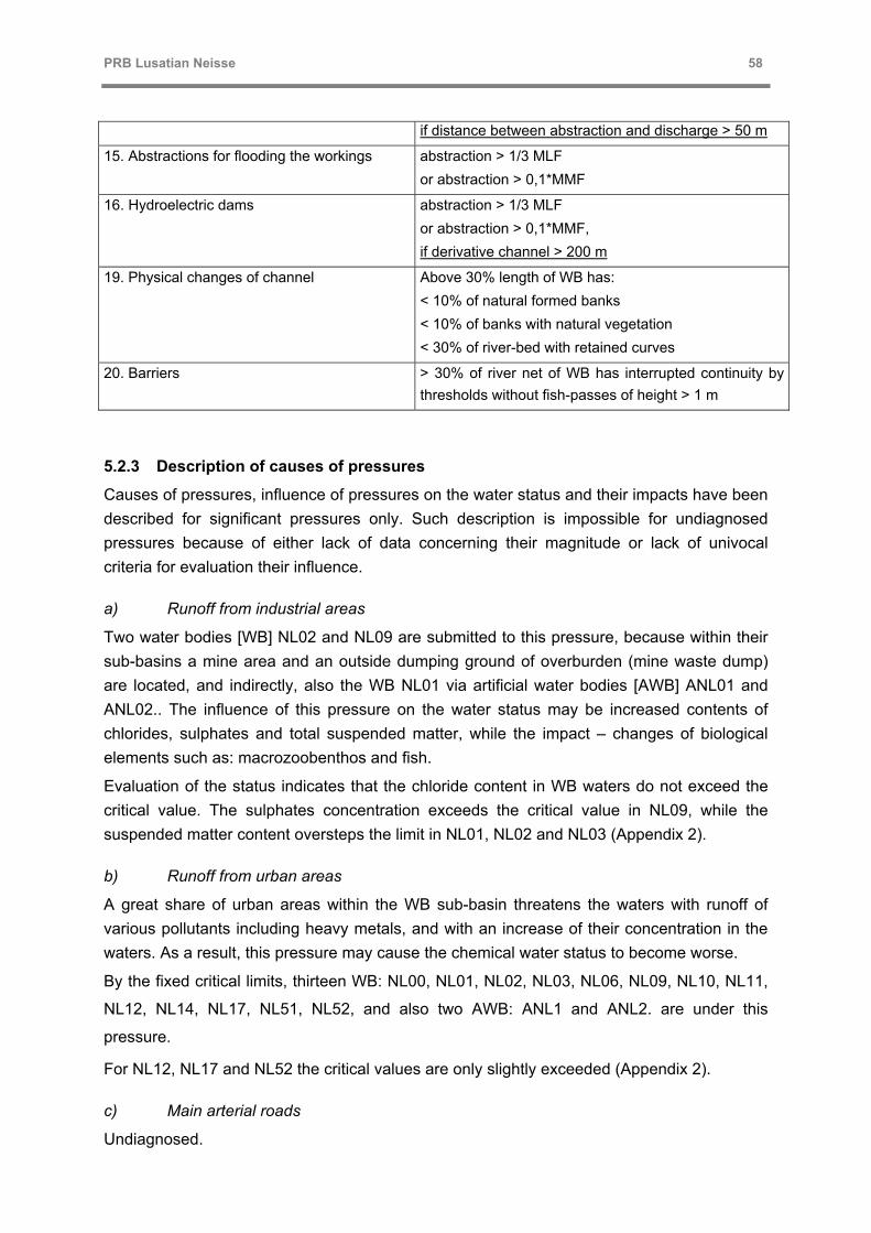
PRB Lusatian Neisse 58
if distance between abstraction and discharge > 50 m
15. Abstractions for flooding the workings abstraction > 1/3 MLF or abstraction > 0,1*MMF
16. Hydroelectric dams abstraction > 1/3 MLF or abstraction > 0,1*MMF, if derivative channel > 200 m
19. Physical changes of channel Above 30% length of WB has: < 10% of natural formed banks < 10% of banks with natural vegetation < 30% of river-bed with retained curves
20. Barriers > 30% of river net of WB has interrupted continuity by thresholds without fish-passes of height > 1 m
5.2.3 Description of causes of pressures
Causes of pressures, influence of pressures on the water status and their impacts have been described for significant pressures only. Such description is impossible for undiagnosed pressures because of either lack of data concerning their magnitude or lack of univocal criteria for evaluation their influence.
a) Runoff from industrial areas
Two water bodies [WB] NL02 and NL09 are submitted to this pressure, because within their sub-basins a mine area and an outside dumping ground of overburden (mine waste dump) are located, and indirectly, also the WB NL01 via artificial water bodies [AWB] ANL01 and ANL02.. The influence of this pressure on the water status may be increased contents of chlorides, sulphates and total suspended matter, while the impact – changes of biological elements such as: macrozoobenthos and fish.
Evaluation of the status indicates that the chloride content in WB waters do not exceed the critical value. The sulphates concentration exceeds the critical value in NL09, while the suspended matter content oversteps the limit in NL01, NL02 and NL03 (Appendix 2).
b) Runoff from urban areas
A great share of urban areas within the WB sub-basin threatens the waters with runoff of various pollutants including heavy metals, and with an increase of their concentration in the waters. As a result, this pressure may cause the chemical water status to become worse.
By the fixed critical limits, thirteen WB: NL00, NL01, NL02, NL03, NL06, NL09, NL10, NL11,
NL12, NL14, NL17, NL51, NL52, and also two AWB: ANL1 and ANL2. are under this
pressure.
For NL12, NL17 and NL52 the critical values are only slightly exceeded (Appendix 2).
c) Main arterial roads
Undiagnosed.

PRB Lusatian Neisse 59
d) Arable land share in the structure of ground utilization
A big share of arable land may cause an increase of contents of biogenic substances (Nog. and Pog.), total suspended matter and pesticides (phytocides and insecticides). The impact of the pressure may be manifested by algal blooms and an excessive growth of water macrophytes (nutrients), a decrease in diversity and quantity of macrozoobenthos and fish (suspended matter), elimination of macrophytes (phytocides), and macrozoobenthos and fish (insecticides).
At the set critical levels, ten WB: NL10, NL11, NL12, NL13, NL14, NL15, NL16, NL17, NL18 and NL19, and one AWB - ANL 03 are under this pressure.
Evaluation of the status (Appendix 2) indicates that critical values of the parameters which may be modified by this pressure, i.e. the contents of Pog. and Nog have not been exceeded in the WB: NL10, NL11 and NL14.
e) Deposition from the atmosphere
The main influence of deposition from the atmosphere is an increased content of nutrients, which in turn impacts an increase of water trophy. In lake ecosystems, more sensitive than river ones, the increased concentration of biogenic substances is manifested by algal water-blooms. The load deposited per one unit of a surface can be estimated by applying the Vollenveider's criterion.
Evaluation of the deposition in the WB NL36 (Brodzkie Lake) and NL46 (Jańsko Lake), and the AWB ANL03 (Witka Reservoir) expressed as a percentage of permissible load according to the Vollenveider’s criterion is presented below:
Table 20: Deposition from the atmosphere in Polsih part of the Catchment
Year NL36 – av. depth 1,2 m NL46 – av. depth 0,7 m ANL3 – av. depth 2,8 m
Pog. Nog. Pog. Nog. Pog. Nog.
2001 40% 194% 40% 194% 28% 138%
2002 48% 211% 48% 211% 35% 148%
Based on the data of the Inspectorate of the Environment Protection/IMWM, Wrocław Branch, that were acquired within the framework of the State Monitoring of the Environment
The critical value of Nog content has been exceeded in each of the three WB, thus the
pressure should be regarded as a significant one.
f) Drainage in forestry
Undiagnosed.

PRB Lusatian Neisse 60
g) Municipal wastes, mostly communal sewage
The pressure causes an increase of the nutrients concentration, and its impact may be manifested as an excessive growth of algae and macrophytes, as well as changes in assemblages of macroinvertebrates and fish can appear.
At the set critical limits, none of the determined WB is under this pressure (Appendix 2). However, according to the critical values fixed by the Polish Law (change from the I class to the II class at the limit value of total phosphorus >0,2 mg/dm3) one can estimate that two WB – NL01 and NL40 directly, and NL02 and NL03 indirectly. undergo this pressure In case to ascertain the causes of overstepping the critical value, one should take into account the fact that such an exceed occurs also in the WB NL00, so it may be of another origin.
h) Mine drainage
This pressure may influence on the status by an increase of contents of chlorides, sulfates and total suspended matter, while its impact may result in changes of biological elements such as macrozoobenthos and fish.
Two WB: NL02 and NL09, as well as two AWB: ANL01 and ANL02 undergo this pressure
directly,. Indirectly, via the AWB, under this pressure is also the WB NL01.
Evaluation of the status (Appendix 2) indicates that only the critical value of the total
suspended matter has been exceeded, nevertheless the pressure impacts on another one
WB – NL03.
i) Priority substances
Undiagnosed.
j) Priority hazardous substances
Undiagnosed.
k) Other significant substances
Undiagnosed.
l) Abstractions for industry
Reduction in flow influences on the status directly (making habitat conditions worse, e.g. by reducing a number of hiding-places or changing bottom structure etc.), and also indirectly by an increase of the concentration of pollutants. The pressure impact may cause changes in assemblages of macroinverterbrates and fish.
Evaluation of the pressure significance of the identified abstractions is presented below:

PRB Lusatian Neisse 61
Table 21: Abstraction for industry in the Polish part of the catchment
WB User Non-returnable abstraction > 50 dm3/s
Abstraction > 0,1*SSQ
Pressure rating
NL09 Turów power plant + (70) - (0,08) Insignificant
NL11 Turów power plant + (740) + (0,20) Significant
NL17 Polfarmer Jerzmianki - (40) + (0,28) Significant
m) Abstractions for fish farms
Influence of the pressure on the status, and its impact – as mentioned above.
Evaluation of the pressure significance for the identified abstractions is presented below:
Table 22: Abstraction for fish farms in the Polish part of the catchment
WB User Non-returnable abstraction > 50 dm3/s
Abstraction > 0,1*SSQ
Pressure rating
NL27 Fish farm Żary - Janików - (36) - (0,05) Insignificant
NL28 Fish farm Żary - Grotów + (51) - (0,03) Insignificant
NL38 Fish farm Latoszek – Zelechów
Fish farm Miłowice
Fish farm Latoszek – Czarnowice
- (7)
- (17)
+ (71)
- (0,02)
Insignificant
NL48 Fish farm of the State Forestry Chlebice - (1) - (<0,01) Insignificant
NL49 Fish farm of the State Forestry Tuplice
Fish farm of the State Forestry Biecz
+ (80)
- (33)
- (<0,01) Insignificant
n) 14. Abstractions for hydroelectric power plants
River hydro-plants do not cause reduction in flow on condition that intake and discharge of water take place at the same site, and then their impact and influence on the water status are analogous to these of barriers which will be describe below (20). An additional pressure cause hydroelectric power plants that work on a long side derivative channel, where the water intake takes place at the entry, while the discharge even several hundred metres farther. In this situation, the flow in some of the water bodies [WB] is disturbed by hydroelectric power plants, in extreme cases it is reduced nearly to zero. An impact of such reduction of flow causes disappearance of adult individuals of typical river fish species and an increase of a number of fish species typical for stagnant waters.
Three WB undergo this pressure. There are: NL03 (the German hydroelectric power plant Ludwigsdorf), NL04 (the Polish hydroelectric power plant on an „energetic channel” in

PRB Lusatian Neisse 62
Pieńsk) and NL06 (the Polish hydroelectric power plant Żarki Wielkie with the derivative channel of a length ca. 500 m and the German power plant Gross Gastrose).
o) Abstractions for flooding the workings
Reduction of flow influences on the status directly (making the environmental conditions worse, e.g. by reducing a number of hiding-places or changing bottom structure etc.), and also indirectly by an increase of the concentration of pollutants. The pressure impact may cause changes in assemblages of macroinvertebrates and fish.
One WB – NL02, undergoes the pressure directly, while the other WB established on the Nysa Łużycka River indirectly because of periodical reduction of flow. However as the river runs downstream, the impact should diminish.
p) Hydroelectric dams
Influence of the pressure on the status and its impact, as well as danger for WB are the same as these described in the item 14.
q) Retention reservoirs
Undiagnosed.
r) Weirs
Undiagnosed.
s) Physical changes of river-bed
The pressure influences on the status most of all by reduction of numbers and diversity of habitats, while its impact causes changes in assemblages of fish and macrozoobenthos, and may cause changes in an assemblage of macrophytes.
Not for all WB, data necessary to evaluate physical changes of the river bed are sufficient. therefore some of them have not been evaluated (Appendix 2).
Physical changes of the bed of 14 WB: NL00, NL01, NL09, NL14, NL16, NL17, NL18, NL19,
NL21, NL25, NL38, NL39, NL40 and NL41 should be considered as significant. In the
diagnostic monitoring investigations, one should take into account the possibility of
classifying these WB as heavily modified water bodies [HMWB].
t) Barriers
Influence of this pressure on the status appears as breaking of the continuity of a river and making difficult or impossible for water organisms to migrate. Firstly, the pressure impact is manifested by disappearance of migrating anadromous fish species such as salmon, trout and vimba, that live in a sea and migrate for spawning-time into rivers. Secondly, barriers make impossible migration of eels living in rivers and spawning in a sea. They may make difficult migration for spawning-time of other fish species and various organisms as well.
Existing barriers along the Nysa Łużycka River are shown in Map 4.2.

PRB Lusatian Neisse 63
0,00
1,00
2,00
3,00
4,00
5,00
6,00
0,020,0 40,0 60,080,0100,0120,0140,0 160,0 180,0 200,0 km of river course
Height of a barrier [m]
WB
BARRIERS ELECTRIC POWER PLANTs
CHANNEL > 200 m PLwith fish pass
without fish pass
fish passdesigned
height < 1 mD
NL00
NL01
NL02
NL03
NL04
NL05
NL06
NL07
NL08
Figure 16: Distribution of barriers along Nysa Łużycka River
Parameters and distribution of barriers (transverse obstacles) along Nysa Łużycka River are presented below. Included here are the objects occurring as a complex, where the river continuity can be restored on one of the objects (and for this particular object a kilometre-post of the barrier is specified), EW – hydro-electric power plant; DE – German objects; PL – Polish objects.
Table 23: Parameters and distribution of barriers
WB Symbol at maps 2
River course km
Obstacle height [m]
Fish pass actual
Fish pass designed
Type of obstacle State
NL00 nł-34 196,4 2,0 none ? Zittau - Roller gate dam DE
NL01 nł-33 188,0 1,9 none ? Hirschwelde - Gate valve weir
DE
NL02 nł-32
nł-31
nł-30
nł-29
nł-28
178,8
176,9
174,0
171,0
167,1
2,2
2,2
2,5
3,0
0,7
Bar-lock type
Bar-lock type
none
Bar-lock type
none
Bar-lock type
unnecessary
Kl. Marienthal -Solid weir
Ostritz - Solid weir
Krzewina - Solid weir
Leuba- Solid weir
Hegenwerder - Solid weir
DE
DE
PL
DE
DE

PRB Lusatian Neisse 64
WB Symbol at maps 2
River course km
Obstacle height [m]
Fish pass actual
Fish pass designed
Type of obstacle State
NL03 nł-27
nł-26
nł-25
nł-24
nł-23
nł-22
160,9
159,9
157,5
153,7
151,7
146,9
0,6
1,8
1,1
1,8
2,7
2,8
none
none
none
none
none
Slit type
unnecessary
?
?
?
Bar-lock type
D. Ossig - Solid weir
Koźlice - Solid weir
Weinhubel - Solid weir
Goerlitz - Solid weir, EW DE
Zgorzelec - Solid weir, EW DE
Ludwigsdorf – Solid weir, EW DE
DE
DE
DE
DE
DE/PL
DE
NL04 nł-21-19
nł-18
nł-17
nł-16
nł-15-14
nł-13
137,7
126,3
124,3
123,2
116,9
111,6
4,2
4,0
1,5
2,2
3,1
3,2
none
none
Bar-lock type
none
Bar-lock type
none
Bar-lock type
?
Bar-lock type
Bar-lock type
Pieńsk - Solid weir, EW PL
Niederneundorf - Shell weir, EW DE
Rothenburg - Solid weir
Prędocice - Roof weir
Lodenau - Roof weir, EW DE
Sobolice - Flap weir, EW PL
PL
DE
DE/PL
PL
DE
PL
NL05 nł-12
nł-11
103,0
93,0
5,5
5,3
none
Bar-lock type
Bar-lock type
Bukówka - Gate valve weir, EW PL
Przysieka - Gate valve weir, EW PL
PL
PL
NL06 nł-10 79,8 4,3 none ? Bad-Muskau - Vertical-lift gate weir
DE
NL07 nł-9-8
nł-7
nł-6
nł-5
nł-4
nł-3
nł-2
nł-1
73,1
69,2
55,9
53,2
35,7
27,2
16,8
16,2
3,5
3,3
3,7
1,4
1,7
4,0
1,5
4,5
none
none
none
none
none
none
none
none
Bar-lock type
Bar-lock type
Bar-lock type
?
?
?
?
Slit type
Żarki Wlk. - Gate valve weir, EW PL
Zielisko - Gate valve weir. EW PL
Zasieki - Gate valve weir, EW PL
Forst - Vertical-lift gate weir, EW DE
Griessen - Gate valve weir, EW DE
G. Gastrose - Gate valve weir, EW DE
Guben - Gate valve weir. EW DE
Gubin - Segmental weir , EW PL
PL
PL
PL
DE
DE
DE
DE
PL

PRB Lusatian Neisse 65
Already the first barrier on the Nysa Łużycka, located in Gubin town breaks the river continuity, cutting off the way for migratory fish to all other WB. Similarly, the fish migrating only within the water course have no opportunity to move among particular WB. Therefore this pressure should be considered as a significant one.
5.2.4 Pressures forecast
Prognoses concerning pressures influence on the status and their impacts make possible to evaluate the possibility to reach the WFD objectives – good ecological status of WB and good ecological potential of AWB. The following course of forecasting about pressure significance has been adopted:
a) OBJECTIVES NOT AT RISK
Reaching the objective is not at risk if all of the four preconditions occur:
− there is no risk from the priority substances, priority hazardous substances, specific
substances, and;
− there are no anthropogenic obstacles for migration, and
− critical values of physicochemical characteristics are not exceeded or, at most, only one
value is exceeded, and
− water quality is maintained within the limits of the II class, and the quality of morphological
structure is deteriorated at the section of < 30% of water bodies.
b) OBJECTIVES PERHAPS AT RISK
There is a possibility that reaching the objective would be at risk if the first two
preconditions are satisfied, but one or both of the other two preconditions are not satisfied:
− there is no risk from the priority substances, priority hazardous substances, specific
substances, and;
− there are no anthropogenic obstacles for migration, and
− certain critical values of physicochemical characteristics are exceeded or there are
insufficient data to make evaluation, or
− water quality is below the limits of the II class, and/or the quality of morphological
structure is deteriorated at the section of 30-70% of water bodies.
c) OBJECTIVES AT RISK
Reaching the objective is at risk if one (no matter which one) of the following preconditions
occurs:
− there is a risk from the priority substances, priority hazardous substances, specific
substances, or
PRB Lusatian Neisse 66
− there are anthropogenic obstacles for migration, or
− water quality is below the limits of the II class, and/or the quality of morphological
structure is deteriorated at the section of >70% of water bodies.
In order to make the evaluation, the existing data have been summarized in Appendix 3. The evaluation of physical and chemical conditions [PH-CH] was done on the basis of data of water quality collected within the State Monitoring of the Environment (Dolnośląski/Lower Silesia and Lubuski Voivodeship Inspectorates of the Environment Protection) These data have been summarized in Appendix 2. Migration possibility [M] has been assessed according to Figure, given above. Biological and morphological components were evaluated using data from the database of the Institute of Meteorology and Water Management (IMWM), Wrocław Branch, included in Appendix 2.
Prognosis of achievement of good status
It has been evaluated that 22 water bodies [WB] are at risk of failing to achieve the WFD objectives. The main reason of such evaluation is lack of migration opportunities. For 16 WB this reason is the only risk factor, for 3 WB - an additional factor is physicochemical status, for 1 WB– a river-bed morphology, and for 1 WB – both additional factors, i.e. physicochemical status and morphology. Only one WB is at risk only because of bad river-bed morphology. Synthesis of the prognosis is presented at Map 4.3.
At the stage of economical analysis and consultation with a broad range of the involved parties, it should be assessed whether the WB being at risk because of lack of migration opportunities should be defined as highly modified water bodies [HMWB].
Only 7 WB have been defined as not at risk of failing to achieve the WFD objectives. The remaining 24 WB have been evaluated as being perhaps at risk. For two of them, the reason of such evaluation is river-bed morphology, and for one WB– the physicochemical status. The remaining WB, for which no significant pressures have been identified, have been evaluated in this way, because of lack of the physicochemical and biological data.
Prognosis of achievement of good potential
Only two AWB: ANL01 and ANL02 are at risk of not achieving good potential. The reason is lack of migration opportunities and physicochemical status.
5.3 German strategy for pressures and impacts analysis
The German team followed the DPSIR-concept of the IMPRESS-Guidanance-Document.
The DPSIR-Model describes a sequence of influencing factors:
1. Driving forces
2. Pressures
3. State:
4. Impacts
5. Responses

PRB Lusatian Neisse 67
Goal of the analysis is to produce a causal connection between the driving forces/pressures and the resulting impacts. This analysis is the base for the river basin management planning.
5.3.1 Driving forces
Table 24 shows the relevant driving forces in the German part of the PRB Neisse.
Table 24: Driving forces in the German part of the PRB Neisse.
Category Driving forces Relevant for PRB Neisse
DIFFUSE SOURCE urban drainage (including runoff)
agriculture diffuse
forestry
other diffuse
Yes
Yes
Yes
No
POINT SOURCE waste water
industry
mining
contaminated land
agriculture point
waste management
aquaculture
Yes
Yes
Yes
Unknown
Unknown
Unknown
No
ACTIVITIES USING SPECIFIC SUBSTANCES
manufacture, use and emissions from all industrial/agricultural sectors
Unknown
ABSTRACTION reduction in flow Yes
ARTIFICIAL RECHARGE groundwater recharge Unknown
MORPHOLOGICAL
flow regulation
river management
transitional and coastal management
other morphological
Yes
Yes
No
No
OTHER ANTHROPOGENIC
miscellaneous No

PRB Lusatian Neisse 68
5.3.2 Pressures
a) Urban drainage diffuse sources (including runoff)
Zittau
Figure 17: Urban areas in the Saxonian part of the Neisse-catchment
Figure 17^shows the urban areas in the saxonian part of the catchment. The percentage of urban areas is approx. 12 % (98 km² in total). About 37% of this area are used by industry or for other commercial purposes. (Source: digital land model of Saxony).
Regarding that roads outside the cities are not included in this data set, the percentage of urban areas is a little bit above the German average (12% in 2002).

PRB Lusatian Neisse 69
On state level there is no information about the degree of connection to drainage systems or the type of drainage system (combined or separated) available. On the other hand almost every city or village in Germany has a drainage master plan.
For the city of Zittau (second largest city in the saxonian part of the catchment) is shown how the emissions from urban drainage systems can be estimated.
Figure 18 shows a zoning plan for the City of Zittau. Using mean values the degree of impervious areas can be calculated (City area: 772 hectare, impervious area: 336 hectare).
Within the drainage master plan a conceptual model for the sewer system (see Figure 19) has been developed. With this model not only the annual loads (e.g. COD) but also the hydraulic stress resulting from single storm events can be calculated.
Old houses, city centerOld housesDetached house, narrowDetached house, wideBlock of housesCommercial areasIndustrySchools, UnviersityRailway
Old houses, city centerOld housesDetached house, narrowDetached house, wideBlock of housesCommercial areasIndustrySchools, UnviersityRailway
Figure 18: Zoning plan of Zittau

PRB Lusatian Neisse 70
Figure 19: Sewer system in Zittau
Figure 20: Conceptual model for the sewer system in Zittau using STORM
The STORM model for the City of Zittau covers an area of 770 hectare. Approx. 336 hectare or 44% are impervious. The daily dry weather flow is 4.600 m³/day or 53 l/s.
The model shows that approx. 40% of the storm water (~600.000 m³/year) is discharges by combined sewer overflows. The mean annual runoff from paved areas is around 440 mm/a.
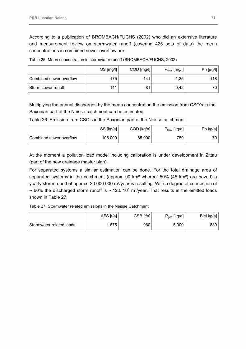
PRB Lusatian Neisse 71
According to a publication of BROMBACH/FUCHS (2002) who did an extensive literature and measurement review on stormwater runoff (covering 425 sets of data) the mean concentrations in combined sewer overflow are:
Table 25: Mean concentration in stormwater runoff (BROMBACH/FUCHS, 2002)
SS [mg/l] COD [mg/l] Ptotal [mg/l] Pb [µg/l]
Combined sewer overflow 175 141 1,25 118
Storm sewer runoff 141 81 0,42 70
Multiplying the annual discharges by the mean concentration the emission from CSO’s in the Saxonian part of the Neisse catchment can be estimated.
Table 26: Emission from CSO’s in the Saxonian part of the Neisse catchment
SS [kg/a] COD [kg/a] Ptotal [kg/a] Pb kg/a]
Combined sewer overflow 105.000 85.000 750 70
At the moment a pollution load model including calibration is under development in Zittau (part of the new drainage master plan).
For separated systems a similar estimation can be done. For the total drainage area of separated systems in the catchment (approx. 90 km² whereof 50% (45 km²) are paved) a yearly storm runoff of approx. 20.000.000 m³/year is resulting. With a degree of connection of ~ 60% the discharged storm runoff is ~ 12.0 106 m³/year. That results in the emitted loads shown in Table 27.
Table 27: Stormwater related emissions in the Neisse Catchment
AFS [t/a] CSB [t/a] Pges [kg/a] Blei kg/a]
Stormwater related loads 1.675 960 5.000 830

PRB Lusatian Neisse 72
b) Agriculture diffuse
Gebietsauslass
Laus
itzer
Nei
ße
Laus
itzer
Neiß
e
TSCHECHIEN
DEUTSCHLAND
POLENpoln. Zufluss: Miedzianka86 km²
poln. Zufluss: Witka 326 km²
poln. Zufluss:Cz. Woda 140 km²
Pegel Görlitz
OstritzKloster St. Marienthal
ZITTAU
GÖRLITZ
Zufluss: Pegel Hartau
Zufluss: Pegel Großschönau 2
Maßstab 1: 150.000
4 0 4 8 Kilometers
N
Forest18%
Meadows20%
Gardens0%
Agriculture46%
Surface Water0%
Mining3%
Urban9%
Industry4%
Figure 21: Land use distribution in the Saxonian part of the Neisse-catchment
Figure 21 shows that agriculture is a major driving force in the catchment. Another reason for the importance of agricultural diffuse sources are the soil conditions. Loess-soils consisting of fine material transported from northern areas by wind are very vulnerable to soil erosion.
There are several tools available for modeling the distributed diffuse emissions from agriculture depending on local conditions. One of these tools is MONERIS (Beherndt et al., 1999). MONERIS had been developed to determine the nutrient emissions from diffuse and point sources for river catchments in Germany. The diffuse emissions are composed of at least four different paths:
• atmospheric deposition
• diffuse emissions from surface runoff
• diffuse emissions caused by hypodermic runoff (interflow)
• diffuse emissions from groundwater (base flow)
In a separate study, the MONERIS model is applied to the Neisse catchment (BEHRENDT, 2004).

PRB Lusatian Neisse 73
c) Forestry
For the Saxonian part of the catchment a detailed GIS about the forest habitat situation is available (see Fehler! Verweisquelle konnte nicht gefunden werden.). The maps are including information about the soil situation so it can be used to determine surface runoff and erosion form forestry. In the PRB Neisse project this will be done using the Moneris concept.
Figure 22: Sector of the forest habitat map

PRB Lusatian Neisse 74
d) Waste water
Within the catchment several waste water treatment plants with a total capacity of 291.000 PE (population equivalent) are discharging into the river system. 2001 approx. 220.000 PE were connected to this WWTPs. All plants were constructed or refitted after 1991. The larger ones (Görlitz, Zittau, Hirschfelde, Rothenburg, Bad Muskau and Mittelherwigsdorf) are equipped with a mechanical-biological treatment including nitrogen and phosphorous removal.
Figure 23: Waste water treatment plants in the Saxonian part of the Neisse catchment
Figure 23 shows that in the Saxonian part of the Neisse catchment and especially in the part with a higher population density the degree of connection to a sewer system is rather high. It can be estimated that in this catchment more than 90% of the population are connection to a (mostly combined) sewer system.

PRB Lusatian Neisse 75
Table 28: Waste water treatment plants in the Saxonian part of the Neisse catchment
WWTP-Name Capacity
(PE) connected
PE Outflow [m³/a]
COD mg/l
COD kg/a
BOD5 mg/l
BOD5 kg/a
Ntot mg/l
Ntot kg/a
Ptot mg/l
Ptot kg/a
Görlitz- Nord 140.000 100.000 2.452.190 46 112.801 4,1 10.054 12,8 31.388 0,5 1.103
Zittau 85.000 66.300 4.132.300 40 166.945 <3 14,5 59.918 0,9 3.636
Mittelherwigsdorf 22.000 28.800 1.033.000 42 43.386 4,9 5.062 5,3 5.475 1,1 1.136
Rothenburg 17.000 6.700 236.961 42 10.047 <3 11,4 2.701 0,3 73
Hirschfelde 11.000 6.100 328.619 62 20.374 5,2 1.709 5,5 1.807 1,4 444
Bad Muskau 5.000 4.300 259.183 43 11.197 <3 2,3 596 0,7 179
Rennersdorf 4.500 1.400 43.131 37 1.596 <3 2,5 108 9,8 423
Kiesdorf 4.000 4.700 186.412 47 8.761 4,3 802 4,0 746 7,0 1.305
Ostritz-Nord neu 2.500 2.300 113.897 24 2.734 <3 80,0 9.112 1,5 165
Sum 291.000 220.600 8.785.693 377.841 17.626 111.851 8.465

PRB Lusatian Neisse 76
e) Industry
According to the statistics of the environmental authorities direct discharges from industry are not very relevant in the Saxonian part of the catchment.
Figure 24: Industrial discharges
f) Mining
In Berzdorf (Saxony, Germany) the first coal mining activities started in 1835. From 1946 a large surface mine had been developed over the years mainly to produce brown coal for the combined heat and power plant in Hagenwerder between Görlitz and Ostritz. The mine was closed in 1997. Since then the mine is going to be rehabilitated and flooded (see h) for abstractions).
In Olbersdorf the mining activities closed in 1995. The process of flooding is already finished.
On polish territory the power plant in Turow and the associated coal mine are still active.
g) Morphology
On the 53 km long Czech part of the Neisse about 21 weirs can be found.

PRB Lusatian Neisse 77
The “development” of the Neisse from the Czech border to the Weinau-Park in Zittau started in 1926. Starting in the late 19th century the Mandau was channeled on the last kilometers.
About 63 weirs for different purposes are located In the Saxonian part of the catchment (see Figure 25).
Figure 25: Flow regulation and permitted abstractions in the German/Polish
h) Abstraction
Figure 25 shows the permitted abstraction from surface waters (Max. in m³/day). Beside of several smaller abstractions for industrial or fishing purposes there three major abstractions in the saxonian part of the catchment (Table 29)
Table 29: Major abstractions in the Saxonian part of the catchment
Purpose of abstraction River max. allowed abstraction [m³/d]
Mean flow [m³/s]
refilling of former mining areas Neiße 864.000 13,3
refilling of former mining areas Pließnitz 216.000 0,4
transition Neiße 172.800 17,6

PRB Lusatian Neisse 78
i) Assessment of pressures
Figure 26 and Figure 27 are showing a comparison of discharges and emissions from different urban sources.
Einleitmenge [m³/a]
11.880.000
8.800.000
100.000600.000
Mischwassereinleitung (Zittau)
Regenwassereinleitungen
Kommunale Kläranlagen
Industrielle Einleitungen
Figure 26: Discharges from „urban“ sources
CSB-Jahresfracht [kg/a]
962.280
427.550
84.600
Pges-Jahresfracht [kg/a]
4.990
9.251
750
Mischwasserentlastungen
Regenwasserabflüsse imTrennsystem
Kommunale Kläranlagen
Figure 27: Emissions from „urban“ sources

PRB Lusatian Neisse 79
5.3.3 State
a) Water qualitiy
Since 1990 water quality in the Neisse improved very much. Figure 28 shows the development of the saprobic index as an indicator for the biological water quality over the last 7 years. Figure 29 shows the actual situation of the saprobic index (I: very good, V: poor).
2,0
2,5
3,0
3,5
Hradek Dreiländereck Drausendorf Hirschfelde oh Görlitz /Zgorzelec
uh Görlitz /Zgorzelec
1993 1994 1995 1999
Saprobienindex (Makro)
Güteklasse III
Güteklasse II-III
Güteklasse II
Figure 28: Longitudinal section of water quality in the Neisse from 1993 to 1999
b) Morphology
Figure 29 (right side) shows the German habitat survey as an indicator for morphologic situation along the river Neisse.

PRB Lusatian Neisse 80
Figure 29: Saprobic index and German habitat survey
5.3.4 Impacts
a) Ichthyology
Within a research project funded by the German Environmental Foundation (DBU) the fish population in the river Neisse was investigated in detail (Bernáth, 2001). Between 1999 and 2001 at 20 different location in Germany and the Czech Republic about 13.500 fish were caught. In total 28 different kind of fish could be proved (e.g. rainbow trout, brook trout, pike, carp, eel, perch, roach, minnow), 22 on German territory 15 on Czech territory.
In addition, Ichthyology was assessed by the fishing authority of Saxony. Following this assessment, deficits at fish fauna for the whole river Neisse including tributaries except the river Pließnitz have to be stated

PRB Lusatian Neisse 81
5.4 Common results of pressures and impacts analysis
5.4.1 Mandau-Catchment
a) IMPRESS-Analysis for the sub-catchment of the Mandau (D-CZ)
In coordination with the project partners, the IMPRESS-Analysis was not carried out for the whole Neisse catchment, due to following reasons:
• An IMPRESS-Analysis takes a lot of effort, because extensive data has to be processed and models have to be used.
• An analysis of the relation between pressures and impacts in a trans-national catchment may be difficult.
• For a test of the Guidance-Documents an application on the whole catchment is not necessary.
• The quantification of nutrient emission (BEHRENDT, 2004) was not finished in spring 2004.
Therefore the project partners agreed to test the IMPRESS-Guidance-Document on two sub-catchments, Czerwona Woda and Mandau.
b) The Mandau Catchment
The Mandau is a tributary of the Neisse on the left side. The catchment lies in German territory in the southeast part of the Free State of Saxony, and in Czech territory in the Rozvoj Šluknovska Region. In total, it amounts to an area of ca. 297 km². About 110 km² of that are in the Czech Republic and ca. 187 km² in the Federal Republic of Germany.
The source of the Mandau lies in the Lusatian Highlands on the Czech side of the border in the town of Nové Křečaný. The Mandau flows through Rumburg and Warnsdorf in an easterly direction and flows into the Neisse near Zittau after running 25 km.
The Mandau catchment lies on the eastern border of the geographical region of the Upper-Lausatian Highlands. The Upper-Lausatian Highlands are strikingly structured. Long-streching and virtually closed forested ridges with elevations of 450 to 550 m alternate with mostly wide, but often divided valleys with an average elevation of 280 to 320 m that are agriculturally utilised and also densely populated. The mountain chains and valleys exhibit a typical west-east or sometimes west-northwest to east-southeast direction. In the southern part, the catchment is bordered in the Czech Republic by the Luzicke Hory (Lusatian Range) and in Germany by the Zittauer Range.

PRB Lusatian Neisse 82
Figure 30: Location of the Mandau catchment
Lasur/ Quelle
Quelle Mandau
Warnsdorf/ Manda
Pstrutny
Lasur/ Unterlauf
Leutersdorfer Wasser
Rumburg/ Mandau
Landwasser
Goldbach
Zittau/ Mandau
GrundbachPochebach
Hainewalde/ Mandau
Bertsdorfer Wasser
Grossschoenau/ Mandau
Teileinzugsgebiete MandauGewässersystemStaatsgrenze
Einzugsgebiet der Mandau - Maßstab: 1 : 100,000
Höhenmodell [m]200 - 225225 - 250250 - 275275 - 300300 - 325325 - 350350 - 375375 - 400400 - 425425 - 450450 - 475475 - 500500 - 525525 - 550550 - 575575 - 600600 - 650650 - 700700 - 800
Figure 31: Topography in the Mandu Catchment

PRB Lusatian Neisse 83
c) Impacts in the Mandau Catchment
Figure 32: Land use in the Mandau Catchment (Source: LfUG)
The percentage of agricultural land in the catchment is over 50%. Due to this high percentage, as well as to the soil situation (loess), one faces relatively high substance inputs from agriculture. An exact approximation of the substance inputs from agricultural surfaces can be done according to the presentation of the study to quantify nutrients (BEHRENDT, 2004).
The treatment plant Mittelherwigsdorf (28800 EW) lies in the catchment. Table 13 shows the discharges from this facility.
Tabelle 13: Emissions from the Mittelherwigsdorf Treatment Plant
Substance Annual Load [kg/a]
CSB 43386,00
Nges 5474,90
Pges 1136,30
AOX 53,37
The impacts from stormwater discharges can be approximated similarly to Chapter Fehler! Verweisquelle konnte nicht gefunden werden..

PRB Lusatian Neisse 84
d) Effects in the Mandau Catchment
Figure 33: Water Quality in the Mandau Catchment (CZ and D)
The structure of water quality in the Mandau is distinctly to starkly changed in large parts, in some parts (City of Zittau) even very intensely changed (see Figure 34 and Figure 35). Even the water qualtiy (saprobic) is in many parts worse than Class II.

PRB Lusatian Neisse 85
Figure 34: : Photo of the Mandau in the area of Zittau
Figure 35: Photo of the Mandau in the area of Mittelherwigsdorf
e) Analysis of the Relationship of Impact to Effect
An intersection of the water quality structure with the development structure shows a definite relationship. The waterbody has been shored to a large extent for reasons of flood protection (raising the discharge capacity) (s. IPS, 2004). Considering the ecological situation in the water body detached from flood protection is not constructive for the Mandau.

PRB Lusatian Neisse 86
The deficits with the water quality can be originally traced back to inputs from agriculture, stormwater discharges from the separated sewer, and discharge from the treatment plant in Mittelherwigsdorf. Which source has the greatest influence, and therefore should be treated with priority in the course of management planning, can be determined according to the presentation of the study to quantify nutrient inputs (BEHRENDT, 2004).
Summary:
The LAWA suggests summary and evaluation criteria for non-point sources. According to that, there is a significant impact by non-point sources whenever:
• > 15% of the area is urban in nature
• > 40 % of the area is agricultural land
• > 20 % of the agricultural land is planted with root crops, including corn
• > 5% of the agricultural land is planted with specialised crops (wine, fruit, hops, vegetables)
• there is > 1,5 livestock units/ha of active agricultural land
• single significant contaminated sites with demonstrated relevance to water law emerge.
For the Mandau, the criterium “urban area“ is not fulfilled, but the criterium “agricultural land” is.
The analysis of the relationship of impact to effect for the Mandau shows that such an approximation alone on the basis of area percentage is not sensible at least for the criterium „urban area“. Rather, other criteria should be considered such as the location of the areas to the water and keeping to the best available technology for stormwater treatement
5.4.2 Polish-Catchment Czerwona Woda River
An area of Czerwona Woda River sub-basin equals 126,62 km2. There are 401 small water-courses of a total length of 155,5 km and 13 both rivers and streams of a total length of 96,42 km (Figure 36).
In Czerwona Woda River sub-basin, forests covers an area of 18,41 km2 (14,3%), arable land - 93,42 km2 (73,8%), and urbanized area - 15,06 km2 (11,9%). There is only 1 point source of pollution– waste water treatment plant in Sulików (1 400 RLM) (Figure 37).

PRB Lusatian Neisse 87
Rivers
Sub-basin boundary
NL15NL14
NL13
Figure 36: Water-net in the sub-basin of Czerwona Woda River.
Rivers
Arable area
Forests
Urbanised area
WWTP Sulików (1 400 PE)
NL15NL14
NL13
Figure 37: Land-use and point sources in the sub-basin of Czerwona Woda River.

PRB Lusatian Neisse 88
In Czerwona Woda River sub-basin, 2 types of water bodies (WB) have been identified:
o Sub-mountain siliceous stream of Sudety and Sudety Foreland
o Lowland gravely river.
In the sub-basin, no artificial water bodies (AWB) nor heavily modified water bodies (HMWB) have been identified. Three significant WB (Figure 38), provisionally indicated as NL (Nysa Luzycka) have been distinguished and their characteristics is as follows:
Table 30: Water bodies in the Czerwona Woda River sub-basin
WB Name of WB Length of WB [km]
Sub-basin area of
WB [km2]
Forests [%]
Arable area [%]
Urbanized area [%]
NL13
Czerwona Woda to Włosiennica
15,5 40,72 7,6 81,0 11,4
NL14
Czerwona Woda from Włosiennica to Nysa Łużycka
25,5 25,92 9,8 72,1 18,1
NL15
Włosiennica (right tributary of Czerwona Woda)
20,0 59,98 20,9 69,6 9,5
Submountain siliceous stream
Lowland gravely river
WB types:
NL15NL14
NL13
Figure 38: Types and water bodies (WB) identified in Czerwona Woda River sub-basin.
Morphological status of identified water bodies: NL13, NL14 and NL15 has been assessed as good or moderate (Figure 39).

PRB Lusatian Neisse 89
Morphology status:
Good
Moderate
Not valuated
NL15NL14
NL13
Figure 39: Morphological status of water bodies identified in Czerwona Woda sub-basin.
The water bodies described are under four pressures with significance for particular WB as
presented below (Table 31).
Table 31: Pressures in Czerwona Woda River sub-basin
PRESSURE CRITERION Water body [WB] NL13 NL14 NL15
2. Outflow from urbanized area
> 15% of urbanized area in the WB sub-basin
Not at risk At risk Not at risk
4. Arable area > 40% of arable area in the WB sub-basin
At risk At risk At risk
19. Physical changes of river-bed
More than 30% of the WB length possesses: < 10% naturally formed banks < 10% banks with natural vegetation < 30% of river-bed deserves curves
Not at risk At risk Not at risk
20. Barriers/* > 30% of the WB river-net has broken continuity by obstacles without fish passages of a height > 1 m
At risk At risk At risk
Total value At risk At risk At risk
/* Barriers making impossible migration of anadromous fish along Nysa Łużycka.

PRB Lusatian Neisse 90
An analysis of mentioned above pressures and their impacts allows to state that three water bodies identified in the sub-basin of Czerwona Woda River are at risk of failing to reach the WFD objectives (Figure 40).
Risk assessment:
At risk
NL15NL14
NL13
Figure 40: Risk assessment of failing the WFD objectives in Czerwona Woda sub-basin

PRB Lusatian Neisse 91
5.5 Risk Assessment for the surface water bodies
Figure 41: Risk Assessment for the surface water bodies

PRB Lusatian Neisse 92
Table 32: Risk Assessment for the surface water bodies
GERMANY
MS_NO RIVERS MONITORING RISK ASSESS-MENT
DIFF_AC DIFF_URB Point BARR MORPHO_1_DE Mandau operational at risk x x xS_3_DE Mandau surveillance at riskO_4_DE Lausur operational at risk x x xO_5_DE Mandau operational at risk x x xO_6_DE Mandau operational pot. hmwb x xS_6_DE Mandau surveillance pot. hmwbO_7_DE Petersbach operational at risk x xO_8_DE Pließnitz operational at risk x x xI_9_DE Pließnitz investigative at risk xS_10_DE Pließnitz surveillance at riskS_11_DE Lausitzer Neiße surveillance at risk xO_12_DE Lausitzer Neiße operational at risk x x x xO_13_DE Lausitzer Neiße operational at risk x x xO_14_DE Lausitzer Neiße operational at risk xO_15_DE Lausitzer Neiße operational at risk xS_15_DE Lausitzer Neiße surveillance at riskS_16_DE Lausitzer Neiße surveillance not at riskO_17_DE Mühlengraben Sagar operational at risk xO_18_DE Legnitzka operational at risk x xO_19_DE Räderschnitza operational at risk x x
CZECH REPUBLIK
MS_NO RIVERS MONITORING RISK ASSESS-MENT
DIFF_AC DIFF_URB Point BARR MORPHS_1_CZ/S_3_DE Mandava- Mandau surveillance at riskS_2_CZ/S_11_DE Lužická Nisa- Nysa
Lužycka - Lausitzer Neisse
surveillance at risk x
S_3_CZ Smědá - Witka surveillance not at riskO_1_CZ/O_1_DE Mandava- Mandau operational at risk x x xO_2_CZ/O_4_DE Podlužský potok-
Lausuroperational at risk x x x
O_3_CZ Lužická Nisa operational pot.hmwbO_4_CZ Harcovský potok operational pot.hmwbO_5_CZ Lužická Nisa operational pot.hmwbI_1_CZ Oleška - Miedzianka investigative not at risk?D_1_CZ Řasnice prepare drinking water not at riskD_2_CZ Hájený potok prepare drinking water not at riskD_3_CZ Smědá prepare drinking water not at risk
POLAND
MS_NO RIVERS MONITORING RISK ASSESS-MENT
DIFF_AC DIFF_URB Point BARR MORPHS_1_PL/S_11_DE Nysa Łużycka surveillance at risk x x x x
O_1_PL Nysa Łużycka operational at risk x x x xO_2_PL Miedzianka operational at risk x x x x xS_2_PL Witka surveillance at risk x x xO_3_PL Witka operational at risk x x xO_4_PL Czerwona Woda operational at risk x x x
O_5_PL/S_13_DE Nysa Łużycka operational at risk x x x xO_6_PL Jędrzychowicki Potok operational at risk x x xO_7_PL Żarecki Potok operational at risk x xO_8_PL Bielawka operational at risk xO_9_PL Żółta Woda operational not at risk
O_10_PL/S_14_DE Nysa Łużycka operational at risk xO_11_PL Skroda operational perhaps at risk x x x
S_3_PL/S_15_DE Nysa Łużycka surveillance at risk x x x xO_12_PL Wodra operational perhaps at risk xO_13_PL Lubsza operational perhaps at risk x x xS_4_PL Lubsza surveillance not at risk x x xS_5_PL Nysa Łużycka surveillance not at risk x x x x
PRESSURES
PRESSURES
PRESSURES

PRB Lusatian Neisse 93
5.6 ToR-Answers on pressures and impacts analysis
ToR 2.1-1: Is the list of “pressures” and the related “criteria” adequate as a basis to define those significant pressures at water body level that pose a risk of failing to meet the environmental objectives
The list of pressures in the IMPRESS guidance document is rather detailed. Using every parameter mentioned there would need a big data set. The German LAWA published a „criteria document“ to identify significant pressures in a more easy way. This document is also mentioned in the IMPRESS paper as a possible tool, helping to do the pressure and impact analysis in time.
In the PRB Neisse we considered these LAWA criteria as well as some additional parameters important in this catchment: We assume, that non point sources of nutrient input will play an important role in the selected areas of the Neisse basin (e.g. Pließnitz) because of agriculture being the major land utilization there. Using results from an other research project, detailed data from water balance models are available. Combining these data with the results of surface runoff concentrations calculated by MONERIS we are able to estimate the relative load of non point sources. We will compare these results with the assessment of the LAWA „criteria document“.
ToR 2.1-2: Is the list of “impact indicators” and “threshold sizes” adequate to asses the risk of failing to meet the environmental objectives?
In the LAWA „criteria document“ used (see 2.1-1), the way how to identify significant pressures as well as criteria for impact indicators for chemical pollution and corresponding thresholds are described there.
ToR 2.1-3: Is the DPSI(R) concept applicable in practice?
The relation between pressures and state variables not assessed (following the DPSI-concept called „state“, e.g. O2-concentration, HQ1, etc.) can be modelled rather easily. Models normally used are: precipitation-discharge-models or water balance models (e.g. NASIM), water quality models (e.g. ATV-FGSM) and models calculating the emission rate (emission model for urban areas e.g. MONERIS calculating the emission of non point sources, see 2.1-1).

PRB Lusatian Neisse 94
6 Monitoring (MONITORING).
6.1 Czech strategy for monitoring The Czech strategy for monitoring is based on last-years experiences and covers all most important impacts. Proposed monitoring sites coordinated with German and Polish partners are in .
Table 33: Czech proposal for monitoring sites
ID_C
Z
RIV
ER
MO
NIT
OR
ING
RIS
K
DIF
F_LW
DIF
F-U
RB
PU
NK
T
QB
W
MO
RP
H
MZB
FIS
H
MP
_PB
PH
YS
ICO
-C
HE
MIC
AL
MO
RP
HO
L
PE
GE
L
S_1_CZ Mandava- Mandau
surveillance at risk
x x x
complete x x
S_2_CZ Lužická Nisa- Nysa Lužycka - Lausitzer Neisse
surveillance at risk
x
x x x
complete x x
S_3_CZ Smědá - Witka
surveillance not at risk x x x
complete x x
O_1_CZ Mandava- Mandau
operational at risk x x x x x
NO3;PO4;NH4;O2;pH;Temp.
O_2_CZ Podlužský potok- Lausur
operational at risk x x x x x
NO3;PO4;NH4;O2;pH;Temp.x
O_3_CZ Lužická Nisa operational potentially hmwb
x x x
complete x x
O_4_CZ Harcovský potok
Operational potentially. .hmwb
x x x
complete x x
O_5_CZ Lužická Nisa Operational potentially hmwb
x x x
complete x x
I_1_CZ Oleška - Miedzianka
investigative not at risk? x x x
complete x
D_1_CZ Řasnice monitoring for drinking water
production
not at risk according to government directive 428/2001 Sb.
D_2_CZ Hájený potok
monitoring for drinking water
production
not at risk according to government directive 428/2001 Sb.
D_3_CZ Smědá monitoring for drinking water
production
not at risk according to government directive 428/2001 Sb.
PRB Lusatian Neisse 95
6.2 Polish strategy for monitoring
6.2.1 Description of the monitoring of surface water
Water monitoring activities in the Polish part of the Nysa Łużycka basin are carried out in two sections – Polish and international: Polish-Czech and Polish-German.
a) INTERNATIONAL MONITORING OF SURFACE WATER
Principles of co-operation in the field of water management on the Polish-Czech section of the border, were set up in the Agreement signed on 21 March 1958, which defined International Polish-Czech Commission for Transboundary co-operation. The following working groups operate within the Commission:
− Polish-Czech Common Working Group, for planning of water management on
transboundary waters, called Group PL,
− Polish-Czech Common Working Group, for hydrology, hydrogeology and flood protection,
called Group HyP,
− Polish-Czech Common Working Group, for regulation of boundary waters, water supply
and melioration of transboundary areas, called Group R,
− Polish-Czech Common Working Group, for protection of boundary waters from
contamination, called Group OPZ.
After political transformations, the principles of co-operation on surface waters did not change; investigations are carried out at two monitoring sites; physico-chemical examinations indicate only 12 elements (Map 6.1., Table 1).
Principles of co-operation on the Polish-German section of transboundary waters, were set up in the year 1965. After political transformations, new co-operation base was established with the Federal Republic of Germany by the Agreement of 19 May 1992, which set up principles of Polish-German Commission for Transboundary Waters. The following working groups operate within the Commission:
− Polish-German Working Group for Hydrology and Hydrogeology of Transboundary
Waters, called Group W1,
− Polish-German Working Group for Protection of Transboundary Waters, called Group
W2,
− Polish-German Working Group for Extraordinary Contamination of Transboundary
Waters, called Group W3,
− Polish-German Working Group for Maintaining of Transboundary Waters, called Group
W4,
− Polish-German Working Group for Planning of Transboundary Waters Management,
called Group W5.

PRB Lusatian Neisse 96
The Working Group for Protection of Transboundary Waters has been continuing a long lasting co-operation, with the new economical circumstances taken into consideration; the Group also aims at implementation of the Framework Water Directive. The Group has been assigned for the following tasks:
− execution of examinations and tests of surface water contamination, by each of the
Parties, and exchange of results obtained from examinations and tests,
− execution of commonly performed intercalibration examinations; establishing of
monitoring plans, analytical methods and methods for evaluation of surface water quality,
− contribution to common database and elaboration of common annual water quality
evaluations; analysing trends of surface water quality changes.
General indicative physico-chemical and biological quality elements are being monitored 12 times per annum at 14 monitoring sites of surface water. The monitoring program covers 36 elements of surface water (Map 6.1., Table 1).
Comparison of Polish-Czech and Polish-German Monitoring programmes indicates that they differ from each other and do not comply with the requirements of the Framework Water Directive.
To date, there have been no analysis for setting up common monitoring and surface water quality evaluation system for the three countries, that would comply with all requirements of the Framework Water Directive.
b) POLISH MONITORING OF SURFACE WATER
In the Polish part of the Nysa Łużycka river basin, the examinations are carried out at 20 monitoring sites, out of which 15 are part of surface monitoring network (Map 6.2., Table 2).
Currently effective Polish surface waters quality monitoring system for the Nysa Łużycka river basin, consists of four types: surveillance monitoring, operational monitoring, investigative monitoring and monitoring for protected areas used for the abstraction of drinking water. Quality examinations for surveillance, operational and protected areas monitoring activities, are carried out by laboratories of Voivodship Environment Protection Inspectorates in Jelenia Góra and Zielona Góra, which have been granted certificate of the Polish Accreditation Centre. Investigative and quantitative monitoring activities are carried out by the Institute of Meteorology and Water Management (IMGW) in Wrocław.
6.2.2 Surveillance monitoring
In the Polish part of the Nysa Łużycka river basin, surveillance monitoring has been implemented in the year 2004 at 17 monitoring sites. Locations of these sites are defined by the requirements of the Framework Water Directive. After one year of examinations, there will be an assessment held, in order to evaluate the plans for reduction of monitoring sites, with simultaneous maintaining of capabilities for monitoring of waters bodies being at risk of failing to achieve objectives of the Framework Water Directive, or water bodies that might potentially be at risk. There is a homogenous programme for surveillance monitoring, that is

PRB Lusatian Neisse 97
a list of parameters indicative for all general physico-chemical and biological quality elements, and monitoring frequencies, depending on the types of parameters (Table 3). The evaluation is made for five classes, based on the value of the percentile 90 (10 for oxygen and 10 and 90 for pH reaction) in 12 examinations per annum. For smaller amounts of data, the worst results are to be taken into consideration for the evaluation.
After one year of examinations, the results of such monitoring shall be used to define the changes that are to be made in the surveillance monitoring programme, which might be extended to include monitoring of priority substances and eco-toxicological tests.
In order to test the workbook "Guidance on Monitoring for the Water Framework Directive", results of Block 3 Section 4 were taken into account ("Guidance on the analysis of pressures and impacts" and "Guidance on the classification of inland surface waters status and reference conditions"), defining proposal for monitoring programme, based on results of evaluation of pressures, and it was initially agreed that surveillance monitoring might be reduced to only 5 monitoring sites (2 single water bodies and 3 water body groups), in which the programme shall be carried out (Map 6.3., Table 3). It is assumed to be the first full surveillance monitoring programme, that shall provide data for determination of quantitative reference basis for the future evaluation of long-term natural and anthropogenic changes. Because the water bodies are of transboundary nature, it is necessary to monitor for all priority substances during the first year of surveillance. The obtained results shall be used for supplementing and validating the assessment of whether water bodies are at risk of failing ecological quality standards, with the aim of progressively reducing contamination from priority substances (Framework Water Directive, art. 4.1.a.iv.). It is advised that surveillance monitoring should be carried on till the year 2006 at full range, and its results shall be the basis for the final verification for assigning monitoring locations, parameters and frequencies. The Polish proposal for the Nysa Łużycka river has been shown in the table below:
Table 34: Polish proposal for monitoring parameters
Quality parameters Rivers Lakes Fitoplankton 6 months 6 months Remaining water flora 3 years 3 years Macrofauna – invertebrates 3 years 3 years Fishes 3 years 3 years Continuity 6 years - Hydrology continuous monitoring 1 month Morphology 6 years 6 years Thermal conditions 1 month 3 months Oxigenation 1 month 3 months Salinity 1 month 3 months Biogenic substances 1 month 3 months Acidification 1 month 3 months Other contamination 3 months 3 months Priority substances 1 month 1 months

PRB Lusatian Neisse 98
After this period of time, the surveillance monitoring programme shall comply with the requirements set up in the Framework Water Directive.
This type of surveillance monitoring programme shall ensure assessment of long-term changes resulting from anthropogenic activity and natural conditions.
6.2.3 Operational monitoring of surface water
Operational monitoring has been designed on parameters indicative for the quality elements most sensitive to the pressures to which the homogenous water bodies are subject. Based on monitoring and evaluation of condition of homogenous water bodies, which are at risk of failing to achieve environmental objectives, operational monitoring network (Map 6.4., Table 4) has been initially defined, located at 13 sites (5 single water bodies and 8 water body groups). The choice of locations for monitoring sites was also based on existing contamination sources, but at the present stage of works, it was not possible to measure the impact of each source of pressure, and as a result of that the entire impact of pressure groups will have to be considered. The choice of homogenous water bodies, representing this type of monitoring, may get changed after the termination of surveillance monitoring.
The choice of monitored quality elements includes the biological and hydromorphological elements, that were particularly vulnerable to pressures in the considered water bodies. The Monitoring and evaluation systems are based on the characteristics of the ecological condition, with the physico-chemical parameters taken into account. The list of quality elements currently suggested for monitoring, have been shown in table 4. Frequencies shall be defined depending on the quality elements. Operational monitoring programme and frequencies shall be defined after evaluation of the surveillance monitoring results for the years 2004 and 2005. It is assumed that these shall be determined in 2006, and implementation of the final version of the monitoring shall commence in 2007. then, the results of this monitoring shall be used to control the condition of water bodies at risk.
6.2.4 Investigative Monitoring of surface water
In the Nysa Łużycka basin investigative monitoring is carried out because of necessity of forecasting changes of water resources and evaluating the impacts on the environment of the open-cast mines existing in this basin. This type of monitoring is realised with the use of Nysa Łużycka River and underground waters monitoring sites network.
Investigative monitoring programme provides monitoring of early warning for maintaining unobstructed water flow on Nysa Łużycka river. For the purpose of investigative monitoring, continuous hydrometric measurements, periodical extended physico-chemical and biological research are conducted at surveillance monitoring sites.
The results of investigative monitoring shall be the basis for determination of the forecast model of quantitative and quality changes in water resources, as well as evaluation of pressures from forecasted changes. Surveillance monitoring data are used for investigative monitoring.

PRB Lusatian Neisse 99
6.2.5 Quality assurance/Quality control
Monitoring is based on standardised methods of physico-chemical tests (ISO). The laboratories have quality system implemented, but it affects the data in the laboratories. There is no quality system for quality control of the data input into the database. These requirements have not been defined in the tested guidance book. Such evaluation is provided in Poland, and these data in the database are verified in the Institute of Meteorology and Water Management (IMGW) in Wrocław.
6.3 German strategy for monitoring
Figure 42 shows the German strategy for the development of the monitoring programme.
Step 1:Selection of all water bodies being at risk / hmwb
Step 2: Selecting the reason for being at risk/hmwb
Step 3: Aggregation of water bodies to water body groups
Step 4: Selection of the kind of monitoring
Step 5: Selection of the biological quality elements and supporting abiotic
parameters to be monitored
Investigative monitoring Operational monitoring
Investigative and operationalmonitoring
Step 6: Checking if these operational monitoring sites are
also useful for surveillance monitoring
Investigative Monitoring Program Operational Monitoring
Program
Step 7: Screening for further appropriate surveillance
monitoring locations
Surveillance Monitoring Program
Figure 42: Flow-chart showing the German strategy for monitoring

PRB Lusatian Neisse 100
Table 35: Monitoring sites in the German part of the catchment
GERMANY
MS_NO RIVERS MONITORING RISK ASSESS-MENT
MZB FISH MP_PB PHYSICO_CHEMICAL MORPHOL GAUGE
O_1_DE/O_1_CZ Mandau operational at risk x x NO3; PO4; NH4; O2; pH; Temp.
S_3_DE/S_1_CZ Mandau surveillance at risk x x x complete x x
O_4_DE/O_2_CZ Lausur operational at risk x x NO3; PO4; NH4; O2; pH; Temp. x
O_5_DE Mandau operational at risk x x TOC; BOD; NO3; PO4; NH4; O2; pH; Temp.
O_6_DE Mandau operational pot. hmwb x x TOC; BOD; NO3; PO4; NH4; O2; pH; Temp.
S_6_DE Mandau surveillance pot. hmwb x x x complete x x
O_7_DE Petersbach operational at risk x x NO3; PO4; NH4; O2; pH; Temp. x
O_8_DE Pließnitz operational at risk x x NO3; PO4; NH4; O2; pH; Temp. x
I_9_DE Pließnitz investigative at risk x x x complete xS_10_DE Pließnitz surveillance at risk x x x complete x xS_11_DE/S_2_CZ/S_1_PL Lausitzer Neiße surveillance at risk x x x complete x x
O_12_DE/O_1_PL Lausitzer Neiße operational at risk x x NO3; PO4; NH4; O2; pH; Temp.
O_13_DE/O_5_PL Lausitzer Neiße operational at risk x x TOC; BOD; NO3; PO4; NH4; O2; pH; Temp.
O_14_DE/O_10_PL Lausitzer Neiße operational at risk x NO3; PO4; NH4; O2; pH; Temp.
O_15_DE Lausitzer Neiße operational at risk x NO3; PO4; NH4; O2; pH; Temp.
S_15_DE/S_3_PL Lausitzer Neiße surveillance at risk x x x complete xS_16_DE/S_5_PL Lausitzer Neiße surveillance not at risk x x x complete x x
O_17_DE Mühlengraben Sagar operational at risk x NO3; PO4; NH4; O2; pH; Temp. x
O_18_DE Legnitzka operational at risk x NO3; PO4; NH4; O2; pH; Temp. x
O_19_DE Räderschnitza operational at risk x NO3; PO4; NH4; O2; pH; Temp. x
PARAMETERS
6.4 Common monitoring results
Figure 43 and Figure 44 are showing the common results for the monitoring sites.

PRB Lusatian Neisse 101
Figure 43: Surveillance monitoring sites

PRB Lusatian Neisse 102
Figure 44: Operational und investigative monitoring site

PRB Lusatian Neisse 103
7 Transboundary experiences
7.1 Project coordination
In June 2003, a kick-off meeting with partners from all participating states took place. At this meeting, objectives, work packages and the Guidance Documents, which have to tested, have been presented. All partners agreed to contribute to the project with respect to the schedule. After organisational difficulties in phase 1 (June – November 2003), a constructive and fruitful cooperation characterized phase 2 (Dezember 2003 - Dezember 2004). In total, 8 work meetings took place (Figure 45).
Figure 45: Internal meetings
7.2 Workshops on EU-level and public relations work
The results of the project have been presented on several workshops
• Workshop on water body delineation Bruxelles, September 2003, Participants: P. Podraza (ube)
• Workshop in Belgirate (Italy), November 2003, Participants: B. Fritzsche, P. Podraza und H. Sieker (IPS) Presentation: ”Lessons resulting from Guidance Document Testing with focus on transboundary experiences”, H. Sieker
• Workshop in Rome, April 2004, Participants: B. Fritzsche, S. Gondlach und H. Sieker
• Workshop in Ghent, October 2004 Participants: B. Fritzsche, H. Sonntag, P. Podraza and M. Halle und H. Sieker Presentation: ”PRB Neiße - Transboundary Experiences ”, H. Sieker
• ASB-Meetings in Bruxelles (September 2003, October 2003, February 2004)

PRB Lusatian Neisse 104
In addition, the results (progress-reports, presentations) were published on the website www.wasserblick.net. For the meeting of water directors in June 2004 a poster has been produced (Figure 46).
Figure 46: Poster for the meeting of water directors in June 2004

PRB Lusatian Neisse 105
8 Summary The Lausatian Neisse Catchment was selected as a pilot river basin by the water directors of each country to test the following CIS Guidance Documents:
• Identification of waterbodies • Impacts and Effects (IMPRESS), • Reference Preconditions (REFCOND), • Monitoring (MONITORING).
The goal of the test is to assess the practicability and coherence of the listed guidelines. Aside from that, concrete results for implementing the EU-WRRL should be compiled and the foundation for a trusting cooperation should be formed in this international river basin.
In June of 2003, German, Polish and Czech representatives agreed to carry out this test in the scope of a transnational project collectively. On the German side, this project is being promoted by the Federal Environmental Agency. The State Environmental Office in Bautzen contracted Ingenieurgesellschaft Prof. Dr. Sieker mbH and the Environmental Office (Umweltbüro), Essen to carry out the project. This report covers the time period from July 2003 to November 2004.
The project partners have amically agreed to carry out the process first according to the usual national methods, to then compile results, and then to adjust and compensate only where necessary (in the border regions). With this method, area-wide maps were created in the scope of countless meetings for:
• Watebody identification,
• The reference preconditions,
• A risk determination concerning reaching the goals of the WRRL,
• Monitoring Locations, as well as for
• Impacts and Effects (selected criteria).
This called for organising national data and work results into a homogenous geographical information system.
The impact-effect analysis (IMPRESS) was carryed out exemplarily for two sub-catchments (Mandau and Czerwona Woda). At the same time came innovative methods like polluting load models for urban areas or nutrient balance models for application.

PRB Lusatian Neisse 106
9 Literatur SMUL (2004): Bericht über die Umsetzung der Artikel 5 und 6 sowie die Anhänge II, III und
IV der Richtlinie 2000/60/EG im Bearbeitungsgebiet Lausitzer Neiße, 2004
BEHRENDT, H. (1999): Nährstoffbilanzierung der Flussgebiete Deutschlands, Forschungsbericht, 75/99, Umweltbundesamt, Berlin.
BEHRENDT (2004): Quantifizierung der Nährstoffeinträge in die Lausitzer Neiße (in Vorb.)
BERNÁTH, PAVEL (2001): Erfassung und Bewertung des Verlaufes der natürlichen Revitalisierung der Ichthyozönose in der Lausitzer Neiße, Abschlussbericht zum Förderprojekt der Deutschen Bundesstiftung Umwelt, Aktenzeichen 12449, Projektträger: Karlsuniversität zu Prag, Naturwissenschaftliche Fakultät, Antragsteller: Landratsamt Löbau-Zittau
BROMBACH, FUCHS (2003): Datenpool gemessener Verschmutzungskonzentrationen in Misch- und Trennkanalisationen, KA-Abwasser, Nr. 4 2003 (50),
CIS GUIDANCE DOCUMENT IMPRESS: Guidance Document on the Analysis of pressures and impacts (signifikante Belastungen, Prioritäre Stoffe), CIS Working Group 2.1, verfügbar unter www.wasserblick.net
CIS GUIDANCE DOCUMENT HMWB: Guidance Document on heavily modified water bodies (HMWB) (stark veränderte Gewässer), CIS Working Group 2.2, verfügbar unter www.wasserblick.net
CIS GUIDANCE DOCUMENT REFCOND: Guidance Document on Reference conditions Inland surface waters (Referenzbedingungen für Oberflächengewässer), CIS Working Group 2.3, verfügbar unter www.wasserblick.net
CIS GUIDANCE DOCUMENT MONITORING: Guidance Document on Monitoring (Überwachung), CIS Working Group 2.7, verfügbar unter www.wasserblick.net
CIS GUIDANCE DOCUMENT PLANNING PROCESSES: Guidance Document on Best practices in River Basin Planning (Methoden für die Flussgebietsplanung), CIS Working Group 2.9, verfügbar unter www.wasserblick.net
CIS Guidance Document GIS: Guidance Document on Geographical Information Systems (einheitliche GIS-Plattform), CIS Working Group 3.1, verfügbar unter www.wasserblick.net
CIS Guidance Document Identification of Water Bodies, CIS Working Group on Water Bodies, verfügbar unter www.wasserblick.net
HAD (2003): Hydrologischer Atlas von Deutschland, Bundesministerium für Umwelt, Naturschutz und Reaktorsicherheit, Bonn
IPS (2004): Hochwasserschutzkonzeption für das Einzugsgebiet der Mandau, Abschlussbericht, erstellt im Auftrag des Staatlichen Umweltfachamtes Bautzen

PRB Lusatian Neisse 107
Annex
Profiles of German Stream Types