training manual for - utah division of water rights€¦ · training decreases the workload of...
TRANSCRIPT
PROOF PROFESSIONAL
TRAINING MANUAL
For
PROOF OF BENEFICIAL USE
In The
STATE OF UTAH
Utah Division of Water Rights
Salt Lake City, Utah
2012
Purpose of this manual
The purpose of this manual is to explain and improve the proof and certification process
by providing the information necessary for applicants and proof professionals to ensure
that an accurate and timely Certificate of Beneficial Use is delivered to the water right
owner. This information is intended to help applicants and proof professionals understand
what is required of them in this process so as to aid in the efficient processing of the
relevant documents.
Due to the various levels of experience found among applicants and proof professionals;
an overview of fundamental water right concepts will be given, along with a review of
the applicable statutes and administrative rules, and a historical perspective on how and
why the process came to be.
Other subjects will be discussed as they pertain to the proof and certification process.
These will include, but are not limited to, the proof, certification, amendatory change, and
adjudication processes; proof requirements and processing procedures; standard values
used in calculating diversion and depletion amounts; mapping standards; supplemental
water rights and their relation to a water right’s sole supply; tools available on Division’s
website; and determining when it’s appropriate to file a municipal proof.
Mission of the Division of Water Rights
The mission of the Division of Water Rights is to provide order and certainty in the
beneficial use of Utah’s water.
The proof and certificate process are fundamental in accomplishing that mission.
Application approval authorizes the development of a proposed project conditionally.
Proof demonstrates the project has actually been implemented, water has been placed to
the beneficial use authorized, and a certificate (documenting the specific details of the
water right as it moves from a conditional authorization to a permanent water) is justified.
Order is only maintained if the proof accurately describes the details of the project as
constructed so the State Engineer’s record, as reflected in the issued certificate, is reliable
documentation of the water right created.
Table of Contents
Reasons for Training Proof Professionals
Water Rights Statutes and Administrative Rules
Water Right Processes
Proof Process
Certification Process
Amendatory Change Process
Statutory Proof Requirements
Proof Processing Procedures
Showing Beneficial Use
Mapping
Flow Measurements
Appurtenance
Supplemental Water Rights
Sole Supply
Water Rights in Excess of Beneficial Use
Miscellaneous Points of Diversion
OSE & Memorandum Decision Conditions
Subdivision Proofs
Municipal Use Proofs
Municipal Use Proof Analysis
Affidavits of Beneficial Use for a Small Amount of Water
What Separates an Excellent from an Acceptable Proof?
Standard Diversion Values
Standard Depletion Values
Reasons for Applicant and Proof Professional Training
Training helps applicants and proof professionals prepare better proofs more efficiently.
Because a certificated water right is considered real property, it is essential that it be
defined thoroughly and accurately.
Training decreases the workload of Division personnel in reviewing and processing
proofs, and issuing certificates. If a proof is accurate and complete upon submission, then
the water right owner can receive their certificate without the proof professional and
Division staff having to expend time and effort on corrections, amendments, title updates,
etc.
Water Rights Statutes and Administrative Rules
Utah’s water laws were first enacted in 1903 to address a variety of issues and are mostly
found in Title 73 of the Utah Code Annotated (UCA). Most notably, they define the
process for appropriating water and establish a way to define and record historical, pre-
statutory water uses by allowing water users to file diligence claims as evidence of such
use.
Chapter 1 is the law’s general provisions dealing with units of measurement, beneficial
use, loss of water rights, eminent domain, use and maintenance of ditches, conveyance of
water rights, the appurtenance of water to land, and interference with water deliveries.
Chapter 2 defines the State Engineer’s authority to administer water rights, provide
assistance to state and federal courts, keep records, make agreements with other
governmental entities, conduct cooperative investigations, deal with flood emergencies,
and conduct enforcement activities.
Chapter 3 sets forth the administrative procedures and criteria for appropriating,
changing, and exchanging water. Submission of proof and issuance of certificates are
covered in sections 16 and 17 of this chapter.
Chapter 4 deals with the determination of water rights through adjudicative proceedings
and the State Engineer’s role in said process.
Chapter 5 establishes the State Engineer’s responsibilities in the administration and
distribution of water from its natural source.
Chapter 6 covers the withdrawal of unappropriated waters by gubernatorial proclamation.
Later, other chapters and amendments were added covering water exports, groundwater
recharge and recovery, wastewater reuse, dam safety, and geothermal resources. An
important addition came in 1935 when groundwater was added to the State Engineer’s
responsibilities.
In support of his statutory authority, the State Engineer has promulgated administrative
rules that are found in Title R-655 of the Utah Administrative Rules (UAR). These rules
cover activities such as geothermal wells, administrative procedures, water right
conveyance, water well drilling, mapping standards, informal proceedings, the reuse of
sewage effluent, dam safety, stream alterations, enforcement proceedings, distribution
systems and water commissioners, and the quantification of beneficial use for
supplemental water rights.
Water Right Processes
The State Engineer has developed a number of different processes to accomplish his
statutory and administrative duties. However, the administration of water rights and the
processing of various applications filed by the public consume the bulk of his time. What
follows is a brief explanation of those processes that relate to the proof process.
Proof Process
This process is the responsibility of the applicant and the proof professional he hires. The
proof must be filed showing the works have been constructed and the water put to
beneficial use. When the State Engineer is satisfied the water has been placed to
beneficial use in accordance with the application (as demonstrated by the proof), a
certificate will be issued which completes the water appropriation process.
The main emphasis of this manual is to provide the applicant and proof professional with
the information that will allow them to prepare accurate and acceptably complete proofs.
Certification Process
This process begins when the Division receives a proof. Division staff reviews the
submitted documents for completeness and acceptability, namely that ownership
corresponds with the Division’s records, the proof engineer has signed and stamped the
forms, and applicant’s signature(s) is properly notarized. If the documents are insufficient
in these areas, they are returned to the person making the submission for correction.
When the documents are acceptably complete, personnel in the Regional Office conduct
a field inspection and prepare a draft Certificate of Beneficial Use to be reviewed by the
Division’s Applications & Records Section.
If the field inspection or review of the file reveals errors in proof documents filed prior to
February 1, 2007, they are returned to the person making the submission for correction. If
there are errors or omissions on proof documents filed after February 1, 2007, that do not
materially affect the application, Division staff make note of these and continue to
process the proof. Situations may exist where additional clarifying information is needed
and/or requested to facilitate continued processing of the proof (ex. approval conditions,
flow records, etc.). If the information on the proof does not reflect the approved
application, the Regional Engineer may require the applicant to file an amendatory
change application (see below).
If the proof differs egregiously from the approved application, is fraudulent, or the
requested corrections are not made in a timely manner, it may be rejected and the
application lapsed. If this occurs, the applicant may appeal the lapsing through the State
Engineer’s reconsideration and appeal process.
When the Division’s Applications & Records Section receives the proof, the draft
certificate, and/or the amendatory Order of the State Engineer (OSE), the documents are
checked for consistency and accuracy. Any errors found at this time are referred back to
the Regional Office for resolution. Once this final check is completed, the final version of
the Certificate of Beneficial Use is prepared for the State Engineer’s signature.
After the Certificate of Beneficial Use has been signed, the data is entered into the water
rights database, the documents are scanned into the Division’s imaging system, and the
applicant is sent their certificate. Applicants have the right to record their certificate with
the County Recorder in the county where the water is being used; the County Recorder is
the official office of record for ownership. The State Engineer strongly encourages
applicants to have their certificates recorded.
Amendatory Change Process
A change application is required when the proof and actual water use conditions do not
reflect the approved application. For example, the nature of use and/or the place of use
differ from the approved application. The Division terms change applications filed after
the proof is submitted “amendatory change applications”. The amendatory change goes
through the same administrative process as any other change applications except a proof
due date is not specified since the proof has already been submitted.
An amendatory change may be waived (subject to State Engineer’s discretion) for the
following small deviations from an approved application:
1) The point of diversion is within 150 feet of the approved point of diversion (depending
on other possible peripheral issues).
2) The place of use is located within an adjacent forty-acre public land survey system
tract but consistent with the location identified in the application.
3) The uses qualify as a small application and are located in an area where no advertising
is required on small applications.
After reviewing the proof and the application it supports, the Regional Engineer will
contact the applicant if a change application is required. Generally, the Division will
assist in the preparation of the change application consistent the proof provided.
Statutory Proof Requirements
Section 73-3-16 UCA sets forth the basic information required for a Proof of Beneficial
Use of Water. On, or before, the proof due date, the applicant shall file proof with the
State Engineer on the form furnished by the State Engineer (as shown below) along with
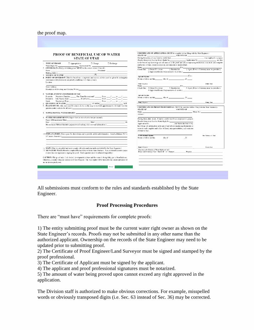
the proof map.
All submissions must conform to the rules and standards established by the State
Engineer.
Proof Processing Procedures
There are “must have” requirements for complete proofs:
1) The entity submitting proof must be the current water right owner as shown on the
State Engineer’s records. Proofs may not be submitted in any other name than the
authorized applicant. Ownership on the records of the State Engineer may need to be
updated prior to submitting proof.
2) The Certificate of Proof Engineer/Land Surveyor must be signed and stamped by the
proof professional.
3) The Certificate of Applicant must be signed by the applicant.
4) The applicant and proof professional signatures must be notarized.
5) The amount of water being proved upon cannot exceed any right approved in the
application.
The Division staff is authorized to make obvious corrections. For example, misspelled
words or obviously transposed digits (i.e. Sec. 63 instead of Sec. 36) may be corrected.
The proof is treated as a submission of the applicant and relied upon as submitted to
establish the facts assembled by the applicant.
Showing Beneficial Use
The purpose of a proof is to “prove” to the State Engineer the water has been placed to
use in accordance with an approved application and any conditions of approval attached
thereto. The proof can only show those uses (covered by the approved application) that
the proof professional actually witnesses. Attesting to uses or features that do not exist or
otherwise submitting falsified information on the proof is violation of professional ethics.
The irrigation of natural vegetation is usually not considered to be a beneficial use unless
it has been specifically in approved in granting an application.
Full-time domestic use must occur at a permanent or semi-permanent structure. Part-time
domestic use may occur at a permanent, temporary, or mobile structure.
Prior to the proof due date and when the beneficial use(s) proposed in the approved
application are not complete, the applicant has 3 options:
1) The applicant can file a request for an extension of time in which to submit proof. This
may allow additional time within which to complete development and place the water to
full beneficial use. However, extension request approvals are discretionary and the
applicant needs to provide evidence work is underway to accomplish the use of water
authorized in the application or the request may be denied.
2) The applicant can let the water right application lapse and seek approval of a new
application. However, if the area in question is closed to new appropriations, a lapsed
application to appropriate cannot be “replaced”. Likewise, regional policy may affect
whether a change application can be approved on an existing water right that was
acquired to “replace” a lapsed water right application. There is no provision in law for
automatic approval of new applications intended to replace a lapsed application. Each
application is considered on its individual merit and appropriation policies in place at the
time the application is filed.
3) The applicant can prove up on the part of the application that has been completed;
segregate off the remaining portion and file an extension request on that portion, or let the
undeveloped portion lapse. All segregations require a $50 fee. Segregations do not
require an OSE.
Mapping
An important part of showing proof is the submission of a proof map. Although proof
maps must identify the location of features of the developed project in relationship to
public land survey monuments and land boundaries, they are not surveys of real property
for the establishment of land boundaries, rights-of-way, easements, alignment of streets,
or the dependent or independent survey or resurvey of the public and survey system.
Accordingly, either a licensed surveyor or engineer may complete them.
When preparing proof maps, the Mapping standards are found in Administrative Rule
R655-5-4 UAR. Maps must be based on a competent survey. A competent survey is
defined by rule (R655-5-2.2 UAR) as one performed by, or under the direction of, either
a Utah-licensed professional engineer or a Utah-licensed land surveyor. It must be based
on measured ties (metes and bounds) to a regularly established and monumented section
corner or quarter corner. The survey shall be conducted to produce location specifications
within a one-foot positional tolerance.
Maps must include a:
1) North arrow.
2) Scale in both written and graphical form, compatible with each other.
3) Legend describing any symbols used.
4) Title block that must include the:
a) Water right number;
b) Application number;
c) Date of the survey;
d) Name of the applicant;
e) Name, seal, and license number of the proof professional; and the
f) Section, township, range, and base and meridian where the parcel is located.
5) Basis of bearing.
6) Any public roads adjacent to or near the property surveyed should be shown and
labeled.
7) If within a legally platted subdivision, the subdivision name and lot/block designations
of the subject parcels shall also be shown.
All information must be legible. Line quality must be distinct. The boundaries of irrigated
areas must be clearly delineated. Shading or hachuring may be used to show irrigated
acreage.
Maps must be submitted on standard drafting medium that is durable and reproducible.
All information shown on the map must be in black permanent drafting ink or other
media of equivalent durability and opacity.
The preferred map sizes are 8½" x 11" or 8½" x 14". Maps of small parcels shall be
drawn to the largest scale practicable. The smallest scale allowable on small maps is 1"=
300' (1:3600). Maps shall not be folded. Margins should be at least 1¼" on the top and
½" on the sides and bottom. Larger maps shall be 24" x 36". Larger maps shall be rolled
for mailing and transport. If mailed, a protective tube or box shall be used.
The following can make the difference between a good map and an unacceptable one: 1)
Show and describe the diverting, measuring, and conveyance works; 2) Describe the
method of irrigation; 3) Show surface sources for some distance above and below the
diversion point(s); 4) Show property boundaries; and 5) Account for all water use
occurring from all sources.
Even though one-foot positional tolerance is the minimum location specification, proof
professionals are strongly encouraged to use standard accepted survey practices and
tolerances in the maps submitted such that their survey can be retraced by any other proof
professional using said practices and tolerances.
Flow Measurements
The measured flow, along with the priority date, determines how water from any
particular source will be diverted and distributed to the users of that source.
If the water right being proved upon diverts from multiple sources, each source needs a
measurement. The combined flow of the sources must support the total volume of water
to be diverted during the periods of use approved on the application. If this combined
flow is insufficient to supply the approved uses, then the uses must be reduced or other
rights in another source must be acquired and changed.
When measuring surface water sources, high water marks or other “theoretical”
measurements are not acceptable. Only physical measurements of the water using weirs,
flumes, flow meters, stopwatch and bucket, current meters, etc. are acceptable.
Measurement of water storage structures can be made using elevation-capacity tables,
surface area-elevation maps, etc.
A reasonable effort must be made to ensure that flow measurements are as accurate as
possible and represent the source capacity.
Appurtenance
Appurtenance means a water right is tied to the land it serves when both the water right
and the parcel are owned by the same entity. When the parcel of land is sold, the water
right, or the portion of it, that serves that parcel is automatically conveyed with the land
unless the water right is specifically excluded in the sale deed. One of the purposes for
submitting proof is to identify water right appurtenance to land or to a water deed
recorded prior to the sale.
Appurtenance must be shown on the proof map for all uses including stock watering.
To aid in the recording of water right certificates, county parcel numbers for lands where
the water is used should be specified and shown on the map.
Supplemental Water Rights
Sometimes proofs do not make sense because they focus on one water right without
addressing all of the water rights involved. The proof needs to reflect actual water use
practices on the ground to make sense. To do this, the proof professional needs to
consider any water rights that may be involved.
Supplemental water rights are, by definition, water rights that are used together for a
common beneficial use such as irrigation. Water rights are not necessarily supplemental
just because they have the same owner, or the water sources are commingled. Water
rights that irrigate adjoining pieces of land may not be supplemental. Supplemental water
rights can be separated through the change application process.
When water rights are supplemental, each water right can potentially provide the entire
flow during a given year. The classic case is when a surface right and a well are used on
the same land.
When water rights are used on the same land, for the same purpose, and have the same
owners, they are generally considered supplemental subject to the following limitations:
Limitation #1: a proof cannot change the place of use (alter the appurtenance) of a water
right that is not the subject of the proof.
Limitation #2: the water right owner may want to show distinct places of use for each
water right for future conveyance purposes or other reasons.
For ease of use and the proper definition of the water rights, supplemental water use
groups organize the uses in the State Engineer’s database. Each group shows the water
rights that serve the uses listed along with their place of use and their period of use. The
amount of water that each water right supplies to the group’s uses is that water right’s
sole supply.
The following figures and commentary illustrate commonly encountered situations
dealing with supplemental water rights, however they do not cover all situations.
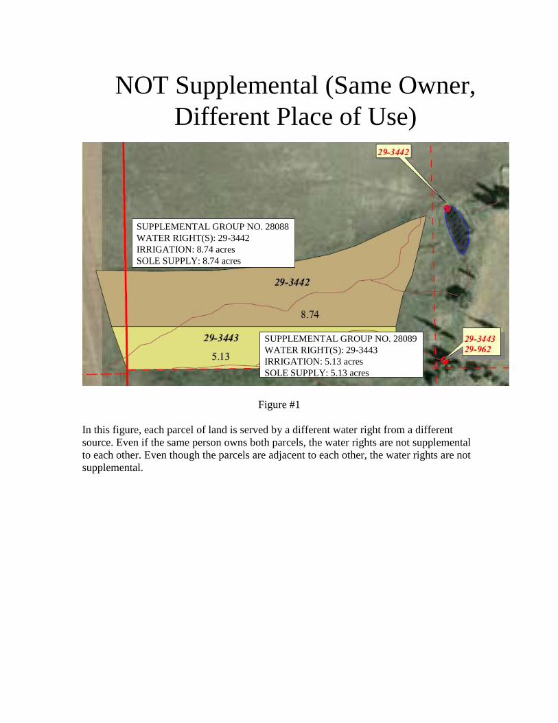
NOT Supplemental (Same Owner,
Different Place of Use)
SUPPLEMENTAL GROUP NO. 28088
WATER RIGHT(S): 29-3442
IRRIGATION: 8.74 acres
SOLE SUPPLY: 8.74 acres
SUPPLEMENTAL GROUP NO. 28089
WATER RIGHT(S): 29-3443
IRRIGATION: 5.13 acres
SOLE SUPPLY: 5.13 acres
Figure #1
In this figure, each parcel of land is served by a different water right from a different
source. Even if the same person owns both parcels, the water rights are not supplemental
to each other. Even though the parcels are adjacent to each other, the water rights are not
supplemental.
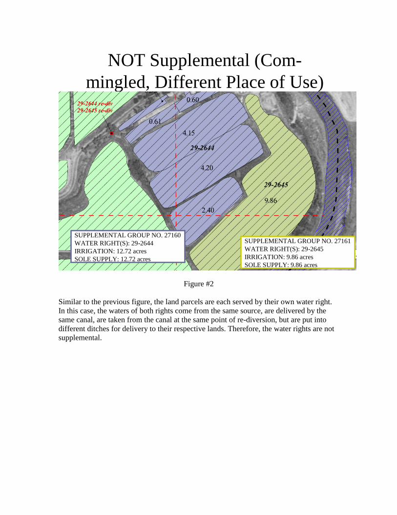
NOT Supplemental (Com-
mingled, Different Place of Use)
SUPPLEMENTAL GROUP NO. 27160
WATER RIGHT(S): 29-2644
IRRIGATION: 12.72 acres
SOLE SUPPLY: 12.72 acres
SUPPLEMENTAL GROUP NO. 27161
WATER RIGHT(S): 29-2645
IRRIGATION: 9.86 acres
SOLE SUPPLY: 9.86 acres
Figure #2
Similar to the previous figure, the land parcels are each served by their own water right.
In this case, the waters of both rights come from the same source, are delivered by the
same canal, are taken from the canal at the same point of re-diversion, but are put into
different ditches for delivery to their respective lands. Therefore, the water rights are not
supplemental.
Supplemental Water Rights
SUPPLEMENTAL GROUP NO. 26110
WATER RIGHT(S): 29-1474, 29-1575
IRRIGATION: 156.0 acres
SOLE SUPPLY: 29-1474 80.0 acres
29-1575 76.0 acres
Figure #3
Here a single parcel of land is served by two different water rights. Each right’s water can
be delivered to any part of the parcel. Even though each water right has a sole supply,
they both serve the entire parcel. For this reason, they supplement each other. The water
rights may have different owners, different sources, or different priority dates, but,
because they serve the same land, they are supplemental.
Sole Supply
Sole supply is defined as a quantification of a water right’s beneficial use representing the
maximum use of water when used alone and separate from any and all supplemental
water rights.
Water rights are not necessarily limited by sole supply when used supplementally. As
mentioned above, a surface water right and a well water right can be used to irrigate a
tract of land. During wet years, the surface source may supply all of the needed water. In
a drought, the well may supply all of the needed water. During most years, the surface
source will supply all of the water available under its water right and the well will supply
the remaining water under its water right. The sole supply should reflect the average
annual amount of water diverted under each water right on a long-term basis.
In most cases, sole supply must be defined for a water right before a certificate can be
issued. If the sole supply is less than the total amount, all other quantities must be
accounted for by other water rights. If those other water rights are not defined as to sole
supply, the applicant may choose to file a Declaration of Beneficial Use wherein the sole
supply amount for each water right in a supplemental water use group is quantified.
Water Rights in Excess of Beneficial Use
This occurs when the place of use has more water rights than can be beneficially used.
Claiming uses in a proof that are already reflected on another water right will not be
acknowledged in a certificate since it is a not a new beneficial use of water. This includes
water delivered by mutual irrigation companies and storage water delivered under
contract.
Tools are available on the Division’s website to aid the proof professional in checking for
existing water rights during the proof process. Programs are available that allow proof
professionals to search by owner name, source of supply, point of diversion, and place of
use.
Miscellaneous Points of Diversion
Points of diversion for dams located on the natural channel are defined as “the point
where the longitudinal axis of the dam crosses the center of the streambed” [73-3-2(d)(iii)
UCA].
A point of re-diversion is “The point where released storage water is taken from the
[natural] stream [73-3-2(d)(iv) UCA]. This also applies to inter-basin transfers of water.
A point of return is the point where unconsumed water that has been diverted is returned
to a natural source. This applies when the water use is non-consumptive, such as
hydroelectric power generation or other industrial uses, and the water is returned to a
natural stream after use. It does not apply to irrigation return flows or other uses where
unused water seeps back to the system.
OSE and Memorandum Decision Conditions
To protect prior water rights, guard against over appropriation of a water source, or
facilitate water distribution, there may be certain conditions imposed when an application
is approved. These conditions are stated in the approving OSE or Memorandum Decision.
It is essential that these conditions be met prior to the submission of a proof. Typically,
approval conditions become conditions of any ensuing certificate issued.
Listed below are some of the more common OSE conditions.
Measuring Devices: Statute requires all water right holders to meter their diversions.
When a meter is specifically required to satisfy the concerns of any protestants or as part
of a ground-water management plan, proofs on water uses should show metered diversion
records and indicate on the proof the location and type of measuring device installed.
Land Removed From Production: When a change application is approved that takes
irrigation water and changes it to another use or moves it to another place of use, the land
heretofore irrigated by the water being changed must be taken out of production.
Multi-Source Language: When an application is approved where water is diverted from
more than one source, conditions may be imposed limiting the amount of water that can
be diverted from each source or prescribing the order in which water can be diverted
from said sources.
Maintenance of Contract or Ownership of Shares: When a change application is based on
shares in a mutual irrigation company or an exchange application is based on a contract
with a water contracting entity, a condition is imposed wherein the water right certificate
remains valid only as long as the applicant retains ownership of the underlying shares or
maintains a valid contract with the contracting agency, respectively.
Subdivision Proofs
Proofs of Appropriation and Permanent Change filed on applications that describe water
to be used for subdivision purposes for domestic use can be filed and a certificate issued
by the State Engineer if evidence of the following conditions are shown in the proof
documents:
1. The subdivision has been filed with the county of record and has met all local, county,
and state requirements and ordinances. All improvements proposed by the developer and
described in the subdivision code or ordinances have been completed and accepted by the
county commission (or appropriate regulating agency).
2. A water system has been approved by the State of Utah, Department of Health,
Division of Environmental Health, and the installation of all appurtenant works has been
completed to the property lines, or as approved, and inspected by that department or
through a Utah licensed engineer.
3. A water right application or change application has been approved by the State
Engineer for all proposed uses. The source(s) of water has sufficient quantity and quality
to meet those described needs as proposed in the pending application and has met the
rules and regulations as required by the Division of Environmental Health.
4. The source(s) of water is equipped with a water totalizing meter(s) and the developer,
as a legal water supplier, or mutual water company shall be prepared to maintain an
accurate measurement and record of water used within the system. These records shall be
submitted to the Division of Water Rights on a calendar-year basis for inclusion in the
annual reports of municipal, commercial, industrial, or related uses.
5. The title to the water right(s) is held by a legally instituted organization (homeowners’
association, mutual water company, private water company, etc.) that has the authority to
act for the water users through an elected or appointed board of directors. Provide
evidence that the titleholder is 1) bound to maintain accurate measurements and records
of water usage, and 2) submit said records of use to the Division at the end of each
calendar year.
6. The proof map meets the Division’s mapping standards.
This process will allow those subdivisions with completed water systems that have been
approved by the State Engineer and Division of Environment Health to file proof on their
present and potential uses of water based on their underlying water right applications.
Upon certification, acre-foot limits will be established for the uses involved, based on
actual measurements of water and accepted usage quantities for those purposes described,
as approved by the Division of Water Rights.
Municipal Use Proofs
Water rights for municipal use are only held by those entities that qualify as public water
suppliers by statute [73-1-4(1)(b) UCA]. All sources and water rights need to be
considered in evaluating municipal use proofs.
The proof needs to show the acre-foot quantity placed to beneficial use. The proof should
show the total quantity of developed water and compare this amount to the total quantity
of water represented by the municipality’s perfected water rights. The applicant may only
prove up on an acre-foot amount that is above and beyond what is already perfected.
Proof of acre-foot use under an application may be analyzed in light of the perfected
source’s actual physical capacity and not necessarily just the perfected water right
theoretical acre-foot limitations. If the application filing included a flow rate, then the

proof should also show the lesser of the approved flow rate or the flow limitation
identified by measurement in the proof.
Municipal Use Proof Analysis
To promote consistency in municipal use proof submissions, it is suggested that the
following steps be used as a guide when preparing a proof submission for a public water
supplier.
Step 1) Identify all municipal use water rights owned by the public water supplier.
Step 2) Determine which municipal use water rights are perfected.
Step 3) Determine the total quantity of perfected municipal use water rights.
Step 4) Determine the maximum historic annual use from all sources.
Step 5) When the maximum annual use exceeds perfected water rights, then a certificate
can be issued for up to the difference between the two. If this difference is less than the
amount being proved upon, a certificate can be issued on the difference and the
remaining water can be segregated to a new water right and a request for an extension of
time in which to submit proof can be submitted on the remainder. If the maximum annual
use is less than the perfected water rights, the public water supplier should not submit
proof at this time and request from the State Engineer an extension of time in which to
submit proof on the relevant water right application(s).
Step 6) If a certificate can be issued, then determine if the sources being proved upon
have the capacity to produce the water needed for the perfected water rights already being
diverted plus the amount of water being proved upon. If the sources cannot deliver that
total amount of water, then a certificate can only be issued for the difference that can be
produced.
Affidavits of Beneficial Use for a Small Amount of Water
This discussion is included for the benefit of those proof professionals who may be hired
to advise applicants on the preparation of their affidavit. It allows an applicant to submit
an affidavit as proof for a small amount of water instead of hiring a proof professional to
prepare a proof. It also allows lapsed applications for a small amount of water, in some
cases, to be reinstated. A small amount of water is defined as one residence, up to ¼ acre
of irrigation, and/or up to 10 head of livestock.
The Affidavit of Beneficial Use, signed by the applicant(s) only, consists of four
documents; 1) the affidavit form properly filled out and executed, 2) the Map of
Beneficial Use that shows the location and extent of water use on the applicant’s land
parcel, 3) a plat map showing the location of the use within a subdivision or section
obtained from the County Recorder, and 4) a Certificate of Occupancy or tax notice
indicating the existence of a residence on the parcel and the parcel’s county parcel
number or property tax identification number.
What Separates an Excellent Proof from an Acceptable Proof?
Photographs showing beneficial use can be submitted in support of the proof documents
and will be placed on the water right’s permanent file. Such photographs are helpful
when clarification may be needed and when Division staff conducts their field inspection.
High quality maps that clearly delineate the beneficial uses and their location as well as
showing, in the case of irrigation, what uses are being supplied by a particular water
right.
No typos, errors, or ambiguities. These are the most frequent causes of delay when the
submitted proof is processed and the Division staff prepares the certificate.
Taking the time to prepare an excellent proof for submission means the proof
professional will not have to face an angry owner when the proof is rejected, or spend
additional time pursuing corrections so a certificate can be issued.
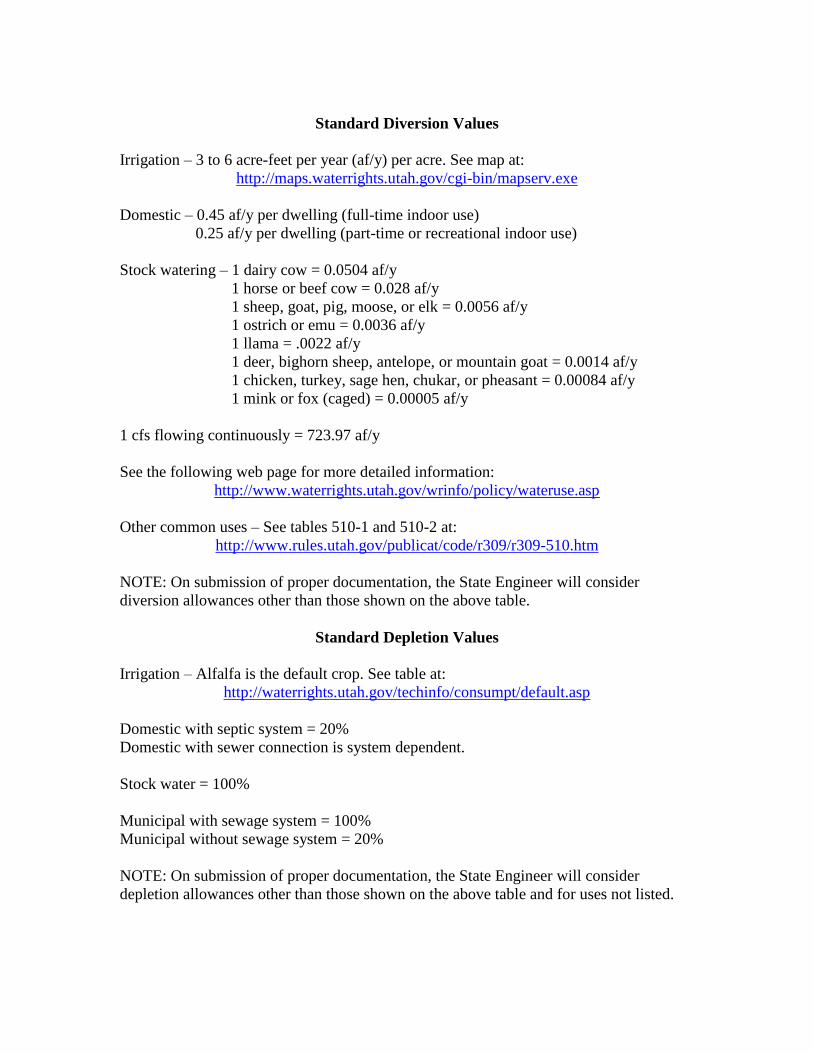
Standard Diversion Values
Irrigation – 3 to 6 acre-feet per year (af/y) per acre. See map at:
http://maps.waterrights.utah.gov/cgi-bin/mapserv.exe
Domestic – 0.45 af/y per dwelling (full-time indoor use)
0.25 af/y per dwelling (part-time or recreational indoor use)
Stock watering – 1 dairy cow = 0.0504 af/y
1 horse or beef cow = 0.028 af/y
1 sheep, goat, pig, moose, or elk = 0.0056 af/y
1 ostrich or emu = 0.0036 af/y
1 llama = .0022 af/y
1 deer, bighorn sheep, antelope, or mountain goat = 0.0014 af/y
1 chicken, turkey, sage hen, chukar, or pheasant = 0.00084 af/y
1 mink or fox (caged) = 0.00005 af/y
1 cfs flowing continuously = 723.97 af/y
See the following web page for more detailed information:
http://www.waterrights.utah.gov/wrinfo/policy/wateruse.asp
Other common uses – See tables 510-1 and 510-2 at:
http://www.rules.utah.gov/publicat/code/r309/r309-510.htm
NOTE: On submission of proper documentation, the State Engineer will consider
diversion allowances other than those shown on the above table.
Standard Depletion Values
Irrigation – Alfalfa is the default crop. See table at:
http://waterrights.utah.gov/techinfo/consumpt/default.asp
Domestic with septic system = 20%
Domestic with sewer connection is system dependent.
Stock water = 100%
Municipal with sewage system = 100%
Municipal without sewage system = 20%
NOTE: On submission of proper documentation, the State Engineer will consider
depletion allowances other than those shown on the above table and for uses not listed.