traffic management report for 6-8 callawa street, orange, nsw
TRANSCRIPT

Job Number: 21NL031-T3 Date: 2nd September, 2021
Traffic Management Report for
6-8 Callawa Street, Orange, NSW
Prepared by
LOKA CONSULTING ENGINEERS PTY LTD
Nermein Loka
BSC, ME, MIE(AUST), CPEng, NPER, RPEQ
Senior Civil Engineer
Accredited Certifier
Director

Table of Contents
1. Introduction ........................................................................................................................... 3
2. Existing Conditions ................................................................................................................ 4
2.1. Existing Development ..................................................................................................... 4
2.2. Public Transportations .................................................................................................... 4
2.3.Existing Road Conditions .................................................................................................... 5
3. Proposed Development ......................................................................................................... 6
4. Off Street Car Parking Provision ............................................................................................ 6
4.1. Car parking .................................................................................................................... 6
5. Car Park and Driveway Layout .............................................................................................. 8
5.1. Driveway and Ramp Design ........................................................................................... 8
5.2. Dimensions of Parking Spaces ....................................................................................... 9
6. Traffic Flows and Volumes .................................................................................................. 11
6.1. Daily Traffic Data .......................................................................................................... 11
6.2. Traffic Survey ............................................................................................................... 12
6.3. Existing Road Service Level ......................................................................................... 17
6.4. Intersection Assessment .............................................................................................. 18
7. Traffic Generation ................................................................................................................ 19
8. Swept Path Analysis ............................................................................................................ 22
Appendix A Architectural Plan ………………………………………………………………………….23
Appendix B Sidra Intersection Analysis…………………………………………………………………26
Appendix C Swept Path Analysis …………………...…………………………………………………35

1. Introduction
Loka Consulting Engineers Pty Ltd has been engaged by Architex to provide a Traffic
Management Plan for the site at 6-8 Callawa St, Orange, NSW (refer to Figure 1-1 and Figure 1-
2).
A Traffic Management Plan and Report is required for the proposed development to identify the
impacts of the proposal on the local street network and mitigation measures required to
ameliorate any impacts. This includes:
• A description of the site and details of the development proposal;
• A review of the road network in the vicinity of the site, and traffic conditions on that road
network;
• A review of the geometric design features of the proposed car parking facilities for
compliance with the relevant codes and standards; and
• An assessment of the adequacy and suitability of the quantum of off-street car parking
provided on site.
Figure 1-1 Subject site (from SIX maps)

Figure 1-2 Site location (from SIX maps)
2. Existing Conditions
2.1. Existing Development
The current site is approximately 4695 m2 and it has one existing building.
2.2. Public Transportations
It takes 1 minute walking (110m) from the site to Kurim Avenue bus stop (refer to figure 2-1).
Table 2-1 shows the bus line name; routes and the time between two successive trips.
Line
Name
Route Weekday Hours
Weekday Interval Weekend Hours
Weekend interval
531 Orange City
Centre to Glenroi
(Loop Service)
07:35 – 19:17
30 - 60min 08:15 – 17:17
50 -137min
Table 2-1 Bus line, route, and time

Figure 2-1 Site to bus stop (from Google maps)
2.3.Existing Road Conditions
The proposed development is bounded by:
• Currong Crescent on the East
• Callawa Street on the West
• Kurim Avenue on the North
• No. 4 Callawa Street, 18 – 19 Pimpala Place & 55 Currong Crescent on the South.
There are two existing vehicular crossing to the site from Kurim Avenue. In addition to two existing vehicular crossing to the site from Callawa Street & Currong Crescent. Callawa Street Callawa Street is a local road and not classified by NSW Roads & Maritime Services. Callawa Street is approximately 9 metres wide with kerbs and gutters on both sides. it provides linkage from Kurim Avenue to Pimpala Place. It has an undivided travel lane in for both directions with kerbside parking on both sides. Currong Crescent Currong Crescent is a local road and not classified by NSW Roads & Maritime Services.

Currong Crescent is approximately 10 metres wide with kerbs and gutters on both sides. It has an undivided travel lane in for both directions with kerbside parking on both sides. Kurim Avenue Kurim Avenue is a local road and not classified by NSW Roads & Maritime Services. Kurim Avenue is approximately 14 metres wide with kerbs and gutters on both sides. It provides linkage from Lone pine Avenue to Blowes Road. It has an undivided travel lane in for both directions with kerbside parking on both sides. Lone Pine Avenue Lone Pine Avenue is a local road and not classified by NSW Roads & Maritime Services. Lone Pine Avenue is approximately 9 metres wide with kerb and gutter on one side only. It provides linkage from Mitchel HWY to Dairy Creek Road. It has an undivided travel lane in for both direction with one parking lane on both sides. Blowes Road Blowes Road is a local road and not classified by NSW Roads & Maritime Services. Blowes Road is approximately 11 metres wide with no kerb and gutter. It provides linkage from Mitchel HWY to Dairy Creek Road. It has one travel lane in each direction with no parking lane on both sides.
3. Proposed Development
The proposed development will facilitate the construction of 54 units and 6 retail stores.
4. Off Street Car Parking Provision
4.1. Car parking
According to Orange Development Control Plan (2004), the following minimum parking spaces
shown in Table 3-2 must be provided for a proposed mixed-use development.
Table 3-2 Off-street parking space rates
Mixed Used Development
Minimum spaces required
Residents
1.0 space per One-bedroom unit 1.2 spaces per Two-bedroom unit 1.5 spaces per Three (or more-bedroom unit
Visitor 0.2 space per 1 unit
Retail 1 space per 50m2

Accordingly, the car parking spaces required for the proposed development is shown in the below
Table 3-3
Table 3-3 Minimum number of off-street parking spaces
Type
No. of unit / Area
Minimum spaces required
Parking required
Parking proposed
Lo
t 1
One-bedroom unit
11 1 11
20 Two-bedroom
unit 4 1.2 4.8
Three-bedroom unit
3 1.5 4.5
Visitor 18 0.2 space per
unit 3.6 4
Retail/commercial 353.51m² 1 space per
50m2 7.1 7
Total 31 31
Lo
t 2
One-bedroom unit
12 1 12
25 Two-bedroom
unit 3 1.2 3.6
Three-bedroom unit
3 1.5 4.5
Visitor 18 0.2 space per
unit 3.6 4
Retail 373.99m² 1 space per
50m2 7.5 8
Total 32 32
Lo
t 3
One-bedroom unit
12 1 12
20 Two-bedroom
unit 3 1.2 3.6
Three-bedroom unit
3 1.5 4.5
Visitor 18 0.2 space per
unit 3.6 3
Retail 343.66m² 1 space per
50m2 6.9 8
Total 31 31
Therefore, the design complies with the requirement from CDCP 2004.
5. Car Park and Driveway Layout
5.1. Driveway and Ramp Design
The design of the driveway, internal roadways & ramps, and car parking spaces must comply with
Australian Standards; details are shown in the ground floor architectural plan. Table 4-1 and
Table 4-2 assess the compliance of the site to Australian Standard and CDCP 2004.
Table 4-1 Driveway and ramp design
FEATURE AS 2890.1 Architectural Plan Compliance
Driveway width Access driveway
• 3.0 to 5.5 for Category 1.
• 6.0 to 9.0 for Category 2.
Entry & Exit on Ground floor towards basement: 3.9m one-way Entry & Exit on Ground floor: 6.6m one-way for service truck
The design is complied with AS 2890.1
Ramp grade Longer than 20m – 1:5 maximum. Up to 20m long – 1:4 maximum.
Transition grade no more than 1:8.
First 6m no more than 1:20.
Changes of grade no more than 1:8.
ENTRY on Ground to Lot 1 1:20 @ 6.0m 1:8 @ 2.0m transition 1:4 @ 10.36m 1:8 @ 2m Lot 1 to Lot 2 1:10 @ 3.5m Lot 2 to Lot 3 1:8 @ 9.6m 1:8 @ 2.4m Entry inside the lot 3 basement EXIT on Ground Floor 1:8 @ 2.0m 1:4 @ 13.2m 1:8 @ 2.0m 1:20 @ 6.0m
The design is complied with AS 2890.1
Ramp grade for commercial vehicle
Max 1:16 (6.25%) for 7m of travel
1:16 @min 7m for HRV truck
The design is complied with AS 2890.2
Internal Driveway/Ramp width
One-way road or ramps (3.0m min between kerb)
To basement Entry Min. 3.3m one way with 300mm on both side
The design is complied with AS 2890.1

Two-way roadway or ramp (5.5m min between kerbs)
Note: 300mm clearance on both side when there is a high kerb or barrier on both sides.
To basement Exit: Min. 3.3m one way with 300mm on both side Ground floor Entry: 6m one-way Ground floor Exit: 6m one-way
Headroom 2.2m min between the floor and an overhead obstruction.
Lot 1: min 3.250 m Lot 2: min 3.03 m Lot 3: min 3.14 m HRV truck: open parking Ensure to provide min 2.2m at cc stage
The design is complied with AS 2890.1
5.2. Dimensions of Parking Spaces
The design of the car parking spaces should be in compliance with AS 2890.1.
Table 4-2 Dimensions of parking spaces
FEATURE AS 2890.1 Architectural Plan Compliance
Residential parking space
5.4m x 3.0m
5.4m x 2.4m The design is complied with AS 2890.1
SDA Parking space
5.4m X 3.8m 5.4m X 3.8m The design is complied with AS 4299- Adaptable Housing
Retail/Commercial parking space
5.4m x 2.4m Normal: 5.4m x 2.6m disable car space: 5.4m x 2.6m with 5.4m x 2.4m shared zone
The design is complied with AS 2890.1
Electric charging bay
5.4m x 2.4m The design is complied with AS 2890.1
Loading bay SRV 3.5m x 6.4m MRV 3.5m X 8.8m HRV 3.5m X 12.5m
12.5m x 3.0m* The design is complied with AS 2890.1*
Visitor parking space
5.4m x 2.4m with additional 300mm when adjacent a wall
5.4m x 2.5m
The design is complied with AS 2890.1
Aisle width 5.8m minimum Basement Level, Lots 1 to 3: Min.5.8m Ground floor, Lots 1 to 3:
The design is complied with AS 2890.1
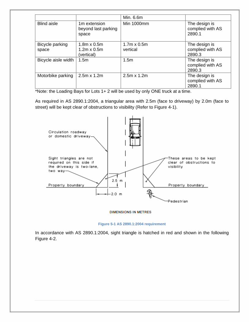
Min. 6.6m Blind aisle 1m extension
beyond last parking space
Min 1000mm The design is complied with AS 2890.1
Bicycle parking space
1.8m x 0.5m 1.2m x 0.5m (vertical)
1.7m x 0.5m vertical
The design is complied with AS 2890.3
Bicycle aisle width 1.5m
1.5m
The design is complied with AS 2890.3
Motorbike parking 2.5m x 1.2m 2.5m x 1.2m The design is complied with AS 2890.1
*Note: the Loading Bays for Lots 1+ 2 will be used by only ONE truck at a time.
As required in AS 2890.1:2004, a triangular area with 2.5m (face to driveway) by 2.0m (face to
street) will be kept clear of obstructions to visibility (Refer to Figure 4-1).
Figure 5-1 AS 2890.1:2004 requirement
In accordance with AS 2890.1:2004, sight triangle is hatched in red and shown in the following
Figure 4-2.

Figure 5-2 Sight triangle
Ensure any object within the sight triangle is max. 1.15m high or 50% transparent above 0.9m if
higher than 1.15m.
The sight triangle requirement complies with Australian Standard.
6. Traffic Flows and Volumes
6.1. Daily Traffic Data
Road and Maritime Service (RMS) collect traffic volume information from roadside traffic
collection devices across the NSW network.
From RMS’s average daily traffic volume map the nearest traffic counting station is station ID
6169 at 1.33Km North of Shreeves Road, Molong 2866 located approximately 43 km North of the
subject site.

Figure 6-1 Traffic Count Station
From the counts undertaken at Station ID 6169 in 2021 average daily traffic account of 1259 vehicles Northbound and 1280 vehicles southbound were counted on average per day passing across Mitchell Highway.
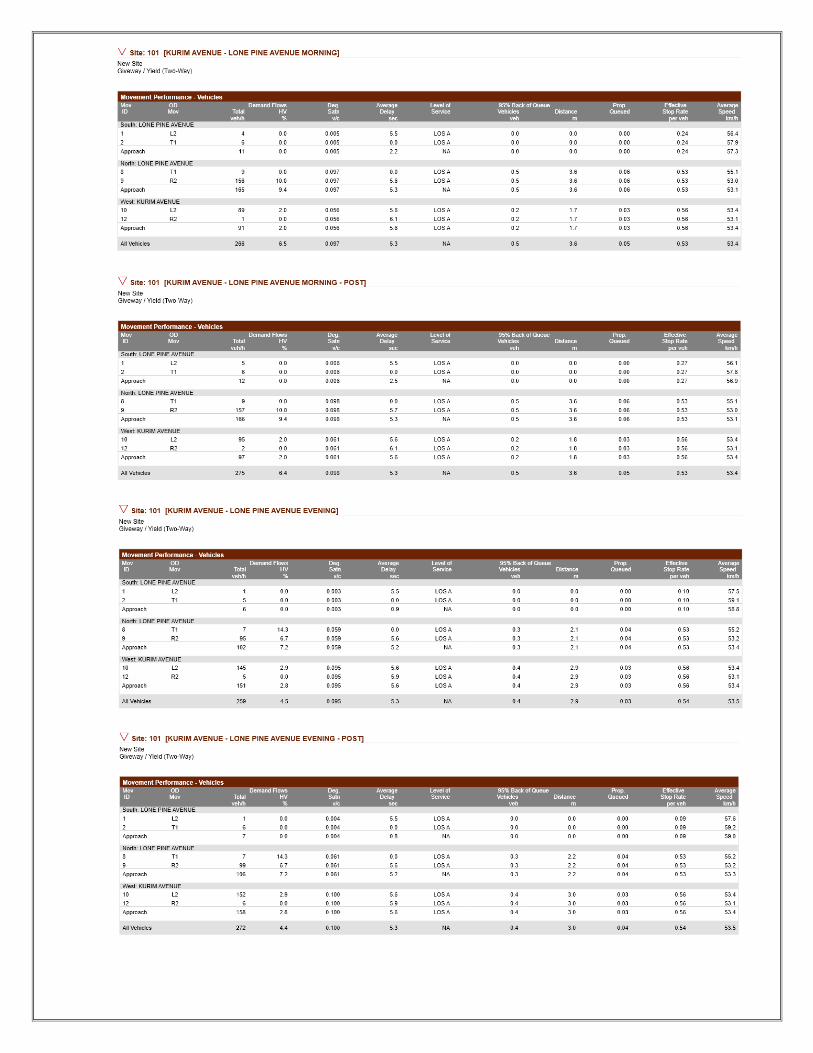
6.2. Traffic Survey
Traffic Counts were undertaken during the morning and afternoon peak periods to gauge the performance of the current road system. Traffic Survey is performed by Trans Traffic Survey Pty Ltd on Thursday 17th of June, 2021 in the morning between 7:00am to 9:00am and in the afternoon between 3:00pm to 6:00pm & Saturday 19th of June, 2021 in the morning between 10:30am to 12:30pm at four (4) locations:
• T-junction at Kurim Ave. & Blowers Rd.
• T-junction at Kurim Ave. & Callawa St.
• T-junction at Kurim Ave. & Currong Cres.
• T-junction at Kurim Ave. & Lone Pine Ave.
Subject Site

Figure 6-2 Locations of Traffic Survey
The full result of the traffic analysis is summarised in Figure 6-3 to 6-10 below.
Figure 6-3 Traffic Survey at Kurim Ave. – Blowers Rd Thursday

Figure 6-4 Traffic Survey at Kurim Ave. – Callawa St. Thursday
Figure 6-5 Traffic Survey at Kurim Ave. – Currong Cres. Thursday

Figure 6-6 Traffic Survey at Kurim Ave. – Lone Pine Ave. Thursday
Figure 6-7 Traffic Survey at Kurim Ave. – Blowers Rd Saturday

Figure 6-8 Traffic Survey at Kurim Ave. – Callawa St. Saturday
Figure 6-9 Traffic Survey at Kurim Ave. – Currong Cres. Saturday

Figure 6-10 Traffic Survey at Traffic Survey at Kurim Ave. – Lone Pine Ave Saturday
6.3. Existing Road Service Level
The capacity of the urban road is generally determined by the capacity of intersections. Table 4.3
and 4.4 of the RMS’s ‘Guide to Traffic Generating Developments’ provide guidance on mid-block
capacities for urban roads and likely levels of service. The tables are reproduced below.
Type of Road One-Way Mid-block Lane Capacity (pcu/hr)
Median or inner lane
Divided Road 1000
Undivided Road 900
Outer or kerb lane
With Adjacent Parking Lane 900
Clearway Conditions 900
Occasional Parked Cars 600
4 lane undivided Occasional Parked Cars 1500
Clearway Conditions 1800
4 lane divided Clearway Conditions 1900
Level of Service (per direction)
One Lane (veh/hr) Two Lanes (veh/hr)
A 200 900
B 380 1400
C 600 1800
D 900 2200
E 1400 2800

Kurim Avenue
Based on the traffic analysis and roadside environment (occasional parked cars), it is considered
that Kurim Avenue operates within the mid-block capacity for an urban road with interrupted flow.
Kurim Avenue is currently functioning at a level of service A in peak hour conditions (at maximum
155 vehicles in one lane at peak hour).
The RMS guide states a service level A, ‘This, the top level is a condition of free flow in which
individual drivers are virtually unaffected by the presence of others in the traffic stream. Freedom
to select desired speeds and to manoeuvre within the traffic stream is extremely high, and the
general level of comfort and convenience provided is excellent.’
Callawa Street
Based on the traffic analysis and roadside environment (occasional parked cars), it is considered
that Callawa Street operates within the mid-block capacity for an urban road with interrupted flow.
Callawa Street is currently functioning at a level of service A in peak hour conditions (at maximum
6 vehicles in one lane at peak hour).
The RMS guide states a service level A, ‘This, the top level is a condition of free flow in which
individual drivers are virtually unaffected by the presence of others in the traffic stream. Freedom
to select desired speeds and to manoeuvre within the traffic stream is extremely high, and the
general level of comfort and convenience provided is excellent.’
Currong Crescent
Based on the traffic analysis and roadside environment (occasional parked cars), it is considered
that Currong Crescent operates within the mid-block capacity for an urban road with interrupted
flow. Currong Crescent is currently functioning at a level of service A in peak hour conditions (at
maximum 19 vehicles in one lane at peak hour).
The RMS guide states a service level A, ‘This, the top level is a condition of free flow in which
individual drivers are virtually unaffected by the presence of others in the traffic stream. Freedom
to select desired speeds and to manoeuvre within the traffic stream is extremely high, and the
general level of comfort and convenience provided is excellent.’
6.4. Intersection Assessment
The existing intersection operating performance of the surveyed intersection for the weekday
morning and afternoon peak hours were assessed using the SIDRA software package (version
7.0) to determine the Degree of Saturation (DS), Average Delay (AVD in seconds) and Level of
Service (LoS).
SIDRA program provides Level of Service Criteria Table as below.

The Average Vehicle Delay (AVD) provides a measure of the operational performance of an
intersection as indicated below, which relates AVD to LOS. The AVD’s should be taken as a
guide only as longer delays could be tolerated in some locations (i.e. inner city conditions) and on
some roads (i.e. minor side street intersecting with a major arterial route). For traffic signals, the
average delay over all movements should be taken. For roundabouts and priority control
intersections (sign control) the critical movement for level of service assessment should be that
movement with the highest average delay.
The degree of saturation (DS) is another measure of the operational performance of individual
intersections. For intersections controlled by traffic signals, both queue length and delay increase
rapidly as DS approaches 1. It is usual to attempt to keep DS to less than 0.9. Degrees of
Saturation in the order of 0.7 generally represent satisfactory intersection operation. When DS
exceed 0.9 queues can be anticipated.
The full SIDRA outputs are presented in the Appendix B for the existing conditions as well as
proposed conditions.
7. Traffic Generation
An indication of the traffic generation potential of the development proposal is provided in
accordance with Roads and Maritime Services (RMS) publication ‘Guide to Traffic Generating
Developments 2002’.
RMS guidelines are based on an extensive survey of a wide range of land uses.
The existing site is a vacant land with zero (0) traffic trips

The subject site is divided into 2 categories as sequence: -
1. residential flat building (48 units in total)
2. retail (596.0 m2)
Residential flat building.
Identified as high-density residential flat building. Rates
Metropolitan Sub-Regional Centres. Daily vehicle trips = not available Peak Hour Vehicle Trips = 0.29 trips per unit.
For the subject site, there are 48 units in total. Therefore, there is a traffic generation potential of
approximately 14 vehicles per hour during peak periods.
Retail
Identified as Bulky goods retail stores
The trip generation rates varied so widely
Rates. In the Thursday evening peak period the average generation rate surveyed was 2.5 veh/hr/100 m² GLFA On the weekend with a mean peak rate of 6.6 veh/hr/100 m2 GLFA
For the subject site, there is 596.0 m2 of commercial area. Therefore, there is a traffic generation
potential of approximately 15 vehicles per hour during peak periods in Thursday & 40 vehicles
per hour during peak periods on weekend
The future vehicle trips should be added to evaluate the net increase in traffic generation for the
entire development. This is shown in Table 7-1
Time Traffic Generation Potential Thursday Saturday
Morning
Residential flat buildings 14 -
Retail - -
Morning Net 14 -
Evening (future)
Residential flat buildings 14 -
Retail 15 40
Evening Net +29 +40
Table 7-1 Project net Increase in peak hour traffic generation potential
Therefore, for the proposed development, there will be max. 14 net increase in traffic generation
in mornings, max. 29 in Friday evenings & 40 in Saturday evening.

+15
+6
+2 +1
+16
+2
+4 +4 +7
+1 +1
+6 +10
+2
+8
+1
+5
+1
+4
Figure 7-1 traffic generated by the proposed development at evening peak hour
(Assuming 80% of the residential traffic generation will enter the development at evening peak hour)
(Assuming 80% of the retail traffic generation will exit the development at morning peak hour)

+13
+6 +6 +1
+1
+1
+5
+1
+3
+2
+1
+1
+2
+1
+1
Figure 7-2 traffic generated by the proposed development at morning peak hour (Assuming 80% of the residential traffic generation will exit the development at morning peak hour)

+15 +25
+4 +4 +7
+2
+10 +2
+1 +1
+6
+1 +15
+10
+5
+1
+9
+1
+8
Figure 7-3 traffic generated by the proposed development at evening peak hour
(Assuming 65% of the retaill traffic generation will exit the development at morning peak hour

Figure 7- 4: level of service pre and post development at Blowes Road – Kurium Avenue in peak hours
Figure 7- 5: level of service pre and post development at Kurium Avenue – Callawa in peak hours
Figure 7- 5: level of service pre and post development at Kurium Avenue – Currong Cres. – Maroo RD in peak
hours

8. Swept Path Analysis
To ensure all vehicles enter and exit the site in a forward direction, swept path analysis has been
conducted in the Appendix B.
It is our opinion that the proposed car parking and driveway comply with Australia Standard.

LOKA CONSULTING ENGINEERS PTY LTD
APPENDIX B
Sidra Intersection Analysis


LOKA CONSULTING ENGINEERS PTY LTD
APPENDIX C
Swept Path Analysis

1:8 1:4 GRADE
1:8
1:8
1:8 GRADE1:10 GRADE1:81:4 GRADE
93.575m 90°00'00"
41.22
m 1
80°0
0'00"
102.72m 270°00'00"
41.22
m 0
°00'0
0"
6.465m
45°00
' 6.465m 135°00'
1:8
NOTE:• All disabled visitors carparking in accordance with AS2890.6 and
adaptable residents parking in accordance with AS4299 - 2.5m min. height clearance
• All parking spaces are a minimum of 2.4m in width by 5.5m in length. Spaces increase to 2.7m in width where adjacent to a wall or an obstruction in accordance with AS 2890.1
• The internal driveway ramp widths, circulation aisles and vehicle turning areas shall be designed and constructed in accordance with AS 2890.1 for two-way vehicle movements
• All parking spaces are a minimum headroom clearance of 2.2m for residents and visitors, 2.5m for disabled car spaces, and 2.3m for internal ramps in accordance with AS2890.1
PARKING LEGEND
RESIDENT CARSPACE
5.4m
2.4m
2.4m
2.4m
5.4m
DISABLED CARSPACE
SHARED ACCESS ZONEBOLLARD
WHE
ELST
OPW
HEEL
STOP
RETAIL / COMMERCIAL CARSPACE
5.4m
2.6m
WHE
ELST
OP
STORAGE ENCLOSURE
1 BED = min. 3m²2 BED = min. 4m²3 BED = min. 5m²
TRUCK HEIGHT CLEARANCE
4.5m (HRV)
VISITOR CARSPACE
5.4m
2.5m
WHE
ELST
OP
SDA UNIT CARSPACE
5.4m
3.8m
WHE
ELST
OP
2.5m MINIMUM HEIGHT CLEARANCE
2.5m MINIMUM HEIGHT CLEARANCE
2.5m MINIMUM HEIGHT CLEARANCE
A
13
A
13
3000
3045
3000
3000
ELECT.CHARGING
BAY
3900
1
21
RL 895.90
RL 895.60
5800
EXIT
EXIT
6600
61506150
ELECT.CHARGING
BAY
EXIT
EXIT
RL 894.70
RL 895.60RL 894.70
RL 894.70
5870
6600
5800
3045
3000
3900
4500 45004500 4250
RL 894.35
RL 893.90
RL 893.90
EXIT
EXIT
ELECT.CHARGING
BAY
3045
3000
62503000
5800
6600
7100
4350 4450
6850
K U R I M A V E N U E
C A
L L
A W
A
S
T R
E E
T
C U
R R
O N
G
C R
E S
C E
N T
L 0 T 1 L 0 T 2 L 0 T 3
C
13
B
13
2
21
C
22
D
22
S301
S302
S303
S304
S305
S306
S307
S308S309S310
S315
S316
S314
S313
S312
S311
S201
S202
S203S204S205
S206
S207
S208
S209
S210 S211 S212
S213
S216S215
S214
S101
S102S103S104
S105
S106
S107
S108
S109
S110 S111 S112
S116
S113
S114
S115
0 m
DEVE
LOPM
ENT
APPL
ICAT
ION
Job No
Project
Client
Do not scale, check and verify all dimensions before comencing new work, ground levels may vary due to site conditions.
Scale
Title
Drawing No. Issue
Drawn Checked
Project Address
architex
True Northpoint
[email protected] www.architex.com.au
Nominated Architect: Roberto Del PizzoNSW Reg. No. 3972
Ryleton pty ltd t/as Architex T : 02 9633 5888abn 32 003 315 142 M : 0418 402 919
Level 3, 7K Parkes StreetParramatta NSW 2150
2 4m 10m
1:200
C 1 : 200
2524
Orange Healthwell Pty. Ltd.
Basement Level 01
PROPOSED MIXED USEDEVELOPMENT
04
PDP DW
6-8 Callawa Street, OrangeTYPICAL UNIT LAYOUTS:REFER TO DWG NO. 15
LANDSCAPE DETAILS:REFER TO LANDSCAPE DRAWINGS
STORMWATER DETAILS + SITE LEVELS:REFER TO HYDRAULIC DRAWINGS
DRIVEWAY RAMP SECTIONS:REFER TO DWG NO. 21 + 22
WASTE MANAGEMENT DETAILS:REFER TO DWG NO. 23
MAIL + FENCE DETAILS:REFER TO DWG NO. 14
PARKING SCHEDULE - LOT 1
Description CountResident 5Resident - SDA Unit 15Visitor 4Retail / Commercial Parking 7Electrical Charging Bay 1Motorcycle Bay 2Carwash Bay 1HRV Loading Bay 1Visitor Bicycle Rack (Fits 2 Bikes) 2
PARKING SCHEDULE - LOT 2
Description CountResident 10Resident - SDA Unit 15Visitor 4Retail / Commercial Parking 8Electrical Charging Bay 1Motorcycle Bay 2Carwash Bay 1HRV Loading Bay 1Visitor Bicycle Rack (Fits 2 Bikes) 1
PARKING SCHEDULE - LOT 3
Description CountResident 5Resident - SDA Unit 15Visitor 3Retail / Commercial Parking 8Electrical Charging Bay 1Motorcycle Bay 2Carwash Bay 1HRV Loading Bay 1Visitor Bicycle Rack (Fits 2 Bikes) 2
1 : 2001 Basement Level 01
SDA UNIT LAYOUTS + DETAILS:REFER TO DWG NO. 16 - 20
Issue Issue descrption DateC Development Application Issue 01-09-21B Final Issue to Consultants 27-08-21A Prelim. Issue to Client + Consultants 28-07-21
BASEMENT STORAGE SCHEDULE
Number Volume
S209 12.4 m³S210 10.4 m³S211 14.8 m³S212 14.8 m³S213 10.6 m³S214 10.6 m³S215 10.6 m³S216 10.6 m³S301 6.8 m³S302 9.5 m³S303 7.2 m³S304 7.2 m³S305 7.2 m³S306 7.2 m³S307 7.2 m³S308 12.6 m³S309 11.1 m³S310 11.1 m³S311 7.7 m³S312 7.7 m³S313 7.7 m³S314 19.7 m³S315 6.9 m³S316 6.7 m³
BASEMENT STORAGE SCHEDULE
Number Volume
S101 16.7 m³S102 10.6 m³S103 10.2 m³S104 10.1 m³S105 7.2 m³S106 7.2 m³S107 7.2 m³S108 7.2 m³S109 7.2 m³S110 12.6 m³S111 11.1 m³S112 11.1 m³S113 11.3 m³S114 11.3 m³S115 11.4 m³S116 18.0 m³S201 13.8 m³S202 13.8 m³S203 11.1 m³S204 11.1 m³S205 12.6 m³S206 11.3 m³S207 11.3 m³S208 11.4 m³

899.7
0
899.5
9
899.4
9
899.3
5
898.9
1
897.9
5
897.8
4897.7
7897.6
8897.5
3
897.3
9897.0
2896.7
5896.7
2896.6
6896.5
5
896.3
7
896.5
7
896.7
8
897.0
0
897.5
2
897.6
1
897.5
6
897.8
5
897.9
8
898.2
3
898.1
3
898.4
3
898.6
8898.7
9898.8
6
898.7
3
898.9
2
899.1
3
898.9
1
898.9
7
898.9
6
898.9
4898.9
2
898.9
1898.8
6
898.8
7
898.8
3
898.9
5
898.9
5899.0
5
899.4
1899.8
7
899.9
9
899.9
0
899.9
2
899.8
1
899.7
5
899.6
5
899.5
7
899.2
6
899.2
9
899.0
7
899.0
5
898.7
4
898.7
7898.5
0
898.5
7898.4
9
898.4
5898.3
5
898.3
9
898.0
6
898.0
6
898.0
6898.0
3
898.0
5
898.0
0897.9
0
897.9
9
897.9
2
897.8
1897.6
7
897.7
7
897.6
2
897.5
2
897.4
1
897.5
1
897.3
4
897.2
3897.1
4
897.2
1
897.0
7
897.0
1
896.8
6
896.9
0896.6
7
896.6
6
896.4
8
896.4
0
897.7
0
897.6
9
898.2
1
898.2
2
898.4
1 898.5
6
898.5
1
899.0
9
898.0
897.0
897.0 898.0
899.0
899.0
900.0
93.575m 90°00'00"
41.22
m 1
80°0
0'00"
102.72m 270°00'00"
41.22
m 0
°00'0
0"
6.465m
45°00
' 6.465m 135°00'
FOOTPATHBUS SHELTER
KO
WS
TEL
SMH
PIT
TEL TEL
SV
SV
SIGNSIGN
SV
BRICK RESIDENCETILE ROOF
BRICK RESIDENCETILE ROOF
172
DP 260088
132
DP 250936
133
DP 250936
134
DP 250936
No.55No.4
TOG902.44
TOG902.40 TOG
902.35
TOG901.15
TOG901.17
TOG901.15
BM SSM 16199RL 898.791
1:81:81:20 GRADE
1:20 GRADE1:4 GRADE
1:16 GRADE 1:16 GRADE 1:16 GRADE
1:14
1:14
1:14 1:141:10
1:14
1:14 1:14
1:4 GRADE
1:16 GRADE
1:20
1:14
1:14 1:14
1:20 GRADE1:
20
1:14
1:14
1:10
1:20
NOTE:• All disabled visitors carparking in accordance with AS2890.6 and
adaptable residents parking in accordance with AS4299 - 2.5m min. height clearance
• All parking spaces are a minimum of 2.4m in width by 5.5m in length. Spaces increase to 2.7m in width where adjacent to a wall or an obstruction in accordance with AS 2890.1
• The internal driveway ramp widths, circulation aisles and vehicle turning areas shall be designed and constructed in accordance with AS 2890.1 for two-way vehicle movements
• All parking spaces are a minimum headroom clearance of 2.2m for residents and visitors, 2.5m for disabled car spaces, and 2.3m for internal ramps in accordance with AS2890.1
PARKING LEGEND
RESIDENT CARSPACE
5.4m
2.4m
2.4m
2.4m
5.4m
DISABLED CARSPACE
SHARED ACCESS ZONEBOLLARD
WHE
ELST
OPW
HEEL
STOP
RETAIL / COMMERCIAL CARSPACE
5.4m
2.6m
WHE
ELST
OP
STORAGE ENCLOSURE
1 BED = min. 3m²2 BED = min. 4m²3 BED = min. 5m²
TRUCK HEIGHT CLEARANCE
4.5m (HRV)
VISITOR CARSPACE
5.4m
2.5m
WHE
ELST
OP
SDA UNIT CARSPACE
5.4m
3.8m
WHE
ELST
OP
2.5m MINIMUM HEIGHT CLEARANCE
2.5m MINIMUM HEIGHT CLEARANCE
2.5m MINIMUM HEIGHT CLEARANCE
A
13
A
13
1
21
RL 898.30
RL 897.75 RL 897.90
RL 897.15RL 897.14
RL 897.60 RL 897.74
RL 896.92
RL 896.74
RL 896.56
RL 897.10
RL 898.30RL 897.40
RL 897.21RL 897.02
RL 896.84
85 m² 103 m²204 m²
RL 899.39
204 m²
RL 899.74
RL 899.64
RL 899.10RL 899.39
RL 899.39RL 898.74
RL 899.39
RL 899.87
RL 900.00
RL 899.44
RL 899.44
RL 898.74
RL 897.97RL 897.73RL 897.15
RL 897.21
RL 897.73
CARW
ASH
BAY
HRV
TRUC
K LO
ADIN
G BA
Y
CARW
ASH
BAY
CARW
ASH
BAY
HRV
TRUC
K LO
ADIN
G BA
Y
HRV
TRUC
K LO
ADIN
G BA
Y
PLANT PLANTPLANT PLANTPLANTPLANT
COMM. BINS
COMM. BINS
COMM. BINS
RESID. BINS
RESID. BINS
RESID. BINS
RL 897.75
RL 897.90
LOBBY
LOBBYLOBBY
EXIT
ONL
Y
ENTR
Y ON
LYEN
TRY
ONLY
EXIT
ONL
Y
RL 897.37
RL 897.63 RL 897.92
ROOM LEGEND
RETAIL
VISITOR PARKING
RETAIL PARKING
RETAIL PARKING
RETAIL PARKING
VISITOR PARKING
VISITOR PARKING
K U R I M A V E N U E
10 1
10
2
103
11
4
115 6 127 8
C
13
B
13
2
21
MAI
L
MAI
L
MAI
L
RL 898.30 RL 899.10
RL 899.64
SUBS
TATI
ON
M/CYCLE
BICY
CLE
M/CYCLE
BICY
CLE
M/CYCLE
BICY
CLE
VEHICULAR SIGHT LINES CLEAR OF ANY OBSTRUCTION
HYDRANT SPRINKLERBOOSTER ASSEMBLY
GAS REGULATORSUBJECT TO AUTHORITY APPROVAL
WATER METERS SUBJECT TO AUTHORITY APPROVAL
C A
L L
A W
A
S
T R
E E
T
C U
R R
O N
G
C R
E S
C E
N T
W/M
W/M
LINE OF AWNING OVER
LINE OF AWNING OVER
XRL897.21 1: 60 GRADE APPROX.
RL 898.74
XRL899.39
12.5
m x
3.5m
12.5
m x
3.5m
12.5
m x
3.5m
6600
6600
6600
6000
123 2
23
C
22
D
22
RL 897.00
RL 897.14
8500
RL 899.70
RL 899.70
8500
6000
RETAIL 01 RETAIL 02 RETAIL 03 RETAIL 04
LINE OF BASEMENT UNDER
LINE OF BASEMENT UNDER
BULK
BULK BULK
STREET TREES IN ACCORDANCE WITH LANDSCAPE DRAWINGS + COUNCIL SPECIFICATIONS
EXISTING TREE TO BE RETAINED
TOW 899.30 TOW 899.74 TOW 899.74 TOW 899.14TOW 898.15TOW 896.85
TOW 898.47 TOW 899.30
TOW 899.74TOW 899.74TOW 898.15 TOW 899.30
TOW
897.7
5
RL897.695x
RL897.695x
RL897.935x
RL897.405x
x RL89
9.70
5
xRL899.405
RL897.115x
RL897.1
15x
RL89
6.80
5x
TOW 899.30
9000 5500
0 m
DEVE
LOPM
ENT
APPL
ICAT
ION
Job No
Project
Client
Do not scale, check and verify all dimensions before comencing new work, ground levels may vary due to site conditions.
Scale
Title
Drawing No. Issue
Drawn Checked
Project Address
architex
True Northpoint
[email protected] www.architex.com.au
Nominated Architect: Roberto Del PizzoNSW Reg. No. 3972
Ryleton pty ltd t/as Architex T : 02 9633 5888abn 32 003 315 142 M : 0418 402 919
Level 3, 7K Parkes StreetParramatta NSW 2150
2 4m 10m
1:200
C 1 : 200
2524
Orange Healthwell Pty. Ltd.
Ground Floor Level
PROPOSED MIXED USEDEVELOPMENT
05
PDP DW
6-8 Callawa Street, OrangeTYPICAL UNIT LAYOUTS:REFER TO DWG NO. 15
LANDSCAPE DETAILS:REFER TO LANDSCAPE DRAWINGS
STORMWATER DETAILS + SITE LEVELS:REFER TO HYDRAULIC DRAWINGS
DRIVEWAY RAMP SECTIONS:REFER TO DWG NO. 21 + 22
WASTE MANAGEMENT DETAILS:REFER TO DWG NO. 23
MAIL + FENCE DETAILS:REFER TO DWG NO. 14
PARKING SCHEDULE - LOT 1
Description CountResident 5Resident - SDA Unit 15Visitor 4Retail / Commercial Parking 7Electrical Charging Bay 1Motorcycle Bay 2Carwash Bay 1HRV Loading Bay 1Visitor Bicycle Rack (Fits 2 Bikes) 2
PARKING SCHEDULE - LOT 2
Description CountResident 10Resident - SDA Unit 15Visitor 4Retail / Commercial Parking 8Electrical Charging Bay 1Motorcycle Bay 2Carwash Bay 1HRV Loading Bay 1Visitor Bicycle Rack (Fits 2 Bikes) 1
PARKING SCHEDULE - LOT 3
Description CountResident 5Resident - SDA Unit 15Visitor 3Retail / Commercial Parking 8Electrical Charging Bay 1Motorcycle Bay 2Carwash Bay 1HRV Loading Bay 1Visitor Bicycle Rack (Fits 2 Bikes) 2
1 : 2002 Ground Floor Level
SDA UNIT LAYOUTS + DETAILS:REFER TO DWG NO. 16 - 20
Issue Issue descrption DateC Development Application Issue 01-09-21B Final Issue to Consultants 27-08-21A Prelim. Issue to Client + Consultants 28-07-21

899.7
0
899.5
9
899.4
9
899.3
5
898.9
1
897.9
5
897.8
4897.7
7897.6
8897.5
3
897.3
9897.0
2896.7
5896.7
2896.6
6896.5
5
896.3
7
896.5
7
896.7
8
897.0
0
897.5
2
897.6
1
897.5
6
897.8
5
897.9
8
898.2
3
898.1
3
898.4
3
898.6
8898.7
9898.8
6
898.7
3
898.9
2
899.1
3
898.9
1
898.9
7
898.9
6
898.9
4898.9
2
898.9
1898.8
6
898.8
7
898.8
3
898.9
5
898.9
5899.0
5
899.4
1899.8
7
899.9
9
899.9
0
899.9
2
899.8
1
899.7
5
899.6
5
899.5
7
899.2
6
899.2
9
899.0
7
899.0
5
898.7
4
898.7
7898.5
0
898.5
7898.4
9
898.4
5898.3
5
898.3
9
898.0
6
898.0
6
898.0
6898.0
3
898.0
5
898.0
0897.9
0
897.9
9
897.9
2
897.8
1897.6
7
897.7
7
897.6
2
897.5
2
897.4
1
897.5
1
897.3
4
897.2
3897.1
4
897.2
1
897.0
7
897.0
1
896.8
6
896.9
0896.6
7
896.6
6
896.4
8
896.4
0
897.7
0
897.6
9
898.2
1
898.2
2
898.4
1 898.5
6
898.5
1
899.0
9
898.0
897.0
897.0 898.0
899.0
899.0
900.0
93.575m 90°00'00"
41.22
m 1
80°0
0'00"
102.72m 270°00'00"
41.22
m 0
°00'0
0"
6.465m
45°00
' 6.465m 135°00'
FOOTPATHBUS SHELTER
KO
WS
TEL
SMH
PIT
TEL TEL
SV
SV
SIGNSIGN
SV
BRICK RESIDENCETILE ROOF
BRICK RESIDENCETILE ROOF
172
DP 260088
132
DP 250936
133
DP 250936
134
DP 250936
No.55No.4
TOG902.44
TOG902.40 TOG
902.35
TOG901.15
TOG901.17
TOG901.15
BM SSM 16199RL 898.791
1:81:81:20 GRADE
1:20 GRADE1:4 GRADE
1:16 GRADE 1:16 GRADE 1:16 GRADE
1:14
1:14
1:14 1:141:10
1:14
1:14 1:14
1:4 GRADE
1:16 GRADE
1:20
1:14
1:14 1:14
1:20 GRADE1:
20
1:14
1:14
1:10
1:20
NOTE:• All disabled visitors carparking in accordance with AS2890.6 and
adaptable residents parking in accordance with AS4299 - 2.5m min. height clearance
• All parking spaces are a minimum of 2.4m in width by 5.5m in length. Spaces increase to 2.7m in width where adjacent to a wall or an obstruction in accordance with AS 2890.1
• The internal driveway ramp widths, circulation aisles and vehicle turning areas shall be designed and constructed in accordance with AS 2890.1 for two-way vehicle movements
• All parking spaces are a minimum headroom clearance of 2.2m for residents and visitors, 2.5m for disabled car spaces, and 2.3m for internal ramps in accordance with AS2890.1
PARKING LEGEND
RESIDENT CARSPACE
5.4m
2.4m
2.4m
2.4m
5.4m
DISABLED CARSPACE
SHARED ACCESS ZONEBOLLARD
WHE
ELST
OPW
HEEL
STOP
RETAIL / COMMERCIAL CARSPACE
5.4m
2.6m
WHE
ELST
OP
STORAGE ENCLOSURE
1 BED = min. 3m²2 BED = min. 4m²3 BED = min. 5m²
TRUCK HEIGHT CLEARANCE
4.5m (HRV)
VISITOR CARSPACE
5.4m
2.5m
WHE
ELST
OP
SDA UNIT CARSPACE
5.4m
3.8m
WHE
ELST
OP
2.5m MINIMUM HEIGHT CLEARANCE
2.5m MINIMUM HEIGHT CLEARANCE
2.5m MINIMUM HEIGHT CLEARANCE
A
13
A
13
1
21
RL 898.30
RL 897.75 RL 897.90
RL 897.15RL 897.14
RL 897.60 RL 897.74
RL 896.92
RL 896.74
RL 896.56
RL 897.10
RL 898.30RL 897.40
RL 897.21RL 897.02
RL 896.84
85 m² 103 m²204 m²
RL 899.39
204 m²
RL 899.74
RL 899.64
RL 899.10RL 899.39
RL 899.39RL 898.74
RL 899.39
RL 899.87
RL 900.00
RL 899.44
RL 899.44
RL 898.74
RL 897.97RL 897.73RL 897.15
RL 897.21
RL 897.73
CARW
ASH
BAY
HRV
TRUC
K LO
ADIN
G BA
Y
CARW
ASH
BAY
CARW
ASH
BAY
HRV
TRUC
K LO
ADIN
G BA
Y
HRV
TRUC
K LO
ADIN
G BA
Y
PLANT PLANTPLANT PLANTPLANTPLANT
COMM. BINS
COMM. BINS
COMM. BINS
RESID. BINS
RESID. BINS
RESID. BINS
RL 897.75
RL 897.90
LOBBY
LOBBYLOBBY
EXIT
ONL
Y
ENTR
Y ON
LYEN
TRY
ONLY
EXIT
ONL
Y
RL 897.37
RL 897.63 RL 897.92
ROOM LEGEND
RETAIL
VISITOR PARKING
RETAIL PARKING
RETAIL PARKING
RETAIL PARKING
VISITOR PARKING
VISITOR PARKING
K U R I M A V E N U E
10 1
10
2
103
11
4
115 6 127 8
C
13
B
13
2
21
MAI
L
MAI
L
MAI
L
RL 898.30 RL 899.10
RL 899.64
SUBS
TATI
ON
M/CYCLE
BICY
CLE
M/CYCLE
BICY
CLE
M/CYCLE
BICY
CLE
VEHICULAR SIGHT LINES CLEAR OF ANY OBSTRUCTION
HYDRANT SPRINKLERBOOSTER ASSEMBLY
GAS REGULATORSUBJECT TO AUTHORITY APPROVAL
WATER METERS SUBJECT TO AUTHORITY APPROVAL
C A
L L
A W
A
S
T R
E E
T
C U
R R
O N
G
C R
E S
C E
N T
W/M
W/M
LINE OF AWNING OVER
LINE OF AWNING OVER
XRL897.21 1: 60 GRADE APPROX.
RL 898.74
XRL899.39
12.5
m x
3.5m
12.5
m x
3.5m
12.5
m x
3.5m
6600
6600
6600
6000
123 2
23
C
22
D
22
RL 897.00
RL 897.14
8500
RL 899.70
RL 899.70
8500
6000
RETAIL 01 RETAIL 02 RETAIL 03 RETAIL 04
LINE OF BASEMENT UNDER
LINE OF BASEMENT UNDER
BULK
BULK BULK
STREET TREES IN ACCORDANCE WITH LANDSCAPE DRAWINGS + COUNCIL SPECIFICATIONS
EXISTING TREE TO BE RETAINED
TOW 899.30 TOW 899.74 TOW 899.74 TOW 899.14TOW 898.15TOW 896.85
TOW 898.47 TOW 899.30
TOW 899.74TOW 899.74TOW 898.15 TOW 899.30
TOW
897.7
5
RL897.695x
RL897.695x
RL897.935x
RL897.405x
x RL89
9.70
5
xRL899.405
RL897.115x
RL897.1
15x
RL89
6.80
5x
TOW 899.30
9000 5500
0 m
DEVE
LOPM
ENT
APPL
ICAT
ION
Job No
Project
Client
Do not scale, check and verify all dimensions before comencing new work, ground levels may vary due to site conditions.
Scale
Title
Drawing No. Issue
Drawn Checked
Project Address
architex
True Northpoint
[email protected] www.architex.com.au
Nominated Architect: Roberto Del PizzoNSW Reg. No. 3972
Ryleton pty ltd t/as Architex T : 02 9633 5888abn 32 003 315 142 M : 0418 402 919
Level 3, 7K Parkes StreetParramatta NSW 2150
2 4m 10m
1:200
C 1 : 200
2524
Orange Healthwell Pty. Ltd.
Ground Floor Level
PROPOSED MIXED USEDEVELOPMENT
05
PDP DW
6-8 Callawa Street, OrangeTYPICAL UNIT LAYOUTS:REFER TO DWG NO. 15
LANDSCAPE DETAILS:REFER TO LANDSCAPE DRAWINGS
STORMWATER DETAILS + SITE LEVELS:REFER TO HYDRAULIC DRAWINGS
DRIVEWAY RAMP SECTIONS:REFER TO DWG NO. 21 + 22
WASTE MANAGEMENT DETAILS:REFER TO DWG NO. 23
MAIL + FENCE DETAILS:REFER TO DWG NO. 14
PARKING SCHEDULE - LOT 1
Description CountResident 5Resident - SDA Unit 15Visitor 4Retail / Commercial Parking 7Electrical Charging Bay 1Motorcycle Bay 2Carwash Bay 1HRV Loading Bay 1Visitor Bicycle Rack (Fits 2 Bikes) 2
PARKING SCHEDULE - LOT 2
Description CountResident 10Resident - SDA Unit 15Visitor 4Retail / Commercial Parking 8Electrical Charging Bay 1Motorcycle Bay 2Carwash Bay 1HRV Loading Bay 1Visitor Bicycle Rack (Fits 2 Bikes) 1
PARKING SCHEDULE - LOT 3
Description CountResident 5Resident - SDA Unit 15Visitor 3Retail / Commercial Parking 8Electrical Charging Bay 1Motorcycle Bay 2Carwash Bay 1HRV Loading Bay 1Visitor Bicycle Rack (Fits 2 Bikes) 2
1 : 2002 Ground Floor Level
SDA UNIT LAYOUTS + DETAILS:REFER TO DWG NO. 16 - 20
Issue Issue descrption DateC Development Application Issue 01-09-21B Final Issue to Consultants 27-08-21A Prelim. Issue to Client + Consultants 28-07-21


898.0
897.0
897.0 898.0
899.0
899.0
900.0
FOOTPATH
BUS SHELTER
KO
WS
TEL
SMH
PIT
TEL
TEL
SV
SV
SIGN
SIGN
SV
BM SSM 16199RL 898.791
1:81:81:20 GRADE
1:20 GRADE1:4 GRADE
1:16 GRADE 1:16 GRADE 1:16 GRADE
1:14
1:14
1:14 1:141:10
1:14
1:14 1:14
1:4 GRADE
1:16 GRADE
1:20
1:14
1:14 1:14
1:20 GRADE
1:20
1:14
1:14
1:10
1:20
K U R I M A V E N U EC
A L
L A
W A
S T
R E
E T
C U
R R
O N
G
C R
E S
C E
N T
6-8 CALLAWA STREET, ORANGE, NSW
NERMEIN LOKA
THIS DRAWING IS THE
PROPERTY OF LOKA
CONSULTING ENGINEERS
AND MUST NOT BE
RETAINED, COPIED OR USED
WITHOUT THE WRITTEN
CONSENT OF THE COMPANY
C
Copyright
Loka
Consulting
Engineers
as date of
issue
MIXED-USE DEVELOPMENT
6-8 CALLAWA STREET, ORANGE,
NSW
CONSENT AUTHORITY:
ORANGE CITY COUNCIL
21NL031
COPYRIGHT: THIS DESIGN AND PLANS ARE NOT TO BE USED OR REPRODUCED WHOLLY
OR IN PART WITHOUT WRITTEN PERMISSION OF LOKA CONSULTING ENGINEERS
A N.L.FOR COORDINATION
A.E. 02-09-21
1 :200 U.N.O
T03 A
FEB 21A.E.
SWEPT PATH ENTRY IN GROUND FLOOR
SCALE 1:200
A.E.
N.L.

898.0
897.0
897.0 898.0
899.0
899.0
900.0
FOOTPATH
BUS SHELTER
KO
WS
TEL
SMH
PIT
TEL
TEL
SV
SV
SIGN
SIGN
SV
BM SSM 16199RL 898.791
1:81:81:20 GRADE
1:20 GRADE1:4 GRADE
1:16 GRADE 1:16 GRADE 1:16 GRADE
1:14
1:14
1:14 1:141:10
1:14
1:14 1:14
1:4 GRADE
1:16 GRADE
1:20
1:14
1:14 1:14
1:20 GRADE
1:20
1:14
1:14
1:10
1:20
K U R I M A V E N U EC
A L
L A
W A
S T
R E
E T
C U
R R
O N
G
C R
E S
C E
N T
6-8 CALLAWA STREET, ORANGE, NSW
NERMEIN LOKA
THIS DRAWING IS THE
PROPERTY OF LOKA
CONSULTING ENGINEERS
AND MUST NOT BE
RETAINED, COPIED OR USED
WITHOUT THE WRITTEN
CONSENT OF THE COMPANY
C
Copyright
Loka
Consulting
Engineers
as date of
issue
MIXED-USE DEVELOPMENT
6-8 CALLAWA STREET, ORANGE,
NSW
CONSENT AUTHORITY:
ORANGE CITY COUNCIL
21NL031
COPYRIGHT: THIS DESIGN AND PLANS ARE NOT TO BE USED OR REPRODUCED WHOLLY
OR IN PART WITHOUT WRITTEN PERMISSION OF LOKA CONSULTING ENGINEERS
A N.L.FOR COORDINATION
A.E. 02-09-21
1 :200 U.N.O
T04 A
FEB 21A.E.
SWEPT PATH EXIT IN GROUND FLOOR
SCALE 1:200
A.E.
N.L.

898.0
897.0
897.0 898.0
899.0
899.0
900.0
FOOTPATH
BUS SHELTER
KO
WS
TEL
SMH
PIT
TEL
TEL
SV
SV
SIGN
SIGN
SV
BM SSM 16199RL 898.791
1:81:81:20 GRADE
1:20 GRADE1:4 GRADE
1:16 GRADE 1:16 GRADE 1:16 GRADE
1:14
1:14
1:14 1:141:10
1:14
1:14 1:14
1:4 GRADE
1:16 GRADE
1:20
1:14
1:14 1:14
1:20 GRADE
1:20
1:14
1:14
1:10
1:20
K U R I M A V E N U EC
A L
L A
W A
S T
R E
E T
C U
R R
O N
G
C R
E S
C E
N T
6-8 CALLAWA STREET, ORANGE, NSW
NERMEIN LOKA
THIS DRAWING IS THE
PROPERTY OF LOKA
CONSULTING ENGINEERS
AND MUST NOT BE
RETAINED, COPIED OR USED
WITHOUT THE WRITTEN
CONSENT OF THE COMPANY
C
Copyright
Loka
Consulting
Engineers
as date of
issue
MIXED-USE DEVELOPMENT
6-8 CALLAWA STREET, ORANGE,
NSW
CONSENT AUTHORITY:
ORANGE CITY COUNCIL
21NL031
COPYRIGHT: THIS DESIGN AND PLANS ARE NOT TO BE USED OR REPRODUCED WHOLLY
OR IN PART WITHOUT WRITTEN PERMISSION OF LOKA CONSULTING ENGINEERS
A N.L.FOR COORDINATION
A.E. 02-09-21
1 :200 U.N.O
T05 A
FEB 21A.E.
SWEPT PATH HRV TRUCK ENTRY
SCALE 1:200
A.E.
N.L.

898.0
897.0
897.0 898.0
899.0
899.0
900.0
FOOTPATH
BUS SHELTER
KO
WS
TEL
SMH
PIT
TEL
TEL
SV
SV
SIGN
SIGN
SV
BM SSM 16199RL 898.791
1:81:81:20 GRADE
1:20 GRADE1:4 GRADE
1:16 GRADE 1:16 GRADE 1:16 GRADE
1:14
1:14
1:14 1:141:10
1:14
1:14 1:14
1:4 GRADE
1:16 GRADE
1:20
1:14
1:14 1:14
1:20 GRADE
1:20
1:14
1:14
1:10
1:20
K U R I M A V E N U E
C A
L L
A W
A
S
T R
E E
T
C U
R R
O N
G
C R
E S
C E
N T
6-8 CALLAWA STREET, ORANGE, NSW
NERMEIN LOKA
THIS DRAWING IS THE
PROPERTY OF LOKA
CONSULTING ENGINEERS
AND MUST NOT BE
RETAINED, COPIED OR USED
WITHOUT THE WRITTEN
CONSENT OF THE COMPANY
C
Copyright
Loka
Consulting
Engineers
as date of
issue
MIXED-USE DEVELOPMENT
6-8 CALLAWA STREET, ORANGE,
NSW
CONSENT AUTHORITY:
ORANGE CITY COUNCIL
21NL031
COPYRIGHT: THIS DESIGN AND PLANS ARE NOT TO BE USED OR REPRODUCED WHOLLY
OR IN PART WITHOUT WRITTEN PERMISSION OF LOKA CONSULTING ENGINEERS
A N.L.FOR COORDINATION
A.E. 02-09-21
1 :200 U.N.O
T06 A
FEB 21A.E.
SWEPT PATH HRV TRUCK EXIT
SCALE 1:200
A.E.
N.L.