traffic management and mitigation study in the leslieville ... · t 2. purpose of the public open...
TRANSCRIPT

1
Welcome
Traffic Management and Mitigation Study in the Leslieville CommunityPublic Open House #1Wednesday, July 18, 2018
Please Sign In and Take a Comment Sheet

2Traffic Management and Mitigation Study in the Leslieville Community
Purpose of the Public Open House
1. To introduce the Traffic Management and Mitigation Study2. To hear your comments on the study including:
• Existing traffic conditions
• Problems and opportunities
Feedback can be received by:
• Completing a comment sheet and dropping it into the box provided• Emailing / mailing your comment sheet to the address provided by
Wednesday, August 1, 2018• Participating in the Open House• Speaking with the Project Team

3Traffic Management and Mitigation Study in the Leslieville Community
Study Background and Objectives
EASTERN AVE
LAKE SHORE BLVD EEASTERN AVE
QUEEN ST E
DUNDAS ST E
CARLAW AVE
CARLAW AVE
Heward Ave
Boston Ave
Pape Ave
Pape Ave
Winnifred Ave
Brooklyn Ave
Bertmount Ave
Coady Ave
Jones Ave
Curzon St
Caroline Ave
Larchmount Ave
Berkshire Ave
Rushbrooke Ave
Marigold Ave
Mosley St
Sears St
Knox AveMemory Ln
McGee St
Saulter St
Empire Ave
Booth Ave
Booth Ave
War
den
StDe Grassi St
Cummings St
Booth AveLogan Ave
Logan Ave
Verral Ave
Colgate Ave
Logan Ave
Logan Ave
Morse St
Morse St
Commissioners St
North Service Rd
LESLIE ST
LESLIE ST
QUEEN ST E
STUDY AREA
Legend
STUDY AREA
STREET
LANEWAY
MULTIUSE PATH
SCHOOL
BACKGROUND - Many development projects have been approved or proposed within the Leslieville Community that may impact travel patterns and congestion. This may intensify a number of transportation issues once development has been completed.
OBJECTIVE - To identify a prioritized action plan of innovative short and long-term projects to mitigate transportation issues.
PROJECT SCHEDULE - The project kicked off in June 2018, and is targeting a completion date in Winter 2018
Study Area
June 2018
Project Initiation
July 2018
Public Open House #1
WE ARE HERE
Fall 2018
Public Open House #2
Winter 2018
Final Report

4Traffic Management and Mitigation Study in the Leslieville Community
Study BackgroundBackgroundThere are currently a number of transportation issues that may be intensified once development has been completed. At the City Council meeting on November 3 and 4, 2015, Councillor Paula Fletcher introduced a motion which was carried concerning the 629, 633 and 675 Eastern Avenue Zoning By-Law Amendment. The motion required a Traffic Management and Mitigation Study to be performed. The Traffic Management and Mitigation Study will review the transportation impacts from proposed development projects.
There were additional requests made by City Council. A summary of these items from both motions are highlighted below.
TE11.4 - City Council consideration on November 3, 2015 - Final Report - 629, 633 and 675 Eastern Avenue - Zoning By-law Amendment ApplicationCity Council on November 3 and 4, 2015, adopted the following: …
3. City Council approve the installation of traffic control signals at the intersection of Caroline Avenue and Eastern Avenue, to the satisfaction of the General Manager, Transportation Services, at the applicant’s expense.4. City Council approve the installation of traffic control signals at the intersection of the site driveway to 629, 633 and 675 Eastern Avenue (the extension of Caroline Avenue) and Lake Shore Boulevard East, to the satisfaction of the General Manager, Transportation Services, at the applicant’s expense.
5. City Council request the Director, Transportation Services, Toronto and East York District in co-operation with the Director, Community Planning, Toronto and East York District, to continue to work with the traffic working group for 629, 633 and 675 Eastern Avenue on addressing any traffic infiltration issues in the neighbourhood immediately north of the subject property and to bring forward any recommendations to Toronto and East York Community Council as required.…7. Before introducing the necessary Bills to City Council for enactment, City Council require the owner to enter into an Agreement pursuant to Section 37 of the Planning Act as follows:
…h. the owner shall, when required by the City, build a roadway over the proposed main north-south thoroughfare through the site (between Lakeshore Boulevard East and Eastern Avenue) (the “Easement Road”) to the City’s applicable standards for public roads, the precise location and specifications of which are to be secured in conjunction with site plan approval for the first phase of the development;i. the owner shall, when required by the City, transfer a surface easement to the City and general public over the Easement Road for nominal consideration;…o. the owner shall pay for all costs for the installation of traffic control signals at the intersection of Caroline Avenue and Eastern Avenue and the intersection of 629 Eastern Avenue (the new Street A) and Lake Shore Boulevard East;
and the owner shall pay all costs for the installation of traffic control signals at Pape Avenue and Eastern Avenue if recommended in the local traffic mitigation plan;
…10. City Council request the Toronto Transit Commission to review options to better service 629, 633 and 675 Eastern Avenue including the possibility of the extension of the 72 Pape Avenue bus route, the potential of creating an eastbound and westbound stop for the 143 Downtown/Beach Express bus and/or any other possible service options.…13. City Council request the Director, Transportation Services, Toronto and East York District, in co-operation with the Director, Community Planning, Toronto and East York District to continue to work with the Traffic Working Group for 629, 633, and 675 Eastern Avenue to develop a Traffic Management Mitigation Plan, and in doing so include the following:
a. include the Public Realm Office as part of the staff team in the development of the Traffic Management Mitigation Plan with the Traffic Working Group, and invite Toronto District School Board development staff, with a view to paying particular attention to student safety at Bruce Public School;b. establish the geographic boundaries to be covered by the Traffic Management Mitigation Plan as the streets directly to the north of the applicant’s site - Pape, Winnifred, Caroline, Larchmount, Berkshire and Rushbrooke, as well as the Queen and Jones intersection;
c. require the Traffic Management Mitigation Plan take into account traffic improvements for the South of Eastern employment area between Rushbrooke and Leslie including heightened safety measures for pedestrians and cyclists;d. review operations on Leslie Street and determine traffic patterns for vehicular traffic, including trucks, within six months of the new streetcars operating on Leslie going to the Leslie Barns;e. relocate the Larchmount Traffic signal to Rushbrooke, to be paid for by the City of Toronto, if recommended in the local Traffic Management Mitigation Plan;f. bike lane connection options for both Pape and Rushbrooke, to create better cycling connections to the Martin Goodman Trail and to increase the safety of the Eastern Bike Lane;g. incorporate in the 5-year capital funding appropriate additional funds required to complete the recommendations in the Traffic Management Mitigation Plan;h. work with Toronto Public Health and Parks, Forestry and Recreation to establish a community-based tree planting project for the rights of way and public realm improvements in the surrounding streets and neighbourhood as part of the Traffic Management Mitigation Plan; andi. report to the Toronto and East York Community Council as required on the status of the Traffic Management Mitigation Plan, on timing related to phases of construction, including quick starts, and medium and long-term projects.

5Traffic Management and Mitigation Study in the Leslieville Community
Study BackgroundPG31.2 - Planning and Growth Management Committee consideration on July 5, 2018 - 721 Eastern Ave - Official Plan Amendment, Zoning Amendment and Draft Plan of Subdivision Applications - Final ReportThe Planning and Growth Management Committee recommends that: …
4. City Council amend By-law 344-2008 to permanently open a portion of the boulevard on the north side of the Lake Shore Boulevard East right-of-way in order to permit the connection to the new public street as proposed in the development application and as generally shown on Attachment 1 to the report (June 25, 2018) from the Chief Planner and Executive Director, City Planning, and to authorize the introduction of a Bill to Council once the site specific amendments to Zoning By-law 438-86 and Zoning By-law 569-2013 for 721 Eastern Avenue are in-force and the Subdivision has received draft plan approval to enact the change upon receipt of a Reference Plan identifying the above modification to the satisfaction of the General Manager, Transportation Services.…8. City Council approve the installation of traffic control signals at the applicant’s expense at the intersection of Eastern Avenue and Rushbrooke Avenue, to the satisfaction of the General Manager, Transportation Services.9. City Council request the Director, Transportation Services, Toronto and East York District in consultation with the Director of Community Planning, Toronto and East York District, to continue to work with the traffic working group for 629, 633 and 675
Eastern Avenue on addressing any traffic infiltration issues in the neighbourhood immediately north of the subject property and to bring forward any recommendations to Toronto and East York Community Council as required.…11. That City Council direct that the following matters be secured in the Section 37 Agreement as a legal convenience to support development, at the owner’s expense, all to the satisfaction of the Chief Planner and Executive Director, City Planning and the City Solicitor:
…i. Prior to the issuance of the first above grade building permit for Block C, not including a building permit related to site preparation, excavation, demolition, or alteration of existing buildings or construction of roads, the owner shall, build and convey a public street between Lakeshore Boulevard East and Eastern Avenue, according to approved plans, including intersection improvements and any identified new signals and pedestrian/cycling infrastructure to the City’s applicable standards for public roads, the precise location and specifications of which are to be secured in conjunction with site plan approval for the development of Block C or plan of subdivision to the satisfaction of the General Manager, Transportation Services.…
l. Prior to the earlier of the registration of the Plan of Subdivision or the issuance of the first above grade building permit for Block C, the owner shall secure and pay for all costs associated with the design, installation and future maintenance of traffic control signals, stop signs, and other streetscape infrastructure at the intersection of Rushbrooke Avenue and Eastern Avenue and the intersection of Rushbrooke Avenue and Lake Shore Boulevard East to the satisfaction of the Chief Engineer and Executive Director, Engineering and Construction Services.
TE18.5 - City Council consideration on October 5, 2016 - Final Report - 897 and 899 Queen Street East - Zoning Amendment ApplicationCity Council on October 5, 6 and 7, 2016, adopted the following: …
7. City Council request the General Manager, Transportation Services to review and report to the Toronto and East York Community Council in the first quarter of 2017 on the potential to explore changes to the use and design of the Morse-McGee laneway (which extends east from Empire Avenue to Carlaw Avenue), adjacent to the subject site, to potentially formalize safe pedestrian movement on the laneway.

6Traffic Management and Mitigation Study in the Leslieville Community
Hot Spots: Queen Street & Jones Avenue
There are a large number of pedestrians and turning vehicles, resulting in a large number of conflicts.
Opportunities:
1. Right-turn-on-red (RTOR) restrictions would help separate vehicular flows and pedestrian movements, but would lower intersection vehicle capacity
2. Leading Pedestrian Interval (an “advanced walk phase”) would give pedestrians a “head start”, but would lower intersection vehicle capacity
3. Relocate westbound streetcar stop to reduce conflicts with eastbound left turns
4. Install bicycle boxes on Jones Avenue for southbound left-turning bicycles
Queen St. and Jones Ave, looking east Queen St. and Jones Ave, looking north
Queen St. and Jones Ave, looking west
EASTERN AVE
LAKE SHORE BLVD EEASTERN AVE
QUEEN ST E
DUNDAS ST E
CARLAW AVE
CARLAW AVE
Heward Ave
Boston Ave
Pape Ave
Pape Ave
Winnifred Ave
Brooklyn Ave
Bertmount Ave
Coady Ave
Jones Ave
Curzon St
Caroline Ave
Larchmount Ave
Berkshire Ave
Rushbrooke Ave
Marigold Ave
Mosley St
Sears St
Knox AveMemory Ln
McGee St
Saulter St
Empire Ave
Booth Ave
Booth Ave
War
den
St
De Grassi St
Cummings St
Booth AveLogan Ave
Logan Ave
Verral Ave
Colgate Ave
Logan Ave
Logan Ave
Morse St
Morse St
Commissioners St
North Service Rd
LESLIE ST
LESLIE ST
QUEEN ST E
STUDY AREA
Legend
STUDY AREA
STREET
LANEWAY
MULTIUSE PATH
SCHOOL
7Traffic Management and Mitigation Study in the Leslieville Community
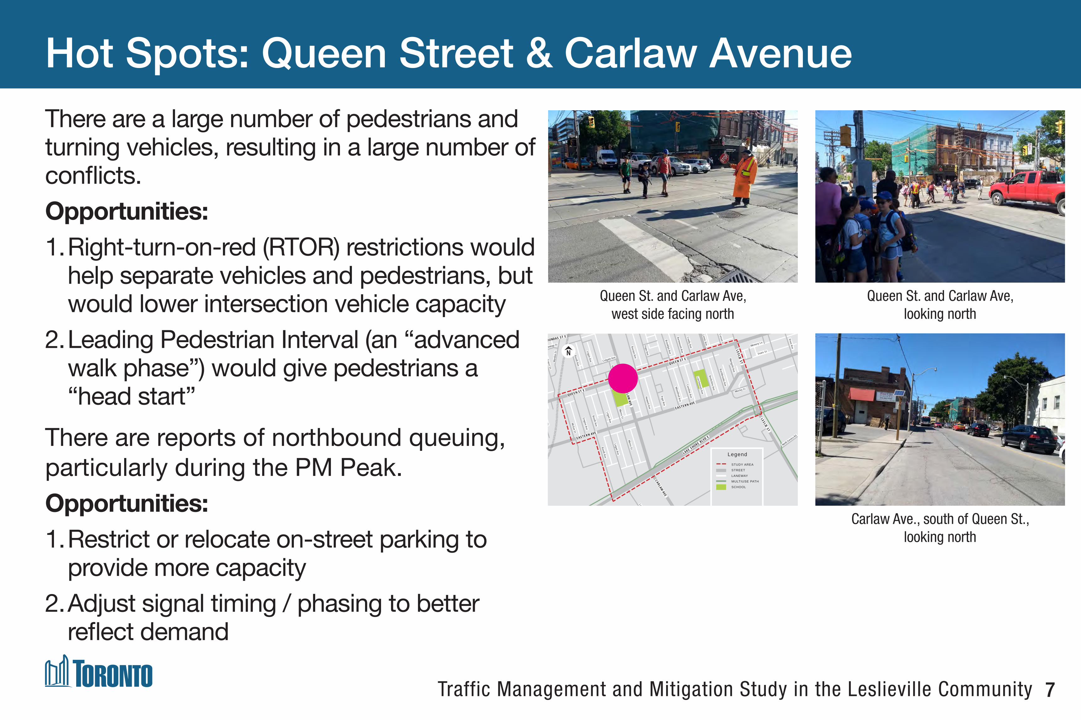
Hot Spots: Queen Street & Carlaw Avenue
Queen St. and Carlaw Ave, west side facing north
Queen St. and Carlaw Ave, looking north
Carlaw Ave., south of Queen St., looking north
There are a large number of pedestrians and turning vehicles, resulting in a large number of conflicts.Opportunities:1. Right-turn-on-red (RTOR) restrictions would
help separate vehicles and pedestrians, but would lower intersection vehicle capacity
2. Leading Pedestrian Interval (an “advanced walk phase”) would give pedestrians a “head start”
There are reports of northbound queuing, particularly during the PM Peak.Opportunities:1. Restrict or relocate on-street parking to
provide more capacity2. Adjust signal timing / phasing to better
reflect demand
EASTERN AVE
LAKE SHORE BLVD EEASTERN AVE
QUEEN ST E
DUNDAS ST E
CARLAW AVE
CARLAW AVE
Heward Ave
Boston Ave
Pape Ave
Pape Ave
Winnifred Ave
Brooklyn Ave
Bertmount Ave
Coady Ave
Jones Ave
Curzon St
Caroline Ave
Larchmount Ave
Berkshire Ave
Rushbrooke Ave
Marigold Ave
Mosley St
Sears St
Knox AveMemory Ln
McGee St
Saulter St
Empire Ave
Booth Ave
Booth Ave
War
den
St
De Grassi St
Cummings St
Booth AveLogan Ave
Logan Ave
Verral Ave
Colgate Ave
Logan Ave
Logan Ave
Morse St
Morse St
Commissioners St
North Service Rd
LESLIE ST
LESLIE ST
QUEEN ST E
STUDY AREA
Legend
STUDY AREA
STREET
LANEWAY
MULTIUSE PATH
SCHOOL

8Traffic Management and Mitigation Study in the Leslieville Community
Morse St. south of Queen St., looking south Morse St. south of Queen St., looking north
Berkshire Ave., looking south
EASTERN AVE
LAKE SHORE BLVD EEASTERN AVE
QUEEN ST E
DUNDAS ST E
CARLAW AVE
CARLAW AVE
Heward Ave
Boston Ave
Pape Ave
Pape Ave
Winnifred Ave
Brooklyn Ave
Bertmount Ave
Coady Ave
Jones Ave
Curzon St
Caroline Ave
Larchmount Ave
Berkshire Ave
Rushbrooke Ave
Marigold Ave
Mosley St
Sears St
Knox AveMemory Ln
McGee St
Saulter St
Empire Ave
Booth Ave
Booth Ave
War
den
St
De Grassi St
Cummings St
Booth AveLogan Ave
Logan Ave
Verral Ave
Colgate Ave
Logan Ave
Logan Ave
Morse St
Morse St
Commissioners St
North Service Rd
LESLIE ST
LESLIE ST
QUEEN ST E
STUDY AREA
Legend
STUDY AREA
STREET
LANEWAY
MULTIUSE PATH
SCHOOL
School Zones: Morse Street, Berkshire Avenue, and Larchmount AvenueNorthbound lane along Morse Street had TDSB vehicles parked in drop-off area.
Opportunities:1. Restrict and enforce on-street parking
2. Relocate school board vehicles to other streets during start/end of school
Some pick-up drop-off activities along Morse St, Berkshire Ave, and Larchmount Ave were taking place from live traffic lane, the wrong side of street and/or blocking sidewalks.
Opportunities:1. Expand and enforce on-street parking
2. Discourage “wrong side” drop-offs
3. Simplify school drop-off area regulations
4. Formalize school drop-off area on Berkshire Ave

9Traffic Management and Mitigation Study in the Leslieville Community
School Zones: Carlaw Avenue
Carlaw Ave., looking south Carlaw Ave., looking south
School area signage and traffic calming
EASTERN AVE
LAKE SHORE BLVD EEASTERN AVE
QUEEN ST E
DUNDAS ST E
CARLAW AVE
CARLAW AVE
Heward Ave
Boston Ave
Pape Ave
Pape Ave
Winnifred Ave
Brooklyn Ave
Bertmount Ave
Coady Ave
Jones Ave
Curzon St
Caroline Ave
Larchmount Ave
Berkshire Ave
Rushbrooke Ave
Marigold Ave
Mosley St
Sears St
Knox AveMemory Ln
McGee St
Saulter St
Empire Ave
Booth Ave
Booth Ave
War
den
St
De Grassi St
Cummings St
Booth AveLogan Ave
Logan Ave
Verral Ave
Colgate Ave
Logan Ave
Logan Ave
Morse St
Morse St
Commissioners St
North Service Rd
LESLIE ST
LESLIE ST
QUEEN ST E
STUDY AREA
Legend
STUDY AREA
STREET
LANEWAY
MULTIUSE PATH
SCHOOL
Heavy traffic and high speeds makes Carlaw Ave undesirable for school pick-ups / drop-offs.
Opportunities:1. Formalize the space in front of Morse St
Public School for school activities
2. Restrict general traffic from southbound lane
3. Encourage pick-up/drop-off along Morse St
4. Reduce speed limit on Carlaw Ave to 30km/hr during school times
On-street parking interferes with garbage collection, forcing vehicles into on-coming traffic.
Opportunities:1. Restrict or relocate on-street parking

10Traffic Management and Mitigation Study in the Leslieville Community
Pedestrians: Crossings
Crosswalks and pedestrian signals were well used, but many pedestrians cross at unprotected crossings and at mid-block locations. Eastern Avenue is of particular concern, with large distances between protected crossing locations.
Opportunities:
1. Reassess the locations of existing signalized intersections
2. Reassess the locations of existing pedestrian crosswalks (PXOs)
3. Replace existing PXOs with signalized intersections
4. Provide additional PXOs
Queen St. and Larchmount Ave., looking east Eastern Ave. and Larchmount Ave., looking east
Queen St. and Morse St., looking north

11Traffic Management and Mitigation Study in the Leslieville Community
Speeding: Speeds Along Local Roads
Data suggests that more than half of vehicles travelling along the local streets within the study area are doing so faster than the posted speed limits.
Opportunities:
1. Provide traffic calming elements along local streets, such as on-street parking, planters, bump-outs (of the curb), or other “road diet” (narrowing) features
2. Assess locations of speed limit signage
3. Consistently set speed limits with nature of street and road classification
Rushbrooke Ave., looking north Resident-installed signage
EASTERN AVE
LAKE SHORE BLVD EEASTERN AVE
QUEEN ST E
DUNDAS ST E
CARLAW AVE
CARLAW AVE
Heward Ave
Boston Ave
Pape Ave
Pape Ave
Winnifred Ave
Brooklyn Ave
Bertmount Ave
Coady Ave
Jones Ave
Curzon St
Caroline Ave
Larchmount Ave
Berkshire Ave
Rushbrooke Ave
Marigold Ave
Mosley St
Sears St
Knox AveMemory Ln
McGee St
Saulter St
Empire Ave
Booth Ave
Booth Ave
War
den
St
De Grassi St
Cummings St
Booth AveLogan Ave
Logan Ave
Verral Ave
Colgate Ave
Logan Ave
Logan Ave
Morse St
Morse St
Commissioners St
North Service Rd
LESLIE ST
LESLIE ST
QUEEN ST E
STUDY AREA
Legend
STUDY AREA
STREET
LANEWAY
MULTIUSE PATH
SCHOOL

12Traffic Management and Mitigation Study in the Leslieville Community
Other: Traffic Signs
There is a lot of signage along all streets within the study area. Too much information presented to drivers may result in confusion and/or indifference, resulting in non-compliance.
Opportunities:
1. Assess on-street policies to ensure these align with signage provided
2. Consolidate signs, ensure visibility, and only present what is needed
Booth Ave., south of Queen St. Booth Ave., south of Queen St. Larchmount Ave., south of Queen St.

13Traffic Management and Mitigation Study in the Leslieville Community
Other: Laneways
Laneways were heavily used by students and families, but are shared spaces to be used by all parties.
Opportunities:
1. Entrances to laneways can be formalized to increase visibility. Potential streetscaping and/or traffic calming may help
2. Signage and traffic calming along some laneways exist, but consistent design may assist road users with navigating safely
Laneway south of Queen St. and Morse St. Lane between Larchmount Ave. and Caroline Ave.
Laneway south of Queen St. and Rushbrooke Ave.
EASTERN AVE
LAKE SHORE BLVD EEASTERN AVE
QUEEN ST E
DUNDAS ST E
CARLAW AVE
CARLAW AVE
Heward Ave
Boston Ave
Pape Ave
Pape Ave
Winnifred Ave
Brooklyn Ave
Bertmount Ave
Coady Ave
Jones Ave
Curzon St
Caroline Ave
Larchmount Ave
Berkshire Ave
Rushbrooke Ave
Marigold Ave
Mosley St
Sears St
Knox AveMemory Ln
McGee St
Saulter St
Empire Ave
Booth Ave
Booth Ave
War
den
St
De Grassi St
Cummings St
Booth AveLogan Ave
Logan Ave
Verral Ave
Colgate Ave
Logan Ave
Logan Ave
Morse St
Morse St
Commissioners St
North Service Rd
LESLIE ST
LESLIE ST
QUEEN ST E
STUDY AREA
Legend
STUDY AREA
STREET
LANEWAY
MULTIUSE PATH
SCHOOL

14Traffic Management and Mitigation Study in the Leslieville Community
Existing & Future Transportation Network
EASTERN AVE
DUNDAS ST E
CARLAW AVE
CARLAW AVE
Heward Ave
Boston Ave
Pape Ave
Pape Ave
Winnifred Ave
Brooklyn Ave
Bertmount Ave
Coady Ave
Jones Ave
Curzon St
Caroline Ave
Larchmount Ave
Berkshire Ave
Rushbrooke Ave
Marigold Ave
Mosley St
Sears St
Knox AveMemory Ln
McGee St
Saulter St
Empire Ave
Booth Ave
Booth Ave
War
den
St
De Grassi St
Cummings St
Booth AveLogan Ave
Logan Ave
Verral Ave
Colgate Ave
Logan Ave
Logan Ave
Morse St
Morse St
Commissioners St
North Service Rd
LESLIE ST
LESLIE ST
QUEEN ST E
LAKE SHORE BLVD E
EASTERN AVE
EXISTING TRAFFIC CHARACTERISTICS
Legend
STUDY AREA
TRAFFIC SIGNAL
ONE-WAY STREET
PEDESTRIANCROSSING
SCHOOL
NEW ROAD
NEW TRAFFIC SIGNAL
EXISTING NETWORK FUTURE NETWORK

15Traffic Management and Mitigation Study in the Leslieville Community
Existing & Future Cycling Network
EASTERN AVE
LAKE SHORE BLVD EEASTERN AVE
QUEEN ST E
DUNDAS ST E
CARLAW AVE
CARLAW AVE
Heward Ave
Boston Ave
Pape Ave
Pape Ave
Winnifred Ave
Brooklyn Ave
Bertmount Ave
Coady Ave
Jones Ave
Curzon St
Caroline Ave
Larchmount Ave
Berkshire Ave
Rushbrooke Ave
Marigold Ave
Mosley St
Sears St
Knox AveMemory Ln
McGee St
Saulter St
Empire Ave
Booth Ave
Booth Ave
War
den
St
De Grassi St
Cummings St
Booth AveLogan Ave
Logan Ave
Verral Ave
Colgate Ave
Logan Ave
Logan Ave
Morse St
Morse St
Commissioners St
LESLIE ST
LESLIE ST
QUEEN ST E
North Service Rd
EXISTING & FUTURE CYCLING NETWORK
LegendSTUDY AREA
ONE-WAY STREET
SCHOOL
MULTI-USE TRAIL
BIKE LANE / CYCLE TRACK
DESIGNATED ROUTE
QUIET STREET ROUTE
CONTRA-FLOW BIKE LANE
FUTUREEXISTING

16Traffic Management and Mitigation Study in the Leslieville Community
Existing Transit Routes and Stops
EASTERN AVE
LAKE SHORE BLVD EEASTERN AVE
QUEEN ST E
DUNDAS ST E
CARLAW AVE
CARLAW AVE
Heward Ave
Boston Ave
Pape Ave
Pape Ave
Winnifred Ave
Brooklyn Ave
Bertmount Ave
Coady Ave
Jones Ave
Curzon St
Caroline Ave
Larchmount Ave
Berkshire Ave
Rushbrooke Ave
Marigold Ave
Mosley St
Sears St
Knox AveMemory Ln
McGee St
Saulter St
Empire Ave
Booth Ave
Booth Ave
War
den
St
De Grassi St
Cummings St
Booth AveLogan Ave
Logan Ave
Verral Ave
Colgate Ave
Logan Ave
Logan Ave
Morse St
Morse St
Commissioners St
North Service Rd
LESLIE ST
LESLIE ST
QUEEN ST E
EXISTING TRANSIT ROUTES AND STOPS
Legend
501 QUEEN STREETCAR
72 PAPE BUS
83 JONES BUS
31 GREENWOOD BUS
143 DOWNTOWN / BEACH EXPRESS BUS
TRANSIT STOP
REGULAR TRANSIT ROUTE
LMITED SERVICE ROUTE
ONE-WAY SERVICE ONLY
STUDY AREA
ONE-WAY STREET
SCHOOL

17Traffic Management and Mitigation Study in the Leslieville Community
Speed Limits and Speeding in Study Area
56%3%
61%
19%45%
18%
36%
20%
61%
44%
23%
EASTERN AVE
LAKE SHORE BLVD EEASTERN AVE
QUEEN ST E
DUNDAS ST E
CARLAW AVE
CARLAW AVE
Heward Ave
Boston Ave
Pape Ave
Pape Ave
Winnifred Ave
Brooklyn Ave
Bertmount Ave
Coady Ave
Jones Ave
Curzon St
Caroline Ave
Larchmount Ave
Berkshire Ave
Rushbrooke Ave
Marigold Ave
Mosley St
Sears St
Knox AveMemory Ln
McGee St
Saulter St
Empire Ave
Booth Ave
Booth Ave
War
den
St
De Grassi St
Cummings St
Booth AveLogan Ave
Logan Ave
Verral Ave
Colgate Ave
Logan Ave
Logan Ave
Morse St
Morse St
Commissioners St
North Service Rd
LESLIE ST
LESLIE ST
QUEEN ST E
SPEED LIMITS AND SPEEDING IN STUDY AREA
Legend
STUDY AREA
ONE-WAY STREET
SCHOOL
30 KM / HR
40 KM / HR
50 KM / HR
60 KM / HR
PERCENTAGE TRAVELLING FASTER THAN POSTED SPEED LIMIT_%

18Traffic Management and Mitigation Study in the Leslieville Community
Road Classifications in Study Area
EASTERN AVE
LAKE SHORE BLVD EEASTERN AVE
QUEEN ST E
DUNDAS ST E
CARLAW AVE
CARLAW AVE
Heward Ave
Boston Ave
Pape Ave
Pape Ave
Winnifred Ave
Brooklyn Ave
Bertmount Ave
Coady Ave
Jones Ave
Curzon St
Caroline Ave
Larchmount Ave
Berkshire Ave
Rushbrooke Ave
Marigold Ave
Mosley St
Sears St
Knox AveMemory Ln
McGee St
Saulter St
Empire Ave
Booth Ave
Booth Ave
War
den
St
De Grassi St
Cummings St
Booth AveLogan Ave
Logan Ave
Verral Ave
Colgate Ave
Logan Ave
Logan Ave
Morse St
Morse St
Commissioners St
North Service Rd
LESLIE ST
LESLIE ST
QUEEN ST E
ROAD CLASSIFICATIONS IN STUDY AREA
Legend
STUDY AREA
ONE-WAY STREET
SCHOOL
LOCAL
COLLECTOR
MINOR ARTERIAL
MAJOR ARTERIAL
Major Arterial Road
Minor Arterial Road
Collector Road
Local Road
Primary Function
Traffic movement, subject to property access control
Traffic movement, and some property access control
Provide access to property and traffic
Provide access to property
Vehicles Per Day
Greater than 20,000
8,000 to 20,000
2,500 to 8,000
Less than 2,500
Transit Passengers Per Day
Greater than 5,000
1,500 to 5,000
Less than 1,500
Generally no routes
Speed Limits 50 to 60 km/h 40 to 60 km/h
40 to 50 km/h
Low traffic speed
Sidewalks Both sides of road
Both sides of road
Both sides of road
At least one side of road
Special Facilities for Cyclists
Desirable Desirable As Required
As Required
Truck Restrictions Generally None Generally
None Permitted Preferred

19Traffic Management and Mitigation Study in the Leslieville Community
Existing Vehicular Volumes (Weekday AM Peak Hour)
3643 328
5189
4570
3666
30
157
77
75
38
37369
809
81
109
75
604
535
479
289
275
379
EASTERN AVE
LAKE SHORE BLVD EEASTERN AVE
QUEEN ST E
DUNDAS ST E
CARLAW AVE
Boston Ave
Pape Ave
Pape Ave
Winnifred Ave
Brooklyn Ave
Bertmount Ave
Coady Ave
Jones Ave
Curzon St
Marigold Ave
Mosley St
Sears St
Knox AveMemory Ln
Saulter St
Empire Ave
Booth Ave
War
den
St
De Grassi St
Cummings St
Logan Ave
Logan Ave
Verral Ave
Colgate Ave
Logan Ave
Logan Ave
Morse St
Commissioners St
North Service Rd
LESLIE ST
QUEEN ST E
LESLIE ST
CARLAW AVE
Rushbrooke Ave
Berkshire Ave
Larchmount Ave
Caroline Ave
McGee St
Booth Ave
Heward Ave
Morse St
Booth Ave
EXISTING VEHICULAR VOLUMES (AM WEEKDAY PEAK HOUR)
Legend
WEEKDAY AM PEAK HOUR VOLUME
<300 VEHICLES
301-600 VEHICLES
601-800 VEHICLES
801-1300 VEHICLES
1301-3300 VEHICLES
STUDY AREA
ONE WAY

20Traffic Management and Mitigation Study in the Leslieville Community
Existing Vehicular Volumes (Weekday PM Peak Hour)
6339 123
39185
6581
37158
36
113
79
100
39
47
85
83
86
362
506
439
775
474
323
744
338
EASTERN AVE
LAKE SHORE BLVD EEASTERN AVE
QUEEN ST E
DUNDAS ST E
CARLAW AVE
Boston Ave
Pape Ave
Pape Ave
Winnifred Ave
Brooklyn Ave
Bertmount Ave
Coady Ave
Jones Ave
Curzon St
Larchmount Ave
Rushbrooke Ave
Marigold Ave
Mosley St
Sears St
Knox AveMemory Ln
Saulter St
Empire Ave
Booth Ave
War
den
St
De Grassi St
Cummings St
Logan Ave
Verral Ave
Colgate Ave
Logan Ave
Logan Ave
Morse St
Commissioners St
North Service Rd
LESLIE ST
QUEEN ST E
LESLIE ST
CARLAW AVE
Booth Ave
Morse St
Berkshire Ave
Caroline AveHeward Ave
Logan Ave
Booth Ave
McGee St
EXISTING VEHICULAR VOLUMES (WEEKDAY PM PEAK HOUR)
Legend
WEEKDAY PM PEAK HOUR VOLUME
<300 VEHICLES
301-600 VEHICLES
601-800 VEHICLES
801-1300 VEHICLES
1301-3300 VEHICLES
STUDY AREA
ONE WAY

21Traffic Management and Mitigation Study in the Leslieville Community
Existing Traffic Conditions (Weekday AM Peak Hour)
A
B
B
B
BB
B
C
C
E
F
EASTERN AVE
LAKE SHORE BLVD EEASTERN AVE
QUEEN ST E
DUNDAS ST E
CARLAW AVE
CARLAW AVE
Heward Ave
Boston Ave
Pape Ave
Pape Ave
Winnifred Ave
Brooklyn Ave
Bertmount Ave
Coady Ave
Jones Ave
Curzon St
Caroline Ave
Larchmount Ave
Berkshire Ave
Rushbrooke Ave
Marigold Ave
Mosley St
Sears St
Knox AveMemory Ln
McGee St
Saulter St
Empire Ave
Booth Ave
Booth Ave
War
den
St
De Grassi St
Cummings St
Booth AveLogan Ave
Logan Ave
Verral Ave
Colgate Ave
Logan Ave
Logan Ave
Morse St
Morse St
Commissioners St
North Service Rd
LESLIE ST
LESLIE ST
QUEEN ST E
EXISTING TRAFFIC CONDITIONS (AM WEEKDAY PEAK HOUR)
Level of Service (LOS) is a letter designation that describes a duration of delay experienced by drivers.
= Free flow
= Reasonably free flow
= Stable flow
= Approaching unstable flow
= Unstable flow
= Forced or breakdown flow
ABCDEF
_ Overall Signalized Intersection LOS
Specific Direction LOS
One-Way Street

22Traffic Management and Mitigation Study in the Leslieville Community
Existing Traffic Conditions (Weekday PM Peak Hour)
B
B
A
AB
C
C
B
F
F
AEASTERN AVE
LAKE SHORE BLVD EEASTERN AVE
QUEEN ST E
DUNDAS ST E
CARLAW AVE
CARLAW AVE
Heward Ave
Boston Ave
Pape Ave
Pape Ave
Winnifred Ave
Brooklyn Ave
Bertmount Ave
Coady Ave
Jones Ave
Curzon St
Caroline Ave
Larchmount Ave
Berkshire Ave
Rushbrooke Ave
Marigold Ave
Mosley St
Sears St
Knox AveMemory Ln
McGee St
Saulter St
Empire Ave
Booth Ave
Booth Ave
War
den
St
De Grassi St
Cummings St
Booth AveLogan Ave
Logan Ave
Verral Ave
Colgate Ave
Logan Ave
Logan Ave
Morse St
Morse St
Commissioners St
North Service Rd
LESLIE ST
LESLIE ST
QUEEN ST E
EXISTING TRAFFIC CONDITIONS (PM WEEKDAY PEAK HOUR)
Level of Service (LOS) is a letter designation that describes a duration of delay experienced by drivers.
= Free flow
= Reasonably free flow
= Stable flow
= Approaching unstable flow
= Unstable flow
= Forced or breakdown flow
ABCDEF
_ Overall Signalized Intersection LOS
Specific Direction LOS
One-Way Street

23Traffic Management and Mitigation Study in the Leslieville Community
Existing Pedestrian Volumes
AM: 335
PM: 432
AM: 352
PM: 506
AM: 371
PM: 301
AM: 215
PM: 396
AM: 853
PM: 1182
AM: 244
PM: 405
AM: 142
PM: 276
AM: 504
PM: 611
AM: 81
PM: 78
AM: 248
PM: 290 AM: 205
PM: 170
AM: 40
PM: 141
LAKE SHORE BLVD E
DUNDAS ST E
CARLAW AVE
Heward Ave
Pape Ave
Winnifred Ave
Brooklyn Ave
Coady Ave
Jones Ave
Curzon St
Caroline Ave
Larchmount Ave
Berkshire Ave
Rushbrooke Ave
Marigold Ave
Mosley St
Sears St
Knox Ave
McGee St
Saulter St
Empire Ave
Booth Ave
Booth Ave
War
den
St
De Grassi St
Cummings St
Booth AveLogan Ave
Logan Ave
Logan Ave
Morse St
Morse St
Commissioners St
North Service Rd
LESLIE ST
LESLIE ST
EXISTING PEDESTRIAN VOLUMES
Bertmount Ave
QUEEN ST E
EASTERN AVE
Memory Ln
Logan Ave
Pape Ave
Boston Ave
Colgate Ave
CARLAW AVEEASTERN AVE
QUEEN ST E
Legend
<50 PEDESTRIANS
51-180 PEDESTRIANS
181-320 PEDESTRIANS
321-610 PEDESTRIANS
611-2040 PEDESTRIANS
STUDY AREA
ONE WAY
CROSSWALK
TOTAL NUMBER OF PEDESTRIANS
WEEKDAY AM PEAK + PM PEAK HOUR
VOLUMES

24Traffic Management and Mitigation Study in the Leslieville Community
Existing Cycling Activities (Weekday AM Peak Hour)
55
12
11
61925
4814
2
10
73
51
2
1611 138
7 2
1 1
1
7
2
3
9
4 4
6
34
26
8
2
3
5
4
9 187
14
14
7
LAKE SHORE BLVD E
DUNDAS ST E
CARLAW AVE
Heward Ave
Pape Ave
Winnifred Ave
Brooklyn Ave
Coady Ave
Jones Ave
Curzon St
Caroline Ave
Larchmount Ave
Berkshire Ave
Rushbrooke Ave
Marigold Ave
Mosley St
Sears St
Knox Ave
McGee St
Saulter St
Empire Ave
Booth Ave
Booth Ave
War
den
St
De Grassi St
Cummings St
Booth AveLogan Ave
Logan Ave
Morse St
Morse St
Commissioners St
North Service Rd
LESLIE ST
LESLIE ST
Logan Ave
EXISTING CYCLING ACTIVITIES (WEEKDAY AM PEAK HOUR)
Bertmount Ave
QUEEN ST E
EASTERN AVE
Memory Ln
Logan Ave
Pape Ave
Boston Ave
Colgate Ave
Verral Ave
CARLAW AVE
EASTERN AVE
QUEEN ST E
LegendNUMBER OF CYCLISTS BY DIRECTION
(WEEKDAY AM PEAK)
<5 CYCLISTS
6-10 CYCLISTS
11-25 CYCLISTS
26-50 CYCLISTS
51-100 CYCLISTS
101-210 CYCLISTS
STUDY AREA
ONE WAY

25Traffic Management and Mitigation Study in the Leslieville Community
Existing Cycling Activities (Weekday PM Peak Hour)
33
8
22
234
11918
115
3
1 103
18 10
65 182
210
12
16 14
12
12
41
6
8
5
12
658
9
24
198
51
LAKE SHORE BLVD E
DUNDAS ST E
CARLAW AVE
Heward Ave
Pape Ave
Winnifred Ave
Brooklyn Ave
Coady Ave
Jones Ave
Curzon St
Caroline Ave
Larchmount Ave
Berkshire Ave
Rushbrooke Ave
Marigold Ave
Mosley St
Sears St
Knox Ave
McGee St
Saulter St
Empire Ave
Booth Ave
Booth Ave
War
den
St
De Grassi St
Cummings St
Booth AveLogan Ave
Logan Ave
Morse St
Morse St
Commissioners St
North Service Rd
LESLIE ST
LESLIE ST
Logan Ave
EXISTING CYCLING ACTIVITIES (WEEKDAY PM PEAK HOUR)
Bertmount Ave
QUEEN ST E
EASTERN AVE
Memory Ln
Logan Ave
Pape Ave
Boston Ave
Colgate Ave
Verral Ave
CARLAW AVE
EASTERN AVE
QUEEN ST E
LegendNUMBER OF CYCLISTS BY DIRECTION
(WEEKDAY PM PEAK)
<5 CYCLISTS
6-10 CYCLISTS
11-25 CYCLISTS
26-50 CYCLISTS
51-100 CYCLISTS
101-210 CYCLISTS
STUDY AREA
ONE WAY

26Traffic Management and Mitigation Study in the Leslieville Community
Existing Conditions: Reported Collision Analysis
LAKE SHORE BLVD E
DUNDAS ST E
CARLAW AVE
CARLAW AVE
Heward Ave
Boston Ave
Pape Ave
Pape Ave
Winnifred Ave
Brooklyn Ave
Bertmount Ave
Coady Ave
Jones Ave
Curzon St
Caroline Ave
Larchmount Ave
Berkshire Ave
Rushbrooke Ave
Marigold Ave
Mosley St
Sears St
Knox AveMemory Ln
McGee St
Saulter St
Empire Ave
Booth Ave
Booth Ave
War
den
St
De Grassi St
Cummings St
Booth AveLogan Ave
Logan Ave
Verral Ave
Colgate Ave
Logan Ave
Logan Ave
Morse St
Morse St
Commissioners St
North Service Rd
LESLIE ST
LESLIE ST
QUEEN ST E
EASTERN AVE
EASTERN AVEQUEEN ST E
EXISTING TRAFFIC CONDITIONS: COLLISION ANALYSIS
Collision Scale
1-3 COLLISIONS
VEHICLE-CYCLIST
VEHICLE-PEDESTRIAN
4-6 COLLISIONS
7-10 COLLISIONS
11+ COLLISIONS
Legend
STUDY AREA
STREET
LANEWAY
MULTIUSE PATH
SCHOOL
*All coll isions occurred between 2013-2017

27Traffic Management and Mitigation Study in the Leslieville Community
Existing Conditions: Reported Collision Analysis
0123456789
10
0 1 2 3 4 5 6 7 8 9 10 11 12 13 14 15 16 17 18 19 20 21 22 23
# C
ollis
ions
Hour Starting
Cyclist and Pedestrian Collisions by Hour (2013-2017)
Cyclist Collisions Pedestrian Collisions
020406080
100120140160
2013 2014 2015 2016 2017
# C
ollis
ions
Year
Collisions by Year
Non-Fatal Injury Property Damage Only
Turning Right48%
Driving Forward
40%
Turning Left10%
U-Turn2%
Vehicle Action - Cyclist Collisions
53Collisions
Turning Left36%
Driving Forward28%
Turning Right29%
Reversing7%
Vehicle Action - Pedestrian Collisions
28Collisions
* No cyclist fatalities noted between 2013-2017 * No pedestrian fatalities noted between 2013-2017
* No fatalities noted between 2013-2017

28Traffic Management and Mitigation Study in the Leslieville Community
Vision Zero Road Safety Plan
What is the Purpose? To eliminate killed and seriously injured (KSI) collisions in Toronto through data-driven and map-based decision making. Safety measures include engineering, education, enforcement, and technology programs and initiatives.
How Does it Relate to this Study?With several future developments leading to an increase in the number of pedestrians, transit users, and cyclists, safety measures from the Vision Zero Road Safety Plan will be considered when implementing changes to the road network.
What is Being Done Now?The City of Toronto has proposed that the streets abutting Morse Street Junior Public School (Carlaw Ave and Morse St), and Bruce Public School (Larchmount Ave and Berkshire Ave) be designated as Community Safety Zones between Queen St E and Eastern Ave. Community Safety Zones come with a suite of safety measures options including automated speed enforcement, “Watch Your Speed” feedback signs, improved signage, pavement markings, and many others.
25
The Vision Zero Road Safety Plan identifies and addresses six emphasis areas, which were determined through collision data analysis, public engagement and Council direction. They include Pedestrians, School Children, Older Adults, Cyclists, Motorcyclists and Aggressive Driving and Distraction.
For each of these emphasis areas, the plan outlines existing, enhanced and new safety measures that includes engineering, education, enforcement and technology programs and initiatives.
WHAT ARE OUR EMPHASIS AREAS?
PEDESTRIANSCYCLISTS MOTORCYCLISTS AGGRESSIVE
DRIVING ANDDISTRACTION
SCHOOL CHILDREN OLDER
ADULTS

29Traffic Management and Mitigation Study in the Leslieville Community
Next Steps Contact
• Review comments received from Open House #1
• Examine future traffic conditions with estimated development traffic included
• Review problems identified by residents and stakeholders
• Develop alternatives for mitigating traffic impacts
• Provide short-term and long-term recommendations
Satbinder Pabla
Project Manager
City of Toronto
Metro Hall
55 John Street, 17th Floor
Toronto, ON M5V 3C6
416-338-5388
Stay ConnectedVisit our webpage for more information and updates:
www.toronto.ca/leslievilletrafficstudy