track - gov.wales
TRANSCRIPT

Track
Well
Pond
Track
Track
Track
Spring
Drain
The OldStable Yard
96.8m
101.5m
WellTirgwaidd
Pentre-HarddWell
Track
Well
Coal Shaft(disused)
Issues
100.3m
93.9m
98.3m
ETL
118.2m
118.0m
Dyffryn Fach
Issues
Trac
k
Track
Shaft
41.8m
Erw-wastad-fachTrack
35.0m
ETL
FarmSychnant
83.1m
87.6m
104.5m
Bryn Awel
Stone
Trac
k
Cattle Grid
Well
Sinks
Cottage
Penrhiw
84.7m
ETL
Sluice
Issues
Drain Well
93.9m
Wern-Ddu
Gelli Organ
Issues
Blaen-Cwm-Bychan
Track
21.0m
20.4m
21.0m
19.2m
River Loughor/ Afon Llwchwr
El Ps
El Ps
47.1m
Collects
Issues
Bryn-y-Rhyd
Proje
ct:Pr
oject
Loca
tion:
Docu
ment
Title:
Scale
:Sh
eet
Form
at:Pr
oject
Desig
ner:
Bryn - Y - Rhyd PV Solar FarmLlanedi, Pontardulais
South Wales, SA4 0FD
1:2500
A1 "594 x 841"
Island Green Power UK Limited
Descriptive Legend
2000 10050
MN, AA,Unit 20.2, Coda Studios189 Munster Road, London SW6 6AW
Comp
any:
Draw
ingNu
mber
:Da
te: 09/06/2021
Other Land in control of the Applicant Security Fence
4
Construction Access
Application boundary
Substation Area Building compound Public Footpath Gas Pipelines Tree-Hedge Canopies Ditches
Security Fence
Gates CCTV
Swale Indicative Planting
WPD Power Lines
Construction Access

27.68
5.001.34
2.75
1.46
4.84
2.41
1.13 0.02
0.02
FRONT VIEW
VIEW FROM "A"
1:100
(*) To be determined basedon geotechnical data
SIDE VIEW
A
2.75
15°
1.46
(*)
1.97
2.414.84
8.00
3.56
(*)
1.97
2.414.84
1:50
Proje
ct:Pr
oject
Loca
tion:
Docu
ment
Title:
Scale
:Sh
eet
Form
at:Pr
oject
Desig
ner:
Bryn - Y - Rhyd PV Solar FarmLlanedi, Pontardulais
South Wales, SA4 0FDMounting structure elevation details
A3 "420 x 297"
5
Comp
any:
Island Green Power UK Limited
17/05/2021
Draw
ingNu
mber
:Da
te:
Varies
Alessio Aru,Unit 20.2, Coda Studios189 Munster Road, London SW6 6AW
0 54321
0 105

6.06
2.90
2.44
0.50 2.84
2.90
0.60
GROUND
6.08
6.06
2.443.04
0.20 0.30
TOP VIEW
FRONT VIEW SIDE VIEW
0.30
3.33 2.73
6.46
0.30
0.20
A A AAB C B C
A Strip foundation
B Pea gravel ground
C Solid grounde.g.,gravel
Proje
ct:Pr
oject
Loca
tion:
Docu
ment
Title:
Scale
:Sh
eet
Form
at:Pr
oject
Desig
ner:
Bryn - Y - Rhyd PV Solar FarmLlanedi, Pontardulais
South Wales, SA4 0FDConversion unit details
A3 "420 x 297"
6
Comp
any:
Island Green Power UK Limited
17/05/2021
Draw
ingNu
mber
:Da
te:
1:50
Alessio Aru,Unit 20.2, Coda Studios189 Munster Road, London SW6 6AW
0 54321

2.90
2.00
2m high Deer Fencing
0.70
Front view Side view
Proje
ct:Pr
oject
Loca
tion:
Docu
ment
Title:
Scale
:Sh
eet
Form
at:Pr
oject
Desig
ner:
Bryn - Y - Rhyd PV Solar FarmLlanedi, Pontardulais
South Wales, SA4 0FDSecurity fence details
A3 "420 x 297"
8
Comp
any:
Island Green Power UK Limited
17/05/2021
Draw
ingNu
mber
:Da
te:
1:50
Alessio Aru,Unit 20.2, Coda Studios189 Munster Road, London SW6 6AW
0 54321

BOTT
GROUND
TOP
4.00
1.00
3.00
Hole D200/1200mm-drilled
Concrete D15/D25
Gravel 16/32mm
0.08
Proje
ct:Pr
oject
Loca
tion:
Docu
ment
Title:
Scale
:Sh
eet
Form
at:Pr
oject
Desig
ner:
Bryn - Y - Rhyd PV Solar FarmLlanedi, Pontardulais
South Wales, SA4 0FDCCTV system details
A3 "420 x 297"
8
Comp
any:
Island Green Power UK Limited
02/06/2021
Draw
ingNu
mber
:Da
te:
1:25
Alessio Aru,Unit 20.2, Coda Studios189 Munster Road, London SW6 6AW
0 1 2 3

Track
Well
Pond
Track
Track
Track
Spring
Drain
The OldStable Yard
96.8m
101.5m
WellTirgwaidd
Pentre-HarddWell
Track
Well
Coal Shaft(disused)
Issues
100.3m
93.9m
98.3m
ETL
118.2m
118.0m
Dyffryn Fach
Issues
Trac
k
Track
Shaft
41.8m
Erw-wastad-fachTrack
35.0m
ETL
FarmSychnant
83.1m
87.6m
104.5m
Bryn Awel
Stone
Trac
k
Cattle Grid
Well
Sinks
Cottage
Penrhiw
84.7m
ETL
Sluice
Issues
Drain Well
93.9m
Wern-Ddu
Gelli Organ
Issues
Blaen-Cwm-Bychan
Track
21.0m
20.4m
21.0m
19.2m
River Loughor/ Afon Llwchwr
El Ps
El Ps
47.1m
Collects
Issues
Bryn-y-Rhyd
Proje
ct:Pr
oject
Loca
tion:
Docu
ment
Title:
Scale
:Sh
eet
Form
at:Pr
oject
Desig
ner:
Bryn - Y - Rhyd PV Solar FarmLlanedi, Pontardulais
South Wales, SA4 0FD
1:2500
A1 "594 x 841"
Island Green Power UK Limited
Descriptive Legend
2000 10050
MN, AA,Unit 20.2, Coda Studios189 Munster Road, London SW6 6AW
Comp
any:
Draw
ingNu
mber
:Da
te: 09/06/2021
Other Land in control of the Applicant Security Fence
9
Mounting Structures Conversion Unit Maintenance Tracks
Site layout plan & coal mining areas
Application boundary
Substation Area Building compound Public Footpath Gas Pipelines Tree-Hedge Canopies Ditches
Security Fence
Gates CCTV
Swale Indicative Planting
WPD Power Lines
Shafts High Risk Zone

S1
K1

• • •

Small Scale Grid Index

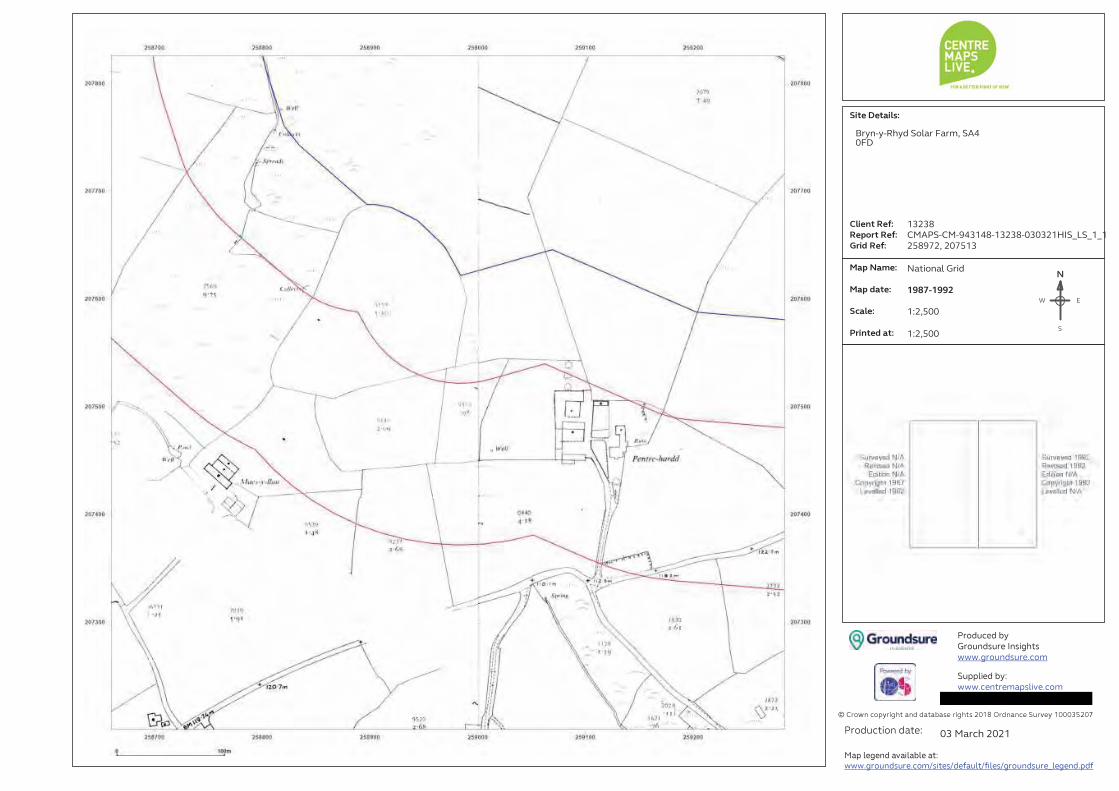
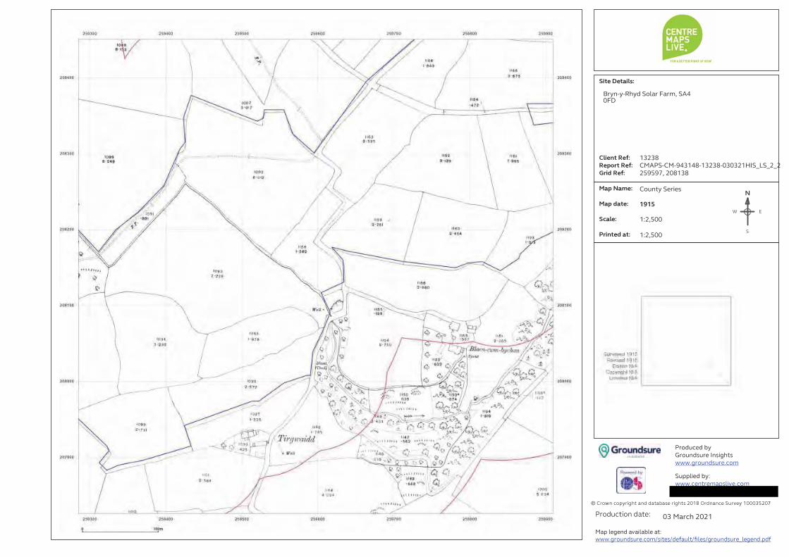
Site Details:
Client Ref:
Report Ref:
Grid Ref:
Map Name:
Map date:
Scale:
Printed at:
© Crown copyright and database rights 2018 Ordnance Survey 100035207
Produced by
Groundsure Insights
www.groundsure.com
Supplied by:
www.centremapslive.com
Production date:
Map legend available at:
www.groundsure.com/sites/default/files/groundsure_legend.pdf
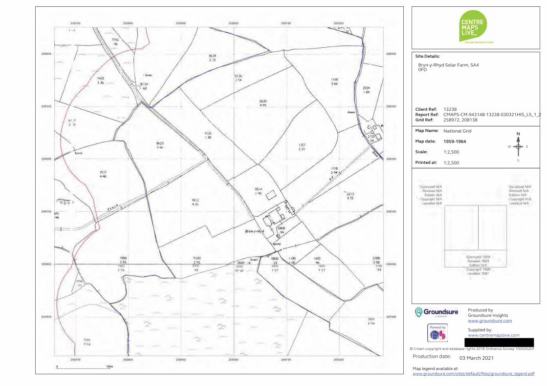
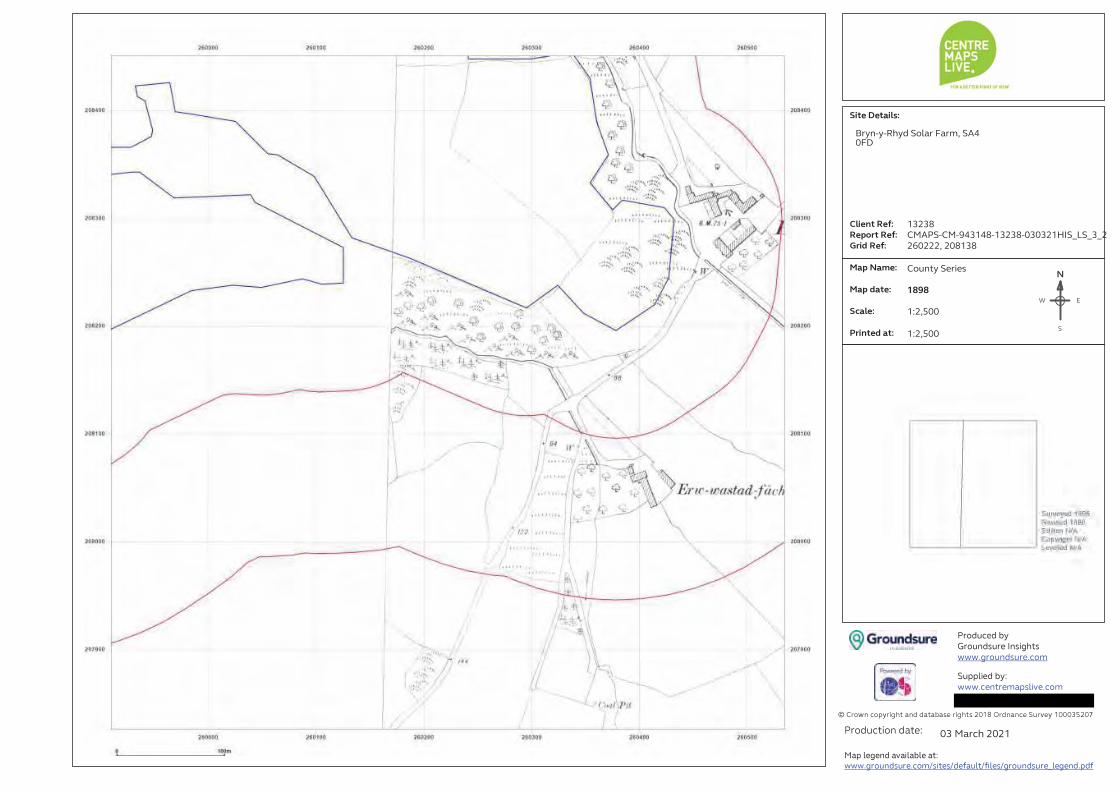
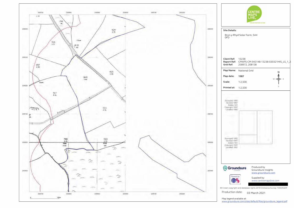
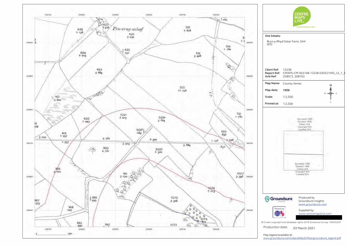

Site Details:
Client Ref:
Report Ref:
Grid Ref:
Map Name:
Map date:
Scale:
Printed at:
© Crown copyright and database rights 2018 Ordnance Survey 100035207
Produced by
Groundsure Insights
www.groundsure.com
Supplied by:
www.centremapslive.com
Production date:
Map legend available at:
www.groundsure.com/sites/default/files/groundsure_legend.pdf

Site Details:
Client Ref:
Report Ref:
Grid Ref:
Map Name:
Map date:
Scale:
Printed at:
© Crown copyright and database rights 2018 Ordnance Survey 100035207
Produced by
Groundsure Insights
www.groundsure.com
Supplied by:
www.centremapslive.com
Production date:
Map legend available at:
www.groundsure.com/sites/default/files/groundsure_legend.pdf

Site Details:
Client Ref:
Report Ref:
Grid Ref:
Map Name:
Map date:
Scale:
Printed at:
© Crown copyright and database rights 2018 Ordnance Survey 100035207
Produced by
Groundsure Insights
www.groundsure.com
Supplied by:
www.centremapslive.com
Production date:
Map legend available at:
www.groundsure.com/sites/default/files/groundsure_legend.pdf

1:2,500 Scale Grid Index

Site Details:
Client Ref:
Report Ref:
Grid Ref:
Map Name:
Map date:
Scale:
Printed at:
© Crown copyright and database rights 2018 Ordnance Survey 100035207
Produced by
Groundsure Insights
www.groundsure.com
Supplied by:
www.centremapslive.com
Production date:
Map legend available at:
www.groundsure.com/sites/default/files/groundsure_legend.pdf

Site Details:
Client Ref:
Report Ref:
Grid Ref:
Map Name:
Map date:
Scale:
Printed at:
© Crown copyright and database rights 2018 Ordnance Survey 100035207
Produced by
Groundsure Insights
www.groundsure.com
Supplied by:
Production date:
Map legend available at:
www.groundsure.com/sites/default/files/groundsure_legend.pdf
Site Details:
Client Ref:
Report Ref:
Grid Ref:
Map Name:
Map date:
Scale:
Printed at:
© Crown copyright and database rights 2018 Ordnance Survey 100035207
Produced by
Groundsure Insights
www.groundsure.com
Supplied by:
www.centremapslive.com
Production date:
Map legend available at:
www.groundsure.com/sites/default/files/groundsure_legend.pdf

Site Details:
Client Ref:
Report Ref:
Grid Ref:
Map Name:
Map date:
Scale:
Printed at:
© Crown copyright and database rights 2018 Ordnance Survey 100035207
Produced by
Groundsure Insights
www.groundsure.com
Supplied by:
www.centremapslive.com
Production date:
Map legend available at:
www.groundsure.com/sites/default/files/groundsure_legend.pdf

Site Details:
Client Ref:
Report Ref:
Grid Ref:
Map Name:
Map date:
Scale:
Printed at:
© Crown copyright and database rights 2018 Ordnance Survey 100035207
Produced by
Groundsure Insights
www.groundsure.com
Supplied by:
www.centremapslive.com
Production date:
Map legend available at:
www.groundsure.com/sites/default/files/groundsure_legend.pdf

Site Details:
Client Ref:
Report Ref:
Grid Ref:
Map Name:
Map date:
Scale:
Printed at:
© Crown copyright and database rights 2018 Ordnance Survey 100035207
Produced by
Groundsure Insights
www.groundsure.com
Supplied by:
www.centremapslive.com
Production date:
Map legend available at:
www.groundsure.com/sites/default/files/groundsure_legend.pdf

Site Details:
Client Ref:
Report Ref:
Grid Ref:
Map Name:
Map date:
Scale:
Printed at:
© Crown copyright and database rights 2018 Ordnance Survey 100035207
Produced by
Groundsure Insights
www.groundsure.com
Supplied by:
www.centremapslive.com
Production date:
Map legend available at:
www.groundsure.com/sites/default/files/groundsure_legend.pdf

Site Details:
Client Ref:
Report Ref:
Grid Ref:
Map Name:
Map date:
Scale:
Printed at:
© Crown copyright and database rights 2018 Ordnance Survey 100035207
Produced by
Groundsure Insights
www.groundsure.com
Supplied by:
www.centremapslive.com
Production date:
Map legend available at:
www.groundsure.com/sites/default/files/groundsure_legend.pdf


BRYNRHYD SOLAR FARM Llanedi, Carmarthenshire, SA18 3PL Environmental Statement TECHNICAL APPENDICES Chapter 11 NOISE AND VIBRATION

ENVIRONMENTAL STATEMENT TECHNICAL APPENDICES
SEPTEMBER 2021 BRYNRHYD SOLAR FARM
APPENDIX 11.1
DETAIL ON THE NATIONAL GUIDANCE AND STANDARDS RELEVANT TO THE NOISE ASSESSMENT OF THE SOLAR FARM AT
BRYN-Y-RHYD FARM

ENVIRONMENTAL STATEMENT Noise and Vibration
Brynrhyd Solar Farm
11.7 APPENDIX 11.1
11.7.1 This Technical Appendix document presents further detail on the national guidance and standards relevant to the noise assessment of the Solar Farm at Bryn-y-rhyd Farm.
Descriptive Noise Units
11.7.2 Noise is defined as unwanted sound. The range of audible sound is from 0dB to 140dB. The frequency response of the human ear is usually taken to be about 18Hz (number of oscillations per second) to 18 000Hz. The ear does not respond equally to different frequencies at the same level. It is more sensitive in the mid-frequency range than the lower and higher frequencies and, because of this, the low and high frequency components of a sound are reduced in importance by applying a weighting (filtering) circuit to the noise measuring instrument (the sound level meter). The weighting which is most widely used and which correlates best with subjective response to noise is the A-weighting. This is an internationally accepted standard for noise measurements.
11.7.3 For variable noise sources such as traffic, an increase of 1dB(A), which equates for example to an approximate 25% increase in road traffic, is barely perceptible. In addition, a doubling of traffic flow will increase the overall noise by 3dB(A), providing that a number of factors, including speed, remain unchanged. The ‘loudness’ of a noise is a purely subjective parameter, but it is generally accepted that an increase/decrease of 10dB(A) corresponds to a doubling or halving in perceived loudness.
11.7.4 External noise levels are rarely steady, but rise and fall according to surrounding activities. In an attempt to produce a figure that relates this variable noise level to the subjective response, a number of noise metrics have been developed. These include:
The LAeq noise level
11.7.5 This is the ‘equivalent continuous A-weighted sound pressure level, in decibels’, and is defined in British Standard BS7445 as the “value of the A-weighted sound pressure level of a continuous, steady sound that, within a specified time interval, T, has the same mean square sound pressure as a sound under consideration whose level varies with time”. It is a unit commonly used to describe construction noise, and noise from industrial premises and is the most suitable unit for the description of many other forms of environmental noise.
The LAmax noise level
11.7.6 This is the maximum noise level recorded over a particular measurement period.
The LA10 noise level
11.7.7 The LA10 is the noise level that is exceeded for 10% of the measurement period, and gives an indication of the noisier levels. It is a unit that has been used over many years for the measurement and assessment of road traffic noise.
The LA90 noise level
11.7.8 The LA90 is the noise level that is exceeded for 90% of the measurement period and gives an indication of the noise level during quieter periods. It is often referred to as the ‘background’ noise level.

ENVIRONMENTAL STATEMENT Noise and Vibration
Brynrhyd Solar Farm
Regulatory Context
Control of Pollution Act (CoPA) 1974
11.7.9 The Act of Parliament which specifically relates to the control of noise and vibration from construction sites is the Control of Pollution Act 1974 (CoPA). This is achieved by the means of the imposition of appropriate conditions and by the development of agreed working procedures.
11.7.10 Sections (S)60 and 61 of the CoPA gives local authorities in Scotland, England and Wales special powers for controlling noise arising from construction and demolition works on any building or civil engineering sites. S60 refers to the control of noise on construction sites and provides legislation by which local authorities can control noise from construction sites to prevent noise disturbance occurring. In addition, it recommends that guidance provided by BS5228 be implemented to ensure compliance with S60. S61 refers to prior consent for work on construction sites and provides a method by which a contractor can apply for consent to undertake construction works in advance.
Environmental Protection Act (EPA)
11.7.11 The Environmental Protection Act (EPA) (Section 79, Part III of Chapter 43, Statutory Nuisances and Inspections) contains a definition of what constitutes a “statutory nuisance” with regard to noise and places a duty on Local Authorities to detect any such nuisances within their area. This section further defines “Best Practicable Means” (BPM) as ‘reasonably practical having regard, among other things, to local conditions and circumstances, to the current state of technical knowledge and to the financial implications’.
11.7.12 Local Authorities have the power under Section 80, Part III of Chapter 43 of the EPA (summary proceedings for statutory nuisances) to serve an abatement notice requiring the abatement of a nuisance or requiring works to be executed to prevent their occurrence.
Relevant Guidance
11.7.13 In addition to the regulatory guidance detailed above, assessment methodologies appropriate for this type of development will also be referred to within the completion of this study.
11.7.14 The relevant guidance and methodology documents are discussed in the following sections.
BS5228 ‘Code of practice for noise and vibration control on construction and open sites Part 1: Noise +A1:2014
11.7.15 Part 1 of BS5228, Code of practice for basic information and procedures for noise control, gives recommendations for basic methods of noise control relating to construction and open sites where work activities/operations generate significant noise. The document includes sections on: legislative background; community relations; training; occupational noise effects; neighbourhood nuisance; project supervision; and control of noise.
11.7.16 Annexes include information on: EC and UK legislation; noise sources, remedies and their effectiveness (mitigation options); sound level data for onsite equipment and site activities (source terms that are used for modelling); a methodology

ENVIRONMENTAL STATEMENT Noise and Vibration
Brynrhyd Solar Farm
for estimating noise from sites (calculation procedures which form the basis of the modelling packages); and guidance relating to noise monitoring.
11.7.17 It is noted, that the guidance of BS5228 Part 1 provides example noise effect significance criteria within Annexe E, and states the key factors that must be considered. These include:
• a) site location; • b) existing ambient noise levels; • c) duration of site operations; • d) hours of work; • e) attitude of the site operator; and • f) noise characteristics.
11.7.18 BS5228 contains two example methods of determining the significance of construction noise. Method 1 ‘The ABC Method’ examines absolute levels based on various threshold categories and is detailed in the table below:
Table 11.1.1: BS5228 ‘ABC’ Method Assessment Values
Assessment category and threshold value period (LAeq)
Threshold Value, in decibels (dB)
Category A A) Category B B) Category C C)
Night-time (23:00 – 07:00) 45 50 55
Evening and Weekends D) 55 60 65
Daytime (07:00 – 19:00 and Saturdays 07:00 – 13:00) 65 70 75
NOTE 1 A significant effect has been deemed to occur if the total LAeq noise level, including construction, exceeds the threshold level for the Category appropriate to the ambient noise level. NOTE 2 If the ambient noise level exceeds the threshold values given in the table (i.e. the ambient noise level is higher than the above values), then a significant effect is deemed to occur if the total LAeq noise level for the period increases by more than 3 dB due to construction activity. NOTE 3 Applied to residential receptors only. A) Category A: threshold values to use when ambient noise levels (when rounded to the nearest 5 dB) are less than these values B) Category B: threshold values to use when ambient noise levels (when rounded to the nearest 5 dB) are the same as category A values C) Category C: threshold values to use when ambient noise levels (when rounded to the nearest 5 dB) are higher than category A values D) 19:00 – 23:00 weekdays, 13:00 – 23:00 Saturdays and 07:00 – 23:00 Sundays.
11.7.19 Method 2 of BS5228 refers to a ‘5dB(A) Change’ and states that construction noise is deemed to be significant if the total noise level exceeds the pre-construction ambient noise level by 5dB or more, subject to lower cut off values of 65dB, 55dB and 45dB for the daytime, evening and night-time periods respectively.
11.7.20 The standard states it is good practice to attempt to minimise construction noise impacts through environmental controls defined in either a Construction Environmental Management Plan (CEMP) or a Code of Construction Practice.
BS4142: 2014+A1:2019 ‘Methods for rating and assessing industrial and commercial sound
11.7.21 The standard method for assessing noise of an industrial or commercial nature affecting housing, is British Standard BS4142 “Method for rating and assessing industrial and commercial sound”. A BS4142 assessment is typically made by determining the difference between the industrial noise under consideration and the background sound level as represented by the LA90 parameter, determined in the absence of the industrial

ENVIRONMENTAL STATEMENT Noise and Vibration
Brynrhyd Solar Farm
noise. The LA90 parameter is defined as the level exceeded for 90% of the measurement time, representing the underlying noise in the absence of short duration noise events such as dog barks or individual cars passing.
11.7.22 The industrial noise under consideration is assessed in terms of the ambient noise level, LAeq, but a character correction penalty can be applied where the noise exhibits certain characteristics such as distinguishable tones, impulsiveness or, if the noise is distinctively intermittent. The ambient noise level, LAeq is defined as the steady-state noise level with the same energy as the actual fluctuating sound over the same time period. It is effectively the average noise level during the period. The industrial noise level (LAeq) with the character correction (if necessary) is known as rating level, LAr, and the difference between the background noise and the rating level is determined to make the BS4142 assessment. The standard then states:
• a) “Typically, the greater the difference, the greater the magnitude of the impact.
• b) A difference of around +10dB or more is likely to be an indication of a significant adverse impact, depending on the context.
• c) A difference of around +5dB is likely to be an indication of an adverse impact, depending on the context.
• d) The lower the rating level is relative to the measured background sound level, the less likely it is that the specific sound will have an adverse impact or a significant adverse impact. Where the rating level does not exceed the background sound level, this is an indication of the specific sound source having a low impact, depending on the context.”
11.7.23 The standard outlines a number of methods for defining appropriate ‘character corrections’ to determine the rating levels to account for tonal qualities, impulsive qualities, other sound characteristics and/or intermittency.
11.7.24 The standard also highlights the importance of considering the context in which a sound occurs. The standard indicates that factors including the absolute sound level, the character of the sound, the sensitivity of the receptor and the existing acoustic character of the area should be considered when assessing the noise impact. The absolute sound level is of particular importance where the measured background sound levels are low, which is typically taken as LA90 30dB and below. In regard to low sound levels, the standard states:
11.7.25 ‘Where background sound levels and rating levels are low, absolute levels might be as, or more, relevant than the margin by which the rating level exceeds the background. This is especially true at night.’
Guidelines for Environmental Noise Impact Assessment
11.7.26 The institute of Environmental Management and Assessment (IEMA) guidance (Oct 2014) addresses the key principles of noise impact assessment and how these fit within the Environmental Impact Assessment (EIA) process. The guidance document is not intended as a prescriptive methodology for noise impact assessment.
11.7.27 The document offers guidance on the processes involved in the assessment of noise for both the EIA process and smaller scale developments including: scoping; establishing baselines; prediction of noise levels; assessment; and mitigation.
The guidance details a matrix of degree of effect which is summarised below:
Table 11.1.2: Degree of Effect Matrix

ENVIRONMENTAL STATEMENT Noise and Vibration
Brynrhyd Solar Farm
Importance/ Sensitivity of Receptor
High Medium Low Negligible M
agni
tude
of C
hang
e
Large Very Substantial Substantial Moderate None
Medium Substantial Substantial Moderate None
Small Moderate Moderate Slight None
Negligible None None None None
Table 11.1.3: Effect Descriptor
Very Substantial Greater than 10dB LAeq change in sound level perceived at a receptor of great sensitivity to noise.
Substantial Greater than 5dB LAeq change in sound level at a noise-sensitive receptor, or a 5 to 9.9dB LAeq change in sound level at a receptor of great sensitivity to noise.
Moderate A 3 to 4.9dB LAeq change in sound level at a sensitive or highly sensitive noise receptor, or a greater than 5dB LAeq change in sound level at a receptor of some sensitivity.
Slight A 3 to 4.9dB LAeq change in sound level at a receptor of some sensitivity.
None/ Not Significant
Less than 2.9dB LAeq change in sound level and/or all receptors are of negligible sensitivity to noise or marginal to the zone of influence of the proposals.
Calculation of Road Traffic Noise Memorandum
11.7.28 The Technical Memorandum, Calculation of Road Traffic Noise (CRTN) (Department of Transport and Welsh Office, 1988) document details an empirical prediction methodology for the calculation of road traffic noise. The procedures described within the document set out the calculation methodology as well as the information requirements which includes traffic flow components, the type of ground cover, relevant heights and distances, and the presence of any barriers/obstructions.
11.7.29 These are used in order to calculate the source noise level of the given road link and the reduction in noise at a given receiver location due to propagation and screening effects.
The document further outlines where and how the monitoring of existing traffic noise conditions should be undertaken.

ENVIRONMENTAL STATEMENT TECHNICAL APPENDICES
SEPTEMBER 2021 BRYNRHYD SOLAR FARM
APPENDIX 11.2
PROTOCOLS AND METHODOLOGIES EMPLOYED WITHIN THE SCOPE OF THE 3D ACOUSTIC MODELLING OF THE SOLAR FARM

ENVIRONMENTAL STATEMENT Noise and Vibration
Brynrhyd Solar Farm
11.8 APPENDIX 11.2
11.8.1 This Technical Appendix document outlines the protocols and methodologies employed within the scope of the 3D acoustic modelling of the Solar Farm.
Prediction Protocols
11.8.2 The facility is neither in situ or operational at the current time therefore, noise associated with the plant/ equipment has been assessed by means of a 3D noise model, constructed using the IMMI software.
11.8.3 Within the modelling exercise informing this study, acoustic propagation has been calculated in accordance with ISO9613-2: Acoustics – Attenuation of sound during propagation outdoors: Part 2: General method of calculation. The Immi software implements this methodology in full.
11.8.4 The prediction methodology of the ISO Standard takes account of wind and meteorological conditions in the following ways:
• Wind Direction – The software assumes a positive wind vector in all directions from the source to receptor.
• Humidity – 70% • Temperature – 10°C
11.8.5 In addition, ground conditions are considered to be mixed (G = 0.5) between the site and receiver locations.
Foundation of the Noise Model
11.8.6 The noise model was constructed utilising the following information: • OS Open data mapping (TIFF format); • Digital Terrain Mapping obtained from OS Open Data (DWG format); • Site layout plan supplied by Pegasus Group Ltd; and, • Noise levels for the proposed plant and equipment provided by Pegasus
Group Ltd.
Modelling Assumptions
11.8.7 Within the construction of the noise model the following assumptions have been made:
• All predictions are made to a free field receptor location at a height of 1.5m above local;
• Screening effect of hedgerows and perimeter fences etc is assumed to be negligible;
• All off site buildings are assumed to be 8m high from local ground height.
11.8.8 The proposed development is for a solar farm including the following: • 7 No. power transformer / inverter ‘Conversion’ units; • A single Distribution Network Operator (DNO) transformer station.
11.8.9 The nature of solar farms is such that electricity is only generated during daylight hours. This may extend into times considered to be part of the night (that is early

ENVIRONMENTAL STATEMENT Noise and Vibration
Brynrhyd Solar Farm
mornings before 07:00 hours) and during evenings (after 19:00 hours) during the summer. An outline plan of the proposed facility is presented in Figure 11.2.1 below.
Figure 11.2.1: Conversion Unit Location Plan
Conversion Units
11.8.10 The conversion units are to be located around the site and are understood to include both power transformer and inverter elements.
11.8.11 Noise data for the actual conversion units is not available at this time. The actual plant used is likely to differ from the example data below however, in the absence of specific information, noise data for the SMA SC2200 central inverter with an integrated power transformer, is considered a reasonable proxy for the type of noise generated. Table 3 summarises the measured data. This represents unit operating at 100% capacity during a sunny daytime period.
Noise Source
Sound Power Level (dB) in Octave Bands Overall dB LWA 63 125 250 500 1000 2000 4000
Conversion Unit 96.7 92.1 87.6 81.9 77.7 76.6 73.4 85.5
11.8.12 The inverter / power transformer data used includes a dampener which reduces the overall noise emissions from the units and reduces the tonality. Analysis of the measured 1/3rd octave band data indicates a number of peaks in the noise spectrum however none of the peaks achieve the levels warranting the +6dB tonal correction required by the BS4142:2014 Annex C (Objective) methodology. Moreover, the high frequency peaks will tend to be dissipated readily with distance (and atmospheric absorption) such that these sources are not heard outside of the solar farm site.
N
Conversion Units
DNO Station

ENVIRONMENTAL STATEMENT Noise and Vibration
Brynrhyd Solar Farm
DNO Station - Transformer
11.8.13 The DNO station includes a number of items of plant which facilitate the connection to the National Grid. The most significant noise source is the large power transformer.
11.8.14 Again, no specific information has been provided for the DNO transformer, therefore typical noise data from a similar solar farm site has been used in this assessment. The sound power level used within this assessment is summarised in Table 4 below.
Noise Source
Sound Power Level (dB) in Octave Bands Overall dB LWA 63 125 250 500 1000 2000 4000
DNO Power Transformer 78.0 78.8 80.4 83.7 77.7 67.6 62.0 83.0
BRYNRHYD SOLAR FARM Llanedi, Carmarthenshire, SA18 3PL Environmental Statement TECHNICAL APPENDICES Chapter 12 MISCELLANEOUS MATTERS

ENVIRONMENTAL STATEMENT TECHNICAL APPENDICES
SEPTEMBER 2021 BRYNRHYD SOLAR FARM
APPENDIX 12.1
MAJOR ACCIDENTS AND DISASTERS IN EIA: A PRIMER, DATED SEPTEMBER 2020
Major Accidents and Disasters in EIA: A Primer
September 2020

2
Contents 2
Context, aims and audience 3
Key terminology 4
Introduction 7
Background 8
Structure of the remaining document 9
Screening for EIA 10
Scoping for EIA 11
o Scoped in or out? 11
o Scoped in – defining the scope 12
Assessment 17
o Setting out the baseline – hazard identification and receptor tagging 17
o Assessment – identifying reasonable worst-case impact 18
o Assessment – Selecting the grouped Risk Events that need further assessment 18
o Assessment – understanding the likelihood of a Risk Event occurring 19
o Mitigation – Identifying the requirements for secondary mitigation 19
o Mitigation – Risk management options 20
o Residual assessment 20
Final words 21
Appendix A – Supplementary terminology 22
Appendix B – Useful legislation 27
Appendix C – Case studies 29
Appendix D – Hazard identification record template 34
Appendix E – FAQs 35
Appendix F – References 36
Contents

3
What is a major accidents and/or disasters assessment?
• The topic was introduced into the UK Environmental
Impact Assessment (EIA) Regulations as a result
of EU Directive 2014/52/EU (the EIA Directive).
• It covers the assessment of potentially significant
adverse effects of a development on the
environment deriving from its vulnerability to risks
of relevant major accidents and/or disasters.
• A major accident is an event (for instance,
train derailment or major road traffic accident)
that threatens immediate or delayed serious
environmental effects to human health, welfare
and/or the environment and requires the use of
resources beyond those of the client or its appointed
representatives (i.e. contractors) to manage.
• Major accidents can be caused by disasters resulting
from both man-made and natural hazards.
• A disaster is a man-made/external hazard (such as
an act of terrorism) or a natural hazard (such as an
earthquake) with the potential to cause an event or
situation that meets the definition of a major accident.
• In general, major accidents and/or disasters
should be considered as part of an assessment
where the development has the potential to
cause the loss of life, permanent injury and/
or temporary or permanent destruction of an
environmental receptor which cannot be restored
through minor clean-up and restoration.
What does this primer aim to provide?
• This primer aims to increase awareness of the major
accidents and/or disasters EIA topic and its application.
• It offers an assessment methodology based on
known current practice within the UK to date and
identifies key terminology that can be used.
• It has been structured around a typical assessment
approach and offers a proportionate method
for considering major accidents and/or disasters
through screening, scoping and assessment.
• It has been developed to generate
comment and discussion, from which future
guidance and institutional and regulatory
change can evolve over time.
Who is this primer aimed at?
• The intended audience of this primer is impact
assessment practitioners and those with an
interest in improving working practice and
awareness across impact assessment.
• It is assumed that the reader has basic knowledge
of EIA in the UK. Further information on EIA more
generally can be found within IEMA’s resources.
Context, aims and audience

4
Key terms used in this primer are set out below. Supplementary terminology, including
sources from which the below has been drawn, is presented in Appendix A.
Key term Definition
Adaptive capacity The capacity of receptors to adjust to potential damage, to take
advantage of opportunities, or to respond to consequences.
As low as reasonably practicable (ALARP) Involves weighing a risk against the trouble, time and money
needed to control it. Thus, ALARP describes the level to which we
expect to see risks controlled.
Disaster May be a natural hazard (e.g. earthquake) or a man-made/external
hazard (e.g. act of terrorism) with the potential to cause an event or
situation that meets the definition of a major accident.
Reasonable worst-case scenario A challenging manifestation of the scenario after highly implausible
scenarios are excluded1.
Magnitude of impact The magnitude of an impact is typically defined by the following
factors:
extent – the area over which an effect occurs;
duration – the time for which the effect occurs;
frequency – how often the effect occurs;
severity – the degree of change relative to existing environmental
conditions.
Major accident Events that threaten immediate or delayed serious environmental
effects to human health, welfare and/or the environment and
require the use of resources beyond those of the client or its
appointed representatives to manage. Whilst malicious intent is
not accidental, the outcome (e.g. train derailment) may be the
same and therefore many mitigation measures will apply to both
deliberate and accidental events.
1 As defined in: www.gov.uk/government/publications/national-risk-register-for-civil-emergencies-2015-edition/national-risk-register-of-civil-emergencies-chapter-1-main-types-of-civil-emergency
Key terminology
5
Key term Definition
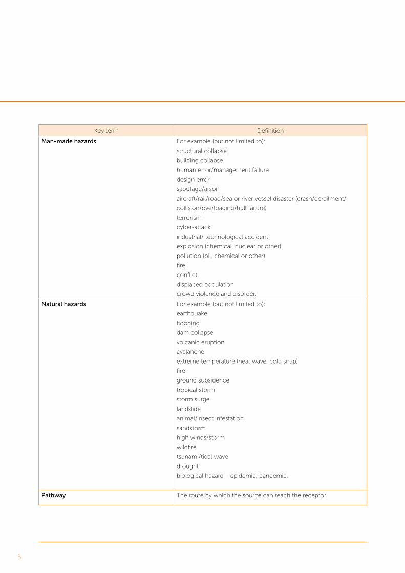
Man-made hazards For example (but not limited to):
structural collapse
building collapse
human error/management failure
design error
sabotage/arson
aircraft/rail/road/sea or river vessel disaster (crash/derailment/
collision/overloading/hull failure)
terrorism
cyber-attack
industrial/ technological accident
explosion (chemical, nuclear or other)
pollution (oil, chemical or other)
fire
conflict
displaced population
crowd violence and disorder.
Natural hazards For example (but not limited to):
earthquake
flooding
dam collapse
volcanic eruption
avalanche
extreme temperature (heat wave, cold snap)
fire
ground subsidence
tropical storm
storm surge
landslide
animal/insect infestation
sandstorm
high winds/storm
wildfire
tsunami/tidal wave
drought
biological hazard – epidemic, pandemic.
Pathway The route by which the source can reach the receptor.

6
Key term Definition
Receptor The specific component of the environment that could be adversely
affected if the source reaches it.
Environmental receptor is specifically defined as:
features of the environment that are subject to assessment under
Article 3 of the EIA Directive, namely population and human health,
biodiversity, land, soil, water, air and climate, material assets, cultural
heritage and landscape.
Risk The likelihood of an impact occurring, combined with the effect or
consequence(s) of the impact on a receptor if it does occur.
Risk Event An identified, unplanned event, which is considered relevant to the
development and has the potential to result in a major accident
and/or disaster, subject to assessment of its potential to result in a
significant adverse effect on an environmental receptor.
Sensitivity The sensitivity of a receptor is a function of its value, and capacity to
accommodate change reflecting its ability to recover if it is affected.
It is typically defined by the following factors:
Adaptability – the degree to which a receptor can avoid, adapt to or
recover from an effect.
Tolerance – the ability of a receptor to accommodate temporary or
permanent change.
Recoverability – the temporal scale over and extent to which a
receptor will recover following an effect.
Significant environmental effect (in relation
to a major accidents and/or disasters
assessment)
Could include the loss of life, permanent injury and temporary or
permanent destruction of an environmental receptor which cannot
be restored through minor clean-up and restoration.
Source The original cause of the hazard, which has the potential to cause
harm.
Source-pathway-receptor linkage For a risk to arise there must be hazard that consists of a ‘source’
(e.g. high rainfall); a ‘receptor’ (e.g. people, property, environment);
and a pathway between the source and the receptor (e.g. flood
routes).
Vulnerability Describes the potential for harm as a result of an event, for example
due to sensitivity or value of receptors. In the context of the EIA
Directive, the term refers to the ‘exposure and resilience’ of the
development to the risk of a major accident and/or disaster.
Vulnerability is influenced by sensitivity, adaptive capacity and
magnitude of impact.

7
Major accidents and/or disasters was a new EIA
topic introduced by the 2014/52/EU EIA Directive
(the EIA Directive). The objective of this primer is to
present learning from existing development within
the UK where the topic has been assessed, to share
best practice and to promote a consistent approach
across the general network of EIA professionals.
It is not intended to be an introduction to risk
management itself, rather to give impact assessment
practitioners an introductory working knowledge
of the topic and its application, and to stimulate
further discussion and debate as the topic evolves.
As this is an emerging topic, this document is intended
as a primer only to introduce the concept of the topic
and offer an initial appreciation on methodology that
could be adopted. It will prompt discussion upon which
future guidance, and therefore practice, can evolve. The
primer is intended to be updated as experience of the
topic develops, and as the methodology is advanced
and more widely agreed. There is a huge variance in the
scope and extent of development that falls under EIA,
and this primer is not intended to mandate a ‘one size fits
all’ approach, nor to suggest one would be appropriate.
This primer aims to communicate the positive process
of hazard identification, and avoidance, reduction or
mitigation through the EIA process. The methodology
outlined offers a transparent platform to communicate
to stakeholders how development vulnerabilities to
major accidents and/or disasters have been reduced
to an acceptable level. As with any topic, the earlier
in the process vulnerabilities to major accidents and/
or disasters are identified and appraised the greater the
likelihood of residual risks being appropriately controlled,
and the scope of the EIA remaining proportionate.
Introduction
8
The EIA Directive was transposed into UK legislation in
2017, including but not limited to the Town and Country
Planning (EIA) Regulations 2017 (devolved between
England, Wales, Scotland and Northern Ireland), and
the Infrastructure Planning (EIA) Regulations 2017
(collectively referred to as the EIA Regulations from here).
The EIA Regulations require:
‘A description of the expected significant
adverse effects of the development on the
environment deriving from the vulnerability of
the development to risks of major accidents and/
or disasters…’ (Schedule 4, Paragraph 8)
The underlying objective of the assessment is to
ensure that appropriate precautionary actions
are taken for those developments which:
‘…because of their vulnerability to major accidents
and/or natural disasters (such as flooding, sea
level rise, or earthquakes), are likely to have
significant adverse effects on the environment.’
(Paragraph 15 of Directive 2014/52/EU)
A key aim of the EIA Directive update was to
ensure efforts are not duplicated, reinforcing the
need for proportionality. It further states:
‘In order to avoid duplications, it should be possible to
use any relevant information available and obtained
through risk assessments carried out pursuant to
Union legislation, such as Directive 2012/18/EU of the
European Parliament and the Council (13) and Council
Directive 2009/71/Euratom (14), or through relevant
assessments carried out pursuant to national legislation
provided that the requirements of this Directive
are met.’ (Paragraph 15 of Directive 2014/52/EU)
The UK already has a structured framework of risk
management legislation in place. This guidance
therefore suggests a ‘sign-posting’ approach to
assessment, making efficient use of existing and
available risk assessments rather than duplicating any
risk quantification and management already undertaken
on developments as part of the assessment approach.
This primer recognises that primary and tertiary
mitigation (refer to Appendix A for definitions) of a
development’s vulnerability to major accidents and/or
disasters, for infrastructure and other built environment
developments, is covered by a wide range of other
safety and non-safety-related legislation. This mitigation
is generally sufficient to manage vulnerabilities to
major accidents and/or disasters without the need
for secondary mitigation in most circumstances. The
guidance within this primer aims to help developments
communicate this process to stakeholders through
the Environmental Statement2 to demonstrate how
a development’s vulnerability to major accidents is
adequately managed to prevent or reduce potential
significant adverse effects to environmental receptors.
2 Also known as an Environmental Report under the Scottish EIA Regulations. The term ‘Environmental Statement’ is used for the purpose of this primer to refer to any written output of the EIA process.
Background

9
The remainder of this primer presents an assessment
approach that can be adopted by impact assessment
practitioners undertaking a major accident and/
or disasters assessment. This can act as a basis for
methodology to evolve as experience in the field grows.
The following steps are covered:
• Screening
o Identifying if a development falls within the
definition of EIA development under the
EIA Regulations, by virtue of the likelihood
of significant environmental effects from
major accidents and/or disasters.
• Scoping
o Deciding if a major accidents and/or disasters
assessment should be scoped in or out of the EIA.
o If scoped in, how to set out a proposed
methodology as part of a scoping report.
• Assessment
o Key steps to enable practitioners to undertake
an assessment and identify any potential
significant effects that require further mitigation.
o Understanding risk management
options as part of the process.
Further detail is included within the following appendices:
• Appendix A – supplementary terminology drawn
from existing sources providing a background
appreciation of current definitions that have
informed key terminology for this topic.
• Appendix B – references to the broader
legislative context surrounding the topic.
• Appendix C – a sample of existing
case studies to demonstrate how this
assessment approach can be applied.
• Appendix D – a hazard identification record
template to support the assessment process.
• Appendix E – a selection of frequently
asked questions that have arisen as the
methodology for this topic has evolved.
• Appendix F – references that have
informed this primer.
Structure of the remaining document

10
The level of effort required at the screening stage
for major accidents and/or disasters is likely to be
minimal. During screening it should be sufficient to
identify if a development has a vulnerability to major
accidents and/or disasters and to consider whether
a development could lead to a significant effect.
High-level questions to consider (which will
be considered in more detail at the scoping
stage if screened in) could include:
• Is the development a source of hazard itself that could
result in a major accident and/or disaster occurring?
• Does the development interact with any sources
of external hazards that may make it vulnerable
to a major accident and/or disaster?
• If an external major accident and/or disaster
occurred, would the existence of the development
increase the risk of a significant effect to
an environmental receptor occurring?
Considering these at a high level, without necessarily
providing evidence at this stage, should help guide
whether the development has the potential to be
vulnerable to major accidents and/or disasters,
or to increase vulnerability elsewhere.
It is valid to consider and identify proposed mitigation at
the screening stage. If it is possible to demonstrate that
proposed design measures, existing legal requirements,
and codes and standards are likely to adequately control
any potential vulnerability to a major accident and/or
disaster then this should be factored into the conclusion.
If a development is not vulnerable to major accidents
and/or disasters and is not likely to increase vulnerability
elsewhere, it is unlikely to lead to an event that would
cause a significant environmental effect upon a
receptor. In these circumstances, it should be valid to
propose that the requirement for EIA is not triggered
in relation to major accidents and/or disasters risks.
Screening for EIA

11
The aim of the scoping stage is to determine in
more detail whether there is potential for significant
effects as a result of major accidents and/or disasters
associated with a development, and the resulting
scope of and approach to the assessment if required.
o Scoped in or out?
To guide the scoping decision, think carefully about what
is relevant to the development specifically, such as its
location, type, context, existing and future constraints,
and likely receptors. A major accidents and/or disasters
assessment will be relevant to some developments
more than others, and for many developments it
is likely to be scoped out of the assessment.
Figure 1 provides a process flow that can be
used to help guide a scoping decision:
Is the development a source
of hazard that could result in a
major accident and/or disaster?
If yes
Is there a pathway to cause a
significant environmental effect
to an environmental receptor?
Does the development
interact with any external
sources of hazard?
If yes
Does the presence of the
development increase the
risk of that hazard to occur
at its external source?
If an external man-made
or natural hazard occurred,
would the presence of the
development increase the risk
of significant environmental
effect to an environmental
receptor occurring?
If yes to any
Do existing design measures or legal requirements, codes and standards adequately control the potential
major accident and/or disaster, or will it be adequately covered/assessed by another topic?
If no - scope the topic in, further
assessment is likely to be required
If yes - scope the topic
out and signpost to these
measures/assessments
Figure 1 - scoping decision process flow
Scoping for EIA

12
Major accidents and/or disasters can be scoped out of
the assessment if you can clearly demonstrate that:
1. there is no source-pathway-receptor linkage of a
hazard that could trigger a major accident and/
or disaster or potential for the scheme to lead
to a significant environmental effect; or
2. all possible major accidents and/or disasters are
adequately covered elsewhere in the assessment
or covered by existing design measures3 or
compliance with legislation and best practice.
The Scoping Report can be used to signpost to the
evidence that justifies scoping the topic out.
However, if there is any uncertainty, a major
accidents and/or disasters assessment should
be scoped in. This is likely to require discussion
with clients or other stakeholders to explain the
benefits of the assessment with reference to
the need for clarity in the communication of
development risks and how they will be managed.
Examples of scoping decisions for this topic on a
variety of developments are provided in Appendix C.
o Scoped in – defining the scope
Even in circumstances when the topic is scoped into
the assessment, it is likely that it can be limited to
specific elements of the development or the baseline
environment and therefore remain limited in scope.
This needs to be clearly set out in the scoping report
to manage expectations at an early stage, with a focus
on proportionality and likely significant effects.
The scoping report should set out the following:
Baseline
In line with the EIA Directive, this will be existing
sources of risk assessment or other relevant studies,
rather than collecting survey data (as might typically
be the case for other EIA topics for receptors that
the major accidents and/or disasters topic may
impact upon)4. Duplication of data gathering and risk
assessment should be avoided, and standalone risk
assessments for the topic should only be undertaken if
the information is not available from existing sources.
Sources of risk assessment might include the
developments Construction Design Management (CDM)
risk register, relevant development studies such as
geotechnical desk-based assessments, and System Safety
Hazard Records. Other sources of information such as
the UK’s current National Risk Register5, and its associated
local community risk registers6, may also provide useful
prompts for any risks not captured in development-
specific documentation. Data from the Health and Safety
Executive, Environment Agency, and their counterparts
in Scotland (Scottish Environment Protection Agency)
and Wales (Natural Resource Wales), as well as local
authorities, on adjacent Control of Major Accident
Hazards (COMAH) and other potentially hazardous sites
or installations should also be set out within the baseline.
You will need to consult with your development
team, client and stakeholders to fully agree the extent
of baseline information available and to be used.
This will differ development to development.
3 For instance, altering the internal spatial layout of a scheme to simply avoid a hazard could be embedded as a primary mitigation measure at the scoping stage.
4 This is in accordance with Paragraph 15 of the EIA Directive 2014 to avoid duplication.
5 www.gov.uk/government/collections/national-risk-register-of-civil-emergencies
6 www.gov.uk/guidance/local-resilience-forums-contact-details

13
The above information will provide the list of
hazards (the source part of the source-pathway-
receptor linkage) that will then be collected
and considered further in the assessment.
At the scoping stage, this data does not need to be
collected or reported in full. The list of sources that
will be used in the assessment should be set out in
the scoping report for agreement with stakeholders,
along with a request for any other sources of
information they may wish to draw attention to.
Receptors
Receptors are features of the environment that are
subject to assessment under Article 3 of the EIA
Directive, namely population and human health,
biodiversity, land, soil, water, air and climate,
material assets, cultural heritage and landscape.
Relevant receptors can be identified through a review
of base mapping and aerial photography, as well as
through consultation with the development team
and other EIA topic leads that may have identified
receptors specific to their environmental topic.
For smaller developments, this might involve
identifying, for instance, certain designated sites/areas
that will be assessed as part of your assessment.
For larger-scale developments, this might instead
focus on identifying groups of receptor types and
focus on a more development-wide approach.
An environmental receptor that could be vulnerable
to a major accidents and/or disasters risk, but is
outside the scope of the wider EIA, is very unlikely
so it is important to ensure these receptors align
with the other topics considered under the EIA.
Deciding on a proportionate assessment
Not all potential events will fall into the scope of a
major accidents and/or disasters assessment. The
level of risk therefore needs to be defined to inform
what types of events are within the scope of the
major accidents and/or disasters assessment.
Events that have a high likelihood of occurring and would
be of high consequence are a high risk and would be
unacceptable for any development. These should already
be managed or designed-out by a development. These
might include, for example, an element of highway
design that did not comply with standards leading
to a major road traffic collision. These are therefore
likely to be outside the scope of the assessment.
At the other end of the scale, low-impact events whatever
the likelihood, such as minor spills, are low risk and
are unlikely to be considered a major accidents and/or
disasters risk. These events would not threaten immediate
or delayed serious environmental effects to human
health, welfare and/or the environment that require
the use of resources beyond those of the client or its
appointed representatives to manage. These are also
therefore likely to be outside the scope of the assessment.
The assessment will typically focus on low likelihood but
potentially high consequence events, refer to Figure 2.

14
Risks that are likely to lead to an event occurring,
such as effects knowingly caused by a development
like noise and vibration, are already assumed to be
accounted for in other topics of the EIA and are not
replicated. These impacts are a known impact, rather
than an unplanned event, that would knowingly
occur as the result of a development and would be
specifically mitigated for. For example, the risk of
irreversible impacts to human health caused by noise
could meet the definition of a major accident and/or
disaster, but the assessment and mitigation is covered
elsewhere, in this instance under the EIA topic of noise.
The definition of a low likelihood event may be shaped
through further practice. For the purposes of this primer
it is considered to be an event that could occur but is
unlikely to. Specific time definitions for a development
could be defined as part of scoping, recognising
the likely timescales of construction and operation.
For example, no more than once in X years for the
construction phase, and no more than once in Y years
for the operational phase. If a development risk matrix
is available, reference can be made to this to define risk
categories that are within the scope of the assessment.
Alternatively, professional judgement can
be used when categorising events into their
respective categories, provided there is a clear
justification for the judgement made.
High
Like
liho
od
of
eve
nt
occ
urr
ing
Low High
low-consequence events
E.g. Leaks and spills at construction sites.
Not in scope of the major accidents
and/or disasters assessment as they
do not meet the definition.
Where relevant, these risks to the environment
are addressed under other topics in the EIA.
High-likelihood/high-consequence events
The risk assessment and design process
will identify and avoid or manage
out any unacceptable risks.
Development unlikely to receive consent
to operate with these present.
Low-likelihood/high-consequence events
Focus of the major accidents and/
or disasters assessment.
The assessment will identify relevant
events and determine whether a significant
environmental effect is likely. Embedded
mitigation and response strategies
required to demonstrate management
of risks to be ALARP will be identified.
Consequence/effect on environmental receptor
Figure 2 - Summary of Risk Events considered in the scope of the assessment for major accidents and disasters

15
Setting the spatial scope
This should include external features that may
present a hazard to the development, even if
these are beyond the scheme boundaries. For
instance, the presence of a particular hazardous site
may be beyond the development’s construction
and operational boundary, but still have the
potential to interact with the development.
The assessment can be undertaken at a development
(rather than receptor) level, depending on the
nature of the scheme. However, where relevant, any
locations considered more vulnerable to a major
accident and/or disaster and/or sensitive to significant
adverse effect, should be clearly identified.
Defining significance
As part of scoping, it will be important to agree
what the definition of a significant effect will be.
Factors that can be considered include:
• the geographic extent of the effects. Effects
beyond the development boundaries are
more likely to be considered significant;
• the duration of the effects. Effects which are
permanent (i.e. irreversible) or long-lasting are
more likely to be considered significant;
• the severity of the effects in terms of number, degree
of harm to those affected and the response effort
required. Effects which trigger the mobilisation
of substantial civil emergency response effort
are more likely to be considered significant;
• the sensitivity of the identified receptors; and
• the effort required to restore the affected environment.
Effects requiring substantial clean-up or restoration
efforts are more likely to be considered significant.
Drawing from criteria within Annex VI of the
Seveso III Directive, a significant adverse
effect can be specified (see Appendix B).
As an example, the significance threshold could be set
at anything that causes the loss of life or permanent
injury, and/or permanent or long-lasting damage to an
environmental receptor. However, this is just one example
and the threshold set will differ depending on multiple
factors on different developments. Significance criteria
are also likely to be shaped through further practice.
Defining exclusions
It is important to define conditions to which vulnerabilities
to major accidents and/or disasters do not apply, and
any elements scoped out of the assessment as a result,
subject to detailed consideration by the development
team (including any legal advisors) and agreement with
stakeholders. These should be clearly communicated
in the scoping report and might include, for example:
• low-consequence (regardless of likelihood)
events – the EIA Regulations focus on major
accidents and/or disasters, both of which terms
imply significant harm. So, for example, likely
construction-related accidents such as slips, trips
and falls should not fall within the scope;
• high-likelihood, high-consequence events
– these should be addressed elsewhere,
and being unacceptable by definition,
are implicitly outside scope;
• any hazards for which there is no credible
source-pathway-receptor linkage;
• this will be a development-specific decision, but it
may be appropriate to consider excluding effects
on members of the public who wilfully trespass. If
the development takes appropriate measures to
provide a secure boundary to reduce likelihood of
trespass, those ignoring these measures might not be
considered valid receptors. It could be considered that
a development will already have mitigated for trespass
as far as reasonably practicable, so there would be
no further mitigation available to mitigate further;

16
• also dependent on individual development decisions,
but it may be appropriate to consider excluding
effects on employees working on-site, as they are
protected by existing health and safety legislation,
although this should be agreed on a development-
by-development basis to ensure this is the case; and
• hazards associated with other topics, for
example, damage or contamination of aquifer
or borehole which would typically fall under a
water/flood risk/land quality assessment.
Agreeing how the assessment will be reported
There are several options for reporting the major
accidents and/or disasters assessment. This should be
agreed as part of the scoping process. Options include:
• within existing chapters, i.e. under an additional
section heading, describing these as unplanned
events, during construction and/or operation.
This may involve a description of methodology
in the upfront text describing this approach,
and then for each EIA topic a section under
construction and operation that deals with abnormal
circumstances (major accidents and/or disasters);
• within a standalone major accidents and/
or disasters chapter, which cross-references
to other EIA topics where necessary; or
• as a risk assessment which is an appendix to the
scoping report or the Environmental Statement
and referred to as part of the ‘Description of the
development’ or ‘Scope of the Assessment’ sections.
The decision should be made on a development-
by-development basis and included in the scoping
report for agreement with stakeholders.
Summary
To recap, the following factors should be agreed
with stakeholders at the scoping stage:
• the reasons for either scoping the topic in or out;
• if scoped in:
o the sources of information to be used for
the baseline to inform the assessment;
o the receptors that will be considered
as part of the assessment;
o the spatial scope of the assessment;
o how significance will be defined;
o the inclusions and exclusions
within the assessment; and
o any unknowns or uncertainties that are
inherent in the data or the assessment.

17
If major accidents and/or disasters has been scoped into
the assessment, the methodology for undertaking the
assessment might follow the example provided in this
section. However, methodologies may vary between
developments and is likely to evolve with practice.
A robust record of all steps should be kept. As with
any EIA topic it is possible that during consultation,
some major accidents and/or disasters hazards are
queried, and it should be possible to refer to how or
why these were screened out or assessed further.
o Setting out the baseline – hazard
identification and receptor tagging
Using the baseline sources agreed through scoping,
commence the analysis to identify hazards that will
be assessed.
Risk registers are typically live documents and will need to
be frozen at set times so they can be used to inform the
assessment. This may align with particular design freeze
points in the programme or happen at other times. For
the avoidance of any doubt, the version of any data used
should be clearly stated in the assessment assumptions.
The multiple sources of information you analyse
should be collated and presented consistently
in one hazard identification record, an example
template for which is presented in Appendix D.
This collated hazard identification record will
provide the evidence base for the assessment.
Depending on the scale of the development, identified
hazards may be grouped into high-level ‘Risk Events’
which have the same potential consequence. This can
help to keep the assessment proportionate. For example,
all hazards, sources and pathways that could lead to a
major road traffic accident could be combined, since it is
the traffic accident that has the potential to cause harm
to an environmental receptor, regardless of the cause.
The grouped Risk Events should then be reviewed and
assigned to relevant environmental receptors that may
experience an impact (noting the scope you agreed
during scoping). This may be specific, such as a river at
a certain location, or more general, such as members of
the public in the vicinity. This tagging can be added to the
hazard identification record template. It is unlikely that
your existing baseline data will have categorised hazards
against receptors, and therefore this is an important step.
This may require further consultation with EIA topic leads
to inform an understanding of what receptors are present
within the location that a grouped Risk Event could occur.
If you have a Risk Event with no valid receptor tagged
against it then this Risk Event will not require further
assessment as there is no valid source-pathway-
receptor linkage. This can be reported in the hazard
identification record template and discounted
from any further reference in the assessment.
Assessment

18
o Assessment – identifying reasonable
worst-case impact
As you move into assessing major accidents and/
or disasters impacts, the reasonable worst-case
environmental impact should be identified for
each grouped Risk Event with a valid receptor.
This is likely to be done qualitatively, using professional
judgement and consultation with other EIA topic
specialists to understand what a reasonable worst-
case impact might be for that receptor. If there
is any uncertainty around what the reasonable
worst-case impact might be, then a realistic level
of caution is recommended. Generally, it will be
possible to demonstrate later in the assessment
that the reasonable worst-case impact has been
mitigated despite the inherent uncertainty.
The following question may assist
at this point in the process:
‘Could the grouped Risk Event reasonably
constitute a major accident and/or natural
disaster in terms of the definitions provided?’
For example, if the grouped Risk Event has the
potential to harm a member of the public, the
important consideration is whether that harm could
constitute a fatality, multiple fatalities or permanent
injury – all of which are likely to classify it as a major
accident and/or disaster (noting any exclusions your
assessment may make, such as trespassers).
Similarly, the impact on the natural environment should
be considered in terms of widespread or irreversible harm.
The hazard identification record template
(Appendix D) provides further examples
of reasonable worst-case impacts.
The hazard identification record template should set out
the results of the review process undertaken, recording
consultations with other EIA topics as an evidence
trail, and providing any other comments that will assist
in demonstrating how an outcome was reached.
o Assessment – Selecting the grouped Risk
Events that need further assessment
It is expected that the collated and grouped hazard
identification record will hold some information
that may not be relevant to the overall assessment.
At this stage you can consolidate your hazard
identification record by screening out any Risk
Events that meet the following criteria:
• there is no source-pathway-receptor linkage;
• the receptor is not within scope, as
defined through scoping;
• the consequence does not meet the criteria
of a significant environmental effect, and
therefore the grouped Risk Event is not a
potential major accident and/or disaster; or
• the consequence and likelihood of the risk is high,
to the extent that it is considered unacceptable
to the development and has therefore been
designed-out or otherwise managed.
The reasons for screening these out of further
detailed assessment should be recorded
in the hazard identification record.
Remaining grouped Risk Events should then be
assessed further as described in the following sections.
This will determine whether potential significant
effects on receptors are already managed and/or
mitigated to an acceptable level (i.e. perhaps using
the term as low as reasonably practicable [ALARP])
or whether there are gaps in mitigation that need
to be addressed through secondary mitigation.

19
o Assessment – understanding the
likelihood of a Risk Event occurring
The possibility of the reasonable worst-
case environmental impact occurring
should be evaluated considering:
• the likelihood of the grouped Risk Event
occurring considering the measures already
embedded into the design and best practice
(primary and tertiary mitigation); and
• the likelihood that an environmental receptor is
affected by the reasonable worst-case grouped Risk
Event following primary and tertiary mitigation.
Likelihood assessments need not be quantitative
but should evaluate and report as part of the hazard
identification risk record whether the reasonable
worst-case impact you have identified is a realistic
outcome of the grouped Risk Event therefore
requiring further mitigation, or whether this
outcome has already been adequately addressed by
embedded and best practice mitigation measures.
This evaluation can refer to existing risk assessments
as well as consultation with relevant EIA topic and
non-EIA (i.e. members of the design team) specialists,
with reference to the definition of low likelihood.
Non-technical consultees, such as affected
residents, will understand a description around the
chance of fatality due to explosion, for example,
better than a probability such as ‘less than 1 in
1,000’. Therefore, careful consideration should
be given to the communication of likelihood in
simple terms. For instance, a development may
use terms such as a development has ‘x’ chance
of an event happening over the next 10 years.
o Mitigation – identifying the requirements
for secondary mitigation
The outcome of the above activity will highlight risks for
which existing primary and tertiary (embedded and best
practice) measures do not provide sufficient mitigation
to reduce the risk to an acceptable level, and therefore
significant effects could occur. Where this is the case,
secondary (additional) measures will be required.
In consultation with relevant topic leads, secondary
mitigation must be developed to manage the risk to
an acceptable level, most likely below the significance
criteria for a major accident and/or disaster.

20
o Mitigation – risk management options
Risk management options for major accidents
and/or disasters will fall into one of the
following categories, consistent with the
mitigation hierarchy used for EIA generally:
• eliminate (or ‘avoid’) the risk, by adopting
alternative processes to eliminate the source
of the hazard or remove the receptor.
• reduce the risk by adapting proposed processes
such that either the likelihood or the impact
of the Risk Event can be reduced.
• isolate the risk, by using physical measures to
ensure that should the Risk Event occur, it can be
effectively isolated such that there is no pathway.
• control the risk, by ensuring that appropriate
control measures are in place (e.g. emergency
response) so that should a Risk Event occur, it can
be controlled and managed appropriately. The EIA
mitigation hierarchy of repair and compensate for
any significant damage to environmental receptors
may then apply following a control measure; and
• exploit the risk, if it presents potential benefits or
new opportunities, for instance moving an existing
asset to which a development relates further from a
potential source of hazard, such as a hazardous site.
o Residual assessment
As the impact of safety risks must be adequately
addressed within the regulatory framework of a
development it is not anticipated that significant
residual effects will be identified following assessment,
although further practice will inform this further.
Importantly, the above process should focus
on demonstrating how secondary mitigation
reduces the likelihood and/or significance of the
reasonable worst-case impact occurring to an
acceptable level. The hazard identification risk
record can be used to report this process and
demonstrate the following flow of assessment:
• Risk event leads to reasonable worst-
case impact upon receptor.
• Reasonable worst-case impact identified as not
adequately mitigated via primary and tertiary mitigation,
and as such, significant adverse effect likely to occur.
• Secondary mitigation options explored.
• Reasonable worst-case impact adequately
mitigated to acceptable limits, or reasons
for not doing so clearly justified.
21
The major accidents and/or disasters topic requires
consultation and collaboration over and above
specialist EIA topic-specific skills. Where specialist
risk assessments are required, it is expected that this
expertise would generally already exist within the client
or the development team, and the role of the major
accidents and/or disasters topic team is to consult with
these specialists and connect their work to the EIA.
The guidance presented in this primer will evolve as
practice in the field emerges. The primer offers an
example approach and does not stipulate that this
method should be followed. Instead the content
should be used as a basis to help build awareness and
a platform from which to evolve the approach. As
practice evolves, this primer will be updated and a move
towards an agreed uniform approach – preferably in
the form of a practical guidance note – may be issued.
Final words

22
Definition Source Comment
Accident: ‘Something that happens by chance or without
expectation’.
Disaster: ‘A sudden accident or a natural catastrophe that
causes great damage or loss of life’.
Oxford English Dictionary
‘Serious accident’ means any train collision or derailment
of trains, resulting in death of at least one person or serious
injury to five or more persons, or extensive damage to rolling
stock, the infrastructure, or the environment, and any other
similar accident with an obvious impact on railway safety
regulation or the management of safety.
‘Extensive damage’ means damage that can immediately be
assessed by the investigating body to cost at least £2 million
in total.
Railway Safety Directive
(Directive 2004/49/EC)
The definition applies to
a wider scope of impacts
than required under the
EIA Directive (refer to
section 4 above)
To satisfy the definition of ‘emergency’ under the Act, the
event or situation must threaten serious damage to human
welfare in, or the environment of, a place in the United
Kingdom.
Additionally, to constitute an emergency, an incident
or situation must also pose a considerable test for an
organisation’s ability to perform its functions.
The common themes of an emergency are the scale of the
impact of the event or situation; the demands it is likely to
make of local responders; and the exceptional deployment
of resources.
Civil Contingencies Act
2004 and
Her Majesty’s
Government’s
accompanying non-
statutory guidance7
This Act provides an
overarching framework
for preparing for and
responding to civil
emergencies within the
United Kingdom
‘An occurrence such as a major emission, fire, or explosion
resulting from uncontrolled developments in the course of the
operation of any establishment covered by this Directive and
leading to serious danger to human health or the environment,
immediate or delayed, inside or outside the establishment, and
involving one or more dangerous substances.’
The Seveso III Directive
(Directive 2012/18/EU)
Relates to the COMAH
involving dangerous
substances
7 HM Government (2013) Emergency Response and Recovery – Non-statutory guidance accompanying the Civil Contingencies Act 2004, Cabinet Office, 28 October 2013.
Appendix A – Supplementary terminology

23
Definition Source Comment
Events with the potential to result in:
• the death or adverse effects on local populations
of species or organisms, with lower thresholds
for high-value or protected species;
• contamination of drinking water supplies,
ground or groundwater;
• damage to designated areas, habitats or
populations of species within the areas;
• damage to listed buildings;
• damage to widespread habitats; and
• damage to the marine or aquatic environment.
The Control of
Major Accident
Hazards (COMAH)
regulations, 2015 and
the HSE guidance on
implementing them8
The requirements of
the Seveso III Directive
are transposed into UK
legislation via the COMAH
regulations
‘Major accident’ is defined as an occurrence on-site […]
leading to a loss of life or serious danger to human health
and/or the environment, whether immediately or over time,
on-site or off-site.
‘Serious danger to human health’ relates to people present
permanently or for prolonged periods of time in the
potentially affected area but excludes workers operating at
the facility. Injuries leading to disability or prolonged states of
ill health shall count as serious dangers to human health.
‘Serious danger to the environment’ relates to:
• a contaminant source strength that does not
decrease significantly within a short time;
• permanent or long-lasting environmental damage; and
• the affected environment not being restored
through minor clean-up and restoration efforts.
Major Accident
Off-Site Emergency Plan
(Management of Waste
from Extractive Industries)
(England and Wales)
Regulations 20099
These regulations
implement the provisions
of the Mining Waste
Directive (Directive
2006/21/EC)
8 Health and Safety Executive (2015) The Control of Major Accident Hazards Regulations 2015: Guidance on Regulations, L111, Third Edition, June 2015
9 Department of Environment, Food and Rural Affairs (2011) Guidance: Major Accident Off-Site Emergency Plan (Management of Waste from Extractive Industries) (England and Wales) Regulations 2009 Mining Waste Directive: Article 6 Category ‘A’ Waste Facilities. Department of Environment, Food and Rural Affairs, August 2011.

24
Definition Source Comment
Refer to Section 3.2 of the CDOIF guidelines for thresholds
to be used when determining the potential for a Major
Accident to the Environment (MATTE) to a variety of defined
environmental receptors. The thresholds outlined must be
exceeded for the scenario to be considered a potential MATTE.
Chemical and
Downstream Oil
Industries Forum
(CDOIF) – Guideline
Environmental Risk
Tolerability for COMAH
Establishments
Hazard – something with the potential to cause harm. Institution of
Occupational Safety and
Health (IOSH)
IOSH is the Chartered
body for health and safety
professionals
Likelihood – chance of something happening.
Note 1: In risk management terminology, the word ‘likelihood’
is used to refer to the chance of something happening,
whether defined, measured or determined objectively or
subjectively, qualitatively or quantitatively, and described using
general terms or mathematically (such as a probability or a
frequency over a given time period).
Note 2: The English term ‘likelihood’ does not have a direct
equivalent in some languages; instead, the equivalent of
the term ‘probability’ is often used. However, in English,
‘probability’ is often narrowly interpreted as a mathematical
term. Therefore, in risk management terminology, ‘likelihood’
is used with the intent that it should have the same broad
interpretation as the term ‘probability’ has in many languages
other than English.
Risk – effect of uncertainty on objectives.
Note 1 – An effect is a deviation from the expected. It can be
positive, negative or both, and can address, create or result in
opportunities and threats.
Note 2 – Objectives can have different aspects and categories
and can be applied at different levels.
Note 3 – Risk is usually expressed in terms of risk sources,
potential events, their consequences and their likelihood.
ISO 31000:2018 ISO 31000 is a family
of standards relating
to risk management
codified by the
International Organization
for Standardization.
The purpose of ISO
31000:2009 is to provide
principles and generic
guidelines on risk
management

25
Definition Source Comment
Selected criteria for notification of a major accident to the European Commission under Article 18(1) of Directive
2012/18/EU and Regulation 26 of the COMAH Regulations 2015. A major accident meets the criteria for notifying the
European Commission, if it has at least one of the consequences described in Paragraphs 1 to 4 below:
Injury to persons and damage to property:
a. a death;
b. six persons injured within the establishment and hospitalised for at least 24 hours;
c. one person outside the establishment hospitalised for at least 24 hours;
d. a dwelling outside the establishment damaged and unusable as a result of the accident;
e. the evacuation or confinement of persons for more than 2 hours where the value (persons × hours) is at least 500; or
f. the interruption of drinking water, electricity, gas or telephone services for more than 2 hours where the value
(persons × hours) is at least 1,000.
Immediate damage to the environment:
a. Permanent or long-term damage to terrestrial habitats:
i. 0.5 hectares or more of a habitat of environmental or conservation importance protected by legislation; or
ii. 10 or more hectares of more widespread habitat, including agricultural land;
b. Significant or long-term damage to freshwater and marine habitats:
i. 10 km or more of river or canal;
ii. 1 hectare or more of a lake or pond;
iii. 2 hectares or more of delta; or
iv. 2 hectares or more of a coastline or open sea; or
c. Significant damage to an aquifer or underground water: 1 hectare or more.
Damage to property:
a. damage to property in the establishment, to the value of at least EUR 2,000,000; or
b. damage to property outside the establishment, to the value of at least EUR 500,000.
Cross-border damage: any major accident directly involving a dangerous substance giving rise to consequences outside
the territory of the Member State concerned.

26
Definition Source Comment
Mitigation – means primary (inherent design), secondary
(foreseeable) and tertiary (inexorable) measures.
Primary – Modifications to the location or design of the
development made during the pre-application phase that
are an inherent part of the development, and do not require
additional action to be taken.
Secondary – Actions that will require further activity to achieve
the anticipated outcome. These may be imposed as part of the
planning consent, or through inclusion in the ES.
Tertiary – Actions that would occur with or without input from
the EIA feeding into the design process. These include actions
that will be undertaken to meet other existing legislative
requirements, or actions that are considered standard practices
used to manage commonly occurring environmental effects.
IEMA (2016),
Environmental Impact
Assessment
Guide to Delivering
Quality Development
Mitigation considered in
the following order:
Primary = Embedded
mitigation
Tertiary = Good practice
Both above are
considered when initially
predicting environmental
effects. If significant
effects remain following
this initial assessment,
consideration of
secondary mitigation is
made.
Secondary = Additional
mitigation
27
Legislation Description
Health and Safety at Work etc. Act 1974
(HSWA)
This legislation places general duties on employers, people in control of
premises, manufacturers and employees. Health and safety regulations
made under this Act contain more detailed provisions. The Act provides
the framework for the regulation of industrial health and safety in the
UK. The overriding principle is that foreseeable risks to persons in
workplaces shall be reduced so far as is reasonably practicable and
that adequate evidence shall be produced to demonstrate that this has
been done.
Construction (Design and Management)
Regulations 2015 (CDM Regulations)
These regulations place specific duties on clients, designers and
contractors so that health and safety is considered throughout the life
of a construction development from its inception to its subsequent final
demolition and removal. Under the CDM Regulations, designers are
required to avoid foreseeable risks so far as reasonably practicable by
eliminating hazards from the construction, cleaning, maintenance, and
proposed use and demolition of a structure, reducing risks from any
remaining hazard, and giving collective safety measures priority over
individual measures.
The Management of Health and Safety at
Work Regulations 1999
These regulations generally make more explicit what employers are
required to do to manage health and safety under the HSWA.
Electricity at Work Regulations
(1989 No. 635)
The purpose of the Regulations is to require precautions to be taken
against the risk of death or personal injury from electricity in work
activities.
The below is a selection of some of the legislative background surrounding developments but is not
comprehensive. A full review of all relevant legislation should be undertaken for each individual development.
Appendix B – Useful legislation

28
Legislation Description
EU Regulation 402/2013 on the Common
Safety Method on Risk Evaluation and
Assessment (CSM-RA) (as amended by
Regulation EU 2015/1136)
An EU Regulation that describes the methods required to be used to
assess compliance with safety levels and safety requirements.
The Planning (Hazardous Substances)
Regulations 2015
The Planning (Hazardous Substances) Regulations 2015 implement
land-use planning requirements under the Seveso III Directive (2012/18/
EU) on the COMAH. Hazardous substances consent is required for
the presence of certain hazardous substances at or above controlled
quantities specified.
Control Of Major Accident Hazards
(COMAH) Regulations 2015
The COMAH Regulations aim to prevent and mitigate the effects of
major accidents involving dangerous substances which can cause
serious damage/harm to people and/or the environment. COMAH
treats risks to the environment as seriously as those to people.
Seveso III Directive Main EU legislation dealing specifically with the control of onshore
major accident hazards involving dangerous substances.

29
DevelopmentScoped in
or out?Link
Comments/Planning Inspectorate (PINS)
feedback
High Speed 2
(HS2) Phase 2a
In www.gov.uk/government/
collections/hs2-phase-2a-
environmental-statement
www.gov.uk/government/
consultations/hs2-phase-2b-
draft-environmental-impact-
assessment-scope-and-
methodology-report
For High Speed Two Phase 2a, a significant adverse
effect was considered to mean the loss of life or
permanent injury, and/or permanent or long-lasting
damage to an environmental receptor. Note: this
may be considered a low threshold within the
health and safety discipline; however, given the
sensitivity of the consultation, it was found to be
difficult to support anything else.
Expansion of
London Luton
Airport
In infrastructure.
planninginspectorate.gov.uk/
projects/eastern/expansion-of-
london-luton-airport/?ipcsection
=docs&stage=1&filter1=Environ
mental+Impact+Assessment+S
coping
At the scoping stage, PINS commented that
insufficient information had been provided on
measures already in place to scope out some risk
items. The Environmental Statement (ES) should
include a definition of these and the current systems
in place to address impacts for these matters.
On-site safety of Airport staff should be taken into
consideration, in addition to the on-site safety of
members of the public.
The ES should establish a baseline in respect of
natural disasters, for example setting out the current
susceptibility of the site to seismic movement,
extreme storms, tornadoes, snow and fog.
Any risk registers relied upon must be made public.
The ES should clearly demonstrate how significance
factors are taken into consideration and combined to
determine the overall significance of effects.
The ES must clearly set out the risk tolerability
criteria referred to and contain an explanation as to
how it has been taken into consideration within the
assessment in concluding on likely significant effects.
Appendix C – Case studies

30
DevelopmentScoped in
or out?Link
Comments/Planning Inspectorate (PINS)
feedback
A30 Chiverton
to Carland
Cross
Out infrastructure.
planninginspectorate.gov.
uk/projects/south-west/a30-
chiverton-to-carland-cross-sche
me/?ipcsection=docs&stage=1&f
ilter1=Environmental+Impact+As
sessment
High-level screening undertaken as part of
scoping. This showed that the volume and type of
traffic using the development would not change
significantly from that using the current road
alignment, and therefore it was reasonable to
conclude that there was no general increase in
risk of a major accident and/or disaster.
Cuadrilla
Shale Gas
Exploration
Considered cuadrillaresources.uk/wp-content/
uploads/simple-file-list/PNR-
Planning-/Environmental-Risk-
Assessment.pdf
In the form of an Environmental Risk Assessment,
prior to 2017 EIA Regulations. Mandated by Royal
Society, and sensible given potential hazards
associated with, and high-profile nature, of
development.
Document to provide assurance to the
Department for Energy and Climate Change
(DECC), that an appropriate risk management
structure is in place, and that environmental
risks to human health and the environment have
been robustly identified and will be managed
appropriately or controlled.
The focus of the risk assessment was on
identifying and assessing the unplanned outcomes
from the proposed activities of construction,
operation and restoration of the proposed shale
gas exploration development.
Risks identified were broken down into source;
pathway; receptor; development phase;
embedded mitigation measures; likelihood;
consequence; risk score; justification for risk score;
and comments for clarity. The document was
provided ahead of the EIA for the development.

31
DevelopmentScoped in
or out?Link
Comments/Planning Inspectorate (PINS)
feedback
Expansion
of Heathrow
Airport (Third
Runway)
In infrastructure.
planninginspectorate.gov.uk/
projects/london/expansion-of-
heathrow-airport-third-runway/?ip
csection=docs&stage=1&filter1=E
nvironmental+Impact+Assessmen
t+Scoping
Although scoped in, the scoping report proposes
to scope several matters out. However, the scoping
opinion from PINS requests a number of these to
be scoped back in or provide further justification
and baseline for scoping out.
The ES should establish a baseline in respect of
natural disasters, for example setting out the current
susceptibility of the site to seismic movement,
extreme storms, tornadoes, snow and fog.
Study area needs to be agreed with the Civil
Aviation Authority (CAA), Heathrow Strategic
Planning Group (HSPG) and other affected local
authorities.
ES should take account of the major accident
hazard sites and major accident hazard pipelines
identified by the Health and Safety Executive.
Gatwick Airport
Northern
Runway
In infrastructure.
planninginspectorate.gov.uk/
projects/south-east/gatwick-
airport-northern-runway/?ipcsec
tion=docs&stage=1&filter1=Envi
ronmental+Impact+Assessment
+Scoping
PINS commented:
Public Safety Zones (PSZ) to be considered.
Not enough detail presented to presently scope
out risks that will not increase risk compared to
existing situation, and those perceived to already
be mitigated by existing protocols.
Little justification for the study areas selected
(10km for “wider events” related to airspace and
1km for ground based/on-site events) beyond the
use of expert judgement. PINS do not consider
arbitrary distances should be applied and instead
be based on individual Risk Events. Approach to be
agreed with relevant consultation bodies.

32
DevelopmentScoped in
or out?Link
Comments/Planning Inspectorate (PINS)
feedback
Drax Re-power In infrastructure.
planninginspectorate.gov.uk/
projects/yorkshire-and-the-
humber/drax-re-power/?ipcsectio
n=docs&stage=app&filter1=Enviro
nmental+Statement
No topic chapter proposed in scoping.
PINS considered that the description of the
development should address the risk of major
accidents and/or disasters relevant to the
development concerned. If risks are identified that
have the potential to result in a likely significant
environmental effect, these should be assessed
within the ES along with the likely measures that will
be employed to prevent and control such matters.
Sizewell C New
Nuclear Power
Station
In (as part of
other topics)
infrastructure.
planninginspectorate.gov.uk/
projects/eastern/the-sizewell-c-
project/?ipcsection=docs&stag
e=app&filter1=Environmental+S
tatement
PINS commented that information presented
within other technical assessments may not be
enough to undertake the assessment of major
accidents and disasters.
ES should include criteria against which impacts
will be assessed to establish the worst-case
scenario for each risk.
Significance criteria to be agreed with relevant
consultation bodies.
ZoI [zone of influence] may need to broaden
beyond just surrounding land.
ES should consider incidents and accidents at
relevant similar facilities that have occurred both in
the UK and abroad.

33
DevelopmentScoped in
or out?Link
Comments/Planning Inspectorate (PINS)
feedback
Brent Field
Decommissioning
Considered assets.publishing.service.gov.uk/
government/uploads/system/
uploads/attachment_data/
file/590278/Brent_Field_
Environmental_Statement.pdf
Oil rig decommissioning in the North Sea.
EIA carried out prior to 2017 EIA Regulations,
therefore not a full assessment, but consideration
for major accidents and disasters.
Each decommissioning option was broken
down into activities/end points, which were
then evaluated against a range of environmental
and socioeconomic categories including:
onshore, resource use, hazardous substances,
waste, physical, marine, environmental risk
from accidents, employment, legacy, fisheries,
shipping, energy and emissions) to identify
the environmental impacts (spillages of oil/
chemicals, broken vessels/pipelines, misplaced
disposal. A system for emergency preparedness
and response is maintained by Shell to ensure
that the correct action is taken in the event of
an incident or accident that could affect the
environment. Arrangements covering the Brent
Decommissioning development activities, and in
particular oil spill or release contingency planning
arrangements were made.
E.g. the response strategy incorporates areas
such as trans- boundary arrangements, the
resources available (onshore and offshore) to
deal with releases, dispersants available on the
standby vessel, and membership of Oil Spill
Response Limited (OSRL).

Text
Grouped Risk Event
Source and/or pathways
ReceptorSource
document
Reasonable worst
consequence if event did occur
Ag
ricu
ltu
re, f
ore
stry
an
d s
oils
Air
qu
alit
y
Co
mm
un
ity
Cu
ltu
ral h
erit
age
Eco
log
y
Hea
lth
Lan
d q
ual
ity
Lan
dsc
ape
and
vis
ual
Soci
oec
on
om
ics
Sou
nd
, no
ise
and
vib
rati
on
Traffi
c an
d t
ran
spo
rtat
ion
Wat
er r
eso
urc
es a
nd
flo
od
ris
k
Primary/tertiary mitigation
Could this lead to a major
accident and/or natural disaster
with existing
mitigation in place?
Is the reasonable
worst consequence managed to
an acceptable level with existing
mitigation in place?
If no, what secondary mitigation is required to reach an acceptable
level?
Ground Collapse
Tunnelling Various CDM Risk Register
Ground settlement reaches surface resulting in subsidence and structural damage to buildings immediately above.
Y Y Y Y Managed via CDM: tunnel design and construction methods include risk assessment for overlying structures and monitoring or mitigation if required.
No Yes
Major road traffic accident
Working over or adjacent to existing highways.Movement of construction vehicles along public roads and adjacent to public rights of way.
Various CDM Risk Register
Death and/or injury to a member of the public.Delays and congestion in surrounding area.
Y Y Y Y Risks identified and managed via CDM, construction planning, draft Code of Construction Practice (CoCP) and method statements etc.Risks to public road users assessed and managed in the ES and then as part of construction planning. Overarching controls addressed via draft CoCP and implemented through method statements, traffic management plan etc.
Yes Yes
Are cross-disciplinary impacts likely? Text
Appendix D – Hazard identification record template
34

35
Below is a selection of frequently asked
questions that arose in drafting this primer
that may offer some further guidance.
How to consider malicious threats,
wilful harm or terrorism?
The focus of the assessment is the impact of a
major accident and/or disaster on the environment,
regardless of the specific cause, for example,
explosion rather than bombing, or obstacle in road
rather than specifically a deer or a fly-tipped fridge.
The correct security measures specific to the nature and
scale of the development should always be in place prior
to operation to prevent such threats if they are relevant.
What about residual risks?
There needs to be a general acceptance when
conducting a major accidents and/or disasters
assessment that some risks, however unlikely, may still
occur. Mitigation should be identified pre-event and
post-event to reduce the effects to an acceptable level.
For those risks that cannot be completely designed-out,
emergency plans are available to deal with the response
in order to minimise the significance of any impacts.
Are the EIA Regulations the correct
vector for this topic?
We are all aware of the environmental consequences of
events such as Deepwater Horizon, Fukushima, Seveso
and Chernobyl. The process within the assessment
offers a cross- disciplinary and alternative environmental
lens of focus to development risk which may lead to
previously unconsidered risks. The major accidents
and/or disasters assessment is also an opportunity to
provide the public and decision-makers with a clear
and logical approach to hazard identification and
mitigation. It does not seek to replace or duplicate
health and safety regulations that are in place to manage
risks, rather to add to the available information on the
potential major accidents and/or disasters risks of a
development from an environmental perspective.
Will this not just become a tick box exercise?
Every development is unique. Each client and legal
team will have their own issues and concerns,
and each local authority is likely to develop its
own approach to this assessment. Therefore, the
scope of and approach to major accidents and/or
disasters assessment is likely to differ greatly between
developments. With time, there may be standard
approaches to certain common risks events.
Appendix E – FAQs

36
Cabinet Office (2017) National Risk Register of Civil Emergencies. Available at: assets.publishing.service.gov.uk/
government/uploads/system/uploads/attachment_data/file/644968/UK_National_Risk_Register_2017.pdf
Cabinet Office (2018) Local resilience forums: contact details. Available at:
www.gov.uk/guidance/local-resilience-forums-contact-details
Department of Environment, Food and Rural Affairs (DEFRA) (2011) Guidance: Major Accident Off-Site
Emergency Plan (Management of Waste from Extractive Industries) (England and Wales) Regulations
2009 Mining Waste Directive: Article 6 Category “A” Waste Facilities. Department of Environment,
Food and Rural Affairs, August 2011. Available at: assets.publishing.service.gov.uk/government/
uploads/system/uploads/attachment_data/file/69409/pb13626-mining-waste-directive.pdf
DEFRA and the Collaborative Centre of Excellence in Understanding and Managing Natural and
Environmental Risks, Cranfield University (2011) Guidelines for Environmental Risk Assessment
and Management: Green Leaves III, November 2011. Available at: www.gov.uk/government/
publications/guidelines-for-environmental-risk-assessment-and-management-green-leaves-iii
Health and Safety Executive (2015) The Control of Major Accident Hazards Regulations 2015: Guidance on
Regulations, L111, Third Edition, June 2015. Available at: www.legislation.gov.uk/uksi/2015/483/contents/made
HM Government (2013) Emergency Response and Recovery – Non-statutory guidance
accompanying the Civil Contingencies Act 2004, Cabinet Office, 28 October 2013. Available at:
https://assets.publishing.service.gov.uk/government/uploads/system/uploads/attachment_data/
file/253488/Emergency_Response_and_Recovery_5th_edition_October_2013.pdf
The Infrastructure Planning (Environmental Impact Assessment) Regulations 2017. Available
at: www.legislation.gov.uk/uksi/2017/572/pdfs/uksi_20170572_en.pdf
The Town and Country Planning (Environmental Impact Assessment) (England) Regulations
2017. Available at: www.legislation.gov.uk/uksi/2017/571/pdfs/uksi_20170571_en.pdf
The Town and Country Planning (Environmental Impact Assessment) (Scotland) Regulations
2017. Available at: www.legislation.gov.uk/ssi/2017/102/pdfs/ssi_20170102_en.pdf
The Town and Country Planning (Environmental Impact Assessment) (Wales) Regulations 2017.
Available at: www.assembly.wales/laid%20documents/sub-ld11027/sub-ld11027-e.pdf
The Town and Country Planning (Environmental Impact Assessment) (Northern Ireland) Regulations
2017. Available at: www.legislation.gov.uk/nisr/2017/83/pdfs/nisr_20170083_en.pdf
Appendix F – References

+44 (0)1522 540069 | [email protected] | iema.netIEMA, City Office Park, Tritton Road, Lincoln, LN6 7AS. UK
© IEMA 2020
About IEMA
IEMA is the professional body for everyone working in
environment and sustainability. We’re committed to
supporting, encouraging and improving the confidence and
performance, profile and recognition of all these professionals.
We do this by providing resources and tools, research and
knowledge sharing along with high quality formal training and
qualifications to meet the real world needs of members from
their first steps on the career ladder, right to the very top.
We believe that together we can change perceptions
and attitudes about the relevance and vital importance
of sustainability as a progressive force for good. Together
we’re transforming the world to sustainability.
iema.net
About Arup
Arup is an independent firm of designers, planners,
engineers, architects, consultants and technical specialists,
working across every aspect of today’s built environment.
Together we help our clients solve their most complex
challenges – turning exciting ideas into tangible reality as
we strive to find a better way and shape a better world.
4h

COPYRIGHTThe contents of this document must not be copied or reproduced in whole or in part without the written consent of Pegasus Group. Crown copyright. All rights reserved, Licence number 100042093