towne crest apartments, llc, applicant - montgomery county
TRANSCRIPT
1
Staff Recommendation:
Approval of Local Map Amendment (LMA) G-910 and the associated Development Plan.
Approval of the Preliminary Forest Conservation Plan (PFCP) and tree variance with conditions.
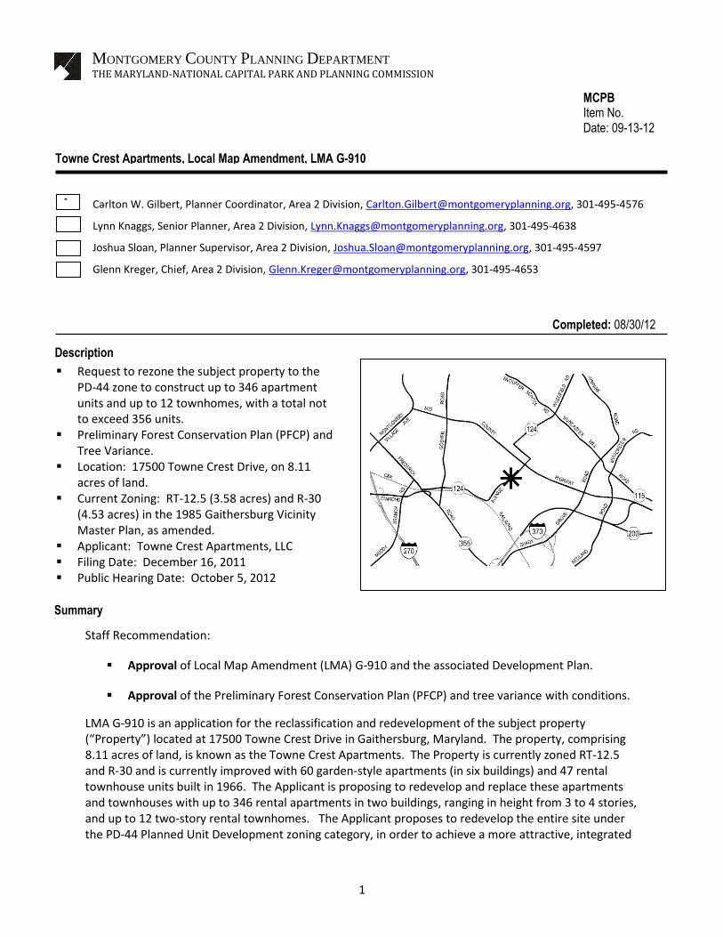
LMA G-910 is an application for the reclassification and redevelopment of the subject property (“Property”) located at 17500 Towne Crest Drive in Gaithersburg, Maryland. The property, comprising 8.11 acres of land, is known as the Towne Crest Apartments. The Property is currently zoned RT-12.5 and R-30 and is currently improved with 60 garden-style apartments (in six buildings) and 47 rental townhouse units built in 1966. The Applicant is proposing to redevelop and replace these apartments and townhouses with up to 346 rental apartments in two buildings, ranging in height from 3 to 4 stories, and up to 12 two-story rental townhomes. The Applicant proposes to redevelop the entire site under the PD-44 Planned Unit Development zoning category, in order to achieve a more attractive, integrated
Summary
MONTGOMERY COUNTY PLANNING DEPARTMENT
THE MARYLAND-NATIONAL CAPITAL PARK AND PLANNING COMMISSION
MCPB Item No. Date: 09-13-12
Towne Crest Apartments, Local Map Amendment, LMA G-910
Carlton W. Gilbert, Planner Coordinator, Area 2 Division, [email protected], 301-495-4576
Lynn Knaggs, Senior Planner, Area 2 Division, [email protected], 301-495-4638
Joshua Sloan, Planner Supervisor, Area 2 Division, [email protected], 301-495-4597
Glenn Kreger, Chief, Area 2 Division, [email protected], 301-495-4653
Request to rezone the subject property to the PD-44 zone to construct up to 346 apartment units and up to 12 townhomes, with a total not to exceed 356 units.
Preliminary Forest Conservation Plan (PFCP) and Tree Variance.
Location: 17500 Towne Crest Drive, on 8.11 acres of land.
Current Zoning: RT-12.5 (3.58 acres) and R-30 (4.53 acres) in the 1985 Gaithersburg Vicinity Master Plan, as amended.
Applicant: Towne Crest Apartments, LLC Filing Date: December 16, 2011 Public Hearing Date: October 5, 2012
Description
Completed: 08/30/12

3
Site Map
There are six garden apartment buildings on the 4.53-acre, R-30-zoned northern portion of the Property and 47 rental townhouses on the 3.58-acre RT-12.5-zoned southern portion of the Property. The apartment buildings contain 60 apartments and are a brick veneered frame construction. Parking for these buildings is provided in highly visible surface parking located in front of the buildings. The existing dumpster pad is also located in front of the building. Parking for the townhouses is also visible surface parking located in front of the units. In many instances, the rear elevations of the townhouses face onto the public street. One of several existing WSSC Sanitary Sewer easements divides the Property roughly into halves at the boundary between the two existing zones. This easement will not be moved or disturbed as part of the proposed development. There are no forests, streams, wetlands, or buffers on the Property. There are no known historical features on the Property.
SURROUNDING AREA Staff defines the surrounding area as the tract bounded by the City of Gaithersburg to the north and the Mid-County Highway to the northeast and including Washington Square Park to the east, the Town of Washington Grove to the south, and Maple Lake Park and the West Woods to the west. The immediate

4
neighborhood is characterized by a mixture of residential apartments, townhouses, and single-family developments. The larger surrounding area consists primarily of single-family residential uses within the Town of Washington Grove and the City of Gaithersburg. The Washington Grove MARC station is located approximately one-half mile south of the Property. The Property is bordered on the east by Towne Crest Drive. Across from the property are townhouses in the RT-12.5 zone. These townhouses front on Larchmont Terrace or Town Crest Court with their sides or backs facing Towne Crest Drive. A church is located at the corner of Towne Crest Drive and Washington Grove Lane. Washington Grove Lane borders the south side of the subject property with a single-family community, mostly within the Town limits of Washington Grove, south of the street. Abutting the western property line of the Property, there are four single-family houses on Daylily Lane within the Town of Washington Grove. The Gaithersburg Vicinity Master Plan recommended the heavily wooded area comprising the rest of the area abutting the western property line for parkland. To the north of the site are three single-family houses located on Saybrooke View Drive in the City of Gaithersburg.
Site Vicinity
ZONING HISTORY The Property was classified in the R-A (Residential Agricultural) zone until 1958. Upon the adoption of the 1958 Zoning Ordinance, the Property was incorporated into the Regional District and classified in the R-R (Rural Residential) zone. In 1963, a request to reclassify the property (C-906) to the R-20 (Multi-Family, Medium Density Residential) zone failed by a tie vote of the District Council. On June 23, 1964, the District Council granted zoning applications C-1196 and C-1197 to rezone the northern portion of the property to the R-30 (Multi-Family, Low Density Residential) zone and the southern portion of the property to the R-T (Residential Townhouse) zone, which currently apply to the property.

5
PROPOSAL The use of the Property must be in accordance with the development plan submitted in conjunction with the rezoning application. As previously stated, the redevelopment of the Towne Crest Apartments property proposes two new apartment buildings (up to 346 apartment units) and up to 12 townhouse units, with 12.5% MPDUs. The site planning has been designed to buffer impacts to all surrounding properties. The two proposed multi-family buildings are four stories (50 feet maximum) in height, stepping down to three stories closer to Towne Crest Drive. Building A, the northern building, will house approximately 224 units surrounding a 4-story parking garage with 328 parking spaces. The garage will be screened from Towne Crest Drive and neighboring communities. This building will provide ample room for buffering and landscape treatments along the northern and eastern boundaries. The mass of the building has been further softened by the creation of four courtyards that provide breaks in the building elevation facing Towne Crest Drive. An additional internal courtyard is designed for a pool, bordered on its southeast by building amenities, such as an exercise room, club room, and library for the residents of the community. Building B consists of approximately 122 apartments and steps back from Towne Crest Drive to minimize the length and mass of the building along the Drive. The floor plan of this building also screens a 3-story parking structure with 210 parking spaces and provides internal site courtyards. The rear of this building’s parking garage will be well screened from West Woods Park by extensive landscaping. The southern portion of the site will contain a maximum of twelve townhouse units, two-stories (35 feet maximum) in height, surrounding an internal parking area. One stack of these units faces Washington Grove Lane, helping to define the residential nature of that street, and extensive landscaping is provided in the green areas around these units. The townhomes are designed to be the main welcoming façade of the project. The proposed scale and character of the townhomes are designed to blend well with the surrounding Washington Grove and Wedgewood neighborhoods. The townhomes will have individual driveways and garages within the homes. The proposed development will provide a 100-foot landscape buffer along the north side, a 25-foot landscape buffer along the east side, a 45-foot buffer on the south side, and a 6-foot high fence with a 25-foot buffer along the west side. The Applicant intends to replace the existing sidewalk along the entire length of Towne Crest Drive and install new, wider sidewalks along Washington Grove Lane as well as install street trees on both streets. Access to the site will be provided by two entrances from Towne Crest Drive. The southern access point will provide ingress/egress to the townhouse units and the northern access point provides access to the entrances to the garages for multi-family Buildings A and B. There will be some parking along the internal entry street that can be used by guests and as short-term parking.

6
Illustrative Plan
Final design of the development will be reviewed by the Montgomery County Planning Board at the time of subdivision and site plan review. The Applicant must submit a site plan in accordance with Section 59-D-3 of the Zoning Ordinance before any development of the site may take place. The Proposal will be subject to the following binding elements:
1. The uses on the property are limited to Multi-Family Residential uses and Townhouse Dwelling units.
2. The proposed development density must not exceed 356 dwelling units, including 12.5% MPDUs (45 units).
3. The proposed building heights will not exceed 4 stories or 50 feet for Building “A” and Building “B”, and 2 stories or 35 feet for the Townhouse Units.
4. Green space for this project must not be less than 50% of the gross tract area, which may include abandoned right-of-way in the future.
5. The proposed development will be limited to two (2) access points from Towne Crest Drive.
PUBLIC FACILITIES The subject application will be adequately served by public facilities. Water and Sewer Public water and sewer are both available at the subject property which is currently served by water and sewer categories W-3 and S-3, respectively. Currently, there are 5 water connections to the site. The proposed plans will abandon the existing connections and provide two new connections to the site. An 8-inch sewer line runs through the property and will provide a sewer connection for each of the proposed multi-family buildings and each of the proposed townhouse units. Gas, electric, telephone and cable television utilities will be available to the site via existing easements along Towne Crest Drive and Washington Grove Lane.
Building A Building B

7
Schools With regard to school capacity, the Property is located in the Zadok Magruder High School Cluster. The most current 2008 Student Generation rates reflect that the existing Towne Crest development generates approximately 15 elementary school, 9 middle school and 10 high school students. In the future, the proposed Towne Crest redevelopment, with the proposed 356 units, is anticipated to generate approximately 38 elementary school, 22 middle school and 21 high school students. Based on these numbers, the proposed Towne Crest redevelopment will result in a net increase of 23 elementary, 13 middle and 11 high school students. Under the recommended FY2013 Capital Budget and the FY2013-2018 Capital Improvements Program, there is adequate capacity at the high school and middle school levels. The elementary schools are projected to exceed the County’s 105% capacity limit, which requires mitigation through payment of the school facilities payment at the time of building permit, but does not result in a residential moratorium. Therefore, the school capacity is currently considered adequate to serve the proposed development.
Other Public Facilities The property is located four miles from the 6th District Police Station, and two miles from two fire stations that are staffed by the Gaithersburg – Washington Grove Volunteer Fire Department. Police, fire and rescue services are adequate to serve the proposed project.
MASTER PLAN The Gaithersburg Vicinity Master Plan was approved in 1985, amended in 1988, and again in 1990. Recommendations for this area have not been changed from the 1985 plan.
The Master Plan has very little to say about this property. It is identified as Analysis Area number 2 in the Midcounty Highway District. Analysis Area 2 is 21 acres and includes the Towne Crest Apartments and the adjacent townhouse development to the east. The Master Plan recommends R-30 and RT-12.5 zoning, with 231 Potential Units Recommended (Table 3, page 46 of the Master Plan). It also lists the existing development as 171 townhouses and 60 garden apartments, totaling 231 units. The Land Use map that accompanies the Master Plan designates Analysis Area 2 as “High Density Residential, 8-15 units/acre.”
The entire text for the Midcounty Highway District in the Master Plan (p. 42-49) consists of four short paragraphs:
“The Midcounty Highway District includes Analysis Areas 1 through 13. These properties, all lying south of Emory Grove Road, will be affected by their proximity to the proposed Midcounty Highway. The design of this and other highways planned for this area should consider the need for noise abatement and protection of stream valleys.
Another characteristic of this area is its proximity to the City of Gaithersburg and the Town of Washington Grove. The Plan reflects these borders by recommending appropriate residential densities near existing or planned developments and recommending buffering when necessary.
This district has good planned or existing access to Metro, employment, and shopping areas. This access supports the Plan’s recommendations for higher density on suitable vacant properties.
The presence of floodplains, streams, erodible soils, and steep slopes in parts of this district indicate that development should be clustered away from these features.”

8
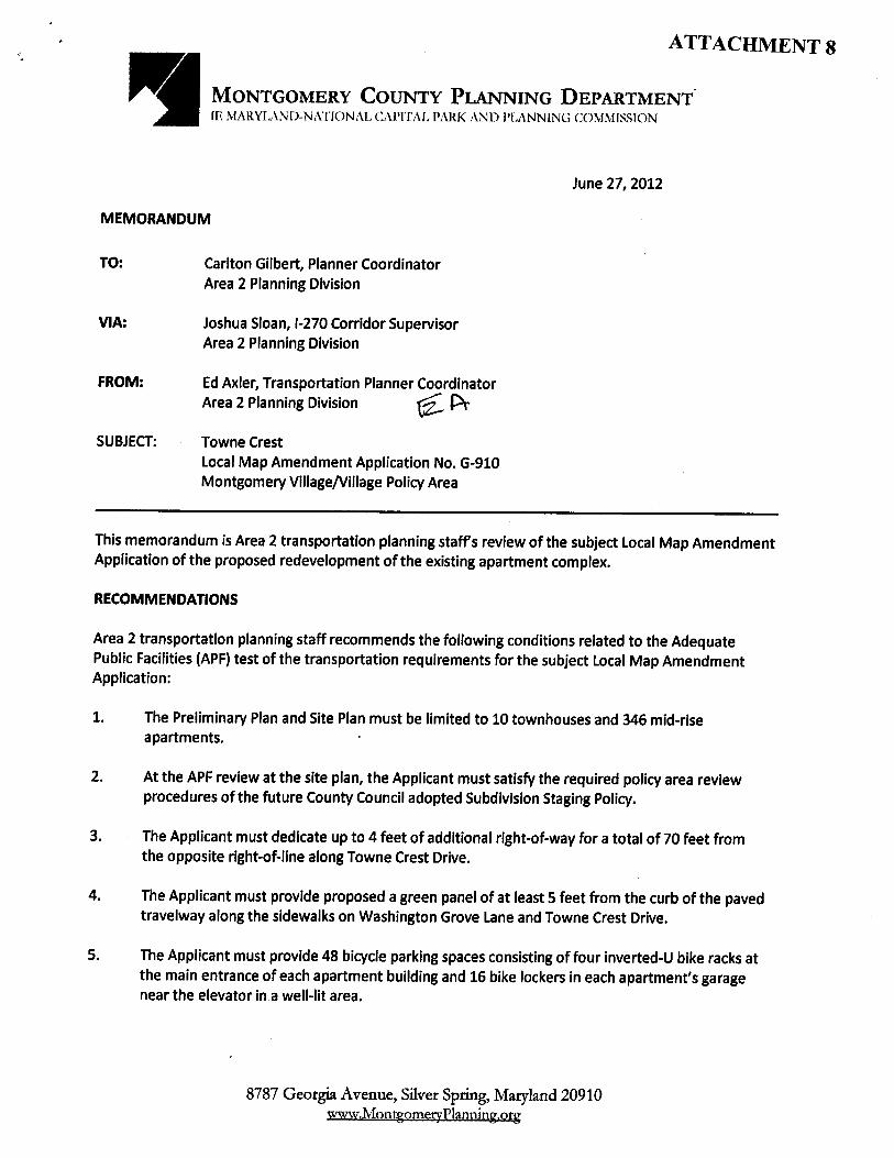
TRANSPORTATION The following issues related to the Adequate Public Facilities (APF) test of the transportation requirements for the subject Local Map Amendment Application must be addressed at the relevant subsequent reviews: 1. The Preliminary Plan and Site Plan must be limited to a maximum of 356 total units. 2. At the APF review at the preliminary plan, the Applicant must satisfy the required policy area
review procedures of the future County Council adopted Subdivision Staging Policy. 3. The Applicant must dedicate up to 4 feet of additional right-of-way for a total of 70 feet from
the opposite right-of-line along Towne Crest Drive. 4. The Applicant must provide a green panel of at least 5 feet along the sidewalks on Washington
Grove Lane and Towne Crest Drive. 5. The Applicant must provide at least 48 bicycle parking spaces consisting of at least four inverted-
U bike racks at the main entrance of each apartment building and secure locations for 16 bicycles in each apartment’s garage near the elevator in a well-lit area.
Transportation Demand Management A traffic mitigation agreement is not required because the subject housing redevelopment is located outside the Greater Shady Grove Transportation Management District. Public Transit Service Transit service is readily available near the subject site:
Along Midcounty Highway: Ride On routes 60, 64, and 65. Along Washington Grove Lane: Ride On route 57 with a bus stop at the corner of the
intersection with Towne Crest Drive. Along East Diamond Avenue/Railroad Street: Ride On route 61. The proposed housing redevelopment is located within a long walking distance (approximately
2,600 feet) from the Washington Grove MARC Station.
Master-Planned Roadways and Bikeways In accordance with the 1985 Gaithersburg Vicinity Master Plan, as amended, and 2005 Countywide Bikeways Functional Master Plan, the master-planned roadways and bikeways are as follows
1. Midcounty Highway is designated as a four-to-six-lane major highway, M-83, with a recommended 150-foot right-of-way and a bikeway, S-82. The Countywide Bikeways Functional Master Plan recommends a shared use path, SP-70 along Midcounty Highway.
2. Washington Grove Lane is designated as a primary residential street with a recommended 70-foot right-of-way where the existing right-of-way is 78 to 92.
3. Towne Crest Drive is a primary residential street with a 70-foot wide right-of-way as listed in the County’s road maintenance records but not designated in the Gaithersburg Vicinity Master Plan street network. The existing right-of-way varies from 66 to 72 feet and, therefore, additional right-of-way dedication is required as discussed in Recommendation No. 3.
Pedestrian and Bicycle Facilities The existing 4-foot wide sidewalks are proposed to be widened to 5 feet along Washington Grove Lane and Towne Crest Drive; green panels and street trees will be required along each street. Given the proposed 570 vehicular parking spaces, 48 bicycle parking spaces are needed.

9
Local Area Transportation Review (LATR) The table below shows the number of peak-hour trips generated by the proposed redevelopment during the weekday morning peak period (6:30 to 9:30 a.m.) and the evening peak period (4:00 to 7:00 p.m.).
Land Use No. of Units Peak-Hour Trips
Morning Evening
Proposed Mid-Rise Apartments +346 +141 +164
Proposed Townhouses +10 + 5 + 8
Total Proposed Housing Units +356 +146 +172
Existing Multi-Family Units -60 -26 -29
Existing Townhouse Units -47 -23 -39
Total Existing Housing Units -107 -49 -68
Net Increase in Site-Generated Trips +249 +97 +104
The Applicant submitted a traffic study to satisfy the LATR test because the proposed redevelopment generates 30 or more peak-hour trips within the weekday morning and evening peak periods. The table below shows the calculated Critical Lane Volume (CLV) values from the traffic study at the analyzed intersections for the following traffic conditions:
1. Existing: Existing traffic conditions as they exist now. 2. Background: The existing condition plus the trips generated from approved but unbuilt nearby
developments. 3. Total: The background condition plus the site-generated trips.
Analyzed Intersection Weekday Peak Hour
Traffic Condition
Existing Background Total
Washington Grove Lane & Midcounty Highway
Morning 1,304 1,352 1,400
Evening 1,104 1,134 1,152
Washington Grove Lane & Towne Crest Lane
Morning 554 568 697
Evening 545 565 627
Washington Grove Lane & East Diamond Avenue
Morning 854 856 866
Evening 1,114 1,138 1,171
The CLV values at all analyzed intersections in all traffic conditions are less than the 1,475 congestion standard and, thus, the LATR test is satisfied. Policy Area Mobility Review The current PAMR test requires no mitigation by the Applicant because the percent mitigation of new peak-hour trips is zero for new developments located in the Montgomery Village/Airpark Policy Area. If PAMR is replaced by the Transportation Policy Area Review (TPAR) at site plan review, the Applicant must satisfy the applicable requirements of the future County Council adopted Subdivision Staging Policy.

10
ENVIRONMENT Natural Resource Inventory/Forest Stand Delineation (NRI/FSD) The net tract area includes the 8.11 acre site and 0.93 acres of off-site improvements for a total of 9.04 acres. This Property appears to have been substantially filled and graded prior to the existing development of the site, resulting in a site that is relatively flat. Runoff drains primarily from east to west across the site. The Property lies within the Seneca Creek watershed, which has a State Use Class designation of I-P. The Property is not within a Special Protection Area.
Currently, the site is developed with garden apartments, townhouses and associated surface parking. Most of the rest of the site is maintained as lawn. A Natural Resource Inventory/Forest Stand Delineation (#420111880) was approved on April 25, 2011. The site contains no streams or their buffers, wetlands or their buffers, or known occurrences of rare, threatened, or endangered species.
No on-site forest was identified in the NRI/FSD. A significant stand of forest occurs immediately adjacent to the western site boundary. This forest lies within the Town of Washington Grove. Four specimen trees on the site are proposed for removal. In addition, the plan identifies the critical root zones of 14 specimen trees off-site in the Town of Washington Grove that will be impacted by development of this site. The Applicant proposes to save all 14 of these trees.
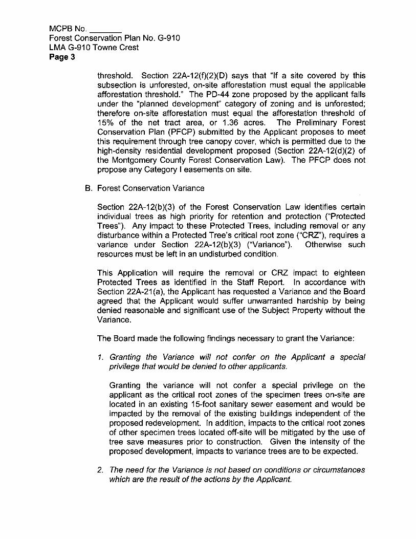
Preliminary Forest Conservation Plan (PFCP) Section 22A-12(f)(2)(B) of the Montgomery County Forest Conservation Law states that “In a planned development, or a site development using a cluster or other optional method of development in a one-family residential zone, on-site forest retention must equal the applicable conservation threshold. Section 22A-12(f)(2)(D) says that “If a site covered by this subsection is unforested, on-site afforestation must equal the applicable afforestation threshold.” The PD-44 zone proposed by the applicant falls under the “planned development” category of zoning and is unforested; therefore on-site afforestation must equal the afforestation threshold of 15% of the net tract area, or 1.36 acres. Submission of a PFCP (Attachment 2) is required at the time of rezoning to demonstrate that the Applicant can meet the planting requirement on-site. The PFCP submitted by the Applicant proposes to meet this requirement through tree canopy cover, which is permitted due to the high-density residential development proposed (Section 22A-12(d)(2) of the Montgomery County Forest Conservation Law). The Preliminary Forest Conservation Plan does not propose any Category I easements on site.
Forest Conservation Variance Section 22A-12(b) (3) of Montgomery County Forest Conservation Law provides criteria that identify certain individual trees as high priority for retention and protection. Any impact to these trees, including removal of the subject tree or disturbance within the tree’s critical root zone (CRZ) requires a variance. An applicant for a variance must provide certain written information in support of the required findings in accordance with Section 22A-21 of the County Forest Conservation Law. The law requires no impact to trees that: measure 30 inches or greater, DBH; are part of a historic site or designated with a historic structure; are designated as a national, State, or County champion trees; are at least 75 percent of the diameter of the current State champion tree of that species; or trees, shrubs, or plants that are designated as Federal or State rare, threatened, or endangered species. The Applicant submitted a variance request on June 21, 2012 for the impacts/removal to trees with the proposed layout (Attachment 3). The Applicant proposes to remove 4 trees that are 30 inches and greater, DBH, and to impact, but not remove, 14 others on adjacent property that are considered high priority for retention under Section 22A-12(b) (3) of the County Forest Conservation Law.

11
Table 1: Trees to be removed or potentially removed
Tree Number
Species
DBH
Status
10 Quercus alba 39” Remove
15 Liriodendron tulipifera 38” Remove
70 Quercus rubra 38” Remove
71 Quercus rubra 38” Remove
Table 2: Trees to be affected but retained (off-site)
Tree Number
Species DBH CRZ Impact Status
14 Liriodendron tulipifera 31” 39% Save
26 Liriodendron tulipifera 33” 15% Save
27 Liriodendron tulipifera 36” 41% Save
28 Liriodendron tulipifera 42” 17% Save
34 Liriodendron tulipifera 38” 35% Save
37 Liriodendron tulipifera 31” 3% Save
41 Liriodendron tulipifera 31.5” 12% Save
43 Liriodendron tulipifera 42” 7% Save
46 Liriodendron tulipifera 30” 4% Save
48 Liriodendron tulipifera 30” 10% Save
49 Liriodendron tulipifera 31” 23% Save
50 Liriodendron tulipifera 31.5” 1% Save
59 Liriodendron tulipifera 43” 9% Save
72 Liriodendron tulipifera 31” 46% Save
Unwarranted Hardship Basis As per Section 22A-21, a variance may only be granted if the Planning Board finds that leaving the requested trees in an undisturbed state would result in unwarranted hardship. In this case, the unwarranted hardship is caused by existing buildings on-site, the presence of an existing sanitary sewer easement along the western boundary of the site, and the irregular shape of the property. If the Applicant was not allowed to impact the requested trees, the Applicant would not be able to demolish the existing buildings or retrofit the existing sanitary sewer located within a 15-foot easement along the western boundary of the site.
Variance trees number 10, 15, 70 and 71 are located between the western property boundary and an existing 15-foot sanitary sewer easement. Saving these trees would require major changes to the proposed development and would not protect the critical root zones of these trees from disturbance associated with the maintenance and upgrade of the existing sanitary sewer. Staff concurs that the Applicant has sufficient unwarranted hardship to consider a variance request.
Section 22A-21 of the County Forest Conservation Law sets forth the findings that must be made by the Planning Board or Planning Director, as appropriate, in order for a variance to be granted. Staff has made the following determinations in the reviews of the variance request and the proposed forest conservation plan:

12
Variance Findings Staff has made the following determination based on the required findings that granting of the requested variance:
1. Will not confer on the applicant a special privilege that would be denied to other applicants. Granting the variance will not confer a special privilege on the applicant as the critical root zones of the specimen trees on-site are located in an existing 15-foot sanitary sewer easement and would be impacted by the removal of the existing buildings independent of the proposed redevelopment. In addition, impacts to the critical root zones of other specimen trees located off-site will be mitigated by the use of tree save measures prior to construction. Given the intensity of the proposed development, impacts to variance trees are to be expected. Therefore, it is staff’s opinion, that granting the variance will not confer a special privilege to the applicant.
2. Is not based on conditions or circumstances which are the result of the actions by the applicant.
Staff concurs that the requested variance is based on the constraints of the site and the proposed development density, public facilities and amenities, rather than on conditions or circumstances which are the result of actions by the Applicant.
3. Is not based on a condition relating to land or building use, either permitted or non-conforming, on neighboring property.
Staff concurs that the requested variance is a result of the proposed site design and layout on the subject property and not as a result of land or building use on a neighboring property.
4. Will not violate State water quality standards or cause measurable degradation in water quality.
The proposed development plan would improve the water quality on-site and in adjacent areas downslope of the site with the addition of on-site water quality treatment facilities and Environmental Site Design practices. In addition, the specimen trees requested for removal on-site are not located in an environmental buffer or special protection zone.
Therefore, staff concurs that the project will not violate State water quality standards or cause measurable degradation in water quality.
Mitigation for Trees Subject to the Variance Provisions There are four trees proposed for removal as a result of the proposed development. There will also be some disturbance within the CRZ of another 14 trees located off-site.
Mitigation should be at a rate that approximates the form and function of the trees removed. Therefore, staff is recommending that replacement occur at a ratio of approximately 1” DBH for every 4” DBH removed, using trees that are a minimum of 3” DBH. This means that for the 153 caliper inches of trees removed, the required mitigation will be 13 native canopy trees with a minimum size of 3” dbh. While these trees will not be as large as the trees lost, they will provide some immediate canopy and will help augment the canopy coverage. Staff therefore recommends the addition of 13 native canopy trees with a minimum size of 3” dbh to the landscape plan. Because these trees are in mitigation for specimen trees removed, they do not count toward afforestation requirements.

13
The trees subject to this variance to be impacted but retained are located off-site. The Applicant proposes to implement rigorous tree save measures in an attempt to save these trees, including progressive root pruning over a number of years in advance of construction, application of a tree growth regulator, and crown cleaning. No mitigation is recommended for trees impacted off-site.
County Arborist’s Recommendation on the Variance In accordance with Montgomery County Code Section 22A-21(c), the Planning Department is required to refer a copy of the variance request to the County Arborist in the Montgomery County Department of Environmental Protection for a recommendation prior to acting on the request. The request was forwarded to the County Arborist on June 25, 2012. On June 27, 2012, the County Arborist issued her recommendations on the variance request and recommended the variance be approved with mitigation (Attachment 4).
Variance Recommendation Staff recommends that the variance be granted.
Stormwater Management A Stormwater Concept Plan was submitted to and approved by the Montgomery County Department of Permitting Services (DPS).
Conclusion and Preliminary Forest Conservation Plan Recommendation Staff finds that the plan is in compliance with applicable laws and M-NCPPC’s Environmental Guidelines. Staff recommends that the Planning Board approve the Preliminary Forest Conservation Plan with the conditions cited in this Staff Report. The variance approval is assumed in the Planning Board’s approval of the Preliminary Forest Conservation Plan.
EVALUATION AND FINDINGS Sec. 59-C-7.1. P-D ZONE, PLANNED DEVELOPMENT ZONE A floating zone requires an evaluation for compliance with the purposes of the zone. Section 59-C-7 of the Montgomery County Zoning Ordinance contains the requirements for development of property in the Planned Development (PD) Zone. The stated purposes of this zone, and how the Project satisfies the zone’s objectives, are summarized below. Section 59-C-7.11 of the Zoning Ordinance sets forth the purposes that the PD zone is designed to accomplish: It is the purpose of this zone to implement the general plan for the Maryland-Washington Regional District and the area master plans by permitting unified development consistent with the densities proposed by master plans. It is intended that this zone provide a means of regulating development which can achieve flexibility of design, the integration of mutually compatible uses and optimum land planning with greater efficiency, convenience and amenity than the procedures and regulations under which it is permitted as a right under conventional zoning categories. In so doing, it is intended that the zoning category be utilized to implement the general plan, area master plans, and other pertinent county policies in a manner and to a degree more closely compatible with said county plans and policies than may be possible under other zoning categories.

14
The following analysis demonstrates how the Application conforms to these purposes.
a. To Implement the General Plan and Area Master Plan and provide means of regulating development to provide flexibility of design.
Specifically, the Gaithersburg Vicinity Master Plan has very little to say about this property. The subject property falls within the Airpark Study Area of the overall Gaithersburg Vicinity Master Plan, last amended in July, 1990. The Airpark Study Area is divided into three districts. This Property is identified as Analysis Area number 2 in the Midcounty Highway District. This Master Plan was originally prepared in 1971 and has had subsequent amendments to several portions but this area has never been subject of an amendment. Since this plan was first developed to respond to the “wedges and corridors” concept, many policies and patterns of development have changed. In general, there has been a greater emphasis to redirect densities to areas that are in proximity to transit facilities to encourage the use of public transportation. These areas can take better advantage of the existing MARC station and the other public transportation opportunities located nearby. Since commuter rail service is provided in the area at the Gaithersburg Station and at the station at Washington Grove, Staff finds that this project meets this objective. Additionally, the proposed redevelopment allows for the integration of the two existing zoning categories on the site into a single, harmonious, infill, multi-family community. This project provides screened structured parking to replace existing surface parking on the site and mitigates the visual impact of the automobile on the surrounding neighborhoods. Furthermore, the project provides the opportunity to update the dated apartments and provide new investment in the area.
b. That the project be so designed and constructed as to facilitate and encourage a maximum of social and community interaction and activity among those who live and work within an area and to encourage the creation of a distinctive visual character and identity for each development. It is intended that development in this zone produce a balanced and coordinated mixture of residential and convenience commercial uses, as well as other commercial and industrial uses shown on the area master plan, and related public and private facilities.
The buildings proposed in this project are designed as elevator served, central corridor apartment buildings with controlled entrances and visitor lobbies to replace the existing garden apartment buildings. The existing, aging garden apartments have multiple unsecured entrances with limited opportunities for resident social interaction. The proposed apartment buildings and townhouse units surround a common area that will create a neighborhood feel that will encourage interaction. The project will feature party rooms, a business center, exercise gym, pool, bathhouse, and a full array of events and programs intended for greater social interaction among the residents.
c. To provide and encourage a broad range of housing types, comprising owner and rental
occupancy units, and one-family, multiple-family and other structural types. Promote development designed and constructed to facilitate and encourage a maximum of social and community interaction and activity among those who live and work within an area and to encourage the creation of a distinctive visual character and identity for each development.

15
The project achieves this objective by providing a mix of multi-family and townhouse units. Additionally, by replacing the existing apartments, this proposal preserves and somewhat increases the rental apartment inventory in the area that is primarily comprised of owner-occupied single-family and townhouse units. It does this without adding new apartment projects in other more sensitive locations.
d. To preserve and take the greatest possible aesthetic advantage of trees and in order to do so,
minimize the amount of grading necessary for construction of a development.
The redevelopment of Towne Crest will not remove a significant amount of trees or introduce any significant grading on the site. Staff finds, however, that this project will provide an opportunity to greatly increase the amount of new trees, street trees and extensive new landscaping along the edges and throughout the site.
e. To encourage and provide for open space …conveniently located with respect to points of
residential and commercial concentration so as to function for the general benefit of the community and public at large for places of relaxation, recreation and social activity and furthermore, open space should be so situated as part of the plan and design of each development as to achieve physical and aesthetic integration of the uses and activities within each development.
This proposal contains approximately 50% green space in accordance with the requirements of the PD-44 zone, and increases the amount of recreation and social spaces interior to the buildings as well as exterior. The proposed development plan provides for significant open space at the northern boundary of the site adjacent to Building A as well as in front of Building B. Also, open space will be provided between Building B and the proposed townhomes. Furthermore, the Applicant maintains its continued interest in working with the Town of Washington Grove to create an attractive gateway to the historic Town along Washington Grove Lane and will play a role in the clean-up and improvements to Washington Grove’s West Woods.
f. To encourage and provide for development of comprehensive, pedestrian circulation networks,
separate from roadways, which constitute a system of linkages among residential areas, open spaces, recreational areas, commercial and employment areas and public facilities to minimize reliance on the automobile. The Development Plan includes a pedestrian walkway interconnecting the proposed apartment buildings with the proposed townhomes. The Applicant proposes to re-construct and/or replace all sidewalks and plant street trees around the site to Montgomery County standards. The Applicant will complete all pedestrian links with walks within the project to the public sidewalks. The Applicant states that if access is requested by the Town to any nature trails or walkways within the Washington Grove woodlands, the Applicant will comply.
g. To encourage development on a large enough scale to achieve purposes of the zone.
The proposed Development Plan on an 8.11-acre parcel allows for a more comprehensive development by providing a mix of multi-family and townhouse units that achieves the purpose of the zone. The proposal also provides amenities and facilities for the residents as well as the community at large.

16
h. To achieve a maximum of safety, convenience and amenity for residents of each development and the residents of neighboring areas, and, furthermore, to assure compatibility and coordination of each development with existing and proposed surrounding land uses.
The proposal is designed and planned to maximize safe connection between the residential buildings and the surrounding neighborhood. Sidewalks connect the proposed residential buildings to Towne Crest Drive and Washington Grove Lane. Vehicular access to the garage parking is provided from Towne Crest Drive. The architectural treatment of stepping down the building height from 4-stories to 3-stories facing Towne Crest Drive and the proposed landscaping will help to ensure compatibility with surrounding uses.
i. Approval or disapproval shall be upon findings that the application is or is not proper for the
comprehensive and systematic development of the county, is or is not capable of accomplishing the purpose of the zone and is or is not in substantial compliance with the general plan and master plan.
Staff believes that the proposal should be approved as appropriate for the development of the County and in keeping with the purpose of the zone and in substantial compliance with the general plan and master plan.
59-C-7.12 Where Applicable Master Plan. No land can be classified in the planned development zone unless such land is within an area for which there is an existing, duly adopted master plan which shows such land for a density of 2 dwelling units per acre or higher. This property is within the Gaithersburg Vicinity Master Plan last amended in July 1990 and it is currently shown in that plan as residential with the high residential designation of multi-family (with densities of 8-15 Dwelling units per acre).
Minimum area. No land can be classified in the planned development zone unless the district council finds that the proposed development meets at least one of the following criteria: (a) That it contains sufficient gross area to construct 50 or more dwelling units under the density
category to be granted; (b) That it would be logical extension of an existing planned development; (c) That it would result in the preservation of an historic structure or site (as indicated on the current
historic sites identification map or as recommended by the planning board as being of historic value and worthy of preservation);
(d) That the accompanying development plan would result in the development of a community
redevelopment area;

17
(e) That the site is recommended for the PD zone in an approved and adopted master plan or sector plan and so uniquely situated that assembly of a minimum gross area to accommodate at least 50 dwelling units is unlikely or undesirable and the development of less than 50 dwelling units is in the public interest.
The subject property can be classified as a planned development zone because it meets one of the criteria listed as requirements for its eligibility: the proposed development contains sufficient area to allow for 356 units, including 12.5 percent MPDUs.
59-C-7.13 Uses Permitted
Although the zone permits a large array of uses, it is essentially a zone designated for residential development. The PD-44 zone allows townhouses and multifamily structures with a wide range of heights. The project includes structures that range from 2 to 4 stories in height. While commercial uses are also permitted in the PD zone, none are proposed as part of this application due to the residential character of the area and the density proposed, which does not meet the threshold for commercial uses in the PD zone.
59-C-7.14 Density of Residential Development
The PD-44 zone allows a maximum density of 44 dwelling units per acre, or 414 total dwelling units. The project proposes a total of 356 dwelling units. These units range in size from efficiency to one-, two-, and three-bedroom apartments and multi-bedroom townhomes. The proposed unit mix reflects the current market demands. The number of MPDUs must be at least 12.5 percent for projects with more than 20 dwelling units. This project is proposing 45 MPDUs.
59-C-7.15 Compatibility. (a) All uses must achieve the purposes set forth in section 59-C-7.11 and be compatible with the other uses proposed for the planned development and with other uses existing or proposed adjacent to or in the vicinity of the area covered by the proposed planned development. (b) In order to assist in accomplishing compatibility for sites that are not within, or in close proximity to a central business district or transit station development area, the following requirements apply where a planned development zone adjoins land for which the area master plan recommends a one-family zone:
(1) No building other than a one-family detached residence can be constructed within 100 feet of such adjoining land; and
(2) No building can be constructed to a height greater than its distance from such adjoining
land. A waiver of the requirement of paragraph (b)(1), may be permitted if:
(1) The property is within or in close proximity to a central business district or transit station development area and reduced setbacks are recommended by the master or sector plan, and the Planning Board finds that the reduced setbacks are compatible with existing or proposed development in the adjoining or confronting one-family detached zones; or

18
(2) The property is within or in close proximity to a historic district and the Planning Board reuse,
or redevelopment of a designated historic district and the immediately adjoining property will not be adversely affected by the waiver.
(3) The maximum building height under this waiver must not exceed 50 feet.
Compliance with these requirements does not, by itself, create a presumption of compatibility. The proposed project achieves the purposes of the planned development zone and is compatible with adjacent residential uses. As noted above, the project incorporates a 100-foot landscape buffer along the north side of the Property, which adjoins single-family development within the corporate limits of Gaithersburg. A minimum 25-foot landscape buffer is provided along the east side of the property, which confronts townhouse developments and two single family lots. This setback, in combination with the right-of-way for Towne Crest Drive, provides the required 100-foot setback from the properties to the southeast, which are recommended in the Master Plan for single-family development. Because the properties to the south and west are within the Town of Washington Grove and not within the zoning controls of Montgomery County, the setback provisions of Section 59-C-7.15 (b) do not apply along these borders. However, 25-foot landscape buffers are provided along the southern and western edges of the property. On the south, this 25-foot setback, in combination with the right-of-way for Washington Grove Lane, still results in a 133-foot setback between the nearest townhouse unit and the closest residential property to the south. The minimum 25-foot setback provided from the west significantly increases the setback beyond existing conditions, which currently is approximately 18 feet. 59-C-7.16. Green Area Green area must be provided in amounts not less than the following schedule: Density Green Area Category (Percent of Gross Area) High PD-28 50 PD-35 50 PD-44 50 The proposal includes green area on the site and meets the 50 percent minimum green area required for the PD-44 zone. The Applicant proposes an overall green area of 51.06%, located along the perimeter of the property as well as in a series of courtyards and open spaces. The Applicant notes that the common green space area will be accessible to people who live in and/or use the building.

19
59-C-7.17. Dedication of land for public use. Such land as may be required for public streets, parks, schools and other public uses must be dedicated in accordance with the County subdivision regulations, General Plan, Master Plan and identified on the Development Plan. 59-C-7.18. Parking Off-street parking must be provided in accordance with the requirements of article 59-E. The parking for this project is provided internal to the site and does not rely on any on-street parking along adjacent public streets. The majority of on-site parking is provided in parking structures located in each of the two main buildings; the remainder is provided as surface parking serving visitors. The townhouse units have single garages and driveways. All the parking is shielded from view from the streets and neighboring uses either by the residential structures themselves or by extensive landscaping.
The minimum required total of parking spaces for this proposed development is 506 parking spaces. The Applicant is providing a total of 570 parking spaces in the structured parking garages. Parking spaces will be provided on the subject property as follows:
Parking Level No. of Floors *No. of Spaces
G-1 4 328
G-2 3 210
Surface Parking N/A 22
Townhouse Garage N/A 10
Total N/A 570 parking spaces
*Final parking counts to be determined on site plan.

20
59-C-7.19. Procedure for application and approval (a) Application and development plan must be in accordance with division 59-D-1. (b) Site plan must be submitted and approved in accordance with 59-D-3. The application includes a Development Plan. A site plan that will be reviewed in accordance with Section 59-D-3 subsequent to approval of the Development Plan. 59-D-1.6 – Approval by District Council 59-D-1.61 – Findings Before approving an application for classification in any of these zones, the District Council must consider whether the application, including the development plan, fulfills the purposes and requirements set forth in article 59-C for the zone. In doing so, the District Council must make the following specific findings in addition to any other findings which may be necessary and appropriate to the evaluation of the proposed reclassification:
(a) That the zone applied for is in substantial compliance with the use and density indicated by
the Master Plan or Sector Plan, and that it does not conflict with the general plan, the county capital improvements program or other applicable county plans and policies;
As indicated previously, the PD-44 zone is in compliance with the use and density recommendation of the Sector Plan for this area. The proposal complies with the uses outlined in the Midcounty Highway District of the Airpark Area Section of the Gaithersburg Master Plan (originally prepared in 1971 as part of the “Wedges and Corridors” vision), which recommends multi-family uses for the Property. While the densities are higher than contemplated in the older plan, the proposed densities are consistent with current County policies providing higher densities near transit and transportation rich areas of the County; page 49 of the Master Plan describes this area as having “good planned or existing access to Metro, employment, and shopping areas” and states that “this access supports the Plan’s recommendations for higher density on suitable vacant properties”. Although not vacant nor expected to redevelop in 1985, the buildings are aging and the property could better serve the goals of the Master Plan through redevelopment. Finally, the proposed development is not contingent upon any County capital improvements.
(b) That the proposed development would comply with the purposes, standards and regulations of the zone as set forth in article 59-C, would provide for the maximum safety, convenience, and amenity of the residents of the development and would be compatible with adjacent development.
The proposed development complies with the purposes, standards and regulations of the PD-44 zone as set forth in article 59-C. The development plan maintains an appropriate scale, both in terms of activity and layout, to achieve compatibility with the surrounding mix of multi-family, institutional, commercial, and single-family uses. The proposal will enhance both pedestrian and vehicular safety because the access driveways, pedestrian ways and entrance features have been designed in a safe and efficient manner. Moreover, the design

21
is such that many of the multi-family units will have direct access to structured parking spaces on the same level as their units and the townhomes will each have a private garage.
(c) That the proposed internal vehicular and pedestrian circulation systems and points of
external access are safe, adequate, and efficient;
The internal vehicular and pedestrian circulation for the project has been designed to provide clear drive aisles, sidewalks, drop-off and pick-up areas, and separate loading areas. The internal and external vehicular circulation patterns are safe, adequate and efficient. Access is limited to two entrances either where access points already exist or in close proximity to existing access points that have functioned safely. Internal drive aisles have clear circulation patterns leading to parking. Pedestrian systems in the proposed plan, for both residents and surrounding neighborhoods, will be greatly improved, continuous, and rational. The streetscape along Washington Grove Lane will be greatly improved with wider sidewalks, street trees, and a continuous green panel behind the back of curb. This perimeter sidewalk flows into an on-site pedestrian circulation system providing access to all building areas, open spaces, and parking areas.
(d) That by its design, by minimizing grading and by other means, the proposed development
would tend to prevent erosion of the soil and to preserve natural vegetation and other natural features of the site. Any applicable requirements for forest conservation under Chapter 22A and for water resource protection under Chapter 19 also must be satisfied. The district council may require more detailed findings on these matters by the planning board at the time of site plan approval as provided in division 59-D-3;
The Department of Permitting Services (DPS) has approved a stormwater management (SWM) concept plan for the redevelopment of the site. The proposed development will meet the new, more stringent, stormwater requirements in the State of Maryland and other mandated environmental regulations enacted in Montgomery County and the State. The new SWM techniques will improve the stormwater quality of the site, as well as the adjacent wooded area located in the Town of Washington Grove.
(e) That any documents showing the ownership and method of assuring perpetual maintenance
of any areas intended to be used for recreational or other common of quasi-public purposes are adequate and sufficient.
At the appropriate time, the Applicant will submit all required documents, covenants, and restrictions and record them for the property to the satisfaction of the County Council and Planning Staff. The Applicant must provide appropriate assurances of maintenance of common areas as required by law prior to any conveyance of building units.
DEVELOPMENT STANDARDS The design of the development will be finalized and reviewed by the Montgomery County Planning Board at the time of subdivision and site plan review. The Development Standards for the PD-44 zone are tabled below:

22
Development Standards
Zoning Ordinance Required /
Permitted Proposed for Approval
Minimum Lot Area 1.16 AC 8.11 AC
Gross Area (SF):
Prior ROW Dedication 56,850 or 1.305 AC
Gross Area 410,125 or 9.415 AC
Net Area (SF): 353,265 SF or 8.11 AC
Setbacks (FT):
North: Brookham Lane & SF Not specified 100’, Final to be determined on Site Plan
East: Towne Crest Drive Not Specified 25’, Final to be determined on Site Plan
South: Washington Grove Lane Not Specified 25’, Final to be determined on Site Plan
West: Day Lily / West Woods Not Specified 25’, Final to be determined on Site Plan
Green Area: 50% - 205,063 51.06% - 209,429
Density: 44 DU/AC = 414 356
# of Units Building A Max. 224
# of Units Building B Max. 122
# of Townhouse Units Max. 12
MPDU: 12.5% 12.5% (45 DU)
Building Height MF:
Townhouses:
Not Specified 4-story (50 ft. max. height)
2-story (35 ft. max. height)
Parking*:
G-1 328 in 4 levels
G-2 210 in 3 levels
Surface Parking 22
Townhouse Parking 10
Total Parking Spaces 506 570
*Final parking counts to be determined on site plan.
COMMUNITY CONCERNS Staff received a letter from the Gaithersburg Planning Commission which fully supports redevelopment at this location. The Commission and City staff believes that the current plan reflects the appropriate density for this site. Furthermore, the Commission recognizes that the Towne Crest neighborhood currently experiences significant stress from crime and that redevelopment of this site will help to stabilize crime rates within the neighborhood and could serve as a catalyst for further redevelopment within the surrounding area (Attachment 12).

23
Staff received five letters in opposition to the proposed development from neighboring citizens and associations, including the Greater Shady Grove Civic Alliance and the Town of Washington Grove. Staff also toured the Town of Washington Grove with members of the community and met with concerned citizens and their legal counsel. The general concerns expressed include:
opposition to the proposed density, building height, and mass; inconsistency with the planned development purpose clause in the County Zoning Ordinance; inconsistency with the Master Plan recommendations for the Towne Crest property; redevelopment cannot be justified by proximity to transit; and the impact on neighborhood safety due to increased traffic. (Attachment 13)
Staff believes these concerns have been addressed in this Staff Report. In addition, the Applicant’s response to some of the concerns expressed by the Town of Washington Grove and their legal counsel is attachment 14.
RECOMMENDATION FOR LOCAL MAP AMENDMENT G-910 Staff concludes that LMA G-910 complies with the purpose clause of the Planned Development (PD-44) Zone and its requirements for zoning, use, and density. The Development Plan is compatible with existing and proposed uses in the surrounding areas and meets the intent of the Gaithersburg Vicinity Master Plan. Therefore, Staff recommends approval of the Development Plan and Binding Elements enumerated herein.
RECOMMENDATION AND CONDITIONS FOR THE PRELIMINARY FOREST CONSERVATION PLAN Staff recommends approval of the Preliminary Forest Conservation Plan and associated Variance for LMA G-910 subject to the following conditions:
1. The Applicant must submit a Final Forest Conservation Plan for the area covered by rezoning application G-910 with the Site Plan.
2. All afforestation requirements must be met on-site as mandated by the zone. 3. Thirteen native shade trees of at least 3” caliper must be included in the landscape plan for the
site as mitigation for the removal of four (4) specimen trees. These trees will not count toward afforestation requirements.
4. The Applicant must coordinate with the Town of Washington Grove regarding removal of any off-site trees in the Town of Washington Grove and mitigation required.
5. The Applicant must submit a Tree Save Plan as a component of the Final Forest Conservation Plan for the trees impacted along the Town of Washington Grove municipal boundary. The Tree Save plan must be signed by an International Society of Arboriculture Certified Arborist.
CG:ha: N:\Area 2\Gilbert\Towne Crest apartments LMA G-910 Final

24
Attachments 1. Preliminary Forest Conservation Plan (PFCP) Resolution 2. PFCP 3. Applicant tree variance request 4. County Arborist recommendation on variance request 5. G-910 Development Plan 6. Architectural plans and elevation perspectives 7. Master Plan memo 8. Transportation planning memo 9. Environmental planning memo 10. Stormwater management concept letter 11. Fire Marshal approval memo 12. Letter in support 13. Letters in opposition 14. Applicant’s response to opposition