town of dell prairie comprehensive plan ... of dell prairie comprehensive plan adopted 2006 prepared...
TRANSCRIPT

TOWN OF DELL PRAIRIE
COMPREHENSIVE PLAN
ADOPTED 2006
Prepared by:
North Central Wisconsin Regional Planning Commission

TOWN OF DELL PRAIRIE
Town Board
Dan McFarlin, Chair
Darrell Schulz, Supervisor I
Dan Mitchell, Supervisor II
Veronica Osborn, Clerk
Plan Commission
Darrell Schulz, Chair
Dorthy Wick
Albert Dick
Kenny Jensen
Dannell Petzke
Photo Credits: Town Plan Commission
Draft August 2004 Revised Draft February 2005 Revised Draft October 2005
Final Draft August 2006 Adopted October 2006
This plan was funded by a grant from the Wisconsin Department of Administration and Adams County


TOWN OF DELL PRAIRIE
TABLE OF CONTENTS:
SECTIONS:
1 Issues & Opportunities............................................................................................ 2 2 Natural, Agricultural & Cultural Resources.......................................................... 9 3 Housing.................................................................................................................... 21 4 Transportation ........................................................................................................ 24 5 Utilities & Community Facilities .......................................................................... 30 6 Economic Development ....................................................................................... 33 7 Land Use.................................................................................................................. 37 8 Intergovernmental Cooperation........................................................................... 47 9 Implementation....................................................................................................... 50
TABLES & DISPLAYS: Table 1 Population.................................................................................................... 5 Display 1 2000 Age Cohorts ....................................................................................... 6 Display 2 2000 Race Makeup...................................................................................... 6 Table 2 Educational Attainment, Persons Age 25 and Older, 2000.................. 7 Table 3 Total Employed .......................................................................................... 7 Table 4 Median Household Income....................................................................... 8 Table 5 Per Capita Income ...................................................................................... 8 Table 6 Poverty Rate ................................................................................................ 8 Table 7 Existing Land Use, 2004.......................................................................... 37

MAPS:
Map 1 Location Map .............................................................................................. 1 Map 2 Water Features .......................................................................................... 10 Map 3 Soils ............................................................................................................. 12 Map 4 Soil Limitations for Septic Tank Absorption Fields ............................ 13 Map 5 Woodlands ................................................................................................. 15 Map 6 Prime Agricultural Soils ........................................................................... 18 Map 7 Farmland Preservation Areas .................................................................. 19 Map 8 Transportation........................................................................................... 28 Map 9 Utilities & Community Facilities ............................................................ 32 Map 10 Existing Land Use..................................................................................... 38 Map 11 Future Land Use ....................................................................................... 39 Map 12 Existing Zoning......................................................................................... 44
ATTACHMENTS: A. Adams County Plan Process B. Public Participation Plan C. Community Survey D. 2000 Census Summary E. Population, Household, Employment and Land Use Projections. F. Map Excerpts from Adams County Comprehensive Plan

North Central Wisconsin - 1 - Town of Dell Prairie Regional Planning Commission Comprehensive Plan
Map 1 Location Map

North Central Wisconsin - 2 - Town of Dell Prairie Regional Planning Commission Comprehensive Plan
1. ISSUES AND OPPORTUNITIES Background The Town of Dell Prairie is located in the lower southwestern part of Adams County, Wisconsin. With the Wisconsin River leaving 8 partial sections on the west side of Township 14 North - Range 6 East, the town "borrows" Sections 6, 7, 18, 19, 30 and 31 from Township 14 North - Range 7 East, for an additional 28 full sections. The Towns of Springville and Jackson to the north, the Town of New Haven to the east, the County of Juneau to the west, and the County of Columbia to the south bound the town. It is one of the seventeen towns in the county. See, Map 1, locational reference. Over the years the town has been dominated by forestry and scattered agricultural uses. However, recently, more and more non-farming uses, mainly scattered residential development, have been locating in the town. Additional information on many of the topics within this town’s comprehensive plan is described in more detail within the respective element in the Adams County Comprehensive Plan. See the Adams County Comprehensive Plan for more detailed information. The Planning Process The Town of Dell Prairie joined with all the local units and Adams County to apply for funding to complete a comprehensive plan. An application was prepared and submitted in 2002 and approved in 2003. The North Central Wisconsin Regional Planning Commission has coordinated this effort and is assisting with the development of these plans. A Planning Committee was created to oversee the development of the plan. The working group met to analyze and discuss information that was gathered and presented by the NCWRPC. A three-phase process over a three-year period was developed for the completion of the Adams County Comprehensive Plan and all of the local unit plans (except for the Town of Rome, which completed a plan in 2002). Phase one was the inventory stage where data was collected, information was reviewed and maps were prepared. The second phase was the development of the 18 local unit plans, including this one. Finally, phase three was the creation of the County Comprehensive Plan, where the local unit plans were merged together to form a county level plan. Draft local plans were provided to all local units in August 2004. North Central Wisconsin Regional Planning Commission staff met with each local unit over the fall and winter to review the draft text and maps. Revised drafts were prepared and distributed to the Towns in February 2005. See Attachment A for more detailed information.

North Central Wisconsin - 3 - Town of Dell Prairie Regional Planning Commission Comprehensive Plan
Relationship to County Plan As mentioned earlier, this plan is part of a county-wide planning effort. The Adams County Comprehensive Plan contains much of the detailed background information that is briefly mentioned throughout this document. Although this plan refers to the County Plan, there is no change in the existing relationship between the Town of Dell Prairie and Adams County. Public Participation An important part of any planning process is public involvement. Public involvement provides the citizens of the town an opportunity to express their views, ideas, and opinions on issues that they would like addressed on the future development of their town. Local officials use this input to guide policies and decisions with greater awareness of the public’s desires and consensus. See Public Participation Plan in Attachment B. Community Survey The Town mailed surveys to property owners, with 136 surveys returned, providing a 26 percent response rate. This is a summary of how property owners in the Town of Dell Prairie responded to the questionnaire. See Community Survey in Attachment C. All respondents are permanent residents of Dell Prairie. Residents came to Dell Prairie in the four almost equal waves: in the past 5 years (24%), 6-10 years ago (21%), 11-20 years ago (26%), over 20 years ago (29%). Land ownership is mainly small parcels of 1-5 acres (40%), but also includes parcels of less than 1 acre (9%), 6-10 acres (15%), 11-20 acres (13%), 21-40 acres (7%), 41-100 acres (7%), 101-200 acres (6%), and parcels over 200 acres (3%). Most properties in the Town are used as residences (60%), followed by farms (13%), hunting grounds (10%), recreational (7%), business/commercial (5%), vacant (4%), and for conservation (1%). Custom built homes constitute 61 percent of the housing in the Town, followed by manufactured (17%), mobile home (15%), and recreational homes (7%). Residents listed their ages as follows: 25-35 yrs old (9%), 35-44 yrs old (17%), 45-54 yrs old (20%), 55-64 yrs old (24%), 65 and older (28%), with two replies listing 13 yrs old and 82 yrs old. Occupations of residents are: Managerial/Professional (21%), Skilled Trades (13%), Service (6%), Sales (4%), Farming (4%), Healthcare (4%), Education (3%), Operator/Laborer (3%), other occupations (4%). Retired people make up 38 percent of town residents. Two-thirds of residents do not work at home. Commutes are 10 miles or less (36%), 11-25 miles (33%), 26-50 miles (9%), more than 50 miles (13%), with 9 percent of commuters having various length commutes.

North Central Wisconsin - 4 - Town of Dell Prairie Regional Planning Commission Comprehensive Plan
Resident's Desires For The Next 5 To 20 Years
Desire for Town More Same Less
Number of permanent residents. 35% 59% 6% Number of seasonal residents. 23% 41% 36% Number of tourists visiting. 30% 43% 27% Business establishments. 32% 46% 22% Active family farms. 49% 42% 9% Large corporate farms. 9% 31% 60% Single family homes. 47% 45% 8% mulit-family homes. 8% 38% 54% Mobile home parks. 11% 26% 63% Subdivisions. 24% 37% 39% Apartments. 13% 30% 57% Elderly/disabled housing. 49% 42% 9% Jobs with benefits in Dell Prairie. 55% 38% 7% Property taxes for Dell Prairie purposes. 19% 51% 30% Parks and recreational areas. 40% 50% 10% Industry. 28% 42% 30% Campgrounds. 15% 52% 33% Billboards/Signs. 7% 29% 64% Programs to improve Dell Prairie aesthetics. 65% 31% 4%
Resident's Desires For The Next 20 Years
Issue Need to Improve No ChangeHighways/Roads. 63% 37% Public transportation (bus or taxi). 27% 73% Transportation for disabled & elderly. 64% 36% Bicycle paths. 52% 48% Walking paths. 51% 49% Sewers/septic systems. 39% 61% Storm water runoff. 36% 64% Public water supply. 27% 73% Telecommunications. 47% 53% Number of cemeteries 22% 78% Availability of child care. 37% 63% Police. 45% 55% Fire. 47% 53% Rescue. 50% 50% Schools. 35% 65% Lakes/surface water. 49% 51% Wetlands. 35% 65% Stream corridors. 37% 63% Groundwater. 45% 55% Wildlife habitat. 46% 54% Recycling/trash. 47% 53% Cooperation between Town & Adams County. 69% 31% County services. 63% 37%

North Central Wisconsin - 5 - Town of Dell Prairie Regional Planning Commission Comprehensive Plan
Town Demographics A. Population The Town’s population has increased over the last ten years according to the Census. As displayed in Table 1, the Town experienced a 33 percent increase between 1990 & 2000. Meanwhile the county grew at the rate of 27 percent over the same time period. All of the surrounding towns had a higher percent change than Dell Prairie, except for New Haven. Between 1990 and 2000, Dell Prairie added 352 persons, which is about 8.3 percent of the total additional persons in Adams County. The town is about 7 percent of the total population of the county. Annually, the Wisconsin Department of Administration publishes population estimates for all minor civil divisions. These numbers vary slightly from the U.S. Census information. For the 2003 estimates, all of the towns, including the county were expected to grow. Table 1: Population
Minor Civil Division 1990 2000 2003 1990 - 2000 1990 - 2000 % Change Net Change
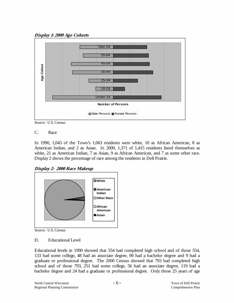
Dell Prairie 1,063 1,415 1,433 33% 352Springville 785 1,167 1,221 49% 382Jackson 641 926 961 44% 285New Haven 511 657 672 29% 146Adams County 15,682 19,920 20,452 27% 4,238Source: U.S. Census, DOA 2003 estimate If the ten-year growth trend were maintained, the town would expect about a 33 percent increase in population over the next ten years. Thus, 467 additional residents would reside in the town. However, if the town grew at the same pace as the county it would expect about 382 additional residents. (See Attachment E for population projections.) B. Age The number of people aged 65 and older that lived in the community increased from 145 in 1990, to 198 in 2000, an increase of 36.6 percent. Meanwhile the number of persons 5 and under increased by 33.9 percent that same period from 62 in 1990 to 83 in 2000. Both percentages indicate a steady or slowly aging population in Dell Prairie. According to the U.S. Census in 1990, Dell Prairie’s median age was 38 and in 2000 the median age was 41. Compared to Adams County, in 1990 the median age was 40 and in 2000 the median age was 44. Over the decade, Dell Prairie’s median age has increased by 3 years and is below the county’s median age by three years. Display 1 shows the majority of the population in 2000 to be in the under 18 range, which has a high compression of more ages under one classification. The 35-44 year and 45-54 year ranges with a ten-year increment bulge out compared to the other categories and shows the reason why the town’s median age is so low.
North Central Wisconsin - 6 - Town of Dell Prairie Regional Planning Commission Comprehensive Plan
Under 18
18-24
25-34
35-44
45-54
55-64
Over 64A
ge C
ohor
t
Number of Persons
Male Persons Female Persons
White
AmericanIndianOther Race
AfricanAmericanAsian
Display 1: 2000 Age Cohorts
Source: U.S. Census C. Race In 1990, 1,043 of the Town’s 1,063 residents were white, 10 as African American, 8 as American Indian, and 2 as Asian. In 2000, 1,371 of 1,415 residents listed themselves as white, 21 as American Indian, 7 as Asian, 9 as African American, and 7 as some other race. Display 2 shows the percentage of race among the residents in Dell Prairie. Display 2: 2000 Race Makeup
Source: U.S. Census D. Educational Level Educational levels in 1990 showed that 554 had completed high school and of those 554, 133 had some college, 48 had an associate degree, 90 had a bachelor degree and 9 had a graduate or professional degree. The 2000 Census showed that 793 had completed high school and of those 793, 251 had some college, 56 had an associate degree, 119 had a bachelor degree and 24 had a graduate or professional degree. Only those 25 years of age

North Central Wisconsin - 7 - Town of Dell Prairie Regional Planning Commission Comprehensive Plan
and older are reflected in these statistics. Table 2 provides a summary of educational attainment in Dell Prairie, Adams County, and the State. Table 2: Educational Attainment, Persons Age 25 and Older, 2000
Educational Attainment Level Town of Dell
Prairie Adams County
State of Wisconsin
Less than 9th Grade 3.8% 7.0% 5.4% 9th to 12th Grade, no diploma 16.0% 16.4% 9.6% High School Graduate 34.7% 41.9% 34.6% Some College, no degree 25.4% 19.9% 20.6% Associate Degree 5.7% 4.9% 7.5% Bachelor’s Degree 12.0% 6.5% 15.3% Graduate or Professional 2.4% 3.4% 7.2% Source: U.S. Census
The Town of Dell Prairie has a higher percentage of residents compared to the county and state with an educational attainment of those with some college but no degree. The town’s percentages are above the county with residents that have an associate degree and a bachelor degree. E. Households The number of households in the town has grown by 37.6 percent, from 402 in 1990 to 553 in 2000. Of the 553 total households, in 2000, 72.9 percent were family households, while the other 27.1 percent were non-family households. Almost sixty-three percent were married couple households. Twenty-six percent of all households included someone 65 years old or older, while thirty-two percent included someone 18 or younger. The average household size was 2.51 people. (See Attachment E for household projections.) F. Employment Between 1990 and 2000 the town’s employed residents increased 32.7 percent, from 505 to 670. The two employment sectors with the most employed in 1990 were Retail Trade and Manufacturing. That changed in 2000, with Art, Entertainment, Recreation, Accommodation & Food Services and Educational, Health, & Social Services as the top two employers. Construction was the third most employed sector Manufacturing was fourth and Retail trade was sixth. Over the decade, the percentage of unemployed went down in Dell Prairie. In 1990, 58 people reported they were unemployed, for a 6.9 percent of unemployed and in 2000, 34 people reported they were unemployed, for a 3.1 percent of civilian labor force unemployed. (See Attachment E for employment projections.)
Table 3: Total Employed Minor Civil Division 1990 2000 1990-2000 % Change
Dell Prairie 505 670 32.7% Springville 282 524 85.8% Jackson 222 408 83.8% New Haven 249 317 27.3% Adams County 5,640 7,847 39.1% Source: U.S. Census

North Central Wisconsin - 8 - Town of Dell Prairie Regional Planning Commission Comprehensive Plan
G. Household Income The 1999 median household income (MHI) in the town was $43,750, which was more than Adams County, but less than the State, which were $33,408 and $43,791 respectively. Of the 549 households in the town, 144 reported incomes less than $24,999 and 33 had an income above $100,000. The 2000 Census indicates that poverty is concentrated among individuals over 65 years. Nine percent of this population is below the poverty rate. Table 4: Median Household Income Minor Civil Division 1990 2000 Adj. Net Change* % Change*
Dell Prairie $24,688 $43,750 $11,223 34.5% Springville $19,400 $34,531 $8,971 35.1% Jackson $19,844 $39,338 $13,193 50.5% New Haven $28,173 $35,536 -$1,583 -4.3% Adams County $21,548 $33,408 $5,019 17.7% Source: U.S. Census & NCWRPC. *Adjusted for inflation
Table 5: Per Capita Income Minor Civil Division 1990 2000 Adj. Net Change* % Change*
Dell Prairie $12,274 $19,209 $3,038 18.8% Springville $11,266 $16,145 $1,302 8.8% Jackson $10,116 $19,080 $5,752 43.2% New Haven $11,732 $15,624 $167 1.1% Adams County $11,945 $17,777 $2,039 13.0% Source: U.S. Census & NCWRPC. *Adjusted for inflation
Table 6: Poverty Rate (%)
Minor Civil Division 1989 Poverty Rate (%) 1999 Poverty Rate (%) Town of Dell Prairie 5.9% 7.8% Adams County 14.4% 10.4% State of Wisconsin 10.7% 8.7% Source: U.S. Census
H. Community Issues There are a variety of influences in the town, from population growth, to residential development, to the future of farming. These issues are critical to the long-term success of the town. A four page summary from the U.S. Census is included as Attachment D. The following sections of the document examine the many issues that impact the town.

North Central Wisconsin - 9 - Town of Dell Prairie Regional Planning Commission Comprehensive Plan
2. NATURAL, AGRICULTURAL & CULTURAL RESOURCES A. NATURAL The town lies in the mid-latitude continental climatic zone, which is characterized by long, snowy winters and short, warm summers. Spring and fall are often short with rapid changes from summer to winter and winter to summer. Annual precipitation, throughout the area, averages about 32 inches. About one-half to two-thirds of the annual precipitation falls between May and September. Snowfalls range between 45 and 80 inches annually, with a continuous snow cover from December to early April. In terms of the physical landscape, the protection of certain natural features is necessary for the environment and for future generations. Certain environmental features and assets have more than merely aesthetic and leisure-time activity values. They are essential to long-term human survival and the preservation of life, health, and general welfare. As such, the protection and/or management of these environmental features and assets clearly are in the public's best interest. The environmental features and assets that were examined in this plan include soils, wetlands, floodplains, water and woodlands. 1) Water, Wetlands & Floodplains
Together the ponds, lakes, streams and wetlands total about 1,206 acres in the town or 5.5 percent of the total acres. The major water body is the Wisconsin River. These surface water resources replenish the groundwater as part of the hydrologic cycle. See the Water Features Map.
View of Wiscsonsin River - Dell Prairie.
Under natural conditions, the aquifers generally receive clean water from rainfall percolating through the overlying soils. However, contamination of groundwater reserves can result from such sources as percolation of water through improperly placed or maintained landfill sites, private waste disposal located near the water table, leaks from sewer pipes, and seepage from some types of mining operations into the aquifer. Runoff from livestock yards and urban areas and improper application of agricultural pesticide or fertilizers can also add organic and chemical contaminants in locations where the water table is near the surface. Protection of these groundwater reserves is necessary to ensure adequate water to domestic, agricultural and

North Central Wisconsin - 10 - Town of Dell Prairie Regional Planning Commission Comprehensive Plan
Map 2 Water Features

North Central Wisconsin - 11 - Town of Dell Prairie Regional Planning Commission Comprehensive Plan
commercial uses. If groundwater is not protected, contamination could result; thus, endangering the quality and supply of the water in the town. Wetlands perform many indispensable roles in the proper function of the hydrologic cycle, and local ecological systems. In a natural condition, they control floodwater by moderating peak flows, and some may act as groundwater recharge sites. All wetlands have valuable water purification capabilities and make significant contributions to surface and groundwater quality. They act as settling areas for inflowing streams as well as functioning in the reduction of water nutrients through uptake of these compounds into plant tissues. They also have a buffering affect on water acidity or alkalinity and are helpful in the elimination of harmful bacteria, which may be found in surface or groundwater. They also serve as breeding and nesting grounds for waterfowl and many other animals that depend on aquatic habitats; they are an important recreational, education, and aesthetic resource. In many instances, wetlands serve as the combined roles of flood moderation, water purification and aquatic habitat, wetlands are important to the maintenance of downstream habitat as well. See the Water Features Map.
Wetlands generally occur in areas where water stands near, at, or above the soil surface during a significant portion of most years. Vegetation is generally aquatic in nature and may vary from water lilies and rushes in marsh areas to alder and tamarack in lowland forest. Swamps, bogs, marshes, potholes, wet meadows, and sloughs are all wetlands. The soils in these areas are usually saturated during the growing season within a few inches of the surface.
When drainage of wetlands occurs, or drainage patterns are altered, the water table is locally lowered and soils are exposed to oxidation at depths usually saturated. Nutrients held in the wetland soils can then be leached away. Heavy siltation can occur downstream as water previously held by the soils is swept away. Wildlife population and habitat in drained areas and downstream locations may be negatively affected, lowering the recreational and educational value. Eradication of wetlands can also occur in urban locations through the use of fill material. This can destroy the hydrologic function of the site and open the area to improper development. The Wisconsin Department of Natural Resources (WisDNR) has delineated the location of wetlands and has standards for managing wetlands. There are no natural lakes in the Town, but there are a number of tributaries to the Wisconsin River.
Floodplains are a natural feature not conducive to development. Inappropriate location of roadways in floodplains can result in serious flood damage. Periodic roadbed saturation and embankment washing eventually lead to an increase in road maintenance costs. In addition to roads, floodwaters can create a number of problems by damaging foundations of homes, electrical equipment, heating units, etc. Basements constructed on permeable sands and silts of floodplains are especially susceptible to damage resulting from seepage through walls. Thus, it is advisable to restrict development in such areas. In the town, the areas that are designated as floodplains by the Federal Emergency Management Agency (FEMA) are mainly adjacent to River and streams. See the Water Features Map.

North Central Wisconsin - 12 - Town of Dell Prairie Regional Planning Commission Comprehensive Plan
Map 3 Soils

North Central Wisconsin - 13 - Town of Dell Prairie Regional Planning Commission Comprehensive Plan
Map 4 Soil Limitations for Septic Tank Absorption Fields

North Central Wisconsin - 14 - Town of Dell Prairie Regional Planning Commission Comprehensive Plan
2) Soils
As with most areas in Central Wisconsin, the Town of Dell Prairie has a variety of soil types within the town. According to the 1984 USDA Soil Survey of Adams County, the soil patterns include scattered areas of Adrian Muck (Ad), which is in most of the areas classified as DNR Wetlands and along the creeks and lakes. Newson Loamy Sand (Ne) is also scattered in these same areas and normally border the Adrian Muck. Scattered between the creek and wetland areas is Plainfield Sand [(PfB), (PfC) and (PfD)], Boone Sand (BnD), Coloma Sand (CoD), Wyocena Loamy Sand (WyD) and Algansee Loamy Sand (AlA), which cannot be used for cultivating crops or construction of houses. Some soils that potentially can be used as farmland include Billett Sandy Loam (BlA), Boone Sand (BnB), Brems Loamy Sand (BrA), Briggsville Silt Loam (BtB), Wyeville (WeA), Delton Sand [(DsA), (DeB) and (DeC)], Coloma Sand [(CoB) and (CoC)], Gale Silt Loam [(GaB) and (GaC)], Grays Silt Loam [(GrB) and (GrC)], Meehan Loamy Sand (MoA), Okee Loamy Sand [(OkB), (OkC) and (OkD)], Richford Loamy Sand [(RfA), (RfB) and (RfC)], Sparta Loamy Sand (SpA), Tell Silt Loam (TeA), Wyocena Loamy Sand [(WyB) and (WyC)] and Wautoma Loamy Sand (Wa). Billett Sandy Loam (BlA), Boone Sand [(BnB) and (BnC)], Brems Loamy Sand (BrA), Delton Sand [(DsA), (DeB) and (DeC)], Gale Silt Loam [(GaB) and (GaC)], Grays Silt Loam [(GrB) and (GrC)], Okee Loamy Sand [(OkB) and (OkC)], Richford Loamy Sand [(RfA), (RfB) and (RfC)], Sparta Loamy Sand (SpA), Tell Silt Loam (TeA), Wyocena Loamy Sand [(WyB) and (WyC)] and Coloma Sand (CoB), are also suitable for construction of houses and with special precaution, can also be suitable for private onsite waste water treatment systems. Boone Rock Outcrop Complex (BpF), found on the Elephants Back and very steep hills, is unsuitable for development and cultivated crops because of steep elevation. Soils are an important natural resource. Knowledge of the potential uses and/or limitations of soil types is necessary to evaluate crop production capabilities or when considering construction of buildings, installation of utilities, or other uses of land. Problems that limit development on certain soils include poor filtration, slow percolation, flooding or ponding, wetness, slope, and subsidence. A "severe" limitation indicates that one or more soil properties or site features are so unfavorable or difficult to overcome that a major increase in construction effort, special design, or intensive maintenance is required. For some soils rated severe, such costly measures may not be feasible. See the Soils with Limitations Map.
3) Woodlands
Forest cover provides many vital functions, which are diverse in nature; forested lands provide for recreational opportunities, scenic beauty, economic commodity (timber products), and wildlife habitat as well as protection of sensitive environmental areas. From the Wisconsin Land Use Databook, of the 22,120 acres of land in Dell Prairie, 59.6 percent or 13,183 acres are forests. In regard to the latter, tree cover is essential, especially for erosion control and to reduce effluent and nutrient flows into surface water bodies and courses. See the Woodlands Map.

North Central Wisconsin - 15 - Town of Dell Prairie Regional Planning Commission Comprehensive Plan
Map 5 Woodlands

North Central Wisconsin - 16 - Town of Dell Prairie Regional Planning Commission Comprehensive Plan
Some woodlands in the town are being maintained through the Managed Forest Law (MFL) and the Forest Crop Law (FCL). This tax assessment program is available to landowners willing to manage their forest plot according to sound forestry practices as specified in a management plan. More information exists in the Natural, Ag., & Cultural Resources element of the Adams County Comprehensive Plan.
4) Threatened or Endangered Species
The Town of Dell Prairie has 14 sections with occurrences of aquatic and/or terrestrial plants, animals, and/or natural communities of endangered status as identified in the Wisconsin Natural Heritage Inventory. The Natural Heritage Inventory County map, see Attachment F, provides generalized information about endangered resources (rare, threatened, or endangered species and high-quality natural communities) to the section level. Each section identified may have several different species or natural communities, or just one species or natural community.
Goals:
1. Protection of natural areas, including wetlands, wildlife habitats, ponds, woodlands, open spaces and groundwater resources.
2. Protection of economically productive areas, including farmland and forests.
Objectives:
1. New development in the Town should not negatively impact natural resources.
2. Minimize impacts to the Town’s natural resources from non-metallic mineral mining.
3. Encourage and support the preservation of natural open spaces that minimize flooding such as wetlands and floodplains.
4. Promote development that minimizes groundwater impacts from on-site septic systems and other sources.
Policies:
1. New development should be discouraged from areas shown to be unsafe or unsuitable for development due to flood hazard, potential groundwater contamination, loss of farmland, highway access problems, incompatibility with neighboring uses, etc.
2. Expansion of existing non-metallic mining operations or development of new sites should be allowed only on lands where the expansion will not conflict with preexisting development.
3. Reclamation of non-metallic mining sites should conform to the land use plan map in regard to the reclaimed use.
4. Discourage the draining or filling of wetlands.

North Central Wisconsin - 17 - Town of Dell Prairie Regional Planning Commission Comprehensive Plan
B. AGRICULTURAL According to the Wisconsin Land Use Databook, the Town of Dell Prairie between 1991-1993 was almost 38 percent agricultural. According to this document, 19.3 percent of the town’s total land (33.4 square miles) is used for row crops, 2.8 percent is used for foraging and 15.4 percent is grassland, for a total of 37.5 percent. The report also found that 59.6 percent of the town was in forest cover and 2.6 percent is wetlands. In terms of farming trends, the town has lost 9.8 percent of farmland acres on tax rolls between 1990 and 1997. According to the Wisconsin Land Use Databook there were 15 active farms in 1997; at that time there were still 2 dairy farms within the Town. Prime farmland produces the highest yields with minimal inputs and results in the least damage to the environment. See the Prime Farmlands Map. Farmland preservation areas are based on guidelines of the state's farmland preservation program including presence of prime farmland, see Farmland Preservation Areas Map.
Goal:
1. Protection of economically productive farmland and forest areas.
Objectives:
1. Support diversification of farming types and practices to maintain agriculture as a viable economic activity.
2. Existing agricultural uses and buildings should be taken into consideration when locating new development to avoid conflicts.
3. Preserve productive farmland for long-term agricultural uses.
4. Confined animal feeding operations should be located within agricultural areas and maintain a quarter mile buffer from designated residential areas.
Policies:
1. Non-farm development, particularly subdivisions, will be encouraged in areas away from intensive agricultural activities, in order to minimize farm & non-farm conflicts due to noise, odors, nitrates in well water, pesticides, farm/vehicle conflicts on roadways, late night plowing, etc.
2. Consider the use of such tools to protect sensitive areas, such as transfer of development rights (TDR) or purchase of development rights (PDR).
3. Encourage landowners to develop forest management plans and enroll in the managed forest law program.
4. Inconveniences, such as irrigation, dust, noise, odors, vehicles traffic, etc. that result from agricultural operations that are not a major threat to public health of safety, should not be considered a nuisance.

North Central Wisconsin - 18 - Town of Dell Prairie Regional Planning Commission Comprehensive Plan
Map 6 Prime Agricultural Soils

North Central Wisconsin - 19 - Town of Dell Prairie Regional Planning Commission Comprehensive Plan
Map 7 Farmland Preservation Areas

North Central Wisconsin - 20 - Town of Dell Prairie Regional Planning Commission Comprehensive Plan
C. CULTURAL There are several original farm homes and farm buildings in the town, but there has been no historical examination of these structures for inclusion on the Historic Registry.
Old Plainville School - reuse as antique shop. Two Century Farmsteads exist within town. A century farmstead has maintained family ownership for at least 100 years. The Wisconsin State Fair recognized the Walter Dale Helm & the Margaret Page farmsteads in 2000. Dell Prairie century farmsteads Walter Dale Helm on 30 acres in T14N R7E Sec 6 was settled in 1887. Margaret Page on 80 acres in T14N R6E Sec 12 was settled in 1895.
See the Adams County Comprehensive Plan, Natural, Agricultural, & Cultural Resources element for more detailed information on this topic. Goals:
1. Preservation of cultural, historic and architectural sites.
2. Building of community identity by revitalizing "main" streets and enforcing design standards, were appropriate.
Objective:
1. Work with the Adams County Historical Society and others to provide guidance in the identification and protection of historic and cultural resources.
Policy: 1. Development proposals should be reviewed relative to the potential impacts to the
historical and cultural resources of the Town.

North Central Wisconsin - 21 - Town of Dell Prairie Regional Planning Commission Comprehensive Plan
3. HOUSING Background In 1980, there were 358 housing units in the town. Three hundred fifteen of these housing units were occupied, 17 were vacant for sale or rent, 15 were vacant for occasional use, and 11 were other vacant housing units. About 89 percent of all occupied housing units in the town were owner-occupied. The average household size was 2.72 people. The 1990 Census indicates that there were 638 housing units in the town. All but 7 of these units had complete plumbing facilities, 7 lack complete kitchen facilities and 15 did not have telephone service. One hundred and eighty-six of these units were built between 1980 and 1989, and fifty-four units were built before 1939. In 2000, there were 754 housing units in the town, an increase of 18.2 percent since 1990. Five hundred and fifty-three of these were occupied, while 201 of the housing units were vacant. One hundred and sixty-four units were identified as seasonal. Over 87 percent of all housing units in the town are owner-occupied. The average household size was 2.51 people.
Shoreline Home - Town of Dell Prairie. As a result of the projected population increase, the town needs to add at least an additional 152 housing units to accommodate population growth. However, as the persons per household drops the overall number of new units will increase. It is expected that there will be between 15 and 19 new housing starts per year for the next several years. The amount of land consumed by future residential development would vary depending on where the development would take place. See the Adams County Comprehensive Plan, Housing element for more detailed information on this topic. The following are housing programs available to the Town: 1. Wisconsin Housing and Economic Development Authority (WHEDA) administers
the Federal Low Income Housing Tax Credit (LIHTC). Investors who allocate a number of units as affordable to low-income families for a certain period (usually 15 years) are allowed to take a credit on their income tax. There are 24 housing units that utilize the LIHTC in the county.

North Central Wisconsin - 22 - Town of Dell Prairie Regional Planning Commission Comprehensive Plan
2. U.S. Department of Agriculture – Rural Development (USDA-RD) is focused on rural areas, and thus may be the most promising source of housing-related funding. Below is a listing of programs available:
Section 502 Homeownership Direct Loan program of the Rural Health Service (RHS) provides loans to help low-income households purchase and prepare sites or purchase, build, repair, renovate, or relocate homes. Section 502 Mutual Self-Help Housing Loans are designed to help very-low-income households construct their own homes. Targeted families include those who cannot buy affordable housing through conventional means. Participating families perform approximately 65 percent of the construction under qualified supervision. Section 504 Very-Low-Income Housing Repair program, provides loans and grants to low-income homeowners to repair, improve, or modernize their homes. Improvements must make the homes more safe and sanitary or remove health or safety hazards. Section 515 Multi-Family Housing Loan program supports the construction of multi-family housing for low-income residents. Under the program, which has been in operation in Wisconsin since 1969, USDA underwrites fifty-year mortgages at a one percent interest rate in exchange for an agreement to provide housing for low and very low-income residents. Section 521 Rural Rental Assistance program provides an additional subsidy for households with incomes too low to pay RHS-subsidized rents. Section 533 Rural Housing Preservation Grants are designed to assist sponsoring organizations in the repair or rehabilitation of low-income or very-low-income housing. Assistance is available for landlords or members of a cooperative.
3. There are also programs through the Department of Housing and Urban
Development (HUD):
The HUD Self-Help Homeownership Opportunity Program finances land acquisition and site development associated with self-help housing for low-income families.
The HOME Investment Partnership Program aims to encourage the production and rehabilitation of affordable housing. HOME funds may be used for rental assistance, assistance to homebuyers, new construction, rehabilitation, or acquisition of rental housing. U.S. Department of Housing and Urban Development Section 8 Housing Choice Vouchers are administered locally by the Central Wisconsin Community Action Corporation (CWCAC). The program is open to any housing unit where the owner agrees to participate and where the unit satisfies the standards. Congress is considering replacing the current voucher program with a block grant to states. If enacted, eligibility criteria for the program may change.

North Central Wisconsin - 23 - Town of Dell Prairie Regional Planning Commission Comprehensive Plan
The Small Cities Development Block Grant (CDBG) program is the rural component of HUD’s Community Development Block Grant program, which is administered by the State of Wisconsin, Department of Administration. The state CDBG program provides assistance for the development of affordable housing and economic development efforts targeted to low- and moderate-income people.
Goals: 1. Allow adequate affordable housing for all individuals consistent with the rural
character of the community. 2. Encouragement of neighborhood designs that support a range of transportation
choices, if applicable. Objectives: 1. Ensure that local land use controls and permitting procedures do not discourage or
prevent the provision of affordable housing opportunities. 2. Support development of senior and special needs housing within the Town. 3. Direct residential development away from existing agricultural uses and buildings to
avoid conflicts. Policy: 1. The Town should work with developers to provide a variety of housing types for all
income and age groups.

North Central Wisconsin - 24 - Town of Dell Prairie Regional Planning Commission Comprehensive Plan
4. TRANSPORTATION Background The transportation system in the town includes all the state, county and local roads. The local transportation network is an important factor for the safe movement of people and goods, as well as to the physical development of the town. A map of Primary Truck Routes in the Town of Dell Prairie Region is shown in Attachment F. A map of potential bicycling and walking routes is also shown in Attachment F. There is no transit, rail, air or water transportation service within the town’s jurisdiction. The Adams County Transit System operates out of Adams/Friendship; the nearest rail service is provided by Canadian Pacific through Wisconsin Dells; and the nearest commercial air service is available at the Dane County Regional Airport near the City of Madison. The Baraboo/Wisconsin Dells Airport provides the nearest air cargo service. There are no water transportation facilities in the area. State and Regional Transportation Plans: 1. State Plans Corridors 2020 was completed in 1989. The plan was designed to meet Wisconsin's mobility needs for the future. The 3,200-mile state highway network was comprised of two elements: a multilane backbone system and a two-lane connector system. The backbone system is a 1,650-mile network of multilane divided highways interconnecting the major population and economic centers in the state and tying them to the national transportation network. The connector system is 1,550 miles of high-quality highways that link other significant economic and tourism centers to the backbone network. All communities over 5,000 in population are to be connected to the backbone system via the connector network. Within Adams County, STH 21 is a Corridors 2020 connector route, and the only highway in the County designated as part of the Corridors 2020 system. Another state plan was Translinks 21, completed in 1994. This effort began developing more detailed modal plans that include in-depth analysis of a specific mode and its relationship to the other modes. Completed plans include the Wisconsin State Highway Plan 2020, the Wisconsin Bicycle Transportation Plan 2020, the Wisconsin State Airport System Plan 2020, the Wisconsin Pedestrian Policy Plan 2020 and the Wisconsin Rail Issues and Opportunities Report. Each modal plan includes extensive analysis of land use related issues. Another state level plan related to the highway system is the Wisconsin Access Management System Plan. This is a plan for managing access on portions of the State Trunk Highway System that designates 5,300 miles of state highways on which access will be managed through the purchase of access rights or the designation of "controlled access highways". It shows where WisDOT intends to control access points as new development occurs and to consolidate or eliminate existing access as necessary and feasible. The access management plan is composed of two tiers. Tier 1 consists of the routes that make up the Corridors 2020 system, including STH 21 in Adams County. Access

North Central Wisconsin - 25 - Town of Dell Prairie Regional Planning Commission Comprehensive Plan
management on these routes is seen as essential to maintaining the required high level of service. Because these highways are generally the main routes between communities and have higher traffic volumes that other state highways, they tend to experience the greatest development pressure. Tier 2 is comprised of other State Trunk Highways that meet specified criteria, including STH 13 and STH 73 in Adams County. These routes are roadways where limiting access is seen as a cost-effective strategy to improve safety, reduce congestion, facilitate planned access to developing land, and delay or avoid future construction expenditures. 2. Regional Plan The Regional Comprehensive Plan: A Framework for the Future, 2002 – 2020 was adopted by the North Central Wisconsin Regional Planning Commission (NCWRPC) in 2003. The RCP looks at transportation in all ten counties that make up the North Central Region, including Adams. It looks at general trends within the Region and recommends how county and local government can address transportation issues. The RCP identifies a number of transportation issues including growing traffic volumes and congestion. Moderate levels of congestion, see MAP 4 are expected by the year 2020 on STH 13 in Adams/Friendship and north of the lakes area in the Town of Rome as well as STH 21 west of STH 13, assuming no capacity improvements. Moderate congestion indicates that speeds and distance between vehicles are reduced, constricting traffic flow. Freedom of drivers to maneuver within the traffic stream or enter the highway is noticeably limited. Minor incidents can result in traffic jams because the traffic stream has little space to absorb disruptions. Traffic volumes continue to swell, especially in summer months due to the local tourism and seasonal housing growth. The RCP shows 72 to 77 percent increase in average daily traffic on major routes in Adams County between 1980 and 2000. The RCP addresses other modes of travel as well as highways, including bicycle transportation. The North Central Wisconsin Regional Bicycle Facilities Network Plan is incorporated in the RCP by reference. The plan envisions development of a regional system of new interconnected bicycle facilities for the ten county area including Adams. The proposed network will encompass routes on bicycle paths, bicycle lanes, paved shoulders and wide curb lanes which will link existing and potential traffic generation sites and points of interest, as outlined in the plan, to make bicycling a more attractive and safer transportation alternative. A map displaying highway suitability for bike routes is included in the attachments. The goals of the regional bike plan are to generate public interest in using existing and developing new bike trails across the Region and state and to provide county and municipal officials with guidance in planning and establishing bike facilities at the local level. See the Adams County Comprehensive Plan, Transportation element for more detailed information on this topic.

North Central Wisconsin - 26 - Town of Dell Prairie Regional Planning Commission Comprehensive Plan
Road Network The road system in the Town of Dell Prairie plays a key role in development by providing both access to land and serving to move people and goods through the area. The interrelationships between land use and the road system makes it necessary for the development of each to be balanced with the other. Types and intensities of land-uses have a direct relationship to the traffic on roadways that serve those land-uses. Intensely developed land often generates high volumes of traffic. If this traffic is not planned for, safety can be seriously impaired for both local and through traffic flows. See the Transportation Map. A significant local road issue exists in the Town of Dell Prairie. This being traffic on River Road. Serving the southern corner of the Town between STH 13 and the Wisconsin River, River Road is a heavily used conduit between intensive land uses in the Town such as Chula Vista Resort and Golf Course and the City of Wisconsin Dells. Traffic levels on River Road rival most county trunk and even some state highways with an average annual daily traffic (AADT) level of 2,000 vehicles per day (WisDOT 2001 count). Town officials consider River Road a beautiful, scenic asset to the Town, which they do not want to see change. The Town would like to further capitalize on River Road's scenic beauty by adding bicycle and pedestrian accommodations. However, the road was not build to handle the level of traffic currently using the facility. Increasing Semi traffic bring supplies to the various commercial enterprises along the road are often cutting off the shoulders at various points. Space for the road is narrow and significant cliff-cuts would be necessary to expand lane capacity. Future plans of Chula Vista to expand by eventually adding 300 condominium units will further stain the capacity of River Road. A number of options for addressing this River Road issue are being looked at by the Town. Possible options include: reducing speed limits, traffic calming, limiting/rerouting truck traffic, and developing frontage roads for STH 13. These proposed frontage roads would ease traffic on STH 13 making it more attractive as an alternative route. It would also open up access to lands between River Road and the highway while maintaining limited access on STH 13. Some of the development pressure in the River Road corridor could be shifted to the STH 13 frontage road areas. The Town of Dell Prairie road network consists of roughly 8.15 miles of state highway, 13.32 miles of county highway and 50.88 miles of local roads. The town utilizes a WisDOT PASER computer program to maintain an inventory of its local roads and monitor conditions and improvements of its roads. Ideally, this system will enable the town to better budget and keep track of roads that are in need of repair. Traffic generated and attracted by any new land-use can increase the volume throughout the highway system and increase congestion on the roadway system keeping property from reaching its full potential value. Even without the creation of new access points, changes in land-uses can alter the capacity of the roadway because more, and possibly different, kinds of vehicles than before, enter, leave, and add to the traffic flow. Uncontrolled division of land tends to affect highways by intensifying the use of abutting lands, which impairs safety and impedes traffic movements.

North Central Wisconsin - 27 - Town of Dell Prairie Regional Planning Commission Comprehensive Plan
In terms of traffic volumes, there is the Department of Transportation annual average daily traffic counts for ten areas in the town. In 2001, Highway 13 between Gem and Gillette Drives the AADT count was 5,100; Highway 13 north of Gulch Avenue the AADT count was 6,200; River Road north of North Grouse Lane the AADT count was 2,000; County B south of Gale Avenue the AADT count was 1,300; County B by Gillette Drive the AADT count was 1,300; County B north of Highway 23 the AADT count was 1,700; County K west of County B the AADT count was 230; County P east of County B the AADT count was 390; Highway 13 south of County B the AADT count was 6,900 and Highway 23 east of County B the AADT count was 1,900. These counts need to be monitored as a way to gauge the increase of traffic in the town. Wisconsin was one of the first states to recognize this relationship between highway operations and the use of abutting lands. Under Chapter 233, the Department of Transportation (WisDOT) was given the authority to establish rules to review subdivision plats abutting or adjoining state trunk highways or connecting highways. Regulations enacted by the WisDOT establish the principles of subdivision review. They require new subdivisions to: (1) have internal street systems; (2) limit direct vehicular access to the highways from individual lots; (3) establish building setbacks; and (4) establish access patterns for remaining unplatted land. As development continues and land use changes, the cost of maintaining the road system must be increased. More traffic requires more maintenance and expansion of the local road system.

North Central Wisconsin - 28 - Town of Dell Prairie Regional Planning Commission Comprehensive Plan
Map 8 Transportation

North Central Wisconsin - 29 - Town of Dell Prairie Regional Planning Commission Comprehensive Plan
Goals
1. Encouragement of neighborhood designs that support a range of transportation choices.
2. Providing an integrated, efficient and economical transportation system that affords mobility, convenience and safety that meets the needs of all citizens, including transit-dependent and disabled citizens.
Objectives: 1. Support and maintain a safe and efficient Town road system. 2. Promote the development of multi-use trails, trail linkages, or wide shoulders as part
of new development proposals, where appropriate. 3. Support the Adams County Transit System. Policies: 1. Prepare and update a 5-year Road Improvement Plan to improve existing roads and
plan for frontage roads where needed. 2. The Town should work with the county on any project that affects the Town.
3. Land uses which generate heavy traffic volumes will be discouraged on local roads
that have not been constructed or upgraded for such use. 4. Roadway access will be better spaced along the existing Town road network to
increase safety and preserve capacity. 5. Future road locations, extensions or connections will be considered when reviewing
development plans and proposals. Frontage roads are encouraged for developments on county and state highways that cause high traffic volume and access issues.
6. All Town roads must accommodate access requirements for emergency services (fire, EMS, ambulance, etc.) as well as school bus and snowplows.

North Central Wisconsin - 30 - Town of Dell Prairie Regional Planning Commission Comprehensive Plan
5. UTILITIES & COMMUNITY FACILITIES Background As a small rural town relatively few utilities exist. There are no sanitary sewer, storm water systems, water supply, power plants, health care facilities, childcare facilities, schools or libraries. The town does not provide curbside refuse collection; however, service is available through private firms that offer curbside refuse/recycling collection for a fee. A high voltage electric transmission line follows River Rd, CTH Q and 11th Ave. on its way to a substation in Springville. There are 2 public access points to the Wisconsin River: 13th Dr. & Gem Ct. The Town of Dell Prairie has agreements with Kilbourn Fire Department for volunteer fire and first responders; and the town has an agreement with Wisconsin Dells to provide ambulance service. A map displaying the fire service areas is included in the attachments. The Adams County Sheriff's Department provides police protection for the town. Clinic and hospital facilities are available in Adams/Friendship and Wisconsin Dells. Major regional medical centers for specialized care are available in Marshfield or Madison. Community facilities include a Town Hall and a park. The Town Hall building is owned and maintained by the Town and functions as a multi-purpose building. The park is a former wayside on Highway 13 that was closed by WisDOT and turned over to the Town. Named Fireman's Park, the 1/2-acre site has a picnic area and restrooms. The area volunteer firefighters association maintains the park. See the Utilities & Community Facilities Map.
Entrance to Fireman's Park. Two cemetery exists in Dell Prairie, and its location is shown on Map 9 –Utilities & Community Facilities. Minimum acreage requirements exist for cemeteries established on or after November 1, 1991 unless the cemetery is owned by a religious association, or the Town enacts an ordinance allowing new cemeteries of less than 20 acres to be constructed. Plenty of undeveloped land is available throughout the town for the creation of a new cemetery when necessary. UW-Extension maintains a list of child-care providers available to Adams County residents. The list in 2004 showed 17 providers, six of which are outside the County. Seven of the providers are located in Adams-Friendship, three are in Grand Marsh (Town of New Chester), and one is in Arkdale (Town of Strongs Prairie). Childcare needs are based upon

North Central Wisconsin - 31 - Town of Dell Prairie Regional Planning Commission Comprehensive Plan
personal choice, availability of family members to help with supervision, and availability of private childcare providers. The Adams County Library and the Lester Public Library of Rome are the two libraries located in Adams County. Both libraries are affiliated with the South Central Library System and provide library services for the town. Generally, the Town of Dell Prairie is a rural town with existing facilities that are sufficient for the planning period. See the Adams County Comprehensive Plan, Utilities & Community Facilities element for more detailed information on this topic.
Goals:
1. Providing adequate infrastructure and public services and an adequate supply of developable land to meet existing and future market demand for residential, commercial and industrial uses.
2. Promotion of the redevelopment of lands with existing infrastructure and public services and the maintenance and rehabilitation of existing residential, commercial and industrial structures.
3. Encouragement of land uses, densities and regulations that promote efficient development patterns and relatively low municipal, state government and utility cost.
Objectives: 1. Make information available to residents on the proper maintenance of septic
systems. 2. Consider the potential impacts of development proposals on groundwater quality
and quantity. 3. Explore opportunities to develop integrated, multi-use trail systems and recreational
facilities. 4. Consider sharing equipment and services across Town boundaries. Policies: 1. Work with adjoining towns, the county, the state, and individual landowners to
address known water quality issues. 2. The feasibility of wastewater collection and treatment systems on water quality
should be considered by major developments. 3. Develop and maintain a Capital Improvements Plan for major equipment purchases. 4. Encourage recycling by residents.
North Central Wisconsin - 32 - Town of Dell Prairie Regional Planning Commission Comprehensive Plan
Map 9 Utilities & Community Facilities

North Central Wisconsin - 33 - Town of Dell Prairie Regional Planning Commission Comprehensive Plan
6. ECONOMIC DEVELOPMENT Background As discussed in previous sections, the town has been an agriculturally based community for generations. Farming is still the dominant economic sector occurring in the town. Nearly 38 percent of the total land is used for agriculture. According to the Wisconsin Town Land Use Databook, there were 15 active farms in the town in 1997. Scattered throughout the town there are small businesses, other than farms, that employ a few people. Most of the town’s residents commute to employment areas outside of the town such as Wisconsin Dells, Baraboo and Portage. There are several industrial parks nearby in the Cities of Wisconsin Rapids and Adams, as well as the Village of Friendship that provide employment opportunities. There are no major redevelopment areas in the town.
Tourism is a significant economic sector. There are no existing contaminated commercial or industrial sites in the Town that have available utilities and services. There are a variety of county, regional, state and federal economic development programs available to businesses in the Town. These programs range from grants to loans, to general assistance. 1. County: Adams County Rural & Industrial Development Corporation (ACRIDC) ADRIDC is a non-profit organization that promotes the economic development of Adams County, Wisconsin, and its respective cities, villages, and towns. ACRIDC is comprised of area businesspersons, citizens, local government, utility company representatives, state agencies and elected officials, educational institutions and other organizations essential to the growth of Adams County. ACRIDC is prepared to serve the needs of new businesses coming to the area as well as to assist existing companies.

North Central Wisconsin - 34 - Town of Dell Prairie Regional Planning Commission Comprehensive Plan
JAM Development Zone Adams County was awarded designation as a Wisconsin Development Zone in association with Juneau and Marquette Counties. Known as the JAM Zone (Juneau-Adams-Marquette), Adams County qualifies for special state incentives available to businesses that locate or expand within the Zone. The extent of the credits for any given business is determined during the certification process. This program is administered by the ACRIDC. Adams County Revolving Loan Fund A Wisconsin Department of Commerce Economic Development Grant was awarded to Adams County in 1996. This grant enabled Adams County to establish a revolving loan fund in order to assist local businesses and is administered by the ACRIDC. Adams County Chamber of Commerce The Adams County Chamber of Commerce is dedicated to the development of the business community in Adams County. The Chamber offers information on local business and industry and also provides a variety of programs designed to assist business development. Adams - Columbia Electric Coop (ACEC) Revolving Loan Fund The ACEC established a USDA - Rural Development IRP revolving loan fund designed to address a gap in private capital markets for long-term, fixed-rate, low down payment, low interest financing. It is targeted at the timber and wood products industry, tourism and other manufacturing and service industries. 2. Regional: North Central Wisconsin Development Corporation The North Central Wisconsin Development Corporation (NCWDC) manages a revolving loan fund designed to address a gap in private capital markets for long-term, fixed-rate, low down payment, low interest financing. It is targeted at the timber and wood products industry, tourism and other manufacturing and service industries. North Central Advantage Technology Zone Tax Credits Adams County has been designated a Technology Zone by the Department of Commerce. The Technology Zone program brings $5 million in income tax incentives for high-tech development to the area. The North Central Advantage Technology Zone offers the potential for high-tech growth in knowledge-based and advanced manufacturing clusters, among others. The zone designation is designed to attract and retain skilled, high-paid workers to the area, foster regional partnerships between business and education to promote high-tech development, and to complement the area’s recent regional branding project. 3. State: Rural Economic Development Program This program administrated by Wisconsin Department of Commerce provides grants and low interest loans for small business (less than 25 employees) start-ups or expansions in rural areas, such as Adams County. Funds may be used for "soft costs" only, such as planning, engineering, ad marketing assistance.

North Central Wisconsin - 35 - Town of Dell Prairie Regional Planning Commission Comprehensive Plan
Wisconsin Small Cities Program The Wisconsin Department of Commerce provides federal Community Development Block Grant (CDBG) funds to eligible municipalities for approved housing and/or public facility improvements and for economic development projects. Economic Development grants provide loans to businesses for such things as: acquisition of real estate, buildings, or equipment; construction, expansion or remodeling; and working capital for inventory and direct labor. Wisconsin Small Business Development Center (SBDC) The UW SBDC is partially funded by the Small Business Administration and provides a variety of programs and training seminars to assist in the creation of small business in Wisconsin. Transportation Economic Assistance (TEA) This program, administered by the Wisconsin Department of Transportation, provides immediate assistance and funding for the cost of transportation improvements necessary for major economic development projects. Other State Programs Technology Development grants and loans; Customized Labor Training grants and loans; and Major Economic Development Project grants and loans. 4. Federal: U.S. Dept. of Commerce - Economic Development Administration (EDA) EDA offers a public works grant program. These are administered through local units of government for the benefit of the local economy and, indirectly, private enterprise. U.S. Department of Agriculture - Rural Development (USDA – RD) The USDA Rural Development program is committed to helping improve the economy and quality of life in all of rural America. Financial programs include support for such essential public facilities and services as water and sewer systems, housing, health clinics, emergency service facilities, and electric and telephone service. USDA-RD promotes economic development by supporting loans to businesses through banks and community-managed lending pools. The program also offers technical assistance and information to help agricultural and other cooperatives get started and improve the effectiveness of their member services. Small Business Administration (SBA) SBA provides business and industrial loan programs that will make or guarantee up to 90% of the principal and interest on loans to companies, individuals, or government entities for financing in rural areas. Wisconsin Business Development Finance Corporation acts as an agent for the U.S. Small Business Administration (SBA) programs that provide financing for fixed asset loans and for working capital.

North Central Wisconsin - 36 - Town of Dell Prairie Regional Planning Commission Comprehensive Plan
The Towns strengths and weaknesses for attracting business have been identified as follows: Strengths: Town residents have a strong work ethic, ample land for development, especially for agricultural related and home-based businesses, and good crossroads highway access. Weaknesses: Limited infrastructure and support services for employers, and limited access to broadband services. Categories of new businesses and industries desired by the Town are drawn from community survey results. More "active family farms" are desired by 49 % of respondents. Approximately 55 % desire more "jobs with benefits in Dell Prairie township". About 46 % want to maintain the same level of general business/commercial establishments, while 60 % want to see less large corporate farms. See the Adams County Comprehensive Plan, Economic Development element for more detailed information on this topic. Goal:
1. Promote the expansion and stabilization of the current economic base and the creation of a range of employment opportunities at the state, regional and local levels.
Objectives: 1. Encourage new retail, commercial & industrial development to locate in designated
areas and adjacent to county or highways. 2. Encourage businesses that are compatible in a rural setting. Policies: 1. Accommodate home-based businesses that do not significantly increase noise, traffic,
odors, lighting, or would otherwise negatively impact the surrounding areas. 2. Review the costs and benefits of a proposed development project prior to approval. 3. Commercial and industrial development should be directed to designated planned
areas consistent with the Future Land Use Map. 4. Intensive industrial uses should be steered to areas that have the service capability to
support that development.

North Central Wisconsin - 37 - Town of Dell Prairie Regional Planning Commission Comprehensive Plan
Table 7: Existing Land Use, 2004 Land Use Type Acres PercentAgriculture 5,133 24.2%Commercial 294 1.4%Governmental 117 0.5%Industrial 52 0.2%Open Grassland 132 0.6%Outdoor Recreation 40 0.2%Residential 3,672 17.3%Transportation 725 3.4%Water 822 3.9%Woodlands 10,252 48.3%Total Acres 21,239 100.0%Source: NCWRPC GIS
7. LAND USE Background The Town of Dell Prairie covers an area of about 21,239 acres in Adams County. The area is characterized by thin till and pitted outwash. The typical terrain is flat with prominent outcroppings and covered with hardwoods or open for agricultural use with a general east to west drainage pattern. The natural resource base of the area is dominated by timber. Agricultural uses of the land are vitally important. See the Adams County Comprehensive Plan, Land Use element for more detailed information on this topic. Existing Land Use 2004 Knowledge of the existing land use patterns within a town is necessary to develop a desired “future” land use pattern. The Existing Land Use Map was developed using air photos from a countywide flight in 1992/1998, with updates by the locals in 2004. Wooded properties cover about 48 percent of the area, followed by Agriculture with 24 percent and Residential with about 17.3 percent. See the Existing Land Use Map. Future Land Use 2005-2025 The Future Land Use Plan Map represents the long-term land use recommendations for all lands in the town. Although the map is advisory and does not have the authority of zoning, it is intended to reflect community desires and serve as a guide for local officials to coordinate and manage future development of the town. The Plan groups land uses that are compatible and to separate conflicting uses. To create the Plan, nine basic future land use categories were created. The majority of the classifications generally correspond to the districts within the Adams County Zoning Ordinance, to ease future implementation of the plan. Again, the classifications are not zoning districts and do not have the authority of zoning. However, the preferred land use map and classifications are intended to be used as a guide when reviewing lot splits, re-zoning requests, and revisions to the town zoning map as necessary.

North Central Wisconsin - 38 - Town of Dell Prairie Regional Planning Commission Comprehensive Plan
Map 10 Existing Land Use

North Central Wisconsin - 39 - Town of Dell Prairie Regional Planning Commission Comprehensive Plan
Map 11 Future Land Use
North Central Wisconsin - 40 - Town of Dell Prairie Regional Planning Commission Comprehensive Plan
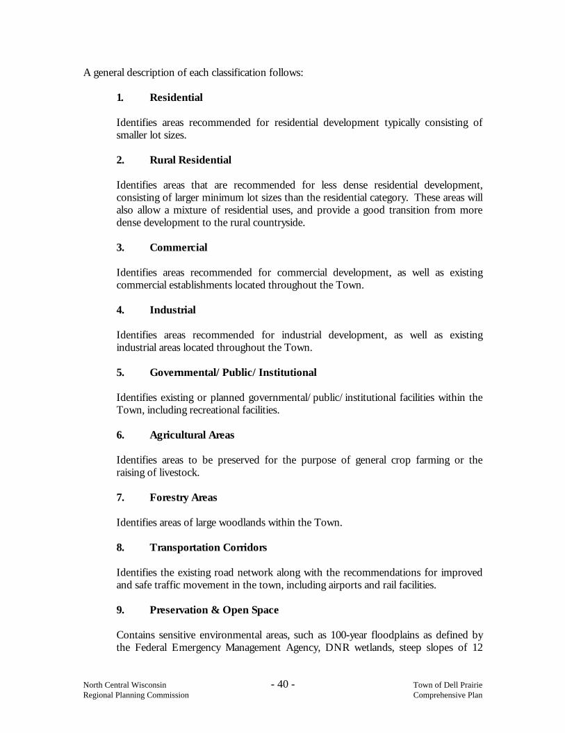
A general description of each classification follows:
1. Residential
Identifies areas recommended for residential development typically consisting of smaller lot sizes.
2. Rural Residential
Identifies areas that are recommended for less dense residential development, consisting of larger minimum lot sizes than the residential category. These areas will also allow a mixture of residential uses, and provide a good transition from more dense development to the rural countryside.
3. Commercial
Identifies areas recommended for commercial development, as well as existing commercial establishments located throughout the Town.
4. Industrial
Identifies areas recommended for industrial development, as well as existing industrial areas located throughout the Town.
5. Governmental/Public/Institutional
Identifies existing or planned governmental/public/institutional facilities within the Town, including recreational facilities. 6. Agricultural Areas
Identifies areas to be preserved for the purpose of general crop farming or the raising of livestock.
7. Forestry Areas
Identifies areas of large woodlands within the Town.
8. Transportation Corridors
Identifies the existing road network along with the recommendations for improved and safe traffic movement in the town, including airports and rail facilities.
9. Preservation & Open Space
Contains sensitive environmental areas, such as 100-year floodplains as defined by the Federal Emergency Management Agency, DNR wetlands, steep slopes of 12

North Central Wisconsin - 41 - Town of Dell Prairie Regional Planning Commission Comprehensive Plan
percent or greater, and open water. This could include endangered species habitat or other significant features or areas identified by the Town.
Using these categories the Land Use Planning Committee participated in a mapping exercise to identify the desired land use. Committee members were asked to indicate their thoughts on a map by drawing shapes or circles to place these different land uses on a map. Specifically, they used their broad knowledge of the town, the series of maps that were prepared as part of the planning process and their interpretation of the current trends. The goal was to produce a generalized land use plan map to guide the town’s growth in the next decade. The Year 2025 Land Use Plan Map represents the desired arrangement of preferred land uses for the future, see Map 11, Future Land Use Plan.
Some major land uses exist in Dell Prairie. Future Land Use Plan Map Overview The future land use plan map has identified approximately 3,963 acres of land for agriculture, 6,414 acres of land for forestry, 108 acres of land for preservation & open space, 6,643 acres for rural residential development, 1,290 acres of land for residential development, 243 acres government/public/institutional development, 79 acres of land for industrial development, and 1,150 acres of land for commercial uses. See Attachment E for land use projections. The plan calls for continued rural residential development, lower density, scattered over a significant area while preserving some larger forested tracts and agricultural land along County Highway B. Pockets of more dense, smaller lot, residential development will have room to expand to adjacent areas. For example, the 100+ acres north of the Fawn Lake development is designated single family residential. Residential and commercial uses west of STH 13 along the river reflect the existing development trend of this area. The goal of this land use plan is to balance individual private property rights with the town’s need to protect property values community-wide, minimize the conflicts between land uses and keep the cost of local government as low as possible. An essential characteristic of any planning program is that it be ongoing and flexible. Periodic updates to the plan are needed to maintain that it is reflective of current trends.

North Central Wisconsin - 42 - Town of Dell Prairie Regional Planning Commission Comprehensive Plan
Analysis of Trends in Land Demand & Price As identified in the tables in Attachment E, there is demand for 1,017 residential acres, 238 commercial acres, and 27 industrial acres over the planning period. According to the Future Land Use Plan, there are adequate areas for these land uses to locate. Woodlands is the dominant land use covering about 48 percent of the land in town, with agriculture covering 24 percent of the land. According to the Wisconsin Town Land Use Databook, 22,963 acres of farmland were sold in Adams County between 1990 and 1997, averaging $1,016 per acre. During the same period, 625 acres of farmland were sold in Dell Prairie, averaging $988 per acre. Of the 625 acres of farmland sold in Dell Prairie, 220 acres were converted out of agriculture. From 1998 to 2003, the average price of farmland sold in Adams County went from $1,205 per acre to $2,195 per acre, increasing 82 percent, according to the Wisconsin Department. of Revenue Bureau of Equalization. During the same period, overall Wisconsin farmland prices increased from $1,514 per acre to $3,268 per acre, increasing 116 percent. Existing/Potential Land Use Conflicts Some land use issues in Dell Prairie are Wisconsin River development & STH 13 development. Many septic systems along the river may fail and affect river water quality for swimming. The other issue is the random mix of development along STH 13. Traffic congestion and loosing a sense of place are some of the worries of allowing this type of development to continue. Continued erosion of the town through annexation by the City of Wisconsin Dells is also a concern. Over 90 percent of respondents from a county-wide survey agreed that protection is important of natural areas, including wetlands, wildlife habitats, lakes, woodlands, open spaces, and groundwater resource. Protection of economically productive areas, including farmland and forests is important to over 85 percent of respondents. Zoning County Shoreline Jurisdiction All counties are mandated by Wisconsin law to adopt and administer a zoning ordinance that regulates land-use in shoreland/wetland and floodplain areas for the entire area of the county outside of villages and cities. This ordinance supersedes any town ordinance, unless the town ordinance is more restrictive. The shoreland/wetland and floodplain area covered under this zoning is the area that lies within 1,000 feet of a lake and within 300 feet of a navigable stream or to the landward side of a floodplain whichever distance is greater.

North Central Wisconsin - 43 - Town of Dell Prairie Regional Planning Commission Comprehensive Plan
County General Zoning Nearly all of the counties in Wisconsin have established a general county zoning ordinance for lands outside of the shoreland jurisdiction. A town can join under this ordinance by resolution. The Town of Dell Prairie is currently under Adams County zoning. Zoning is the major implementation tool to achieve the proposed land uses. Other implementation tools include such things as purchase of land or easements, subdivision ordinance, mobile/manufactured home restrictions, nuisance regulations, design review for commercial and industrial developments, infrastructure improvements (sewer and water, utilities), road construction and maintenance, and public services, among others. See the Existing Zoning Map. To achieve the proposed land uses under the existing comprehensive County zoning authority, two basic options are available. Both options however would require County approval for implementation. 1. Utilize existing County zoning ordinance/districts. The Town could carefully review the existing district descriptions to determine which “best fit” or are most appropriate to each of the proposed land uses. The advantages of this option are that the existing zoning ordinance can be used. County Board approval of proposed zoning map amendments might be easier to achieve. The disadvantages of this option are that the existing zoning districts may not enable the Town to achieve the preferred future condition of the proposed land uses. For example, permitted uses in an existing district may not fit well with the proposed land uses, causing conflicting land uses. 2. Propose new zoning districts or modifications to existing district descriptions for the
countywide ordinance. The Town would need to petition the County for zoning ordinance amendments that would be in effect for the entire county. The advantage of this would be that other towns may be in support of similar modifications and could provide political support for the changes. If approved, the Town would be able to create a better match between the zoning districts and proposed land uses. County staff would continue to administer zoning. The disadvantage would be that the changes would affect the entire county and may not be politically supported by other towns, the County Planning & Zoning Committee, Zoning staff, or the County Board. More zoning districts may make the existing County ordinance more complex and difficult to administer. Land Use Vision The Town of Dell Prairie boasts a safe, peaceful, country-style environment as a special place to raise a family. The Town’s wish is to preserve our country-style and conserve our most valuable resource of prime agricultural land, and to protect food, fiber and livestock production.

North Central Wisconsin - 44 - Town of Dell Prairie Regional Planning Commission Comprehensive Plan
Map 12 Existing Zoning

North Central Wisconsin - 45 - Town of Dell Prairie Regional Planning Commission Comprehensive Plan
Goals: 1. Promotion of the redevelopment of lands with existing infrastructure and public
services and the maintenance and rehabilitation of existing residential, agricultural, commercial and industrial structures.
2. Encouragement of land uses, densities and regulations that promote efficient
development patterns and relatively low municipal, state governmental and utility costs.
3. Providing adequate infrastructure and public services and an adequate supply of
developable land to meet existing and future market demand for residential, agricultural, commercial and industrial uses.
4. Balancing individual property rights with community interests and goals. 5. Planning and development of land uses that create or preserve varied and unique
urban and rural communities. Objectives: 1. Maintain orderly, planned growth which promotes the health, safety and general
welfare of residents and makes efficient use of land and efficient use of public services, facilities and tax dollars.
2. New development should not negatively impact the natural environment or existing
property. 3. Provide for a mix of land uses within the Town. 4. Promote new land development that is consistent with this plan.
North Central Wisconsin - 46 - Town of Dell Prairie Regional Planning Commission Comprehensive Plan
Policies: 1. The Town will maintain the comprehensive plan, which will serve as a guide for
future land use decisions. New development will be permitted based on consideration of this Plan, as well as other Town, County, Regional, and state plans and other regulations.
2. The Town will actively participate in zoning and subdivision review decisions at the
County level, which affect the Town. This plan will be cited as the basis for all such actions including "disapproval" of proposed zoning amendments.
3. Land uses and building locations that minimize both the loss of productive farmland
and the potential for conflicts between existing and proposed land uses will be encouraged.
4. Land uses and building locations that minimize fragmentation of large contiguous
forest tracts will be encouraged. 5. Use conservancy zoning to protect natural resources in the Town. 6. Encourage conservation easements and other tools to protect environmentally
sensitive or unique resources. 7. Update existing land use regulations to be consistent with this plan.

North Central Wisconsin - 47 - Town of Dell Prairie Regional Planning Commission Comprehensive Plan
8. INTERGOVERNMENTAL COOPERATION Background Governmental relationships can best be described as “vertical” relationships, such as between federal, state and local units (county/city/town) are relatively well established in law. Unfortunately, there is little public policy in Wisconsin law that requires, horizontal governmental relationships such as town to town and municipality to county or town. The result is that towns, municipalities, and counties act more as adversaries than as partners. School districts are one of the most common intergovernmental organizations since they cross-traditional local municipal boundaries. Adams County is served by five school districts. A school district map is included in the attachments. See the Adams County Comprehensive Plan, Intergovernmental Cooperation element for more detailed information on this topic. Wisconsin Statute s.66.30, entitled "Intergovernmental Cooperation", does enable local governments to jointly do together whatever one can do alone. Typically, intergovernmental cooperation and coordination refers to the management and delivery of public services and facilities. It is also dependent upon a defined geographic area within which cooperation and coordination may be feasible. Often the area is a central city and its surrounding area, or several similar towns. It is a collection of local communities in which the citizens are interdependent in terms of their employment, residence, health, and medical care, education, recreation and culture, shopping and other experiences. A variety of other factors, some long-standing and some of fairly recent origin, are combining to force citizens and local governments in both urban and rural area to confer, cooperate, and in some cases, to join together in a search for better ways to deliver public services in their respective areas. These factors include: • population settlement patterns; • local government structure, finance, and politics; • high population mobility; • economic and environmental interdependence; and • high cost, capital-intensive functions. Adjoining Units of Government The entire Town is in the Wisconsin Dells School District, and fire/rescue/EMS/ambulance service is provided by the City of Wisconsin Dells via contract. Wisconsin Dells DNR Ranger Station handles forest/wild fire protection. The Towns of Springville, Jackson and New Haven, and the City of Wisconsin Dells are in the same stage of completing their own comprehensive plans. Columbia County and across

North Central Wisconsin - 48 - Town of Dell Prairie Regional Planning Commission Comprehensive Plan
the river Sauk County are just beginning the process and Juneau County, also across the river, is in the stage of exploring the options of planning. Cities, such as Wisconsin Dells, have authority to exercise "extraterritorial" zoning. The extraterritorial zoning jurisdiction consists of the unincorporated area within one and one-half miles of the corporate limits of a fourth class city like Wisconsin Dells. Extraterritorial zoning is similar to other zoning in terms of purposes and type of districts. It differs in terms of the process by which a zoning ordinance is adopted. When a city decides to zone its extraterritorial area, a joint extraterritorial zoning committee must be established. It consists of three citizen members of the city planning commission and three members from each of the affected towns. This joint committee prepares a proposed plan and regulations for the extraterritorial area and submits it to the city. The city may adopt it as proposed or resubmit the proposal to the joint committee for changes. In either case, the proposed regulations must receive a favorable majority vote from the joint committee before the city can adopt them. The City also has land division/parceling or subdivision plat approval authority within the mile and a half extraterritorial area. The City of Wisconsin Dells and Town of Dell Prairie have developed a three-year agreement on an extraterritorial plan. As a result the future land use concept plan in this Town plan closely resembles the Wisconsin Dells Future Land Use map contained in the City's plan. Conflict Resolution Between Governments Occasionally, issues occur between Dell Prairie and Adams County in local zoning and land use matters. Dell Prairie will work to minimize these issues by undertaking a more comprehensive review of land use proposals, providing better communication to Adams County and making a stronger case for its local land use recommendations. Dell Prairie will cooperate with all levels of government on issues of mutual concern, including resource protection, transportation, land use, education, and human services. Cost sharing or contracting with neighboring towns or the county will continue to provide services or public utilities efficiently. There are no other existing or potential conflicts with other governmental units known at this time. Goal: 1. Encourage coordination & cooperation among nearby units of government. Objectives:
1. Promote communication with other units of government, including adjoining towns, the county, the state, and federal government.

North Central Wisconsin - 49 - Town of Dell Prairie Regional Planning Commission Comprehensive Plan
2. Join together with other units of government to provide services in a more cost-effective manner.
Policies: 1. Pursue cooperative agreements regarding boundary agreements, annexation,
expansion of public sewer and water services, and growth management between the City/Village and the Town.
2. Identity alternative solutions to existing or potential land use, administration or
policy conflicts that may hinder intergovernmental cooperation. 3. Regularly meet with adjoining unit of government to discuss issues of mutual
concern. 4. Periodically review existing shared service agreements, and explore additional
agreements. 5. Continue to work with the City to monitor "boundary" issues and to plan for the
future. 6. Extra-territorial area issues need to be discussed with the City on a regular basis.

North Central Wisconsin - 50 - Town of Dell Prairie Regional Planning Commission Comprehensive Plan
9. IMPLEMENTATION Implementation of this Comprehensive Plan depends on local officials. It is also important that local citizens and others become aware of this plan. Some steps have already been accomplished toward implementing this plan, such as the adoption of written public participation guidelines, the formation of a Plan Commission, hosting an open house meeting, passing a Plan Commission resolution recommending Plan adoption by the Town Board, holding a formal public hearing, and approval of the Plan by ordinance by the Town Board. The following recommendations are made to further implement this Comprehensive Plan: Recommendation 1: The Town Board should use this plan as a guide when making decisions, especially those that relate to growth and development. The Planning Commission and any other official committee of the Town should also use this plan in their efforts as well. Recommendation 2: The Town should encourage citizen awareness of the comprehensive plan by making copies available, making reference to at public meetings and Town newsletters, and displaying a copy of the future land use plan map in the Town Hall. Neighboring local units of government and others will receive copies of the plan. A website should be established to allow Internet access to the plan document and maps. Recommendation 3: The primary implementation tool for this plan is the Adams County Zoning Ordinance, which provides the regulatory framework that supports many of the Plan’s policies. It is important that the Town review the existing zoning and initiate change to achieve consistency between the plan and the zoning ordinance. The Town Board and or Plan Commission should review local zoning petitions and forward recommendations to Adams County for consideration. Although the County makes the decision on the zoning petition, the Town has veto authority over zoning changes approved at the county level. The Comprehensive Plan should be cited at the basis for all Town zoning actions, including review and recommendations to the County Board and exercise of veto power. Additional tools and approaches can be utilized by the Town to achieve the goals of the plan. These include but are certainly not limited to the following: land division ordinance, official mapping, fee simple land acquisition, easements, deed restrictions, land dedication, and ordinances or programs regulating activities such as building permits, erosion control, or septic pumping, etc. The Town should consider these tools as needed.

North Central Wisconsin - 51 - Town of Dell Prairie Regional Planning Commission Comprehensive Plan
Recommendation 4: Amendments to this Plan may include minor changes to the plan text or maps, and or major changes resulting from periodic review. Wisconsin Law requires that the same process used to adopt the plan will be used to make any amendments. The steps are outlined below:
• An amendment or change may be initiated by either the Town Board or Plan Commission, a request from a resident, or may result from a regular review of the plan.
• The Plan Commission prepares the specific text or map amendment being
considered, holds a public meeting and votes to recommend approval or disapproval of the proposed amendment, by resolution to the Town Board.
• A copy of the proposed Plan amendment is sent to all affected government units,
including Adams County.
• Town Clerk publishes a 30-day Class 1 notice announcing a Town board public hearing on the proposed changes.
• The Town Board conducts the public hearing and votes to either approve,
disapprove or approve with changes, by ordinance. Any approved changes are sent to affected government units, including Adams County. Frequent minor changes to accommodate specific development proposals should be avoided. Recommendation 5: Periodic updating of the plan is necessary to insure that it reflects the desires of the Town's residents. The Plan Commission should review the plan on an annual basis, and conduct an in-depth review of the plan every five years. At a minimum the plan must be updated every ten years. The annual review should compare how decisions, especially land use related, made during the year relate to the goals, objectives, and policies of the plan. If decisions are inconsistent with plan, changes need to be made. The update should consider the following to maintain consistency in the land development process: Revision should be made to bring decision-making back in line with Plan’s goals,
objectives, and policies. The goals, objectives, and policies should be reviewed to ensure they are still relevant
and worthwhile in the Town.

North Central Wisconsin - 52 - Town of Dell Prairie Regional Planning Commission Comprehensive Plan
New implementation tools should be considered to gain more control over decisions.
The above recommendations provide a general process for the Town to best implement the findings of this plan. The process to develop the plan consisted of countless hours of time from elected, non-elected staff and the general public; however, the ability to implement the plan lies with the Town Board. In the end, it is the Town Board’s responsibility to uphold and promote this plan. Consistency Among Plan Elements The comprehensive planning law requires that the implementation element describe how each of the elements of the Comprehensive Plan shall be integrated and made consistent with the other elements of the comprehensive Plan. The nine sections (elements) of this Plan were prepared simultaneously to achieve integration and eliminate any inconsistencies between the different sections.

ATTACHMENT A
ADAMS COUNTY PLAN PROCESS

ATTACHMENT B
PUBLIC PARTICIPATION PLAN

ATTACHMENT C
COMMUNITY SURVEY

ATTACHMENT D
2000 CENSUS SUMMARY

ATTACHMENT E
POPULATION, HOUSEHOLD, EMPLOYMENT AND LAND USE PROJECTIONS

ATTACHMENT F
MAP EXCERPTS FROM ADAMS COUNTY COMPREHENSIVE PLAN