town of claremont foreshore advisory committee · town of claremont . foreshore advisory committee...
TRANSCRIPT

FORESHORE ADVISORY COMMITTEE AGENDA 21 FEBRUARY, 2018
Page (i)
TOWN OF CLAREMONT
FORESHORE ADVISORY COMMITTEE
NOTICE OF MEETING
A MEETING OF THE FORESHORE ADVISORY COMMITTEE
TO BE HELD IN THE TOWN OF CLAREMONT ADMINISTRATION BUILDING, COUNCIL CHAMBERS
308 STIRLING HIGHWAY CLAREMONT,
WEDNESDAY, 21 FEBRUARY, 2018
COMMENCING AT 4:00PM
Liz Ledger Chief Executive Officer Date ___________________

FORESHORE ADVISORY COMMITTEE AGENDA 21 FEBRUARY, 2018
Page (ii)
DISCLAIMER
Persons present at this meeting are cautioned against taking any action as a result of any Committee recommendations until such time as those recommendations have been considered by Council and the minutes of that Council meeting confirmed.
FORESHORE ADVISORY COMMITTEE AGENDA 21 FEBRUARY, 2018
Page (iii)
TABLE OF CONTENTS
ITEM SUBJECT PAGE NO 1 DECLARATION OF OPENING/ANNOUNCEMENT OF VISITORS............. 1
2 RECORD OF ATTENDANCE/APOLOGIES ................................................ 1
3 ELECTION OF PRESIDING MEMBER ........................................................ 1
4 DISCLOSURE OF INTERESTS ................................................................... 1
5 CONFIRMATION OF MINUTES OF PREVIOUS MEETINGS ..................... 1
6 BUSINESS NOT DEALT WITH FROM A PREVIOUS MEETING ................ 1
7 REPORTS OF THE CEO ............................................................................. 3
7.1 INFRASTRUCTURE SERVICES ................................................................. 3
7.1.1 PROGRESS REPORT ON FORESHORE ACTIVITIES .................... 3
8 COMMITTEE MEMBERS’ MOTIONS OF WHICH PREVIOUS NOTICE HAS BEEN GIVEN ...................................................................... 11
8.1 FORESHORE IMPROVEMENT BETWEEN CHESTER RD AND MRS HERBER’S PARK ............................................................................. 11
9 FUTURE MEETINGS OF COMMITTEE ..................................................... 13
10 DECLARATION OF CLOSURE OF MEETING .......................................... 13

FORESHORE ADVISORY COMMITTEE AGENDA 21 FEBRUARY, 2018
Page 1
FORESHORE ADVISORY COMMITTEE
AGENDA
1 DECLARATION OF OPENING/ANNOUNCEMENT OF VISITORS
2 RECORD OF ATTENDANCE/APOLOGIES
3 ELECTION OF PRESIDING MEMBER
4 DISCLOSURE OF INTERESTS
5 CONFIRMATION OF MINUTES OF PREVIOUS MEETINGS
That the Minutes of the Foreshore Advisory Committee meeting, held on 29 March 2017 be confirmed.
6 BUSINESS NOT DEALT WITH FROM A PREVIOUS MEETING

FORESHORE ADVISORY COMMITTEE AGENDA 21 FEBRUARY, 2018
Page 2

FORESHORE ADVISORY COMMITTEE AGENDA 21 FEBRUARY, 2018
Page 3
7 REPORTS OF THE CEO
7.1 INFRASTRUCTURE SERVICES
7.1.1 PROGRESS REPORT ON FORESHORE ACTIVITIES
File No: GOV/00049 Attachments: Foreshore Management Plan Appendix E
TOC (Attachment 1) Facebook post regarding Alex Prior Drain (Attachment 2)
Responsible Officer: Saba Kirupananther Executive Manager Infrastructure
Author: Andrew Head Manager Parks and Environment
Proposed Meeting Date: 21 February 2018 Disclosure of Interest: NIL Role Of Council: Advocacy - when Council advocates on its
own behalf or on behalf of its community to another level of government/ body/ agency.
Purpose To provide an update on the progress of implementation of the Western Suburbs Regional Organisation of Councils (WESROC) Foreshore Management Plan for Freshwater Bay.
Background In May 2016, the WESROC Foreshore Management Plan was received by WESROC’s regional officer. On 19 July 2016, the finalised plan was presented to Council for support. Three projects were identified for delivery by the Town, namely: (1) rebuilding of the revetment of Chester Road Carpark, (2) modification of the Alex Prior drain outfall, and (3) development of a sand accretion/management plan. In addition to these deliverables, there has been a development approval with conditions in place for improved access to the boatshed for Christchurch Grammar School which also addresses a number of items within the Foreshore Management Plan (FMP). Following those there are other items of which the committee members have asked for updates on, and a request from a local resident.

FORESHORE ADVISORY COMMITTEE AGENDA 21 FEBRUARY, 2018
Page 4
Discussion The following updates relate to actions found within the WESROC Foreshore Management Plan: Chester Road Carpark The revetment limestone wall has now been rebuilt and the carpark has been resurfaced. This design work for construction was done using the same company which undertook the development of the FMP to ensure the design was in line with any expected changes in water levels during the life of the structure. Initial reed planting has occurred on the beach east of the carpark and further planting will occur behind the revetment wall and the new reed planting to aid nutrient stripping of stormwater prior to entering the river and to protect the shoreline from erosion. This work is planned to occur once hot weather abates.
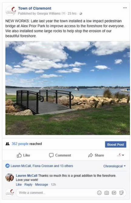
Alex Prior Swale and Bridge The swale and bridge were installed just prior to Christmas 2017 and feedback received from the community so far has been positive, as shown in Attachment 2. The swale coped well with the 1:300 year rainfall event in January and stopped any serious erosion of the beach which used to occur on every significant rainfall event. The bridge provides improved access for people with prams and limited mobility. Additional planting of reeds will occur at the same time as the Chester Road planting in late March or early April. Sand accretion and erosion management As per the FMP there is a recommendation to harvest sand on the eastern side of Claremont Yacht Club to use for renourishment of beach at the Chester Road on both the eastern and western side approximately every two years. To undertake this activity, a sand management plan will need to be developed. This will require approval, or endorsement, from the Department of Biodiversity, Conservation and Attractions, the South West Aboriginal Land and Sea Council,
FORESHORE ADVISORY COMMITTEE AGENDA 21 FEBRUARY, 2018
Page 5
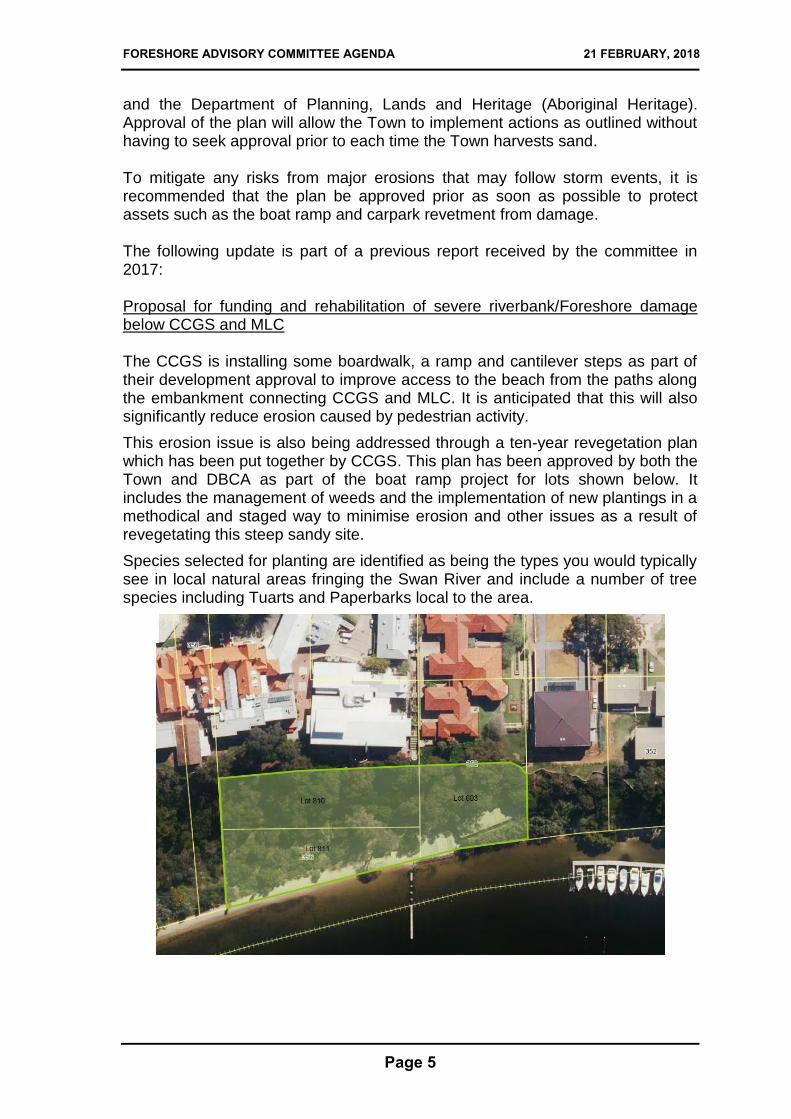
and the Department of Planning, Lands and Heritage (Aboriginal Heritage). Approval of the plan will allow the Town to implement actions as outlined without having to seek approval prior to each time the Town harvests sand. To mitigate any risks from major erosions that may follow storm events, it is recommended that the plan be approved prior as soon as possible to protect assets such as the boat ramp and carpark revetment from damage. The following update is part of a previous report received by the committee in 2017: Proposal for funding and rehabilitation of severe riverbank/Foreshore damage below CCGS and MLC The CCGS is installing some boardwalk, a ramp and cantilever steps as part of their development approval to improve access to the beach from the paths along the embankment connecting CCGS and MLC. It is anticipated that this will also significantly reduce erosion caused by pedestrian activity.
This erosion issue is also being addressed through a ten-year revegetation plan which has been put together by CCGS. This plan has been approved by both the Town and DBCA as part of the boat ramp project for lots shown below. It includes the management of weeds and the implementation of new plantings in a methodical and staged way to minimise erosion and other issues as a result of revegetating this steep sandy site.
Species selected for planting are identified as being the types you would typically see in local natural areas fringing the Swan River and include a number of tree species including Tuarts and Paperbarks local to the area.
FORESHORE ADVISORY COMMITTEE AGENDA 21 FEBRUARY, 2018
Page 6
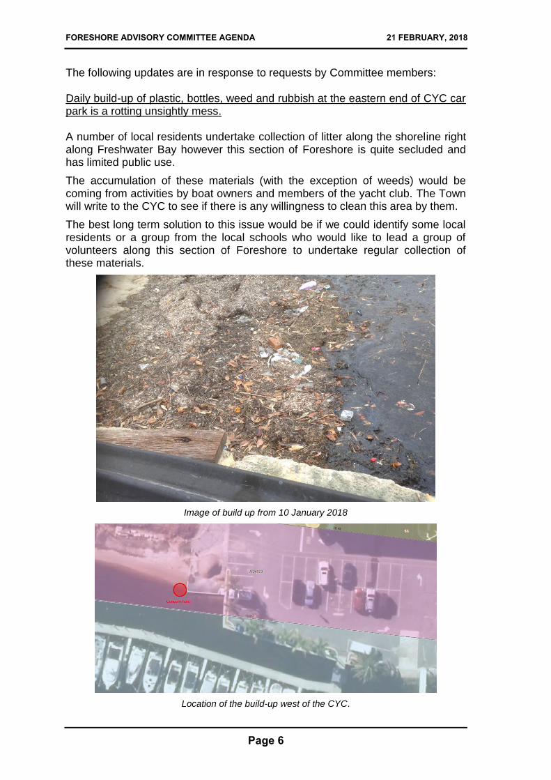
The following updates are in response to requests by Committee members: Daily build-up of plastic, bottles, weed and rubbish at the eastern end of CYC car park is a rotting unsightly mess. A number of local residents undertake collection of litter along the shoreline right along Freshwater Bay however this section of Foreshore is quite secluded and has limited public use.
The accumulation of these materials (with the exception of weeds) would be coming from activities by boat owners and members of the yacht club. The Town will write to the CYC to see if there is any willingness to clean this area by them.
The best long term solution to this issue would be if we could identify some local residents or a group from the local schools who would like to lead a group of volunteers along this section of Foreshore to undertake regular collection of these materials.
Image of build up from 10 January 2018
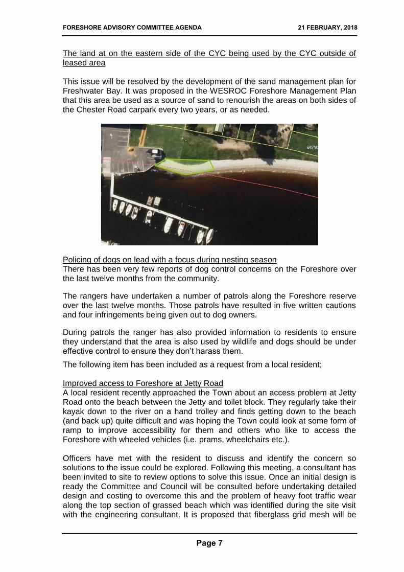
Location of the build-up west of the CYC.
FORESHORE ADVISORY COMMITTEE AGENDA 21 FEBRUARY, 2018
Page 7
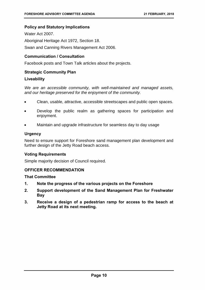
The land at on the eastern side of the CYC being used by the CYC outside of leased area This issue will be resolved by the development of the sand management plan for Freshwater Bay. It was proposed in the WESROC Foreshore Management Plan that this area be used as a source of sand to renourish the areas on both sides of the Chester Road carpark every two years, or as needed.
Policing of dogs on lead with a focus during nesting season There has been very few reports of dog control concerns on the Foreshore over the last twelve months from the community.
The rangers have undertaken a number of patrols along the Foreshore reserve over the last twelve months. Those patrols have resulted in five written cautions and four infringements being given out to dog owners.
During patrols the ranger has also provided information to residents to ensure they understand that the area is also used by wildlife and dogs should be under effective control to ensure they don’t harass them.
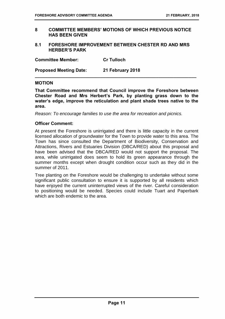
The following item has been included as a request from a local resident; Improved access to Foreshore at Jetty Road A local resident recently approached the Town about an access problem at Jetty Road onto the beach between the Jetty and toilet block. They regularly take their kayak down to the river on a hand trolley and finds getting down to the beach (and back up) quite difficult and was hoping the Town could look at some form of ramp to improve accessibility for them and others who like to access the Foreshore with wheeled vehicles (i.e. prams, wheelchairs etc.). Officers have met with the resident to discuss and identify the concern so solutions to the issue could be explored. Following this meeting, a consultant has been invited to site to review options to solve this issue. Once an initial design is ready the Committee and Council will be consulted before undertaking detailed design and costing to overcome this and the problem of heavy foot traffic wear along the top section of grassed beach which was identified during the site visit with the engineering consultant. It is proposed that fiberglass grid mesh will be

FORESHORE ADVISORY COMMITTEE AGENDA 21 FEBRUARY, 2018
Page 8
used as part of the design to ensure that this ramp doesn’t fail or become a slip hazard.
Location of proposed ramp and mesh walkway
Past Resolutions Ordinary Council Meeting 2 June 2015, Resolution 95/15:
That Council;
1. Supports the progress of the WESROC Foreshore Adaptation Plan.
2. Requests administration to liaise with the Swan River Trust to create some educational materials and guided walk programs for the Foreshore and for a report to be submitted to the Committee when program has been developed.
3. Requests for a report on Clean Up program for implementation in 2015-16 financial year.
4. Requests administration to ensure the jetty steps, the Alex Prior Drain and beach erosion be addressed in the Foreshore Adaptation Plan.
5. Requests the Foreshore Management Committee to reconsider its proposal about the management of dinghies having regard to Council decision (54/14 of 15 April 2014).
6. Requests administration to review on lead signage along Foreshore and for administration to develop some designs for interpretive signage.
CARRIED Ordinary Council Meeting 19 July 2016, Resolution 111/16:
That Council approves;
1. The WESROC Foreshore Management Plan Report.
2. The section Appendix E, relating to Town of Claremont.

FORESHORE ADVISORY COMMITTEE AGENDA 21 FEBRUARY, 2018
Page 9
3. The use of remaining budgets being for Foreshore Stage 1 Management Plan and River Foreshore Erosion control, to be used for the development of detailed plans for;
a) Chester Road car park modification design.
b) Alex Prior drain outfall.
c) Sand accretion and erosion management.
CARRIED Foreshore Advisory Committee Meeting 13 October 2016: That Committee supports the proposed design for Christ Church boat ramp and access subject to the following conditions:
1. Removal of redundant stairs previously providing access to Foreshore by Christ Church Grammar School and re-establish local native vegetation along the former stairway alignments.
2. Set ramp back to align with High Water Mark by cutting back failing wall on dinghy store to provide adequate room along beach and improve hydraulic smoothness or shoreline.
3. Redesign revetment in front of ramps and boat shed to re-establish a natural beach shoreline by removing redundant ramp to a point two meters north of High Water Mark and densely plant remaining revetment areas with Melaleuca and Saltbush as per the species nominated on the plan to improve sediment transport.
4. Provide new cantilever steps from the western landing to the Foreshore to the satisfaction of the Town of Claremont to improve pedestrian access to the Foreshore.
5. Remove all redundant building materials including but not limited to failed rock wall, ramp and revetment materials
6. Creation and implementation of a ten year revegetation plan to remove exotic plants and revegetate with provenance seed grown plants to slow erosion across the embankment to the satisfaction of the Town of Claremont.
7. Application is to be made to and a Section 18 approval is to be granted by Department of Indigenous Affairs.
CARRIED
Financial and Staff Implications Resource requirements are in accordance with existing budgetary allocation.
FORESHORE ADVISORY COMMITTEE AGENDA 21 FEBRUARY, 2018
Page 10
Policy and Statutory Implications Water Act 2007.
Aboriginal Heritage Act 1972, Section 18.
Swan and Canning Rivers Management Act 2006.
Communication / Consultation Facebook posts and Town Talk articles about the projects.
Strategic Community Plan Liveability
We are an accessible community, with well-maintained and managed assets, and our heritage preserved for the enjoyment of the community.
Clean, usable, attractive, accessible streetscapes and public open spaces.
Develop the public realm as gathering spaces for participation and enjoyment.
Maintain and upgrade infrastructure for seamless day to day usage
Urgency Need to ensure support for Foreshore sand management plan development and further design of the Jetty Road beach access.
Voting Requirements Simple majority decision of Council required.
OFFICER RECOMMENDATION
That Committee 1. Note the progress of the various projects on the Foreshore 2. Support development of the Sand Management Plan for Freshwater
Bay 3. Receive a design of a pedestrian ramp for access to the beach at
Jetty Road at its next meeting.
FORESHORE ADVISORY COMMITTEE AGENDA 21 FEBRUARY, 2018
Page 11
8 COMMITTEE MEMBERS’ MOTIONS OF WHICH PREVIOUS NOTICE HAS BEEN GIVEN
8.1 FORESHORE IMPROVEMENT BETWEEN CHESTER RD AND MRS HERBER’S PARK
Committee Member: Cr Tulloch Proposed Meeting Date: 21 February 2018 ________________________________________________________________
MOTION That Committee recommend that Council improve the Foreshore between Chester Road and Mrs Herbert’s Park, by planting grass down to the water’s edge, improve the reticulation and plant shade trees native to the area. Reason: To encourage families to use the area for recreation and picnics.
Officer Comment: At present the Foreshore is unirrigated and there is little capacity in the current licensed allocation of groundwater for the Town to provide water to this area. The Town has since consulted the Department of Biodiversity, Conservation and Attractions, Rivers and Estuaries Division (DBCA/RED) about this proposal and have been advised that the DBCA/RED would not support the proposal. The area, while unirrigated does seem to hold its green appearance through the summer months except when drought condition occur such as they did in the summer of 2011.
Tree planting on the Foreshore would be challenging to undertake without some significant public consultation to ensure it is supported by all residents which have enjoyed the current uninterrupted views of the river. Careful consideration to positioning would be needed. Species could include Tuart and Paperbark which are both endemic to the area.

FORESHORE ADVISORY COMMITTEE AGENDA 21 FEBRUARY, 2018
Page 12
FORESHORE ADVISORY COMMITTEE AGENDA 21 FEBRUARY, 2018
Page 13
9 FUTURE MEETINGS OF COMMITTEE
16 May 2018, 4pm 15 August 2018, 4pm 21 November 2018, 4pm
10 DECLARATION OF CLOSURE OF MEETING

FORESHORE ADVISORY COMMITTEE AGENDA 21 FEBRUARY, 2018
Page 14

FORESHORE ADVISORY COMMITTEE AGENDA 21 FEBRUARY, 2018
FORESHORE ADVISORYCOMMITTEE MEETING
A T T A C H M E N T S
21 FEBRUARY 2018

FORESHORE ADVISORY COMMITTEE AGENDA 21 FEBRUARY, 2018
FORESHORE ADVISORY COMMITTEE AGENDA 21 FEBRUARY, 2018
7. REPORTS OF THE CEO
7.1 INFRASTRUCTURE SERVICES
7.1.1 PROGRESS REPORT ON FORESHORE ACTIVITIES
ATTACHMENT 1 – FORESHORE MANAGEMENT PLAN APPENDIX E TOC
Pages 28

FORESHORE ADVISORY COMMITTEE AGENDA 21 FEBRUARY, 2018
SE018-01-Rev0 WESROC FMP 20160525 367
Appendix E Town of Claremont
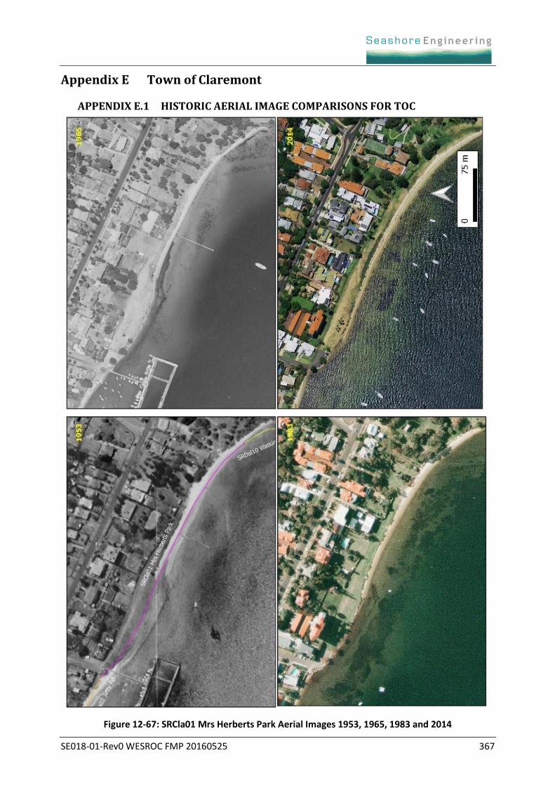
APPENDIX E.1 HISTORIC AERIAL IMAGE COMPARISONS FOR TOC
Figure 12-67: SRCla01 Mrs Herberts Park Aerial Images 1953, 1965, 1983 and 2014

SE018-01-Rev0 WESROC FMP 20160525 368
Figure 12-68: SRCla02 Jetty Rd Aerial Images 1953, 1965, 1983 and 2014
SE018-01-Rev0 WESROC FMP 20160525 369
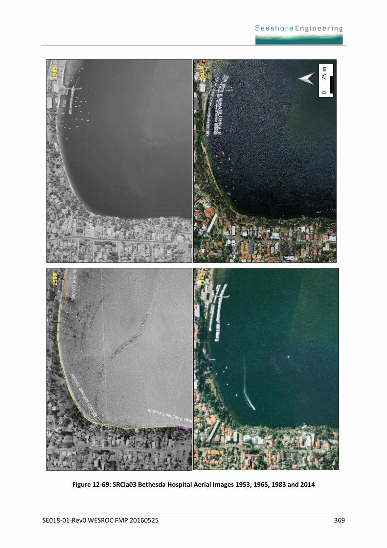
Figure 12-69: SRCla03 Bethesda Hospital Aerial Images 1953, 1965, 1983 and 2014
SE018-01-Rev0 WESROC FMP 20160525 370
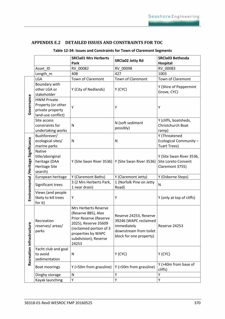
APPENDIX E.2 DETAILED ISSUES AND CONSTRAINTS FOR TOC
Table 12-34: Issues and Constraints for Town of Claremont Segments
SRCla01 Mrs Herberts Park
SRCla02 Jetty Rd SRCla03 Bethesda Hospital
Asset_ID RV_00082 RV_00098 RV_00083
Length_m 408 427 1003
Go
vern
ance
LGA Town of Claremont Town of Claremont Town of Claremont
Boundary with other LGA or stakeholder
Y (City of Nedlands) Y (CYC) Y (Shire of Peppermint Grove, CYC)
HWM Private Property (or other private property land-use conflict)
Y Y Y
Site access constraints for undertaking works
N N (soft sediment possibly)
Y (cliffs, boatsheds, Christchurch Boat ramp)
Envi
ron
me
nta
l /H
erit
age
Sig
nif
ican
ce Bushforever/
ecological sites/ marine parks
N N Y (Threatened Ecological Community – Tuart Trees)
Native title/aboriginal heritage (DAA Heritage Site search)
Y (Site Swan River 3536) Y (Site Swan River 3536) Y (Site Swan River 3536, Site Loreto Convent Claremont 3755)
European heritage Y (Claremont Baths) Y (Claremont Jetty) Y (Osborne Steps)
Significant trees 3 (2 Mrs Herberts Park, 1 near drain)
1 (Norfolk Pine on Jetty Road)
N
Views (and people likely to kill trees for it)
Y Y Y (only at top of cliffs)
Re
crea
tio
n in
fras
tru
ctu
re Recreation
reserves/ areas/ parks
Mrs Herberts Reserve (Reserve 885), Alex Prior Reserve (Reserve 2025), Reserve 35609 (reclaimed portion of 3 properties by WAPC subdivision), Reserve 24253
Reserve 24253, Reserve 39246 (WAPC reclaimed immediately downstream from toilet block for one property)
Reserve 24253
Yacht club and goal to avoid sedimentation
N Y (CYC) Y (CYC)
Boat moorings Y (>50m from grassline) Y (>50m from grassline) Y (>40m from base of cliffs)
Dinghy storage N Y Y
Kayak launching Y Y Y
SE018-01-Rev0 WESROC FMP 20160525 371
SRCla01 Mrs Herberts Park
SRCla02 Jetty Rd SRCla03 Bethesda Hospital
Boat ramps N Y (Chester Road) Y (CYC private ramp, Christchurch boatshed private ramp)
Cycle path N N N
Toilet blocks Y (set back beyond inundation zone)
Y (Jetty Road) N
Car parks Y (Chester Road) Y (Jetty Road, also CYC but not public)
N (CYC in part but not public)
Infrastructure in inundation zone (100Yr ARI + SLR)
Y (carpark, rock revetment around carpark, boat ramp, Chester Road, drain, private property assets, seating, play equipment)
Y (Jetty Road carpark, Claremont Jetty, Jetty Road, toilets at Jetty Road, sewage pump station at Jetty Road, drains (groynes and flexmat in scour area), stairs, private property assets, seating, CYC infrastructure, flexmats adjacent to CYC)
Y (CYC infrastructure, Christchurch boatshed and boatramp (and broken jetty), Rock wall adjacent to Christchurch boatshed, private property assets (including boatsheds))
Stairs N Y (two sets of floating stairs (attached to jetty))
Y (on hill extending from Christchurch to mid-slope - creating UA issues)
Disabled access N (Chester road car park on to grassed area possible)
Y (Jetty Road carpark only on to Jetty Road. Needs relocation due to overbank runoff)
N
Seating Y Y N
Jetties (require navigability)
N Y Y (Private assets of CYC)
Re
spo
nse
to
mo
dif
icat
ion
s
Historic dredging <100m from shoreline
Y (not traditional dredging but rocks were excavated from the bed (pre-1931), Claremont baths may have been dredged)
Y (local excavation of material at CYC)
N
Historic dredging >100m from shoreline
Maybe Maybe N
Historic reclamation/ renourishment
Y (1920, 1931, additional dates unknown)
Y (1995, 1997, Unknown, 2004)
N
Structure extending riverward providing artificial control
Y (Chester Road carpark revetment and boat ramp [>20m extension])
Y (Jetty Road abutment, groynes at drains [3m], CYC [30m since 1953])
Y (CYC [30m since 1953], Christchurch boat ramp [5m now])
Previous structure extending riverward providing control, now removed
Y (Chester Road revetment pre-1931 alignment)
N N
SE018-01-Rev0 WESROC FMP 20160525 372
SRCla01 Mrs Herberts Park
SRCla02 Jetty Rd SRCla03 Bethesda Hospital
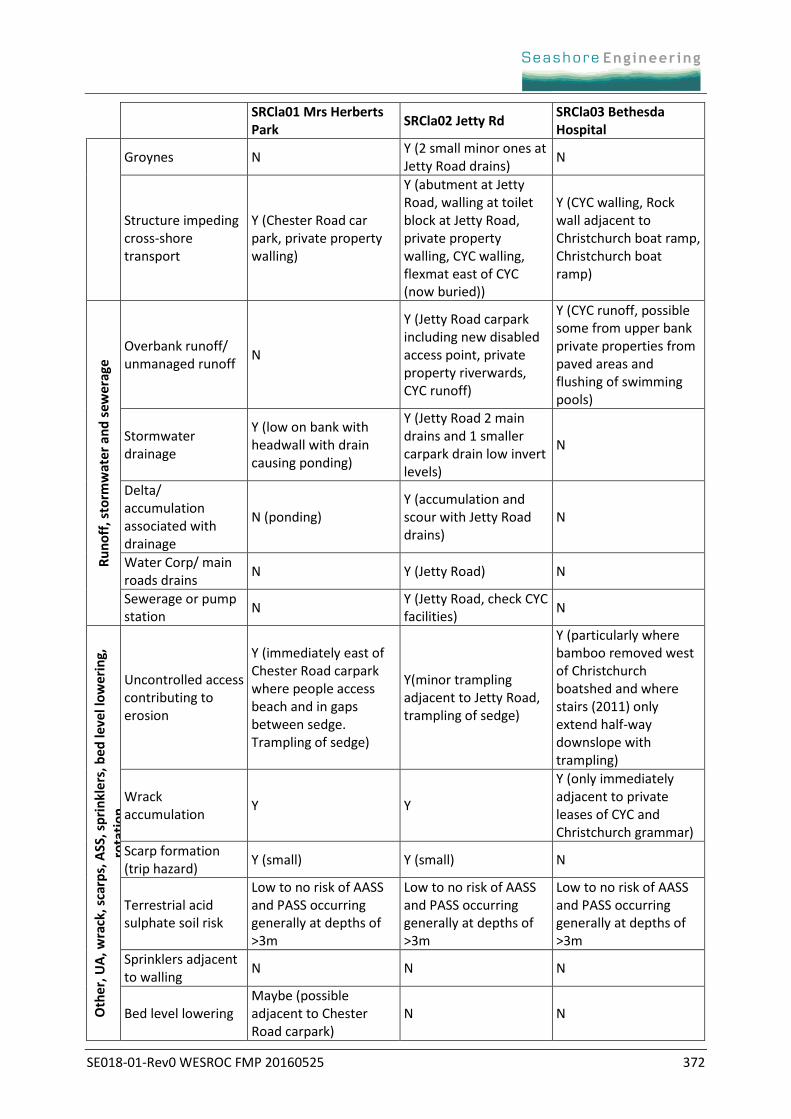
Groynes N Y (2 small minor ones at Jetty Road drains)
N
Structure impeding cross-shore transport
Y (Chester Road car park, private property walling)
Y (abutment at Jetty Road, walling at toilet block at Jetty Road, private property walling, CYC walling, flexmat east of CYC (now buried))
Y (CYC walling, Rock wall adjacent to Christchurch boat ramp, Christchurch boat ramp)
Ru
no
ff, s
torm
wat
er
and
sew
erag
e
Overbank runoff/ unmanaged runoff
N
Y (Jetty Road carpark including new disabled access point, private property riverwards, CYC runoff)
Y (CYC runoff, possible some from upper bank private properties from paved areas and flushing of swimming pools)
Stormwater drainage
Y (low on bank with headwall with drain causing ponding)
Y (Jetty Road 2 main drains and 1 smaller carpark drain low invert levels)
N
Delta/ accumulation associated with drainage
N (ponding) Y (accumulation and scour with Jetty Road drains)
N
Water Corp/ main roads drains
N Y (Jetty Road) N
Sewerage or pump station
N Y (Jetty Road, check CYC facilities)
N
Oth
er, U
A, w
rack
, sca
rps,
ASS
, sp
rin
kle
rs, b
ed le
vel l
ow
eri
ng,
rota
tio
n
Uncontrolled access contributing to erosion
Y (immediately east of Chester Road carpark where people access beach and in gaps between sedge. Trampling of sedge)
Y(minor trampling adjacent to Jetty Road, trampling of sedge)
Y (particularly where bamboo removed west of Christchurch boatshed and where stairs (2011) only extend half-way downslope with trampling)
Wrack accumulation
Y Y
Y (only immediately adjacent to private leases of CYC and Christchurch grammar)
Scarp formation (trip hazard)
Y (small) Y (small) N
Terrestrial acid sulphate soil risk
Low to no risk of AASS and PASS occurring generally at depths of >3m
Low to no risk of AASS and PASS occurring generally at depths of >3m
Low to no risk of AASS and PASS occurring generally at depths of >3m
Sprinklers adjacent to walling
N N N
Bed level lowering Maybe (possible adjacent to Chester Road carpark)
N N
SE018-01-Rev0 WESROC FMP 20160525 373
SRCla01 Mrs Herberts Park
SRCla02 Jetty Rd SRCla03 Bethesda Hospital
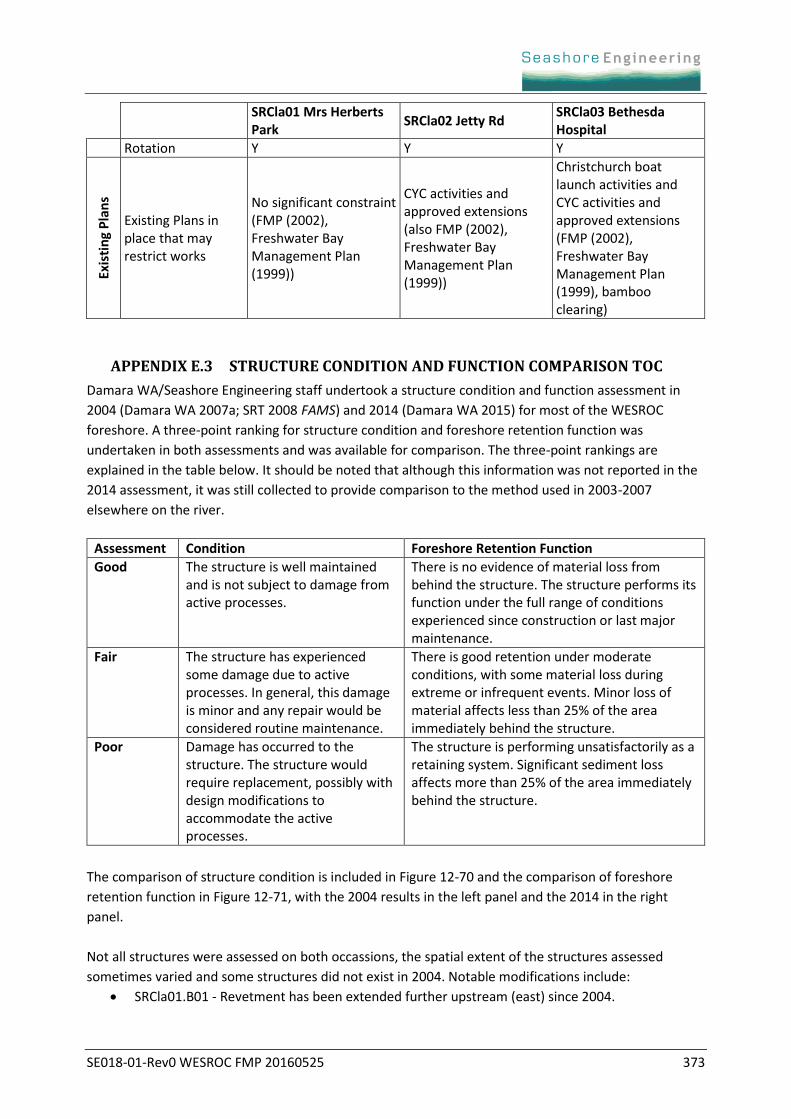
Rotation Y Y Y
Exis
tin
g P
lan
s
Existing Plans in place that may restrict works
No significant constraint (FMP (2002), Freshwater Bay Management Plan (1999))
CYC activities and approved extensions (also FMP (2002), Freshwater Bay Management Plan (1999))
Christchurch boat launch activities and CYC activities and approved extensions (FMP (2002), Freshwater Bay Management Plan (1999), bamboo clearing)
APPENDIX E.3 STRUCTURE CONDITION AND FUNCTION COMPARISON TOC
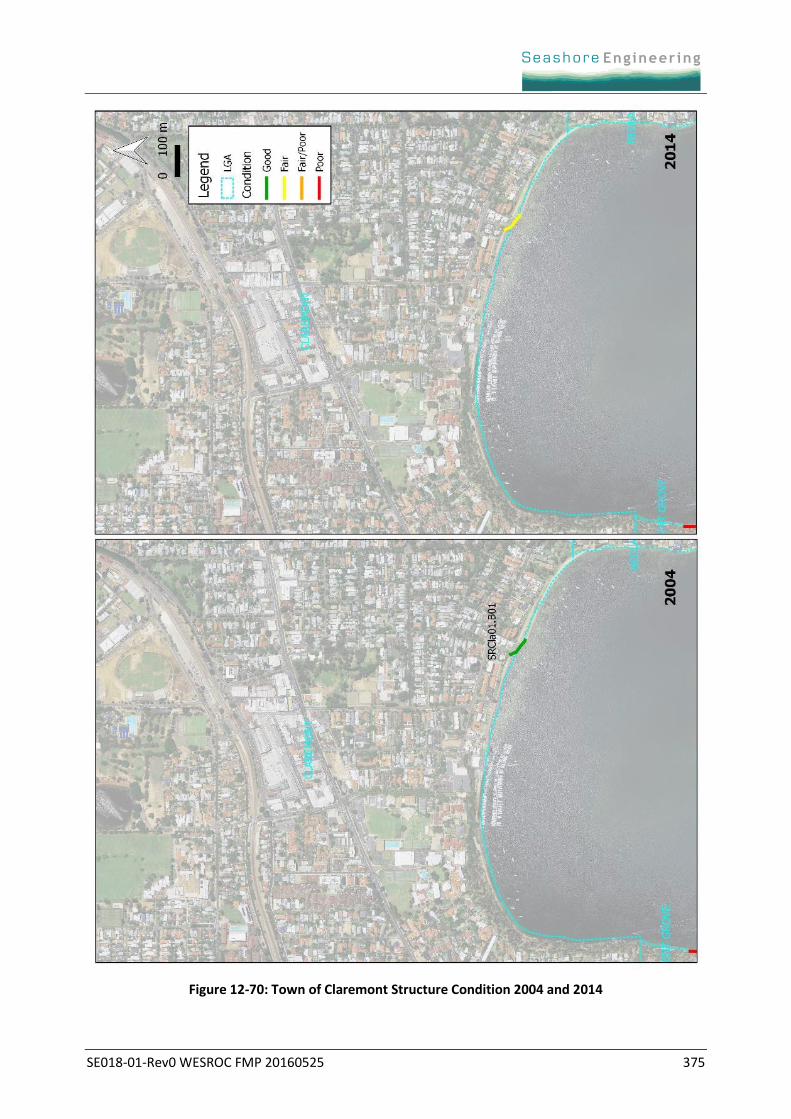
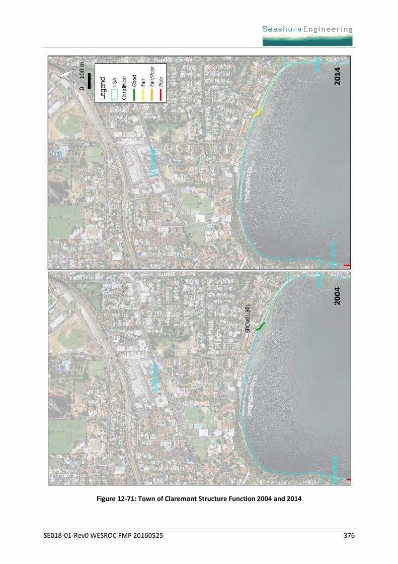
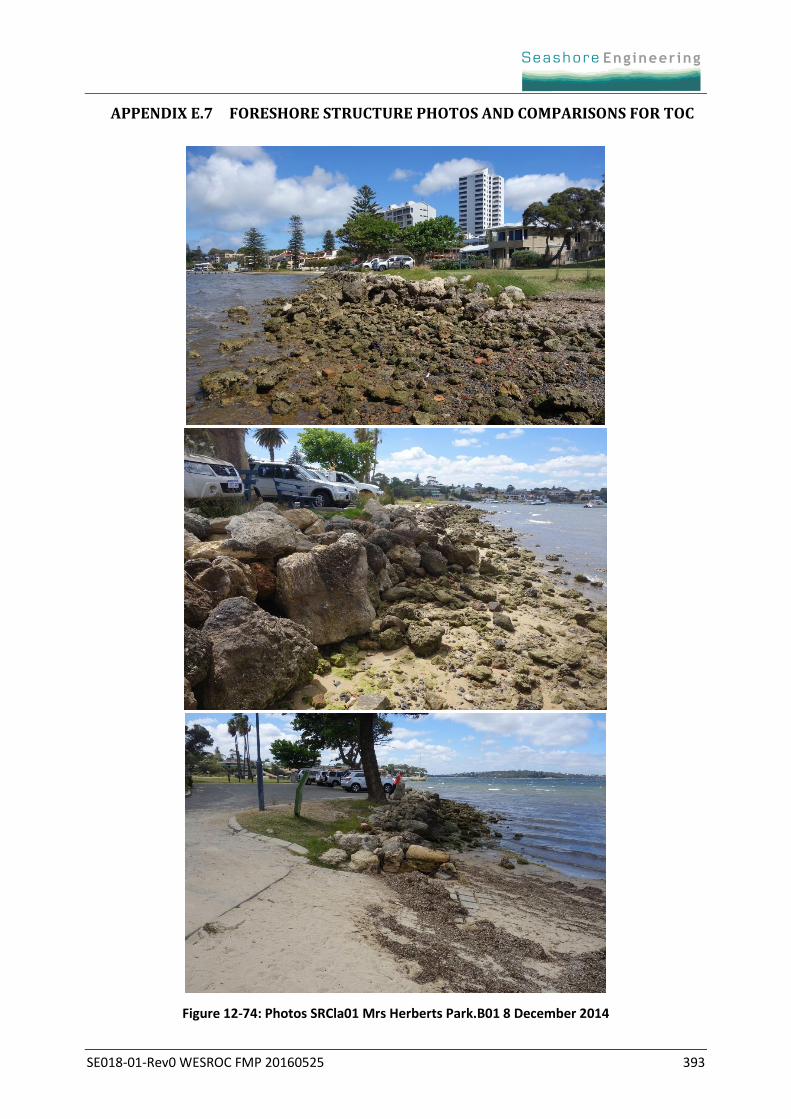
Damara WA/Seashore Engineering staff undertook a structure condition and function assessment in
2004 (Damara WA 2007a; SRT 2008 FAMS) and 2014 (Damara WA 2015) for most of the WESROC
foreshore. A three-point ranking for structure condition and foreshore retention function was
undertaken in both assessments and was available for comparison. The three-point rankings are
explained in the table below. It should be noted that although this information was not reported in the
2014 assessment, it was still collected to provide comparison to the method used in 2003-2007
elsewhere on the river.
Assessment Condition Foreshore Retention Function
Good The structure is well maintained and is not subject to damage from active processes.
There is no evidence of material loss from behind the structure. The structure performs its function under the full range of conditions experienced since construction or last major maintenance.
Fair The structure has experienced some damage due to active processes. In general, this damage is minor and any repair would be considered routine maintenance.
There is good retention under moderate conditions, with some material loss during extreme or infrequent events. Minor loss of material affects less than 25% of the area immediately behind the structure.
Poor Damage has occurred to the structure. The structure would require replacement, possibly with design modifications to accommodate the active processes.
The structure is performing unsatisfactorily as a retaining system. Significant sediment loss affects more than 25% of the area immediately behind the structure.
The comparison of structure condition is included in Figure 12-70 and the comparison of foreshore
retention function in Figure 12-71, with the 2004 results in the left panel and the 2014 in the right
panel.
Not all structures were assessed on both occassions, the spatial extent of the structures assessed
sometimes varied and some structures did not exist in 2004. Notable modifications include:
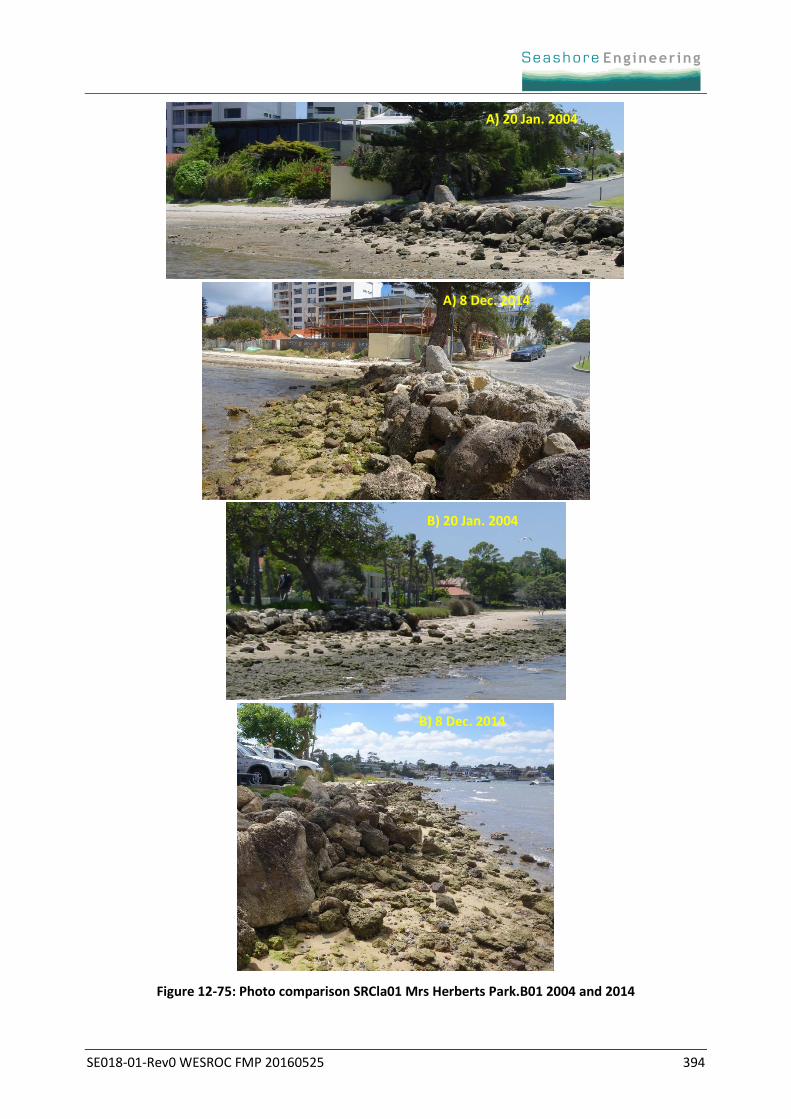
SRCla01.B01 - Revetment has been extended further upstream (east) since 2004.

SE018-01-Rev0 WESROC FMP 20160525 374
Further visual comparison between photos of structures, along with three photos of each structure is
provided in Appendix E.7. The 2014 photos of each structure are from Damara WA (2015), the
2003/2004 photos are from Damara WA (2003, 2007).
The 2014 assessment also noted any structures with areas of focal condition of 4 or 5 (out of a rank of
5, with 5 being the worst condition), which corresponds to focal areas of ‘poor’ condition according to
the three-point ranking in the table above. Structures not rated as poor, with small areas of condition 4
or 5 included:
Town of Claremont: SRCla01.B01
The information on where these focal areas of poor condition are located is included in Table 12-36.
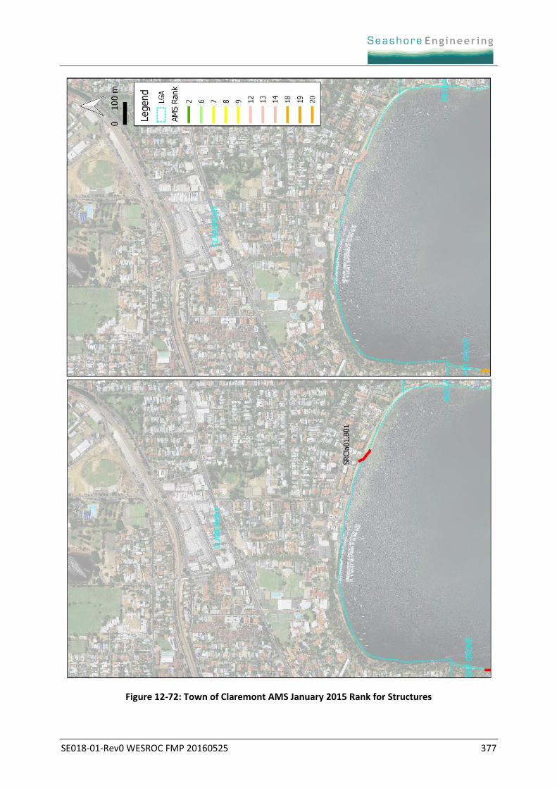
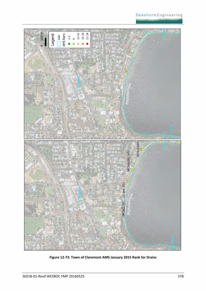
A visual representation of the combined condition and consequence ranking for structures and drains in
the WESROC area is provided. This rank is called the Asset Management System (AMS) Rank and it was
used in the recent assessment of asset condition for Parks and Wildlife (Damara WA 2015, after MP
Rogers & Associates 2013). This combined ranking is according to Table 12-35 with condition provided
as a rank of 1 (good) to 5 (poor) and consequence provided as a rank of 1 (low) to 5 (high). The
combined ranks are colour-coded into six ranks of management priority with red highest priority
through to dark green as lowest priority. A limitation of this approach is the rank was applied for the
whole foreshore subsegment and it does not incorporate small locations of failure.
Table 12-35: Asset Management System (AMS) Rank
The number of structures and drains (left panel), along with their AMS rank (right panel), are shown in
Figure 12-72 and Figure 12-73. Further explanation of the condition, consequences and management
requirements are provided in Table 12-36 and Table 12-37. Not all assets were assessed. For example,
drains ending in code .D0x were not assessed.
Condition
1 2 3 4 5
Co
nse
qu
en
ce 5 5 10 15 23 25
4 4 9 14 20 24
3 3 8 13 19 22
2 2 7 12 18 21
1 1 6 11 16 17
SE018-01-Rev0 WESROC FMP 20160525 375
Figure 12-70: Town of Claremont Structure Condition 2004 and 2014
SE018-01-Rev0 WESROC FMP 20160525 376
Figure 12-71: Town of Claremont Structure Function 2004 and 2014
SE018-01-Rev0 WESROC FMP 20160525 377
Figure 12-72: Town of Claremont AMS January 2015 Rank for Structures
SE018-01-Rev0 WESROC FMP 20160525 378
Figure 12-73: Town of Claremont AMS January 2015 Rank for Drains
SE018-01-Rev0 WESROC FMP 20160525 379
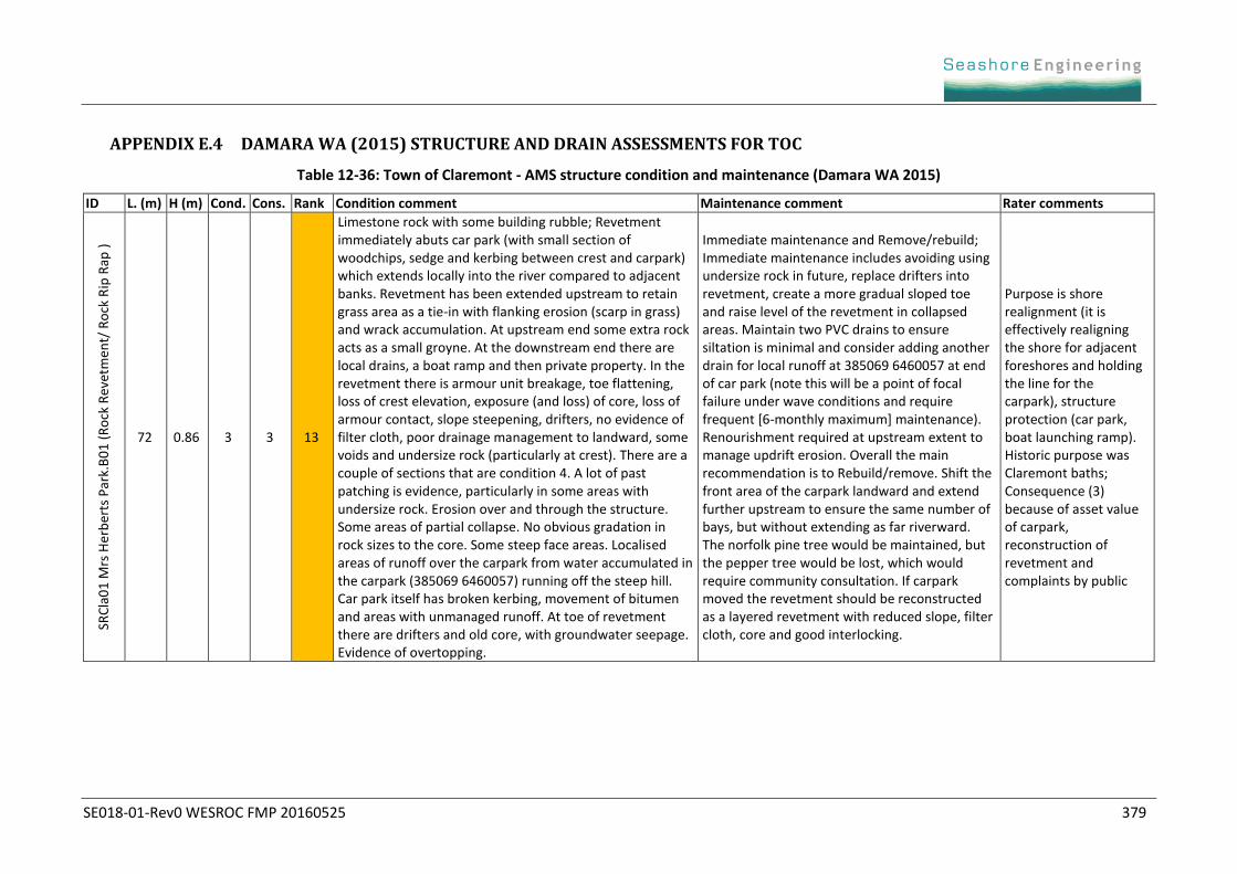
APPENDIX E.4 DAMARA WA (2015) STRUCTURE AND DRAIN ASSESSMENTS FOR TOC
Table 12-36: Town of Claremont - AMS structure condition and maintenance (Damara WA 2015)
ID L. (m) H (m) Cond. Cons. Rank Condition comment Maintenance comment Rater comments
SRC
la0
1 M
rs H
erb
erts
Par
k.B
01
(R
ock
Rev
etm
ent/
Ro
ck R
ip R
ap )
72 0.86 3 3 13
Limestone rock with some building rubble; Revetment immediately abuts car park (with small section of woodchips, sedge and kerbing between crest and carpark) which extends locally into the river compared to adjacent banks. Revetment has been extended upstream to retain grass area as a tie-in with flanking erosion (scarp in grass) and wrack accumulation. At upstream end some extra rock acts as a small groyne. At the downstream end there are local drains, a boat ramp and then private property. In the revetment there is armour unit breakage, toe flattening, loss of crest elevation, exposure (and loss) of core, loss of armour contact, slope steepening, drifters, no evidence of filter cloth, poor drainage management to landward, some voids and undersize rock (particularly at crest). There are a couple of sections that are condition 4. A lot of past patching is evidence, particularly in some areas with undersize rock. Erosion over and through the structure. Some areas of partial collapse. No obvious gradation in rock sizes to the core. Some steep face areas. Localised areas of runoff over the carpark from water accumulated in the carpark (385069 6460057) running off the steep hill. Car park itself has broken kerbing, movement of bitumen and areas with unmanaged runoff. At toe of revetment there are drifters and old core, with groundwater seepage. Evidence of overtopping.
Immediate maintenance and Remove/rebuild; Immediate maintenance includes avoiding using undersize rock in future, replace drifters into revetment, create a more gradual sloped toe and raise level of the revetment in collapsed areas. Maintain two PVC drains to ensure siltation is minimal and consider adding another drain for local runoff at 385069 6460057 at end of car park (note this will be a point of focal failure under wave conditions and require frequent [6-monthly maximum] maintenance). Renourishment required at upstream extent to manage updrift erosion. Overall the main recommendation is to Rebuild/remove. Shift the front area of the carpark landward and extend further upstream to ensure the same number of bays, but without extending as far riverward. The norfolk pine tree would be maintained, but the pepper tree would be lost, which would require community consultation. If carpark moved the revetment should be reconstructed as a layered revetment with reduced slope, filter cloth, core and good interlocking.
Purpose is shore realignment (it is effectively realigning the shore for adjacent foreshores and holding the line for the carpark), structure protection (car park, boat launching ramp). Historic purpose was Claremont baths; Consequence (3) because of asset value of carpark, reconstruction of revetment and complaints by public
SE018-01-Rev0 WESROC FMP 20160525 380
Table 12-37: Town of Claremont - AMS drains condition and maintenance (Damara WA 2015)
ID Int Diam (mm)
Invert (m)
Cond. Cons. Rank
Condition comment Maintenance comment Rater comments
SRCla01 Mrs Herberts Park.D01
225; 225
0.594; 0.417
3 2 12
PVC; 2 small pipes that locally drain car park adjacent to steep Chester Road. Some siltation of the two drains with leaf litter likely to often obscure drains. Discharge to within large revetment. Not lowest point in carpark so not all runoff flows to this drain. Flows off at low point in car park/revetment as identified in B01
No urgent works required; Ongoing (6-weekly) clearing of vegetation and leaf litter on landward and riverward sides of drains.
Consequence (2) if drain is blocked, water from steep Chester Road accumulates in car park and flows off at low point in car park/revetment.
SRCla02 Jetty Rd.D01
900 -0.02 3 4 14
Concrete; gross pollutant trap (GPT). Water Corporation - Large round drain and in conjunction with a large rectangular drain (D02) discharges into the same area, creating the same problems. Discharges into an area with decking above, channelled between two training walls (grouted limestone blocks), with insufficient grout. Adjacent to decking is the Claremont Jetty. Sand bar forms between two training walls blocking stormwater flow from the drains and the draining of water from high water level events in the river. At the time of assessment a scour channel had formed in the bar to allow the release of water. Trapped water could also have trapped seagrass emanating a sulfurous smell (concern for local residents). Area is susceptible to scour during large flow events, with a scour hole >0.5m deep on the terrace, full of wrack during the December 2014 assessment. Landward of the scour hole is a 150mm x 150mm flexmat (flexible concrete block mattress), with scour riverward.
Immediate maintenance; Re-grout limestone block groynes. Do not install any larger scour management plans for these drains (no larger scour apron). If smell is a concern - dig out sand bar and allow to flush when required or dig out decomposing wrack and seagrass. Remove decomposing wrack and seagrass also from scour hole to reduce smell.
Consequence (4) because of the local scour and blocking caused by movement of the beach and interaction with the flow from the large Water Corporation drains. When drain is blocked there can be a bad odour from decomposing wrack generating a lot of complaints. Local loss of beach also a concern. Scour hole a safety hazard.
SE018-01-Rev0 WESROC FMP 20160525 381
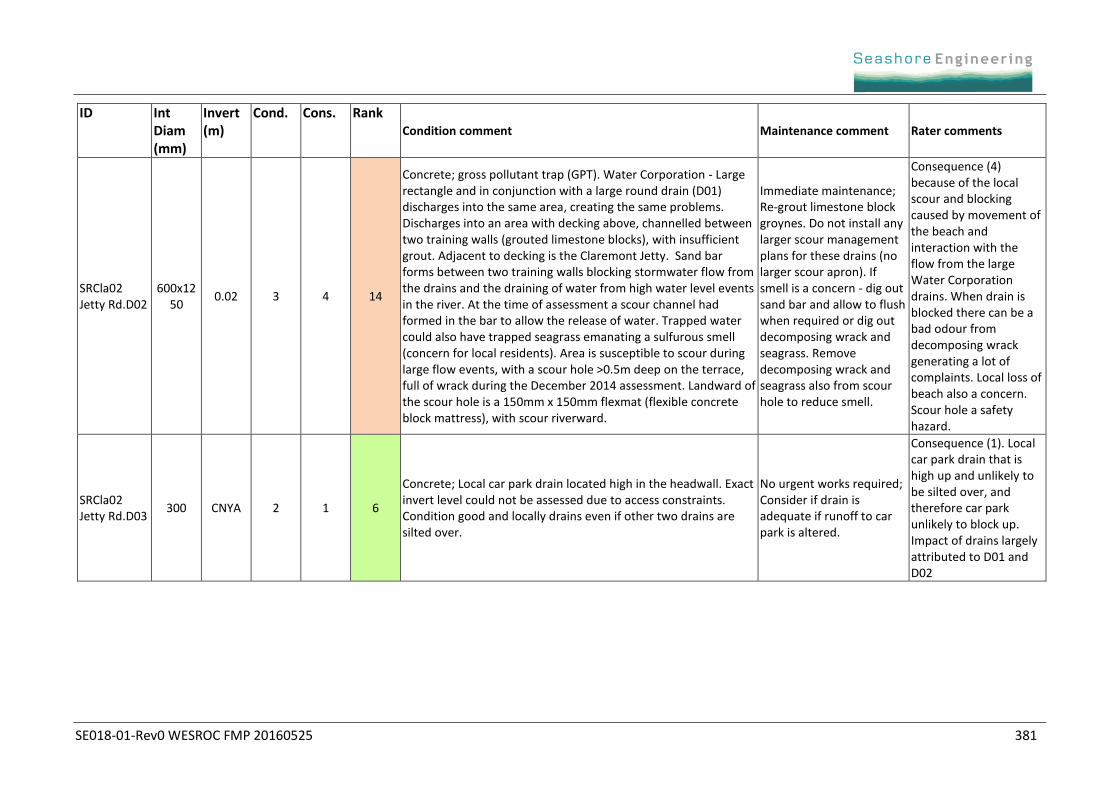
ID Int Diam (mm)
Invert (m)
Cond. Cons. Rank
Condition comment Maintenance comment Rater comments
SRCla02 Jetty Rd.D02
600x1250
0.02 3 4 14
Concrete; gross pollutant trap (GPT). Water Corporation - Large rectangle and in conjunction with a large round drain (D01) discharges into the same area, creating the same problems. Discharges into an area with decking above, channelled between two training walls (grouted limestone blocks), with insufficient grout. Adjacent to decking is the Claremont Jetty. Sand bar forms between two training walls blocking stormwater flow from the drains and the draining of water from high water level events in the river. At the time of assessment a scour channel had formed in the bar to allow the release of water. Trapped water could also have trapped seagrass emanating a sulfurous smell (concern for local residents). Area is susceptible to scour during large flow events, with a scour hole >0.5m deep on the terrace, full of wrack during the December 2014 assessment. Landward of the scour hole is a 150mm x 150mm flexmat (flexible concrete block mattress), with scour riverward.
Immediate maintenance; Re-grout limestone block groynes. Do not install any larger scour management plans for these drains (no larger scour apron). If smell is a concern - dig out sand bar and allow to flush when required or dig out decomposing wrack and seagrass. Remove decomposing wrack and seagrass also from scour hole to reduce smell.
Consequence (4) because of the local scour and blocking caused by movement of the beach and interaction with the flow from the large Water Corporation drains. When drain is blocked there can be a bad odour from decomposing wrack generating a lot of complaints. Local loss of beach also a concern. Scour hole a safety hazard.
SRCla02 Jetty Rd.D03
300 CNYA 2 1 6
Concrete; Local car park drain located high in the headwall. Exact invert level could not be assessed due to access constraints. Condition good and locally drains even if other two drains are silted over.
No urgent works required; Consider if drain is adequate if runoff to car park is altered.
Consequence (1). Local car park drain that is high up and unlikely to be silted over, and therefore car park unlikely to block up. Impact of drains largely attributed to D01 and D02
SE018-01-Rev0 WESROC FMP 20160525 382
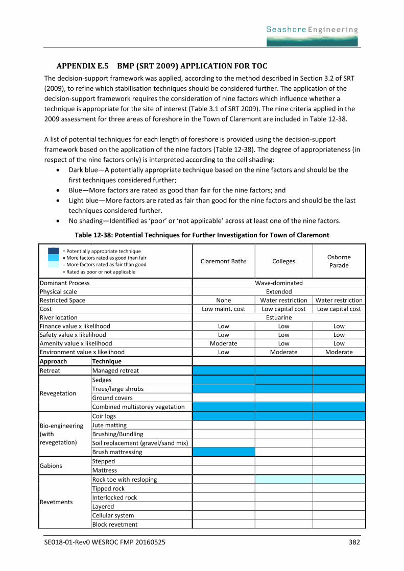
APPENDIX E.5 BMP (SRT 2009) APPLICATION FOR TOC
The decision-support framework was applied, according to the method described in Section 3.2 of SRT
(2009), to refine which stabilisation techniques should be considered further. The application of the
decision-support framework requires the consideration of nine factors which influence whether a
technique is appropriate for the site of interest (Table 3.1 of SRT 2009). The nine criteria applied in the
2009 assessment for three areas of foreshore in the Town of Claremont are included in Table 12-38.
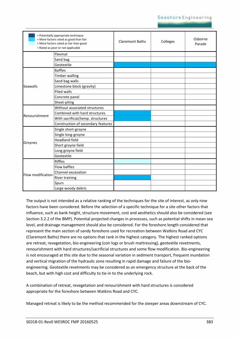
A list of potential techniques for each length of foreshore is provided using the decision-support
framework based on the application of the nine factors (Table 12-38). The degree of appropriateness (in
respect of the nine factors only) is interpreted according to the cell shading:
Dark blue—A potentially appropriate technique based on the nine factors and should be the
first techniques considered further;
Blue—More factors are rated as good than fair for the nine factors; and
Light blue—More factors are rated as fair than good for the nine factors and should be the last
techniques considered further.
No shading—Identified as ‘poor’ or ‘not applicable’ across at least one of the nine factors.
Table 12-38: Potential Techniques for Further Investigation for Town of Claremont
Claremont Baths Colleges Osborne Parade
Dominant Process Wave-dominated
Physical scale Extended
Restricted Space None Water restriction Water restriction
Cost Low maint. cost Low capital cost Low capital cost
River location Estuarine
Finance value x likelihood Low Low Low
Safety value x likelihood Low Low Low
Amenity value x likelihood Moderate Low Low
Environment value x likelihood Low Moderate Moderate
Approach Technique
Retreat Managed retreat
Revegetation
Sedges
Trees/large shrubs
Ground covers
Combined multistorey vegetation
Bio-engineering (with revegetation)
Coir logs
Jute matting
Brushing/Bundling
Soil replacement (gravel/sand mix)
Brush mattressing
Gabions Stepped
Mattress
Revetments
Rock toe with resloping
Tipped rock
Interlocked rock
Layered
Cellular system
Block revetment
= Potentially appropriate technique = More factors rated as good than fair = More factors rated as fair than good
= Rated as poor or not applicable
SE018-01-Rev0 WESROC FMP 20160525 383
Claremont Baths Colleges Osborne Parade
Flexmat
Sand bag
Geotextile
Seawalls
Baffles
Timber walling
Sand bag walls
Limestone block (gravity)
Piled walls
Concrete panel
Sheet-piling
Renourishment
Without associated structures
Combined with hard structures
With sacrificial/temp. structures
Construction of secondary features
Groynes
Single short-groyne
Single long-groyne
Headland field
Short groyne field
Long groyne field
Geotextile
Flow modification
Riffles
Flow baffles
Channel excavation
River training
Spurs
Large woody debris
The output is not intended as a relative ranking of the techniques for the site of interest, as only nine
factors have been considered. Before the selection of a specific technique for a site other factors that
influence, such as bank height, structure movement, cost and aesthetics should also be considered (see
Section 3.2.2 of the BMP). Potential projected changes in processes, such as potential shifts in mean sea
level, and drainage management should also be considered. For the foreshore length considered that
represent the main section of sandy foreshore used for recreation between Watkins Road and CYC
(Claremont Baths) there are no options that rank in the highest category. The highest ranked options
are retreat, revegetation, bio-engineering (coir logs or brush mattressing), geotextile revetments,
renourishment with hard structures/sacrificial structures and some flow modification. Bio-engineering
is not encouraged at this site due to the seasonal variation in sediment transport, frequent inundation
and vertical migration of the hydraulic zone resulting in rapid damage and failure of the bio-
engineering. Geotextile revetments may be considered as an emergency structure at the back of the
beach, but with high cost and difficulty to tie-in to the underlying rock.
A combination of retreat, revegetation and renourishment with hard structures is considered
appropriate for the foreshore between Watkins Road and CYC.
Managed retreat is likely to be the method recommended for the steeper areas downstream of CYC.
= Potentially appropriate technique = More factors rated as good than fair = More factors rated as fair than good
= Rated as poor or not applicable
SE018-01-Rev0 WESROC FMP 20160525 384
APPENDIX E.6 DETAILED TABLES ON WORKS FOR EACH SEGMENT FOR TOC
Table 12-39: Segment SRCla01 Mrs Herberts Park
Short-term (risk management) for 0-5 years
Goal Capital works and costs Maintenance works & costs
Improve resilience for interannual variations in MSL and winds.
Modify car park revetment for gradual tie-in to the east, increasing the curve to landwards and a more smooth transition. Cost: $10-15k (price increase may occur if pre-1931 reclaimed area requires excavation). Reuse existing rock.
Create small drain or drainage chute (grouted rock channel with low point to channel flow) at the low point in the car park. Cost: $2-3k
Manually breach the sand bar at the Alex Prior drain (≈monthly towards neap tides). Sediment can infill the scour hole under the drain (reduce ponding) or go on adjacent beach. Cost: In-kind labour
Maintain sedge. Cost: $2k pa + in-kind labour
Minor renourishment adjacent to Chester Rd car park using 100 m3 sand from CYC. Annual or 2-yearly with dependent on wind patterns (or linked to other sand harvesting). Cost: $3.5k. Sand from CYC (2-yearly)
Backfill between revetment crest and car park. Create a wider splash zone at the crest between the top of revetment and car park kerbing. Cost for backfill with coarse gravel: $2k pa + in-kind labour
Monitoring (all timeframes)
Tabulate records of rates and timing of revegetation, backpassing, renourishment, drain storm bar breaching (Alex Prior Park) and repairs to the rock revetment and car park.
Annual and post-event revetment inspection.
Annual photos at 50m intervals.
Monthly photos of beach widths at fixed locations.
Issues to be resolved (all timeframes)
Identify when car park surface renewal is planned, and when renewal of Alex Prior Park drain is planned.
Long-term plans of narrowing car park require a groyne to be constructed at CYC (see SRCla02 Table 12-40).
Private property owners to be informed of future requirements for works to mitigate erosion/inundation hazard.
An agreed plan required with CoN for management at Watkins Road to minimise transfer of erosion hazard to ToC.
Community awareness about the natural processes that govern seagrass wrack accumulation on the beach.
Whadjuk approval for excavation of the car park and revetment, and construction of the groyne (long-term).
Cease WAPC resumption of land during subdivision process.
SE018-01-Rev0 WESROC FMP 20160525 385
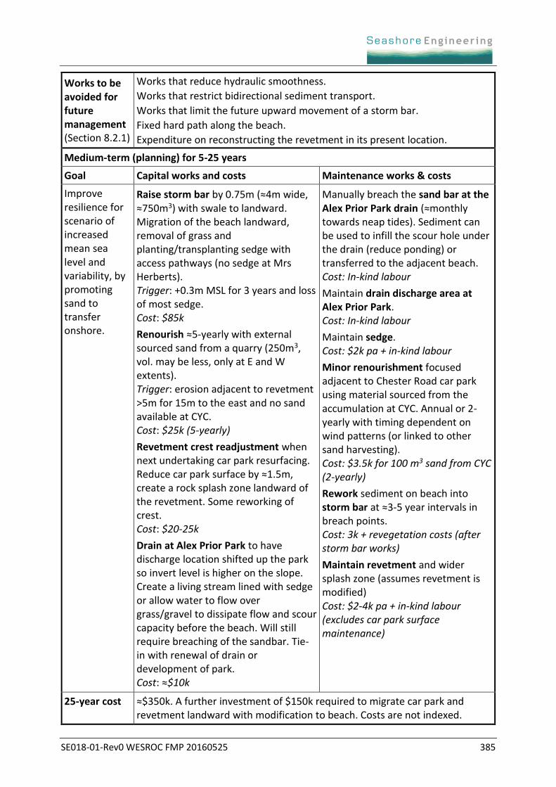
Works to be avoided for future management (Section 8.2.1)
Works that reduce hydraulic smoothness.
Works that restrict bidirectional sediment transport.
Works that limit the future upward movement of a storm bar.
Fixed hard path along the beach.
Expenditure on reconstructing the revetment in its present location.
Medium-term (planning) for 5-25 years
Goal Capital works and costs Maintenance works & costs
Improve resilience for scenario of increased mean sea level and variability, by promoting sand to transfer onshore.
Raise storm bar by 0.75m (≈4m wide, ≈750m3) with swale to landward. Migration of the beach landward, removal of grass and planting/transplanting sedge with access pathways (no sedge at Mrs Herberts). Trigger: +0.3m MSL for 3 years and loss of most sedge. Cost: $85k
Renourish ≈5-yearly with external sourced sand from a quarry (250m3, vol. may be less, only at E and W extents). Trigger: erosion adjacent to revetment >5m for 15m to the east and no sand available at CYC. Cost: $25k (5-yearly)
Revetment crest readjustment when next undertaking car park resurfacing. Reduce car park surface by ≈1.5m, create a rock splash zone landward of the revetment. Some reworking of crest. Cost: $20-25k
Drain at Alex Prior Park to have discharge location shifted up the park so invert level is higher on the slope. Create a living stream lined with sedge or allow water to flow over grass/gravel to dissipate flow and scour capacity before the beach. Will still require breaching of the sandbar. Tie-in with renewal of drain or development of park. Cost: ≈$10k
Manually breach the sand bar at the Alex Prior Park drain (≈monthly towards neap tides). Sediment can be used to infill the scour hole under the drain (reduce ponding) or transferred to the adjacent beach. Cost: In-kind labour
Maintain drain discharge area at Alex Prior Park. Cost: In-kind labour
Maintain sedge. Cost: $2k pa + in-kind labour
Minor renourishment focused adjacent to Chester Road car park using material sourced from the accumulation at CYC. Annual or 2-yearly with timing dependent on wind patterns (or linked to other sand harvesting). Cost: $3.5k for 100 m3 sand from CYC (2-yearly)
Rework sediment on beach into storm bar at ≈3-5 year intervals in breach points. Cost: 3k + revegetation costs (after storm bar works)
Maintain revetment and wider splash zone (assumes revetment is modified) Cost: $2-4k pa + in-kind labour (excludes car park surface maintenance)
25-year cost ≈$350k. A further investment of $150k required to migrate car park and revetment landward with modification to beach. Costs are not indexed.

SE018-01-Rev0 WESROC FMP 20160525 386
Long-term (strategy) for >25 years
Goal Capital works and costs Maintenance works & costs
Progressive retreat to allow for mean sea level increase.
Once beach has narrowed the car park will be narrowed and extended east to have similar capacity for car-parking (and access to private property) with reduced control on adjacent foreshores. Excavation of remnant rocks from revetment and reclaimed area will be required and available for use. Requires groyne at CYC first. Approximately 255m3 material excavated (car park and revetment) and 52.5m3 bitumen disposed. 60m x 10m car park construction with drainage and a 72m rock revetment 1.25m height, with broad splash zone. Trigger: maintenance costs for revetment and car park exceed 10% capital costs over 5 years (ie $15k) and annual renourishment required from external sources. Cost: $125k (exc. Groyne – see Table 12-40) + $10k for regrading/revegetation of beach east of new car park.
Renourish ≈3-5-yearly with external sourced sand from quarry (250m3). Trigger: erosion adjacent to revetment >5m for 15m to the east and no sand available at CYC. Cost: $25k (3- to 5-yearly)
Drain at Alex Prior Park could be consolidated into groundwater recharge within the park. Avoid increasing flow if land is developed. Not costed
As beach responds to new car park alignment continue to regrade beach areas into a storm bar and swale. Cost: $5k pa for first few years after car park construction
Maintain sedge. Cost: $3k pa + in-kind labour
Minor renourishment focused adjacent to Chester Road car park using material sourced from the accumulation at CYC (likely groyne). Annual or 2-yearly with timing dependent on wind patterns (or linked to other sand harvesting). Cost: $3.5k for 100 m3 sand from CYC
Rework sediment on beach into storm bar at ≈3-5 year intervals in breach points. Cost: 3k + revegetation costs
Maintain revetment and wider splash zone. Cost: $3k pa + in-kind labour
Raise storm bar again Trigger: if sustained >+0.5m MSL occurs. Not costed
SE018-01-Rev0 WESROC FMP 20160525 387
Table 12-40: Segment SRCla02 Jetty Rd
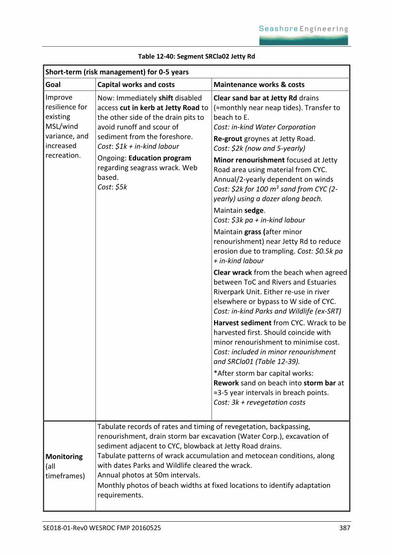
Short-term (risk management) for 0-5 years
Goal Capital works and costs Maintenance works & costs
Improve resilience for existing MSL/wind variance, and increased recreation.
Now: Immediately shift disabled access cut in kerb at Jetty Road to the other side of the drain pits to avoid runoff and scour of sediment from the foreshore. Cost: $1k + in-kind labour
Ongoing: Education program regarding seagrass wrack. Web based. Cost: $5k
Clear sand bar at Jetty Rd drains (≈monthly near neap tides). Transfer to beach to E. Cost: in-kind Water Corporation
Re-grout groynes at Jetty Road. Cost: $2k (now and 5-yearly)
Minor renourishment focused at Jetty Road area using material from CYC. Annual/2-yearly dependent on winds Cost: $2k for 100 m3 sand from CYC (2-yearly) using a dozer along beach.
Maintain sedge. Cost: $3k pa + in-kind labour
Maintain grass (after minor renourishment) near Jetty Rd to reduce erosion due to trampling. Cost: $0.5k pa + in-kind labour
Clear wrack from the beach when agreed between ToC and Rivers and Estuaries Riverpark Unit. Either re-use in river elsewhere or bypass to W side of CYC. Cost: in-kind Parks and Wildlife (ex-SRT)
Harvest sediment from CYC. Wrack to be harvested first. Should coincide with minor renourishment to minimise cost. Cost: included in minor renourishment and SRCla01 (Table 12-39).
*After storm bar capital works: Rework sand on beach into storm bar at ≈3-5 year intervals in breach points. Cost: 3k + revegetation costs
Monitoring (all timeframes)
Tabulate records of rates and timing of revegetation, backpassing, renourishment, drain storm bar excavation (Water Corp.), excavation of sediment adjacent to CYC, blowback at Jetty Road drains. Tabulate patterns of wrack accumulation and metocean conditions, along with dates Parks and Wildlife cleared the wrack. Annual photos at 50m intervals.
Monthly photos of beach widths at fixed locations to identify adaptation requirements.

SE018-01-Rev0 WESROC FMP 20160525 388
Issues to be resolved (all timeframes)
Identify when Water Corporation are planning on renewing the Jetty Road drains, plans for the sewage pump station and sewage overflow tanks. Restrict any CYC expansion riverward or to the east. ToC to depend on sand at E of the parking area for other areas (Chester & Jetty Rds) during periods of net W transport. Walling at eastern extent of car park may require strengthening (CYC), with CYC responsible for maintenance and renewal of their structures. Sand harvesting area underlay by flexmats ca 1997. CYC to manage runoff from hard areas away from sand harvesting area. Water Corp. commitment to monthly clearing of sand bar at Jetty Rd drains. Parks and Wildlife commitment to clearing seagrass wrack and maintaining in the system. The requirement will increase once the groyne is installed. Arrangement with CYC, Parks and Wildlife and ToC for wrack clearing near CYC, harvesting sand at CYC and backpassing here and SRCla01 (Table 12-39). Inform private property owners of requirements to mitigate erosion/ inundation hazard. Community awareness about the natural processes of wrack accumulation. Ensure groyne is constructed before large renourishment programs and car park revetment retreat (SRCla01 Table 12-39). Whadjuk approval for construction of the groyne (long-term). Resolve any potential issues with ponding or increased inundation hazard on low-lying private properties due to raising the foreshore area (long-term).
Cease WAPC resumption of land during subdivision process.
Works to be avoided for future management (Section 8.2.1)
Large renourishment before CYC groyne construction to avoid sedimentation of CYC. Minor renourishment at focal locations (e.g. Jetty Rd) are fine. Reducing hydraulic smoothness (e.g. impervious structures under the jetty). Works that restrict bidirectional sediment transport. Works that limit upward storm bar movement & raising the foreshore level. Fixed hard path along the beach. Works that restrict harvesting of sand adjacent to CYC. High capital investment at landward extent of the jetty. Damage to Norfolk pine at Jetty Road. Harvesting sand for external use, other than renourishment of ToC beaches. Removing seagrass wrack from Swan-Canning System (biological impacts).
New and expensive infrastructure in the inundation hazard zone.
Medium-term (planning) for 5-25 years
Goal Capital works and costs Maintenance works & costs
Extend existing foreshore use for as long as possible.
Raise storm bar by 0.75m (≈4m wide, ≈825m3) with landward swale. Landward beach migration, removal of grass, plant sedge with access paths (no sedge in high use areas). Raise foreshore level (long-term) sooner if a cheap supply of sand is available. Trigger: +0.3m MSL for 3 years & loss of most sedge. Cost: $100k
See 0-5 year column.
SE018-01-Rev0 WESROC FMP 20160525 389
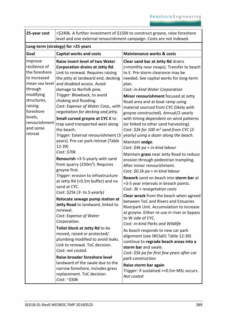
25-year cost ≈$240k. A further investment of $150k to construct groyne, raise foreshore level and one external renourishment campaign. Costs are not indexed.
Long-term (strategy) for >25 years
Goal Capital works and costs Maintenance works & costs
Improve resilience of the foreshore to increased mean sea level through modifying structures, raising foreshore levels, renourishment and some retreat
Raise invert level of two Water Corporation drains at Jetty Rd. Link to renewal. Requires raising the jetty at landward end, decking and disabled access. Avoid damage to Norfolk pine. Trigger: Blowback, to avoid choking and flooding. Cost: Expense of Water Corp., with negotiation for decking and jetty.
Small curved groyne at CYC E to trap sand transported west along the beach. Trigger: External renourishment (3 years). Pre-car park retreat (Table 12-39) Cost: $70k
Renourish ≈3-5-yearly with sand from quarry (250m3). Requires groyne first. Trigger: erosion to infrastructure at Jetty Rd (<0.5m buffer) and no sand at CYC. Cost: $25k (3- to 5-yearly)
Relocate sewage pump station at Jetty Road to landward, linked to renewal. Cost: Expense of Water Corporation.
Toilet block at Jetty Rd to be moved, raised or protected/ plumbing modified to avoid leaks. Link to renewal. ToC decision. Cost: not costed.
Raise broader foreshore level landward of the swale due to the narrow foreshore, includes grass replacement. ToC decision. Cost: ~$50k
Clear sand bar at Jetty Rd drains (≈monthly near neaps). Transfer to beach to E. Pre-storm clearance may be needed. See capital works for long-term plan. Cost: in-kind Water Corporation
Minor renourishment focused at Jetty Road area and at boat ramp using material sourced from CYC (likely with groyne constructed). Annual/2-yearly with timing dependent on wind patterns (or linked to other sand harvesting). Cost: $2k for 100 m3 sand from CYC (2-yearly) using a dozer along the beach.
Maintain sedge. Cost: $4k pa + in-kind labour
Maintain grass near Jetty Road to reduce erosion through pedestrian trampling. After minor renourishment. Cost: $0.5k pa + in-kind labour
Rework sand on beach into storm bar at ≈3-5 year intervals in breach points. Cost: 3k + revegetation costs
Clear wrack from the beach when agreed between ToC and Rivers and Estuaries Riverpark Unit. Accumulation to increase at groyne. Either re-use in river or bypass to W side of CYC. Cost: in-kind Parks and Wildlife
As beach responds to new car park alignment (see SRCla01 Table 12-39) continue to regrade beach areas into a storm bar and swale. Cost: $5k pa for first few years after car park construction
Raise storm bar again Trigger: if sustained >+0.5m MSL occurs. Not costed
SE018-01-Rev0 WESROC FMP 20160525 390
Table 12-41: Segment SRCla03 Bethesda Hospital
Short-term (risk management) for 0-5 years
Goal Capital works and costs Maintenance works & costs
Allow lower foreshore to erode to provide a source of sediment, while managing trampling
Christchurch to extend stairs from school to the boat shed (extends half-way down the slope) to minimise erosion from pedestrians. Fence other pathways to minimise trampling and revegetate. Cost: Christchurch Grammar School
Develop guidelines and memoranda of understanding regarding requirements for private property owners and leaseholders (see Issues to be resolved below). Cost: Unknown.
Maintain stairs and fencing to guide pedestrian access between Christchurch school and the boat shed. Annual and post-event checks with maintenance to be undertaken as needed. Cost: Christchurch Grammar School
Encourage any areas with bamboo removal to be revegetated with other plants to slow erosion, if erosion is threatening any existing facilities. Cost: Unknown, to be confirmed with private property owners and Parks and Wildlife (ex-SRT)
Monitoring (all timeframes)
Tabulate records of any known works undertaken by private property owners along this section of foreshore.
Annual photos at 50m intervals to monitor rates of lower foreshore retreat and to check works by private property owners.
5- to 10-yearly geotechnical assessment of toe of steep banks to determine hazards related to slip failure or bank collapse.
Issues to be resolved (all timeframes)
Clear documentation outlining the responsibility of CYC, Bethesda Hospital, Christchurch School and private property owners in terms of:
maintaining their own erosion mitigation structures and facilities (no financial assistance provided by government). This also requires maintenance of access to their lower foreshore areas for heavy vehicles, or arrangements with adjacent owners for access or the understanding that a barge may be required.
minimising the transfer of erosion risk to adjacent properties and the potential to have to provide financial compensation if any works undertaken transfer erosion.
works should not reduce hydraulic smoothness or restrict bidirectional transport.
contributing to weed management and fire load reduction for fire management (details TBC). This includes no dumping of garden waste.
surface runoff management and pool discharge for properties at the top of cliffs and steep slopes.
any works to require Whadjuk approval.
SE018-01-Rev0 WESROC FMP 20160525 391
Issues to be resolved (cont.)
Develop a Memorandum of Understanding with CYC to ensure CYC are responsible for maintenance of their walling and facilities, with no further extensions of their car parking or hardstand areas to the east or riverward. Also if any excavation of boat pens is undertaken, and material is clean, it should be maintained in the system in the lower foreshore area.
Encourage Christchurch School to modify their stair access directly to their boatshed and ensure ongoing maintenance is undertaken. Advise Christchurch to reduce riverward extension of their boat ramp facilities.
Cease WAPC resumption of lower foreshore during subdivision process.
Works to be avoided for future management (Section 8.2.1)
Works that reduce hydraulic smoothness.
Works that restrict bidirectional sediment transport.
Works that could result in slips of the steep slopes, which could cause damage to private property above.
Reinstatement of Osborne steps, or equivalent access to lower foreshore, because of high capital and maintenance costs and the inability to guarantee safe pedestrian access between Christchurch boat ramp and CYC.
Harvesting any sediment from this section for use elsewhere on the river as it will enhance the rate of erosion of the steep banks.
Works that transfer erosion hazard to adjacent properties.
Plans for pedestrian access along this section of foreshore.
Renourishment of the lower foreshore because of contribution to sedimentation of CYC pens, unless the material is harvested from the pens.
Medium-term (planning) for 5-25 years
Goal Capital works and costs Maintenance works & costs
Allow lower foreshore to erode to provide a source of sediment and ensure private property owners do not transfer erosion stress without compensation
Install fencing to restrict lower foreshore access once erosion is causing a safety hazard. Trigger: Geotechnical assessment that slip failure or bank collapse could occur. Cost: ≈$40k (unknown as depends on fence locations).
Maintain stairs and fencing to guide pedestrian access between Christchurch school and the boat shed. Annual and post-event checks with maintenance to be undertaken as needed. Cost: Christchurch Grammar School
Maintain fencing restricting lower foreshore access, with likely damage due to corrosion, wave damage and vandals. Cost: $3k pa
Review guidelines and memoranda of understanding with private property owners and leaseholders on a 5- to 10-yearly basis. Cost: Unknown.
Encourage any areas with bamboo removal to be revegetated to slow erosion, if erosion is threatening any existing facilities. Cost: Unknown, to be confirmed with private property owners & Parks and Wildlife (ex-SRT)

SE018-01-Rev0 WESROC FMP 20160525 392
25-year cost Difficult to estimate with this foreshore as it depends on the agreements established with private property owners and leaseholders. In-kind and lawyer costs likely required to establish responsibilities.
Long-term (strategy) for >25 years
Goal Capital works and costs Maintenance works & costs
Encourage managed retreat, or adaptation, for the lower foreshore for some private property owners.
Recommend lease-holders and private property owners seek guidance on pathways for managed retreat on the lower foreshore or how to adapt their facilities for ongoing erosion and potential increase in mean sea level rise. Cost: Unknown and to be shared between private property owners and leaseholders.
Maintain stairs and fencing to guide pedestrian access between Christchurch school and the boat shed. Annual and post-event checks with maintenance to be undertaken as needed. Cost: Christchurch Grammar School
Maintain fencing restricting lower foreshore access, with likely damage due to corrosion, wave damage and vandals. Cost: $3k pa
Review guidelines and memoranda of understanding with private property owners and leaseholders on a 5- to 10-yearly basis. Cost: Unknown.
Encourage areas with bamboo removal to be revegetated with other plants to slow erosion, if erosion is threatening any existing facilities. Cost: Unknown, to be confirmed with private property owners and Parks and Wildlife (ex-SRT)
SE018-01-Rev0 WESROC FMP 20160525 393
APPENDIX E.7 FORESHORE STRUCTURE PHOTOS AND COMPARISONS FOR TOC
Figure 12-74: Photos SRCla01 Mrs Herberts Park.B01 8 December 2014
SE018-01-Rev0 WESROC FMP 20160525 394
Figure 12-75: Photo comparison SRCla01 Mrs Herberts Park.B01 2004 and 2014
B) 8 Dec. 2014
A) 8 Dec. 2014
A) 20 Jan. 2004
B) 20 Jan. 2004
FORESHORE ADVISORY COMMITTEE AGENDA 21 FEBRUARY, 2018
7. REPORTS OF THE CEO
7.1 INFRASTRUCTURE SERVICES
7.1.1 PROGRESS REPORT ON FORESHORE ACTIVITIES
ATTACHMENT 2 – FACEBOOK POST REGARDING ALEX PRIOR DRAIN
Pages 1

FORESHORE ADVISORY COMMITTEE AGENDA 21 FEBRUARY, 2018