town of - brookhaven, new york l… · town of brookhaven town hall patchogue, new york 11772 dear...
TRANSCRIPT

J.
,.: .....
TOWN OF
BROOKHAVEN 1987
LAND USE PLAN

]
1
J
RPPW~ 555 White Plains Road., Tarrytown. New York 10591 (914) 631-9003 (212) 365-2666
Supervisor Henrietta Acampora Town of Brookhaven Town Hall Patchogue, New York 11772
Dear Supervisor Acampora:
December 29, 1987
We are pleased to submit to you, the members of the Town Council, the members of the Planning Board, and the citizens of Brookhaven, this 1987 Land Use Plan. The environmental concerns summarized in this Plan are discussed in detail in the Town of Brookhaven "Open Space study I Technical Report, 1985, I. the 1986 1t205J-Special Groundwater Protection Area Project" by the Long Island Regional Planning Board, and other documents prepared by the Suffolk County Department of Health Services, the New York State Department of Conservation and the Long Island Regional Planning Board. Additional background studies and a bibliography can be found in a companion volume to this Plan, "Background Memoranda," delivered to you in August 1987. .
The next step in the planning process is an environmental impact study of the Plan, under the provisions of the State Environmental Quality Review Act. Following this review and any resultant plan modifications, the final Land Use Plan can be prepared.
On November 3, 1987, the voters of Suffolk County overwhelmi~gly approved the Water Quality Protection Program, earmarking $296 million for acquisition by Suffolk County and the various towns of critical watershed properties, including at least 10,000 acres of pine barrens in Brookhaven. Such acquisitions will greatly further the objectives of the Land Use Plan, and we urge the County and Town of Brookhaven to move swiftly "to acquire critical parcels by creating a County Bond and using the 1/4% sales tax to payoff the bond.
It has been a great pleasure to work with the Town in developing the Plan which, we hope, will help to guide the Town in years to come.
ELL:kfv
Enc.
Edith L. Litt Vice President
Planning. Design and Development Consultants
Other Offices: Hamden, CT; Upper Saddle River, NJ; New York, NY An Equal Opportunity Employer
:\:1.:':.':
<.>:~
]
,J
Town of Brookhaven
Henrietta Acampora, SitpelVisor
Town Board Anthony Losquadro Joseph Macchia Donald W. Zimmer George A. Davis Eugene Gerrard John J. LaMura
Planning Board John F. Luchsinger, Chairman Anthony Aiiperti Lewis W. Davis Linda Petersen Peter Sapienza Charles B. Sullivan Salvatore E. Taibbi
Department of Planning, Environment & Development Carole S. Swick, R.L.A., Commissioner Vincent G. Donnelly, P.E., Past Commissioner (January 1981 to June 1987)
Thomas W. Cramer, R.L.A., Deputy Commissioner
Planning Consultants, RPPW Inc., Tarrytown, NY
Edith L. Litt, AICP, Project Ma1lager Robed Geneslaw, AICP, Assista1lt Project Manager George M. Raymond, AICP, AlA, Special Consulta1lt
Paula Abelove Gilbert Stephan A. Maffia, P.E. Michael Monteleone Deborah J. Parriott Csaba Teglas, AICP
Karen Gray, Jill Jeffries, Patricia Kelly, Anne Orfinger, Siena Porta, Marjorie Rachelson Samuels, David B. Schiff, AICP, Lesley Sprague
Michael Smirnoff, Graphics Design, Edward Kirchner, Graphics Supervision, Libbyann Burwell Jeanine Ferrari, Elizabeth KJadny, Jessie Kreidler, Katherine Villines

J j
CONTENTS Page
Introduction ...••.••••......•••••.•.•.••.•••...............••••.....••••••.••••••••••••••.•....••••.••••••••••••••.•••••...•• 2 Objectives of the 1975 Plan ...•••••••••••••••••••••••••••••••••••••••••••.•••••••••••••••••••.•.•.•• 2 Changes, 1975-1987 •••••.••.•••••..•......••••••••.••••••••••••••••••••.•.•••..••••••••••••••••.•••...••• 2 Evolution of the 1987 Plan •.•......•••••••••••••••••••••••••••••..••••••••••••••••••......•.•.....•. 5 The 1987 Plan: Balancing the Objectives ••••••••••••••••.•.•••••..•••••.•....••.•.•••... 6
The Open Space Plan ••..•.•••••..................•.•.....•...••••••••••••••••••••••••..•••••.•••••••••.•••••••.•••.•• 9 The Residential Plan ..............•••••.••.......•..••••.•...•••••......•................•••..•••••.....••••.•...... 15 Historic Presenation .........•••.••..•••••••..........•••.••••.....•.•••••.•..•........••...••••••••.••••.•........ 21 The Commercial Plan .................•••....•..•...•••.••••....•••••••••••••...•..••.•..••••.••..••••••.•.••...... 22 The Industrial Plan ...•...•.•..•.••••••••••••••.•••...••••••••..•.••••••••••••..•.••.•.....•••...•.•••...••••...•.••• 25 The Circulation Plan ....•...........•..............•.•.•.•...•..••••••.••••.••••.•••••.••.•••••••••••••••.••.•••.... 29
Transportation Centers ••........•....••..••.•••••..•.......•.•••••.•...•.•••••••••••••••••...•.•.•. 29 Rail Transportation •.....•••••••........••••.••••••..............•.••.......••••.•.••••.............• .30 Bus Transportation •.•.........•••.•......••.•.•••.•...•.•.•..•••............••...••••••...•....••..•.. 31 Ferry Transportation •••••••••••.•..•..•.....••••.••••••••••••.•...•...•.•••••.••••....•.••.• ; ••••.... 32 Airports •••••••••.••.••...••....••.•.......•..••..•.•••..•••.••••••.•••.••.•.••.••.•....•••...••••••••••........ 33 Highways ...••....•.......••••••.•..•••.....•.•.••.....•.•••••..........••.•••••....•.•••...••••.•.•••...•••... 33 Programmed Improvements .......•..•..•••..•...•.........•...........•....•••••.•...........•• 34 Recommendations .•......•..•••.••.••.••••••.•••••••••.•••••••••••••••••••.••••••••••••••••••••••..•••. 37
Implementing Mechanisms: Transfer of Development Rights, Impact Fees, and Changes in Land Use Regulations •••••••.•.•.•••.••••••.••••.••••••.•.•••••. .43 The Land Use Plan Map .•...••.••••........................•.••••........•..••••••......•••....••••.••..•......•. 45
FIGURES Following Page
Environmentally Sensitive Land ••.••....•.....•..•..•••••••••.•...•••••••••••...•...••...•.•.•..•.............• 3 Special Environmental Areas ..•.•••.••••..•••..•.••••.••..••.•••...••.........•......•.....••••.................• 9 Historic Districts .......................•..•.••••••....••..•.••••••.•.•.•..•....... ~ ...........•......••.•........•..•.. 21 Highway System ..•......•....•.......•.•..•..••••••...•.••••••••••••...••••.••..............••.....•••..•...•...••.•.•.. 29 Average Daily Traffic ....•..........•••••••.•...•.•.•••••.••.••••...••••.•.•.••..........•.•.••••••.•••.•.••..•...... 30 Volume vs. Capacity ••.•.....•.....•.....•..••..•.••...••.•....••...••.•.......••.......••••..••••••••.•.••.•.......... 33 Accident Frequency ..•.•.••...•.•...•.•..•.•...................•..••......•••.••••••.•••••..••.•.••...••••.........•.. 34 Roadway Sections with Poor Safety Records .......................................................... 35 Transportation Recommendations ••..•....•..•••••..•••.•..........•..••••••.••.••••••...•••••••........... 37
Land Use Plan •••••••.•••....•.......•.•.•••••••.•••...•...••••..••.•..............•.••••...•.••••... In rear pocket

]
."J
:]
! ,J
J 'j
• J. ,. . \ ,
! ~ j
INTRODUCITON
Objectives of the 1975 Plan
In early 1975 the Town of Brookhaven completed a Master Plan which it adopted as a guide. That Plan had five primary objectives:
• The preservation of significant and unique environmental features including those needed for the protection of depletable natural resources such as potable water;
• The preservation of sufficient open space in its natural state to maintain the Town's present high standard of environmental quality;
• The structuring of development patterns to enable the eventual establishment of public transportation systems;
• The structuring of development patterns to enable their being supplied economically and effectively with all needed public facilities and services; and
• The achievement of a variety of housing of an acceptable quality to serve the needs of all of the Town's residents.
These objectives were to be pursued through four concepts, three of which had been introduced in the Nassau-Suffolk Comprehensive Development Plan-corridors, clusters, and centers--and a fourth concept, conservation, which was added. The Town had already recognized these objectives, and was using a clustering technique to conserve natural resources. These objectives have continued in the years since 1975 to serve as the basis for Town development policies .
Changes, 1975-1987 In the past decade, Brookhaven has changed in many ways. Some of the more important changes from a planning perspective are:
2

J ]
.] I
J
J
j .. J
1. Growth of the Town:
• The population of the unincorporated Town increased from 214,000 in 1970 to 332,000 in 1980 and 352,000 in 1985. Between 1980 and 1985, two-thirds of Suffolk County's growth took place in Brookhaven.
• As the Town has grown, traffic has increased. The increase, based on data from 1972 and 1983, 1984 and 1985, has been in trips within the Town. This means that the distribution of traffic is changing from an overwhelmingly east-west orientation to a more dispersed pattern.
• While Brookhaven's economy has grown substantially, there have recently been indications of a shortage of workers to fill potential new jobs. Many workers are unable to move closer to these jobs due to the lack of affordable housing.
2. Increasing awareness of the environment:
• The protection of the environment has become an important concern for Town residents, and terms such as ground water divide, pine barrens, deep recharge, salt water intrusion, endangered species and toxic wastes have become household words.
• In particular, there is an increasing awareness of the importance and potential fragility of the underground aquifers, the water source for all of Long Island.
• Brookhaven has removed all industrial zoning from the Manorville area, created a Pine Barrens Watershed Area, approved mandatory clustering, required strict environmental reviews in large parts of the Pine Barrens Watershed Area and along the south shore, and officially adopted an Open Space Policy. The Town has acquired thousands of acres of open space through clustering and other methods and created a Land Preservation Bank for the purchase of critical open space areas.
3

TOWN OF BROOKIIAVEN
19t17 LAND USE PlAN
Environmentally Sensitive Land
••••••••• 0. .... _ 0._ 1M3
6 o 1.000" , I
RPPW Inc_. "'onnm,eo.-II¥I#

J
• Suffolk County has strengthened its regulations in an effort to preserve surface and ground water quality and the terrestrial habitat. It has done this through various -Health Department regulations, through creation of the Pine Barrens Commission, and through land acquisitions.
• New York State has acted to preserve several critical areas: the Carmans and Peconic rivers and their adjoining upland areas have been designated, and are being protected, as Scenic and Recreational Rivers; the former RCA property, 5,000 acres in Rocky Point, has become protected under the jurisdiction of the State Department of Environmental Conservation.
3. Increasing sophistication of Town government:
• The Town has formed a Department of Planning, Environment and Economic Development, bringing a professional, full time staff to bear on these important issues.
• The Town has established a Department of Housing, Development, and Intergovernmental Affairs, improved deteriorating neighborhoods, revitalized "downtowns," and helped in the building of assisted housing for low and moderate income households and for the elderly.
• Historic districts have been created and landmarks recognized by the Town Board to protect historic properties. The districts are: Stony Brook, Old Setauket, Dyers Neck, the Main Street area of East Setauket, Miller Place, Mount Sinai, Yaphank, the Longwood Estate area of Yaphank-Ridge, the Fireplace Neck area of Brookhaven, and Old Mastic in Mastic Beach. 0
• The Town has embarked on this Land Use Plan, a major update of . the 1975 Plan, and has implemented a number of proposals even as the Plan as a whole is being finalized.
4

J J
J J
~. J
Evolution of the 1987 Plan
The factfinding phase of developing the 1987 Plan consisted of a review of available data and studies; new data collection, field work, mapping, and studies; and a series of meetings with representatives of civic organizations from all parts of the Town, as well as with numerous elected and appointed officials.
Through these meetings and studies a variety of issues and concerns emerged. Among them were:
• Increasing traffic congestion;
• The urgency of the need to protect the groundwater;
• The loss of such environmental features as the pine barrens and the wetlands, and of farmlands;
• The desire for greenbelts and, in some of the developed areas, parks;
• Loss of access to and views of the waterfront;
• Isolated and/or incompatible industrial, commercial, or high density residential uses in low density residential neighborhoods;
• The spread of strip commercial development accompanied by a proliferation of signs along major roads;
• Inappropriate commercial development in historic areas;
• The lack of a sense of place--an attractive and identifiable downtown or hamlet--in many communities; and
• The need for affordable housing.
These issues have all been addressed in the Plan. For many of them, traditional land use controls and funding sources are adequate solutions. For others, newer techniques are recommended to supplement the more traditional solutions: for
5
>1
]
J J ! ~j
open space (and particularly aquifer) protection, transfer of development rights and clustering on non-contiguous properties; for the provision of affordable housing, density increases; and for highway improvements, impact fees and improvement districts. These are all discussed in more detail below.
Throughout the planning phase, consideration was given to the individual needs of the 21 school districts and their varying characteristics and needs, within the context of environmental features, already established development patterns, the presence of highway facilities and traffic volumes, and the other factors that enter into decision making.
The 1987 Plan: Balancing the Objectives
As the 1987 Plan was being formulated, it became increasingly clear that the objectives of the 1975 Plan remain relevant, and that, even more than in 1975, water must be a dominant theme of the Plan. This theme embraces the barrier beaches, the erosion of the North Shore cliffs, saltwater wetlands, freshwater wetlands and lakes (many of which are exposed ground water, not spri~g-fed), the Scenic and Recreational Carmans and Peconic Rivers, and, most significant of all for those living here now and for future generations, the underlying aquifers. Water is needed for consumption, for recreation, and for maintenance of the living landscape.
Water studies, completed before the 1975 Plan, concluded that Brookhaven had an adequate supply of water for an ultimate population of 1,000,000. At the time the 1975 Plan was being completed the potential full development under Brookhaven's zoning was 700,000-750,000. This range was modified by various events: the implementation of some of the proposals of the 1975 Plan, major open space acquisitions, a reduction in household. size, some zone changes granted in the last decade, and Suffolk County Department of Health regulations limiting lot sizes in the absence of sewage treatm.ent facilities. The present potential full development under current zoning is 500,000-600,000, assuming new households averaging 3.5 persons. Based on present knowledge, there is an adequate supply of water for this potential population.
Of much greater concern than the total amount of water now and in the future is the potential for degradation of the supply. The sources of this degradation include commercial and industrial discharges; salt water intrusion; household
6

t
]
'·.1. ... sewage, especially in areas with small lots served with wells; lack of adequate sewage treatment facilities; and the continued operation of substandard sewage treatment facilities.
The zoning of vacant land controls its use. According to the land use plan studies, one-third of the land area of Brookhaven is vacant and developable.
If the Town were fully developed according to its present zoning, 42,000-59,000 new homes could be built on the vacant acreage (the higher number is the zoning potential assuming sewering). Another 7,000 or so homes could be built on infill lots in existing settlements, for a total potential of 49,000-66,000 new homes. Full development of the land zoned for non-residential use would bring 89,000,000 square feet of floor space in new industrial and commercial buildings. At a ratio of one job per 500 square feet (a general average weighted towards industrial or warehousing jobs), some 178,000 jobs could be produced.
Thus, under full development, today's zoning could produce more than three new jobs for each new home. Only some of these jobs could be filled by those who now live in Brookhaven but work elsewhere: in 1980 the Town housed 28 percent of the County's population and provided 20 percent of the County's jobs; of the 85,000 jobs in Brookhaven, 75 percent were filled by Brookhaven residents. The marketplace would not develop all of the land now zoned for industrial use because it would not be possible to find workers for all the new jobs created.
Full development of all land does not happen in one decade or two, if ever. For the present, the Plan recommends certain adjustments to the commercial and industrial zoning to improve future development patterns, protect residential neighborhoods, utilize the road system wisely, and preserve the environment. These recommendations result in some loss of industrially and commercially zoned land. This is not a problem as it will, in fact, help to balance the Town's future growth of new population and new jobs.
No predetermined target population figure was used in the update, nor was there a predetermined acreage figure for commercial and industrial development; rather the objective was to re-order growth in a way that would benefit the Town and its school districts and be fair to its residents and the business community.
7
J
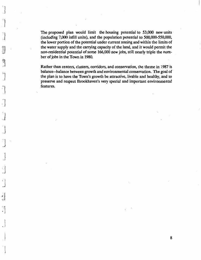
The proposed plan would limit the housing potential to 53,000 new units (including 7,000 infill units), and the population potential to 500,000-550,000, the lower portion of the potential under current zoning and within the limits of the water supply and the carrying capacity of the land, and it would permit the non-residential potential of some 166,000 new jobs, still nearly triple the number of jobs in the Town in 1980.
Rather than centers, clusters, corridors, and conservation, the theme in 1987 is balance--balance between growth and environmental conservation. The goal of the plan is to have the Town's growth be attractive, livable and healthy, and to preserve and respect Brookhaven's very special and important environmental features.
8

]
~J
. 'j' ~ ... :
}
J
THE OPEN SPACE PLAN
The preservation of open space has become more important to the Town than ever before for aquifer and surface water protection, to provide relief from the otherwise continuous development pattern, to retain significant environmental features and the natural habitat, and to protect the Carmans and Peconic river corridors. These objectives are consistent with one another. The provision of recreation and the maintenance of waterfront access, which are also important, are generally environmentally consistent with the above objectives. The continuation of farming is important to provide local crops and employment as well as attractive open space; however, farming is not compatible with aquifer protection. Furthermore, the open space objectives are not equally achievable on a geographic basis.
Aquifer protection is the open space objective that affects the greatest land area of the Town. The transfer of the RCA property to the State has contributed, in a highly significant way, toward protecting environmental values, as have the forward looking Town and County programs of acquiring critical open space. As beneficial as these programs are, they are not enough. There remain thousands of undeveloped acres of pine barrens in Manorville, Yaphank and Ridge that should be protected.
Pine barrens is the name given to a fragile ecosystem. One of the characteristics of this ecosystem is that the pines tend to burn periodically and thus rejuvenate themselves. As man has learned more about the processes of nature, it has become the practice to allow natural processes to occur within a limited framework of area and intensity. Allowing the pine barrens to burn without hazard to people may well be the best method of permitting the natural ecosystem to operate. To do this, development within the pine barrens should be avoided. The presence of scattered development, even on large lots, endangers structures and residents and workers .
An important element of the Plan, then, is to create a critical mass of area, large enough to allow the large scale preservation of the pine barrens. The Town and County have recognized the need to protect the aquifer through the adoption of legislation designating Pine Barrens and hydrogeologic Zone III boundaries (similar but not identical). Within these designated areas, there are special
9

SpecIal Environmental Areas
•••••••••
I
_ 0. ..... f". CIon .. D. I:;: ..... ,
n I:
I I ~, ' n
- 1'''':"
-6 o 1,000 "

J
I .. J
I
'.J '1
... 1 «;:]
controls limiting the uses permitted and the way in which land may be developed, and also regulating the handling of effluents and discharges. As a part of the implementation of the 1975 Plan, the Town rezoned some 6,000 acres within the pine barrens from a minimum lot size of half-acre or so to a minimum of one or two acres. More recently, the Town has identified much of the undeveloped pine barrens as a critical environmental area and mandated cluster development. The County has also designated a similar portion of the pine barrens as a critical environmental area. All of these have been important steps and have helped to control development and mitigate potential impacts in the pine barrens. But to respond to the need to establish a critical mass of undeveloped area while it is still possible, a more far-reaching approach must be used.
The acquisition by the Town and County of such a large area may not be financially feasible. Even if the County were to be able to purchase the entire area, it would take a few years, during which time some critical portions would be lost to development. A substantial enough increase of the minimum lot size to limit development would raise questions of equity and, at least as important, does not meet the objective of discouraging scattered development.
Recognizing the above, the Plan recommends the use of the transfer of development rights (TOR) concept. In a sense, this technique is an extension of the use of Section 281 of Town Law, which allows clustered housing. Clustering is the transfer of the right to build houses from one part of a piece of property to another part. A transfer of development rights is the transfer of the right to build houses from one parcel of property to a different parcel. If the properties are under different ownership, the developments rights would be sold when they were transferred. The areas to be saved as open space--the areas from which development rights would be sold--are called Sending Zones. The areas to which development rights could be transferred are called Receiving Zones. Sending Zones are discussed below; Receiving Zones are described in the Residential Plan.
In order to encourage the transfer of development rights from designated Sending Zones a bonus would be given--a five to one ratio. In other words, while only one dwelling unit could be built on a parcel of a given size within a Sending Zone, the development rights to five units could be transferred to a Receiving Zone. The computation of the density to be transferred would be based on a mathematical formula. In contrast, under clustering, the yield of a piece of
10

I j
, I d
I l 1
)
property is based on how many units can be placed on a given parcel in a conventional subdivision, with an inevitable loss from roads, irregular boundaries, special environmental considerations, etc. Thus the yield of a given piece of property would be greater in the proposed TDR plan than under clustering.
In this way there is an incentive to the owner of the land in the Sending Zone to help achieve an important public purpose. The sale of development rights between buyer and seller would be a private negotiation, but the Town could decide to participate in the market if there were a shortage of buyers or sellers or to prevent development on some critical parcel. Once the development rights have been sold, the vacant land would be required to remain in open space, and the ownership could be transferred to a public or private organization that would ensure that it remain in its natural state. Only privately owned land would be eligible for TDR. Furthermore, transfers would take place within the same school district.
Initially, the Plan recommends designation of two major Sending Zones. The first of these Sending Zones is in the Manorville pine barrens and Peconic River corridor, an area of 5,700 acres roughly similar to but larger than the the present area of two acre zoning. The Plan proposes that this Sending Zone be rezoned to a minimum density of 10 acres (400,000 square feet) for development but that a two acre density (80,000 square feet) be used to calculate the transferrable number of dwelling units.
The second Sending Zone, an area of some 3,400 acres, includes undeveloped land along the Carmans River corridor, the headwaters of the Peconic River, Warbler Woods, and other adjacent vacant land. In this area, the predominant existing zoning is "A Residence" (minimum lots of 30,000 square feet); in actual fact, however, Suffolk County Health Department regulations mandate a minimum lot size of 40,000 square feet for unsewered homes in this location. The Plan therefore proposes that this Sending Zone be rezoned to a minimum lot size of five acres (200,000 square feet) for development, but that dwelling units would be transferred at a one acre density (Le., the existing Health Department minimum of 40,000 square feet). The Sending Zone includes areas of Yaphank and Ridge now zoned for single-family, multi-family or commercial use, as well as areas along the Carmans River designated by the State as two or four acre zones. The entire Sending Zone would be rezoned to the base density of one unit per five acres, with a sending capacity of one unit per acre. The bonus for
11

1
] ]
\,-,..1
,J ]
.J
1 ! J
transferring development rights is at the same 5: 1 ratio as in the Peconic-Manorville Sending Zone.
Parks and other large public and quasi-public holdings would be rezoned to a ten or five acre category depending onthe location of the holding, but development rights would not be transferrable, as these areas should remain public open space and not contribute density anywhere. The Calverton "clear zone," the undeveloped portion of Brookhaven National Laboratories, and the largest County and State Parks should be protected through a minimum lot size of ten acres.
Including publicly-owned land, the total land recommended for preservation amounts to some 14,500 acres, as follows:
Peconic-Manorville Carmans River Brookhaven Labs, undeveloped portion Total Acres
Publicly-Owned, Not Eligible ForTDR 2,700 1,200
1,500 5,400
PrivatelyOwned 5,700 3,400
9,100
Total 8,400 4,600
1,500 14,500
During the initial period when TDR is limited to two large Sending Zones, other large conservation areas in the Town could be preserved through more traditional techniques of large lot zoning, clustering, and, if necessary, acquisition.
After any necessary refinement of the transfer of development rights mechanisms, TDR could be made available throughout the Town on a 1:1 basis that is, without the 5: 1 bonus. Open space--woodlands, wetlands, farms, country clubs, camps, greenbelts, etc.--iIi other areas could be included. The development rights would be received within each school district at the hamlet centers that have been suggested for enlargement as well as in new Receiving Zones located along major roads in areas with adequate sewage treatment.
12
·····.· .. l ", .1
".'.f. ' ~
C]
·.' .. ·.1 .•. .. !
I. J !{ •• J
,." ... ~ ! J.
',j
Water concerns, as the theme of the Plan, are not limited to aquifer protection and the rivers. Brookhaven is fortunate to have extensive waterfront areas. When Brookhaven was more rural, many opportunities existed for access to the waterfront for swimming, boat launching, fishing, or simply to enjoy the view. Those opportunities have become more limited as new development takes place. In many cases on the south shore, waterfront access has been lost through redevelopment of marinas to non.,.water dependent uses and the construction of residential developments with gatehouses, fences and buildings that have foreclosed views or physical access. The Plan therefore recommends that the Town's land subdivision and site plan regulations be amended to require a maximum of public access consistent with the historic use of the site and development proposals being made. On the north shore, the few remaining undeveloped locations with access to the water should be secured through public acquisition. Also, development on the north shore should be set back a minimum of 100 feet from the top of the bluffs.
The ecological and flood-protection value of wetlands has been clearly demonstrated. The largest of the wetlands along the south shore are protected, but there are numerous remaining unprotected wetlands that should be pre~erved through such techniques as acquisition, clustering, and the use of more restrictive subdivision and site plan regulations. For large undeveloped areas, density can be lowered. Development should be discouraged adjacent to wetlands and low-lying areas in the Town.
Agriculture represents a special problem. On the one hand, it benefits the Town by contributing to the beauty of the Town as well as to its economy; on the other hand, farms mean fertilizers, pesticides, and frequent sprinkling, which are all detrimental to the quality or quantity of ground water. Furthermore, as land values continue to increase, it is more and more difficult to maintain Brookhaven's agricultural industry. In the last few years, several key farms have been sold to developers. If the large farms cannot be maintained in agricultural use, the Town should consider requiring clustered residential development, to keep some large proportion of the farm as open space for community enjoyment.
For recreation purposes, connections should be made between existing and proposed open spaces to create a greenbelt system (many of these are specifically identified in the Brookhaven Open Space Study completed in 1984 and adopted by the Town). The general categories of links in the open space system
13

I .J
. J
are: segments along existing or future ~ighways; LILCO rights-of-way; connections between existing elements and additional new lands, acquired through clustering and TOR; and preserved rights-of-way where highways are not to be built.
The Plan also recommends that the Town strengthen its policies limiting the clearing of forested areas and other natural vegetation in development sites. This will further the objectives of retaining open space and aquifer protection, and will provide visual reJief in the form of natural growth between developments. With natural vegetation, there is less need for watering of lawns, less temptation to plant imported vegetation that may be unable to survive on local rainfall levels, and a lesser likelihood that fertilizers and chemical pest and weed control agents will be used. New planting, where needed, should be limited insofar as possible to plant materials needing little or no artificial fertilizers and little watering. Where development takes place within or adjacent to the pine barrens, this approach is of particular importance, but it would be useful as well as aesthetically pleasing in all parts of the Town. As important as the policies themselves is their enforcement.
Such policies have several implications. First, each building lot would have less useable area, whether it be a building or parking or a cleared lawn area. Second, the overall grading of a site or subdivision would be based on decisions concerning the portions of a site to remain natural. The Plan supports the Town's Open Space Policies and the County's Pine Barrens Commission recommendations that a given proportion of each lot be left in a natural state, the exact amount being a function of lot size. This area can be in required setbacks, or dispersed through the site, and should be covenanted. To help implement these policies as well as to allow flexibility in overall planning, the Planning Board has been granted the opportunity throughout the Town to require clustering of detached single-family homes onto smaller lots.
In other parts of the Plan, recommendations are made for new office and multifamily development in the western part of the Town. Accompanying these developments, to serve existing residents as well as new, there should be new or expanded recreation opportunities. The connections to the greenbelt system should help to meet some of the recreation need, bl).t these connections should be supplemented by additional park facilities in Centereach, Coram, Blue PointPatchogue and Mastic-Shirley.
14
J
THE RESIDENTIAL PLAN
As the 1975 Plan was completed, the economic outlook for the construction industry changed. High interest rates and low resale values after the gasoline crisis greatly lowered the rate of building. Since a substantial proportion of the Town was undeveloped and the rate of construction was relatively low, there appeared to be a considerable amount of time to preserve open areas. Not so today. With the Planning Board approving 4,000 dwelling units a year, the threat to open areas is severe.
There are other concerns as well, however. Municipalities must balance the need to protect the character of the land and its resources with recognition of the need for housing, especially for low and moderate income residents. The Courts have found that Brookhaven has tried to meet these needs, stating that its zoning ordinance allows for a wide variety of types and densities of residential housing. The Town now contains a substantial proportion of the County's multi-family housing units and of its publicly assisted housing units.
Brookhaven has used a variety of available Federal and State programs to help provide adequate housing for lower income households. The Town has five Federally subsidized rental housing projects with about 1,500 apartments; an estimated 4,000 single family homes were built using Farmers Home Administration programs; and some 2,000 families are being helped through rent subsidies, homesteading, etc. The Town has also used available funding to improve neighborhoods with concentrations of deficient housing and low income households. The largest such area in the Town is North Bellport, where the Town's efforts have produced visible results. The Town should continue to apply for funding for such projects using whatever programs are available.
There remains an unmet need for low income housing in Brookhaven and nationwide. Unfortunately, future funding for all Federal pmgrams that have provided housing assistance monies has been jeopardized, making the provision of additional housing for low income households problematic. Adequate housing for low income households cannot be achieved by the local municipality without such funding. Housing for middle income households--so-called' affordable housing--is also a problem throughout the nation and particularly in the New York metropolitan
15
~J
J
region. As developers build primarily (in terms of price) to the top of the market, resale prices of other homes generally follow an upward trend, and the cost of housing increases, leaving a larger gap in terms of the number of available units for those not having upper-middle incomes. Brookhaven is growing, but its growth is coming from new private market homes and apartments primarily for upper middle and upper income households. Many young people, retirees, and single-income families cannot afford this new housing, nor can many of those working in new jobs being created in the Town. Without affordable housing, many jobs will not be created, or if created, will be filled by non-Brookhaven residents, commuting along Brookhaven's already crowded roads.
Thus Brookhaven, along with the rest of the New York metropolitan region, needs affordable housing, for households with incomes up to $45,000.
With its Neighborhood Homes Program, the Town has demonstrated that affordable single family homes can be produced, at least in small numbers for those with incomes of $30,000-$45,000. Unfortunately, the funding levels available are not adequate to provide a significant number of affordable units.
In order to increase the number of affordable housing units, the Plan proposes several related actions. Multi-family housing would not be built as-of-right on pre-zoned parcels. Increased density could be achieved by the provision of affordable housing (or, to preserve vacant land, through TOR). A developer wishing to build such housing could provide the affordable housing either on the specific site being rezoned or elsewhere in the Town, in an appropriate location within a reasonable distance of shopping and transportation. The developer would have to meet a requirement that, for example, 20 percent of the units on the site or the equivalent number off-site be available to households with incomes no higher than 80 percent of the median for the County. The units could be constructed on the site receiving the zone change, or on another site approved by the Town. The rehabilitation of existing units to sell or rent at appropriate income levels could also qualify. 0
The Plan thus proposes that, regardless of existing zoning, new medium-high density housing achieve its density on site through the transfer of development rights from other areas in the same school district, or through building or enabling affordable housing. Furthermore, new medium-high density housing
16
i
J
,
f "
should be provided at appropriate locations along or near main roads, preferably in centers with adequate sewage treatment plants and public water.
In the open space section, the TDR concept was described and the Sending Zones generally defined. The Receiving Zones for TDR would be in the same school district as the Sending Zone. Densities in Receiving Zones are envisioned as ranging from a high of some five or seven units per acre where apartment or higher density townhouse construction is appropriate to as low as two per acre, as long as adequate sewage treatment can be provided. The Receiving Zones recommended in the Plan vary in size and, as the TDR concept is further refined, these sizes may change; the Receiving Zones in each school district should generally be amply large to accommodate comfortably all the potential units from the Sending Zones in that district.
For the Manorville-Peconic Sending Zone, the suggested Receiving Zones are:
• on the south side of Nugent Drive;
• north of the hamlet of Eastport;
• on both sides of County Route 111 at its junction with the Long Island Expressway;
• on both sides of County Route 111 east of Moriches-Riverhead Road; and
• at lesser densities, along the south side of Route 111.
The Route 111-LIE area, where a small new hamlet is proposed, is well served by highways with considerable excess capacity, and it includes portions of three school districts, all of which include areas the Town should preserve. The new hamlet would need to be served by a sewage treatment plant, so that the sewage disposal from the proposed population would not degrade the aquifer. Many of the existing plants have (for various reasons, including poor maintenance) been polluters. The new plant would have to be sufficiently sophisticated to assure
, that it would not degrade the environment. This does not mean a large sewer district but rather a plant sized to serve the hamlet and, preferably, other developments along Route 111.
17

,]
i j
To absorb the density from the Carmans River Sending Zone, several Receiving Zones of varying size and density are sugges~ed:
• along Route 25 around Artists Lake;
• west of Sills Road, on both sides of its interchange with the Long Island Expressway;
• east of Yaphank hamlet, near the race track property (or on it, if the race track operation is abandoned); and
• on Longwood Road.
An additional Receiving Zone would be appropriate on one of the large parcels now zoned and being considered for a regional shopping center. Two parcels are so zoned, but only one regional shopping center is needed.
The Receiving Zones suggested above are all in locations that are now undeveloped.
Other Receiving Zones within the same school district as the Sending Zones could be created in time, in locations with good road access, where adequate sewage treatment and public water can be provided, and where existing residential neighborhoods will not be overwhelmed or sensitive environmental features destroyed. Existing sewage treatment plants should be enlarged and upgraded whenever possible.
Whether the density is achieved through TDR or .through the provision of affordable housing (or both), one type of location for new medium-high density housing is adjacent to and reinforcing existing centers .. In many cases, locations are shown for medium-high density housing which might be equally appropriate for office use. Either office or medium-high density use can serve to strengthen a center; the choice depends on the specific location, its topography, possible site plans, traffic patterns, neighbors, etc. A lively center would have retail, office, and medium-high density residential uses in close proximity, and it would have adequate sewage treatment facilities, public water and adequate roads;
18

j
While increases in the size of several centers are suggested in the Plan map, these recommendations depend on adequate infrastructure.
At this time, no significant increases in residential density are proposed along Route 25A east of Pipe Stave Hollow Road, pending detailed studies of this corridor and needed improvements to Route 25A.
Another type of location for medium-high density housing is the numerous vacant parcels along major roads that are now zoned for shopping centers or industrial use. Only some of these are needed for retail or industrial development. As with the centers, many of these parcels--particularly along Routes 347 and 25--might be developed alternatively as offices, depending on traffic and other environmental studies specific to the site.
Note that these medium-high density areas are used to help to create or strengthen centers, to create a sense of place, to help preserve open space, to create a variety of housing choices, and to help create some affordable housing.
The Plan recommends rezoning some of the vacant commercially zoned strips along major roads to residential use. Some of these strips are appropriate for two-family homes (or three- or four-family homes). The Town may require owner-occupancy of one unit in the two-family house, thus helping to meet both rental and ownership needs.
A lowering of potential density is recommended in certain generally undeveloped and fragile areas, particularly near wetlands. For example, along the south shore, there are some sizeable undeveloped tracts. Lowering the potential density would help preserve the wetlands, encourage development on higher-lying land, and help to preserve the existing rural qualities of these neighborhoods.
With two main exceptions (single and separate lots; areas with both sewage treatment and public water), the County Health Department regulations mandate a minimum lot size of 40,000 square feet in Zones III and VI, and 20,000 square feet elsewhere. Zones III and VI include the entire Town south of Routes 347-25A and east of the LILCO right of way-Nicolls Road and contain almost all of the larger undeveloped residential tracts of land in the Town. Except for the Manorville Hills and an area along the upper Carmans River, these tracts are all
19

-j
J
d
in zoning districts which permit development on lots of 15,000 to 30,000 square feet (B, B-1, and A). To reinforce the County Health Department policies, it is recommended that Brookhaven adopt similar policies, mandating minimum lots of 40,000square feet in Zones III and VI and 20,000 square feet elsewhere, unless adequate sewage treatment and public water can be provided.
The old filed maps in Brookhaven present a particular problem. These old filed maps are old land subdivisions, with lots in diverse ownership that are significantly smaller than Brookhaven's zoning or Suffolk County Health Department provisions would permit today. Nevertheless, an owner of one of these lots has traditionally been permitted to build on it as long as all adjacent property is owned by others (i.e., as long as it is a single-and-separate lot). This type of development can pollute the ground water and overcrowd the land. In some of these old filed maps, Suffolk County has been able to prevent the possibility of development by foreclosing on many individual parcels for non-payment of taxes. For those old filed maps that are largely or completely undeveloped and still privately owned, it is recommended that the Town declare them vacant-land urban renewal areas, acquire the land (using eminent domain if necessary), and either hold it for conservation purposes or replat and sell it or its development rights in accordance with the Plan. For undersized single-andseparate lots in partially developed areas, the Town might consider giving transferrable development rights to the owner of the undersized single-andseparate lot in exchange for title to the lot.
20

,J
J
"'J .• i;;; ...
HISTORIC PRESERVATION
In the last decade or so, Brookhaven has begun to recognize the importance of giving government encouragement, support and protection to its historic districts and buildings. The Town has taken the position that historic designation should be a process that starts at the ground up--that is, the initial request and support for designation should begin with the building owner or the local community. It is believed that this procedure is more likely to result in a continuing interest in the designation of unlisted buildings and the protection of those already listed than a process that starts with governmental action. There are, however, additional potential historic districts in the Town where designation would help to preserve the existing charm and small-scale character.
The Town has designated ten historic districts and some 13 buildings as landmark structures, and has adopted regulations intended to protect them. Designation is pending for other buildings. Where district designation has occurred, the emphasis has been on a grouping of historic buildings, whil~ other features that may be of value have generally not been protected or recognized. In some parts of the Town it may be desirable to consider the establishment of districts with unique characteristics that go beyond buildings or groups of buildings. These could include areas with archaeological remains, former cranberry farms, examples of early farming patterns, or unique natural areas. These could be designated as multiple use areas rather than historic areas, and would serve to remind Brookhaven residents of some of the Town's early characteristics.
In the historic districts, the Plan recommends that the historic district regulations control facades, parking, building size and architectural style, signs, and landscaping so that the distinctive scale and architectural and streetscape qualities of each of the districts can be maintairied. A study is underway regarding the appropriateness of commercial zoning in the historic districts. The Town should also consider modifying the Town's historic district regulations to meet State certification requirements, thus qualifying certain properties for funding for rehabilitation or restoration. '
21

TOWN OF BROOKHAVEN
1987 lAND USE PIAN
fiREPLACE NECI(
Historic Districts
.0-o 8.000 II I '
RPPW Inf' .• Plo"I>'''1I Consult.""

]
]
• 1 j _J
THE COMMERCIAL PLAN
The planning analysis disclosed two general-categories of problems relating to commercial development. These can be generally described as having to do with the location and extent of existing or permitted commercial development and the manner in which site planning and access have traditionally been handled.
Throughout the Town there are small commercially (or industrially) zoned areas in residential neighborhoods. These parcels pose a potential. threat to neighborhood character due to the incompatibility of commercial or industrial uses with residential neighborhoods arising from the hours of operation, traffic, night lighting, handling and disposal of solid waste, litter, and noise. The Plan recommends that these areas, whether vacant or not, be rezoned to a residential zoning category consistent with the surrounding area. In time, many of the operating businesses will terminate and the properties could be converted to residential use. Without such rezoning new non-residential uses could.replace the defunct ones. With the rezoning, they would become legally non-conforming and thus able to continue but not expand significantly.
In hamlet centers, the Plan encourages a mixture of uses, with residential and commercial (office and retail) development in relatively close proximity. The adoption of carefully designed zoning and site plan controls can permit a reasonable intermix of such uses while providing the attributes of a center that include a sense of place, convenience, reduced travelling for errands, possibilities for walking, and local employment opportunities.
Outdated zoning patterns persist along state and local highways with miles of frontage zoned for commercial development in shallow strips. There is an excess of commercial zoning along some roads--Route 347, portions of Route 25A and Route 112, Route 25 in Ridge and Middle Island, portiop.s of CR 80 (Route 27 A), CR 16 in Farmingville, Neighborhood Road in Mastic, and others. The Plan recommends that the commercial zoning of the vacant areas be reduced, leaving clusters of commercial zoning located so that no residential neighborhood is far from shopping. Where lots are deep or the properties are backed up by existing residential development, two-family or multi-fainily zoning might be appropriate. Some of the large areas zoned J -3 are suitable for office development or multi-family use.
22

··1 ,.J
'1 J
As the eastern half of Long Island grows, there will be increasing need for a regional shopping center in eastern Brookhaven. At the present time, Brookhaven has two large vacant parcels zoned for shopping centers (J-3) on or near the William Floyd Parkway. Only one is needed; only one should be built. The other would be appropriate as a Receiving Zone for multi-family housing or, possibly, could be considered for office uses. A location at the intersection of the Long Island Expressway and the William Floyd Parkway would be suitable, as would several other locations on major highways. Regardless of the location, substantial roadway improvements will be needed, including possible bridges across major highways.
The other general category of issues concerning commercial development is the way in which sites and immediately adjoining areas are developed. The existing zoning code tends to control the size of the building through overly strict parking requirements (rather than through coverage or floor area ratio limitations). This results in overcrowded sites. At the same time, not enough area is left for vegetation. In the Open Space section of the Plan, reference is made to requiring a set percentage of each site to be left in its natural state. Such a requiremen't would provide the opportunity for significantly upgrading the appearance of new commercial development, as well as helping to meet the recharge needs of the Town and County. Other recommendations include increasing the use of low plantings and berms along the front of properties to help shield from view the parking lot pavement and vehicles, without obscuring store signs and facades. Landscaping should be required in large parking lots, to soften the expanse of pavement. Access to retail sites and traffic safety in general would be improved through increased use of parallel service roads along major highways such as Route 347. According to the current ordinance, commercial parking may encroach fifty feet into residential areas. As the zoning code is reviewed, this policy should be examined. The Town should be given credit for the improved appearance of recently developed sites, but more needs to be done through changes to the zoning code, and better site planning techniques and access management. Maintenance of landscaping should be assured through enforcement of the Town's maintenance ordinance.
Several of the recommendations above are visually as well as functionally oriented. Other primarily visually oriented recommendations include control of signs. Retail centers should be limited to a single roadside identification sign, with tenant signs only on the building facade. All signs should conform to the
23

]
«J •. '«
,J
Town's standards, which should be strictly and uniformly enforced. The size, position, and structural provisions for signs should be integral parts of the building design and, along with architectural and facade details, should be part of an upgraded site plan review process of the Town. The Town should institute a town-wide enforcement program, proceeding area by area through the Town on a regular schedule to eliminate signs that are illegal.
Through zoning, the Town will need to revise the kinds of commercial activities permitted within the County's designated Zone ill since uses needing large quantities of water or having the potential for polluting ground water are not being permitted by County regulations.
Along the waterfront areas of the Town, encouragement should be given to the continuation, expansion, and initiation of such water dependent uses as marinas and boatyards.
24

,j
J J J J
THE INDUSTRIAL PLAN
The knowledge that some industrial discharges are polluting the aquifer has led the Town and County to restrict the location and type of development permitted in the Town. Limitations placed on industrial development in Zone ill make much of the land in that area currently zoned for industry difficult to use from a developer's point of view and undesirable for industrial use from a public policy perspective, except for light clean industries and offices. There are 4,300 acres of vacant industrially zoned land in Brookhaven; this is more than will be needed, according to the Land Use Plan studies. Full industrial development of all of this land is unlikely, due, among other factors, to a potential shortage of affordable housing for future workers.
These two factors have led to a re-examination of the amount of land available for industrial development and its location, particularly in areas lacking infrastructure, where ground water protection is of high importance, or in residential neighborhoods. At the same time, projected job growth of 'Some 50 percent from 1985-2000, the need of the school districts for a tax base, the constraints of existing patterns of development, and the presence or absence of highways must all be taken into account. Thus, a reduction in the amount of industrially zoned vacant land is not as achievable as if only the first two priorities were to be recognized.
Industrial zoning is appropriate in non-residential areas with good highway access. The Plan recommends changing some of the inappropriately located industrially zoned land to other categories, primarily residential. This should be done wherever reasonably possible in those parts of Zone ill and the pine barrens where industrial development has not occurred. Some land should remain available for industrial purposes in as many school districts as possible. Vacant industrial parcels in residential neighborhoods and away from highways should be rezoned to match that of their neighbors. Moreover, the L-2 district and uses should be prohibited in the pine barrens portion of Zone Ill.
Among the major changes recommended are the following:
• Because of access problems, the Gyrodyne property at the Town's western border should be changed to a low density residential
25
,J
• j
J
)
i ,. J
category, with any development clustered away from the steeper slopes. If adequate access can be provided, higher density residential use would be appropriate, clustered away from the wooded hillside facing Stony Brook Road.
• The industrial area north of Route 347 on both sides of Belle Meade Road might be cut back to become part residential, part office, and part industrial. Adequate buffering between the residential and industrial uses would be important.
• Wherever possible, the industrial zoning elsewhere in the Three Village area north of Route 347 should be changed to residential or office use. (Office use would be appropriate if the Route 25A bypass were to be built; otherwise, such development might tend to overburden the existing road system.)
• The industrial zoning of vacant industrial land along Mill Road southeast of Coram should be changed to that of the surrounding residential neighborhoods.
• Lands south of the Long Island Expressway in Yaphank should be changed from residential to industrial and office use. A large area from the Long Island Expressway to Sunrise Highway has the potential to become a major industrial-office park.
• The area north and east of Brookhaven airport has been proposed for purchase by the County. This would be desirable, from the standpoint of protection of the pine barrens. If County purchase proves infeasible, the area should be developed for industrial and office use, except for the area nearest North Street (that is, closest to the William Floyd Parkway) which could either be residential or a part of an office-industrial park. The majority of the large vacant area, however, is unsuitable for residential use, as it lies in the flight path. To develop as an industrial-office park, however, this area requires a new road to provide good access to the Long Island Expressway without disturbing residential neighborhoods. Certain types of industrial development would also be restricted, as the area lies at the edge of Zone III and the designated Pine Barrens ¥eas.
26
']
,]
,]
J
• An area along Montauk Highway, east of North Bellport, would be appropriate for smaller industrial uses.
The Plan also recommends that the industrial zoning of sand mines in residential areas be changed to a residential zoning category. Wherever there is concern that the ground water has been exposed or is endangered, the zoning category should be lower than that of the surrounding area. This is because, first, a significant economic value has been obtained, and, second, after mining, part of the land may not be usable because of an exposed water table. The Town should institute a special permit requirement or conditional use requirements for the continuation of mining, which would limit days of the week and hours of operation. The Town has recently enacted legislation requiring limitations on the environmentally detrimental characteristics of operation, and including specific provisions for reclamation of the land. The reclamation plan must include protection of any exposed ground water and specify permissible modification of contours to enable future development without steep grades; the legislatiol) does not require restoring original contours through the extensive use of fill.
Large scale office development is relatively uncommon in the Town. As service sector jobs increase, more space of this type will be needed. The Plan suggests that relatively large scale office development be encouraged in Yaphank, Farmingville and Selden and, in general, along major highways. In areas now industrially zoned, this would not necessarily require a change of zone. Offices or industrial-park uses would be equally appropriate at some of the major intersections of the Long Island Expressway.
An analysis of economic trends undertaken as part of the Land Use Plan study noted that manufacturing is still a growing aspect of the Town's economy, particularly for firms employing fewer than 100 people. The zoning ordinance and building codes should be examined to ensure that there are appropriate provisions for firms displaying this characteristic. A trend known as flex-space has become popular, in which a building shell is constructed with the interior set up to allow various alternatives to subdivide space into different configurations. Although seemingly simple, sometimes the substantive or procedural requirements of individual municipal codes and their enforcement make this type of construction difficult and problematic.
27

} ,,)j
J ]
In some of the older industrial areas, the lot requirement was too small. Inadequate space was allowed for the maintenance of natural vegetation, parking, landscaping and buffers between buildings -and between properties. In new development, a greater external separation would be appropriate in many cases. This could be accompanied by a reduction in internal controls in a large multibuilding site, subject to detailed site plan review. Where development is to take place in Zone III, particular attention must be given to the specific proposed industrial processes and their potential discharges. In all industrial areas, a minimum area of land not to be disturbed or to be appropriately re-landscaped should be required to allow for ground water recapture. The Town's zoning, in actual practice, regulates building size (floor area) through parking rather than floor area ratio or coverage. High land coverage is permitted, yet parking standards in many cases are actually too high. The landscaping requirement should be increased, natural vegetation should be incorporated in the landscaping requirements, and the parking requirement should be decreased.
28
J
J
THE CIRCULATION PLAN
An important transportation change from the 1975 Plan is the increase in travel within the Town, not accompanied by any increase in travel into or out of the Town on major east-west roadways. Comparison of traffic volumes on the major east-west roads (1-495, NYS 25, NYS 27, and NYS 347-25A) between 1972 and the period of 1983-85 shows that at the Town's western boundary volume declined three percent and at the Town's eastern boundary volume decreased eight percent, while at NYS 112 volume increased 32 percent and at William Floyd Parkway volume increased 28 percent. In addition, north-south traffic within the Town showed an increase of 43 percent on CR 97 (Nicolls Road) and an increase of 10 percent on the William Floyd Parkway. Thus, there has been a considerable increase in intra-Town traffic during this period. Nevertheless, today, as in the early seventies, the bulk of the vehicular traffic shares a characteristic with the railroad; that is, most travel is east-west, and oriented primarily westward, toward the more intensely developed portions of the Island. However, today's east-west trips tend to be shorter than those of a decade ago. Some 78 percent of working Brookhaven residents work in Suffolk County, most of them in Brookhaven or the western towns. Nassau County and New York City are each the job locations for only about 10 percent of the Town's working population.
The increasingly dispersed nature of travel patterns requires greater reliance on the automobile and, consequently, on the highway network. The private automobile is the most convenient and widely used form of transportation in the Town and will remain so. Since 91 percent of Brookhaven's job holders drive to work, it is this travel mode that must be given the overwhelming attention and resources. At the same time, the size and capacitY of the highway network is limited, so alternate forms of transportation will continue to be important.
Transportation Centers
The earlier plan included transportation centers il1 Ronkonkoma and Yaphank. In 1975, there was already need for a center in Ronkonkoma. In 1987, feasibility studies were underway relating to physical, marketing, and financial aspects of such a multi-modal transportation center, allowing a tie-in between the Long
29

TOWN OF BROOKHAVEN
1987 LAND USE PLAN
Highway System
STATE HIGHWAYS
:=: ~. ,-~
COUNTY HIGHWAYS •• __ 0...1
.. -...... ~
.0-o I.OOC to I '
IIPPW Inc .. PI"",,"I Consul,."ro

J
1 .. J
Island Rail Road, MacArthur Airport, the Long Island Expressway and several routes in the Suffolk County bus system. Mor~ intensive office and commercial developments are being planned which would both capitalize on the transportation elements and support them.
Yaphank, the second location recommended for a transportation center, has seen several changes since the last plan, all of which were, in part, anticipated by that plan. The racetrack, then under construction, opened, then closed, then opened again (and may again close). Several hundred units of multi-family housing have been built nearby. A possible regional shopping center has been proposed, north of the Long Island Expressway. The Carmans River and the adjacent upland has been designated as a Scenic and Recreational River under New York State legislation, and Old Yaphank has been designated a historic district by the Town. South of the Long Island Expressway, the County remains interested in providing additional office space near its existing complex and proposals have been made for intensive office and industrial development in the same area and at Brookhaven Airport. The kinds of transportation improvements identified in the 1975 Plan for this area remain appropriate: overpasses across the Long Island Expressway and the William Floyd Parkway, additional lanes and upgraded or completed service roads along the Long Island Expressway, and expanded bus service to the somewhat spread out sub-centers.
Rail Transportation
While only about 4,700 Town residents commute to work using the ten Long Island Rail Road stations in Brookhaven, projections by the MT A indicate that ridership is increasing, and, if electrification projects on the Main Line and Port Jefferson Branch are completed, will increase at a more rapid pace. It is also likely that the transportation centers at Ronkonkoma and Yaphank will attract some work-related commuting. Ridership has increased significantly on a percentage basis since 1972 at the major stations of Ronkonkoma, Port Jefferson, Patchogue, Stony Brook and Mastic-Shirley.
Freight volume on the Long Island Rail Road is low in comparison to the level of trucking, and this relationship is not likely to change significantly because industries on the Island tend not to need high capacity, high weight, high quantity shipments and because rail lines are limited in location; however, where
30

TOWN OF BROOKHAVEN
1987 LAND USE P1AN
Average Dally Traffic 24 Hour Two Way Vehicle Volumes
............. Q,.,ol. __ .- _ .. _
,_ 1._0- .. r __
.0 o B.ooo" ,
RPPW In<:., Plonning ConI<JIt.,u
I ~J
. I
I
possible, rail freight should be encouraged to take advantage of an opportunity to relieve the congested highway system. The· State and the Long Island Rail Road should continue to pursue completion of the electrification of the Ronkonkoma and Port Jefferson branches. As ridership increases, additional station parking should be provided where needed, since parking spaces are far less expensive to build than additional highway lanes and generally are less disruptive.
In 1975 and today, parking is a particular problem at the Stony Brook station. The haphazard parking patterns and pedestrian activity associated with the University makes the area hazardous and unsightly. The Town should continue its efforts to ameliorate this problem. The track at the Stony Brook station requires straightening to improve safety during boarding. This action would make some additional area available for parking.
Bus Transportation
Since the 1975 Plan was completed, a major organizational change has taken place with respect to bus transportation in Suffolk County: the active participation by the County in upgrading the existing network and sponsoring new routes into areas that were inadequately served, by contracting with private bus companies. This has resulted in a significant increase in bus service in Brookhaven (examples are William Floyd Parkway and Route 25 east of Coram, neither of which previously had service). There are now parts of fifteen main routes and seven feeder routes operating in Brookhaven. The County system carried 8,400 daily passengers in 1982. Surveys of riders indicate that the system primarily serves a transit dependent population -;; low income residents and those without access to an automobile. Just over half the riders use the bus to get to work, with the next highest group using it to get to school.
As development takes place in accordance with the recommendations of the Land Use Plan, bus ridership may increase. Depending on the type, location, and intensity of development, there will be opportunities for either feeder or loop routes. Additional bus service will also be' appropriate in areas that are underserved, or where development intensity increases through zone changes or density transfer. The participation of local government in bus transportation systems is common nationally, and will continue to be necessary if service is to
31

1 j
J J J
be maintained, since the existing and potential levels of ridership and fare box revenues cannot meet capital and operating expenses.
Ferry Transportation
At the time the 1975 Master Plan was being completed, a cross-sound bridge was still being discussed. In 1987, a cross-sound bridge is no longer considered a possibility. Ferry service has been operating since at least 1844. In 1982, more than 380,000 passengers and some 125,000 vehicles crossed between either Port Jefferson or Orient Point and Connecticut. From 1972 to 1982, passenger growth increased by 110 percent at the Orient Point facility and by 62 percent at the Port Jefferson facility. In the last several years both ferry operators have added a ferry, increasing capacity, and ridership has continued to grow at a steady rate.
Increasing ridership will strengthen the demand for an additional ferry line. Growth of the Port Jefferson ferry line is severely restricted by narrow crowded access roads and limited parking; the Orient Point-New London ferry serves primarily those destined for northern or eastern New England, and, in Suffolk County, is only accessible via two lane roads.
A ferry terminus at Shoreham, in contrast, would connect to all the major eastwest roads in Suffolk County via the underutilized William Floyd Parkway.
A Shoreham - New Haven ferry was considered an important possibility in the 1975 plan, which recommended that "if and when high speed ferry service is established across Long Island Sound, the William Floyd Parkway should be extended north to the Sound in such a manner as to minimize disruption of the moraine and wetlands. For this reason, a ferry terminal and associated facilities should be as modest as possible." This recommendation remains valid in 1987, and it is further recommended that the State sponsor a corridor study of access and staging areas, addressing such issues as property acquisition, access, and environmental impacts associated with such a proposal, as well as the economic feasibility of high speed service rather than conventional service.
32
]
J ~1
}
I ~:.J
···· •. 1·
.,'"",'
, J
J
Airports
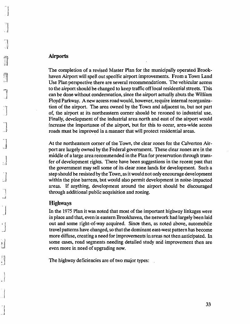
The completion of a revised Master Plan for the municipally operated Brookhaven Airport will spell out specific airport improvements. From a Town Land Use Plan perspective there are several recommendations. The vehicular access to the airport should be changed to keep traffic off local residential streets. This can be done without condemnation, since the airport actually abuts the William Floyd Parkway. A new access road would, however, require internal reorganization of the airport. The area owned by the Town and adjacent to, but not part of, the airport at its northeastern corner should be rezoned to industrial use. Finally, development of the industrial area north and east of the airport would increase the importance of the airport, but for this to occur, area-wide access roads must be improved in a manner that will protect residential areas.
At the northeastern corner of the Town, the clear zones for the Calverton Airport are largely owned by the Federal government. These clear zones are in the middle of a large area recommended in the Plan for preservation through transfer of development rights. There have been suggestions in the recent past that the government may sell some of its clear zone lands for development. Such a step should be resisted by the Town, as it would not only encourage development within the pine barrens, but would also permit development in noise-impacted areas. If anything, development around the airport should be discouraged through additional public acquisition and zoning.
Highways In the 1975 Plan it was noted that most of the important highway linkages were in place and that, even in eastern Brookhaven, the I!etwork had largely been laid out and some right-of-way acquired. Since then, as noted above, automobile travel patterns have changed, so that the dominant east-west pattern has become more diffuse, creating a need for improvements in areas not then anticipated. In some cases, road segments needing detailed study ana improvement then are even more in need of upgrading now.
The highway deficiencies are of two major types:
33
TOWN OF BROOKHAVEN
1987 LAND USE PIAN
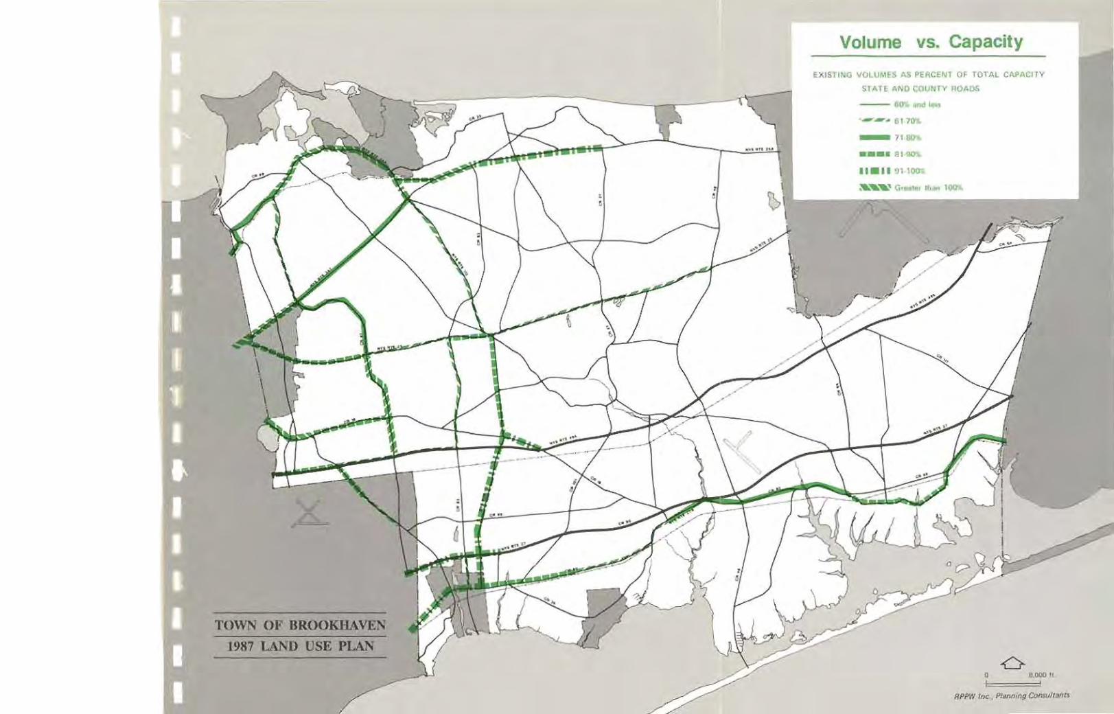
Volume vs. Capacity
()lISTING VOLUMES AS PERCENT Of TOTAL CAI'A,C!TY
STATE AND COUNTY ROADS ---- ... __ n_ •••• 11·_
-6 o 11,000" : I
RPPW ,"" .. PI.",;", C--I,.,,.

~1
J
.J
'I
"j
\
1. Operational difficulties, which often severely limit capacity especially along roadway sections with numerous access driveways' to commercial properties and at-grade intersections with other high-volume streets.
The operational difficulties include making left turns or gaining access to and from local streets, irregular pavement width, substandard geometry, intersection capacity constraints or signalization problems. Route 25A, a significant problem in 1975, today has the worst overall operating characteristics of all the roads in the Town.
Roadway sections operating at or near capacity are:
Roadway Section
NYS Route 25A Western Town boundary to Rocky Point Road NYS Route 347 Western Town boundary to Nicolls Road NYS Route 27 (Sunrise Highway) Western Town boundary to Phyllis Drive NYS Route 112 Port Jefferson to NYS 25A and the LIE to NYS 27 County Road 8O/NYS 27A Western Town boundary to CR 36 (South County Rd.) (Montauk Highway) County Road 16 Western Town boundary to CR 19 (Patchogue-Holbrook Road) (Portion-Horseblock Road) County Road 97 (Nicolls Road) LIE to NYS 25
2. Safety problems, which were found at high volume intersections and along sections of roadway with many driveways and interections or poor alignment. The worst accident records in the Town are on the following roadway segments:
Roadway
NYS25 NYS 112 NYS25A NYS347 CR16
Section
Western Town boundary to NYS 112 CR 83 to NYS 27 Old Town Road to William Floyd Parkway Western Town boundary to NYS 25A Ronkonkoma Avenue to NYS 112
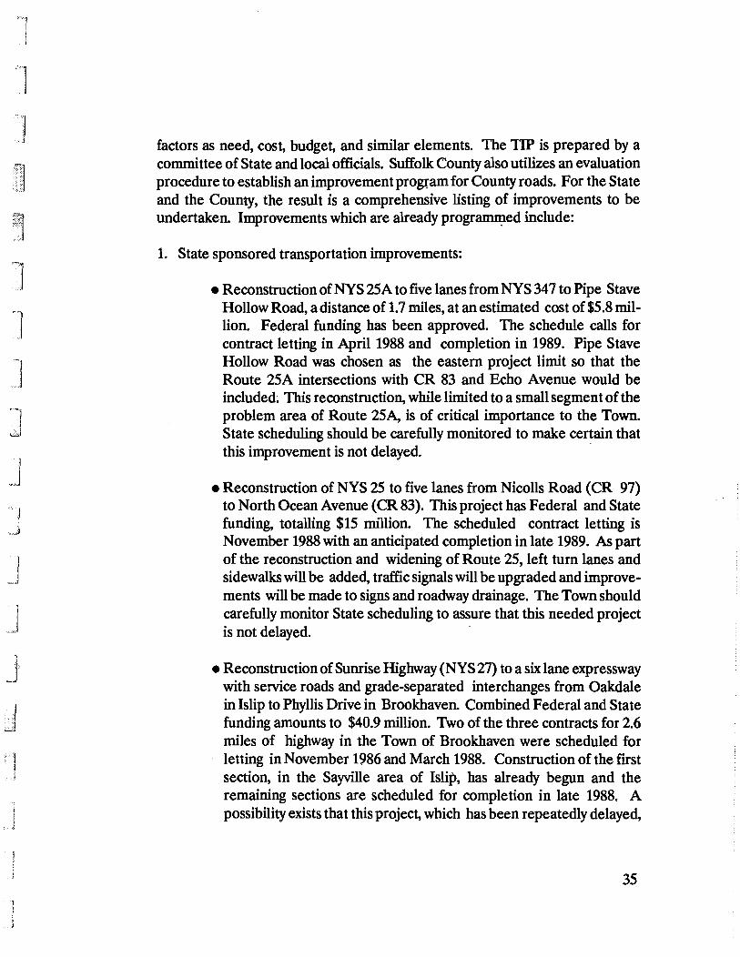
Programmed Improvements An established part of the procedure for implementing transportation improvements that will receive funding through the NYS Department of Transportation is their listing in a Transportation Improvement Program (TIP), evaluating such
34

Accident Frequency
"'''''''11( R Of ACel I .. n 11_, 0 • " ... " " • " " • ...
TOWN OF BROOKHAVEN
.911'7 UND US!! PIAN 0
l~!. .. ~~~~~~~~'::'-:::::-:~~ ____________________________ .-~~~~::~~ __________________________ ::: 0 ~ .. ,
, ,,~w __ ,~.
--
J
J
factors as need, cost, budget, and similar elements. The TIP is prepared by a committee of State and local officials. Suffolk County also utilizes an evaluation procedure to establish an improvement program for County roads. For the State and the County, the result is a comprehensive listing of improvements to be undertaken. Improvements which are already progr~ed include:
1. State sponsored transportation improvements:
• Reconstruction ofNYS 25A to five lanes from NYS 347 to Pipe Stave Hollow Road, a distance of 1.7 miles, at an estimated cost of $5.8 million. Federal funding has been approved. The schedule calls for contract letting in April 1988 and completion in 1989. Pipe Stave Hollow Road was chosen as the eastern project limit so that the Route 25A intersections with CR 83 and Echo Avenue would be included: This reconstruction, while limited to a small segment of the problem area of Route 25A, is of critical importance to the Town. State scheduling should be carefully monitored to make certain that this improvement is not delayed. -
• Reconstruction of NYS 25 to five lanes from Nicolls Road (CR 97) to North Ocean Avenue (CR 83). This project has Federal and State funding, totalling $15 million. The scheduled contract letting is November 1988 with an anticipated completion in late 1989. As part of the reconstruction and widening of Route 25, left turn lanes and sidewalks will be added, traffic signals will be upgraded and improvements will be made to signs and roadway drainage. The Town should carefully monitor State scheduling to assure that this needed project is not delayed. .
• Reconstruction of Sunrise Highway (NYS 27) to a six lane expressway with service roads and grade-separated interchanges from Oakdale in Islip to Phyllis Drive in Brookhaven. Combined Federal and State funding amounts to $40.9 million. Two of the three contracts for 2.6 miles of highway in the Town of Brookhaven were scheduled for letting in November 1986 and March 1988. Construction of the first section, in the Sayville area of Islip, has already begun and the remaining sections are scheduled for completion in late 1988. A possibility exists that this project, which has been repeatedly delayed,
35
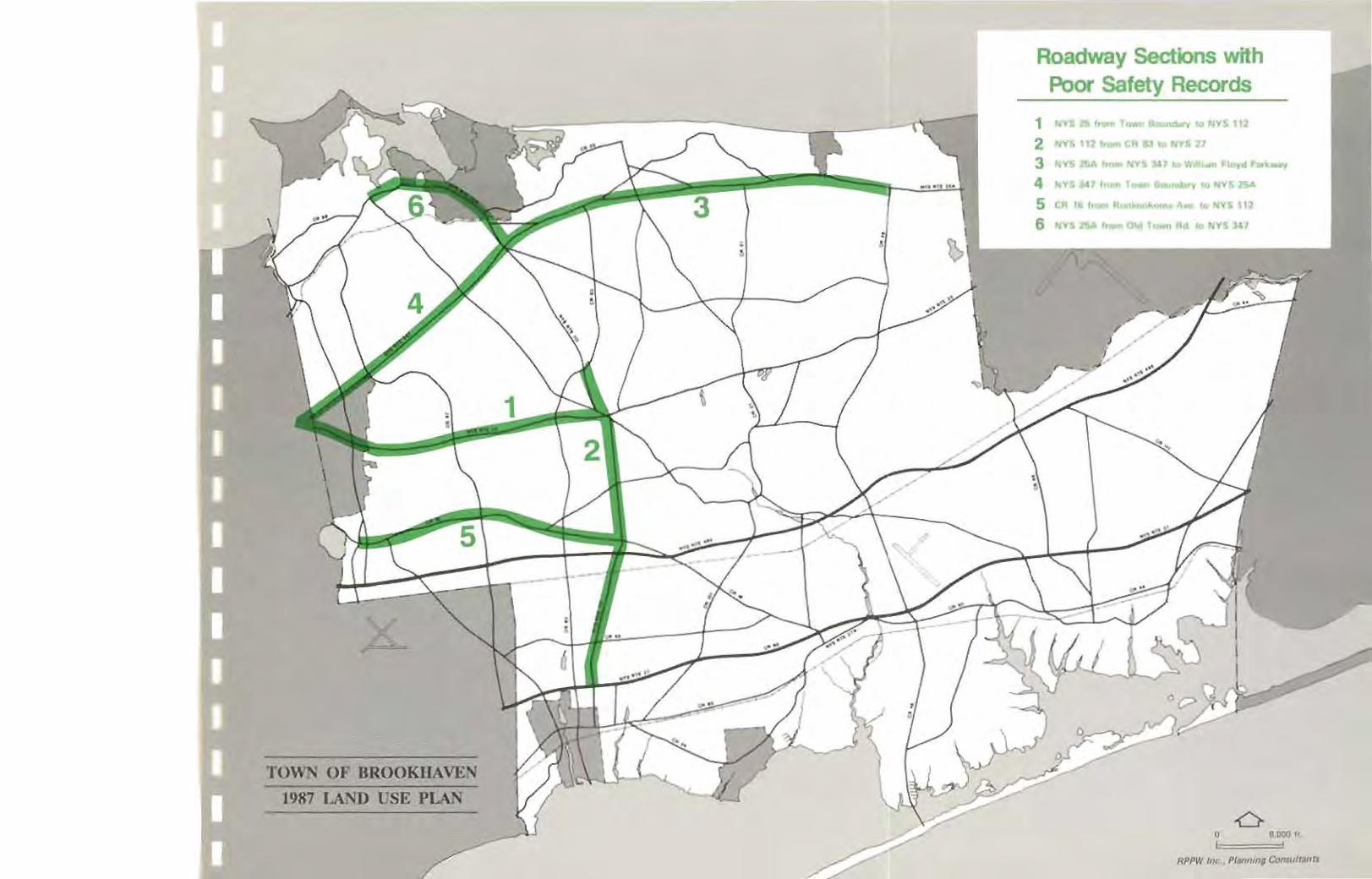
TOWN OF BROOKHAVEN
1987 lAND USE PLAN
Roadway Sections with Poor Safety Records
1 "VIllI, ,,,.,. ,.,10 ..... '112
2 .. ,,' 111.. II 10 ,,,,'$1.
3 '""5 a... !._ NY' JoU 101'1, ... ~Ic>yd ~ ... _
4 "'1'5)017 .. _ _ . ' .... "Y$ 2f>A
5 CIII 1, ._ A ___ A .. to NVS 112
6 ,",vs a... "o. )lei ,_ "'" .., NYS "'1
-6 o .,000" ,

j I i
",J
will again be postponed. (In" 1975, it was thought this would be the "next major DOT project; in late 1986, State transportation officials proposed a one to two year delay.) The Town, alert to the threat of postponement, has been encouraging and should continue to urge speedy construction of this improvement.
• Reconditioning and preservation of NYS 112 from Woodside Avenue (CR 99) to the Long Island Expressway, a distance of 1.9 miles. Federal and State funding totals just over $6 million for these improvements. This type of improvement restores the structural integrity and rideability of existing roadways. Typical improvements may include resurfacing, drainage improvements and minor widening for turning lanes. Without question, these improvements will increase the safety and capacity of this congested and dangerous road segment; whether they are sufficient to improve the road to adequate operating standards is not known at this time. Furthermore, when the Sunrise Highway is improved to a limited access highway in western Brookhaven, it will put an extra strain on Route 112.
• Reconditioning and preservation of Old Town Road from NYS 347 to Sheep Pasture Road in the Setauket area. With Federal, State and local funding totalling $1.26 million, this contract is scheduled to be let in November 1987 and completed a year later.
• Chapmans Boulevard from Railroad Avenue to CR 111 in the Manorville area is also scheduled for reconditioning and preservation in 1987 using Federal funding assistance as part of the $370,000 estimated cost.
2. County sponsored transportation improvements:
• Reconstruction to four travel lanes of a section of Horse Block Road (CR 16) from Nicolls Road (CR 97) to North Ocean Avenue (CR 83) with turning lanes and traffic signal improvements at major intersections. The County has committed, $3.59 million for right-of-way acquisition and construction by the 1986-1987 fiscal year, and a total of $11.44 million for the same purposes by the 1989-1990 fiscal year.
36

]
] 1
,.J
J 'J .• <
, I 1 J
• Reconstruction of Montauk Highway (CR 80) to add turning lanes in a section from William Floyd Parkway (CR 46) to Mastic Road. The budget for right-of-way acquisition and construction by 1989-1990 is '$2.8 million.
Recommendations
In addition to the already programmed items above, the 1987 Plan recommends other highway improvements to meet present and future capacity and safety needs. After evaluating these recommendations, the Town may wish to request some modifications to the TIP.
State and Federal funding, at present levels, are not adequate to meet the highway needs of Brookhaven or other communities in Suffolk County. Other approaches must be examined. Suffolk County should investigate whether its highways are getting their fair share of funds through the NYS Department of Transportation. There is an increasing demand for limited State and Federal transportation funds. The regional and statewide needs for both rehabilitation and new construction of highway and other transportation facilities is too great to be met in the current period of governmental fiscal conservatism. At the same time, the relatively low price of gasoline and the transfer and creation of more jobs in the suburbs increases dependence on the automobile and produces more diverse traffic patterns. If adequate roadway improvements are to be made, alternative funding sources must be found.
Increasing attention is being given to the use of alternate funding sources both public and private, and also to the traffic generating characteristics of various alternative land uses. The typical development related roadway improvement in New York State has been the front entrance of the development site, perhaps with signalization, lane widening, and similar improvements. For exceptionally large developments more extensive improvements have been provided, such as bridges and highway interchanges some distance away,. The latter often result from the State Environmental Quality Review Act process and the findings with respect to transportation. Even those improvements have tended to be piecemeal and often do not adequately factor in the potential traffic from other locations.
Some states have attempted to address this situation through the use of impact fees, based on traffic generation, or special improvement districts. The former
37

TOWN OF BROOIDIAVJ!N
1987 lAND USE PIAN
Poss!ble Ferry Service
(Shoreham NY
Transportation Recommendations
••• _,,~C< "" .. :t_
__ .. -...,. "_'noe_ LI( s... ... ,,_ ConoIAoc ......
6 o 1.1100" ,

is paid by private developers as part of specific development approvals, while the latter is a charge on all properties within a defined area. Both techniques may be appropriate for specific highway sectors in Brookhaven.
The Plan urges the Town to explore these possibilities in a few selected corridors to test their potential application to the Town. Without these and other efforts, some highway projects will be deferred indefinitely and some development proposals may be postponed because of the lack of an adequate highway network. These proposals are needed to foster the orderly and planned growth of the Town, as well as to meet current needs.
1. Route 25A, CR 111, and a By-Pass
The State has programmed reconstruction of Route 25A only from Route 347 to Pipe Stave Hollow Road. For the longer segment of Route 25A east of Pipe Stave Hollow Road, there is at present no funding nor is there any timetable even for design studies.
In the 1975 Plan, a continuation of Route 347 was recommended--a Route 25A by-pass to join Route 25A near the William Floyd Parkway. That Route 25A bypass is no longer a realistic possibility. First of all, condemnation of existing homes and probably businesses would now be necessary at the intersection of proposed County Road 111 (Canal Road), where Route 347 and Route 25A would intersect or nearly intersect. Second, the former RCA property in Rocky Point is now a nature preserve, under the protection of the State Department of Environmental Conservation. To obtain the right of way for a new road would require an act of the State Legislature. Furthermore, there has been so much local opposition to such a road (as well as considerable support) that the State DOT has dropped the alternative from consideration.
In order to speed State reconstruction of Route 25A east of Pipe Stave Hollow Road, a Route 25A corridor study from Pipe Stave Hollow Road east to William Floyd Parkway (CR 46) is underway. This study may not only confirm the need for a corridor improvement but also identify any possible alternate improvements which would adequately serve capacity and safety demands without causing severe impacts on existing adjacent land uses. Also, the study will assist the Town, as it reviews development applications (zone changes,
38

.~'.···l.·. ..
J
t.
subdivisions, site plans, etc.) in preserving the rights-of-way needed for a future widening of Route 25A. The need for a by-pass of Route 25A will also be addressed.
According to State DOT studies reconstruction of Route 25A will solve existing problems for about 10 years; thereafter further traffic'relief will be needed. These State studies indicate that a combination of a reconstructed State Route 25A and a new County Road 111 will adequately serve expected future traffic, and offer the advantage of a diagonal north-west to south-east route. The rightof-way for this road had been secured by the County, even through the former RCA property. Recent action by the County Legislature, however, designating the CR 111 right-of-way from Hollow Road to the Long Island Expressway as parkland, may prevent the useful completion of this roadway even as a two-lane roadway in a greenbelt east of Rocky Point Road (CR 21). It may be necessary to substitute the upgrading of Whiskey Road east of the former RCA property to provide a suitable alignment for the completion of a diagonal route from NYS 25A to the William Floyd Parkway to serve the future traffic needs.
Another problem exists with the remaining portion of proposed Route 111. The intersection of routes 111, 347 and 25A is a complex one. Some options have been foreclosed by new construction. Possible intersection solutions should be studied without delay and right-of-way secured so that an adequate intersection can be built.
In the Three Village area, the State should establish a program to monitor the effectiveness of recently completed and programmed spot safety and capacity improvements along Route 25A. This monitoring program would review accident records and traffic volumes as part of inter.section studies in order to identify the potential need for more intensive improvements or for a by-pass along right-of-way already owned by the State. In any event, this right-of-way should continue to be held, either for a future road or as open space.
2. CR 8 and CR 21
A new road, CR 8, is needed to serve the Rocky Point-Yaphank areas. This roadway is needed to meet present demand. A feasibility study should be undertaken by the County with particular emphasis on construction of a two lane road within a wide greenbelt. (The County DPW and State DOT both prefer a
39
] "'1 .J
" 1 'I .J
:.1
minimum of four lanes in new construction, as with CR 111 in Manorville. Such a standard may be unnecessary and can be harmful, particularly in areas of environmental significance.} Property acquisition should occur in order to obtain sufficient right-of-way to accommodate the two-lane CR 8 within a wide greenbelt. Access should be carefully controlled to prevent the highway from inducing development.
The Plan suggests an alignment for CR 8 that differs slightly from the County's proposal, in that the northernmost portion of the road, instead of joining CR 21 through the former RCA property, skirts the western boundary of this RCA property. If this alignment is not feasible, the Plan supports the County's proposed alignment.
Construction of CR 8 would ease demands on CR 21, a narrow winding roadway with a poor safety record. In particular, construction of CR 8 and its designation as a truck route would make it possible to strictly limit truck traffic on CR 21 and preserve its character as a residential road.
A Rocky Point Road (CR 21) Deficiency Study should be performed by the County. When specific accident patterns are understood, it will be possible to address the safety problems with appropriate improvements.
3. State Route 347
The ongoing State sponsored corridor study for NYS Route 347 may result in a recommendation to upgrade this major arterial to expressway standards with six lanes, grade-separated interchanges and service roads. Strip commercial development along this road should be discouraged. Instead, a variety of uses should be encouraged, including residential and office. Whenever possible, access should be from service roads or from combined driveways, with large residential parcels having reverse frontage.
4. CR97
The County should sponsor a Nicolls Road (CR 97) corridor study to plan for needed improvements to accommodate the increasing traffic. Immediate improvements which should be considered are the grade separation of the intersections of Nicolls Road with NYS 347 and Middle Country Road (NYS 25).
40
J ]
5. Expansion of Programmed Improvements
The plan recommends expanding the Chapmans Boulevard reconstruction project south along Railroad Avenue to the Frowein By-pass (CR 98) and expansion of the County project to reconstruct Portion-Horse Block Road (CR 16) to include CR 16 from Ronkonkoma to Sills Road (CR 101).
6. Recommended State and County Studies
• The State should undertake a study to determine the specific rightof-way needs and project scheduling elements for the completion of Long Island Expressway service roads between exits 66 and 70 in Brookhaven.
• The State should undertake a Route 112 corridor study to identify the geometric and operational deficiencies of this arterial. The reconditioning and preservation project scheduled for a section of this roadway should also be assessed as to its anticipated effectiveness in addressing the identified deficiencies. The results of the study would help the State to decide either to include sections of Route 112 both north and south of the initial section in the reconditioning and preservation project or change the proposed action to a reconstruction project as a more effective solution of the problems found along this older State route.
• The State should undertake a study of safety deficiency conditions along the Route 25 corridor through Brookhaven and establish a program of appropriate improvements.
• The County should sponsor a Montauk Highway corridor study to identify operational and safety problems and specify improvement programs to address these deficiencies.
• The Stony Brook Road-Hawkins Avenue corridor should be studied to identify locations where traffic signal upgrading, intersection approach widening or other improvements will be required to provide adequate levels of operation. (This recommendation is based on a suggestion by members of the County Planning
41
l ]
J ]
]
]
; 1 J
:J
I
.1
Department who are concerned by the significant amount of development proposed in the Stony Brook University area.)
7. Improvements to Town Roads
• If the County purchase of the area east of Brookhaven Airport between the Long Island Expressway and Sunrise Highway proves infeasible, an area access study should be undertaken for an industrial-office park to determine the need to upgrade existing roadways and to identify alignments for new access roads outside of residential neighborhoods. Any major industrial development in this location should be predicated on direct access to the LIE without traversing any residential roads. This study should be coordinated with the proposals of the Land Use Plan.
• A direct access road should be constructed from William Floyd Parkway (CR 46) to Brookhaven Airport (across airport property) to eliminate traffic impacts on residential streets now being used for airport access.
• An additional access is needed across the Montauk Branch of the Long Island Rail Road from CR 80 to the Mastic Beach area. It is recommended that the Town investigate the possibility of a crossing on Madison Street.
42

\ (
cJ
• .I ~J
IMPLEMENTING MECHANISMS: TRANSFER OF DEVELOPMENT RIGHTS, IMPACf FEES, AND CHANGES IN LAND USE REGULATIONS
The Land Use Plan suggests numerous policies and several innovative techniques requiring new legislation--in particular, transfer of development rights and impact fees.
A special study of TDR is underway. As for impact fees, new development imposes extra burdens on highways, some of which are already at capacity. Further, new non-residential development creates jobs, thereby increasing the need for affordable housing. An impact fee, as distinguished from a tax, is directly related to the benefits received; it is an assessment against the action, rather than the property. Impact fees can be used for highway construction and for other infrastructure.
The Town may wish to impose impact fees on new development, in accordance with the Land Use Plan. In order to do so, the Town should be aware of the following:
• Impact fees cannot be used to fund existing deficiencies, except to the extent that a new development worsens an existing problem. Impact fees may be used to correct a deficiency caused by new development.
• the improvement or construction should be placed on the capital budget and its cost estimated.
• The impact fees should not exceed the fair-share cost of accommodating the new development.
• The impact fees should be specifically earmarked for the area needing improvement because of the development which is contributing the funds.
In addition to TDR and impact fees, numerous changes to the zoning text and map are recommended above. Beyond that, the Plan recommends that the Town
43

i .1
j
'1 !
undertake a complete revision of its land control regulations. The zoning ordinance in particular exhibits serious problems: a proliferation of districts, including single-use districts (if a gas station or nursing home goes out of business, the owner can make no other use of the land, without applying for rezoning); differing site plan requirements for similar types of development in different districts; control of non-residential. density indirectly through overly strict parking regulations, rather than directly, through a floor area ratio; inadequate landscaping requirements; etc.
44

THE LAND USE PLAN MAP
The map of the Land Use Plan is generalized. It is not meant to depict property lines or show proposed land uses on a parcel-by-parcel basis. The Land Use Plan map shows recommended land uses for all sizeable areas of vacant land in the Town--usually not less than 50 acres. By and large, where land is already fully or partially developed, the map shows development as it has already occurred.
The legend on the map includes the following categories:
Open Space: Major existing and proposed open space, both public and private.
Agriculture: Large active farms.
Low Density Residential: Overall net densities of one home or less per acre.
Medium Density Residential: Overall net density of two to four homes per acre, primarily in detached housing but including two and three family homes.
Medium-High Density Residential: Overall net density of more than four homes per acre, primarily in areas of townhouses and multi-family structures.
Commercial: Retail, office, general commercial and similar uses.
Commercial Recreation: Marinas and other commercial recreation.
Office: Major office areas and light industrial parks.
Industrial: New and existing industrial uses.
Institutional: Major public and private institutions.
45
