total dist direction / street name - renegade race series€¦ · you cross alicia pkwy) 26 fluid...
TRANSCRIPT
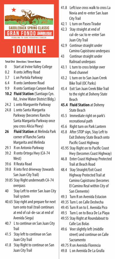
Direction / Street Name
0 Start at Irvine Valley College0.2 R onto Je�rey Road3.7 L on Portola Parkway6.4 R onto Jamboree Road9.9 R onto Santiago Canyon Road10.2 Fluid Station (Santiago Cyn.
Rd., Irvine Water District Bldg.)24.2 L onto Marguerite Parkway24.8 L onto Santa Margarita
Parkway (becomes Rancho Santa Margarita Parkway once you cross Alicia Pkwy)
26 Fluid Station at Melinda Park corner of Rancho Santa Margarita and Melinda
29.1 R on Antonio Parkway39.2 R onto Ortega Hwy (CA-74
West)39.6 R Reata Road39.8 R into �rst driveway (towards
San Juan City Trail) 39.85 Stay Right underneath CA-74
overpass40 Stay Left to enter San Juan City
Trail system40.65 Stay right and prepare for next
turn onto trail (trail continues at end of cul-de-sac at end of Avenida Siega)
40.7 L to continue on San Juan City Trail
41.5 Stay left to continue on San Juan City Trail
41.8 Stay Right to continue on San Juan City Trail
41.8 Left/use cross walk to cross La Novia and re-enter San Juan City Trail
42.1 L turn on Paseo Tirador42.3 Stay straight at end of
cul-de-sac to re-enter San Juan City Trail
42.9 Continue straight under Camino Capistrano underpass
43 Continue straight under Railroad underpass
43.1 L turn to cross bridge over �ood channel
43.2 L turn on to San Juan Creek Bike Trail (OC Parks)
45.4 Exit San Juan Creek Bike Trail to the right at Doheny State Beach
45.4 Fluid Station at Doheny State Beach
45.5 Immediate right on park’s recreational path
45.6 Right turn on Park Lantern45.8 After STOP sign, Stay Left to
Exit Doheny State Beach onto Paci�c Coast Highway
45.95 Stay Right on to Paci�c Coast Hwy (becomes Coast Highway)
46.8 Enter Coast Highway Protected Trail at Beach Road
48.4 Stay Straight/Exit Coast Highway Protected Trail at Camino Capistrano (becomes El Camino Real within City of San Clemente)
49.3 Turn R on Avenida Estacion49.35 Turn L on Calle Deshecha49.45 Turn R on to E. Avenida Pico49.5 Turn L on to Boca De La Playa49.55 Stay Right at Roundabout to
Calle Las Bolas49.6 Veer slightly left (middle
street) and continue on Calle Sacramento
49.75 R on Avenida Florencia49.8 L on Avenida De La Grulla
50 R on Calle La Puente50.5 R on W. Avenida Palizada50.6 L on to N. Calle Seville (turns
into Avenida Santa Barbara)50.9 R onto S. Ola Vista51 Slight left to Stay on S. Ola
Vista51.6 Slight Left to Stay on S. Ola
Vista52.3 L on Avenida Cala�a52.35 R onto Avenida Del Presidente53.4 L onto Christianitos53.4 Immediate Right onto Paci�c
Coast Bike Route trail54.4 Stay left to exit thru fence
opening onto Old Paci�c Coast Highway
57.1 Continue straight to enter San Onofre State Beach
59.05 Turnaround at Fluid Station 5 (San Onofre State Beach)
61.05 Continue straight to Exit San Onofre State Beach
63.75 Stay Right to Enter turnout then cross Old Paci�c Coast Highway in crosswalk then
63.75 Enter fence opening on Right to re-enter Paci�c Coast Bike Route
64.85 L onto Christianitos Road64.85 Stay right on to Avenida Del
Presidente65.85 L onto Avenida Cala�a65.9 R onto S. Ola Vista67.35 L onto Avenida Santa Barbara
(turns into S/N Calle Seville)67.8 L onto Calle Puente68.3 L onto Avenida De La Grulla68.4 R onto Avenida Florencia68.45 L onto Calle Sacramento68.65 Stay left onto Calle Las Bolas68.7 Stay right at Roundabout then
left on Calle Deshecha
68.75 R onto Avenida Pico68.8 L onto N. El Camino Real
(becomes Coast Highway)69 Stay right to Enter El Camino
Real Segregated Side Path69.85 Re-enter Coast Highway
Protected Path at Camino Capistrano (Important: Use crosswalk on North side of Intersection)
71.45 L turn onto Beach Road (over Railroad tracks)
71.5 R onto Doheny Beach Trail72.4 L turn onto Park Lantern72.6 L turn onto Doheny Beach
Path (just after bridge)72.65 Fluid Station (Welcome Back!)72.7 U-Turn to the left to re-enter
San Juan Creek Bike Trail75 R turn to go over bridge, then
left on other side of bridge75 Stay left to enter Trabuco
Creek Trail (City of San Juan Capistrano)
76 L turn onto Avenida De La Vista
76.9 R onto Oso Rd.76.95 L onto Camino Capistrano79.3 R onto Avery Parkway79.4 L onto Marguerite Parkway87.3 L onto Santa Margarita (turns
into Portola Pkwy at El Toro Road)
89.6 Fluid Station – (Intersection of Bake Pkwy. & Portola Pkwy.)
90 L onto Alton Parkway94.3 R onto Barranca Parkway98.4 R onto Je�rey Road98.6 R into Irvine Valley College98.7 R turn onto IVC Access Road98.8 Follow IVC Access Road to
Finish
Total Dist
100M ile

Direction / Street Name
0 Start at Irvine Valley College0.2 R onto Je�rey Road3.7 L on Portola Parkway6.4 R onto Jamboree Road9.9 R onto Santiago Canyon Road10.2 Fluid Station (Santiago Cyn.
Rd., Irvine Water District Bldg.)24.2 L onto Marguerite Parkway24.8 L onto Santa Margarita
Parkway (becomes Rancho Santa Margarita Parkway once you cross Alicia Pkwy)
26 Fluid Station at Melinda Park corner of Rancho Santa Margarita and Melinda
29.1 R on Antonio Parkway39.2 R onto Ortega Hwy (CA-74
West)39.6 R Reata Road39.8 R into �rst driveway (towards
San Juan City Trail) 39.85 Stay Right underneath CA-74
overpass40 Stay Left to enter San Juan City
Trail system40.65 Stay right and prepare for next
turn onto trail (trail continues at end of cul-de-sac at end of Avenida Siega)
40.7 L to continue on San Juan City Trail
41.5 Stay left to continue on San Juan City Trail
41.8 Stay Right to continue on San Juan City Trail
41.8 Left/use cross walk to cross La Novia and re-enter San Juan City Trail
42.1 L turn on Paseo Tirador42.3 Stay straight at end of
cul-de-sac to re-enter San Juan City Trail
42.9 Continue straight under Camino Capistrano underpass
43 Continue straight under Railroad underpass
43.1 L turn to cross bridge over �ood channel
43.2 L turn on to San Juan Creek Bike Trail (OC Parks)
45.4 Exit San Juan Creek Bike Trail to the right at Doheny State Beach
45.4 Fluid Station at Doheny State Beach
45.5 Immediate right on park’s recreational path
45.6 Right turn on Park Lantern45.8 After STOP sign, Stay Left to
Exit Doheny State Beach onto Paci�c Coast Highway
45.95 Stay Right on to Paci�c Coast Hwy (becomes Coast Highway)
46.8 Enter Coast Highway Protected Trail at Beach Road
48.4 Stay Straight/Exit Coast Highway Protected Trail at Camino Capistrano (becomes El Camino Real within City of San Clemente)
49.3 Turn R on Avenida Estacion49.35 Turn L on Calle Deshecha49.45 Turn R on to E. Avenida Pico49.5 Turn L on to Boca De La Playa49.55 Stay Right at Roundabout to
Calle Las Bolas49.6 Veer slightly left (middle
street) and continue on Calle Sacramento
49.75 R on Avenida Florencia49.8 L on Avenida De La Grulla
50 R on Calle La Puente50.5 R on W. Avenida Palizada50.6 L on to N. Calle Seville (turns
into Avenida Santa Barbara)50.9 R onto S. Ola Vista51 Slight left to Stay on S. Ola
Vista51.6 Slight Left to Stay on S. Ola
Vista52.3 L on Avenida Cala�a52.35 R onto Avenida Del Presidente53.4 L onto Christianitos53.4 Immediate Right onto Paci�c
Coast Bike Route trail54.4 Stay left to exit thru fence
opening onto Old Paci�c Coast Highway
57.1 Continue straight to enter San Onofre State Beach
59.05 Turnaround at Fluid Station 5 (San Onofre State Beach)
61.05 Continue straight to Exit San Onofre State Beach
63.75 Stay Right to Enter turnout then cross Old Paci�c Coast Highway in crosswalk then
63.75 Enter fence opening on Right to re-enter Paci�c Coast Bike Route
64.85 L onto Christianitos Road64.85 Stay right on to Avenida Del
Presidente65.85 L onto Avenida Cala�a65.9 R onto S. Ola Vista67.35 L onto Avenida Santa Barbara
(turns into S/N Calle Seville)67.8 L onto Calle Puente68.3 L onto Avenida De La Grulla68.4 R onto Avenida Florencia68.45 L onto Calle Sacramento68.65 Stay left onto Calle Las Bolas68.7 Stay right at Roundabout then
left on Calle Deshecha
68.75 R onto Avenida Pico68.8 L onto N. El Camino Real
(becomes Coast Highway)69 Stay right to Enter El Camino
Real Segregated Side Path69.85 Re-enter Coast Highway
Protected Path at Camino Capistrano (Important: Use crosswalk on North side of Intersection)
71.45 L turn onto Beach Road (over Railroad tracks)
71.5 R onto Doheny Beach Trail72.4 L turn onto Park Lantern72.6 L turn onto Doheny Beach
Path (just after bridge)72.65 Fluid Station (Welcome Back!)72.7 U-Turn to the left to re-enter
San Juan Creek Bike Trail75 R turn to go over bridge, then
left on other side of bridge75 Stay left to enter Trabuco
Creek Trail (City of San Juan Capistrano)
76 L turn onto Avenida De La Vista
76.9 R onto Oso Rd.76.95 L onto Camino Capistrano79.3 R onto Avery Parkway79.4 L onto Marguerite Parkway87.3 L onto Santa Margarita (turns
into Portola Pkwy at El Toro Road)
89.6 Fluid Station – (Intersection of Bake Pkwy. & Portola Pkwy.)
90 L onto Alton Parkway94.3 R onto Barranca Parkway98.4 R onto Je�rey Road98.6 R into Irvine Valley College98.7 R turn onto IVC Access Road98.8 Follow IVC Access Road to
Finish
COURSE CONTACT: DAVID 949-419-5005MEDICAL EMERGENCY: 911