to gauge an understanding of how boundaries are perceived
TRANSCRIPT

Technological University Dublin Technological University Dublin
ARROW@TU Dublin ARROW@TU Dublin
Conference Papers School of Transport Engineering, Environment and Planning
2011
To Gauge an Understanding of How Boundaries are Perceived in To Gauge an Understanding of How Boundaries are Perceived in
Ireland by Landowners Ireland by Landowners
Daragh O'Brien Technological University Dublin, [email protected]
William Prendergast Technological University Dublin, [email protected]
Follow this and additional works at: https://arrow.tudublin.ie/beschspcon
Part of the Land Use Law Commons, Property Law and Real Estate Commons, and the Urban Studies
and Planning Commons
Recommended Citation Recommended Citation O'Brien, D., O'Brien, W., Prendergast, W.:To Gauge an Understanding of How Boundaries are Perceived in Ireland by Landowners. FIG Working Week 2011:Bridging the Gap between Cultures, Marrakech, Morocco, 18-22 May 2011.
This Conference Paper is brought to you for free and open access by the School of Transport Engineering, Environment and Planning at ARROW@TU Dublin. It has been accepted for inclusion in Conference Papers by an authorized administrator of ARROW@TU Dublin. For more information, please contact [email protected], [email protected].
This work is licensed under a Creative Commons Attribution-Noncommercial-Share Alike 4.0 License

1/23
To gauge an understanding of how boundaries are perceived in Ireland by landowners.
Daragh O’Brien, [email protected]
Dr. Patrick Prendergast, [email protected]
Department of Spatial Information Sciences, Dublin Institute of Technology, Dublin 1 SUMMARY Recent anecdotal evidence from property professionals indicates that there has been a significant increase in boundary disputes in Ireland since the phased publication of the Land Registry digital map in 2005. There is a need to investigate this development in order to confirm or refute this trend and attempt to identify the issues causing these disputes. There is an absence of detailed information on the causes and types of boundary disputes within the Irish Legal system. This project aims to address this lack of information by collecting comprehensive information on a range of case studies over the past 5 years and determine the incidence of these types of disputes. The cost to all parties to these disputes will also be estimated to inform policy makers of the effectiveness of the current system. An electronic questionnaire on boundaries in general, was carried out to gauge the perception and context in which property boundaries are perceived in Ireland by landowners. Initial results from this first questionnaire show that 32% and 38% of landowners in urban and rural areas respectively have issues with their boundaries, and 22% of landowners did not know whether their property is registered in Land Registry or in Registry of Deeds. A second questionnaire, currently in progress, intends collecting information on specific boundary dispute cases to determine the issues causing these disputes and identify the various types of disputes within this litigation category. This study hopes to inform the need for policy reform of the Land Administration System for land tenure in Ireland. Key words: Non-Conclusive Boundaries, Boundary Disputes & Property Boundaries

2/23
To gauge an understanding and concept of how boundaries are perceived in Ireland by landowners.
Daragh O’Brien
1. INTRODUCTION Without boundaries there would be no maps. International boundaries have been man made which give countries their shape and whose borders limit sovereignty. Boundaries were formed throughout history based on historical background and colonial times. Where you find boundaries a detailed analysis may uncover conflict, whether this is between one country and another, it is very prevalent between one landowner and another. The purpose of this paper is to show Irish landowner's knowledge of their boundaries and an overall perspective of how property boundaries are perceived in Ireland. Many landowners know where their property boundaries are by locating the physical features on and around their holding. However, ask them to precisely identify where the exact boundary lines are, many have different views where their boundaries are. Their views range from identifying the physical natural boundary, locating deeds, maps, architectural/engineering/land surveying drawings or they may not know at all. Detailed and specific information is not available for Irish property owners and maybe inadequate for use today in mapping or conveyancing. Information on boundaries needs to be clarified and accurately defined to avoid ambiguity. This paper includes a detailed discussion of the key findings from two questionnaires and concludes with a number of recommendations. 2. BOUNDARY CATEGORIES The term boundary is denoted by a physical feature marking the limit of a land parcel or an imaginary line identifying the divide between two legal interests in a plot of land (Williamson et al, 2010). The boundary system within a country is the cornerstone for a land administration to work effectively and efficiently. Below is an example of some of the main categories of boundaries. 2.1 Cadastre Recording and taxing ownership of land has been in operation since Egyptian and Napoleonic times. Cadastres were one of the first systems used to aid in the collection of taxes on land. A Cadastre can be described as a complete co-coordinated map of accurately defined land parcels, which describe every parcel of land in a country i.e. residential properties, commercial properties, roads, public spaces and infrastructure (Wallace et al, 2010). Cadastres are planimetric maps where accurate co-coordinated measurements of boundaries can be taken from the map. No topographic features are shown on Cadastre maps. An important requirement of Cadastral maps is that they show a sufficient number of points, which can accurately define positions on the ground (FAO, 2011). In most countries, ground surveys are used to accurately define the land parcels. However, some countries cannot afford to survey land parcels on the ground due to expenses involved and lack of personnel. Once a Cadastre is functioning, detailed information can be accessed from the maps including the ability to scale information (Wallace et al, 2010). All this information is stored in digital databases where geocoding is added i.e. street address, location of houses and plot numbers etc. A country that uses a cadastre efficiently is Australia where farmers,

3/23
developer’s, water authorities, road builders, delivery systems, planners, land managers and others use this system which provides information and data to them in an authoritative and legally enforceable way (Wallace et al, 2010). A Cadastre system is essential for a good land administration and land management. 2.2 Conclusive Boundaries Conclusive boundaries are also known as fixed boundaries. Conclusive boundaries were introduced under the Torrens system where property boundaries were guaranteed when ones land was registered (Murphy et al, 1992). Conclusive boundaries can be defined as the precise line of the boundary determined by land surveys which are in turn expressed by co-ordinates (Williamson et al, 2010) where as the Inter-Professional Task Force on Property Boundaries (IPTFPB) defines a conclusive boundary as where,
“…the register does contain sufficient information to define the boundary either legally or geometrically so that it is not open to challenge, and is guaranteed by the state” (IPTFPB, 2010).
Concrete posts, steel rods or a boundary mark in the ground usually represents these types of boundaries marked by professional surveyors. This boundary system is the most common system used around the world and two variants are available, the German and Torrents systems (Figure 3). 2.3 Non – Conclusive Boundaries Non-conclusive boundaries are also known as general boundaries in the United Kingdom. Ireland uses a non-conclusive boundary system where the precise location of the boundary and its features is not accurately defined. The system is defined as where,
“...the register does not contain sufficient information to define the boundary either legally or geometrically. Consequently, the boundary is open to challenge, and is not guaranteed by the state” (IPTFPB, 2010).
Ireland began to use non-conclusive boundaries in 1891 under the local Registration of Title Act, which came about from the English Land transfer Act 1875. More recently in the Registration of Title Act 1964, S85, it states,
“…except as provided by this Act, the description of the land in the register or on such maps shall not be conclusive as to the boundaries or extent of the land” (Houses of the Oireachtas, 1964, Section 85).
Irelands land registration system is made up of folios and maps. Irish property folios are deemed to be reliable, thus the title is conclusive and guaranteed by the state. In contrast, the Property Registration Authority (PRA) maps are regarded as unreliable and non-conclusive and are consequently not guaranteed by the state. This aspect of the Irish mapping system is less secure and is an area where reform is needed (Prendergast el al, 2008). Non-Conclusive boundaries are usually represented on the ground by physical features, natural or man made, for example, fence, hedgerow, wall, ditch, road or tree line (Williamson et al, 2010). It should also be noted that the registered boundary depicts the physical feature rather than the determined boundary.

4/23
3. IRELAND’S PROPERTY BOUNDARIES Ireland has two separate systems for recording property transactions, the Registry of Deeds (registration of deeds system) and the Land Registry (registration of title system). The first system of registration was introduced in 1707 when the Registry of Deeds was set up to record the registration of documents dealing with land and conveyances under the Registration of Deeds Act of 1707 (Fitzgerald, 1989). There was no obligation to register, however priority was lost in failing to register and thus it became standard conveyancing practice to register deeds in relation to unregistered land (Fitzgerald, 1989). Work within the Registry of Deeds became technical and difficult because of the complications with Irish titles and names of town lands, which became time consuming and expensive with fees ranging from £37 - £5,000 for each transaction and reform of the Registry of Deeds was required (Murphy et al, 1992). Reform was being considered in 1854 when the Registration of Title Commission was appointed and on foot of their report in 1857 the Registration of Titles in Ireland was founded. In 1858, Irish born Sir Robert Torrens introduced a simple form of registration of title in Southern Australia. The Torrens system was revolutionary delivering cost effective and quick land registration where it detailed on one single piece of paper the description of the land parcel, the known registered proprietor and any encumbrances (i.e. mortgages) to do with the land (Williamson et al, 2010). Ireland adopted the English version of the Torrens system, which in contrast used a form of general boundaries instead of defined boundaries. As Ireland was under British rule at this time, further English acts were implemented and revised, such as The Land Registry Act (1862) and the Land Transfer Act (1875) that after many years of consultation concluded that boundaries were no longer required to be accurate to the nearest inch (Murphy et al, 1992). Various commissions and reports were introduced to deal with registration to develop a satisfactory system for Ireland.
In 1862, an act to facilitate proof of title was introduced to register land, which was voluntary and proved a problem, as only a small number (349) of properties were registered mainly because of the complexity of English law (Murphy et al, 1992). In 1865, land registration was attempted with the Record of Title Act (Ireland) drafted by Sir Robert Torrens, which required land registration within seven days of purchase. This again was cumbersome and slow where only 681 titles were recorded (Murphy et al, 1992). A further Royal Commission issued a report in 1879 and was followed by the Land Law Ireland Act of 1881. The Purchasing Land Act of 1885 recorded 21,850 properties being vested in tenant purchasers (Murphy et al, 1992). The Land Commission was established in 1885 to distribute loans to farmers under a tenant purchase scheme. Substantial progress was made in 1888 when the Attorney General for Ireland suggested two bills to the chief secretary to resolve Land Registry…a) The reform of the Registration of Deeds and b) a Registration of Title. The Registration of Title Ireland bill of 1891 was passed and came into operation on the 1st January 1892 (Murphy et al, 1992). When the Land Registry was set up in 1891, Ireland was still recovering from the famine in the 1840’s. Under a British incentive the land registration system was to give tenant farmers freehold ownership of their farms and to replace the feudal system that was in operation at the time (Prendergast el al, 2008). The 1891 Act was amended

5/23
by the Registration of Title Act 1942 which were both replaced by the Registration of Title Act 1964 and which was then in turn replaced by the Registration of Deeds and Title Act 2006. Most recently in 2009, the Land and Conveyancing Law Reform Act was established to repeal enactments that were obsolete, unnecessary and of no assistance in modern circumstances (Houses of the Oireachtas, 2009).
The Land Registry make it clear that when a map is submitted for registration, it is the responsibility of the applicant to ensure the accuracy of the areas and that boundaries have no conflict with the current Land Registry map (Fitzgerald, 1989). According to Maltby (2010), the lines on a Land Registry map have no spatial significance and simply serve to indicate the separation between properties. The Land Registry also maintains three registers relating to the ownership of land and appurtenant rights on the land, namely freehold, leasehold and hereditaments or other rights on the property. Each of these consists of separate folios/files that contain information on the title of a particular interest in freehold land, leasehold interest or incorporeal rights which is attached to property and which is inheritable (Brophy, 2003). Nowadays the Registry of Deeds deals with titles mostly in urban areas, while the Land Registry deals with titles outside the main urban areas. Files in the Registry of Deeds record the name of the person who has disposed of property, which or may not have been the property’s owner (Brennan et al, 2008). One of the main differences between the Land Registry and Registry of Deeds is that the Registry of Deeds system provides for the registration of documents dealing with land. The Land Registry provides registration for ownership and title together with other interests in land (Fitzgerald, 1989). Other differences set out in Figure 1 include:
Registry of Deeds
(Unregistered Title)
Land Registry
(Registered Title)
– Existence of documents used – Registration gives no validity except in case of
judgement mortgage – Title must be fully investigated – not conclusive – Title not guaranteed by the state – Property is identified by the description
contained in various title deeds
– The effect of documented noted – Registration gives validity to the effect of a
document – Title & folio conclusive (except for s72
burdens & boundaries) – Title guaranteed by the state – Property identified by official Land Registry
Ordnance Survey map contained in various title deeds
Figure 1: Registry of Deeds & Land Registry differences (Brennan et al, 2008)

6/23
Land Registry Ireland operates on a non-conclusive boundary system, where the map does not indicate the physical feature of a boundary. The physical boundary on the ground is the most reliable evidence of physical features, such as hedge, ditches, fence or wall (Maltby, 2010). Ordnance Survey Ireland (OSi) is Ireland’s official national premier mapping agency and is responsible for the topographic mapping indicating the natural and built environment. The OSi position regarding property boundaries is that,
“OSi maps never indicate legal property boundaries, nor do they show ownership of physical features. Although some property boundaries may be coincident with surveyed map features, no assumptions should be made in these instances and consequently it is not possible to identify the position of a legal property boundary from an OSi map” (OSi, 2011, pg. 1).
From research the OSi conducted from 2004 – 2009, accuracy of their large scale mapping system indicates accuracy of urban areas to be 98.7% accurate to within 2m and 99.9% accurate in rural areas to within 5m accurate (Society of Chartered Surveyors, 2010). Under the provisions of the Registration of Deeds and Title Act 2006, the Registry of Deeds and the Land Registry were combined to form the PRA. The Land Registry and Registry of Deeds had been undergoing major changes to its systems for a number of years and a more modernized land registration system was needed, such as digital mapping, to further develop online services such as e-conveyancing. Another reason for this amalgamation was that legal transactions were up by 125% mainly because of the property boom in Ireland between 1999 – 2006 (Organisational Review Programme, 2008). The PRA’s primary statutory mandate is to provide a system of registration of title to land that is complete and easy to use. According to O’Sullivan (2007),
“…when the title to a piece of property is registered, the PRA on behalf of the State guarantees that title. The statutory position is that a deed does not operate to transfer registered land until the transferee is registered as owner. This means that no legal title passes to a purchaser of registered property until the transaction is registered on the land register” (O’Sullivan, 2007, pg.1).
Approximately 1.8 million registered titles covering about 2.5 million land parcels are now catered for in the Land Register (85% of all legal titles within the state) (O’Sullivan, 2007). The Land Registry in 2005 announced that all existing paper based maps would be converted into electronic form over a five-year period, known as the Digital Mapping Project. In August 2010 the mapping project was completed with all 26 counties fully digitized. The digital mapping project now provides easy access to data, which is viewed by clicking the seed point on the map to give information on the property, including the folio number.

7/23
Figure 2: Percentage of registered titles in Ireland (adapted from O’Sullivan, 2007)
8/23
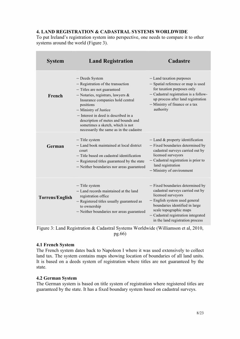
4. LAND REGISTRATION & CADASTRAL SYSTEMS WORLDWIDE To put Ireland’s registration system into perspective, one needs to compare it to other systems around the world (Figure 3).
System
Land Registration
Cadastre
French
– Deeds System – Registration of the transaction – Titles are not guaranteed – Notaries, registrars, lawyers &
Insurance companies hold central positions
– Ministry of Justice – Interest in deed is described in a
description of metes and bounds and sometimes a sketch, which is not necessarily the same as in the cadastre
– Land taxation purposes – Spatial reference or map is used
for taxation purposes only – Cadastral registration is a follow-
up process after land registration – Ministry of finance or a tax
authority
German
– Title system – Land book maintained at local district
court – Title based on cadastral identification – Registered titles guaranteed by the state – Neither boundaries nor areas guaranteed
– Land & property identification – Fixed boundaries determined by
cadastral surveys carried out by licensed surveyors
– Cadastral registration is prior to land registration
– Ministry of environment
Torrens/English
– Title system – Land records maintained at the land
registration office – Registered titles usually guaranteed as
to ownership – Neither boundaries nor areas guaranteed
– Fixed boundaries determined by
cadastral surveys carried out by licensed surveyors
– English system used general boundaries identified in large scale topographic maps
– Cadastral registration integrated in the land registration process
Figure 3: Land Registration & Cadastral Systems Worldwide (Williamson et al, 2010, pg.66)
4.1 French System The French system dates back to Napoleon I where it was used extensively to collect land tax. The system contains maps showing location of boundaries of all land units. It is based on a deeds system of registration where titles are not guaranteed by the state. 4.2 German System The German system is based on title system of registration where registered titles are guaranteed by the state. It has a fixed boundary system based on cadastral surveys.

9/23
4.3 Torrens/English System The Torrens system uses fixed boundaries based on Cadastral surveys where registered titles are guaranteed by the state (Brophy, 2003). The English system is a variant of the Torrens system of land registration, where registered titles are guaranteed by the state, however boundaries are not. Properties are identified on maps from Ordnance Survey maps using general/non–conclusive boundaries. Below is an illustration of the types of registration systems used throughout the world.
Figure 4: World Map of Land Registration Systems (Enemark, 2004)
Recording boundaries accurately is not just a problem here in Ireland. It is an issue worldwide. In Hong Kong, official monuments may mark the corner of land parcels, while boundaries may be defined by descriptive plans however it may not fully define boundaries on the ground (Park, 2003). In Hong Kong, Tang (2004) describes their land registration system as way behind the stable Australian boundary system and very far behind the Singaporean system, where their national land boundary records are a legal co-ordinate cadastre. Land administration systems are essential parts of a country’s national infrastructure. They are in constant reform and are part a nations identity,
“...representing societies perceptions of land, making them distinctly different in every country... Land administration systems are generally complex in themselves, and the cultural, traditional, and social diversities increase the complexity of evaluating and comparing national systems with each other even more” (Steudler, 2004, pg. 4).
Land registration systems are all well and good for countries that can afford them, it is different in third world countries that have no funding and cannot afford such elaborate systems. This can be seen primarily in South America where they have adapted deeds registration without legal sanction of boundaries (Tang, 2004). A main contributor to the cause of property rights for poverty stricken countries is Peruvian born economist, Hernando De Soto. De Soto (2000), describes England & Europe as having “an integrated legal property system” that manages a nations assets. Europe with their Cadastre and England with their title based system enables these countries to register land effectively. De Soto wants more security of tenure for property owners in undeveloped countries. De Soto has acted on this and has proposed that

10/23
land held by the poor be titled, and thus create financial opportunities that would release the value of land. De Soto believes that this would help identify capital that is tied up in land and use their land as security and an opportunity to access credit. This ideology is now being implemented by the United Nations (Williamson et al, 2010). 5. SOCIAL BOUNDARIES However, for the undeveloped countries, access to credit is not as important as the way they value their land. The same is for western democracies. People value land for spiritual, social, & economic reasons, it is not just something people walk on (Williamson et al, 2010). Irish people for instance, have had a long affection with land and Irish boundaries and boundary disputes have been famously depicted in literature and film. This connection to land has been highlighted by Patrick Kavanagh in his 1938 poem, “Epic”, which described a violent row between neighbours.
“…who owned/that half a rood of rock, a no-man's land/ Surrounded by our pitchfork-armed claims./I heard the Duffy’s shouting "Damn your soul…” (Brien el al, 1972, pg. 136)
More recently the 1990 Hollywood movie, “The field” was written by John B. King as a play in 1965, featuring “The Bull McCabe” who did all he could to save (murdering the purchaser of the land) the land he loved from being sold at public auction. What is impressive about “Epic” and “The field” is the timelessness of the writing. They both continue to be applicable in modern Irish life and have not lost relevance in the years of writing where one witnesses land and boundary disputes cases in the courtrooms of modern Ireland.
6. RESEARCH METHODOLOGY This aim of this research is to assess the knowledge of boundaries of landowners of Irish Property (property located on the island of Ireland) and to gain an overall perspective of how property boundaries are perceived in Ireland. An electronic survey of landowners was conducted using SurveyGizmo and a link to the survey was provided on the research website, www.boundarydisputesireland.com. The questionnaire was available also in postal form. In order to make people aware of the research and to complete the questionnaire, it was necessary to promote the research project in a number of National and Regional newspapers such as, the Irish Independent, a feature article was written on the research project in the Irish Times by renowned journalist Mr. Frank McNally, and a large number of regional newspapers. The questionnaire attempts to collect information on the issues and problems being experienced in relation to property boundaries. It also collects a broad spectrum of different opinions on the subject matter and how people perceive their own boundaries and what was their knowledge of the land/plots they owned.

11/23
Figure 5: Image of Research Project Website
The Questionnaire was divided into two separate sections, a survey on Boundaries for Landowners who own Residential Properties in urban areas and a survey on Boundaries for Landowners in rural settings. The questions asked include, do they know they own the lands to the middle of the road? What boundary features surround the property? Did professionals check the boundaries? Do they know where their property is registered? A pilot study was performed among twelve relevant professionals including Architects, Barristers, Engineers, Quantity Surveyors, Solicitors and Land Surveyors to ensure the questions were relevant and understood. On the basis of the pilot study results, numerous alterations were made to the questionnaire and once amendments were completed the survey was published for general release after receiving ethical approval. Considerable effort was made from the outset, in the questionnaire design, that the questionnaire would reach the target population and maximise responses. 7. LIMITATIONS OF RESEARCH A number of limitations were encountered in this process. The main ones being: — It was apparent when analysing the data from the surveys, that some of the
questions posed at the start of the survey were too detailed. This led to a number of surveys being abandoned (91 rural & 77 urban) or partially completed (39 rural & 8 urban). In hindsight the questionnaire was possibly too detailed and thus completing it was too time consuming for respondents.
— Some questions may have been inappropriate to which people were not comfortable in answering, such as asking people to elaborate on the issues they have with their boundary.
— The study had a relatively small response rate. A total of 86 respondents.

12/23
8. RESULTS 8.1 Validity of Results Probability theory and random sampling help to avoid biases in survey results, but this was not used for this survey due to difficulties involved with targeting respondents. Convenience sampling was used instead to specifically target owners of Irish properties. These results apply to landowners rather than the general public. The Land Registry state that they have 1.8 million registered properties and they also estimate that the Registry of Deeds contains another 15% of properties (270,000), which indicates a total of 2,070,000 properties in the State as compared to a total population of 4,450,000 determined by the 2006 census (CSO, 2006). There are no statistics available yet to break down these properties into urban and rural, so for the purposes of this research the total figure has been split in half for urban and rural areas.
Questionnaire Population Size
Required sample for +/-10% Error
Margin
Responses Sampling Error to Date
Urban 1,035,000 68 41 ±13.0%
Rural 1,035,000 68 45 ± 12.4%
Total 2,070,000 68 86 ± 8.9%
Figure 6: Validity of Responses Received The validity of this research was checked using the statistical tool available at http://www.relevantinsights.com/research-tools. A confidence level of 90% and a margin error of ±10% were adopted for the survey. This means that if the survey is completed 100 times, the answer to any question can be expected to vary between the chosen margin of error in 90 out of 100 times. For both surveys the margin of error was larger than planned at ±13.0% and ±12.4% respectively due to the relatively small size of the sample, while the margin of error for both surveys combined was within the adopted tolerance at ±8.9%.

13/23
8.2 Respondents Forty-five respondents completed the rural questionnaire, which included Irish property owners from Qatar, United Kingdom, Netherlands and the United States of America. Forty-one respondents completed the urban questionnaire and some respondents were from United Kingdom, Canada and the United States of America.
Figure 7: Percentage of respondents with respect to property ownership

14/23
8.3 Registered Property According to the O’Sullivan (2007) there are 2.5 million parcels of land in Ireland are registered with the PRA. The other unregistered land is presumed to be with the Registry of Deeds, which is due to close in the coming years. The question sought landowners knowledge where their property was registered indicated a divergence of views. The survey indicated that 20% did not have any knowledge of where their property was registered and this applied to both urban and rural respondents. On balance, circa 80% knew that registration on some level was required and over 60% confirmed the Land Registry as the appropriate body to register their property.
Urban Rural Land Registry 67% Registry of Deeds 13% Don’t know 20%
Land Registry 61% Registry of Deeds 18% Don’t know 21%
8.4 Boundary Features The features of a boundary are what distinguishes one property from another and are the source of much argument and ambiguity when it comes to a dispute. The difficulties with boundary features are that they are delineated on Ordnance Survey maps, however the actual line of the boundary is not determined or recorded on the maps. Results from the survey were what was generally to be expected with a high proportion of Walls (58%) recorded as boundaries in urban areas in keeping with high density due to the extensive planning and requirements of Local Authority planning conditions to have permanent type of boundary walls in residential development. Urban areas also showed a wide variety of fencing types, 20% where different types of material were used for railing, timber fencing etc. Again in complying with the local development plans in rural areas up to 80% of boundaries were natural, tree lined, hedgerows with timber stud railing in keeping with the natural environment of the countryside. Lines on OSi maps illustrate topographic features however does not define the type of feature. These maps may represent property boundaries or may not. However the PRA use OSi maps without any guarantee on their reliability (Prendergast et al, 2008).
Urban Rural Walls 58% Other 22% Fence 13% Trees/Hedgerow 7%
Trees/Hedgerow 57% Fence 22% Wall 21% Other 0%
15/23
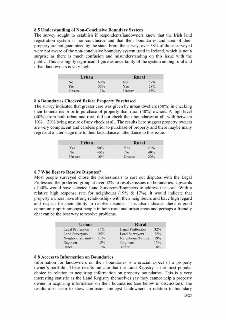
8.5 Understanding of Non-Conclusive Boundary System The survey sought to establish if respondents/landowners knew that the Irish land registration system is non-conclusive and that their boundaries and area of their property are not guaranteed by the state. From the survey, over 58% of those surveyed were not aware of the non-conclusive boundary system used in Ireland, which is not a surprise as there is much confusion and misunderstanding on this issue with the public. This is a highly significant figure as uncertainty of the system among rural and urban landowners is very high.
Urban Rural No 60% Yes 33% Unsure 7%
No 57% Yes 28% Unsure 15%
8.6 Boundaries Checked Before Property Purchased The survey indicated that greater care was given by urban dwellers (50%) in checking their boundaries prior to purchase of property than rural (40%) owners. A high level (40%) from both urban and rural did not check their boundaries at all, with between 10% – 20% being unsure of any check at all. The results here suggest property owners are very complacent and careless prior to purchase of property and there maybe many regrets at a later stage due to their lackadaisical attendance to this issue.
Urban Rural Yes 50% No 40% Unsure 10%
Yes 40% No 40% Unsure 20%
8.7 Who Best to Resolve Disputes? Most people surveyed chose the professionals to sort out disputes with the Legal Profession the preferred group at over 32% to resolve issues on boundaries. Upwards of 40% would have selected Land Surveyors/Engineers to address the issue. With a relative high response rate for neighbours (19% & 17%), it would indicate that property owners have strong relationships with their neighbours and have high regard and respect for their ability to resolve disputes. This also indicates there is good community spirit amongst people in both rural and urban areas and perhaps a friendly chat can be the best way to resolve problems.
Urban Rural Legal Profession 34% Land Surveyors 25% Neighbours/Family 17% Engineer 15% Other 9%
Legal Profession 32% Land Surveyors 28% Neighbours/Family 19% Engineer 13%
Other 8% 8.8 Access to Information on Boundaries Information for landowners on their boundaries is a crucial aspect of a property owner’s portfolio. These results indicate that the Land Registry is the most popular choice in relation to acquiring information on property boundaries. This is a very interesting statistic as the Land Registry themselves say they cannot help a property owner in acquiring information on their boundaries (see below in discussion). The results also seem to show confusion amongst landowners in relation to boundary
16/23
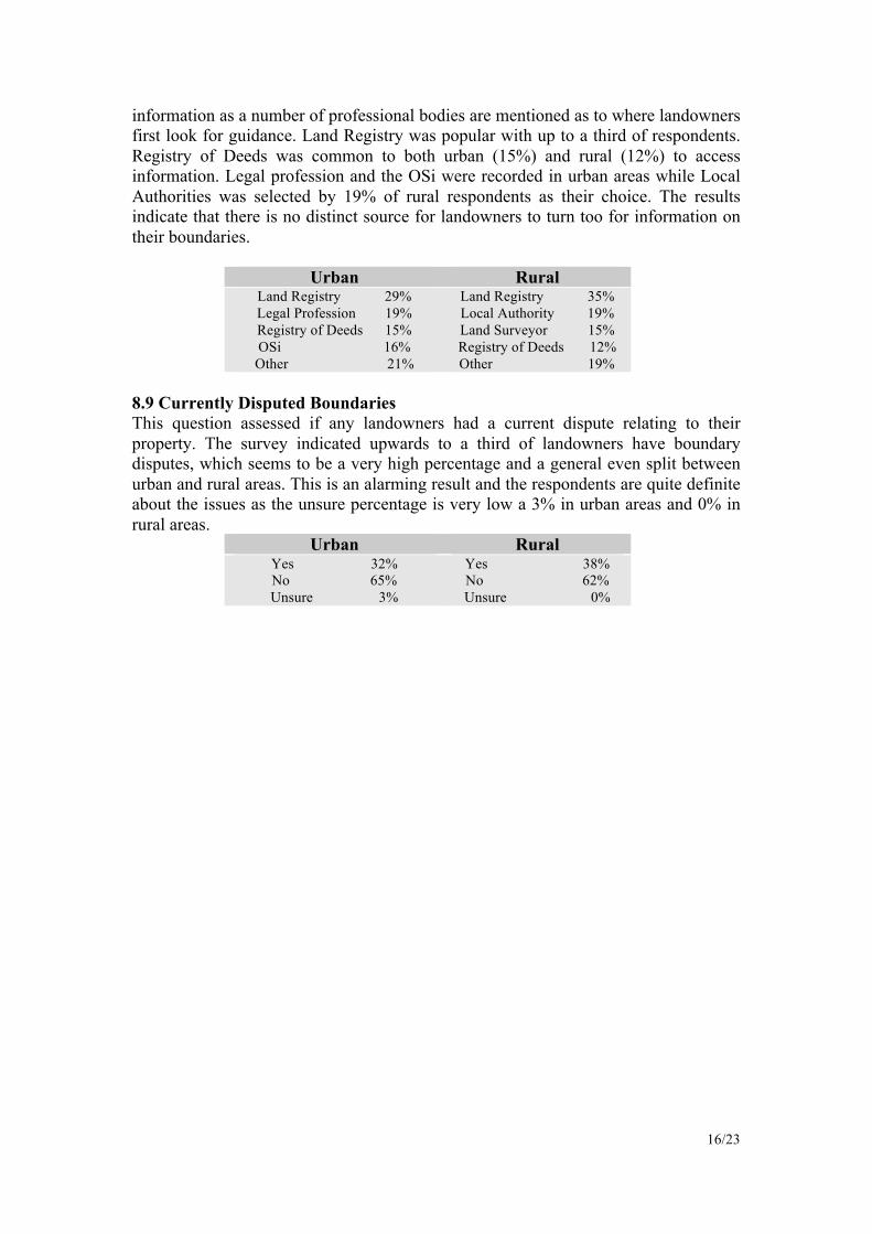
information as a number of professional bodies are mentioned as to where landowners first look for guidance. Land Registry was popular with up to a third of respondents. Registry of Deeds was common to both urban (15%) and rural (12%) to access information. Legal profession and the OSi were recorded in urban areas while Local Authorities was selected by 19% of rural respondents as their choice. The results indicate that there is no distinct source for landowners to turn too for information on their boundaries.
Urban Rural Land Registry 29% Legal Profession 19% Registry of Deeds 15% OSi 16% Other 21%
Land Registry 35% Local Authority 19% Land Surveyor 15% Registry of Deeds 12%
Other 19% 8.9 Currently Disputed Boundaries This question assessed if any landowners had a current dispute relating to their property. The survey indicated upwards to a third of landowners have boundary disputes, which seems to be a very high percentage and a general even split between urban and rural areas. This is an alarming result and the respondents are quite definite about the issues as the unsure percentage is very low a 3% in urban areas and 0% in rural areas.
Urban Rural Yes 32% No 65% Unsure 3%
Yes 38% No 62% Unsure 0%

17/23
9. DISCUSSION Every boundary system used throughout the world has its strengths and weaknesses and more often than not, the boundary system a country uses is influenced by local history. For Ireland, this was no different, as the boundary system we have today was inherited back in 1891. The data from this research illustrates that Ireland’s registration system has some way to go to improve Irish landowners knowledge of their boundaries. As described, on average, 21% of people did not know where their property was registered, while 60% of landowners choose the Land Registry as the main port of call to access information on their boundaries. There is confusion among landowners of the system of registration due to the many changes over the years and now with the introduction of the PRA, which is attempting to streamline the system. The results suggest there is a lack of confidence in the PRA to develop accurate documentation undermines the credibility and the public apathy and trust in the system and this may be its Achilles heel. 80% of those surveyed indicated that registration of some type was recorded and it is encouraging and certainly work needs to be done by the statutory authorities to promote and clearly define the system of registration in Ireland. Better communication is required by the statutory authorities to engage with the general public in providing information on their property.
“I have a dispute with my neighbour over where the boundary lies. Can you tell me who is right? No. The Land Registry map is an index map and identifies property, not boundaries. Therefore, we are not in a position to advise.” (PRA, 2010).
This statement suggests there is a problem with land registration system. This is noted by leading solicitors Kaye (2006) explaining that as long as the plans from the Land Registry do not clearly describe where the boundary lines are on a maps, they will always be open to dispute and thus boundary disputes will occur. Prendergast et al (2008) is also taken aback by this quote,
“For most property owners this answer is unbelievable. If the PRA cannot supply reliable information on property boundaries to resolve boundary disputes, who can, or more importantly, should the PRA be in a position to do so?” (Prendergast et al, 2008, pg. ix ).
The features of a boundary are what distinguishes one property from another and are one of the most important aspects of any boundary dispute. The results indicated hard landscape boundaries in urban areas and boundary features in keeping with rural landscape and its environment. The boundary features differ in type, shape and size from single post and wire fencing to a wide double ditch with watercourses. As the OSi maps show a line to represent a boundary together with the limited stated tolerances on the OSi maps, boundary features need to be surveyed accurately to show what is on the ground and all calculation of areas, plots and fields need to be made more accurately. Each boundary feature needs to be assessed in computing calculations and detail surveying of each feature for accurate mapping purposes.
“The lines on OSi maps depict topographic features (hedgerows, walls, etc) which may or may not represent property boundaries, and the PRA uses these lines on OS maps, without any checks on their veracity to depict the boundaries of properties” (Prendergast et al, 2008, pg. 3).
This ambiguity is thought to be one of the many reasons why boundary disputes occur and why Ireland’s land registration system does not guarantee property. Determining

18/23
the centre line of a boundary feature is important and an example of this can be described with a concrete block wall, which is easily determined. In relation to walls, some blocks maybe 100 mm wide, one is able to record the position of the centre line to ± 10 mm. However with other boundary features, such as an overgrown hedgerow and fences, they may differ in size and determining the accuracy and centre line of a boundary feature is extra important, as Ireland’s boundaries are non-conclusive (Prendergast et al, 2008). It was interesting to note that on average 58% of people did not know that Irelands boundaries were non-conclusive and not guaranteed by the state. This result further indicates the lack of property boundary knowledge Irish landowners have. Whether Ireland will change from a non-conclusive boundary system to a conclusive boundary system remains to be seen. There is a strong movement from the IIS (Irish Institute of Surveyors, 2008) where their aim is to adopt best practice and use modern surveying techniques to produce accurate boundary surveys for land registration and to implement a Cadastral like system to register boundaries as conclusive. One such way in which the Land Registry provides conclusive boundaries is when people have a dispute over a boundary; they can in fact under existing legislation, have the new agreed boundary registered as conclusive with the Land Registry. This has been in operation since the Registration of Titles Act 1964, sections 86, 87 & 88, however this is rarely used. It is also been encourage that landowner’s voluntary shift from non-conclusive boundaries to conclusive. It is difficult to see landowners opting for this, as both parties must form an agreement after detailed surveying has been complete. There are also encouraging signs of improvement within the professional surveying community with the development of a guidance note for Boundary Identification & Demarcation & Dispute Resolution (Society of Chartered Surveyors, 2010). This was introduced to encourage the surveying profession to implement standards in their day-to-day work to minimize ambiguity in their work. To further elaborate on this, Wallace et al (2010) explains that, in some underdeveloped countries, one cannot register their ownership of land & thus an informal selling process of land is only available. An effective land market needs to be functioning effectively through organized conveyancing mechanisms, boundary definitions and a well functioning banking sector that allows land to be kept as security. Wallace et al (2010), also claims that only around 35 countries in the world are able to use their land to generate wealth. Examples of countries who run effective land markets are USA, Europe, Canada, and Australia & New Zealand. In the USA, one aspect is different than other western democracies (Europe, Canada, Australia) in that the USA does not, like Ireland, have a national Cadastre. Wallace et al (2010) claims that one of the prime reasons for mortgage market failures, also known, as the sub-prime mortgage market was the lack of a national Cadastre which enables banks to identify which loans are bad and the location of these loans. Thus, the infection of the bad loans would not have spread as wildly through the main city areas and is a principal reason why Cadastres can be used to great effect along with the ability to manage land markets. Has Irelands lack of a Cadastre been a contributing factor in the catastrophic failure of Irelands Banking and Property system, currently estimated at €150 Billion? It was surprising that on average, 55% of landowners never checked their property boundaries or were unaware if they did so. This seems very careless by the

19/23
prospective purchaser when “caveat emptor” is well known as the purchasers risk in acquiring property. The survey records that only 45% of respondents checked their boundaries, which was a surprisingly low result in a vibrant market for property in the past 10 years when property became very expensive. The survey also indicated that the expert people within the Legal, Engineering and Surveying professions were best to resolve disputes. This would require landowners paying professional fees for their service and all of this tends to end up in court or an alternative dispute resolution with expensive costs, borne by the landowners. Results suggest that, 18% of neighbours choose to resolve their own disputes, however it was clearly not possible in the majority of cases. There was quite a wide variation of views from respondents with regard to access to information and where best to obtain direction on their boundaries. Even with the introduction of the new PRA system, it appears that the general public is not aware of its position or responsibility. More information is needed to address this situation by the relevant statutory bodies. The survey raised the issue of current disputes by landowners and it was significant that urban (32%) and rural (38%) had current disputes. This is over a third of respondents and what emerged was that there was a multiplicity of issues involved and uncertainty is an area that needs to be detailed and investigated further. Respondents were invited to identify how long they have owned their property. This was then matched to those who had claimed they had a dispute. It was found that the number of years people owned their property and those currently involved in a dispute was between 2 years and 40 years. When compared to the people in rural areas, a significant difference was established. The length of time they possessed their property was between 6 years and going back to previous generations for 200 years. The data clearly indicates that people who possess property for a longer period of time i.e. inherit and those who own a larger acreage of land are more susceptible to having disputes over their boundary. This information looks odd and needs further investigation. Furthermore respondents claimed that they were having issues with their boundaries asserting that that the new digital Land Registry map is inconsistent with boundaries on the ground, both in rural and urban areas. The issue of Irelands mapping system needs to be addressed, and the question needs to be asked, why are millions of Euro being spent on a system that is approximate nature and has little legal validity? 9.1 Other issues raised The survey indicated that landowners were unhappy that their rights of way were not registered or shown on Land Registry maps or deed maps, which in many cases created uncertainty and ambiguity with landowners entitlements. Other issues identified include, encroachments by neighbours and alternations to original boundaries due to planning permission issues. 10. CONCLUSIONS & RECOMMENDATIONS From the data collected, the results indicate that Land Registry maps do not accurately define a person’s property or reflect what is actually on the ground and there is distinct lack of reliable information on boundaries in Irelands land registration system. Tang (2004), states that for one to accurately define boundaries is the job of a

20/23
professional, such as a Land Surveyor, while to make boundaries secure it is a matter of law and the countries land registration system. Prendergast et al (2008), explains that the cost of creating a cadastre of conclusive boundaries from scratch in a short project time frame would be expensive so, they propose a gradual progression from non-conclusive to conclusive boundaries where all new boundaries will be registered as conclusive while non-conclusive boundaries are occasionally registered as conclusive boundaries at the landowners request (Prendergast et al, 2008). The purpose of the survey was to gauge an understanding of how boundaries are perceived in Ireland by landowners. ⎯ The survey indicated that there was confusion among landowners with regard to
the role of the Land Registry & Registry of Deeds. There should be better communication and dissemination of knowledge to landowners with regards to their statutory role in Ireland by promoting & explaining the various roles of statutory bodies in a user friendly way.
— A large percentage of those surveyed did not understand the difference between conclusive and non-conclusive boundaries, and in particular did not know that the state does not guarantee their boundaries. This illustrates the importance of adopting a system that is uniformly accepted and clearly defined in Ireland.
— A surprising feature of the results suggest that a large proportion of those surveyed did not have their boundaries checked prior to the purchased of their property and did not check their boundaries described in their title deeds. The landowners are heavily dependent on legal profession to check and verify the accuracy and completeness of title on legal documentation prior to sale/purchases of property. The survey indicates that the landowners should take more care and responsibility in examining and considering all documentation in association with professionals.
— Approximately, one-third of the respondents indicated that they had a boundary related dispute. There was a multiplicity of issues raised relating to these disputes on an individual and personal basis. A consequence to these disputes is the heavy financial burden and the overall economic impact to the parties involved. It is the intention of this research to quantify the incidence and identify the types of boundary disputes in Ireland because of the varied and many personal issues, which give, rise to ambiguity and cause conflict.
This paper will be followed by another paper outlining the current results of a questionnaire investing boundary disputes in Ireland. Aimed once again at Irish landowners, the research will attempt to identify what is causing the different types of boundary disputes currently occurring in Ireland and thereby attempt to develop solutions to minimise or eliminate their incidence in the future.

21/23
11. REFERENCES Brennan, G. & Casey, N., (Ed), 2008, “Conveyancing Volume 1 & 2”, Oxford, Oxford University Press. Brien, M., O’Keefe., 1972, “Epic”, Patrick Kavanagh Collected Poems, pg. 136, London, Flat Iron Publishing. Brophy, J., 2003, “Land Registry Mapping in Ireland: Current Problems & Possible Solutions”, Undergraduate Thesis, Dublin, Dublin Institute of Technology. Central Statistics Office (CSO), 2006, “Population – Principal Statistics”, http://www.cso.ie/statistics/population.htm, Cork, Central Statistics Office. Citizens Information Board, 2010, “Property deeds in Ireland”, http://www.citizensinformation.ie/en/housing/owning_a_home/buying_a_home/property_deeds.html, Dublin, Citizens Information Board.
De Soto, H., 2000, “The Mystery of Capital: Why Capitalism Triumphs in the West and Fails Everywhere Else”, New York, Basic Books. Enmark, S., 2004, “Land Administration Systems - Managing Rights, Restrictions and Responsibilities in Land” (Image), http://www.gisdevelopment.net/application/lis/policy/mwf09_stig.htm, Noida, GIS Development. Fitzgerald, B., 1989, “Land Registry Practice”, Volume 1, Dublin, The Round Hall Press. Food and Agriculture Organization of the United Nations (FAO), “Cadastral surveys and records of rights in land”, http://www.fao.org/docrep/006/v4860e/v4860e03.htm, Rome, Food and Agriculture Organization of the United Nations. Henssen, J., 1996, “Basic Principles of the Main Cadastral Systems in the World”, http://www.geo21.ch/cadastrallibrary/international/Henssen1995-BasicPrinciplesCadastralSystems.pdf, Delft, International Federation of Surveyors. Houses of the Oireachtas, 2009, “Land And Conveyancing Law Reform Act 2009”, http://www.oireachtas.ie/documents/bills28/acts/2009/a2709.pdf, Dublin, Office of the Attorney General. Houses of the Oireachtas, 2006, “Registration of Deeds and Title Act 2006”, http://www.oireachtas.ie/documents/bills28/acts/2006/A1206.pdf, Dublin, Office of the Attorney General. Houses of the Oireachtas, 1964, “Registration of Title Act 1964”, http://www.irishstatutebook.ie/1964/en/act/pub/0016/index.html, Dublin, Office of the Attorney General.

22/23
Inter - Professional Task Force on Property Boundaries, 2010, “Core Issues”, http://www.tfpb.ie/core_issues.htm, Dublin, Inter - Professional Task Force on Property Boundaries. Inter - Professional Task Force on Property Boundaries, 2010, “Survey & Downloads”, http://www.tfpb.ie/surveys%20&%20downloads.html, Dublin, Inter - Professional Task Force on Property Boundaries. Kaye, P., 2008, “Neighbour Disputes – “Potty” Or Fair?”, http://www.lindermyers.co.uk/article.asp?id=679 , Manchester, Linder Myers Solicitors. Lane, J., Holohan, B., 2010, “Land and Conveyancing Law Reform Act 2009, Chapter 3 – Party Structures”, http://www.engineersirelandcork.ie/downloads/CIOB%20CPD%20Lecture%2012Oct10%20J%20Lane%20B%20Holohan.pdf, Dublin, Holohan Solicitors. Maltby Land Surveys Ltd, 2010, Boundaries, General Boundaries, http://www.maltbysurveys.co.uk/general.html, West Sussex, Maltby Land Surveys Ltd. Murphy, J., Moylan, T., Deeney, J., Carroll, M., Wylie, J., Hayden, F., McMahon, P., Bourke, AP., Brennan, C., Long, M., Kelly, B., Feeney, B., Gilbert, C., McCaffrey, B., Fitzgerald, B., Chriodáin, NN., Ó’ Cillín, P., De Búrca, S., O’Sullivan, J., (Ed), 1992, “Land Registry Centenary”, Dublin, Department of Justice. Ordnance Survey Ireland (OSi), 2011, “Joint Statement by Ordnance Survey Ireland and the Property Registration Authority of Ireland”, pg. 1, Dublin, Ordnance Survey Ireland. Organisational Review Programme, 2008, “ORP Report on the Property Registration Authority” http://www.orp.ie/files/English_Version/ORP_Report_2,_Chapter_5_PRA.pdf, Dublin, Department of the Taoiseach. O’Sullivan, J., 2007, “eRegistration & eConveyancing in Ireland – the story so far”, pp 2 -10, pg. 1, Dublin, Property Registration Authority. Park, M. M., 2003, “The effect of adverse possession on part of a registered title land parcel”, PhD Thesis, Melbourne, University of Melbourne. Poucher, A., 2010, “Love thy neighbour”, The Society of Chartered Surveyors Review, Winter Edition 2010, Volume 4, Issue 4, pp. 20, Think Media Ltd. Prendergast, WP., Flynn, M., Corrigan, P., Sweeny, BF., Martin, Á. and Moran, P., 2008, “Green Paper Proposing Reform of Boundary Surveys in Ireland”, Dublin, The Irish Institution of Surveyors. Prendergast, WP., Flynn, M., Corrigan, P., Sweeny, BF., Martin, Á. and Moran, P., 2009, “Progress Report on the Green Paper Proposing Reform of Boundary Surveys

23/23
in Ireland, Proposing Reform of Boundary Surveys in Ireland”, pp. 5-10, Bergen, The Norwegian Association of Surveyors. Property Registration Authority, 2010, “Land Registry FAQs, I have a dispute with my neighbour over where the boundary lies. Can you tell me who is right?” http://www.landregistry.ie/eng/About_Us/Frequently_Asked_Questions/Land_Registry_FAQs1.html, Dublin, Property Registration Authority.
Relevant Insights, 2011, Research Tools, http://www.relevantinsights.com/research-tools, Euless, Relevant Insights. Society of Chartered Surveyors, 2010, “Boundaries: Procedures for Boundary Identification, Demarcation and Dispute Resolution in Ireland”, 1st Edition, Dublin, Society of Chartered Surveyors. Steudler, D., 2004, “A Framework for the Evaluation of Land Administration Systems”, PhD Thesis, pp.4, Melbourne, University of Melbourne. Tang, C., 2004, “Legal sanction of Boundary”, The Hong Kong Institute of Surveyors Journal, Volume 15, Issue 1, Hong Kong, N/A. Wallace, J., Enemark, S., Williamson, I., Rajabifard, A., 2010, “Land Administration for Sustainable Development”, http://www.esri.com/news/rss/pod_speaker.xml, California, Esri Speaker Series Podcasts. Williamson, I., Enemark, S., Wallace, J., Rajabifard, A., 2010, “Land Administration for Sustainable Development”, pg. 66, California, ESRI Press Academic. CONTACT DETAILS Daragh O’Brien, Dublin Institute of Technology, Department of Spatial Information Sciences, School of Spatial Planning, Bolton Street, Dublin 1, IRELAND. E-mail: [email protected] Website: www.boundarydisputesireland.com