tiül miiüt, tiül mindek mixejchiiüts en la tierra y en las...
TRANSCRIPT
En la
tie
rra
y en
las
lagu
nas
de
nu
estr
os a
nte
pasa
dos
Ti
ül m
iiüt,
tiü
l min
dek
mix
ejch
iiüts
Tiül miiüt, tiül mindek mixejchiiüts
En la tierra y en las lagunas de nuestros antepasados
Atlas del territorio de los Ikoots de San Mateo del Mar (Oaxaca, México)
Cristiano Tallè
(logotipo)
1
Tiül miiüt, tiül mindek mixejchiiüts
En las tierras y en las lagunas de nuestros antepasados
(Toponymic Atlas of Huave/Ikoots of San Mateo del Mar - Oaxaca, Mexico)
1. Outline of the project
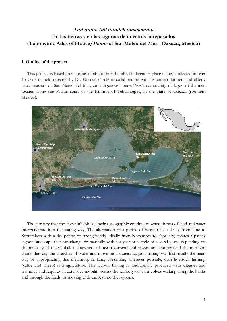
This project is based on a corpus of about three hundred indigenous place names, collected in over
15 years of field research by Dr. Cristiano Tallè in collaboration with fishermen, farmers and elderly
ritual masters of San Mateo del Mar, an indigenous Huave/Ikoots community of lagoon fishermen
located along the Pacific coast of the Isthmus of Tehuantepec, in the State of Oaxaca (southern
Mexico).
The territory that the Ikoots inhabit is a hydro-geographic continuum where forms of land and water
interpenetrate in a fluctuating way. The alternation of a period of heavy rains (ideally from June to
September) with a dry period of strong winds (ideally from November to February) creates a patchy
lagoon landscape that can change dramatically within a year or a cycle of several years, depending on
the intensity of the rainfall, the strength of ocean currents and waves, and the force of the northern
winds that dry the stretches of water and move sand dunes. Lagoon fishing was historically the main
way of appropriating this metamorphic land, coexisting, wherever possible, with livestock farming
(cattle and sheep) and agriculture. The lagoon fishing is traditionally practiced with dragnet and
trammel, and requires an extensive mobility across the territory which involves walking along the banks
and through the fords, or moving with canoes into the lagoons.

2
The territory inhabited by the Ikoots of San Mateo del Mar

3
The appropriation of the territory: fishing, livestock farming and agriculture

4
All the place names, which have never recorded before, have been collected with GPS and geo-
referenced. They are mostly transparent multi-nominal linguistic compounds referring to the specific
landscape morphology of the lagoons and the ocean coast, to the forms of life (vegetal and animal)
living there, and to specific human activities or historical/mythical events. To give some examples:
ndorrop mbas najkül /charco frente al iris de agua/ “the puddle in front of the water iris”
mbeaj yow soj /boca del agua de la acacia/ “the mouth of the water (the water’s edge) of the acacia”
mal iüt tüch /cabeza de la tierra del icaco/ “the head of the earth (the ford) of the icaco”
mal iüt indeow win / cabeza de la tierra (donde) muere la tortuga marina/ “the head of the earth (the
ford) where the sea turtle dies”
imeay jüm /(donde) duerme el lagarto/ “(where) the crocodile sleeps”
nejants ndok /(donde) se lavan las redes/ “(where) the nets are washed”
akwüüch oleaj monteok /(donde) el rayo dejó su impronta/ “(where) the lightning left his footprint”
5
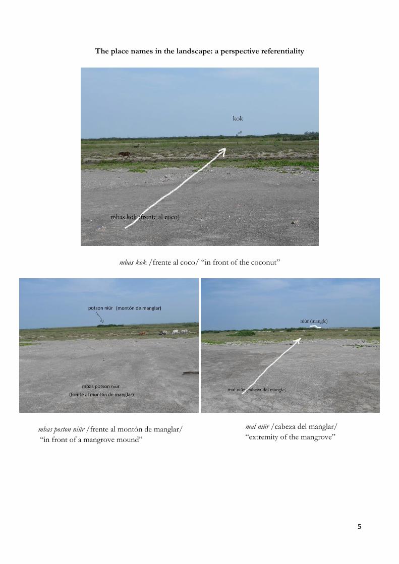
The place names in the landscape: a perspective referentiality
mbas kok /frente al coco/ “in front of the coconut”
mbas poston niür /frente al montón de manglar/
“in front of a mangrove mound”
mal niür /cabeza del manglar/
“extremity of the mangrove”
6
Taken together, these place names form a system of shared references covering the territory with a
very high density, footprint of economic activities, ritual practices and ancestral stories, through which
the Ikoots took control of its territory throughout the centuries. This specific linguistic heritage is an
inalienable dimension of economic, social and symbolic reproduction of community life, perceived as a
legacy of ancestors.
2. Degree of endangerment
Among the isolated languages in Mexico, Huave is the most endangered. If the other two, namely
Purepecha and Seri, are still fairly vital, Huave on the contrary is a language that is experiencing massive
borrowing and a swift process of language shift, reaching the point of extinction in certain varieties,
leading to the emergence of Spanish as the first language of most children in the majority of Huave
villages. Over all, Huave speakers range between 10 and 14 thousand of a total population of 27
thousand dwellers variously distributed among four main villages: San Mateo del Mar, San Dionisio del
Mar, San Francisco del Mar and Santa Maria del Mar. If we look at the socio-linguistic data of the four
Huave settlements, we find that in San Francisco del Mar and Santa Maria del Mar the local varieties are
almost lost, while in San Dionisio del Mar it is still used by people over 40. Only in San Mateo del Mar
is Huave still widely used in a local variety (ombeayiüts /mouth-our/). However, even if this variety is still
in full-fledged use, it is ideologically and practically endangered. When phonological, morphological,
lexical-semantic and syntactic interferences are analyzed, they provide an outline of the pervasive
presence of Spanish in San Mateo speech, with a consequent significant reduction of Huave repertories.
Before San Mateo reaches the stage of loss shared by the other three varieties, there is an urgent need
for documentation there.
In this frame the main and most significant lexical loss has taken place, and is swiftly taking place, in
the area of the lexicon related to environmental knowledge. Young people, even in San Mateo, let alone
the other three Huave villages, can use only a minimal part of the lexicon of their native language
relevant to talking with some detail about their environment: every day abilities of the youth to describe
in ombeayiüts the morphology of landscape, the meteorological phenomena, a fish’s behaviour or the
parts of a plant decreases, together with the competence to control the environment. The
environmental depredation and impoverishment, together with the gradual loss of control over
resources, goes hand in hand with the increasing loss of interest in the linguistic coding of many
complex nuances of the environment; consequently, shifting to Spanish rapidly fills up conceptual and
discursive spaces perceived as irrelevant, abandoned and left empty.
In the last few decades, this negative escalation (between the loss of control of the language and the
environment) has become very fast with more destructive consequences taking place every day. In the
last few years this strip of coastal land consisting of a continuum of water, earth and wind, which to
date has been very much at the margins of the national economy, has become an arena of the global
political-economy, attracting the interest of a joint-venture of transnational Green Economy companies
determined to install a network of Wind Farms on a large scale in the region (cfr. The Indigenous World,
IWGIA, 2013, p. 69-70). This project represents a great threat to the ecological balance of the local
environment and, consequently, to the control of environmental resources by the people living there
and their food sovereignty. Faced with this critical scenario, it is becoming more and more urgent to
document the indigenous place names, before it is too late. If we think of the future generations, the
expertise embedded in the use of place names, which is essential in taking control of their territory, are

7
at risk of disappearing at any time. In our aims, the publication of a toponymic Atlas could be a
remarkable learning resource for bilingual school education, promoting in the classrooms the
intergenerational transmission of this invaluable heritage, which is severely threatened outside. In a
broader cultural and political sense, the Atlas would represent the point of view of those who have
lived there for centuries, providing an important tool for strengthening identity and cultural self-
awareness, as well as an important political and legal instrument for the public representation of
occupation, use and the customary ownership of ancestral lands, facing the huge problem of land
grabbing.
3. Editorial plan of Atlas
The Atlas “Tiül miiüt, tiül mindek mixejchiiüts - En las tierras y en las lagunas de nuestros antepasados”
(In the Lands and Lagoons of our Ancestors), is a bilingual book in ombeayiüts /our mouth/ (the local
variety of Huave, with some 11000 speakers - ISO 639-3: huv) and in Spanish, designed to illustrate and
document the interweaving of local knowledge and memory anchored to the landscape through the
place names, threatened today with disappearance in a couple of generations. The bilingual Atlas (edited
by Dr. Cristiano Tallè) will consist of around 180/200 pages. The Atlas is in its final stages. At the
moment it is undergoing a final revision of the bilingual texts. The cartographic work was completed
thanks to GBS funding. It consists of a large general map (mural) and 22 detailed maps.
The entire book will be divided into four sections: A) Cartographic Section, B) Textual Section,
C) Linguistic Section, D) Online Section.
A) Cartographic Section
In the first part will be presented a large set of cartographic materials, composed of general,
thematic and detailed maps of different scale, conventional and satellite, with ombeayiüts place names.
Below an example of a detailed map, consisting in a large-scale satellite tables where all the place names
are put in the landscape in detail.

8
B) Textual Section
The cartographic section will be followed by a section of bilingual texts, divided into five thematic
parts:
- Ngineay ajlüy püjchiün/Las formas del paisaje/ The landscape forms
- Minüt niüng ajlüy xiül/Los fitotopónimos/ The phyto-toponyms
- Minüt niüng ajlüy nimal/Los fitotopónimos / The zoo-toponyms
- Niüng akül, niüng arang najiüt nipilan/Los antropotopónimos/ The anthropo-toponyms
- Niüng ajiür micuenta nej de tanomb, niüng ayakaran ichecharan/Los topónimos míticos y rituals/Mythical
and ritual place names
Each thematic section, with a brief introduction written by Christian Tallè (in Spanish), will present
bilingual texts collected during field work, documenting the various forms of discourse and knowledge
“anchored” to the landscape through place names (myths, historical memories, ritual speeches,
everyday speech of fishermen and farmers, etc.).
C) Linguistic Section
The textual section will be followed by a large linguistic appendix consisting of a full toponymic
glossary (with numeral references and geographic coordinates), and in some synoptic tables illustrating
the semantic and morphological aspects of ombeayiüts place names: the morphological structure of the
name, the topographic, anatomical, botanical and zoological lexicon forming it, etc. This section will
include a sketch of various grammatical aspects of ombeayiüts.

9
D) Online Section
The Place Names will be made available online through Google Mapping Tools (My Maps or Tour
Builder) along with some multimedia materials (story maps, bilingual texts, photographs, video and
audio recordings).
The Atlas will be accompanied by a wide photographic set (satellite images and some photos
collected during field work) illustrating in detail the salient points of the territory, the forms of land use
and the correspondence between the landscape morphology and the morphology of place names.
4. Field Work within community
Since 1999 Dr. Cristiano Tallè has carried out his ethnographic field work in the community of San
Mateo del Mar, at the beginning as member of the research team of “Italian Ethnological Mission in
Mexico”, funded by Italian Ministry of Foreign Affairs and coordinated by the cultural anthropologist Prof.
Alessandro Lupo (University of Rome “La Sapienza”), and from 2006 as part of the “Project for
Enhancement of Cultural and Linguistic Huave Self-awareness”, funded by the Salus Mundi Foundation (Tucson,
Arizona) administratively based at Berkeley, University of California (Prof. William, F., Hanks) and
coordinated by Prof. Flavia Cuturi (University of Naples “L'Orientale”) and Prof. Maurizio Gnerre
(University of Naples “L'Orientale”). In 9 different stays in the community (1999, 2000, 2001-2002,
2005, 2006, 2008, 2013, 2016, 2017) he studied and documented the daily social, linguistic, economic,
political and ritual domains of life in San Mateo del Mar, with particular regard to two topics: the
indigenous bilingual schooling on the one hand (subject matter of his PhD thesis), and the use of land
and language, the place names and his situated discursive use, on the other. The results of this research
can be seen, among the others, in two monographs: “Scuola, Costumbre e identità. Un’etnografia
dell’educazione nella comunità indgena di san Mateo del Mar (Messico)”, CISU, Roma, 2009, 448 p. [School,
Costumbre and Identity. An ethnography of education in the indigenous community of San Mateo del
Mar - Mexico], and “Sentieri di parole. Lingua, paesaggio e senso del luogo in una comunità indigena di pescatori nel
Messico del Sud”, SEID, Firenze, 2015, 306 p. [Paths of Words. Language, Landscape and Sense of Place
in an Indigenous Community of Fishermen in Southern Mexico].

10
All the investigations have been carried out in a perspective of active and informed participation,
involving a network of local actors in different contexts: children and their parents, indigenous
teachers, fishermen and farmers of different ages, municipal authorities, elderly ritual masters,
indigenous associations (in business, political and cultural domain). In this perspective the Atlas project
must be considered as an open project in progress, part of a broader knowledge (practical, oral and
polymorph) shared with many native actors and in constant interchange with local institution, as the
bilingual community schools, the municipality and the Casa del Pueblo (the House of Village).
Walking with native collaborators to map the place names

11
5. Target group, benefits of publication
The Atlas project is aimed to support bilingual education in the local indigenous schools and, in a
larger sense, to strengthen the cultural and linguistic self-awareness of collective forms of land
ownership in the face of global challenges that the community is facing. The Atlas will be a learning
resource to compensate for the lack of bilingual teaching materials and should promote the
intergenerational transmission of knowledge and memory of territory that is likely to be interrupted
within a few generations outside of the school.
The Atlas will be distributed free to approximately 6 bilingual kindergartens, 10 bilingual primary
schools and 1 bilingual high school of the San Mateo del Mar municipality (in the center of San Mateo
del Mar and in its municipal agencies), among the municipal authorities, the authorities of Bienes
Comunales (communal agrarian goods), the committee of Casa del Pueblo (The House of the Village), as
among the teachers, the fishermen, the farmers, the ritual masters, the elders who have personally
contributed to the Atlas project and generally to anyone interested. It will be very important to convene
a public event for the presentation and distribution of the book as an opportunity to give back to the
community the knowledge that has been collected over many years of research.
Bilingual schools in San Mateo del Mar

12
The homeland painted on the walls of the schools
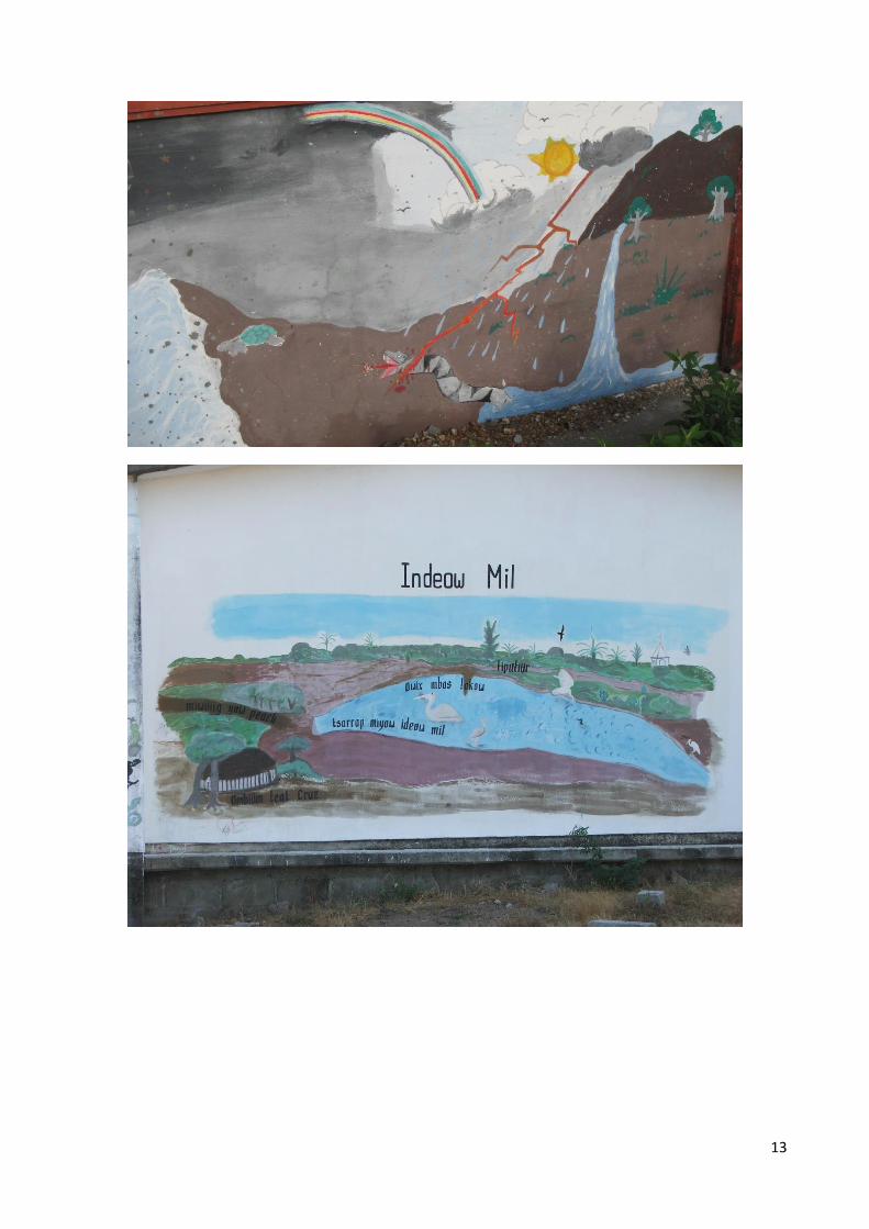
13