tinker lane 1 exploratory well, retford road, between ... · tinker lane 1 exploratory well,...
TRANSCRIPT

Tinker Lane 1 Exploratory Well, Retford Road, between Blyth and
Barnby Moor, Nottinghamshire
Town and Country Planning (Environmental Impact Assessment)
Regulations 2011
Request for a Scoping Opinion under Regulation 13
On behalf of Island Gas Ltd
Ref: 402.05891.00001 October 2015

Island Gas Limited i Ref: 402.05891.00001 Tinker Lane 1 Exploratory Well – Scoping Request October 2015
CONTENTS
1.0 INTRODUCTION .......................................................................................................... 1
1.1 Proposed Application ....................................................................................... 1
1.2 Request for Scoping Opinion........................................................................... 2
1.3 Notice of Intention ............................................................................................ 2
1.4 Statutory Background ...................................................................................... 2
2.0 THE SITE ..................................................................................................................... 5
2.1 Introduction ....................................................................................................... 5
2.2 Location ............................................................................................................. 5
2.3 Site Description ................................................................................................ 5
2.4 Land Use and Sensitive Receptors ................................................................. 6
3.0 PROPOSED DEVELOPMENT ..................................................................................... 8
3.1 Introduction ....................................................................................................... 8
3.2 Construction ..................................................................................................... 8
3.3 Drilling and Evaluation ..................................................................................... 8
3.4 Decommissioning and Restoration ............................................................... 11
4.0 POTENTIAL ENVIRONMENTAL EFFECTS .............................................................. 12
4.1 General ............................................................................................................ 12
4.2 Summary of the Potential Environmental Effects ......................................... 13
5.0 PROPOSED SCOPE OF EIA ..................................................................................... 15
5.1 Introductory Chapters .................................................................................... 15
5.2 Traffic............................................................................................................... 15
5.3 Air Quality ....................................................................................................... 16
5.4 Noise and Vibration ........................................................................................ 17
5.5 Geology and Hydrogeology ........................................................................... 18
5.6 Ecology ............................................................................................................ 19
5.7 Landscape and Visual .................................................................................... 20
5.8 Cultural Heritage ............................................................................................. 23
5.9 Population and Land Use ............................................................................... 23
TABLES
Table 2-1 Summary of Environmental Receptors ............................................................. 7
Table 4-1 Significant Environmental Topics ................................................................... 14
Island Gas Limited 1 Ref: 402.05891.00001 Tinker Lane 1 Exploratory Well – Scoping Request October 2015
1
1.0 INTRODUCTION
This document comprises a formal request on behalf of Island Gas Limited, a subsidiary of IGas Energy plc, (‘the prospective applicant’) for a “scoping opinion” under Regulation 13 of the Town and Country Planning (Environmental Impact Assessment) Regulations 2011 (the ‘EIA Regulations’).
This request is being made to Nottinghamshire County Council (as mineral planning authority).
1.1 Proposed Application
The prospective applicant intends to apply to Nottinghamshire County Council (in its role as the mineral planning authority for the prospective application site), for permission to drill a single exploration well and three sets of monitoring boreholes, which would contain up to three boreholes in each set, to sample groundwater and ground gas.
The prospective applicant, having regard to Schedule 3 of the EIA regulations, considers that no EIA is required, however, given that this is one of the first shale exploration well proposals in the area, it is intended that the application will be accompanied by a voluntary environmental statement (ES). The ES will describe the findings of an environmental impact assessment (EIA) exercise which will be carried out by an independent environmental consultant. For future wells, whether or not a voluntary ES will be submitted will be decided on a case by case basis.
The exploratory well, to be known as Tinker Lane 1, would be a vertical multi core well which would recover samples from, and to measure the properties of, the Namurian and Dinantian geological formations that underlie the site. These strata are exposed at surface in the Peak District to the west of the site but in Nottinghamshire become buried to a significant depth by younger strata. The monitoring boreholes would target the Nottingham Castle Sandstone formation and any isolated shallow sandstone formations that may be present.
The exploratory well would be drilled through all of the coal and shale formations with core samples taken at multiple intervals whilst drilling. Hydraulic fracturing would not be performed in the well on either the coal or shale targets at this stage of the operation.
Depending on the core analyses, electronic logging results and geological modelling, the well would either be plugged (to surface) and abandoned (in accordance with OGUK guidelines and regulatory requirements) and the site restored back to its current agricultural use or it could continue to be used for temporary baseline seismicity monitoring.
If positive results from core analysis and geophysical logging are received a new planning application would be submitted for either:
a) a new horizontal well (a new well on the same site keeping the original vertical well for monitoring purposes) to target the most prospective shale horizons and extended well testing (including hydraulic fracturing); or
b) a vertical hydraulic fracture operation and well testing on the existing vertical well.
Following the exploration and testing phases (either a or b) and dependent on results, the site would be restored back to its current agricultural use or a separate planning permission would be sought for hydrocarbon production.

Island Gas Limited 2 Ref: 402.05891.00001 Tinker Lane 1 Exploratory Well – Scoping Request October 2015
2
Any such future planning application would be the subject of a full public information and consultation exercise and the application would be accompanied by a new and comprehensive environmental statement.
1.2 Request for Scoping Opinion This document is a formal request for the Council to provide, in accordance with the provisions of Regulation 13 of the EIA Regulations, an opinion as to the information to be provided in the ES which will accompany the proposed planning application. The ES will set out and consider the likely significant impacts for the proposed development and, if required, propose mitigation to address those impacts. In accordance with the EIA Regulations, this request for the Council to adopt a scoping opinion is accompanied by:
(a) a plan sufficient to identify the land which relates to the proposed development
(see Drawings TL1 and TL2); (b) a brief description of the nature and purpose of the proposed development
(see Section 3 below) and of its possible effects on the environment (see Section 4 below); and
(c) such other information or representations the applicant considers material to this request (see Sections 2, 4 and 5).
1.3 Notice of Intention The prospective applicant hereby gives the Council notice that it intends to make a planning application (as detailed above), and to accompany the application with an ES. This notice, made pursuant to Regulation 15 of the EIA Regulations, includes information necessary to identify the location, the nature and purpose of the proposed development, and indicates the main environmental consequences to which the prospective applicant proposes to refer to in its ES. The Council is requested to:
(a) give notice to the appropriate statutory consultative bodies (and such other
persons that are in the opinion of the Council likely to be concerned by the proposed development by reason of their specific circumstances and/or environmental responsibilities) in writing of the name and address of the prospective applicant and of the duty imposed upon them by Regulation 15 to make information available to the prospective applicant; and
(b) give notice to the prospective applicant in writing of the names and addresses of the consultative bodies and persons so notified.
1.4 Statutory Background
The EIA process is an important procedure for ensuring that the likely effects of a new development on the environment are fully understood and taken into account before the development is allowed to proceed. The term EIA describes a procedure that must be followed for certain types of development before they are given “development consent”, which in the UK includes the grant of a planning permission. The procedure is a means of drawing together, in a systematic way, an assessment of a project’s likely significant environmental effects.

Island Gas Limited 3 Ref: 402.05891.00001 Tinker Lane 1 Exploratory Well – Scoping Request October 2015
3
1.4.1 European Context The Environmental Impact Assessment Directive1
(the ‘EIA Directive’) requires that, before granting ’development consent’ for projects, including development proposals, authorities should carry out a procedure known as environmental impact assessment of any project which is likely to have significant effects on the environment. The aim of the EIA Directive is to ensure that the authority giving consent for a project makes its decision in the knowledge of any likely significant effects on the environment. The first EIA Directive (85/337/EEC) came into force in 1988. An amending Directive (97/11/EC) came into force on 14 March 1999. This extended the range of development to which the Directive applies and made some small changes to EIA procedures. The Directive was further amended in 2003 by Directive 2003/35/EC which strengthened the requirements within the EIA procedures for public consultation and participation and in 2009 by Directive 2009/31/EC by adding projects related to the transport, capture and storage of carbon dioxide (CO2). The initial Directive of 1985 and its three amendments have been codified by Directive 2011/92/EU2 of 13 December 2011.
1.4.2 National Context
The EIA Directive has been implemented by regulations for development proposals under the Town and Country Planning Act 1990 (the 1990 Act). The current regulations are the Town and Country Planning (Environmental Impact Assessment) Regulations 20113 (the ‘EIA Regulations’).
1.4.3 Content
Regulation 2(1), and the associated Schedule 4 of the EIA Regulations, sets out the requirements regarding the content of an ES. In particular, it states that an ES should include descriptions of the likely significant effects, both direct and indirect, of the proposed development on the following:
• population;
• flora;
• fauna;
• soil;
• water;
• air;
• climatic factors;
• the landscape;
• material assets;
• architectural and archaeological heritage; and,
• the interaction between any of the foregoing.
1.4.4 Scoping
Regulation 13(1) of the EIA Regulations provides for a developer to obtain a formal ‘scoping’ opinion from the relevant planning authority on the topics that should be focussed upon in the Environmental Statement prior to embarking on an EIA.
The purpose of the scoping exercise is:
1 Council Directive 85/337/EEC on the assessment of the effects of certain public and private projects on the
environment, http://eur-lex.europa.eu/LexUriServ/LexUriServ.do?uri=OJ:L:1985:175:0040:0048:EN:PDF 2 http://eur-lex.europa.eu/LexUriServ/LexUriServ.do?uri=OJ:L:2012:026:0001:0021:EN:PDF
3 SI 2011 No. 1824

Island Gas Limited 4 Ref: 402.05891.00001 Tinker Lane 1 Exploratory Well – Scoping Request October 2015
4
• to focus the EIA on the environmental issues and potential impacts which need the most thorough attention;
• to identify those which are unlikely to need detailed study; and
• to provide a means to discuss methods of impact assessment and reach agreement on the most appropriate.
It is intended that the scoping process should focus on the key issues to be addressed in the EIA process. Whilst the EIA Regulations require all environmental considerations to be addressed, it is important to identify clearly the main (significant) environmental issues. This allows for a more detailed and targeted assessment to be carried out.
Accordingly, the prospective applicant is seeking the Council’s formal opinion as to the scope of the EIA. The following sections of this document provide the Council with the information necessary to come to an opinion on what issues should be addressed in the EIA.

Island Gas Limited 5 Ref: 402.05891.00001 Tinker Lane 1 Exploratory Well – Scoping Request October 2015
5
2.0 THE SITE
2.1 Introduction
This section of the scoping report provides a brief description of the site, in terms of physical features and topography, land use and identifies sensitive receptors within the locality.
2.2 Location
The site is located in the Bassetlaw District area of Nottinghamshire, on the Retford Road (A634) between Blyth and Barnby Moor. The site is located on agricultural land with direct access on to the public highway (see Figure 2.1 and Drawing TL1).
Figure 2.1 Application site looking west from the A634
The proposed application site would be approximately 2.43ha in size but, not all of the site is required for the construction of the initial exploration well, so only part of this site would be used (approx. 1.2ha) in order to minimise the developed footprint of the site.
For identification purposes, the proposed site is centred in National Grid Reference (NGR) 465032 (easting) 385344 (northing) and shown edged in red on Drawing TL2.
2.3 Site Description
The site is currently in agricultural use and is surrounded by farmland to the north, west and south with the A634 forming the eastern boundary as shown in Figure 2.2. It is located approximately 2.5km south-east of Blyth and 1.5km north-west of Barnby Moor. The village of Torworth is located approximately 1.6km to the north-east of the site.

Island Gas Limited 6 Ref: 402.05891.00001 Tinker Lane 1 Exploratory Well – Scoping Request October 2015
6
Figure 2.2 The A634 forming the eastern boundary of the site
The nearest residential properties to the site are Jubilee Farm to the north and Beech Farm to the west; both are approximately 750m from the centre of the site. To the east, the nearest property is College Farm at 900m and, to the north-east, Billy Button Cottage is at a distance of 800m from the site.
There are footpaths and bridleways to the north, west and south of the site, but the site itself has no rights of way across it or adjacent to it.
2.4 Land Use and Sensitive Receptors
2.4.1 Land Use
The site is currently in agricultural use and is subject to an entry level environmental stewardship agreement.
2.4.2 Sensitive Receptors Table 2-1, below sets out the environmental constraints within a 2km radius of the centre of the site which defines the area of interest. With regard to some high-level ecological receptors a 10km wide area of interest has been adopted.
These receptors are also illustrated in relation to the site location in Drawing TL4.

Island Gas Limited 7 Ref: 402.05891.00001 Tinker Lane 1 Exploratory Well – Scoping Request October 2015
7
Table 2-1 Summary of Environmental Receptors
Criteria Comment
Air Quality, Noise and Vibration
There are no Air Quality Management Areas (AQMAs) within the area of interest. The nearest residential properties are 750m to the north and west of the site and the closest settlement is Barnby Moor, approximately 1.5km to its south-east.
Cultural Heritage
No designations or recorded features of cultural heritage interest are located within the boundary of the site. Listed buildings are located within Blyth, Torworth and Barnby Moor. In addition there are conservation areas in Torworth and Barnby Moor and scheduled monuments in Blyth.
Ecology and Biodiversity
The site has no ecological designations and the nearest statutory designated site is the Daneshill Lakes Local Nature Reserve which is located 1.6km to the east. The site is just inside the SSSI potential impact zone for Mattersey Hill Marsh SSSI which is located 2.8km to the north-east. There are no European Habitats sites within 10km of the site boundary.
Geology and Soils
The proposed exploratory well site is shown by British Geological Survey and Environment Agency mapping to be underlain by near surface Triassic bedrock strata of the Nottingham Castle Sandstone Formation. The site is in agricultural use. The underlying sandstone produces freely draining, slightly acid, sandy soil which is regarded as Grade 3 land on the agricultural land classification.
Hydrology and Hydrogeology
The Triassic strata of the Nottingham Castle Sandstone Formation are classified as a Principal Aquifer and are considered by the Environment Agency to be vulnerable to pollution. Environment Agency mapping also shows that the sites are located in groundwater source protection zone 3 (total catchment) e.g. remote from but potentially in hydraulic continuity with licensed groundwater abstractions used for public supply.
To the east of Barnby Moor, some 2.4 km from the site, SPZs 1 and 2 have been identified around a groundwater pumping station operated by Severn Trent plc.
Environment Agency mapping also confirms there are local groundwater abstractions at Jubilee Farm, College Farm and within Barnby Moor.
The site is not within an area at flood risk (it is located in Flood Zone 1) and the risk of flooding from surface water ponding / overland flow is shown to be very low or low. Environment Agency mapping confirms that the proposed well site is not located within zones safeguarded for drinking water.
Landscape
There are no national landscape designations within the study area.
The site is located at an elevation of between 25-30m AOD. The broader topographical context is gently undulating associated with the basin of the River Idle at over 5km to the east and its tributary, the River Ryton at c1km to the north and c2km to the west.
The settlement pattern in the immediate vicinity is relatively dispersed, with isolated farmsteads such as Jubilee Farm, Billy Button Cottage to the north-east, College Farm to the east and Beech Farm to the south-west.
Land Use The site comprises agricultural land.

Island Gas Limited 8 Ref: 402.05891.00001 Tinker Lane 1 Exploratory Well – Scoping Request October 2015
8
3.0 PROPOSED DEVELOPMENT
3.1 Introduction
As described in Section 1.1, the exploratory well would be a vertical multi core well to target the Namurian and Dinantian geological formations. It is known that these formations underlie the site at depth. In addition three sets of monitoring boreholes would be installed to sample groundwater and ground gas within the Nottingham Castle Sandstone formation and any isolated shallow sandstone formations that may be present.
The project would involve the construction work associated with the development of the well site, the drilling and evaluation of the well and monitoring boreholes and then the decommissioning and restoration of the site back to agricultural use.
3.2 Construction
The construction phase would be a day time only operation (0700 to 1900 hours Monday to Friday and 0700 to 1300 hours on Saturdays) and would take approximately three months to complete. The construction activity would generate a maximum of around 60 vehicle movements a day (30 in and 30 out) of which 40 could be HGVs and 20 light vehicles.
Approximately 20 to 25 people would be employed during this phase of the development.
The wellsite construction process would consist of the following:
• Formation of new site access;
• Erection of gates, security fencing and CCTV;
• Stripping and storage of top and subsoils and formation of on-site bunds which would be put to grass and maintained for the life of the development;
• Creation of the wellsite platform using impermeable geotextile membrane layers covered by a layer of aggregate hardstanding and the installation of a wellhead cellar with associated steel conductors;
• Installation of bunded storage areas for chemicals and a surface water attenuation tank for surface water management; and
• Staff welfare accommodation and on site vehicle parking.
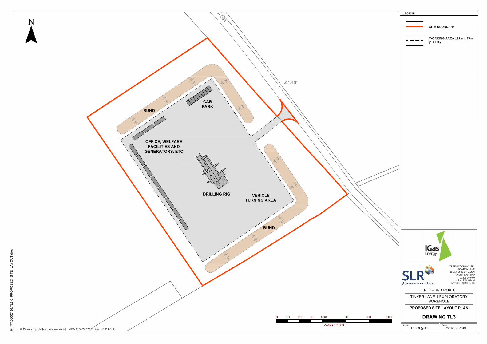
A potential site layout is illustrated in Drawing TL3.
3.3 Drilling and Evaluation
3.3.1 Drilling
Drilling activity for the exploratory well would be a 24 hour, seven day a week process and would last for approximately four months including the installation and removal of the drilling rig. The delivery and removal of the drilling rig would generate in the region of 12 to 16 HGV movements a day, a number (approx.10) of which would be oversize vehicles over a two week period. Light vehicle movements over this period would average around 10 per day (5 in and 5 out). During the drilling phase HGV movements would be around 10 per day (5 in and 5 out) and light vehicle movements would be around 40 per day (20 in and 20 out).
Up to three monitoring boreholes may be drilled at each location with the deepest being between 20-40m. The deeper borehole would target the Nottingham Castle Sandstone formation and the shallower boreholes would only be required if any distinct water bodies are identified in the shallower horizons. Drilling of the monitoring boreholes would be a
Island Gas Limited 9 Ref: 402.05891.00001 Tinker Lane 1 Exploratory Well – Scoping Request October 2015
9
daytime operation only with no night time or weekend working. The drilling equipment used to construct these boreholes would be mounted on a heavy duty commercial 4x4 truck so it would not be necessary to construct a drilling pad of these boreholes.
Employment in this phase would increase to around 25 to 30 jobs with the site being operated in shifts to maintain the 24 hour drilling programme for the exploratory well.
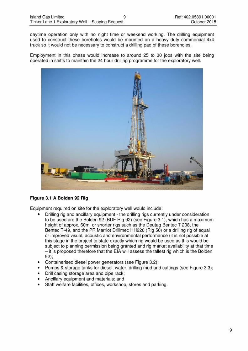
Figure 3.1 A Bolden 92 Rig
Equipment required on site for the exploratory well would include:
• Drilling rig and ancillary equipment - the drilling rigs currently under consideration to be used are the Bolden 92 (BDF Rig 92) (see Figure 3.1), which has a maximum height of approx. 60m, or shorter rigs such as the Deutag Bentec T 208, the Bentec T-49, and the PR Marriot Drillmec HH220 (Rig 50) or a drilling rig of equal or improved visual, acoustic and environmental performance (it is not possible at this stage in the project to state exactly which rig would be used as this would be subject to planning permission being granted and rig market availability at that time – it is proposed therefore that the EIA will assess the tallest rig which is the Bolden 92);
• Containerised diesel power generators (see Figure 3.2);
• Pumps & storage tanks for diesel, water, drilling mud and cuttings (see Figure 3.3);
• Drill casing storage area and pipe rack;
• Ancillary equipment and materials; and
• Staff welfare facilities, offices, workshop, stores and parking.

Island Gas Limited 10 Ref: 402.05891.00001 Tinker Lane 1 Exploratory Well – Scoping Request October 2015
10
Figure 3.2 Containerised Generators
Lighting would be required around the perimeter of the site for security purposes and within the site to enable safe 24 hour working. All lighting would be suitably shielded and directed to only light the site and operations and to minimise light spill outside of the site.
In respect of pollution control, the exploratory well design would provide multiple barriers between the well and groundwater and would have to be approved by an independent well examiner and the Health and Safety Executive to ensure it was in accordance with current regulations and industry best practice. For the monitoring boreholes a solid casing, screen, filter pack and grouting would be installed to ensure that the monitoring instruments only monitors the target strata and does not act as a vertical pathway that could link the surface to the aquifers or link different water bodies.
The exploratory well would be designed and constricted to comply with a wide range of relevant guidance and regulations, including:
• UK Onshore Shale Gas Well Guidelines Exploration and Appraisal Phase Issue 3, UKOOG, March 2015;
• OG UK Well Life Cycle Integrity Guidelines, Issue 2, June 2014;
• The Offshore Installations and Wells (Design and Construction, etc) Regulations 1996, (SI 1996/913);
• The Borehole Sites and Operations Regulations 1995 (SI 1995/2038); and
• OGUK Guidelines for the Abandonment of Wells, Issue 5 July 2015.
The monitoring boreholes would be the same as that commonly used to install groundwater abstraction boreholes on farms and residential properties. The design of these boreholes and headworks would be the subject of consultation with the Environment Agency.
Drilling mud and cuttings would be stored in tanks and would be transported off site for treatment and/or disposal at an appropriate permitted waste management facility. Surface water run off would be managed by the attenuation tank with sufficient capacity to handle a 1 in 100 year event and would be collected and then removed from site by tanker to maintain storage capacity. It would be taken to an appropriate waste water treatment plant.

Island Gas Limited 11 Ref: 402.05891.00001 Tinker Lane 1 Exploratory Well – Scoping Request October 2015
11
Figure 3.3 Drilling Mud Pumps
3.3.2 Evaluation
The evaluation period could last up to two years and during this stage the well would be suspended and maintained in accordance with industry best practice and all above ground equipment would be removed from the site apart from the wellhead, site offices and security fencing. Traffic movements would be minimal during this period with just monitoring and security visits required and there would be no night time activities or lighting required.
Collection of data from the monitoring boreholes would continue through this period.
3.4 Decommissioning and Restoration
In the event that the results of the exploration work indicate that further development of the site is not viable, the exploratory well would be plugged and capped in accordance with industry best practice including the OGUK Guidelines for the Abandonment of Wells, Issue 5 2015. In respect of the monitoring boreholes, the headworks and the uppermost 0.5 m of casing would be removed from each borehole and the boreholes backfilled in accordance with Environment Agency guidelines.
The remaining surface development would then be removed from the site, the stockpiled topsoil and subsoils would be replaced and the site would be restored back to its previous agricultural use.
Operating hours and maximum traffic movements would be the same as for the construction stage, albeit for a shorter period.
Following restoration the restored land would be subject to a five year aftercare period to ensure that the site is returned to full agricultural productivity.

Island Gas Limited 12 Ref: 402.05891.00001 Tinker Lane 1 Exploratory Well – Scoping Request October 2015
12
4.0 POTENTIAL ENVIRONMENTAL EFFECTS
4.1 General In order to consider the likely environmental effects of the development proposals, the site and the proposed development have to be described so as to provide the baseline data against which the proposals can be assessed. The preceding sections of this document provide a suitable framework to highlight any perceived environmental effects. Defining the scope of an EIA is a fundamental element of the EIA process. Based upon discussions with the prospective applicant, together with SLR’s experience of undertaking EIAs for similar developments, a range of environmental issues have been identified for investigation. As stated above in Section 1, Regulation 2(1) specifies that an Environmental Statement is a statement “which includes such information referred to in part 1 of Schedule 4 as is reasonably required to assess the environmental effects of the development….” The information described in Schedule 4 includes at paragraph 3 to Part 1 the following requirement:
“A description of the aspects of the environment likely to be significantly affected by the development, including, in particular, population, fauna, flora, soil, water, air, climatic factors, material assets, including the architectural and archaeological heritage, landscape and the inter-relationship between the above factors”.
The scoping exercise has identified a range of potential environmental issues, many of which vary both in terms of when they occur within the life cycle of the development, and the length of time they are significant. In relation to the proposals, the life cycle of the development can be divided into four phases:
• Construction - typically being three months for the construction of a well site;
• Operational – this would include the delivery and setting up of the drill rig, drilling of the vertical well and the removal of the drill rig which would take place over a four month period.
• Evaluation - this would be a longer (up to two years) period when the results of the logging and coring are assessed, the wellsite would remain in place for this period but with only the wellhead, site offices and fencing and gates remaining on site; and
• Restoration/decommissioning – if the results of the exploration work do not support further investigation then the well would be plugged and the site returned to its original condition within a two to three month period, followed by a five year aftercare programme.
It is usual to classify the duration of identified potential impacts into three timeframes; Short Term, Medium Term and Long Term. However, the nature of the development is such that all impacts would be short term. Identified effects can be temporary or permanent; direct or indirect; and positive or negative, for instance: Temporary/permanent effects
The potential for effects to occur is associated with the development.

Island Gas Limited 13 Ref: 402.05891.00001 Tinker Lane 1 Exploratory Well – Scoping Request October 2015
13
Direct/indirect effects
The proposed development would have direct effects on the environment as a whole in relation to emissions of noise, dust, gaseous emissions, as well as the changing appearance of the site. Indirect impacts can also occur, largely in relation to the transportation of materials to the site, and export of waste materials.
Positive/negative effects
The proposed development would generate both positive and negative effects, either by the virtue of the proposals themselves or as a result of the mitigation measures proposed. These benefits might include the identification of a potential energy source which could contribute to national energy supply and security of that supply, and the potential socio-economic benefits (such as employment and input into the local economy) of the development.
4.2 Summary of the Potential Environmental Effects Having considered the above issues, the potential environmental effects flowing from the proposed development have been identified. Accordingly, Table 4-1 has been prepared to identify the significant environmental topics to be addressed by the Environmental Statement. This provides a brief description of the potential impacts, the likely effects that would result, and where appropriate, an additional commentary.

Island Gas Limited 14 Ref: 402.05891.00001 Tinker Lane 1 Exploratory Well – Scoping Request October 2015
Table 4-1 Significant Environmental Topics
TOPIC ASPECT OF PROPOSED DEVELOPMENT GIVING RISE TO POTENTIAL IMPACT POTENTIAL EFFECT COMMENTS
Effects on Human Beings
Noise and Vibration
• Site construction and restoration works;
• Noise and vibration generated from the drilling processes (24 hour and 7 days a week)
• Transportation of materials to and from the site by HGVs
Loss of amenity at/disturbance to noise/vibration sensitive receptors surrounding the site.
Noise/vibration impacts associated with site preparation works and a 24 hours drilling programme. Works would be short term and temporary and the site is well separated from sensitive receptors with the nearest properties being approximately 750m away.
Traffic • Import of construction materials and drilling equipment to the site.
• Export of materials from the site.
Effects of traffic on local highway network, in terms of capacity and safety. Loss of amenity due to site related traffic movements
A new access to serve the site would be gained directly off the A634. Movements would be short term and temporary and would not exceed 60 (30 in and 30 out) a day. A review of HGV routeing would be undertaken.
Air and Climate
• Dust generated during construction and restoration phases;
• Particulate and gaseous emissions to the atmosphere during the operational phase.
Disturbance/loss of amenity to neighbouring sensitive properties and receptors. Potential effect of emissions on health of human receptors.
Construction and restoration phases would be short term and temporary and the site is well separated from sensitive receptors. The site is not within or close to an AQMA and the site is well separated from residential properties Emissions from the drilling phase would again be short term and temporary.
Visual Impact
• Well site, including a rig of some 60m in height;
• Movement of plant, machinery and vehicles within the site
• Lighting associated with 24 hour operations.
Loss of visual amenity from sensitive properties, public rights of way and public areas.
The proposed development would be short term and temporary and the site would be returned to agriculture. The site is well separated from residential properties and is not located within or close to any national landscape designations.
Effects on Water
Water
• Siting of fuel oils/chemicals on site
• Potential pollution of surface and ground water from site operations;
• Alteration of catchment areas and surface water flows
Contamination of surface/ground water by pollutants resulting in adverse effects on the groundwater and surface water regime. Risk of flooding Indirect impacts on any ecological interests in nearby water bodies.
The site is within a principal aquifer and zone 3 of a Groundwater Source Protection Zone. The site is not within an area of flood risk but surface water runoff will need to managed to avoid increasing the risk of flooding elsewhere. The site is well separated from any ecological designations
Effects on Land
Landscape Character
Agriculture
• Change in appearance of the site
• Stripping of soils during the construction phase
Effects on the intrinsic character of the area. Loss of agricultural land
As stated above, the site is not within or close to any national landscape designations and the development would be short term and temporary with restoration back to agriculture. The soil would be retained on site to be used for restoration to agriculture.
Flora and Fauna
• Site preparation and construction works
• Drilling of borehole
• Restoration works
Potential damage to features of natural heritage (ecological) importance (designated sites) Loss of habitat of ecological value
There are no ecological designations lying within the site boundary. Outwith the site the nearest site of ecological value (a local nature reserve) is approximately 1.6km from the site boundary. A walkover survey has not identified any habitat or species of value on the site
Cultural Heritage
• Site preparation and construction works and operation of wellsite, including a drilling rig of some 60m in height;
Potential damage to features of cultural heritage and archaeological importance. Impact upon the setting of listed buildings in the locality.
There are no designations on the site itself and it is well separated from listed buildings and other heritage designations.
Effects on Air and Climate
Air Quality • Emissions of dust,
• Emissions of pollutants from on site processes
• Emissions from HGVs
Derogation of local air quality See ‘Air and Climate’ above

Island Gas Limited 15 Ref: 402.05891.00001 Tinker Lane 1 Exploratory Well – Scoping Request October 2015
5.0 PROPOSED SCOPE OF EIA
5.1 Introductory Chapters
ES chapters to cover the Introduction, Site Description, Description of the Development, Policy and Alternatives would be prepared to include the following:
• Introduction – outline of the project, the applicant and the approach to EIA;
• Site Description – a detailed description of the site and its surrounding area;
• Description of the Development – outline of the proposed project to include details of the proposed equipment, structures, ancillary development and processes to be carried out on the site, construction programme and details, transport and access arrangements, hours of operation, employment, lighting, landscaping and surface water attenuation details;
• Policy – a summary of the relevant policy documents that have been considered in the preparation of the ES;
• Alternatives – an outline of the main alternatives considered by the applicant.
Finally, a set of Conclusions and a standalone Non Technical Summary would be provided.
In respect of cumulative impacts it is noted that the Planning Practice Guidance for Onshore Oil and Gas advises that it is unlikely to be an issue in the exploratory phase of such developments. Having considered the short term nature of the exploratory phase it is concluded that cumulative effects are unlikely in this case.
5.2 Traffic
A detailed site investigation would be undertaken in order to understand the potential site location, surrounding highway network and identify any potential issues/safety concerns. This would also determine any local constraints on the immediate roads. Access requirements and junction operation would also be assessed at this time. A review of potential HGV routeing to/from the site(s) and strategic highway network would also be undertaken.
Discussions would be held with the local Highways Authority and Highways England to discuss the extent of their requirements for the Transport Assessment (TA), but at this stage the following scope of work is proposed:
• Determine baseline conditions, including a site visit to determine the existing situation with the road network and existing access arrangements;
• Collection of existing traffic data for the A634 Retford Road within close proximity to the site access (1 no. 24 hour 7 day ATC);
• Collection of accident data over a suitable study area to include the A634 Retford Road near to the site(s) access and potential HGV routes to/from the strategic highway network/A1(M);
• Quantification of future trips arising from the site;
• Quantitative assessment of effect of development traffic based on proportion of development to baseline traffic and environmental factors including road safety;
• Consideration of suitability of access route(s) for HGVs and oversized vehicles, swept path analysis along the route(s) provided where necessary;
• Provision of a preliminary access design drawing(s);
• Consideration of mitigation measures where appropriate; and
• Chapter text and suitable drawings.

Island Gas Limited 16 Ref: 402.05891.00001 Tinker Lane 1 Exploratory Well – Scoping Request October 2015
Plans would be provided to show the location of the site in the context of the local road network, identifying any features that are identified in the existing conditions text.
For the swept path analysis, a series of plans would be provided depicting HGV/oversized vehicle routeing and swept path tracking; identifying where any off-site road infrastructure improvements will be required in order to allow the delivery of large components during the construction phase.
Full consideration would be given to the suitability of the proposed site access and road layout in terms of operation and safety. Preliminary Access Design plan(s) would be produced detailing the access arrangements for the proposed site, with vehicle swept path tracking provided as necessary.
Appendices to the ES chapter would include traffic and road safety data and any analysis work associated with the determination of relevant effects.
5.3 Air Quality
The proposed site and access routes are in a rural area, relatively remote from residential properties. Bassetlaw District Council is responsible for Local Air Quality Management in this area and undertakes monitoring of nitrogen dioxide in proximity to the A1, which indicates that this is a major source of emissions to air in the locality but does not lead to any breaches of the air quality objectives.
Potential effects from any dust generated during the site construction and restoration phases would be considered, as would the combustion emissions from onsite power generation plant (associated with the drilling rig) and vehicle exhausts, on both sensitive human and ecological receptors.
The assessment of the significance of potential air quality effects would be undertaken in accordance with the requirements of the NPPF, local planning policies and relevant guidance issued by the Institute of Air Quality Management (IAQM), Environment Agency (EA) and UKOOG as appropriate.
Given the rural locale of this site, it is proposed that the baseline air quality conditions could be adequately characterised from DEFRA predictions and monitoring undertaken by Bassetlaw District Council.
The potential significance of dust impacts associated with construction and restoration activities would be assessed qualitatively in accordance with IAQM guidance for construction dust and appropriate mitigation measures identified for incorporation into a dust management plan if required.
The need for a quantitative assessment of the effects of combustion emissions from vehicle exhausts (road and non-road) would be considered using the screening methodology in IAQM guidance and if appropriate detailed modelling undertaken using the ADMS-Roads modelling system.
To quantify the potential offsite exposure to combustion pollutants (such as oxides of nitrogen, carbon monoxide and sulphur dioxide) released by the on-site diesel power generation plant associated with the drilling rig, detailed atmospheric dispersion modelling (using a new generation model such as ADMS or AERMOD) would be undertaken in accordance with guidance issued by the Environment Agency. This modelling would incorporate local topography, site buildings, and 5-years of hourly average meteorological data to quantify the magnitude of exposure at sensitive human and ecological receptors. IAQM guidance would be used to assess the significance of this impact at human

Island Gas Limited 17 Ref: 402.05891.00001 Tinker Lane 1 Exploratory Well – Scoping Request October 2015
receptors and the impact on both critical levels and critical loads would be assessed at ecological receptors in accordance with EA guidance.
5.4 Noise and Vibration
The main potential effect of noise generated by the proposed development are considered likely to be those experienced at the nearest residential properties arising from the temporary drilling operation.
An assessment of potential effects of the proposed development with respect to noise would be undertaken. In respect of vibration a brief qualitative assessment would be undertaken to demonstrate that the proposed development would not cause nuisance or damage at the nearest residential receptors.
5.4.1 Baseline Survey
Notwithstanding consultation with the local authority, in order to determine the prevailing noise levels in the vicinity of the drilling locations, baseline noise measurements would be undertaken at up to four nearby noise-sensitive receptors over a weekend period. It is anticipated that meters would be installed on a Friday and retrieved on a Monday. Should this not be possible, SLR would undertake attended monitoring which would consist of a minimum of four non-consecutive fifteen minute measurements during a Sunday daytime, and a continuous 30-minute measurement during Sunday night into Monday morning.
5.4.2 Drilling Rig Construction Assessment
Construction noise would be assessed in accordance with the ABC methodology presented in BS5228:2009+A1:2014 Code of practice for noise and vibration control on construction and open sites – Part 1: Noise.
5.4.3 Drilling Rig Operational Assessment
Operational noise would be assessed in the first instance in accordance with the Assessing environmental impacts from minerals extraction – Noise emissions section of the Planning Practice Guidance (PPG). The operational noise limits would be set at:
• During normal working hours (0700 – 1900) the limit should not exceed the background noise level at a sensitive property by more than 10dB(A). At locations where meeting this limit is not possible, the LAeq, 1hr (free-field) noise level of operations at the drilling site must not exceed 55dB at the sensitive property.
• During the evening (1900 – 2200) the limit should not exceed the background noise level at a sensitive property by more than 10dB(A) and should not exceed LAeq,1hr (free-field) 55dB.
• At night (2200 – 0700) the LAeq,1hr (free-field) noise level of operations at the drilling site must not exceed 42dB at the sensitive property.
If required an assessment of operational noise would also be undertaken in accordance with the ABC methodology presented in BS5228:2009+A1:2014.

Island Gas Limited 18 Ref: 402.05891.00001 Tinker Lane 1 Exploratory Well – Scoping Request October 2015
5.4.4 Drilling Rig Traffic Assessment
Noise
With regard to potential traffic noise impacts upon nearby existing residents SLR does not consider that the proposals would generate sufficient traffic to require a Design Manual Roads and Bridges (DMRB) 11.3.7 Noise Assessment.
Instead the predicted ambient noise level of development related traffic during a worst-case hour would be compared against the existing ambient noise environment at up to four nearby existing sensitive receptor locations.
5.5 Geology and Hydrogeology
The proposed exploratory well site is shown by British Geological Survey and Environment Agency mapping to be underlain by near surface Triassic strata of the Nottingham Castle Sandstone Formation, which are classified as a Principal Aquifer and are considered by the Environment Agency to be vulnerable to pollution. Environment Agency mapping also shows that the site is located in Groundwater Source Protection Zone 3 (total catchment) e.g. remote but potentially in hydraulic continuity with licensed groundwater abstractions used for public supply.
Environment Agency mapping also confirms there are least three groundwater abstractions within 1 – 2km of the proposed well site and there is a disused Severn Trent groundwater abstraction point at Barnby Moor, 2.4 km to the east of the site. No superficial deposits are recorded by BGS mapping.
The site is not within an area at flood risk (it is located in Flood Zone 1) and the risk of flooding from surface water ponding / overland flow is shown to be very low or low.
Groundwater is expected to be present at shallow depth in the sandstone that underlies the site and this, and potential effects and required mitigation to protect groundwater and surface water, would need to be assessed as part of the EIA. The assessment would also need to consider flood risk as while the site is not in an area considered to be at flood risk, there is potential without appropriate management and control for the proposed works to locally increase flood risk.
The potential effects of the proposed development on ground and surface water that would need to be assessed are likely to include:
• the development and removal of a temporary construction site and management of the rate and quality of runoff from this area;
• the potential pollution of ground and surface water from spillages (inc. drilling fluids) during construction, drilling and demobilisation;
• the adequacy of the well design and its integrity to control the potential escape of drilling fluids, gas and formation fluids to groundwater.
Published data sources and site specific information would be used to characterise the site and there hydrological and hydrogeological setting. Consultation will be undertaken with the Environment Agency, water utility, Internal Drainage Board and local Council for details of local water use to establish baseline conditions. A source-pathway-receptor conceptual model would then be developed which would be used to assess potential impacts and required controls / mitigation with reference to best practice guidance. Residual impacts would be identified in addition to potential cumulative impacts (if appropriate).
Island Gas Limited 19 Ref: 402.05891.00001 Tinker Lane 1 Exploratory Well – Scoping Request October 2015
It is expected that best practice construction techniques and monitoring procedures detailed in Environment Agency and UKOOG guidance will be used to inform the design of the site and to determine appropriate controls that reflect site conditions.
It is proposed that an outline surface water drainage strategy would be included that considers existing and potential rates of runoff from the site and measures required to manage runoff so as not to increase flood risk to the site or third parties. Where appropriate, Sustainable Drainage Systems (SuDS) would be specified as required by the National Planning Policy Framework and supporting guidance.
5.6 Ecology
Baseline data from the Nottinghamshire Biological and Geological Records Centre would be collated and presented in the ecology chapter of the ES, with supporting technical appendices where required. An ecological impact assessment (EcIA) would be conducted in accordance with Guidelines for Ecological Impact Assessment (IEEM 2006)4. Where necessary, outline mitigation measures would be proposed to reduce or avoid impacts of the development.
An EcIA comprises two main data gathering components, a desk-top study and field surveys, including habitat survey to at least the standard of an ‘extended Phase 1 survey’.
5.6.1 Desk-Top Study & Consultation
A desktop study would be undertaken to determine the scope of the existing ecological knowledge and data relating to the development area. This would involve a review of the data held by the Local Records Centre, in addition to examining published data and internet sources. This search would cover the recorded presence of protected and notable species within 2km of the site and protected European habitats sites within 10km of the site. Desk study information would be used to inform the field survey and be appended to the main report.
The Local Authority ecologist and local Wildlife Trust would also be contacted during the course of the project in order to obtain any further information they may hold, and to confirm the scope and extent of surveys proposed.
5.6.2 Extended Phase 1 Habitat Survey
A habitat survey of the site and its immediate surrounding area (approximately a 30m buffer where access is possible) would be undertaken following the methodology set out by the Joint Nature Conservation Committee (JNCC) guidelines5 or other equivalent habitat survey methodology. Descriptions in the form of target notes would be gathered and used to produce a habitat map and to describe the composition and structure of habitats present on the site.
5.6.3 Further Species Surveys
Based on a site visit and review of local records it is considered that no further species surveys would be required to complete the EcIA other than a reptile survey focussed on the road verge adjacent to the site.
4 Institute of Ecology and Environmental Management (2006). Guidelines for Ecological Impact Assessment.
5 Nature Conservancy Council (1990). Handbook for Phase 1 Habitat Survey – a Technique for Environmental Audit,
2003 reprint. JNCC, Peterborough.

Island Gas Limited 20 Ref: 402.05891.00001 Tinker Lane 1 Exploratory Well – Scoping Request October 2015
Following completion of an ecological walkover by an experienced ecologist in August 2015 it is considered that the verges bordering the A634 and the longer established field margins could have the potential to support the more common reptile species. It is considered likely that improvements to the field access off the A634 will be required, including the widening of the existing gate and the creation of visibility splays which have the potential to affect the verges. A survey for reptiles has therefore been carried out.
Reptile Survey Method
The reptile survey methods employed at the site were based on SLR’s experience, current standard methodologies and published good practice guidelines .
A series of artificial refuges comprising of 0.5m2 to 1m2 sections of heavy duty roofing felt were positioned in rows and clusters in areas of suitable habitat at a density of at least 10 refuges per hectare, as recommended by Froglife3 .
Reptile Survey Timing
The refuges were set out, left for one week and then checked on seven occasions using a combination of afternoon and morning visits during suitable weather, in September and early October 2015. In addition, during each visit the survey area was subject to a walkover survey with direct observational methods (of likely basking spots) used to record reptiles.
A stand-along reptile survey report will be prepared as an appendix to the EcIA
5.7 Landscape and Visual
The main potential landscape and visual effects related to the proposed development are anticipated to be those associated with the following:
• Vegetation clearance, soil stripping and ground preparation of development areas and access (internal and external);
• Construction and operation of the drilling mast, substructure / frame, trailer and ancillary structures, such as power pack and mud pumps, control room and welfare cabins, perimeter security fencing, lighting and vehicle parking and movements; and
• Decommissioning and restoration of the site(s).
The highest element of the proposed development would be the drilling mast which could be as high as 60 metres above ground level, with the majority of the development being typically less than 10m high, with additional ground level hardstanding.
The short-term nature of the development and the careful stripping, storage and recovery of soil means that the site would be capable of being returned to a similar state as existing.
However there is the potential for landscape enhancements, such as tree and shrub planting around site perimeters, infilling of hedgerows or as field corner spinneys, to result in longer lasting beneficial effects, well beyond the operational phases of the development.
A study area of 5km is envisaged for the landscape and visual impact assessment at this stage.

Island Gas Limited 21 Ref: 402.05891.00001 Tinker Lane 1 Exploratory Well – Scoping Request October 2015
5.7.1 Landscape Baseline
The site is located in open countryside, adjacent to A634, approximately 2.5km south-east of the village of Blyth.
The site is located at an elevation of 25-30m AOD. The broader topographical context is gently undulating associated with the basin of the River Idle at over 5km to the east and its tributary, the River Ryton at c1km to the north and c2km to the west.
The site is managed as farmland which is the predominant land cover in the local area. Tightly clipped hedgerows are commonplace and there are some mature trees, such as the L-shaped block south of the site or around Jubilee Farm, but generally the vegetation cover is sparse. This results in a low level of enclosure, with long distance views frequently available from higher ground to broad horizontal horizons. Scale is typically medium to large, with an organised and regular pattern of hedged fields giving a unified visual character. Movement is focused principally along the road corridor, with occasional farm machinery in the fields.
The settlement pattern in the immediate vicinity is relatively low, with isolated farmsteads such as Jubilee Farm, Billy Button Cottage to the north-east, College Farm to the east and Beech Farm to the south-west. The villages of Ranskitt, Torworth and Barnby Moor extend along the A638 Great North Road at over 1km to the north-east, east and south-east respectively.
A network of minor roads connect these villages and properties with the A1 and A638, providing busier connections at over 1km to the west and east respectively. The A1 bypasses Blyth and becomes the A1(M) just to the north of the village and service area at the junction with A614.
A railway line is orientated north to south and is 1.5km to the east of the site at its nearest point. An overhead powerline runs parallel to A634 (north-west to south-east alignment) at c0.5km to the south.
There is a public footpath to the north of the site and a bridle path to its west. The Cuckoo Way follows the route of the Chesterfield Canal at approximately a distance of 2km, at its nearest point to the south of the site. Other recreational locations in the study area include Daneshill Lakes, a former gravel extraction area which has been restored as wetland complex and managed as a local nature reserve, with car parking indicated on the OS explorer map and walks promoted on the County Council’s website.
Local variations in landscape character and quality include sites such as Hodsock Priory, a historic house with gardens and parkland, situated approximately 4km away.
There are no national landscape designations affecting the site and its immediate vicinity.
The Nottinghamshire Countryside Appraisal describes the sites as located within Idle Lowlands (The Village Sandlands sub-area) “A varied, low lying region characterised by sparsely settled carrlands, levels and rolling sandlands with village settlements.”
Key recommendations for Village Sandlands are:
• Conserve and strengthen the traditional pattern of hedged fields and trackways;
• Conserve the integrity and distinctive vernacular character of rural villages;
• Promote small-scale tree and woodland planting as a means of enhancing the structure and unity of the landscape; and
• Identify opportunities for enhancing ecological diversity

Island Gas Limited 22 Ref: 402.05891.00001 Tinker Lane 1 Exploratory Well – Scoping Request October 2015
Thus any mitigation strategy for the proposed development could incorporate tree and shrub planting around perimeters, infilling of hedgerows or as field corner spinneys.
Visual Baseline
Given the heights of the proposed structures and the character and elements within the immediately surrounding areas, potential visual receptors are anticipated to include the following:
• Local residents, such as Jubilee Farm, College Farm, Beech Farm, but also villages such as Blyth, Torworth, Ranskitt and Barnby Moor;
• Recreational users of public rights of way and recreational visitors to Daneshill Lakes and Cuckoo Way / Chesterfield Canal;
• Users of the road network such as A634, A638, A1 and A1(M), but also minor roads.
5.7.2 Landscape and Visual Assessment
The LVIA would be undertaken in accordance with the guidance produced by The Landscape Institute and Institute of Environmental Management and Assessment’s Guidelines for Landscape and Visual Impact Assessment, third edition (GLVIA3) and the Countryside Agency’s Landscape Character Assessment Guidance for England and Scotland. Paragraph 1.1 of GLVIA 3 states that “Landscape and Visual Impact Assessment (LVIA) is a tool used to identify and assess the significance of and the effects of change resulting from development on both the landscape as an environmental resource in its own right and on people’s views and visual amenity”.
The recent published GLVIA3 emphasises proportionality of assessment and a focus on likely significant effects as well as the importance of the duration of effect in determining magnitude.
The approach to the assessment of the exploratory wellsite would be based on recognition that this is a short term, temporary development within a relatively small area.
In accordance with GLVIA3 use of zone of theoretical visibility (ZTV) analysis based on digital terrain modelling would be used to determine initial potential representative viewpoints, for example, to cover different directions, distances and types of receptor. The full height of the drill rig (the most visible element) and also the lower infrastructure (which is likely to have a much reduced ZTV) would both be modelled.
The final viewpoints for use in the assessment would then be confirmed by consultation with Nottinghamshire County Council’s Landscape Officer and undertaking field work / site visits. Paragraph 5.1 of the GLVIA3 describes how landscape effects are concerned with “how the proposal will affect the elements that make up the landscape, the aesthetic and Paragraph 6.1 of the GLVIA3 describes how visual effects are concerned with “assessing how the surroundings of individuals or groups of people may be specifically affected by changes in the content and character of views as a result of the change or loss of existing elements of the landscape and/or introduction of new elements”. Thus, the assessment would deal separately with each of these effects, although where relevant and appropriate, cross references may be made to the same features or elements where they are relevant to both assessments.

Island Gas Limited 23 Ref: 402.05891.00001 Tinker Lane 1 Exploratory Well – Scoping Request October 2015
More specifically, the LVIA would entail:
• a review of baseline landscape, including landscape based planning designations within the study area, any relevant published landscape character assessments within the study area and description of the site and immediate surroundings;
• a review of visual baseline, including ZTV, identification of appropriate viewpoints and agreement with the planning authority, field work and recording of views from the representative viewpoints using digital camera;
• preparation of a LVIA comprising text and supporting drawings and photography including a landscape mitigation plan, as appropriate; and
• an assessment of lighting and the impact this would have at the nearest sensitive receptors.
5.8 Cultural Heritage
Web-based sources show a number designated heritage assets are listed within 2km of the site. Most of these are listed buildings, although also included is one scheduled monument. In addition there are four locally identified heritage assets, mostly Roman enclosures. There are also Conservation Areas in the villages of Blyth and Torworth.
The cultural heritage study area would comprise a 2km zone surrounding the application boundary. All designated historic assets (scheduled monuments, listed buildings, conservation areas, Historic Landscape Areas, Register Parks and Gardens, and Battlefields) would be mapped, as well as historic assets listed on the Nottinghamshire Historic Environment Record (HER). Historic map regression would be undertaken to understand the development of the historic landscape, and place-names as well as other information on the cultural heritage of the area, would be analysed to help with understanding the heritage significance of the assets and their settings. This would enable a robust impact assessment to be made, and an appropriate level of mitigation designed for any likely impacts.
A structured approach to the main stages of assessment would be adopted including baseline survey, summary of scheme design, assessment of heritage significance and identification of what within the setting of nationally important sites contributes to their heritage significance, assessment of degree of change from the development, and a significance of effect determined. Mitigation measures can then be proposed which would reduce the magnitude of impact, so that a residual effect can be suggested.
National and local legislation and planning policy would be summarised, and the assessment undertaken to ensure compliance with these policies. Consultation would be undertaken with the Nottinghamshire County Archaeologist and Local Authority Conservation Officers, as well as with Historic England, as necessary depending on the nature of the heritage assets and their national importance.
5.9 Population and Land Use
Potential impacts on the local population and the mitigation proposed as part of the assessments outlined above would be identified. In addition the potential effects on public health would be considered and assessed.
An agricultural land classification survey would be carried out and based on the results of that survey appropriate soil stripping, handling and storage arrangements would be proposed to ensure that the soil is retained on site in a suitable condition to be used for restoration purposes.

Island Gas Limited 24 Ref: 402.05891.00001 Tinker Lane 1 Exploratory Well – Scoping Request October 2015
The need for a coal mining risk assessment has been considered but the site is not within a Development High Risk Area so one is not required.

Island Gas Limited 25 Ref: 402.05891.00001 Tinker Lane 1 Exploratory Well – Scoping Request October 2015
Drawings

SITE
N
© Crown copyright [and database rights] 0100031673 Expires
www.slrconsulting.com
Scale Date
TREENWOOD HOUSE
ROWDEN LANE
BRADFORD-ON-AVON
WILTS. BA15 2AU
T: 01225 309400
F: 01225 309401
04477.00007.16.T
L1.0_S
IT
E_LO
C_P
LA
N.dw
g
DRAWING TL1
1:50,000 @ A4 OCTOBER 2015
SITE LOCATION PLAN
TINKER LANE 1 EXPLORATORY
BOREHOLE
RETFORD ROAD
[19/08/16]2015
0 500 1000 1500 2000m 3000 4000 5000
Metres 1:50,000

0447
7.000
07.1.
0b_E
nviro
nmen
tal C
onstr
aints
TL4AUGUST 2015
DateScale @ A31:25,000
LEGEND
TRENWOOD HOUSEROWDEN LANE
BARDFORD ON AVONWILTSHIRE, BA12 2AU
T: 0122 530 9400www.slrconsulting.com
RETFORD ROAD
© Crown copyright [and database rights] (2015) 0100031673 Expires 14/08/15
ENVIRONMENTAL CONSTRAINTS
0 1 2 3 km
¯
TINKER LANE 1 EXPLORATORYBOREHOLE
PROPOSED SITE BOUNDARY
2KM STUDY AREA
ANCIENT WOODLANDINVENTORY
LOCAL NATURE RESERVE
SITES OF SPECIALSCIENTIFIC INTEREST
SCHEDULED MONUMENTS
LISTED BUILDINGS (GRADE)
$+ I $+ II $+ II*
SOURCE PROTECTION ZONES
ZONE 1 ZONE 2
NATURAL FLOOD ZONES
FLOOD ZONE 2
FLOOD ZONE 3
NOTE: ALL MAPPING AREA SHOWN IS WITHIN SOURCE PROTECTION ZONE 3

26.7m
24.2m
L
a
y
-
b
y
28.7m
L
a
y
-
b
y
A
6
3
4
27.4m
N
© Crown copyright [and database rights] 0100031673 Expires
www.slrconsulting.com
Scale Date
TREENWOOD HOUSE
ROWDEN LANE
BRADFORD-ON-AVON
WILTS. BA15 2AU
T: 01225 309400
F: 01225 309401
LEGEND
04477.00007.16.T
L2.0_P
RO
PO
SE
D_S
IT
E_P
LA
N.dw
g
DRAWING TL2
1:2500 @ A3 OCTOBER 2015
PROPOSED SITE PLAN
TINKER LANE 1 EXPLORATORY
BOREHOLE
RETFORD ROAD
[19/08/16]2015
0 80m 200
Metres 1:2500
SITE BOUNDARY
A
6
3
4
27.4m
DRILLING RIG
CAR
PARK
VEHICLE
TURNING AREA
OFFICE, WELFARE
FACILITIES AND
GENERATORS, ETC
BUND
BUND
N
© Crown copyright [and database rights] 0100031673 Expires
www.slrconsulting.com
Scale Date
TREENWOOD HOUSE
ROWDEN LANE
BRADFORD-ON-AVON
WILTS. BA15 2AU
T: 01225 309400
F: 01225 309401
LEGEND
04477.00007.16.T
L3.0_P
RO
PO
SE
D_S
IT
E_LA
YO
UT
.dw
g
DRAWING TL3
1:1000 @ A3 OCTOBER 2015
PROPOSED SITE LAYOUT PLAN
TINKER LANE 1 EXPLORATORY
BOREHOLE
RETFORD ROAD
[19/08/16]2015
0 10 20 30 40m 60 80 100
Metres 1:1000
SITE BOUNDARY
WORKING AREA 127m x 95m
(1.2 HA)