tillicum fan habitat restoration concepts...
TRANSCRIPT

Tillicum Fan Habitat Restoration Concepts ReportSubmiTTed ToYakama Nation Fisheries
MaRCh 2017

Tillicum Fan Habitat Restoration Concepts Report
MaRCh 2017
SubmiTTed ToYakama Nation Fisheries 401 Fort Road Toppenish, Wa
prepared byInter-Fluve, Inc.501 Portway ave, Suite 101hood River, OR 97031 (541) 386-9003

Tillicum Fan Habitat Restoration Concepts Report
i
Table of Contents
INTRODUCTION ................................................................................................................................... 1
Overview .......................................................................................................................................... 1
Project Area Description ................................................................................................................... 1
Goals and objectives ........................................................................................................................ 2 Regional Habitat Objectives and Priorities ........................................................................................... 2
SITE CONDITIONS AND ANALYSIS ......................................................................................................... 3
Site Survey and Data Collection ........................................................................................................ 3
Geomorphology ............................................................................................................................... 6
Hydrology ........................................................................................................................................ 7
Hydraulic Modeling .......................................................................................................................... 8
PRELIMINARY DESIGN CRITERIA ........................................................................................................... 9 Habitat .................................................................................................................................................. 9 Geomorphology/Hydrology .................................................................................................................. 9 Engineering and Risk ............................................................................................................................. 9 Construction Impacts .......................................................................................................................... 10
CONCEPT DESIGNS ............................................................................................................................. 10
Concept 1: Fan Swale Extending to Mad River ................................................................................ 12
Concept 2: Short Fan Swale Extending to Mad River Relic Channel ................................................. 13
Concept 3: Long Fan Swale Extending to Mad River Relic Channel .................................................. 14
Designer’s notes on configurations ................................................................................................. 14
REFERENCES ....................................................................................................................................... 15
Attachments – Plans and estimates
Appendix 1 – Stream substrate pebble count data
Appendix 2 – Stream hydrology
Appendix 3 – Hydraulic modeling output

Tillicum Fan Habitat Restoration Concepts Report
March 2017 1
1. Introduction
OVERVIEW
This report presents field investigations and development of concepts for opportunities to
enhance stream processes and aquatic habitat at the Tillicum Creek Fan project area. The project
proposes to improve stream processes and riparian conditions to enhance aquatic habitats for
Endangered Species Act (ESA) listed Chinook salmon (Oncorhynchus tshawytscha) and steelhead
(Oncorhynchus mykiss).
PROJECT AREA DESCRIPTION
Tillicum Creek is a tributary to the Mad River at River Mile 1.92, approximately 10 miles
northwest of Entiat, in Chelan County, Washington, near the intersections of Mad River Road
(119A) and Forest Service Roads 5700 and 5800. The Mad River is tributary to the Entiat River
near the unincorporated community of Ardenvoir. Tillicum Creek has formed an alluvial fan
that terminates along 560 feet of the Mad River and extends up the Tillicum Valley 700 feet
where Tillicum Creek flows out of a confined valley and expands radially across the wider fan
surface. The fan is bounded on both sides by steep valley walls. Forest Road 5800 runs along
the toe of the north valley wall and Tillicum Creek runs along the toe of the south valley wall.
The project area of Tillicum Creek and fan and right bank of Mad River encompasses
approximately 3.57 acres. The entire project area is located on land owned by the U.S. Forest
Service.
Tillicum Creek is entrenched and confined in some locations by a levee, preventing hydrologic
connection to the full width of the historic fan limits. The fan is predominantly open field that
is grazed seasonally. The banks of Tillicum Creek and Mad River are vegetated with riparian
trees.

Tillicum Fan Habitat Restoration Concepts Report
March 2017 2
Figure 1. Location of the Tillicum Creek watershed and the project area.
GOALS AND OBJECTIVES
Regional Habitat Objectives and Goals
Regional objectives for salmonid habitat protection and restoration in the Upper Columbia
Region have been evaluated and summarized in the document A Biological Strategy to Protect and
Restore Salmonid Habitat in the Upper Columbia Region (2014) by the Upper Columbia Salmon
Recovery Board (UCSRB) Regional Technical Team (RTT). This Biological Strategy is part of the
Upper Columbia Spring Chinook Salmon and Steelhead Recovery Plan (UCSRB 2007). It
recommends region‐wide biological considerations and approaches for salmonid habitat
restoration and protection actions. The RTT guides the development and evaluation of salmonid
recovery projects within the Upper Columbia Region.
The Biological Strategy has identified several assessment units within the Entiat River
watershed, including the Mad River assessment unit which includes the Tillicum Creek fan
project area. The Mad River is a Tier II priority and the project area is within an area known to
provide spawning and rearing habitat for steelhead and rearing habitat for spring Chinook.

Tillicum Fan Habitat Restoration Concepts Report
March 2017 3
The Biological Strategy notes factors affecting habitat conditions to include historical sheep
grazing and timber harvest practices, which have both increased upland erosion and sediment
delivery to the stream. Further, the Mad River Road constricts the main stem channel at the
project area. Ecological concerns include:
Channel structure and form
Sediment conditions
Riparian conditions
Food
Habitat quantity.
The primary project goal is to improve stream process and associated habitats along the
Tillicum Fan by creating improved hydrologic connectivity of Tillicum Creek with its fan, and
Mad River with its floodplain, along the distal end of the Tillicum fan. Improved stream
processes will enhance habitat complexity, create wetland and riparian vegetative communities,
and possibly access to ground water inflow.
2. Site Conditions & Analysis
SITE SURVEY AND DATA COLLECTION
Topographic and bathymetric data were collected October 2, 2016 using total station survey
equipment. The data collection focused on capturing channel cross sections for hydraulic
modeling, as well as topography of the fan for mapping and concept designs. Temporary
benchmarks were placed throughout the project site for future reference. Survey is based on a
project relative datum.
Tillicum Fan Habitat Restoration Concepts Report
March 2017 4
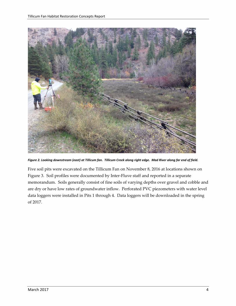
Figure 2. Looking downstream (east) at Tillicum fan. Tillicum Creek along right edge. Mad River along far end of field.
Five soil pits were excavated on the Tillicum Fan on November 8, 2016 at locations shown on
Figure 3. Soil profiles were documented by Inter‐Fluve staff and reported in a separate
memorandum. Soils generally consist of fine soils of varying depths over gravel and cobble and
are dry or have low rates of groundwater inflow. Perforated PVC piezometers with water level
data loggers were installed in Pits 1 through 4. Data loggers will be downloaded in the spring
of 2017.

Tillicum Fan Habitat Restoration Concepts Report
March 2017 5
Figure 3. Locations of 2016 soil pits
Soil types mapped by the USDA NRCS are fine loam in the valley (Figure 4). The two primary
soil types in the Tillicum Fan project area include: #37 ‐ Billyridge gravelly sandy loam, which is
a well‐drained soil that forms in alluvial fans; and, #33 ‐ Ardenvoir stony fine sandy loam which
is a well‐drained soil that is generally formed by colluvium parent material from adjacent
mountain slopes.

Tillicum Fan Habitat Restoration Concepts Report
March 2017 6
Figure 4. NRCS soils types within the Tillicum fan area (USDA NRCS 2017).
GEOMORPHOLOGY
The Tillicum Creek and fan is confined by valley wall along the south edge and Forest Road
5800 and valley wall along the north edge. The basal end of fan is about 700 feet upstream of
the confluence with the Mad River. The distal end of the fan is the right bank of the Mad River.
With few exceptions, riparian vegetation is robust along the banks of Tillicum Creek and the
Mad River. The Tillicum fan surface is former pasture and currently fenced. Figures 2 and 3
provide an overview of site conditions.
Tillicum Creek average grade is 2.5% along the project reach. The creek is confined through
entrenchment and periodic levees along the left bank. The right valley wall is in close proximity
to the right bank with narrow 10 to 30‐foot wide flood prone benches between the creek and
valley toe. Riparian vegetation is dense. The stream bed grade is partly controlled by colluvially
derived lag material and woody debris that temporarily stores sediment. The stream banks are
generally stable with vegetated banks along much of the project reach. Some banks have been
stabilized with concrete rubble or stone armoring. Two locations vegetated by reed canary
grass have undercut their banks and are migrating laterally.

Tillicum Fan Habitat Restoration Concepts Report
March 2017 7
Occurrences of self‐formed channel sections and gravel bars are limited but do exist. Near the
upstream end of the project reach, the creek has apparently hydrologically connected narrow
vegetated flood benches (Figure 5). Approximately 80 feet upstream from the confluence with
the Mad River is a gravel bar along the inside of a bend that provides a reference condition for
future channel design. One pebble count was conducted along this self‐formed gravel bar
indicative of developing OHW flood prone channel surface. Gradation of the sampled gravel
bar material includes D16, D50, and D84 were 22mm, 64mm, and 128mm, respectively.
Summary data are included in Appendix 1. Pebble count data will be used for channel design
in future design phases.
Figure 5. Looking downstream along Tillicum Creek at typical self‐formed channel dimensions.
HYDROLOGY
The Tillicum Creek watershed (Figure 1) encompasses approximately 22.25 square miles. It
flows into the Mad River at approximately RM 1.9, which discharges to the Entiat River near the
community of Ardenvoir. The Entiat River discharges to the Columbia River near Entiat, WA.
Tillicum Creek watershed elevations range from about 1,400 feet up to about 5,700 feet. Mean
annual precipitation in the basin is approximately 35 inches. Tillicum Creek has a snowmelt‐

Tillicum Fan Habitat Restoration Concepts Report
March 2017 8
driven hydrograph with low flows in late summer and peak stream flows occurring during
snow melt in spring and early summer. Runoff timing and duration are affected by ambient air
temperatures, snowpack mass, and the distribution of the season’s snowpack.
No gage data exist for Tillicum Creek, and no flow measurement data on the creek were
available for this study. A USGS gage exists on the Entiat River near Ardenvoir, but is of
limited use for detailing Tillicum Creek hydrology. Thus, recurrence flows were calculated for
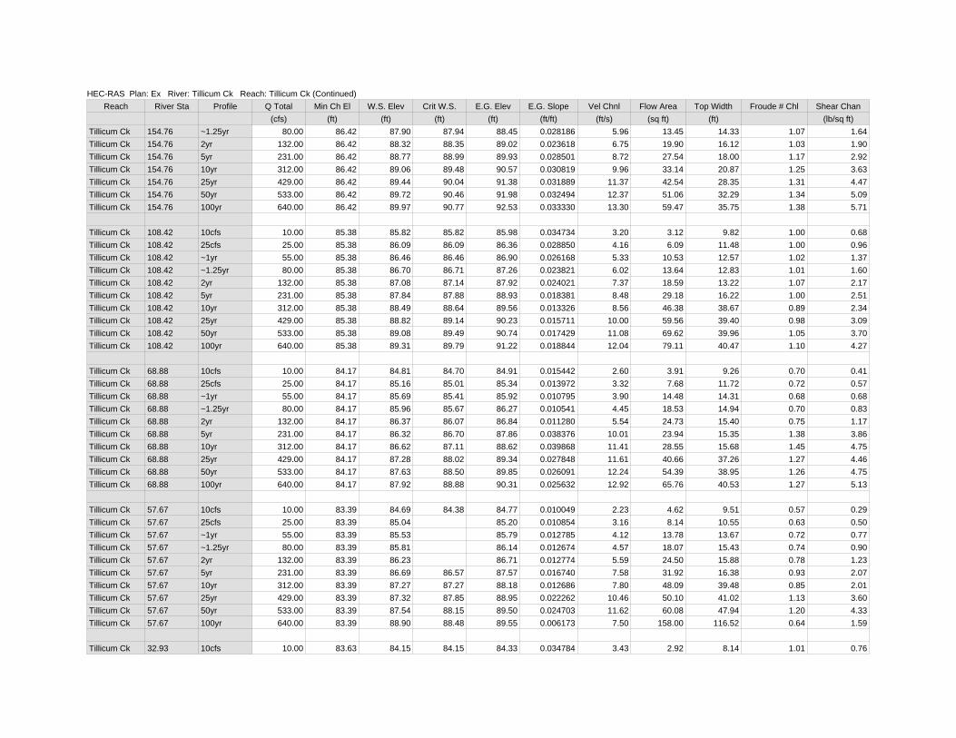
Tillicum Creek using USGS regression equations (Mastin, 2016) and are summarized in Table 1.
Calculations are included in Appendix 2.
Table 1. Flood recurrence flows for Tillicum Creek.
Recurrence Interval (years)
Peak Discharge (cfs)
2 132
10 312
25 429
50 533
100 640
HYDRAULIC MODELING
Existing channel and floodplain hydraulics were simulated using the U.S. Army Corps of
Engineers Hydraulic Engineering Center River Analysis System (HEC‐RAS 5.0.3; USACE 2016).
HEC‐RAS is a computer program that models the hydraulics of water flow through natural
rivers and other channels. The model was run in one‐dimensional steady state mode. Model
results include estimates of flow depth, velocity, energy and extents of inundation for various
flow conditions.
The model geometry for existing conditions cross sections were developed using topographic
and bathymetry data obtained from the Inter‐Fluve survey completed in October 2016. Cross
sections extend from Forest Service Road 5800, through the fan and channel to the south valley
wall. The 2‐, 5‐, 10‐, 25‐, 50‐, and 100‐year recurrence interval floods summarized in Table 1
were modeled, as well as several flows less than the 2‐year event. Values for Manning’s n
coefficient of hydraulic roughness were initially set at 0.07 for the floodplain and 0.040 for the
channel based on professional judgement. The model was run in mixed mode to account for
possible subcritical and supercritical flow conditions. Upstream and downstream boundary
conditions were set at critical depth. Model results for existing conditions are included in
Appendix 3.
Cross sectional geometries from survey data where self‐formed floodplain benches or gravel
bars were present and HEC‐RAS inundations were used to estimate bank full flow to be
Tillicum Fan Habitat Restoration Concepts Report
March 2017 9
approximately 80 cfs (~1.25‐year event). Corresponding average bank full channel cross section
is 12 to 14ft wide by about 1ft deep. Proposed conditions were not modeled at this conceptual
level and will be included as part of later phases of design.
The FEMA flood insurance rate map for Chelan County Washington (unincorporated areas),
Community Panel 530015 0375A, effective date of February 4, 1981, indicates that the base flood
delineation for the Mad River stops well short of the project area. Other than the NF 5800 road
bridge at the upstream, northeast corner of the project area, the closest infrastructure to the
project includes downstream residences with the closest being 0.9 miles downriver which
includes a house with private bridge. Project impacts on Mad River hydraulic conditions will
not extend downstream.
3. Preliminary Design Criteria A suite of preliminary design criteria are outlined below to guide development of concepts
including: 1) Habitat, 2) Geomorphology/Hydrology, 3) Engineering and Risk, and 4)
Construction Impacts.
Habitat
Promote natural habitat‐forming processes to the maximum extent practicable
Increase floodplain inundation
Increase in‐stream and floodplain habitat quality and quantity for steelhead and
Chinook salmon rearing at a range of flows
Design habitat elements that have low risk of creating fish passage barriers
Geomorphology/Hydrology
Design channels and floodplains that are consistent with current and projected
hydrologic and geomorphic regimes
Promote dynamic habitat‐forming processes
Maintain sediment transport continuity to maximize design life and reduce in‐filling
Promote sediment sorting
Engineering and Risk
Do not increase flooding or erosion risk to public or private infrastructure
Provide adequate ballasting of placed logs to withstand high flows that overtop the
structures (i.e. compensate for buoyancy)
Minimize risk to river users. The only identified recreational use of Tillicum Creek and
the Mad River is camping and day use along the floodplain and banks near the roads

Tillicum Fan Habitat Restoration Concepts Report
March 2017 10
Construction Impacts
Choose channel alignments that take advantage of gaps in riparian vegetation to protect
existing mature vegetation.
Minimize impacts to existing mature vegetation that is providing shade to Tillicum
Creek and the Mad River
Maximize shading of Tillicum Creek
4. Concept Designs This site is suitable for a project that provides enhanced floodplain connection and habitat
complexity by excavating in the field area. New channel patterns can be formed on the alluvial
fan to replicate fluvial signatures typical of dynamic fan and confluence processes.
The three enclosed concepts were developed to represent a range of restoration intensities and
construction impacts. Each concept would create diverse and complex habitats through
hydrologically connected floodplains and high flow channels, backwater areas and wetlands.
All three concepts leave Tillicum Creek in its current alignment and create a fan swale adjacent
to the creek to increase flood prone riparian areas. Portions of bankfull and greater flows would
access these areas, providing habitat opportunities while reducing hydraulic stress in the creek.
The fan swale would be inset into a floodplain bench, and placement of woody debris would
further improve habitat, geomorphic function, and natural aesthetic. The variation in terrain
and seasonal contact with surface water and groundwater will support diverse wetland and
riparian vegetation communities.

Tillicum Fan Habitat Restoration Concepts Report
March 2017 11
Alternatives one and two add a flood channel off the Mad River that would further increase
habitat, diverse flow patterns, and wetland mosaic. High flows would seasonally pass along
the upper portion of this new channel (cross section one), while the downstream portion would
be backwatered by the Mad River (cross section two).
All concepts assume that fill generated from excavations will be placed on site as embankment
along NF 5800 Road on site, contoured to blend into the surrounding landscape, and planted
with upland trees and shrubs. The fill could be also be configured to reduce visibility of the
project from the road and accessibility to recreational off road vehicles and snowmobiles.
Piezometer groundwater levels are currently being collected by water level data loggers and
will be downloaded in the spring of 2017. Groundwater elevation information is anticipated to
be useful for designing elevations that may be suited for wetlands and riparian plant
communities. However, the November 2016 pump tests at Pit 1 indicates that inflow rate is
very low, and other pits had insufficient inflow to warrant pump tests. Thus groundwater
inflow is not anticipated to be adequate as a supply for flow along the new channel.
Tillicum Fan Habitat Restoration Concepts Report
March 2017 12
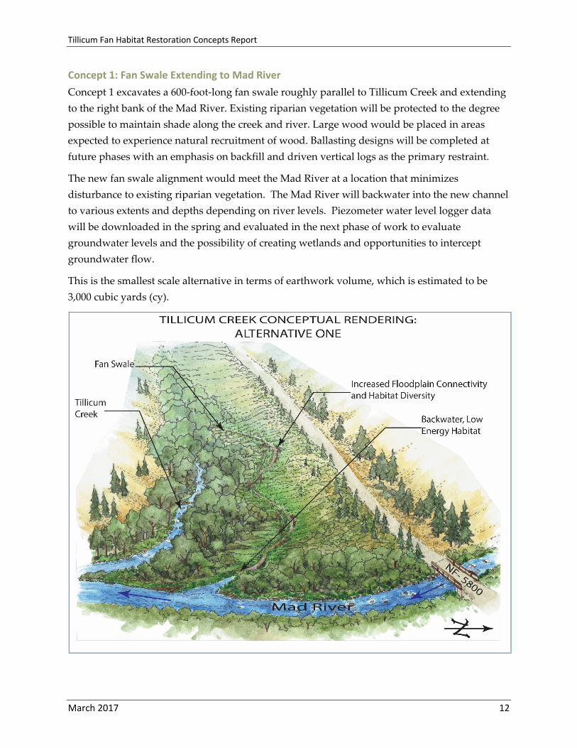
Concept 1: Fan Swale Extending to Mad River
Concept 1 excavates a 600‐foot‐long fan swale roughly parallel to Tillicum Creek and extending
to the right bank of the Mad River. Existing riparian vegetation will be protected to the degree
possible to maintain shade along the creek and river. Large wood would be placed in areas
expected to experience natural recruitment of wood. Ballasting designs will be completed at
future phases with an emphasis on backfill and driven vertical logs as the primary restraint.
The new fan swale alignment would meet the Mad River at a location that minimizes
disturbance to existing riparian vegetation. The Mad River will backwater into the new channel
to various extents and depths depending on river levels. Piezometer water level logger data
will be downloaded in the spring and evaluated in the next phase of work to evaluate
groundwater levels and the possibility of creating wetlands and opportunities to intercept
groundwater flow.
This is the smallest scale alternative in terms of earthwork volume, which is estimated to be
3,000 cubic yards (cy).

Tillicum Fan Habitat Restoration Concepts Report
March 2017 13
Concept 2: Short Fan Swale Extending to Mad River Relic Channel
Concept 2 includes excavating a shorter length of fan swale through the existing field to
enhance flood prone areas similar to Concept 1. This concept also includes a 375‐foot‐long
excavation within the Mad River floodplain to emulate a relic channel of the Mad River that runs
along the distal edge of the Tillicum fan. The upstream end of this relic channel would include
a bar apex log structure to encourage portions of river flood flows to split into the relic channel,
providing floodplain function and habitat. The upstream half of the relic channel is anticipated
to be predominantly riparian wetland, with seasonal connection to groundwater and regularly
flooding, while the lower extents would be backwatered by the river to various extents and
depths depending on river stage.
This is the medium scale alternative, with less earthwork associated with the fan swale but
more earthwork associated with Mad River floodplain enhancement. Volume is estimated to be
4,400 cy.

Tillicum Fan Habitat Restoration Concepts Report
March 2017 14
Concept 3: Long Fan Swale Extending to Mad River Relic Channel
Concept 3 is the largest scale project that combines aspects of Concepts 1 and 2, creating a long
fan swale that connects to a Mad River relic channel. This concept provides the greatest amount
of habitat and complexity at a variety of flows, and the largest acreage of wetland creation.
Earthwork volume is estimated to be 5,400 cy.
DESIGNER’S NOTES ON CONFIGURATIONS
The concepts presented here are meant to show a suite of possibilities. Each of these concepts is
scalable and can be combined or reconfigured into other schemes. The only limitation would be
on the amount of fill that can be placed on site. If a significantly larger scale scheme is
considered, offsite disposal of fill may be required.
The existing creek exhibits many attributes of good habitat, particularly during average and low
flows. The riparian corridor is narrow, but it provides excellent shade canopy over the stream,
and it is a source of small woody debris inputs and trapping. It was therefore decided to not

Tillicum Fan Habitat Restoration Concepts Report
March 2017 15
include alternatives that re‐align the channel. Instead, the alternatives work with the existing
creek by attaching adjacent flood prone areas that would relieve flood stress in the channel
while also providing additional floodplain habitat and perennial backwater habitat.
Furthermore, by not altering the existing channel, impacts to the fish and wildlife that occupy
the stream are minimized, making environmental permitting easier, and significantly reducing
fish exclusion and rescue efforts during construction.
Although the intent is to leave the existing channel in its current alignment, alluvial fans are
naturally dynamic areas, so future sediment and debris loading, or beaver activity is expected
to cause the configuration to evolve over time.
5. References Mastin, M.C., Konrad, C.P., Veilleux, A.G., and Tecca, A.E., 2016, Magnitude, frequency, and
trends of floods at gaged and ungaged sites in Washington, based on data through water
year 2014 (ver 1.1, October 2016): U.S. Geological Survey Scientific Investigations Report
2016‐5118, 70 p.
United States Geological Survey. 2016. StreamStats Program. Web. March 27 2016.
<http://water.usgs.gov/osw/streamstats/>.
Upper Columbia Regional Technical Team (UCRTT). 2014. A Biological strategy to protect and
restore salmonid habitat in Upper Columbia Region (revised). A Report to the Upper
Columbia Salmon Recovery Board from the Upper Columbia Regional Technical Team.
http://www.ucsrb.org/Assets/Documents/Library/REVISED%20Upper%20Columbia%20Rev
ised%20Biological%20Strategy%202014%20(March%20).pdf
Upper Columbia Salmon Recovery Board (UCSRB). 2007. Upper Columbia salmon and
Steelhead recovery plan: Upper Columbia Salmon Recovery Board, Wenatchee,
Washington, 300 pp. <http://www.ucsrb.com/plan.asp>.
USDA‐NRCS (United States Department of Agriculture – Natural Resources Conservation
Service) National Cooperative Soil Survey. Official Soil Series Descriptions. Web. May 27,
2016.
<http://www.nrcs.usda.gov/wps/portal/nrcs/detailfull/soils/home/?cid=nrcs142p2_053587>.
Washington State Dept. of Transportation (WSDOT). 2010. US2, XL 2793/4 Tumwater Canyon
Bridge Replacements Geotechnical Report. Memorandum by B Romine. August 10, 2010.
Washington State Dept. of Transportation (WSDOT). 2014. WSDOT Fish Passage Performance
Report. Environmental Services Office, Biology Branch, Stream Restoration Program. 184
pp.

Tillicum Fan Habitat Restoration Concepts Report
Attachments
Tillicum Fan Habitat Restoration Concepts Report
‐ Grading plan and profile of alternatives ‐ Estimates

0+00
1+00
2+003+004+00
5+006+00
7+00
8+009+00
9+30
0+00
1+00
2+003+00
4+005+00
6+00
6+53
80
90
100
80
90
100
0+001+002+003+004+005+006+006+53
2.4%
3.2%
GRAD
E BR
EAK
STA
= 0+
13EL
EV =
85.
8GRAD
E BR
EAK
STA
= 3+
69EL
EV =
94.
2GRAD
E BR
EAK
STA
= 6+
44EL
EV =
103
.0
CONCEPT 1TILLICUM CREEK FAN CHANNEL
TO MAD RIVER
1 OF 3
MAD RIVER
PLAN
C:\U
sers
\dan
mill
er\D
ocum
ents
\Clie
nt\Y
akam
a N
atio
n\Ti
llicu
m F
an\D
raw
ings
\Ref
eren
ces\
Civi
l 3D\
IFI_
Tilli
cum
-Fan
_MPL
-3-d
m.d
wg
SCALE IN FEET
0 16080
PROFILE
TILLICUM CREEK
3,000 CY EXCAVATION3,000 CY FILL

0+00
1+00
2+003+004+00
5+006+00
7+00
8+009+00
9+30
0+00
1+00
2+00
3+00
4+00
5+00
5+34
80
90
80
90
0+001+002+003+004+005+005+34
1.2%
2.4%
GRAD
E BR
EAK
STA
= 0+
01EL
EV =
83.
0
GRAD
E BR
EAK
STA
= 1+
60EL
EV =
84.
9GRAD
E BR
EAK
STA
= 4+
94EL
EV =
93.
0
CONCEPT 2TILLICUM CREEK FAN CHANNEL (SHORT)
AND MAD RIVER FLOODPLAIN ENHANCEMENT
2 OF 3
MAD RIVER
PLAN
C:\U
sers
\dan
mill
er\D
ocum
ents
\Clie
nt\Y
akam
a N
atio
n\Ti
llicu
m F
an\D
raw
ings
\Ref
eren
ces\
Civi
l 3D\
IFI_
Tilli
cum
-Fan
_MPL
-3-d
m.d
wg
SCALE IN FEET
0 16080
PROFILE
TILLICUM CREEK
4,400 CY EXCAVATION4,400 CY FILL

0+00
1+00
2+003+004+00
5+006+00
7+00
8+009+00
9+30
0+00
1+00
2+00
3+00
4+00
5+006+00
7+00
7+16
80
90
100
110
80
90
100
110
0+001+002+003+004+005+006+007+007+16
1.1%
3.4%
GRAD
E BR
EAK
STA
= 0+
15EL
EV =
83.
2
GRAD
E BR
EAK
STA
= 1+
63EL
EV =
84.
9
GRAD
E BR
EAK
STA
= 7+
02EL
EV =
103
.0
CONCEPT 3TILLICUM CREEK FAN CHANNEL (LONG)
AND MAD RIVER FLOODPLAIN ENHANCEMENT
3 OF 3
MAD RIVER
PLAN
C:\U
sers
\dan
mill
er\D
ocum
ents
\Clie
nt\Y
akam
a N
atio
n\Ti
llicu
m F
an\D
raw
ings
\Ref
eren
ces\
Civi
l 3D\
IFI_
Tilli
cum
-Fan
_MPL
-3-d
m.d
wg
SCALE IN FEET
0 16080
PROFILE
TILLICUM CREEK
5,400 CY EXCAVATION5,400 CY FILL

Tillicum Fan Habitat Restoration Concepts Report
Appendix 1
Tillicum Fan Habitat Restoration Concepts Report
Pebble count

Tillicum FanSediment Grain Size Analysis
Gravel bar Identifier SUBSTRATE PHOTO10/2/16 Date
MM, MBr PersonnelTillicum Ck Stream
0.75 Approximate Depth of Flow at Thalweg (ft)gravel bar Longitudinal Description (Pool, Riffle, Bend, Crossing)
surficial material Sample Type: Armor Layer or Subarmor
Notes:overview photo:
OVERVIEW PHOTO
Pebble Count DataClass (Wentworth) Size Class mm Frequency Cumulative %Sand <2 0 .0%Sand 2 3 3.4%Very Fine Gravel 2.1-4 0 3.4%Fine Gravel 4.1-5.7 0 3.4%Fine Gravel 5.8-8 0 3.4%Medium Gravel 8.1-11.3 1 4.6%Medium Gravel 11.4-16 5 10.3%Coarse Gravel 16.1-22.6 2 12.6%Coarse Gravel 22.7-32 6 19.5%Very Course Gravel 32.1-45 6 26.4%Very Course Gravel 45.1-64 13 41.4%Small Cobble 64.1-90 16 59.8%Small Cobble 90.1-128 21 83.9%Large Cobble 128.1-256 8 93.1%Small Boulders >256 6 100.0%
Total 87
0%
10%
20%
30%
40%
50%
60%
70%
80%
90%
100%
0
2
4
6
8
10
12
14
16
18
20
22
24
<2 2
2.1-
4
4.1-
5.7
5.8-
8
8.1-
11.3
11.4
-16
16.1
-22.
6
22.7
-32
32.1
-45
45.1
-64
64.1
-90
90.1
-128
128.
1-25
6
>256
Freq
uenc
y
Median Axis Diameter (mm)
Pebble CountSurficial Grain Size Analysis
Frequency
Cumulative %

Tillicum Fan Habitat Restoration Concepts Report
Appendix 2
Tillicum Fan Habitat Restoration Concepts Report
Hydrology

Flood Q Regression Tool. Use to estimate flood discharge in Washington State at ungaged sites based on regional regression equations and user-determined basin characteristics.
Steps Selected Region: Regression Region 21
= 22.2 square miles
= 35.00 inches
= 50 %
Selected Region: Regression Region 2
AEP *Qu, ft3/s PIL, in ft3/s PIU, in ft3/s
0.5 = 132 43.6 399.70.2 = 231 82.8 644.10.1 = 312 106.4 914.80.04 = 429 132.4 1390.50.02 = 533 150.0 1894.40.01 = 640 165.2 2478.80.005 = 757 176.6 3244.70.002 = 930 191.8 4510.3
*rounded to 3 significant figures
Prediction Intervals, 90% confidence level
2 Determine the drainage area, DA and the Annual Precipitation, P for the ungage drainage basin. If you pick Regression Region 1 or 2, determine the percent canopy cover, CAN .
Select the Regression Region below from the List Box
DA = Drainage Area, in square miles; P = Average Basin Annual Precipitation, in inches (from PRISM data set, years 1981-2010); CAN = Percent canopy cover (NLCD 2001); AEP = Annual Exceedance Probability; Qu = Flood Discharge, in cubic feet per second at ungaged site for the indicated AEP; PIL, PIU= Predition Intervals (L=Lower and U=Upper)
Instructions for using the Flood Q Tool to estimate Flood Discharges at Ungaged Sites using the regional regression equations
Instructions
User determined basin characteristics for ungaged site
Estimate of indicated flood discharge for Regression Region 2 using regional regression equations
Range of values that are valid for the regression
0.42 - 1820
8.86 - 84.20
Drainage Area, DA
Annual Precipitation, P
Percent Canopy, CAN 0.0 - 97.0
Regression Regions in Washington State
Rows 23-30 will have the results. Estimated flood discharge, Qu, will be found in column O and the 90% prediction limits for these flood discharges will be found in columns R and T. 4
3Enter these basin characteristic values in the green-shade cells. If the cell changes to red, than the value is outside the range of valid values for this regression. Valid value range listed to the right of the green cells.

Tillicum Fan Habitat Restoration Concepts Report
Appendix 3
Tillicum Fan Habitat Restoration Concepts Report
HEC‐RAS hydraulic modeling – existing conditions

Tillicum Ck
719.38
679.65
645.82
563.66
511.9
424.84387.24
287.31
247.32225.38
193.36
154.76
108.42
68.88
32.93T i l l i cum
Ck

0 100 200 300 400 500 600 70080
85
90
95
100
105
110
115
Tillicum Fan Plan: TF-Existing 1/24/2017
Main Channel Distance (ft)
Elev
atio
n (ft
)
Legend
WS 100yr
WS 50yr
WS 25yr
WS 10yr
WS 5yr
WS 2yr
WS ~1.25yr
WS ~1yr
WS 25cfs
WS 10cfs
Ground
LOB
ROB
57.6
768
.88
108.
42
154.
76
193.
36
225.
38
247.
32
287.
31
359.
85
387.
24
424.
84
485.
43
511.
9
563.
66
596.
8261
3.21
645.
82
679.
65
719.
38
Tillicum Ck Tillicum Ck

0 20 40 60 80 100 120104
106
108
110
112
114
116
118
120
Tillicum Fan Plan: TF-Existing 1/24/2017 RS = 719.38
Station (ft)
Elev
atio
n (ft
)
Legend
WS 100yr
WS 50yr
WS 25yr
WS 10yr
WS 5yr
WS 2yr
WS ~1.25yr
WS ~1yr
WS 25cfs
WS 10cfs
Ground
Bank Sta
.07 .04 .07
0 20 40 60 80 100 120104
106
108
110
112
114
116
118
Tillicum Fan Plan: TF-Existing 1/24/2017 RS = 679.65
Station (ft)
Elev
atio
n (ft
)
Legend
WS 100yr
WS 10yr
WS 50yr
WS 5yr
WS 25yr
WS 2yr
WS ~1.25yr
WS ~1yr
WS 25cfs
WS 10cfs
Ground
Bank Sta
.07 .04 .07
0 20 40 60 80 100 120 140 160104
106
108
110
112
114
116
118
Tillicum Fan Plan: TF-Existing 1/24/2017 RS = 645.82
Station (ft)
Elev
atio
n (ft
)
Legend
WS 100yr
WS 50yr
WS 25yr
WS 10yr
WS 5yr
WS 2yr
WS ~1.25yr
WS ~1yr
WS 25cfs
WS 10cfs
Ground
Bank Sta
.07 .04 .07
0 20 40 60 80 100 120 140 160102
104
106
108
110
112
114
116
Tillicum Fan Plan: TF-Existing 1/24/2017 RS = 613.21
Station (ft)
Elev
atio
n (ft
)
Legend
WS 100yr
WS 50yr
WS 25yr
WS 10yr
WS 5yr
WS 2yr
WS ~1.25yr
WS ~1yr
WS 25cfs
WS 10cfs
Ground
Bank Sta
.07 .04 .07

0 20 40 60 80 100 120 140 160100
102
104
106
108
110
112
114
116
Tillicum Fan Plan: TF-Existing 1/24/2017 RS = 596.82
Station (ft)
Elev
atio
n (ft
)
Legend
WS 100yr
WS 50yr
WS 25yr
WS 10yr
WS 5yr
WS 2yr
WS ~1.25yr
WS ~1yr
WS 25cfs
WS 10cfs
Ground
Bank Sta
.07 .04 .07
0 20 40 60 80 100 120 140 160 180100
102
104
106
108
110
112
114
Tillicum Fan Plan: TF-Existing 1/24/2017 RS = 563.66
Station (ft)
Elev
atio
n (ft
)
Legend
WS 100yr
WS 50yr
WS 25yr
WS 10yr
WS 5yr
WS 2yr
WS ~1.25yr
WS ~1yr
WS 25cfs
WS 10cfs
Ground
Bank Sta
.07 .04 .07
0 20 40 60 80 100 120 140 160 18098
100
102
104
106
108
110
112
Tillicum Fan Plan: TF-Existing 1/24/2017 RS = 511.9
Station (ft)
Elev
atio
n (ft
)
Legend
WS 100yr
WS 50yr
WS 25yr
WS 10yr
WS 5yr
WS 2yr
WS ~1.25yr
WS ~1yr
WS 25cfs
WS 10cfs
Ground
Bank Sta
.07 .04 .07
0 20 40 60 80 100 120 140 160 18098
100
102
104
106
108
110
Tillicum Fan Plan: TF-Existing 1/24/2017 RS = 485.43
Station (ft)
Elev
atio
n (ft
)
Legend
WS 100yr
WS 50yr
WS 25yr
WS 10yr
WS 5yr
WS 2yr
WS ~1.25yr
WS ~1yr
WS 25cfs
WS 10cfs
Ground
Bank Sta
.07 .04 .07

0 50 100 150 20096
98
100
102
104
106
108
Tillicum Fan Plan: TF-Existing 1/24/2017 RS = 424.84
Station (ft)
Elev
atio
n (ft
)
Legend
WS 100yr
WS 50yr
WS 25yr
WS 10yr
WS 5yr
WS ~1yr
WS 2yr
WS ~1.25yr
WS 25cfs
WS 10cfs
Ground
Bank Sta
.07 .04 .07
0 50 100 150 200 25096
98
100
102
104
106
Tillicum Fan Plan: TF-Existing 1/24/2017 RS = 387.24
Station (ft)
Elev
atio
n (ft
)
Legend
WS 100yr
WS 50yr
WS 25yr
WS 10yr
WS 5yr
WS 2yr
WS ~1.25yr
WS ~1yr
WS 25cfs
WS 10cfs
Ground
Bank Sta
.07 .04 .07
0 50 100 150 200 25092
94
96
98
100
102
104
106
Tillicum Fan Plan: TF-Existing 1/24/2017 RS = 359.85
Station (ft)
Elev
atio
n (ft
)
Legend
WS 100yr
WS 50yr
WS 25yr
WS 10yr
WS 5yr
WS 2yr
WS ~1.25yr
WS ~1yr
WS 25cfs
WS 10cfs
Ground
Bank Sta
.07 .04 .07
0 50 100 150 200 250 30090
92
94
96
98
100
102
Tillicum Fan Plan: TF-Existing 1/24/2017 RS = 287.31
Station (ft)
Elev
atio
n (ft
)
Legend
WS 100yr
WS 50yr
WS 25yr
WS 10yr
WS 5yr
WS 2yr
WS ~1.25yr
WS ~1yr
WS 25cfs
WS 10cfs
Ground
Bank Sta
.07 .04
.07

0 50 100 150 200 250 30088
90
92
94
96
98
100
Tillicum Fan Plan: TF-Existing 1/24/2017 RS = 247.32
Station (ft)
Elev
atio
n (ft
)
Legend
WS 100yr
WS 50yr
WS 25yr
WS 10yr
WS 5yr
WS 2yr
WS ~1.25yr
WS ~1yr
WS 25cfs
WS 10cfs
Ground
Bank Sta
.07 .04
0 50 100 150 200 250 30088
90
92
94
96
98
Tillicum Fan Plan: TF-Existing 1/24/2017 RS = 225.38
Station (ft)
Elev
atio
n (ft
)
Legend
WS 100yr
WS 50yr
WS 25yr
WS 10yr
WS 5yr
WS 2yr
WS ~1.25yr
WS ~1yr
WS 25cfs
WS 10cfs
Ground
Bank Sta
.07 .04
0 50 100 150 200 250 300 35086
88
90
92
94
96
Tillicum Fan Plan: TF-Existing 1/24/2017 RS = 193.36
Station (ft)
Elev
atio
n (ft
)
Legend
WS 100yr
WS 50yr
WS 25yr
WS 10yr
WS 5yr
WS 2yr
WS ~1.25yr
WS ~1yr
WS 25cfs
WS 10cfs
Ground
Bank Sta
.07 .04
.07
0 50 100 150 20086
87
88
89
90
91
92
93
94
Tillicum Fan Plan: TF-Existing 1/24/2017 RS = 154.76
Station (ft)
Elev
atio
n (ft
)
Legend
WS 100yr
WS 50yr
WS 25yr
WS 10yr
WS 5yr
WS 2yr
WS ~1.25yr
WS ~1yr
WS 25cfs
WS 10cfs
Ground
Bank Sta
.07 .04 .07

0 50 100 150 20085
86
87
88
89
90
91
92
Tillicum Fan Plan: TF-Existing 1/24/2017 RS = 108.42
Station (ft)
Elev
atio
n (ft
)
Legend
WS 100yr
WS 50yr
WS 25yr
WS 10yr
WS 5yr
WS 2yr
WS ~1.25yr
WS ~1yr
WS 25cfs
WS 10cfs
Ground
Bank Sta
.07 .04
.07
0 20 40 60 80 100 120 140 160 18084
85
86
87
88
89
90
Tillicum Fan Plan: TF-Existing 1/24/2017 RS = 68.88
Station (ft)
Elev
atio
n (ft
)
Legend
WS 100yr
WS 50yr
WS 25yr
WS 10yr
WS 2yr
WS 5yr
WS ~1.25yr
WS ~1yr
WS 25cfs
WS 10cfs
Ground
Bank Sta
.07 .04 .07
0 50 100 150 20083
84
85
86
87
88
89
90
Tillicum Fan Plan: TF-Existing 1/24/2017 RS = 57.67
Station (ft)
Elev
atio
n (ft
)
Legend
WS 100yr
WS 50yr
WS 25yr
WS 10yr
WS 5yr
WS 2yr
WS ~1.25yr
WS ~1yr
WS 25cfs
WS 10cfs
Ground
Bank Sta
.07 .04 .07
0 5 10 15 20 25 30 3583
84
85
86
87
88
Tillicum Fan Plan: TF-Existing 1/24/2017 RS = 32.93
Station (ft)
Elev
atio
n (ft
)
Legend
WS 100yr
WS 50yr
WS 25yr
WS 10yr
WS 5yr
WS 2yr
WS ~1.25yr
WS ~1yr
WS 25cfs
WS 10cfs
Ground
Bank Sta
.07 .04 .07

HEC-RAS Plan: Ex River: Tillicum Ck Reach: Tillicum CkReach River Sta Profile Q Total Min Ch El W.S. Elev Crit W.S. E.G. Elev E.G. Slope Vel Chnl Flow Area Top Width Froude # Chl Shear Chan
(cfs) (ft) (ft) (ft) (ft) (ft/ft) (ft/s) (sq ft) (ft) (lb/sq ft)Tillicum Ck 719.38 10cfs 10.00 105.71 106.36 106.36 106.52 0.035216 3.26 3.06 9.47 1.01 0.70Tillicum Ck 719.38 25cfs 25.00 105.71 106.63 106.63 106.89 0.030693 4.11 6.08 11.96 1.02 0.96Tillicum Ck 719.38 ~1yr 55.00 105.71 107.03 107.00 107.40 0.023600 4.85 11.33 14.09 0.95 1.16Tillicum Ck 719.38 ~1.25yr 80.00 105.71 107.28 107.24 107.73 0.022325 5.34 14.98 15.41 0.96 1.32Tillicum Ck 719.38 2yr 132.00 105.71 107.63 107.63 108.27 0.023089 6.39 20.68 16.92 1.01 1.74Tillicum Ck 719.38 5yr 231.00 105.71 108.21 108.21 109.10 0.019813 7.60 31.03 18.93 0.99 2.17Tillicum Ck 719.38 10yr 312.00 105.71 108.63 108.63 109.68 0.017892 8.29 39.24 20.39 0.98 2.41Tillicum Ck 719.38 25yr 429.00 105.71 109.28 109.28 110.37 0.013461 8.53 58.80 34.14 0.89 2.34Tillicum Ck 719.38 50yr 533.00 105.71 109.71 109.71 110.86 0.012167 8.90 73.75 35.00 0.86 2.43Tillicum Ck 719.38 100yr 640.00 105.71 110.02 110.02 111.31 0.012487 9.56 85.33 45.81 0.89 2.73
Tillicum Ck 679.65 10cfs 10.00 104.96 105.99 105.58 106.02 0.003716 1.48 6.74 12.09 0.35 0.12Tillicum Ck 679.65 25cfs 25.00 104.96 106.38 105.92 106.45 0.004423 1.99 12.54 16.41 0.40 0.20Tillicum Ck 679.65 ~1yr 55.00 104.96 106.80 106.92 0.005570 2.75 20.02 19.15 0.47 0.34Tillicum Ck 679.65 ~1.25yr 80.00 104.96 107.03 107.20 0.006626 3.26 24.54 20.63 0.53 0.46Tillicum Ck 679.65 2yr 132.00 104.96 107.39 106.90 107.66 0.007632 4.11 32.27 22.26 0.59 0.68Tillicum Ck 679.65 5yr 231.00 104.96 107.91 107.42 108.35 0.008963 5.33 44.45 24.56 0.66 1.04Tillicum Ck 679.65 10yr 312.00 104.96 108.20 107.79 108.80 0.010588 6.27 51.68 25.82 0.73 1.39Tillicum Ck 679.65 25yr 429.00 104.96 107.83 108.23 109.48 0.035476 10.34 42.41 24.19 1.31 3.98Tillicum Ck 679.65 50yr 533.00 104.96 108.12 108.62 110.02 0.034461 11.09 49.74 25.49 1.31 4.39Tillicum Ck 679.65 100yr 640.00 104.96 108.45 108.94 110.48 0.031290 11.53 58.37 27.61 1.28 4.54
Tillicum Ck 645.82 10cfs 10.00 104.74 105.54 105.54 105.73 0.034428 3.46 2.89 7.95 1.01 0.76Tillicum Ck 645.82 25cfs 25.00 104.74 105.87 105.87 106.11 0.031281 3.95 6.37 13.65 1.01 0.91Tillicum Ck 645.82 ~1yr 55.00 104.74 106.22 106.22 106.53 0.030933 4.42 12.65 22.96 1.04 1.07Tillicum Ck 645.82 ~1.25yr 80.00 104.74 106.39 106.39 106.77 0.027733 4.97 16.46 23.30 1.03 1.25Tillicum Ck 645.82 2yr 132.00 104.74 106.68 106.68 107.20 0.024349 5.83 23.37 23.92 1.02 1.53Tillicum Ck 645.82 5yr 231.00 104.74 107.18 107.18 107.89 0.019680 6.82 36.37 30.84 0.98 1.84Tillicum Ck 645.82 10yr 312.00 104.74 107.54 107.54 108.33 0.016935 7.29 48.92 38.89 0.94 1.96Tillicum Ck 645.82 25yr 429.00 104.74 107.91 107.91 108.86 0.016385 8.10 65.03 47.24 0.95 2.27Tillicum Ck 645.82 50yr 533.00 104.74 108.47 108.47 109.21 0.010194 7.40 109.03 91.78 0.78 1.76Tillicum Ck 645.82 100yr 640.00 104.74 108.54 108.71 109.50 0.013217 8.56 115.05 93.74 0.89 2.34
Tillicum Ck 613.21 10cfs 10.00 102.38 102.63 102.76 103.11 0.325161 5.56 1.80 13.31 2.67 2.73Tillicum Ck 613.21 25cfs 25.00 102.38 102.73 102.96 103.65 0.313628 7.69 3.25 14.39 2.85 4.40Tillicum Ck 613.21 ~1yr 55.00 102.38 102.91 103.25 104.23 0.233983 9.20 5.98 16.22 2.67 5.35Tillicum Ck 613.21 ~1.25yr 80.00 102.38 103.02 103.44 104.65 0.220889 10.25 7.81 17.25 2.68 6.20Tillicum Ck 613.21 2yr 132.00 102.38 103.22 103.78 105.33 0.178291 11.67 11.38 18.43 2.56 7.14Tillicum Ck 613.21 5yr 231.00 102.38 103.55 104.33 106.33 0.136205 13.42 17.77 20.43 2.40 8.24Tillicum Ck 613.21 10yr 312.00 102.38 103.79 104.68 106.94 0.115417 14.35 22.97 21.91 2.29 8.74Tillicum Ck 613.21 25yr 429.00 102.38 104.15 105.13 107.57 0.090697 15.07 31.09 24.06 2.12 8.85Tillicum Ck 613.21 50yr 533.00 102.38 104.40 105.49 108.18 0.083560 15.95 37.21 24.97 2.08 9.44

HEC-RAS Plan: Ex River: Tillicum Ck Reach: Tillicum Ck (Continued)Reach River Sta Profile Q Total Min Ch El W.S. Elev Crit W.S. E.G. Elev E.G. Slope Vel Chnl Flow Area Top Width Froude # Chl Shear Chan
(cfs) (ft) (ft) (ft) (ft) (ft/ft) (ft/s) (sq ft) (ft) (lb/sq ft)Tillicum Ck 613.21 100yr 640.00 102.38 104.74 105.83 108.42 0.065832 15.86 45.82 25.74 1.90 8.82
Tillicum Ck 596.82 10cfs 10.00 101.62 102.19 102.17 102.34 0.028710 3.05 3.28 9.62 0.92 0.60Tillicum Ck 596.82 25cfs 25.00 101.62 102.45 102.45 102.72 0.029243 4.14 6.04 11.43 1.00 0.96Tillicum Ck 596.82 ~1yr 55.00 101.62 102.88 102.88 103.19 0.029064 4.47 12.39 20.96 1.02 1.08Tillicum Ck 596.82 ~1.25yr 80.00 101.62 102.96 103.05 103.47 0.040463 5.73 14.11 21.74 1.23 1.70Tillicum Ck 596.82 2yr 132.00 101.62 103.27 103.37 103.90 0.030733 6.43 21.31 24.50 1.14 1.88Tillicum Ck 596.82 5yr 231.00 101.62 103.52 103.89 104.72 0.043445 8.88 27.72 26.72 1.41 3.33Tillicum Ck 596.82 10yr 312.00 101.62 103.70 104.21 105.33 0.049547 10.39 32.85 30.11 1.54 4.36Tillicum Ck 596.82 25yr 429.00 101.62 103.94 104.59 106.09 0.053632 12.01 40.72 34.53 1.64 5.52Tillicum Ck 596.82 50yr 533.00 101.62 104.11 104.90 106.73 0.058697 13.37 46.36 34.88 1.74 6.63Tillicum Ck 596.82 100yr 640.00 101.62 104.31 105.17 107.21 0.057364 14.17 53.47 35.32 1.76 7.20
Tillicum Ck 563.66 10cfs 10.00 100.69 101.14 101.14 101.33 0.032632 3.47 2.92 7.90 1.00 0.76Tillicum Ck 563.66 25cfs 25.00 100.69 101.47 101.48 101.72 0.031081 4.05 6.29 12.89 1.02 0.94Tillicum Ck 563.66 ~1yr 55.00 100.69 101.80 101.84 102.17 0.032431 4.87 11.52 18.39 1.08 1.26Tillicum Ck 563.66 ~1.25yr 80.00 100.69 101.97 102.05 102.44 0.035418 5.48 14.88 21.19 1.15 1.54Tillicum Ck 563.66 2yr 132.00 100.69 102.30 102.37 102.84 0.031963 5.93 22.73 26.59 1.13 1.68Tillicum Ck 563.66 5yr 231.00 100.69 102.87 102.78 103.44 0.018276 6.09 38.85 29.30 0.92 1.53Tillicum Ck 563.66 10yr 312.00 100.69 103.25 103.07 103.88 0.014824 6.45 50.01 30.54 0.86 1.58Tillicum Ck 563.66 25yr 429.00 100.69 103.80 103.45 104.48 0.010982 6.68 67.49 32.38 0.78 1.54Tillicum Ck 563.66 50yr 533.00 100.69 104.22 103.75 104.96 0.009526 6.97 81.50 33.78 0.75 1.59Tillicum Ck 563.66 100yr 640.00 100.69 104.64 104.06 105.43 0.008437 7.22 98.90 52.55 0.72 1.62
Tillicum Ck 511.9 10cfs 10.00 99.47 100.00 99.92 100.09 0.016805 2.39 4.18 11.88 0.71 0.37Tillicum Ck 511.9 25cfs 25.00 99.47 100.27 100.17 100.44 0.017292 3.32 7.52 13.22 0.78 0.61Tillicum Ck 511.9 ~1yr 55.00 99.47 100.65 100.52 100.94 0.016088 4.26 12.91 14.61 0.80 0.86Tillicum Ck 511.9 ~1.25yr 80.00 99.47 100.91 100.75 101.26 0.015498 4.78 16.75 15.60 0.81 1.02Tillicum Ck 511.9 2yr 132.00 99.47 101.34 101.15 101.82 0.014361 5.57 24.01 17.75 0.81 1.25Tillicum Ck 511.9 5yr 231.00 99.47 102.01 101.76 102.66 0.012376 6.54 37.66 24.68 0.80 1.54Tillicum Ck 511.9 10yr 312.00 99.47 102.48 102.19 103.22 0.010897 7.03 49.73 26.40 0.78 1.66Tillicum Ck 511.9 25yr 429.00 99.47 103.13 102.67 103.95 0.009075 7.48 69.59 36.46 0.74 1.74Tillicum Ck 511.9 50yr 533.00 99.47 103.43 103.13 104.43 0.009997 8.33 81.39 42.57 0.79 2.10Tillicum Ck 511.9 100yr 640.00 99.47 103.57 103.57 104.86 0.012383 9.52 88.22 62.97 0.88 2.70
Tillicum Ck 485.43 10cfs 10.00 98.85 99.31 99.31 99.47 0.034599 3.21 3.13 9.98 1.00 0.69Tillicum Ck 485.43 25cfs 25.00 98.85 99.58 99.58 99.86 0.028827 4.24 6.00 11.20 1.00 0.99Tillicum Ck 485.43 ~1yr 55.00 98.85 99.97 99.97 100.40 0.024866 5.30 10.73 12.96 1.00 1.34Tillicum Ck 485.43 ~1.25yr 80.00 98.85 100.23 100.23 100.76 0.023241 5.87 14.24 14.13 1.00 1.53Tillicum Ck 485.43 2yr 132.00 98.85 100.66 100.66 101.36 0.020815 6.78 20.75 16.49 0.99 1.85Tillicum Ck 485.43 5yr 231.00 98.85 101.32 101.32 102.26 0.017288 7.95 33.07 20.68 0.96 2.24Tillicum Ck 485.43 10yr 312.00 98.85 101.79 101.79 102.85 0.015489 8.58 43.29 23.05 0.94 2.45

HEC-RAS Plan: Ex River: Tillicum Ck Reach: Tillicum Ck (Continued)Reach River Sta Profile Q Total Min Ch El W.S. Elev Crit W.S. E.G. Elev E.G. Slope Vel Chnl Flow Area Top Width Froude # Chl Shear Chan
(cfs) (ft) (ft) (ft) (ft) (ft/ft) (ft/s) (sq ft) (ft) (lb/sq ft)Tillicum Ck 485.43 25yr 429.00 98.85 102.23 102.23 103.59 0.016353 9.81 53.71 23.74 0.99 3.03Tillicum Ck 485.43 50yr 533.00 98.85 103.15 103.15 104.18 0.009213 8.79 95.36 69.04 0.78 2.23Tillicum Ck 485.43 100yr 640.00 98.85 103.49 103.64 104.55 0.008961 9.16 122.02 86.84 0.78 2.35
Tillicum Ck 424.84 10cfs 10.00 96.62 97.30 97.15 97.35 0.008164 1.83 5.52 14.04 0.51 0.20Tillicum Ck 424.84 25cfs 25.00 96.62 97.58 97.37 97.69 0.008564 2.67 9.59 14.69 0.57 0.37Tillicum Ck 424.84 ~1yr 55.00 96.62 97.95 97.69 98.17 0.009872 3.81 15.10 15.52 0.65 0.65Tillicum Ck 424.84 ~1.25yr 80.00 96.62 97.66 97.92 98.56 0.060399 7.63 10.78 14.87 1.54 2.88Tillicum Ck 424.84 2yr 132.00 96.62 97.92 98.31 99.27 0.061703 9.36 14.71 15.47 1.63 3.94Tillicum Ck 424.84 5yr 231.00 96.62 98.34 99.00 100.36 0.059504 11.54 21.37 16.86 1.69 5.34Tillicum Ck 424.84 10yr 312.00 96.62 98.65 99.45 101.09 0.056116 12.74 27.14 20.91 1.70 6.10Tillicum Ck 424.84 25yr 429.00 96.62 99.06 99.99 101.84 0.049171 13.76 37.06 26.46 1.65 6.63Tillicum Ck 424.84 50yr 533.00 96.62 99.23 100.39 102.78 0.057386 15.63 41.76 28.72 1.80 8.34Tillicum Ck 424.84 100yr 640.00 96.62 99.55 100.69 103.19 0.051157 16.06 51.51 32.92 1.74 8.44
Tillicum Ck 387.24 10cfs 10.00 96.20 96.64 96.64 96.78 0.035268 3.00 3.34 11.88 0.99 0.62Tillicum Ck 387.24 25cfs 25.00 96.20 96.89 96.89 97.13 0.029794 3.93 6.41 13.53 1.00 0.89Tillicum Ck 387.24 ~1yr 55.00 96.20 97.21 97.21 97.58 0.026526 4.86 11.51 16.44 1.01 1.19Tillicum Ck 387.24 ~1.25yr 80.00 96.20 97.42 97.42 97.88 0.024049 5.48 14.97 16.85 1.00 1.39Tillicum Ck 387.24 2yr 132.00 96.20 97.78 97.78 98.42 0.021519 6.46 21.26 17.57 1.00 1.73Tillicum Ck 387.24 5yr 231.00 96.20 98.44 98.44 99.27 0.016450 7.42 35.00 27.42 0.94 1.99Tillicum Ck 387.24 10yr 312.00 96.20 98.80 98.90 99.79 0.016136 8.22 46.28 35.59 0.95 2.32Tillicum Ck 387.24 25yr 429.00 96.20 99.22 99.42 100.39 0.015827 9.11 63.51 45.86 0.97 2.69Tillicum Ck 387.24 50yr 533.00 96.20 99.31 99.79 100.95 0.021594 10.85 67.47 47.92 1.14 3.78Tillicum Ck 387.24 100yr 640.00 96.20 99.51 100.07 101.40 0.023285 11.81 77.82 52.87 1.20 4.37
Tillicum Ck 359.85 10cfs 10.00 92.67 93.06 93.32 94.29 0.506398 8.88 1.13 5.73 3.53 6.15Tillicum Ck 359.85 25cfs 25.00 92.67 93.24 93.61 94.97 0.424086 10.54 2.37 8.16 3.45 7.62Tillicum Ck 359.85 ~1yr 55.00 92.67 93.48 93.96 95.66 0.327238 11.85 4.64 11.02 3.22 8.50Tillicum Ck 359.85 ~1.25yr 80.00 92.67 93.62 94.20 96.11 0.294796 12.66 6.32 12.57 3.15 9.15Tillicum Ck 359.85 2yr 132.00 92.67 93.87 94.59 96.84 0.224453 13.83 9.57 13.69 2.90 9.76Tillicum Ck 359.85 5yr 231.00 92.67 94.25 95.17 97.94 0.176726 15.43 15.08 15.40 2.72 10.83Tillicum Ck 359.85 10yr 312.00 92.67 94.54 95.60 98.51 0.143223 16.02 19.70 16.39 2.54 10.88Tillicum Ck 359.85 25yr 429.00 92.67 94.94 96.08 99.19 0.105484 16.59 26.41 16.99 2.28 10.62Tillicum Ck 359.85 50yr 533.00 92.67 95.30 96.69 99.66 0.082784 16.81 32.72 17.54 2.09 10.19Tillicum Ck 359.85 100yr 640.00 92.67 95.66 97.14 100.14 0.068679 17.07 39.08 18.07 1.96 9.96
Tillicum Ck 287.31 10cfs 10.00 90.23 90.85 90.85 91.02 0.035435 3.28 3.05 9.37 1.02 0.71Tillicum Ck 287.31 25cfs 25.00 90.23 91.14 91.14 91.40 0.030091 4.11 6.08 11.77 1.01 0.96Tillicum Ck 287.31 ~1yr 55.00 90.23 91.51 91.52 91.90 0.026791 5.01 10.98 14.40 1.01 1.25Tillicum Ck 287.31 ~1.25yr 80.00 90.23 91.75 91.75 92.22 0.025128 5.48 14.61 15.96 1.01 1.41Tillicum Ck 287.31 2yr 132.00 90.23 92.13 92.13 92.75 0.022678 6.30 21.04 17.72 1.00 1.69

HEC-RAS Plan: Ex River: Tillicum Ck Reach: Tillicum Ck (Continued)Reach River Sta Profile Q Total Min Ch El W.S. Elev Crit W.S. E.G. Elev E.G. Slope Vel Chnl Flow Area Top Width Froude # Chl Shear Chan
(cfs) (ft) (ft) (ft) (ft) (ft/ft) (ft/s) (sq ft) (ft) (lb/sq ft)Tillicum Ck 287.31 5yr 231.00 90.23 92.63 92.69 93.57 0.022285 7.82 30.11 19.10 1.05 2.33Tillicum Ck 287.31 10yr 312.00 90.23 92.92 93.09 94.17 0.024015 9.01 35.74 19.91 1.12 2.94Tillicum Ck 287.31 25yr 429.00 90.23 93.25 93.61 94.96 0.026938 10.57 42.51 20.84 1.22 3.84Tillicum Ck 287.31 50yr 533.00 90.23 93.50 94.01 95.63 0.029313 11.81 47.84 21.54 1.29 4.63Tillicum Ck 287.31 100yr 640.00 90.23 93.72 94.40 96.29 0.031720 12.98 52.77 22.17 1.36 5.44
Tillicum Ck 247.32 10cfs 10.00 89.18 89.63 89.60 89.76 0.027244 2.88 3.47 10.64 0.89 0.55Tillicum Ck 247.32 25cfs 25.00 89.18 89.89 89.87 90.13 0.025177 3.95 6.39 11.97 0.93 0.86Tillicum Ck 247.32 ~1yr 55.00 89.18 90.15 90.23 90.68 0.035076 5.91 9.60 12.90 1.15 1.72Tillicum Ck 247.32 ~1.25yr 80.00 89.18 90.37 90.49 91.05 0.033212 6.68 12.60 13.71 1.15 2.03Tillicum Ck 247.32 2yr 132.00 89.18 90.78 90.93 91.68 0.030334 7.77 18.48 15.18 1.14 2.49Tillicum Ck 247.32 5yr 231.00 89.18 91.47 91.62 92.61 0.025231 8.86 29.85 17.67 1.07 2.90Tillicum Ck 247.32 10yr 312.00 89.18 91.95 92.09 93.23 0.023289 9.51 38.74 19.40 1.03 3.16Tillicum Ck 247.32 25yr 429.00 89.18 92.64 92.67 93.99 0.019902 9.93 52.94 21.88 0.96 3.24Tillicum Ck 247.32 50yr 533.00 89.18 93.08 93.15 94.58 0.020046 10.61 62.83 23.45 0.97 3.59Tillicum Ck 247.32 100yr 640.00 89.18 93.48 93.56 95.13 0.020181 11.20 72.70 24.92 0.97 3.89
Tillicum Ck 225.38 10cfs 10.00 88.33 88.91 88.91 89.09 0.034052 3.40 2.94 8.13 1.00 0.74Tillicum Ck 225.38 25cfs 25.00 88.33 89.23 89.23 89.52 0.030700 4.29 5.83 10.29 1.00 1.02Tillicum Ck 225.38 ~1yr 55.00 88.33 89.54 89.63 90.07 0.040670 5.86 9.39 12.71 1.20 1.76Tillicum Ck 225.38 ~1.25yr 80.00 88.33 89.83 89.87 90.41 0.029174 6.11 13.23 13.56 1.06 1.72Tillicum Ck 225.38 2yr 132.00 88.33 90.25 90.30 91.03 0.026108 7.11 19.19 14.79 1.04 2.10Tillicum Ck 225.38 5yr 231.00 88.33 90.77 91.00 92.00 0.029349 9.01 27.81 18.39 1.13 3.09Tillicum Ck 225.38 10yr 312.00 88.33 91.14 91.45 92.63 0.029749 10.01 34.88 19.63 1.15 3.63Tillicum Ck 225.38 25yr 429.00 88.33 91.62 92.02 93.40 0.029841 11.11 44.61 21.23 1.17 4.24Tillicum Ck 225.38 50yr 533.00 88.33 92.02 92.45 93.99 0.029195 11.80 53.36 22.57 1.16 4.62Tillicum Ck 225.38 100yr 640.00 88.33 92.39 92.87 94.54 0.028651 12.40 62.16 23.84 1.15 4.95
Tillicum Ck 193.36 10cfs 10.00 87.18 87.81 87.88 88.10 0.056597 4.36 2.29 6.46 1.29 1.22Tillicum Ck 193.36 25cfs 25.00 87.18 88.27 88.22 88.53 0.023177 4.07 6.14 9.90 0.91 0.88Tillicum Ck 193.36 ~1yr 55.00 87.18 88.59 88.65 89.11 0.030879 5.80 9.59 11.56 1.10 1.61Tillicum Ck 193.36 ~1.25yr 80.00 87.18 88.85 88.93 89.48 0.028769 6.35 12.84 12.93 1.10 1.82Tillicum Ck 193.36 2yr 132.00 87.18 89.21 89.37 90.11 0.030136 7.66 17.83 14.97 1.17 2.44Tillicum Ck 193.36 5yr 231.00 87.18 89.77 90.05 91.07 0.027946 9.30 27.11 18.48 1.19 3.20Tillicum Ck 193.36 10yr 312.00 87.18 90.14 90.53 91.72 0.026786 10.28 34.53 20.87 1.20 3.68Tillicum Ck 193.36 25yr 429.00 87.18 90.61 91.10 92.51 0.025838 11.43 44.89 23.80 1.22 4.27Tillicum Ck 193.36 50yr 533.00 87.18 90.97 91.56 93.11 0.025179 12.26 53.93 26.10 1.23 4.72Tillicum Ck 193.36 100yr 640.00 87.18 91.30 91.92 93.67 0.024825 13.03 62.83 27.83 1.24 5.15
Tillicum Ck 154.76 10cfs 10.00 86.42 87.10 87.04 87.22 0.021265 2.73 3.67 10.17 0.80 0.47Tillicum Ck 154.76 25cfs 25.00 86.42 87.36 87.32 87.59 0.024667 3.89 6.43 11.60 0.92 0.84Tillicum Ck 154.76 ~1yr 55.00 86.42 87.70 87.70 88.11 0.026505 5.12 10.73 13.39 1.01 1.29
HEC-RAS Plan: Ex River: Tillicum Ck Reach: Tillicum Ck (Continued)Reach River Sta Profile Q Total Min Ch El W.S. Elev Crit W.S. E.G. Elev E.G. Slope Vel Chnl Flow Area Top Width Froude # Chl Shear Chan
(cfs) (ft) (ft) (ft) (ft) (ft/ft) (ft/s) (sq ft) (ft) (lb/sq ft)Tillicum Ck 154.76 ~1.25yr 80.00 86.42 87.90 87.94 88.45 0.028186 5.96 13.45 14.33 1.07 1.64Tillicum Ck 154.76 2yr 132.00 86.42 88.32 88.35 89.02 0.023618 6.75 19.90 16.12 1.03 1.90Tillicum Ck 154.76 5yr 231.00 86.42 88.77 88.99 89.93 0.028501 8.72 27.54 18.00 1.17 2.92Tillicum Ck 154.76 10yr 312.00 86.42 89.06 89.48 90.57 0.030819 9.96 33.14 20.87 1.25 3.63Tillicum Ck 154.76 25yr 429.00 86.42 89.44 90.04 91.38 0.031889 11.37 42.54 28.35 1.31 4.47Tillicum Ck 154.76 50yr 533.00 86.42 89.72 90.46 91.98 0.032494 12.37 51.06 32.29 1.34 5.09Tillicum Ck 154.76 100yr 640.00 86.42 89.97 90.77 92.53 0.033330 13.30 59.47 35.75 1.38 5.71
Tillicum Ck 108.42 10cfs 10.00 85.38 85.82 85.82 85.98 0.034734 3.20 3.12 9.82 1.00 0.68Tillicum Ck 108.42 25cfs 25.00 85.38 86.09 86.09 86.36 0.028850 4.16 6.09 11.48 1.00 0.96Tillicum Ck 108.42 ~1yr 55.00 85.38 86.46 86.46 86.90 0.026168 5.33 10.53 12.57 1.02 1.37Tillicum Ck 108.42 ~1.25yr 80.00 85.38 86.70 86.71 87.26 0.023821 6.02 13.64 12.83 1.01 1.60Tillicum Ck 108.42 2yr 132.00 85.38 87.08 87.14 87.92 0.024021 7.37 18.59 13.22 1.07 2.17Tillicum Ck 108.42 5yr 231.00 85.38 87.84 87.88 88.93 0.018381 8.48 29.18 16.22 1.00 2.51Tillicum Ck 108.42 10yr 312.00 85.38 88.49 88.64 89.56 0.013326 8.56 46.38 38.67 0.89 2.34Tillicum Ck 108.42 25yr 429.00 85.38 88.82 89.14 90.23 0.015711 10.00 59.56 39.40 0.98 3.09Tillicum Ck 108.42 50yr 533.00 85.38 89.08 89.49 90.74 0.017429 11.08 69.62 39.96 1.05 3.70Tillicum Ck 108.42 100yr 640.00 85.38 89.31 89.79 91.22 0.018844 12.04 79.11 40.47 1.10 4.27
Tillicum Ck 68.88 10cfs 10.00 84.17 84.81 84.70 84.91 0.015442 2.60 3.91 9.26 0.70 0.41Tillicum Ck 68.88 25cfs 25.00 84.17 85.16 85.01 85.34 0.013972 3.32 7.68 11.72 0.72 0.57Tillicum Ck 68.88 ~1yr 55.00 84.17 85.69 85.41 85.92 0.010795 3.90 14.48 14.31 0.68 0.68Tillicum Ck 68.88 ~1.25yr 80.00 84.17 85.96 85.67 86.27 0.010541 4.45 18.53 14.94 0.70 0.83Tillicum Ck 68.88 2yr 132.00 84.17 86.37 86.07 86.84 0.011280 5.54 24.73 15.40 0.75 1.17Tillicum Ck 68.88 5yr 231.00 84.17 86.32 86.70 87.86 0.038376 10.01 23.94 15.35 1.38 3.86Tillicum Ck 68.88 10yr 312.00 84.17 86.62 87.11 88.62 0.039868 11.41 28.55 15.68 1.45 4.75Tillicum Ck 68.88 25yr 429.00 84.17 87.28 88.02 89.34 0.027848 11.61 40.66 37.26 1.27 4.46Tillicum Ck 68.88 50yr 533.00 84.17 87.63 88.50 89.85 0.026091 12.24 54.39 38.95 1.26 4.75Tillicum Ck 68.88 100yr 640.00 84.17 87.92 88.88 90.31 0.025632 12.92 65.76 40.53 1.27 5.13
Tillicum Ck 57.67 10cfs 10.00 83.39 84.69 84.38 84.77 0.010049 2.23 4.62 9.51 0.57 0.29Tillicum Ck 57.67 25cfs 25.00 83.39 85.04 85.20 0.010854 3.16 8.14 10.55 0.63 0.50Tillicum Ck 57.67 ~1yr 55.00 83.39 85.53 85.79 0.012785 4.12 13.78 13.67 0.72 0.77Tillicum Ck 57.67 ~1.25yr 80.00 83.39 85.81 86.14 0.012674 4.57 18.07 15.43 0.74 0.90Tillicum Ck 57.67 2yr 132.00 83.39 86.23 86.71 0.012774 5.59 24.50 15.88 0.78 1.23Tillicum Ck 57.67 5yr 231.00 83.39 86.69 86.57 87.57 0.016740 7.58 31.92 16.38 0.93 2.07Tillicum Ck 57.67 10yr 312.00 83.39 87.27 87.27 88.18 0.012686 7.80 48.09 39.48 0.85 2.01Tillicum Ck 57.67 25yr 429.00 83.39 87.32 87.85 88.95 0.022262 10.46 50.10 41.02 1.13 3.60Tillicum Ck 57.67 50yr 533.00 83.39 87.54 88.15 89.50 0.024703 11.62 60.08 47.94 1.20 4.33Tillicum Ck 57.67 100yr 640.00 83.39 88.90 88.48 89.55 0.006173 7.50 158.00 116.52 0.64 1.59
Tillicum Ck 32.93 10cfs 10.00 83.63 84.15 84.15 84.33 0.034784 3.43 2.92 8.14 1.01 0.76

HEC-RAS Plan: Ex River: Tillicum Ck Reach: Tillicum Ck (Continued)Reach River Sta Profile Q Total Min Ch El W.S. Elev Crit W.S. E.G. Elev E.G. Slope Vel Chnl Flow Area Top Width Froude # Chl Shear Chan
(cfs) (ft) (ft) (ft) (ft) (ft/ft) (ft/s) (sq ft) (ft) (lb/sq ft)Tillicum Ck 32.93 25cfs 25.00 83.63 84.46 84.46 84.76 0.029984 4.39 5.70 9.76 1.01 1.06Tillicum Ck 32.93 ~1yr 55.00 83.63 84.89 84.89 85.33 0.025891 5.33 10.38 12.05 1.01 1.36Tillicum Ck 32.93 ~1.25yr 80.00 83.63 85.15 85.15 85.69 0.024014 5.90 13.69 13.45 1.00 1.56Tillicum Ck 32.93 2yr 132.00 83.63 85.62 85.62 86.30 0.018821 6.67 21.26 19.16 0.94 1.76Tillicum Ck 32.93 5yr 231.00 83.63 86.29 86.29 87.16 0.015670 7.73 35.79 26.09 0.92 2.10Tillicum Ck 32.93 10yr 312.00 83.63 86.50 86.75 87.75 0.020447 9.37 41.54 30.00 1.06 2.99Tillicum Ck 32.93 25yr 429.00 83.63 87.00 87.27 88.38 0.018427 10.08 57.42 33.05 1.04 3.25Tillicum Ck 32.93 50yr 533.00 83.63 87.35 87.61 88.85 0.017828 10.69 69.10 33.05 1.04 3.52Tillicum Ck 32.93 100yr 640.00 83.63 87.92 87.92 89.27 0.013492 10.36 88.00 33.05 0.93 3.13