this page intentionally left blank final environmental impact statement ... tennessee to the...
TRANSCRIPT


THIS PAGE INTENTIONALLY LEFT BLANK
i
SUMMARY
Proposed Action
This Final Environmental Impact Statement (FEIS) identifies and assesses the environmental
impacts associated with the construction of a segment of proposed Interstate 69 (I-69) that
extends from Canada to Mexico across the United States. The segment of interstate highway
discussed in this document is Segment of Independent Utility 9 (SIU 9) as identified in the I-69
Corridor 18, Special Environmental Study dated February 7, 2000. The study corridor begins at
the Interstate 55 (I-55) and Mississippi 304 (MS 304) Interchange in Hernando, Mississippi and
extends north through Memphis, Tennessee to the intersection of US Highway 51 (US 51) and
State Route 385 (SR 385) in Millington, Tennessee. The project is located in DeSoto and
Marshall Counties in northwest Mississippi and Shelby and Fayette Counties in southwest
Tennessee (Reference the Project Location map, Figure 1).
The Tennessee Department of Transportation (TDOT), the Mississippi Department of
Transportation (MDOT), and the Memphis Metropolitan Planning Organization (MPO), in
cooperation with the Federal Highway Administration (FHWA) is proposing a Systems
Approach Alternative for this segment (SIU 9) of proposed I-69. It involves constructing two
routes, an I-69 route through Memphis and a proposed I-269 route which by-passes Memphis to
the east. The proposed project is consistent with the Memphis Long Range Transportation Plan
and Mississippi’s Vision 21 Plan.
Background
This proposed project is part of the overall 1,600 mile long I-69 corridor that is proposed to
connect Canada to Mexico across the United States. The I-69 corridor has been supported by
Congressional mandates since 1991. It was first approved as a high priority corridor from
Indianapolis, Indiana to Memphis, Tennessee in the 1991 Intermodal Surface Transportation
Efficiency Act (ISTEA) legislation. In 1993 it was further amended by Congress to extend from
Memphis to Houston, Texas. The National Highway System Designation Act of 1995 further
extended the corridor from Houston to include the Lower Rio Grande Valley of Texas. The


iii
Transportation Equity Act for the 21st Century (TEA 21), signed into law June 9, 1998 redefined
the corridor and officially designated it as Interstate 69.
A Steering Committee was formed after the passage of the ISTEA legislation with members
representing the eight states along the corridor to guide the development of the 1,600 mile long
I-69 corridor study. The member states are Texas, Louisiana, Arkansas, Mississippi, Tennessee,
Kentucky, Indiana, and Michigan. Each state department of transportation and the FHWA are
represented on the Steering Committee. The Arkansas State Highway and Transportation
Department was designated as the administrative agency for the Steering Committee.
Several studies of the overall corridor have been conducted under the guidance of the Steering
Committee:
1. Corridor 18 Feasibility Study (1995)
2. Corridor 20 Feasibility Study (1996)
3. Corridor 18 Special Issues Study (1997)
4. I-69 (Corridor 18) Special Environmental Study (2000)
5. I-69 Sections of Independent Utility (2000)
These studies involved developing the purpose and need for I-69, setting goals, and evaluating
the feasibility of multimodal alternatives such as rail, mass transit, and river barges. Based on
the results of these studies it was determined that an interstate highway was the most feasible and
most cost effective alternative to meeting the purpose and need of I-69. The overall 1,600 mile
corridor was divided into 32 Segments of Independent Utility (SIU’s) for study purposes. Each
state is responsible for the segments within their state boundaries. Segments of Independent
Utility are defined as independent highway sections that have logical beginning and ending
points and are stand-alone projects that are considered to be a reasonable expenditure of public
funds even if no other sections of I-69 were built. The proposed segment discussed in this
document is Segment of Independent Utility 9 (SIU 9). (Copies of the above listed reports are
available at TDOT and MDOT offices.)

iv
Purpose and Need
The purpose of I-69 is to provide an adequate transportation corridor for the movement of freight
between Canada and Mexico. Studies of the movement of commodities, both finished goods and
raw materials, show there is a significant demand for this movement of freight to occur along a
route within the designated I-69 Corridor (See Corridor Map Figure 1.1). With the increasingly
global economy and evolving international trade opportunities, making a connection from
Canada to Mexico across the United States is vital to the health of the United States economy.
The I-69 corridor will improve international and interstate trade, increase accessibility to the
region, improve transportation system linkages, and stimulate economic development. I-69 will
give the nation new capacity to efficiently move commodities from border to border significantly
reducing travel times and cost.
The purpose of SIU 9 is also to respond to local traffic growth and travel demands of the region
by providing a high speed access controlled facility that is responsive to traffic usage and
enhances access between communities and routes within the I-69 Corridor.
Memphis is the center of a 21 county growth area that includes eastern Arkansas, northwest
Mississippi and west Tennessee. It is one of the top ten distribution centers in America and has
spent the last decade building infrastructure to support its economic base. The Memphis
International Airport is the largest air cargo facility in North America and ships over one million
tons a year. The International Port of Memphis is the fourth largest inland port in the United
States. Memphis has attracted many new jobs and the employment centers are hiring to keep
pace with the distribution industry. This new growth has resulted in new warehousing and the
development of new industrial parks and the expansion of existing industrial parks in both
Tennessee and Mississippi. The expansion of the Frank C. Pidgeon Industrial Park in West
Memphis, along with the North Memphis Industrial Park, the West Tennessee Business Center in
Millington and the Chickasaw Industrial Park in northern Mississippi, have the potential to add
over 75,000 new jobs in the Memphis growth area. These emerging and already established
employment centers are generating extensive residential growth north, east, southeast, and south
of Memphis. Fayette, Marshall, and DeSoto Counties are experiencing similar growth. Because
of the region’s importance as a transportation and distribution hub, this growth is likely to

v
continue for decades. This new development will require needed support services and an
adequate transportation system to afford people a reasonable commuting time to employment
centers, as well as a safe and efficient means to move people and goods in and around the
Memphis area.
Alternatives Considered
The alternatives considered for this project were selected based on the results of eight public
involvement meetings, field reviews using aerial photography and USGS topographic maps,
reviewing documented environmentally sensitive areas and constraints and input from other
agencies as part of the scoping process. Recent traffic studies and the evaluation of future
growth patterns in the project impact area were also factors in the selection of the alternative
alignments.
A Technical Advisory Committee (TAC) consisting of representatives of the Tennessee and
Mississippi Departments of Transportation, the Memphis Metropolitan Planning Organization,
and the Federal Highway Administration from Tennessee and Mississippi was formed to
evaluate information gained from the project studies and to make decisions regarding project
development. The project alternatives selected for study, including the No-Build Alternative and
those eliminated were approved by the TAC.
In the early phase of project development for this segment of I-69, two alternative corridors with
a common beginning point at the I-55 Interchange in Hernando and a common ending point at
the intersection of US 51/SR 385 in Millington were evaluated. One corridor passed through
Memphis, the other bypassed Memphis to the east. As the study progressed and after evaluating
traffic patterns and growth patterns in the surrounding area, it became apparent that neither a
single route through Memphis, nor a single route bypassing Memphis to the east would meet the
purpose and need of this segment of I-69.
Studies of the projected I-69 traffic and freight movement show that a large volume of the I-69
commercial traffic will have an origin or destination in Memphis. Recent traffic studies also
indicate that a majority of traffic on the existing system through Memphis is local traffic and that

vi
the interstates currently operate at congested levels during peak hour periods. During the
congested periods, through traffic on I-69 with destinations either north or south of the city and
traffic destined for the major highways leaving Memphis to the east are not adequately served
without an eastern bypass route. Also, since a large volume of traffic is destined for the
downtown Memphis area, a single bypass route to the east does not meet the purpose and need of
I-69. Since a single route will not meet the purpose and need of this segment of I-69, a Systems
Approach Alternative was proposed.
The No-Build Alternative and a Systems Approach Alternative that involves constructing two
routes, one through town and a bypass route to the east, were fully evaluated in the DEIS and
FEIS for this project.
No-Build Alternative
The No-Build, or No-Action Alternative, involves not building SIU 9 and leaving the existing
roadway system in place. The widening of I-55 from Hernando, Mississippi to the state line
would continue, as well as other ongoing improvements to I-240 and I-40 through Memphis.
The construction of SR 385 and other planned improvements in the area independent of I-69
would be implemented along with other normal maintenance activities.
Systems Approach Alternative
In order to meet the purpose and need of I-69 and provide an adequate route for the movement of
freight between Canada and Mexico through Memphis, as well as freight movement in Memphis
and serve the anticipated traffic growth in this region, a Systems Approach Alternative was
proposed. The Systems Approach Alternative will provide a route through Memphis, as well
as a bypass route to the east of Memphis. It will utilize sections of existing interstates and state
highways built to interstate standards. It will also require the construction of two new sections of
interstate. It will connect approximately 100 miles of existing interstate and existing and
proposed state highways into one complete system and will benefit far more businesses and
people than a single route through Memphis or a single eastern bypass. It will provide an
adequate level of traffic service to move people and freight in a safe and efficient manner in and
around the Memphis area.
vii
Approximately 55 miles of the proposed Systems Approach Alternative is already in place.
This project will result in the construction of approximately 45 miles of new interstate
construction; one 15-mile section north of Memphis, and a 30-mile section southeast of Memphis
(See Project Location Map Figure 1).
The Systems Approach Alternative will begin at the I-55/MS 304 Interchange in Hernando and
involves utilizing existing I-55, I-240, and I-40 through Memphis to US 51. A new 15 mile,
4-lane divided section of interstate will be constructed from US 51 north to connect with existing
SR 385 in Millington. The existing section of SR 385 that extends south from Millington to I-40
and the proposed SR 385 alignment that extends south of I-40 to Collierville will be utilized as
part of the eastern bypass segment. A new (approximately) 30 mile long 4-lane divided section
of interstate will be constructed from SR 385 south of Collierville to connect with the I-55/MS
304 Interchange in Hernando, connecting the entire system. This Systems Approach
Alternative will have interchanges with all intersecting State highways and major roadways
around the Memphis area (See Project Location Map, Figure 1). No improvements to I-55, I-
240, I-40 or SR 385 will be made as a result of this project. The existing section of SR 385 at
Millington was previously built to interstate standards, and the new section currently under
construction south of I-40 to Collierville will also be built to interstate standards. The on-going
improvements to I-55, I-240, I-40, and SR 385 are separate and independent projects that have
their own funding and approved environmental documents. The environmental impacts
associated with these projects has been well documented and appropriate mitigation measures are
being implemented. The only changes to these projects as a result of the proposed I-69 project
will be the new interstate designation signs.
Since the Systems Approach Alternative requires two new construction segments, one north of
Memphis, and the other southeast of Memphis, to connect the entire system and meet the overall
national and local purpose and need for the project, the segment that follows I-55, I-240, and
I-40 north through Memphis will be designated I-69. It is proposed to designate the segment that
bypasses Memphis to the east as I-269.
viii
In evaluating this Systems Approach Alternative, two new location alternative alignments were
evaluated for the 15 mile northern section, proposed I-69, and three new location alternative
alignments were evaluated for the 30-mile southeast section, proposed I-269.
Proposed I-69
In evaluating the 15-mile new location section of proposed I-69, two alternative alignments were
studied, A1 and A3 (See Location Map, Figure 1). As previously stated, the proposed I-69 route
through Memphis begins at the new I-55/MS 304 Interchange currently under construction in
Hernando, Mississippi and follows I-55, I-240, and I-40/240 through Memphis to US 51. Both
alternative alignments share this common alignment. The existing cross-sections of I-55, I-240,
and I-40/240 through this area vary from 4-lane section to 8-lane sections. Some sections of the
existing roadway have recently been upgraded to eight 12-foot traffic lanes, some sections are
currently under construction and other segments are in various planning stages of upgrade.
Along these existing sections, no new right-of-way will be needed for the I-69 project.
Alternative A-1
Beginning at the SR 300/US 51 Interchange, Alternative Alignment A-1 extends west for
approximately 0.7 mile on new location before shifting north and crossing over the Loosahatchie
River and floodplain. It continues north on new location for approximately 14 miles. It traverses
mostly open land, some forested areas and scattered residential areas. It passes behind the BFI
landfill and ends at a proposed interchange with SIU 8 at Millington. This alternative will cross
several existing and proposed landfills. Alternative Alignment A-1 is approximately 15.2 miles
in length. It will displace 21 families and two businesses. It crosses 21 streams and will result in
the unavoidable fill of 48 acres of wetlands in the Wolf River and Loosahatchie River
watersheds. It will also require the conversion of 128 acres of farmland to interstate right-of-
way.
Alternative A-3
Alternative Alignment A-3 begins at the same location as Alternative Alignment A-1 and is
coincident with A-1 to just south of the Loosahatchie River. Alternative Alignment A-3 does not
cross the river at this point; it remains on the east side; it passes through agricultural land,

ix
forested land, several landfills, and a portion of a mobile home park. The alignment joins
existing US 51 near the SR 388 intersection in Frayser. It passes just east of Firestone Park and
continues along US 51 through the commercial area of Frayser. Alternative Alignment A-3 then
crosses the Loosahatchie River and associated wetlands adjacent to existing US-51. After
crossing the river it extends north on new location through the Woodstock Community traversing
some scattered residential areas and open land, ending at a proposed interchange with SIU 8 at
Millington. This alignment is approximately 15.3 miles in length; it displaces 60 families and 5
businesses. It crosses 20 streams and will result in the unavoidable filling of 53 acres of
wetlands in the Wolf River and Loosahatchie River watersheds. It will also require the
conversion of 95 acres of farmland to highway right-of-way.
The proposed roadway cross-section for the new location alignments (A-1, A-3) will have four
12-foot wide traffic lanes separated by an 88-foot wide median within a minimum 300-foot right-
of-way. Auxiliary lanes will be provided as needed between the proposed interchanges to
accommodate merging traffic. The segment of Alternative Alignment A-3 that extends along
existing US 51 through Frayser will have four 12 foot thru lanes separated by a 22-foot wide
median with a concrete median barrier within a minimum 300 foot right-of-way. Auxiliary lanes
will be provided as needed between interchanges to accommodate merging traffic. The segment
on new location north of Frayser will be the same as Alternative Alignment A-1. Interchanges
are proposed at all State routes and major roadways.
Proposed I-269
In evaluating the 30-mile new location segment of proposed I-269, three new location
alternatives were evaluated, B-1, B-2, and B-3. The proposed I-269 route (eastern bypass) also
begins at the new I-55/MS 304 Interchange in Hernando, Mississippi. The three proposed
alternative alignments extended east on new location and shared the same alignment for
approximately 1.2 miles, then split into two separate alignments, B-1 (B-3), and B-2 (Reference
the Location Map Figure 1).

x
Alternative B-1
Alternative Alignment B-1 continues east crossing mostly farmland and open land, as well as
creeks, scattered woodlands and residences. It crosses the Coldwater River and associated
wetlands and heads north to Collierville, crosses the Coldwater River again and connects with
the previously approved section of SR 385 south of Collierville. It then follows the approved
SR 385 alignment to I-40 and then follows existing SR 385 to the end of the project in
Millington and ties into a proposed interchange with SIU 8. Alternative Alignment B-1 is
approximately 28.6 miles in length. It will displace 57 families and 6 businesses. It crosses 39
streams and will result in the unavoidable fill of 69 acres of wetlands in the Coldwater River
watershed. It will convert approximately 435 acres of farmland to roadway right-of-way.
Alternative B-2
Alternative Alignment B-2 separates from Alternative Alignment B-1 approximately 1.2 miles
east of I-55 and extends south, then east, crossing over the Coldwater River, traversing open land
with scattered residences, farmland and forested areas. It rejoins Alternative Alignment B-1 at
the proposed US 78 Interchange at the DeSoto/Marshall County line and then extends north to
follow the same alignment as B-1 to the end of the project in Millington. Alternative Alignment
B-2 is approximately 30.6 miles in length. It currently displaces 53 families and 6 businesses.
There are several new subdivisions being developed along this alignment. B-2 has the potential
to displace an additional 100+ residences. It crosses 46 streams and will result in the
unavoidable filling of 51 acres of wetlands in the Coldwater River watershed. It will require the
conversion of 497 acres of farmland to highway right-of-way.
Alternative B-3
Alternative Alignment B-3 is coincident with Alternative Alignment B-1 from the beginning of
the project to a point approximately 10.6 miles east; it then extends north to follow the northern
floodplain of the Coldwater River. This alignment traverses open farmland, forested areas and
scattered residential sites. It also passes through the Forest Hill Community, a recently
developed residential area that contains many new homes and a new elementary school. There
are 1,600 residential lots in this planned community. Alternative Alignment B-3 joins
Alternative Alignments B-1 and B-2 approximately 3,000 feet north of the MS 302 Interchange

xi
and follows the same route to the end of the project in Millington. This alternative alignment is
approximately 26.6 miles long. It currently displaces 52 residences and one business. Because
of the rapid residential development along this alignment, it has the potential to displace several
hundred additional residences. It crosses 37 streams and will result in the unavoidable fill of 6
acres of wetlands in the Coldwater River watershed. It will require the conversion of 253 acres
of farmland to highway right-of-way
The proposed cross-section for these new location corridors will consist of four 12-foot traffic
lanes with a 64-foot wide median within a minimum right-of-way width of 300 feet.
Interchanges are proposed at state routes and major roadways.
Preferred Systems Approach Alternative
During the project development process, a wide range of alternatives were identified as possible
alignments for this segment of I-69. Alternatives were analyzed for their ability to meet the
purpose and need, financial feasibility and potential social, economic, and environmental effects.
A preferred alignment for the northern I-69 segment and the southern I-269 segment have been
selected (Reference the Preferred Alternative Location Map, Figure 2). This selection was made
based on information contained in the DEIS, noise studies, wetland and ecological studies, and
other technical studies and on evaluating information obtained through an extensive public
involvement process and agency coordination prior to publication of the DEIS. It was also based
on the comments received on the DEIS and concerns raised by local residents attending the
Corridor Public Hearings. It involved evaluating several design options aimed at resolving local
concerns expressed in comments at the Corridor Hearings.
Proposed I-69 Preferred Alternative
Alternative Alignment A-1 was selected as the preferred alignment for this segment of the
Systems Approach Alternative for the following reasons:
� The alignment is slightly shorter and requires less right-of-way.
� A-1 displaces fewer families and businesses and is estimated to cost $20 million less than
A-3.


xiii
� It avoids impacting the trailer park on Old Millington Road and is further away from
concentrated neighborhoods in the Benjestown Road area.
� Alternative A-1 avoids construction impacts associated with providing ingress and egress to
local businesses along US 51 through Frayser during the construction phases.
� Alternative A-1 avoids the construction congestion associated with building an interchange at
the existing US 51/SR 388 (North Watkins Street) intersection in Frayser and maintaining
local traffic through this busy intersection.
� It will not impact access to the Vietnam Memorial Park or access to Firestone Park during
project construction.
� It is further away from the Woodstock Community which will result in less congestion along
US 51 in the vicinity of Woodstock during construction.
� There will be less noise impacts along the A-1 alignment.
� Alternative A-1 impacts less wetland acres.
� Alternative A-1 was preferred by local residents and received the most support at the
Corridor Public Hearing.
Proposed I-269 Preferred Alternative
Alternative Alignment B-1 has been selected as the preferred alignment for the I-269 segment of
the Systems Approach Alternative. The I-269 corridor is presently experiencing a significant
increase in residential development and other infrastructure construction. Many new homes have
been constructed since the beginning of this study which is directly related to the availability of
developable land and the economic growth in this region.
Each of the alternative alignments studied have similar social, economic, environmental, and
land use impacts. Alternative B-3 is the shortest route and follows the edge of the Coldwater
River floodplain. Because the land in this area is above the floodplain, it is the most desirable
for residential development, and as a result it is undergoing rapid change. Since the beginning of
this study, a 1,600 lot planned residential community has developed. A new elementary school
and fire station have been constructed. The alignment was shifted to miss the school;
unfortunately it separates the school from the community it is designed to serve. The on-going
rapid development of this planned community places many of the new homes in the path of the
xiv
B-3 alignment. This planned community will be completed before funding is available for I-69
and will result in several hundred residential displacements, which will significantly increase the
cost of the project and divide this community, as well as cause significant noise impacts on the
homes adjacent to the interstate. Shifting the alignment further south will impact other new
subdivisions currently under construction and have a greater impact on the Coldwater River
floodplain. Shifting the alignment further north would have a greater impact on existing
residential development. B-3 also passes through a new subdivision under development south of
Burke Road, as well as another new 200± lot subdivision under development on Smith Road. B-
3 in this area would divide these residential areas, displace many homes and would have a noise
impact on those left adjacent to the interstate. B-3 was opposed by a large majority of the public
attending the Corridor Public Hearing, as well as local elected officials in the area; for these
reasons B-3 was not selected. (The Corridor Public Hearing Summary is available at TDOT and
MDOT offices).
Alternative B-2 is the longest of the three alignments studied and has the highest estimated cost.
B-2 also has the potential to adversely impact new residential development in the area. It passes
through the corner of a new subdivision (estimated to be 100± lots) currently under construction
on Getwell Road. It also passes just south of a new subdivision (estimated to be 50± lots) under
development on Fairview East Road. These new housing developments will be complete before
the construction of this segment of I-69 begins. B-2 would displace many of these new homes
and subject those left adjacent to the interstate to traffic noise impacts. For these reasons B-2
was not selected.
In consideration of the on-going development in this region and the impacts associated with each
alternative along with public comments made at the Corridor Public Hearings and support of
local officials, Alternative Alignment B-1 was selected as the preferred alignment.
Alignment B-1 closely follows MDOT’s previously proposed MS-304 alignment that was
presented at local public meetings. The three alignments proposed for the I-269 route were field
located in an attempt to avoid as many existing environmentally sensitive areas, houses,
businesses, churches, and other infrastructure as possible, to minimize the impact of this project.

xv
The alignments were shifted during the course of this study to avoid new development as it
occurred. Although Alternative B-1 was initially estimated to displace 64 families which is
slightly higher the Alternatives B-2 and B-3, there are no new subdivisions currently under
development in the path of B-1. This alignment is supported by local elected officials who have
the authority to approve land use zoning to control future residential development in this area.
Alternatives B-2 and B-3 due to the previously discussed on-going development will displace
more houses and other infrastructure than the preferred alignment.
Alternative B-1 will displace more wetlands than Alternative B-3. The B-3 alignment was
selected for this study because it was above the Coldwater River floodplain and avoided many
wetlands. However, because of this desirable location new housing development is rapidly
occurring. A new 1,600+ lot planned residential community is currently under construction in
the path of Alternative B-3. Alternative Alignment B-3 has the potential to displace several
hundred of these new homes. It would split the community and be very close to a recently
constructed elementary school.
Alternative B-1 is more economically beneficial to the City of Byhalia and Marshall County. It
will provide access to more land for local development. It will increase the tax base and improve
the quality of life. It will provide better traffic service to existing industrial and residential
development in the area. Alternative B-1 has been endorsed by the Northern Mississippi
Industrial Development Association, Marshall County Industrial Development Authority,
Marshall County Board of Supervisors, the Byhalia Chamber of Commerce and the town of
Byhalia. It will provide very much needed economic relief to this area.
A more detailed description of the alternative alignments studied can be found in Chapter 2
Alternatives.
The following table (Table 1) is a comparison of the alternative alignments on new location.
Since much of SIU 9 is on existing interstates and highways or on roadways previously approved
for construction, the data presented is only for the new location alternative alignments.

xvi
Project Impacts
Land Use Impacts
The impacts to land use are very similar for all of the new location alignments studied including
the preferred alternative alignments. Land use would change as land currently in agricultural
use, open farmland or other uses, is converted to highway right-of-way. Because the proposed
roadway is access controlled, secondary development resulting from the proposed roadway is
most likely to occur at the proposed interchanges with the state routes and major roadways it
crosses. Development pressure would be focused on areas around the proposed interchanges,
although not all interchanges are likely to develop in the foreseeable future.
The cumulative impact to land use involves the conversion of land from agricultural use and
open space to residential, commercial and industrial uses. This conversion is already occurring
at a rapid rate at various locations in the project area. Based on a review of land use plans
prepared by the surrounding communities, as the population rate increases and job opportunities
increase it is likely that the need for more residential and commercial development will continue
for decades. These land use changes will result in the loss of wildlife habitat, wetlands, forested
areas, farmland, as well as impact the floodplains of the surrounding rivers and streams. The
number of acres of potential loss can not be accurately determined at this time. The actual size
and number of future development projects and the likelihood of these actions being permitted is
unknown.
Economic Impacts
None of the alternative alignments studied would have an adverse impact on the local economy.
All of the alternatives including the preferred alternative alignments would displace a small
number of businesses, however businesses similar to those displaced would remain in the area
and there are sites available should the displaced businesses choose to relocate in the project
area. The proposed project will have a beneficial secondary impact on the local economy by
supporting the local governments’ efforts to recruit new industrial, retail, and other facilities to
the project area. The expansion of existing industry and new industry will increase area tax
revenues and provide jobs. The cumulative impact will be an increase in the tax base in the
surrounding communities through new development.

xvii
Environmental Justice
Executive Order 12898, Federal Actions to Address Environmental Justice in Minority
Populations and Low Income Populations, February 11, 1994 requires that the evaluation of
Federal actions identify and address disproportionately high and adverse human health and
environmental impacts on low income and minority populations. The evaluation of the preferred
alternative alignments has not revealed any disproportionately high concentration of low-income
and/or minority populations along the alternative alignments. The preferred alternative
alignment would not change the basic social arrangement or character of the project area and
would not create a barrier to social interaction. No impact on school districts or churches is
foreseeable. Consequently, the project would not have a disproportionately high and adverse
effect on those population groups.
Hazardous Materials
Although no hazardous material sites have been identified within the proposed right-of-way,
additional studies of the land fill sites within the proposed right-of-way will be conducted to
determine the contents and extent of materials and the specific impacts to the land fill site. In the
event that hazardous substances or wastes are encountered within the proposed right-of-way of
the preferred alternative alignments, their disposition shall be subject to the applicable sections
of the Federal Resources Conservation and Recovery Act (RCRA), as amended, the
Comprehensive Environmental Response, Compensation and Liability Act (CERCLA), as
amended and the Tennessee Hazardous Waste Management Act of 1983.
The preferred alternative alignments will involve the removal of buildings and has the potential
for encountering friable asbestos. Pursuant to the TDOT Standard Specifications for Road and
Bridge Construction (March 1995), the construction contractor must notify the Tennessee
Department of Environment and Conservation (TDEC) prior to the demolition of any building in
accordance with TDEC policy and regulations. All structures containing friable asbestos must be
demolished in accordance with these regulations and policies.

xviii
Protected Species
The proposed project will not impact any Federal listed threatened or endangered species or
critical habitat. The proposed project is in compliance with Section 7 of the Endangered Species
Act.
Cultural Resources Impacts
There are no archaeological or historical properties listed on or eligible for the National Register
of Historic Places located along the preferred alternative alignments. SIU 9 of proposed I-69 is
in compliance with Section 106 of The National Historic Preservation Act of 1966.
Section 4(f) Impacts
The proposed project does not involve the use of publicly owned land from a park, recreation
area, or wildlife refuge, or any land from a historic site of national, state, or local significance.
The proposed project (SIU 9) is in compliance with Section 4(f) of the Department of
Transportation Act of 1966.
Executive Order 11990 Wetland Impacts
All of the new location alternative alignments evaluated for this segment of I-69 (SIU 9) involve
the unavoidable filling of wetlands (See Table 1). Early in the planning phase an effort was
made to field locate all the alternative alignments studied to avoid wetlands or minimize the
impact to the extent practical. Until a ground survey is completed and roadway plan
development is underway, the precise level of wetland impacts and appropriate mitigation can
not be determined. The unavoidable impacts to wetlands will be mitigated at an approved
wetland site. There are several wetland mitigation banks governed by approved “Wetland
Banking Agreements” located in the affected watersheds that could be used to mitigate the
unavoidable wetland impacts. On past projects, when use of wetland banks was authorized by
the wetland Mitigation Banking Resource Team (MBRT), which is made up of Federal and State
resource and permitting agencies, the mitigation ratio has been a minimum 2:1 for wetlands
replaced inside the watershed and a minimum 4:1 for replacement of wetlands impacted outside
the watershed. A listing of the type wetlands impacted, their size and functional value are
contained in Chapter 4 under Wetland Impacts. TDOT and MDOT will work with the

xix
appropriate permitting agencies and follow established wetland banking procedures to determine
if the use of the wetland banks is appropriate for this project and determine the level of
mitigation required. A detailed mitigation plan will be developed in consultation with resource
and permitting agencies during the design and permitting phase of the project.
Permits Needed
The preferred alternative alignments will require both State and Federal Water Quality Permits
for stream crossings and wetland impacts. Section 404 permits from the USACE, National
Pollution Discharge Elimination System (NPDES) permits, and Tennessee and Mississippi State
Water Quality Permits will be needed. TDOT and MDOT will coordinate mitigation efforts with
Federal and State regulatory agencies before preparing final mitigation plans and submitting
permit applications. It is during the permitting process phase that the appropriate compensatory
mitigation for the unavoidable impacts of this project will be determined.
Other Major Actions
There are several projects under development along the Systems Approach Alternative
Corridor that will be incorporated into the overall I-69 route. The Mississippi Department of
Transportation is presently constructing a new I-55/MS 304 Interchange in Hernando that will be
the beginning point for SIU 9. MDOT will also be widening I-55 to eight lanes from Hernando
to the state line. TDOT has under development the widening of I-240 to eight lanes from the
I-55/240 Interchange to the I-40/240 Midtown Interchange. There is also another approved
project currently under construction to widen I-240 to eight lanes from the I-40/240 Midtown
Interchange to SR 300. With the construction of these projects, there will be an eight-lane
facility that extends from Hernando, Mississippi north through the city of Memphis ending at the
junction of US 51 and SR 300 just south of Frayser, Tennessee.
Another project TDOT is committed to build is a new segment of SR 385 east of Memphis. This
project will connect with a previously constructed segment of State Route 385 constructed to
interstate standards that extends from I-40 north to Millington. The new segment begins at the
existing I-40/SR 385 Interchange and extends south to Collierville and connects with Nonconnah

xx
Parkway. This project has an approved Final Environmental Impact Statement and sections of
the new roadway are currently under construction.
All of these improvements are separate projects, they have their own funding and environmental
documentation that discussed the environmental impacts of each project, and they are not
dependent on the approval of I-69. The environmental impacts associated with these projects
have been evaluated and the appropriate mitigation measures have been implemented. Copies of
the environmental documents are available at TDOT and MDOT offices. All of these projects
are included in the current 2026 Long Range Transportation Plan that has been adopted and
found to be in conformity with the Clean Air Act. This segment of I-69 (SIU 9) will be routed
over these roadways, however no additional lanes will be added and no new right-of-way is
required. The only changes to these roadways will be the interstate signing.
SAFETEA-LU Statute of Limitations
“A Federal Agency may publish a notice in the Federal Register, pursuant to 23USC§139(1),
indicating that one or more Federal agencies have taken final action on permits, licenses, or
approvals for a transportation project. If such notice is published, claims seeking judicial review
of those Federal agency actions will be barred unless such claims are filed within 180 days after
the date of publication of the notice, or within a shorter time period as is specified in the Federal
laws pursuant to which judicial review of the Federal agency action is allowed. If no notice is
published, then the periods of time that otherwise are provided by the Federal laws governing
such claims will apply.”
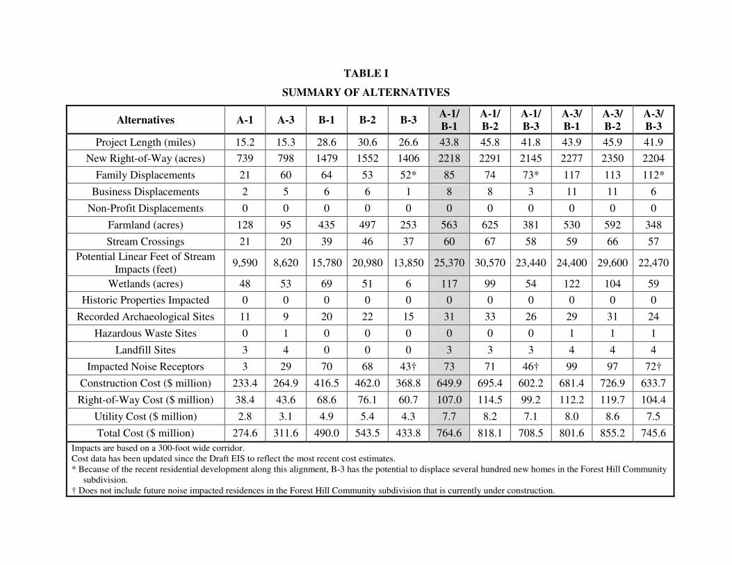
TABLE I
SUMMARY OF ALTERNATIVES
Alternatives A-1 A-3 B-1 B-2 B-3 A-1/ B-1
A-1/ B-2
A-1/ B-3
A-3/ B-1
A-3/ B-2
A-3/ B-3
Project Length (miles) 15.2 15.3 28.6 30.6 26.6 43.8 45.8 41.8 43.9 45.9 41.9 New Right-of-Way (acres) 739 798 1479 1552 1406 2218 2291 2145 2277 2350 2204
Family Displacements 21 60 64 53 52* 85 74 73* 117 113 112* Business Displacements 2 5 6 6 1 8 8 3 11 11 6
Non-Profit Displacements 0 0 0 0 0 0 0 0 0 0 0 Farmland (acres) 128 95 435 497 253 563 625 381 530 592 348 Stream Crossings 21 20 39 46 37 60 67 58 59 66 57
Potential Linear Feet of Stream Impacts (feet) 9,590 8,620 15,780 20,980 13,850 25,370 30,570 23,440 24,400 29,600 22,470
Wetlands (acres) 48 53 69 51 6 117 99 54 122 104 59 Historic Properties Impacted 0 0 0 0 0 0 0 0 0 0 0
Recorded Archaeological Sites 11 9 20 22 15 31 33 26 29 31 24 Hazardous Waste Sites 0 1 0 0 0 0 0 0 1 1 1
Landfill Sites 3 4 0 0 0 3 3 3 4 4 4 Impacted Noise Receptors 3 29 70 68 43† 73 71 46† 99 97 72†
Construction Cost ($ million) 233.4 264.9 416.5 462.0 368.8 649.9 695.4 602.2 681.4 726.9 633.7 Right-of-Way Cost ($ million) 38.4 43.6 68.6 76.1 60.7 107.0 114.5 99.2 112.2 119.7 104.4
Utility Cost ($ million) 2.8 3.1 4.9 5.4 4.3 7.7 8.2 7.1 8.0 8.6 7.5 Total Cost ($ million) 274.6 311.6 490.0 543.5 433.8 764.6 818.1 708.5 801.6 855.2 745.6
Impacts are based on a 300-foot wide corridor. Cost data has been updated since the Draft EIS to reflect the most recent cost estimates. * Because of the recent residential development along this alignment, B-3 has the potential to displace several hundred new homes in the Forest Hill Community
subdivision. † Does not include future noise impacted residences in the Forest Hill Community subdivision that is currently under construction.