the vistas handbook - sparks, nevada
TRANSCRIPT

]
1
1
11
i_tr!.
"1
J.
•
TheVISTA S'.-A Planned Residential Community
- ' /. -.--- , ..- ._./
~lc;
CitJfofopark§
October 14, 1988
M.A.P. Enterprises3680 Grant Drive, Suite C-I-AReno, Nevada 89509
ATI'N: Tim McDonald, Partner
RE: Special use Pe:mit Case No. SP-19-87-1(Th!: Vistas 1A & IB)
,,,," ,., I~'
( :: ~ Cl I.n:
j
Je
Gentlemen:
'This is to inform you that at the regular meeting of the Sparks City Col,Incil .held October 10, 1988, the Council conducted the public hearing on your', .Special Use PeImit application for an overall planned unit develoIJDeI1t for a364 lot subdivision on approximately 129.9 acres in ~~e Rl-1S/PUD zonesituated northeast of Satellite Hills, Spa.~, Nevada, having slopes in excessof 10% over 25% ormre of the site.
After careful consideration of all the facts presented, the Council approvedyour application subject to the attached list of eighteen (18) conditions.
Please be advised that you may not conduct or establish the usc for 'Which thisapplication was approved until you have been issued your Special Use Pennit.Please contact the Zoning Inspector at 356-2384 to make arranganents to haveyour Special Use Per.::ri.t issued.
If you have my questions or require further information, please contactPlanrJ,ng Director Greg Evangelatos' at 356-2340.
Ve;)· truly yours,/'" " .,.: -:-;- .
<......- , /; .~"'_/ ~ ~~;,..,-...,~.-------.:.. . ' . "' .
Jane L. Ster..-a....""tCity Clerk andClerk of ~ie City Council
ef
E.."1C: (1)a~..-·"
'cc: Planr'.ing/wilist (fo,:" distri:r...::iC:1)Ucensi.."'1g!w/ list:BuildL~lr~?ector/w/l~st
Fire Chief/w/listFile
... -- ... -------

IJ
RECOHKE!1"'DATION
The Planninq Department is recommendinq approval of an overallplanned unit devel6pment tor a 129.09 acre portion inclusivoot twosubdivisions in an existing Rl-15 PUD (single-family residentialwith planned unit development overlay) having slopes in excess of10' over 25' ot the site:
1.'" That the development be carried out largely in conformancewith the developer provided in the Master Plan and communityDesign Standards Handbook as sub1:litted in th.e application aswell as the conceptual "village" plan submitted in theapplication.
2. That the applicant conform to the recommendations relative tothis development as submitted by the District HealthDepartment.
3. That the applicant conform to the reco~~endations relative tothis development as submitted by the Airport Authority ofWashoe County.
4. That all the roof treatments of all buildings or structuresfound in this project be of tile or concrete slate for fireprotection purposes.
5. That the applicant conform to the recommendations of theRegional Transportation Commission relative to modificationsto access to the commercial corner located at the southeasterncorner of spanish Sprinqs Road and the project entrance wayto the satisfaction of the Public Works Director .
--------.-------. -- ..- - -------_..• -._.. ._...._----------_.... --~-,...,...----

7.
, :~
..~.-..
That each villago or subdivision within ~ village :~ roviewedvia the standard tentative map process and aloo wi~~ referenceto the Master Plan/Cor.u:lunity Standards H~ndbook. ~ub:::i t tod .... i ththe original application. Normal Park Construction Tax taosvill be assessed on each building permit.
That tho applicant pave tvo standard roadway lanes from thoedge of the existing pavement on Vista Boulevard just northof Disc Drive to the project edge to the satisfaction of thePublic Works Director prior to the issuance of a buildingpermit on any structure in the development.
s. 'rh4t the applicant secure and dedicate to the city two• additional lanes of right-of-way for Vista Boulevard along an
alignment acceptable to the Public Works Director prior to theissuance of a building permit.
9. That the applicant dedicate the site indicated as a' firestation (1.5 acres) to the city prior to the issuance of abuilding permit and that this dedication occur in a manner
.. acceptable,to the Public Works Director.
10. That the applicant dedicate the elementary school site listedas 5 acres to the city prior to the issuance of a buildingpermit in the area depicted in the master site developmentplan and that the dedication occur in a manner acceptable tothe Public Works Director.
11. That the applicant dedicate the 4 acre parcel listed as apUblic facility site adjoining the elementary school to thecity. This parcel is intended to be a joint use facilitybetween the elementary school ~nd the city. That thisdedication occur prior to the issuance of any building permitfor any structure on the property in a manner acceptable tothe Public Works Director.
The following conditions relate to the proj ect on a thresholdbasis. That is, as houses are finished at a certain numericalthreshold improvements are made.
12.*'That at the construction of SOO homes, that a fire station beconstructed in a manner approved by the City of Sparks FireDepartment on the aforementioned site. The station willconsist of two bays and be approximately 5,000 square feet(estimated construction cost $500,000) .
13. That at the construction of those 800 homes, a pumper bepurchased by the developer but selected and approved by thecity and dedicated to the city (estimated purchase price$150,000). (Combined cost of Items 12 and 13 will not exceed$750,000) .
-----------_.__ . -------_..._-- -,- .---

15.* That at the construction of 1000 h~~es, the applicantcontribute a "fair share II of the funds needed to widen SpanishSprings Road an additional two lanes from the current edge ofpavement to the project site entrance. That the "fair share"amount will be calculated by the PUblic Works Director anQcharged back to the project based on a "proportional benefit".(Not to exceed $200,000).
1
r j
14. That. at the construction of 600 homes, the devcl::oer eitherinstall a private recreational facility or build and dedicateto the city a community center facility on the ':csiCjnated 2a~re site. that the plans and specifications of the communitycenter be approved by the City Councill. (Estimate $200,000)
lG.* That the applicant agrees to at 1,400 hO::les to contribute anamount of money to be determined to construct a multi-purposefield on an existing parcel of city-owned property followingplans and specifications developed by the city. (Estimate$100,000). The ·combined total. for items 1~ and 16, if pUblic,will not exceed $312,800. '
17. That each village, SUbdivision, or amenity is proposed forconstruction that the specific components be reviewed by theDirector of Public Works and the Planning Director to insurecompliance with the original concept prior t;o the issuance ofany bUilding permits, tentative maps, parcel maps, etc.
18. That the landscaped scenic corridor and jogging path thattraverses the middle of the property be submitted in finalform in a detailed manner prior to the issuance of a buildingpermit and that the rate of installation ~irror the schedulefound on page 29-30 in the Master Plan and cO:':':.lunity DesignStandards Handbook.
,..~-..* The not to exceed dollar figures
accordance with the Consumer Priceconstruction or dedication.
will be adjusted inIndex at the tiDe of

School 5 Acres
Park 9 Acres
Community Center 2 Acres
Convenience Commercial 3 Acres
rife Station 1.5 Acres
RV Storage 4 Acres
135 Homes
84 Homes
105 Ho~s
72 Homes
235 Homes
84 Homes
84 Homes
65 Homes
1.614 Homes
Vista HoUow
Westview
Spring Vista
~\
jJ
·e
)
ie,'jJ
MASTER PLANILLUSTRATIVE PLAN
c:::Jc:::Jcoaega & Fricke, inc.~c:::Joengineers+ planners "---I .

J:Ij
11_]
J
1
J
-'
e.
The Vistas Master Plan & Community DesiEn Standards
The Vistas
MasterPlan and Community Design Standards .
prepared for: MAP Enterprises
prepared by:
Codega & Fricke. inc.
engineers + planners3880 Grant DrtvelSuite J Reno, Nevada 89508, (702)827-8833
Chum. Fittinghoff & Associates. Inc..
Plalmers, Enaineers &: Surveyors
Foothill Design Group
ArcbitectJtte. Landscape Architecture, Planning
Environmental Analysis
Yay 1987

J
lf'IJ
The Vistas Master Plan & Commumty Design Standards
rrABLE OF CONTEN1·S
SEcnON
1. INTRODUCfIONProiect LocationThe Master Developer.The PlannlnglOesign TeamProject Goals & Policies
Hous.ngEnvironmental Protection & EnhancementResource ManagementCommunity Design
./ Growth Management
2 PROJECf DESCRIPTIONThe Master Plan ConceptSite Anatysls
TopographyDralnagewaysViewsS~ils
The Master PlanVlata HollowWesMewSpring VI_Canyon Vista Northcanyon Vista SouthPoint VistaSouthVIewVista Village West- .Park VistaCity VistaVlstaridgeVI_ Village EastVlata V.nage SouthVista GlenVista Village Elementary School
fAGE NO
1134
4
5567
91111
. 11131314171818181919192020202021212121

I
ij.•. J.~
1
1j
The Yi!i.t3s Master Plan & Community Desiin St3Ildards
Vista Village ParkVista Village Rre stationVista Village Community CanterVista ·Crosslng Convenience CenterThe Vistas Community RV Storage
.Site Sectional StudiesZoningPhasing
Compliance StatementslPhased Implementation
3. COMMUNITY DESIGN SfANDARDSCirculation & Access
Parkway/Arterial
Standard ArterialResidenaatColiector
/ Re.ldenaal StreetPublic Access RoadResidential PlacePrIvate Street .ParkIngPedeatrlanlBicyete Path.
ArchitectureCharacterlThemeMas8inglFormsMaterialalTexture.LIvIng Area StandardsEntry Architecture
LandscapingCommonAreuPrtvate Yard.Erosion ControlIrrtgatlon
B~Jldlng SJUnglSetbacksGeneral ConsiderationsBuilding SlUng CriteriaEstate LotAreu (VIllages 9 & 11)
Setback VariationGrading· & erosion Control
Hillside Adaptive ArchitectureSlope Treatments
Design Detail.
222222222323262628
3131
31
31
3S3535353538383837374444484650585.8595980616163636367

The VlStas Master Plan &. Communuy uestgn ;;;'lanaiUa:;
SlgnageIGraphic: 67Fencing 69ughtlng 70e
4. INFRASTRUCTUREStormwater 73
Climate 73Physical Characteristics 73General Drainage Patterns 75Methodology 75
stormwater Management 80
Sewerage 83Traffic Impact Analysis 86
Background Growth 86Protect Trip Generation & Distribution 86
/ Level of SeMce Analysis 86
MllgaUon Measures 91
Air Quality Impact Analysis 92FIre ProtectlonlPrevention 94
Parkt & Recreation 94
Impact Fees and other Mitigation Measures 95
iJ e1 5. APPENDIXj Protective Covenants. Conditions & RestricUons
Traffic Impact AnalysisRecommended Ptanung ustGeotechnical ReportHydrOlogy Report
:5
J
6. POCKETIUustratlve Master Ptan

I The Vistas Master Plan ~ l".ommunlTY ueslgn .".>lanQaJQS
I..ISI OF FIGURES
e El9Um Page No.
1. Location Map 2
2. Site Analys's Map 12
3. Land Use Plan 15
4. SecUonai S1Udies 24
5. Seclonal Studies . Key Map 256. Phasing Plan 27
7. Circulation Plan 32
8. 'S1reet Sections 339. Archltecturat CharacterlForrns 38
10. SaleaIMarkellnQ Bulldlngc 46
I'1. SChematic Parkway Plan 47
12. Parkway, Concept Plan 48
'3. Parkway Concept Plan 49/. 14. Entry Plan 51
J 15. EntrY Elevation 62
18. DMded Parkway seeton 531 17. UndIVIded Parkway Seellon 54I" 18. Parkway Open Space Pocket Treatment 55j
19. Setback Vanatton Standarcla 62
ii 20. HIII,lde Adaptive Architecture 64'IJe 21. Possible Slope Planing Techniques 66
22.. Entry Signage 68'1
I 23. Ughtlng concepta 72J 24. Watershed Map 74
1 25 sto~ Management Plan s,·1
I 26. Stormwater Infiltration System 82.j
27. Sewer Plan 84
28•.Off.Site Sewer 8529. 2002 Background Traffic Volumes 87
30. 2002 Background + Project Traffic Volumes 88
I1__...:..-----

. ;'i. j
. 1:1iJ
JIj
I\ .,
The Vistas Master Plan 8: COmmunlty Ueslgn ::>tana.uas
LIST OFTABLES
1. Land Use Data2. Phasing Schedule3. LMng Area standards4. Minimum Setback Variation Standard.5. Hillside Adaptive Architecture Requirements6. Precipitation Values7. Interpolated Precipitation DataB. HEC-1 Runoff· . Undeveloped9. HEe.-1 Runoff - Developed10. Rational Runoff . undeveloped11. Ralonal Runoff - Developed12. Future RoadWay Unk Operating Conditions
_.
Page No.1629....616376777878797990

1'I'I;1J
1
j
,'" ~. ~.
-.
.--.,..;,.
....... ;.
~r' ••.•_ ~., ..
. ~.
Introduction

The Vistas Master Plan & Community Design Standards
"~a. 'w'1. INTRODUCTION
The purpose of this document Is to describe the master plan for The V1statand to specify the community design standards that WID guide the develop·
ment of the project.
~
'Ij
1"Je1,j
i1
,,1
Project LOcation
The 660 + acre"''' Iocat8d to the no"'e'" of the present tennlnUS ofVIlla BoullMl'Cl. Spanllh Springs Road, or the extension of VIsta BoUlevard,nms to the north and to the east Into the subject property, forming the Ifrontdoor' Into The VIttaI•. The proJecfs IDclion .. depicted In Figure 1.
The Master Developer
MAP enterprt... owna theprope", and Is the master developer of The Vis·... DlvenJftedDevelopment and Construction, a Nevada Umited pll1nenhlp,and Pace·Tete, Inc., a Nevada corporalon, are doing bustne8S 88 MAPEnterprI.... Dlvenlfled Development and Construction bUUdl homesthroughout the TRickee Me8doWl, InclUding two projects thld are CUlT8n11y un·derway In the CIty of SparICI. Pace·Tete, InC.,II best known for their SIIIIIII8
HUls 'proJect In theCIly of Sparks.
At the m....r developer'of The VI"", MAP Enterprls.. Will be responsiblefor providing the major lnfraItrUetureto the site, implementing the commonarea Improvement8, and revlewtnglmonltt»r1ng development to ensure the com·
munIty d88lgn standard. are mel
1

1•c· .
Iu·I
I
ir··,I,: SITE =II
It/ 1&•••..s:
Bart Blvd
Prater
2
1. Location .Map

·:e
j
J1
The Vistas Master Plan 8& Community Design Standards
The Planning/Design Team
sensitive and 8enslble planning dlctate8 thal the muter plan must reapect the .natural characteristics of the property and nurture the many ·OpPOrtunIU88 ofthe 81te to effect a de8lrab1e. marketable and emclent end re8ullThe uniquefeatures of The VIataa lite. combined wilt careful and innovatIVe planning andImplementalon. will make the project a unique addlUon to the City of Sparka.To thl8 end. a well·balanced planning and design team was .sembled toprovtde a comprehen.1ve and reallalc master·plan.
Team memben are at followl:
Codega & Fricke. Inc.; eng........ + ,.unen . developed the masterplan concept and oversaw the prep..aon of the community design standard8.
CIIU.... Flalaghoff • Anocl... Inc.; Plannen. Enllneen • sur·veyon . waluated 1he generallnfraatrUcture needs. provtded land aurwytng88IVtcaa. and afforded general civil engtneertng and planning Input
Footldll 0-1111 GrOup; Arcldlecture. Landacape ArcIlIteclur8. Plan·nIng..• ElM.......... AnaIyaIa - developed landscape concepti and plana.prepared archtt8cturat. character stan.... and plana. and developed com·munIty design elementa for thInga such at graphlca, lighting and fencing.
Barton Aacllmu Aa.ocl..... Inc.; Traffic Engeneen • TranaportatlonPI prepared traffic Impact anatyae8 and developed mlUgalonm for the project and the larger Spanlth Spr1nga Annexdon Area.
Gil Pabnon.Alr Quantr - evaluated the air .quality effect:a atloclated withthe project.
Paone.1e • Anocl..... Geotecllnlcal Englneen . conducted preliminary aoIIt·.lnveatlgatory work.
3

- ,,I
i
1
]
i,j
The Vistas Master Plan & Community Design Standards
Project Goals & Policies
This 88CtI0n pre.entl the policy framework which 18 the foundation of The Vis·tas Muter Plan and that will guide Its Implementation. The goalt and policiesstate" the muter developers p081t10n8 on"the development of The Vistas anddefine how the protect will maintain and enhance the general public's welfare.
The goals and" policies are presented under five headings: Housing, Envtron·mental Protection and Enhancement. Resource Management. CommunityDesign, and Growth Management
Housing
Hou8lng must be property related to tho.. who will lIVe there and to com·munIty facU... and service.. Housing must also be provided" that meetlprOjected demands. The.......ments of" community concem are echoed byThe VlItat' ctevetop..... and reflected In the poUClet WhIch foUow.
Goal . To effIcienlymeet the projected housing needs of the community that.. appropriate to the phylicaiCharacterldC8 of the" 8118 and the
8OCI08conomic "demands of the rnarkelplac8.
Policy 1 . To provide a mIX of hOusing denalle.. types, stzea, price.. and set·Ings thai reflect 8lq)ected demands and The VI..' ability to meet thotedernandl.
PoDcy 2 . To orient the housing to complement the 8ft8'S"natUral environment_80'" maximum 'lvabuny- will be achIeVed for tho88 Who will reside there.
Poley 3 . To d8Velop the ho....ng In a cohesive 8erlll of dItIlnctIve, weDplanned"neighborhoods, each with Its own Identity that respects the variousphysical sellnge of the 8It8.
Policy 4 - To bUild energy·eflJclent housing th.rough the use of energy savingmeDU1'8S thai are cost·effectIVe and do not severely limit marketability and lifestyIlI.
Policy 6 - To reqUire that all buDding materials reflect Ih8 general architectural character programmed for the prQfeCt.

· ij
1I
1e1j
!J
b
The Vistas Master Plan & Community Desigil Standards
Environmental Protection Be Enhancement
A variety of Interesting and aIIractIve environmental aellng. are pre.ent onthe property.· Development of the property shoUld not be Ilmled by these fac·tore, bUt should In_ad Slrlke a .endlVe balance betWeen man and nlb.n.The Iseue Is not density per .e, but Wh8t8 and how the density occun.
Goal· To achieve a reasonable balance betWeen the preservation andenhan·cement of 8endIVe slopa on the alta and the function of a property plannedresidential community.
Poncy 1 . To preserve and enhance the .en'" hiliaide. and the naturaldrainage feature, found In The VI.....
Policy 2 . To foClJt. or cl...... bUilding and partdng In certain areasd88lgned to mtnImIze envlronmerdaf _eeta and to·8RIUf8 that ....tIIve .areasof The VI8tM are 1eft.1n a natural state.
Policy 3 ·To require that all ... planntng. architectural de.1gn and materials.electlon retp8Ct the Ym'Ious natural charae1erIdcs of the .Ite.Policy 4 . To ensure this goal 's actdeVed. an development must meet"e
meticulous requirements of TheViatas ProtectIVe Covenants and Restrictionsand the .chltectural control commntee. In addition·to ... atandm'dl of the CityofSp....
Resource Management .
The prudentuae of R8lLlrai resources II a key m.... plan criterion. The.cope of The VlItu and lie commitment of 18 developere afford8 the oppor·IIInily to manage f880UfCes on a meaningfUl acaI8. Resources gIVen particularcoMideralon Include energy. waI8r and open space.
Goal . To deVelOp a community that uses and manages ....ources efficientlyand 8IfectlV8ly.
Policy 1 . To achieve an optimal level of resource efficiency. gMng dUe con·slderatlon to design. marketability. livability and .alhetlc Impncallons.
5

The· Vistas Master Plan & Community Design Standards
Polley 2 . To bUild a community that hlghllghtt energy management.wherefeatures are colt·effective, not specUlatIVe, so that The Vistas Will seNe as.amodel.
Poley 3.. To minimIZe land.cape water requlrement8 by Ilmlllng.yard .1Z8I,and thus the amount of Irrigated yard areas, encouraging the use of water con·serving Irrtgatlon techniques and drought tolerant planting, and·by preservingor enhancing significant areas of natural landscape.
Poley 4 . To retain large amounts of natural open space that require minimalrn8Int8nance and yield significant natural beauty to the community.
Community Design
sensitive and sen.ible comrnunfty design i. crucial to .... 8ucc88tfullm·plementalon of the Muter Plan. The expected outeom.. of the proposeddevelopment hinge. on both the 'ground ruin' set forth 1ntht8 plan and the .refInernent8 that will occur .. apeclflc feature. of the protect are designed andbuill Ponel... 8tandard8 and crtterta rnuatenaure that the end prodUct Is acoheaM. well d..igned community, .and at the same time retain a certainamount of flexibility to effect the belt re.ultt.
Goal· To build a weil·designed, unique and effiCient communlty.
Polley 1 . To provide a variety of bUIlding types and lot sizes In a cohesivemanner which Is complementary and compatible with the site and ttl.surround·Ings.
Policy 2 . To develop a system of neighborhoods. atre_capel, Qse8 andopen apace that Is logical and that capitalizes on thellgnlflcanee of the site.
PoUcy 3 . To landscape the protect In a manner that fIt8 the U888 of themaster plan and that blenda In will the naturalenvtronment that I. to bepr888IV8d .or enhanced.
Polley 4 . To develop community support facUlII..; such II the conveniencecenter. school. and park; where nece88&ry or desirable -that archItectUrally andfUnclonaily compll!"8nt thl raldlna~ area and open spac....
e ·1---------=----------------~6~

",1j
.)
1J
:,I
]
j
The Vistas Master Plan & Community Design Standards
Policy 5 . To develop a coordinated and slteltheme sensItIVe system of slgnage, lighting and fencing.
POlicy 6 . To develop a·comprehenslVe, efficient and safe transportation net·work, that wID Include appropriately designed streets and bicycle andpedestrian pathl.
Policy 7 . To develop a utility 8Y*m thalprovldes efficient service and thatrespects the character of "'e planned development
Policy 8 . To requlr8 that energy and waler management be key dellgncriteria as the muter plan II Implemented.
Policy 9· To enlure compliance WIllI the community design criteria througha comprehensive set of Protective Covenants and Restrictions and a balancedl'8Ytew comm.....
Growth ·Management
Public services and faclnae. are the lifelines nece.nry to support The VIstas.Because The VI" I. a 8IZ8b18 protect planned to be bUIlt over 'everaI yelln,all of the. speclflc8 related to the design and amtng of pubUc 'eMces and'acH....·cannot be· pt'8CItely specified at this 8me. It would be unreaIldc toeither make definitive statements regarding availability or to require all of theImprovementaneeded to Implement the plan be. provided up front However,the plan I1IU8t anddoet detennlne what facH..... will eventually beneectad andprovlda a framework for enlUl'lng pUblic factllllet and .ervlce. are built Inconcert with the project.
Goal . To enture that nece.sary pubIc 88rvIce8 and faclllU.. are provided.. the project develop••
PoUcy 1 ·To overcome the complexlly andrelateduncertatnty over thetiming and staging of the development and public faclille. and SeMce.,'Peclflc Impacts and mIIIgatIona win be 8C1'*'81y addressed as Individualproject appllcaaon•• such as tentatIVe maps, are made.
Policy 2 . To effect prudent capltallmprovementplarlnlng by both the publicand private parties, the Individual projects and their ..oelated servlen reoqulrements. are coniroUed under thl. muter· pIarI~
7.

The Vistas Master Plan & Community Design Standards
The chapters that foRow dncrlbe The Vistas Master Plan and present thedesign principles and standards that will gUide the Implementaaonof themaster plan. Two. requests are being made of the C'" of SparkS. The ftrat I.to approve the 662.±. acre muter plan wtth Its community design standards.
The second Is to rezone the 280.±.. acres of the project that were annexed Into
the cfty pursuant to the SparkS C'" COuncil's action of February 23, 1987.WIthin three..years, the balance of the site 18 proposed ..for SUbsequent annexa·
lion and rezoning to perma the bUildout of the master·planned community.
• 8 .•

lI
i
.'
· ,.~-
r.o
.• '"t.
" ......
.,
~".
• oJ. :
:;.
......:;~.,.,...
..~ -."
", . ." ....
Project Description
.r''-:

The Vistas Master Plan 8& Community Design Standards
2. PROJECT DESCRIPTION
1I]
Ij
.Ij
1)'\:J
!Ij
.J
i, ,J
The' Master Plan Concept
TheViatal II de.lgned to provld. a unlqueaddlUon to ttIe City of Sparte8.
A land us. concept plan was presented to ,ttIeSparkS Planning COmml88lon
on S.ptemb.r 11, 1988. In summary, this plan called for 1,545 to 1,830hom.s In Th. VIstas plul. anoth.r 100 to 120 home. on the -Wcey" prop.rty.Thus, the total unit yield on the combined acreage amounted to a rang, of
aboUt 1,850 to 1,950 dwelling unlit. The 'Land U.e COrtcept' plan (S.ptem·
ber 1988) hal b.en refined Into The VI8taI Master Plan. Th. new plan calISfor 1,814 hom•• In The.VIstas. ThIS equ8l8s to a grOIl resldenaal density of
aboUt 2... hom•• per aCre. Additional U888 are a small convenl.nce center(3.±. acrel), a park and .I.m.ntary school sne, a parkWay and other
landscaped common areas, and natural op.n space. Rounding out ,the uses
are a fire' ltaIIon site, a community RV storage area, and a I" for a day carecenter or an altemate cornmuntty facility, such as a community bUIlding.
Th. land use conc.pt leaves over on. third of the site In open· space. Much
of th.·open area Is comprised of sensitive slopes thai are bitt left un··deVeloped. DevelOpment II g.n.rally proposed for are.. that have a gradl.ntof fifteen p.rc.nt or I.... In addllon to focusing the develOpment Where It Ismost approPl1ale, a variety of tIe·sens111V8 grading and hlllSld. adaptIVe con- _
strucllontechnlques Will be used to .nsure aprop.r fit between the man·mad.
and natural .nvIronments. Examples of ..... meaaurea follow: 'The site haa a
fllr amount of rocky terrain -. thll native material Will be U88d to mechanicallystabilize .Iop•• and aa an IntegrailandlcapemateriaL Th. vI.1b1llly of cut andfill lIopes will be IImlted.by a comblnallon of minimizing the extent, of the.e
.Iopes, steep.nlng the .Iopes to the degree polllble. Itrateglc plac.ment. andscreening WIth atructurel or landscaping. Smaller ..d ,.pllt' road 88CUone 'are proposed to minimIZe thll crllcal up,ctof site grading. HIUllde adaptive
buDding. where the home. fill the topography rather than grading to fit the
home, will be Uled. SIte-s.nsltlVe and flexible structure slllng (custom tailored
letback8) will .0 88M to minimize hillside related developmentconcema•...J
- 9•

IJ
. ]
The Vistas Master Plan & Community Design Standard,s
Several dlstlnctpreclnct8 or villages will be developedwllhlnthe project.Each WIll' haVe It1 own Identity and' market appeal, but aI. the same time wartctog8lherwllh Integrated slgnage, lighting and fencing and compatlbl' archltec·tural styIet.apenspac. teparat88. moat·prote. Moat of· the housing Will be
developed aI 'typICailurban dens"" of four to sIX unlta p.racre. Some ofthe hOUlIng may be attached (townhom.... dUptexet or condomlnlumlapart·
ment nat8landreach ac:l8nslty of·tweIVe unltape, acre. At the other end ofthe spectrum, eataI8·alZ8lot8 for custom orllml·custom homes are plannedat two to ...... unIt1 an acre. . The Master Plan Indicates thai moat of the hous·
Ing will be detached (75"d8tached, 25" allached).
Vlatartdge Parkway (a partially divided aIr88t will limited accII.that II.. In apark·like con1dor). 8Ktend8 from Spaniah Springs Road through "'e site toISeCUon 251 and S8N8t as the transportation ibackbo..... The residentialprojects feed off of tlds parkWay corridor. From the Spanish SpringsRoadMata Boul8V8l'd extension, the ParkWaY enters the site at a lUbatantlaJ,land8caped lentty .....mentI ThIs land8cap1ng ~ then extended up the
parkWay corridor and IIrves as the entry to moat of the residential uset.Thedrainage ch........ thai run through the pamvay corridor, and .Isewh.re, Will
be -n1lblralV IlnedWllh nallVe. rock and Interrnll8nt vegetation. crealng the U·IU8IOn of a creek running IIrough the project and alto .eNtng a stormwatermanagement function. PedestrtanlblcyCle palht, separaled from the street, WIllbe placed along the· parkWay to provide a recrealon resource and'to link thevarious us.. together.
In order to nurture therath8r unique addition to the City of Sparks that I,en·
visioned, :a number of detall.d· planning and design crJteria have beendeveloped for The Vistas. Specific toplct or areas of concem are llated
below•
.• Integrated algnage, Ughllng & fencing 8tandards.
.. A comprehensIVe set of condllon., covenants & reslrtCUona thai specify
both hoW things WIll be bUIlt and hoW the protect will be used and malDtalned.A master homeowners as,oclalon will own and maintain g.n..... commonareas. -Sub·assoclatlonsl may be estabUshed and be responsible for feature,
or amenll.. thai serve only an Individual protect.
.. Land.caplng concepta for both commonareaa and Prtvale yard•.
10

1
1IJ
1j
, !
111_J W
II
.J
The Vistas Master Plan & Community Design Standards
;. Architectural' controls and architectural review. For example, an'addlltOnto a home will require archItectUral ~ew and approval to ensure'the aln·tegmy- of the home and the netghborh;oodls maintained•
.. The re8triCUon of fencing In lOme areas (eg. estate lots rear ridge tops). Where lot line delnealon II undesirable and unwarranted.
. •• VIeW'proteCUon and enhancement standardl.
.. specific building envelopes (custom setbacks) and height Umlls.
:. Measures to encourage energy con88rvat1on.
Site Analysis
The IUbJect prope...,.. physical charactertdlc••have been Inventorled.o that,the m..... plan property respects these conttralntland opportunmea. Thekey .ltefeature. are briefly described below.
Topography
Slopes In the project range from flat to 1.00000d ..a that exceed thirty per·, cent In gradient. Development Is generally confined to areas where alopel
are flfteeR ,percent or le8l. AI. the frtnge of the -vtIIagaaor sub..... 'oflhemaster pi.,., 'deVelopment will take place on areas that· exceed a fifteen per·cent slope, but tht.wIH be limited In extent and tomld·tange topography (16
20").01 course. snett and other Infraatructure componentt wlUbY nece••ttytraverse tome areas steeper than fifteen percent.
Drainaeeways
The natural,dralnageelement8 on the ... will be, retained 10 that 'a morenatural, aesthetiCally p'easlngand cost . effective approach to sto~rmanagement can be used. Further, through the sendlve use of natIVe roCkand landscaping, these drainage ways will form a key element of the ParkWaY/· .common" area design.
11

1.\
J
1
I)
I1J
i,.t ., .
,',
• li:1 I"~ "'.~. · . I . .
• J' /:'.
~...cl\ ~ . , . ..
.'. i\
.1.1",i
, (;\
,",',., \
~~.'
\i;\:1\'i ~\ i;/,loJt 'I
Ii '., .,
I,
. i~·, c. ~
/\\.\,
7(\,\".'.
))i I
/ """ • .1Of
?/(i~ (\~\'\
" II.~ .' ' .
. ~ ), ,
j
,, "
lZlSl.....rnMASTERPLAN ~~~2-.~S~i~t"::'e-=A:::;=-;:n:"'a=-Iy";:u s=i~s::'::'...::.M-a-p-------.;,.~~·..-~~0 c=J
~;-c::::JD12

j
I.I,
The Vistas Master Plan & Commun.ity Design Standards
Views
A variety of Important viewelement8exist, both on-and off-site. The canyonsand hollows offer ,ecluded, Internal viewtheds. The upper reache, of theprotect allow one to· look for miles, to the city lights to the south and south·west, to the SpaniahSprings Valley to the west and nor1h, and up and throughttlemountalns to the east.
Soils
The ,Ite compriae, roughly a one aquare mile area eut of Spanish Spring.Valley In·the Pah Rah range. Vegetation conalsts predominantly of sagebru....sprtng hopsage and cheatgrasa. .The central and eastem portlona of thedevelopment are characterIZed by··moderat8 to steeply stoplng htIIs dissectedby a aystem of dry stream channela. Based on geologic mapping completedby Bonham (1989) and Bell (1981, 1982; PreUn1Inary Geologic Map, VI8taQuacI), the majortty of matertals underlying thl. portion of the· alte conalst ofTertiary age basalt, bu....e and881t8 and pyroxene ande.1te flows. Quaternary age alluvial fan· depo'll8 underll. the g.ntIy slOping fan In the westemportion of lie development. The.e depollt8 consltt generally of poorty sortedsll8, sanda andgravela. In addllon, the U.S•.Soil ConaeNatlon Service hasIdentified aeveral cldnct IOU typea within the protect area No known faultstran.ect the .Ite, however, the project la located In a ••lsmlcally·acIIVe area(UBC S.limle Zone 3).
Based on the reaults of a preliminary investigation, the site 18 .ultabl. for thepropoaed protect. Durtng a review of the pertinent geological lnform&Uon anda site reconnal....ce.th. following g.otechnlCai considerations regarding sitedewlopment have b••n Identified:
1. RlppabU~ of bedrock materiala within the pro;.ct
2. stability of cut .Iop.a.
3. Local pre••nce .of .xpanslVe clay '0118.
4. Fluh·flood potential within the propos.d developm.nt.
WIIh the .xc.paon of the we.tem portion of the site; the prop.rty 18 undertalnby bedrock at shallow d.pths. G.nerally, th. b.drockmaterial. conslat of
13

The Vistas Master Pi;m & Community Design Stand:uds
, basalt: and basalUc ande'ite,. The degree of fracturing within these materials
Is unknown. A detailed seismic Investigation should be performed prior to
construction to determine the rlppability of the bedrock materials. Grading
plans Will be reviewed to determine If utility trench excavations or deep cuts
are proposed In materials Which could reqUire blasting. The materials
generated by site work In the bedrock areas shoUld be classified as rock flll.
Seismic studies will provide an indication of the siZe distribution of these
materials.
Bedrock cut slopes should be stable at maximum Inclinations of one and.one
half horiZontal to one vertical (1'112:1). Locally, fracture orientations may
create unstable conditions. Therefore. all slopes Will reqUire final evaluation In
the field. Proper benching Widths and intervals should be Incorporated in thedesign of any .Iopes. Wire mesh may be necessary to protect ......downSlope from rocks ravelling or toppling. In addition. rock traps or fences
may be necessary. Permanent cut slopes constructed WIthin allWtai materials
and fill slopes should be designed at a maximum incllnallon of two horIZontalto one vertical (2:1).
Studies completed by the U.S. Soil Conservation SelVice Indicate that expan
sIVe clay soils are lOCally present Wfthtn the development. Clay 801ls can ex·
perience volume changes (shrink and swell) With changes In moisture content.resulting in unfavorable movement of structural elements. Mitigation proce
durea shOUld be anticipated.
Complete geotechnical Investigations WID be performed to proVIde detailed In
formallon on the subsurface conditions In the final design stage. Engineeringparameters of the underlying materials Will then be determined to provide con
clusions and recommendations concerning site preparation and grading.
foundation design criteria. support of exterior flatwork and flexible pavement
The Master Plan
I
I
The Land U.e Plan for The Vi8ta8 Is shown on the following page. The plan
depicts the various villages. their densities. the major roadWayS, and thegeneral location of the common area features. Both detached and attached ,
housing are proposed. The plan I_gely envisionsdetaehedhom8a. but at,
tached homes tetve to accomplish specific design objeeUV8a in sotne cas.s.~~d ~3Q·~3terwm·to c~rt:tn ;egmem; of tho housing ma."k8t, :u:h a:'t:mpt-;- , .
neaters,
14

16
a
.~--~a·a
~...lbd. - -r-t...II-I
m
Vistaridgeo35 Hanes
•
o School
o Park
@ CQi~ty Center
@ Fire Station
""lI!!!!!II~._.. ..
a
•i
.......aiIii! _~_-';;.._...."'~~
0Estate lDts ·(9,000 sf. +)
0Urban Lots (6,000 sf mi~.....t-I
(~)Compact Lots «6,000 sf min. Q;,.....~__,
oDuplex
0 Townhare
. @APartmento/Condominiums
SCcmDerCUU@RV Stor24»'e
MASTER PLAN C:::J[::::::J3::.--:-L-=a=-n':::'d~U:-s":e:"'::P~la~n'='--------"'r-lIl!!!l~~=::.':"I!l-r~~~~b§f? ..
1'j!
.J
l
je]j
....:j
j
1. J
....

The Vistas Master Plan & Community Design Standards
The liand Ute ataIIstics for the master plan are presented In the followingtable::e
I Table #1Land Use
VlllagBlPlan Acreage Use Density Unit Yield
Area +/- ('fa) (dUlaC) +/-
U!'l:\- Y~J/.Icf4.C III
.:t: Vista Hollow 42 (8.3) Compact Lots 5.0 205 1.0~ (-,t;
,2: WBtMew 44 (8.8) UrbanLots 3.5 \155 It, \ Cot (,)
~ Spring VIsta,
~2... (- 18)28 (4.2) Urban LAta 3.5 100
.A: canyon VlstaN. 32 (4.8) Compact Lots 5.0 180 ~e, (~ 101)
~ .canyon.VI': S 11 (1.7) Compact Lots 5.0 50 t;'f (t4~)
8. Point VIsta 28,(3.8) Duplex 5.5 140(-IS)
17. SouthVIew 27 (4.1) compact Lots 5.0 135 \10
, 8. VIsta VlUageW. 5.5(0.8) Apts./Condo. 12.0 64IC>~ (-to 3)J
8. Park VIsta 35 (5.3) Mlnl·Ettat8s 3.0 105
10. CIty Vista 12 (1.8) Townhomes 8.0 72
11. Vietarldge 100(15.1) ,EItate8 2.4 235
12. Vista VUlage E. 5.5(0.8) Apts.lCondo. 12.0 64
J 13. Vista VIllage S. 5.5(0.8) Apt8./Condo. 12.0 64)e '14. Vista Glen 18 (2.7) ,Urban LoIS 3.5 65,1
1
lJ RVStorage 4 (0.8) RV Storage NlA NlA
1Rre StatIon 1.5(0.2) Fire StatIon NlA NlA
Convenience. Center 3 (0.5) Conven.Retall NlA NlA:J
COmmuntty Center 2 (0.3) community NlA °NlA
'.' Vista Wlage Park 9 (1.4) Park NlA NlA~1
l Elementary School 5 (0.8) School NlA NlA1
Major Roads ,20 (3.0) Transportation NlA NlAj Open ° Landscaped 18 (2.4) Open Space NlA NlAl Open.· Natural 210(31.7) Open Space NlA NlAJ
lj TOTAL 882 (100) NlA 2.4 1,814
):{
.J
j
eo 18

j].
J
I
1'I.J
J
iI
; J
..,i1J
The Vistas Master Plan & Community Design Standards
The master plan', overall dentlty of 2A.±..homes an acre fIt8 within thematter plan designation of 1 to 3 dWelling units per acre that was jUst adoptedby the Clty of Sparks. The three·acre convenience center at the· southeastcomer of the Intel'l8ct1on of Vlataridge Parkway and Vista Boulevard allOmatches the Clty"s master plan designation.
The .densilles shown for each vlRage·are ,uggesave ·In nature. That'ls, thedenslll8a maybeadluated -UpWaI'd,wIhJn spectfled Jlmlt8. or dOWnWard ,tomeet thetp8clftcrequlrementa of a·particular proJ.eland develop.r. The den·stiles shown WlUnotbeexceededbymorethanflfteenpercent WIthout specificapproval from the City of Sparks. In any event, the total unit yield WIll not ex·ceed·the·maxlmum 1.614 envisioned In the matter plan.
A descr1pt1on of each of the villages or proJects In The Vistas follow. The. use, acreage density and relalonshlp to the overall plan 18 dlscusled. Each,
descrlpton II general In nature and may be changed. lubJect to matterdeveloper and CIty of Spartes approval, to encourage flexible anc:IlnnovalVeland planning and housing soldons.
1. Vista Hollow
Vista Hollow flanks the north side of Vlatarldge Parkway at the .ntrance to theproject The site 18 about 42.±.. &ern In tIze and 's proposed to .be built out ata denllty·of about 5.0 unlt8 per acre. ThUI, the total unit yield 18 about 205hornet. .The Iota are planned to be about 5,000 square ·feet In IIze. WIthwidths of fifty feet or more. A divided. parkway.typ. entrance provides ac·ce.. to the SUbdivision from VI....dge ParkWaY. Thts 'first' Intersection.In theprotect 18 designed .. the Ifrontltplec8- for the entire planned community.The backbone of Th.VI...• stonn drain system. the open drainageway along'Vl8tarldge Parkway heads north and welt through Vista Hollow~ providing 2lunique creekllke environment IIrough the SUbdivision. Landscape,efementawill be placed where the dralnageway meeta the local 8tr8eta and a pathwayfoRowalle ·creek' to provide a useable open apace .Iementln lie protect. Atot lot might *0 be Incorporated to enhance the value of this open corridor.
17

1"
.J
J
The Vista!; Master PIiU\ &: Community Dp.sign Standards
2 \Vestview
WeaMew lies across the parkway from VIsta Hollow. Here, 'typIcal· urban
lots are proposed at a density of about 3.5 units per acre. About 156 homesWill be situated on the 44-t acre site. These Iota have a minimum aquarefootage .. of 6.000 and will be sIXty plus feet In average Width. Here 'agatn,the
entry statement at the first parkWay Intersection provides an attractive, dMded
gateway to this protect. Residents of WeaMew wtll have convenient access tothe jogglnglblcycle paths In the parkway corrtdor that lead to the· park. school.
convenience center and the remainder of The Vistas' village8. To the south
and eut, natural open apace providea a aultable buffer yard and scenic back~
drop for the housing.
~ Spring Vista ,
This project Will be buln at a density aJdn to that of westView. The 28.:t- acreparcel I. planned at a density of 3.5 units per acre. ',' The illustrative Master
Plan depicts a profe~ With 100.±..lots aomewhatsmaller than those of
WesMew but WIth the incorporation of a ·commons· In the center of theaubdMsion. This woUld .provide a strategic open area at the center of the'
housing that could accommodale children'S play apparatus. Informal turf playareas and· landscaped or semlnaturat passive ·park space": The use of
, residential construction tax credit is proposed for consideration to provide
such a commons.
4. Canyon Vista North
Canyon \/tsta Nonh '8 situated on the north aide of vtataridge Parkway. Thehomes creep up the ~8ides' of the 'canyonU to the point Where the .alopes be·come too steep to properly develop. Here. the homes have nice views acroasand through the canyon.' This project atso· Includes two minor dralnagewaycorrtdora that run through the hom_iles to the malordralnage element along
Vlatarldge Parkway. This allows both open, semi,natural drainage and
provides strategic relief to the butn environment. Where the two minor
dralnagewaya meet the parkway, there is asubstantlaJ widening of the parkWay
corrtdor where a park.like effect can be created. This area might aI.o aceom·
modale slormwater detention and. thus, have stormwater management
benefits. This area contatns 32.:r_ acres and Is master·planned for 5.0:1:.homes per acre, or about 160 units.
18

The Vistas Master Plan & Community Design Standards
s. Canyon Vista South
1
lJ
IJe11"
1j
Canyon Vltta South i. a amaller, ·sl...... project to canyon. Vltta North. AsIts name Implies, nile. atong "e .ouIIem edge of Vl8taI1dge Parkway.Similar to Canyon Vista North, ·thl8 11±. acre site is programmed for approximately fifty homes, with a gro.s.·density of 5.0.±-. units to the acre.
6. Point Vista
Point VIsta extend. from the "VIsta.VIllage' area to the west out on a.prominent knol'.that overfooD the entry Into TheVl8ta8. This 28.±.. acre site Isplanned for duplex units on IndMduaI Iota that are designed to work wtth thetopography. Homes are either oriented toward stepping 'up the hlU' or 'downthe hiD' to minimIZe earthwork andmaxtmtze view potential. ConceptuaJly, theduplex structures could be de.lgned .0 that from above or below, .they looklike rather large 8lngle~famlly detached hom... fencing and yards atong the'downhUlhomes' that lie along the westerty knollwiU be controlled to en.ure aclutI8red effect does not resun and to nurture a sensitive transition to the .natural, hUlslde open space below. Natural or .eml-natural open space lie. atthe core of the project At about 5.5 units per acre. 140.±..homes are plannedfor Point Vista.
7. SOuthview
Southview Is positioned In the· IOuthWett com.rof The VI.... Here. an effI·clent lifestyle I. afforded on 'compact Iota' .lted at a density. of about 5 unlt8per acre. Minimum lot standards under conslderalon InclUde 50.±. feet Wideby SO.±.. feet deep or SO.±.. feet Wide by 70.±.. feet deep. These relativelyamau, but a1.ofalrly Wide, loti are being used elsewhere to provide a larger·looldng horne and to counter the 'garage door syndrome' and the lack of8Inet parking sometimes found In smaller Iota WIth mlnlmat slr8etfromage.One hundred ttdf\t-fIVe homes are envisioned for the 27..±. acre••
19

j. j
1J
J
,I
Ii
The V~S1.~s i\:1.lster Plan & Community Design Standards
8. Vista ViUage Volest
Vista Village West is an apartment or condominium proJect proposed next tothe schooi and park sites. The Intent i. to create a "Village' feeling in thenatural bowl that Include. this project and the school, the park, the fire statton,
the community center site, and the -built edges' of Vista Village South and
Vista Village East. The· apartment structures, being more massive than single
family home. and with the landscaped grounds around them, add to the poten·
t1a1 for creating the desired village effect at the community's core. This 6·6acre site Will fit about 64 homes at an approximate density of 12 untta per acre.
9. Park Vista
Park Vista is an area of minl·estates that are sItUated just to the e&standabove. the Vista Village Park. This project includes about 35 acres. At a den
sItY of 3.0-:l::.. units per acre, 105 homes are planned for Park Vista. Here, thelots are schedUled to be a,Ooo.±, to 10,OOO.±, square feet In siZe. These ups·
cale homes will afford Views over the Vista Village area and beyond to moun·taint to the weal
10. City Vic;ta
A prominentbluff iathe location of City Vista. This site lies between the mini·
estates of ParkVlata and the estates planned to the north. Luxury townhomes
are positioned for views to the south and the west These homes are en·visioned as 'downhill units-with view-oriented· rooms Iooldng out and ~epplng
down the moderate· slopu. The twelve-acre site Includes about 72 homes ata Dberaldenatty of 6i. unlt8 to the acre.
11. Vistaridge .
Vlstarldge sits atop The Vistas With commanding Views in every direction.
Here. one·third.±. acrehomesites. will be geared toward custom home or"seml·custom· home construction. Each lot will have a specially designated
building envelope that specifies both Where the house 1$ to be placed on the
lot and how tall a structure may be. This accomplishtls several things: (1)
views from adjoining lots can be protected, (2) construction and driVeWay ac
20

)
Ie
I1
, )
1Ij
j
The Vistas Master Plan & Community Design Standards
cess can be confined, to locations where most appropriate. and (3) the homes
can be sited 80 thai from below, stark 'skyllne silhouetting' and excessive grad·Ing Impaett are avoided. Also In this area, lots along the perimeter will havefinClng resb1cted or prohibited to nurture a 'clean' hlllsid. view and to effect,amore .endlVe tran8l11on from housing to, natural common areas. VI8tarIdge',100;;Lacrea h88 a density ,... Ihan 2.5 units per acre. About 235 hom.. areplanned for the are..
12 Vista Village East and 13. Vista Village South
These two projeeta are envl8loned to be Identical to thai of Vista Village
Weal ,In fact. the88 two pro,eeta may be developed and operated togetherWIth Vista Village West to achieve .cale economl. In management Each altaIncludes 5 to 6 acres, about 64 homes and densities of a dozen units per acre.
14. VISta Glen
Vista Qlen le8 aI the .outhemmost .ecUon of The Vistas. TradItIonal·.1Zed, .ingle family Iota occupy illS area. Traversing Vista Qten I. a dralnageway, thai will Include part of The Vistas' ,oggtnglbk:ycle path network. About 66
homes are programmed for lie 18.±. acres for a density of around 3.5 dwell·Ing units per acre~
Vista Village Elementary School
A 5;;L acre site .. depicted for an elementary .chool thai 1181 at the ap.proXimate center of The Vistas. Preliminary dl.cu88lons with Washoe County
School DIstrict officials Indicate that the population of The Vistas will warrant
about '1.0' elementary school. The size of the 8118 I. bated upon a joint use
agreement concept with the adJoining park. The recommended 4.5 acre slZ8
18 Increased to 5.±. acre8. The school Is located off of VIstarIdge Parkway 80that the school cro88lng8 and the as.oclated speed zone8 can be confined tothe street In front of the school and not affect the relatively heavlly·traveledparkWay., Also, the palh system Is d88lgned to p~de safe and convenient
acC88S to the school from the various neighborhood. or villages.
21
, ~)
j ," J
The Vistas Master Plan & Community Design Standards
Vista Village Park
NIne .±. acre. I••et u'de for the Vista Village Park. ,This park Is Intended toserve at an ad,unct, joint use facility with the elementary school and to roundout the open .pace and park-like features of the project Informal turfptayflelds, .children', play apparatus areas and passive park ua., are en·vlato..-d for' the park. No 'formall athletic' or ballftelda are proposed becausethe ".soclated grading requirements would be out of context wtth·the masterplan and hillside grading concern. In general. Themator dratnagewayseparates the park ftom the' apartments/condominium. abutUng to the we.tandmeancters through a portion of the subJect property.
Vista Village Fire Station
A fire ataIion .Ite 18 situated at the easterly quadrant of the .Intersection,of \118..doe Parkway and CJtyvtsta Road. 1.5.±.. acre. It atloted for the fire station.Dl8c~slona with Sparks Rre Department staff .Ied lothi. 10caDon .tnce It i. onII. major thoroughfare, vtstarldge Parkway, and becau.e It serves both the.... doWnhill to the West and the balance of the Spanish Springs AnnexationAre.. Which lie. to the east, northe.t, and southeast.
Vista Village Community Center
. The two acre.· that occupy the northern quadrant Of Vlatartdge Parkway andCltyvlata Road I.ClIOnt8d for a Inon-commerclall community use. Possible·us.. lnclude a community center 1hat mlght'be constructed, owned andoperated by The VIataa Homeowne... As8ocldon or a fitness facility. Construction of thl. facUlty may be left up to the homeowners u.oclatlon.
Vista CrossitlgConvenience Center
A convenience shopping center It planned for three acres that occupy thesouthem flank along Vtatarldge' Parkway at the front door to The Vistas. Usesenvtaloned for this location Include a convenience market, a aatealproject of
nce·for The Vistas, and .mall convenience .•hopping-oriented shops.. ThetaletlprOlect office 18 designed so that It can be converted Into a day carecenter in the future.
22

j.le. 1
iJ
i'i.J
'- ....
The Vistas Master Plan & Community Design Standards
The Vistas Community RV Storage
A four·acre parcel In the extreme southW8st·comer of TheVistal Will be usedto store -recreational vehicles of residents of The VlstaI. On lot RV storage IIprohibited In The Vlltas unlesl It Is In a totally encloled structure. Therefore,residents can use the community facility for a nominal fee or use a 'commerclal· faclilly. The four·acre site should accommod. about 300 to 350 RV'I.It 18 estimated that The Vistas buUdout popUlation WIll be about 4.000 to 4,500person.. Nevada Department of Motor Vehicle data show that Nevadans hawabout 45 RV's per 1,000 population. At 45 AVa per 1,000 people, TheVlataIprojected population would have an esUmated 160 to 200 RV'a. Therefore,the 4·acre (300 to 350 RV capacity) ana shOUld more than meet the projectaneeda. Of vital Importance with reapect to the RV storage site are security and'buffer1nga. The area will be securely fenced and _properly lit with non·ob·truslve (to neighboring prop~rle.) lighting. The site will alao require extensiveperimeter,· as well as pOUlbIy aome Internal, landscaping to soften lie edgesand not Impole a tea of trailers, boatt and campers on the cltyacape.
ThI. site may be used a. a plant mnery until-demand warrants the RVstorage facUlty. The nursery would gradually tranailon from holding plantmaterial to recreational vehicles. Some of the nursery stocklnilallyplanltdwould remain (per an ultimate design acheme) so that relatively mature plantmaterial- would 8urround and fit between the AVs.
Site Sectional Studies
The alte tectlona shown on the foUowIngpagea Illustrate how the villages reolate to the topography, each other, and the common areas. They alao depicthow open apace I. u.ed to provide atrateglc relief to the clty8cape, protecttenalllve vlewtheda, andUmlt encroachment on aensltlve hillside areas.
23

~J •,-, :
1.
g.....
!;;t:Ill.":::I
~fIi--t--...
I
!•
iUI
=i
....." -!
•jI
<j-ocI
!..I
I 1
e !.' ..
-I
ii•i15It
I 0 g0.. '"'" '"! I
"0
'6~
i~
0
Io
•j-et---g
!
CD
j-¥.....-_.C'I)
.1...."1-et1:
J&0 g C-:~0 o ~1 •0 .. •.. • '" CI E"',2
1 ! ;0 0%.u E;- !
J~ a~II lloi~o i,~I- ....
• E_0.-_.••U1U
I1
J
4. Sectional' Studies

. 1
\
1']
J
\ -
[g. - .. -
~
rnMASTERPLAN ~~;;"~~;';=o":,,~+:;::i,,:::'"":":!:t~1 .:;~;:.:+~.,::,,..~~,,~V~I:!)-'-'-.l"A"~-....-----:§..l'l:::T1&~=_:-::ft. O__[:=]
25

The V~T3S M3ster Plan 8. Community Design Standards
,eI
1
1
\
ZoningThe entire site will. at least initially. be zoned R·1·161PUO. This permits a
density of up to 2.9 unit8 per acre and affords flexibility in lot size and set·backs which Is necessary to· prudentty Implementing The Vistas Master Plan.As IndMdual proJects are designed (and legally described) pieces of The Via
tas·will be rezoned where necessary to accommodate a speciflc· proiect Forexample. an attached housing project Is not. now permitted under the R-1.-
.151PUO classification. The plan does envision some attached homes. so in
that situation the SUbject property will be rezoned (eg. R·2) to accommodate
the project when It Is proposed for development Also, the 3.0 acre conve·nlence center (amall·scale neighborhood retail) will be zoned C·1.
Phasing
The absorption rate for the ·project la eatlmated to run from 160 to 300homes per year. Thus, the 1,604 homes project shoula take five to eleven
years to complete. The phasing plan (Figure 6) shows the general sequencethat will be followed during the bulldout of the master plan. Note the significant common areaIIandscaping commitment that accompanies the firstphase.
The intent of the phasing strategy pre.entAd here Is to effect a balanced and
efficient approaCh to the buildout of the project The phasing plan Is a state·ment of the developers' Intentions related to the pattern and timing of construc
tion. The phasing plan also permits governmental enUUes to undertake capitalimprovement and seMce programming. The phasing described is not "cast in
concrete- .. it presents a likely and logical sequence for development of the
project. Factora that will affect phasing plana Include changes In Intereatrates, relative .&les/demand for the various type. of housing, the paces of In·
dMdual developers of the project, and the availability of Infrastructure.
The goal ofthephaalngia to at all times provide a mix ofhoualng densitiel,
types, aizes,prices and lettingS to the local housing market. to the extentfeasible. The phasing schedule that folloW8 shows how thl. mix Is planned to
be· provided. The phasing plan a1rfVe8. to provide recreation facilities. shop
ping, service. and the elementary school when Justified to meet the needs of
the project population and nearby re$tdent:. The pha:ing schedule :=1:0shows how $UPpol1 seMces are geared toward the residential butldout of the
II
I
'---- ------~I26
J
IfII
. J Ie !

•
•
o 100 Homes
G)260Homeso 295 HaDes
~ 314 EklDes
o 278 HaDes
o 277 Hanes
e 90 HaDes
c::::Jc::JM~~A~ST.!.J.E~R:!..~PL~A51!N~_~-----"1c=~aMlla55_0 c:::J8. Phasing Plan ~~···c:JD

·-!
i .
The Vistas Mastll PJan 8& omunulUty D8SJIJl :>lanaaraS
pro)eCt. M ataIed prevloU8Jy, If the final location or design of a project aif8CII lhecl8trlbulon of acreage from one neighborhood or 'll1Iage to another,lie ..... or d8ndy In ... neighborhood or" thIIt beCOmet amauer maybe redltlrlbuted to an adjacent village or plan ire..
Compliance. StatementslPhased Implementation
a-..; , or .. bUIdIftg ......•pllcaIIOfttf8fltalltt6 onmapor., Plaanlng penrdt appllcallonWllbe~bf'._meatIhllt8llUlll8l'ltP·~._ ............pllltMd ...... been'approved by." .... develOper_ StrouIdIle.IPPlIc8Ionnotbe In cornpIIanoeWllhth8condllonl of ",matter.'.. It·...d ' ...............(.) from.fheoonclloM.... ,.....'or", · __ ·rneaturetpropo$8d. to.rnIIIpte.,~ad~.. .
FollowIng. II a phallng' acbedUl8 ... aboW8 When and Wh8r8 nae·Vl8tal1aprojected 'or development. The tchedUI8 thoWI when and Where 1he vartouahouIIng .......... common ... ' convenience and commercial ......public faclJllea, 8IId ....,or lnfrIItructIn are foreouled to· come on-line. Tbe PhatInt Plan graphically d8pIcII ""e. Tb8 8ChedUI8deplcta a Joglcat MqU8IIC8 for ... development of the project. AcIU8I starling_complelon ...... for'" ,...... will be a funclon of ....condIIIonI.
28

The Vistas MIster PJan 8& Community 0esJp Standards .
TABLE #2PhaIIng•• SChedule
!bill. ~.
1 18871981198118871887
1IIZ
2 18881.1.1_,.118.
1.,1_'988,1988,:JIll
~u..or
fMIIIIV ,"'.HoIowW.....'II8t8rIdge PRWaV.011· sewer011· storm DI'IIn"'* CnwfDQ egnv, cr,....... 1Ho.......
~PRWaVVIlla HolloWWatvIeWSpItng VIllacan,oa VIlla NoI1b
. <;gpo "'* acue....... 2HOU81ng
~PRWaV
VIlla HolloWwe.lvIewSprtng VI8ta
canyon "'.... NorthPoIntVlttaSOdI View
CIV \1M ROad....... 3Hout1ng
". of UIIItI orAmount of
NqnrMtdInIIaI UtI
50 hon1eI>50h....
9001~complete
'00 hoIIIft
2100155 .....55 ......50 homea50 hom..so hqnIII
280 .....
1500150 hOmeI5Oho....50 home.8Oho....40 ......Shom..
3IQQI_-home•
29

The Vistas Master Plan & CommuDity .Desip Standards
VII., Use #ofUnJlloror Amount·of
e fbIII. XIII: FaqJIIy NpnrnldlnlllIUn
4 1880 VlltaHoHow 50 hOmeI
1880 Canyon VItIa NDrII 50 tIOnIe8
1880 PoIntVltta 5OhOnwe1_ SOUIIMeW· 45hOmea1880 PM'k VIIta 35 hOm8a
1880 CllyViata 24 .....
'988 Vlttarldge 80 hom..
1988 VItIa VIllage eem. School 5acrea1880 VIIta Village PII1c
8 __
1880 VIIta VIllage FIre station 2 .....,_vw.t8ItClge ParkWaV 1800f
1111 CIIY"'* AQIdMoo I
Phue 4 Houatng 3'Mbom8I
J. I 5 1881 PoIntVllta 50 hOm881881 SOUIIMeW 45 hoIne8
1881 ~ VIllage WItt 84 hoIn88
1981 . fWtVl* .·hom..1881 CIlyVllta 24 hoIne8
I.1881 Vltlarldge 80 home8
1181 TIle VIaaa COInm. RV storage 4 .....
1181 VIItIrIdge ParkWaY 1000 f
:1111 "'. em'"ng cony CIt CQIDA"PhaIe 6 Houaing 278 homet
8 18ft ParleViata 35homn1992' CIlyVlata 24 homet
1992 Vlat8rtdge 80 .......1992 VIIta YIIIaOe Eatt Mtromea1992 VIlla VIIIage-·SouIh 14 ......
} 1882 VIata Glen 30 tromeaj 1I8l """ddge PIr\WIV 1100 I
PhaIe 8 Houatng 277 .tIoI'n88
i 65hOmnj 7 1813 VIttaItdQe1883 VItIa Glen 36hOm8a
1113. "'* yPIagt comm. ctr. cOQlDlIte...... 1 HoutJng 80 homtl

........-
.:".; ........:»"
..:,.
.... 'i._6~
.,'
,., : ."-- t'··.··
...........-..
.....~... ~ ........
-~ ..
,"-~i• ....... , ••
-- ~ .,~ .
....,..~' .~,
...., ...
..~..- -.. '.....• '-~;':~
., ..... ,_...,.~..
.~
Community Design Standards
..... ,_:.r-,r\',: ':"'"
...
: ....
-.
. r"".;
.......
""'.. , ..~ ... ,
...: ,.''- ,.;,s<.z·.' .
-~._ ... ,.
--- _.......,"
..,--.,'
-- .
.... -- .....:'"
", .
~.. -::....
....j-
'.
... ;;,: .i:....
.-......'!'~.'
:-:. ~.,.~ :.~-~.
," - .... ~
.... ~....
...... , ., ....~
·14..·•.~.. " ......'~--: ..
..- ~
......:.
........ ,
..- -.,\•• !'"
-'.·.l.····.:1
J~'I ," ..... .
....--_..;J'"
"_. ;,,;.
._ ..........
.-..':
....' ...
...-......... ~ ...
., ,,:- .......... '.''''. '" .-
.. :,....... ,;
...~ .
J ...-".- ..•.
.~ .', '.'::".
". ~""'f'"
-"_." . - .. ~.'!••,:-.
'00;•••' .-,...... ,-~ ....
"-;" ...
.......:...
.~
", ..~, ....,. '"-""
.~..
..-':r~
'.
The Vistas Master PJc & ComJIlunityDesiln Standards
e· 3. COMMUNITY DESIGN STANDARDS
I'.
Circulation & Access
..... types. of roadwayl .....pIanned for The VI.... 'hOWn.1n Figure 7.Each roadWay etallIIIeaIIOn II briefly detcrlbed below and In Figure 8.
Parkway/Arterial
Th....... rnator roadway aervlng ... proJeeL Tbe .... InclUdes two 24·,oot P&U8daeclona (.~haocommodalng two 12-'oot tnMC I ) ..per1d8dby a ....dlaNo-parIdng I..... are prcMded becaUIe no dIrectIy abut....... and, ...,0 on·.." parIdng II both unnecenary and un·deanble. .Off· UI8d In lIeU of ltandard 81c:tewaJka.
S1andard Arterial
ThI8 IIVll of .... II 118ad Where traft1c volUma .. pro)ectect to reach
1,000 (ADT) or mora. Here, two or four 12-foot travet IanfJ8 will be prcwldedd8pencIng on tnIIIlc wiuTaneI. Nlne·foot parldng .... WIn be providedWherWer adJoIning u arepropo..d 8UCh that the need will occur. Ellherald8Walkt or·- pethwayt may be und to accommodate pede8trlanmovemenlI.
Residential Collector
Thl8' atreet will be 118ed to 8eM vlDages or eluate... of vllaget wher'etrafllc .volUInetwlll range from 2,500 to 5,000 ADT. The 8tr8et ..cion .. lie .ame
31

lI
I
o Parkway
@ Residential Street
@ PrIvate Street
@ PerkWay Entry
,-I•i
Ii•ii•i•i•i•"-iIIiIIi••
flTb4._.. -.~
c:Jc::::JM~A~STu.~ER~~·P:.!L~A~N.1- ~e.-~~&_~_[J ~ 32·7. Circulation Plan ===='-c:::JO

I I~ I• •
e .)J I..
I
J..-t: I 1:1 .~
i · •I . r:. :!, t:
- I a:. . ;e- . I
S I:~ t:.. I =-, -CD-..Q)....<
-ats·..CD"CC«I..en
. '.ID
r:"1
Ii
-. CD .-..•......C->.·CD~~..CD.~
. '.L..;...A- -010.- C
J\JW
'8~' Street' Cross-Sections33

e e eC»I) •
D.: Re81dentl,i Streek '~~::.:.r.r• • o. • ••••• P~GDDI"'.
- -0P1I0NM. ,. ....... ".~>-.. ".-~"".t. fT.- ~"..'.ir:SlDlWALIC
",n. R/W
Inlin. I lin.,n.'I · . II n. RI'f 01
C.: Re8IdenUat.?QuecttPNIIQNG MAY ••P.P.D,.NO ADJOINIHI __
'..........
!e..CDCD....n1.~..o(I)(I)I
enCDa..._.o:::I(I)
.-.- -.:: pr --.;;;
.OP~\
1--11 n. I •• n.- ~10 ".-+-,. n--+-I n.- n. '. n. 1
I an.R/W IlE.SS 1HAH _ n.
, '.
E.' Access' Road
1 ~ n. R/W IeMIl tOOn.
I 3In.R/W. I
I , .
F.. Residential' Plaoe
I
'2 n. 1 '2 n
• anR/W ..
, .G.. Private' Street
4.. "#...' R'",n. ft·.·,"tSDrWALIC . . . .' ~~I.. . . . '. lIKE PA1H 011, . ''=='' ..,' =-.
,
Pedestrlan/Blcycle'Ways';:'

I· .
II
The Visas Master Plan & Community DesiIn Standards
.. for the standard ArtertaI, WIth the exception thai four ...WIll never b.....quIr8d.
. Residential Street
The ttandani publIC reeIdenIIeI ... (.... thin 2600 ADT) will PnMcIe two10·fOOl traU8I..... WIllI 8·fOOl partdng.... One P8I1dnG lane may bedeleted Wh8I'8, becauM of adjoIrdng land ..... (or non·....) or dUe to the pw.tlcua.detlgn of a proJect, II II not needed.
Public Access Road"
TIda roadWay II UI8d to pnMde public or aecondary .mergency ace... to a.... or vlllage(t). For ItIoft ....... (up to 4fOO feet) a 24·fOOl paved lecIIon II1CIeqI.... For longer runt (CMf 400 feet) a 28·foot eeeaon wID accornrnodatetwo 10·foot travel ........ an 8·foot emergency J*fdrIg ..... "
Residential Place
Ttdt teCIIon It prOposed for dead end 1'0_ (c....·de·..) "18M ten orfewer loti .s thai haVe adequate off·...... parldng. "The croa·88Cllon It. the........ foI'''' PublIc Acoeaa Road (over 4001, a 28~foot 18CIon.
Private Street
PIMte may or may not be inclUded In ....PI'OItCl Ally tuctI*"lsWIll be 24·feetln WIcIIh .s have IUIIIcIent off·... pdIIg.. or IDe
.. approprIatI public ... teetIon.
Plrtdno Win be prOvIded .. required In Sparb" code. Addlllonally, parIdngon cuIt·de·_ Wh.... amaIIer 1.(1'" than 6,000 square feet In tIZe) aredeveloped, addIIIonai partdng wi be deUeJoped by providing partdng.COUI1I
as

I" I
1
1.J
or bays, increasing 8Ir8eI frontage, or by Increasing front yard aetbacb toaccommodate longer (eg. 4·car) drIveWays. AIIo, all parlclnglota WIll be
deVeloped In·a 'modular' format. wIIh at I.. 20 percent of the lot landacapedor WIll a PeMOUt surface..
PedestrianlBicyde Paths
SId8waIIc8 or p8d88trlan paths win be four feet In width and paved. Bicyclep..... will be pawet WIll asphalt and algid feet InWldlb,unln. aafely designedto be one·way, wtdch In that case they can be redUCed to·.,. feet In WIdIh.
Architecture
A COIIIlttent arctdtecfurll etyIe will be deVeloped for e.proJect or villageII8t It 'compaIIbW WItt the eMraII community c:IeaIgn of The VI..... A com·bInatIon of ...... fonnt and ranch·type "..,.., aucb at heavy WOOd tim·ben and rough eawn wood, It preferred. In general, the arctdI8ctUr8 It 'con·temporary' or 'contemporlzad tractIIIo..... Where traditional architectural el8~menIa, IIIc8 muDlOned WIndow. or Victorian Ifacad8I treatments are added. No
" adJacent home. along a ....at win be permitted to haVe the 881118 plllll8leVa·tIcm.
H.....de adaptlw con_etlon, where topographic changea are accom·moclal8d acroa the ttructure are encouraged and In many C8888 ..requIr8d
(refer to hIUaId8 adapIve conltrUctlon .cIon). InnoVaIIV8 haUlIng and land "planning" concepta are highly encouraged. 'ThII IncIud88 things IIIc8 "'Z! Iota (adOUbt8 zero lot line houIew wilen IJde ymdt.. are expanded and conatrIcted tocnate more yard. apace and b8I8r Integrate Indoor and" outdoor livingapacea). zero lot (eg. one ten·foot aide yard on one ..de of the homeralher thlll a fIve·foot ..de yard on each aide of lie hoU88), ZIpper Iota (an In·tertocldng lot Where the back .e oJ lie garage. the year yard one of"e
-'"1IoUIe to ....,,-paao. homet. IIld 'cIUIW hom... A icily to ... properUI8 of conceplt It to ..... the hOun to the yard, WIll prudent dIntIOnbeing paid to prtvacy concerns, IlIldScaplng, IIld a comprehensIVe· projectdesign slralltgy.
38·

1lie
The Vistas Master Plan & Community Desian Standards
AllbuIlc:llng pl_ InUIt be approved by the Ace prior to obtaining a bUIldIngpenni.
Massinglforms
A VIrtIly·of forma anc:IlIIUIIng, that .. ·at thl ..... time compatible II'Idcamp......" .. to be prcMded In a Protect to create an ............g envtron·ment. LandIcapIng WIll bl und to tofIIn and complement buDding forma.Roof ...... shoUld be ortenI8d In dlfertng dIr8cIIona. All one·.., or a com·blndon of one IIId two·ttory homa wID be UIed to avoid the -roW houW ef·fecLAIto, wh8nI two·.., pial ... UMd, the raIIo of aecond Roof to fInI
. floor lIVIng apace d be tubalanllally varied IIICI ora.... In dlfertng clnc'10lIl (. wlndowa to to fronta, to rear). BuIldInG helghta shoUld relateto I8tbacIct: .... taller the ....., the greater the aetback mutt be, paracutw·ay WInn WIndoW placement c:nNd8a prtvacy concernt for 1I8IghborIng....... .WIndow placement It parIcuIarty __ ahouId be CCNIIIder8d and
mOlt h.1POItanIIY .ad8qUIIlI prtvacy be afforded.
SIeep"* pIebeI .. pr8fetTId(eg. 8:12, 8:12+). Flat roOf hlgtdydlt·couraged. Where It It , It It d8a1r8d thai roof linea mimic naIuraIIIIId forma. WInn aIopet I'8taIIV8Iy .. (over ten percenI),. homeaahouId .. lIP, .down or lIong lie ...... to work with, railer than agaInII, 118.... SOl.. accen w8I alto be conlldered In. hOme de.lgn .. at the very .....
. probleml (eg. one houIe erdInly Ihaclng the Uleab18 yard .pace of an adloln·.Ing home) muat be avold8cL
MateriaJsltextures
The UI8 or Incorpondon of wood, atone IRdIor brtck on exterIOrs It highlyencouraged. AD ",or. will··be concrete lie and of a uniform cotor throughoutThe VIIIU. Th8 permIIeIbIe color or ...... of a cotar WIll be ettabIIlhed bylleN;C.
Along lie PerkWay, all deVeloped common _, and Where lie hOme. WIll
be .... to .. COIIIIIIIIIIIlY In general, lie lldel and/or rea of the holll8lftIU8t receIVe a 8ImUar 8I8VIIIon traaIment • that provided on the front of thehome. WIndow and dOor~ and colora must be consIStent throughouta proJect or VIllage.
37

eI
/
-Single: Family: Varlatiarr with: step: root. .
1 ". "J over_2nd' .tory;: popped-out bays,'
. . .1 root overhang at entry"&' garage!
IJ
9A.Architec.tural'Farms

-, "'--------------------)
11
~J.. . I.
Single Family' Variatlo·1t wltn.. -~- .
I I • l •
roof over entry. garage' away'
from: 8treet~ roof:-Ilrie variation. _....:.
. .
~. 98. 31

~e,I,
- ..
. . .. Clustered' hames' with
.' ..'J;:ourtyards' carr:..connect_tCt._th~_.
'!j . pedestrian/operr space' system
9C.

i]~v::!Y
11)

1
~e
.,
:1,J
. .Higher elevation
. ..abrupt changes' of ridgelines
9E.42

]. Forms: mimic:ot complem.ent:
j Jandforms& are: hillsid& adapti-v&.J
jJ
J
SF.

iI .
The Vistas Master PJaa 8& CommUDity Desip Standards
Living Area Standards
Each of The YIetaI' "'IIaget or plan ... II Ulledbelow along will lie·.1·mum·allowable lIVe... floor ... per unit.
Tabl. #3-LMng Area'standards
1234S878
•10
l'12131..
Entry Architecture
1,2001._1,6001,2001.2001,2001,2001._1.6001,800
800800
1.600
J
. i
11Ie ,-1I8cIIn of lie gate hoUse and~ bUilding It a rudecombination of .ltem fOl'llll anct ........ ~............. T1Ie bUtIdInga con·.... of loW rock waDI turI"OUIIdIIIg .. tII'UCtUI"et WIll heaVY tImbert fOl'llllng
....... and open 81I'IIcIUr8I1bCM In .-eloping deck. The exIII1or....
.. boMi and b WhIle roofing It ..... tone ..h'-el.

1jA).
- -'--' ---_._ _--_ ....•_- ._-_ - .._---- - _- -'--"'---Front Elevation
.Side Elevation
FloorPJan
10.' Sales/Marketing' Building

e The. Vistas Muter PlaD & Community Desip.Standards
Landscaping
Common Areas
SChemaIIc PI.... The ICIaem8Ic plan demon'" the alignment of·...entry to lie project, lie naIIn of lie· median and landtcape setback rf9ht ofWIIY', and the location of Individual village .nlrla. The structure of theboUlevard can be divided Into 1Ine mator componentl: 1118 project entry, In·t8n8cIIon Ir'uIm8nII, and lie boul8V8rd col'l1don b8lW88n VIIIaG' 1ntIn8c.10lIl. The ICh8maIIc plan ahowa the IIrUctur8 of... elements andd8mon8IraIet lie InI8nI to creaI8 dllferenllalon thrOUgh IandIcap8 treatment.
COnoept Plan ··.The BoUl8Ylrd It aligned on .... III to take fUll' adVantage of.....g concIIIIona and to pnMde.a baCIcbOn8 to the auto/ped8ttrtan etreuIa·Ion....... Moat of lie Parkway (not Including lie entry tromspan....Sprtngt Road) COIIItttI of four .... of traffic dIVIded by' a 30' WIdeIlIIdtcaped III8dIaIL ,.... II a 70' IIIIdtcape ntback on lie aide of lieparkWay Wh.... the majOr draInageway ..... and a SO' Mtback on the otheraide. In adcIIIOft, .... paving In lie roacaway den... bOIl" a pad......croaIng Iftd a VIllage enIry.
The Landtcape concept prtmarlly conaltts of a dry, xerte landlcape thrOUghlie COITIdOr and apecIaI trutment .. the InI8neCIIOn enlrllI. The villageentrI8, .. punctuaf8d WIll rock·wau ..... Integrated Into ..... b.rma WIllIdiy, xeric Ilftdacaplng on lie berrn8. In"e entIY foregrol8ld, irrigatedgroundccMr and flowing ....... pnMded .. 1ft acc8nI. indIvIdUal slgnageand graphICI .. to be mounted· on lie CUIVIIInt of ...·rock waIIIlftd..., It to re...... unimpeded to. the stnet.
All 8IIWg8d IandIcap8 setback.on one side of VIttIrIdge Partauay IIprcMd8d 1n0000er to handle and adVantage of lie n8IInI dI'IIIIage chan·..... The dI'IIIIage ayII8m co of a ....... of meand8l1ng, rock·1Ined..... f88dIng lido and from a hoICIIng bUIll mIdWaY down the parkWay.
Peel....... watk ......... provtded In ... IandICap8 l8IbacIcIan 8IIheraide of lie parkWay. The watk II a .... of uptIaII concnte over a gravetbate. The pedntrIan walk COIIII8CI8 to d Inteflectlon, Iftd poInia of .ntry.The pedellrtan walle meanden along ... drainage chIftn8I and bltdg.. overlie ohanneI at varIoUt po..

,,'.
1 I I II ........"-r-• + -+--+-

•a-t- C
ii... "!! I 1; ~r- ill. • =... E ! : I• E. • c'".. .s 'i. ! NO •• • _I to- C••• ...... .. 1::=- ! •• ;II •= ·»Ito--e...... 0 0 •U .• -1I-1 .. 1=1M .... - C "1ft;
iU 1: I :Il •••o • a. 0 • 'C ..... a;::.J:J'.. . . . . .

IiIII
J;
iI-I•!i
.:.. ;Iiel'... c•••.. -••I •,.1;1I.:' •... a.-tl!illa&.a. . .
" ..
",II"'_~-

ihe Vistas Master Plan Be Community Dp.sign Standards
Ughtlng 13 to be achieved by proViding 30 foot high ;harp cutoff luminairesat the intersections and decoratIVe luminaires on small 15 foot standards In thecorridor zones. This provides for adequate lighting for traffic and pedestrianmovement at Intersections and good sidewalk delineation In the comdors,While simultaneously minimiZIng objectionable lighting on the windowa ofresidences.
Entry Plan .. The pro;ect entry Is similar to the Intersection treatments. Here,the landscape setback is 50' to the north and south. and the median is 50'wide. A gate house or another architectural statement at the entry can provideInf~rmatlon as wen as lend a sense of security. Highly visible rock wallsretain earth berms WIth dry, xeric landscaping. The overall planting treatmentconslata of dense masses of trees. flowering trees above the walls. and Ir·rlgated groundcover In the foreground. Project IdentlflcaDon signage is to bemounted on the curvatures of the rock walls. Irrlgated"turf Is proposed for themedian and corridor between the protect entry and the first Village ent1'Y.
Private Yards
Landscaping requirements will ensure that private yard udeslgn··both adds to'communl1y valueR and the IndMetuai homeowner's Ilfestyte.
Merchant builders will be required to aUbmitfront yard/street tree landscapeplant with final maps and building permits. Plans must also Indicate fencelocations, with fencing to be of a consistent style (except where "VieW" fencingIs used along tide or rear yards). fA. recommended plant list will.bedeveloped for each project .. they may vary from village to village to nurturedifferent themes (eg. nowerlng tree. deciduous. evergreen). At least threetrees wilt be required to be planted In front yards.
e.
Yards wiil be required to be completely landscaped within eight months ofoccupancy. To aid in this effort. a "how to' booldet will be provtded tohomebuyers that addresses plant material selection. use of 'hardscap'ng'.protection and enhancement of views, prIVacy, xertscape concepti, use ofturf. and irrtgaUon system detignlWater conservation. A program may beestablished to revtew and as8t~ homeowners in preparing 'plans' for theiryards.

.............. ~.' _. _.:~" .,.":I .&;~ ';:-::_.. . ~.-.. 4_ ,. ~ ••• 4 L. .••••• _ ••-1.. _ _ _._. __•. ....:. ••-_ • ..-4._ - .._ -"--" .~ -_..•..; _ _.. .. -. . _.- .' .
e.

•
I• c
• I= C~
c••»-•~II•
I
•
I
i•I
•

l·..

I
( lI 81 °
8(' I
I ""~ :.. ii i "_.._
t:·.. : 0: ( 's·
0
0
'. ( I" .. : - .o 0
o o. 0 I \.. .~
I II I ..
..

'..,
'.
o

The Vistas. Master Plan & Community Design Stanctards
Erosion Control
All disturbed areas will be revegetated or renovated. WIth proper erosioncontrol methods and topsoil stackplUng. erosion and the 1088 of·v8luable top·soil can be minimIZed. Sediments entering creeks and drainage channels andwlnd·canted duat can allO be greatly reduced. The following pracUces Willbe carried out
.. Large seale grading .will be limited to late spring through fail to prevent
. eroston.from strong winds and ralnI8now· runoff. Grading plans for· all but CU1'
tornltndlvtdual home building mUlt show the order, Umlng. and extent of grad·Ing.
.. Conatructlon s'" Win be graded In sections that are as smatl as Is pracU·cal, so that large areas are not left exposed for any length of Ume.
.. Ally exiSUng vegetallon will be saved whenever possible, since the roots
bind soU together and protect the IOU from water erosion and mUdslides.Construction equipment will be limited to areas Intended for specific Improve·menta In oreler to minimIZe damage to vegetation, as specified In the
Covenants, COndllol1t and Restrlctons•
.. On steeper slop.., dlVer8lon channell· will be conatructed at the top of .slopes and at regular Intervals along the alope. to prevent water from ac·celeratlng down the slope and the resultant washing away.of aoU•
.. Temporary sediment control balln8 win ·be constructed· In areas where aln
type .olla .xtator where sin could enter a drainage channe"
Seeding. Planung and mulChing methods are GUllned beloW:
.. Seeding should be done as soon as pOIslble after finish grading has beencompleted given consideration to the seaeon and the type(s) Of plant materialsto be used. nIs more succelsfUi If done In earty sprtng after the ground sof·tens.. or In the early fall When the seed. have ame to become establishedbefore winter. Sprtng .and fall atao provide enough rain to germinate the
seedl. Seeding that's not to be Irrtgated will only be done .In early spring or
early fall. Where possible, seed will be drlned Into the soil.

The Vistas Master Plan & Community Design Standards
.. steep slopes not accessible by machine should be seeded with a mechanl·
cal broadcaster and raked by hand. Accessible areas should be hydromUl·ched•
.. Woody plants, shrubs and trees can be used for revegetation of disturbed
areas, but for InlUai cover and quick prot8cUon,gm8es are the most valu·able. Many trees and stlrub$ can be established by direct seeding, others arebest planted using cuttings. The random arrangement of lI'8es and shrui:l'provide a more natural appearance for a newty graded area. BeloW are twoplant lists, one for trees and shrubs, and the other for grasses. Four or fivedifferent plant types should be .selected to· ensure a good survival rate and
healthy competlllon. The plant list I. not Intended for use In fire breaks. InlUai
coverage required is dependent on the specie. InvolVed.
TREES AND SHRUBS
Bearbeny Plnemat Manzanita*Blg sagebrush
*BIg Saltbush Jeffrey Pine
*Blllerbruah *Rubb. RabbltbrushBlack Locust . SlCUnlcbrush Sumac*Fourwtng Saltbush
Golden Currant Woods RoseGreenleaf Manzanita
*&tabllsh well from seeds
GRASSES AND LEGUMES
Fairway Crested WheatgrassDesert WheatgrassThlcksplke Wheatgraa
Sand DropseedYelloW sweetclover
Pon~saPine
Snowbeny
Junebeny
Sibertan WheatgrassSodar WheatgrassIndian Rlcegraas
Alkali Sacaton
.. A wood fiber material or Jute matting should be used to prevent the seedlfrom being blown or washed 'I/I!IJ8j. oth. mulches WhIch can be used In·elUde straw, seed husks, and bark. The mUlch should be anchored with a net·
tlng or one of a number· of commercial tacklfYen.

The· Vistas Master Plan 8& Community Design Standards
.. FertilIZer and additional water appllcatlonswtll be based on solUertil1tytests· and the general appearance of the vegetallon during subsequent grOWIngseasons•
.. On very low fertility areas, the appHca1lon of 40 to 80 pounds Of nitrogen,50 to 75 pound8 of phosphoric acid and 50 pound8 of potash per acre WUIpr~de a good growtng medium for 1IIe ~e'ds.
Measures to protect top soli Include these Items:
.. Areas to be regraded Will have 1IIe.topsoil stripped and replaced toprovide a beIler medium for plant growth.ExIttIng topsoil contains natIVeseeds and plant ~ulllngs thai WID groW In cOnjuncllon with IntrodUced .eeds•
.. Jopaoll that Is removed .WlII be stockpiled nearbY to '88sen the .cost oftransportatIOn. The stoclCplle should be protected from eroaion by seeding,watertng, mUlching, or coverlng. •
•. Care should be taken In the placement of the topsOil stockpile. existingdralnageways muat b.. kept cle. to allow water to flow unimpeded. Ridgetopt sUlceptibleto high Winds should allo be avoided.
.. After grading haa been·completed, certain precautions must be taken to.en·sure the topsoil Is not·108t. Slope. Should be scarified so that the topsoildoes not slip Off When saturated with water. In areas·of flU, the loll Iho~ld beplaced Ina 8erles of lifts and compacted after each lift. Terraces Should be·come a part Of 1IIe slope, acting to sloW down water, stabilize the soil andprovide a flat sUlface forplanta to become established on.
" Where topsoil Is very thin or non·eld8tent, scarification Is nec888arytoprovide at least one Inch of loosened material for plant growth.
Irrigation
The. follOWlngltema will be· used to redUce the domeaUc water used for Irrlga·tlon:·
•..Specific bUIlding ·envelope. Will.be specified for all single family estatedtUelol2ment and landscaping wiiibe limned toapeciiic are••

e The Vistas Master Plan 8& Community Design Standards
" Landacaplng Will be of a type that la commenaurateWith .xlstlng naturalsurroundings as specified under landscaping policies.
" Automatic and. Where cost effectIVe. drip Irrigation systems Will b. In·statted In all landscaped common areas.
" .nine clocks are encouraged for all Irrigation systems and homebuyers Willbe Instructed to set proper Irrigation time durations and frequencies and toschedule Irrigation for times Of minimal evaporation by the Homeowners At·soclallon.
Building Siting/Setbacks
Genera1Considerations
All. building sillng Will be such that dlsrupton to the environment Will be mini·mIZed. Important site fe...... such .. rock outcrop., are protected and theuse and enjoyment of neighboring properaes 18 not undUly Impaired. .A primeconsid.ratlon 11 Imatchlng' building and acceu to the particular plec. ofproperty under consideration. Th.mi..... frontyard8e1backafor slngl'family hom.laflfteen"eet, with ,a.FI'IIRIRIumtwetltVfoOt'leRgthfordrtveways.Th.<mmimum rear'" ._ackfor.tngte,amly'botnes·I n,f'ttL··.Mlnl.mum ... yard ...........;fIve:feeLL·Afl •••ualC)ng ·wJllb.m.aaured from the I.dge of Improvementa,lndh.rthan from the rtght·Of:way.Alao, Iota WIll provide a minimum of IUS.able' (at I...t 10 f••t In width and noate.p.r than 20") yard area In an amount of 213 of the minimum allowable.liveable floor area. These. minimums do not apply to clustered 8Ing" fam'lyhomes or innovative land planning techniques like Ir lots, Zipp.r lots, etc.,which may V8I'J In conc.pt from these standards to larg.r requirem.nts onon. exIrem. to lara lot 11n.1on the oth.r. and mUlt have a detall.d site planshowing lot.lines, .bUilding footprints and Ich.matlc architectural p.ans and b.approved bY both the A.C.C. and the City of Sparkt.

The Vistas Master Plan & Community Design Standards
Building Siting Criteria
The evaluation crtterla specified In this policy will often conflict with oneanother. Thus, the oblectlves of each crtterlon must be weighted againstthose of the other·crtterla.
The master developer orth~ Architectural Control Committee (A.C.C.) wiD berasponslble for evaluating building locations, using the following criteria:
.. fit of building plans to the terrain. Finished grades surrounding buildingsshOUld carefully blend In with the existing. natural grades to minimize exposedcut and fill alop...
.. Degree of slopeltopography In general. The more genUe the slope Is andthe more even the topography In generat, the more suitable an area Is forbuilding.
.. Existing rock outcrops and nalural features. The I88S rock outcrops, unl·que landforma or oller natural. features an area has, the more suitable It la forbuDding because l'8t8nIIon of th..e features Is desirable•
.. VIeWs from the proposed structure. As much of any vlewsheds from abuDding site should. be retained as Is poss'ble. This Is most Important In theestate area.
.. Eff.eta on views from neighboring properties. When establishing building.envelopes. lie relationshIps between envelopes, Where one building site canaffect the views from other envelop.., must be ·consldered. Again, this Is par·UcUlarly crucial In the estale area.
.. Retention of· usable open space. U.eable open space Include., bUt I. notlimited to: areas thatprotect views, and areas that· create space betweenhome., between differing land U88S or between roadWays and buildings.
.. So'ar exposure and protection of 80lar access to adJoining properU... Tothe extent practical, the combined effect of envelope sillng and height rntrtc·lona should be such that a buIlding envelope will be In sunshine from 9 A.M.to 3 P.M. on December 21. Note that this Is nearly Impossible to achieve In ameaningfUl W8}J eKcept for the larger (114-acre +) lott.
. .. Vehicular acce8l. Access to the buDding envelope should be such that theamount of land dl8turbance required for such acceas (the drtveway) Is minimal.

e The Vistas Master Plan & Community Design Standards
TentatIVe SUbdivision maps Will Include Individual or typical bUl141ng envelopelocations. The tentative map applications will also address how the abovecrlterta were·applied. Any special height reatrtcUons designed to protectviews and/or solar access win also be shown on the tentatIVe map and finalrestrictions recorded at the final map stage.
Estate Lot Areas (Villages 9 & 11)
In estalelot ......~aII· building must be confined to a Predetermined bUDdingenvelope•. The· bUffdIng· envelopes wUl.·beof a vartety of shapes and.sitesWblCbwill.b8shCMnon final plat maps.and markedlnttleffeld.< Variancesfrom lI..e·enVeloPes· muttb8<approved bytheArcNt8c1uratCOmroICommltteean~th8.c:ItyWll8f8thevartanceWOUldailoWbUlldlng.·notlncontonnancewItft·.·nonnll ..CIty.tetback·requirementaW·1he.setbackvarfances were;not··prevlouslyapprO\l8d In the project approval proc....OutbUildlngt•..•uch.asstorapbuildlnga orpoo' taouaea... exemptfrom1h8 building envelope reoqulrement
Setback Variation
.WIthin each prolect or vtllage. front yard building setbacks will. be staggeredor curvilinear streett will be used so that the wall closest to the street of eachhome IS off·set from the adlolnlng homes according to the folloWIng table.
TABLE #4MINIMUM SETBACK VARIATION STANDARDS
Minimum Front Yard Minimum AngUlar OffsetSetback Variation (refer to Figure 19)
5 feet.. feet3 feet
2 feet1 foot-0·
odegreesS degrees
10 degrees15 degree.20 degrees25 degrees

./--..-. Ct,lIJ
o Oeor•• Angular Offs.t 15 Oegr•• Angular Offset
J.'•
5. Oegr.. Angular Offset 20 Degree Angular Offset
-.-- -" .----
10 Degree Angular Offset 25 Degr.e Angular Offset

e The Vistas Master Plan 8& Community Design Standards
Grading & Erosion Control
Hillside Adaptive Architecture
Hlllsid. adaptive archltectur. Is the us. of the structure to accommodate slg~
ntfIcant grad. changes on the prop.rty rather 1I1an (or In conjunction wtIh) theus. of cut and fill slop.s at or along prop.rty lin... ThJa technique canprovide better yard spac., Interesting Intenor spaces and exterior forms, andminimize unslghlly scarring or contrIVed land forma. As 111. slope of Ihenatural ground Incre•••• 80 does the benefit of hliiaide adaptive architecture.HIDsid. adaptive building also has a b.neflt.of 'cr.atlng' more useabl. spac.for construction or, allematlVety, using I8ss spac. for a gIVen amount of hous·Ing. Tabl. 5 pre••nts the hillaid. adaptIVe building requir.m.nts forth.various sl~p. categone••
TABLE #5HILLSIDE ADAPTIVE ARCHITECTURE REQUIREMENTS
Gradl.nt ofBuIlding Envelop.
o . 10" No restrictions10 - 15"
15 . 20"
Greater than 20"
Slope Treatments
R.qulrem.nts
112·ltory tteps In buildings or acombination of 112'story, fuJI· story.and no step.Comblnauon of 112-sto'1 and full·storystep.Full·story steps
Du. to the highly dIVerse topography WIthin the proj.ct 11mb, many altemateslop. stabUlZallon practlc.s wtll· b. used.

\
t.f8~T8ACI fUlW. 8lETBAC I'
,
E£j ee :b:J." 8LOPE
1CN 8LOPE
188LOPE

The Vistas Master Plan & Community Design Standards
All cuts and fills within the landscape corridor located along VlstarldgeParkway will be .Iandscaped according to the landscape plans. landscapingwill Include the use of dralnagewayalcf8ekbeds, Irrigation systems, paths,
Intes, grass, etc. Please refer to landscaping plans forgre." detail. Allslopes located outside the landscape corridor will be stabilized as follows:
The construction of roadwayt will be limited to grades of 8 percent on
streets With ·pool'" solar exposure and 10 percent Where 80lar exposure Is
·goOd· unless approved by the public worka director. Cut and fill slopes
along roadways Will be limited to 2:1 In areas Where the natural ground hascross slopes of 15 percent or less. In areas of steeper cross slopes, cuts andnils of 1:1 gradient are proposed In order to reduce the.vI8uallmpact of the
slopes. Retaining walls may be used In cut slopes along areas of steep cross
slopes. If a cut slope exposes stabilized rock, steeper slopes may be used
SUbject to approval by the Washoe Storey Conservation DIstrict, the solis en·gineer and the project engineer.
Areas located Withln·the common areas but not affected by any land disturb·
Ing activities will remain .In their natural 8tat8 (other than UrnIted enhancementplanting such as wild flowen). Areas located within the common areas andWhete land Is disturbed WOI be atablllZld as folowa:
1) Slopes natter than 2:1 will elltler be mechanically stabilized or landscaped
(planted Wfth a seed mIXtUre approved by Washoe Storey Conservation District). Permanent or temporary Imgaaon sy8t8ms Will be used If condlaon.warranl Please refer to the landscape section of this report for suggested
planting types and methods.
2) Slopes steeper than 2:1 will be mechanically stabilized, likely using rocksfound on the site. Slopes Which approach 1:1 will have the base .layer ofrocks anchored. so as' to prevent the rocks from sliding doWn the hill Plantmaterial and terracing. will be Incorporated Where practical to soften the
tIopes. Other treatments may be usedsublect to approval by the publicworb director.
3) Due to the rocky nature of the soli, a cut slope exposing stabilIZed rockmay remain·_eper than 1:1. All rocky slopes with gradients. steeper than 1:1will· be approved by the public worb director, the salls engineer, the project
engineer and the Washoe Storey Conservation DlsIriCl .

Oft-1C:t1UAL.~!J c:eer Wo-TCf2- ~f.lJ~UPTo~
T~-"fI' rra:'T~l- 2,'~15-FII-I~ 61Je,N:)Ei.
~~ f1L.L. OF=Xc,A¥,A,TW ~T~
~ILIUP- T~T~

The Vistas Master Plan & Community Design Standards
Slopes located on lot: Will generally be 3:1 or flatter. Slopes :t8eper than3:1 will have an approved seed mIxtUre applied In the form of hydromulchlngor use of other suitable techniques approved by the public works director.
Retaining walla may be required In some areas. These retaining wafls willgenerally be located In cut slopes and shall be constructed of· or Incorporatethe use of rock8 and wood to the degree possible. (For -higher' slopes, acombination or sel1e. of walls Is an effective retaining structure and blendswell with the natural rock outcrops and slopes found throughout the area).
Grading of the lots Will be accomplished as required for the construction ofhomel. Grading requlrementa will generally follow the FHA standards, Wfth ex·cepUoRS made on occasion tobetl8r reflect the site conditions. Elevation dlf·'erencel between adjoining lots Will be taken up using either slopel, step foot·Ings, retalnlngwaJls, the use of spilt levet homel or a comblndon of theabove. Lots Will be graded to drain toward the street Where practical. Wherecommon areas·eXist to the rear of the Iota and conditions warrant, Iota·may bespilt drained to the front and rear. .Earthen swales located In the commonarea will direct water as n8C888ary.
During construction. all equipment will be restricted to areas of constructionIn order to reduce any Impaet8 to the sensHlve areas.
Design Details
All signage, IIghUng and fencing Is to be consistent with the slteilheme sensl·live scheme for The Vistas. Ughtlng, slgnage, and 'enclng In the project Willbe of unified design. They are the threads tying the entire prolect together.implementation of the dellgn elementa will support the emphasis placed oncreating and .enhanclng the natural. outdoor ranch atmosphere of the project.
Confonnlty to this provision will rest solely with the ACe;.
The ·lIghUnglslgnagelfenclng scheme Is described below.
SignagelGraphics
A7

I
Le
- --- -
- 1?/idlY AI MAtr~PN7P;Y~Jt;c".. &t ~"-c,~~e.i,.. 1N"I~'t!, eI~
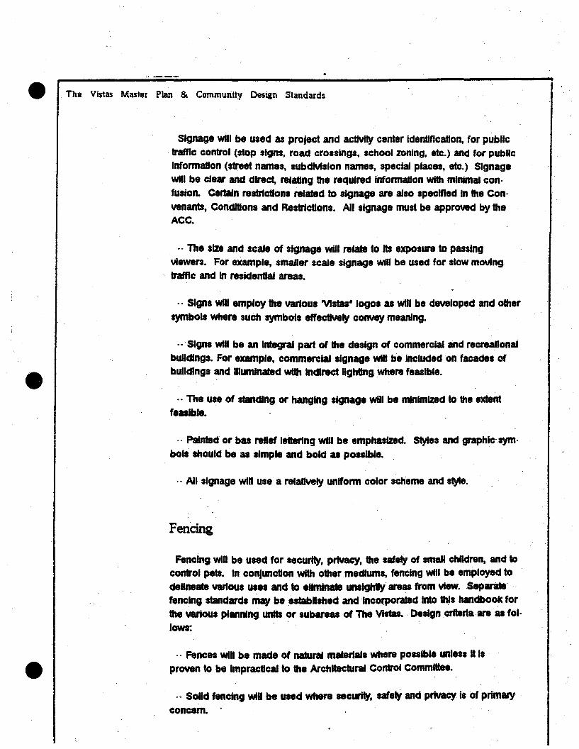
The Vistas Master Plan & Community Design Standards
Signage will be used as project and actIVity center Identification, for publictraffic control (stopalgns, road croaslngs, school %onlng, etc.) and for publicInformation (street names, subdIVIsion names, special places, etc.) SignageWin be clear and direct, relating the required Informauon with minimal con·fusion. certain restriction. related to slgnage are also specified In the Con
venanta, CondlDon. and Restrictions. All slgnage must be approved by theACC.
_. The size and scale of slgnage will relate to Its exposure to passing
viewers. For example, smaoer scale aignage will be used for slow movingtraffic and In residential areas•
.. Signs wiD employ the various 'VIstas- logos as WIll be developed and other
symbols Where such symbols effectIVely convey meaning•
.. SIgna will be an Integral part of the design of commercial and recreational
buDdlngs. For example, commercial slgnage WID be inclUded on facad.. ofbUildings and Illuminated WIth Indirect Ughtlng Where feasible.
.. The use of standing or hanging slgnage Will be minimized to the extentfeallble.
.. Pafnted or bas relief lettering WID be emphasized. Styles and graphlCsym·
bois should be uslrriple and bold as possible•
.- All signage Will use· a relatIVely uniform color scheme and s~e.
Fencing
Fencing Will be used for securfty, Pr1VaCY, the safety of small children, and tocontrol p.. In conjunction with other mediums, fencing Win be employed to
delineate vartous uses and to eliminate unsightly are. from vtew.Separate.fencing· atandarda. may be established andlncorporat8d ·Into this handbook forthe various planning unltlor _are. of The VI.... Design crtterla areas fol·
lows:
.. Fenc.. win be made of naturaamaler1a1s where possible unl... It Is
proven to be Impractical to the Architectural Control Committee•
., Solid fencing will be used where security. safety and privacy is of primary
concern. .
t .

•
The Vistas Master Plan & Community Design Standards
.. The use of chalnllnk fence will be minimized. Vinyl chajnllnk Will be usedwhere this type Of fenctng Is required.
.. Simple open fences will be used to delineate common areas from prIVateproperty Where privacy Impacts are minimal.
··On re8lden8a1·lota that abut a met or common area, lot line fencing Willbe discouraged where PriVacY Impacts are minimal.
Lighting
Ughtlng will be funclon" and aesthetically pleulng. It will Illuminate ...andpathWayi, points of potential pedestrian/automobile conflict, foster asense Of security and light sign.. Aesthetically, it will highlight.enlrances tobuildings, key areas Of the ranch, and points Of Interest Ughtlng along publicaneta will be owned and operated by "e governmental entity that owns themel
Ughtlng used in residenUai areas will have three basic functtons. It willprovtde a sense of security. mark a drfveWay at the street level and Illuminateenlrywayt and outdoor IlYIng areu. Ughtlngttandards are presented below:
.. The teate, piacement and style win be determined by Ita funCUon. Ex·ample: pedestrian and stow vehicular lighting will be les$ Intense and close tothe ground.
.. Soft. Indirect lighting will be employed wherever feulble.· particularly inresidential are...
.. The support structure for lighting will be made Of a matertalthat match..or complementa that of the. adloinlng use(t)•
.. The Rghthouslngs will be of· materials and colora harmonious to the ad·Jacent atructure(t). .
" SpiUover, IntrUsive light will be mlnlrrdZed.
.. Ughtlng· color should be uniform throughout the development

The ViStas Master Plan 8& Community Design Standards
Ughts will be places where they are most useful rather than trying to lightentire areu. For example, they should be used to Illuminate InformaDonai anddirectional slgnage and for security, and not for flooding an entire baCkyard
with light
.. ughUng level. will conform to standards recommended by the lIIumlnaDngEng'neen Society In IES Ughtlng Handbook, 4th Edllion, New York. whereW8IT8I1ted.
.. On public streets, the style of light standard will be unique to The Vistas.

'"

, .. " i
e··
• ~. t,.. ...
· ...,.••r
....:.. •• >
.. :,." ..
Infrastructure
.• ~'l.
The Vistas Mastel Plan & Community Design Standards
4.
Stormwater
INFRASTRUCTURE
Climate
The climate found In the Spanish Springs Vailey 't somewhat typicai of theSierra N~a.. Thunderstorms are most frequently observed In the mfddle ofsummer thro~gh early fall. Rainfail from this type of storm Is aimost aJway$characteriZed by high Intensity and ahort-duratlon precipitation.
The average annual precipitation Is less than ten Inches (10'), wItb the weuestmonths December and January, and the driest months July, August and September.
Temperatures have considerable dally ranges between maximum and mini·mum,· sometimes exceeding 46 degrees F. OayUme temperatures average 80degrees F. In the winter and 80 degrees to 90 degrees F. In the summer.
WInds.fluetuate daily wfth light morning wtnds and strong afternoon winds.Winds are very strong In the months of July and August
Physical Characteristics
The dratnage bastn for The Vistas Is broken Into two (2) major drainage sub·baslM. Dratnage baaln 1 I. ·Iocated on·the north aide of the· drainage basinand •• compoted of 515 acrel. Drainage bastn 2 I. located on the· south sideand Is composed of142 acres. See Figure 24.
The project ,Itt Is In hilly terrain, with vegetation and ground cover with lightto heawysagebrush and grass cover. The highest elevation 184,860 In the

_ ; -" - '...• ....- '---" ' ... "~'"'''' ."" .. ~. -_..... - ' • ... _ ...4 .... __ ... '....... _ ••_ •••• ' ... _ _ .. __ •
..~
A:::....
.'
i(\
. .r--.. ..'v'
o\
- -_... ~. .
."'-"
i.... c::...-_.._.~-~~
......-./~ -_.
-;'
. ..~ ..
,.~.
"'~...
'.
\
c i "-III ... da= en
C 0CD
9
! ~ ~_.:~ ..I
. ... '.
..;
Zl:' ..........._~ ..... .....•".....
,'.
:::. ... -_..
...
.'
. ' ....
....... ..
"
............_...... __..~._'
:: ..

._·;# •.\...;.....:. .....·i,.~ ..::..... _..~ .................i.:._·:-'-......~~;,:j:,.#.'·;',M •.:'~~,;:...,.,.·_·~~ ........;.... W·.·.......~"""-...........:ri'Q·...j~.~......<....:.....-=.,",:~C""_~~..,.."'---',;.~......,..~..._ ...e._......"_-.l_ .... _ ....._~ ._" ..... _'_"_.. _. __....__ .. __ .... -.. .
The Vistas Master Plan & Community Design Standards
northeast area. Thes.e peak areas are rocky ter1lary volcanIc rocD. The Vis·las "generally slopet from east to west. .
The salls found In this area are bedrock on the higher elevations and ce·mented pan salls on the lower elevallons. The cemented pan Is an Imper·vtous layer composed of silty clays.
General Drainage Patterns
. Dratnage and drainage facllllles WIthin The vt8tat are practeatly noneXl.-ntThe one. runoff on the higher elevations of the sub·dralnage area #1 It In·tercepted at about the center of the section next to a dirt acee•• road. Th••drainage pattern eonUnue. west along the dirt road where It eros.e. over theSpanish Springs Road and then It eonUnuea west. The runoff of aub·dralnage*2 flows In the northwestern dlrecton and eros.ea over the Spanish SpringsRoad.
Methodology
Hydrology calculations were performed by two (2) methods - lhe'HEC·1Computer Program and the Rational Method. The peak dlacharge for the 5year.10-year and 100·year ewnta were'determlned for both the undewlopedand dewloped eondlUona. A comparison was made between the reautts of
the two (2) methods and showed relatIVely good agreement
The Input to the HEC·t model was based on a synthetic hydrograph usingthe NOAA Atlas (Reference 2) and a 1088 rate using SoU' Conservation service(SCS) curve number. The procedure uaed was as foHows:
- Determine preclpltallon depth for the 6·hour and 204·hour duration from theNOAA Atlas (Reference 2). North latItUde used was 39 35'00· and west longllUde used was 119 042'30-.
e'. 'Preclpltallon value8were then adlutted from the partlaJduratlon series to
annual aeries baaed on mUltiplying factors provided In Reference 2. Results
are shown In Table 6.

iThe. Vistas Master Plan & Community Design Standards
Table #6Precipitation ValUet
6·Hour Duration 24·Hour Duration
Return Map x PartIal Annual Map x PartIal AnnualPeriod ValUe Series = Series Value Serlet= Series(Years) to Annual Value to Annual Value
Series SeriesCorrectn Correctn
2 0.70 0.88 0.82 1.00 0.88 0.885 0.90 0.96 0.86 1.40 0.96 1.3410 1.10 0.99 1~09 1.80 0.99 1.5825 1.30 1.00 1.30 2.00 1.00 2.0050 1.40 1.00 1.40 2.20 1.00 2.20100 1.60 1.00 1.60 2.40 1.00 2.40
e Precipitation Data Taken at 39136100, north Iat. 119142130, west long.
.. The 2·year and 100·year. 1·hour duration vaIIIes were determined by equa·tlons 1 and 2 (Reference 2).
.. FIVe·mlnute and 15·mJnute duration values were determined by equations 3and 4 (Reference 2).
" SIX·hour and 24·hour duration values were plotted on Figure 3 for th.2·~5·,10· and 100;year events.' The resulting 12.hour duration values were deter·mined· fr~m the graph•
., One·hour and 6·hour duration valuet were plotted on Figure 4 for the 2" 5·, 10·, and 100·year events. The resuttlng 2·hour and 3·hour duration valueswere read from the graph. Also, equa1lons 5 and 8 (Reference' 2) could be
used to determine these Values•
.. The 5·mlnute, 15·m.nuts. 1·hour. 2·hour. 3·hour. 6·hour. 12;hour and 24·hour duration values for the 5·, 10· and 100·year events were then used asInput to the HEC·1 program to form the synthetic hydrograph. These areshown as Table 7.

The Vistas Master Plan & Community Design Standards
Table #7
Interpolated PreclpltaUon Data
Duration Return pertOd (Yean)
2. 5 10 100
5 min. Eg. 3 0.11 0.17 0.19 0.34
15 min. Eg.4 0~22 0.33 0.38 0.66
1 hr. . Eg'. 0.38 0.58 0.87 1.161&2Rg. 3
2 hr. Flg.5 0.45 0.86 0.80 1..29Eg.,5
3 hr. Flg.5 0.51 0.73 0.89 1.39Eg. 6
8 hr. . NOAA 0.62 0.86 1.09 1.60ATLAS
12 hr. Fig. 4 0.75 1.10 1.34 2.00
24 hr. NOAA 0.88 1.34 1.58 2.40
ATLAS
.. The Ion rate was baaed on an SCS curve number of 82.
~. The SCS untt hydrograph was ·th8 output hydrograph. The mape of.thi.hydrograph Is only dependent· on tho··lag time. The lag time was determined
by the equation:
Lag =0.72 (LI&) 0.38· (Reference 3)
5.5
., For the developed condlUon, an Impervious area of twenty·fIVe percent(25%) wu used In order to reduce the loss rate·determined by the SCS curvenumber.

The Vistas Master Plan & Community Design Standards
The resulting HiC·1 peak flow·rates for the undeveloped and developed can·dltlon. are tabulated In Tables 8 and 9.
Table #8
HEC·'Peak Runoff Summary . undevelopedRow In CUbic Feet per Second
BeWm PerfodArea AreaNo. (Sq.M1le.) 5·yr. 10·yr. 100·yr.
1 0.80 36 59 1732 0.22 12 20 601&2 1.02 47 78 226
Table #9
HEC·lPeak Runoff Summary· DevelopedRow in Cubic Feet per Second
Rmum PertodArea AreaNo. (Sq. Miles) 5·yr. 10·yr. 100-yr.
1 0.80 78 105 2312 0.22 27 36 791&2 1.02 103 137 303
The Rational Method calculations were based on the formula Q =CIA. An un··developed runoff coefficient of 0.15 and a developed runoff coefficient of0.29 were uted. The lmentiles (I) were dertved from the City of sparu rain·
fall Intensity curves for the 5·, 10· and 100·year storm events. The reau1t8 of

.•. "~:".. ~.&.'4""'''''''''.· .' :#•._ _ \ •• _ ••• ,._._ ,, •.•
The Vistas Master Plan & Community Design Standards
the Rational Method calcUlations are shown In Tables 10 and 11 for both theundeveloped and developed concllUons.
Table #10
Rational MethodPeak Runoff Summary - Undeve.opedFlow In Cubic Feet per Second
Return periodArea AreaNo. (acres) s.yr. 10.yr. 100-118_
;1 515 46 61 1122 142 12 11 311&2 857 57 18 143
Table #11
Raaonal MethodPeak Runoff Summary ; DevelopedFlow In CUbic Feet per Second
Return PertodArea AreaNo. (acres) 5-yr. 10·yr. 100-yr.
1 615 81 118 2112 142 24 32 591&2 851 111 150 218

The Vistas Master. Plan .& Community Design Standatds
Storm Water Management
Storm water management and ground water recharge have receIVed con·aiderable attention In recent Umes In the Truckee Meadows and more especial·Iy In the Spanlah Sprtngs area. The storm water management pian Includes !
itwo (2llevels. Fim, a storm water collecUon system will be designed to Injectthe storm water.to the ground water aquifer. ·Second, thelncreued runofffrom·the S·year stonn that I. caused by the development will be reduced to ai
minimum, with the proposed InfiltraUon drainage a~tem. Only forty percent(40") of the proposed aite win be covered With impervIOus area. DetaiisOfthe infiltration aystema are shown In Figure 28. The proposed groundwaterreCharge aystem will function as follows:
a) The storm chin system Will be constructed With tongue and groove rein·forced concrete pipe laid ·openjo,nr.The pipe may be bedded and back·filled With suitable material. No clay materi" Will be used In bedding or back·nil.
b) Trapezo'dal channels or open drainage Interceptors shall. be constructedthroughout the SUbdIVIsions.
In summary, the peak storm water runoff Will be reduced considerably by the,nnltraton and storm drainage ay8tem. ThIs Innltraalon system Will reduce thestorm nowt wen beyond the Increased runoff (S·yaar recurrence). Thus lend·Inglbelf to groundWater recharge that Is definitely. needed In .the spanish.Springs Valley.

-!f!. -=•I
L ..~
tls~l· . I~
~~--(:...- ....J..---.:.~ ...

........ __ ••.'- , •••. - ••• _ •••• , •• _ •• __•• _ .._ ••••• 4 - ..... _.4,
BEDDING
\""-.....-- BLACK PLASTICFLM (8 MIL)
•N
8+----~~~~....
bL __.~1.+-..!J4-lIr.r--I- ORAJN ROCK
STORM TRENCH DETAIL N.T.S.
(SEE OPEN JOINT DETAL BELOW)
+I-GAP
-IIIIII
J
R.C.P.
. ,. 0.$... •.... ,.i8_. •• 0'"41 ~ 0"... ~ •
_-------...:9p*'~r..:.--.-.-.,.;.....': _SEE NOTE I
OPEN JOINT DETAIL N.T.5.
NOTESI. CONTRACTORS SHALL INSTALL DR\' WELLS ..
AREAS WHERE LAYERS OF CLAY ARE ENCOUli i EMD •LOCAT1DN AND .ACINI SHALL IE DETIIMED II THE
. FELD IY THE SOLS D8 En.
L IAacFLL SHALL MEET THE REOUI&tENTS FORC1M8 T 8ACICFLL WITH NO ROCICS OVER 4- •
3.~I. MATERIAL 8tW.L MEET THE REOUI&tENTSor· CLAS8 eA- BAaCfLL M atOWN .. SUIIECTION2D0.03.02 OF STANDNI) IPECFlCATIONI •

"
The Vistas Master Plan & Community Design Standards
.Sewerage
Sewerage for this protect Will be provtded by the Reno-Sparks joint treatmentplanl Bued on the 325 gallons per day per unit treatment standard•. and ananticipated bulld·out of 1.600 units. the required capacity 18 520.000 gallonsper day.
Connection Will be provtded to the City of Sparks caliecUan system by an out·fall sewer. approximately 7.445 feet In length. This outfall sewer Will connectto the existing twelve·lnch (121
) trunk sewer, which serves the Spring Creek·SUbdivision In Spanish Springs Valley. (See Figure 25.)
The ten·lnch (10') diameter outfall sewer Will have a full·flow capacity of923.000 gpd. at a minimum slope of 0.0025. This will be aclequate to serveall the 1,600 unlta planned for this project.

-...--- ..._-~~ I
I
L __~~~ I
I

\. e..
. ~ ..
. <?z
n NOI.&,:»38 ••--==zz ;,o1.L~JS

The Vistas Master Plan & Community Desiin Standards
Traffic Impact Analysis
Here, the traffic Impacts associated with The Vistas are described. Alongwtth the analysis of existing condltlona, level.of seMce anatyaea are presentedfor the following two scenarios:
.. Year 2002 Background Conditions (no development); and
.. Year 2002 Background plus The Vistas Project (1800.±. unitt)
Based upon dl.cusalons with ATC staff, the analyses of the above scenariosassume the construction of a fUll Interchange at the Sparb Boulevarctll-80 June·lure.
Background Growth
Buedon projected residential, commercial and Industrial growth wtthln thestudy area, year 2002 background volumes were developed from ATe·modelruns. Figure 29 IIlualrates the weekday average dally traffic (ADT) volumes onthe key roadWay links. These figures show that background·traffic Is expectedto Increase between 2.5 to 61 Umes the eKilOng volumes.
Project Trip Generation and Distribution
Current plans call for about 1,600 residential· units to be constructed In TheVistas. Approximately 10,050 trips Will be generated from this development onan average weekday. From the ATe model, these trips were then distributedonto the roadways In the study area. Figure 30 shows the future 2002 ACTvolumet with the project traffic added.
Level of Service Analysis
The traffic Impacts due to a proposed development are typically assested Interms of the ability of the supporting road system to accommodate site-genera·ted traffic. The operating characteristics and the volume-to· capacity raIIos ofvarious levels of service are described In the appendix.

Q:>...ICD(I)
~ ....-..a:<Q. o(1)0...
"
r----------.··---,: IIIIIIIIIII,L_ t I.. r---J
I II II IL.-__.l
o·0..
(II)
eARINGBLVo._2...7i1iiiii3_0_0-+_.....:1.:.7,,:9~0~O•
d>...ICD
.......... <~en>
29,800 16,800
:26.000

d>~CO·CJ)
~ ...-..a:<a..CJ)
r-~~--·-~-_··_---~• •• •• •I I• •· '· 'I 'I ', .• •• •• IL.. :
a._~ • , J
• •, .• •L.....
8N
BARING BLVC._3 _2 r.;;,1~OO:........-=.1.:.~,2:.::5~O"..;'
ci>-'CD
~-.. <len->
Eo pqATER WAy__3_e_,_8_0...0_t-_..;:3:.:2:J,~3;,:O::O:-~~_1~8~I~O~O~OWl.o-o"'"
I-SO
41.800

The Vistas Master Plan & Community Design Standards
Capacity caiculaDona. were conducted for both of the scen~oa describedearlier. Table 12 shows the resultS of these caicUlations for the key roadwaylinks.
As shown, the background growth to the year 2002 wlllcauae considerablecongestion along several roadWay links within the study area.; .. FIVe links Willopera18 unacceptably In the year 2002, with three of those opera6ng at Lavelof Service F:. Sparks Boulevard from East Prater to 1·80, East Prater WtIJ fromMcCarran to Howard, and East Prater Way from Howard to Sparks Boulevard•
•

The Vistas Master Plan & Community Design Standards
TABLE 12FUTURE ROADWAY UNK<l)
OPERATING CONOmONS
Year 2002 Vear2002
ExIsting Background wlPr0Ject
LInk Y& Ld Y&.~ Y&.. J.gS,
Sparb Boulevard:Disc to Shadow 0.06 A 0.22 A 0.56 A
Shadow to Baring 0.03 A 0.11 A 0.39 A
Baring to .E. Prater 0.09 A 0.58 A 0.63 B
E. Prater to 1·80 0.02 A 1.49 F 1.55 F0.75C(2) 0.77 COO
Vista Boulevard:Ollc to Baring 0.03 A 0.09 A 0.23 A
Baring to·· E. Prater 0.14 A 0.900 0.99 E
e 0.80A(3) 0.86 &(3)
E. Prater to 1·80 0.15 A 0.53 A 0.60 A
B....ng BoallMlrd: .McCarran to Sparks 0.48 A 0.95 E 1.11 F
0.83 B(3) 0.74 C(3)
Sparks to Villa 0.08 A 0.82 B 0.87 8
E. Prater Way:McCarran to Howard 0.63 B 1.09 F 1.28 F
0.73 cro 0.85 0(3)
Howard to· Sparks 0.41 A 1.03 F 1.12 F
0.89 800 0.75 C(3)
Sparks to VI_ 0.17 A 0.58 A 0.83 8
.....ntate .8:McCarran to Villa 0.30 A 0.84 8 0.85 8
Sparks to VIsta 0.30 A 0.41 A 0.41 A
NOTES:1. At-grade roadWay caJculaDons buedupon capacity of 7,200
evehlclesJIane ACT, freeway calculatlon·s based upon capacity of 16,000
vehlcleallane ACT.2. Widen cross seellon to eight lanes.
3. Widen ero..·section to sIX lanet.
The Vistas Master Plan & .Community Design Standards
The other nine links Will continue to operate efficiently with VIC ratio. rangingfrom 0.09 to 0.84 (Levels of Service A to B).
Wllhthe addition of project traffic, the same fIVe congested links (WIth unac·ceptable levels of service) will become somewhat worse. The BaringBoulevard McCarTan·to·Sparks link Will experience an Increase In VIC ratiofrom 0.95 (loS E)to 1.11 (Los F). Also, the VIC ratio for Vista Boulevard be·tween Baring Bout~d and East Prater will Increase from 0.90 (LoS D) to0.99 (LoS E). The three other congested links will remain at Level of ServiceF.
Although the other nine roadWay links are Impacted by project traffic, theywill stili operate well within acceptable levels with VIC ratios ranging from 0.22to 0.6?
Mitigation Measures
Bated upon the relulll of 1he capacly calculatlonl, It II apparent that the .roadWay Iinka that win operate unacceptably wtth the project developed areIInka that will already be operating unacceptably due to Juat the projected 2002background traffic. Therefore, the following miUgation measures'will beneeded by th8 dellgn year, and are made necenary In large part by non·project development
· WldenSparka 'Boul~d between E~ Prater and 1·80 from four to eightIan..;
'. Widen Vista Boulevard between Baring BOUlevard and E. Prater WSil/ fromfour to six Ian..;
· Widen Baring Boulevard to six lane. between McCarran Boulevard andSparka Boulevard; and
· Widen e. Prater WSil/ to .Ix lanel between McCarran·Boulevard andSparks Boulevard.
As shown In Tlbie 12, the addition of these mlagatlon measures win allow allof the key roadWay links to operate acceptably (VIC = 0.86 or less) for both
the year 2002 background and year 2002 background plu. project .cenarlos.

e' The Vistas M~ter Plan & Community Design Standards
Air Quality Impact Analysis
The Truckee Meadowa 'S presenUy In 'non·attainment' for carbon monoxideand totaf suspended patUculates. To be considered In non·attainment, onlytwo exceedencea of the Federal AII' QUality standards per year are reqund.1987 Is th.- year In wtrich attainment must be accomplished or the EPA wlU 1m·po.. sanctions such as withholding certain highWay funds. The present attain·ment ttrategy is .based on a roll back analysis of the relationship .betweengross emissions In the Truckee Meadows and the magnitude of the present ex;ceedenee.. The gro88 eml.slons are 'roUed··bacj(l or reduced to an allowable'tons per winter. day' as a·percentage of the Federal Air· Quality· standard andtile current ernlalon violation vatue.
The prtmary source. of carbon monoXide are motor vehicle. and woodstoves, with wood atovea. contrtbutlng a large percentage of the totalluapended particulate.· that give. the air the 'huy' look due to Ught tcattertngby the small patUculatea. The·magnitude of atl other sources for carbonmonoxide'such as natural gas combustion isonty a few percent·of the~taffor motor vehicles and wood smoke.
The Ponutlon Standard Index (PSI) i. a weighted measure of the various pol·lutant concentrations· and Is Indexed .0 that·a PSI of100 indicates an airquality exceedence of one of the five pollutants which are carbon monoxide(CO),eulphur oxides (SOX),· nitrogen oxides (HOX), hydrocarbons (Herandtotal suspended patUculatea (TSp). Thes.pollutanta are monitored by theWashoe County Dlatr1et Health Department.
AJr quality vlolauona for CO vatues typically occur In December ",d Januarydurtng period. when cold air In· the valley Is trapped by a layer. of warm·airabOVe the valley. These 'lnvenlons' last for several days and allOW littlerilbdng or replacement of the all' In the valley. AII' quality monitoring data.ofCO show that .the. highest valu.. occur late at night around 11 PM and that thelowest values occur during the mId afternoon. The CO exceedences are.ofthe· eight hour standard of 9 ppm. The one· hour standard of 35 ppm hasnever been·exceeded In the TruekeeMeadows.· current CO monltortng .beingconducted by Comprehensive Planning In the Immediate vicinity of PlumbLane and KJetzkI Lane In February of 1987 shows valueaof 5 ppm at5 AM Inthe momlngwhen no traffic .. present. At peak hour conditions, the·upwindmonitors $how only a few pam per million while the downwind· monitors areshowing higher valUes contnbuted by the adlacent traffic.
.I

e The Vistas Master Plan & Community Design Standards
The fact that the highest CO values occur late at nJght and are quite 31g·nlficant even With no nearby local contributing activity Indicates thatatr qUalityViolations are contributed to on a region Wide basis over a twenty·fourhour orlonger periOd depending on the length of the Inversion•. Individual intersec·Uona do not directly cauae exceedenceabut rather contribUte atong WIth allother actlvllles ·In .the Truckee Meadows.
TO Improve or at least not further degrade the atr qUality, It •• necessary toredUce emlssioRS dUrfngthos8 several dayS a year When the TruckeeMeadows i. under an Inversion condilion. Improved wood burning practicesand, catatyllc equipped stoveawtll http. Free burning fireplaces emit slg·.nlflcanly 1888 CO and TSP than do Ugtdly banDd' wood stoves. The WashoeCOUnty Health Deparlment currently has the authority to require the ces.atlonof wood burning When the PSI exceedS.100. SIne. wood burning, occurs 'nthe evening, this haa direct ~mpact on that time partod When concentrationsare the higheat. Such .pi'Odlc 80lutlona are not recognized ,by the SPA as anacceptable non·alainment 8trategy,however.
Addtllonal redUctions' In Itt quality emisslons',can be made,by redUcing traf·fIC congestion, e.pecjally In reducing the number of vehicles required- to stopand then accelerate as acceleration em'ssloRS are 10 times .h'gher than cruiseemlulon.. SUCh" reductions can be accompHshed by Intersection Improve·ments, timing of the traffic signals so that traffic flows,through the streets ,rather than from Intersection tOlnteraeCUon and by dispersing trlpaaraCUons80 that traffic 18 not concentrated on particUlar c0r:rtdOrs or channeled throughcertain Interseeuons.
The attainment'of the Federal Air Quality standiU'da In the Truckee Meadows18 almost at the Whim of the weather. GIVen a severe Inversion lasUng four tosix days In December ar January, VlalaliGns are almGst certain. There are,however, things such as traffle now WhICt1 can be Improved and wood bumlng
, wtdch can be made more effIelentor curtailed as neceaaary to Improve airquaIIt'J the entire ·''18ar and leaa8R the severity and 'frequency of the·viOlations.

e The Vistas Master Plan & Community Design Standards
Fire ProtectionIPrevention
Several measures are being taken to ensure adequate fire protection is af·forded In The Vlataa.
Class A'rooflng (concrete Ules) Is required for all reside",at structures in TheVistas., Also, where deemed necessary by the Sparks Fire Department, firefU~i bre. will be placed around development projects.
Of note Is the proposed Impact fees that wli fund the land acqulsiUon, can·muctIon and equipping of the fire station to serve the Spanish Springs Annexa·Uon Area. This $700,OOO.±.. project Is a 'flnt phase' capital Improvementproject In the Spanish Springs area and will be loc.d In The Vistas.
Parks & Recreation• A nine .±.. acre park site I. designated in The Vistas master plan for use as apublic park and as a joint use facility with the adloining elementary school.The lolnt use feature serves to make better use,of the area and also allowsshared maintenance,responslbillUes for the park area. The park aile Is locatednear the populalon center of The Vlataa and generally meets the 0.5 mile'service standard·. No ballflelds or organized athletic fields are proposed because this would be contrary to hillside concerns and also because the 4,000to ".500 project populauon doesn't warrant those kinds of factliUes. The parkIs' envisioned as being 'oriented around children play areas (Ie. "tot lots'), Infor·mal turf play areas, and passive park space. The Vlatas' popUlation does Justify the Inclusion of 2.±,. tennis courts and one or two game coum (eg. out;door bast<etball courts).
The Vlstaa' developers would also like the City of Sparks to considerResldenaal ConttruCUon Tax (RCT), or park tax. credlt8 for certain privatefaclllUes In the protect Specifically, the bicycling/logging trails will be' open tothe pUblic and, along wtth the associated landscaping, aerve Important andusefUl recrealon purposes. Therefore, theae factllUes should be considered "for RCT credit. Alto, smatl 'pocket parka'. accommodated tot lots, etc. couldbe Interspersed within each or some of the vlliages to provide very convenientrecreatlonat resources. Agatn, this would serve to meet RCT objectIVe.. The'beauty' of this concept Is that operation and maintenance (0 & M) cost; areVOlUntarily .hIIled to the prtvate sector (the homeowners association). WIth the
,.
e The Vistas Master Plan & Community -Design Standards
association In place and Its existing 0 & M commitments, the a<:Idltionai bur·den would be relatIVely minor for The Vistas' residents.
'Impact Fees' & Other Mitigation Measures
The uae of Impact fee8 to ensure the coata of growth, are property accommodated In the Spanish Springs area Is endorsed by The Vistas at long asthe fees are fait predictable, equitablY administered and serve to provide theDecllaary fICllitlesln a timelY and cost·effectlye fasbjon.
, One noteworthy point Is Ihat the use of RCT credit Is proposed with The Vis·tal. At $1,100 per home (the estimated RCT revenue on a $100,000 home),The Vlltaswlll generate over 11,750,000 In RCT and the larger SpanishSprtngs area Will provide about $7,700,000 In RCT revenue (7,000 homes @
$1.100). There are a minimum, of siX neighborhood parka proposed In theSpanlsh'Sprtngs area. If th888 parkS each cost. say $500,000, about13.000.006(6 partes) to 14,000,000 (8 partes) would be needed to meet th8protected neecia. Thus, WIth the Impact fees at least partially covertng the$3,600,000 In leisure services capltalcost8 prolected for the spanish SpringsAnnexation area, $3,500,000 to 14,500,000 In RCT may be available for RCTcredlt8 or other uses. The U8e of RCT credlt8 may be a desirabte '001- forthe 'City of SparkS to U8e In encouraging site·sensitIVe, InnovatIVe planned unitdevelopment In the area and to volUntartIy shift the operating and maintenanceburden to the private sector.
The staff report that wu revtewed ~y the city of Sparks Planning Commls·slon on April 23, 1987 and recommended for public hearing follows.

· '. CITY OF SPARKS·.PLANNING COMMISSION AGENDA ITEM
... MEETING' DATE: Apri1 23, 1987
Subject:Springs Valley
Petitioner:
Fiscal impact fees for development in Spanish
Planning Department
R~endatfon: Tbe Planning Department is r~~omme~ding that thePlanning Commission review the cost/revenue analysis and determine~f the proposed fiscal impact fees are appropriate for developmentin Sganisb Spr~ngs Valley.
Background/Analysis/Alternatives
BACKGR.OUND
Historically, when a developer sought to subdivide property, cityregulations required that the developer was responsible forprOViding all' the improvements within the, subdivi~ion. Fordecades, it was the developer paying for internal subdivisionimprovements while the public assumed the cost for prOVidingnecessary external off-site improvemen~s such as roads, watermains, sewer intetceptors , parks, fire stations, police services ,and other public services as may be required. Lacking any specificauthority, cities were not able to require developers to pay foroff-site improvements through' their subdi.vision regulations. Thiswas despite the fact that these off-site improvements could bespecifically attributed to the proposed new deve~opments.
Times. ~ave changed, cities are struggling to meet their annualbudgets and people have realized that subdivisions have an tmpacton city services beyond the. subdivision boundarie.s. What hasevolved is the requirement for off-site improvements to beprOVided by developers through the use of exactions or impactfees. The rapid use of such systems by cities has ·be.ri akin to atidal wave. However, in the r.ush to use these systems to shift thecost burdens, there has been a concern that these systems could bemisused. In order to avoid the claim of misuse by developers therehave been. at least six key issues which should be addressed· bycities in developing a legally sound impact fee system. These are:

5.
.•1. Linkage with comprehensive plan
The most defensible" impact fee systems are those sup~oTted bya comprehensive plan. Competent plans are evidence of acommunities' commitment to plan f.or future growth anddevelopment.
2. Defining facility service areas
Definition of service facility areas are necessary because adefined service area should be related to the prograIIIDing ofcapital improvements. An example of this is that Sparks hasdefined its fire station service area as a. maximum two milerunning distance from the fire station. As new developmentoccurs, new fire stations are programmed into the CapitalImprovements Program to comply with this standard (i.e. GregStreet· Station to be constructed this summer).
3. Evaluating Service Adequacy
All impact fee systems must address the initial question ofimpact upon existing facilities or capacities. If existingfacilities and· service levels are adequate by adoptedstandards to absorb the impact of new development, then thereis not a need for impact fees. However, if the existingfacilities and service levels are not adequate to absorb theimpact of new development, then there is a. justification forimpact fees.
4. Pricing of Impacts
Charging . more than the total cost of the facility to beimproved from one or all projects whose total impacts equalthe total facility need, could constitute "double taxation".The common solution to the double taxation issue is to conductsufficient fiscal and economic analysis to define the natureof the revenue and costs incurred due to all projectsinvolved. Once this is done you need to demonstrate that thecombination of impact fees and revenues will not exceed onehundred percent of the cost of facility expansion.
Administering Revenues
The adoption and implementation of an impact fee systemconstitutes the beginning of a variety of opeTational andadministrative activities. Trust funds for earmarkea fees mustbe established by ordinance. Of necessity a series of policyand.pTocedura1 issues must also be addressed.

...First, the transaction point at which the impact assessmentand fee payment are to occur must be established.· Some systemsinitiate assessment' at any point within the, developmentprocess but defer payment until issuance of the buildingpermit. Others assess '. and collect entirely at the buildingpermit stage. A second issue involves permitting theconstruction or installation of improvements by the developerin lieu of making payments to the trust fund. Such optionsmust rely upon the use of contractural development agreements.A third issue involves the adjustment of assessments whichhave been deferred to recognize fluctuating construction andland costs through inflation/deflation indexes.
6. Administering' Expenditures
Another critical issue involved in the management .ofan impactfee s.ystem . involves the administration of expenditures toinsure reasonable developer benefits in the provision ofexpanded facilities and services. All fees must be expendedfor the purposes collected within a reasonable period of time.And futher, any .methodology should insure that total feescollected and expended do not exceed 100 percent of the costof the needed facility. If collected fees have prOVided 100percent of the cost and a fee is still being collected for .thesame facility purpose, the system has either. overchargedeveryone, mis-estimated the total facility cost, .orfailed inapportioning fair share.
ANALYSIS
The Planning Commission and City Council recently approved theSpanish Springs Annexation Study • Pa.rt of this' study contained afiscal impact analysis to determine if development in SpanishSprings would cause greater costs to the City than what revenues
'could be generated. It was determined that costs would be greaterthan revenues and a policy was adopted to develop an impact. feesystem. Development of, this proposed impact fee system is based onthe comprehensive, planning done in the Spanish Springs Study aswell as the City Master Plan. In addition, both of these studiesdefine the facility service areas and the adequacy or inadequacy
. of these facilities to handle the projected development in SpanishSprings Valley.
A substantial amount of financial analysis has been done todetermine the' magnitude of financial impacts on the City fromdevelopment in Spanish Springs Valley. This analysis isillustrated by the seven tables follOWing this report. A brief.summary of each table. follows:

Table IV -
Table V -
eTable VI -
'e.
e'
· ,
Table I - This table illustrates the different sources ofrecurring revenues, generated by a typical singlefamily home 'valued at $100,000 in the City of Sparks.Total revenues generated by this typica1 home are$571.85 per year. .
Table II - This table prqjects the revenues which would begenerated by development of the proposed 7000 homes inthe Spanish Springs area over the next f9urteen years.Total revenues generated during this fourteen yearperiod would be $26,494,400.
Table III - This table illustrates' the additionalClty ," personnelthat would be required as a result of development intothe Spanish Springs area.
This table illustrates the financial costs' incurred bythe hiring of additional City personnnel.
This table illustrates the additional non-recurringcosts for road, fire, police, public works, andrecreational improvements necessitated by developmentin Spanish Springs Valley. Total capital costs fordevelopment of the 7000 homes is $8,390,000.
This table illustrates recurring and non-recurringcosts incurred by the Spanish Springs development. Thetotal costs incurred to develop the 7000 homes inSpanish Springs Valley is $30,573,990.
Table VII - This table summarizes the previous six tables. Thetotal costs incurred to complete development inSpanish Springs is $30,573,990. The total revenuesgenera.ted' during this period are $26,494,400. Thetotal deficit incurred by the City from thisdevelopment is $4,079,590. If you divide this deficitequally among the 7000 homes built in this area' youcome up with a proposed development impact fee of$582.80 per house based on current prices.
The conclusion drawn from this financial analysis is that a impactfee of $582.80 per house would be required along with thepro jectedrevenues from these homes to meet 100 percent ,of the
,costs incurred from this development. Administratively it would bethe simplest to collect this fee at the" time of issuance of abUilding permit. Because the development period of this area willextend over fourteen years the impact fee should be tied to a costof ,living or inflation index. This would protect the C.ity fromgathering these fees and not having sufficient funds to proyideimprovements because of inflation.

RECOMMENDATION -
The Planning Department is recommending that the PlanriingCommission review this report and deci de_wh.e.ther....t;·ne-y_··wou1:d· -li-keto schedule this for an additional review session or a publiChe&l:'irng.
Re}l!-e.etl2.l~Ys.~itt. e.. ~~.;(~L ) Y'4- /.'/~..~~~ :;.... ~r-~----
RICK JOHNSON, A~I.C.P.
SENIOR PLANNE13/
RJ/le

TABLE I
-PROJECTED RECURRING REVENUE PER DWELLING UNIT
RECURRING REVENUES
GENERAL FUND
PROPERTY ,TAXESSUPPLEMENTAL CITY/COUNTY
RELIEF TAXESBASIC CITY/COUNTY
RELIEF ·TAXESCIGARETTE SALES·TAXESLIQUOR EXCISE TAXESMOTOR VEHICLE PRIVILEGE TAXDOG LICENSESBICYCLE LICENSEUTILITY FRAUCHISE FEES
GAS, ELECTRIC, WATER'TELEPHOUEGARBAGECABLE TELEVISION
MUUICIPAL COURT FINES
TOTAL GENERAL FUIDOPERATIONS
ANNUAL PER DWELLING UNIT
$ 69.~9
189.17
159.5546.287.18
21.60.72.01
32.009.001.203.60
31.85
$571.85

TABLE II
SPANISH SPRINGS VALLEY REVENUE ANALYSIS
TOTAL REVENUES GENERATED FROM BEGINNING (1987) TO COMPLETION (2000) OF APPROVEDAHNEXATION IN SPANISH SPRINGS VALLEY $26,494,1100.
-.. ,

e·TABLE III
ADDITIONAL PUBLIC PERSONNEL REgUIRED
2500 HOMES 5000-HOMES 7000 HOMESFIRE DEPARn-1ENT
CAPTAINS 3 3 3PUMP OPERATORS 3 3 3FIREFIGHTERS 6 6 6
POLICE DEPARTMENTPATROL OFFICERS 5 10 10
PUBLIC WORKS DEPARTMENTMAINTENANCE YARD 3 q 5STREET CREW 3 6 9SEWER LIlES CREW 1 2 3PARKS CREW 3 5 7TRAFFIC CREW 1 2 3
LEISURE SERVICES'RECREATION SUPERVISOR 1 1 1
e COURTSCLERKS & MARSHAL 1 2 3
ADMINISTRATIOflFINANCE DEPARTMENT 1 1 1PERSONNEL 1 1 1PURCHASING 1 1 1EQUIPMENT SERVICES 1 1 1- - -
TOTAL ADDITIONAL PERSONNEL REQUIRED 3q qa 57

TABLE 'IV
....
ADDITIONAL ANNUAL PUBLIC COSTS
2500 HOMES
$ 451,000
205,000
90,000
5000 HOMES
$ ~51,000
~10,000
120,000
1000 HONES
$ 451,000
410,000
150,000
ADMINISTRATION ,PERSONNEL & EQUIPMENT
UTILITIESELECTRICITY FOR STREET LIGHTS
TRAFFIC SIGNALSWATER FOR PARKS Ie FIRE
HYDRAHTS
TOTAL ADDITIONAL ANNUAL PUBLICCOSTS
151,000 315,000 450,000
24,885 49.110 11.UO
97,664 225,848 262,412
60,375 120,150 169.,050
40,000 40,000 40,000
30,000 60,000 90,000
100",000 100,000 100,000
91,800 181,800 258~000
46.200 98,400 129,600
$1,400,424 $2,118,568 $2,587,232

e· -TABLE V
ADDITIONA~ NON-RECURRING PUBLIC COSTS

TOTAL COSTS INCURRERD FRO" BEGIN.ING .( 1987) TO CO"PLETION (2000) OF APPROVEDANNEXATION"IU SPANISH SPIUGS VALLEY $30,573,9090.
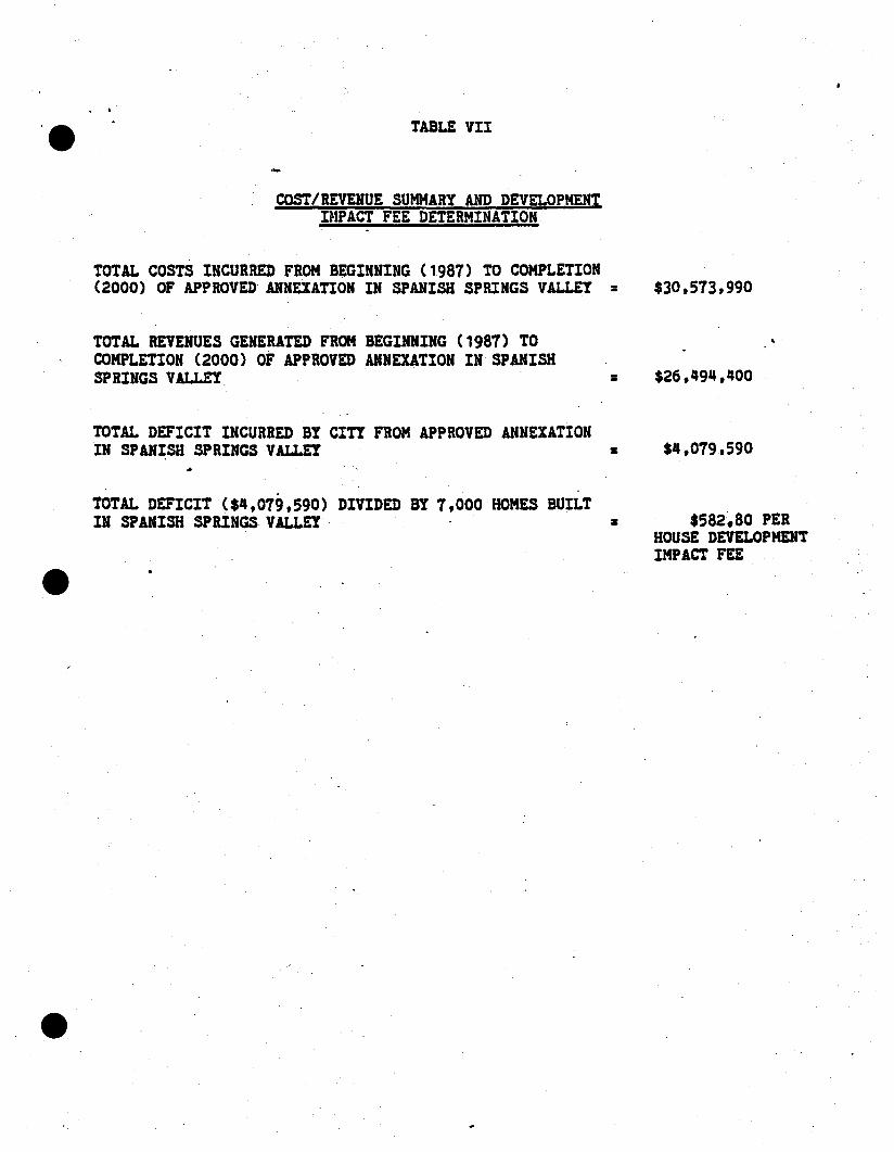
TABLE VII
COST/REVENUE SUMMARY AND DEVELOPMENTIMPACT FEE DETERMINATION
TOTAL COSTS INCURRED FROM BEGINNING (1987) TO COMPLETION(2000) OF APPROVED ANNEXATION IN SPANISH SPRINGS VALLEY = $30.573,990
TOTAL REVENUES GENERATED FROM BEGINNING (1987) TOCOMPLETION (2000) OF APPROVED ANNEXATION IN SPANISHSPRINGS VALLEY,
TOTAL DEFICIT INCURRED BYCIrY FROM APPROVED ANNEXATIONIN SPANISH SPRINGS VALLEY
TOTAL DEFICIT ($~.079.590) DIVIDED BY 7.000 HOMES BUILTIN SPANISH SPRINGS VALLEY'·
--
=
=
$26,q9~,qOO
$~.019,590
$582~80 PERHOUSE DEVELOPMEHTIMPACT FEE

.....,•....
~'.'
", .."
1;..-,-
... _._:,.~...... ~. ..,"·r
.~ ...:.;...'.,-,"_,:~",.. .... I'-'9:~ ";':"_'>A..jl'.:~.'.•. ~
"..... .- ..... ','.'!~"""""'- .'. - :-."'~.
~'C~'·:'~~:~·"\~:;7M:,,:-.;:~,.:: ,~~.:~cF.:~
"\,::..~'" :" ..~"~:~"t;.~~~ ~ .~-.--_..'~~"""'''''''''''\;'.~~
.~~'~' ;::~.~:'."'-~
.........;..:'
:.'.'.-"
Appendix
......::,.
' ..;;,;...:--.-.
..~ .
..........,..,.
:~._".~ ."','':-
. ......:.
..• ~. ,.,.. -_: - :,' ."..
.... J,;
"'~- ..
.' ._.'::-:~.....~.:r.~~. ~;:.~ ~";: ..-....~
. ~" '''';'..:,.._..........~ :,.
q.':- .......",-
,,;'..;.,' '!'o.:,:. ~.,.,
.:..-
.~.~-:: ....;.'""'~,:>~',; , '...;W.:~~ •.'!.'
....~.".~:.~~l' ", ...-10-, -. .."';.~ '~
.,"J~.~._.l:'
: ._~. "tw ,.' ':"....
~1.,;._ •.'"
. ,.":t
;;"-•.. -:'
- : - ..- ."1•.••~ ......... .:'"_:'.":' .
'-~/''''','''''''''''':.~,"j. • , .• ~ ....... ; •• :
~"'.... :., •• 7'
..,-;--,... ..-~-:.- - _....,. "'-",",-.'---.' :..,~~... _.~:.. ......,.,~._:~.;_ ..
• ........ ....:- ~-:;";~......-';j. • '*' ....~~'- .....# ....,.-
.,";~.;';';; '~'i ."" 0' '
"..~/........... ~....:.: ...... ""~'.' . . ~ .......~.
'::'::~;~~~::: ;:... , ~~"'~
,......
.~...,...... -~.>.'. , '.- ,..',--- ,..... "'-.~
~.---,.'
..~.
·r-'"..
••..', .....1 , .. ", •
.ar' ....,.
•• _",.,,r.'.J'io;.
.""~
, .-
._..-.".~-~' ... ,-_.".'- ~~.:.~
... -.......~ ....
... ... _·t·;o~: ~
....-.. , .:..
--:.......,...
..~.. '
'-:'l'.~,..!
, "-.,<,~_·:,_i~.'J' ;'''-
.:~.: 'i2;' ~~~
...., ..,.. ,,' ", ~ .....
--~'-"~"···r
,.'"
- ...."<•• , •• -:. ';:'.~ .
4;
",':" '.•:'!":.;-~.;;iJ;:...,._"",>- .• ".:.~~
. " _._~.:'~_ .., .-,..,.....
.~-
-ill".··
: \,~ ........'.:J'" i'-' "'~~
'~.~ ;-,,"~:'~':""... '
-..... . :,,,:~... '-' "'>0' :;..:.•• --
:-,'
.:..-' .,.,..,:, .
............. io-_ ,.~-
';- ••••• J.:,•
.' ',~
,.......~ .
..:: ......... ~.,l) .....
. ..; ...........
...:r,..
_-.1"'"
....
•".".;.it.,
t ...........
; ..~ ..~
.'--"""""''''...:, .
'.-'-", .:':'~.:';','"Y:~~':.~--"
.••. ;;.' --'<,
'''->:-.••-_ .. ~.
.. " .-:::
--,W'-.
~"~~U
'- ,. -,:>-
,_ "':;;..~"'tl, .•. ~
. '.
. '...";'1' "-,~
·-;t'ti·
,~"" ' ..
. ,,-:':~
" ..."

e The Vistas Master Plan & Community Design Standards
s.
List of Appendices
Appendix
Protective Covenants, COndlUons & Reatl1cllona
TrafflcS1Udy
Planting Ust
Geotechnical Report
Hydrology Report

,
e
PROTECTIVE COVENANTS, CONDITIONS& RESTRICTIONS
These Covenants apply.generally to The. Vlstat. In Ita entirety. SupplemenWyCoven.... CondlDon. and Restrictions may be filed WIth any final map or Withthelatuance of building·permtt or In conjunction with any land sale Wherestlght modifications to these coven" are deemed necessary and desirable.Thete changes may be either morestrtngent or more lenient as the specificcae. may require In the opInion of the Declarant
INDEXDECLARATION OF PROTECTIVE COVENANTSTHE VISTAS
RECITALS
I. DEFfNmONS
II. LAND USEA. Single Family ResldenthU
1. Minimum Area2. Height Umltatlon3. BuDding Envelope
B. Multiple·Famfly Reslderdlal1. Locauon2. Minimum Uvtng Areas3. Carport or Garage I4. Areas Held In UndMded Interests WIth'n Multiple Family Res'4entla5. Draperies In Multiple· Family ResIdential Unlb
1 -
j
C. Common Areas1. OWnership2. Use3. Maintenance4. Subsequent Dedication
J
J
Je
IlL RESIDENTIAL RESTRICTIONSA. Acce880ry OutbUildingsB. Completion of co.nstructlonC. Prohlbmon Against Used StructuresD. Maintenance of LotiE. Disposal of Sannary WasteF. Fence.G. NUisancesH. SignsI. AnimalsJ. Garbage and Refuse DisposalK Concealment of Fuel storage Tanks and Trash Receptacles
L AntennasM. Travel Trailers, Motor Homes & Boat storageN. Defacing or Removal of Common Area Improyement:O. Umlted Acce..P. ResubCUVIslon or Joinder of LotsQ. Operallon of and Motor VehiclesR. UtIlity UnesS. No Commercial EnterpriseT. Temporary StructuresU. Peaceful EnjoymentV. excavationw. Certificate of occupancyX. Clothes Une.Y. landscapingZ ~e.orC~o~
AA No Commercial LeasingBB. BUilding Heightce. ExterIor UghangDO. exterior Wall. & TrimEE. Roof.FF. Construction Procedures
IV. THE ARCHITECTURAL CONTROL COMMITTEE
A. General PoweRB. Committee MembeRhipC. Grounds for DisapprovalD. Rules and RegulationsE. VariancesF. Certification of ComplianceG. AdministratiVe FeesH. UabllnyI. PrIncipal OffIceJ. Enforcement
v. THE VISTAS HOMEOWNERS ASSOCIATION, A NON-PROFIT CORPORA·
TlON
1
e
A.B.C.D.E.
GeneralContrOl of Association by DeclarantMembenhlpMentbenhip Rights. PrIVIleges and ObligationsOutlet of Astoclatlon
VI. ASSESSMENTSA. GeneralB. An.,..aI Ana••mentaC. Special AsteasmenD. NoticeE. New UnitsF. ColleCtIon and UenG. Prlorlty of UenH. EnforcementI. Proof of PaymentJ. SuspentlonK. RtcBl Vear
VII. EASEMENTSA. Reservations
1. utliltiel
2. Slope and Drainage3. Path'. Trails and Greenbelts4. Other Easementa6. Transfer of Euemenlt

B.c.D.
Use of Maintenance by OWners
Uability for Use of Easement
Modification
L'
VIII. ANNEXATION
A. Property °to be Annexed
B. Manner of Annexation
IX. REMEDIES
A. Enforcement
B. Suspension of PrlvIleges
C. CumulatIVe Rights
X. GRANTEE'S ACCEPTANCE
XI. SEVERABIUTY
XII. CAPTIONS
XlU. TERMS AND AMENDMENTS
>tN. INTERPRETA110N
>N. DISCLAIMER OF .UABlUlY
EXHIBITS
A. Supplemental Declaration. (To be Included With IndMduai projects as
needed).

DECl.ARATIONOF PROTECfIVE COVENANTS
THE VISTAS
THIS OECLARATION is made on -...---\(lllIldat.elCo,jl)__ by (the Declarant),!Ltgal gesQJjdmll..
RECITAlS
Declarant I. the developer of that certain real property located In the Countyof washoe, State of Nevada. known as The Vistas, as shown on the masterplan thereof attached hereto u exhibit eA- and made a part hereof.
Declarant Intends to sen and convey the lots and parce's slttiatecl WIthin TheVistas and before doing so, desires to Impose upon them mutual and benefl·clal restrictions, covenants, equitable servItUdes and charges under a general.plan or scheme of Improvement for the benefit of all of the lots and parcelstherein and the owners and future owners thereof.
NOW, THEREFORE, Declarant declares that all of the lots and parcell In TheVl8tat, as hereinafter defined are held and sh~1 be held. conveyed, hypothe·cated of encUmbered, leased, rented. used. occupied and Improved, SUbjectto the provisions of this Declaration, all of Which are declared and agreed tobe In· furtherance of a plan for the development and sale of said I~ts and par·cels. and are established and agreed upon for the purpose of enhancing andprotecting the vatue, desirability and attractlvene.s thereof. The proVisions ofthe Declaration are intended to create mutual eqUitable servitudes upon eachof said lots and parcel. In favor of each and all other lots and parce's; to
create rectprocal rights between the respectiVe owne... of all such lots. and parcels; to create a privity of contract and estate between the grantees Of suchlots and parcels, their heirs, successors and uslgns; and shall, as to theowner of such tOt or parcel, his hetrs, successors or a.slgn8 operate ascovenants running WIth the land for the benefit of each and all other such lots
AAd pMce,* In the development ii net'e;fiifliJf oefined aR.d mei!' respectiveowne..., present and future.

e·
I .DEFINITIONS. The followtng terms as used In this Declaration are defined as follows:
A "MclesM means the·Artlcles of Incorporation of the Association.
B. 'Association' means The Vistas Homeowners Association, the propertyowners' association which Is a Nevada nonprom corporation.
C. 'Board' means· the Board of Directors of the Association.
D. 'By'Lawt~ means the By·LaM of the Association.
E. "Commtttee" means The Viataa Architectural Committee.
F-1. 'Common Area' means all of the real property designated as such In the
SUpplemental Declaration; all real property which may be later de.crlbed bySupplemental Dec.aratloM at common area; and all real property acqufred bythe Atsoclatlon, whether from Declarant or otheMf.e, together In each In·stance WIth all Improvements which may at any time be constructed thereon
and owned by the Association, Including, but not limited to recreational andcommuntty facilities, lakes, parka, paths and trails. Common area, as used In
this Declaration doe. not Include land owned In common or held In undivided
imereltt by owners of multiple family dwellings within. the Development
F·2. 'Constructlon Plans· means a set of draWings and specifications for the
construction Of residential or nonresidential bUHdlng(s).
G. 'Declarant' mean. the developers of The Vistas, their Successors and a..igna.
H. 'Declaration' mean. this Declaration of Protective Covenants and anyamendments hereto.
I. 'Development' means all that property altuated In the County of Washoe,
State of Nevada, described In the Supplemental Declaration and all other realproperty which may be cletcrtbed .In additional Supplemental declar&Uons
. recorded from IIme to time wah the Washoe County Recorder which
.Development Is commonly known at the The Vista.
J. 'Improvements' mean. all buildings. outbuildings••treets. roads. trails,
pathways, drlvewaya. parking areas, fencea.retalnlng and other walls, docla,

piers. landscaping, light standards, antenna and any other structures of anytype or kind.
K· 'Land owned In Common' means land owned In common or held In un·dIVIded Interem by the owners of multiple family dWellings.
L 'lot means any numbered lot as designated on the map or any lIVing unitIn a multiple family dWelling. Land owned In common as part of a multiple
family dWelling shall not be considered to be a separate lot for purposes ofthis Declaration. Non·recorded 1018 or mUIUpie family IMng units under theownership of the declarant shall be considered lots With one vote for eachsuch lot or unit avaIlable'to the declarant In
association matters. Said non.recorded ·101$ shall not be SUbject to any as·10claUon fe.. or _.e••menb.
M. 'Map' meana the maps of the development as Ihey are from Ume 10 Umerecorded.
N. 'Multlple Family Dwelling- means a residential structure such as atownhouse or condominium structure containing two or more Individual apart·m.nts or lIVIng units and constructed on a lot·or parc.' Whose use 18 desig·nated In the Supplemental Declaration as multl·famlly residential.
o.·own.... m.ans:
1. Any person or legal entity, Including Declaranl who holds fee simple OUeto any lot, unit, or parcel Within the development.
2. Any p.rson or legal entity Who has contracted to purchase fee title to alot pursuant to a written agreement recorded In the Washoe County, Nevada,R.corder's OffIce In Which case the seller under said agreement shall ceaseto be the owner While said agreement Is In effect or
3. A 1e888ft of a lot under a recorded lease from the owner of fee simpletitle to said lot for a term of not less than fifty (50) years. in Which cue the les- .sor under said lease cease. to be the owner while said lease Is In effect
4. owner doe. not Include the As.ocldon.
P,·Parcel· mean. any portion of the development other than a iot Of com·
mon area.

-,I'I
J
Q. "Slng'e Fam'ly Dwelling" means a residential structure for the owner andhis Immediate family, his casual guests and his domestic servants and domesDc employees, Which dwelling is constructed on a 'ot designated In the Sup·plemental Declaration as a single family residential lol
R. "Supplemental Declaration" means:
1. The recorded Supplemental Declaration of Declarant attached hereto asexhibit "A"; or
2. In the case of parcels being SUbsequently annexed to the development,the recorded Supplemental Declaration of Declarant Which, incorporates theprovisions of this Declaration herein by reference.
In either event. the Supplemental Declaration shall inciude a description ofthe real property covered thereby SUbject to the provislon$ of this Declarationand shall designate the permlled US88 of such property.
IL 'LANP USELoti and parceis In the Supplemental Declaration shall be designated therein
as to their perml8slble uses. and shall thereupon become subject to the restrlc·tIve or other provisions of thia Declaratton and of The Vistas OevelopmentStandards Handbook relating to such uses. In the event a use Is designatedfor Which no such proVisions are contained herein (e.g•• singie family dWell·Ing,multlple family dwelling, etc.), the same may be set forth In such Sup·
. plemental Declaration. Only actMtles connected with the designated UteS maybe carried out on any lot or parcel. There shall be no use of a lot or parcelothe,r than the designated use.
A. Single family BesideDb'. Only single family dwellings and such outbulld·ings as are usually accessory thereto and as may be permitted by the Commit·tee, shall be permllled on any lot designated as single,family residential. Thefolk>Wfng restrictions s.hall apply specifically to such lots.
1. Minimum Area. Each dwelling constructed shall have fully enclosed floorarea (exclusive of roofed or unroofed porches. terraces, garages. carporta.guest houses or other outbuildings) not le8S than 1200 square feel
2. Height limitation. No structure or poriion thereof (except chimneys) con·structed on any lot Within the development shall extend to a point higher than

that dealgnated for such lot on an applicable supplement to this Declaration ofProtective Covenants filed with the Washoe County Recorder from time to Umewith respect to each unit of the development, Which suppiementshall be sofiled prior to ~e Declarant conveying any lots within any such unlL In the ab·
sence of·such filing. height limitations within any unit shall be those for eachlot within such unit established by the Committee. Such height limits shall beshown on flnal subdivision plata. No height Ilmlta can exceed City of SparkSordinance reqUirements unless expressty permlled by the Clay of Sparksthrough approval of supplemental declarations.
3. BUilding EnvelQRJ.. The Declarant shall establish a building envelope andrecommended point of acce,1 for each lol This envelope will be basedupon the topography of the lot, 1t'8 relation8hlp to neighboring lots, and anyunique feature thai the lot may haua .uch .. tr•••• m.adoWSt. rook o&derop.
pings, etc. The size and shape of the building envelope may vary from lot tolollf, In the opinion of the declarant, certatn lots do not warrant the estab·Iishment of a specially designated envelope. the envelope for th08e lot. thallbe set according to the normal setbacks of the governing local agency for th~type of lot In question. In general. all building construction, .hall be confinedto the building envelop. areL If. In the opinion of the Commllee. the buildingenvelope cau88d the lot owner undue hardship In the siting of his home or inthe cas. of any outbUilding requ....d by the. owner and deemed desirable bythe Committe.. small vanances may be permitted by the Committee as.long al
COunty or City .etback requirements are met Any such variance mutt be Inwriting and signed by the chalrperlon of the Committee. No variance may begranted that would be contrary to any setback requirements of the City unle88expressly permtaed by the City of Sparks.
B. Multiple familY Residential. Only multl·famlly dWelling: and such outbUild
Ings as are uSUally accessory thereto shall be permitted on any parcel designated as mullple family residential. The fOllowing restrictions and covenantsshall apply specifiCally to such lots or parcela:
. 1. Locdon Multiple family residential use shall be allowed only withinareas approved for such ute and as designated on Supplemental Declarations.
2. Minimum Wng Area. The amount of fully enclosed floor area devotedto living purposes In each such unit shall not be less than 800 square feet foran apartment, .patio.home or condominium unit or 1000 square feet for atownhome.

1
lj
3. Carport Garage or Screened Parkfng Area A carport or garage shall
be con~cted for each townhome unit Apartments, patio homes or con·dotnlnium units may be allowed With screened parking areas in lieu of or· in
. combination WIth ·garages or carports, If approved In wrlung by the 'declarantand the· committee.
4. Am.. Hetd In Undivided Interests WIthin MuNgle Family Besldentla! par·~: (Referred to above a land owned in common.) Area held In un·dMded Interests· Within mulUple family residential parcels shall not be con·veyed to the Association but shall be owned, developed and managed consls·
tent with the development plan or scheme for the multiple famlty residentialparcels.
5. Draperies In MuNgle Family Residential Unit.. The Committee may, prior
to the sale of any units In a multiple family residentlaf untt structure establish auniform color scheme for all drapery liners on exterior windows. In the eventsuch a color. scheme ·i8 established, the Commtltee shall notify the Associationwhlch shall notify all real estate persons seiling· such units so that the buyers
of such units Will be advised of such requirement prior to purchae. Such
color scheme shall be maintained until changed by the Committee or with the
consent of eighty percent (80%) of the owners of the 81rUctu~ InvolVed.
C. Common Areg.· AU areaa in the development designated as common
areas, (owned and to be owned by the Association) are and shall remainprivate property and Declarant's recordation of a map showing such common
areas shall not be construed aa a dedication to the public ofaRy sueh com·man areas located therein.
1. ownership. Declarant Will convey all such common areas to the AssoCia·Don (except aa set forth herein) free and clear of all lien. and encumbrances(other than liens for taxe8), but sublect to such easements and rights·of·wayat then appear of record. such conveyances shall be accompliShed In seg·
ments from time to Ume as improvements. if any, to be located thereon as
shown on the recorded map. of the development are completed.
2. UK. The use and enjoyment of· said common area and Improvements
thereon. Whether before or after conveyance to the Association. thall be subjactto the powers of the Association a set forth In Its articles and by·lawsand to rules and regulations governing the use of such property and Improve·ments as may from time to time be adopted by the Board of the AssoCiation.

3. Maintenance. Maintenance of such common areas and repairs to any im·provement8 thereon shall be the obligation and responsibility of Declarant until
conveyance thereof to the Association; thereafter the Association shall havesole responsibility therefor.
4. SUbsequent pedlcation. At any Umeafter conveyance to the Association
of any common areas, the Association may, upon the affirmatIVe vote of seven·ty percent of Its membership offer any such property for dedication to public
use. SUCh offer shall be SUbject to acceptance by the appropriate governmen·tal authOrity pursuant to Its then applicable standards. During the period of
control of the A.sociatlon by Declarant as set forth hereinafter in Section VI B,Declarant shall not offer for dedication any of the common areas of the As··sociatlon.
m. RESIDENTIAL RESTRICTIONS
The following shall be applicable to all lots and parcels within the develop·ment, whether single family or multiple-family, and each owner, as to his lot or
parcel. covenants to observe and performs the same:
A. Acceuory Outbylldlngs. No accessory outbuildings (e.g. garages or
shedS) shall be erected on any lot or parcel prior to the erection thereon of adwelling. In no event shall any accessory outbuilding or temporary structureor trailer or tent. ever be used for human occupancy or habltafJon except suchguest houses or servants quarters as may be approved In writing by the Com
m�ttee. Unattached accessory outbuildings may be constructed only as may
be approved in writing by the Committee.
B. Compl8Uon of Construction. Construction of any Improvement once
commenced, shall be pursued diligently to completion. Improvements not socompleted or upon which construction has ceased for ninety (90) consecutIVedaya or which have been partially or totally destroyed and not rebuilt within areasonable period shall be deemed nuisances. Declarant or the Association
may remove any such nuisance or repair or complete the same at the cost of
the owner proVided the owner has not commenced required work within thirty
(30) days from posting a notice to commence such work: upon the property.
Such notice shatl state the steps to be taken· to eliminate the nuisance.

C. Prohibition Against Used structures. No used or existing or previouslyconstructed buildings or structl.lres, Intended for use as a dWelling or outbiJild·lng, shall be placed on any lot from the date of recording this Declaration.
D. Maintenance of Lots. All lots and parcels. whether vacant or Improved.occupied or unoccupied, and any improvements placed thereon, shall at alltimes be maintal,ned In such manner as to prevent their· becoming unsightly, unsanitary, or a hazard to health. If not so maintained, the Auoclatlon shall
have the right after gMng thirty (30) days written notice In like manner asabove set forth In SUbparagraph BB, through Ita agents and employees, to un·dertake such work as may be necessary and desirable to remedy the unsight·Iy, unsanitary or hazardous condition, the cost of Which shall be added to andbecome.a part of the annual assessment to which such lot is subject TheBoard of Directors has sole discretion as to What Is unsightiy or unsanitary.Neither the Association nor any of Its agents, employees or contractors shallbe liable for any damage which may result from any maintenance work as per·fonned nor shan the Association or any of Its agents or employees be liablefor any failure to exercise Its right to also maintain any parcel or lol
E. Plsposal of Sanitary Waste. All permanent plumbing fixtures, dish·wuhers, toilets or garbage disposal systems shall be connected to thesanitary sewer system In the development
F. Fences. Unless specifically restated In a Supplemental Declaration, thefollOWing general fencing guidelines shall apply. All property lines from singlefamily dwelling houses to the street shall be kept free and open. There shallbe no fencet or Walls over five (5) feet in height anywhere within the Develop·ment WIthout Committee approval. There shall be no fences or walls surround·Ing multiple family dWellings Without Committee approval. There shall be nochainUnk, woven Wire or any type of Wire fence Within the Development exceptto back yard pet enclosures and swimming pools or as approved by the Com·mlttee for secul'l1y or safety purposes. All fences and walls shall be approvedby the Committee prior to Installation and detailed plans therefor shall be SUb·
mltted to the Committee as In the case of other structures. Nothing herein con·tained shafl prevent necessary erection of retaining wafl. required by topog·raphy and approved by the Committee. City of Sparks height restrictions forfences In front yards also apply to The Vistas.
G.· Nuisances. No noxious or offensive actMttes or nuisances shan be permitted oit any lot or parcel In the developmenl No refuse. unsightly or aban·doned vehicles, debris, noxious material. discarded personal effects. construc
tlon materials not for immediate use, compost materials and similar matter,

shall be permitted' on any lot or portion thereof. It is incumbent upon allproperty owners to maintain their lots and yards In a neat, orderly and well·groomed manner, Whether said lots are vacant or Improved.
H. SIQnl. Other than during construction of house, no sign, billboards or
ad\f8rtlslng structures of any kind may be displayed on any lot or parcel ex·cept upon application to and receipt of written permission from the Commit·tee. The Committee shall not unreasonably withhold permission with respect
to aigns advertising a lot or parcel for sale, however the Committee mayprovide such signs Of a standard sIZe and color with space proVided for thename and telephone number of the sellef or seller's agent, which signs onlyshall be used If provided. One sign, Identifying the contractor during construe·
Uon or adVertising a home for sale, is permitted, proVided It is sing'e sided,tan In color with black or 91"88n 181tering, with a ma)dnwm area of a~o .quare
Inches and the longest dimension not greater than 36 Inches. The sign Is to. be on Its own post and shall not be placed higher than 42 inches from theprevailing ground plain. The. sign must be place~ no closer then 20 feet fromthe nearest roadWay and be approximately parallel to the centerline of theroadway. Wording of contractor signs shaff be limited to the narne and phonenumber of the contractor, the words 'contractor" or "general contractor', If not
contatned in the firm name, and the architect or designer and.owner(s) Of thehome. Subcontractor and materialmen signs are prohibited. Contractor signsmust be removed upon completion Of construction. All residences 3hall havea designated lot number that is easily viewable from the road of such designthat Is consistent with the community and approved by the Committee. .Signsnot meeting ACC standards of sIZe, color and other specifications Will beremoved from premises Where displayed. They will be.held for 14 days In theAdministrative office to be claimed by ownef. Exceptions to the above criteria
may be granted.by the committee upon application. No other signs shall be
permitted except 88speclfled in this section.
. I. Animals. No animals shall be kept or maintained on any lot except theusual household pets not kept for commercial purposes which shaD be keptreasonably confined so as not to become a nuisance. Household pets shallnot unreasonably Interfere WIth the comfort, priVacy or safety Of other ownerswithin the Development No .lot shall' have more than four such householdpets. The Declarant may file SupplementaJ Declaration alloWing horses. andlor4·H animals limited to cattte and sheep on specific lots, proViding those lotsare a minimum of one acre in size and are In-an area Where such use would
be In keeping with the physical constraints of the .land .iifld .in character with
the uses of the surrounding properttes.
J. Gil:lage and Refuse DlspJ2!ilJ, There :;hall be no exterior burning oftrash, garbage or other like household refuse without a permit from the Com·mlttee. nor shall any owner accumulate on his lot junked or unsightly vehiclesor litter, refuse or garbage, except In receptacles provided for such purposes.
K. Concealment of Fuel Storage Tanks and Trash Bec;eptaclea. Fuelstorage tanks and every receptacle for ashes, trash, rubbish or garbage shallbe Installed underground or be so placed and kept as not to be visible fromany street, lake, lot, parcel or common area Within the Development·except atthe times when refuse collections are made.
L AlUnnas. TeleVision antennas, satellite discs. and antennas forshortwave or ham radio Installations will not be Installed on any lot or parcelwithout the express written permission of the Committee..
M. Travel TrailtA. Motor Homes and Boat Storage. No travel trailer, motorhome (R.V.) or boat trailer shall be parked within the Development for morethantwent¥·four consecutive hours nor for more than five (5) days in a thirty(30) day consecutive periOd unless kept within a fully enclosed roofed garageso as not to be \/tsible from any street, lot, parcel, lake or common area. TheIntent of this· paragraph ·18 to aJlow only for loading and unloading suchvehlcltsWlthln the Development unless kept In a garage as aforesaid.
N. Defacing or Removal of Common Area Improvement No tree, shrUb orimprovement within a common area shall be defaced or removed except atthe express direction of the Association.
O. Umiled Accell. There shall be no access to any lot or parcel on theperimeter of the development except from designated streets or roads asshown on recorded maps of the Development.
P. ResybdMsion or Joinder of Lots. No lot or parcel shall be further SUb·
dMded except those designated multi·family residential and then only to the ex·tent required or permitted by governmental authority nor shall there be anyseverance of the surface·and subsurface rights. The owner of two or morecontiguous Iota may apply to the Committee for permission to use such lots asthe site of a single dWelling. Notwithstanding such permission, said Iota shallremain as separate lots for all purposes except as set forth in II.A3 above.
Q. Operation of Motor Yebjc;les. Except as to authoriZed maintenancevehicles. no motoriZed vehicle shall be. operated in any area within the
development except on a street or driVeWay. All speed limit and other traffic

control signs erected within the Development ~haJl be observed at all times.Motorized vehicles are specifically prohibited on all paths, trails, or WaikWays;
R. Utility Unes. All utility lines and connections within the development shallbe placed underground. No light shail be suspended from a pole In excessof ten (10) feet from the ground within the development except those ownedand maintained by the Declarant or the Association or as expressly approvedIn wrtUng by the Committee.
S. No Commer¢lai Enterprise. No business or commercial enterprise shall
be performed or conducted upon any residentlailYzon~d lot or Within anydwelling or outbUilding WIthin the Development except for a home business asallowed by the City of Sparks and for construction and· sales actiVItIes directlyrelalad to and during the development *tag8 of the Development. ~rml**lon
for any temporary construction or sales facility must be approved in writing byDeclarant and may be revoked at any time by Declarant. Nothing herein con·wned shall be construed as preventing the' construction of Improvements
within the Development approved by the Committee.
T. Temporary §tructures. No temporary structure of any form or type shall
be permitted on any lot or parcel except during construction Of a specifiC uniton that lot or parcel and at approved by the.Committee.
u. PeacefUl Enioyment No use of any lot or structure Within the develOpment shail annoy or adversely affect the use, value, occupation and enjoymentof adjoining property or the generaJ neighborhood. Final determination ,Withinthese bounds shall be left to the discretion of the Association.
v. excavation. No excavation for mlneraJ.. stone, gravel or earth shall bemade upon any lot other than excavation for necessary con~truetlon purposes . Iretattngto main dwelling units, retaining watls, outbuildings and pools, and forthe purpose of contouring, shaping, and landscaping, or In the erection of permitted fencing generally improving any lot.
w. Certlflc;ate of occupancy. A certlflcate of occupancy must be Issued by
the City of Sparks Building Department prior to occupancy of any. dWelling unll
X. Clothes Unet. No clothes line shall be constructed or erected Which
would be visible from any street, common area or other lot
y, LandsCaplnc. Within eight(S) month: of complatlon of the matn dV:cmnguhlt, .ach lot ot parcel shall be completely landscaped consistent with ap,

proved. landscape plans in a manner suitable to the character and quality of
The Vistas Development, and all landscaping shall be maintained to harmonize
With and sustain the attractiveness of the Development A minimum of three15 gallon evergreen trees will be planted between the front lot line and dwell·Ing unit as part of the overall landscape plan.
Z. Garage. Every single family dWelling unit constructed Within the SUb·
dMsion shall have on the same lot or parcel enough covered automobile andcompletely enclosed storage space for at least two automobiles.
AA. No Commercial LeMing. No owner of any lot shall participate In anyplan or 8cheme for the rental of the improvements on such .Iot, nor shall any
such lot be operated as a commercial venture. Nothing In this paragraph
shall prevent an owner of a lot from renUng the lot and Improvemen~ thereonduring periods of such owner's absence. nor shall the renting of mumple faml·Iy units be prOhibited.
BB. ~ulldlng Height Building height IimitaUons may be Imposed by the
Declarant in order to preserve views from neighboring homes into common
areas and to minimize the impact of structures on sensitIVe natural areas ofThe Vistas. No height" limits can exceed· City Or Sparks requirements unless ex·pressly permitted by the CII¥ of Sparks through approval of suppiemental dec·laratlons.
ce. Exterior Ughting. All exterior ligbUng plans muat be submitted WIth con·
structlon or alteration pians submitted for approval. Exterior lighting Which
can be seen from the roads. the greenbelts, or a neighboring homesite mustbe indirect The light source may not be Visible in such circumstances.
DO. Exterior WAIls and Trtm•. Materials deemed in the character of thedevelopment for a specific sne by the ARC, are required for all exterior Walls.All reflectiVe metal such as chimney stacks, flashings, eXhaust vents and pipes
must be Painted to match or blend With surrounding materials. All such color:
are also SUbject to apprOVal by the Committee. The Declarant may file SUb·sequent Dectarations specifytng acceptable colors of stains and paints. All
draperies and Window coverings should al80 be of materials and colors Whichharmonize with the surroundings and shoUld be chosen With consIderation toneighbors and neighboring Views, especially along greenbelts and roads.Aluminum wlndowa. door frames, solar panels, and skylights must be bronzed
anodized. Steel window and door frames must be painted to match or blendWith surrounding materials. Colors are SUbject to approval by the Committee.
I
I

J,.)
,el
I· EE. B9..Q!i. Concrete tUe roofing, in a color and texture ~ultable to the Com·mlttee, is required. Other materials will be considered If deemed In characterwith the The Vistas by the Committee. Rat roofs are highlY discouraged.
FF. Construction Procedures. Prior to the commencement of any construc·tion actiVity on any lot or parcel, the owner and/or contractor shall rope offthose areas not, intended for actual construction or staging to protect the sitefrom unnecessary damage and to reduce erosion and dust problems. Thesite shaJl be kept in a clean and orderly fashion at all tlme~ and the contractorshall have approved sanitary facilities on site as well as a garbage dumpsteror other suitable device for regUlar disposal of trash. No constructionmaterials shall be dumped or stored on roadWays, pathways, trails, green·belts. open space or any common area. Construction work hours shall belimited to 7 A.M. to 6 P.M. Monday through saturday. Th. Commllta. may r•.
quire the contractor to submit an erosion protection plan to control possiblesedimentation travel to parkS. greenbelts, streams, or other common areasWhen In the opinion of the Committee it is deemed necessary or when re·qulred by'the County or CIty as a condition of approval of a project If reoquested, this plan Will be submitted prior to any construction actIVIty and car·ried out diligently.
IV. THE ARCHITECTURAL COl\TTROL COMMITTEE.
A. [email protected] POw~r!. All improvemenl$ constructed or placed on any lot orparcel must nrst have the written approval of the Committee. Such approvalshall be granted only after written application has been made to the Commit·
tee in the manner and form prescribed by it The appiication, to be accom·panled by not less than two (2) sets of plans and specifications, shall showthe location of all improvements, if any, existing upon said lot, the location of
the improvement proposed to be constructed. proposed material staging area.the existing topography to two foot contours: front, rear, and all side eleva·tlona,showing the muctures' relationship to the existing and nnlshed topog·raphy, all cuts and fills, the color'and composition of all exterior materials tobe used, landscape plan. the screening proposed for any wood storage area,and any other information which the Committee may require. Including soiland engineenng reporu and recommendationa, if reque3ted by the Commit·tee. All nonresidential and multl·famlly residential building plans must also In·
clude grading plans that specify the timing, 3equence and extent of proposed
grading. In the event a lot owner desires to redecorate the exterior of any ex1sting structure. It ahall only be neceaaary to aubmlt the new prop08~d color

scheme to the Committee for Its approvat. Remodeling or adding to existingstructures or making structural or architecturat changes shall require the lotowner to submt1.complete plans·therefore to the Committee as in the case oferecting new structures. Failure of the Committee to comment on anyappllca·tion. property submitted. Within forly·flve (45) days of receipt by the Committeeat its office shall be deemed approval of such application by the Committee.The CommltteeshaU have the power to render decisions on such other mat·ters as are referred to the Committee under this Declaration, or as may bereferred to the Committee by the Association with the Committee's consent,With applications for such decisions and the renderings thereof to be in accordance with such rules and regulations as may from time to time beadopted by the Committee. Committee comments with respect to any application shall be sbietly followed. If requested by the Committee, Applicationsmust be resubmitted to the Committee, In which case the Committee shall haveforty·flve (45) days after the resubmission to comment thereon. The Commit·tee may also adopt supplemental standards to meet the City Council's andlorthe Board of County Commissioners' Intent In their approval.
B. Committte Membellhip. The Committee shall be composed of not lessthan three (3) nor more than seven (7) members, to be appointed byDec'arant, at least one' of whom shall be a qualified member of one of the aI·lied physical design professions (i.e., cMI engineer, architect, land planner,etc.), .With the first Committee to consist of
C. Grounds for Disapprovaf. The Committee may disapprove.any appllca·tion:
1. If such application does not comply with this Declaration and/or theMaster Plan and Community Design standards;
2. Because of the reasonable dissatisfaction of the Committee With gradingplans, location of the proposed Improvement on a lot, ·finlshed ground eleva·tion. color scheme. exterior finish. design. proportions. architecture. shape.height or style of the proposed Improvement, the materials used therein, theklnd,pitch or t1Pe of roof proposed to be placed thereon. or for purely aes·thetlc reasons.
D. Rules and BegulaUons. The Committee may from· time to time adopt writ·ten rules and regulations of general application governing Its procedures andapproval criteria Which may IncludeI among other things. provisions for theform and. content of application; required number of copies of plans and
specifications; provisions for noUce of approval or disapproval, and various

1,
• 1
I
approval criteria Copies of such rules shall. If adopted. be available to eachbuyer of a lot or parcel within the Development at the time of ciose of escrowand shaJJ be maintained at the office of the Committee.
E. variances The Committee may grant reasonabie variances or adjust·ments from the proVisions In this Declaration where literal application thereofresults In unnecessary hardship and If the granting hereof In the opinion of theCommittee Will not be materially detrimental or injurious to owners of otherlots. The Committee may not grant variances to City of Sparks land useregUlations.
F. Cel1lfJcatlon of Compliance. At any time prior to completion of construc·. Uon of. an Improvement. the Committee·may require· a certification, upon suchform a.$ It thall furni*h. from the contractOr, owner or a lIeanaa" aurvayor thatSUCh improvement does not Violate any set· backrute, ordinance or statute, norencroach upon any easement or right·of·way of rec::ord and/or that all con·struction is in strict compliance with plan.approved by the Committee.
G. Admtnlatratlye Fe's. As a means of defraying Its expenses, the Commit·tee shall reqUire a filing fee of $50.00 to accompany the SUbmission of plansand specifications fora new home and a filing fee of $25.00 for submittingplans for remOdeling or additions or exterior redecorating color scheme. Afiling fee of S1SQ.00 shall be required for any multi·family or commercial build·ing. No additional fee shall be required for resubmissions, nor shatla fee berequired for proposais for erection of a fence not as part of the origInal constructton.
H. UabIlUy. Notwithstanding the approval by the Committee of pians andspecifications neither It, the Declarant, the Association. nor any per;on actingIn behalf of any of them shall be responsible in any way for any defects· in anyplans or specification or other material submitted to the Committee. nor forany defectt In any work done pursuant thereto. Each· person submitting suchplans or specifications shall be solefy responaiblefor the aufficiency thereofand the adequacy of Improvements constructed pursuant thereto. No memberof the Committee shall be held liable to any person, Whether an owner of a lotor parcel within the development or not, on account of any action or dedslonof the Committee or failure of the Committee to take any action or·make anydecisIon•
I. Prtncipal omce. The principal office of the Commillee shali be at (ad·
dress) , or at such other address as the pommittee 3hall "C?tlfy the A;
~oclaUon In wrlUng from time to time.
II
I

,e'..,li
J. Enforcement In the event any Improvement shall be commenced withoutCommittee approval as herein required or In the event any Improvement Isconstructed not In conformance with plans therefor approved by the Commit·tee, or not In conformance With this or any applicable supplemental deciara·tlon, the same shall consatute a violation of this Declaration. In addition to theremedies for Violation of any portions of this Declaration set forth In Section Xbelow, the Committee shall also have the power and authority to Institute legalor other appropriate proceedings to enfoln or otherwlse prevent a Violation ofthe proVisions of this seclion proVided, however, that no suit or other proceed·Ing shall be commenced by the Committee after the expiration of sixty (60)
days from such Violation coming to th8 attention of the Committee in WrlIlng.
v. THE VISTAS HOMEOWNERS ASSOOATI()N, A
NONPROFIT CORPORAnON.
A General. The Association Is a Nevada nonprofit corporation organIZed tomaintain, develop and' operate the common areas of the development and im·provements located thereon. The ASlociation shall have such powers in thefurtherance of Ita purposes as are set forth In its ArtIcles and By Laws.
B. Control of Association by Declarant For the Initial period of thirteen (13)years from and after~ or until the final map for the last unit In TheVistas Development has been recorded, whichever shall last occur or at such
sooner date at Declarant's optton, but tn any event not more than twenty (20)yean from said date, Declarant shall have sole management of the Associa·Uon and the right to vote all memberships therein on all matters which mayproperty be voted on by members and such right herein set forth .haJJ can·stltute, without further documentation. an Irrevocable proxy couple with an interest In favor of the Declarant for the period of control herein set forth. Fromand after said Inlttal period, all owners of lots within the development shall ex·er<:ise full membership rights with respect to said Association; assessmentsmay be leVied as herein proVIded against lot owners (Including Declarant tothe extent Declarant Is the owner of a recorded lot or lots) durtng said In.t'alperto~. Dec'arant shall not during said Inlttal period, (a) cause any of the As·soclatlon's propeny to be dedicated for public use nor (b) cause the AS80cia·tlon to be dissolVed, nor cause the Association to borrow funds, except suchas may be necessary for current expenses of the Association.
I,

"
j
I
III·
.1!
c. MMn.bJtr.!b1r!. Membership in the Association is limited to owne", ofsingle family lots and mulUple family dwelling units (also defined as lots
herein) and to owne", of undeveloped portions of the development and isautomatic with and appurtenant to such ownership and may be represented by
a membership certificate: provided. however. that no such certificate shalf be
transferred on the books of the Association unUI all prior charges and assess
menta against said membership shall have been paid In full. No other per·
sons may become members. There may be different classes of memberships
as prOVided in the Association's ArtIcles and By·Lam.
D. MembershiP, Bights. PrlYfleges and Obligations. The rights and duties,
privileges and obligations appertaining to various classes of memberships Inthe Association. Including voting rights and assessment obligations, and penal,tie. for failure. to comply with the Aa*ociatlon'. Aula. and RaeuJallOM ara aaset forth in Its ArtIcles and By·laws. One owner of more than one lot or parcel shall be considered as one member for the purpose of use of the facilltlasof the Association. In the event a corporation. partnership or association shallown any lot or parcel, such corporauon, partnership or aS8ociation ,hall deslg·
nate. by corporate resolution certified by the secretary or by written consent of
all partners or members deliVered In each case to the Association, the name
of the person Who. together With his family. shall have the right to utilIZe thefaclllUes of the Association.
E. pua" of Association. The Association shall have the duty of enforcingthe provisions of this Declaration including the duty to commence and main·
tain an action to enjoin any breach or threatened breach of the provisionshereof. In addition to such enforcement, remedies as may be contained In the
ArtIcles and By·laws of the Association. failure of any member to comply withthe Rules and RegUlations of the Association shall be deemed to bea viola
Uon of this Declaration and enforceably by the Association as other violations
of this Declaration. The Association shall from and after January 1, (lDIllaI.)lU[1 be expressly required to maintain and repair and otherwise to manageto high standards all common areas owned' or controlled by the Association,Including all lakes Within the development and all facilities thereof Including,but not limited to, all roads or paths or trails owned by the Association and all
Improvements located on any of the foregoing.
The Association shall purchase any and all equipment, materials and sup,
plies necessary to undertake Ita duties imposed by these Declaration of Protee·
tive Covenants or its Articles and By·LaW1t. Declarant may s.-it any of such
equipment. material; and ;upplie: to the A:;;oclation and the Association may
II

II
purchase any of 3uch equipment materials and supplies provided the pur·
chase price shall be the fair market value thereof.
VL ASSESSMEl\JTS
A ~neral.. Pursuant to the powers granted to It in Its Articles and By-Laws.the Association fs hereby expressly authorIZed and empowered to levy annual
and special assessments against aU lots In the development including those ofDeclarant Such assessments shall be u7niform as to membership claS8.
There shall be no assessments by the Association for maintenance of and/or
rapalr to Improvements within the areas .he'd in undivtdeo Interests Within multi·
pie family residential areas (land owned tn common). AU costs and expens8tIncurred In connection With operation, maintenance, repatr (Including all taxes)
or maldng improvements on, areas held tn undMded Interests within multiple
family residential areas shall be borne by the owneno' unlU within the mUltipte family area and not the Association.
B. An.nuAI Assessments. Within thirty (30) days prior to the commencement
of each calendar year. beginning wtththe year __.' the Board shall considerthe current and future needs of the Association (excluding expenditUres forWhich Special Assessments may be levied) and, In light of those needs, shall
fix by resolution the amount of annuat assessment for purposes, other thancapital Improvements for acquisitions, to be levied against each lot in the
development, which amount shall be a debt of the owner thereof at the timesuch charge. Is made. PrIor to January 1, (InWai yew>. all costs of undertak·ing and carrying out the duties of Association shall be paid by Declarant. Its
successor or assigns. During the calendar year~ Declarant Itssuccessor or assigns, will pay all costs of undertaldng anet carrying out theduties of 1fte Association covered by annual assessments in excess 9f the sum
of S30.00 per month for each existing membership.
c. ~.nnwltl. Special assessments may be made by the Boardupon an affirmative vote of a majority of the memberships representing lots soassessed.· upon a determination by the Soard that such assessment is neces·sary for cap.tal Improvements of Assoclatfon property or for purposes related
to .the health, safety and welfare of such lot owners or for the acquisition of ad·
dttlonal Association property. No such sp"eclal assessment shall be leviedwithout benefit of a hearfng for Which at least thirty (30) days' written notice
shall be given to all affected lot owners. Special assessments may be madeby the Board against any lot to secure the liability of the owner thereof to the

Auociation arising out of any breach of the provisions of this Declaration bysuch owner, which breach shall require the Association to expend funds by Virtue thereof.
O. Notice. The secretary ;hallmail to each owner whose lot is assessed. atsuch owner's address Within the development, written notice of each annual orspecial asseasment and the time and manner for payment thereof at lew thirty(30) days prior to the time such assessment Is due and payable to the Anocla·
- tion.
E. New Units. The lots In new units shall be sUbject to pay the next quarterIy or monthly In8~lment of the previously established annual assessment,afterthe expiration of sbc (6) months from recording the final map for such unit WIth
. the WMbo. Coun~ Recorder and .hall b••ubil'c::t to pay all .P.4Ial a".JUl.mentslevied after recordation of such final map. In the case of mUlti-familyunits. unit owners shall be requIred to pay the next quarterly or monthly instaU·ment after a certificate of occupancy haa been issued for the SUbject unit.
I
II
F. Collection and Uen. Annual assessments shall be paid either quartenyon January, April. July and October on the first day of each said month ormonthly on the first day of each month as determined by the 60ard. Theamount of any special assessment levied by the Association shall be paid to Iton or before the date fixed by resolution of the Board. If any assessment payment is not paid on the date reqUired. With ten days (10) grace, the entireamount Of such assessment, Including any deterred portion of any annual as·sessment, piUS any other charges thereon. including interest at ten percent(1 0%) per annum from date of delinquency and costs Of collection. includingattorney's fees. If any, shall constItUte and become a lien on the lot so as·sessed When the Board causes to be recorded in the OffIce of the CountyRecorder of Washoe County, Nevada, a notice of delinquent as~e$smentwhich shall state the amount of such assessment and such other charges anda description of lot Which has been assessed. 'Such notice shall be signed bythe President or Secretary of the A.sociation on behalf of the Association.Upon payment of said assessment and charges, or other satisfaction thereof,the Board shall, within a reasonable time. cause to be recorded a furthernotice stating the satiSfaction and the release of said lien.
II
I-I
G. priority of lien. Conveyance of any lot shall not affect any lien for as .sessments provided· herein. Such lien shall be prior to ail other liensrecorded SUbsequent to said notice of assessment

-II
I
I
I-I
J
H. Enfgrcement The lien proVided for herein may be enforced by ;aJe of. the property which is sUbject to a notice of delinquent assessment, ~uch saleto be made by the Association or any of Its authorized officers or attorneys Inaccordance With the proVisions of Covenants numbered 6. 7 and 8 of NRS
107.030 and in accordance With the proVisions of NRS 107.080 and 107.090
appliCable to the exercise of powers of sale In deeds of trust. or In any othermanner proVided by law. In exercising the power of sale herein contained.the Association shall be deemed to occupy the position of Trustee andBeneficiaty and the delinquent lot owner the position of defaulUng Trustor. inaddlUonto the above enumerated Items constituting the lien. the Associationmay also realIZe from the sale the costs Of such sale together with areuonable attorney's fee. The naoclaUon may be a bidder at the sale.
I. proof of Payment Upon request, the Association shall furnish a statementcertifying that all usessments then due have been paid or indicating theamount then due.
J. Suspension. The Association shall not be·required totraDsfer member·ships· on Its books or to allow the exercise of any rights or prM'eges Of mem··bership. including voting rights. on account thereof to any owner or to any per·son claiming under them unless or until all assessments and charges to Whichthey are SUbject have been brOUght current
K Fiscal year. The Board may adopt a fiscal year other than the calendaryear.
VII. EASEMENTS.
A. Beservatlon. The following easements also constituting irrevocable IIcen·ses over each lot or parcel and the common areas and the right of ingressand egress to the extent reasonably necessary to exercise such easementsand irrevoCable licenses are reserved to declarant and Its Iicenaees and whereapplicable .lor the benefit of the Association, the Declarant, 11$ successors and88signs.
'j. iJ..tlUtftt Such utility ea;emenl$ a$ are shown on maps ot various unitsWithin The Vistas development recorded from time to time together with theright to extend aft utility services within such easements to othef afeas beingdeveloped. within the development itself for the in3tallation, maintenance andoperation of all utilities. including street lights and the accessorY right to locate
rI
1
I}
III
I
!I. I-,•
I
or to cut trim or remove trees and plantings Wherever necessary In connec
tion with ::uch Installation. maintenance and operation.
2. Slope and Drainage. A ten (10) foot Wide easement across an lot lines
coincident WIth street rlght·of·way lines for the purpose of cUUing, filling.
drainage and maintenance of slopes and drainage courses.
3. paths. nails and Greenbelts. An ·euement on, over and under all paths.
trails. and· greenbelts In the development for the purpose of Installing. maintain·Ing and operating uUllties thereon or thereunder to all portions of the over· all
The Vistas. for purposes of drainage control: for access to any lot or parcel
WIthin the development: and for the purposes of maintenance of such paths,
trails and greenbelts and for providing accen to undeveloped portions of thedevelopment for any and all purpo••• at any and all tim••, Including. but not
by way of limitation, the right to use said paths, trails and greenbelts duringconstruction of improvements on undeveloped portions of the development
and as may be necessary from time to Ume in connection With maintenance
and repair and operaDon of any lake, dRch or stream.
4. Other Easements. Any other euements shown on the maplof the
. development recorded from time to time with the Washoe COl,lnty Recorder.
5. Transfer Of Easel1JJ.lBl. A conveyance of common areas to the· Associa
tion shall transfer to such Association all easements herein reserved to
Declarant which are necessary or convenient to the obligation of the Associa·
tlon to carry out Its duties prescribed herein and In Ita Articles and By·Laws,Which transfer shall not diminish the rights in and to said easements herein
reserved. Nothing set forth herein shall be construed to Impose on Declarant·
any duty or obligation of maintenance of paths. trails and greenbelts, utility
lines, common areas or Improvements thereon after ~onveyance ofthe com·mon areas on Which· such may be located to the Association, except that
Declarant shall maintain such Improvements until January 1, ." . .. Declarant
reserves to Itself and Its licensees· the right to extend any and all utility lines
(water, sewer, electrical, etc.), roads and any other improvements necessaryto complete the entire development and as may be neces3ary with respect toThe Vistas project a8 a Whole. except that the roads shan not be extended
beyond the development. except for fire and emergency roads as may be re·
qulred.
8. Use or Maintenance by OWners. The areas of any iot affeelitd by the
easements reserved herein shall be landscaped and maintained col1Unuously
by the owner of such lot, but no structures shall be placed or permitted to

'-
i
-,
I,} I
,e I
II
II
remain or other activities undertaken 1hereon "a.rhich may damage or interferewith the use of said easements for the purposes herein set forth.
C" liability for Use of Easement. No owner shall have any claim or causeof action against Declarant
D. Modification. None of the easements and rights granted under this Section VIII may be mOdified. terminated or abridged Without the written consentof the persons in Whose favor such easement8run.
VIII. P...~1\i'EXAnON.
A etoperty to be Annexed. Declarant may, from time to time and in its solediscretion. annex to any unit or unlta of The Vistas, any other real propertyWhich constiMes a portion of the development
B. Manner gf AnnexatiOD. Declarant shall effect such annexation by record·ing a map of the reat property to be annexed and by recording a Supplemen·tal Declaration Which shall:
1. Describe the reaf property being annexed and designate the permissibleuses thereof;
2" DeClare that such annex~d property is held and shall be held. conveyed.~ypothecated, encumbered, leased, rented, used, occupied and improved sub,ject to the provisions of this Declaration: and
. 3. Set forth any new or modified restrictions or covenants Which may be ap.pllcable to such annexed property. Upon the recording of such·map and Sup·plementaJ Declaration. the annexed area shafl become a part of the develop·
ment andshatl be subiect to the provisions hereof. as supplemented, as fUllyas If such area were part of the development on the date of recording of thisDeclaration.
----'-'-------~- ---------

Ii
·1
LX. REMEDIES.
A. Enforcement. Declarant and each person to whose benefit this Declara·tlon Inures, including the Association, may proceed at law or in equity topr~nt the occurrence, continuation or violation of any provision of thisDeclaration. and the court In such actton may award the successful partyreasonable expenses in prosecuting such action, including attorneys' fees. If
special funds are required to commence action. a speciaf assessment may beimposed to cover such costs.
8. SuspensiOn of Privileges. The Board may. anything herein to the can·trary notwithstanding, suspend atl voting right: and atl rights to use the As·soclaUon's common areas of any owner for any period during Which any As·sociation assessment against such owner's property remains unpaid. or duringthe period of any continuing violation of the provisions of this Declaration bysuch owner after the existence thereof has been declared by the Soard, Includ·Ing a violation by Virtue of the failure of a member to comply With the Rulesand Regulations of the AssocIation.
C. Cumulative Rights. Remedies specified herein are cumulatiVe and anyspecifications of them shall not be taken to preclude an aggrieved party'sresort to any other remedy at law or In equfty. No delay or failure on the partof any aggrieved party to invoke an available remedy in respect of a Violationof any proVision of this Declaration shailbe held to be a waiVer by that partyof any right available to him upon the recurrence or continuance of said viola·Uon or the occurrence of a different violation.
X.GRANTEE'S ACCEPTANCE
Each grantee or purchasers of any lot or parcel shall. by acceptance of adeed conveying title thereto; or the execution of a contract for the purchasethereof, whether from Declarant or a subsequent owner of such lot or parcel,accept such deed or contract upon and SUbject on each and all of theprovisions of this Declardon and to the jUrisdiction. rights.•powers, prMlegesand Immunttles of Declarant and of the Auoclatlon. By such acceptance.
$uch grantee Of pUfchaser shafl for himself. his heirs. persona! repretentative8. 3ucce880rs and assigns. covenant, consent and agree to and WithDeclarant. and to and with the grantees and subsequent owners' of e~ch of the
IIII

iI
e !II,I
J II~II•
:~ .
Il)
I
IIII
I
IIII
,1
,eI
~
~
III
II
e!IjI
II
I
other lots or parcels In the development to keep, observe, comply with andperform all of the provisions of this Declaration and shall further agree to thecontinuation of the completion of the development and all parts and projectedunits therein In substantially the manner heretofore approved by the Board ofCounty Commissioners.
XI. SEVER•.l\BILITY.
Each proviSion of this Deciaratlon is hereby declaredlo be Independent of
and severable from every other provision hereof. If any provision hereof shallbe he'd by a court of competent jurisdiction to be invalid, or unenforceable,all remaining provisions shall continue unimpaired and in full force and effect.
X11. C.l\PTIONSParagraph captions in this Declaration are for convenience only and do not
in any way limit or amplify the terma or provisions hereof.
XIIL TERM ..!\l'\jD AMENDMENTThe provisions of this Declaration shall affect and run with the land and shall
exist and be binding upon all parties claiming an interest In the developmentunltlJanuary 1, __' after Which Umethe same shall be extended for succes·siVe periods of ten (10) years each. Prior toJanuary 1, (date thown above), this Declaration may be amended (except
for Paragraph~Which may not be amended without the consent of
Declarant and except as to any rights set forth herein in favor of Declarant),by the affirmative vote of seventy percent (70%) of the then owners of all lots
. in the Development entitled to vote and thereafter by a majority. of said ownersby recording an amendment to this Declaration duly executed by (a) the requl·site number of such owners required to effect such amendment or (b) by theAssociation. in Which latter case such amendment 3hall have attached to it aeopy Of the resolution of the Board attesting to the affirmative action of the req·uisite number of SUch owner; to effect such amendment. certified by the
secretary of the Association. THE CI1'Y OF SPARKS MUST APPROVE ANYAMENDMENTS THAT DIRECTLY AFFECT THE ENFORCEMENT OF THE CtTY

\
j
i'j
ICOUNCIL'S INTENT AS EXPRESSED THROUGH THEIR APPROVAL OF THEVISTAS DEVELOPMENT REPORT.
XIV., I1'JTIRPRETATION.
The Association shafl have 80le right and authority to interpret any of theproVisions Of this Declaration of Protective Covenants, which Interpretation
-shall. so long as the same is reasonable. be conclusive.
xv. DISCLAL\I!:ER OF LIABILITY.
Oeclarantdlsclaims' any liability for repairs or maintenance of roada, 'or otherImprovements, including utility lines located within the common areas of thedevelopment from and after the date of conveyance of such common areas tothe Association.
IN WITNESS WHEREOF, Declarant has executed this Declaration the day and~'8ar first above wrftten.
OECLARANT .__
By _
II
II.1 !
1'--, ------------- 1

TRAFFIC IMPACT STUDYFOR THE
SECTION 23 ANNEXATION
PREPARED FOR
CHUAN, FITTINGHOFFAND ASSOCIATES, INC.!
PREPARED BY
BAATON-ASCHMAN ASSOCIATES, INC.

!J
i eI
Deoentber2,1986

• Iji
1.IN'J:B:))]JCl,-m~-,",jl(Jf
Site Iclcatian and P.roposec1 Iand use
2.EXIS'rING CONDI'I'lONS
Evaluation of Ex::i.sti.r¥; ca:diticns
3.PUIORE cnmI'I'lCE - SECl'lON 23 ANNED.TlCIf
4.Ft1.ItJRE cnmI'I'lCE - !WCXJM ANNEXATION
1
1
5
6
12
1317
19
7101621
nGURl!S
1. Site I.ocation 22. Ex::i.sti.r¥; AIJr VolUl'ES 63. Year 2002 Bac1<ground Am' VolUl'lllS 144. Year. 2002 Bac1<ground Plus Project Ar1r Volumes 155. Year 2002 Bac1<groundPlus Maxi1mDII Annexation Am Volumes 20
D1D8
1. Definitions· of Ievel of serv.i.Qe for Bcaaways(Unintettupted Flat)
2. Ex::i.sti.r¥; Rcadway Operatirq Cotditions3. Futu1:e Roadway Link OperatiDJ ecmi:t:icms4. P'l1mre Rcadway Link OperatiDJ ecmiticms
11

j~e
1.
Bartcn-Asdmlan Associa1:es, Inc. was retained to perform the Traffic Impact
study for the proposed Section 23 residential development. The
app%e»dmately 671 acre site, shown in Figure 1, is included within an areaof land tmder ecnsi.de:rati:on: for annexation by the City of Sparks.
Current plans call for the const:ructi.on of :between 1,545 an:i 1,830 single
family and townbcuse units over the next 15 years. For the purpose of this
study, the"wo.rst case" figure of 1,830 units will be assumed.
1

\ -~....._._.._--.-
, iii.
---_..----II
I1 ,
• ON$1 E lO~~I~'ATES IN(BART ON·ASCHM

I;I
, ,
'Ihe objectives of this study were to:
o Evaluate the traffic impacts upon roads in the surrounding area
that are due to the secti.an 23 Project.
o Evaluate the traffic impacts due to development (approximately
7,000 units) of the maxi:mum annexation plan: an:i
o Recammen:i external roadway CXI'lfiguratia1S that would be necessm:y
to ac:commcc5ate future 'traffic volumes.
Bart:a1-"sc:hJDan worked mclcse coordination with the Reqi.cnal Transportation
C'Qmnissian (1m:) m·oraer to~ the most accurate fLIture. c::ormticns data. .
for the study area. '!be RIC mmel runs perfcrmec1 fer this st:udy served as
the most iJnpcrt:ant data san:ce. Di.scussia'l with the R1t: staff, in additia'l
t:Q the model run data, helped Bartan-Aschman perform the fcllowin; analyses
to determine the site traffic impacts associated with theprcposeddevelcpment:
1. Data Collection. In addition to the existing average daily
traffic (AD'!') data received from R'l'C, information was gathered
concerninq roadway configurations in the project vicinity.
Possible :fUture roadwayadditia1S were also i.dentifiea.
2. Trip Generation and Distribution. The trips generated from the
project were calcUlated an:i then d.:Lst:ril:uteC aver the study area
roadway system, by the model runs at RIC.
3

3. capacity Analyses. capacity analyses were performed for the key
roadway links within the study area. 'lhese analyses are done in
order to evaluate the ability of the roadways to accommodate
future traffic: volumes.
4. Determination of Roadway Requirements. The external roadwayfacilities needed to aCO?'Dmcdate fL1tUre traffic volumes, for 1:loth
project-related and full annexation-related traffic, were
identified.
4

2.
'!be area roadway network in the vicinity of the site, includes the followin;key roadways:
o Vista Boulevard. Vista. Boulevard is the north-south collector
that will provide the main access to the project site. Ithasa
four-lane cross section from I-80 up to a locaticm app:raxdmatelyone-half mile .nort:h of Ba:ri.t1:.1 Bculevard, where it na:c:cws to twolanes. There is a full interchanqe at Vista Boulevard and I-SO.
Vis'taBoulevaxd carries between 500 vehicles (north en:3.) ani 4,300
vehicles (near I-SO) d.uri.nq the average weekday.
5

o Barir!;r Boulevard. Ba:I:in; Boulevard is one of two major east-westcollectors within the study area. Its four-lane cross sectioncarries between 2,300 an:i 13,300 vehicles on an average weekday.
,)
l'1
o East Prater Way. . '!be other east-west collector in the st:.udy area,
East Prater Way also has a four-lane cross section within thestudy area. '!'his roadway experiences volumes between 4, SOO an(11l,700 vehicles on an average weekday.
o Int:ersta.teSO. 'Ibis .four-lane divided freeway is lcx::ated at the
southem end of the study area. It carries approximately 19,000
vehicles on an average weekday.
These key roadways are shown in Figure 2 with the existinq average daily~fic (Am') volumes foreac:h link.
A series of roadway capacity calculations were performed in order to
evaluate the operational efficiency of the key roadway links within thestudy area. '1hese calculations compare the traffic volumes on a particular
link to the available capacity of the roadway cross section and yield anoverall volume-to-capacity (VIC) ratio. Based on this ratio, the operationof a roadway link can be described in te1:ms of a "Level of· service...
As shown in 'I'able 1, Ievels of BeJ:vice range from A to F. I.svel of 5e%Vice
A indicates free-flow conditions, while Isvel of service F represents
extreme conqestion. In an uman area, Iavel of Service 0 (VIC of O.S) is
generally considered the minimum aooept:able level of service.
6

o>...Ien(I)~ .............a:<a..(I)
gCD
§..BARING BLVO._1_3i1oiiii3_00_-+_-:2:.;:3:.::0~0:..-",
c>...ICD
~-<....(I)
$:
go•
E. PRATER WAy·__1_8,...0_0_0---tr-_....;.11_,:.;.7.;:;O.;:;O_.J-....:;48:::.;O:::.;0~~-'
0 80 &').... •
1-80
18,000
e 6E~X~I~S~TI~N~G~A~D;.,.;T~V~O;;::L::;;U;;;:M=E::.;:;S ...;.;....._n NBAR10N ASCHMAN ASSOCIATES. INC. FIGURE
U 2

j:ij
l'J'A'BIE 1
IEFIH1".1'Iam QP .I.EVEL OF SERV:ICE !OR~ (tJNDfl:ERRJPl!D FUM)
IsYel of service A - VIC ratio: 0 .. 00 - 0.60
This is a condition of free flow, accompanied by low volumes and highspeeds. Traffic density will be low, with uninterrupted flow speedscontrolled by drive- &!sires, speed li:mits, and physical roadway cormtia'JS.'lbere is little or no restriction in :maneuverability due to the presence ofother vehicles, ana. drivers can maintain their desired spee:3swith little orno delay.
Ievel of service B- VIC ratio: 0.61 -0.70
'Ibis occurs in the .zone of stable flow, with operation speeds beqinni.nq to:be restrict:ecl somewhat by traffic cormtions. Drivers still have reasamblefreedom to select their speed and lane of operation.. Reductions in speedare not unreasonable, with a low probability of traffic flow }:)eingrestrict:ecL '1be lower limit (lowest speed, highest volume) of this level ofservice has been used in the design of rural highways.
Ievel of service C - VIC mt:.io: 0.71- 0.80
'Ibis is still in the zane of stable flow, l:utspeeds and maneuverability aremore closely controlled by the higher volumes. Host of the drivers arerestricted in their freedom to select their own speed, change lanes, orpass. A relatively satisfactory operating speed is still obtained, withservice volumes suitable far w:tIan design pract:ice.
Ievel of service D - VIC mtiD: 0.81 - 0.90
This level of service approaches unstable flow, with tolerable operatingspeeds being maintained, though considerably affected by changes inoperation cormtions. Fluctuations in volume and temporary restrictions· toflow. may cause substantial drops in operatirq speeds. Drivers have .littlefreedom to maneuver, and comfort ani convenience are low. 'Ihese CCl¥iitionscan· be toleratecl, however, for sbcrt pericx3s of time.
Ievel of service E - VIC rat:ic: 0.91 - LOO
'Ibis cannot be described by speed alone, but represents operations at -loweroperati.rr:J speeds, typically, but~ always, in the nei.ghl:x:)J:hc. of 30 milesper hour, with volumes at of near the caPacity of the highway. Flow isunstable, and there may be·stcppages of momenta%Y duration. '!his level ofseJ:Vice is associated with ·operation of a facility at capacity flows.
. Ievel of service F - VIC mt:iD: L01+
This describes a forced-flow operation at low speeds, where volumes arebelow capacity. In the extreme, both speed and volume can drop to zero.'Ibese c:orditions usually result f%om queues of vehicles ba.c:k:i.nq up.' f%om arestriction downstream. The section under study will be serving as astorage area durine; parts or all of the peak hour. Speeds are reducedsubstantially and. stoppaqes< may OCcw:' for short or lena nA'!""i:od~ of' 1- i 1ftA
'--,1 'I'able 2 illustrates the existinq levels of service en the aforementioned key
roadway links. As shown, all of these links are currently operating wellj within acceptable levels of scvi.ce.t
J1j
'e.j,~
ji

0PERATJlC CXH:I1')i IONS
Link VIC lOS
Sparks Boulevard:Disc to ·Sbadcw 0.06 AShadQw to Ba:d.rq 0.03 ABa:d.rqto E. Prater 0.09 AE. Prater to I-SO 0.02 A
J e Vista Boulevard:) .Disc to. Ba:d.rq 0.03 A
Ba:d.rq to J. Prater 0.14 AE. Prater to I-80 O.lS A
Barin:l Boulevard:lfcCarran to .Sparks 0.46 ASparks to Vista 0.08 A
E. PJ:ater way:lfcCarran to Hcwm:d 0.63 B
I Hcwm:d to Sparks 0.41 AI Sparks to Vista 0.17 A
Interstate SO:HcCarran to Vista 0.30 A
10

j 0
j
3.
IDlURE CXImE!ICH3 - sa::t:Lal 23~
This chapter describes the 'traffic impacts due to· the proposed section 23
development. Alonq wit.ht.he analysis of existing conditions, level of
service amlyses are presented forO the follcwinq two scenm:ic:s: °
o Year 2002 Backg3::ourrj ccrxli:tims (no annexatiandevelopxent): am
o Year 2002 Backg3::ourrj plus section 23 Project (1830 units)
Based. upon disoJSSions with RIt: staff, the analyses of the above scenariosassume the canst:ructian of a full i.nt:erc::han3e at the Sparks Boulevard/I-SO
juncture. !!:lis.canst:ructian is cun:ent:ly part of the Nevada Department of
Transportation Ten Year Highway ecnst:ructi.cn Plan, therefore it is safe to
assume· canst:ructian within 15 years.
12

r----------------,I•
}.iJ
d>ao~ ....-..~Q. O0 0..
W
.,~------. r---~• I
I II IL..••'"
oo..w
BARING BLVO._2_71oiiiii3_0_0-+_....:.17:.",:,90=O~
E. PRATER WAY_3_1..,4_00__t-__29,;,i,_8_0_0_-+-.:.1.:.6z.:6;::0;::0;....:~
41,000
28,000
6YEAR 2002 BACKGROUND AOT VOLUMES .n N~~~~~~~~;;.;~~::;,.;:--=---;;",,;....;...;;,.::.;:~:.=.;~----------- FI,.U'!!'BRBARTON.ASCIolMAN ASSOCIATES. INC. .. "'II:liIiiiiOo....-__;;,:;.;..-:~==.:.:.~..:.:.:.:::O'- ,., i _

r----------------,• 1
ci>-'CD---<tel)
>
••L • r---~
• •• •• •L•••"
d>-'CD(I):.::.-.....a:<Q.(I)
gN
o10:
BARING BLVO._3_2_1_0_0-+_~1:.:1~,2:.:5::0~
E. PRATER WAY__3_8..,8_0_0_1-_...3,;;;2.,3;.;;0;.;;0;._+-....:.:.:.:::.:.::....:.....,.
, I
·.1. ~
o10o....
41,aoo26,600
6YEAR 2002 BACKGROUND PLUS PROJECT ACT VOLUMES N_A...A_T_ON_.A_S..C_HM_A_N:.::;AS~SO~C_IA~T.=.=ES:o...:.I~NC:=o.' """ i FIG~Aj

I·I' -
l 1I
I
; Ij
• I!
Based an projected residential, commercial am imustrial growth within the
study area, year 2002 bac:kg:rc:lurn volumes were developed from Rn: model runs.
Figure 3 illustrates the weekday averaqe daily traffic (Am') volumes an the
key roadway links. 'lbese figures shew that baCkground ~fic is expected toin:rease between 2.5 to 61 times the existinq volumes.
CUrrent plans call for up to 1,830 residential units to be constructed by
the Proposed project. Approximately 10,050 trips will be generated from
this development on an average weekday. From the Ri'c model, these trips
were then dist:riJ::ut:ed ante the roadways in the study area. Figure 4 shows
the future 2002At71' volumes· with the project traffic added•
.'!he traffic impact:s. due to a proposec1 development are typically· assessed in
t~rms of the ability of the supportinq road system to accommodate site
generated. traffic.'lbe cpera:tinq charact:eristic and the volume-to-capacity
ratios of various levels of se1:Vi.ce were deScribed in Table 1.
capacity calculations were conducted for both of the scenarios describedearlier. Table 3 shows the results of 'these calculations for the key
roadway li:nks.
13

~ TA'BI:B 3
POlte~ IiINK(l)
0P.ImATllG c:x:::IID I'I' ICfiS
I-!
Year 2002 Year 2002I
1EXi.st:in; Bac:kgroUtxi wjP%'oject .
Link VIC !ei VIC ~ VIC !eiSparks Bculevam:
Disc to Shadcw 0.06 A 0.22 A 0.56 A. Shadow to BariD; 0.03 A 0.11 A 0.39 A
! BariD; to E. Prater 0.09 A 0.58 A 0.63 BI E. Prater to I-BO 0.02 A 1.49
~(2)1.55 ~(2))
0.75 0.77
J
Vista. Bculevam:Disc to BariD; 0.03 A 0.09 A 0.23 ABariD; to E. Prater 0.14 A 0.90
~(3)0.99
:(3)0.60 0.66
l E.Prater to I-BO O.lS A 0.53 A 0.60 AJe BariD; Boulevard:
HcCarran··to Sparks 0.46 A 0.95:(3)
1.11 ~(3)0.63 0.74Sparks to Vista 0.08 A 0.62 B 0.67 B
E. PJ:a'ter way:HcCarran to Hdward 0.63 B 1.09 ~(3)
1.28 ~(3)0.73 0.85Hdward to Sparks 0.41 A 1.03 ~(3)
1.12 F0.69 0.75 C(3.)
Sparks to vista 0.17 A 0.58 A 0.63 B
Interstate 80:HcCarran to vista 0.30 A 0.64 B 0.65 BSparks to vista 0.30 A 0.41 A 0.41 A
NOITS:
1. At-grade roadway calculations based upon capacity of 7,200 vebiclesjlaneAM', freeway caJ.culations based upon capacity of 16,000 vehicles/laneAIJl.
2. Widen cress section to eight lanes.
3. widen e:tcss section to six lanes.

.-
• I
I JI~,
As shown, the background growt:h to the year 2002 will cause considerable
CCDJeSti.cn alen; several rcadway links wi1:hin the study area. Five links
will opera't:e unaa:-spt:ably in the year 2002, with 't1n'ee of these cperati.ng at
Isvel of serYice F: Sparks Bc:ulevard from East Prater to I-eO, East Prater
Way from Mccarran 'to Heward, and East Pn:t:er Way from Howard to Sparks-BaWMmi.
'lbe ot:ber nine links- will c:cnt1nue to operate efficiently with VIC ratios
rm;i.n; frcm 0.09 to 0.64 (Ievels of 8e1:Vi.ce A to B) •
With the addition of project traffic, the same five congested links (with
unacceptable levels of service) will become somewhat worse. The Baring
SCUlevard Mc::Ou:mn-to-Sp link will experi.encean i.ncJ:ease in VIC ratiofrom 0.95 (IDS E) to 1.11 (IDS F). Also, the VIC ratio for vista Boulevard:between Barin; !cW.eva%d an:! East Prater willi.ncJ:ease fram 0.90 (IDS D) to
0.99 (IDS E). '1he three other cOngested links will remain at Level of
ServiceF.
Altbnlgh the ot:ber nine roadway links are i.mpact:ed by project traffic, they
will still operate well within acceptable levels with VIC ratios ranging
fran 0.22 to 0.67.
Based upon the results of t:he capacity calc::uJ.a.t.icns, it is apparent tbat the
roadway JJnJcs that will operat:e unao:eptably with the project developed arelinks that will already be cperat:inq umccept:ably due to just the projected
2002 bac:k;rauncl traffic. '1herefore, the followilq mitigati.cn measuns will!
17

•
.' eI 1
be needed by the design year, ana are made necessary in large part by non-
• 1 project development:~,)
• 1,IJ
i j
j)
I J:;
,
•
o Widen Sparks Boulevard between E. Prater and I-BO from four toeight lanes;
o Widen Vista: Boulevm:d between Bari.n; Boulevard and E. Prater Way
frail four to six lanes;
o Widen Bari.n; Boulevm:d to six lanes between xcearran' Boulevard and, .Spimcs Boulevard; am
o WidenE. Prater Way to six lanes between McearranBoulevard and
Sparks BcuJ.evard.
As shewn in 'l'able 3, the additian of these mitigation measures will allow
all of the key roadway links to operate ao:et:Jt:ably '~/C -= 0.85 or less) for
both the year 2002 background and year 2002 background plus project
scenarios.
'lraff1c impacts due to maximum amexati.an development are di SC'.1Ssed in the
:next: chapter.
18
&. .
"'e
I J
• 1:1
1
. I
, IJ
iI
! .
4.
l'Vl\JR1S aRJ1·tlQl; - JmXDDI ANNE:XlG.'I.m
'!'he maximum annexation under consideration by the City of Sparkswould include an area larqe enouqh to accommodate approximately 7,000
residential units.
The trips generated by this projected development (which includes thesect:ian 23 project) were calc::uJ.atSd arxl then di.st:ributed art:o .the study. area
roadways by the Rl'C model. Figure 5 illustrates the year 2002 volumes withtull 'bnUdout of the, maximum amexatian area.
capacity calculatians were performed to indicate the traffic impacts this
development would have upon the roadway system. '!'he results of these
calcula1:ia1s am sham in the last column of Table 4.
As shawn, the most heavily impacted roadway links are these alang the north
end of Sparks Boulevard. Sparks Boulevard, between Disc Drive and Shadow
19

'e
; 1i}
• I'
)
1Ii
1!
d>...CD(I):a::: .....--ea:-<Q. o(1)0
~ftft
r~---------------,
-.~. • , J
I •I II IL '"
iI J
oo....ft
BARING BLVC.-4...S..,7_0_0-.._-=:z:~."",
ci>...CD
.---.-<I(I)
>
E. PRATER WAy__4_S_,_3_0...0-t_~3.;;.1:.;,I;.;;O;.;;O__--1~2~1,:.::I~O~O....:~
44000
YEAR 2002 BACKGROUND PLUS .0-MAXIMUM ANNEXATION ADT VOLUMES n N_r.'lnAr;T~oN~.A:-:s~c~HM~A~I\I~A~SS~o~c'~A~TE~s.~'I\I~c~.:;.;.:....;..;..:;;..;.....:..;=:.:.:.;.:.:~------------ F'CURE

•
• I
1.
2.3.e' 4.
At-grade roadway calcula1:i.ans based up:m capacity of 7,200 vehic1esjlaneAm, freeway calculations based capacity of 16,000 vehiclesj].ane ADI'.Widen cross sect:icn to four lanes.widen cross section to six lanes.Widen cross. sect:icn to eight lanes.

j.J
....'...
.~. CUT OI'F TOft $BCTION OF nurE/ . AiUMUD • ., HAIIa",N.
, TltSE TIIUNIC
No. '0 GAUGE GALVANI%C •• WI1H_If OR PLAsno II08E~
(21 1-" % '0·00- LODGDOLI'". STAICD FOIlfI GAL. .. 2.- .0% flfEl!S(rJ ,-, % '0·.0- LtJDGEIIOLE ". STAICES FOIf• GAL. TII.S
ItACIC FILL IIIJCNDDLE AND SSTTU 8ACICFILL ""lOll TOUrnN. TIIEE
;".__--./M__""'fH nus .- EACH..IfOOT 8ALL

~...
-..i'......II",......~r2"....-.._ 2- THICK IlULCHp
~...J:.'IP'J 4' ....~ TABLETSr;;;.-__ROOTBALL
r:--__BACKFILL MIXPUDDLE AND .sETTLE PRIOR TOSETTING SHRUB

~anw: 0It _II..110.AROUND TINIIIIC -_.........:ag-.;:;:~
CA&6 cw...--- ..:::::::::~
,"'". c:...&.I--------__.~ ro .OUAUZ. ANDIlAIIITAIII fACIJIEU ", ...__........_MIIIIIlie. '0 GALVANIDD -----::~_~"IRE
:f'~~~~D~~&rI",:;GIIOUIID OR GALV• .,..., MItft
SeA"",., IlDES-----.----"~~lIllItl'f&L-----.
IIOO1'8ALL WID"''''''' '.,UCII ----+----=iiAIItU. #IOU FILLED WI'" SAND c.·..•DftIt _OR AS ••COIIWNDU ., SOILSIfSIOIfTJ

• A PezoneIIa .Io'\.1 CLr"\,AIIociote/.lnc.
Consulting Engineers and Geologists
Codega and Fricke, Inc.369U Grant Drive, Suite JReno, Nevada 89509
Attention:
Gentlemen:
:4?R 01
1030 MATLEY LANE • RENO. NEVADA 89502 • {7021 323-5566
March 31, 1987
Site Feasibility StudyThe VistasWashoe County, Nevada
Intrpgp'ItipD
This letter discusses the results of the site feasibil1ty study weperformed for the proposed Vistas Development to be located inWashoe County, Nevada.· The scope of our work was to review available published and unpublished geological literature and maps,aerial photographs, and to complete a site reconnaissance in orderto address primary geotechnical concerns regarding site development.
We understand tbe proposed development will be constructed inphases as a planned residential community. The majority of theproject wiil be located within Section 23 of Townsh1p 20 North,Range 20 East in Washoe County, Nevada. The planned community willconsist of single family residences, shopping centers, paved roadways and parks. All development will be connected to communitysewer and water service.
aito and ao11 Cong1t1QD&
The site comprises roughly a one square mile area east of SpanishSprings Valley in the Pah Rah range. Vegetation consists predominantly of sagebrush, spring hopsage and cheatgrass. The centraland eastern portions of the development are characterized by moderate to steeply sloping hills dissected by a system of dry streamchannels. Based on geologic mapping completed by Bonham .(1969)ana Bell (1981,1982; Preliminary Geologic Map, Vista Quad), themajority of materials underlying tbis portion of the site consistof Tertiary age basalt, basaltic andesite and pyroxene andesite

PezoneIIc AIIOClote/.lnc.Codega-Fricke, Inc.March 31, 1987 - Page 2
flows. Quaternary age alluvial fan deposits underlie the gentlysloping fan in the western portion of the development. Thesedeposits consist generally of poorly sorted silts, sands andgravels. In addition, the o.s. Soil Conservation Service hasidentified several distinct soil types within the project area. Noknown faults transect the site, however, the project is located ina seismically active area (OBC Seismic Zone 3).
Based on the results of oqr p~eliminary investigation, we concludethat the site is suitable for the proposed development. During ourreview of the pertinent geological information and our site reconnaissance, the following geotechnical considerations regarding sitedevelopment have been identified:
With the exception of the western portion of the site, the propertyis underlain by bedrock at shallow depths. Generally, the bedrockmaterials consist of basalts and basaltic andesites. The degree offracturing within these materials is unknown. A detailed seis~
mic investigation should be perfor.med to determine the rippabilityof the bedrock materials. We should review grading plans to determine if utility trench excavations or deep cuts are proposed inmaterials which could require blasting. We believe that the materials generated by site work in the bedrock areas will be classified as rock fill. Seismic studies will provide an inaication ofthe size distribution of these materials.
We anticipate bedrock cut slopes will be stable at maximum inclinations of one and one-half horizontal to one vertical (1-1/2:1).Locally, fracture orientations may create unstable conditions therefore; all slopes will require final evaluation in the field.Proper benching widtns and intervals should be incorporated in the

Codega and Fricke, Inc.March 31, 1987'- Page 3
PezoneIIo IIIodoteJ•Inc.
design of any slopes. Wire mesh may be necessary to protect areasdownslope from rocks ravelling or toppling. In addition, rocktraps or fences may be necessary. Permanent cut slopes constructedwithin alluvial materials and fill slopes should be designed at amaximum inclination of two horizontal to one vertlcal (2:1).
Studies completed by the o.s. Soil Conservation Service indicatethat expansive clay soils are locally present within the development. Clay soils can experience volume changes (shrink and swell)with changes in mOlsture content, resulting in unfavorable movementof ·structural elements. Mitigation procedures should be anticipated.
A hydrologic investigation should be completed to determine thepotential for flash-flooding of the area.
We recommend that a complete geotechnical investigation be performed to provide detailed information on the subsurface conditions. Engineering parameters of the underlying materials should'be determined to provide conclusions and recommendations concerningsite preparation and grading, foundation design criteria, supportof exterior flatwork and flexible pavement design.
We trust this provides the information needed at this time, however, if you should have any questions, please contact us.
Yours very truly,
P~ZON.ELLA.~SOCIATES, INTi/-:, "(·1. j /-y -!..., ...L··;' I,... • :. !·h ~., t:7 / ~( ~ y ~ "'I. ,#:
Richard H. LouisellGeologist
RHL/llb

jif '
HYDROLOGY REPORTFor
SECTION 23
,,j
j
'e
T20 N • R 20 'II • M. D.M.Sparks. ~ashoe County. Nevada
Prepared for
-----=--=- a
By
a a
Churn. Fittinghoff ~ Associates. Inc.1150 CorporaleBlvd. Reno. NY 80502
(702) 786-1150
March 1987

(~
TABLE 1
Precipitation Data Taken at 39°35'00", north lat. 119°42'30",) west long.
===WftU .............."tIIlMl'l"'a~~..,i=lill=la.I......4_= ==r••~id_'j""""h.wrm~~'_II"'dlJIRmr.~mmml:
ReturnPeriod(Years)
6-Bour DuratioD._.,,~.,.. . i= mG...
Kap X Partial Series =Value to ADDual Series
Correction
AnnualSeriesValue
Kap xValue
Partial Series =to AnDual SeriesCorrectioD
ADDualSeriesValue
...... _u .... -.,.-:- ~mau-=at"'.I'1t::'fP'rt:.:.iAL. UUiWU .w.= ===== leu _, ,.........__ . a Mil
. _=aw::ou...• '~.::na.-'':=l"_'''I:nI''ftl''o::~~~.4U. _
2 0.70 0.88 0.62 1.00 0.88
5 0.90 0.96 0.86 1.40 0.96
10 1.10 0.99 1.09 1.60 0.99
25 1.30 1.00. 1.30 2.00 1.00
;_0 1.40 1.00 1.40 2.20 1.00
100 1.60 1.00 1.60 2.40 1.00
0.88
1.34
1.58
2.00
2.20
2.40

•TABLE 2
INTERPOLATED PRECIPITATION DATA
ReturnPeriod(Years) 5 min 15 min
Duration
1 hr2 hr 3 Br 6 Br. 12 Br 24 Br.. :'''l."'''l·_.~~lt.·r:r:''''''~I:tt-__.lIUH_rl.......ru _. ......._ ....._0:::•.__••,.....= jj.~*"l$ .._=== 'W"AII". Ammu;.............._ ........." ....... •• _w•."....,.===_."""'__=.........__......__~rn·r.'·.,.!'"!":t:r
Eg. 3 Eg.4 Egis1 & 2Fig 3
Fig 5'Eg 5
Fig 5Eg 6
IOAAATLAS
Fig 4 IOAAATLAS
2 0.11 0.22 0.38 0.45 0.51 0.62 0.75::.~·"_1Ur~~t=.....i£ ....'u
5 0.17 0.33 0.58 0.66 0.73 0.86 1.10••~. ,"=sp." ::1::=.0:;&.... : C • w .....u.naiWU ==-iii'" .au::au.10 0.19 0.38 0.67 0.80. 0.89 1.09 1.34
-~':';:-= sao::swu•. _.a - 4444 ••••A .. ..._.4.--....._ .......... u .iI
0.88
1.34. W:W= 1=::U..UUhlm:M
1.58
I 100 0.34 0.66 1.16 1.29 1.39 1.60 2.00 2.4~i"; .. -"::.:"'''' -·~m····:·:mn-.a:.o::ot·~~n::r"tt:l""I!"~ ..~;..·~::·WJorotlS"':._·.t":;..;&:: • ===..=bU _=I :1'__:T.~~::at;.~..,.~'1r"'~-~;".."t"=,~~·"ftC"•..L 1·'~-~I'~~.U:~:r--.:.-:-tr.!=-,·_·:;·.. ···
;~qUations for estimating 1-hr values in Revada Region (2),., .
(Eq. 1) Ya. 0.005 + 0.852 [(L)(Xl/X:&)]
(Eq.2) Yuo II 0.322 + 0.789 [(Xa) (Xa/L)]
List of variables:
YI II 2-yr 1-hr estillated value
Y100 II 100-yr 1-hr estiaated value
Xl II 2-yr 6-hr value fro. precipitation-frequency aaps in in.
XI II 2-yr 24-hr value from precipitation-frequency maps in in.
Xa • 100-yr6-hr value froa precipitation-frequency maps in in.
L = 100-yr 24-hr value fro. precipitation-frequency maps in in•
.Equations for estimating 5-ain andlS-min durations
4It;. 3) S-ain value • 0.29 x (l-hr value)
(Eq. 4) 15-ain value • 0.57 x Cl-hr value)

_.~
.;
TABLE 3HEC-l
Peak Runoff Summary - UndevelopedFlow in CUbic Feet per Second
Return Period
Area No.Area(Sq. Miles) 5-year 10-year 100-year
.•. :••~••:: : ·• ..:··:,:_···· ..-,·..··M=:~~~=-tfl"lP.ft"~;:,I"'*"*~~n#nl~r:m.~ltt:_;tr"..lr.nnm:~==-~1·:t:oJttl"""'·m_."."",.I_ """•• ~.i~:":ItIa~
1 0.80 36 59 173
2 0.22 12 20 60
1 .& 2 1.02 47 78 226
TABLE 4HEC-l
Peak Runoff SummaryFlow in CUbic Feet
Return Period
Area No.Area(Sq. Miles) 5-year
- Developedper Second
10-year•11==:=:===... ,
100-year
_.
;r~"""........__..__.1= ........__·......_ .......""'.•.:=.....14.=..=...._..._===::........=....... .......__......_ .......__
1 0.80 78 105 231----_......._......._"'--_----_0 .. ... ._....... _
I
2
1 « 2
0.22
1.02 .
27
103
35
137
79
303

TABLE 5RATIONAL METHOD
Peak Runoff Summary - UndevelopedFlow in Cubic Feet per Second
Return Period
Area No.Area(Acres) 5-year 10-year 100-year
-'=zt~''''''-~=l,~.~.Q:;;j_I'''__..........._... """..._ ........"""...__.,..,••....,'".•~.~4=M"_="""._... 1.....4 ......a"""'......:.I~Il=~~ "on :::ueua:: ....._1&=== ;So .. wm u. Ill.....1•. mw l.n
1 515 45 61 112____==WWU=:Ui.".. .....- ._ji ~_:~II.~mnII'I'mmrm:n:=r__ 4i_..a= a,,;,.••.."'"""d_ _-__ , A.Zl;i.:t!':==nm-.m~
2 142 12 17 31
1.& 2 657 57 78 143
I'I
""tMIIIIIn'r'n••:It-·••~~............... c:aml"1lD&l~.II=~....I.=.....I. _.........._.lSiiUb.......__......_ ..................._ ......_.,.....,4...,.,....II.•,.:.~~••~===;sm:--=- - == "·====.431 64. =.
TABLE 6RATIONAL METHOD
Peak Runoff Summary - DevelopedFlow in Cubic Feet per Second
1 515
2 142
1 & 2 657
Return Period
5-year 10-year 100-yearU_;Iaw:_
87 118 217....24 32 59
====-111 150 276
__...........u:u ==-== au.......;Qa ......... =e-=rwa=:.• ;. • = ..a . ........." •.Area(Acres)
===:uo=.. -=Area No.

References
1. U.S. Army, Corps of Engineers, Hydrology Engineering Center,HEC-l Computer Program (IBM XT 512K Version>, February 1985 • ,
2. U.s. Department of Commerce, National Oceanic and AtmosphericAdministration, National Weather Service, NOAA Atlas 2,Precipitation - Frequency Atlas of the Western United States,Volume VII - Nevada, 1973
3 • Linsley/Kohler/ Paulhus , ~HJ..Y~d~r~o~l:.::o~guY'----:if!:.:o~r:"---:iE=n=:g~::l.:.:·n::,e=.e::.r.=s..c.'_.::S~e~c:.:::o~n::.=.dEdition, McGraw Hill, Inc. 1975

I·iI
Appendix A
HEC-l
COMPUTER RESULTS
,. Uti
FLOOD HYDIOGR1PH PACtAGE HEC-i iIB! IT 5121 VEISIOI' -FEB 1.1915U.S. AR!! COIPS OF £IGIIE£IS. 7BE HYDROLOGIC ~!GI.EER!.G CENTEI. 009 SECCRD ST!EET. D1VIS. CA. 95616
11&1
THIS HEC-1 VlRSIOI COItAIIS ALL OPTIOIS EXCEPT £COIOIICS. AID 1IE 101&£1 OF PLAIS AlE REDUCED TO 3
IEC-1 IIPUT
LII! ID•••••••1•••••••2••••.••3•.•••.•C•.••.••5.••..••6•••••••7•••••••1•.••••• , ••.•••10
PAGE 1
i &U :i~! UI
'!J
je...23
•
ID SEeTla. ~3'- SPlIISH SPRINGS VALLEY BEC-l lIALYSISID UlDEVELOPED IYDROLOGY FROK 5-YEll STOIK EVEIT iUID5J10 • 0n 5 ~8
10111213
o 0.17 0.33 0.58 0." 0.73 0.a6 1.10 1.3.82 0
j,;;~. J
56789
II All11B1 .80n . GLS 0un 1.05
n lIW11 .22LS 0un .11
82 o
i1.
1
14151617
II li2II COBID .HYDIOGllPIS nOli AlEAS 1 AID ~
Ie . ~
zza.aa
FLOOD HYDROGllPl PlellGE lIe-l lIBI IT 5121 VElSIOIJ -FIB 1.1985U.S. AlIIY COIPS or BlGIIIIIS. TIl HYDROLOGIC BlGIIIBlIIG CIIfBl. 60! SICOID STlII!. D1VIS. C1. 95616
a•••
SEeTIO. 23 - SPlIISI SPlIIGS'VALLEYlle-1 1I1LYSISUlDIVlLOPID HYDROLOGY 'lOIS-YEll STOll EVIIt IUlDSI
3 10 OUTPUT eOITlOL VAlI1BLES...._ ......_ .a_._

QSCAL O. BYDIOGRlPB PLOT SCALE
!IRUTES II COKPUT1TIOI IITEIVALSTll'l':RG DUESTA1UIG 'miEHUIBE! OF iYD10GiAPB 01D111TESBlDIIG DUEBlDIIG tIKI
51 ~
GOOD288
1 02355
BYDIOGIAPB TIKE D1T1Nl!II .
:~ATE
!T!!EBO
IUDlfEIUTllE
...
.I.-
COIPUT1TIOI IIfIRYlL .08 BOUlSTOTlL TIlE 81S1 23.92 BOUIS
EIGLISB UIITS
••••a. aaa aaa .aa .aa aaa aa. aaa aaa aaa aaa .aa a.a aaa .a. a•• a•• aaa aa. aaa ••a .a. aaa aa. aaa aaa a•••a•••••••••• •

~c;" ...- 14S. ~3l. ll~. ..- 5: . 81- "~ H.... I. .,1:. .. '..;". ' ...5&. 4S. U. 38. 34. 3D. 26. ~J.
oft lS.61;.
16. 14. 13. 11. 10. s. a. , 6. 5.I.
S. •• 4. 3. 3. J. 2. 2. 2• l.I. 1. 1. O. O.
III III III III III III all III III II. I •••1••11 I •• I'••1••11 III .1••11 III III III .11 III I •••11 I •• 1.1 .1••11 III III
1111111111111.
I I
10 IF. I
•1111 I 2
ierU1
7 PI
IIIIIIIUIIIII
SllBUSIlf lUiOFF DAtA
SVIIlSI. CB111CtllISTICSf1111 .22 SllBllSII 1111
PIBeIPItlfIOI DAtA
DBmS'01 O-'Rem momtIClL stan••••• 1tD10-35 •••••• ••••••••••••••• !P-4D ••••••••••••••• ••••••••••• !p-e, ..•.•...•..S-IU 15-ln 60-m 2-D 3-D
.17 .33 .58 .66 .736-D 12-D 24-D 2-DlY 4-D1Y 7-D1Y 10-D1Y.86 1.10 1.34 .00 .00 .00 .00
12 LS ses LOSS unsmL
ClOIlltIIP
S!OlIlIl1 • .22
.tt IlItIlL UsmcnOl82.00 CDIVE IUlBEl
.00 PDem InRnous 1111
13 UD SCS DIIDSIOIUSS m!G11P1fLAG .78 LAG
tI'VII! ItDIOGl1PI
C9 IID-O,-'DIOD OlDII1!IS4. 13. 2S. U. 63. 87. 107. 121. 121. 129.
127. 119. 109. 98. 85. 70. S7. 48. U. 3S.30. 26. 22. 18. 16. 13. 11. 9. 8. 7•..
5. S. 4. 4. 3. 3. 2. 2. 2. 1.I. 1. 1. I. 1. O. O. o. o.

Ie
1-
16 BC
.11.1... 111111
li2 I
I •..............CODIIII IYDROGl1PBS FIOI 11US 1 lID 2
HYD10GllPB COIBIIAfIOI!COIP 2 JUlIER OF IYDROGRAPIS fO CODIII-
.u
lUlorF SUWYFLOi II CUBIC FEEf PIISICOID
. fII! II lOUIS. AlII II SQUl!! IILIS
II' IOIDL un OF DC-I ...·z

••••FLOOD BYDROGRAPB PACIAGE BEC-1 lIBI IT 5121 1E1SIOII -FEB 1.1985 .
U.S. ARKT calfS OF EffGIJl!!lS. THE HYDROLOGIC £IIGIlfIERI.G CEllTEl. 609 SECORD STEEET. DAns. :1. 9~616....
filS BEC-l V1lSIor COIfAl!! ALL OPTIO!S EICEP! ICOIOIICS. lID fiE !U!BBl OF PLA!S AlE IEDUCED TO 3
FLOOD HYDIOGllPI PACIAGE IIC-1 1111 I! 5121 VlISIOI' -FEB 1.1985V.S. lilt COIPS OF OGIOnS, fiE IDIOLOGIC 0'1IIIIIIG com. 609 SltOID STlEEt, DUIS. CA. 95616....
....
IEC-l IlPut
ID •••••••1•••••.• , •••• ••.• 3•••••••4•••••••5•••••••6•••••••7•••••••8•••••.•9••••••10
PAGE 1
o 0.19 0.38 0.67 0.80 0.89 1.09 1.34 1.5882 0
82 0
ID SEC1IO! ~3 - SPlIISH SPillGS VALLEY BEC-l lIlLYSISID tJlDlVILOPBD HYDROLOGY Pial lO-YE11 STalK EVEn 10lD10110 4 0It 5 "288
U 11111B1 .80PI 0LS 0UD 1.05
U 1Ul2B1 .22LS 0UJ) .71
tI li2b COOlIE IIYDIOGI1P!S FlaK 11ElS 1 lID ~
IC 2U
1
LIIE
u. FiEE .u
1
ie 23
1 4j
5,~~~
7a,
10111213
14151617
1
SEtTIOI 23 - SPAIISH SPIIIGS VALLEY IEC-l lIALYSIStlIDEVILOPID IYDIOLOGY FROI 10-TIlI STOll IVEIf lUlD101
3 10 outPUT COITROL VlIIlILES. IPRI'I' 4 tiT'" ,.n.....nr.

~SC1L a.' IYDIOGI1P! PLOT SCILE
!T BYDIOGIAP! TIK! D1TARKIB 5 KIHUTES II COKPUT1TIOI IHT£lVAL
:DA!E : 0 STAITING OATEIT!!! 0000 5T11fIIG TIK!
Be 288 BUlBll or HYDIOGllPB 01D1l1T£5inDUE 1 0 DDIIG DATEInTI!E 2355 ElDIIG TIlE
COIPUTltIOli InnVlL .08 HaUlStotAL tIl! BASE 23.92 lOUIS
UGLlSI UIITS
••• ••• .1. .1. • ••••1 ••1 .1•••1... ••• ••• .1. ••• .1. ••• ••• ••• • •••11 III III III .1••1. • •• II. II' I.. ••• ••• • ••

, C" 17C. ItS. l~l. 115. 10,. 91- 81. ,~ 04..-, . I ••
:6. 49. 44. J8. JC. JO. 26. 23. 20. 18.16. U. 13. 11. 10. 9. 8.
, 6. 5.f.
5. C. C. J. 3. 3. 2. 2. 2. 1.1. 1. 1. O. O.
ttt ta••••••••••••••••••••••••••••••••••••••••••••••••••••••••••••••••••••••••••••••••••••••••••• a •
•·.a ..
• •1G II •
•liD •
lelIA\
7 '1
..............SUBllSII lUlOFl Dl'l
SUBBISII CB1I1C!1lIstICS'UI1 .22 mWII 1111
'lICIPI!lrIOI Dl!1
DBmS '01 O-PIICD! IYPOmfIClL stOD••••• 1YD10-35 •••••• ••••••••••••••• !p-ea ...........•..• ••.•.•.•... !P-t' •••••••.•••5-m Is-m 60-III 2-D 3-0
.19 .J8 .67 .80 .8'6-11 12-0 24-11 2-011 4-»11 7-D1Y 10-D1Y1.0' 1.34 1.58 .00 .00 .00 .00
12 LS SCS Lois unsnn
avmI!IIP
srOl1 1U1 = .22
•It ImIlL usmmol82.00 cnVl OOD
.00 'Dcm IIPDYIOUS lin
13 tJD SCS DIIDSIOILISS VJmllPI'fL1G .78 L1G ...
utI! 1YD1O,mBC, 11O-o1-'1I10D 0101Il11S
4. 13. 25. 41. 63. 87. 101. 121. 128. 129.127. 11'. 10'. '8. 85. 10. 51. u. n. 35.30. 26. 22. 18. 16. 13. U. 9. 8. 7•.6. S. 4. 4. J. J. 2. 2. 2. 1.1. 1. 1. 1. 1. O. O. o. o.

1&1 ••• llla ••••
a •
a U2 • .
10 He·
• a..............COUlD IYDIOGUPIS nOI AlIlS 1 1I1l 2
BYDIOGllPI COIIII!tIOIICOIP 2 IUlBII OF lYDiOGllP!S to COIlIIS
...IUiOFl mwy
FLO' II CUBIC FIn PII SICOD'flO II laOS, AIEl II SQUAll IILlS
Pill 'fIn OF lVEllGE FLOI FOI KlUnK PElIOD USII I1IIIU! tIlE OFOPElAnOI SUtIOI FLOI PW AIEl S'l1GE III S'l1GE,,- i-BOUl ~.-BOUl 72-100
jIYD10GWIlf::
Of 1111 59. 13.17 26. a. a. .80
IYD10GUPI U1111 28. 12.92 1. 2. 2. .22
2 COUIIED 1-:1&2 71. 13.08 33. 10. 10. 1.02
••• IOlllL lID OF IIC-1 ••1
IA:.

iif!~"; A;j WI'
1 taU
FLOOD EYD10G1APH,P1CIlGE IEC-l lIB! IT 5121 7E1SIOlI -FEB 1.1985a.s. A1KY CORPS OF EIGIIEERS. TIE HYDROLOGIC EIGlBEERIIG CEBTER. 609 SECORD STREET. DIVIS. CA. 95616
aau
TlIS IEC-l 1BlSIOI COl71IIS 1LL OPTIOIS EICEPT ECOIOIICS. AID TIE IUlBEl OF PLAIS 111 llDUCED TO 3
FLOOD BJD1OG1API'AeIlGE IIC-l 1111 If 5121 VlISIOI) -FEB 1,1985U.s. lilY ems OF UGIIBnS, DB BYDlOLOGIC DGIImIlG cam. 609 SleDD mElt. DAVIS, CA. 95616....
....
IEC-l IIPUT
ID•••.•.•1•••••••2•••••••1•••••••4•••••••5•••••••6•••••••7•••••••8•••••••9••••••10
'1GE 1
o 0.3« 0.66 1.16 1.29 1.39 1.60 2.00 2.CO82 0
82 0
ID SECTIOR 23 - SPAIISI SP1IIGS VALLEY HEC-l AIALYSIS10 UJDEVELOPEDIYD10~OGY FlOI 100-YEll S101l EVEIT IUlDI00110 4 0IT 5 218
U It2II COOlIE IYDIOGl1PIS FIOK AWl 1 lID 2Ie 2%%
n l1B1B1 .80PI 0LS 0DB 1.05
U l1W11 .22LS 0DB .78
1
LIIE
a aa Fr.EE aaa
121- 3
i 4
56
..... 7~~;.:. 8
9
10111213
14151617
1
SEC!IOI 23 - SPliISI SP1IIGS VlLLIY IIC-l lIALYSIS. UlDEVELOPBD IYDIOLOGY FIOI 100-YB1I STOll EVEIT IUlDlOOJ
3 10 OUTPUT eOITlOL VllI1BLESI'll! 4'IT., r.nlf,nt

QSClL o. HYDIOG1APB PLOT SClLE
IT iYDIOG1APB TIlE DITlK!I5 : KIIUTES II CO!PUTATIQH INTERVAL
IDl'!! 1 0 ST11T11G DATE.--- InKE 0000 STllTIIG 'fIKE
10 288 JUIIER OF IYDiOGll'! OIDtIAT!SODln 1 0 BlDlt' DUE •IDtIl!· 23SS DDIIG fIlE
COKPUUtIOI ImlVlL .08 HOUlSTotAL tIKE IlSE 23.92 lOUIS
0&1.151 VlITS
•••••• I'•••••••••••••••••••.•••••• • i • •••••••••••• II. II•••• III ••• I'•••••11 .'1 III I" II' III 1.1 1.1 II•• ~ •
..............• •
..............
•I
un I
•1
. smull IUlO'F DAn
6 U. SUlBlSII cnucmISTICSTun .89 SUlIUlllUl
PlICI!If1fIOI Dlfl
1P1 DBmS POI O-PIlCDtmmmClL stOll••••• 1tD1G-35 •••••• ••••••••••••••• !P-4D ••••••••••••••• ••••••••••• !P-C9 •••••••••••s-m lS-ItJ 6O-m 2-D 3-D 6-0 12-0 24-0 2-DlY I-Ill 1-D1Y 10-DAY
.31 .56 1.16 1.29 1.39 1.60 2.00 2.40 .00 .00 .00 .00
mu nn I: .80
a LS SCS LOSS utISD!L
annIflIP
.44 tlIttAL .18SmC'fIOI&2.00 Cfttl JUDD
.00 ,ncm IIlDVIons un!UD ses DIDISIOILISS VlItGUPB
fLlG 1.05 LAG
...8.
11"
IS.
VlIT IYDIOGUPI65· IID-Qr-PER10D OIDIIA'lIS
70. 102. 14l. 10ft

lS; • 170. In. 131- 115. 102. 9l. 81. 72. 64.56. 49. U. JI. 34. 30. 26. 23. 20. 18.16. 14. IJ. 11. 10. 9. 8. 7. 6. 5.5. 4. 4. 3. 3. 3. 2. 2. 2. 1., 1. 1. O. O•..
aaa aaa •••••• ·.aa ••• aaa aaa aaa ••••••••••a. a•• a.a .a••a••••••••a••••••a .a••••••••••••a •••••••1. a•••1••••
uaauuull..
•10 II • 11El • 2
7 PI
•••••a••••••••
SUiIASI. lUIOFF DAtA
SUBWII ClWCDllftICStWl .22 IUIIlSI. 1111
PRECIPItlnOI Dltl
DBmS FOI O-PIlCDT InmmClL STOB••••• 1YD1G-35 •••••• ••••••••••••••• !P-40 ••••••••••••••• ••••••••••• fP-t! ..••.••.••.5-11. IS-m iO-III 2-11 3-11
.3e .66 1.1& 1.2' 1.3'6-11 12-11 24-11 2-D1Y e-D1Y '-D1Y 10-DAY1.60 2.00 2.40 .00 .00 .00 .00
I12 LS
~ .
SCS LOSS unmn.
ClVlIIttIIl
STOll 1111 • .22
.44 IlltIlL ABSTllCfIOI12.00 CDlVE JUIIEI
.00 poem IllllYIOVS 1111
3 VB SCS DlmSlOlLlSS umGWI'fLAG .78 LAG
.u
mt mlOGUPI49 IID-oF-POIOD OIDllltlS
c. 13. 25. U. &3. 17. 107. 121. 128. U9.127. 119. 10!. 'a. as. 70. 57. U. 41. 35.30. 26. 22. 18. 16. 13. 11. 9. 8. 7.i. 5. 4. 4. J. 3. 2. 2. 2. 1.1. 1. I. 1. 1. O. O. o. o.

••••••••••••••
••
U2 .-. \ ...............CODIII IYD10GUPIS nOK nElS 1 AID 2
16 Ie IYD10Gun COIBUAtIOIICOIP 2 IOKID OF 1YD1OGUPIS 'fO COKIIIE
....L
l'j lUlO" SlJD1lY
FLOI II CUBIC-FEEt PEl SECOID'fIlE II lOUIS, AREA II SQUllE KILES
AVEUGE PLOt rOl mIIUI PElIOnOPUAtIOI
IYDIOGUPI 1t
ItDlOGWll!
2 CODIDD 1%
S11tlOI
lilA
1&2
PElt tIlE OFFLOi Pill
173. 13.08
iG. 12.13
226. 13.00
17.
79•
2.-1011
19.
5.
25.
12-BOIll
19.
5.
25.
BASIl 11IIIUK 'lIIE OFnn STAGE III S'l1GE
.80
.22
1.02
••• IORIlL lID or IIC-l •••~"!
.~ ....
FLOOD HYDIOG!lPH P1CIAGE HEC-1 fIBK IT 5121 VEISIOR) -FEB 1.1985U.S. AllY CORPS OF EIGI!E!RS. THE HYDROLOGIC ERGI!!!R!IG CE!TER. 609 SECOND STR!ET. DAVIS. CA. 95616....
filS BIC-l VIISIOI COITAIIS ALL OPtIOIS EIeEP! ECOIO!!CS, AID m IUDER OF PLAIS All UDUCED TO 3
1 IEe-l IIPUT
LllE ID•••••••1•••••••~•••••••J•••••••4•••••••5•••••••6••••• •• 7•••••••8••••••• , ••••••10
P1GE 1
... :2££."I
:-12JC
ID SleTIOI ~3 - SPlIISI SPIIIGS V1LLIY HIC-l Al1LYSIS10 DIVELOPED HYD10LOGY FlOI S-YEAl STOll EVEIT IDEVS)10. C 0n 5 U8
o 0.17 0.33 0.58 0.6' 0.73 0.'6 1.10 1.3C82 25
56 .7
•,10111213
II l1W81 ••0PI 0LS ·01m 1.05
a 11112J1 .22LS 0UD .78
82 25
FLOOD HYD1OG1API PACIAGE IEC-l IIBI X! 5121 VlRSIOI' -FEB 1.19'5u.S. l1IY COUS OF OGIIIDS, til mlOLOGIC UliIDUllli cum, 609 SICOID STlI!!, DAVIS.C1. 95616....
!ii.
1
1C151617
II 112II COOIn nD10GUPIS nOI l1ElS 1 lID 2Ie 2Z% ....
SICfIOI 23 - SPliISH SP1IIGS VALLEY BEC-l 111LYSISDmLOPID HYDIOLOGY FIOI 5-YEll STOll EVEIT IDElSI
3 10 OUTPUT COI!lOL VlRllBLISIPlIY j "T" ~n...n,

e197. 170. 1U. 131. 115. 102. 91. 81. n. u.
56. n. 44. 31. 34. 30. 26. 23. 20. 18.16. 14. 13. 11. 10. 9. 8. ~ 6. 5.I.
5. 4. 4. J. 3. J. ~ . , ,". ... "., ,
1. O. O•.. ..
... . I.. aa•••a ••• ••• ••• ••• ••• ••• ••• ••• •••••••
............n
lOU•••
•1111 ••
2
11il
7 PI
..............SUBBASIl tUfO'F DAf1
SUBBASIl CIAlICfIlISTICSflllA .22 SUBBASII Alll
PlICIPlflfIOI DAfA
DimS POI O-PDCIft IYPOfIftICIL STOll••••• IYDIO-35 •••••• ••••••••••••••• tp-CO ••••••••••••••• ••••••••••• fP-t9 •••••••••••5-111 15-111 6O-m 2-a 3-D 6-a 12-a 24-0 2-DAY 4-DAY 7-DAY lO-DAY
.17 .33 .58 .66 .13 .16 1.10 1.34 .00 .00 .00 .00
mil WA • .22
12 LS SCS LOSS lADsunanIflIP
.ct mmL usmmo.82.00 CUlflllDD25.00 PDelft mUYIGUS 111A
13 un SCS DlmUOIL!SS U1IfGUPIWG .78 LAG
...am IlDIOGllPI
C9 m-OF-PUIOD OUIIADS4. 13. 25. 41. 63. 81. 107. 121. 128. 12'.
127. 119. 109. 98. 85. 10. 51. U. U. 35.30. 26. 22. 18. 16. 13. 11. 9. 8. 7.6. 5. 4. f. 3. 3. 2. 2. 2. 1.1. 1. 1. 1. 1. O. O. o. o.
••• ••• ••• ••• ••• ••• ••• ••• ••• ••• ••• ••• ••• ••• ••• ••• ••• ••• ••• ••• ••• ••• ••• ••• ••• ••• ••• ••• ••• ••• ••• ••• I

· .•
14 II • 1&2'
•••••••••••••••
l
!
COIfII.! IYDIOGI1PIS flail AlIAS 1 liD 2
161C 1YD1OGI1P1 CODIlltIOIICOIfP 2 IUIIEI OF IYDIOGllPIS 10 COIIIIE
t ..
1RUiorr S1JDAlY
FLOI II CUIIC FEEt PEl SECOIDtIll II lOUIS, AIEl II SQUAll KILES
'+
+
+
a.a IOlllL lID or IEC-1 •••A:

1 ••••FLOOD IYDIOGll'1 'lCllGE IEC-l IIBK IT 5121 VE1SIOIl -FEB 1.1915
U.s. AlKY CORPS OF EIGIIE!RS. THE HYDROLOGIC ENGINEERING CEI1ER. 609 SECOID STREET. DAVIS. CA. 95616....
TlIS IEC-l muo. COftUIS ALL onIOIS IICE'T ECOloncs. 1BD fiE BUIIB!! OF PL1IS AlE !lDUCED fa J
1 HIC-l lim
Llli ID•.•••••l •••••••2•.•••••J•••••••c•••••••s•••••••6•.••...7•....•.1....•..9.....•10
PAGE 1
.u FUE II'
1234
ID stC!IOI 23 - SP1I1S1 SPIIIGS VALLEY IEC-l lIlLYSISID DEVELOPED IYDlOLOGYFROI lO-YEll STOll EVEIT IDEV10110 4 0IT 5 ·281
o 0.1' 0.3' 0.67 0.'0 0.19 1.09 1.34 1.58.2 25
567I9
10111213
II HIDB1 .80PI 0La 0VB 1.05
II lUl2B1 .22La 0VB .78
.2 25
1
14151617
II 1'2o COUlD mlOGWIS nOI Alns 1 lID 2Ie 2u ....
FLOOD IYDIOGllPl PICllGl IIC-1 1111 11 5121 VlISIOII -'IB 1.1915U.s. lIlY COIPS or IIGIIIIlS, !II HYDIOLOGIC IIGI111l11' CIIfEl. 609 SECOID SflErf. D1VIS, Cl. 95616....
Slct10i 23 - 8'11181 SPIIIGS VILLEt IEC-l lIlLYSISDEVELOPED IYDIOLOGY '101 10-Y11I srOIK EVDr (DEVIOI
3 10 OUTPUT COIfROL 111I1BLISI'lft 4 PIIIt conlOL.....

QSClL O. BYD10GllPJI PLOT SClLE
KIBUTES II CCKPUTA!!CS !N1!!1ALSTARTING DATEstllTIIG TIUIUIII1 or IYD10GllP! 0IDII1'£5DDIt; DlDDDIIG 'fIlE
51 0
0000281
1 a2355
HYDIOGllP! 'lIKE DATA.HIlI
IDUEIrIU
10IDDlnMID
1'1'
CQlP1Itlf101 IlmUL .08 IOVlS'fotAL 'fIlE I1SE 23~92 10VlS
DGLISI UlITS
III III III III III III III III III III III III III III III III III III III 1.1 .1••11 II' III III III III III lit ••1 III •••
1.1••1"111.1'.
saI
• 11£1 I
I I
11111111111111
1
SUlWII IDorr DAtl
6 B1 ...IUII CI11lcmImcst1ll1 .IG mUIII lUl
PIICIlI!1!I01 DIU
7P1 DIPDS POI O-PDCD1' momtIClL stOll••••• ItDIO-35 •••••• ••••••••••••••• !P-ID ••••••••••••••• ••••••••••• tP-C! •••••••••••5-111 15-ID &0-111 2-0 3-8 &-0 12-0 24-0 2-D11 4-DlY 7-DlY la-DAY
.19 .38 .6' .10 .89 1.09 1.34 1.58 .00 .00 .00 .00
stOD .lin = .&0
8 LS SCS LOSS UBmn
amiImP
•II In!IlL umlmOI82.00 enn JUDD25.00 POCII! IROfIOUS 1W
9 un " SCS "DIimIOILISS UlI!WPIm; 1.05 LAG
III
8.... 2(. 45•
0I'f IYD10Gl1PB65 IID-QF-PDIOD OlDIll'!'IS
70. 102. 143. '190. 240. 11li

e197. 110. lU. 131. 115. 102. 91. 81. 72. U.56. 49. 44. 38. 34. JO. 26. 23. 20. 18.
'. 16. 14. 13. 11. 10. S. 8.., 6. 5.I.
5. 4. 4. 3. ~ . 3. ., ., .,1-.. .. ••
~: I 1. .1- 1. O. o.,;j i·
•••••••••••••••••••••••••••••••••••••••••••••••••••••••••••• t •• t ••••••••••• t ••••••••••••••••• t ••
..............10 11
•••
•1111·
•2
..............SUlllSD IDOFF D1f1
11 81 SUBBASIl CllllCTElISTICStun .22 SUBBlSIJ All!
P1ECIPItlfIOI D1!1
DIms FOI o-,uem BYPODItIClL Ston••••• IYDIo-3S •••••• ••••••••••••••• tp-ta ••••••••••••••• ••••••••••• fP-C! •••••••••••5-111 15~ 60-lIJ 2-D 3-8 6-0 12-0 24-0 2-DlY 4-DlY '-DAY lO-DlY
.19 .38 .61 .80 .89 1.09 1.34 1.58 .08 .00 .00 .00
S!Ob Ull :I .22
12 LS ses LOSS 11ftS!ln
ClVDtImP
••• IJnm lIm1ctIOI12.00 mft IUDIl25.00 mCUf IIPUYIOUS UD
\
13 UD SCS DIIDSIOILISS UlmUlIruG .78 LAG
...m! mlOGnn
49 1IO-o'-'III0D OlDII1!BSt. 13. 25. U. 63. n. 107. 121. 121. 129.
121. 119. 109. '8. 85. 70. 51. U. U. 35.30. 26. 22. 11. 16. 13. 11. 9. 8. 7.5. 5. 4. 4. 1. 3. 2. 2. 2. 1.1. 1. 1• 1. 1. O. O. D. D.
••• ••• ••• ••• ••• ••• ••• ••• ••• ••• ••• ••• ••• ••• "t •••••• t.t •••••••••••••••••••••••••••••••••••••••••••••

............u
14 II 1&2 •
••••••••••• au
COOliE BYDIOG1UBS FlOII AlElS 1 AID 2
16 Be BYDIOGWI (OIlIIlAnD)Icon 2 JUDD OF IYDIOGll'BS TO COIIUIE
...1
lUiOFl SlJ!fIARYFLOI II CUIIC flU PO SECORD
mE 11 10000S. lin II SQt1ltl KILES
AVlUGE FLOIFOI KlXIIIUI PElIOD
+O'OAtIO.
HYD10Gl1PI If
SUtIOI'1lI nUOlFLOI PilI
6-lon 24-IOUl 12-IOUl
B1SI. IlIIIUI tIII£or1111 SfAGI 111 St1GE
+ 1111 lOS. 13.0' U. 14. 14. .10
je+nDIOGllPJl At
1U1 35. 12.83 11. C. c. .22I'j
2 COOIID l'l+ 162 137. 13.00 53. 11• 11. 1.02
... 10UlL BID or 11(-1 *u..z

1 ••••FLOOD BYD10GI1PH PlClAGE HEC-l lIB! IT 5121 VERSIORI -FEB 1.1985
U.S. ARK! COIPS OF EIGIIE!lS. tiE HYDROLOGIC ElGIN!!lIIG CEITER. 609 SECORD StREEt. DIVIS. el. 95616••••
1HIS HEC-l YIlSIOI COItAIIS ALL OPTIOIS EXCEPT ECOIOKICS. lRD1HE IUIBIR OF PLlIS All lEDUCED TO 3
1 HEC-l IIPOT
LIIE ID•••••••1•••••••2•••••••3•••••••••••••••5•••••••6••••••.7..•••••8•••••••9••••••10
PIGE 1
... flEE ...1234
ID SICtIOI 23 - SPlIISI SPRIIGS VALLI! HEC-1 lIlLYSISID DEVELOPED HYDROLOGY FlOK lOO-YlA1St01K BVEIT IDEVIOOI10 4 0It 5 ·288
o 8.34 0.66 1.16 1.29 1.39 1.60 2.00 2.CO82 25
5. 6
78,
10111213
II lIW11 .8'PI 0La 0UD 1.05
II lIWJ1 .22La aUD .78
82 25
1
14151617
n li2U COOID IYDIOGUPIS FIOI lWS 1 lID :2IC 2U
a..a
FLOOD ItDlOGl1P1 P1CIlGIIIC-l IIBI IT S12IVlISIOII -rEB 1.1985u.s. lIlY COIPS or IIGWIlS. DIIYDIOLOGIC DGIBIIIIG Clltll/ 60' SICOID StilET. DIVIS. CA. 95616....
SICfIOI 23 - S'IIISH SPIIIGS VALLEY.IEC-! 1IlLYSISDEVELOPED BYDROLOGYFlOI lOG-YIIRStORK EVIIT IDEVIDD}
3 10 OUTPut COItlOL VlIIllLESIPll! C P1IIT COlfIot

OSCAL O. HYDROGIAPB PLOT SCALE
0000288
I 02355
....IT HYDIOGIAP! TIlE· DATA
1111IDATEIfliE
IQIDOlfllOmE
5 IIHUTES IN CCKPU111ION INTERVALG .STAlTIIG DATE
stUfIlG TIlEIDIBEl OF IYDIOGIIPB CIDIHATESDDIIG DAtEIIDIIG TIlE
COIPUfltIOI mOVAL .08 BOUISfOTAL TIll 81S1 23.92 lOUIS
UGLISI VIm
••• ••• ••• • •••1. III III III •••••1 ••• • •• II' I'. 1.1 II•••1 ••• • •••1••••••• III .1' 181 "1 181 818 III 1.1 ••8 III
..I.IIU.I..II
• •5U •
•1111 •
•1
-1
...1 .
SUlBUII lutoFF DAtI
6 B1 mWD CIlIlcmIstICSfUll ••0 maUD 1111
PlICIPI!l!IOI DAti
7 PI••••• 1IDIG-35 ••••••5-111 lS-m 60-m
.3. .66 1.16
DimS FOI '-PUCIft IYPOrmIClL STOll••••••••••••••• tp-4D ••••••••••••••• ••••••••.•• !P-4! •••••••••••2-n 3-n 6-H 12-0 2.-0 2-DlY 4-DlY 7-DAY 10-DAY1.29 1.39 1.60 2.00 2••0 .00 .00 .00 .00
8 LS ses LOSS 11f1mfL
amiImP
stOU 1111 = ••0
•U IIIfIlL lISDlatol12.00 enn IVDEI25.00 poem IIPOYIOUS 1111
91JD sa DIDISIOILUS mtGllPl!LAG 1.05 LAG
.1'
8. 2•• .5.
VlIT IYDIOGI1PI65 IID-o'-PIIIOO ORDIIA!!S
70. 102. 1.3. 190. 283. 315.

-' 197. 17G. 149. 131. 115. 102. 91- 81- 72. 64.56. 49. 44. 38. 34. 30 • 26. 23. 20. 18... H. 13. 11. 10. S• 8. ~ 6. ,.1.0. "
~.
i. 4. J. 3. . ,~. , ,.. J. ... ... ••, , , .. o.•• .. ... .. .
••• ••• ••• •a••••••a .aa a••••••aa ,••a ••••aa ••••••••••••••••••••••••••••••••••••••••a••a••••••••a. '1
10 II
.uuu.uu..
•• AlD'• •uu....a..u.
2
II 51
7 PI
SUlSUII IUlOrr DUl
SUBBlSII CllIlC!E1ISfICStAlll .22 SUaIlSI. 11£1
PIECIPITlfIOI Dlfl
Dims FOlD-POem ItpOTIITIClL STOll••••• ItDIO-35 •••••• ••••••••••••••• tp-tO ••••••••••••••• ••••••••••• fP-t' •••••••••••5-111 15-ID 60-111
.34 .6' 1.162-D1.29
3-D1.39
'en1.60
12-02.00
2-DIY.00
4-DlY.00
'-Dl! 10-DIY.00 .00
12 LS SCS LOIS mEsmL
alDlImP
stOll Wl :I .22
... IIUIlL UmlmOI82.00 CUI" ODn25.00 poem IlPDnOUS AlI1
13 un sa DIIDSIOILESS umGUPIfLlG .78 LAG
...VII! IYDIOGUPI
49 BID-OF-PIiIOD OIDIll!!S4. 13. 25. n. 63. 87. 107. 121. 128. 129.
127. 119. 109. 98. 85. 70. 57. 48. U. 35.30. 2i. 22. 11. 16. 13. 11. 9. I. 7.i. 5. 4. C. 3. 3. 2. 2. 2. 1.1. 1• 1. 1. 1. O. O. o. o.
••• ••• ••• ••• ••• • a•••••••••••••••••a. a••••a ••••••••••••••••••••••••••• ,." •••••••••••••••••••••••• •

1IIIIIIIaallll
I I
14 II 1&2 I
IIIII1I1I1II11
COIIIIE BYDIOGl1PBS FlOI 1R£lS 1 AID 2
16 BC BYD10GUPI CODIB1!IOIICOIP 2 nua OF BYDIOGI1PBS TO CODIn
IU
1. IUIOll SUKWY
FLOI II CUBIC FElt PEl SECORD'lI1I II 1I0UlS, lin II SOUlIE IlLES
Pill tIl! OF AVEIlGE FLOI FOI IlIIIU! PIIIOD I1SII IlIII1II fIn OFOPD1tIOI StUIOI lLOt Pill nil stAGE III SfAGE
+ 6-IOUI 24-1I0Ul 72-IOUI
, HYD10Gl1PII AT1 + lin 231. 13.01 It. 27. 27. .10I:j1- B!D10GWD l'l.; . + 1111 79. 12.75 22. I. I. .221.-
2 CODIIED At+ 112 303. 13.00 103. 35. 35. 1.02
III 10UlL DD OF DC-1 III..z