the true character of alfred’s burghal … · 0 the true character of alfred’s burghal system:...
TRANSCRIPT

0
THE TRUE CHARACTER OF ALFRED’S BURGHAL
SYSTEM: AN EVALUATION OF THE BURGHAL HIDAGE
IN RELATION TO THE ANDREDESWEALD
March 2015
1
THE TRUE CHARACTER OF ALFRED’S BURGHAL
SYSTEM: AN EVALUATION OF THE BURGHAL HIDAGE
IN RELATION TO THE ANDREDESWEALD
ABSTRACT
The purpose this study is to re-examine the character of the West Saxon fortified network initiated by Alfred the Great at the end of the ninth century, in particular reference to the Burghal Hidage. It will utilise a range of material, both written and archaeological while also considering the extensive, but also inconsistent, models constructed by secondary interpretation. Overall, it aims to demonstrate the hybridised derivation of the West Saxon burhs, that the network which they formed had significant weaknesses and that their function as refuges was their primary function. This will be achieved through applying characters of the system in reference to the Andredesweald area that now resides in modern-day Sussex and Surrey.

2
Contents
Abstract ......................................................................................... 1
Acknowledgements ....................................................................... 2
List of Illustrations ....................................................................... 4
Abbreviations ............................................................................... 5
Introduction ................................................................................. 6
Chapter One: The Burhs of Wessex .............................................. 12
Chapter Two: The Defence of the Kingdom: The Burghal Hidage . 21
Chapter Three: The Andredesweald: The Alfredian Achilles Heel?
..................................................................................................... 31
Conclusions ................................................................................ 45
Appendix .................................................................................... 48
Bibliography ................................................................................ 49

3
List of Illustrations
Cover Photograph. Photograph showing the exterior defences of Portchester
Castle, Sussex (M. De La Pole, February 2015).
Figure 1. Map showing the Andredesweald region studied in Chapter Three. 7
Figure 2. Maps showing the street layouts of Saxon Winchester and Bath in
contrast to the excavated Roman system ............................................... 13
Figure 3. Diagrams demonstrating the distinct similarities between Roman
ramparts (3.1) and those of Wessex (3.2) ............................................... 15
Figure 4. Maps showing the rectilinear Street and defensive layouts of
Cricklade and Wareham .................................................................... 17
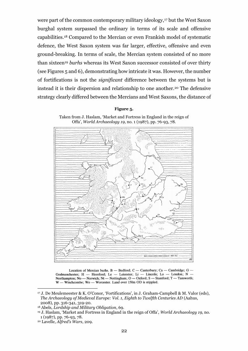
Figure 5. Location of Mercian burhs .................................................. 23
Figure 6. Map demonstrating the quasi-linear defences of the Burghal
Hidage fortifications ........................................................................ 25
Figure 7. Map showing the burhs of Edward the Elder (899-924) ............ 29
Figure 8. Map showing the extent of the Andredesweald in Anglo-Saxon
England .......................................................................................... 31
Figure 9. Demographic map of England according to Domesday ............. 32
Figure 10. Map showing the Roman Roads of South-East England .......... 34
Figure 11. Diagram showing the figure of eight defences at Burpham ....... 38
Figure 12. Viking Campaigns 892-3................................................... 39
Figure 13. Map of South-East England showing the location of burhs,
minsters, settlement, industries and resources ....................................... 41

4
Abbreviations
ASC Anglo-Saxon Chronicle: Cited by MS (where it differs from MS A),
annal year, corrected annal year and relevant page(s) from M.
Swanton (ed. and trans.), The Anglo-Saxon Chronicles (London,
2000).
EHD English Historical Documents Vol. 1: c.500–1042, ed. D.
Whitelock (London, 1955; 2nd edn, 1979).
Asser Asser, Vita Alfredi: trans. S.D. Keynes and M. Lapidge (eds),
Alfred the Great: Asser’s Life of King Alfred and Other
Contemporary Sources (Harmondsworth, 1983), cited by chapter,
relevant page(s).
Æthelweard, Chronicon Chronicon Æthelweardi: The Chronicle of
Æthelweard, ed. and trans. A. Campbell, Medieval Texts (London,
1962).
DB Greater Domesday Book: Domesday Book: A Complete
Translation, A. Williams and G.H. Martin (eds) (London, 2002),
cited by fol., relevant page(s).

5
Introduction
This dissertation seeks to establish a greater understanding of the series
of fortifications laid down by Alfred the Great (r.871-899) and his son Edward
the Elder (r.899-924) in the Kingdom of Wessex. This is will be achieved
through the study of Andredesweald region of south-east England and with
particular reference to the fortifications listed in the Burghal Hidage document
of the early tenth century. Alfred’s victory at Edington (878) presented the
opportunity for military reform in Wessex and a chance establish a defensive
system.1 These defences were significant in the establishment of the English
Kingdom which emerged under during hegemony of the West Saxons at this
time.2 The dissertation considers the wide range of associated historiography
with this phenomenon, using it to establish a fresh perspective and provide new
insights. However, the paper also reflects upon the interpretation of primary
material, both archaeological and written, made by previous scholarship as well
as suggesting novel interpretations. That said, it not only reviews this material
but also establishes a study in a geographical area relatively untouched in this
field, this being the zone between the North and South Downs in Sussex and
Surrey (see Figure 1).3 This will all be achieved while also considering the
context of the situation Alfred and Edward found themselves in, most notably
the ‘Viking Age’ (c.800–1066). It will assess the origin, development but also
the grand network of the burh fortifications, providing new insights particularly
in Chapter Three. Thus, Chapters One and Two are an essential review of the
burghal network, one that is required to put Chapter Three into context.
The issue of burh derivation is examined in Chapter One, the
dissertation rejecting the traditional notion that the West Saxon Kings, such as
Alfred, were exclusively responsible for the design of an effective fortification
used to counter the Viking threat. Instead, it corresponds with recent study that
emphasises the role of foreign culture in the design of the burh by the likes of
Stephen Bassett for example.4 However, Bassett’s work is very much based
1 R. Lavelle, Fortifications in Wessex, c.800-1066: The Defences of Alfred the Great Against
the Vikings (Oxford, 2003), 16. 2 P. Stafford, Unification and Conquest: A Political and Social History of England in the
Tenth and Eleventh Centuries (London, 1989), 31. 3 i.e. the Andredesweald. 4 S. Bassett, ‘Divide And Rule? The Military Infrastructure of Eighth and Ninth-Century
Mercia’, Early Medieval Europe 15 (2007), pp. 53-85, 58.

6
upon earlier ideas that developed in the 1980s that has re-emerged, particularly
the work of Jeremy Haslam and Richard Abels. Haslam is the first to highlight
the significance of eighth and ninth-century Mercian burhs as a prototype for
Alfred’s.5 This was soon followed up on by Abels in 1988, while also implying
that it was not only fortifications in Mercia that influenced those in Wessex but
also those in the West Frankish Kingdom.6 Bassett’s theses are drawn from
these works in light of the advance in archaeology in the last thirty years,
especially in what we know of the Mercian burhs.
Much of what Haslam and Abels discussed was directly linked to the
extensive archaeological excavation of burh sites, most notably Martin Biddle’s
excavations of Winchester in the 1960s/70s. Biddle’s chapter in The
Archaeology of Anglo-Saxon England seems to be the basis of this, but also a
5 J. Haslam, Early Medieval Towns in Britain c. 700 to 1140 (Aylesbury, 1985), 31. 6 R.P. Abels, Lordship and Military Obligation in Anglo-Saxon England (London, 1988), 68.
Most notably the fortified bridges of Charles the Bald in the 860s.
Figure 1.
Map showing the Andredesweald region studied in Chapter Three (highlighted area).
Modified from J. Baker & S. Brookes, Beyond the Burghal Hidage: Anglo-Saxon Civil
Defence in the Viking Age (London, 2013), 7.

7
foundation in the study of burh archaeology for the subsequent decades.7 Biddle
even refers to the archaeology of Anglo-Saxon towns as only a ‘recent
phenomenon’ and previous to this, historians were often limited to
documentation and topographical studies.8 That said, the scholarship and
debate on Anglo-Saxon towns commenced as far back as the 1930s between
James Tait and Carl Stephenson, both focusing on whether they even existed.9
This debate was heavily reliant of documentary sources, which is by no means
poor practice, though such studies predate the full establishment of the Burghal
Hidage text which is key to the historical study of the field.10
Derivation of the burh is by no means a thing of the distant past however.
Indeed, the late twentieth and early twenty-first centuries saw a new generation
of historians and archaeologists come into the academic eye, individuals who
would reassess previous work while establishing new theses. Academics such as
Bassett, Stuart Brookes, John Baker, Andrew Reynolds and Ryan Lavelle built
upon what previous scholars suggest while also engaging in an active dialogue
with their predecessors. A key argument that seems to have arisen from the likes
of Reynolds and Lavelle is that Alfred’s burhs may have been more original than
previously stressed by the likes of Abels and Haslam.11 Indeed, Lavelle suggests
that similar designs of fortification without collaboration can be applied to West
Frankia in the ninth century in reference to the burh.12 In similar pro-Alfredian
fashion, Reynolds suggests that Roman remains such as gateways were used
purely because of the practicality they offered, instead of them being an
inspiration to the West Saxons.13 This is logical and increasingly so following
7 M. Biddle, ‘Towns’ in D.M. Wilson (ed.), The Archaeology of Anglo-Saxon England
(London, 1976), pp. 99-150. 8 Biddle, ‘Towns’, 101. Referring to E.A. Freeman’s town/burh sketches of the 1870s. The
study had a keen interest with towns and the internal layout of Winchester, and in particular the arrangement of the streets.
9 Biddle, ‘Towns’, 100. See C. Stephenson, ‘The Anglo-Saxon Borough’, The English Historical Review, Vol. 45, No. 178 (Apr., 1930), pp. 177-207, and J. Tait, The Medieval English Borough: Studies on its Origins and Constitutional History (Manchester, 1936).
10 The full Burghal Hidage text was established as late as 1969. In addition to these works, there are some archaeological based publications from the 1930s, such as Helen Cam’s excavations at Cambridge and R.E.M. Wheeler’s assessment of London, though some of these post-date the initial publications of Tait and Stephenson. These localised archaeological studies multiplied in the middle of the twentieth century, culminating in Biddle’s work on Winchester. H.M. Cam, ‘The Origin of the Borough of Cambridge: A Consideration of Professor Carl Stephenson’s Theories’, Proceedings of the Cambridge Antiquarian Society, Vol. 35 (1935), pp. 33-53. R.E.M. Wheeler, London and the Saxons (London, 1935).
11 A. Reynolds, Later Anglo-Saxon England: Life and Landscape (Stroud, 1999), 86. 12 R. Lavelle, Alfred’s Wars: Sources and Interpretations of Anglo-Saxon Warfare in the
Viking Age (Woodbridge, 2010), 213. 13 A. Reynolds, Later Anglo-Saxon England, 90.

8
Haslam’s later work in 2006, in which he implies that the fortifications in the
Burghal Hidage were set up in a mere fifteen months.14 However, this
dissertation takes a more balanced stance between the two sides of the
argument. Chapter One will argue that even though practicalities were
important, as Reynolds suggests, it is hard to completely exclude any external
influence on the West Saxon burh.
The 1970s saw a reversal back to the written sources of Angl0-Saxon
towns and burhs. This was very much initiated by Henry Loyn and Nicolas
Brooks in 1971, suggesting that more could be learnt from studying
documentation alongside the new archaeological evidence.15 Due to this
reversal, there was an increased emphasis on the network of burhs rather than
the burh sites themselves.16 As stated, Chapter One will discuss the physical
characteristics of the fortifications whereas Chapter Two will look into the
aspect of the burhs as a fortified network of defence. Specifically, it will analyse
the structure and supply of this network in terms of military organisation. This
brings us back to the work of Haslam and Abels, but there are other significant
contributors such as Richard Hodges in 1989 for example. Although, Hodges
emphasised the role of the Anglo-Saxon wic or trading centre that pre-dates the
burhs of Wessex, using key examples such as Southampton.17 Hodges also
brings his idea of ‘The First English Industrial Revolution’ to the table, casting
a far more sociological view on the field.18 Instead of this, Abels seems to focus
on military organisation, suggesting that this was the real ‘genius’ of Alfred’s
fortifications.19 The contribution of Haslam’s work to the field should not be
forgotten though. With numerous articles concerning the origins of Anglo-
Saxon urban sites as well as many book contributions, Haslam is an invaluable
contributor.
14 J. Haslam, ‘King Alfred and the Vikings: Strategies and Tactics 876-886 AD’, Anglo-Saxon
Studies in Archaeology and History 13 (Oxford, 2006), pp.122-154, 129. 15 P. Clemoes & K. Hughes (eds), England Before the Conquest: Studies in Primary Sources
Presented to Dorothy Whitelock (Cambridge, 1971). See Loyn’s chapter on Anglo-Saxon towns and Brooks’ chapter on military obligation.
16 However, there were still archaeological reports such as Biddle’s piece on 1976 but also other ones such as that by J.M. Hassall and David Hill in 1970. Hassall and Hill’s article is particularly interesting as it is one of the few dedicated studies to the influence of Frankia or Mercia on the West Saxon burhs. J.M. Hassall & D. Hill, ‘Pont de L’Arche: Frankish Influence on the West Saxon Burh?’, The Archaeological Journal 127 (1970), 188-194.
17 R. Hodges, The Anglo-Saxon Achievement: Archaeology and the Beginnings of English Society (London, 1989), 147-8.
18 Hodges, The Anglo-Saxon Achievement, 150 fd.. 19 Abels, Lordship and Military Obligation, 74.

9
Historiography associated with Chapter Two seems to have continued
into the 1990s, particularly in Hill’s and Alexander Rumble’s publication The
Defence of Wessex.20 This study not only consolidated work previous to it, but
also assessed the textual difficulties posed by the Burghal Hidage document.21
In particular, this dissertation utilises Brooks’ chapter on the administrative
background of the Burghal Hidage when examining the fortification system
set-up by Alfred.22 Brooks highlighted the importance of the ‘common burdens’
to Alfred’s system but also stresses how these where not Alfred’s innovation, but
rather the end of a long tradition of military organisation.23 This argument is
central to the study of the burghal system and is expanded upon in this
dissertation, arguing that even though Alfred had this pre-existing system at his
feet, he exploited it to great effect.
Other recent scholars such as Bassett reiterate the points made by Abels
and Haslam in the 1980s, particularly that the West Saxon burhs had a
prototype in Mercia. This is fully emphasised in Bassett 2007 publication
‘Divide And Rule?’, in which he assesses new evidence for the presence of a
sophisticated system of fortified defence in eighth and ninth-century Mercia.24
Chapter Two has been dedicated to the assessment of the Burghal Hidage
defence network and poses the question whether a previous Mercian system can
really be seen as a substantial prototype. Chapter Three examines the
Andredesweald in terms of the burghal network also, arguing that it was by no
means perfect, it had areas of defensive weakness.
The most recent substantial works based around the study of Anglo-
Saxon fortifications have to be Baker and Brookes’ Beyond the Burghal
Hidage,25 as well as Landscapes of Defence which is edited by the previous two
20 D. Hill & A.R. Rumble (eds), The Defence of Wessex: The Burghal Hidage and Anglo-
Saxon Fortifications (Manchester, 1996). 21 J. Blair, ‘The Defence of Wessex: The Burghal Hidage and the Anglo-Saxon Fortifications’,
review of The Defence of Wessex: The Burghal Hidage and the Anglo-Saxon Fortifications, by D. Hill & A.R. Rumble (eds), The English Historical Review, Vol. 113, No. 454 (Nov., 1998), pp.1263-1264, 1263.
22 N.P. Brooks, ‘The Administrative Background of the Burghal Hidage’, in D. Hill & A.R.
Rumble (eds), The Defence of Wessex: The Burghal Hidage and Anglo-Saxon Fortifications
(Manchester, 1996), pp. 128-150. 23 Brooks, ‘Background of the Burghal Hidage’, 129 24 S. Bassett, ‘Divide And Rule? The Military Infrastructure of Eighth and Ninth-Century
Mercia’, Early Medieval Europe 15 (2007), pp. 53-85, 58. 25 J. Baker & S. Brookes, Beyond the Burghal Hidage: Anglo-Saxon Civil Defence in the
Viking Age (London, 2013).

10
authors alongside Reynolds.26 Baker and Brookes’ study assembles all past
scholarship in reference to Anglo-Saxon fortifications in general, rather than
limiting itself to those included in the Burghal Hidage. However, they do
challenge some widely accepted models for the development of the West Saxon
burhs. An example would be their divergence from Biddle’s thesis that the
streets of Winchester were laid-down in a single phase of operation.27 The book
also makes a case study of the Kentish area in the south-east of England which
has much logical motive because of its exclusion from the Burghal Hidage
document.
For similar reasons, this dissertation will examine the Sussex and Surrey
Andredesweald as it was not included in the Burghal Hidage or in the burghal
system in general. Unlike Kent however, this area does not contain any sort
West Saxon fortification whereas Kent’s defences were simply not included in
the system. Thus, the study of Chapter Three and indeed the main thesis of this
dissertation is fixed around this absence of burghal defence in the Weald. From
this, more general conclusions can be made about the burghal system as a
whole, conclusions that shed new insight on the primary function of Alfred’s
defensive system. It will argue that the system’s primary motive was the defence
of the West Saxon population.
However, this dissertation will not rely solely upon secondary works but
will actively engage with contemporary source material as well as
archaeological excavations to achieve its goals. Of course, this period does lack
extensive documentation compared to more modern times, even that of the
later medieval periods. This dissertation particularly utilises the Anglo-Saxon
Chronicle and Asser’s Life of King Alfred, although other written sources such
as Domesday Book and contemporary charters will be employed also. Each of
these has their own particular advantages and drawbacks concerning their
dependability and worth, elements of which will be discussed throughout the
paper where appropriate.
26 A. Reynolds, J. Baker & S. Brookes (eds), Landscapes of Defence in Early Medieval Europe
(Turnhout, 2013). 27 Baker & Brookes, Beyond the Burghal Hidage, 68. See Chapter One for this.

11
Chapter One: The Burhs of Wessex
Before c.850 there were no more than ten known burhs but by the next
century there were over one hundred,1 clearly this reflects an urban building
programme. Much of this has been accredited to Alfred the Great’s (r.871-899)
building programmes, though more credit should be given to his successors.2
There appears to have been a great deal of external influence on the burhs in
terms of their physical design and purpose.3 This chapter will analyse the
remaining physical evidence for the burhs and relate the archaeology back to
ideological concepts. This background study into to the purpose of the West
Saxon burhs will prove essential when examining the burghal network in
Chapter Two and indeed Sussex/Surrey region in Chapter Three.
The first recorded burhs are the rebuilt Roman towns and forts such as
at Winchester, Chichester and Portchester and there is evidence that such
places had been occupied as early as the seventh century.4 The best evidence for
the internal layout of these towns comes from the rebuilt Roman town of
Winchester, due to its extensive excavation and its characterisation for most
West Saxon sites.5 However, it must be said that Winchester does not provide a
model for all sites as not all burhs had such an urban function, notably the
promontory forts. Though, Winchester does provide a model for the de nova
(Latin for “afresh”) burhs built during Alfred’s reign, the most notable of which
are Cricklade, Wallingford and Wareham. This chapter will analyse the physical
and written evidence for the West Saxon burhs while relating the evidence back
to the common defensive ideology.
At Winchester the main Roman streets seem to have been kept while
additional branch roads have been added. The site shows a clear rectilinear
arrangement in the street layout which was used to divide the area lying within
the old Roman walls.6 This suggests a reuse of the Roman streets, but following
1 Hassall & Hill, ‘Pont de L’Arche’, 188. 2 Hodges, The Anglo-Saxon Achievement, 154. 3 W. Hollister, Military Institutions on the Eve of the Norman Conquest (Oxford, 1962), 142. 4 Baker & Brookes, Beyond the Burghal Hidage, 55. 5 Biddle, ‘Towns’, 131. 6 Biddle, ‘Towns’, 130.

12
Martin Biddle’s archaeological work in the 1960s and 1970s it appears that the
street system is of the Alfredian era.7 That said, later archaeological work by
Graham Scobie suggests that the period in which Biddle and Hill have suggested
the street-plan was laid out is too short and was more staged.8 The main
thoroughfares of the Roman town seem to have been reused in Alfred’s ninth-
century street-plan.9 The medieval high-street is only sixteen metres north of
the original Roman east-west street and there is also a correlation between what
is now Middle Brook Street and the original Roman north-south thoroughfare
(see numbers 6 and 9, Figure 2).10 The gateways were already in suitable
positions, near ditch causeways and river crossings.11 Other examples where the
Roman street systems were ignored include Canterbury and Bath. At
Canterbury, the Saxon east-west street cuts diagonally across the old Roman
street system12 and at Bath the temple and bath complex is ignored by a totally
new street (see Figure 2).13 Despite these few examples, the street pattern is
‘remarkably consistent’ in this rectangular fashion, throughout the fortified
7 Reynolds, Later Anglo-Saxon England, 89. 8 Baker & Brookes, Beyond the Burghal Hidage, 68-9. See to the west of the city at St Georges
Street and urban reorganisation c.840-80. 9 Biddle, ‘Towns’, 130. 10 Biddle, ‘Towns’, 107. 11 M. Biddle & D. Hill, ‘Late Saxon Planned Towns’, The Antiquaries Journal, Vol. 51 (1971),
pp.70-85, 81. 12 Biddle, ‘Towns’, 109. 13 Biddle & Hill, ‘Planned Towns’, 81.
Figure 2.
Maps showing the street layouts of
Saxon Winchester and Bath in
contrast to the excavated Roman
system. Taken from M. Biddle & D.
Hill, ‘Late Saxon Planned Towns’, The
Antiquaries Journal, Vol. 51 (1971),
pp. 70-85.
Roman Streets and Features red

13
towns of Wessex.14 Two key features of this system were the ‘crossroad’ of the
main thoroughfares,15 and the ‘wall’ street. The former were maintained due to
the practicality of using the Roman gateways in the rebuilt towns, rather than
as an attempt to revive the older Roman road system.16 The latter is more
significant as it is an addition to the concept of the Roman street system.17 The
‘wall’ street followed the internal walls of the burh, allowing speed of access to
the fortifications, their presence suggests a real military purpose of these rebuilt
towns, even if only preliminary.18 As for the other streets, the existing Roman
streets were maintained where usefully situated but remodelling was employed
in other areas.
The walls of the rebuilt Roman towns ‘were probably still standing
sufficiently high above ground to require no more than repairs to their
stonework’,19 when Alfred began their reconstruction in the late ninth century.
However, their reconstruction may have started even as early as 860 during the
reign of Æthelbald (r. 858 to 860).20 According to the contemporary chronicler
Æthelweard, the Romans ‘made cities, forts, bridges and streets with skill, and
these are to be seen to this day’.21 Written sometime in the late tenth-century,
the fact these structures still appeared to be made ‘with skill’ suggests that they
were still in decent condition and not just ruins. Naturally, this cannot be
applied to every remaining Roman town or fort. According to Asser’s extended
Chronicle entry for 867 the city of York ‘did not yet have firm and secure
walls’,22 when the Vikings raided it, despite the fact Roman walls had been
present. Though York was in the Northumbrian Kingdom, this reference
demonstrates that not all Roman fortifications were fully intact during the ninth
and tenth centuries. In Colchester, Canterbury, Winchester, Chichester and
Exeter the medieval walls follow the exact path of the previous Roman ones.23
Indeed, the first five metres of stonework at the Westgate in Winchester appears
14 Biddle, ‘Towns’, 131. 15 M. Welch, Anglo-Saxon England (London, 1992), 128. 16 Reynolds, Later Anglo-Saxon England, 90. This is a well-considered point bearing in mind
that these fortified towns were constructed in order to protect local populations. Creating new gateways would have proved a lengthy and pointless commission in times of vulnerability from Viking raids.
17 Haslam, Early Medieval Towns, 22. 18 Biddle, ‘Towns’, 130. 19 Biddle, ‘Towns’, 127-8. 20 Baker & Brookes, Beyond the Burghal Hidage, 69. 21 Æthelweard, Chronicon, 5. 22 Asser, ch.27, 76. 23 Biddle, ‘Towns’, 107. Also London and Lincoln outside of Wessex.

14
to be Anglo-Saxon, which suggests that the Roman gate was rebuilt.24 This may
also be true for Chichester’s Eastgate and Exeter’s Southgate.25 Despite this,
during Alfred’s reign there is little evidence for any major refurbishment of the
Roman defences,26 which would suggest the walls were intact enough to be
effectively defended.27
The first series of new burhs constructed, namely those during Alfred’s
reign, imitated these old Roman forts and towns with their impressive
geometry.28 These de nova burhs are particularly interesting as they
demonstrate the concept of a fortified settlement from the West-Saxon
perspective.29 Compared to the rebuilt Roman towns, the de nova burhs are
much more obscure however, as they consisted of earth walls and ramparts,
with stone walls rather a later addition.30 The clearest evidence for this is at
Wareham where the original West-Saxon rampart survives to this day. Haslam
states that the defences of these sites included a wooden palisade.31 Though
evidence for this is limited,32 it is not unreasonable to suggest that there were
wooden palisades used to support the rampart,33 which were probably the
24 Biddle, ‘Towns’, 128. 25 Biddle, ‘Towns’, 128. 26 Biddle, ‘Towns’, 127. 27 Baker & Brookes, Beyond the Burghal Hidage, 63. See site at Malmesbury where there is no
evidence for Alfredian refortification despite being included in the Burghal Hidage. 28 Lavelle, Fortifications in Wessex, 33. 29 Reynolds, Later Anglo-Saxon England, 90. 30 Biddle, ‘Towns’, 128. 31 Haslam, Early Medieval Towns, 31. 32 Biddle, ‘Towns’, 128. 33 Lavelle, Fortifications in Wessex, 19. Though local variations did exist.
Figure 3.
Diagrams demonstrating the distinct similarities between Roman
ramparts (3.1) and those of Wessex (3.2). Taken from A. Johnson, Roman
Forts (London, 1983), 54 and R. Lavelle, Fortifications in Wessex c.800-
1066: The Defences of Alfred the Great Against the Vikings (Oxford,
2003), 19 respectfully.
3.1 3.2

15
standard.34 They would also act as a ten foot vertical face, supporting the
sloping earth rampart and presenting a formidable barrier externally (see
Figure 3.2).35 At Wareham, from the base of the ditch to the top of the palisade
was about nine feet, presenting a daunting barrier to enemies.36
The defences of these sites were not limited to ramparts and palisades;
in many places they were far more sophisticated.37 At Cricklade and Lydford,
there is some evidence for a palisade and clearer indication of impressive triple
ditch-systems.38 The concentricity of multiple ditches seem to recall the
sophisticated systems used by the Romans,39 used to break up enemy
formations as well as to slow their advance. One of the most complex was at
Cricklade where the triple ditch-system surrounded the site in combination
with the River Thames, stressing its importance in the defence of the northern
border.40 Remarkable is the fact that Roman forts and fortified towns employed
a similar tactic, which is to increase the number of ditches in areas of greater
anticipated hostility.41 While this need not have been the case for the West
Saxons, it is hard to overlook the similar characteristics.42 Though the walls of
Roman sites would still be mostly intact, the same cannot be said for ditches
that would be at least five-hundred years old. While their trajectories may still
have been visible, their exact measurements were almost certainly not.
However, there is evidence for the use of an Iron Age/Roman ditch at
Winchester,43 though this was in addition to the Saxon defences which would
suggest that it was not fully intact. Thus, these ditches may have inspired the
West-Saxon earthworks but are not likely to have been copied directly either
34 Lavelle, Fortifications in Wessex, 35. 35 Lavelle, Fortifications in Wessex, 35. 36 B.S. Bachrach & R. Aris, ‘Military Technology and Garrison Organization: Some Observations
on Anglo-Saxon Military Thinking in Light of the Burghal Hidage’, Technology and Culture, Vol. 31, No.1 (Jan., 1990), pp.1-17, 4.
37 Haslam, Early Medieval Towns, 31. 38 Haslam, Early Medieval Towns, 31. 39 Biddle, ‘Towns’, 129. 40 Lavelle, Fortifications in Wessex, 33. See Chapter Two in reference to the quasi-linear
defences of the burghal network on the Mercian frontier. 41 G. Webster, The Roman Imperial Army (London, 3rd edn, 1985), 176-9. 42 Webster, Imperial Army, 177. For a typical Roman ditch, the width would be three to four
metres wide at the top and two to two-and-a-half metres deep. Correspondingly, the ditches of the de nova burhs of Wallingford and Cricklade were around 3.6 metres wide and 1.9 metres deep. Baker & Brookes, Beyond the Burghal Hidage, 76. The depths almost match up suggesting a direct inspiration but this is probably limited.
43 K.E. Qualmann et al., Oram’s Arbour: The Iron Age Enclosure at Winchester, Volume 1: Investigations 1950-1999 (Winchester, 2004), 95.

16
from the Roman ruins or Iron Age hillforts. This is important when considering
the context in which these fortifications were built.44
The internal layouts of these towns is harder to decipher than the
defences due to later developments on the same sites. Haslam has suggested
that the lack of internal layout evidence itself may suggest that such sites failed
to function as urban centres in this design.45 What we do know is that they
followed a similar pattern to the rebuilt Roman sites, a rectilinear street layout
with two main thoroughfares.46 However, smaller fort sites such as Shaftsbury
or Malmesbury cannot be included in this model due to the harsh topography
of these sites.47 ‘At Wareham, Wallingford, and Cricklade, new burhs were built
adopting an innovative design imitating Roman towns … based on a similar,
regular geometric plan, comprising a central road crossing’ (see Figure 4).48
Some of these original plans are reflected in the modern street layout of the
surviving burh towns but the burghal forts were not internally organised
regularly due to their limited size.49 The incorporation of ‘wall’ streets, as we
saw in as additions to the rebuilt burhs, appear to be a common feature of the
44 See Chapter Two. 45 Haslam, Early Medieval Towns, 24. 46 Biddle & Hill, ‘Planned Towns’, 82-3. 47 Biddle & Hill, ‘Planned Towns’, 81. 48 Baker & Brookes, Beyond the Burghal Hidage, 6. 49 Biddle, ‘Towns’, 126.
Figure 4.
Maps showing the rectilinear Street and defensive layouts of Cricklade and
Wareham. Taken from M. Biddle & D. Hill, ‘Late Saxon Planned Towns’, The
Antiquaries Journal, Vol. 51 (1971), pp. 70-85.

17
de nova burhs.50 These show the duel-purpose of the burh settlements as not
just urban foci but also as military centres.51 The internal division also shows an
economic function with certain areas specialising in certain industries.52 That
said, more recent empathises is put on the development of the burhs into
economic centres, particularly in the later tenth century.53
These new burhs were all constructed near key strategic positions which
would include a flat river crossing or a spur site.54 Of the thirty-eight burhs
recorded in the Burghal Hidage, twenty-two of them were on river crossings,55
stressing their strategic importance.56 They were also set to the location of
available water for the use in industrial activities.57 Those associated with river
crossings included Cricklade and Wallingford and examples of spurs sites
would include Malmesbury, Lydford and Shaftsbury.58 The use of ‘natural
topography, such as the bend in a river or promontory, allowed the construction
of a highly defensive site’.59 Positions such as Malmesbury and Shaftsbury
essentially became new hillforts.60 The sites that used such defensive landscape
features had a more restricted plan/layout compared to those on flat river
valleys.61 However, even those burhs had topographical limitations to their
design and size, forced to sub-react to the landscape.62 This is seen at Wareham
and Wallingford, where the defences were not quite so rectilinear, compared
with Cricklade’s for example (see Figure 4).63 More on topography in terms the
network of West Saxon burhs will be discussed in the subsequent chapter.
The burhs were by no means limited to the reign of Alfred, his successors
played an important role in their evolution and the construction of others.
Indeed, historians have tended to neglect the burhs in southern England
between the reigns of Edward the Elder (r.899-924) and Æthelred ‘the
50 Biddle, ‘Towns’, 130. 51 Haslam, Early Medieval Towns, 31. 52 Biddle, ‘Towns’, 131. 53 G. Astill, ‘Community, Identity and the Later Anglo-Saxon Town: The Case of Southern
England’, in W. Davies, G. Halsall & A. Reynolds (eds), People and Space in the Middle Ages (Turnhout, 2006), pp.235-254, 236.
54 Haslam, Early Medieval Towns, 31. 55 Lavelle, Fortifications in Wessex, 28. Again similar to Roman principles. 56 Also possibly their economic function. 57 Biddle, ‘Towns’, 133. 58 Haslam, Early Medieval Towns, 31. 59 Lavelle, Fortifications in Wessex, 33. 60 Lavelle, Fortifications in Wessex, 33. 61 Welch, Anglo-Saxon England, 128. 62 Hassall & Hill, ‘Pont de L’Arche’, 191. 63 Hassall & Hill, ‘Pont de L’Arche’, 191. Here is where Hassall and Hill have questioned the
prevalence of rectangular design in West Saxon fortifications.

18
Unready’ (978-1013 and 1014-1016).64 Lavelle has emphasised the tension
between urban life and the military requirements of the burhs.65 This followed
the expansion of the West Saxon kingdom in the tenth century,66 which put the
southern burhs on a far more economic footing as they saw less and less
conflict. This is evident in Winchester with suburban growth outside the
Westgate in the second half of the tenth century,67 with similar evidence at
Oxford.68 Previous archaeology has shown that it was by the mid-ninth century
that people started to re-settle the Roman walled towns such as Winchester and
Canterbury for protection against the Vikings.69 However, archaeological work
by Grenville and Astill has found that several large areas of burhs remained
undeveloped even into the tenth century.70 Single coin finds as well as a lack of
international pottery shows that the burhs ‘did not prompt an immediate
explosion in economic growth’.71 This was not consistent in every burh
settlement however, during Æthelstan’s reign (r. 924-939) there is a clear
commercialisation of the burhs shown through the regulation of Channel trade
for example.72 This is also shown in the abandonment of certain sites such as
Pilton for more economically desirable ones such as Totnes and Barnstaple
(Devon).73 There is also a clear attempt to upgrade the burh settlements to stone
fortifications in the late tenth century.74
Edward the Elder and those who reigned after him participated in a
programme of urban foundation that surpassed that of Alfred’s in terms of
innovation.75 This included the use of the ‘double burh’, the earliest of which
appears during Alfred’s reign at (or near) Hertford in 894 at which Alfred ‘made
two fortifications on the two sides of the river’.76 Such structures demonstrate a
variety of other influence from other cultures as the ‘double burhs’ that have a
64 Lavelle, Fortifications in Wessex, 40. 65 Lavelle, Fortifications in Wessex, 40. 66 Stafford, Unification and Conquest, 24. Especially with the death of Æthelflaed (918) and
the unification of Merica and Wessex under Edward the Elder and especially under his son Æthelstan (c.894-939) in 925.
67 Biddle, ‘Towns’, 133-4. 68 Welch, Anglo-Saxon England, 128. 69 Hodges, The Anglo-Saxon Achievement, 148. 70 Baker & Brookes, Beyond the Burghal Hidage, 89-90. Namely Gloucester, Cricklade,
Wallingford, London and Canterbury. 71 Baker & Brookes, Beyond the Burghal Hidage, 90. The growth of the Five Boroughs in the
Danelaw possibly shows that trade was more internal than external. 72 Baker & Brookes, Beyond the Burghal Hidage, 90. 73 Biddle & Hill, ‘Planned Towns’, 84. 74 Lavelle, Fortifications in Wessex, 35. 75 Hodges, The Anglo-Saxon Achievement, 154. 76 ASC, 895 (s.a. 894), 89.

19
clear derivation from Charles the Bald’s structures in ninth-century West
Frankia as well as some Scandinavian structures.77 The later ‘double burhs’
would include Buckingham (918), Bedford (919), Stamford (922) and
Nottingham (924).78 However, Hassall and Hill have pointed out that some of
these were relatively close to river sources and traversed small streams which
would not support the strategy to block Viking incursions up rivers.79 On the
other hand, many of Edward’s new burhs were placed across river mouths or
estuary heads which practice this exact tactic.80 Such a tactic is reflected not
only on a local scale but also in terms of the whole burghal network.
A variety of settlements can be labelled as burhs in the West Saxon
Kingdom during the ninth and tenth centuries. The first of which were the
rebuilt towns and forts left behind by the Romans in the first half of the
millennium. With substantial fortifications remaining and ideally placed in the
landscape, these places once again became important centres of authority and
of the economy.81 It is off these that the de nova burhs were ultimately based
when one reviews the archaeological remains, verifying the very Roman sway
on the West Saxon burhs. The other class of fortifications found in Wessex were
the promontory forts which are far more significant in terms of the system as a
whole.82 Other cultural influence has been observed in the West Frankish
‘double burh’ possibly providing a prototype for those in Wessex. However,
Mercian principles of defence clearly had a profound effect of West Saxon
burhs. However, the next chapter will argue that their influence was far more
important in terms of the administration of the network as a whole, the Burghal
Hidage.
77 See the D-shaped fortification at Repton, Derbyshire in 873/4. 78 M. Swanton (trans.) (ed.), The Anglo-Saxon Chronicles (London, 2000), 89, n. 8. 79 Hassall & Hill, ‘Pont de L’Arche’, 191. The water courses not being substantial enough to
support Viking ships. 80 Haslam, Early Medieval Towns, 38. 81 Lavelle, Fortifications in Wessex, 33. 82 See Chapter Two below.

20
Chapter Two: The Defence of the Kingdom: The
Burghal Hidage
The Burghal Hidage document is what gives historians some idea of the
scale of the administration required to defend the West Saxon Kingdom.1 It is a
list of over thirty burhs and the hidage figures associated with them to arrange
for their maintenance, repair (wealstilling) and defence (waru).2 Written down
in the early tenth century, the purpose and authorship of the Burghal Hidage
is contested, though it is certainly either a practical administrative document or
a paper exercise.3 However, this chapter is by no means a repetition of
numerous assessments made on the origin of the document but an examination
of the practical administration of the burghal network itself in preparation for
Chapter Three. It will look into organisation of the defence of the West Saxon
Kingdom and argue that this was the real achievement of Alfred and his
successors, not the burh fortifications themselves.
That said, the ‘construction or repair of fortifications as a defence against
Vikings was not a new policy in the reign of Edward the Elder, or even Alfred’.4
Burhwork or burhbot had been a general obligation throughout Anglo-Saxon
England, not just Wessex and not just on the underprivileged landowners.5 In
September 822 for example (forty-nine years before Alfred’s accession),
Ceolwulf I, King of Mercia granted Archbishop Wulfred land that was …
… to remain freed everywhere for ever from all burdens … except from these four causes which I [Ceolwulf] will now name: military service against pagan enemies, and the construction of bridges and the fortifications or destruction of fortresses among the same people6
Many Anglo-Saxon charters, and even ones that predate this one, contain such
a clause in the agreement suggesting that even well before Alfred’s reign
burhbot was a traditional burden, one of the three ‘common burdens’. These
1 Lavelle, Fortifications in Wessex, 18. 2 Brooks, ‘Background to the Burghal Hidage’, 128. 3 Brooks, ‘Background to the Burghal Hidage’, 128. 4 Brooks, ‘Background to the Burghal Hidage’, 129. 5 Brooks, ‘Background to the Burghal Hidage’, 129. 6 EHD, 515.

21
were as named above: service in the army, burhwork and bridgework. The
traditional view is that Alfred was at the forefront of implementing the ‘common
burdens’, though more recent study by the likes of Bassett among others has
challenged this, assigning more credit to their Mercian counterparts as well as
Alfred’s son Edward the Elder.7 Indeed, by the end of even the eighth century,
the ‘common burdens’ or ‘threefold obligations’ were widespread throughout
Mercia and were a key factor in their hegemony in that era (c.600-c.900),8 a
fact that was not lost on Alfred or his successors.9 It was an ‘embryonic burghal
system’,10 a ‘prototype’ for Alfred’s Burghal Hidage system of the late ninth
century.11 This is down to the ‘morphological similarities in the construction of
these defence works [which] has been used to suggest they existed … in a
network of fortified places, akin to that described by the Burghal Hidage’.12
Recent work by Lavelle appears to concur with Bassett’s notion though
Lavelle seems to favour the idea that ‘none of these periods of development are
necessarily mutually exclusive’.13 This is to say that there were no distinct
phases of redevelopment, but rather that the Mercian and West Saxon
kingdoms developed their similar defensive organisation in parallel but
undoubtedly at different rates and in different technological directions. Indeed,
by looking at certain charters, we can assume that by the reign of Æthelbald
(r.858-860), the common burdens were fully integrated throughout the
Kingdom of Wessex.14 Though this is later than in Mercia, we cannot assume
that these charters represent the first use of the system however, which could
push the date back as far as the eighth century.15 Though what is clear is that by
the tenth century, over eighty percent of West Saxon charters contained such
obligations.16
Although the Burghal Hidage had its origins in the ‘common burdens’,
the system also presents some quite innovative features. Fortification systems
7 Welch, Anglo-Saxon England, 125. 8 Bassett, ‘Divide And Rule?’, 58. 9 Baker & Brookes, Beyond the Burghal Hidage, 49. 10 Bassett, ‘Divide And Rule?’, 84. 11 Bassett, ‘Divide And Rule?’, 58-9. Though Bassett does rightfully question whether the
Mercian system has been exaggerated in this sense. 12 Baker & Brookes, Beyond the Burghal Hidage, 49. 13 Lavelle, Alfred’s Wars, 212. 14 Brooks, ‘Background to the Burghal Hidage’, 129. 15 Brooks, ‘Background to the Burghal Hidage’, 129. 16 Baker & Brookes, Beyond the Burghal Hidage, 44.
22
were part of the common contemporary military ideology,17 but the West Saxon
burghal system surpassed the ordinary in terms of its scale and offensive
capabilities.18 Compared to the Mercian or even Frankish model of systematic
defence, the West Saxon system was far larger, effective, offensive and even
ground-breaking. In terms of scale, the Mercian system consisted of no more
than sixteen19 burhs whereas its West Saxon successor consisted of over thirty
(see Figures 5 and 6), demonstrating how intricate it was. However, the number
of fortifications is not the significant difference between the systems but is
instead it is their dispersion and relationship to one another.20 The defensive
strategy clearly differed between the Mercians and West Saxons, the distance of
17 J. De Meulemeester & K. O’Conor, ‘Fortifications’, in J. Graham-Campbell & M. Valor (eds),
The Archaeology of Medieval Europe: Vol. 1, Eighth to Twelfth Centuries AD (Aahus, 2008), pp. 316-341, 319-20.
18 Abels, Lordship and Military Obligation, 69. 19 J. Haslam, ‘Market and Fortress in England in the reign of Offa’, World Archaeology 19, no.
1 (1987), pp. 76-93, 78. 20 Lavelle, Alfred’s Wars, 209.
Figure 5.
Taken from J. Haslam, ‘Market and Fortress in England in the reign of Offa’, World Archaeology 19, no. 1 (1987), pp. 76-93, 78.

23
the forts to every position in the kingdom of forty miles is not matched in
Mercian arrangement.21 Contrastingly, from what we know, the Mercian sites
seemed only to really cover the traditional heartlands of the kingdom,22 whereas
the West Saxon system is far more dispersed being within forty miles of every
point in the kingdom. However, the West Saxon system failed to achieve this on
occasion, an example of which will be discussed in Chapter Three.
The dispersion of the West Saxon burhs compared to those of Mercia
suggests a different defensive strategy was used by the West Saxons, namely
defence-in-depth.23 Very similar to that employed by the Romans,24 this system
was innovative in comparison to Wessex’s contemporaries across northern
Europe. Whereas the Mercian and Frankish models focused on defending the
borders of their respective territories or just the central royal centres of each
region, the West Saxon system endeavoured to defend the whole interior of the
kingdom.25 The prime example would be Offa’s Dyke of Eighth-century Mercia
under King Offa (r. 757-796) which followed the Mercian-Welsh border.26 It is
even questionable to whether the Mercian fortifications operated in a cohesive
system but were rather just individual strongholds.27 This made them far more
effective in repelling Vikings as from the late ninth century their raids had been
targeting royal estate centres, penetrating the Kingdom in order to seize
renders.28 An example of this is action was in 914 with the raid of Ohter and
Hroald in Kent who were intercepted despite avoiding the burhs upon
infiltration.29 By placing the burhs on key lines of communication: Roman
roads, track-ways and rivers, Alfred and his successors were able to protect their
kingdom effectively on both its borders and internal landscape.30 That said, the
system does still display traditional ideals of linear border defence. Of those
burhs founded by Alfred and Edward in the late ninth and early tenth centuries,
a clear defensive line in the north of the West Saxon kingdom is evident (see
21 Baker & Brookes, Beyond the Burghal Hidage, 52. 22 Modern day Glos., Heref., Oxon., Worcs., Warks., Staffs., West Midlands, Northants.,
Bucks., Beds., Herts., and Cambs.. 23 Baker & Brookes, Beyond the Burghal Hidage, 86. 24 Bachrach & Aris, ‘Military Technology and Garrison Organization’, 3. Though the
suggestion that Anglo-Saxon commanders had ‘a well-developed sense of strategy that may have been based on Roman ideas of the later empire’ is perhaps stretching the evidence.
25 Lavelle, Fortifications in Wessex, 26. 26 D. Tyler, ‘Offa’s Dyke: a historiographical appraisal’, The Journal of Medieval History, Vol.
37, pp.145-161, 153. 27 Baker & Brookes, Beyond the Burghal Hidage, 49. 28 Lavelle, Fortifications in Wessex, 26. 29 Abels, Lordship and Military Obligation, 72. 30 Abels, Lordship and Military Obligation, 69.

24
Figure 6).31 Though not a linear structure per se, such as a dyke, the sites do
form a linear network that sat on the Wessex-Mercia border of which a similar
line stretches along the southern coast to repel the Viking threat. However,
these linear border systems were only a portion of the entire defence network,
it is the others (the internal burhs) which really demonstate the ingenuity of the
Alfred and Edward. Portchester has been included in this linear system though
was probably a later addition as it comes into royal possession during the reign
of Edward the Elder.32
As Figure 6 clearly demonstrates, the burghal system was by no means
assigned to defending just the borders of Wessex. There are certainly at least
nine or ten that one could label as ‘inland’ sites rather than being placed on the
coast or on the borders of the kingdom.33 These include both fortified towns
such as Winchester or Bath but also promontory forts like Eashing or Lydford.
31 Reynolds, Later Anglo-Saxon England, 87. 32 Haslam, ‘King Alfred and the Vikings’, 144. 33 Namely: Lydford, Lyng, Langport, Shaftesbury, Wilton, Winchester, Eashing, Chisbury, and
Bath. Possibly Halwell, Axbridge or even Eorpeburnan. Buckingham not included as it was in the Burghal Hidage as it had recently been occupied by Edward the Elder (c.914), an expansion of the original system.
Figure 6.
Map demonstrating the quasi-linear defences of the Burghal Hidage fortifications. Modified from
Baker & Brookes, Beyond the Burghal Hidage: Anglo-Saxon Civil Defence in the Viking Age
(Leiden, 2013), 7. Red lines are the individual additions.

25
The Burghal Hidage document fails to reveal this variety in burh fortification,34
the list only representing their rough location in terms of a clockwise pattern
throughout the kingdom.35 This is a considerable limitation when assessing the
individuality of the Burghal Hidage document as the variety of burhs
mentioned within it was actually one of its key innovative features.
As shown in Chapter One, the fortifications were by no means just
limited to just proto-urban fortifications and fortified towns but it also included
promontory forts,36 and perhaps even beacons (though evidence for the latter
is scarce).37 This distinction has been neglected in past studies where it should
not have been.38 Though not defending a civilian population or valuable
resource, these smaller defensive sites were important to the whole network as
they were situated on keys lines of communication that even enemy units would
have used. It is because of this function that this study will examine the absence
of burh fortifications in central Sussex. Being built in these key locations, they
allowed garrisons to combine to defeat enemies quickly and effectively, possibly
assembling in only half a day.39 Brooks highlights these so-called ‘emergency
burhs’ as one of the unique features of the West Saxon system which can only
be seen terms of the Burghal Hidage as a whole.40 In reference to the beacons,
these may appear as relatively rudimentary but as a beacon system this is less
so.41 These beacons would not be simply placed at the highest points in the
landscape, in fact, they would have been carefully positioned to view entire
valleys and placed to circumvent large hills/mountains.42 With the first being
lit on the coast in times of attack, the system would start a chain-reaction that
would give the rural populace time to seek refuge in the closest burh as well as
warning the garrisons nearby.43 These beacons needed to be kept dry at all times
with plenty of wood stockpiled in preparation for an attack, the men manning
them would have to well drilled and steadfast for the system to be effective.44
34 Biddle, ‘Towns’, 126. 35 Lavelle, Alfred’s Wars, 211. This pattern was very much the norm when it came to listing
fortification circuits for the Anglo-Saxons. 36 Such as Malmesbury or Shaftsbury for example. 37 D. Hill & S. Sharp, ‘An Anglo-Saxon Beacon System’, in R. Lavelle, Alfred’s Wars: Sources
and Interpretations of Anglo-Saxon Warfare in the Viking Age (Woodbridge, 2011), pp.218-225, 218.
38 Baker & Brookes, Beyond the Burghal Hidage, 66. Notably Haslam (2006). 39 Lavelle, Fortifications in Wessex, 26. 40 Brooks, ‘Background to the Burghal Hidage’, 136-7. 41 Lavelle, Fortifications in Wessex, 28. 42 Hill & Sharp, ‘An Anglo-Saxon Beacon System’, 222. 43 Hill & Sharp, ‘An Anglo-Saxon Beacon System’, 225. 44 Baker & Brookes, Beyond the Burghal Hidage, 181.

26
Although it is hard to prove that such a system existed, Hill and Sharp believe
that enough evidence does survive though it would be expected to have existed
regardless of this.45 This is through place-name evidence which we also see
extensively explored along Stane Street in Sussex by Graham Gower.46 It is clear
that the West Saxon defence system boasted a range of mechanisms that were
at its disposal but what really demonstrates the genius of the burghal system
developed by Alfred and Edward is the garrisoning of it.47
Indeed, ‘without standing garrisons, these fortified towns were worse
than useless; they could be taken by the Danes and turned into enemy
strongholds’,48 as seen with earlier fortifications in the Chronicle entries for
867, 870 and 875-6.49 The manning of these fortifications represented a
significant development in the defence of resources and population,50 and the
style of warfare conducted in the 890s would suggest that they were garrisoned
enough to withstand Viking attacks by the Great Army.51
The king had separated his army into two, so that there was always half at home and half out, except for those men who had to hold the fortresses.52
The Chronicle confirms that there is a clear level of organisation here. Alfred
established a permanent garrison to man the burhs that was separate from the
army itself, perpetually defending these recently built fortifications.53 This was
Alfred’s newly reformed fyrd, a standing garrison supplied by the thegns and
nobility of Wessex.54 Abels has previously emphasised how important the
45 Hill & Sharp, ‘An Anglo-Saxon Beacon System’, 225. 46 G. Gower, ‘A Suggested Anglo-Saxon Signalling System between Chichester and London’,
London Archaeologist, Vol. 10:03 (2002), pp. 59-63, passim. 47 Abels, Lordship and Military Obligation, 74. 48 Abels, Lordship and Military Obligation, 74. Also see R.P. Abels, ‘The Costs and
Consequences of Anglo-Saxon Civil Defence, 878-1066’, in Baker, Brookes & Reynolds (eds), Landscapes of Defence in Early Medieval Europe (Turnhout, 2013), pp.195-222, 203.
49 ASC, 868 (867), 870 & 876-7 (875-6), pp.68-74. Baker & Brookes, Beyond the Burghal Hidage, 64. Namely Nottingham, Reading and Exeter respectfully.
50 Baker & Brookes, Beyond the Burghal Hidage, 64. 51 Brooks, ‘Background of the Burghal Hidage’, 129. 52 ASC, 894 (893), 84. 53 Lavelle, Fortifications in Wessex, 17. The Burghal Hidage calculation assigns 27,071 men,
almost certainly an extremely optimistic figure. Abels, ‘Costs and Consequences’, 206. This also does not include the number that would have been assigned to the burhs in Kent, perhaps another c.2000 men additionally.
54 Previously, the fyrd had been a levied force of freemen in which each shire contributed a pre-allocated number of men to the king but Alfred put it on a more permanent footing.

27
relationship between the fyrd and the burh fortifications was, not just in terms
of static defence but also in terms of offence.55 Other scholars such as Eric John
do not seem to share the same belief, to him, the duty to garrison these
fortifications laid outside the fyrd completely.56
However, not only would they both act cohesively in defence of Viking
raids (see 914 incursion as previously mentioned)57 but would also combine to
conquer and consolidate territory, particularly in Edward’s reign (899-924).
Indeed, in terms of offence, it is Edward that should be credited and not Alfred
for this strategy.58 It was this amalgamation that ‘robbed the Vikings of their
major strategic advantages: surprise and mobility’,59 and even enabling them to
become the ‘military creators of the English kingdom’ in the tenth century.60
Used to consolidate conquered territory, the later burhs of Edward (see Figure
7) demonstrate a significant feature of the West Saxon burghal system. For
example, compared to the Mercian conquest of East Anglia, the West Saxon
assimilation of Kent was far more successful because of this strategy.61 Although
other rulers such as Æthelflaed of Mercia (r.911-918) also used this system such
as at Chester, its significance is clearly observed. At the Battle of Tettenhall,
English forces levied from these fortifications won a decisive victory against the
Northumbrian-Danes in 910.62 The victory would open-up the expansion of the
West Saxon kingdom into Northumbria,63 the system was ‘a key element in their
[West Saxons] systematic conquest of eastern and northern England’.64
However, this burghal system was a huge burden on the whole West
Saxon kingdom.65 Indeed, such a system was only plausible through competent
taxation and royal persuasion to build the burhs themselves.66 Alfred was very
much at the centre of this, using the Viking threat to his advantage, using it to
55 Abels, Lordship and Military Obligation, 71. 56 E. John, Reassessing Anglo-Saxon England (Manchester, 1996), 86. 57 See page 24. 58 Haslam, Early Medieval Towns, 38. 59 Abels, Lordship and Military Obligation, 71. 60 Stafford, Unification and Conquest, 31. Though a variety of other factors contributed to this
achievement, specifically the union of Mercia and Wessex under Æthelstan and the effective internal administration of the kingdom.
61 Stafford, Unification and Conquest, 27. 62 ASC, MS E, 910, 95. 63 F.M. Stenton, Anglo-Saxon England (Oxford, 1971), 319. 64 Welch, Anglo-Saxon England, 128. 65 R.P. Abels, ‘From Alfred to Harold II: The Military Failure of the Late Anglo-Saxon State’, in
R.P. Abels & B.S. Bachrach (eds), The Normans and Their Adversaries at War: Essays in Memory of C. Warren Hollister (Woodbridge, 2001), pp.15-30, 20.
66 Baker & Brookes, Beyond the Burghal Hidage, 8.

28
extort his kingdom to pay for these projects, creating ‘a new societal
collectively’.67 The effective defence of Wessex was dependent upon Alfred’s
extortion and the compliance of his noble landowners with it.68 Asser makes a
significant account of this:
… by gently instructing, cajoling, urging, commanding, and (in the end when his patience was exhausted) by sharply chastising those who were disobedient and by despising popular stupidity and stubbornness in every way, he carefully and clearly exploited and converted his bishops and ealdormen and nobles, and his thegns most dear to him, and reeves as well … to his own will and to the general advantage of the whole realm.69
This purposefully precedes a notable account of an unfinished fortification –
probably Eorpeburnan, on the Kent/Sussex border – which was attacked in
c.892/3.70 Both sources demonstrate how the fear of Viking attacks and royal
67 Baker & Brookes, Beyond the Burghal Hidage, 8. 68 Abels, ‘Costs and Consequences’, 197. 69 Asser, ch.91, pp.101-2. 70 Baker & Brookes, Beyond the Burghal Hidage, 341.
Figure 7.
Map showing the burhs of Edward the Elder (899-924). Taken from R. Lavelle, Alfred’s Wars: Sources and Interpretations of Anglo-Saxon
Warfare in the Viking Age (Woodbridge, 2010), 228.

29
punishments led to the ‘hesitant West Saxon aristocracy’ agreeing to this
punitive common burden.71 That said, this was implemented in other
contemporary kingdoms72 and in fact earlier ones also.73 Although, this
interpretation of Alfred’s skill may just be a reflection the Asser’s bias towards
the king, this account was placed in his biography of Alfred. In addition, the legal
administrative infrastructure that had been implemented prior to Alfred’s reign
may have allowed him to succeed where others had failed.74 That said, it is vital
to remember that Alfred’s new obligations were in addition to the common
requirements to service in the fyrd that was previously established.75 Alfred
seems to have enforced a more effective system, one that lays at the forefront of
his achievement despite its very deep roots in both Wessex and Mercia.76 This
system was to have its strategic flaws though, an example of which is discussed
in the following chapter.
71 Abels, Lordship and Military Obligation, 77. 72 Brooks, ‘Background to the Burghal Hidage’, 129. 73 Abels, Lordship and Military Obligation, 77-8. Offa seems to have conducted similar
exploitation when constructing his dyke in eight-century Mercia. 74 Baker & Brookes, Beyond the Burghal Hidage, 24. 75 G. Williams, ‘Military and Non-Military Functions of the Anglo-Saxon Burh, c. 878-978’, in
J. Baker, S. Brookes & A. Reynolds (eds), Landscapes of Defence in Early Medieval Europe (Turnhout, 2013), pp.129-163, 133.
76 Hodges, The Anglo-Saxon Achievement, 152.

30
Chapter Three: The Andredesweald: The
Alfredian Achilles Heel?
The burghal system and its associated defensive sites demonstrate a
sophisticated system of defence that was both innovative but also evolutionary.
However, this study has yet to provide an in depth analysis of a certain area or
region within this network of fortifications. In their 2013 study, Baker and
Brookes selected Kent for this, as it was quite unique in its political
administration and apparent absence from the Burghal Hidage document
itself.1 This study will examine the area directly to the west of Kent, namely the
Sussex/Surrey region (see Figure 1) which may have had a similar political
individuality. This zone of Anglo-Saxon Wessex has received some
historical/archaeological attention though it is often neglected in many studies.
Much of this has been focused either side of the geographical region known as
the Weald or Andredesweald which separates the North and South Downs of
the South-East (see Figure 8). The rationale behind this, would be to consider
the level of settlement and fortification on the region’s coastline in contrast to
its sparsely populated interior (see Figure 9). Indeed, the number of candid
references to towns in Sussex from Domesday is less than five.2 However, when
1 Baker & Brookes, Beyond the Burghal Hidage, 379. 2 D. Hill, ‘The Origins of the Saxon Towns’, in P. Brandon (ed.), The South Saxons (Chichester,
1978), pp.174-189, 177.
Figure 8.
Map showing the extent of the Andredesweald in Anglo-Saxon England. Taken from P. Brandon,
‘The South Saxon Andredesweald’, in P. Brandon (ed.), The South Saxons (Chichester, 1978),
pp.174-189, 140.

31
considering a defensive system and its lack of defences within certain zones, the
population density is not the only factor. Environmental and strategic dynamics
can been seen to be just as important. Paradoxically, these are also fundamental
motivations for building fortifications in places such as the Weald, in addition
to the presence of communication networks, estate centres and local industry.
The chapter will investigate this apparent ‘dead-zone’ in the burghal system that
occupies north-central Sussex and southern Surrey. It will discuss why there
was not and why there should or should not have been fortification(s) there and
the strategic significance of this. In essence, was this the Achilles Heel of the
Alfredian burghal system?
Figure 9.
Demographic map of England according to Domesday. Taken from D. Hill,
An Atlas of Anglo-Saxon England (Oxford, 1981), 19.

32
The most prominent feature of the Sussex-Surrey area, and indeed that
of the entire South East, is the dense woodland area known as the Weald.3 This
mainly clay soiled area seems to have been relatively uninhabited during the
Saxon period, though some headway had been made into clearing areas of the
forest even since the Iron Age.4 That said, the scattering of Roman pottery in
the Weald suggests that it was arable farmland during the early first
millennium.5 Even though medieval woods grew up over these areas, the area
is by no means consists of the ‘dark tangles jungles’ previously suggested.6
There are very few written references to the nature of the Weald during this
period but the Chronicle sheds some light on the matter for the entry for 892.
Here in this year the great raiding-army … came up into the mouth of the Lympne [River Rother, Kent] with 250 ships. That river-mouth is in eastern Kent, at the east end of the great wood which we call Andred. That wood is a hundred-and-twenty miles long or longer from east to west, and thirty miles broad.7
This account immediately precedes the description of an unfinished burh
(almost certainly Eorpeburnan) being destroyed by Vikings, but overestimates
the length of the area by about thirty miles.8 Other than this, we look to wills,
local charters and even Domesday for topographical information.
A clear penetration of the area was made by the Roman roads that lied
on a rough north-south axis stretching from London to areas of the south-coast
(see Figure 10).9 These suggest that access to the Weald was by no means
impossible and by the ninth and tenth centuries and would probably have been
slightly easier than in pre-Roman Britain. However, even though these routes
existed, their condition in the ninth and tenth centuries is harder to
determine.10 Indeed, following the Roman withdrawal from Britain in the early
fifth century, there is little doubt that sections of these roads fell into disrepair,
3 P. Brandon, ‘The South Saxon Andredesweald’, in P. Brandon (ed.), The South Saxons
(Chichester, 1978), pp.174-189, 140. 4 Brandon, ‘South Saxon Andredesweald’, 138-9. See the Roman ‘iron ways’ which had been
used to transport iron from the area probably since the Iron Age. 5 D. Chatwin & M. Gardiner, ‘Rethinking the Early Medieval Settlement of Woodlands:
Evidence from the Western Weald’, Landscape History, Volume 27 (2005), pp.31-49, 31. 6 Chatwin & Gardiner, ‘Settlement of Woodlands’, 31. 7 ASC, 893 (s.a. 892), 84. 8 Brandon, ‘South Saxon Andredesweald’, 141. 9 These include the London-to-Lewes Way, London-to-Brighton Way and the most prominent
of the three, Stane Street. 10 A.J. Langlands, Travel and Communication in the Landscape of Early Medieval Wessex:
Volume 1 (Unpublished PhD thesis. University of Winchester, 2013), 242.

33
especially considering the extensive flooding that occurs in the low lying area of
the Weald.11 An example of this would be the Riven Arun valley and its effect of
the course of Stane Street between the old Roman stations of Hardham and
Alfoldean (Sussex). New routes to by-pass these areas of flooding would have
been made and the use of them (especially Stane Street) is evident from the very
Saxon place-names that fall along their courses.12 In the Weald there are also a
substantial number of track-ways known as ‘Droves’, routes that cut deep into
the forested ridges. These had been used for the movement of livestock to graze
in the woodland, particularly pigs.13
The Chronicle commonly refers to the use of Roman roads and track-
ways (herepaths) by the West Saxon military to travel across the kingdom.14
This meant that they were not just navigable but also used on a regular basis.
The Chronicle records a battle at ‘Oak Field’ (Aclea) in the year 850 in which
11 G.J. Copley, ‘Stane Street in the Dark Ages’, Sussex Archaeological Collections, Vol. 89
(1950), pp.98-104, 104. Though labelled as ‘Dark Ages’ this study does cover the period up to c.1075.
12 Copley, ‘Stane Street’, 104. Langlands, Travel and Communication, 242. Some Roman roads may have even been ‘reborn’ as part of the Anglo-Saxon urban strategy.
13 Chatwin & Gardiner, ‘Settlement of Woodlands’, 37. 14 Baker & Brookes, Beyond the Burghal Hidage, 140.
Figure 10.
Map showing the Roman Roads of South-East England, some of which may have been in poor
condition in Anglo-Saxon England. Taken from I.D. Margery, Roman Roads in Britain (London,
1967), 37.

34
‘King Æthelwulf … made the greatest slaughter of a heathen raiding-army’.15
Though the location of this battle is unclear, there has been much emphasis on
it being located near village of Ockley, located on Stane Street near the Surrey-
Sussex border.16 Though it does not explicitly record the use of Stane Street, one
can assume that the location of the battle implies its use of it by both forces.17
Thus, Stane Street offered an aggressor, such as the Vikings in 850, an easy
route into Sussex,18 the street being essential to any force wishing to control
Sussex or Surrey. In 2002, Gower provided a persuasive argument for the
existence of a beacon signalling system along Stane Street, between London and
Chichester.19 This was supported mainly through Old English place-name
evidence, especially for ‘tot’ sites which can be translated as a ‘look-out
places’.20 This suggests that the West Saxons appreciated the importance of
Stane Street but also the danger it posed in terms of Viking movement.
The strategic significance of these routes is clear and was appreciated by
post-Roman peoples,21 with many of Alfred’s burhs being placed on or close to
them. So why do we find no fortifications built along them in the Weald?
Instead, the Sussex-Surry burhs are mainly located on or near to the coast at
Chichester, Burpham, Lewes and Hastings (the only exception is Eashing,
Surrey which will be discussed in due course). Comparatively, there are
fortifications in the Burghal Hidage that occupy similar environments to
Sussex/Surrey such as at Lydford, Devon and Hertford, Hertfordshire. Lydford
is a promontory burh, as mentioned in previous chapters, but its location in the
sparsely populated moorlands of Devon (see Figure 9) makes an interesting
comparison to the environment of the Weald.22 In addition to this, it is located
inland and not immediately on a key line of communication.23 What Lydford
does have in its favour though, is its strategic position on a valley spur next to
the River Lyd. The place-name obviously infers that there was a crossing point
or ‘ford’ near the site, but as previously discussed, Viking raiding was very much
15 ASC, MS E, 851 (s.a. 850), 65. 16 ASC, MS E, 851 (s.a. 850), 65. The account records the Viking army coming south from the
River Thames which would suggest that the West Saxon army came from the south. 17 Gower, ‘Signalling System’, 62. 18 Gower, ‘Signalling System’, 60. 19 Gower, ‘Signalling System’, passim. 20 Gower, ‘Signalling System’, 59. 21 Gower, ‘Signalling System’, 60. 22 Though not in terms of woodland, the Weald being far more vegetated than areas such as
Dartmoor. 23 Nearest one is the Roman Road 6km to the north which does not seem to have been in very
good condition in comparison to those in the South-East.
35
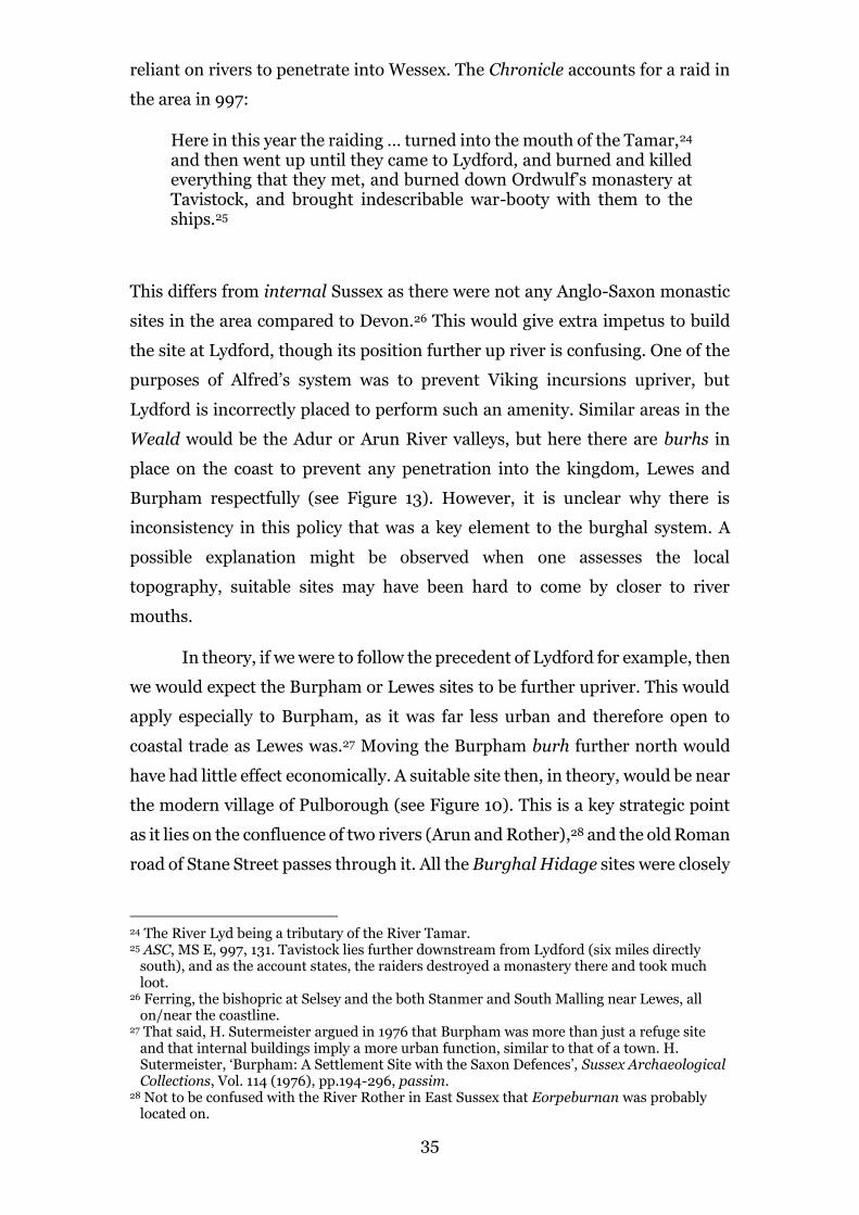
reliant on rivers to penetrate into Wessex. The Chronicle accounts for a raid in
the area in 997:
Here in this year the raiding … turned into the mouth of the Tamar,24 and then went up until they came to Lydford, and burned and killed everything that they met, and burned down Ordwulf’s monastery at Tavistock, and brought indescribable war-booty with them to the ships.25
This differs from internal Sussex as there were not any Anglo-Saxon monastic
sites in the area compared to Devon.26 This would give extra impetus to build
the site at Lydford, though its position further up river is confusing. One of the
purposes of Alfred’s system was to prevent Viking incursions upriver, but
Lydford is incorrectly placed to perform such an amenity. Similar areas in the
Weald would be the Adur or Arun River valleys, but here there are burhs in
place on the coast to prevent any penetration into the kingdom, Lewes and
Burpham respectfully (see Figure 13). However, it is unclear why there is
inconsistency in this policy that was a key element to the burghal system. A
possible explanation might be observed when one assesses the local
topography, suitable sites may have been hard to come by closer to river
mouths.
In theory, if we were to follow the precedent of Lydford for example, then
we would expect the Burpham or Lewes sites to be further upriver. This would
apply especially to Burpham, as it was far less urban and therefore open to
coastal trade as Lewes was.27 Moving the Burpham burh further north would
have had little effect economically. A suitable site then, in theory, would be near
the modern village of Pulborough (see Figure 10). This is a key strategic point
as it lies on the confluence of two rivers (Arun and Rother),28 and the old Roman
road of Stane Street passes through it. All the Burghal Hidage sites were closely
24 The River Lyd being a tributary of the River Tamar. 25 ASC, MS E, 997, 131. Tavistock lies further downstream from Lydford (six miles directly
south), and as the account states, the raiders destroyed a monastery there and took much loot.
26 Ferring, the bishopric at Selsey and the both Stanmer and South Malling near Lewes, all on/near the coastline.
27 That said, H. Sutermeister argued in 1976 that Burpham was more than just a refuge site and that internal buildings imply a more urban function, similar to that of a town. H. Sutermeister, ‘Burpham: A Settlement Site with the Saxon Defences’, Sussex Archaeological Collections, Vol. 114 (1976), pp.194-296, passim.
28 Not to be confused with the River Rother in East Sussex that Eorpeburnan was probably located on.

36
associated with river crossings, both burh and bridge combining as a single unit
to restrict Viking movement along rivers.29 The place-name itself would suggest
that there is a fortified enclosure (‘-borough’) next to the confluence of the Arun
and Rother Rivers of which ‘-pul’ (pool) may refer to. It is hard to say whether
this was of ninth-century origin specifically, but the reference to the village in
Domesday suggests that it was around in the general period.30 The old Roman
station at Hardham also stresses its strategic importance (see Figure 10), the
point at which the Greensand Way (known to be used in the Saxon period)
meets Stane Street. There is also an abrupt rise in the landscape at the Village
itself, this lies just north of the Arun River and provides a reasonable view
across the Arun valley to the foot of the South Downs. The site may have also
been part of the Stane Street signalling system proposed by Gower, acting as a
lookout beacon.31 Domesday records two churches and allocates sixteen hides,
a reasonably large sum in comparison to other hundreds in Sussex.32 The survey
also records thirty acres of meadow at Pulborough but only a meagre eight at
Burpham.33 Clearly by 1086, Pulborough was a significant settlement with
much land cleared around it. This, along with the eleventh-century churches
located in the area,34 would suggest that Pulborough was settled during the
Anglo-Saxon period. Placing a burh here would have also protected more
ecclesiastical sites that are located further upriver.35 Their location next to the
river may suggest that the river was navigable this far up, though it is certainly
even tidal up to Pulborough at any rate.36
However, there was logical reasoning in placing the Arun burh at
Burpham rather than further upriver in the Weald, in significantly strategic
places such as Pulborough. For a start, the Burpham fortification (see Figure 11)
is possibly the successor to an Iron Age fort on the same site.37 Even though
Alfred was keen to change the original defences on his burh sites,38 many of the
sites listed in the Burghal Hidage (especially promontory sites) were built upon
29 Haslam, Early Medieval Towns, 20. 30 DB, Sussex (fol. 24v), 58-9. 31 Gower, ‘Signalling System’, 60. 32 DB, Sussex (fol. 24v), 58-9. The later village of Burpham itself was only allocated five hides
for comparison. 33 DB, Sussex (fol.24v), 58-9. 34 Namely St. Botolph's Church, Hardham and the Church of St. Mary the Virgin, Stopham. 35 Selham, Woolbeeding and Chithurst. 36 Although, these sites are in relative proximity to the burhs of Chichester and Eashing which
were presumably responsible for their security. 37 Sutermeister, ‘Burpham’, 197. 38 Sutermeister, ‘Burpham’, 197. Such as Portchester, Hampshire.

37
pre-existing Iron Age or Roman defences. This would align with Haslam’s thesis
in 2006, that the burghal system was set-up rapidly to counter the particular
threat of a Viking army in Mercia (878/9).39 Alfred would have taken every
opportunity to reduce the work load and the construction time by reusing
earlier sites. Due to the site’s former role as an Iron Age site and probable use
by the South Saxon Kingdom prior to the ninth century, Burpham is an ideal
site in the landscape. It lies on a natural Chalk ridge that elevates it above the
floodplain, utilising the natural contours of the river valley.40 In addition to this,
the River Arun probably flooded more frequently than in modern times and
would have made Burpham quasi-islandic much of the time.41 That said, there
are at least six other Iron Age hillfort/enclosure sites in the Sussex Weald that
Alfred could have utilised but chose not to.42
If we consider the political context of Alfred’s building program, then
Burpham makes a far more obvious choice than somewhere further north. To
construct a brand-new fortification would have taken more time and resources,
39 Haslam, ‘King Alfred and the Vikings’, 29. Haslam suggests a fifteen month period for this,
May 878 to August 879. 40 Sutermeister, ‘Burpham’, 197. 41 Sutermeister, ‘Burpham’, 197. 42 M. Russell, Prehistoric Sussex (Stroud, 2002), 131. Garden Hill (nr. Crowborough),
Hammer Wood (nr. Midhurst), High Rocks (nr. Royal Tunbridge Wells), Philpots (nr. West Hoathly), Piper’s Copse (nr. Northchapel) and Saxonbury (nr. Crowborough) respectfully.
Figure 11.
Diagram showing the figure of eight
defences at Burpham, Sussex. Taken from H. Sutermeister, ‘Burpham: A Settlement
Site within the Saxon Defences’, Sussex
Archaeological Collections, Vol. 114 (1976),
pp. 194-206, 196.

38
the former Alfred had very little of. The Burpham site also offers protection for
a larger part of the area as it controls river movement nearer to the mouth of
the Arun. Thus, it seems to protect the whole valley if one presumes the threat
came from the river. It also provides a refuge for a greater per cent of the rural
population, of which most resided closer to the coast. This would suggest that
Alfred’s burhs are far more concerned with protecting the local populations in
which they are situated, rather than as an overall defensive network. This is not
to say that they was not any relationship between the location of the burhs to
one another, as there is, but that their localised duty of protecting the
population was their primary function. This is reinforced by the events that
occurred in 893, around fifteen years after Alfred’s burhs were constructed.
Figure 12.
Viking Campaigns 892-3. Taken from Taken from D. Hill, An Atlas of
Anglo-Saxon England (Oxford, 1981), 40.

39
King Alfred gathered his army and … went through the forest in gangs and mounted groups, on whichever edge was without an army … [but] The raiding-army did not come out in full from those positions more than twice; on the one occasion … when they wanted to leave those positions … Then the army [Alfred’s forces] rode in front of them and fought against them at Farnham, and put the raiding-army to flight and recovered the war-booty.43
This follows the destruction of Eorpeburnan by the said army after which, had
taken up positions in both a fortification and ‘the woods’ (Andredesweald).44
The scribe consigns these events to ‘Appledore’,45 Kent but Alfred’s army does
not engage the Viking army until it reaches Farnham, west-Surrey (see Figure
12). This, along with the description of what seems to be Alfred’s army searching
through the Weald forest for the army, suggests a weakness in the fortification
network. We can see that the Weald forest,46 acted almost as a free passage into
the West Saxon heartlands.47 The fact that their ‘war-booty’ was reacquired
when they reached Farnham also suggests that travelling in the Weald was not
as difficult as it may have seemed; they were able to navigate it while still
carrying their loot. Concealment in the Wealden forest would account for the
written absence until they reached Farnham, with the Eashing burh, just to the
south of Farnham, possibly having swayed them further north towards the
River Thames (see Figure 13). The episode demonstrates how the function of
the burhs protecting their hinterlands may have been more of a priority than
the defensive integrity of the entire kingdom. It also shows the fragility of the
system. If one coastal burh such as Eorpeburnan were to fall as it did, then the
whole system was compromised and the interior of the kingdom is at risk.
In many areas this had been assured however, especially in the west.
Here, coastal burh forts such as Southampton, Christchurch and Wareham had
a safeguard in Winchester, Wilton and Shaftesbury respectfully (see Chapter
Two). This ‘defence-in-depth’ that has been previously discussed was not
present in the Sussex-Surrey region, but why? Obvious environmental and
demographic reasoning has been pointed out but also challenged. As we have
43 ASC, 894 (s.a. 893), 84-5. 44 Also known as the Weald forest mentioned above and below. 45 ASC, 893 (s.a. 892), 84. 46 Which stretches from Kent as far west as the Hampshire border (see Figure 8). 47 Æthelweard Chronicon, 49. Æthelweard also accounts for the events in his entry for 893
(though particularly focuses on Edward’s activities), stating that ‘the army … following the thickets of a huge wood called Andred … penetrated Wessex’.
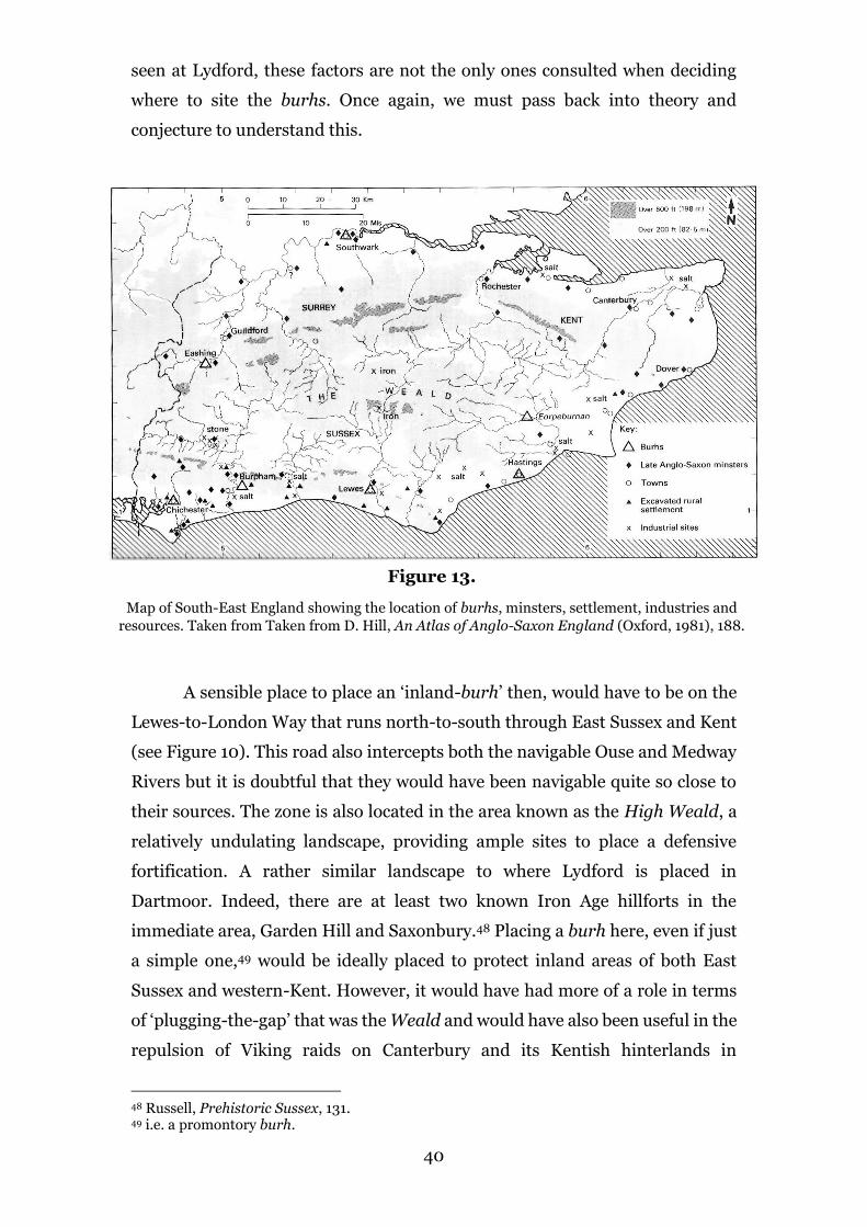
40
seen at Lydford, these factors are not the only ones consulted when deciding
where to site the burhs. Once again, we must pass back into theory and
conjecture to understand this.
A sensible place to place an ‘inland-burh’ then, would have to be on the
Lewes-to-London Way that runs north-to-south through East Sussex and Kent
(see Figure 10). This road also intercepts both the navigable Ouse and Medway
Rivers but it is doubtful that they would have been navigable quite so close to
their sources. The zone is also located in the area known as the High Weald, a
relatively undulating landscape, providing ample sites to place a defensive
fortification. A rather similar landscape to where Lydford is placed in
Dartmoor. Indeed, there are at least two known Iron Age hillforts in the
immediate area, Garden Hill and Saxonbury.48 Placing a burh here, even if just
a simple one,49 would be ideally placed to protect inland areas of both East
Sussex and western-Kent. However, it would have had more of a role in terms
of ‘plugging-the-gap’ that was the Weald and would have also been useful in the
repulsion of Viking raids on Canterbury and its Kentish hinterlands in
48 Russell, Prehistoric Sussex, 131. 49 i.e. a promontory burh.
Figure 13.
Map of South-East England showing the location of burhs, minsters, settlement, industries and
resources. Taken from Taken from D. Hill, An Atlas of Anglo-Saxon England (Oxford, 1981), 188.

41
1011/12.50 That said, the eleventh century witnessed a significant decline in the
burghal system, with some burhs replaced with more economic centres.51 Burh
site ditch defences such as that at Cricklade and Southampton were allowed to
fill, while other sites such as Shaftesbury and Eashing were completely
abandoned.52 If there was burh placed in the High Weald then it would have
surely suffered the same fate before 1011. In a place of such low population
density,53 it would have probably been one of the first to be forsaken, though
some of these promontory sites were reoccupied following the recommence of
Viking raids in the eleventh century.54
On the other hand, the area does possess naturally occurring iron ore (see
Figure 13).55 Indeed, ‘the Weald is one of the few areas of iron ore in Southern
England’,56 emphasising its importance to protect through fortification. The
metal was essential for the production of tools and weaponry. In the Ashdown
Forest area there was evidence of iron smelting and production found in 1980,
though it appears to be on a rather small scale.57 However, this does not rule out
its importance as more substantial sites may just have not been excavated as yet,
or later developments on ore sites may have destroyed such evidence. What we
can say is that iron production in the Weald would have been very liable, not
only because of the presence of iron itself but also the extensive woodland which
could be used for smelting fuel.58 This industry would have been worth
protecting but the fact that it was not suggests that the scale of the commerce
may be overstated.
Another function of the West Saxon burh was to exuberate authority on
the landscape in which it were situated, particularly royal authority.59 Although
many of Alfred’s sites seem to have militarily focused, the developing burghal
50 ASC, MS E, 1011, 141. ‘They had overrun … all the Kentish and South Saxons and the
Hastings district and Surrey and Berkshire and Hampshire and much of Wiltshire … And in this year, between the Nativity of St Mary and Michaelmas they besieged Canterbury…’.
51 Haslam, Early Medieval Towns, 50. 52 Haslam, Early Medieval Towns, 50. 53 D. Hill, An Atlas of Anglo-Saxon England (Oxford, 1981), 19. Under 2.5-5 per square mile. 54 Haslam, Early Medieval Towns, 50. Commonly known as the ‘emergency burhs’ of the later
tenth century. 55 P. Drewett, D. Rudling & M. Gardiner, The South-East To AD 1000 (Harlow, 1988), 330.
Most notably the Ashdown Forest area in East Sussex. 56 Drewett, Rudling, Gardiner, The South-East, 327. 57 Drewett, Rudling, Gardiner, The South-East, 330. Domesday mentions only one ironworks
or ferraria in the South-East which would suggest little financial value in the industry. 58 Drewett, Rudling, Gardiner, The South-East, 330. The Iron Age Hillfort of Garden Hill is
also located in the area (see n.41), a suitable site to convert into a burh as was done at Burpham.
59 Lavelle, Alfred’s Wars, 213.
42
system acted as centres of royal authority and public manifestation.60 This
appears to have been severely lacking in the Sussex/Surrey region due to the
lack of state fortification. Documents such as the Will of Alfred himself shed
light on what estate centres existed during the late ninth and tenth centuries.
I, Alfred, king of the West Saxons, by the grace of God and with this witness, declare how I wish to dispose of my inheritance after my death … to my brother’s son Æthelhelm the estate at Aldingbourne and at Compton and at Crondall and at Beeding and at Beddingham and at Burnham and at Thunderfield and at Eashing.61
Most of these reside in either Sussex or Surrey,62 but the ones of key interest are
that of ‘Thunderfield’ and ‘Beeding’, which lie in the Weald area. The presence
of these centres indicates that the land in the Weald was at least under the
umbrella of royal control. However, Alfred’s decision to leave it to his nephew
suggests that they may have been of little importance. Both places seem to be
rather remote in the kingdom though this applies to Beeding more so. Their
remoteness suggests that they were responsible for a great deal of land or estate
which implies that authority lacked in these areas. Indeed, place-name evidence
suggests that these centres had far reaching outlying lands associated with
them.63 There are two explanations for this, the first being that by the
establishment of remote estate areas the access to resources such as wood,
timber, iron, clay and stone was amplified.64 The other possible explanation is
that it was a means of staking claim to the area for future development.65 Both
explanations would give further impetus for the construction of a fortified site
somewhere in the area, either to protect local resources or to bring the king’s
peace to this area of the kingdom.
Past scholarship seems to label the Andredesweald as a rather desolate
area with settlement few and far between, but this is a little extreme. Certainly
the population density was moderately lower than other areas of Anglo-Saxon
England, but in similar areas such as Devon, fortifications were built. What is
key to consider is that woodland areas in the early medieval period were
60 Williams, ‘Functions of the Anglo-Saxon Burh’, 158. 61 EHD, 492-5. 62 Crondall has been assigned to Hampshire while Compton is too common a name to easily
locate. 63 Chatwin & Gardiner, ‘Settlement of Woodlands’, 48. 64 Chatwin & Gardiner, ‘Settlement of Woodlands’, 48. 65 Chatwin & Gardiner, ‘Settlement of Woodlands’, 48.

43
valuable resources in themselves, there is evidence across England that they
were a source of fuel, game and grazing land.66 It was not an area of the Kingdom
that should have been completely disregarded which seems to have been the
case under the West Saxon kings. Though kings such as Alfred and his son
Edward did not see the landscape aerially intrinsically, this fails to excuse the
hole in their defensive system set-up in the ninth and tenth centuries. On the
other hand, one can understand why there was disregard for the area. The lack
of population seems to have been a key factor along with the presence of burh
fortifications on the southern coast. Without a sufficient population, the
construction of any burh, let alone a proto-urban one, would have seemed a
senseless endeavour in contemporary eyes. Building a burh here would have
been a waste of valuable time, manpower and resources at a point when the West
Saxon Kingdom could not meet the expense of it. This emphasises the role in
which burhs played in the protection of the local population rather than its other
possible fucntions. Alfred needed a system that was effective but he also needed
to recognise practicalities of his predicament, he needed a quick fix to the Viking
threat. Though it would have aided the strategic effectiveness of the Burghal
Hidage, such as in 892, not placing a burh in the Weald was a cut in the system
that could be made, and was indeed made
66 Chatwin & Gardiner, ‘Settlement of Woodlands’, 31.
44
Conclusions
As a whole, each chapter has demonstrated how a different perspective
can be taken when examining the West Saxon burhs, particularly in Chapter
Three. The first section of the paper established the basis of previous
scholarship over the past fifty or so years, a preparation for the main study. The
following two chapters reviewed the evidence for the West Saxon burhs and the
burghal system, while still bringing in new standpoints on occasion. The first
chapter particularly showed that external influence on the design of the West
Saxon burh was significant and should be considered more earnestly. Chapter
Two continued in a similar theme, arguing that Alfred the Great’s Burghal
Hidage was partly based on a pre-existing system, one that originated in the
Mercian ‘common burdens’.1 Finally, the case study on the Andredesweald
challenged the idea that Alfred’s system was as effective as it is made out to be.
This chapter attempted to take the model of the burghal system that was
explored in Chapters One and Two and apply it to an area that it was not
introduced to. In fact, by examining an area in which the system was absent
allows us to discover more about its character and its foremost function.
It is clear that the term ‘burh’ cannot be assigned to a just single class of
fortification,2 this is especially appropriate for those in late ninth and early
tenth-century Wessex. These included reused Roman walled towns, proto-
urban enclosure sites and promontory forts. The point was made that the de
nova proto-urban sites were built in the image of their roman predecessors,
especially in terms of their layout.3 However, their defences were based upon
the Mercian design of the previous centuries, sited at places such as Hertford
and Tamworth. Thus, it appears that the design of the West Saxon burh was
very much a hybrid of the fortifications that were still visible in the landscape,
demonstrated by their reprocessed features. This also applies to the
promontory sites which repeatedly recycled Iron Age hillforts.4 Later
developments in burh disposition demonstrate a similar process of recondition,
most notably the ‘double burh’. It was no coincidence that this new strategy
1 Bassett, ‘Divide And Rule?’, 58-9. 2 Haslam, Early Medieval Towns, 19. Refers either to a private plot (thegnly or royal) with an
enclosure or to a larger communal fortification. 3 Lavelle, Fortifications in Wessex, 33. 4 Sutermeister, ‘Burpham’, 197. Burpham for example.

45
immediately proceeded those built in Charles the Bald’s West Frankish
Kingdom of the late ninth century.5
However, influence on Alfred’s burghal system was not limited the
physical characteristics of the fortifications within it. The burghal system was
the greatest system of defence in Western Europe since those of the Romans,6
consisting of over thirty fortified sites, varying from fortified towns and hillforts
but probably also simple beacons. Its ‘defence-in-depth’ was unique to this
period, a system that does not seem to have been employed since the Romans.7
That said, there is a great deal of evidence to suggest that the administration of
the system was heavily reliant on previous obligations. These ‘common burdens’
seem to have originated in the old Anglo-Saxon Kingdom of Mercia, the burdens
of military service, burhwork and bridgework. Alfred used these obligations as
a basis for his network but must be credited for implementing them to a far
greater degree of efficiency. Hodges compares him to Machiavelli is this regard;
someone who knew how to bend the rules in his favour. This, alongside Alfred’s
military reforms that established a standing army to garrison the network was
Alfred’s real achievement, a genuine patron of his epithet as ‘the Great’.8
Interestingly, the notion that every part of the kingdom was within forty
miles of a burh, does not actually seem to have been upheld. Indeed, areas such
as the Weald lacked any sort of defensive protection with the only part of the
network to cover such areas were beacons, but even these were limited.9 This is
demonstrated by the events of 893, when a Viking army was able to penetrate
deep into the kingdom, something that Alfred’s system was established to
prevent. Clearly we should not over-state the effectiveness of Alfred’s system as
many do to this day. Instead, we should recognise that the system was not
perfect, it had its flaws, both avoidable and unavoidable.
On the other hand, the case of the Weald does not simply show us the
weaknesses in the system but more importantly it benefits our understanding of
what the system’s principal function was. As stated, the area was considerably
5 Although this is contested by some. For example, Lavelle compares the evolution of the West
Saxon and Frankish to the evolution of the Tank in the First World War (1914-1918). He suggests that the evolution of the burh was similar as the tank was derived in Britain and France without cohesion between the countries. Lavelle, Alfred’s Wars, 213.
6 Lavelle, Fortifications in Wessex, 17. 7 Lavelle, Alfred’s Wars, 210. 8 Hodges, The Anglo-Saxon Achievement, 152. 9 See Gower’s study of the Stane Street system in 2002 for the only evidence for one in the
Weald.

46
depopulated during the period in comparison to other parts of Anglo-Saxon
England.10 The absence of fortification here suggests that the primary utility of
the West Saxon burh was ‘for the protection of all the people’.11 This function
appears to supersede the other suggested core functions of the burh (contrary
to Williams),12 namely: the implementation of royal authority, protection of raw
materials, economic centralisation and of course grand military strategy. The
construction of a burh in the Weald would have fulfilled all of these functions
apart from protecting a significant proportion of Wessex’s population. The area
lacked much royal authority, had numerous resources of iron and timber as well
as farmland, required economic centralisation and indeed left a hole in Wessex’s
defence network. The evidence presented here would suggest that the protection
of the West Saxon population was Alfred’s chief concern when he formulated
the burghal system, arguably his most important resource of all. That said, other
evidence would suggest that this was not the case, and that the defence of the
Kingdom as a whole was their chief occupation as Williams suggests.13 Perhaps
then, the best we can take from this study is that we should be more open to the
idea that Alfred wanted to protect his population, rather than just the land they
inhabited.
Word Count: 10375
10 Particularly areas such as Devon where a burh at Lydford was built. 11 EHD, 498. 12 Williams, ‘Functions of the Anglo-Saxon Burh’, 131. Williams suggests that ‘it seems unlikely
that that defence of the civilian population per se was the only, or even major, function of the burhs’.
13 Williams, ‘Functions of the Anglo-Saxon Burh’, 158.

47
Appendix
A Chronology of Relevant Key Events
757–96 Reign of King Offa in Mercia
c.789 First recorded raid in Wessex, Portland (Dors.)
793 Lindisfarne Monastery raid, Northumbria
839–58 Reign of King Æthelwulf in Wessex
855–60 Reign of King Æthelbald in Wessex
860–6 Reign of King Æthelbert in Wessex
866–71 Reign of King Æthelred I in Wessex
871–99 Reign of Alfred ‘the Great’
878 Alfred’s victory over the Vikings at Edington
874-5 Viking force overwinters at Repton (Derbys.)
878 Alfred dispossessed of Wessex by Viking force at Chippenham; Battle of
Edington (Wilts.) and Alfred-Guthrum Peace Treaty (c.878-90)
886 Alfred restores the city London
892 Eorpeburnan burh in the Andredesweald (Kent, unknown location);
Viking fortifications built at Appledore and Milton (Kent)
893 Battle of Farnham between West Saxons and Vikings from Kent
899–924 Reign of King Edward ‘the Elder’ over the ‘Kingdom of the Anglo-Saxons’
924–39 Reign of King Æthelstan over kingdom of the English
978–1016 Reign of King Æthelred ‘the Unready’
998 Viking raids into Dorset, Hampshire and Sussex from the Isle of Wight
999 West Saxon defeat to Vikings at Rochester and extensive raiding in Kent
1011 Vikings army sack Canterbury and raid Kent

48
Bibliography
Primary Sources
Alfred the Great: Asser’s Life of King Alfred and Other Contemporary Sources, ed.
and trans. S.D. Keynes and M. Lapidge (Harmondsworth, 1983).
The Anglo-Saxon Chronicles, ed. and trans. M. Swanton (London, 1996).
Chronicon Æthelweardi: The Chronicle of Æthelweard, ed. J. Campbell, Medieval
Texts (London, 1962).
Domesday Book: A Complete Translation, A. Williams and G.H. Martin (eds)
(London, 1979).
English Historical Documents, Volume 1, c.550–1042, ed. D. Whitelock (London,
1955; 2nd edn, 1979).
Secondary Sources
Abels, R.P., ‘From Alfred to Harold II: The Military Failure of the Late Anglo-Saxon
State’, in R.P. Abels & B.S. Bachrach (eds), The Normans and Their
Adversaries at War: Essays in Memory of C. Warren Hollister
(Woodbridge, 2001), pp.15-30.
Abels, R.P., ‘The Costs and Consequences of Anglo-Saxon Civil Defence, 878-1066’, in
Baker, J., Brookes, S., & Reynolds, A., (eds), Landscapes of Defence in
Early Medieval Europe (Turnhout, 2013), pp.195-222.
Abels, R.P., Lordship and Military Obligation in Anglo-Saxon England (London,
1988).
Astill, G., ‘Community, Identity and the Later Anglo-Saxon Town: The Case of
Southern England’, in Davies, W., Halsall, G., & Reynolds, A., (eds),
People and Space in the Middle Ages (Turnhout, 2006), pp.235-254.
Bachrach, B.S., & Aris, R., ‘Military Technology and Garrison Organization: Some
Observations on Anglo-Saxon Military Thinking in Light of the Burghal
Hidage’, Technology and Culture, Vol. 31, No.1 (Jan., 1990), pp.1-17.

49
Baker J., & Brookes, S., Beyond the Burghal Hidage: Anglo-Saxon Civil Defence in
the Viking Age (London, 2013).
Bassett, S., ‘Divide And Rule? The Military Infrastructure of Eighth and Ninth-
Century Mercia’, Early Medieval Europe 15 (2007), pp. 53-85.
Biddle M., & Hill, D., ‘Late Saxon Planned Towns’, The Antiquaries Journal, Vol. 51
(1971), pp. 70-85.
Biddle, B., ‘Towns’ in Wilson D.M., (ed.), The Archaeology of Anglo-Saxon England
(London, 1976).
Blair, J., ‘The Defence of Wessex: The Burghal Hidage and the Anglo-Saxon
Fortifications’, review of The Defence of Wessex: The Burghal Hidage
and the Anglo-Saxon Fortifications, by Hill, D., & Rumble, A.R., (eds),
The English Historical Review, Vol. 113, No. 454 (Nov., 1998), pp.1263-
1264.
Brandon, P., ‘The South Saxon Andredesweald’, in Brandon, P., (ed.), The South
Saxons (Chichester, 1978), pp.174-189.
Brooks, N.P., ‘The Administrative Background of the Burghal Hidage’, in Hill D., &
Rumble A.R., (eds), The Defence of Wessex: The Burghal Hidage and
Anglo-Saxon Fortifications (Manchester, 1996), pp. 128-150.
Cam, H.M., ‘The Origin of the Borough of Cambridge: A Consideration of Professor
Carl Stephenson’s Theories’, Proceedings of the Cambridge Antiquarian
Society, Vol. 35 (1935), pp. 33-53.
Chatwin, D., & Gardiner, M., ‘Rethinking the Early Medieval Settlement of
Woodlands: Evidence from the Western Weald’, Landscape History, Vol.
27 (2005), pp.31-49.
Clemoes P., & Hughes, K., (eds), England Before the Conquest: Studies in Primary
Sources Presented to Dorothy Whitelock (Cambridge, 1971).
Copley, G.J., ‘Stane Street in the Dark Ages’, Sussex Archaeological Collections, Vol.
89 (1950), pp.98-104.
De Meulemeester J., & O’Conor, K., ‘Fortifications’, in Graham-Campbell, J., & Valor,
M., (eds), The Archaeology of Medieval Europe: Vol. 1, Eighth to Twelfth
Centuries AD (Aahus, 2008), pp. 316-341.

50
Drewett P., Rudling D., & Gardiner, M., The South-East To AD 1000 (Harlow, 1988).
Gower, G., ‘A Suggested Anglo-Saxon Signalling System between Chichester and
London’, London Archaeologist, Vol. 10:03 (2002), pp. 59-63.
Haslam, J., ‘King Alfred and the Vikings: Strategies and Tactics 876-886 AD’, Anglo-
Saxon Studies in Archaeology and History 13 (Oxford, 2006), pp.122-
154.
Haslam, J., ‘Market and Fortress in England in the reign of Offa’, World Archaeology
19, No. 1 (1987), pp. 76-93.
Haslam, J., Early Medieval Towns in Britain c. 700 to 1140 (Aylesbury, 1985).
Hassall, J.M., & Hill, D., ‘Pont de L’Arche: Frankish Influence on the West Saxon
Burh?’, The Archaeological Journal 127 (1970), 188-194.
Hill, D., & Sharp, S., ‘An Anglo-Saxon Beacon System’, in Lavelle, R., Alfred’s Wars:
Sources and Interpretations of Anglo-Saxon Warfare in the Viking Age
(Woodbridge, 2011), pp.218-225.
Hill, D., ‘The Origins of the Saxon Towns’, in Brandon, P., (ed.), The South Saxons
(Chichester, 1978), pp.174-189.
Hill, D., An Atlas of Anglo-Saxon England (Oxford, 1981).
Hodges, R., The Anglo-Saxon Achievement: Archaeology and the Beginnings of
English Society (London, 1989).
Hollister, W., Military Institutions on the Eve of the Norman Conquest (Oxford,
1962).
John, E., Reassessing Anglo-Saxon England (Manchester, 1996).
Johnson, A., Roman Forts (London, 1983).
Langlands, A.J., Travel and Communication in the Landscape of Early Medieval
Wessex: Volume 1 (Unpublished PhD thesis. University of Winchester,
2013).
Lavelle, R., Alfred’s Wars: Sources and Interpretations of Anglo-Saxon Warfare in
the Viking Age (Woodbridge, 2010).
Lavelle, R., Fortifications in Wessex, c.800-1066: The Defences of Alfred the Great
Against the Vikings (Oxford, 2003).

51
Margery, I.D., Roman Roads in Britain (London, 1967).
Qualmann K.E., et al., Oram’s Arbour: The Iron Age Enclosure at Winchester,
Volume 1: Investigations 1950-1999 (Winchester, 2004).
Reynolds, A., Baker, J., & Brookes, S., (eds), Landscapes of Defence in Early
Medieval Europe (Turnhout, 2013).
Reynolds, A., Later Anglo-Saxon England: Life and Landscape (Stroud, 1999).
Russell, M., Prehistoric Sussex (Stroud, 2002).
Stafford, P., Unification and Conquest: A Political and Social History of England in
the Tenth and Eleventh Centuries (London, 1989).
Stenton, F.M., Anglo-Saxon England (Oxford, 1971).
Stephenson, C., ‘The Anglo-Saxon Borough’, The English Historical Review, Vol. 45,
No. 178 (Apr., 1930), pp. 177-207.
Sutermeister, H., ‘Burpham: A Settlement Site with the Saxon Defences’, Sussex
Archaeological Collections, Vol. 114 (1976), pp.194-296.
Swanton, M., (trans.) (ed.), The Anglo-Saxon Chronicles (London, 2000).
Tait, J., The Medieval English Borough: Studies on its Origins and Constitutional
History (Manchester, 1936).
Tyler, D., ‘Offa’s Dyke: a historiographical appraisal’, The Journal of Medieval
History, Vol. 37, pp.145-161.
Webster, G., The Roman Imperial Army (London, 3rd edn, 1985).
Welch, M., Anglo-Saxon England (London, 1992).
Wheeler, R.E.M., London and the Saxons (London, 1935).
Williams, G., ‘Military and Non-Military Functions of the Anglo-Saxon Burh, c. 878-
978’, in J. Baker, S. Brookes & A. Reynolds (eds), Landscapes of Defence
in Early Medieval Europe (Turnhout, 2013), pp.129-163.