the ticknall lime industry and its transport system
TRANSCRIPT

THE TICKNALL LIME INDUSTRY AND ITS TRANSPORT SYSTEM
by
Marilyn Palmer and Peter Neaverson
SUMMARY
This report traces the development and decline of the limestone quarrying and limeburning industry at Ticknall in Derbyshire. A necessary adjunct to its success was a transport system to ship out burnt and unburnt limestone and a horse-drawn tramway system was laid to connect the lime yards to the AShby-de-la-Zouch Canal. The results of documentary research to date and the site survey and excavation will be described. The limeyards lie within the Calke Abbey estate which has been recently acquired for the National Trust and this material will be used in interpretative displays at the Abbey when it is opened to the public.
INTRODUCTION
Limestone occurs at Ticknall as an inlier of Carboniferous age surrounded by younger Triassic marls and sandstones. Similar inliers occur at Dimminsdale, Breedon and Cloud Hill, all of which have been, or are still being, quarried. The limestone at Ticknall and Dimminsdale is dark grey in colour and more fossiliferous than the other deposits which have a magnesium content.
Quarrying activity at Ticknall would seem to date from the end of the 18th century. Lime was in great demand not only for building purposes, but even more for agriculture. The Board of Agriculture was founded in 1793 and commissioned reports on the state of agriculture in Britain: these are known as the 'General Views'. The Derbyshire volume, by John Farey (1), is one of the most useful and deals with minerals extraction and industry as well as agriculture! it dates from 1811. For Leicestershire, William Pitt wrote a report in 1809 (2), replacing an earlier one by Monk (3). These writers agree on the increasing use of lime as a manure for improving land, particularly at a time when land was being enclosed by Act of Parliament - often land which had previously been waste or heathland, like the Ashby Woulds.
Pitt quotes Throsby, late Town Clerk of Leicester, who knew the County well, Pitt himself was not of local origin: he said that Breedon t Barrow and Ticknall lime were used for land dressing, 40 loads where only one load would have been used 50 years ago. Lime, Pitt says, was laid on fallow land, 10 or 12 quarters to the acre t which was laid. quick [burnt] on the land and then harrowed into the pulverised sailor even harrowed in with the seed of turnips or grain. On newly reclaimed lands, like the Ashby Wolds, they were liming heavily every other year: elsewhere it was probably every three or four yearse Farey said that 3 tons of Ticknall lime to the acre were used for wheat. Generally, Ticknall lime was preferred for agricultural purposes to that from Breedon or Cloud Hill in Leicestershire: Breedon was a Magnesian limestone, which produced a strong lime suitable for building purposes: on farm land users had to be careful not to use too much of it, furthermore, Breedon lime was reputed to encourage the growth of thistles.
THE ORIGINS OF THE INDUSTRY AND ITS TRANSPORT SYSTEM
It is difficult to ascertain when limestone was first quarried and burnt at Ticknall. The 18th century county maps, that for Derbyshire by Burdett of 1791 (4) and that for Leicestershire by John Prior of 1777 (5), do not show limekilns at Ticknall, although Prior does record those at Breedon and Cloud Hill in Leicestershire. A plan of the villages on the Harpur-Crewe Estate, made at about the time of the building of the Trent and Mersey Canal in 1777, also does not show any kilns in Ticknall (6). In a Land Tax assessment for 1780, Gilbert Hutchinson is listed as a lime burner on the Gurdett estates (7). His limeworks are in fact shown on a map c.1799 in connection with the transport proposals. Pilkington, in his History of Derbyshire, which was written in 1789, makes it clear that limestone was being burnt at Ticknall at that date (B).
5

, , , """",,\', heath {~~ , ,
\.Calke
D)M'D / 1
-~ 1
""" /' ; ~ {.
ount -- - - -
BREEDON
~I ..... ~- ....
"
I
I ; I I , I
CLOUP HILL
/
PEGGS GREEr
I
I I
~ILLES
/
EY
tramway built
projected canal
Ashby canal , , , , • i , " ,
Fig.1 Plan of proposed Canal from Ashby-de-la-Zouch Canal at Oonisthorpe to the Limeworks at Cloud Hill and Ticknall. Redrawn from undated map DCRO
02375M/174/B. Also showing the tramway lines which were eventually constructed.
5

This is evident, too, from the efforts of the Ashby-de-la-Zouch Canal Company to build branches from their canal· to Ticknall: they would not have bothered unless the lime industry was well established there by then. In 1792 the newly formed Company held its first meeting at the Queen's Head in Ashby and discussed:
the utility of a Canal from the limeworks at Ticknall to Ashby Woulds, and from thence to unite with the Coventry Canal at or near Griff. (9)
A map in the Harpur-Crewe papers shows the intended canal. This map, which is undated, does, however, also show the possible alternative tramways which were proposed; its purpose may have been to prove that tramways would both be cheaper and more effective (10). The Ashby Canal was originally proposed as a through canal between the Coventry and the Trent and Mersey Canals, which would open up the South Derbyshire and Leicestershire Coalfield and also provide transport For the extensive limestone workings in the area. The original estimate for the whole canal, prepared by Robert Whitworth, was £145,545, made up of £63,402 for the main line to Ashby Woulds and £82,143 for the extensions to Ticknall, Staunton Harold [Dirnminsdale 1 and Cloud Hill (11). The branches were comparatively expensive because they would require lockage, unlike the section from Marston Junction to Ashby Woulds which would be level. From the Woulds, there would be a rise of 139 feet by lockage, 5 miles of surrmit level and then 84 feet of lockage down to level branches to Ticknall on the one side and Cloud Hill via the Coleorton collieries on the other, with the Staunton Harold branch to be built if necessary.
The proposed canal line is shown in Fig 1, together with the tramways which were eventually constructed. The main line of canal extended north from Willesley to near Blackfordby village, where a branch went off to the quarries, the main line continuing towards Swadlincote. The branch canal passed through a tunnel in the Ashby Parks area before dividing into two to serve Ticknall and Dimminsdale with one branch and Lount, Peggs Green and Cloud Hill with the other. Transport connections to Breedon itself never seem to have been considered. The original map (12) has the following distances recorded upon it showing the greatly reduced distances, and consequently costs, of the alternative horse tramways:
miles furl. ch. links Canal Donisthorpe to Ticknall Limeworks 13 3 7 43
Donisthorpe to Cloud Hill 15 4 1 50 Railway Donisthorpe to Ticknall Limeworks 7 7 0 0
Donisthorpe to Cloud Hill 8 6 60
The distances were actually those effective from Willesley 8asin~ and those for the railways shown above were not for the lines actually laid.
Horse-drawn railways or tramways were in common use by the time the Ashby Canal was being planned. The Ashby Canal Act of 9 May 1794 included powers to convey traffic by 'Rollers, Inclined Planes or in any other Manner than by Water I (13), which the Company later interpreted as allowing them to replace sections of the canal with tramroads without going back to Parliament for sanction. The construction of tramways to Ticknall and the other quarries had been under discussion since 1793, but the Company I s right to build tramroads really became important when they began to get short of capital in the mid-1790s. The Ashby Canal 'from Marston Junction to the Ashby Woulds was built as a broad canal; this was done because the canals to which it connected were being planned as broad canals or had plans to widen them. Unfortunately for the Ashby Canal Company, the Coventry Canal to which it connected was never widened, and so they spent capital unnecessarily in building a broad canal up to the Ashby Woulds.
The Ashby Canal was opened through to Ashby Woulds by 1798, but the Company found that there was not enough coal being mined in the area to make the canal viable. They tried to persuade local landowners, particularly the Earl of Moira and Joseph ·Wilkes of Measham to exploit the coal resources on their estates. Wilkes tried to boost local coal production, but went so far as to suggest that the limestone traffic would contribute more to canal dues and that coal could be brought into the area as return loads (14).
7

The 17905 were also a period of economic depression brought about by the French Revolutionary Wars, and the cails made on the Company's shareholders were greatly in arrears: by April 1800 the full £150,000 of original capital had been called but only £115,849 received (15).
For all these reasons,. the Company began in 1798 to consider seriously the possibility of building tramroads rather than canals to the limestone quarries. In June 1798 they commissioned Thomas Jewsbury, a local coal viewer, and Thomas Newbold, a local man who had replaced the original canal surveyor Whitworth, to report on the expediency of railways. The Ashby Canal Company Minute Book says that on the 21 August the Company decided to contact Benjamin Outram of the Butterley Company in Derbyshire regarding the advisability of tramroads (16).
In the Harpur-Crewe papers there is a memorandum from- Outram on the subject dated 17 August 1798 and it is therefore possible that Sir Henry Harpur had already contacted Outram independently when the proposed canal did not materialise (17). The following is an extract from this memorandum:
I am of the opl.nl.on that the most advantageous Mode of conveying Lime and Limestone from Ticknall to the Canal now executed, and Coals and Slack in return from the Woulds to Ticknall, will be by a Cast Iron Railway of the best construction, to comnence at the face of the Limestone Quarry at about the level of the Upper Strata of Limestone, and to be carried southwest-ward on a gentle ascent, by a Tunnel about 600 yards in length, thro the high Lands, and under Sir Henry Harpur 1s Coach Road, to the low grounds westward of Caulk Park; thence continuing its southwesterly direction and gentle ascent to the foot of Pistern Hill; from thence it should either ascend the Steep of the Hill to its summit by an Inclined Plane, to be worked by a small Steam Engine, and from the SUlT1llit of the Hill descend gradually to the Woulds; or instead of ascending the ,.Sulmlit pass under Pistern Hill, by a tunnel of about 600 yards in length, to a valley in Sir Francis 8urdett's Estate.
Outram recommended the latter route because of the ease of coals on a reasonably level route ~ithout an inclined plane. the way except in the tunnels and calculated that it would
conveying the expected return loads of He proposed to'make"the line double all
be only two thirds of the length of the proposed canal and cost only a third of the sum that would cost. It would also be completed more quickly, taking only about 12 months to finish. When working, the railway would need two horses to a gang of waggons, with an additional horse from Ticknall to the summit at Pistern Hill, he said:
which additional horse should be taken back by a Boy, to Assist other Gangs 4 times a day; •••••• thus a set of 4 men, 1 Boy and 9 Horses, would convey 40 tons of stone from Ticknall to the Ashby Canal per Day, and bring back such Coals and Slack and Merchandize as there may be demand for, suppose 12 tons per day, which added to the Limestone would make 52 tons per day.
On these calculations, the limestone would be carried to the Canal for less than 8d per ton. He also suggested that limekilns be built on other parts of the route.
The Company agreed to Outram's proposals in December 1798 and instructions were given for the routes to be laid out (18). There were many problems still to overcome, particularly the cash shortage, and Outram had to threaten the Company with stopping work altogether if he were not paid: this happened in February 1801. In December 1799 the Company had decided that they could not afford Outram's double line, and the whole railway from Old Parks tunnel to Ticknall was built single track. The Company, in its turn, complained about the standard of Outram's workmanship and employed inspectors, one of whom was Joseph Wilkes of Measham, to look at the line in 1802 and 1803. Their reports do show the extent of the railways built and opened sometime between July and October 1802, the following line lengths are taken from them (19):
8

miles ch. yds Willesley to Old Parks 3 72 7 double line Old Parks to Cloud Hill 4 2 16 single line Old parks to Ticknall 4 1 2 single line
Branch at Ticknall to Burdett's works 29 13
Marget's Close branch (Ashby) 17 19 Total route mileage 12 43 13 Passing loops and sidings 22 21
Total 12 66 12
The lengths of these lines resemble closely those actually shown on the first edition of the OS One inch to One Mile map produced in the 1830s, and these are also shown in Fig 1. The Burdett branch mentioned above matches with the branch crossing the village street by the existing bridge. The other, Marget I 5 Close, branch served workings south of the village street. The rather misleading reference to Ashby indicates not the location of the tramway but that of the Marget' 5 Close Company who were based in that town (20).
t INGLEBY -.... HARTSHORNE~~~~'
DERBY
LINE OF CANAL ~" IF
Fig 2.
PROPOSED /~ R A I LW AY";"" N Work,
~ __ ~nnel ew
/ 'l ~ I
;' /
{lie AL K E
Detail section of the projected Canal and Tramway at Ticknall. Redrawn from undated map OCRO 02375M/174/B.
9

Several maps have been-found showing other tramway routes (21) which were considered and these will be discussed in the next Section of this report dealing with the growth of the workings. The line to the Cloud Hill limeworks in the possession of Lord Stamford was built in 1802 but the proposed branch from the Ticknall line to the Dimminsdale workings of Lord F errers was not commenced until September 1828; the branch came into use a year later (22).
The railway was built on stone blocks, each with a hole in the centre which contained an oak plug about 5 inches long. Into this was hammered the wrought iron spike which held the tram-plate in place. The tram-plates were iron castings about 36 inches long and L-shaped in cross section. The track gauge was 4 ft 2 inches, and a ballast of small stones was laid between the double row of blocks to provide a footing far horses. Stone blocks were often preferred to wooden sleepers on horse-drawn railways since they did not suffer wear from continuous horse traffic over them, but they were inclined to go out of gauge.
THE DEVELOPMENT OF THE TICKNALL LIMEYARDS
The growth of the quarries during the 19th century is difficult to trace from documentary sources and map evidence has had to be relied upon. As there were few freeholders, most of the quarries were operated either by their owners, the Harpur-Crewe family of Calke or the Burdett family
/ A S r H HarpUf\ New L r"ewo'~\
B s" i- Bv,del[\ LrrlH'work>
C G,I HulCn,r1S0r,\ l_rm~works
Railways o G,lb~,t> Ltm~workl
Fig 3.
1st prolected line -/2
line of deviation -/2 I,neof deviation -/6&12
F Mr Sale's Llrnework~
Limeworkings at Ticknall and alternative tramway routes proposed. Redrawn from undated plans DCRO D2375M!71!174!2, 6 and 12.
10
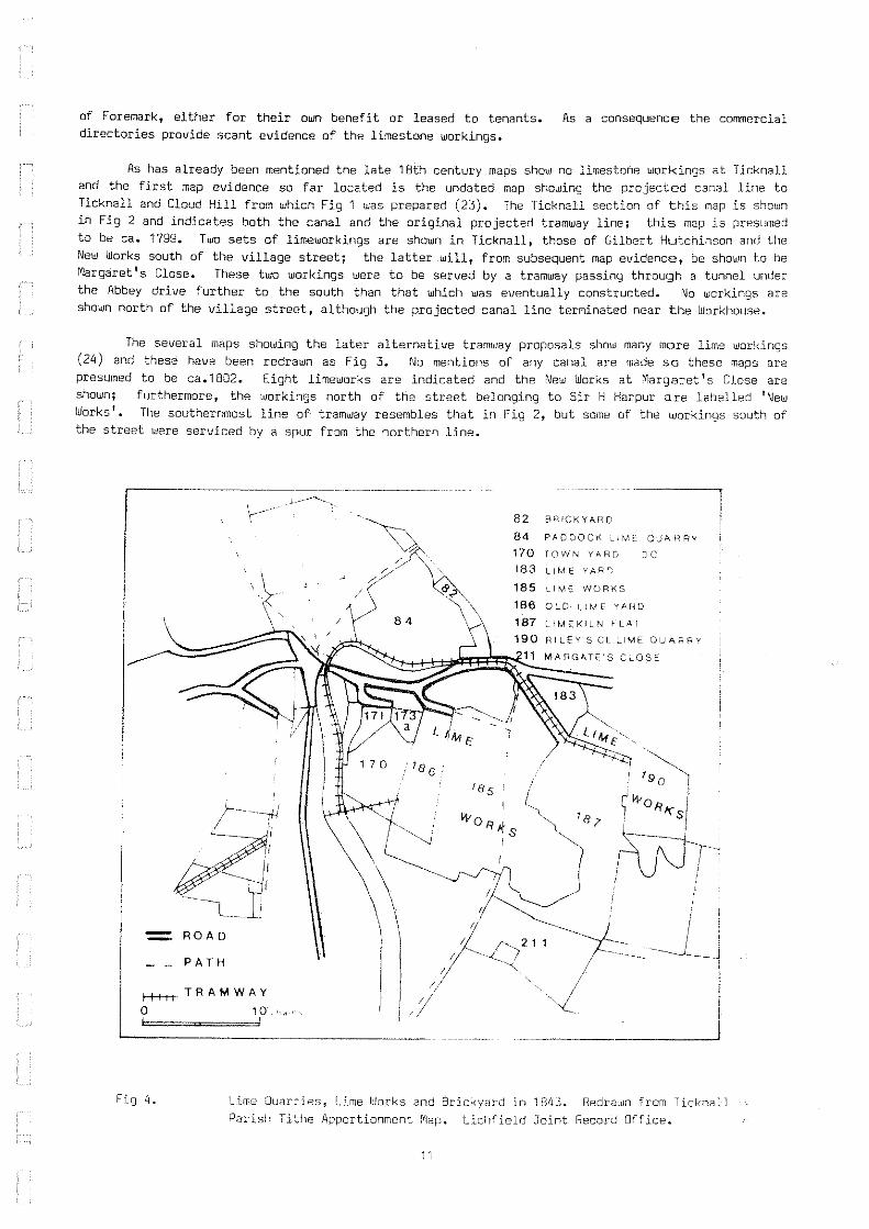
of Foremark, either for their own benefit or leased to tenants. As a consequence the commercial directories provide scant evidence of the limestone workings.
As has already been mentioned the late 18th century maps show no limestone workings at Ticknall and the first map evidence so far located is the undated map showing the projected canal line to Ticknall and Cloud Hill from which Fig 1 was prepared (23). The Ticknall section of this map is shown in Fig 2 and indicates both the canal and the original projected tramway line; this map is presumed to be ca. 1799. Two sets of limeworkings are shown in Ticknall, those of Gilbert Hutchinson and the New Works south of the village street; the latter will, from subsequent map evidence, be shown to be Margaret 1 s Close. These two workings were to be served by a tramway passing through a tunnel under the Abbey drive further to the south than that which was eventually constructed. No workings are shown north of the village street, although the projected canal line terminated near the Workhouse.
The several maps showing the later alternative tramway proposals show many more lime workings (24) and these have been redrawn as Fig 3. No mentions of any canal are made so these maps are presumed to be ca.1802.. Eight limeworks are indicated and the New Works at Margaret I s Close are shown; furthermore, the workings north of the street belonging to Sir H Harpur are labelled 'New Works'. The sQuthernmost line of tramway resembles that in Fig 2, but some of the workings south of the street were serviced by a spur from the northern line •
.------------- - ----------
Fig 4.
82 BRiCKYARU
84 PADDOCK " (ME OUA R RY
170 TOWN YA RD DO 183 II M E Y AR D
185 LI ME WORKS
186 OLD L.! M E YM"W
187 LIMEKILN F l A r 190 RI LEY'S CL LIME OUAf,RY
11 MARGATE"S CLOSE
Lime Quarries, Lime Works and Brickyard in 1843. Redr3\!Jn from Ticknall Parish Tithe Apportionment fYlap. Lichfield Joint Record Office.
11

The first edition One Inch OS map shows little detail of the lime workings but does show the tramway which passed over the village street on the still surviving bridge recrossing the street on the level going to the workings further east.
The map accompanying the Tithe Award of 1843 for Ticknall Parish and the schedule of occupation provides more information (25) and part is reproduced as Fig 4= This map also ShOlllS t.he extension of the northern tramway branch back to the south of the road to serve plot numbers 183, 187 and 190 but the southern spur is only shown extending to the Old Lime Yard plot 186. The ownership, occupancy and use of the various plots are shown below:
PLOT LAND NAME OWNER OCCUPIER CUL TIVATION 183 Lime Yard Thomas Cope In hand 82 Brick Yard Sir George Crewe In hand
170 Town Yard Lime Quarry Sir George Crewe In hand 190 Riley's Close Lime
Quarry Sir George Crewe In hand 84 Paddock Lime Quarry Sir George Crewe Rowland Ordish
185 Lime Works Sir George Crewe ROll/land Or dish 187 Lime Kiln Flat and
Ridings Nook Sir George Crewe Rowland Or dish Pasture 186 Old Lime Yard Thomas Gilbert Himself 211 Margate's Close, 2
cottages & gardens Sir George Crewe ROlJJland Or dish Meadow
These entries in the schedule are supported by evidence from the commercial directories, Pigot in 1842 states that there were extensive limeworks in Ticknall 'wrought to great advantage' (26)~ The limeburners listed in that year were John Foster, Thomas Cope and Rowland Ordishe 8agshaw in 1846 (27), states that the limeworks belong to the Lord of the Manor except for a small part worked by Thomas Cope: the uJorkings had been going on for about 50 years~ Slater in 1850 again lists Thomas Cope and Rowland Ordish as lime burners in Ticknall and also Mumford and Cooper in Calke - this entry may refer to the Dimminsdale working:3 (28)~
Fig 5.
'yvA'~R
..... _ .. __ ~J
Plan of Estate at Ticknall, late the Property of Mr nlomas Cope deceased, 1853. Redrawn from DCRO 02375M/172/12.
12

The activity in the quarries was probably the reason for the growth in population during the early decades of the 19th century. Between 1B11 and 1821 the population increased by 10% from 1166 to 1274. It then remained at about the 1270 level until 1841 census, after which it began to fall. It is very difficult, however, to work out how many people were employed at the quarries. A list of Sir George Crewe's servants .. probably drawn up in the 1830s or 405, lists 12 labourers at the limekilns compared to 57 farm labourers and 24 colliers out of a total work force of 149. This did not include labourers at the limeyards employed by his tenants (29).
Sir George Crewe seems to have adopted a policy of buying out freeholders and estate as much as possible. He bought out the Burdett interest in the limeyards 1832 and 1846 and those of Thomas Gilbert in 1846 and Thomas Cope in 1853 (30).
consolidating his some time between The extent of the
Burdett holdings has not been ascertained; they were in the Repton Priory parish and do not appear on the Ticknall tithe map_ The deed of sale of the deceased Thomas Cope's estate to Sir John Harpur Crewe contains a plan of the estate and this is redrawn as Fig 5 and shows a range of four kilns (31). A provisional survey of this area in 1986 has revealed remains of these kilns and the tramway nearby; in addition a stone-lined leat crosses the same area.
I o
I 66 yds
Fig 6.
Lime kilns in Paddock Wood Quarry, Ticknall, 1872.
Redrawn from plan
DUm D23?M/71 /1 n
The only evidence showing lime kilns to the north of the village street is a plan prepared by John Shaw of Derby in 1872 li.lhich shows a range of kilns in plot no 84 called the Paddock Lime Quarry on the Tithe Award map, then tenanted by Rowland Ordish. This plan is redrawn as Fig 6 (32).
13

Detailed map evidence for the workings is found on the first edition of the 25 inch OS map published in 1882, by which time the workings seem to have reached their maximum extent. The section of this map for the area north of the village street is shown as Fig 7, by which time the Paddock Wood kilns are derelict, and still remain in that state. The brickyard was apparently still operating as marked in the Tithe Award map .in 1843 on plot 82 1 whilst further east the kiln, horse circle and crushing rollers which remain in situ are also marked. The commercial directories do not list any brickmakers so it is presumed that they operated for estate consumption only. The railway is shown with track still in situ, extending as far as the malthouse next to the Royal Oak public house.
1 t ,) i 167 ,0
i
169
158 , ~'-. ...... ,. ··1··
Fig 7. Limeworkings to the north of the village street in TicknalL Extract from first edition 25 inch OS map sheet no LVIII 9 published 1882 (reduced).
14

i ., I
" '\.I~ " , , ...
" i 1 '" ... I: '" I '" ;;C ~
'" I ' co ., .'
"' '" " .'. 'y
J , .. ~ ...
',"j
"",
~~
""? III Q;
i ~ I I~
"" ,*'
I' )-~ J
~.; a,;',: i-' \\ ~ Fig 8. Limeworkings to the south of the village street in Ticknall.
Extract from first edition 25 inch OS map sheet no LVIII 9 published 1882 (reduced).
15

The area south of the ...uJ.ege street is shown in Fig B, and a range of 13 limekiln. is shown, still operational, -with Idhat ""'Y be the full extent of the railway still in position. The range of kilns 1Iihich once belongelt'to Thomas ",Cope are marked but are apparently disused. A further deralict range of ldlns, intersecI;edby the ra1llday, are shobln nearer to the eastarn tunnel portal and thers are substential remains ~on site. The area kno"", as l'Iargate'. Close on the Tithe Award map, plot 211, is marked as plots 366" to 366 on the 25 inch map and shows a lIIatar filled pit with apparently an incline out of it and to t;I1e south a'IlIhl.!aseY·. This close had baan a detached part of the manor of Castle Donington in the seventeenth century end a company hed been formed to quarry limestone there about 1600, selling lime to the Melbourne Hall estate. It was refarred to as 'New Works' on maps shOllling the early canal and raU",ay proposals (Fig 2). By 1B02 the Company appear to have been in financial difficulties, since Edward l'Iammatt, an Ashby solicitor bIho was also an entrepreneur himself, reported on their future operations (33).
A financial stetement listed the following.
Stock belonging to Margarett's Close Company
Steam Engine with Pump Trses, Timbers - framing over the pit ete Ashby Canal Share 1BO double yards of Iron Railway at 10/6 168 feet Deal Planking at 8d 4 Lime Kilns 5 Pit Waggons with Cast Iron Wheels 63/BO tons Sleek at 6/-Hammers drills picks and Crows ete Hay House, Workshop ete at Margaretts close House, Stebles, Lime Kilns ete at Asby Woulds 1200 tons Stone on the 8enk at 2/-15 cord of Wood at 23/-Cord wood bot., of Glbson in "the, rough Heath 16 8errtllllS at 12/-aArl1 Bilii...~15/~ Balance 'of Book Debts
£ s d,
550 0 0 100 0 0
94 10 0 5 12 0
63 0 0 15 15 0 24 0 0 13 1 0 10 0 0
100 0 0 240 0 D. 120 0 0 17 5 0 16 4 0 10 7 0
320 0 0
It would seem from this schedule that the company ptmlped water out of their quarry, using a ' steam engine which could also have wound stone from the pit up the incline. This could explain the inclusion of the term 'whimsey' on the first edition 25 inch map (Fig 8). A range of limekilns, presumably the four referred to in the schedule above, has been located in the area betwaan the whimsey and the quarry. There are also stone sleeper blocks for a tramway supplying the kilns but no connection to the main tramway system has yet been traced. The engine house has not yet been carefully studied, but what appears to be the bob wall survives. It is difficult to say for how long the Margarett IS Close Company operated, as the tithe apportionment schedule makes no mention of limeworking in 'Margate's Close'. It was then in the ownership of Sir George Crewe and tenanted by Rowland Ordish who worked limekilns elsewhere in Ticknall. The limited extent of the workings would suggest that the quality of the stone was poor and they were consequently abandoned.
Examination of the second edition 25 inch OS of 1901 shows all the lime kilns as disused and the railway track lifted except for the branch going over the road bridge. There is, however, an additional kiln in the western leg of the 13 kilns shown as operational on the 1882 map making seven on each side; this extra kiln has apparently been built after the railway was lifted. This seems to be the last limekiln constructed at Ticknall and has been excavated. A sketch map showing this new kiln is shown in Fig 9. This kiln is shown still working along with one of the other bank of seven on photographs in the possession of Mr Stuart Woodward of Ticknall which were taken in the 1920s. It must therefore be presumed that these two kilns were kept going, like the brickworks, for estate use.
16

1881 survey-13 kilns
L-
[Xl"'"
PH AS t
1899 survey-14kilns & excavated kilns
THE REASONS FOR THE DECLINE OF THE TICKNALL LIME YARDS
Fiq 9.
Sketch plan showing additional kiln inserted on the line of the tramway between the 1882 and 1899 25" map surveys
It is apparent that activity at the Ticknall limeyards declined during the second half of the 19th century. Although the use of lime for agriculture was becoming less important, the great town expansions in the last three decades demanded great quantities of lime for mortar. In our opinion, the main reason for the decline of the industry at Ticknall was its inability to compete with other quarries and kilns nearer to important transport networks, such as Caldon Low in Staffordshire or' the extensive workings alongside the Midland Railway in Miller's Dale in Derbyshire.
The Ticknall tramway was difficult to maintain; stone sleeper blocks tended to slip sideways and the line went out of gauge. The L-shaped plateway became old-fashioned once T or I section edge rails were adopted on locomotive railways. The Leicester and Swanning ton Railway opened in 1832/3 and an extension northwards to Worthington Rough, the Coleorton Railway, was opened in November 1833. This encouraged Bostock, the lessee of Lord Stamford's limeworks at Cloud Hill t to ship stone by road to the Coleorton Railway rather than use the tramway to the Ashby Canal (34). Eventually the plateway was lifted to Cloud Hill and replaced with a rib rail, a combined edge rail and plateway, so that waggons from Cloud Hill could make use of either the canal tramway or the Coleorton Railway.. This change was completed in 1840 and the Ashby Canal Company debated whether to relay the whole of their lines with rib rail, but they do not seem to have done so (35).
"The Midland Railway bought out the Ashby Canal Company in 1848 (36) and two years later Charles Hastings demanded the return of the land on the Willesley Estate on which the Ashby-Willesley line had
17

been built (37). This action cut the Ticknall tramway off from the Canal and the waggons had to go east from the Old Parks tunnel junction to Worthington Rough and thence to the Leicester and Swamington Railway. In 1874 the Midland converted the line from Ashby to Worthington Rough to standard gauge, connecting to Derby Leicester and Burton upon Trent (38). This action was of direct benefit to the Cloud Hill quarry but Ticknall stone had to be transhipped from 4ft 2in gauge waggons to standard gauge stock at Old Parks sidings. The tramway remained open until 1913, but in later years journeys were made solely to keep the line open; the last journey was made on the 20 May 1913 and the line officially closed in 1915 (39).
Apart from the problem of transport, the Ticknall limeworks continued to use the old-fashioned kilns which still remain, whereas other quarries were beginning to build modern kilns.. Elliptical continuous burning Hoffman-type kilns were built at Cloud Hill between 1882 and 1903 and at 8reedon by 1906 (40). 80th quarries were then worked by J G Shields and were each capable of turning out 200 tons of burnt lime weekly, compared with the 13 tons per kiln which we estimate was what was produced at Ticknall.
SURVEY AND EXCAVATION WORK
In connection with the transfer of the Calke Abbey Estate, in lieu of duty, to the care of the National Trust, the Trust approached The Royal Commission on the Historic Monuments of England (RCHME) for an assessment concerning the Estate. The survey officer at RCHME suggested that LIHS be contacted regarding the remains of the past industrial activity on the estate. With the co-operation of the National Trust and the Derbyshire Naturalists 1 Trust, a team from LIHS have been carrying out a plane table survey of the limestone workings which is nearly completed, survey work being difficult on account of surrmer vegetation. In addition three kilns have been excavated as far as practicable bearing in mind the ruinous conditions of the draw arches and ingress of surface water.
The three kilns chosen far excavation lie south of the village street and represent three phases of construction as shown from the 25 inch OS map evidence:
Phase Phase 2 Phase 3
Disused by 1882 survey In use at time of 1882 survey, and used till 1920s. Kiln built after 1882 survey and in use til 1920s.
The kilns are located in what appear to be worked out quarries. They have been built against banks of presumably made-up material on the top of which ran the various spurs of the tramway, while further tramway tracks can be found below the kilns. Sections of the three kilns so far excavated can be seen in Fig 10. Material removed from them has included burnt and unburnt limestone, coal, numerous tramway blocks and sections of plateway.
The three kilns all appear to be built of stone with firebrick linings. There are two or three stretcher CQurses of brick at the base of each kiln and the draw-arches are also of brick construction. They are all basically of the same shape, a truncated cone of elliptical section at the top and narrowing at the base to a broadly rectangular trench with a draw-hole at each of the narrow ends. The Phase 1 kiln has a much broader base than the other two, and was probably difficult to clear completely since all parts of the base were not accessible from the draw-hole. It is interesting that the much larger kilns at Cotehele Quay in Cornwall have a very similar shaped base. The Phase 2 and Phase 3 kilns have a much narrower trench, no wider than the draw-holes: this would have enabled complete clearance on burnt lime. They are similar in construction to those at Moira in North-West Leicestershire, built about 1812, except that those have iron castings set into the draw-holes and may have had actual grates across the basal trenches (41)~
It is not known whether the kilns were intermittent or in continuous working: they were probably what has been later described as mixed feed intermittent kilns (42) producing lime that contained a fair proportion of ash and cinders, suitable for agricultural use but not for more refined uses such as the manufacture of plaster. It is estimated that the kilns so far excavated each would have contained a charge of 26 tons of limestone and 5 tons of coal; this would burn to produce about 13 tons of lime for each firing.
18

y
-N
x
y
yy section xx plan PHASE 1 f--.------
y -N
x
y
section plan PHASE 2
y -N
x x
y
section plan PHASE 3 o 2m 1-' -==---==11
Fig 10. Kiln shapes and sections 1986.
19

Work is continuing at the easternmost of the limeyards, known originally as Thomas Cope's 11meyard. Here there are some flooded quarries, two of which are interconnected by a channel passing under a well constructed bridge of brick on stone footings. This has been widened at least twice in the past. A culvert takes water from the flooded quarries and discharges it into a stream a considerable distance to the east. Alongside the pool are the remains of the four limekilns shown in Fig 5. There is little trace of the mouths of the kilns, but each had two draw-holes and were linked by arches set into the tramway spur running above the kilns: such covered areas were essential for keeping the burnt lime dry. Alongside the tramway here is a massive stone-built channel which carried water, but whether this was to keep the quarries dry or to provide water for a pumping or winding engine is not yet known.
Further work is also to be carried out north of the road through Ticknall, where further kilns and tramway spurs await investigation. The limekilns in Margaret 1 s Close are being excavated and have so far yielded a very interesting collection of pottery and early nineteenth century glass, unlike the other kilns so far excavated. Another area of interest is South Wood, now part of the Calke Abbey Estate, where the line of the tramway survives and there are many traces of bell-pits, presumably far coal ..
ACKNOWLEDGEMENTS
Miss Joan Sinar and staff at the Derbyshire County Record Office for access to the Harpur-Crewe papers; Mr Howard Usher; the Lichfield Joint Record Office; Melbourne Parish Church Council (for OS maps); C R Clinker and Charles Hadfield's Paper The Ashby-de-la-Zouch Canal and its Railways.
Mr M J 5 Turner, Regional Director of the National Trust, also Mr John Chesshyre their Historic Buildings representative and Mr Norman Clarke the Head Warden at Calke Abbey ..
Members of LIHS for their assistance surveying and recording: R N Thomson, 0 W Baker, A H Brittan, I Smith, M J Tidd, P M Davies, J Graham, D Lyne, J Vivian, M Johnson, A Smith and Colin Seaton who also provided caving equipment.
REFERENCES
Abbreviations
DCRO Derbyshire County Record Office, Matlock. RAIL Public Record Office Transport Collections CH C R Clinker and Charles Hadfield "The Ashby-de-Ia-Zouch Canal and its Railwaysll
Transactions of the Leicestershire Archaeological and Historical Society, 1958.
Farey J. View of the Agriculture and Minerals of Derbyshire (1811-1817) 2 Pitt W. General View of Agriculture in Leicestershire (1809) 3 Monk General View of Agriculture in Leicestershire (1794) 4 Surdett P.P. Map Survey of Derbyshire begun 1762 and completed 1767. (1791 edition) 5 Prior John. Map of Leicestershire begun 1775 and completed in 1777. 6 DCRO D.2375M/71/128 and 118 Plan of Villages in Derbyshire of Sir HiS Estate. 7 DCRO Land Tax assessment 1780, brought to our attention by Miss Joan Sinar. 8 Pilkington J. A View of the Present state of Derbyshire (1789) 9 RAIL 803/1 Ashby Canal MS 30 August 1792. 10 DCRO D.2375M 71/174/8 Plan of the proposed railways from the Ashby-de--Ia-Zouch Canal. in
Oonisthorpe to the Limeworks at Cloud Hill and Ticknall n.d. 11 RAIL 803/12 Ashby Canal Minute Book. 12 DCRO D.2375M 71/174/8 13 34 Geo III cap. xciii, s. 18. 14 RAIL 803/3 Ashby Canal MB 3 October 1803. 15 RAIL 803/3 Ashby Canal MS 20 October 1800. 16 RAIL 803/2 Ashby Canal MS 21 August 1798.
20

17 DeRO D.2375M 113/43 Observations on the Practicability and Expediency of a Railway from Ashby Woulds to Ticknall, received from Mr Outram 19 August 1798.
18 RAIL 803/2 Ashby Canal MB 4 December 179B. 19 CH ref B.T.C. Archives: ACC. (now part of RAIL collection) 20 Margarettts Close Company Accounts and Report, Melbourne Hall Muniment Room t Box 68.
We are grateful to Philip Heath for drawing our attention to this). 21 DeRO D.2375M 71/174/2, 6 and 12. Plan of the first projected railways with the line of deviation
for the Branches in Ashby Old Parks to the Limeworks in Ticknall, and same from the tunnel 1n Ashby Old Parks to Ticknall as staked out by Benjamin Outram.
22 RAIL 803/5 Ashby Canal MB 2 September 1828. 23 DeRO 0.2375M 71/174/8 24 DCRO D.2375M 71/174/2, 6 AND 12. 25 Lichfield JRO Tithe apportionment map 1843 26 Pigot & Co Commercial Oirectory for Derbyshire (1842) 27 Bagshaw S. History, Gazetteer and Directory of Derbyshire (1846) 28 Slater Derbyshire Directory (1850). 29 DeRO 0.2375/87/26 Summary of servants employed on the farm and different works under Sir George
Crewe 8art. n.d. 30 DCRO D.2375M 134/11 Land Purchased by the late Sir J Harpur Crewe to be carefully kept, sent to my
dear son Sir Vauncey Harpur Crewe. 1 May 1901 31 DeRO D2375M 172/12 Plan of an Estate at Ticknall, late the Property of Mr Thomas Cope deceased. 32 DeRO D2375M 71/177 Limeyards at Ticknall, John Shaw, Surveyor, Derby 1872. 33 op.cit. Margarett's Close Company Accounts and Report 34 CH ref Leicester and Swannington Railway Minutes 7 December 1838 35 RAIL 803/5 Ashby Canal MB 11 September 1837 36 CH ref Midland Railway MB 12 July 1845. 37 CH ref Midland Railway Way and Works Committee Minutes 12 March 1850 and 14 May 1850. 38 28 & 29 Vic. cap cccxxxv 5 July 1865. 39 CH ref Railway Gazette 8 October 1915 353. 40 OS Maps 25 inch IX 15 and XVI 3 1882,1903 and 1923; Taylor F History of Breedon on the Hill
(1906) 41 Cranstone 0 (ed) Moira Furnace North West Leicestershire District Council, 1984. 42 Searle A B, Limestone and its Products, 1935.
21