the territory of poetovio and the boundary between noricum...
TRANSCRIPT
323Arheološki vestnik 65, 2014, str. 323–351
The territory of Poetovio and the boundary between Noricum and Pannonia
Upravno območje Petovione in meja med Norikom in Panonijo
Anja RAGOLIČ
Izvleček
V prispevku smo poskušali določiti upravno območje Petovione, pri čemer smo navedli izbor dosedanjih (malošte-vilnih) raziskav, ki so se dotaknile te problematike. Zaradi odsotnosti kakršnihkoli mejnikov smo poskusili s pomočjo Thiessnovih poligonov in geografskega informacijskega sistema (GIS) zamejiti upravno območje. Dobljene rezultate smo podkrepili z redkimi pisnimi viri ter tudi arheološkimi in epigrafskimi najdbami. Pri določitvi teoretičnega mestnega območja Petovione ostaja problematična predvsem severna meja.
Ključne besede: rimska doba, Panonija, Norik, Poetovio (Ptuj), mestno območje (ager), meje, Thiessnovi poligoni, poraba energije, Aquae Iasae
Abstract
The article contains a new attempt at delimiting the territory of the Roman city of Poetovio. It is a topic tackled in few studies by the past and the article begins with their brief presentation. In the absence of boundary stones or other clear markers, the boundary was sought through the use of Thiessen polygons and GIS analyses, which were then com-pared to the few existing literary sources, as well as archaeological and epigraphic finds. The results enabled a theoretical boundary of Poetovio’s territory to be proposed, with the most problematic part being its northern boundary.
Keywords: Roman period, Pannonia, Noricum, Poetovio (Ptuj), city territory (ager), boundaries, Thiessen polygons, site catchment analysis, Aquae Iasae
1. INTRODUCTION
Poetovio was an important city during the Roman period and much has been written on its central role in the early development of Roman Pannonia. In contrast, researchers devoted much less time to the delimitation of its territory and the boundary between Noricum and Pannonia. In the absence of solid evidence on the subject, this is also understandable. The city was located at the edge of the province and boundaries were changing;
Poetovio at one time formed an administrative part of Pannonia and another time of Noricum.
The scarce literary sources tell us very little as to where Poetovio belonged in the administra-tive sense. Pliny the Elder (roughly 23–79),1 for
1 N. h. III 146: A tergo Carnorum et Iapudum, qua se fert magnus Hister, Raetis iuguntur Norici. Oppida eorum Virunum, Celeia, Teurnia, Aguntum, Iuva<u>m, omnia Claudia, Flavium Solvense. Noricis iuguntur lacus Pe<l>so, deserta Boiorum; iam tamen colonia Divi Claudi Sa<v>aria et oppido Scarbantia Iulia habitantur.
324 Anja RAGOLIČ
example, mentions that Savaria and Scarbantia, during occupation and until the reign of Claudius (41–54) probably belonged to Noricum2 or were under the Norican sphere of influence. Accord-ing to Veleius Paterculus (19 BC–AD 31), the same can for AD 9 be said of Carnuntum.3 Either under Claudius or under Vespasian,4 the eastern part of Noricum came under Pannonia; the cities of Savaria, Scarbantia, Carnuntum and Poetovio, initially belonging to Lower Illyricum, were now part of the province of Pannonia.5 The date of this administrative change is an obvious one, as Noricum at this time became a province, more precisely inermis provincia, with military forces no longer needed here due a long period as a Roman ally. All the mentioned cities are located along an important and old communication link, namely the Amber Route.6 Even before the reign of Claudius, two legions were stationed along this route at strategic positions, i.e. at Poetovio7 (legio VIII Augusta) and Carnuntum8 (legio XV Apollinaris). In order to keep Noricum a province without legions, both camps, as well as a stretch of land along the boundaries, were transferred to Illyricum and the road leading from Carnuntum to the territory of Celeia became a via militaris9 and controlled by the army from Illyricum; this meant that Celeia remained part of Noricum without military presence and the Romans could continue to control and protect the Amber Route.10
Following the reforms of Diocletian, Poetovio again came under Noricum, more precisely the newly founded province of Noricum Mediterraneum. In Itin. Burd. (561, 5) Poetovio is mentioned as the last city of Noricum; by crossing a bridge, a traveller could step into Upper Pannonia11 and
2 Alföldi 1936, 540–541; id. 1974, 41, 57; Tóth 1980, 82; Šašel 1989, 60; Fitz 1989–1990, 82; Šašel Kos 2010, 220, 222. Differently by Kovács 2008, 238–239.
3 Vell. II 109, 5: “A Carnunto, qui locus Norici regni…” Fehér, Kovács (eds.) 2005, 111–116.
4 The former date, under Claudius, is more probable. See Šašel Kos 2010, 222.
5 Saria 1939, 78; Toth 1980, 82; Šašel 1989, 60; Fitz 1993, 16–19; Graßl 1994, 517–524; Gassner, Jilek 2002, 85; Šašel Kos 2010, 217–223.
6 Ubl 2008.7 Ritterling 1925, 1647; Horvat et al. 2003, 165.8 Mosser 2002, particularly 122–123.9 Šašel 1977.10 Ubl 2008, 135; Šašel Kos 2010, 209–210.11 “Transis pontem intras Pannoniam Inferiorem.” The
itinerary contains an error here, as it should rather state Pannoniam Superiorem.
continue the journey towards the post of Ramista (present-day Formin).12
2. BOUNDARIES OF THE POETOVIO TERRITORY IN LITERATURE
There have been rare attempts at delimiting the territory of Poetovio. This endeavour is, of course, hindered by the fact that the city, through centu-ries, belonged now to this and later to the other province. Particularly problematic, however, is the lack of sufficient evidence to draw its boundaries. I shall present a selection of authors who dealt with this topic and repeat their arguments.
The topic was briefly discussed by Anton von Premerstein13 in his article on epigraphic monu-ments from Maribor. He considered the part of the Maribor area on the left bank of the Drava river as belonging to Pannonia Superior, i.e. to the nearby colony of Poetovio; the Drava thus represented the boundary between two provinces. But the problem with this interpretation is that the city of Poetovio spread across both banks of the Drava. Premerstein did not tackle that part of the boundary, as he only concentrated on the Maribor area. He ascertained that Emperor Trajan, after founding the colony, settled the area of Maribor with families who gained citizenship under his reign. This may be evidenced by the inscriptions from Maribor containing the nomen gentilicium of Ulpius, which include an ash chest mentioning an Ulpius Catullinus14 and a now lost funerary stele mentioning a Marcus Ulpius Primus.15
In his article entitled Das Stadtbezirk Poetovios, Hans Pirchegger attempted to delimit the whole territory of Poetovio.16 He based his study on geo-graphical features, but even more on the inscrip-tions known at that time. Based on inscriptions mentioning colonia Poetovionensis,17 he ascribed Starše to the territory of Poetovio. The latter further included the areas of Klenovnik18 and Križovljan,19 but also of Aquae Iasae20 in Croatia. From Klenovnik
12 Šašel 1975, 94.13 Premerstein 1904.14 AIJ 111; ILLPRON 1813; lupa 2129.15 CIL III 15206; AIJ 112; ILLPRON 1814; lupa 3661.16 Pirchegger 1911.17 CIL III 4100 and 4101.18 CIL III 4111.19 CIL III 4108; AIJ 449; lupa 20217.20 CIL III 4117 (see Chapter 6).
325The territory of Poetovio and the boundary between Noricum and Pannonia
and Križovljan,21 two altars dedicated to Jupiter mention two decuriones of Poetovio, respectively, while Aquae Iasae yielded an inscription slab relat-ing that the city of Poetovio had a major building constructed at Aquae Iasae, probably part of the baths. Pirchegger drew the southern boundary based on the tombstone mentioning a Caius Iulius Romanus from Studenice,22 who may also have been mentioned on an altar found at Hajdina in Ptuj.23 He saw evidence for the west boundary in an altar dedicated to Noreia24 from Črešnjevec. In his opinion, the road leading along the foot of the Pohorje Hills, must have belonged to Noricum and the tripoint between the territories of Celeia, Poetovio and Flavia Solva should be sought in the area of Pragersko.
Pirchegger also believed that the Romans did not consider large rivers (such as the Sava, Drava or Mura) as natural boundaries, which led him to include a small area beyond the Drava, along the eastern foot of the Pohorje, into the territory of Flavia Solva. In the east, he saw the hills of Slovenske gorice as belonging to the territory of Poetovio, which may have extended beyond Mura, though Pirchegger provided no evidence of this. In the south, the low hills of Ivančica and Kalnik supposedly did not form a natural boundary, which he rather saw in the line of Macelj–Donačka gora–Boč.
The territory of Poetovio was also briefly dis-cussed by Mihovil Abramić,25 who emphasized that the boundaries could only be drawn very ap-proximately. In his opinion, the territory reached to the foothills of the Pohorje in the west, where it bordered the territory of Flavia Solva, and in-cluded Aquae Iasae in the southeast and the hills of Haloze in the south.
Erich Polaschek26 touched on the boundary of Pannonia and with it the territory of Poetovio only briefly, when discussing the boundaries of Noricum. In his opinion, the boundary of Nori-cum reached to Starše, where it crossed the Drava. The road connecting Flavia Solva and Celeia must
21 The inscription from Križovljan should be taken with caution, because the stone is built into a wall and nothing is known of its findspot. The mention of a decurio from Poetovio is not necessarily evidence of the area belonging to the territory of Poetovio (see Chapter 3).
22 CIL III 5299; ILLPRON 1922; lupa 4155.23 CIL III 10873.24 CIL III 5300.25 Abramić 1925b, 17.26 Polaschek 1936, 982.
have led through Noricum and supposedly ran to the east of the foot of the Pohorje. The settlement of Ragando27 (present-day Spodnje Grušovje) was located on Norican territory. Consequently, Črešnjevec with the dedication to Noreia found there represented the boundary and was located in Noricum.
Balduin Saria28 only repeated earlier supposi-tions; he ascribed Starše and Maribor to the ter-ritory of Poetovio. He ascribed the archaeological sites at Šmartno na Pohorju, Tinje, Modrič and Črešnjevec to Noricum, more precisely to the territory of Celeia. The territory of Poetovio sup-posedly reached beyond Haloze and included the area around Babinec-Križovljan and Aquae Iasae. In the east, the boundary supposedly ran along the Mura river, while he had insufficient evidence to define the northern boundary.
In 1963, Rudolf Egger and Hermann Vetters published an atlas of Austria29 and marked, on map V/3, the Roman cities and the boundaries between them. They ascribed Maribor with its surroundings, the Pohorje Hills and almost the whole Drava Plain to the territory of Flavia Solva. In their opinion, Poetovio only had a narrow strip of land to the north and west of the city proper; while they did not delimit the territory to the south and east.
Géza Alföldy, in his book entitled Noricum,30 determined the eastern boundary of Noricum, based on the Norican beneficiarii station of man-sio Ragando, as running east of the village of Črešnjevec. To the north of the station, not only the Maribor area, but also part of the Drava Plain west of Poetovio belonged to Noricum. Based on the milestone from Starše (CIL III 5744), which he supposed to have stood along the road from Poetovio to Flavia Solva, he ascribed this area to Noricum. Contrary to this, the road station of Ad vicesimum, which he located to Gornja Radgona, still stood in Pannonia. The Norico-Pannonian boundary supposedly ran along the Lapinč river. He interpreted the dedication to the divinities of boundaries from Čadram as standing on the boundary between the territories of Celeia and Flavia Solva.
27 CIL III p. 2328, 47.28 AIJ p. 45, 122; Saria 1951, 1177–1178.29 Egger, Vetters 1963, Karte V/3.30 Alföldy 1974, 60–61. He repeated the same arguments
in the article Alföldy 1989, 49–50.

326 Anja RAGOLIČ
András Mocsy, in his book entitled Pannonia and Upper Moesia,31 drew the boundary between Pannonia and Noricum with a broken line as run-ning in the direction Zidani most–Grobelno–Loče–Zgornja Bistrica–Razvanje–Maribor. At Maribor, it crossed the Drava, turned northwards, crossed the Mura at Straß in Steiermark and ran further to the north. According to him, the whole valley of the Lapinč river and eastern Steiermark belonged to Pannonia. For Maribor, it is not quite clear as to the province in which the area lay.
Erich Hudeczek32 touched upon the issue of the boundaries of the Poetovio ager only when attempting to delimit the territory of Flavia Solva. He stated Starše as a border point, located at the Roman road between Poetovio and Flavia
31 Mocsy 1974, Fig. 59.32 Hudeczek 1988, 23–24.
Solva, without being able to substantiate this. He believed that the milestone from Starše (CIL III 5744) was only interpreted as Norican because of the formulation. He did not suggest the extent of the territory of Flavia Solva to the south, but included in it the western fringes of the Drava Plain, as well as the eastern Pohorje Hills as far as Slivnica.33 He saw the dedication to the divinities of boundaries from Čadram as problematic; if the road along the foot of the Pohorje did run across Norican territory, the Pohorje Hills could not be ascribed to Pannonia. This would also mean that the territory of Flavia Solva reached far to the south, which would considerably shrink the terri-tory of Celeia. Hudeczek believed that the natural continuation of the Pohorje should be followed
33 CIL III 5309 and 11714.
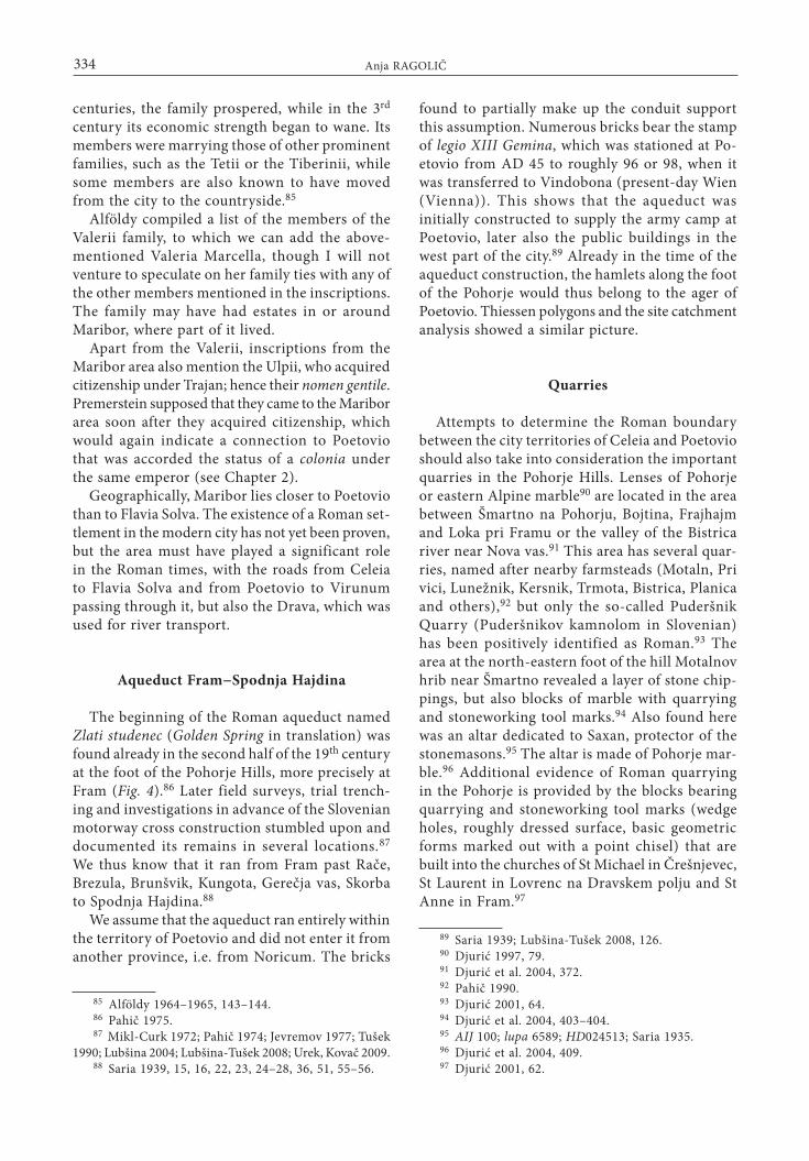
Fig. 1: Boundaries of the territory of Poetovio after Horvat et al. (2003, 154 Fig. 1).Sl. 1: Meje upravnega območja Petovione po Horvat et al. (2003, 154 Fig. 1).

327The territory of Poetovio and the boundary between Noricum and Pannonia
and the boundary between Noricum and Pannonia sought south of Slivnica.
The question of whether eastern Steiermark belonged to Pannonia or Noricum has been posed also by Ortolf Harl.34 He believes that the Raab river with its tributaries separated Noricum and Pannonia. He writes that the inscriptions mention-ing high-ranking officials do not necessarily appear only in the place of their origin. More reliable are the military tombstones, because soldiers were enlisted according to military districts. Based on the tombstones and stamps on bricks that mention units of soldiers from Upper Pannonian legions (XIV and X Gemina, I Adiutrix), he believes that eastern Steiermark belonged to Pannonia, as noted already by Mocsy on his map of Pannonia. This would put Maribor on the boundary between the provinces that also represented the point of the Drava crossing. He did not, however, clearly state whether Maribor belonged to Noricum and Pannonia.
In the book on the autonomous towns of Nori-cum and Pannonia, Irena Lazar35 wrote about the boundaries of the territory of Celeia. She drew the eastern boundary along the Sava, Sotla and cur-rent state boundary up to the Norican settlement of Ragando, further past Slovenske Konjice, after which it turns northwards; the settlements at the foot of the Pohorje would thus belong to Noricum.
In recent years, the delimitation of the terri-tory of Poetovio has been the topic tackled by Jana Horvat and her colleagues.36 Their article summarizes previous discussions on the topic and includes a map (Fig. 1).
3. DELIMITING THE TERRITORY OF POETOVIO
As shown above, the boundaries of Poetovio’s territory are far from clearly definable. The first problem is that there are no boundary stones mentioning Poetovio to help us. In Dalmatia, for example, several such stones have been recovered, either determining the boundary between two neighbouring tribes, private individuals or defin-ing access to a water source, forests and so forth.37 The only boundary stone from Slovenia was found
34 Harl 1997, 195–199.35 Lazar 2002, 72.36 Horvat et al. 2003, 160.37 Wilkes 1974.
at Bevke and determined the boundary between Aquileia and Emona, confirming, in the opinion of Marjeta Šašel Kos, the position of Emona as part of Regio X.38 For the territory of Poetovio, as stated above, no such evidence has been found, although the altar from Čadram, dedicated to the divinities of boundaries (see below), might have played a similar role.39
The boundaries might also be hinted at by the inscriptions mentioning city officials, though these may be misleading. In the past, the findspots of such inscriptions were usually regarded as having belonged to the territory of the city where the duumviri, aediles, quaestores, decurioni and other officials named in the inscriptions served.40 This information was used to determine the hinterland of cities, but also to infer on the boundaries of provinces.41 Today, however, we have a number of examples of inscriptions naming city officials that were found outside the territories of cities where they served.42 In addition, most known inscriptions of this type were not found in situ, but rather in secondary use, as building material in the walls of churches or other buildings; their primary position is thus only rarely clear.
Scholars also often drew boundaries based on geographical features, which they believed to have been considered by the Romans when determin-ing city territories. This may in some cases have been a correct assumption, but very often (as in the case of Poetovio) not possible. In connection with this, we should mention that the boundaries across hilly or mountainous terrains of the Roman Empire might never have been precisely deter-mined.43 Moreover, rivers in the Roman period were not regulated and changed their courses on several occasions during the centuries. The Ro-mans considered them more as boundary zones
38 Šašel Kos 2002.39 ILJug 405.40 Alföldy 1970, 160, 166–167; id. 1974, 98 Fig. 11;
id. 1989, 48–49.41 Gassner, Jilek 2002, 85–86.42 Alföldy 1970, 166; id. 1989, 48. Alföldy is aware that
city officials could visit other places and settle there as landowners. He also emphasizes that only a concentration of such inscriptions could serve as possible evidence. Examples of such inscriptions are also cited by: Vetters 1977, 310; Harl 1997, 196–197; Ehrenreich, Fuch, Wedenig 2006; Breščak, Lovenjak 2010. I therefore believe that individual finds must be considered with caution.
43 Gassner, Jilek 2002, 86.

328 Anja RAGOLIČ
than boundary lines.44 In the case of Celeia, for example, its territory supposedly reached across the Sava at Brestanica.45 In addition to a lack of other material evidence, the absence of natural boundaries makes determining the boundaries of a city territory completely impossible. We cannot (and must not) determine the extent of a city’s hinterland according to standards fixed in advance, because it varies from city to city. This was clearly shown in the case of Emona, the boundary of which towards Aquileia actually ran far more to the east than supposed prior to the discovery of the boundary stone near Bevke.46
Neither can we draw conclusions with the aid of onomastics, i.e. the study of the names mentioned in inscriptions that reveal similarities or differences within city territories. Pliny the Elder mentions the Sereti, Serapili, Iasi and Andiseti among the Pannonian tribes who probably lived along the Drava.47 The tribes living in the area of Poetovio were included into the Celtic Taurisci,48 who also lived in Noricum. Celtic names in Pannonia and Noricum are very similar and no islands of particular names are noticeable. The attempt by Jenő Fitz to compare the cognomina also failed to bring the desired results.49
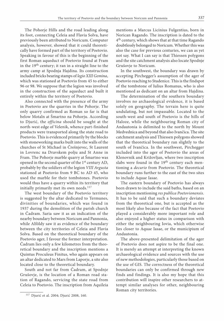
4. USE OF THIESSEN POLYGONS
As shown above, boundary stones, literary sources and small finds did not provide clear evidence for determining the territory of the Poetovio. This led me to make use of Thiessen polygons. This method is based on two assumptions, firstly, that the boundaries between settlement centres (ar-chaeological sites) are not known and, secondly, that the centres, spread across a certain area, act as centres of power for the parts of the countryside lying closer to one centre rather than any other. All points within any given polygon lie closer to the centres of this polygon rather than any other. It is a practical operation, in which we connect two cities, obtaining a segment line, after which
44 Gassner, Jilek 2002, 86.45 Alföldy 1974, 60; RINMS 180; Lazar 2002, 72. For
the changes in the course of the Sava and the supposition that the milestones in the Roman period stood to the north of the river see ILSl 1, p. 17.
46 Šašel Kos 2002.47 N. h. III 147–148.48 Horvat et al. 2003, 158.49 Fitz 1977; id. 1989–1990, 83–84.
we draw a perpendicular line at the centre of the segment line; the perpendicular line represents one side of a Thiessen polygon.
Having said that, we should be aware that Thiessen polygons are merely analytical tools to explain spatial relations. The shape of the obtained polygon does point to correct relations, but only additional analysis allows us to confirm whether the obtained extent of the polygon is reliable or not.50 The knowledge on the economic space plays an important role here, because it allows us to understand the dynamics of the area under study, for example the character of the Roman city and its functioning. Consequentially, this enables us to understand the role of the city in a wider context and the understanding of the economic significance forms a basis for further economic, cultural, historical, political and other studies.
In Slovenian archaeology, the first to use the methodology of spatial studies was Božidar Slapšak in his dissertation.51 With the advancement of computer-based data processing (the geographic information system or GIS), spatial archaeology gained impetus, also in Slovenia.52 The search for new interpretations and explanations of the role of individual sites involved a proliferation of new methodologies of spatial and landscape archaeol-ogy such as establishing the economic hinterland and cost surface analysis on the Iron Age sites of the Dolenjska region,53 Thiessen polygons in the study of the distribution of finds in the Krupsko polje in Bela krajina,54 site catchment analysis modules on the case study of economic hinterland of the Early Middle Age settlements in the Bled area,55 von Thünen model on the example of Ro-man Emona56 and others.
Use of Thiessen polygons and the site catchment analysis on the example of Poetovio57
The above-described method of Thiessen poly-gons was applied to the area of Poetovio, based on
50 Slapšak 1995, 48.51 Slapšak 1995; Novaković 2003, 250.52 Dular et al. 1992.53 Dular, Tecco Hvala 2007, 198–203; Novaković 2003,
117–118.54 Budja 1989.55 Štular 2006.56 Županek 2002.57 I thank Benjamin Štular, Iza ZRC SAZU, for his help
in this chapter and for creating the maps.

329The territory of Poetovio and the boundary between Noricum and Pannonia
the assumption that the administrative boundaries were the same as the ideal economic ones. Very important in drawing Thiessen polygons is to map sites of the same type, because the underly-
ing assumption is that all sites are known.58 My analysis took into consideration all archaeologically attested neighbouring cities that were autonomous. I mapped the economically self-governing cities
58 Slapšak 1995, 48.
Fig. 2: Thiessen polygons.Sl. 2: Thiessnovi poligoni.
330 Anja RAGOLIČ
and disregarded the differences in their status (colonia, municipium or civitas), because the cit-ies may have differed in status, but did not form hierarchical relationships; each required a relatively large hinterland to secure its survival.
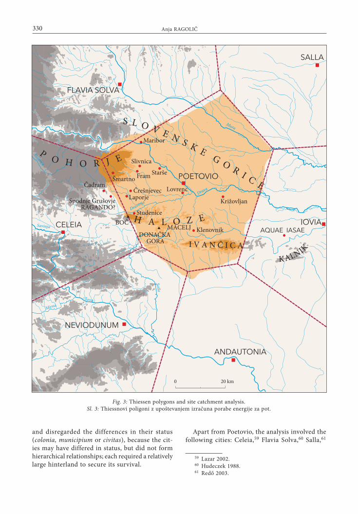
Apart from Poetovio, the analysis involved the following cities: Celeia,59 Flavia Solva,60 Salla,61
59 Lazar 2002.60 Hudeczek 1988.61 Redő 2003.
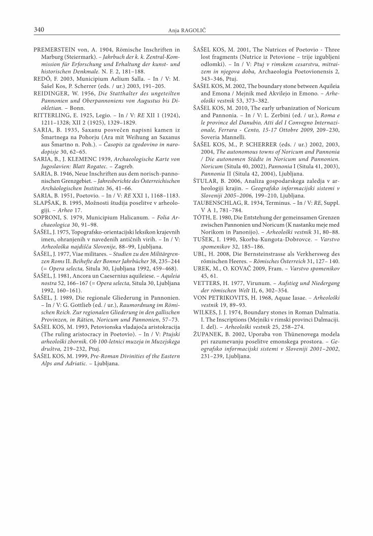
Fig. 3: Thiessen polygons and site catchment analysis.Sl. 3: Thiessnovi poligoni z upoštevanjem izračuna porabe energije za pot.

331The territory of Poetovio and the boundary between Noricum and Pannonia
Iovia,62 Andautonia63 and Neviodunum.64 Based on the current state of research, I believe that these towns represent a complete set, i.e. that all relevant sites are known.65
The first step (Fig. 2) was to map the towns and create Thiessen polygons. The obtained poly-gons represent an approximation of the actual delimitation in the case of boundaries running across the mid-distance between individual cit-ies. Other criteria, primarily the relief, were not considered in this step. The result served merely as an analytical aid, to later, after conducting the site catchment analysis, enable the comparison of the two analyses.
The next step (Fig. 3) was to include the relief (but not rivers – i.e. the Mura) in the Thiessen polygons, supposing that this would change the shape and extent of the previously drawn polygons. In the usual Thiessen polygon, each point on the polygon is equidistant from each adjacent centre, which means that the calculation is based on the line as the crow flies. This step also involved a site catchment analysis, which means that access-ing each point on the polygon required the same amount of energy.66
I expected that the boundary thus formed would shift to the highest peaks, i.e. to the Pohorje Hills in the northwest and to the Ivančica summit in the south. However, the resulting boundaries almost coincided with those in the previously created polygons! Because of the undulating terrain also in other areas around Poetovio, neither the Pohorje nor Ivančica represented an obstacle that would shift or change the territory boundaries when site catchment analysis are taken into considered.
62 Gregl, Migotti 2004.63 Nemeth-Ehrlich, Kušan Špalj 2003, 129.64 Lovenjak 2003.65 Halicanum (present-day Sv. Martin na Muri, Croatia),
which may positively be determined as a road station on the road from Poetovio to Carnuntum or Savaria on the basis of a note in the Antonine Itinerary and by the Anonymous of Ravenna, was not considered in the analysis. Its status of a municipium, supposedly obtained under Hadrian (Municipium Aelium Halicanum), can only be supposed on the basis of the inscription from Aquincum (Tit. Aq. 652; lupa 2959; HD008266). See Patsch 1912, 2878; Soproni 1979; Šašel 1981; Kerman 1990; Fitz 2003.
66 Štular 2006.
5. ATTEMPT AT A NEW DELIMITATION OF THE POETOVIO TERRITORY
The new delimitation of the city territory of Poetovio was drawn with the use of Thiessen polygons that included the results of the site catchment analysis (Fig. 4). Rivers (in this case the Mura) were not considered in the site catchment analysis. The Mura, however, represents the larg-est natural obstacle in the area between Salla and Poetovio, which led me to shift the boundary in the northeast closer to Poetovio, i.e. towards the southwest and determine the river as the most likely boundary.
The territory thus obtained can at least in part be substantiated by material evidence, which will be presented below.
Votive inscription from Čadram
The parish church in Čadram was torn down in 1937 and, during demolition, workers stumbled upon several Roman and Gothic stones. These included a small votive altar dedicated by Quintus Proculeus Finitus to the female/male protectors of boundaries called Termunes.67 This altar is not a boundary stone. However, dedications to the di-vinities of boundaries symbolized and represented boundaries68 and, very probably, stood in their immediate vicinity. The findspot of the altar has been widely discussed in the past years. Built into a church wall, it was certainly found in secondary location,69 which makes its original location near the boundary as drawn with the aid of Thiessen polygons uncertain. Furthermore, literature on this find raises the question of which boundary this inscription supposedly referred to, either between Noricum and Pannonia70 or between Celeia and Flavia Solva.71 Thiessen polygons and the site catchment analysis favour the former, i.e. the boundary between the provinces of Noricum and Pannonia, which is also the boundary between the city territories of Poetovio and Celeia. It is of interest that the dedicator, Quintus Proculeus Finitus, also appears on a dedication to Mars found
67 ILJug 405; lupa 9512; HD021879; Saria 1939, 18; id. 1946, 56–59.
68 Taubenschlag 1934.69 Saria 1939, 79.70 Saria 1939, 18, 78; id. 1946, 58–59.71 Alföldy 1974, 99 fn. 94.

332 Anja RAGOLIČ
Fig. 4: Theoretical boundaries of the territory of Poetovio.Sl. 4: Teoretična meja upravnega območja Petovione.
at Laporje.72 According to our polygons, Laporje is located just inside the ager of Poetovio, but very close to the theoretical boundary. The dedication
72 AIJ 83; lupa 8855; Saria 1939, 36.
to Termunes could thus have been set up by a man living in the immediate vicinity of the boundary.
Thiessen polygons were also used by Slapšak when attempting to establish the economic hinter-land of the Roman city in Ajdovščina near Rodik. When comparing the obtained polygons with

333The territory of Poetovio and the boundary between Noricum and Pannonia
the finds from the vicinity, he observed that an inscription,73 mentioning the area around the hill of Rodik and the town in Ajdovščina, was found only a few kilometres outside the polygon of the territory. The inscription is also not a boundary stone, but does mark the boundary between the land of Gaius Laecanius Bassus and that of the Rundictes. It may be pure coincidence, but the altar from Čadram offers an almost identical pic-ture for the ager of Poetovio. Its inscription does not specify the boundary, but the mention of the divinities certainly indicates one, either between provinces and/or cities, possibly even between private estates.
Mansio Ragando
Only a few kilometres south of Čadram lies Spodnje Grušovje, the location of the road station of Ragando, in the distance of 18 Roman miles from Poetovio. A settlement of a considerable size on this spot is corroborated by small finds. According to Thiessen polygons, the station is located only slightly to the west of the boundary, i.e. in Noricum. The station is also referred to on an inscription slab, found already in 1889 in Aquileia,74 which mentions a Licinius Fulgentius natus in Norico Ragandone.75 This clearly locates the station to Noricum. However, the inscription is dated to the 4th century and reflects the state of affairs at that time. After the reforms of Diocle-tian, the territories of Poetovio and Celeia both belonged to the newly founded province of Nori-cum Mediterraneum. The inscription tells us that Licinius Fulgentius died over 50 years old; if the inscription dates more precisely to the beginning of the 4th century, we could undoubtedly locate mansio Ragando, according to the boundaries determined with Thiessen polygons, to Noricum. If the inscription is of a later date, it cannot and should not be taken in consideration when at-tempting to determine the boundary in question.
73 CIL V 698; ILJug 450; lupa 16158; Slapšak 1995, 69 (with references).
74 Maionica 1893, 117; CIL III p. 232847; Inscr. Aquil. 2858; lupa 17098.
75 D(is) M(anibus) et in perpetuo / securitatem Licinius / Fulgent(ius) ex(archus) n(umeri) eq(uitum) Stabl(e)s(ianorum) / natus in Nor(ico) Ragand(one) /5 qui vixit an(nos) L m(enses) VI / d(ies) III qui perit in aqua / Aquil(eiae) die V Idus Iul(ias) / facta memor(ia) de suo per Avit(um) exarchum /10 [et] filium Adiurmium.
Maribor
The cult of the Nutrices ranks among the most important ones in the area of Poetovio, alongside that of Mithra. Numerous inscriptions and reliefs dedicated to these wet nurses and protectresses of infants and youth were found in Zgornji Breg and Spodnja Hajdina at Ptuj. Their sanctuary is believed to have stood in Spodnja Hajdina,76 while Abramić supposed a second, smaller sanctuary at Zgornji Breg.77 In the 1980s, for example, a grave from the 4th century was unearthed while planting apple trees on the hill of Panorama. It was lined with six stone slabs and covered with the seventh one. All the slabs bore dedications to the Nutrices and certainly originated from a sanctuary that must have been located in the vicinity.78
The numerous finds with dedications to the Nutrices are limited to Poetovio, with a single exception found in Maribor. The latter was an altar, which is now lost, but we do have its tran-scription and the information that it was visible in Marchburgi in basi turris ecclesiae.79 Because of the considerable distance separating Ptuj and Maribor, it is unlikely that the inscription was originally from Poetovio.80 The altar thus most probably originated from the Maribor area. In this case, the cult of the Nutrices suggests that Maribor belonged to the territory of Poetovio.81 Furthermore, the inscription on the altar mentions a Valeria Marcella.82 Her nomen gentile is a well known one in Poetovio. In the 2nd century, the Valerii were the most prominent family of Poetovio, the members of which held high-ranking positions in the city administration, as many as four serving as duoviri.83 A very prominent personality from this family was also Marcus Valerius Maximianus the Younger, who had a successful military career and went on to become the first known Panno-nian senator.84 The family was originally from north Italy and probably came to Poetovio in the first half of the 1st century. During the 1st and 2nd
76 Gurlitt 1896.77 Abramić 1925b, 32.78 Šašel Kos 1999, 168.79 CIL III 5314 = 11713; Šašel Kos 2001, 343–346 with
earlier references.80 Gurlitt believed that the inscription undoubtedly
originated from Spodnja Hajdina. See Gurlitt 1896.81 Šašel Kos 1999, 178–180.82 Šašel Kos 1999, 180.83 Šašel Kos 1993, 222–225.84 Alföldy 1964–1965.
334 Anja RAGOLIČ
centuries, the family prospered, while in the 3rd century its economic strength began to wane. Its members were marrying those of other prominent families, such as the Tetii or the Tiberinii, while some members are also known to have moved from the city to the countryside.85
Alföldy compiled a list of the members of the Valerii family, to which we can add the above-mentioned Valeria Marcella, though I will not venture to speculate on her family ties with any of the other members mentioned in the inscriptions. The family may have had estates in or around Maribor, where part of it lived.
Apart from the Valerii, inscriptions from the Maribor area also mention the Ulpii, who acquired citizenship under Trajan; hence their nomen gentile. Premerstein supposed that they came to the Maribor area soon after they acquired citizenship, which would again indicate a connection to Poetovio that was accorded the status of a colonia under the same emperor (see Chapter 2).
Geographically, Maribor lies closer to Poetovio than to Flavia Solva. The existence of a Roman set-tlement in the modern city has not yet been proven, but the area must have played a significant role in the Roman times, with the roads from Celeia to Flavia Solva and from Poetovio to Virunum passing through it, but also the Drava, which was used for river transport.
Aqueduct Fram−Spodnja Hajdina
The beginning of the Roman aqueduct named Zlati studenec (Golden Spring in translation) was found already in the second half of the 19th century at the foot of the Pohorje Hills, more precisely at Fram (Fig. 4).86 Later field surveys, trial trench-ing and investigations in advance of the Slovenian motorway cross construction stumbled upon and documented its remains in several locations.87 We thus know that it ran from Fram past Rače, Brezula, Brunšvik, Kungota, Gerečja vas, Skorba to Spodnja Hajdina.88
We assume that the aqueduct ran entirely within the territory of Poetovio and did not enter it from another province, i.e. from Noricum. The bricks
85 Alföldy 1964–1965, 143–144.86 Pahič 1975.87 Mikl-Curk 1972; Pahič 1974; Jevremov 1977; Tušek
1990; Lubšina 2004; Lubšina-Tušek 2008; Urek, Kovač 2009.88 Saria 1939, 15, 16, 22, 23, 24–28, 36, 51, 55–56.
found to partially make up the conduit support this assumption. Numerous bricks bear the stamp of legio XIII Gemina, which was stationed at Po-etovio from AD 45 to roughly 96 or 98, when it was transferred to Vindobona (present-day Wien (Vienna)). This shows that the aqueduct was initially constructed to supply the army camp at Poetovio, later also the public buildings in the west part of the city.89 Already in the time of the aqueduct construction, the hamlets along the foot of the Pohorje would thus belong to the ager of Poetovio. Thiessen polygons and the site catchment analysis showed a similar picture.
Quarries
Attempts to determine the Roman boundary between the city territories of Celeia and Poetovio should also take into consideration the important quarries in the Pohorje Hills. Lenses of Pohorje or eastern Alpine marble90 are located in the area between Šmartno na Pohorju, Bojtina, Frajhajm and Loka pri Framu or the valley of the Bistrica river near Nova vas.91 This area has several quar-ries, named after nearby farmsteads (Motaln, Pri vici, Lunežnik, Kersnik, Trmota, Bistrica, Planica and others),92 but only the so-called Puderšnik Quarry (Puderšnikov kamnolom in Slovenian) has been positively identified as Roman.93 The area at the north-eastern foot of the hill Motalnov hrib near Šmartno revealed a layer of stone chip-pings, but also blocks of marble with quarrying and stoneworking tool marks.94 Also found here was an altar dedicated to Saxan, protector of the stonemasons.95 The altar is made of Pohorje mar-ble.96 Additional evidence of Roman quarrying in the Pohorje is provided by the blocks bearing quarrying and stoneworking tool marks (wedge holes, roughly dressed surface, basic geometric forms marked out with a point chisel) that are built into the churches of St Michael in Črešnjevec, St Laurent in Lovrenc na Dravskem polju and St Anne in Fram.97
89 Saria 1939; Lubšina-Tušek 2008, 126.90 Djurić 1997, 79.91 Djurić et al. 2004, 372.92 Pahič 1990.93 Djurić 2001, 64.94 Djurić et al. 2004, 403–404.95 AIJ 100; lupa 6589; HD024513; Saria 1935.96 Djurić et al. 2004, 409.97 Djurić 2001, 62.

335The territory of Poetovio and the boundary between Noricum and Pannonia
Bojan Djurić supposes that the officina of the quarry was located in the vicinity of Šmartno, somewhere between Zgornja Polskava and the main Roman road from Celeia to Poetovio, possibly even at the north-eastern edge of the Velenik for-est.98 From there, marble blocks and part-finished products were transported along the state road to Poetovio.99
Based on marble analyses, Djurić supposes that the early, simple steles from Poetovio, dated around AD 25, were made from the marble quarried at Gummern in Kärnten, Austria.100 The extraction of the marble from Pohorje supposedly only began in the second quarter of the 1st century; it was, for example, used to make the stele of Marcus Petro-nius Classicus,101 centurion of legio VIII Augusta, and of a retired soldier of the same legion.102 The so-called architectural and aedicula-type steles from the mid-1st century were again only made of Gummern marble, while the steles with moulded frames continued to be made of Pohorje marble.103 This suggests that a particular marble (Gummern) was used to make a particular type of stele by specific orders, and that the distance from the quarry to the city played a lesser role.
The question of the status of the quarries on the Pohorje, i.e. who owned them, is a more difficult one. Based on the steles from the 1st century,104 Djurić supposes that Pohorje marble began to be extracted in the second quarter of the 1st century by the soldiers of the Eighth Augustan Legion.105 The high-quality marble first served the needs of Poetovio,106 while products of Pohorje marble were later being exported also outside the city territory. The dates of the funerary monuments from Po-etovio, the marble blocks with stoneworking tool marks built into the walls of churches and, most of all, the distribution of the products of Pohorje marble, which locates the centre of their trading
98 Djurić 2001, 63.99 Djurić et al. 2004, 409.100 The stele of Saturninus, hastatus of the Eight
Augustan Legion, is dated to around AD 25 (AIJ 262; lupa 3749). See Djurić 2005, 77; Djurić et al. 2004, 405.
101 CIL III 4060; CIL III 10869; AIJ 260; lupa 3102.102 lupa 6194; HD004954. See Djurić 2005, 77; id.
2008, 162.103 Djurić 2005, 409–410; id. 2008, 163.104 AIJ 260; CIL III 4060, CIL III 10869; lupa 3102;
Djurić 2005, 78.105 Djurić 2008, 161.106 Djurić 2005, 80; Djurić et al. 2004, 410; Djurić
2008, 164.
to Poetovio, led Djurić to ascribe the quarry/quar-ries from the vicinity of Šmartno na Pohorju to the city territory of Poetovio.107
Slivnica near Maribor
In earlier literature, we find that the area around Slivnica was most often attributed to the city terri-tory of Flavia Solva.108 This attribution was based on the tombstone of Caius Iustius Proculus,109 whom the inscription revealed as aedilis of Flavia Solva. Assuming that officials could only serve within the territory of their city, the area of Slivnica and northwards was thus set outside the territory of Poetovio. The evidence given above, i.e. the quarries in the vicinity of Šmartno, the aqueduct at Fram, the inscription from Starše mentioning colonia Poetoviensis and the inscription from Maribor dedicated to Nutrices, however, shows that Slivnica as well, located between Fram and Maribor, belonged to the territory of Poetovio. The tombstone could thus serve as yet another example of city officials serving outside the ter-ritory of their native city.
Aquae Iasae
The thermal springs in the area of present-day Varaždinske Toplice led the Romans to found a settlement in this spot and name it Aquae Iasae. The systematic archaeological excavations have been conducted here since 1953 and revealed a public area (forum) with a porticus and temples, as well as baths and a basilica in their vicinity.110 The first baths were built already in the 1st century and later extended and rearranged on several oc-casions, last under Constantine I.111
The inscription slabs, most often dedicated to the nymphs, but also other divinities, reveal that the thermal springs were visited by private individuals, but also high-ranking officials and soldiers.112 A particularly important inscription for this article
107 Djurić et al. 2004. The article contains an error; Hinker ascribes Šmartno na Pohorju first to Poetovio (see 383–403) and then to Celeia (see 421–425).
108 Hudeczek 1988, 23.109 CIL III 5309; lupa 9525.110 Kušan Špalj, Nemeth-Ehrlich 2012 with earlier
literature.111 CIL III 4121; AIJ 469; lupa 5339.112 AIJ 458–471.

336 Anja RAGOLIČ
is one dating from the reign of Marcus Aurelius, which states that the governor of Pannonia Superior, Lucius Dasumius Tullius Tuscus, ordered the res publica Poetovionensis to build a part of the bath complex; the work was arranged by procurator Titus Geminius Rufinus.113 The mention of Poetovio was evidence enough for the researchers in the past to ascribe Aquae Iasae to the territory of Poetovio. Comparing the baths to others known across the Empire (Aquae Sulis, present-day Bath; Aquae Granni, present-day Aachen; Aquae, present-day Baden-Baden), Harald von Petrikovits supposed that the soldiers not only visited the spa and baths complex at Aquae Iasae, but were also involved in its construction. He believed that Aquae Iasae, located at the edge of the province of Pannonia Superior, became the spa of the legions stationed in (Upper) Pannonia.114
The analysis made with the use of Thiessen polygons and the site catchment analysis, taking into consideration the natural and other sources, puts Aquae Iasae outside the city territory of Po-etovio. If geographic location of the spa were the sole criterion, Aquae Iasae would belong to Iovia115 rather than Poetovio. From the administrative point of view, however, the opposite has always been the accepted interpretation. Throughout the Imperial period, from its very beginnings, Poetovio played a considerably more important role (army camp, colony from the reign of Trajan onwards, seat of Illyrian customs) in comparison to Iovia. Andau-tonia was located considerably father to the south and it is thus not very likely that the baths formed part of its territory. The inscription mentioning res publica Poetovionensis would thus speak in favour of the baths forming part of the territory of Poetovio.
6. SOUTHERN BOUNDARY
The author most occupied with the southern boundary of Poetovio’s territory was Pirchegger. In the southwest, he located the farthest point at Studenice. This is the findspot of the tombstone of Caius Iulius Romanus, which, in his opinion,
113 CIL III 4117, AIJ 461; lupa 5346; Von Petrikovits 1968; on Dasumius Tullius Tuscus see Reidinger 1956, 83–84 No. X; Dobó 1968, 109–110 No. 88; Fitz 1993, 487–489 No. 289; on Geminius Rufinus, only known from this inscription, last by Fitz 1993, 727 No. 404.
114 Von Petrikovits 1968, 93.115 Gregl, Migotti 2004, 135 with earlier literature.
is the same person as the one mentioned on an altar from Hajdina; this he considered evidence for attributing Studenice to the ager of Poetovio. From there, he drew the boundary along the peaks of the Haloze, in the line of Boč–Donačka gora–Macelj. Further to the east, he determined the boundary based on the inscription slabs from Klenovnik and Križovljan, each of which mentions a decurio from Poetovio (see Chapter 2).
All the locations mentioned above fall within the theoretical boundary drawn with the use of Thiessen polygons and the site catchment analysis. Pirchegger’s boundary in the south-west runs just slightly more to the west of Studenice, while con-siderably more territory is included in the south and the southeast.
7. CONCLUSION
The lack of conclusive evidence, particularly boundary stones, has prevented the boundaries of the ager of Poetovio to be drawn with any cer-tainty. This led me to reconsider the known stone monuments and other archaeological finds and to attempt to determine the boundaries also with the aid of the GIS-based site catchment analysis and Thiessen polygons.
The obtained results showed that in the north-east, the territory of Poetovio supposedly reached to the Mura, which represents the largest natural obstacle between Poetovio and Salla.
The determination of the northern border is hindered by a lack of conclusive evidence and I thus turned to the boundaries as drawn with the aid of Thiessen polygons and the site catchment analysis. This led me to include the area of Mari-bor, previously attributed to Flavia Solva, in the territory of Poetovio. Such an interpretation is corroborated by several inscription slabs found in and around the present-day town, which mention families that acquired citizenship under Trajan and were thus given the nomen gentile of Ulpius.116 According to Premerstein, these families came to the area of Maribor from the nearby colony of Po-etovio. A further proof is the now lost votive altar dedicated to the Nutrices that mention a Valeria Marcella. The cult of the Nutrices is only known from Poetovio, while the Valerii represented one of the most prominent families in Poetovio.
116 AIJ 111; ILLPRON 1813; lupa 2129 and CIL III 15206; AIJ 112; ILLPRON 1814; lupa 3661.
337The territory of Poetovio and the boundary between Noricum and Pannonia
The Pohorje Hills and the road leading along its foot, connecting Celeia and Flavia Solva, have previously been attributed to Noricum. Computer analysis, however, showed that it could theoreti-cally have formed part of the territory of Poetovio. Speaking in favour of this is the beginning of the first Roman aqueduct of Poetovio found at Fram in the 19th century; it ran in a straight line to the army camp at Spodnja Hajdina. Its construction included bricks bearing stamps of legio XIII Gemina, which was stationed at Poetovio from 45 to either 96 or 98. We suppose that the legion was involved in the construction of the aqueduct and built it entirely within the territory of Poetovio.
Also connected with the presence of the army in Poetovio are the quarries in the Pohorje. The only quarry confirmed as Roman so far is that below Motaln at Šmartno na Pohorju. According to Djurić, the officina should be sought at the north-west edge of Velenik, whence part-finished products were transported along the state road to Poetovio. This is evidenced primarily by the blocks with stoneworking marks built into the walls of the churches of St Michael in Črešnjevec, St Laurent in Lovrenc na Dravskem polju and St Anne in Fram. The Pohorje marble quarry at Šmartno was opened in the second quarter of the 1st century AD, probably by the soldiers of the legion VIII Avgusta stationed at Poetovio from 9 BC to AD 45, who used the marble for their tombstones. Poetovio would thus have a quarry within its territory that initially primarily met its own needs.117
The west boundary of the Poetovio territory is suggested by the altar dedicated to Termunes, divinities of boundaries, which was found in 1937 during the demolition of the parish church in Čadram. Saria saw it as an indication of the nearby boundary between Noricum and Pannonia, while Alföldy saw it as evidence of the boundary between the city territories of Celeia and Flavia Solva. Based on the theoretical boundary of the Poetovio ager, I favour the former interpretation. Čadram lies only a few kilometres from the theo-retical boundary and the inscription mentions a Quintus Proculeus Finitus, who again appears on an altar dedicated to Mars from Laporje, a site also located close to the theoretical boundary.
South and not far from Čadram, at Spodnje Grušovje, is the location of a Roman road sta-tion of Ragando, servicing the state road from Celeia to Poetovio. The inscription from Aquileia
117 Djurić et al. 2004; Djurić 2008, 160.
mentions a Marcus Licinius Fulgentius, born in Norican Ragando. The inscription is dated to the 4th century, which shows that at that time Ragando doubtlessly belonged to Noricum. Whether this was also the case for previous centuries, we can as yet not say. What I can say is that Thiessen polygons and the site catchment analysis also locate Spodnje Grušovje to Noricum.
In the southwest, the boundary was drawn by accepting Pirchegger’s assumption of the ager of Poetovio reaching to Studenice. This is the findspot of the tombstone of Iulius Romanus, who is also mentioned as dedicant on an altar from Hajdina.
The determination of the southern boundary involves no archaeological evidence, it is based solely on geography. The terrain here is quite undulating, but not impassable. Located to the south-west and south of Poetovio is the hills of Haloze, while the neighbouring Roman city of Andautonia is delimited to the north by Mount Medvednica and beyond that also Ivančica. The site catchment analysis and Thiessen polygons showed that the theoretical boundary ran slightly to the south of Ivančica. In the southwest, Pirchegger included into the ager of Poetovio the areas of Klenovnik and Križovljan, where two inscription slabs were found in the 19th century each men-tioning a decurio from Poetovio. The theoretical boundary runs further to the east of the two sites to include Aquae Iasae.
The eastern boundary of Poetovio has always been drawn to include the said baths, based on an inscription mentioning res publica Poetovionensis. It has to be said that such a boundary deviates from the theoretical one, but is accepted as the most likely also because of the fact that Poetovio played a considerably more important role and also enjoyed a higher status in comparison with either the neighbouring Iovia, which otherwise lies closer to Aquae Iasae, or the municipium of Andautonia.
The above-presented delimitation of the ager of Poetovio does not aspire to be the final one. It is merely an attempt at interpreting the known archaeological evidence and sources with the use of new methodologies, particularly those based on the use of GIS. The correctness of the theoretical boundaries can only be confirmed through new finds and findings. It is also my hope that this contribution will inspire other researchers to at-tempt similar analyses for other, neighbouring Roman city territories.

338 Anja RAGOLIČ
Addendum
Investigations at Aquae Iasae are ongoing. The excavations conducted since 2001 in the area of the spring pool have shown that the renovation of the pool in the 4th century used earlier inscrip-tions, reliefs and even statues as building mate-rial. The inscribed stones include a pedestal for a statue and two altars that are of interest here. The pedestal bore a dedicatory inscription mentioning Quintus Gavius Fronto, primus pilus of the legion XIII Gemina and praefectus of the communities of
the Scordisci, Breuci and Iasi.118 Both the mention of the Thirteenth Legion, which was stationed at Poetovio, and even more so the two altars,119 each mentioning a priest who attended to the mainte-nance of the Imperial cult at Poetovio (avgustalis Coloniae Ulpiae Traianae Poetoviensis), confirm our assumption on the spa of Aquae Iasae forming part of the territory of Poetovio.
Translation: Andreja Maver
118 Kušan Špalj 2014, 152 No. 64.119 Kušan Špalj 2014, 159 No. 73 and 164 No. 79.
Abbreviations / Kratice
AIJ = V. Hoffiller, B. Saria, Antike Inschriften aus Jugoslavien, Heft I: Noricum und Pannonia Superior. – Zagreb 1938.
CIL = Corpus inscriptionum Latinarum.HD = EDH, Epigraphische Datenbank Heidelberg (skrb-
nik / Service provider: Heidelberger Akademie der Wissenschaften; http://edh-www.adw.uni-heidelberg.de/home?&lang=de).
ILJug = A. et J. Šašel, Inscriptiones Latinae, quae in Iugoslavia inter annos MCMLX et MCMLXX repertae et editae sunt (Situla 19). – Ljubljana 1978; iidem, Inscriptiones Lati-nae, quae in Jugoslavia inter annos MCMII et MCMXL repertae et editae sunt (Situla 25). – Ljubljana 1986.
ILLPRON = Inscriptionum lapidariarum Latinarum pro-vinciae Norici.
ILSl 1 = M. Lovenjak, Inscriptiones Latinae Sloveniae 1. Neviodunum (Situla 37). – Ljubljana, 1998.
Inscr. Aquil. = J. B. Brusin, Inscriptiones Aquileiae I–III. – Udine 1991–1993.
lupa = UBI ERAT LUPA – F. und O. Harl, www.ubi-erat--lupa.org (Bilddatenbank zu antiken Steindenkmälern).
RE = Pauly-Wissowa-Kroll-Mittelhaus-Ziegler, Real-Encyclopädie der classischen Altertumswissenschaft. – Stuttgart 1893–1995.
RINMS = M. Šašel Kos, The Roman Inscriptions in the National Museum of Slovenia / Lapidarij Narodnega muzeja Slovenije (Situla 35). – Ljubljana 1997.
Tit. Aq. = Kovács, P., Á. Szabó 2010, Tituli Aquincenses II (Tituli sepulcrales et alii Budapestini reperti). – Budapestini.
ABRAMIĆ, M. 1925a, Poetovio. Vodnik po muzeju in stavbnih ostankih rimskega mesta. – Ptuj.
ABRAMIĆ, M. 1925b, Poetovio. Führer durch die Denkmäler der römischen Stadt. – Wien.
ALFÖLDI, A. 1936, The central danubian Provinces. – In / V: Cambridge Ancient History XI. The imperial peace A. d. 70-192, 540–554.
ALFÖLDY, G. 1964–1965, Die Valerii in Poetovio (Valerii v Poetovioni). – Arheološki vestnik 15/16, 137–144.
ALFÖLDY, G. 1970, Patrimonium Regni Norici. Ein Be-itrag zur Territorialgeschichte der römischen Provinz Noricum. – Bonner Jahrbücher 170, 163–177.
ALFÖLDY, G. 1974, Noricum. – London, Boston.ALFÖLDY, G. 1989, Die regionale Gliederung in der
römischen Provinz Noricum. – In / V: G. Gottlieb (ed. / ur.), Raumordnung im Römischen Reich. Zur regiona-len Gliederung in den gallischen Provinzen, in Rätien, Noricum und Pannonien, 37–55.
BREŠČAK, D., M. LOVENJAK 2010, The tombstone of two town magistrates of Celeia in the region of Nevio-dunum / Nagrobnik dveh mestnih veljakov iz Celeje na območju Nevioduna. – Arheološki vestnik 61, 295–310.
BUDJA, M. 1989, Arheološki zapis na površju, palimpsest preteklih stanj. – Poročilo o raziskovanju paleolita, neolita in eneolita v Sloveniji 17, 83–102.
DJURIĆ, B. 1997, Eastern Alpine Marble and Pannonian Trade. – In / V: B. Djurić, I. Lazar (eds. / ur.), Akten des IV. Internationalen Kolloquiums über Probleme des provinzialrömischen Kunstschaffens, Situla 36, 73–86.
DJURIĆ, B. 2001, The end od Roman Quarrying on Pohorje (Konec rimskih kamnolomov marmorja na Pohorju). – In / V: Ptuj v rimskem cesarstvu, mitraizem in njegova doba, Archaeologia Poetovionensis 2, 61–70, Ptuj.
DJURIĆ, B. 2005, Poetovio and the Danube marble trade. – In / V: Römische Städte und Festungen an der Donau: Akten der regionalen Konferenz organisiert von Alexander von Humboldt-Stiftung, Beograd, 16-19 Oktober 2003, 75–82, Beograd.
DJURIĆ, B. 2008, Early stelae from Poetovio and the marble studies. – In / V: S. Lamm et al. (eds. / ur.), Thiasos. Festschrift für Erwin Pochmarski zum 65. Geburtstag, Veröffentlichungen des Instituts für Archäologie der Karl-Franzens-Universität Graz 10, 159–165, Wien.
DJURIĆ B., B. HERBERT, C. HINKER, E. HUDECZEK, S. KARL, W. H. MÜLLER 2004, Marmore römischer Brüche und Steindenkmäler in der Steiermark und in Štajerska. Ergebnisse eines Forschungsprojektes. – Fund-berichte aus Österreich 43 (2005), 365–431.
DOBÓ, Á. 1968, Die Verwaltung der römischen Provinz Pannonien von Augustus bis Diocletianus. Die provinziale Verwaltung. – Budapest.

339The territory of Poetovio and the boundary between Noricum and Pannonia
DULAR, J., S. TECCO HVALA 2007, South-eastern Slovenia in the Early Iron Age. Settlement – Economy – Society / Jugovzhodna Slovenija v starejši železni dobi. Poselitev – gospodarstvo – družba. – Opera Instituti Archaeologici Sloveniae 12.
DULAR, J., B. SLAPŠAK, Z. STANČIČ, S. TECCO HVALA 1992, Arheologija in GIS. – Oddelek za geografijo Filo-zofske fakultete Univerze v Ljubljani. Dela 9, 213–222.
EGGER, R., H. VETTERS 1963, Topographie der Römer-zeit. – In / V: Atlas von Österreich, Karte V/3, Wien.
EHRENREICH, S., G. FUCH, R. WEDENIG 2006, Ein municipaler Questor von Celeia im mittleren Murtal. Die Grabinschrift vom Kirchberg bei Deutschfeistitz, Steiermark (Kvestor municipija Celeje na območju avstrijske Štajerske). – Arheološki vestnik 57, 417–426.
FEHÉR, B., P. KOVÁCS 2005, Early Geographers. The Period of the Roman Conquest (to AD 54). – Fontes Pannoniae Antiquae 1, Budapest.
FITZ, J. 1977, Onomastique Pannonienne: La population de la Pannonie sous l'aspect de l'onomastique et de l'archeologie. – In / V: L'Onomastique Latine, Collo-ques Internationaux du Centre Nationale de Recherche Scientifique, 395–402, Paris.
FITZ, J. 1989–1990, Noricum und Pannonien zur Zeit der römischen Okupation. – Römisches Österreich 17/18, 79–86.
FITZ, J. 1993, Die Verwaltung Pannoniens in der Römerzeit I–IV. – Budapest.
FITZ, J. 2003, Die Städte Pannoniens. – In / V: M. Šašel Kos, P. Scherrer (eds. / ur.) 2003, 47–52.
GASSNER, V., S. JILEK 2002, Die Frühzeit. – In / V: V. Gassner, S. Jilek, S. Ladstätter, Am Rande des Reiches. Die Römer in Österreich. Österreichische Geschichte 15 v. Chr.-378 n. Chr., 78–152, Wien.
GRAßL, H. 1994, Die Grenzen der Provinz Noricum - Pro-bleme der Quellenkunde in der antiken Raumordnung. – In / V: E. Olsahausen, H. Sonnabend (eds. / ur.), Stuttgarter Kolloquium zur historischen Geographie des Altertums 4, 1990, (Geographica historica 7), 517–524.
GREL, Z., B. MIGOTTI 2004, Civitas Iovia (Botivo). – In / V: M. Šašel Kos, P. Scherrer (eds. / ur.) 2004, 131–143.
GURLITT, W. 1896, Die Nutrices Augustae. – Archaeolo-gisch-epigraphische Mitteilungen 19, 1–25.
HARL, O. 1997, Norikum oder Oberpannonien? Die Grabädikula eines Kaiserpriestes aus Bad Waltersdorf / Steiermark. – In / V: G. Erath, M. Lehner, G. Schwarz (eds. / ur.), Komos. Festschrift Thuri Lorenz zum 65. Geburtstag, 185–202, Wien.
HORVAT, J., M. LOVENJAK, A. DOLENC VIČIČ, M. LUBŠINA TUŠEK, M. TOMANIČ JEVREMOV, Z. ŠUBIC 2003, Poetovio, Development and Topography. – In / V: M. Šašel Kos, P. Scherrer (eds. / ur.) 2003, 153–189.
HRIBERŠEK, M. (prev. / transl.) 2012, Plinij starejši, Naravoslovje 1. Kozmologija in geografija. Knjige 1–6. – Historia scientiae, Ljubljana.
HUDECZEK, E. 1988, Flavia Solva. – In / V: G. Christian (ed. / ur.), Leibnitz 75 Jahre Stadt. Festschrift zum Jubiläum der Stadterhebung am 27. April 1913, 21–54, Leibnitz.
JEVREMOV, B. 1977, Zgornja Hajdina pri Ptuju. – Varstvo spomenikov 21, 278–279.
KERMAN, B. 1994, Halicanum – Lindolveschirichun ali Lendava? / Halicanum - Lindolveschirichun or Lendava? – In / V: Lendavski zvezki 14, 12–17, Lendava.
KOVÁCS, P. 2008, Some notes on the Division of Illyricum. – In / V: I. Piso (ed. / ur.), Die Römischen Provinzen. Begriff und Gründng, 237–247, Cluj, Napoca.
KUŠAN ŠPALJ, D. [et al.] 2014, Katalog razstavljenih del / Cataloque of exhibited works. – In / V: N. Pirnat--Spahić, (ed. / ur.), Aquae Iasae. Najnovejše rimske najdbe na področju Varaždinskih Toplic / Aquae Iasae. Recent discoveries of Roman remains in the region of Varaždinske Toplice, Ljubljana.
KUŠAN ŠPALJ, D., D. NEMTH-EHRLICH 2012, Aquae Iasae – Varaždinske toplice. Arheološka istraživanja rimskog izvorišnog bazena i okolnog prostora (Aquae Iasae – Varaždinske Toplice – archaeological research of roman fountain pool and its surroundings). – In / V: Arheologija varaždinskog kraja i srednjeg Podravlja 28, 107–129.
LAZAR, I. 2002, Celeia. – In / V: M. Šašel Kos, P. Scherrer (eds. / ur.) 2002, 71–101.
LOVENJAK, M. 2003, Municipium Flavium Latobicorum Neviodunum. – In / V: M. Šašel Kos, P. Scherrer (eds. / ur.) 2003, 93–105.
LUBŠINA, M. 2004, Arheološke raziskave na trasi rim-skega vodovoda Fram-Poetovio v Kungoti pri Ptuju (Archäologische Untersuchungen and der Trasse des römischen Wasserleitungssystems Fram – Poetovio in Kungota pri Ptuju). – Časopis za zgodovino in narodo-pisje 2004/1, 29–40.
LUBŠINA-TUŠEK, M. 2008, Kungota pri Ptuju. – Varstvo spomenikov 44, 124–126.
MAIONICA, E. 1893, Nachrichten über das k. k. Staats--Museum in Aquileia. – Mittheilungen der k. k. Cen-tral-Commission zur Erforschung und Erhaltung der Kunst- und historischen Denkmale 19, 113–117.
MIKL-CURK, I. 1972, Fram. – Varstvo spomenikov 15, 152–154.
MOCSY, A. 1974, Pannonia and Upper Moesia. A history of middle Danube provinces of the Roman Empire. – London, Boston.
MOSSER, M. 2002, C. Atius und die legio XV Apollinaris in Vindobona. – Fundort Wien. Berichte zur Archäologie 5, 102–126.
NEMETH-EHRLICH, D., D. KUŠAN ŠPALJ 2003, Muni-cipium Andautonia. – In / V: M. Šašel Kos, P. Scherrer (eds. / ur.) 2003, 107–129.
NOVAKOVIĆ, P. 2003, Osvajanje prostora. Razvoj prostorske in krajinske arheologije. – Ljubljana.
PAHIČ, S. 1974, Ješenca pri Račah. – Varstvo spomenikov 17–19/1, 130.
PAHIČ, S. 1975, Fram. – In / V: Arheološka najdišča Slo-venije, 300, Ljubljana.
PAHIČ, S. 1990, Rimljani na Šmartnem. – Naši kraji v pradavnini 5, Maribor.
PATSCH, C. 1912, Halicanum. – In / V: RE VII 2, 2878.PIRCHEGGER, H. 1911, Das Stadtbezirk Poetovios. –
Zeitschrift des Historischen Vereines für Steiermark 9, 100–110.
POLASCHEK, E. 1936, Noricum. – In / V: RE XVII 1, 971–1048.
340 Anja RAGOLIČ
PREMERSTEIN von, A. 1904, Römische Inschriften in Marburg (Steiermark). – Jahrbuch der k. k. Zentral-Kom-mission für Erforschung und Erhaltung der kunst- und historischen Denkmale. N. F. 2, 181–188.
REDŐ, F. 2003, Municipium Aelium Salla. – In / V: M. Šašel Kos, P. Scherrer (eds. / ur.) 2003, 191–205.
REIDINGER, W. 1956, Die Statthalter des ungeteilten Pannonien und Oberpannoniens von Augustus bis Di-okletian. – Bonn.
RITTERLING, E. 1925, Legio. – In / V: RE XII 1 (1924), 1211–1328; XII 2 (1925), 1329–1829.
SARIA, B. 1935, Saxanu posvečen napisni kamen iz Šmartnega na Pohorju (Ara mit Weihung an Saxanus aus Šmartno n. Poh.). – Časopis za zgodovino in naro-dopisje 30, 62–65.
SARIA, B., J. KLEMENC 1939, Archaeologische Karte von Jugoslavien: Blatt Rogatec. – Zagreb.
SARIA, B. 1946, Neue Inschriften aus dem norisch-panno-nischen Grenzgebiet. – Jahresberichte des Österreichischen Archäologischen Instituts 36, 41–66.
SARIA, B. 1951, Poetovio. – In / V: RE XXI 1, 1168–1183.SLAPŠAK, B. 1995, Možnosti študija poselitve v arheolo-
giji. – Arheo 17.SOPRONI, S. 1979, Municipium Halicanum. – Folia Ar-
chaeologica 30, 91–98.ŠAŠEL, J. 1975, Topografsko-orientacijski leksikon krajevnih
imen, ohranjenih v navedenih antičnih virih. – In / V: Arheološka najdišča Slovenije, 88–99, Ljubljana.
ŠAŠEL, J. 1977, Viae militares. – Studien zu den Militärgren-zen Roms II. Beihefte der Bonner Jahrbücher 38, 235–244 (= Opera selecta, Situla 30, Ljubljana 1992, 459–468).
ŠAŠEL, J. 1981, Ancora un Caesernius aquileiese. – Aquleia nostra 52, 166–167 (= Opera selecta, Situla 30, Ljubljana 1992, 160–161).
ŠAŠEL, J. 1989, Die regionale Gliederung in Pannonien. – In / V: G. Gottlieb (ed. / ur.), Raumordnung im Römi-schen Reich. Zur regionalen Gliederung in den gallischen Provinzen, in Rätien, Noricum und Pannonien, 57–73.
ŠAŠEL KOS, M. 1993, Petovionska vladajoča aristokracija (The ruling aristocracy in Poetovio). – In / V: Ptujski arheološki zbornik. Ob 100-letnici muzeja in Muzejskega društva, 219–232, Ptuj.
ŠAŠEL KOS, M. 1999, Pre-Roman Divinities of the Eastern Alps and Adriatic. – Ljubljana.
ŠAŠEL KOS, M. 2001, The Nutrices of Poetovio - Three lost fragments (Nutrice iz Petovione – trije izgubljeni odlomki). – In / V: Ptuj v rimskem cesarstvu, mitrai-zem in njegova doba, Archaeologia Poetovionensis 2, 343–346, Ptuj.
ŠAŠEL KOS, M. 2002, The boundary stone between Aquileia and Emona / Mejnik med Akvilejo in Emono. – Arhe-ološki vestnik 53, 373–382.
ŠAŠEL KOS, M. 2010, The early urbanization of Noricum and Pannonia. – In / V: L. Zerbini (ed. / ur.), Roma e le province del Danubio, Atti del I Convegno Internazi-onale, Ferrara - Cento, 15-17 Ottobre 2009, 209–230, Soveria Mannelli.
ŠAŠEL KOS, M., P. SCHERRER (eds. / ur.) 2002, 2003, 2004, The autonomous towns of Noricum and Pannonia / Die autonomen Städte in Noricum und Pannonien. Noricum (Situla 40, 2002), Pannonia I (Situla 41, 2003), Pannonia II (Situla 42, 2004), Ljubljana.
ŠTULAR, B. 2006, Analiza gospodarskega zaledja v ar-heologiji krajin. – Geografsko informacijski sistemi v Sloveniji 2005–2006, 199–210, Ljubljana.
TAUBENSCHLAG, R. 1934, Terminus. – In / V: RE, Suppl. V A 1, 781–784.
TÓTH, E. 1980, Die Entstehung der gemeinsamen Grenzen zwischen Pannonien und Noricum (K nastanku meje med Norikom in Panonijo). – Arheološki vestnik 31, 80–88.
TUŠEK, I. 1990, Skorba-Kungota-Dobrovce. – Varstvo spomenikov 32, 185–186.
UBL, H. 2008, Die Bernsteinstrasse als Verkhersweg des römischen Heeres. – Römisches Österreich 31, 127– 140.
UREK, M., O. KOVAČ 2009, Fram. – Varstvo spomenikov 45, 61.
VETTERS, H. 1977, Virunum. – Aufstieg und Niedergang der römischen Welt II, 6, 302–354.
VON PETRIKOVITS, H. 1968, Aquae Iasae. – Arheološki vestnik 19, 89–93.
WILKES, J. J. 1974, Boundary stones in Roman Dalmatia. I. The Inscriptions (Mejniki v rimski provinci Dalmaciji. I. del). – Arheološki vestnik 25, 258–274.
ŽUPANEK, B. 2002, Uporaba von Thünenovega modela pri razumevanju poselitve emonskega prostora. – Ge-ografsko informacijski sistemi v Sloveniji 2001–2002, 231–239, Ljubljana.

341Upravno območje Petovione in meja med Norikom in Panonijo
1. UVOD
Petoviona je bila v antiki velikega pomena, o njeni osrednji vlogi v zgodnjem razvoju Panonije je bilo napisano mnogo. Toliko manj so se znan-stveniki posvečali zamejitvi agra in hkrati meji med Norikom in Panonijo. To je razumljivo, saj trdnih dokazov o upravnem območju Petovione ni. Mesto je stalo na robu province, meje so se spreminjale, Poetovio pa je administrativno pripadala enkrat Panoniji, spet drugič Noriku.
Skromni znani viri nam o administrativni pri-padnosti Petovione povedo zelo malo. Pri Pliniju starejšem (ok. 23–79)1 lahko najdemo podatek, da sta Savaria in Scarbantia v času okupacije in do vladavine cesarja Klavdija (41–54 n. št.) najver-jetneje sodili v Norik2 oz. pod noriško interesno sfero. Prav sem je po Veleju Paterkulu (19 pr. n. št.– 31. n. št.) v letu 9 n. št. sodil tudi Karnunt.3 Bodisi pod Klavdijem bodisi pod Vespazijanom4 je bil vzhodni del Norika prestavljen v Panonijo; mesta Savaria, Scarbantia, Carnuntum in Poetovio, ki so na začetku sodila v Spodnji Ilirik, so odtlej sodila k provinci Panoniji.5 Časovna umestitev te administrativne spremembe je razumljiva, ker je Norik tedaj postal provinca, in sicer inermis provincia (provinca brez vojaških enot), saj zaradi dolgoletnega zavezništva z Rimom vojska v provinci
1 N. h. III 146: A tergo Carnorum et Iapudum, qua se fert magnus Hister, Raetis iuguntur Norici. Oppida eorum Virunum, Celeia, Teurnia, Aguntum, Iuva<u>m, omnia Claudia, Flavium Solvense. Noricis iuguntur lacus Pe<l>so, deserta Boiorum; iam tamen colonia Divi Claudi Sa<v>aria et oppido Scarbantia Iulia habitantur. Prevod (Hriberšek 2012, 248): “V ozadju Karnov in Japudov, koder teče veliki Hister, se z Reti povezujejo Noriki. Njihova mesta so Virunum, Celeja, Teurnija, Aguntum in Juvavum, ki so vsa klavdijska <mesta>, ter flavijski municipij Solva. Noriki mejijo na jezero Pelzon in pušče Bojev, ki pa jih danes kljub temu naseljujeta Savarija, kolonija božanskega Klavdija, in mesto Scarbantia Iulia.”
2 Alföldi 1936, 540–541; id. 1974, 41, 57; Tóth 1980, 82; Šašel 1989, 60; Fitz 1989–1990, 82; Šašel Kos 2010, 220, 222. Drugače Kovács 2008, 238–239.
3 Vell. II 109, 5: “A Carnunto, qui locus Norici regni …” Fehér, Kovács (ur.) 2005, 111–116.
4 Verjetnejša je prva možnost. Glej Šašel Kos 2010, 222.5 Saria 1939, 78; Toth 1980, 82; Šašel 1989, 60; Fitz
1993, 16–19; Graßl 1994, 517–524; Gassner, Jilek 2002, 85; Šašel Kos 2010, 217–223.
Upravno območje Petovione in meja med Norikom in Panonijo
ni bila potrebna. Vsa omenjena mesta pa so ležala ob pomembni stari prometni povezavi, jantarjevi poti,6 vzdolž katere sta bili še pred nastopom Klavdija na strateških položajih postavljeni dve legiji, v Petovioni7 (legio VIII Augusta) in v Kar-nuntu8 (legio XV Apollinaris). Da pa bi Norik ostal provinca brez legij, sta bila oba tabora vključno z večjim pasom ob meji prestavljena v Ilirik, cesta od Karnunta vse do mestnega območja Celeje pa je postala via militaris9 pod nadzorom vojske iz Ilirika; tako je Celeja brez vojske ostala v Noriku, jantarjevo pot pa so Rimljani lahko nadzorovali in ščitili še naprej.10
Po Dioklecijanovih reformah je bila Petoviona ponovno v Noriku, tokrat v novoustanovljeni pro-vinci Noricum Mediterraneum. V Itin. Burd. (561, 5) se Petoviona omenja kot zadnje mesto Norika. Od tod je popotnik čez most vstopil v Zgornjo Panonijo11 in nadaljeval pot proti naslednji postaji, imenovani Ramista (danes Formin).12
2. DOSEDANJA MNENJA O RAZDELITVI UPRAVNEGA OBMOČJA PETOVIONE
V literaturi sicer redko, a vendar zasledimo poskuse zamejitve upravnega območja Petovione. Problematično ni zgolj menjavanje administrativ-ne pripadnosti mesta v teku stoletij, temveč tudi pomanjkanje zadostnih argumentov, da bi njeno mejo sploh lahko začrtali. V nadaljevanju bomo predstavili izbor avtorjev, ki so o meji upravnega območja Petovione pisali, in navedli njihove ar-gumente zamejitve.
Na kratko se te problematike dotakne A. Pre-merstein13 v članku o epigrafskih spomenikih iz Maribora. Del mariborskega okoliša na levem bregu Drave prišteva k Zgornji Panoniji oz. k bližnji koloniji Petovioni. Po njegovem mnenju je
6 Ubl 2008.7 Ritterling 1925, 1647; Horvat et al. 2003, 165.8 Mosser 2002, zlasti 122–123.9 Šašel 1977.10 Ubl 2008, 135; Šašel Kos 2010, 209–210.11 “Transis pontem intras Pannoniam Inferiorem.”
Na tem mestu je v itinerariju napaka, pisati bi moralo Pannoniam Superiorem.
12 Šašel 1975, 94.13 Premerstein 1904.

342 Anja RAGOLIČ
bila Drava ločnica med obema provincama. Toda kje je tekla meja med provincama Norikom in Panonijo, ko pa je tudi Petoviona ležala na obeh bregovih Drave? Premerstein njenega poteka ne poda. V članku se je namreč osredotočil zgolj na to, h kateri provinci uvrstiti mariborsko območje. Ugotavlja, da je cesar Trajan po ustanovitvi kolonije Petovione na območje Maribora naselil družine, ki so pod istim cesarjem dobile državljanstvo. Na to bi kazali napisi z gentilicijem Ulpius, najdeni v Mariboru, med njimi tudi pepelnica z omembo Marka Ulpija Katulina14 (Marcus Ulpius Catullinus) ter danes izgubljena nagrobna stela z omembo Marka Ulpija Prima15 (Marcus Ulpius Primus).
V celoti je poskušal upravno območje Petovione v članku Das Stadtbezirk Poetovios zamejiti H. Pirchegger.16 Svoje razmišljanje je argumentiral na osnovi geografskih danosti, zlasti pa na do takrat znanih napisnih kamnih. Starše so po napisih, na katerih se omenja colonia Poetovionensis,17 sodile k petovionskemu agru. Sem je prištel tudi območje Klenovnika18 in Križovljana19 ter Aquae Iasae20 na Hrvaškem. Iz Klenovnika in Križovljana21 sta znana oltarja, posvečena Jupitru, na katerih se omenjata dekuriona Petovione, v Aquae Iasae pa je bil od-krit napisni kamen, na katerem je zapisano, da je mesto Poetovio poskrbelo za neko večjo gradnjo, verjetno dela term. Kot argument za potek južne meje je Pircheggerju služil nagrobnik z omembo Gaja Julija Romana (Caius Iulius Romanus) iz Studenic,22 saj se morda ista oseba omenja na oltarju s Hajdine.23 Na zahodu se je Pirchegger oprl na oltar, posvečen Noreji,24 najden na Čre-šnjevcu. Cesta, ki je tekla ob vznožju Pohorja, je po njegovem mnenju sodila k Noriku. Nekje v okolici Pragerskega je torej treba, po njegovem mnenju, iskati tromejo med upravnimi območji Celeje, Petovione in Flavije Solve.
14 AIJ 111; ILLPRON 1813; lupa 2129.15 CIL III 15206; AIJ 112; ILLPRON 1814; lupa 3661.16 Pirchegger 1911.17 CIL III 4100 in 4101.18 CIL III 4111.19 CIL III 4108; AIJ 449; lupa 20217.20 CIL III 4117 (glej pogl. 6).21 Napis iz Križovljana je treba upoštevati s pazljivostjo,
saj je kamen vzidan kot spolja in o njegovem najdišču ne vemo ničesar. Omemba dekuriona Petovione ne pomeni nujno, da je to območje sodilo k petovionskemu agru (glej pogl. 3).
22 CIL III 5299; ILLPRON 1922; lupa 4155.23 CIL III 10873.24 CIL III 5300.
Pirchegger je še menil, da Rimljani večjih rek (npr. Save, Drave, Mure) niso upoštevali kot na-ravne meje, zato je k mestnemu območju Flavije Solve sodil tudi manjši odsek onstran Drave, ob vzhodnem vznožju Pohorja. Na vzhodu je upravno območje Petovione obsegalo Slovenske gorice, morda je segalo celo onstran Mure, kar pa Pirchegger ni znal argumentirati. Na jugu manjši vzpetini Ivan-čica in Kalnik naj ne bi predstavljali naravne meje. Južno mejo petovionskega agra bi po Pircheggerju morali vleči v smeri Macelj–Donačka gora–Boč.
Na kratko je o upravnem območju Petovione spregovoril M. Abramić,25 pri čemer je poudaril, da lahko meje povlečemo le približno. Na zahodu naj bi upravno območje segalo do vznožja Pohorja, kjer je mejilo na Flavijo Solvo. Na jugovzhodu naj bi k petovionskemu območju sodile Aquae Iasae, na jugu pa Haloze.
E. Polaschek26 se meje Panonije in s tem me-stnega območja Petovione dotakne samo bežno, ko govori o mejah Norika. Meja naj bi po njegovem mnenju segala do Starš, kjer naj bi prečkala Dravo. Cesta, ki je povezovala Flavijo Solvo s Celejo, je morala biti noriška in je tekla nekoliko vzhodneje od vznožja Pohorja. Vsekakor je cestna postaja Ragando27 (danes Spodnje Grušovje) že ležala na noriškem ozemlju. Črešnjevec s posvetilom Noreji naj bi potemtakem predstavljal mejno točko in ležal v Noriku.
B. Saria28 predpostavke, ki so bile sprejete pred njim, samo povzema: k mestnemu območju Peto-vione naj bi sodili Starše in Maribor. Arheološka najdišča Šmartno na Pohorju, Tinje, Modrič in Črešnjevec je Saria pripisal Noriku oz. mestnemu območju Celeje. Petovionsko upravno območje naj bi segalo čez Haloze in vključevalo ozemlje Babinec–Križovljan ter Aquae Iasae. Na vzhodu naj bi meja potekala do Mure, za potek severne meje pa Saria ni imel zadostnih dokazov, da bi si jo upal definirati.
Leta 1963 sta R. Egger in H. Vetters izdala atlas Avstrije29 ter na karti V/3 vrisala antične kraje in meje med njimi. Mestnemu območju Flavije Solve sta pripisala Maribor in okolico, Pohorje in skoraj celotno Dravsko polje. Petoviona je po njunem mnenju zavzemala le ozek pas ozemlja na severu
25 Abramić 1925a, 24.26 Polaschek 1936, 982.27 CIL III p. 2328, 47.28 AIJ str. 45, 122; Saria 1951, 1177–1178.29 Egger, Vetters 1963, karta V/3.

343Upravno območje Petovione in meja med Norikom in Panonijo
in zahodu. Na jugu in vzhodu mestnega območja Petovione nista zamejila.
Po G. Alföldyju v delu Noricum30 je vzhodna noriška meja tekla vzhodno od vasi Črešnjevec, kjer je stala noriška beneficiarna postaja mansio Ragando. Severno od nje ni v Norik sodilo samo mariborsko območje, ampak tudi del Dravskega polja zahodno od Petovione. Na podlagi miljnika CIL III 5744 iz Starš, za katerega domneva, da je stal na cesti Poetovio–Flavia Solva, je to območje pripisal Noriku. Cestno postajo Ad vicesimum, ki jo je lociral v Gornjo Radgono, je še prišteval k Panoniji. Noriško-panonska meja naj bi tekla vzdolž reke Lapinč. Posvetilo božanstvom mej iz Čadrama je razlagal kot mejno postajo med me-stnima območjema Celeje in Flavije Solve.
Mejo med Panonijo in Norikom je A. Mocsy v delu Pannonia and Upper Moesia31 s črtkano linijo vrisal na karto v smeri Zidani Most–Gro-belno–Loče–Zgornja Bistrica–Razvanje–Maribor. V Mariboru je meja prestopila Dravo, se obrnila proti severu, v kraju Straß in Steiermark prestopila Muro in tekla naprej proti severu. Celotna dolina reke Lapinč in vzhodna avstrijska Štajerska sta po njegovem mnenju sodili k Panoniji. Za Maribor ni povsem jasno, v katero od obeh provinc naj bi sodil.
E. Hudeczek32 se dotakne meje petovionskega agra zgolj pri definiranju južne meje mestnega območja Flavije Solve. Kot mejno točko navaja Starše, ki so ležale na antični cesti med Petoviono in Flavijo Solvo, a dokazov za to nima. Miljnik iz Starš (CIL III 5744) je bil po njegovem mnenju opredeljen kot noriški zgolj na podlagi formulacije. Kako daleč na jug je območje Flavije Solve sega-lo, ni vedel, a je k njenemu teritoriju prišteval še zahodni rob Dravskega polja ter vzhodno Pohorje vse do Slivnice.33 Problematično se mu je zdelo posvetilo božanstvom mej v Čadramu. Če je cesta ob vznožju Pohorja res bila noriška, potem Pohorje ne bi smelo biti pripisano Panoniji. Vendar bi po drugi strani ozemlje Flavije Solve segalo daleč na jug, torej bi Celeji odvzelo precej ozemlja. Po njegovem mnenju je treba slediti naravnemu na-daljevanju Pohorja in iskati mejo med Norikom in Panonijo južno od Slivnice.
Vprašanje, ali je vzhodna avstrijska Štajerska pripadala Panoniji ali Noriku, si je postavljal tudi
30 Alföldy 1974, 60–61. Iste argumente zastopa avtor tudi v članku Alföldy 1989, 49–50.
31 Mocsy 1974, Fig. 59.32 Hudeczek 1988, 23–24.33 CIL III 5309 in 11714.
O. Harl.34 Menil je, da reka Raba in njeni pritoki razmejujejo Norik in Panonijo. Piše, da se napisi višjih uradnikov ne pojavljajo nujno samo v kra-ju, iz katerega izhajajo. Zanesljivejši so vojaški nagrobniki. Vojaki so bili v vojsko vpoklicani po vojaških okrožjih. Ker se na nagrobnikih in žigih opek omenjajo enote vojakov zgornjepanonskih legij (legio XIV in X Gemina, I Adiutrix), meni, da je torej območje avstrijske Štajerske sodilo k Panoniji, na kar je opozoril že Mocsy na svoji karti Panonije. Maribor bi s tem imel mejno lego, kjer je verjetno potekal tudi prehod čez Dravo in meja med provincama Norikom in Panonijo. Ni povsem jasno, kam mesto postavlja.
V publikaciji o avtonomnih mestih Norika in Panonije je I. Lazar35 pisala o meji Celeje. Vzhodno mejo je začrtala po Savi, Sotli in današnji državni meji vse do noriške postaje Ragando in naprej čez Slovenske Konjice, kjer se je obrnila severno. Naselbine ob vznožju Pohorja od Slivnice proti zahodu so torej že stale na noriških tleh.
V zadnjih letih se je skupaj z drugimi avtorji z zamejitvijo mestnega območja Petovione ukvarjala J. Horvat.36 V članku so povzeli pretekle argumente za mejo in jih prikazali na karti Petovione (sl. 1).
3. PROBLEMATIKA ZAMEJITVE UPRAVNEGA OBMOČJA PETOVIONE
Prvi problem je, da za Petoviono nimamo mej-nikov, ki bi določali mejo upravnega območja. V Dalmaciji je bilo odkritih več napisnih kamnov, ki so označevali mejo med dvema sosednjima plemenoma, privatnima osebama oz. določevali dostop do vodnjaka, gozdov itd.37 Edini mejnik na današnjem slovenskem prostoru je bil doslej odkrit v Bevkah, označeval je mejo med Akvilejo in Emono in naj bi, po mnenju M. Šašel Kos, potrdil pripadnost Emone k Deseti regiji.38 Za petovionsko upravno območje, kot rečeno, ni znanih podobnih primerov. Lahko pa bi imel podobno vlogo samo oltar, posvečen boginjam/bogovom mej iz Čadrama (glej v nadaljevanju).39
Zavajajoči so lahko tudi napisni kamni z omembo uradnikov. Najdišča takšnih napisov so običajno
34 Harl 1997, 195–199.35 Lazar 2002, 72.36 Horvat et al. 2003, 160.37 Wilkes 1974.38 Šašel Kos 2002.39 ILJug 405.

344 Anja RAGOLIČ
povezovali z upravnim območjem tistega mesta, kjer so bili najdeni,40 saj je namreč veljalo, da lahko napise za župane, edile, kvestorje, dekurione in druge mestne funkcionarje najverjetneje najdemo samo znotraj upravnega območja nekega mesta. Ko so tako določili pripadajoče zaledje mesta, so sklepali tudi na meje provinc.41 Danes je znanih kar nekaj primerov, kjer se napisi mestnih funk-cionarjev najdejo tudi zunaj območij mest, kjer so opravljali funkcije.42 Dodatno se je treba zavedati, da večina znanih napisnih kamnov ni odkrita in situ, ampak v sekundarni rabi, uporabljena kot gradbeni material v stenah cerkva ali zidovih, in je zato njihovo primarno najdišče le redkokdaj jasno.
Ničkolikokrat so se avtorji člankov o mejah naslanjali na naravne danosti, za katere so menili, da so jih Rimljani upoštevali pri določevanju mej. Takšno razmišljanje je sicer v nekaterih predelih možno, večkrat (kot tudi v primeru Petovione) pa nemogoče. Morda natančen potek mej v gorovjih v rimskem imperiju sploh ni bil določen.43 Na drugi strani pa reke v antiki niso bile regulirane in so v stoletjih večkrat spremenile tok. Za Rimljane so predstavljale bolj mejno cono kot mejno linijo.44 V primeru Celeje se domneva, da je mestni teri-torij pri Brestanici segal čez reko Savo.45 Toda, če naravnih danosti nimamo, iskanje mej teritorija sploh ni mogoče. Obsega mestnega zaledja namreč ne moremo (in ne smemo) iskati po nekih vnaprej določenih merilih, saj je širina zaledja bila pri vsakem mestu drugačna. Naj opomnimo samo na primer Emone, kjer je meja med tem mestom in Akvilejo tekla precej vzhodneje, kot so predvidevali do odkritja miljnika pri Bevkah.46
Niti onomastika, s katero bi na podlagi imen, ki so se ohranila na kamnitih spomenikih, lahko sklepali na podobnosti ali razlike znotraj mestnih
40 Alföldy 1970, 160, 166–167; id. 1974, 98 Fig. 11; id. 1989, 48–49.
41 Gassner, Jilek 2002, 85–86.42 Alföldy 1970, 166; id. 1989, 48. Alföldy se zaveda,
da so uradniki lahko obiskovali druge kraje in se na novem mestu naselili kot posestniki. Poudarja, da bi lahko kot morebiten dokaz na bližnjo mejo kazala samo večja koncentracija takšnih napisov. Primere navajajo tudi: Vetters 1977, 310; Harl 1997, 196–197; Ehrenreich, Fuch, Wedenig 2006; Breščak, Lovenjak 2010. Zato menim, da je posamične najdbe treba pazljivo obravnavati.
43 Gassner, Jilek 2002, 86.44 Gassner, Jilek 2002, 86.45 Alföldy 1974, 60; RINMS 180; Lazar 2002, 72. O
spremembi toka reke Save in domnevi, da so bili miljniki v antiki postavljeni severno od reke, glej ILSl 1, str. 17.
46 Šašel Kos 2002.
območij, nam pri določitvi mestnega zaledja Peto-vione ni v pomoč. Plinij starejši med panonskimi plemeni omenja Serete, Serapile, Jaze in Andizete, ki so verjetno živeli vzdolž Drave.47 Plemena, ki so živela na območju Petovione, so sodila med keltske Tavriske,48 ki pa so poseljevali tudi noriško območje. Ker so keltska imena med Panonijo in Norikom zelo podobna, ni opaziti otokov posebnih imen. Niti poskus J. Fitza s primerjavo cognomina ni prinesel želene rešitve.49
4. UPORABA THIESSNOVIH POLIGONOV
Ker nam na primeru Petovione niti mejniki niti pisni viri in arheološke najdbe niso omogočili določiti upravnega zaledja mesta, smo si pri zame-jitvi idealnega gospodarskega prostora pomagali z metodo Thiessnovih poligonov. Predpostavki te metode sta, da meje med poselitvenimi centri (arheološkimi najdišči) niso znane, centri pa so, razpršeni na nekem območju, nosilci moči na tistem delu podeželja, ki leži bliže posameznemu centru kot kateremukoli drugemu. Katerakoli točka znotraj poligona je bližja središču svojega poligona kot kateremukoli drugemu središču. Gre za praktično izvedbo, pri kateri sosednji mesti povežemo in na sredini povezovalne daljice narišemo pravokotnico, ta pa predstavlja stranico Thiessnovega poligona.
Pri tem se je treba zavedati, da so Thiessnovi poligoni zgolj analitični pripomoček, s katerim razlagamo prostorska razmerja. Oblika nastalega poligona sicer kaže na pravilnosti v razmerju, a šele z dodatno analizo poligonov lahko potrdimo, ali je dobljeni obseg poligona zanesljiv ali ne.50 Poznavanje gospodarskega prostora je pomemb-no, saj tako razumemo dinamiko obravnavanega območja, npr. značaj antičnega mesta in njegovo funkcioniranje, s tem pa lahko vlogo preučevanega mesta razumemo v širšem kontekstu; razumevanje gospodarskega pomena ponuja osnovo za nadaljnje ekonomske, kulturnozgodovinske, politične in druge raziskave.
Prvi je v slovenski arheologiji v svoji doktorski disertaciji uporabil metodologijo prostorskih študij B. Slapšak.51 Z razvojem računalniške obdelave podatkov (geografskega informacijskega sistema
47 N. h. III 147–148.48 Horvat et al. 2003, 158.49 Fitz 1977; id. 1989–1990, 83–84.50 Slapšak 1995, 48.51 Slapšak 1995; Novaković 2003, 250.

345Upravno območje Petovione in meja med Norikom in Panonijo
GIS) je prostorska arheologija dosegla razcvet, tudi v Sloveniji.52 Pri doseganju novih interpretacij in razlage vloge najdišč so se začele kopičiti nove metodologije prostorske in krajinske arheologije, kot so določanje gospodarskega zaledja in anali-za stroškovnih površin na najdiščih Dolenjske v železni dobi,53 model Thiessnovih poligonov pri distribuciji najdb na Krupskem polju v Beli krajini,54 uporaba modulov za izračunavanje porabe energije za pot na primeru študija gospodarskega zaledja zgodnjesrednjeveških naselbin v blejskem kotu,55 uporaba von Thünenovega modela na primeru antične Emone56 itd.
Uporaba Thiessnovih poligonov in izračun porabe energije za pot na primeru Petovione57
Zgoraj opisano metodo Thiessnovih poligonov smo uporabili na primeru Petovione, pri čemer smo se vprašali, kakšen rezultat bi dobili ob predpostavki, da je administrativna meja enaka idealni gospodarski. Za izdelavo Thiessnovih poligonov je pomembno kartiranje istovrstnih najdišč, tj. izhodiščna predpostavka temelji, da so znana vsa najdišča.58 V naši analizi smo upo-števali vsa arheološko izpričana sosednja mesta, ki so bila avtonomna. Kartirali smo samoupravna mesta, pri čemer nismo upoštevali razlik v statusu avtonomnih mest (kolonija, municipij ali civitas). Čeprav mesta niso bila enakovredna po statusu, niso bila v medsebojnem hierarhičnem odnosu. Za svoj obstoj so potrebovala razmeroma veliko gospodarsko zaledje.
Pri analizi smo upoštevali naslednja mesta: Celeia,59 Flavia Solva,60 Salla,61 Iovia,62 Andau-tonia63 in Neviodunum.64 Menimo, da na podlagi stanja raziskav našteta mesta lahko obravnavamo
52 Dular et al. 1992.53 Dular, Tecco Hvala 2007, 198–203; Novaković 2003,
117–118.54 Budja 1989.55 Štular 2006.56 Županek 2002.57 Za pomoč pri poglavju in izdelavo kart se najlepše
zahvaljujem Benjaminu Štularju, Iza ZRC SAZU.58 Slapšak 1995, 48.59 Lazar 2002.60 Hudeczek 1988.61 Redő 2003.62 Gregl, Migotti 2004.63 Nemeth-Ehrlich, Kušan Špalj 2003, 129.64 Lovenjak 2003.
kot popolni nabor, tj. da so znane vse relevantne lokacije.65
V prvem koraku (sl. 2) smo omenjena mesta kartirali in izdelali Thiessnove poligone. Poligo-ni, ki smo jih dobili, so samo približek dejanske razmejitve v primeru, da je meja potekala po sredi med dvema sosednjima mestoma. Drugih kriterijev, predvsem reliefa, v tem koraku nismo upoštevali. Rezultat nam je služil zgolj kot analitični pripo-moček, da smo lahko kasneje, po izračunu porabe energije za pot, obe analizi primerjali med seboj.
V naslednjem koraku (sl. 3) smo pri izdelavi Thiessnovih poligonov upoštevali tudi relief (ne pa rek – torej Mure), za katerega smo predpo-stavljali, da bo nekoliko spremenil prej izrisani poligon tako glede oblike kot celotnega obsega. Za običajni Thiessnov poligon velja, da je vsaka točka na mnogokotniku enako oddaljena od sosednjih si središč, torej izračun na podlagi zračne črte. V tem koraku pa smo izračunali porabo energije za pot. To pomeni, da je za dostop do vsake točke poligona potrebna enaka količina energije.66
Domnevali smo, da se bo meja, izračunana s Thiessnovimi poligoni na severozahodu, na ob-močju Pohorja in na jugu, na vzpetini Ivančica, ob upoštevanju porabe energije za pot, prestavila na najvišje vrhove. Pokazala se nam je nekoliko drugačna slika. Dobljeni rezultat je skoraj sovpadal z že prej izrisanimi Thiessnovimi poligoni! Niti Pohorje niti Ivančica, zaradi splošno hribovitega ozemlja tudi iz smeri drugih središč, ne pomenita ovire, zaradi katere bi se meje upravnega območja Petovione, dobljene z upoštevanjem porabe ener-gije, premaknile in spremenile.
5. POSKUS NOVE ZAMEJITVE PETOVIONSKEGA MESTNEGA OBMOČJA
Novo zamejitev mestnega območja Petovione smo izrisali na podlagi Thiessnovih poligonov in z upoštevanjem porabe energije za pot (sl. 4). Prvi so nam pokazali razdelitev mestnega območja brez
65 Halikana (danes Sv. Martin na Muri), ki ga na podlagi omembe v itinerariju Antonini in pri anonimnem geografu iz Ravene lahko zagotovo opredelimo kot cestno postajo na cesti Poetovio–Carnuntum oz. Poetovio–Savaria, pri analizi nismo upoštevali. Status municipija, ki naj bi ga mesto dobilo pod Hadrijanom (Municipium Aelium Halicanum), je na podlagi napisa iz Akvinka (Tit. Aq. 652; lupa 2959; HD008266) zgolj domneven. Glej Patsch 1912, 2878; Soproni 1979; Šašel 1981; Kerman 1990; Fitz 2003.
66 Štular 2006.

346 Anja RAGOLIČ
upoštevanja naravnih danosti, z izračunom porabe energije za pot pa smo prikazali, kako se poligon ob upoštevanju geografskih značilnosti spremeni. Rek (v našem primeru Mure) pri izračunu porabe energije predhodno nismo upoštevali, zato smo dobljeni poligon na severovzhodu premaknili nekoliko jugozahodneje in stranico poligona po-stavili na Muro. Ta reka je največja naravna ovira med Salo in Petoviono, zato jo predlagamo kot verjetno mejo.
Za dobljeno zamejitev mestnega območja lah-ko vsaj delno podamo tudi argumente, ki bodo razloženi v nadaljevanju.
Votivni napis iz Čadrama
Pri podiranju stare župne cerkve v Čadramu leta 1937 so delavci naleteli na več rimskih in gotskih kamnov, med katerimi je bil tudi votivni oltarček, ki ga je Kvint Prokulej Finit (Quintus Proculeius Finitus) posvetil zaščitnicam/zaščitnikom mej, imenovanim Termunes.67 Omenjeno posvetilo ni mejnik, vendar so posvetila božanstvom mej simbolizirala in reprezentirala meje68 in so, ze-lo verjetno, stala v njihovi neposredni bližini. Okoliščine odkritja so v preteklih letih postale tema številnih diskusij. Odkrit je bil v sekundarni legi,69 tako je že na tem mestu njegova postavitev v bližini meje, ki smo jo očrtali, vprašljiva. Dalje lahko v literaturi sledimo razpravi o tem, katero mejo bi omenjeni napis predstavljal. Doslej se je domnevalo, da je oltar stal ali v bližini noriško--panonske meje70 ali je nakazoval bližino meje med mestnima območjema Celeje in Flavije Solve.71 Kot smo prikazali s pomočjo Thiessnovih poligonov in z izračunom porabe energije, je verjetnejša prva predpostavka, s čimer bi oltar predstavljal bližino meje med celejskim in petovionskim agrom in hkrati seveda tudi noriško-panonsko mejo. Zanimivo je, da je posvetitelj napisa, Kvint Prokulej Finit, zapisan tudi na posvetilu Marsu iz Laporja.72 Kraj po naši analizi poligonov teoretično leži znotraj petovionskega agra, a vendar zelo blizu teoretične
67 ILJug 405; lupa 9512; HD021879; Saria 1939, 18; id. 1946, 56–59.
68 Taubenschlag 1934.69 Saria 1939, 79.70 Saria 1939, 18, 78; id. 1946, 58–59.71 Alföldy 1974, 99 op. 94.72 AIJ 83; lupa 8855; Saria 1939, 36.
meje. Potemtakem bi posvetilo Termunam postavil moški, ki je živel v neposredni bližini meje.
Meje gospodarskega prostora je za rimskodobno najdišče Ajdovščina pri Rodiku naredil na podlagi Thiessnovih poligonov tudi B. Slapšak. Ko je analize primerjal z najdbami v okolici, je ugotovil, da je napis,73 ki omenja območje rodiške Ajdovščine, ležal samo nekaj kilometrov zunaj poligona teritorija. Napis prav tako ni mejnik, a označuje razmejitev posestva med Gajem Lekanijem Basom (Caius Laecanius Bassus) in Rundikti (Rundictes). Morda gre zgolj za naključje, vendar nam skoraj identično sliko prikazuje oltar iz Čadrama za petovionski ager. Na njem sicer nimamo jasno definirano, da gre res za označbo meje, vsekakor pa omemba božanstev mej nakazuje na neko razmejitev, bodisi provincialno in/ali mestno mejo bodisi zamejitev privatne posesti.
Mansio Ragando
Samo nekaj kilometrov južneje od Čadrama je v Spodnje Grušovje locirana cestna postaja Ragan-do, oddaljena 18 rimskih milj od Petovione. Tudi arheološki ostanki kažejo na obsežnejšo naselbino na tem mestu. Po Thiessnovih poligonih postaja leži le nekoliko zahodneje od stranice poligona, torej že v Noriku. Dodatno zmedo pri lociranju cestne postaje nam povzroča napisni kamen, od-krit že leta 1889 v Akvileji.74 Napis na njem med drugim sporoča, da je bil pokojni Licinij Fulgentij (Licinius Flugentius) natus in Norico Ragando-ne.75 S tem podatkom je cestna postaja locirana nedvomno v Norik. Toda napis je datiran v 4. st. in podatek nam odslikava stanje v tem času. Po Dioklecijanovih reformah je območje Petovione in Celeje z zaledjem sodilo v novoustanovljeno provinco Noricum Mediterraneum. Na napisu beremo, da je Licinij Fulgentij umrl star več kot 50 let. Če bi napis lahko datirali natančneje, torej na začetek 4. st., potem bi lahko mansio Ragando po naši določitvi meje brez dvoma postavili na
73 CIL V 698; ILJug 450; lupa 16158; Slapšak 1995, 69 (z literaturo).
74 Maionica 1893, 117; CIL III p. 232847; Inscr. Aquil. 2858; lupa 17098.
75 D(is) M(anibus) et in perpetuo / securitatem Licinius / Fulgent(ius) ex(archus) n(umeri) eq(uitum) Stabl(e)s(ianorum) / natus in Nor(ico) Ragand(one) /5 qui vixit an(nos) L m(enses) VI / d(ies) III qui perit in aqua / Aquil(eiae) die V Idus Iul(ias) / facta memor(ia) de suo per Avit(um) exarchum /10 [et] filium Adiurmium.

347Upravno območje Petovione in meja med Norikom in Panonijo
noriško ozemlje. Če pa je napis datiran v drugo polovico 4. st., ga pri določitvi meje ne moremo in ne smemo upoštevati.
Maribor
Nutrice so bile poleg čaščenja Mitre eden izmed pomembnejših kultov na območju Petovione. Številni napisi in reliefi, posvečeni dojiljam in zaščitnicam dojenčkov in mladine, so bili odkriti na Zgornjem Bregu in Spodnji Hajdini, kjer je bilo tudi njihovo svetišče,76 čeprav Abramić sklepa na manjše svetišče tudi na Zgornjem Bregu.77 V osemdesetih letih 20. st. so pri nasadu jablan na Panorami naleteli na grob, datiran v 4. st., ki je bil obložen s šesti-mi ploščami in pokrit s sedmo. Plošče so nosile posvetitve Nutricam in so nedvomno izvirale iz svetišča, ki je moralo biti nekje v bližini.78
Prav zaradi številnih najdb s posvetili Nutricam, ki zunaj Petovione sicer niso znane, je presenetljivo, da je bil en oltar najden tudi v Mariboru. Kamen je danes sicer izgubljen, a ohranil se je prepis in podatek, da je bil viden v Marchburgi in basi turris ecclesiae.79 Da je bil napis iz Petovione naknadno prinesen v Maribor, je zaradi razdalje manj verjet-no.80 Verjetneje je, da je izviral iz mariborskega okoliša. To bi nakazovalo, da je Maribor sodil k Petovioni.81 Na napisu je bila izpričana Valerija Marcela (Valeria Marcella).82 Gentilno ime omenjene ženske je dobro poznano prav iz Petovione. Valeriji so bili v 2. st. najuglednejša petovionska družina in so dosegli visoke mestne magistrature, kar štirje njeni člani so dosegli duovirat.83 Prav tako je iz iste družine izviral Mark Valerij Maksimijan mlajši (Marcus Valerius Maximianus), ki je po uspešni vojaški karieri postal celo prvi znani panonski senator.84 Družina je izvirala iz severne Italije in se je v Petoviono priselila verjetno v prvi polovici 1. st. V 1. in 2. st. je bila družina izredno uspešna in premožna, v 3. st. pa je njena ekonomska moč začela počasi usihati. Njeni člani so se poročali s
76 Gurlitt 1896.77 Abramić 1925a, 38.78 Šašel Kos 1999, 168.79 CIL III 5314 = 11713; Šašel Kos 2001, 343–346 s
starejšo literaturo.80 Gurlitt je menil, da je napis nedvomno izviral s Sp.
Hajdine. Glej Gurlitt 1896.81 Šašel Kos 1999, 178–180.82 Šašel Kos 1999, 180.83 Šašel Kos 1993, 222–225.84 Alföldy 1964–1965.
pripadniki drugih uglednih družin, kot so Tetiji ali Tiberiniji, posamezni predstavniki družine pa so se iz mesta selili na podeželje.85
K seznamu, ki ga je za Valerije izdelal G. Alföldy, lahko prištejemo tudi Valerijo Marcelo, pri čemer bi bilo sklepanje na vrsto sorodstvene vezi z osta-limi člani, omenjenimi v napisih, precej tvegano. Morda je imela družina na mariborskem območju ali njegovi okolici posesti, kjer je živela.
Poleg Valerijev je treba omeniti še Ulpije, ki so državljanstvo dobili pod Trajanom in od takrat no-sili takšen gentilicij. Premerstein je predpostavljal, da so se na območje Maribora naselili kmalu po prevzemu državljanstva, kar bi kazalo na povezavo s Petoviono, ki je pod omenjenim cesarjem dobila status kolonije (glej pogl. 2).
Z geografskega vidika gledano, pa Maribor leži bližje Petovioni kot Flaviji Solvi. Za zdaj obstoj rimske naselbine v mestu še ni bil dokazan, a ob-močje Maribora je moralo imeti v antiki pomembno vlogo: skozenj sta morali teči cesti Celeia–Flavia Solva in Poetovio–Virunum, Drava, ob kateri leži, pa je bila v rabi za rečni transport.
Vodovod Fram−Spodnja Hajdina
Že v drugi polovici 19. st. je bil pod Pohorjem, natančneje v Framu, odkrit začetek rimskega vodovoda, poimenovan Zlati studenec (sl. 4).86 Ob kasnejših topografskih pregledih, sondiranjih in raziskavah na trasah avtoceste so na vodovod naleteli večkrat in ga tudi dokumentirali.87 Njegova trasa vodi od Frama čez Rače, Brezulo, Brunšvik, Kungoto, Gerečjo vas, Skorbo vse do Spodnje Hajdine.88
Domnevamo, da je bil vodovod speljan znotraj petovionskega agra, in ne iz sosednje province, iz Norika v Panonijo. Našo domnevo dodatno podpirajo opeke, iz katerih je bil deloma sesta-vljen kanal vodovoda. Številne nosijo pečat legije Trinajste dvojne, ki je bila nameščena v Petovioni od leta 45. Med letoma 96 in 98 je bila premeščena v Vindobono (danes Dunaj). Akvedukt je torej s pitno vodo oskrboval v prvi vrsti legijski tabor v Petovioni, kasneje pa tudi stavbe javnega značaja v zahodnem delu mesta.89 Zaselki ob vznožju Pohorja
85 Alföldy 1964–1965, 143–144.86 Pahič 1975.87 Mikl-Curk 1972; Pahič 1974; Jevremov 1977; Tušek
1990; Lubšina 2004; Lubšina-Tušek 2008; Urek, Kovač 2009.88 Saria 1939, 15, 16, 22, 23, 24–28, 36, 51, 55–56.89 Saria 1939; Lubšina-Tušek 2008, 126.

348 Anja RAGOLIČ
so torej po naših argumentih administrativno že sodili k petovionskemu agru. Thiessnovi poligo-ni in izračun porabe energije za pot so pokazali podobno sliko.
Kamnolomi
Ko tako poskušamo opredeliti rimsko mejo med mestnima območjema Celeje in Petovione, ne smemo spregledati pomembnih kamnolomov marmorja na Pohorju. Marmorne leče pohorskega oz. vzhodnoalpskega marmorja90 ležijo med kraji Šmartno na Pohorju, Bojtina, Frajhajm in Loka pri Framu oz. v dolini Bistrice blizu Nove vasi.91 Na tem območju je sicer poznanih več kamnolomov, poimenovanih po bližnjih kmetijah (Motaln, Pri vici, Lunežnik, Kersnik, Trmota, Bistrica, Planica itd.),92 a je kot rimski kamnolom z gotovostjo opredeljen zgolj t. i. Puderšnikov kamnolom (pod Motalnom).93 Na severovzhodnem vznožju Motalnovega hriba pri Šmartnem je bila najdena plast kamnitega drobirja, med katerim so bili tudi bloki marmorja s kamnoseškimi sledovi.94 V kamnolomu je bil odkrit tudi oltar, posvečen Saksanu, zaščitniku kamnosekov.95 Izdelan je iz pohorskega marmorja.96 Dodatno bi za rimsko pridobivanje marmorja na Pohorju govorili bloki s kamnoseškimi sledovi (žepi za zagozde, primarna obdelava površin, osnovna kamnoseška risba), ki so vzidani v cerkvah sv. Mihaela na Črešnjevcu, sv. Lovrenca v Lovrencu na Dravskem polju in sv. Ane v Framu.97
B. Djurić domneva, da je officina kamnoloma stala v okolici Šmartnega. Morda je ležala nekje med Zgornjo Polskavo in rimsko državno cesto Celeia–Poetovio, morda celo na severovzhodnem robu gozda Velenik.98 Od tu so lahko marmor in tudi polizdelke transportirali po državni cesti proti Petovioni.99
Djurić na podlagi izvedenih analiz predpostavlja, da so v Petovioni za izdelavo preprostih stel, dati-ranih ok. l. 25, uporabljali marmor iz Gummerna
90 Djurić 1997, 79.91 Djurić et al. 2004, 372.92 Pahič 1990.93 Djurić 2001, 64.94 Djurić et al. 2004, 403–404.95 AIJ 100; lupa 6589; HD024513; Saria 1935.96 Djurić et al. 2004, 409.97 Djurić 2001, 62.98 Djurić 2001, 63.99 Djurić et al. 2004, 409.
na Koroškem.100 Šele v drugi četrtini 1. st. naj bi začeli izkoriščati marmor na Pohorju, iz katerega je narejena stela za Marka Petronija Klasika (Marcus Petronius Classicus),101 centuriona legije Osme Avguste, in za odsluženega vojaka iste legije.102 Sredi 1. st. so za arhitekturni in edikulasti tip stel uporabljali spet samo marmor iz Gummerna, pro-filirane stele so še vedno izdelovali iz pohorskega marmorja.103 Zdi se, da so določen tip stel po naročilu izdelovali samo iz določenega marmorja (Gummern), kljub temu da je bil pohorski marmor Petovioni bližji.
Težje je odgovoriti na vprašanje, kakšen status so imeli kamnolomi na Pohorju oz. v čigavi lasti so bili. Djurić je na podlagi stel iz 1. st. domneval,104 da so pohorski marmor začeli v drugi četrtini 1. st. lomiti vojaki legije Osme Avguste, ki so tudi odprli omenjeni kamnolom.105 Kvalitetni marmor so poiskali najprej zlasti za potrebe Petovione,106 pozneje so izdelke iz pohorskega marmorja izvažali tudi drugam. Na podlagi datacije petovionskih nagrobnih spomenikov, na podlagi marmornih blokov s kamnoseškimi sledovi, vzidanih v cer-kve, ter zlasti na podlagi razširjenosti izdelkov iz pohorskega marmorja, ki priča, da je bilo sredi-šče trgovine s temi izdelki v Petovioni, je Djurić kamnolom(e) iz okolice Šmartnega na Pohorju pripisal petovionskemu upravnemu območju.107
Slivnica pri Mariboru
Nekoliko vprašljiva je v starejši literaturi ad-ministrativna opredelitev območja Slivnice. Naj-pogosteje so jo prištevali k mestnemu območju Flavije Solve.108 Ob upoštevanju prej omenjenih kamnolomov v Šmartnem, vodovoda v Framu, Starš z omembo mesta Poetovio in ne nazadnje
100 Ok. leta 25 je datirana stela za Saturnina, suličarja legije Osme Avguste (AIJ 262; lupa 3749). Glej Djurić 2005, 77; Djurić et al. 2004, 405.
101 CIL III 4060; CIL III 10869; AIJ 260; lupa 3102.102 lupa 6194; HD004954. Glej Djurić 2005, 77; id.
2008, 162.103 Djurić 2005, 409–410; id. 2008, 163.104 AIJ 260; CIL III 4060, CIL III 10869; lupa 3102;
Djurić 2005, 78.105 Djurić 2008, 161.106 Djurić 2005, 80; Djurić et al. 2004, 410; Djurić
2008, 164.107 Djurić et al. 2004. V članku se je pojavila napaka.
C. Hinker Šmartno na Pohorju enkrat pripiše Petovioni (glej 383–403), spet drugič Celeji (glej 421–425).
108 Hudeczek 1988, 23.

349Upravno območje Petovione in meja med Norikom in Panonijo
Maribora z napisom, posvečenim Nutricam, po našem mnenju administrativna pripadnost območja Slivnice ni več vprašljiva. Ker so k Petovioni po naših argumentih sodili vsi prej omenjeni kraji, je k omenjenemu mestu morala soditi tudi Slivnica, ki leži med Framom in Mariborom. K Flaviji Solvi so jo prištevali zgolj na podlagi nagrobnika Gaja Justija Prokula109 (Caius Iustius Proculus). Ker je pokojnik na kamnu opisan kot edil Flavije Solve in ker se je domnevalo, da so uradniki opravljali službe zgolj znotraj upravnega območja nekega mesta (glej predhodno besedilo), so tudi območje od Slivnice naprej prištevali k mestnemu območju Flavije Solve. Nagrobnik je lahko zgolj še ena od potrditev, da so mestni uradniki opravljali funkcije tudi zunaj teritorija svojega mesta.
Aquae Iasae
Termalni vrelci na območju današnjih Varaž-dinskih Toplic so bili vzrok, da so Rimljani na tem mestu ustanovili naselbino Aquae Iasae. S siste-matičnimi arheološkimi izkopavanji, ki potekajo že od leta 1953, so razkrili javni prostor (forum) s stebriščem in svetišči, nedaleč stran sta ležala kopališče in bazilika.110 Prvo kopališče s pripada-jočo naselbino je bilo zgrajeno že v 1. st., kasneje je bilo večkrat dograjeno in prezidano, nazadnje pod Konstantinom I.111
Napisni kamni, ki so jih najpogosteje nimfam, pa tudi drugim božanstvom v zahvalo posvečali obiskovalci zdravilišča, razkrivajo, da so zdravilne vrelce obiskovale tako privatne osebe kot tudi višji uradniki in vojaki.112 Za določitev petovionskega upravnega območja je pomemben zlasti napis, datiran v čas vladanja Marka Avrelija, na katerem je zapisano, da je po naročilu upravitelja Zgornje Panonije, Lucija Dazumija Tulija Tuska (Lucius Dasumius Tullius Tuscus), mesto Poetovio sezidalo del term; za delo je poskrbel prokurator (nadzor-nik financ) Tit Geminij Rufin (Titus Geminius Rufinus).113 Predvsem omemba mesta Petovione je bila raziskovalcem v preteklosti zadosten dokaz, da
109 CIL III 5309; lupa 9525.110 Kušan Špalj, Nemeth-Ehrlich 2012 s starejšo literaturo.111 CIL III 4121; AIJ 469; lupa 5339.112 AIJ 458–471.113 CIL III 4117, AIJ 461; lupa 5346; Von Petrikovits
1968; za Dazumija Tulija Tuska glej Reidinger 1956, 83–84 št. X; Dobó 1968, 109–110 št. 88; Fitz 1993, 487–489 št. 289; za Geminija Rufina, ki je znan le s tega napisa, nazadnje Fitz 1993, 727 št. 404.
so Aquae Iasae pripisovali petovionskemu uprav-nemu območju. Na podlagi primerjav z drugimi kopališči, ki se pojavljajo po imperiju (Aquae Sulis, danes Bath; Aquae Granni, danes Aachen; Aquae, danes Baden-Baden), je H. von Petrikovits predvideval, da zdraviliško-kopališkega kompleksa v Aquae Iasae vojaki niso samo obiskovali, ampak so morda celo sodelovali pri njegovi gradnji. Aquae Iasae, ki ležijo skorajda na robu province Zgornje Panonije, so, tako Petrikovits, postale zdravilišče (zgornje)panonskih legij.114
Po analizi, ki smo jo naredili in ki v veliki meri upošteva naravne geografske in druge vire, so Aquae Iasae seveda zunaj petovionskega mestnega območja; z vidika rimske administracije pa je doslej prevladovalo nasprotno mnenje. Če bi upoštevali geografsko lego zdravilišča, bi Aquae Iasae prej sodile k Joviji115 kot k Petovioni. Toda Petoviona je imela v času cesarstva od samega začetka ne-primerno pomembnejšo vlogo (legijski tabor, od Trajana naprej kolonija, sedež ilirske carine) od manj pomembne Jovije. Andavtonija pa je bila od toplic bolj oddaljena, torej ni verjetno, da bi te pripadale njenemu upravnemu teritoriju. Zgo-raj omenjeni napis, na katerem se omenja mesto Poetovio, bi torej govoril v prid temu, da je bilo zdravilišče pod petovionsko upravo.
6. JUŽNA MEJA
Poteku južne meje se je doslej najbolj posvetil Pirchegger. Na jugozahodu je kot skrajno točko petovionskega agra določil Studenice, kjer je bil odkrit nagrobnik Gaja Julija Romana. Meni, da je na oltarju s Hajdine omenjena ista oseba, zato območje Studenic priključuje k mestnemu območju Petovione. Po njegovem mnenju je tudi treba iskati mejo mestnega območja po vrhovih Haloz, v smeri Boč–Donačka gora–Macelj. Potek meje na jugoza-hodu je določil na podlagi napisnih kamnov, ki so jih odkrili v Klenovniku in Križovljanu, na katerih se omenjata dekuriona Petovione (glej pogl. 2).
Vsi omenjeni kraji so znotraj teoretične meje. Meja, ki jo je predpostavljal Pirchegger, po izrisu Thiessnovih poligonov in izračunu porabe ener-gije za pot na jugozahodu poteka samo nekoliko zahodneje od Studenic, medtem ko smo na jugu in jugovzhodu k mestnemu območju Petovione pripisali še ozemlje onstran omenjenih najdišč.
114 Von Petrikovits 1968, 93.115 Gregl, Migotti 2004, 135 z navedbo starejše literature.

350 Anja RAGOLIČ
7. SKLEP
Zamejitev mestnega območja Petovione zaradi odsotnosti virov in mejnikov še vedno ni dokončno določena. S pomočjo kamnitih spomenikov in ar-heoloških najdb ter tudi z analizo izračuna porabe energije za pot in s Thiessnovimi poligoni smo poskušali določiti njegove meje in jih argumentirati.
Na severovzhodu je petovionski ager segal domnevno do reke Mure, ki je pomenila največjo naravno oviro med Petoviono in Salo.
Natančna določitev severne meje je zaradi po-manjkanja oprijemljivih dokazov težavnejša, zato smo upoštevali meje, ki smo jih dobili z izrisom Thiessnovih poligonov in izračunom porabe energije za pot. Območje Maribora, ki so ga doslej pripiso-vali agru Flavije Solve, smo prišteli k Petovioni. V mestu in okolici je bilo namreč odkritih kar nekaj napisnih kamnov z omembo družin, ki so dobile državljanstvo pod Trajanom in so nosile gentilicij Ulpius.116 Po Premersteinu so se v mariborski okoliš naselile iz bližnje kolonije Petovione. Prav tako bi o pripadnosti Maribora Petovioni govoril tudi danes izgubljen votivni oltar, posvečen Nutricam, na katerem se je omenjala Valeria Marcella. Kult Nutric je izpričan samo v Petovioni, Valeriji pa so bili ena najpomembnejših družin v mestu.
Poleg tega sta bila Pohorje ter cesta, ki je tekla ob njegovem vznožju in povezovala Celejo s Flavijo Solvo, pripisana Noriku. Računalniška obdelava je pokazala, da je vzhodno Pohorje s pripadajočimi naselji ob njegovem vznožju pripadalo teoretičnemu mestnemu območju Petovione. V Framu je bil v 19. st. odkrit začetek prvega rimskega vodovoda, ki je v ravni liniji tekel vse do legijskega tabora na Spod nji Hajdini. Zgrajen je bil iz opek z žigom legije Trinajste dvojne, ki je bila v Petovioni stacionirana od leta 45 vse do leta 96 oz. 98. Predpostavljali smo, da je legija poskrbela za gradnjo vodovoda in ga speljala v celoti znotraj mestnega območja Petovione.
Tudi kamnolome na Pohorju lahko povezujemo z vojaško navzočnostjo v Petovioni. Kot rimski kamnolom je bil doslej potrjen samo Motalnov kamnolom v Šmartnem na Pohorju. Na severoza-hodnem robu Velenika je po Djuriću treba iskati officino, od koder so polizdelke po državni cesti dovažali v Petoviono. V prid temu bi govorili zlasti bloki s kamnoseškimi sledovi, vzidani v cerkvah sv. Mihaela na Črešnjevcu, sv. Lovrenca v Lovrencu
116 AIJ 111; ILLPRON 1813; lupa 2129 ter CIL III 15206; AIJ 112; ILLPRON 1814; lupa 3661.
na Dravskem polju in sv. Ane v Framu. Kamno-lom pohorskega marmorja na Šmartnem je bil v uporabi od druge četrtine 1. st. Verjetno so prav vojaki legije Osme Avguste, ki je bila v Petovioni stacionirana od leta 9 pr. n. št. do leta 45, začeli lomiti pohorski marmor in ga uporabljati za svoje spomenike. Petoviona bi tako dobila individualni kamnolom, ki je ležal znotraj mestnega območja in ki je (v prvih letih) zadoščal zlasti za potrebe mesta.117
Na zahodu nam o bližnji meji poroča oltar, po-svečen božanstvom mej Termunam, ki je bil odkrit leta 1937 pri podiranju župne cerkve v Čadramu. Saria ga je opredelil kot dokaz bližnje noriško-pa-nonske meje, G. Alföldy pa kot dokaz za bližnjo mejo med mestnima območjema Celeje in Flavije Solve. Sami se nagibamo k prvi domnevi. Najdišče leži samo nekaj kilometrov zunaj teoretične meje petovionskega agra, kot dedikant pa se omenja Kvint Prokulej Finit, ki je izpričan tudi na oltarju, posvečenem Marsu, iz kraja Laporje, ki leži prav tako v bližini teoretične meje.
Nekoliko južneje od Čadrama je v Sp. Grušovje locirana cestna postaja Ragando, ki je ležala na državni cesti Celeia–Poetovio. Na napisu iz Akvileje se omenja Mark Licinij Fulgentij, ki je bil rojen v noriškem kraju Ragando. V 4. st., kakor je napis datiran, je to območje gotovo sodilo v Norik. Kako je bilo v 2. in 3. st., pa ne moremo z zagotovostjo trditi. Po izrisu Thiessnovih poligonov in izraču-nu porabe energije za pot leži Sp. Grušovje že na noriških tleh.
Na jugozahodu smo kot kriterij upoštevali Pirch-eggerjevo predpostavko, da je ager Petovione segal do Studenic. Tukaj je bil namreč odkrit nagrobnik Julija Romana, ki se omenja kot dedikant tudi na oltarju iz Hajdine.
Pri določitvi južne meje nimamo arheoloških dokazov, da bi jih lahko upoštevali pri zamejitvi, zato smo se oprli zlasti na geografske danosti. Površje je na tem mestu precej razgibano, a ne neprehodno. Jugozahodno in južno od Ptuja ležijo Haloze, Andavtonijo pa na severozahodu in severu obdajata gora Medvednica in nekoliko oddaljena Ivančica. Izračun porabe energije za pot in Thiessnovi poligoni so mejo postavili nekoliko južno od Ivančice. Na jugozahodu je po Pirch-eggerju sodilo k petovionskemu agru še območje Klenovnika in Križovljana, kjer sta bila v 19. st. odkrita napisna kamna z omenjenima petovion-
117 Djurić et al. 2004; Djurić 2008, 160.

351Upravno območje Petovione in meja med Norikom in Panonijo
skima dekurionoma. Teoretična meja, ki smo jo začrtali, poteka nekoliko vzhodneje od obeh krajev.
Največji problem pri zamejitvi pa nam pomenijo Aquae Iasae, ki so jih doslej na podlagi napisa, na katerem se omenja mesto Petoviona, pripisovali prav temu mestu. Takšna opredelitev je tudi naj-verjetnejša, saj je Petoviona imela pomembnejšo vlogo in višji status kot municipij Andavtonija ali geografsko bližje ležeča Jovija.
Zavedamo se, da dobljen rezultat zamejitve petovionskega agra ni dokončen. Gre zgolj za poskus, kako povezati arheološko gradivo in vire z novejšo metodologijo, zlasti z uporabo sistema GIS. Ali je naša teoretična zamejitev petovionskega mestnega območja pravilna, bomo lahko potrdili samo z novimi najdbami. Vsekakor pa upamo, da bo ta članek spodbudil raziskovalce k izvedbi podobnih analiz še za druga mesta.
Dodatek
Raziskave v arheološkem parku Aquae Iasae še zdaleč niso zaključene. Izkopavanja, ki okrog izvirskega bazena potekajo od leta 2011, so poka-zala, da so pri obnovi tega bazena v 4. stoletju kot gradbeni material uporabili starejše napise, reliefe in celo kipe. Med odkritimi napisnimi kamni je potrebno izpostaviti podstavek za kip s počastilnim napisom, v katerem se omenja Kvint Gavij Fronto (Quintus Gavius Fronto), prvi centurion (primus pilus) legije Trinajste dvojne (legio XIII Gemina) in prefekt skupnosti Skordiskov, Brevkov in Jazov.118 Ne samo omemba XIII. legije, ki je bila stacionirana v Petovioni, ampak zlasti dva oltarja119 z omembo svečenika, ki je skrbel za cesarski kult v Petovioni (avgustalis Coloniae Ulpiae Traianae Poetoviensis) podkrepijo našo predpostavko o uvrstitvi toplic Aquae Iasae v upravno območje Petovione.
Anja RagoličZnanstvenoraziskovalni center SAZUInštitut za arheologijoNovi trg 2SI-1000 [email protected]
118 Kušan Špalj 2014, 152 št. 64.119 Kušan Špalj 2014, 159 št. 73 in 164 št. 79.
