the tennessee eastman hiking and paddling newstehcc.org/pdf/newsletters/news201106.pdf2 2011...
TRANSCRIPT

In This Issue
From the Chair
Konnarock Crew - Hughes Gap to Cloudland Relocations
2011 Damascus Hard Core
ATC’s SWEAT Crew has open positions
From the President of Friends of Warriors Path
Whitewater Locations and Conditions
TEHCC Welcomes New Members
Event Schedule – Next Two Months
Details on Upcoming Events
For the Record
AT Maintenance Reports To submit an article for the Newsletter, send an email to: [email protected]. Articles should be submitted by the 15
th of the
month.
The Tennessee Eastman
Hiking and Paddling News
June 2011 tehcc.org
From the Chair
Ian Powell, Steering Committee Chair The Thru-Hiking Season is definitely in full swing. With Trail Days the second week of May, I am sure if you have been anywhere near the A.T. in our area, you have seen thru-hikers all around. Keep in mind what these individuals are undertaking and please do what you can to help them out. The Friday before Trail Days I got a call on my office phone from a couple of thru-hikers that had found my name on the website. They had gotten into Johnson City to resupply and rest and didn’t have a way back to the trail. Though it was definitely busy at work and an unscheduled trip to Johnson City was the furthest thing from my mind, I conceded to give them a ride after I got off work. I picked them up at their hotel and after a quick trip to Mahoney’s, we were on the way to Erwin to drop them trailside. The drive to Erwin was filled with great conversation and the diversion from the daily grind was ultimately rewarding and welcome. So if you get a chance to help out a thru-hiker, count yourself lucky and enjoy the departure from your daily tasks and remember, the south-bounders will be here before long.
Konnarock Crew - Hughes Gap to Cloudland Relocations
Scheduled for June 3-5, June 17-19, July 8-10, and July 29-31, 2011
Leaders: Joe DeLoach (423-753-7263) and Carl Fritz (423-477-4669) Last year, we began one of our most ambitious Appalachian Trail relocations ever, from Hughes Gap to Cloudland atop Roan Mountain. This formerly 2.6-mile section of Trail ascends 2200', with a 0.4-mile slight descent along the way, making it possibly the steepest section of the A. T. in the South. We don't always relocate a Trail section just because it's steep, but steep trails that run on a ridgeline are very prone to erosion, with only the rockiness of parts of this section retarding that erosion. It is also a treacherous descent, especially in the icy or rainy conditions that are prevalent at those elevations. We've flagged numerous relocations to climb the mountain at a sustainable 10-12% side-hill grade, and built the first four with Hard Core, student groups, and Club outings in 2010. This year, we'll tackle some sections higher on the mountain with all our resources, including the Konnarock Crew, which will work near the midpoint of the section. The Konnarock Crew, in its 29th year, is managed by the Appalachian Trail Conservancy and works with the 12 southern clubs. We are fortunate to have them for five weeks this year, with plans to devote the first four weeks to these relocations and the final week of August 11-15 to putting more gravel on Round Bald. The Crew arrives on a Thursday afternoon, has three full days of work Friday-Sunday, and departs Monday afternoon. So the best days to work with them are Friday-Sunday. Volunteers who work at least 40 hours with the Crew receive a Konnarock T-shirt for their efforts. Please contact Joe DeLoach or Carl Fritz if you're interested in helping.

2
2011 Damascus Hard Core
Carl Fritz reporting “Hard Core! Hard Core! Hard Core!” was shouted late Monday afternoon as the two new relocations were opened. Anyone on Pond Mountain heard those enthusiastic shouts. And well deserved they were. These two relocations comprised about 2150 feet and were by far the toughest that Hard Core has built.
This 11th Hard Core event happened on Sunday, May 15 and Monday, May 16. Unfortunately, rains were occurring on Sunday morning, so many hikers who had signed up were unable to pull themselves out of the tent to go to the assembly point. We were short about 25 from the normal 100 plus hikers. Fortunately, the rains quit by mid morning and everything was positive from there.
We took a hard trudge up the south side of Pond almost to Pond Flats for the major relocation. The hikers, club members and guests put their hearts into building these two relocations. There was more rock work than we have ever attempted to do before with Hard Core. We did not get to measure the rock steps and cribbing, but one area managed by Camo was solid rock cribbing for about 150 feet with crush and fill. There were many other cribbing sections as well and there was not a person present who did not move a rock on that hill.
As Sunday evening came, everyone had a sense of accomplishment even though much remained to be completed. We retreated to Watauga Point Recreation Area for the traditional dinner coordinated by Mary Cunningham with the able assistance of other Club members. The winds were cold, but the participants stuck around for the ice cream and strawberry shortcake to wash down the barbecue dinner including tossed salad and baked beans.
We planned to work Monday below Cloudland. The weatherman was predicting a 60% chance of rain and colder temperatures plus we had not finished the relocations on Pond Mountain; so we elected to go back to Pond Mountain. Some dreaded the trip back up that hill, but many dug deep inside and tackled it again.
Everyone had to move around to unfinished areas on the relocations. Much grubbing and rock work continued. By late afternoon everyone was exhausted, but the trail was done! Blazing, pictures and the shouting of “Hard Core” began.
Monday dinner was served as usual at Kincora Hostel. Long time participants like “Baltimore Jack,” “Chef Paul,” “Crispy Critter,” and “Luna” organized the food purchase, preparation, and serving. Dinner consisted of soup, spaghetti, tossed salad, garlic bread, and dessert.
Overall, 91 hikers worked with 47 club members and local friends during the entire event. On Sunday, 80 hikers worked with 41 club members and local friends. On Monday, 73 hikers joined with 26 club members and local friends. Total man hours for the event were 2192. Many folks played key necessary support roles in providing food, transportation, and tools, including some from Appalachian State University Trail Club and the U.S. Forest Service. Also, thanks to U.S. Forest Service for reserving Watauga Point Recreation Area for Sunday’s event. Thanks to all who made this 11th Hard Core a success.
These TEHCC members, program affiliates and local friends participated:
Daryel Anderson, Juana Anderson, Donna Ashby, Adam Baird, Curtis Baird, Dean Baird, Jennifer Baird, Steve Banks, Steven Banks, Paul Benfield, Pat Buchanan, John Beaudet, Jennifer Berry, Bruce Cunningham, Mary Cunningham, Donna Dean, Joe DeLoach, Andrew Downs, Carol Dunham, Dave Dunham, Jim Foster, Carl Fritz, Mary Jane Fritz, Seth Grindstaff, Faye Guinn, Howard Guinn, Mike Hupko, David LaPorte, Ted Mowery, Ed Oliver, Brian Paley, Bob Peoples, Steve Perri, Kim Peters, Reuben Potter, Brian Satterwhite, "Seiko."
Hikers who participated were:
"Chef Paul," "Crispy Critter," Vincent Mariani, Sandra Mariani, Aaron Smith, Adam Johnson, Alex Grimes, Alison Scheidener, Amber Marshall, Amy Boyce, Amy Peseller, Amy Sternheim, Austin Palmer, Ben Chartoff, Ben Culver, Bill Bancroft, Bob Knight, Bonnie Shneider, Brandon Riggins, Brian Fletcher, Brian Greene, Brian Vavola, Bryan Garcia, Bruce Brown, Byron Garis, Christine Leonard, Cindy Lee, Clark LeddyWard, Colleen McCullagh, Cora Ganzglass, Dave Foley, David Keegan, David Lowe, Deborah Mooney, Derek Ohlgren, Franklin LaFond, Gregory Beauregard, Ian Blanvalt, J D Rayson, Jack Tarlin, James Landon, Janet Arici, Jay DeWilbur, Jen Winings, Jill Wagner, Jonathan Robertson, Josh Dillingham, Kathleen Lawson, Kathryn Woser, Kayle Wilbur, Kendall Abruzzese, Kustch Palmer, Lamar Powell, Leslie Rush, Lewis Moyers, Lisa Karst, Lon Blanvolt, Lyndsey Reimer, M R Prico, Marcus Branch, Mark Jernigan, Mark Perschel, Marty Trephnowsk, Matt Hunn, Matt Limone, Michael Koikilchie, Mike Price, Nick Olsen, Olivia Gomes, Pat Mooney, Paul Renaud, Petek Saracoglu, Phil Abruzzese, Rachel Delucas, Ray Douglas, Richard Evans, Robert Ballagh, Robert Leon, Robert Tomaskaric, Sam Bennett, Scott Ourth, Smith Edwards, Susan Joncole, Tascha Bowan-Kreiver, Terence Todd, Thomas Cruson, Tiara Ward, Tom Baker, Tyler Pierson, Veronica Lang, Wayne Krevatski.

3
Appalachian Trail Conservency’s Smokies Wilderness Elite Appalachian Trail Crew (S.W.E.A.T.) is headed into the woods with open positions!
Appalachian Trail Conservancy’s (ATC) Smokies Wilderness Elite Appalachian Trail Crew (S.W.E.A.T.) begins work in the Smokies on June 6th, and still has a few open positions for volunteers. The Trail crew is close to operating at 100% capacity for the first time in history! The ATC provides all the food, tools, equipment and safety gear needed for volunteers to get into the Backcountry and complete some much needed work on the Appalachian Trail (A.T.).
A.T. Professional Trail crew leaders teach volunteers Trail construction techniques and lead the crew in building steps, drainage structures and beating back the seasonal vegetation that attacks the A.T. in the Smokies. Crew members live and work in the Backcountry of the Smokies for five days.
This spring’s storm season has been tough on the A.T. and the S.W.E.A.T. Crew is looking for strong men and women to join in the rehabilitation of America’s most popular trail.
The S.W.E.A.T. Crew program is a great resume builder and an excellent way to gain a leg up for anyone interested in a job working in environmental conservation with the Park Service or Forest Service. Volunteers from all across the nation come together with the S.W.E.A.T. Crew to give back to the A.T. and make lasting friendships.
To register or for more information, please contact Andrew Downs with the ATC at 828.254.3708 or [email protected].
Open Letter from the President of Friends of Warriors Path
Dear Community Members,
Great things are happening at Warriors’ Path State Park! We are blessed to have a park that includes horse stables, golf, swimming pool, camp grounds, hiking trails, biking trails, walking trails, a universally accessible playground, a universally accessible tree house, a walking trail for the sight impaired, a lake with boating and fishing, a marina, tennis courts, picnic pavilions galore, and a planned amphitheater. If that is not enough, we also have a dedicated staff always ready to serve the citizens of this great community. And the numbers of volunteers helping to maintain our park is growing by leaps and bounds. What more could we want?
Glad you asked. We would love to have you become a Friend of Warriors’ Path State Park. As a Friend, you would be kept apprised of the happenings at the park, invited to participate in and help plan key events, assist in maintaining the park, and suggest ways to improve the park. Each year we have several “Volunteer Work Days,” where hundreds of people come out and participate in work teams. We have cleaned Darrell’s Dream Boundless Playground, cleaned the stream that runs through the park, rebuilt the amphitheaters at the camp grounds, planted flowers throughout the park, mulched areas, and cleaned up the hiking trails. Friends also help with the Autumn Festival, where hundreds of citizens come to be a kid again and enjoy the exhibits, eat the soup beans and corn bread, listen to the music, get their faces painted and enjoy the hay ride. But there is much more to be done and we need your help.
If you are interested in getting involved, please complete the attached application form and include the application fee; the money is used to assist staff with the Autumn Fest, to purchase the materials needed for maintenance, to purchase needed items for the rangers to work with area schools and scouts, and to help offset the expenses of the park when the state is unable to help because of budget woes.
We are really looking forward to 2011-12 and your joining us to make our park the standout in the state park system. If you have questions, email Betty DeVinney at [email protected] or call 423-967-2381.
Warm Regards,
Betty DeVinney, Friends President
Whitewater Locations and Conditions
Debbie Reynolds reporting Not sure where to paddle based on skill set and the current water conditions? Check out the American Whitewater National River database by State. The link to the TN river database provides a list of rivers by section with the class and current water levels. There is typically a comment if it is runnable, too high, too low, etc. I also noticed a warning for one of the creeks had been posted with a date.
4
TEHCC Welcomes New Members
Jeff Quillen
Gage Stanley
John Tate
Joan Amato
William Werner
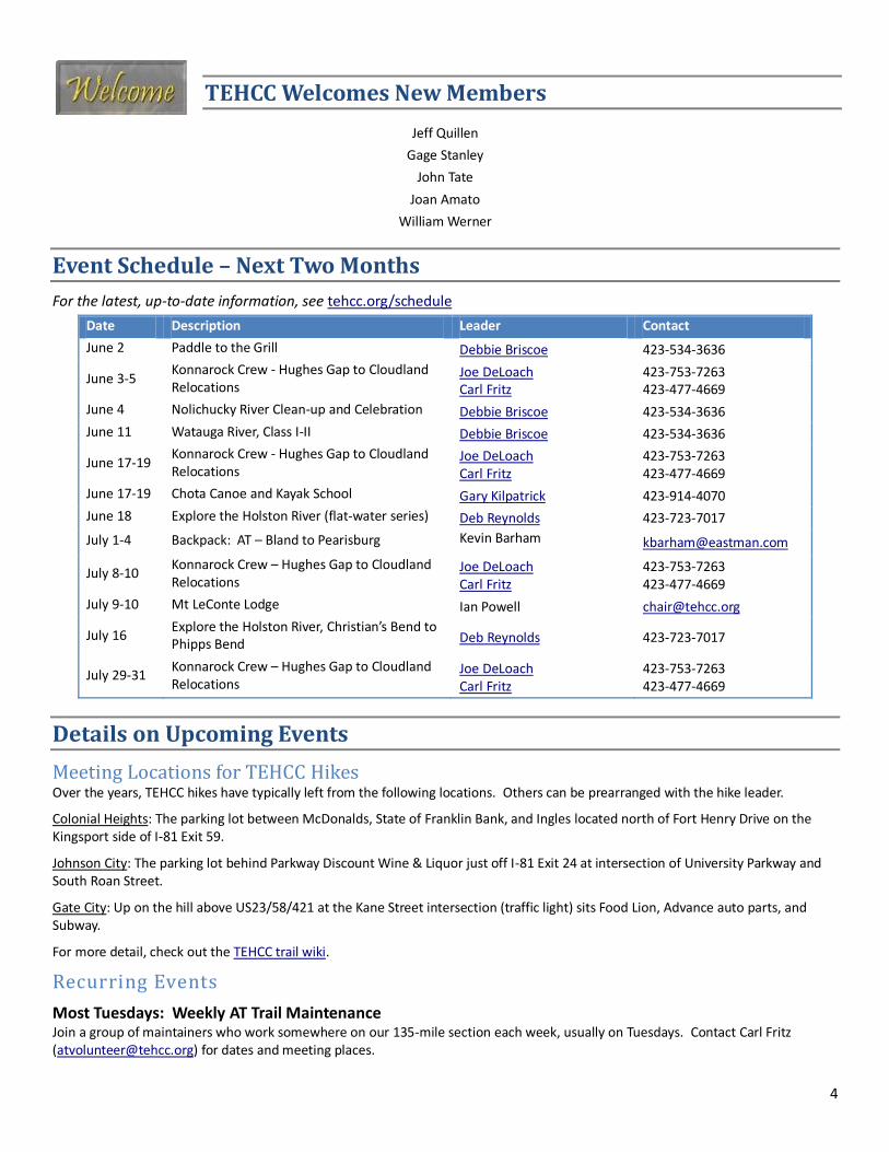
Event Schedule – Next Two Months
For the latest, up-to-date information, see tehcc.org/schedule
Date Description Leader Contact
June 2 Paddle to the Grill Debbie Briscoe 423-534-3636
June 3-5 Konnarock Crew - Hughes Gap to Cloudland Relocations
Joe DeLoach Carl Fritz
423-753-7263 423-477-4669
June 4 Nolichucky River Clean-up and Celebration Debbie Briscoe 423-534-3636
June 11 Watauga River, Class I-II Debbie Briscoe 423-534-3636
June 17-19 Konnarock Crew - Hughes Gap to Cloudland Relocations
Joe DeLoach Carl Fritz
423-753-7263 423-477-4669
June 17-19 Chota Canoe and Kayak School Gary Kilpatrick 423-914-4070
June 18 Explore the Holston River (flat-water series) Deb Reynolds 423-723-7017
July 1-4 Backpack: AT – Bland to Pearisburg Kevin Barham [email protected]
July 8-10 Konnarock Crew – Hughes Gap to Cloudland Relocations
Joe DeLoach Carl Fritz
423-753-7263 423-477-4669
July 9-10 Mt LeConte Lodge Ian Powell [email protected]
July 16 Explore the Holston River, Christian’s Bend to Phipps Bend Deb Reynolds 423-723-7017
July 29-31 Konnarock Crew – Hughes Gap to Cloudland Relocations
Joe DeLoach Carl Fritz
423-753-7263 423-477-4669
Details on Upcoming Events
Meeting Locations for TEHCC Hikes Over the years, TEHCC hikes have typically left from the following locations. Others can be prearranged with the hike leader.
Colonial Heights: The parking lot between McDonalds, State of Franklin Bank, and Ingles located north of Fort Henry Drive on the Kingsport side of I-81 Exit 59.
Johnson City: The parking lot behind Parkway Discount Wine & Liquor just off I-81 Exit 24 at intersection of University Parkway and South Roan Street.
Gate City: Up on the hill above US23/58/421 at the Kane Street intersection (traffic light) sits Food Lion, Advance auto parts, and Subway.
For more detail, check out the TEHCC trail wiki.
Recurring Events
Most Tuesdays: Weekly AT Trail Maintenance Join a group of maintainers who work somewhere on our 135-mile section each week, usually on Tuesdays. Contact Carl Fritz ([email protected]) for dates and meeting places.

5
Tuesdays Evenings: Johnson City Roll Practice Come join the Jackson Action Wagon (J.A.W.), APEs, and other paddlers from around our region at the Freedom Hall Pool in Johnson City, TN from 7:10 to 9:10 pm every Tuesday for tips and tricks about basic kayaking and for learning how to roll. Have you already mastered the basics and have a bomb proof roll? There is still a lot of fun to be had at our pool session by practicing your flat-water freestyle moves and fellowshipping with other paddlers in a nice warm-water environment. Admission to the pool is $2; rolling advice is free! Contact the pool office (423- 461-4872) for session confirmation or questions regarding the facility. Please note: The J.A.W. provides the current fleet of boats for demo at the pool session, but neither the pool nor the J.A.W. provides paddling equipment (paddle, spray skirt, etc...). If you do not have your own equipment, please post a message on the APEs yahoo group site or send Wesley an e-mail asking other members to bring extra equipment. We will try our best to get you outfitted for the night!
Thursday Evenings: Paddle to the Grill Bring your recreation or touring kayak/canoe to meet with The Appalachian Paddling Enthusiasts and TEHCC. The launch is at 6:30 pm at Davis Dock located in Blountville. We will paddle to Boone Docks Restaurant located at Boone Lake Marina in Piney Flats for dinner and a social hour, then paddle back. As we may be paddling back during low or no light, please have a stern light for your boat; PFDs are mandatory. Contact Debbie Briscoe, 423-534-3636 for more details.
Fridays: Friday Hikers Join members of the TEHCC and other hiking enthusiasts for Friday hikes in the northeast Tennessee, western North Carolina and southwest Virginia areas. Trips typically leave from the parking lot between McDonalds and State of Franklin Bank in Colonial Heights at 8 am. Trips to places farther away leave at 7:30 am. Contact Collins Chew to be added to the distribution list.
Most Saturdays: Watauga River Class I-II, June 11- Sept 3, 2011 Contact Debbie Briscoe, 423-534-3636. If there is water elsewhere, we may go there instead; so call first to check and see if it’s on!
Scheduled Events
Nolichucky River Cleanup and Celebration, Saturday, June 4, 2011 Contact: Debbie Briscoe, 423-534-3636 Participants will be assigned to Clean Teams, provided maps of clean-up locations, and given trash bags and gloves. There are plenty of clean-up opportunities of key areas for non-boaters, as well as areas designated for individuals with their own boats or rafts.
FREE FOOD AND ENTERTAINMENT!!!!! For cleanup participants, after the clean-up, Hickory Smoked Bar-B-Q and the all the fixings will be served-up by the APEs in the Pavilion while you enjoy one of the area’s finest bands. Bring a lawn chair, kick back with a cold tasty beverage, and know that you did something good for the river we all enjoy so much!
WIN PRIZES FROM OUR SPONSORS!!!! During the entertainment we will be drawing tickets for fantastic prizes.
Helpful information: Showers and restrooms are on the premises. Be prepared with appropriate footwear, sunscreen, bug repellant, etc. Rafts, pickup trucks, and trailers will be helpful and appreciated. Consider bringing a packed lunch, boating equipment, rain gear, chairs, family, and friends.
For Camping Info: Bruce and Nancy Gantenbein, 423-753-5359, http://www.riverparkcampground.net/
Chota Canoe & Kayak School, June 17-19, 2011 Contact: Gary Kilpatrick, 423-914-4070 Chota's annual Canoe & Kayak School has been a great way to introduce our sport to new comers for many years. We offer beginner classes in whitewater kayak and canoe, as well as touring kayak and canoeing. For those who are already into paddling, but wish to advance in skill level, our school also offers advanced beginner and intermediate whitewater classes. Chota also provides the option of renting equipment from the club, depending on availability, or from area outfitters for this event. This way you can still come and learn even if you do not have your own gear.
Pick your class from this list: Whitewater Kayaking, Whitewater Canoeing, Kayak Touring, or Canoe Tripping
Class descriptions are available on the Chota Website, PaddleChota.org.
Explore the Holston River (Flat-Water Series), June 18, 2011 Contact: Deb Reynolds, 423-723-7017 Several Saturday events are scheduled this summer to explore the local Holston River including the North and South Fork. Most of these events will require a car shuttle, so advance notice is required for planning purposes. The trip length will vary but will normally be between 2 and 4 hours. A lunch or snack will be desired. Fishing and bird watching are options as we will not be racing to see how quick we can get to the end. Bring a friend, a pole or camera, and an attitude for exploring. PFD’s are required. Call Deb Reynolds, 723-7017 or email at [email protected]

6
Mt LeConte Lodge July 9 – 10, 2011 Though the trip is full for this year, there is a waiting list available. To be placed on the waiting list, please send requests to [email protected].
For the Record
Friday Hikers: Doe River Gorge, May 6, 2011 Collins Chew reporting We had occasional misty rain part of the time for our hike through the Doe River Gorge, but it did not interfere with our enjoyment of the day. After signing releases to the landowners, a Christian Camp, we hiked along the old Tweetsie railroad grade for about 2.5 miles and then returned. Several geologic features were noted to be of interest. There were quite a few wildflowers. The showiest were purple phacelia and fire pink, but there were many others. We were back in time to picnic at the camp tables. Hikers were Olin Babb, Kathy and Jerry Case, Anne Cosby, Jan and Chuck Mather, Brian Paley, Susie Seiler, Jerry Sluder, and Collins Chew.
Friday Hikers: Lake Keokee to a point near High Butte, May 13, 2011 Bob Harvey reporting The hike of May 13 was from Lake Keokee to a point near High Butte on the crest of Stone Mountain and return, a total of 9.0 miles.
Lake Keokee possibly is a water source for one of the towns of Southwest Virginia, and it’s not far from Appalachia. We began the hike by going part way around the lake, walking over the big earth-fill dam, then going to the top of Stone Mountain on an easy ascent, arriving at Olinger Gap. From the huge pile of empty beer cans we found at the gap, we could see that there must have been a four-wheelers’ party in the recent past.
Turning to the northeast at Olinger Gap we hiked along the crest of Stone Mountain. For several short sections the trail was bare rock. Much of this crestline trail, except for a few blowdowns, was no problem. There was, however, the matter of two gaps that had steep descents and even worse ascents. When we finally clawed our way to the high point, we took a welcome break to eat lunch, then headed back.
The hike back took a little less time, possibly because we were spurred along by hearing thunder coming from Kentucky, just two miles to the north. According to fellow hiker Don Baker, the bad weather often comes from there, and so it did this time. The rain began, but it wasn’t too bothersome until well after we had gotten back to the cars.
The hikers were Jack Aaron, Olin Babb, Don Baker, Collins Chew, Andrew Cleland, Anne Cosby, Bob Harvey, Carol Idol, Chuck Mather, Larry Miller and Jerry Sluder.
May Club Meeting – The new TEHCC Trail Wiki, May 18, 2011 Tim Schaefer reporting May’s meeting was about the new Trail Wiki. We had several people show up very interested to see more of what has already been done (although we still have a long way to go). The discussion ranged from “what’s a wiki” to how to do some basic editing (it’s really not that hard); but probably most importantly, how to find useful information. Users of the site can search by interest, by difficulty, by area, alphabetically, by choosing from a map, or several other ways to find trails. Many people were interested to hear that they could help those editing the site by offering pictures and GPS logs of their hikes. As always, please check out the site, find a trail, get out there, and update the description of what there is to see. If you see something missing or that we got something wrong, do not hesitate to hit that edit button, make your changes, maybe hit preview to see if it will look like you expect, and then save it. We’ve got a few people who routinely watch the “Recent Changes” page and, if needed, will help you with any changes you’ve made.
Friday Hikers: AT: Yellow Mt. Gap to Little Hump, May 20, 2011 Collins Chew reporting We had a beautiful hike in pleasant, cool weather to Yellow Mountain Gap and on the AT to Little Hump and back to Big Yellow Mountain where we crossed over to the magnificent bald for lunch, then return. Views were hazy but nice. Wildflowers were out in profusion; white fringed phacelia and wood betony (lousewort) perhaps the most spectacular with occasional carpets of bluets. Hikers were Jack Aaron, Lee Bockman, Olin Babb, Kathy and Jerry Case, Anne Cosby, Carol and Dave Dunham, Bob Harvey, Jan and Chuck Mather, Susie Seiler, and Collins Chew.

7
AT Maintenance Reports
Reporting: Bruce Cunningham Date: 04/01/2011 Purpose: Maintain Trail Location: Section 3a, McQueens Gap to spring People: Bruce Cunningham, Bill Elderbrock Summary: We cleaned all water bars, cleaned water basin, eliminated three blowdowns, lopped brush, and clipped nearby pricker bushes. The trail was used by 15 hikers today, all reporting blowdowns all the way from the lake. Reporting: Faye Guinn Date: 04/24/2011 Purpose: Check reported blowdown Location: Section 16b, Iron Mountain Gap to Weedy Gap People: Howard Guinn, Faye Guinn Summary: We found the reported blowdown blocking the trail at the orchard and cut it. We also found a dead 14-inch pine across the trail and had to cut it twice with the hand saw to remove it. We talked to 11 thru hikers. Reporting: Brian Paley Date: 4/29/2011 Purpose: Spring Cleanup Location: Section 8, Wilbur Dam Road to shelter People: Brian Paley Summary: I lopped and cleared several minor blowdowns. The rest of trail is reported to be in great condition after the recent storms! Reporting: Waylon Jenkins Date: 4/30/2011 Purpose: Annual Maintenance - blowdowns, lopping Location: Section 12b, Walnut Mountain Road to Sugar Hollow Creek People: Waylon Jenkins, Carol Jenkins Summary: We cleared reported blowdowns, leaving only one that was about 15 inches, but easy to step over and on a flat section of trail. We lopped a lot of rhodendron and sawed low hanging branches. We met about a dozen hikers, all headed north. Reporting: Mike Hupko Date: 5/1/2011 Purpose: Spring Maintenance Location: Section 17, Beauty Spot to Deep Gap People: Marsha Hupko, Mike Hupko Summary: We cleaned out dips, removed debris from trail, lopped briars and overhanging branches, and removed five trees from trail. The largest tree, about 12 inches in diameter, was pushed off with hikers’ help. Reporting: George Thorpe Date: 5/2/2011 Purpose: Shelter Maintenance Location: Curley Maple Shelter People: George Thorpe, Linda Thorpe Summary: We hiked in from Indian Grave Gap to Curley Maple Gap Shelter passing a dozen NOBOs. All had positive comments about the new shelter. We carried in a new shelter log, shovel, and broom and placed in shelter. We also attached new rebuild information sign to shelter wall, cleaned out fire ring, cleared out water source, and collected and hauled out a small amount of trash. The log-section seats around the fire ring are a big hit with hikers. We hiked out to Chestoa. Only four blowdowns were evident over the eight-mile section. All were easy stepovers and have been identified for removal.

8
Reporting: Carl Fritz Date: 5/4/2011 Purpose: Dig relocation Location: Section 15b, Just south of Cloudland People: John Beaudet, Paul Benfield, Ken Buchanan, Richard Carter, Jim Foster, Carl Fritz, George Thorpe, Kim Peters, Tim Stewart, Bryan Paley, Bob Peoples, Ed Oliver, Daryel Anderson, Ted Mowery, Otto, Jack Tarlin; Hikers: David Skelly, Erik Cleijnle, Brian Gruber, Amy Callahan, Preston Rybar, Matt Smith, Allie Andrews, Cales Willett, F Prince, Amber Marshall, Kevin Patterson, Cameron Cahill, Matthew Bosky, Peggy Smith "Bone Lady," plus one more to be identified later Summary: We had a special trail digging day co-sponsored by TEHCC and ALDHA (Appalachian Long Distance Hikers Association). Bob Peoples recruited mostly hikers that had stayed at Kincora Hostel the last two nights. The weather was a bit tough with temperatures never rising above freezing and with brisk winds. There was a half inch of snow on the ground all day. We banged on and moved rocks all day. Ed Oliver and Daryel Anderson put together a barbecue dinner which was paid for by ALDHA. ALDHA also supplied their first ever patches. Reporting: Paul Benfield Date: 5/5/2011 Purpose: Mow Trail across Osborne Farm Location: Section 4b, Osborne Farm People: Paul Benfield, Ted Mowery Summary: We mowed and trimmed the AT and Accessible Trail across the Osborne Farm. Reporting: Mike Hupko Date: 5/6/2011 Purpose: Follow up on downed trees Location: Section 18, FS 230 to Indian Grave Gap People: Faye Guinn, Howard Guinn, Wayne Jones, Marsha Hupko, Mike Hupko Summary: We removed 10 trees from across the trail after receiving a report from some hikers. We also lopped briars and overhanging rhodos. The water bars need to be reworked soon. Reporting: Mike Hupko Date: 5/6/2011 Purpose: Finish spring maintenance Location: Section 17, Beauty Spot Gap south to Beauty Spot People: Faye Guinn, Howard Guinn, Wayne Jones, Marsha Hupko, Mike Hupko Summary: We removed one 10-inch tree about 5 feet above Trail near Beauty Spot Gap and placed one new trail-marker pole at top of Beauty Spot. Reporting: Mike Hupko Date: 5/6/2011 Purpose: Finish spring maintenance Location: Section 16b, Iron Mountain Gap to Greasy Creek People: Faye Guinn, Howard Guinn, Wayne Jones, Marsha Hupko, Mike Hupko Summary: We cleared 15 trees from the trail, cleaned out the spring at Apple Orchard, and cleaned out water bars from Iron Mountain Gap to Weedy Gap. Reporting: Brian Paley Date: 5/6/2011 Purpose: Clear reported blowdown Location: Section 8, Between 321 and Watauga shelter People: Brian Paley Summary: I cut out an 18-inch tree trunk that had fallen across the trail. Reporting: Joe DeLoach Date: 5/7/2011 Purpose: Konnarock Project Check Location: Section 15b, Cloudland to relos below Beartown Mountain People: Joe DeLoach

9
Summary: I met Torrie, the Crew leader for our project this year, assistant Crew leader Jeff, the other Crew leader and assistant, and Andrew Downs from ATC to look over the relos that Konnarock will work on this summer. I also checked out prospective campsites and cut a few small blowdowns while we were at it. There is a large Forest Service truck full of logs that we might be able to use on Round Bald. Reporting: Jim Foster Date: 5/7/2011 Purpose: Hike and check trail Location: Section 14b, Carvers Gap to Yellow Mountain Gap People: John Tomko, Glen Fisher, Jim Foster Summary: What started out as a hike turned into a maintenance trip as we cleared the trail of 15 to 20 blowdowns and obstructions. Most were of the small to medium variety. The trail is free of all obstructions from Carvers Gap to Yellow Mountain Gap. Reporting: Kim Peters Date: 5/8/2011 Purpose: Spring Cleanup Location: Section 7b, Wilbur Dam Road to about one mile south of Vandeventer Shelter People: Kim Peters Summary: I clipped woody growth, cleaned water bars and ditches, and cleared several blowdowns. There are two blowdowns that I only made passable; a crosscut saw will be required to clear them, as they are 18 to 20 inches in diameter. I met scores of thru-hikers (the shelter will be full to overflowing tonight!) plus two southbound section hikers who are at least 70 and one day hiker whom I had met before on a previous trip. Reporting: Paul Benfield Date: 5/9/2011 Purpose: Shelter maintenance Location: Section 4b, Double Springs Shelter People: Paul Benfield, Ted Mowery, Tim Stewart Summary: We painted the inside of Double Springs Shelter; we will return and paint the sleeping platform. We placed steel laths on the bog bridge south of Hwy 91. A horse has been on the trail from Double Springs Shelter to the Osborne Farm. Reporting: Paul Benfield Date: 5/11/2011 Purpose: Remove blowdown Location: Section 20b, 100 yards south of No Business Knob People: Paul Benfield, John Beaudet Summary: We removed a large blowdown from the trail 100 yards south of No Business Knob Shelter. Reporting: Jim Foster Date: 5/12/2011 Purpose: Redo relocation flag line Location: Section 9b, South Pond Mountain to Hampton trailhead People: Jim Foster Summary: I improved a small section of one of our flag lines and cut it out for the Hardcore event Sunday. I also cut several small blowdowns and trimmed some annual growth between south Pond Mountain and the Hampton trailhead. Reporting: Collins Chew Date: 5/14/2011 Purpose: Measure recent relocation Location: AT between US 321 and Wilbur Dam Road People: Collins Chew and Troop 285 Scouts: Clayton Stanley, Jacob Stanley, Matthew Stanley, Hamilton Falin, Bailey Dickenson, Joshua Harless, Austin Draper, Caleb Yarosh, Evan Dorn, Ben Smith, Ethan Cism, Leaders and other Adults: David White, Robert Stanley, Andrea Stanley, Kevin Draper, Brian Dorn, David Harless, Marty Scism, Elizabeth Seal, Mike Smith Summary: The scouts of Troop 285, Mt. Carmel, took turns operating the measuring wheel and a GPS to measure and map a relocation on the AT between US 321 and Wilbur Dam Road. The relocation added 0.1 miles between US 321 and Watauga Lake Shelter. The scouts got to interview a through hiker at the shelter. The trail was in good shape except for some rather severe wind storm damage/blowdowns on the hill near Wilbur Dam Road. The scouts were camping in Dennis Cove.
10
Reporting: Bob Peoples Date: 05/19/2011 Purpose: Clear blowdowns Location: Section 11a, South of Dennis Cove People: Bob Peoples, Jack Tarlin Summary: Bob and Baltimore Jack cleared several poplars that had sheared off with grape vines entangled in them. Apparently, there were some high winds in this area recently. Reporting: Paul Benfield Date: 05/19/2011 Purpose: Mow the Osborne Farm Location: Section 4b, Osborne Farm People: Paul Benfield, Ted Mowery Summary: We mowed the Accessible Trail and the AT across the Osborne Farm. Reporting: Jim Foster Date: 05/20/2011 Purpose: Walk flag line of proposed relocation with FS biologist Location: Section 19b, Trail about 1 mile north of Nolichucky River People: Ed Oliver, Jim Foster Summary: Ed and I walked the flag line of the proposed relocation with the Forest Service biologist who was doing the plant survey. We encountered one rare plant, one snake, and several "Little Brown Jugs." Reporting: Richard Carter Date: 05/20/2011 Purpose: Clean water diversions Location: Section 14b, South side of Round Bald People: Richard Carter Summary: I removed and replaced one completely dislodged water bar and cleaned out five others, most of which required digging out impacted gravel and sod. I also removed and replaced the faded trailhead sign. Reporting: Bob Peoples Date: 05/20/2011 Purpose: Clear blowdowns Location: Section 10, Laurel Fork Gorge People: Bob Peoples Summary: Bob removed six minor blowdowns in Gorge. High water trail has yet to be cleared. Reporting: Bob Peoples Date: 05/21/2011 Purpose: Clear blowdowns Location: Section 9b, South of Pond Mountain People: Bob Peoples Summary: Bob cleared more small blowdowns. Only the north side of Pond Mountain has blowdowns now. Reporting: Anna Hackler Date: 05/21/2011 Purpose: Clear weeds and check for blowdowns Location: Hampton Blue Blaze to AT intersection. People: Anna Hackler, Shane Hackler Summary: We cleared some weeds and ran into another trail maintainer. Since the trees from the storm had been cleared, it looked pretty good. Reporting: Carl Fritz Date: 05/23/2011 Purpose: Clear blowdowns Location: Section 4a, US421 to Double Springs Shelter People: Carl Fritz, Reuben Potter

11
Summary: Based on hiker reports we cut blowdowns; most were small stepovers. The large reported one just north of Double Springs Shelter was not found. Reuben did cut a hazard tree at the spring and another at the campsite near the spring. He will return with more equipment to cut the one at the shelter. Reporting: Carl Fritz Date: 05/24/2011 Purpose: Cut blowdowns Location: Sections 3a and 3b People: Paul Benfield, Alex Geisman, Tim Stewart, George Thorpe Summary: Paul, Tim, Alex and George cut about 15 blowdowns. Most were on section 3b. Six were 30 to 40 inches in diameter. These two sections are clear as of this afternoon. Reporting: Carl Fritz Date: 05/24/2011 Purpose: Clear blowdowns Location: Section 5, TN 91 to Grindstaff Monument People: Kevin O'Donnell, Ted Mowery Summary: Kevin and Ted cleared a half-dozen blowdowns of 9 to 15 inch variety from TN 91 to Nick Grindstaff Monument. This part of section is clear for now. Reporting: Carl Fritz Date: 05/24/2011 Purpose: Clear blowdowns Location: Section 9a, US321 to Pond Flats People: John Beaudet, David Keegan, Mike Garrison, Brian Paley, Bob Peoples Summary: This crew tackled the north side of Pond Mountain. Obviously, there had been some high winds that sheared the tops of the trees. They cleared 13 blowdowns. Three were outside the wilderness and ten in the wilderness. They also did some trail repairs. More work is needed since some steps are buried with silt, etc. Reporting: Brian Paley Date: 05/25/2011 Purpose: Clear blowdowns Location: Section 8, Wilbur Dam Road and Watauga Dam People: Brian Paley, Bob Peoples Summary: We cleared blowdowns from eight separate areas.

12