the sweet grass hills sweet grass hills t he three distinctive buttes on the horizon to the east are...

1
e Sweet Grass Hills T he three distinctive buttes on the horizon to the east are called collectively the Sweet Grass Hills. West Butte, the closest and highest, rises 3,000 feet above the plains. Middle Butte, farther in the distance and a little to the south, is grass covered and East Butte is the most distant. Together these three buttes make this range the most prominent in north central Montana. Like many of the mountain ranges on Montana’s great plains, the Sweet Grass Hills are the result of igneous activity about 50 million years ago when molten rock intruded Cretaceous sedimentary rocks. e surrounding sedimentary rocks were more rapidly eroded than the hard igneous rock leaving these three buttes and two much smaller buttes jutting up above the plains. At approximately the same time, similar igneous activity occurred in what are now the Highwood and Bears Paw Mountains and other mountains in central Montana. A continental glacier that flowed south from Canada covered this area with an estimated thickness of more than a 1,000 feet of ice, leaving the upper third of these buttes sticking up above the ice. Because the Sweet Grass Hills were not completely ice covered, they do not have the rugged sculpted appearance that characterizes many Montana mountain ranges. Katoyisiks is the Blackfeet word for the Sweet Grass Hills and means “Sweet Pine Hills.” Some of Blackfeet’s oldest stories and traditions involve the hills. According to Blackfeet tradition, Old Man made the Sweet Grass Hills with rocks he carried with him after creating the earth. Long ago the Blackfeet surrounded a party of Crow Indians on the Middle Butte. As night came and throughout the night, the Blackfeet pushed the Crow further up the hill. As this was occurring, the Crow would sing a particular song. With the first light of morning, the Blackfeet closed off their circle at the top. e Crow were gone. e Blackfeet still use this song in their ceremonies, such as the Sundance. Geo-Facts: Gold was mined from gravel in the vicinity of Gold Butte, the highest knob on Middle Butte, mainly in the 1930s. The small town of Gold Butte was established as a result of this mining activity. The Sweet Grass Hills rise nearly 3,000 feet above the level of the surrounding plains. When the glacial ice melted about 10,000 years ago, it left behind deposits of debris that include boulders brought down by the ice from Canada. Geo-Activity: Read about the formation of the Sweet Grass Hills and try to think of some examples in everyday life that help illustrate their formation. Consider a peach, for example. The molten igneous rock is like the core and the flesh of the peach is the surrounding sedimentary rocks. The softer peach can be eaten away, like the sedimentary rocks which eroded, leaving behind the core which is the hard igneous rock. What other examples can you come up with? Hierochloe odorata - sweetgrass Chief Beery Child, Blackfeet Indian [n.d.] Photographer Hileman, Kalispell, Montana Great Northern Railway Co. Montana Historical Society Research Center Photograph Archives, Helena, MT Sweet Grass Hills, photograph by Kristi Hager. Middle Butte East Butte West Butte

Upload: duongtuong

Post on 30-Mar-2018

213 views

Category:

Documents


0 download

TRANSCRIPT

The Sweet Grass Hills

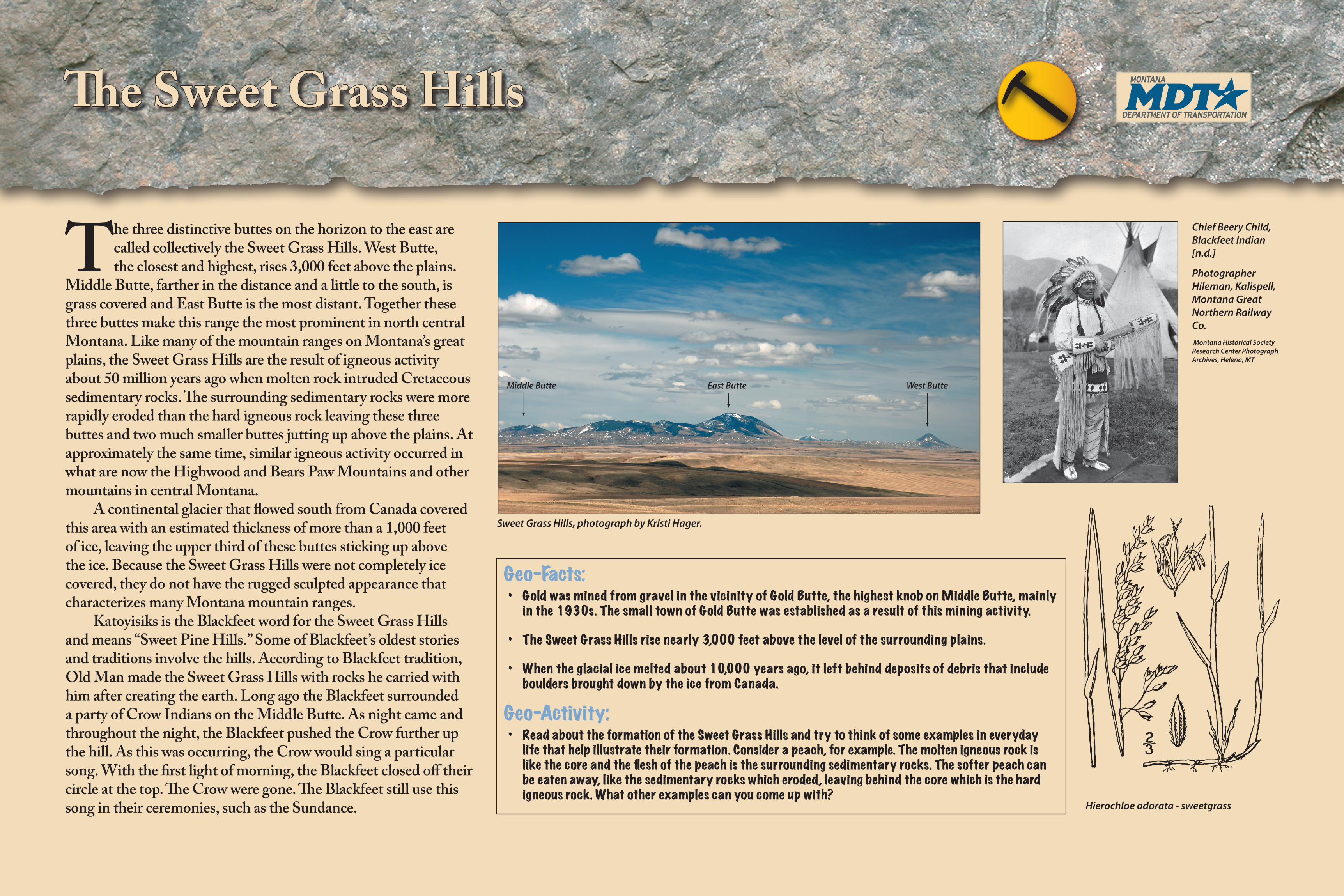
The three distinctive buttes on the horizon to the east are called collectively the Sweet Grass Hills. West Butte, the closest and highest, rises 3,000 feet above the plains.

Middle Butte, farther in the distance and a little to the south, is grass covered and East Butte is the most distant. Together these three buttes make this range the most prominent in north central Montana. Like many of the mountain ranges on Montana’s great plains, the Sweet Grass Hills are the result of igneous activity about 50 million years ago when molten rock intruded Cretaceous sedimentary rocks. The surrounding sedimentary rocks were more rapidly eroded than the hard igneous rock leaving these three buttes and two much smaller buttes jutting up above the plains. At approximately the same time, similar igneous activity occurred in what are now the Highwood and Bears Paw Mountains and other mountains in central Montana.

A continental glacier that flowed south from Canada covered this area with an estimated thickness of more than a 1,000 feet of ice, leaving the upper third of these buttes sticking up above the ice. Because the Sweet Grass Hills were not completely ice covered, they do not have the rugged sculpted appearance that characterizes many Montana mountain ranges.

Katoyisiks is the Blackfeet word for the Sweet Grass Hills and means “Sweet Pine Hills.” Some of Blackfeet’s oldest stories and traditions involve the hills. According to Blackfeet tradition, Old Man made the Sweet Grass Hills with rocks he carried with him after creating the earth. Long ago the Blackfeet surrounded a party of Crow Indians on the Middle Butte. As night came and throughout the night, the Blackfeet pushed the Crow further up the hill. As this was occurring, the Crow would sing a particular song. With the first light of morning, the Blackfeet closed off their circle at the top. The Crow were gone. The Blackfeet still use this song in their ceremonies, such as the Sundance.

Geo-Facts:• GoldwasminedfromgravelinthevicinityofGoldButte,thehighestknobonMiddleButte,mainlyinthe1930s.ThesmalltownofGoldButtewasestablishedasaresultofthisminingactivity.

• TheSweetGrassHillsrisenearly3,000feetabovethelevelofthesurroundingplains.

• Whentheglacialicemeltedabout10,000yearsago,itleftbehinddepositsofdebristhatincludebouldersbroughtdownbytheicefromCanada.

Geo-Activity:• ReadabouttheformationoftheSweetGrassHillsandtrytothinkofsomeexamplesineverydaylifethathelpillustratetheirformation.Considerapeach,forexample.Themoltenigneousrockislikethecoreandthefleshofthepeachisthesurroundingsedimentaryrocks.Thesofterpeachcanbeeatenaway,likethesedimentaryrockswhicheroded,leavingbehindthecorewhichisthehardigneousrock.Whatotherexamplescanyoucomeupwith?

Hierochloe odorata - sweetgrass

Chief Beery Child, Blackfeet Indian [n.d.]

Photographer Hileman, Kalispell, Montana Great Northern Railway Co. Montana Historical Society Research Center Photograph Archives, Helena, MT

Sweet Grass Hills, photograph by Kristi Hager.

Middle Butte East Butte West Butte