the st. donato cathedral in arezzo - chnt | vienna · the st. donato cathedral in arezzo digital...
TRANSCRIPT

The St. Donato Cathedral in Arezzo
Digital reconstruction of a completely lost architecture
Giorgio VERDIANI1 | Mirco PUCCI1 | Mauro MARIOTTINI2
1Dipartimento di Architettura, Florence University, Italy | 2Associazione Culturale Academo, Arezzo, Italy.
Abstract: 3D modelling tools allow to reconstruct what is not clear to the eyes. This simple and short phrase is
quite obvious, but when it meets lost architectures it becomes the key vault of a complex puzzle made of
evidences, knowledge, reading strategies and later communication strategies. In the research presented here,
the case study of the St. Donato Cathedral in Arezzo, becomes the occasion for analysing a full digital
reconstruction process, its adaptation to virtual interactive usage and how this process can bring back useful
information on the ruins that today are the last traces of its existence. The St. Donato Cathedral was the core
of an ancient and independent citadel out of the Arezzo’s walls. A settlement developed starting from the VIII
century over previous Etrurian and Roman remains. It has been completely demolished in the XVI century for
its political misalignment in front of the Cosimo de Medici’s domination strategies. Only few remains of the
citadel plot are now visible in place. Significant traces of these cathedral walls were never be found during the
archaeological investigations, but a various set of representations documents its main aspects. These
representations go from very detailed and pictorial images to schematic sculpted items, to plan drawing. Using
an accurate and articulated digital reconstruction project a complete 3D digital model is produced out of all the
possible traces. The process will be described in all its key passages, from the digital survey of the area, to the
definition of architectural elements. An interactive model of the cathedral will be presented in first release.
Beyond the common features for this kind of models it will have two specific peculiarities: the indication of the
level of liability of each part and the system of references used to guide the process.
Keywords: Arezzo, Pionta, San Donato, Virtual Reconstruction, Digital Survey.
Introduction
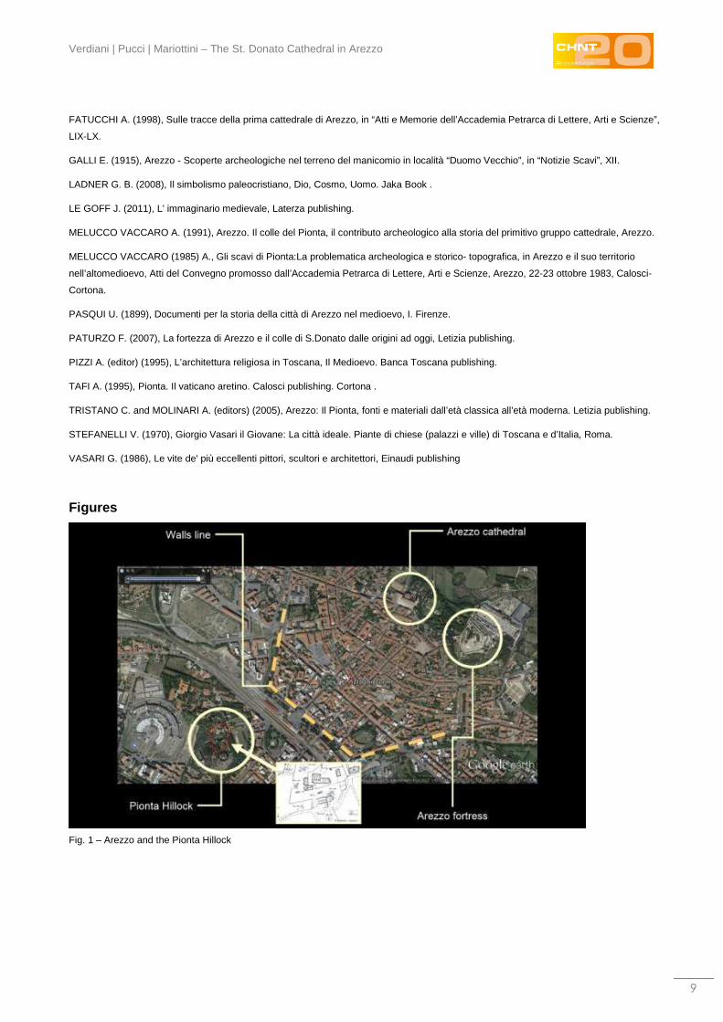
Arezzo is placed in the middle of Italy, in its central part, a town in Tuscany with a rich and intense story. Even
if such a thing is true for a lot of old towns in Italy and abroad, the story of Arezzo has a quite dark spot,
fascinating for its blurred definition and almost transferred from the reality of the evidences to the fantasy of
fragmentary remembering and ideas. In fact, there is an ancient and complex event which has destroyed a
piece of the timeline in the history of this town (FATUCCHI 1969). There was a time when the hillock named
“Pionta” was closed by walls protecting a small independent citadel, governed by bishops (TAFI 1995), with its
own churches and politically aligned with the Pope and the Vatican State. The hill is still there, rising in an area
out of the Arezzo walls, surrounded by the recent urban fabric and isolated from the town centre by the railway
(PATURZO 2007). But until the XVI century it had its own fortifications and was a completely independent
settlement (PASQUI 1899). The Place was not chosen by chance, in the past it has been used by Etruscan
and later by Romans, it was also a burial place (DELUMEAU 1987). Because of its use as a cemetery the San

International Conference on Cultural Heritage and New Technologies | Vienna | 2015
2
Donato burial was placed here, creating all the conditions of faith and devotion that chanced this place from an
ancient graveyard to a holy place. San Donato was an important Saint, he is the patron of Arezzo, the
cathedral still keeps his name (TRISTANO and MOLINARI 2005). He was born in Arezzo at an unspecified
date (even if some studies try to locate his place of birth in Rome, or even in Nicodemia, Turkey) and died as a
martyr in Arezzo on the 7th August 362 AD (or in the 304 AD, according to other studies).
The presence of such an important tomb may explain the reason for the first Christian settlements with the
building of chapels and churches, but the reasons for creating a separated, self-governing town must be found
in more articulated motivations. On one side probably the Pope was interested in having there a political and
strategical outpost, not so far from Rome, but directly in the heart of Tuscany. But on the other hand it is
possible to find some philosophical reasons following the words from Jaques Le Goff in L'imaginaire Médiéval
(LE GOFF 2011). Here, presenting the urban concept from Guglielmo d'Auvergine (Aurillac, 1180 – Paris,
1249) in his Opera Omnia (pp. 407-416), the author underlines the following passages:
"Let's imagine a town made by the grouping of such perfect men (imaginabimur civitatem
aggregatam ex hominibus sic perfectis) that all of their life is focused on giving honour and
respecting God, a life dedicated to reach and apply the noblesse of the soul (honestas), a life
dedicated to serve the others" (...)
"It comes out clear how in front of such an admirable town (preclara), the rest of humanity is like
a savage forest (quasi silva) and all the men outside are like raw wood (quasi ligna silvatica)".
To the contraposition between town and forest, Guglielmo d'Auvergine adds a second contraposition: the one
between the natural materials and the construction materials, in the specific of the natural stone and wood
against wood beams and sculpted stones.
"On the contrary of the brute stones, raw pieces from the quarry (lapidicina, lapides rudes) and of the
natural wood, the cemented stones, nailed or connected and the manufactured wood (coementum, et
clavi, e carteraeque ligature inter lapides, et ligna) are the symbols of the mutual love and of the
spiritual needs coming from humanity".
He defines:
"this admirable town is exactly the society, the aggregation of men or the city (societas, aggregationes
hominum, seu civitates)".
This town is the real alternative to the "fake" towns, which are forests and caves. The town is defined by the
work of men whose capacity of artistry and work is a gift of God (vires, et artem, et artificium). In the end: the
towns are men (Cives civitatis procul dubio sunt veri nomiinis homines). Such ideas can be imagined in their
materialization as a rich, well constructed and “ideal” settlement, placed like a satellite on the borderline of the
main town, a place of faith influencing its urban surrounding, showing and at the same time preserving, the
meaning of Christian values in front of the common political and social context. This particular condition seems
to find its graphical representation in one of the most famous frescos from Giotto (or at least attributed to
Giotto), the “The expulsion of the devils from Arezzo”, realized in Assisi, in the Upper Church between 1295
and 1299, but representing the town of Arezzo. The town is painted as closed by walls, with the apses of an
independent church creating the background for San Francesco and other Friars. The chaos of the town in
parallel with the well organized lines of the church. The message, clearly connected to ideas close to those
expressed by Guglielmo d'Auvergine: the devils can be banned from the town because of the strength of faith,

Verdiani | Pucci | Mariottini – The St. Donato Cathedral in Arezzo
3
but the faith needs proper places to host its intermediaries with humanity. Symbols and signs catalyse the will
of humanity and must be shown properly. Such a reflection was maybe the base for the concept at the origin
of the consolidation of the Pionta citadel as a religious outpost in front of Arezzo.
The tolerance for this small enclave ended in the XVI century. In 1561 Cosimo de’ Medici ordered the
destruction of the walled citadel, bringing to the ground all the buildings and trying to obliterate its existence
not only from the terrain, but apparently from the historical memory (FATUCCHI 1998). But this did not
happened: the memory of the place remained, supported by some elements saved and reused in other
churches, some frescos and paints representing the Citadel, but most of its consistence is due to the “myth”
developed around the first Arezzo Cathedral, the St. Stefano e St. Maria Church and the second one: the St.
Donato Church. Not a simple legend, but the story of two Cathedrals, one near the other, one larger than the
other, one ancient and coming from an early period of Christianity and a second one, rich and almost
experimental, because of its articulated plant, enriched by marbles and spolia elements.
The traditional reading of these events indicates the presence of two large churches in this area, both once
used as cathedrals. The ancient one was dedicated to the Saints Mary and Stefano, it was a quite common
construction in the system of the Romanesque churches, while the following St. Donato, was characterized by
a very complex asset, with a central and symmetric layout organized around a large empty space. The
literature, in general, considers the St. Vitale in Ravenna as the inspiration for the work of Maginardo (PIZZI
1995), the architect of this cathedral. After the destruction of the whole settlement, the hillock felt in a long
period of partial abandon, and even if the presence of this area remained at a latent state in the memory of the
population, the buildings on the hill were demolished and their materials were most probably reused
somewhere else, while only minor parts of the previous churches and chapels were reused and adapted in
combination with new constructions, like the small church of St. Stefano, built in 1610, incorporating a small
crypt from the original settlement (ARMANDI 2003). Various interventions through the centuries have
rearranged the terrain of the hill and after some very early investigations (GALLI 1915), only starting from the
1960 a real archaeological excavation campaign was started, aimed to discover the remains of the ancient
town (DONATI 1965). The ruins of the Romanesque church of St. Maria and St. Stefano were brought to light
and various minor remains were excavated in the following archaeological campaigns. But a large part of this
settlement is still unclear. There are no significant traces of the large church of St. Donato, the real cathedral
of the walled town nor there are remains of the walls protecting the citadel (MELUCCO VACCARO 1985). The
organization and the aspect of the area is barely testified by some paints and drawings (, which include a plan
view of St. Donato made by G. Vasari (STEFANELLI 1970), but this large church seems just disappeared, with
no findings or traces left at all.
The Digital survey of the archaeological site
In 2014, new research for this area was started, based on the collaboration between the cultural association
“Academo, Roberta Pellegrini” and the “Dipartimento di Architettura” of the Florence University. A general
photographic shooting operated by UAV, using an Aeromax drone was done just before the beginning of the
main survey campaign. Then a new survey of the whole area has been made with the use of a 3D Laser
Scanner and a Total Station. During these activities all the emerging walls have been photographed to allow

International Conference on Cultural Heritage and New Technologies | Vienna | 2015
4
further reference and texturing. Specific photogrammetric surveys were made for the main finds, like various
Roman marble urns, original mosaics and sculptures. The survey data treatment, the reading of the
architectural traces and the interpretation of the original projects were made according to the logic of the
architecture. At the same time a specific investigation about the state of knowledge of this area was brought
on. These two research lines formed the basis of a starting hypothesis for a map of the next possible
excavations. Other common solutions to investigate the underground (like georadar survey and visual analysis
of the anomalies) turned out to be not so usable. This limit is due to the strong transformation of the ground
which is mixed with ruins and fragmented parts. In this way the data can be very “noisy”, so only a direct
excavation, planned by clear guidelines, can give results.
The ideas about this place are easy to be resumed. The hillock hosted a very rich citadel, with the presence of
two cathedrals, the older one dedicated to St. Mary and Stefano and the “newer” one designed by Maginardo
in the XI century and dedicated to St. Donato, additionally to the cathedrals there was a set of minor chapels
and small churches, the presence of defensive walls and an undefined number of buildings and facilities
composing an urban pattern. All of this was built over older remains, coming from the Etruscan and Roman
ages. During the destruction all the buildings were demolished to their basements. It is worth to underline that
one of the most surprising element is the total destruction every parts. No traces of the St. Donato Cathedral,
no traces of the defence walls. Most of the ruins seem to come from a level underground which was
underground even at the time of the demolitions. It seems more proper not to formulate the question “Where
are the remains?” but “Why these remains are still in place?”.
In order to start the definition of a virtual reconstruction of the churches, seen the state of the ruins and the
poor remains of most of the excavated areas, it was decided to proceed by comparing other architectures and
getting the digital survey of any elements “connected” to the original settlement and its architectures. While the
gathering of all the possible indications is still in progress, the virtual model of the whole area, in its current
condition, has been completed, allowing the presentation and the browsing of all the parts of the ancient
Basilica. The study and analysis of the architectural traces and indications allows the gradual interpretation of
the original design of the larger parts of the buildings. All the digital tools, from the survey to the data
treatments, to the post processing of the information have been used focusing on the will of understanding and
discovering traces of the original asset of this place.
The whole research started from the digital survey. While, in a situation like this one, it is the first meaningful
way of knowledge, a first approach to separate the mass of data from place and start structuring ideas. The
organization of the survey followed multiple actions. For first the whole area around the site of the church of
St. Mary and St. Stefano was photographed using an UAV, an Aeromax model equipped with a Canon
PowerShot S100 12.1Mp compact digital camera (offering RAW shooting and GPS function). The pictures
were taken from a single height with the camera parallel, most of the time, to the ground and with only few
shots taken from a tilted position. All the shots were taken in raw format and this allowed the recovery of a
certain amount of details from the shadows. Indeed the weather conditions at the time of this survey offered a
clear sky and bright sun causing deep shadows. The total aerial survey was done in one morning, with a
shooting session of 1.5 hours (from the first to the last shot). The pictures were later used to create a first
textured 3D model of the area. This was done using photogrammetry, in the specific case with Agisoft
Photoscan. This solution produced a light and practical 3D model capable of giving a first, generic,

Verdiani | Pucci | Mariottini – The St. Donato Cathedral in Arezzo
5
visualization of the site, with all the main elements visible and readable. But this was not a complete and fully
usable result: the quite large pixels describing the stones and the area and the quite simple mesh resulting
from the photogrammetric process were not fully satisfactory.
The 3D laser scanner survey was planned in the form of an integrated survey, combining 3D LS to a
topographic survey, the solution is quite classic and well suited for a situation like this, allowing the reduction
of the need for a large and overlapping scanning area. The 3D laser scanner used was a phase-shift type, a
Zoller+Fröhlich Imager 5006h. This unit offers good accuracy combined with robust construction, fast
operations and the possibility to use the same tripod of the topographic unit. This last feature can turn to be
quite useful during integrated survey operations: with three or four tripods around the area it is possible to
swap from one to the other, reducing the operational time of the entire process. The working range of this
instrument ranges from 0,4 to 79 metres (according to the technical specification of the manufacturer), in this
survey the most usable data was ranging from one to 50 metres. The positioning of the scan stations was
decided according to the shape and to the specific conditions of the terrain and of the remains. The surveys
were completed taking 112 stations, all of them operated in full panoramic mode, and exploiting the
characteristics of the 3D laser scanner in use, which was capable of scanning 360° on the vertical axis and
310° on the horizontal axis. The site has generous vegetation, with various trees and brushes and at the same
time it has various “empty” space with no relevant structures, the excavated areas are at a certain distance
one from the other, but the terrain is at the same time interesting for investigation and design aims. So the
topographical network worked well in connecting all the scans together and allowing a lower density of the
scans for the terrain and the “connecting” parts and applying a high level of details only for the excavated parts
and the sectors where it was really needed.
Drawings, paints and other references
The poor ruins on the Pionta hillock are not the only witness of the ancient condition of this place. A various
set of iconographic examples are here and there in Arezzo and they testify, in their own way, the original
aspect of the citadel. Some of them are very interesting and so it was decided that photographic or
photogrammetric surveys of each of them were to be taken. The first was the sign engraved on the main door
architrave of “St. Maria of the Old Dome” Church in the Arezzo downtown, probably realized immediately after
the destruction of the citadel. The second was a baked clay plaque from and altar, now located in the
Diocesan Sacred Art Museum in Arezzo. For both items the photogrammetry was based on the use of Agisoft
Photoscan, with the use of a measurement taken in place to put the final model in scale. The use of 3D
models to study such elements is very interesting, because it allows the detailed reading of the shape of the
elements and it makes it possible to take a look from different and specific perspectives. There are also other
graphical descriptions of the place before its destruction, but they are paintings or drawings, thus a simple
flatbed scanner was enough to create a digital copy starting with a good quality reproduction of these
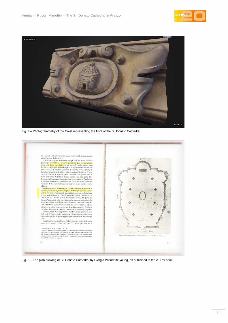
documents. One of these is currently conserved in the Uffizi “Gabinetto dei Disegni” and it’s a work by Giorgio
Vasari the Young. The drawing shows the plan of the original St. Donato Church. This is a very important
document, describing a rare and innovative medieval church, with a spatial organization running all around a
central space, something existing in other architectures, but only in churches built centuries later. The

International Conference on Cultural Heritage and New Technologies | Vienna | 2015
6
combination of this drawing with the other traces left in paintings and in sculptures are the only possible bases
to start a virtual reconstruction of the St. Donato church. While the presence of a certain set of ruins from the
Church of St. Mary and Stefano allows to start investigating this ancient church with more ease.
Giving back a shape to a lost Architecture
The first data treatment was dedicated to the alignment of the point clouds; this was done using Leica
Geosystem Cyclone. The topographical network was the base of all the work, but to ensure a solid result each
couple of scans were consolidated using geometrical matching between the clouds: the so called “cloud
constrain”. This process took time and produced the first 3D digital point cloud model of the archaeological
site. During the following post processing of the point clouds special attention was given to the trees, the parts
of the point clouds describing them were separated and heavily decimated. In this way the overall work, was
simplified to a little less than 2 billions points. Thus this was still a “heavy” and not easy to use dataset, so it
was used only for data extraction and not for interactive usage. A final version of the global point cloud was
exported into Pointools Viewer (now Bentley Pointools) with interesting benefits in interaction and visual
performance.
The dataset was later divided into multiple parts, according to the structure of the site. The first to enter the
process for multimedia aims was the sector of the ruins of the Church dedicated to the Saints Mary and
Stefano. This is indeed the “best” preserved monument of the whole hill, but it’s more or less a collection of
low walls and fragments. But it remains the only clearly readable architecture and a very important reference
for any further study.
The dataset of this ancient structure was treated using a well-consolidated practice, derived from the video
games graphical solutions and still useful for Cultural Heritage items in digital survey processing. Starting from
the point cloud of the church ruins a very detailed mesh was created. Then it was considered as the “high
poly” (high number of polygons) mesh: this very complex model was exported using the .OBJ format into
Raindrop Geomagic Studio. Using the specific tools of this software it was decimated to became a “low poly”
(low number of polygons) mesh. The “high poly” model was then used to extract its details in the form of a
normal map and displacement map; these two bitmaps were then applied back on the “low poly” model. In this
way the lightweight model was capable to be used with ease in multimedia and interactive use, apparently
preserving its original level of details. For the remaining walls of St. Mary and Stefano the decimation was
quite strong, the original model, made of around six million faces was used to apply texture. This one was
created starting from a large set of shots taken on the ruins at the time of the survey. Then, after the extraction
of the normal/displacement maps, it was simplified to be made by only 50 thousands faces, but with the
texture, the normal and the displacement maps applied, it still looks rich and useful for the reading and
interpreting of the site. The processing of the texturing was done using Maxon Cinema 4D, the model was
then exported again in OBJ and DAE formats for further use in multimedia and interactive software.
If the St. Mary and Stefano church offers many walls and various elements to base a reconstruction, the St.
Donato cathedral seems a sort of vanishing building, with no remains to support hypothesis. None of the
previous excavations have ever found traces of this building. The list of possible references are quite short,
the most relevant are: few written lines about the St. Donato in “Le Vite” from Giorgio Vasari (VASARI 1986); a

Verdiani | Pucci | Mariottini – The St. Donato Cathedral in Arezzo
7
plant of the cathedral made by Giorgio Vasari the Young; various paints and frescos, all realized after the
demolition, representing an apses view of the cathedral. Probably most of them are based on the same
drawing and one follows the other altering an original version of this view; the two representation in marble
and baked clay mentioned in the previous paragraph; various ideas coming from previous studies, most of
them oriented to find a reference in the St.Vitale in Ravenna.
For sure it was a quite particular building, rich, articulated, maybe “experimental” for its time, with the effort to
find a balance between the need of a Cathedral and keeping a central space, opened to the roof. For this
complex nature it is not simple to find existing reference buildings, none of them seem available in Tuscany,
almost none of them from the same age. At the state of the research it has been possible to find two
interesting reference: the church of St.Sofia in Benevento and the church of St. Erasmo in Capaci. Both are
not to be considered in connection with the St.Donato, but probably they present a similarity in the spatial
aspect (LADNER 2008), with a central volume articulating the shape of the church all around. The two
churches come from different historical periods, but both present the complex will to design a central space
developing into the naves of a church. There is no doubt that reconstructing this old church is literally the
recreation of “a new reality”, where intuition and partial evidences guide the research.
The digital reconstruction moved from the plant view made by Vasari the young: once oriented and putted in
scale (the drawing has clear notes to help it), it has been the start of any further development. The first
reflection can come from placing this first drawing over the ruins of the St. Mary and Stefano church. They look
compliant, it is possible to suppose the St. Donato built over the previous church, a renewal of the Cathedral in
place of a double Cathedral. No other evidences can support this idea, but this is something happened in
other context, the old church leave space for the new one, the ancient basement remains beneath the new
building. This hypothesis should explain why there are remains of the St.Mary and Stefano, they were
underground at the time of the demolition and so they remained. Obviously there is no way to demonstrate
this, but in the lack of any archaeological finds this can take place in the various number of ideas about this
place.
The definition of the digital reconstruction was here operated using directly a 3D modelling process, starting
from the inside and then going to the apses, then back to the interior and in the end completing the external
sides. For the interior a matroneo (women’s gallery) has been thought to match the St. Vitale in Ravenna
structure.
The development of the model confirms the complex and rich characteristic of this architecture, confirming it
as one of the most peculiar lost building from that age.
Dissemination
As a first test for the possible export and sharing of the models coming from this research, all the main models
were brought inside the Sketchfab.com online community, this interesting service and site allows high quality
real time browsing and at the same time protects the original 3D contents from unauthorized access and
download.
The results are easy to browse in high quality graphic, both the models coming from the main and the
secondary surveys are well integrated inside the website interface. In this way, technology enthusiast and

International Conference on Cultural Heritage and New Technologies | Vienna | 2015
8
scholars can browse and analyse the 3D models of this monumental and mysterious area appreciating the
size and the articulation of each part of this complex puzzle.
Conclusions
The virtual reconstruction of the St. Mary and Stefano church and of the St. Donato was just the first step of a
complex work, the models defined interpolating between existing architecture and inverse design procedures
allow to have a first look at the possible aspects of the area, yet it leaves all the questions about the St.
Donato cathedral open, as its original place remains a mystery and nothing seems successful in finding its
traces. Even the most promising excavations turned out to discover only fragments belonging to other
buildings. While the presence of the underground chapel, gives not enough suggestions to be used as a
possible reference in locating of the main monument. In the end the total destruction applied to all the
buildings of the area and the numerous rearrangements of the terrain seems to have destroyed everything to
such a level that the main question seems to be “why did only the St. Mary and Stefano Church ruins remain
intact enough to be read?” Such a question may be able to open new and interesting scenarios about the state
of knowledge of the area, while the attention raised by the use of contemporary archaeology may be able to
bring back attention and understanding about this rich and unlucky part of the town.
Acknowledgements
The cultural association Academo, “Roberta Pellegrini” has sponsored the research and supported all the
phase of the project, the website of the association is http://www.arezzoperlastoria.it/. The research unit for the
Dipartimento di Architettura, Florence University was composed by: Giorgio Verdiani (Coordinator), Francesco
Tioli (Topographical Survey), Andrea Pasquali, Angela Mancuso, Mirco Pucci, Iacopo Giannini, Giulia Chiti,
Anna Frascari.
The aerial photographic shooting was done using an Aeromax Drone Unit, the survey was operated by Delta
G, Arezzo, with the coordination of Renzo Tavanti.
Data treatment: Giorgio Verdiani, Mirco Pucci, Angela Mancuso, Iacopo Giannini, Giulia Chiti.
The geological survey and material analysis is coordinated by dott. Serena di Grazia.
A special thanks to dott. Silvia Vilucchi, responsible of the Soprintendenza Archeologica in the Arezzo Area,
for the support and for establishing the collaboration between the DiDA and Academo, last but not least,
thanks to arch. Andrea Volpe for promoting collaborative activities and occasion between University and
Institution on the field of Cultural Heritage.
References ARMANDI M. (2003), L’Oratorio di Santo Stefano. La Cripta. Graffiti e cromie su roccia del colle di Pionta, Arezzo.
DELUMEAU J. P. (1987), Arezzo dal IX ai primi del XII secolo: sviluppo urbano e sociale agli inizi del comune aretino, in “Atti e Memorie
dell’Accademia Petrarca di Lettere, Arti e Scienze”, IL.
DONATI P. P. (1965), Scavi Archeologici sul colle del Pionta in “Arezzo, Antichità Viva” n.1, Edam publishing, Firenze.
FATUCCHI A. (1969), I primi mille anni della vicenda urbanistica di Arezzo. In “Atti e Memorie dell’Accademia Petrarca di Lettere, Arti e
Scienze”, XXXIX.
Verdiani | Pucci | Mariottini – The St. Donato Cathedral in Arezzo
9
FATUCCHI A. (1998), Sulle tracce della prima cattedrale di Arezzo, in “Atti e Memorie dell’Accademia Petrarca di Lettere, Arti e Scienze”,
LIX-LX.
GALLI E. (1915), Arezzo - Scoperte archeologiche nel terreno del manicomio in località “Duomo Vecchio”, in “Notizie Scavi”, XII.
LADNER G. B. (2008), Il simbolismo paleocristiano, Dio, Cosmo, Uomo. Jaka Book .
LE GOFF J. (2011), L' immaginario medievale, Laterza publishing.
MELUCCO VACCARO A. (1991), Arezzo. Il colle del Pionta, il contributo archeologico alla storia del primitivo gruppo cattedrale, Arezzo.
MELUCCO VACCARO (1985) A., Gli scavi di Pionta:La problematica archeologica e storico- topografica, in Arezzo e il suo territorio
nell’altomedioevo, Atti del Convegno promosso dall’Accademia Petrarca di Lettere, Arti e Scienze, Arezzo, 22-23 ottobre 1983, Calosci-
Cortona.
PASQUI U. (1899), Documenti per la storia della città di Arezzo nel medioevo, I. Firenze.
PATURZO F. (2007), La fortezza di Arezzo e il colle di S.Donato dalle origini ad oggi, Letizia publishing.
PIZZI A. (editor) (1995), L’architettura religiosa in Toscana, Il Medioevo. Banca Toscana publishing.
TAFI A. (1995), Pionta. Il vaticano aretino. Calosci publishing. Cortona .
TRISTANO C. and MOLINARI A. (editors) (2005), Arezzo: Il Pionta, fonti e materiali dall’età classica all’età moderna. Letizia publishing.
STEFANELLI V. (1970), Giorgio Vasari il Giovane: La città ideale. Piante di chiese (palazzi e ville) di Toscana e d’Italia, Roma.
VASARI G. (1986), Le vite de' più eccellenti pittori, scultori e architettori, Einaudi publishing
Figures
Fig. 1 – Arezzo and the Pionta Hillock

International Conference on Cultural Heritage and New Technologies | Vienna | 2015
10
Fig. 2 – The expulsion of the devils from Arezzo attributed to Giotto, 1295-1299, Assisi, Basilica Superiore and the ruins of the St. Mary
and St. Stefano Church
Fig. 3 – Various representations of the St. Donato Cathedral
Verdiani | Pucci | Mariottini – The St. Donato Cathedral in Arezzo
11
Fig. 4 – Photogrammetry of the Crest representing the front of the St. Donato Cathedral
Fig. 5 – The plan drawing of St. Donato Cathedral by Giorgio Vasari the young, as published in the A. Tafi book

International Conference on Cultural Heritage and New Technologies | Vienna | 2015
12
Fig. 6 – Matching test between the plans of the St. Mary and St. Stefano and the St. Donato Cathedral Churches
Fig. 7 – Virtual reconstruction of the St. Donato Cathedral

Verdiani | Pucci | Mariottini – The St. Donato Cathedral in Arezzo
13
Fig. 8 – Virtual reconstruction of the St. Donato Cathedral
Fig. 9 – Virtual reconstruction of the St. Donato Cathedral

International Conference on Cultural Heritage and New Technologies | Vienna | 2015
14
Fig. 10 – The Sketchfab account dedicated to the Pionta Project
Imprint:
Proceedings of the 20th International Conference on Cultural Heritage and New Technologies 2015 (CHNT 20, 2015)
Vienna 2016
http://www.chnt.at/proceedings-chnt-20/
ISBN 978-3-200-04698-6
Editor/Publisher: Museen der Stadt Wien – Stadtarchäologie
Editorial Team: Wolfgang Börner, Susanne Uhlirz
The editor’s office is not responsible for the linguistic correctness of the manuscripts.
Authors are responsible for the contents and copyrights of the illustrations/photographs.