the senior geography 1919
TRANSCRIPT
7/30/2019 The Senior Geography 1919
http://slidepdf.com/reader/full/the-senior-geography-1919 1/383
"Iiil "iiiliiilliifi' «pw«ww«w«b«»»'-
; ^i^tlmo^m3^mmm1mm'frr i1^^r^^!^^^
THE OXFORD GEOGRAPHIES
THE
SENIOR GEOGRAPHY
BY A. J. HERBERTSON
OXFORDAT THE CLARENDON PRESS
iifiiMtnaHiMffl wtBiiii
MUii*}iM>41m*-*>t»^wmaiai^M
7/30/2019 The Senior Geography 1919
http://slidepdf.com/reader/full/the-senior-geography-1919 2/383
Or
IZ6
HS3
THE OXFORD GEOGRAPHIESPRELIMINARY GEOGRAPHY. By A. J. Herbertson. Sixth
Edition, revised by O. J. R. Howarth, with new and improved diagrams
and maps. is. ad.
JUNIOR GEOGRAPHY. By A. J. Herbertson and R. L.
THOMPSos.._.EJghth. edition, _revised by O. J. R. Howarth, with newand
3s. 6
Wit!
SENIOHerand
Qufi
PHYSIEd.:
QUESTKir
QUESTKir;
THE CVol.
Part
Seps
AmeTHEE
VolEd.s
Vol.
Thre
djornell Imoeraitg Sihrarg
Dthaca, Nero Ijork
BOUGHT WITH THE INCOME OF THE
•5 of Geog.,
!h both, 4s.
I, 43-
tid F. D.
', with new
j4s. With
.
;d.
RAPHY.
3y F. M.1 3d.
3y F. M.
1
3d.
SBERTSON.
eography;
Vol. II, 3s.
;Part VI,
tBERTSON.
\x Islands.Id. 2. is.6d.
L VI : TheEd. 2. 2S.
SAGE ENDOWMENT FUND
THE GIFT OF
HENRY W. SAGE
1891
PRACTatelj
GEOGFAUSTF
Grii
AUSTF
vise<THE ^
Aust
Secc
THE I
Thotrate
COMM]Howarth. as. oa.
THE UPPER THAMES COUNTRY AND THE SEVERN
AVON PLAIN. Ry N. E. Macmunnis. 8d.
ELEMENTARY GEOGRAPHY OF SCOTLANDNewbigin. is. od.
ANIMAL GEOGRAPHY. By M. Newbigin. 4s. 6d. net.
INTRODUCTION TO PLANT GEOGRAPHY. By M. E.Hardy. 4s. net.
THE WORLD AND ITS DISCOVERY. By H. B. Wetherill.3s. 6d. Also in four parts, is. 3d. each.
THE OXFORD WALL MAPS. Prospectus on application.
June, 19 1 8.
iSepar-
:. 2s. 6d.
:cts. By
lition re-
r use in
1 Taylor.
id R. L.
1 and illus-
yO.J.R.
By M.

7/30/2019 The Senior Geography 1919
http://slidepdf.com/reader/full/the-senior-geography-1919 3/383
Cornell University Library
G126 H53 1918
Senior geography by A.J. Herbertson
olin
3 1924 029 846 981

7/30/2019 The Senior Geography 1919
http://slidepdf.com/reader/full/the-senior-geography-1919 4/383
The original of this book is in
the Cornell University Library.
There are no known copyright restrictions in
the United States on the use of the text.
http://www.archive.org/details/cu31924029846981

7/30/2019 The Senior Geography 1919
http://slidepdf.com/reader/full/the-senior-geography-1919 5/383

7/30/2019 The Senior Geography 1919
http://slidepdf.com/reader/full/the-senior-geography-1919 6/383
7/30/2019 The Senior Geography 1919
http://slidepdf.com/reader/full/the-senior-geography-1919 7/383
THE
OXFORD GEOGRAPHIES
THE
SENIOR GEOGRAPHYBY
A. J. HERBERTSONM.A. (Oxon.),Ph.D. (Freiburg i. B.)
SOMETIME READER IN GEOGRAPHY IN THE UNIVERSITY OF OXFORD
AND
F. D. HERBERTSONB.A. (Lond.)
FIFTH EDITION, REVISED BY
O. J. R. HOWARTH, MA.ASSISTANT SECRETARY OF THE BRITISH ASSOCIATION
OXFORD
AT THE CLARENDON PRESS
1918
£
7/30/2019 The Senior Geography 1919
http://slidepdf.com/reader/full/the-senior-geography-1919 8/383
OXFORD UNIVERSITY PRESS
LONDON EDINBURGH GLASGOW NEW YORK
TORONTO MELBOURNE CAPE TOWN BOMBAY
HUMPHREY MILFORDPUBLISHER TO THE UNIVERSITY

7/30/2019 The Senior Geography 1919
http://slidepdf.com/reader/full/the-senior-geography-1919 9/383
PREFACEThe late Professor Herbertson planned the Preliminary,
Junior, and Senior Geographies as a series which contains the
information usually expected from candidates for preliminary,
junior, and senior local examinations, and other examinations
of a similar standard, on geographical and educational lines.
His object was to abolish the distinction between physical and
political geography which was drawn by older text-books.
•The first or preliminary volume is largely descriptive, and
aims at presenting definite pictures of the different regions
ofthe globe, together with an outline of the salient topographical
features.,
In the second or junior book a more definitely causal
treatment is aimed at, and attention is specially drawn to the
interrelation between configuration, climate, vegetation, and
human activities. The geography ofthe British Isles is selected
for specially full treatment on these lines, and the inductive
method is freely employed to establish general geographical
truths which are taken as axiomatic in the present volume.
In this, the third or senior volume, it is assumed that pupils
already possess some concrete knowledge of the world as
a whole, and are familiar with the outlines of the general
and economic geography of each continent. This renders
it possible to proceed to the consideration of the world
according to its Natural Regions. The adoption of this
method of teaching furnishes a rational basisof
classification
and comparison in place of the ordinary irrational system
by political divisions. These in the present volume are
everywhere subordinated to the natural subdivisions. The
opposition between the two, however, is often merely tem-
porary, since political divisions tend inevitably to approximate
to natural divisions. For this reason it has been thought well

7/30/2019 The Senior Geography 1919
http://slidepdf.com/reader/full/the-senior-geography-1919 10/383
iv PREFACE
in the present volume to call attention to the part which
geographical conditions, and more particularly the geographical
control of routes, have played in the history of each region.
While each of the three volumes is complete in itself and
can be used independently of the others, it is probable that in
many schools the three will be used consecutively. Pupils
who have worked through all three will gain, as they proceed,
not merely a more detailed knowledge of the geography
of the World, but a gradually widening conception of geo-
graphical problems and their complexity.
The present edition has been brought so far as possible up
to date, though economic and other changes due to the war
have as a rule not been dealt with. This edition includes
Professor Herbertson's amended division of the World accord-
ing to Natural Regions. The original series of maps and
diagrams has been almost entirely replaced.
O. J. R. HOWARTH..July, 1917.
Extract from Preface to Third Edition.
A Physiographical Introduction has also been prepared which can be
bought and used either independently or with the Junior or Senior
Geography.
The writers have to thank Miss N. E. MacMunn, Demonstrator in
the Oxford School of Geography, and Mr. E. F. Elton, of Wellington
College, both of whom have been good enough to read the proofs and to
make many valuable corrections and suggestions.
An edition with a statistical appendix and questions has been prepared.
They have to thank Miss E. G. R. Taylor for drawing up the statistical
tables. These should be used for exercises similar to those given in
Mr. Unstead's Practical Geography. They are equally indebted to
Miss F. Kirk, Head Mistress of Sleaford High School, who has drawn
up the list of questions, which she has already used in connexion with
the Senior Geography.
Oxford, August, 1909.
7/30/2019 The Senior Geography 1919
http://slidepdf.com/reader/full/the-senior-geography-1919 11/383
CONTENTS
THE
NATURAL REGIONS OF THE WORLDTHE MEDITERRANEAN REGION .
Syria and Palestine
Asia Minor .
Balkan Peninsula
Italy
Spain and Portugal
The African Mediterranean States .
THE MOUNTAIN BARRIER NORTH OFMEDITERRANEAN ....
The Alps ....Switzerland
The Karpathians
Austria-Hungary, without Bohemia .
CENTRAL AND NORTH-WEST EUROPE.France and Belgium
Holland, German Empire, and Bohemia
Denmark
British Isles ....The Islands North of Britain
Scandinavia
RUSSIAN LANDS.
European Russia
Caucasus and Transcaucasia .
Turan or Russian Turkestan
Siberia
THE CENTRAL MOUNTAIN BARRIER OF ASIA
THE SOUTHERN AND EASTERN MARGINS OF THECENTRAL MOUNTAINS
Amuria and Manchuria .
Korea . . . .
China
Japanese Empire.
Indo-China ....Malay Archipelago .
India and Ceylon
7/30/2019 The Senior Geography 1919
http://slidepdf.com/reader/full/the-senior-geography-1919 12/383
vi CONTENTS

7/30/2019 The Senior Geography 1919
http://slidepdf.com/reader/full/the-senior-geography-1919 13/383
LIST OF ILLUSTRATIONS
FIG.
1 7. The Ranges, Passes, and Rivers of the Western Alps
18. The Eastern Alps
19. Tie Ranges, Passes, and Rivers of the Eastern Alps .
20. The Aletsch Glacier and part of the Rhone Valley .
21. 22. Sections of an Alpine Valley
....23. St. Gotthard road and railway
.....24. The Hungarian Plain and its bordering mountains
25. The Mountain Barrier north of the Mediterranean
26. Structure of Central Europe ...27. Part of fiord coast and highlands of Norway28. The Coalfields of Central and Western Europe .
29. The Minerals of Central Europe ....30. Routes and Towns of Fiance .....31. The Routes between the North Sea, Paris, and the Rhine
32. The Netherlands—Waterways and Dykes .
33. Section across a Dyke in Holland
....34. The Basin of the Rhine, and neighbouring basins
35. Lowlands, Heights, and Highlands east of the Elbe .
36. The Highlands and Lowlands of Britain .
37. The Older and Younger Rocks of Britain .
38. Winter and Summer Temperatures ....39. The Rocks of South-eastern England and their continuation into France
(after Topley) .........40. Section from the Channel to the Thames across the Wealden region
41. Section from the Channel to nearly the centre of the English Plain
42. Section across the Welsh Mountains and the Scarplauds north of theThames ......43. Plan and Sections showing the Rocks of the Central and Northern
Pennines ......44. The Coal Basins of the Scottish Lowlands .
45. The Rocks of Ireland and the connexion between the structure of
Ireland and that of Great Britain
46. Section across Ireland ......47. The Entrances to the Baltic and the Lands bordering them
48. Southern Russia in Europe . ....49.
Lowlands of Northern Asia . .
...50. Routes and Towns of Northern Asia
51. The Mountain Barriers of Central Asia (western part)
52. The Mountain Barriers of Central Asia (eastern part)
53. Persia ..... . .
J4- The Mountains bordering North-west India
55. The Mountains bordering North-west India
56. The Mountains and Plateaus east of the Pamirs
57. The Himalayas, showing the chief hill-stations
58. Comparative sections of the Himalayas, Alps, and Si
59. The Marginal Lowlands and Islands of Eastern Asia
60-63. The Monsoon Lands. Atmospheric conditions in January
64-67. The Monsoon Lands. Atmospheric conditions in July
68. Density of Population in the Monsoon Lands .
69. Chief Railways of China ....70. The Physical Features of Northern China
71. Towns of Northern China ....72. The Physical Features of Central and Southern China
73. Towns of Central and Southern China
74. Surface Features and Chief Routes of Southern and Central Japan
ottish Highland

7/30/2019 The Senior Geography 1919
http://slidepdf.com/reader/full/the-senior-geography-1919 14/383
vm LIST OF ILLUSTRATIONS
FIG.
75. Indo-China and Malay Archipelago .
76. The Configuration of India
77. Railways of India
78. Ceylon .... . .
79. The Mid- World Deserts .
80. Arabia
....81. Egypt . . ...82. North Africa
83. The Western Sudan and Upper Guinea
84. Central and East Africa (Political divisions of 1914)
85. South Africa
86. South Africa, physical
87. Physical Divisions of South Africa .
83. Australasia : elevation and sea-depth
89. Relief of Australia ....90. South-eastern Australia . . . .
91. The North Island of New Zealand
92. The Southern Islands of New Zealand
93. The New World—Highland and Lowland
94. Newfoundland and the lower St. Lawrence
95. The upper St. Lawrence and surroundings .
96. New York, Hudson Valley, and surroundings
97. The Central Plains (southern part) ......98. Greater New York, in New York State, and Jersey City, Newark and
other New Jersey cities in immediate vicinity
99. TheNorth-west
Mountain Routes. . . .
100. The South-eastern States
101. North American Rivers ..... . .
102. Climatic Divisions of North America . ...103. The Great Lakes of North America and the St. Lawrence and Ottawa
Rivers
104. The Central Plains west of the Great Lakes
105. The Central Plains (northern part) . . . . . .
106. Section across North America west of 90 W. on the parallel of 40° N107. British Columbia and adjacent lands .....108. The Western Mountain System (Seattle to San Francisco).
109. The Western Mountain System (San Francis;o to Gulf of California)
no. Mexico and Central America ....in. The West Indies and Central America
112. Three sections across the Andes
113. North-western South America, showing the Colombian Andes and the
Isthmus of Panama ... . . . . .
114. The Central Andes ... ... . .
115. The South of South America .... . . .
1 16. Eastern South America : the Brazilian highlands
117. North-eastern South America ....
PAGE
209
213
214
218
220
222
225
229
232
238
244
251
252
256
257
264271
272
279
284
286
2S8
290
292
294295
297
299
302
3°5
308
313
316
317
320
322
327
332
334
336
338
343
346

7/30/2019 The Senior Geography 1919
http://slidepdf.com/reader/full/the-senior-geography-1919 15/383

7/30/2019 The Senior Geography 1919
http://slidepdf.com/reader/full/the-senior-geography-1919 16/383

7/30/2019 The Senior Geography 1919
http://slidepdf.com/reader/full/the-senior-geography-1919 17/383
OXFORDSENIOR GEOGRAPHY
THE NATURAL REGIONS OF THE WORLD.
In studying the geography of the World it is better to con-sider the well-marked natural regions which do not change
rather than the political divisions which do. The chief types
are:
(i) Polar types: which may be divided into lowlands (i c, tundra) and
highlands (i a, Norway ; b, Kamchatka ; and d, Yukon
types), and the ice-covered regions (i e, Greenland
type).
(2) Cool Temperate types
(a) western margin, or West European type;
(6) eastern margin, or St. Lawrence type;
(c) interior lowlands, or Siberian type
(d) interior highlands, or Altai type
(e) high plateaus, or Tibet type.
(3) Warm Temperate types—
(a) western margin, or Mediterranean type
(d) eastern margin, or China type
(c) interior lowlands, or Turan type
(d) plateau, or Iran type;
(e) plateau with cold winters, or Mongolian type.
(4) and (5) Types of Tropical Hot Lands—
4 (a) western desert, or Sahara type
4 (6)
Monsoon summer rain type of eastern or southern
margin
4 (c) summer rain type of interior, or Sudan type;
4 (d) moderate plateau type of East Africa
4 (e) high plateau type of Ecuador
5 (a) wet equatorial lowland, or Amazon type;
5 (6) wet equatorial mountainous islands, or Malay type.
Polar Lowlands or Tundra Type. The polar lowlands,

7/30/2019 The Senior Geography 1919
http://slidepdf.com/reader/full/the-senior-geography-1919 18/383
a THE NATURAL REGIONS OF THE WORLD
or tundra, are found in Europe, Asia, and North America.
They show the effect of protracted cold. The year consists
of two seasons—a long severe winter, with little or no daylight,
and a short summer, during which the daylight is almost con-
tinuous. For two-thirds of the year the tundra is buried in
snow. In summer the snow melts, and the surface soil thaws
for a few inches, affording nourishment for plants whose roots
do not go deep. Below this marshy, waterlogged layer the
ground is permanently frozen. Few plants can endure these
hard conditions. The vegetation of the tundra consists chiefly
of moss and lichens, mixed with low, berry-bearing bushes.
In sheltered spots along the watercourses may be found dwarf
trees a foot or two high. In the extreme north even this
poor vegetation disappears. To the south the tundra passes
imperceptibly into woodland, in which the trees gradually
become larger, more numerous, and of more varied species.
The tundra is thus ill-fitted to sustain animal life, yet it
produces one animal of great importance. This is the reindeer.
It lives on reindeer moss, and is able to reach it in winter
by digging away the snow with its hoof. In the Old World
it has been domesticated, and supplies many tribes with food,
clothing, and a means of transport. In the tundra of the NewWorld it is not domesticated, but the caribou, an animal of
the same family, is hunted.
Polar Highlands and Ice-covered Types. In the pola r
highlands the combination of elevation and high latitude pro-
duces still more severe climates. Greenland is an extreme
example. It is a lofty highland, with peaks from 5,cco to
11,000 feet high along the coast. Except for a narrow coastal
strip the whole island is buried beneath a sheet of ice ofunknownthickness. Only the western coastal strip is habitable. The
surrounding seas are the home of seals, walruses, polar bears,
whales, &c, which supply food, clothing, oil for lighting and
heating, and bones and fibres for many useful purposes.
Antarctica, the lofty continent round the South Pole, is
also ice-capped, uninhabited, and still more inhospitable.

7/30/2019 The Senior Geography 1919
http://slidepdf.com/reader/full/the-senior-geography-1919 19/383
THE NATURAL REGIONS OF THE WORLD 3
As a, rise in elevation involves a fall in temperature, the
conditions of the tundra and of the ice-cap are found on
the higher slopes of lofty mountains. The mountains of the
British Isles are not high enough to illustrate the latter, buton the highest the" characteristics of the tundra, the dwarfing
and gradual disappearance of trees and the preponderance
of mosses and lichens, can be seen on a small scale.
The Cool Temperate Lands. The cool temperate lands
are almost all in the northern hemisphere, where they stretch
across the Old and the New World as a continuous belt
immediately south of the tundra. In the southern hemisphere
they include the extreme south of South America, New
Zealand, and Tasmania.
The temperate lands have cool summers, and cold or
mild winters. The winter cold increases with distance from the
equator, and still more markedly with distance from the sea.
The heaviest rainfall is brought by the westerly winds, andis deposited on the western slopes of the coastal mountains
where these occur. The lowest rainfall is in the lee of the
mountains, and in the interior of the continents. Wheat
ripens everywhere within this area, except in the higher
latitudes, and at high elevations.
Within the vast extent of the northern cool temperate
lands many differences occur, depending mainly on elevation
and on position with relation to the ocean.
The Western Margin or West European Type.
Roth in the Old and the New World there is a well marked
difference between the eastern and western margins. British
Columbia in North America and the western part of Scan-
dinavia in Europe may be compared in configuration andclimate. Both are mountain lands lying in the track of the
westerly winds. The mountain slopes of both intercept
the rainy winds and receive a heavy rainfall at all seasons,
but especially in autumn and winter. In both, fishing and
forest industries are more important than agriculture.
Somewhat similar conditions prevail in the British Isles, in
B 2

7/30/2019 The Senior Geography 1919
http://slidepdf.com/reader/full/the-senior-geography-1919 20/383
4 THE NATURAL REGIONS OF THE WORLD
Northern France, and over much of the German Empire.
These regions have a lower mean elevation, and a very
diversified surface. In the continental portion the highlands
are chiefly in the south, producing a relative uniformity of
temperature. The summers become hotter and the winters
colder towards the east, but the climate is never extreme.
The vegetation of Western Europe has been so modified
by man that little remains in a virgin state. The whole
region was originally covered with forest. The hardiest
forest tree is the birch, which is found higher and farther
north than the conifers. Next come the conifers, the needle-
like leaves of which are specialized to bear the severe winters
of high latitudes or elevations. They compose the forests of
Scandinavia and of the higher highlands of Central Europe.
The lowland forests of Central Europe consist of broad-
leaved trees, which resist the winter cold by shedding their
leaves. The highlands of Western and Central Europe are
still forested, a fact which explains such names as the
Schwarz Wald (Black Forest), Bohmer Wald (Bohemian
Forest), Thuringer Wald (Thuringian Forest), &c, all moun-
tain ranges of Central Europe.
Over the lowlands of Central Europe the forest has largely
disappeared, and agriculture is the principal occupation, except
on the coalfields where manufactures are carried on. Cereals
are the staple crop. Root crops include the potato, intro-
duced from the New World, and now a universal food, the
sugar-beet, largely grown in northern parts of France and
Germany for making sugar, and various roots for fodder. Of
fibre plants, hemp and flax are important, especially in the
east. Sheep are kept on hill pastures, supplying wool, and
cattle on the richer grass lands, where dairy-farming is
important. Manufactures are principally iron and textiles.
In the southern hemisphere are the undeveloped and
densely-wooded south-west of Chile, which may be compared
with British Columbia ; the Falkland Islands, which may be
compared with the Hebrides ; Tasmania, a sheep-shearing,

7/30/2019 The Senior Geography 1919
http://slidepdf.com/reader/full/the-senior-geography-1919 21/383
THE NATURAL REGIONS OF THE WORLD 5
fruit-growing land ; and New Zealand, which is partly pastoral
and partly agricultural.
The Eastern Margin, or St. Lawrence Type. The
chief difference between the eastern and western margins of
the cool temperate lands is that in the former the winters are
much colder, and the rainfall not so abundant. Eastern
Canada in the New World may be compared with Amuria
and Manchuria in the Old World. The rivers and harbours
are icebound in winter, except on the southern margin.
Eastern Canada is the most developed of these lands.
Much of it is still covered with forest. In the cleared areas
agriculture, dairy-farming and fruit-growing are carried on.
The forest industries are very impprtant. Lumber, or unworked
timber, is floated down the rivers, to be sawn by water power
at such lumber centres as Ottawa. Manufactures are growing.
Many of them work up timber, either into wood-pulp and
paper or into joinery. The coastal fisheries are important.
Amuria is in an earlier stage of development. Its forests
are the home of tribes who live by hunting. Manchuria has
fertile plains and valleys, in which agriculture is carried on by
Chinese farmers.
In the southern hemisphere the southern part of Argentina
belongs to this type. It has a smaller rainfall, and is as yet
little developed.
The Interior Lowlands, or Siberian Type. Both in
the Old and New World the interior consists of a vast lowland
crossed by great rivers. The climate is extreme, the winters
being long and severe, and the summers hot. The rainfall
diminishes rapidly, becoming very scanty towards the west in
the New World, and to the east in the Old World. The rain
falls chiefly in summer.
The zones of vegetation are well marked. Immediately south
of the tundra is a poor subarctic woodland, passing gradually
into fine forests of conifers, known in Siberia as taiga. These
thin out in the south and pass into grass lands, in which trees
are rare. These grass lands, or steppes, stretch across Eastern

7/30/2019 The Senior Geography 1919
http://slidepdf.com/reader/full/the-senior-geography-1919 22/383
6 THE NATURAL REGIONS OF THE WORLD
Europe, and across Asia to the highlands of Eastern Siberia.
They have long been the homes of pastoral peoples possessing
domesticated animals, who follow their wandering herds hither
and thither, and obtain from their produce all the necessaries
of life. In North America the steppes are called prairies. At
the time of the European discovery they were the home of
countless herds of bison, which were hunted by Indian tribes.
White settlement exterminated both hunter and game. Agri-
culture, which had been practised to some extent by the
original inhabitants, has been pushed westward as far as the
increasing dryness of the climate allows. Much of the west
is too dry for cereals, and is better suited for stock raising.
The Siberian lands of the. Old World are going through
these stages of development. Wheat has replaced natural
grasses over vast areas, but, as in the New World, its exten-
sion is checked by the aridity of the interior.
Lands of the Siberian type occur only in the centre of largecontinents. There are none in the southern hemisphere.
The Interior Highlands, or Altai Type. Both in the
Old and New Worlds lofty mountain areas occur in the interior
of the continents. In the Old World they consist of the
Altai and other highlands of Siberia. In the New World
they lie considerably nearer to the sea, and form part of
a great mountain system which runs the whole length of
America. The rainfall is heaviest on the northern slopes in
Asia and on the western slopes in America, and these are
forested. The leeward side is drier and barer. Above the
forest line come grass lands, succeeded by vegetation of the
tundra type, which ceases entirely at the snow-line. These
highlands are rich in minerals, which are extensively workedin the New World, and to a slight extent in Siberia. They
present great hindrances to communication, though railways
have been carried across the mountain barriers in the NewWorld. Agriculture is possible only in the valleys. Hunting
is still the chief resource in the Siberian area, as it used to be
in the American. The population is scanty.
7/30/2019 The Senior Geography 1919
http://slidepdf.com/reader/full/the-senior-geography-1919 23/383
THE NATURAL REGIONS OF THE WORLD 7
High Plateaus or Tibet Type. In Asia the plateau of
Tibet is a region of high elevation, with lofty mountains rising
above the snow-line. The population is concentrated in the
valleys of Southern Tibet, the highest inhabited region in the
world. The winters are long and severe ; the summers are
hot. Much of the country consists of glaciers and snow-fields.
The remainder supplies poor pasturage for yaks. In the
sheltered valleys barley and pulses are grown under irriga-
tion. The summers are hot enough to ripen the peach and
apricot, which, with the mulberry, are found high up in many
of the mountain valleys of Central Asia.
The west coast of South America, from the equator to south
of the tropic of Capricorn, is bordered by the Andes, which
rise in the plateaus of Peru and Bolivia to a height of io.coo
or 13,000 feet, with peaks in the surrounding ranges of 30,000
feet. Though lying close to the equator these lofty regions
are tropical only on the lower slopes. The plateau climate
approximates to that of the hot or cool temperate lands accor-
ding to the elevation. The three zones already described are
well marked. The Bolivian plateau may be taken as typical.
The valleys are fertile, but irrigation is necessary. Sugar and
wheat grow side by side. Cotton, maize, melons, wheat,
barley, and potatoes are grown according to the elevation.
On the puna, or highest part of the plateau, the climate is very
extreme, the nights being cold at all seasons. Large herds of
cattle, llamas, vicunas, and sheep are kept. In the forests of
the eastern slopes of the' Andes, which do not belong to the
plateau proper, the cinchona tree is abundant, supplying quinine.
The Warm Temperate Lands of the northern hemisphere
form a continuousbelt across the New World. A
similar belt
across the Old World is interrupted by a wedge of the highest
land in the World. In South America they form a belt across
the tapering continent. They are well marked in South Africa
and Australia.
The warm temperate lands have warmer summers than the
cool temperate lands, and warmer winters, except in regions

7/30/2019 The Senior Geography 1919
http://slidepdf.com/reader/full/the-senior-geography-1919 24/383
8 THE NATURAL REGIONS OF THE WORLD
of high elevation or in the interior of continents, where the
climate is of the most extreme type, the summers being
oppressively hot, the winters bitterly cold. The rainfall varies
in amount and season. In the west the rains fall in winter,
in the east in summer, while the interior is almost rainless.
The warm temperate lands have an enormous range of
products. Maize, millet, and rice tend to replace wheat,
except on the high ground. Cotton, the most important, of
fibre plants, does well in the hotter parts, and silk, the product
of silkworms which are fed on mulberry-trees, is also a char-
acteristic product. The higher pastures supply wool and fine
varieties of hair. The number of palatable and nourishing
fruit is very great. Oil-producing plants, of which the olive
is the most valuable, are also characteristic of the region.
The Western Margin, or Mediterranean Type. The
Mediterranean lands have warm summers, mild winters, and
winter rains, that is, rains in the winter half-year. The chest-
nut and the walnut are characteristic trees of the higher, wetter
parts, and evergreen oaks of various species of the drier parts.
A thorny evergreen scrub is common in the Mediterranean
basin. For summer crops irrigation is generally necessary.
Many of the characteristic Mediterranean plants—the olive,
fig, mulberry, orange, and apricot among fruits, rice, cotton,
and the deep-rooted lucerne—are of Asiatic origin. Thedate was introduced from Africa, maize and tobacco from
the New World. The olive was grown in Sicily many
centuries before the birth of Christ. The vine is of equal
or greater antiquity. Grapes are made into wine except in the
Mohammedan countries, where religious scruples forbid it.
Traces of this feeling remain in Spain,where grapes are exten-
sively dried into raisins, and perhaps in Greece, where a smaller
variety is dried into currants. The orange is a later comer
and was not cultivated in Italy till about a century before our
era. The fig is important in the Levant.
In North America a broad belt of mountains borders
the west coast, and the Mediterranean type is found only in

7/30/2019 The Senior Geography 1919
http://slidepdf.com/reader/full/the-senior-geography-1919 25/383
THE NATURAL REGIONS OF THE WORLD 9
the Californian valley, which will produce whatever can be
grown in the Mediterranean. Wine is becoming an important
product. Irrigation is generally necessary.
The central part of Chile in South America, the western
part of Cape Province in South Africa, and the south-west of
West Australia, the south of South Australia, and Victoria,
belong to the same type. In all attention is paid to the culti-
vation of Mediterranean products, especially the vine.
The Eastern Marginal Lands, or China Type. The
eastern marginal lands of the warm temperature belt receive
summer rains. The climate is extreme, the summers being
hot and the winters extremely cold. In the north of China,
in the latitude of Italy, the rivers are frozen in winter. In
the forests walnut and other trees flourish, and there is an
undergrowth of evergreens of camellia and laurel type, recalling
the evergreen scrub of the Mediterranean region.
In the north cereals and pulses are grown as an early crop,while the summer crops include sugar, indigo, rice, and cotton.
Tea, on well-drained hill slopes, is important farther south.
In the extreme south tropical plants, such as the banana,
appear. The opium poppy and the mulberry for silkworms
are widely grown.
Japan belongs to this type, though winter rains also occur in
the south and west, which have a fairly uniform rainfall all the
year round. In North America, a similar region, of about the
same extent as in Asia, with hot summers, cool winters, and
summer rains, extends from the Atlantic coast to the Missis-
sippi : maize, tobacco, cotton, and rice are staple products.
Natal and the eastern part of Cape Province, and Eastern
New South Wales and Southern Queensland, belong to this
type. There is one important difference, however, for the
winters in these southern regions are very mild. In all of
them, rainfall becomes less towards the interior. The crops
of China and the eastern United States are often found also in
these southern regions.
The Interior Lowlands, or Turan Type. This type

7/30/2019 The Senior Geography 1919
http://slidepdf.com/reader/full/the-senior-geography-1919 26/383
io THE NATURAL REGIONS OF THE WORLD
is represented in Central Asia by a vast area stretching from
the Black Sea far into the heart of the continent, in North
America by a smaller area extending roughly from ioo° W.
to the western mountains, and in South America by muchof Argentina. In consequence of their position in the interior,
all have a very extreme climate and a scanty rainfall.
In the New World these dry lowlands are chiefly used for
stock raising. In the Old World, where the aridity is more
intense, they are little better than desert, except in the irri-
gated areas, where fruits and cereals of the Mediterranean
type are grown. In Russian Central Asia much attention is
being paid to the cultivation of cotton.
The Plateau, or Iran Type. A broad belt of plateaus
stretches across temperate Asia from the Mediterranean to the
frontiers of China, interrupted by still loftier mountains. The
rainfall is extremely scanty, and the climate is very extreme.
The only fertile parts are the valleys leading into the
mountains, and such districts as can be irrigated from the
mountain streams. Even here vegetation is never luxuriant,
and travellers have remarked that plants grow quite separate,
no one touching another. Wherever water can be brought,
cereals, the apricot, peach, almond, &c. are grown.
The Cold Plateau, or Mongolian Type. Mongolia is
an even drier region of a somewhat similar type, with cooler
summers and much colder winters. It is desert or scrub land
with a fringe of oases round the foot of the mountains which
border it. The Great Basin Region of North America west of
the Rocky Mountains is somewhat similar.
The plateau of Mexico lies partly within the tropics, but its
elevation gives it a temperate climate, except on the coasts,
where the climate is moist and very hot, and the vegetation
is tropical. On the plateau, at various elevations, rice, sugar,
cotton, coffee, and cacao are grown under irrigation, with
maize, wheat, tobacco, and fruits still higher. The unirrigated
parts of the plateau are covered with dry, thorny plants, forming
a poor pasturage, best suited for goats. Henequen, a fibre

7/30/2019 The Senior Geography 1919
http://slidepdf.com/reader/full/the-senior-geography-1919 27/383
THE NATURAL REGIONS OF THE WORLD n
plant, and cacti of different varieties are characteristic plants
of the drier parts.
The Hot Lands. The occurrence of seasonal rains, which
we have already seen in the Mediterranean lands (winter) andChina (summer), becomes extremely well marked in the hot
lands. Rain falls only in the summer months, and the year
is divided into a wet and a dry season. The rain belt follows
the sun north and south, crossing the equator twice, and near
the equator, though rain falls at all seasons, the year has two
relatively wet and two relatively dry seasons. In the trade
wind area rainless regions occur as these winds are moving
from colder to warmer latitudes, and so are dry.
In the tropical lowlands the temperature is high at all
seasons, but on the higher parts the climate may be extreme.
The range of products is consequently large, as the products
of each belt can be grown at a suitable elevation.
The West Tropical Deserts, or Sahara Type. Aband of rainless desert, varying in size with that of the land
mass, is found round the tropics on the western side of all the
continents in both hemispheres. It is best marked in Northern
Africa and Arabia, where the Old World is very broad.
A smaller desert is found in the north-west corner of India.
In the corresponding latitudes of North America the continent
is tapering, and the desert area is comparatively small. In
the southern hemisphere are the Chile-Peru desert of South
America, the Kalahari in South Africa, and the great western
desert of Australia. All lie in the track of the trade winds.
The Sahara, or North African desert, has a very varied
surface. It rises gradually to the south, and is traversed from
north-west to south-east by a belt of loftier tableland. Muchof the surface consists of sand dunes. Elsewhere there may
be a thin covering of thorny scrub. The absence of vegetation
allows the exposed surface to become intensely heated during
the day, and rapidly cooled during the night. Hence the range
of temperature between day and night and between summer
and winter is very great.
7/30/2019 The Senior Geography 1919
http://slidepdf.com/reader/full/the-senior-geography-1919 28/383
it THE NATURAL REGIONS OF THE WORLD
Water is often stored in the lower layers of the soil, and
can be reached by sinking wells. Irrigation then becomes
possible, and an oasis, or fertile area, is formed. The oases
are thickly planted with palms. Beneath their shade cereals,
pulses, and fruits are grown. The characteristic animal of the
desert is the camel, which lives on the thorny scrub; In the
better parts sheep and goats are kept by wandering herdsmen.
The oases are inhabited by a settled population, who carry
on some manufactures. Trade is carried on by caravans of
camels, which cross the desert by well-known routes from
well to well and from oasis to oasis.
The Arabian desert is a continuation of the Sahara, from
which it is separated only by the narrow Red Sea. The
valleys are cultivated under irrigation, but the interior consists
of salt or sand deserts, crossed with difficulty by camel cara-
vans. The Indian desert is similar in character.
The North American desert consists of alkaline plains, witha scanty vegetation of cactus, yucca, and other thorny plants.
Some varieties of yucca store water ; others bear a fruit resem-
bling the date in flavour. Wandering Indian tribes feed on
the various desert plants and animals.
The desert of Chile and Peru resembles that of North
America. Large deposits of nitrates are of great value.
The Kalahari desert is a stony, sandy desert. Large areas
are covered with poor grass and thorny desert vegetation.
The Australian desert occupies much of the interior. In
the barer parts it is sandy or stony and without vegetation.
Thousands of square miles are covered with spinifex, a prickly
plant useless for pasture. The summer heat is very intense,
and the range between day and night and between winter andsummer is very great. Certain plants store water in their
roots, a fact well known to the wandering native tribes.
The Monsoon Type. Monsoon lands have outflowing
winds in winter, the dry season, and inflowing winds in
summer, the wet season. These seasonal winds are called
monsoons. India is the typical monsoon land. The north-

7/30/2019 The Senior Geography 1919
http://slidepdf.com/reader/full/the-senior-geography-1919 29/383
THE NATURAL REGIONS OF THE WORLD 13
east or dry monsoon blows from October to April, and the
south-west or wet monsoon from the Indian Ocean from April
to September. Violent storms occur at the change of
monsoon. At uncertain intervalsthe monsoon
brings little
rain, and famine results. Heavy rains fall on the seaward
slopes of the Western Ghats. In the east the wet monsoon
is drawn north over the Bay of Bengal and north-west along
the Ganges valley, but brings little rain to the rest of the
peninsula. In south-east India the north-east trades bring
winter rains after crossing the Bay of Bengal. The wetter
mountain slopes are densely forested. Rice is grown in the
swamps round the river deltas. Wheat is grown under irriga-
tion as a winter crop chiefly in the Punjab. Millet is the
cereal on the drier plains. Cotton, tea on well-drained hill
slopes with a sufficient rainfall, tobacco, the opium poppy,
indigo, sugar, jute, and many other industrial plants are culti-
vated. Thereis
thus considerable resemblance between theproducts of India and of Southern China, which is on the
monsoon fringe. In Ceylon the vegetation is tropical. The
coco-nut palm fringes the sea. The dense forests produce
cinnamon and other spices and the bamboo, a valuable grass.
On the highlands tea and coffee are grown.
The Indo-China peninsula has forested highlands and swampy
lowlands, which grow rice. Teak, a valuable hard timber,
grows in the forests of Burma. The bamboo supplies materials
for furniture and domestic utensils. Many Indian crops are
being introduced into those parts of the peninsula which are
under British and French control.
Central America and the Guiana lowlands are included in the
region of summer rains. The eastern coasts of Central Americahave rain all the year round, but especially in summer. The
western have a well-marked dry season in winter. The pro-
ducts vary with the elevation. The tierra caliente, or hot
zone, up to 3,000 feet, produces luxuriant forests, containing
mahogany, logwood, palm and bamboos. The many tropical
fruits include the banana and the pineapple. Cacao, which
7/30/2019 The Senior Geography 1919
http://slidepdf.com/reader/full/the-senior-geography-1919 30/383
14 THE NATURAL REGIONS OF THE WORLD
requires a high temperature, abundant moisture, a rich, deep
soil, and shade from the scorching rays of the Sun, is cultivated
under the shade of bananas. Sugar is an important cultivated
crop in the hot lowlands, both of Central America and of the
Guianas. Coffee, which requires somewhat similar conditions,
can be cultivated to higher elevations, and is also found in
the lower part of the next zone. In the ticrra templada, or
warm temperate zone, from 3,oco to 6,500 feet, are grown the
fruits and cereals of the temperate lands at suitable elevations.
Maize is the most important cereal. Still higher and cooler is
the tierrafria, or cool zone, suitable for the fruits and cereals
of northern lands. The products of the West Indies are
similar in character, but vary somewhat from island to island.
The Sudan Type. In Africa most of the inter-tropical
region consists of lofty plateaus, rising above the tree-line only
in the higher mountain areas, but too high for the growth of the
dense forests which cover the lowlands. There is a very heavy
summer rainfall. The range of temperature varies with the
elevation. In the low plateaus there is little difference between
winter and summer, but on the higher plateaus the winters are
cold. The vegetation is of the savana type, well seen in the
Southern Sudan. This is a grass land, diversified with clumps
of trees, which give a park-like appearance. The gigantic
baobab is very common. Except where the tse-tse fly is
found, the savanas are suitable for cattle keeping, and are
the home of pastoral tribes. Wheat and millet are grown
at varying elevations. The cultivation of coffee and cotton is
increasing.
In South America savanas are found in Northern Colombia,
Western Ecuador, the Orinoco basin, and the highlands of
Guiana. On the lowlands rice, bananas and tropical fruits,
cacao and sugar are grown. Coffee, cereals and fruits are grown
in the temperate zone. In the savanas east of the Andes
cattle-rearing is important, as well as in the llanos of the
Orinoco and in the savanas of the western lowlands.
Much of Brazil outside the Amazon basin is a savana land.
7/30/2019 The Senior Geography 1919
http://slidepdf.com/reader/full/the-senior-geography-1919 31/383
THE NATURAL REGIONS OF THE WORLD 15
The campos and pampas of the Plate basin are great cattle-
rearing regions. On the highlands coffee, sugar, and cotton are
grown. The coastal lowlands are densely forested.
The northern part of Australia is
a savanaregion.
Inthe
lower lands the banana, pineapple, and other fruits, sugar,
coffee, cotton, &c, are grown.
The East African Plateau, a type of tropical plateau of
moderate height, is cooler and drier than the Sudan type,
and in the higher parts temperate crops can be raised.
The High Plateau type, in Ecuador and also Colombia, is
found above 9,000 or 10,000 ft., this ' cold land ' (tierra frid)
contrasting with the tierra templada and tierra caliente at lower
altitudes. Cereals are grown but do not always ripen, as the
upper limit of cultivation is near.
The Equatorial Lowlands or Amazon Type. The
equatorial lowlands occupy vast areas in the Amazon basin
of South America, and on the Guinea coast and in the Congobasin of Africa. The temperature is high at all seasons, and
rain falls throughout the year, with two relatively wetter
seasons at the equinoxes. These lowlands are covered
with dense primaeval forests, remarkable for the numerous
species of trees, and for the eager struggle for light and air
which goes on. Tree grows upon tree, their roots and foliage
intermingling. Creeping plants climb foot by foot up the
trunks of forest giants, to flower amidst their topmost branches.
Parasitic plants take root wherever a hold can be obtained,
and below, in the warm mud, fungi and other humbler
plants breed in obscurity. The dense roof of branches shuts
out the Sun above, while below the undergrowth itself attains
the dimensions of a forest. The whole is intersected byinnumerable creeks and waterways, feeders of the great rivers
which in the rainy seasons form veritable inland seas. Of
the resources of these tropical forests little is yet known.
The trees of commercial value are rubber in the Amazon
and West Africa, gutta-percha in the East Indies, the oil
palm of the Guinea coast, and cabinet woods such as ebony,
7/30/2019 The Senior Geography 1919
http://slidepdf.com/reader/full/the-senior-geography-1919 32/383
16 THE NATURAL REGIONS OF THE WORLD
mahogany, and satinwood. The native tribes live by hunting
and fishing, and practise rude agriculture.
Equatorial Mountainous Island Type. Tropical forests of
similar character cover the Malay peninsula and the islands of
the Malay archipelago. Their inhabitants are extremely back-
ward. In the Dutch islands agriculture has been developed,
especially in Java, where coffee, sugar, and other tropical
products are cultivated. Spices are obtained in great quantities
from the forests. The sago palm is the chief food plant of the
native tribes.
Summary. Hard and fast lines cannot be drawn between
these regions. We compare Ecuador with the Sudan, but
the comparison is only broadly true for the savana regions.
The highest parts are to be compared with Bolivia or Tibet,
and the forests of the lowlands, or of the eastern slopes of the
Andes, with those of the Amazon. Even in equatorial lands
the conditions of the tundra, and of the polar ice deserts maybe found, if the land is high enough. The paramos of the
equatorial Andes pass into tundra, and finally into glacier
and snow-field.
At the present time, with modern facilities for transport,
the peopling of the Earth by Europeans is proceeding rapidly.
The science of tropical medicine is helping white men to live
safely in tropical lands. By the close of this century
Europeans will probably have settled many tropical and
equatorial lands which are at present too thinly peopled for the
development of their immense resources. A scientific study of
the natural regions of the world would simplify their task, and
would save failures, by showing where experience gained in one
part of the world can be applied in another.
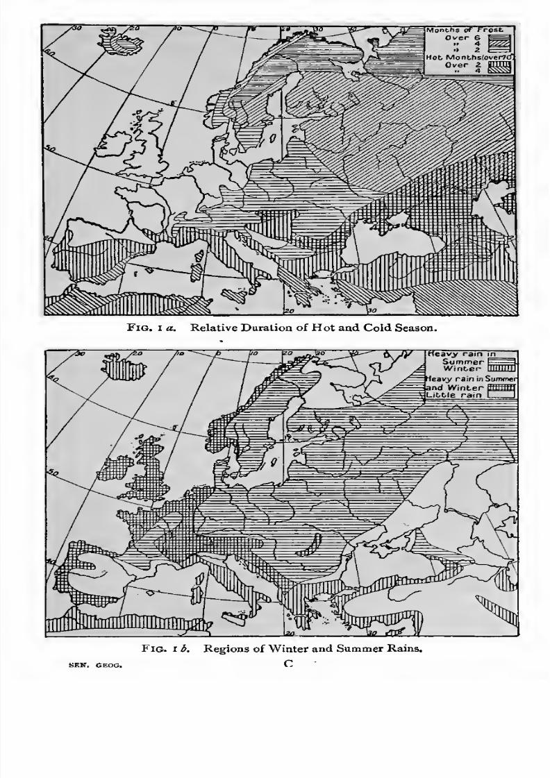
The remainder of this book is divided into sections which
accord more closely with natural divisions than with any others.
Thus the following section, on the Mediterranean region, covers
parts of three continents, Europe, Asia, and Africa, which
border on the Mediterranean Sea. We shall therefore be able
to think of the continents and political 'countries' in terms
7/30/2019 The Senior Geography 1919
http://slidepdf.com/reader/full/the-senior-geography-1919 33/383
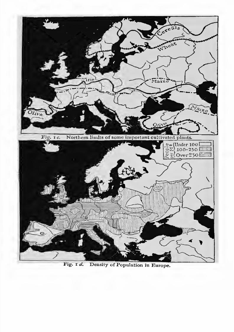
Fig. i a. Relative Duration of Hot and Cold Season.
Fig. i b. Regions of Winter and Summer Rains.
7/30/2019 The Senior Geography 1919
http://slidepdf.com/reader/full/the-senior-geography-1919 34/383
Fig. I c. Northern limits ofsome important cultivated plants.
Fig. i d. Density of Population in Europe.
7/30/2019 The Senior Geography 1919
http://slidepdf.com/reader/full/the-senior-geography-1919 35/383
THE NATURAL REGIONS OF THE WORLD 19
of the natural divisions of each, and to account for the points
of resemblance or of contrast between territories affected by
similar or different natural conditions.
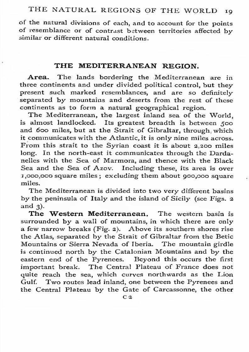
THE MEDITERRANEAN REGION.
Area. The lands bordering the Mediterranean are in
three continents and under divided political control, but they
present such marked resemblances, and are so definitely
separated by mountains and deserts from the rest of these
continents as to form a natural geographical region.
The Mediterranean, the largest inland sea of the World,
is almost landlocked. Its greatest breadth is between 500
and 600 miles, but at the Strait of Gibraltar, through, which
it communicates with the Atlantic, it is only nine miles across.
From this strait to the Syrian coast it is about 2,200 mileslong. In the north-east it communicates through the Darda-
nelles with the Sea of Marmora, and thence with the Black
Sea and the Sea of Azov. Including these, its area is over
i,ooo,oco square miles ; excluding them about 900,000 square
miles.
The Mediterranean is divided into two very different basins
by the peninsula of Italy and the island of Sicily (see Figs. 2
and 3).
The Western Mediterranean. The western basin is
surrounded by a wall of mountains, in which there are only
a few narrow breaks (Fig. 2). Above its southern shores rise
the Atlas, separated by the Strait of Gibraltar from the Betic
Mountains or Sierra Nevada of Iberia. The mountain girdle
is continued north by the Catalonian Mountains and by the
eastern end of the Pyrenees. Beyond this occurs the first
important break. The Central Plateau of France does not
quite reach the sea, which curves northwards as the Lion
Gulf. Two routes lead inland, one between the Pyrenees and
the Central Plateau by the Gate of Carcassonne, the other

7/30/2019 The Senior Geography 1919
http://slidepdf.com/reader/full/the-senior-geography-1919 36/383
20 THE MEDITERRANEAN REGION
between the Central Plateau and the Alps by the narrow
Rhone valley. The Alps, the highest and broadest part of
the mountain barrier separating the Mediterranean from
Northern Europe, and the Apenninesenclose the rest of
the basin. The Apennines are lowest where they join the
Alps, and low passes lead north from the Gulf of Genoa,
the second great gulf of the Western Mediterranean, to the
plains of the Po, and the head of the Adriatic Sea. A volcanic
foreland, with Vesuvius, Etna, and other active volcanoes,
skirts the western side of the Apennines in the south.
Land over 1000 ftl^Aj,Sea deeper than
30O0 ft CZ3
Fig. i. The Western Mediterranean.
A narrow rift, the Strait of Messina, has cut off Sicily, which
is separated from Africa by the wide but shallow Strait of
Sicily or Tunis, ioo miles across.
Five natural ways lead out of the Western Mediterranean,the Straits of Gibraltar, Messina, and Sicily, and the land
routes by the Gate of Carcassonne and the Rhone valley.
Less important routes are by passes across the Catalonian
Mountains to the Ebro valley, and across the Apennines from
Genoa to the Po. (Identify these in Fig. 2.)
The islands of the western basin are the Balearic Islands

7/30/2019 The Senior Geography 1919
http://slidepdf.com/reader/full/the-senior-geography-1919 37/383
THE MEDITERRANEAN REGION 21
in the west and Corsica and Sardinia in the centre, the latter
almost dividing it into two parts.
The Eastern Mediterranean. The larger eastern basin
lies farther south. It is cut into great gulfs. The mountainbarrier is not continuous in the north, and does not exist in
the south (see Fig. 3).
The Adriatic Sea, a depression between the Apennines and
Land over 1000 ft.vSea de.e.ne.r than
3000 ft. %nz.
Fig. 3. The Eastern Mediterranean.
the Dinaric Alps, ends in the plain of the Po. From this
routes open (i) across the high Alps to Central Europe,
(2) across the lower Alps to the Hungarian plain, and (3)
across the Apennines to the Western Mediterranean.
The Aegean Sea, studded with islands, cuts Greece and
Asia Minor into many small peninsulas and bays, which form
excellent harbours. It leads tothe
Vardar and Maritsa

7/30/2019 The Senior Geography 1919
http://slidepdf.com/reader/full/the-senior-geography-1919 38/383
2a THE MEDITERRANEAN REGION
valleys in the north, from which the routes to the Danube
and Central Europe are not difficult. The mountains enclose
many small, isolated, intermont plains, which are the populous
parts of these regions.
The Dardanelles, the Sea of Marmora, and the Bosporus
lead to the Black Sea, which is deep in the south and shallow
in the north, where its floor rises gradually to the plains of
Eastern Europe. The Crimea peninsula almost separates it
from the Sea of Azov.
Between the Black Sea and the Levant, the eastern part
of the Eastern Mediterranean, is the lofty plateau of Asia
Minor, bordered by the Pontic Mountains in the north and
the Taurus in the south. Crete and Cyprus are remnants
of a submerged range farther south. The routes to the
plateau are by valleys opening to the Aegean. In the
extreme south-east the Iskanderun gulf of the Levant leads
to the Cilician plain and the pass of the Cilician Gates across
the Taurus. Another route leads by Aleppo to the Euphrates
and the plains of Mesopotamia.
The eastern and southern shores of the Eastern Mediter-
ranean are very unlike the deeply-cut, island-studded northern
shores. Above them rise the steep escarpments of the Syrian
and African tablelands, fringed in the east by low coastal plains.
The shores are destitute of islands, and broken only by the
gulfs of the Greater and Lesser Syrtes. Northern Africa is
a desert, except in the fertile Nile delta. An eastern exit
from the Eastern Mediterranean, comparable with the western
exit by Gibraltar, has been made by cutting a ship canal
across the isthmus of Suez to the Red Sea.
The Mediterranean Lands, therefore, consist of high-
lands, coastal lowlands, and intermont plains. Their climate
and products have already been described (see p. 8). The
political divisions are numerous. Many languages are spoken.
The religion is Christian in Europe and Mohammedan else-
where, except in the Balkan lands, where both religions mix.
Ease of Navigation. The Mediterranean peopleshave

7/30/2019 The Senior Geography 1919
http://slidepdf.com/reader/full/the-senior-geography-1919 39/383
THE MEDITERRANEAN REGION 23
always been sailors, especially in the eastern basin, where
good harbours are fairly numerous and the peninsulas and
islands tempt the sailor onwards. The regularity of the winds
and currents in both basins made it easy to master the
navigation of the whole sea. The drawbacks are frequent
storms, the absence of estuaries, and the silting up of harbours,,
especially in the dryer east. At the end of long droughts,,
when the rivers are swollen by heavy rains into fierce torrents,
the dry soil, with little vegetation to bind it, is carried down
the hill sides and out to sea as silt. Ephesus, once a great
port, is now five miles inland, and Smyrna has only been
saved by costly engineering works.
Historical Summary. The geography of the Mediter-
ranean has largely determined its history. Much has always
turned on the command (1) of the strait between the two
basins, and (a) of the Levantine starting-points of the routes
to the east. At a very early period
—perhaps between four
and five thousand years ago—there were people in the Aegean
islands and especially in Crete, who reached a high standard of
civilization. Later the Phoenicians, whose chief centre was
Tyre, settled in part of the narrow coastal strip of Syria.
Forested mountains prevented expansion inland, but supplied
metals, in which the Phoenicians became skilful workers.
Unable to depend on agriculture alone, they became ship-
builders and traders, thus utilizing their maritime position and
the timber supplied by the forests. A mollusc found on their
coasts supplied the famous Tyrian purple, which was in wide
demand. To obtain copper and tin, of which they made
bronze, they visited Cyprus, so called from its copper, and the
tin
minesof Spain. Later they passed through the Strait of
Gibraltar, and reached the tin mines of Britain and the amber
lands of the Baltic. The position of Tyre, where routes from
the Mediterranean and from Asia converge, made it the
emporium at which the produce of east and west were
exchanged.
As population and wealth increased colonies were founded
along the Mediterranean. these Carthage, on the peninsula

7/30/2019 The Senior Geography 1919
http://slidepdf.com/reader/full/the-senior-geography-1919 40/383
24 THE MEDITERRANEAN REGION
of Tunis, which irrigation renders very fertile, was the greatest.
Enriched by agriculture as well as commerce, its position gave
it the command of both basins and the presumptive supremacy
of the western.
The plains and wooded highlands of Palestine, south of
Phoenicia, were settled by the Israelites, who under better
natural conditions remained an agricultural and pastoral people,
with no incentive to oversea expansion.
The Greeks entered the Balkan peninsula from the north
and spread from the plains of Thessaly to the intermont plains
of the south, the Aegean islands, and the coast of Asia Minor.
The isolation of the plains and valleys of Greece hindered the
growth of a united nation, and each city state was independent.
The conditions of Phoenicia were thus in some degree repro-
duced for each city, and the Greeks became a maritime and
trading people, planting colonies on all the sea routes open to
them. Many of these, notably Marseille and Alexandria, are
still flourishing cities.
Carthage and the Grecian colonies naturally came into
collision. The struggle was for Sicily, the key of both basins.
Before its close a new Mediterranean power, well-placed
for the control of both basins, came on the scene. This was
Rome.
Rome and Carthage fought out their struggle at manypoints round the western basin, where Carthaginian colonies
were numerous. The death-blow was struck at Carthage.
Possessing it and Sicily, Rome controlled the Mediterranean,
and the Roman arms rapidly penetrated all the natural routes
opening from it. Rome remained the capital so long as the
Empire coincided with theMediterranean, but later a second
capital was founded at Constantinople, the gate of Asia. This
contributed to the decay of the Western Empire, out of which
modern Europe has been formed.
The next great power was that of the Saracens, or Moham-medan Arabs, who became masters of the southern and eastern
shores, which still remain Mohammedan, and long held Spain

7/30/2019 The Senior Geography 1919
http://slidepdf.com/reader/full/the-senior-geography-1919 41/383
THE MEDITERRANEAN REGION 25
on the northern shores. The Crusades failed to dislodge them,
but promoted intercourse between the Eastern and Western
Mediterranean.
Afavourable geographical position led to the rise of
Genoaand Venice, which commanded Mediterranean routes and land
routes across the Alps. Both powers declined after the Turkish
conquests of the fifteenth century closed the routes to Asia
and the discovery of the Cape route led to the rise of Atlantic
ports.
The opening of the Suez Canal made the Mediterranean
once more the great highway between east and west. Marseille,
Genoa, and other ports became more important than they had
ever been. The continental powers north and east of the
mountain barriers are eager for Mediterranean possessions, and
are directing their European policy to this end.
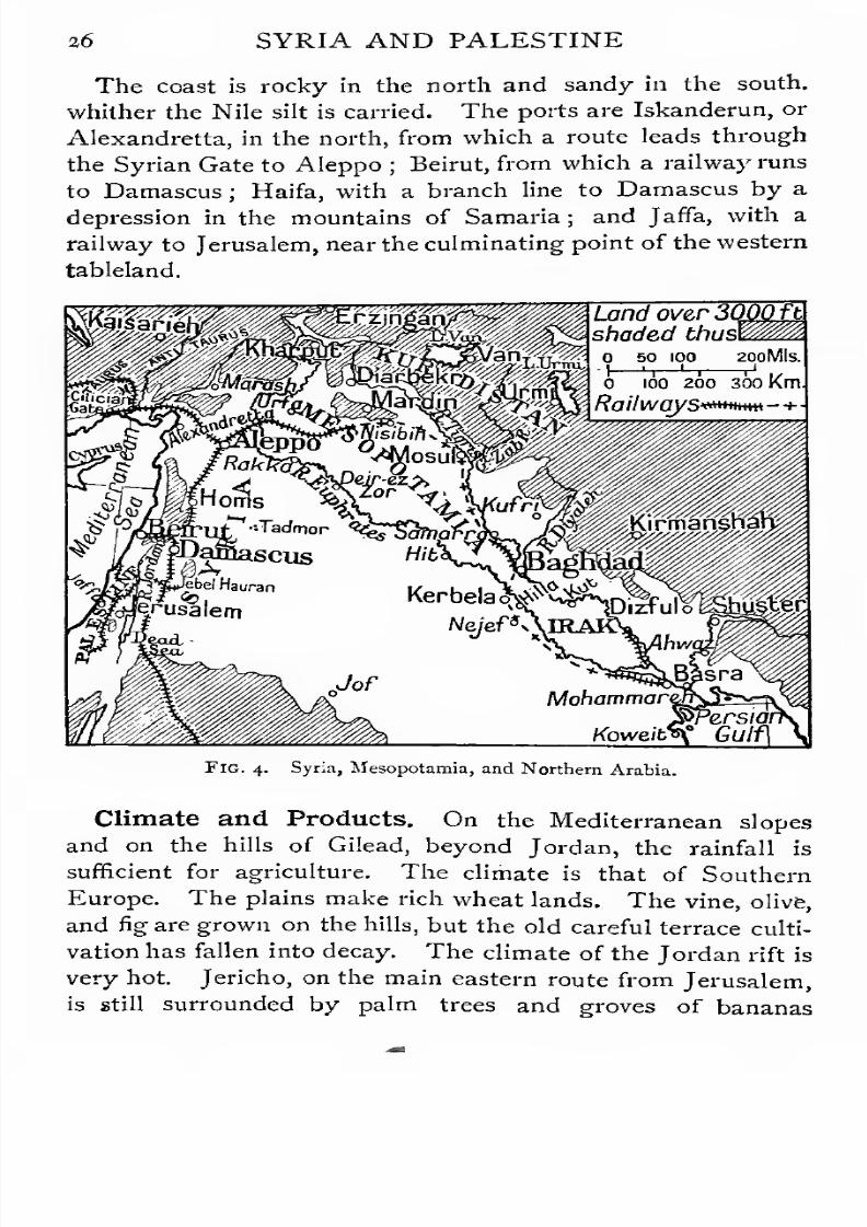
SYRIA AND PALESTINE.
Configuration. Syria is a tableland, crossed from north
to south by a great rift valley. This is drained by the Orontes
and Leontes, flowing to the Mediterranean, and by the Jordan,
flowing to the Dead Sea, which lies 1,300 feet below sea-level,
and is 1,300 feet deep. The rift valley is continued by the
Gulf of Akaba and the Red Sea.
West of the rift valley the high margin of the tableland
comes close to the sea, rising to over 10,000 feet in the moun-
tains of Lebanon. Farther south it recedes from the coast,
leaving the fertile plains of Sharon and Philistia.
Eastof
therift valley, to which the tableland falls steeply
oneither side, the highest part forms the mountains of Anti-
Lebanon, with Damascus at their base. Connected with the
rift is the great volcanic outflow of the Hauran, on the margin
of the Syrian desert. Fine wheat is grown in its fertile, vol-
canic soil. The tableland slopes east to the Euphrates, forming
the Syrian desert.
7/30/2019 The Senior Geography 1919
http://slidepdf.com/reader/full/the-senior-geography-1919 42/383
36 SYRIA AND PALESTINE
The coast is rocky in the north and sandy in the south,
whither the Nile silt is carried. The ports are Iskanderun, or
Alexandretta, in the north, from which a route leads through
the Syrian Gate to Aleppo;
Beirut, from which a railway runsto Damascus ; Haifa, with a branch line to Damascus by a
depression in the mountains of Samaria ; and Jaffa, with a
railway to Jerusalem, near the culminating point of the western
tableland.
Land over3(MfU
shaded thusl200MIS.
o ioo 200 300 Km.
Railways*******- +
Fig. 4. Syria, Mesopotamia, and Northern Arabia.
Climate and Products. On the Mediterranean slopes
and on the hills of Gilead,
beyond Jordan, the rainfall is
sufficient for agriculture. The climate is that of Southern
Europe. The plains make rich wheat lands. The vine, olive,
and fig are grown on the hills, but the old careful terrace culti-
vation has fallen into decay. The climate of the Jordan rift is
very hot. Jericho, on the main eastern route from Jerusalem,
is still surrounded by palm trees and groves of bananas
7/30/2019 The Senior Geography 1919
http://slidepdf.com/reader/full/the-senior-geography-1919 43/383
SYRIA AND PALESTINE 27
and oranges. East of Jordan the summer heat increases,
and the rainfall diminishes. The country is poor grass
land, passing into desert. Ruins of cisterns, tanks, and cities
show that it was once irrigated and cultivated. It is nowthe home of wandering Arab tribes, who keep camels, sheep,
and goats.
Damascus, the capital of Syria, is an oasis irrigated by the
Abana, at the base of Anti-Lebanon. It is the starting-place
of routes (1) by Galilee to the Levant and the Nile, (2) across
the desert to Baghdad and the Persian Gulf, and (3) by the
pilgrim route to Mecca. A railway runs by (3) to Medina.
Historical. Syria, the natural highway between the Nile
and the Euphrates, has been repeatedly seized by invaders
from both sides. In ancient times it was highly cultivated
and thickly peopled. Its importance declined after its conquest
by the Turks, who neglected agriculture and allowed the
irrigation system to fall into decay.
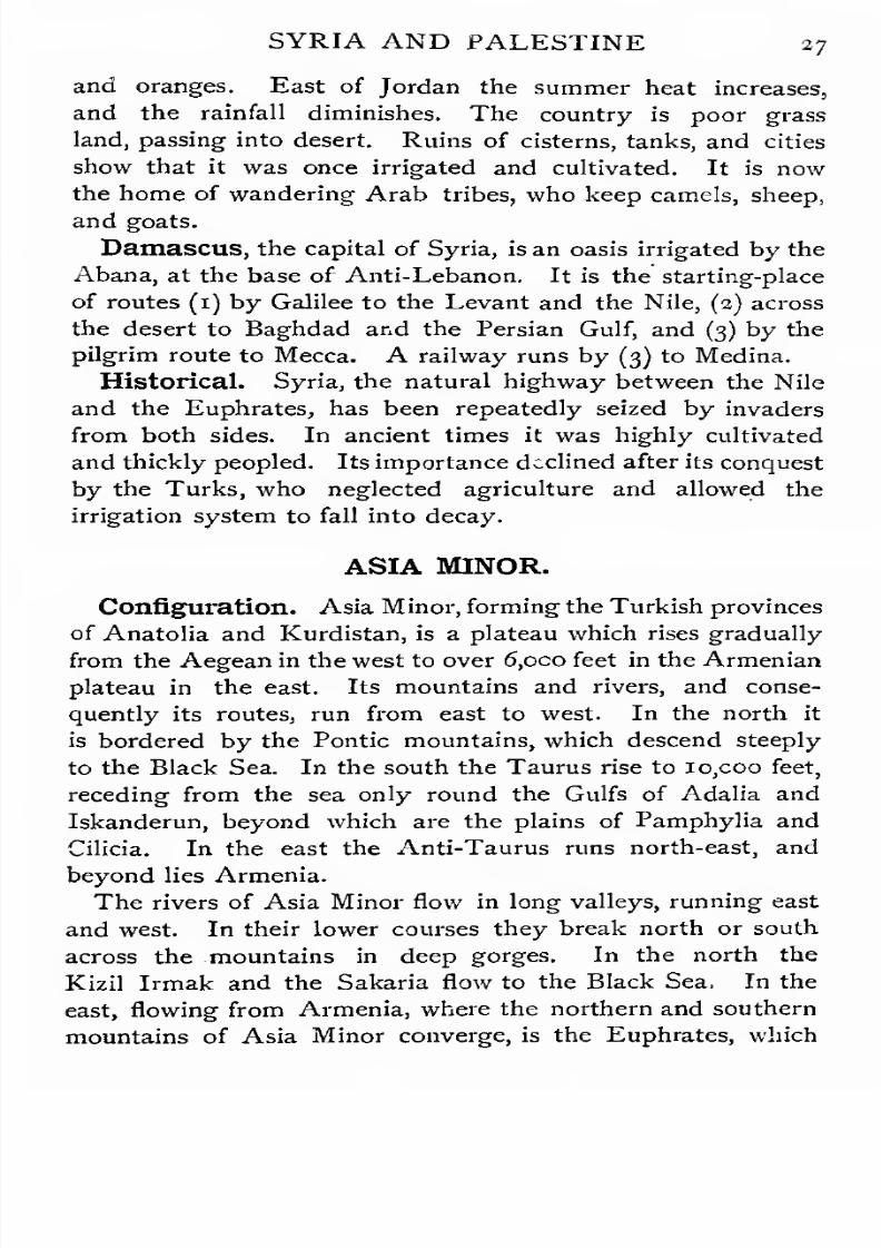
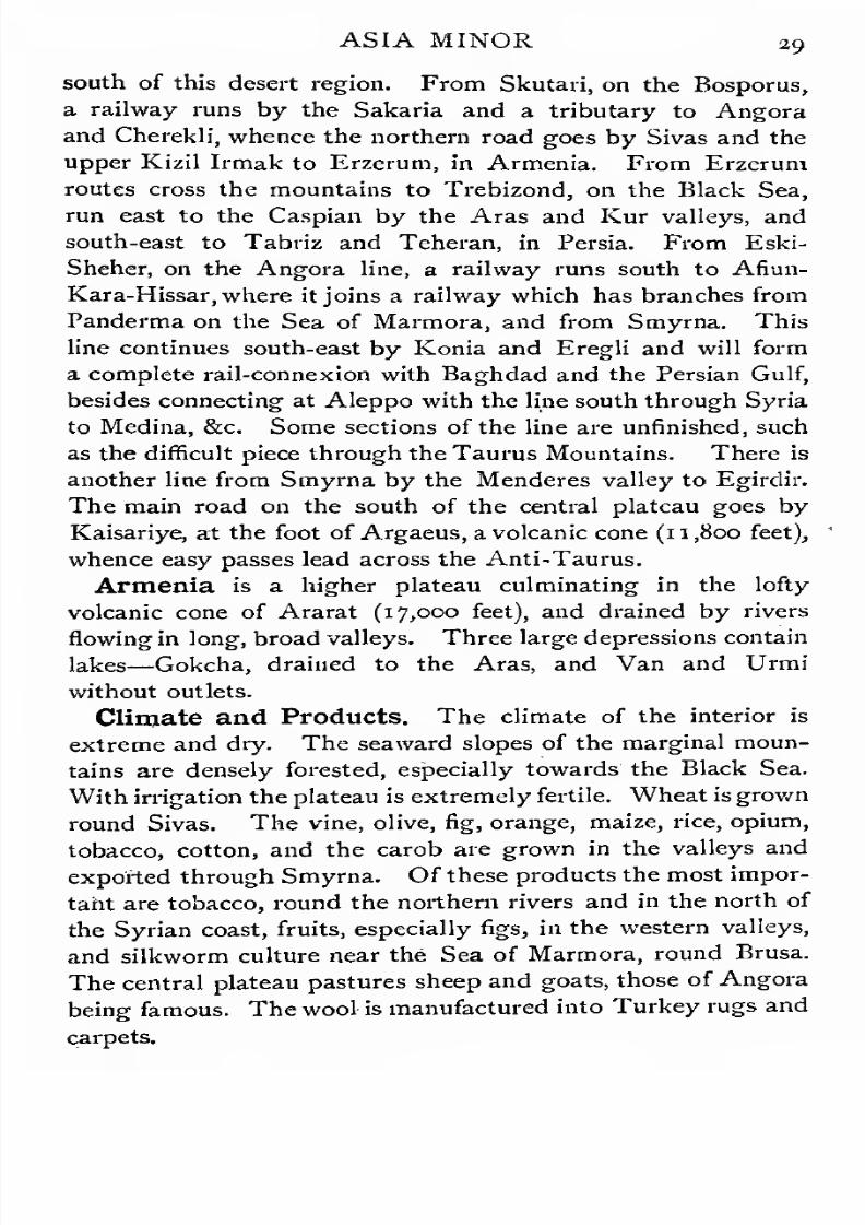
ASIA MINOR.
Configuration. Asia Minor, forming the Turkish provinces
of Anatolia and Kurdistan, is a plateau which rises gradually
from the Aegean in the west to over 6,oco feet in the Armenian
plateau in the east. Its mountains andrivers,
and conse-quently its routes, run from east to west. In the north it
is bordered by the Pontic mountains, which descend steeply
to the Black Sea. In the south the Taurus rise to io,coo feet,
receding from the sea only round the Gulfs of Adalia and
Iskanderun, beyond which are the plains of Pamphylia and
Cilicia. In the east the Anti-Taurus runs north-east, and
beyond lies Armenia.
The rivers of Asia Minor flow in long valleys, running east
and west. In their lower courses they break north or south
across the mountains in deep gorges. In the north the
Kizil Irmak and the Sakaria flow to the Black Sea, In the
east, flowing from Armenia, where the northern and southern
mountains of Asia converge,is the Euphrates,
which

7/30/2019 The Senior Geography 1919
http://slidepdf.com/reader/full/the-senior-geography-1919 44/383
28 ASIA MINOR
breaks south across the mountains to the plains of Mesopotamia.
Routes. The routes from the northern or southern seas
to the central plateau are all difficult, for the lower courses of
the rivers are useless either for routes orfor navigation. This
neutralizes the advantage of the position of Asia Minor between
the Black Sea and the Levant. The Cilician Gate across the
Epjglish Milps
so too tao zooLand oversooo ft. thus MMRailways
3B-
&TEI> IT
Fig. 5. Asia Minor, showing; the genera! arrangement of the ranges andthe position of the chief towns.
Taurus has always been important as a route from the south.
In the west the plateau is lower and more accessible. Its
average elevation is about 2,500 feet, though Olympus rises
to 7,500 feet. Broad longitudinal valleys opening from the
Aegean form natural routes, the most important being those
of the Gediz and Menderes, used by railways from Smyrna.
The marginal mountains arrest the rainfall, and the interior
is a region of salt plains, marshes, and lakes, and of deserts
and poor steppes. Routes pass
7/30/2019 The Senior Geography 1919
http://slidepdf.com/reader/full/the-senior-geography-1919 45/383
ASIA MINOR 29
south of this desert region. From Skutari, on the Bosporus,
a railway runs by the Sakaria and a tributary to Angora
and Cherekli, whence the northern road goes by Sivas and the
upper Kizil Irmak to Erzerum, in Armenia. From Erzerumroutes cross the mountains to Trebizond, on the Black Sea,
run east to the Caspian by the Aras and Kur valleys, and
south-east to Tabriz and Teheran, in Persia. From Eski-
Sheher, on the Angora line, a railway runs south to Afiun-
Kara-Hissar, where it joins a railway which has branches from
Panderma on the Sea of Marmora, and from Smyrna. This
line continues south-east by Konia and Eregli and will form
a complete rail-connexion with Baghdad and the Persian Gulf,
besides connecting at Aleppo with the line south through Syria
to Medina, &c. Some sections of the line are unfinished, such
as the difficult piece through the Taurus Mountains. There is
another line from Smyrna by the Menderes valley to Egirdir.
The main road on the south of the central plateau goes byKaisariye, at the foot of Argaeus, a volcanic cone (11,800 feet),
whence easy passes lead across the Anti-Taurus.
Armenia is a higher plateau culminating in the lofty
volcanic cone of Ararat (17,000 feet), and drained by rivers
flowing in long, broad valleys. Three large depressions contain
lakes—Gokcha, drained to the Aras, and Van and Urmi
without outlets.
Climate and Products. The climate of the interior is
extreme and dry. The seaward slopes of the marginal moun-
tains are densely forested, especially towards the Black Sea.
With irrigation the plateau is extremely fertile. Wheat is grown
round Sivas. The vine, olive, fig, orange, maize, rice, opium,
tobacco, cotton, and the carob are grown in the valleys andexported through Smyrna. Of these products the most impor-
tant are tobacco, round the northern rivers and in the north of
the Syrian coast, fruits, especially figs, in the western valleys,
and silkworm culture near the Sea of Marmora, round Brusa.
The central plateau pastures sheep and goats, those of Angora
being famous. The wool is manufactured into Turkey rugs and
7/30/2019 The Senior Geography 1919
http://slidepdf.com/reader/full/the-senior-geography-1919 46/383
30 ASIA MINOR
Historical. In Greek and Roman times Asia Minor was
a rich agricultural and commercial region, and its flourishing
cities were skilled in the arts and famous for their luxury.
The conquest of this regionby
the Turks, a pastoral race, led
to the neglect of irrigation,agriculture, and roads, and destroyed
the prosperity of the region.
The Aegean Islands. These vary from rocky islets to
fertile islands, producing Mediterranean fruits. Sponge fishing
is important. The principal islands have steamer communica-
tion with the ports of Greece and Asia Minor. Samos and
Mitylene are fertile and prosperous. Rhodes, one of the
largest, was once an important maritime power.
Cyprus, a British protectorate, was anciently famous for
copper. Its forests were cut down for smelting and ship-
building, leaving its limestone hill-sides barren and infertile.
The capital is Nikosia.
THE BALKAN PENINSULA.
Configuration. The Balkan peninsula consists of moun-
tains and intermont plains. The Dinaric-Albanian-Greek
mountains border the Adriatic on the west, and communica-
tion with the interior is difficult. In the north the rounded
forested Balkans shut off the lowlands of the lower Danube.
The slope of the land is to the Aegean and Black Seas, with
which communication is easy.
Four important valleys form the chief routes. These are
the Vardarand Struma, opening from the Aegean Sea ; the
Maritsa, the lower valley of which also opens from the Aegean,
though the middle and upper courses and the valleys of
its chief tributaries run east and west ; and the Morava, which
opens north to the Danube between the Dinaric and Balkan
Mountains. The Morava-Vardar valleys form the main north
and south route between Belgrad, where the Save enters

7/30/2019 The Senior Geography 1919
http://slidepdf.com/reader/full/the-senior-geography-1919 47/383
THE BALKAN PENINSULA 31
the Danube, and Salonica, which is built east of the marshy
delta of the Vardar. The Struma valley is parallel to the
Vardar valley, but is blocked to the north by the wildest part
of the Rhodope or Thracian Highlands. These rise to about
10,000 feet round the sources of the Isker and the Maritsa, and
separate these valleys from the marshy coastal plain of Thrace.
From the upper Isker basin, in which is Sofia, the capital
of Bulgaria, moderately easy passes lead to the Nishava,
a tributary of the Morava, and to the Maritsa. The Orient
Express route from Belgrad goes by the Morava and Nishava
valleys to Sofia, tunnels through to the Maritsa valley, avoid-
ing the longer route by Trajan's Gate, follows the Maritsa
valley past Philippopolis to Adrianople, and continues east by
the valley of a tributary, to Constantinople.
Between the Thracian and Albanian Highlands are the
highlands of Old Serbia and Macedonia, with many small
intermont plains. The Macedonian rivers are marshy and
malarial in their lower courses, but the soil is fertile. Usktib,
in the upper Vardar valley, on a Roman site, commands
routes (1) north to the Morava, (2) west across the Albanian
Mountains to the Adriatic, (3) south to Monastir, and (4) the
main line south to Salonica. Monastir, in a depression
between the Macedonian and Albanian Highlands, controls
a line to Salonica round Lake Ostrovo, and difficult routes
through the mountains leading to Durazzo, in Albania, and
other points on the Adriatic coast.
South of Salonica the peninsula narrows greatly, forming
Greece. The western mountains are well defined, but the
centre and east consists of detached highlands, of which
Olympus is the highest. Partially submerged mountain
ranges form rocky peninsulas and mountainous islands, and
the gulfs and straits which separate them are old valleys sub-
merged and drowned by the sea. There are many mountain-
girt plains, but none are very large. Thessaly, with the small
town of Larissa and the port of Volo on the Aegean, is
separated by Othrys, Oeta, and Parnassus from the plains of

7/30/2019 The Senior Geography 1919
http://slidepdf.com/reader/full/the-senior-geography-1919 48/383
3* THE BALKAN PENINSULA
Attica and Boeotia. The narrow strait of Chalkis separates
the mountainous island of Euboea from the mainland. Small
plains are found at the head of the gulfs of the Morea, where
the mountain ranges form long narrow peninsulas. The Gulf
of Corinth, with Patras at its western end, is the one important
Land over 1000 feet
Fig. 6. The Balkan Peninsula.
break from west to east, and is continued east by the narrow
isthmus of Corinth across which a ship canal has been cut.
The mountains which fringe the Adriatic and Ionian Seas
consist of parallel limestone ranges separated by deep depres-
sions. North of the Drin they run north-west, and fall steeply
to the sea. The Dalmatian islands represent a submerged

7/30/2019 The Senior Geography 1919
http://slidepdf.com/reader/full/the-senior-geography-1919 49/383
THE BALKAN PENINSULA 33
outer range. The gorge of the Drin forms a .difficult route
from Old Serbia to the Adriatic. South of the Drin the
mountains recede from the coast, which is fringed with malarial
lagoons. In Greece the parallel ranges of Pindus run north
and south, and the Zygos pass is the best route across them to
the Thessalian plain in the east. The Ionian Islands (Corfu,
Cephalonia, and Zante), which fringe the west coast of Greece,
represent another submerged outer range.. The east coast is
fringed by the smaller Cyclades and Sporades.
Limestone cr Karst Scenery. The western limestone
region forms what is called karst. The peaks and pinnacles
weather into fantastic forms, and are often richly coloured.
Limestone is a porous rock which is easily dissolved by water.
The surface soil holds little moisture, and vegetation is scanty.
The rivers cut deep, steep gorges, and often disappear through
sink-holes in the limestone, flow underground for some dis-
tance, and gush out at lower levels. When swollen by the
heavy rains which fall on the Adriatic slope they are too
swift and deep to ford, and at other times they are almost dry.
They flow at the bottom of steep gorges and are useless either as
routes or for irrigation. The most fertile parts ofthe limestone
country are the polyes, or plains, which are eroded below the
general level. These are flooded in the rainy season, and
when the waters go down they leave behind a deposit of fine
soil which is suitable for cultivation.
Climate and Products. The northern slopes and valleys
of the Balkans have the climate of Central Europe. The
mountain slopes are covered with oak and beech forests, and
the valleys opening north are planted with orchards. The
plum, the commonest fruit, is dried into prunes or distilled
into plum brandy. The valleys opening south have a more
genial climate and produce vines, olives, mulberries, tobacco,
and roses for making attar of roses, the basis of all the finest
perfumes. Wheat and maize are grown on the northern and
southern slopes of the Balkans. The trade in currants is so
profitable in Greece that many oliveyards have been cut down
SEN. GEOG.
7/30/2019 The Senior Geography 1919
http://slidepdf.com/reader/full/the-senior-geography-1919 50/383
34 THE BALKAN PENINSULA
and turned into vineyards. The Adriatic coast of the Balkan
peninsula has a heavy rainfall, especially in the winter half-year.
Mediterranean crops are grown in the valleys;the lower moun-
tain slopes are clothed with evergreen forests ; and the higher
limestone slopes are bare. Except in the intermont plains the
keeping of sheep and goats is more important than agriculture.
Political Divisions. There is no single centre from which
the whole peninsula can be controlled, and this explains the
numerous political divisions. The isolation of the many
plains, basins, and valleys leads to strong local patriotism
and racial and religious feuds never die out though they maysmoulder. The wars of 1913-13 resulted in what are
practically the present political divisions. Greece has
pushed north into Macedonia ; Turkey retains only the
region between Adrianople and Constantinople ; Bulgaria
extends from the Danube to the Aegean Sea ; Serbia
covers the Morava and the upper Vardar basins and the
neighbouring highlands ; and Albania extends along the
Adriatic from .the Drin and Lake Skutari to the Greek
frontier. The small kingdom of Montenegro lies north of
the Drin. Bosnia-Herzegovina, north of Montenegro, is part
of Austria-Hungary.
Bosnia-Herzegovina, in the karst region, consists of
parallel limestone ranges, with high valleys and plateaus
between. The rivers usually flow in deep gorges through
the mountains, but there is flat land suited for agriculture
along the Save and the lower courses of its tributaries.
Cereals, potatoes, flax, hemp, and plums are grown, but
half the surface is still forest. Cattle, sheep, pigs, and
goats are kept, and sheep and goat skins are exported.
The leather and wood-pulp manufactures are growing, and
roads and railways are opening up the country. Thecapital of Bosnia is Sarayevo, from which a line crosses
the Dinaric Alps to the gorge of the Narenta, and Mostar,
the capital of Herzegovina.
Montenegro is also in the karst region, but olives and
7/30/2019 The Senior Geography 1919
http://slidepdf.com/reader/full/the-senior-geography-1919 51/383
THE BALKAN PENINSULA 35
other Mediterranean plants are grown in the lower valleys
opening to the Adriatic, and cereals, potatoes, and fruits in the
east. Most of the country consists of rugged mountains, and
their height and porous soil are unsuited to agriculture. The
peeping of animals is the chief occupation. The capital is
Cettinye, reached from the beautiful harbour of Cattaro, which
is held by Austria.
Serbia. Serbia has a long shore-line on the Save and
Danube, but no sea coast or port. Most of the country
is occupied by outliers of the Dinaric, Balkan, and Rhodope
Mountains, which are well forested and feed innumerableswine. The lowlands lie along the Morava, the upper Vardar,
and their tributaries. Peasant proprietors farm their holdings
in the most primitive way, but produce fair crops of cereals,
plums, vines, tobacco, mulberries (for silkworms), and cotton.
Minerals are abundant. Serbia also includes Old Serbia,
or Kossovo, and the important towns of Uskub, on the
Vardar, in Old Serbia, and Monastir, on the southern
frontier of Albania. The capital of Serbia is Belgrad, on
high ground at the confluence of the Save and Danube.
Nish, in the centre of the country, is the junction where
the Salonica line leaves the main Orient Express line to
Constantinople.
Bulgaria. The kingdom of Bulgaria has a long shore-
line on the Danube, with Ruschuk and other river ports,
a coastline on the Black Sea with the ports of Varna and
Burgas, and a shorter Aegean coastline, with the ports of
Porto Lagos and Dede Agach. Bulgaria consists of alternate
belts of lowland and highland, running from west to east.
Immediately south of the Danube, the northern boundary,
is a limestone foreland, which rises steeply to the forested
Balkans, the ancient Haemus. Here the climate is extreme,,
with hot dry summers in which wheat and maize come
to perfection. The Balkans reach 8,000 ft. in the centre,,
but sink as they approach the Black Sea, The Shipka
pass in the centre leads from the Danube across the Balkans
2

7/30/2019 The Senior Geography 1919
http://slidepdf.com/reader/full/the-senior-geography-1919 52/383
36 THE BALKAN PENINSULA
to-the plains of Eastern Rumelia. The Rumelian valleys are
sheltered from the cold winter winds of Russia and Northern
Bulgaria and have very hot summers. Roses, wine, tobacco,
and silk are important products. Sofia, the capital, on the
upper Isker, is in a high mountain-girt basin between the Balkan
and Rhodope Mountains. Many valleys converge to it, and
its command of routes makes it extremely important. In the
lowland of Eastern Rumelia the chief town is Philippopolis,
which controls the upper Maritsa valley. Bulgaria is not
altogether well placed geographically, for Serbia covers the
upper part of valleys leading to Sofia, and Adrianople,
which controls the lower Maritsa, is a natural rival to Philip-
popolis.
Albania, the home of wild clans along the Adriatic
coast, is a land of limestone mountains falling steeply
to a marshy, unhealthy coastal plain. Ohrida and Presba are
the largest of many lakes. Agriculture is confined to the
valleys opening to the Adriatic, and the keeping of animals is
the chief occupation in the mountains. The chief towns are
Skutari, on the Drin in the north, Durazzo, on the coast, near
the centre, and Valona, also on the Adriatic, in the south.
European Turkey lies east of the lower Maritsa, and now
includes only a fraction of its former territory. Adrianople,
built where the Maritsa receives the Tunja, commands the
route to Constantinople, the capital, on the Golden Horn.
The site of Constantinople is as picturesque as it is important.
The city is built on both the European and Asiatic shores of
the narrow winding Bosporus, a river-like strait, with palaces,
gardens, and villages along its hilly shores. The Bosporus
leads from the Sea of Marmora to the Black Sea, and Con-
stantinople holds the key to the chief land and sea routes
leading from the Mediterranean to Asia.
Greece. Greece now includes Macedonia with the lower
valleys of the Vardar and Struma, and the great port of
Salonica, as well as Crete and other islands formerly held by
Turkey. Its many fertile plains are cut off from each other
7/30/2019 The Senior Geography 1919
http://slidepdf.com/reader/full/the-senior-geography-1919 53/383
THE BALKAN PENINSULA 37
by ragged mountains, and there are few good passes. Much
of the soil is thin, stony, and porous ;the rivers flow in deep
gorges and cannot be used for irrigation, and the climate
is very dry, especially in the east. Emigration has been con-siderable at all periods of Greek history, and every increase of
territory is important. In 1893 the marshy lake of Kopais
was drained, and added about 100 square miles of soil well
suited for cotton. The currant and olive are both important
crops, and sheep and goats are kept on the mountain pastures.
Athens, the capital, is built in a plain round the base of
a steep crag which commands the narrow route between
the mountains and the sea. The summit is crowned by the
ruins of magnificent temples, built 2,500 years ago. Piraeus,
the port, has a fine harbour. Euboea, or Negroponte, off the
coast of Attica, quarries marble, and grows vines and cereals.
The Aegean islands have fertile plains, and hills with terraced
olive-yards and vineyards. Syra, or Hermupolis, is the com-mercial centre of the Aegean archipelago. The larger Ionian
Islands are wetter and more fertile, The currant crop is
important in all. Zante is the most fertile. Corfu is a winter
resort. A railway, completed in 1916, connects Salonica with
Athens, and thus joins the Greek to the European railway
system.
Crete (3,000 square miles) is a long, narrow, mountainous
island, with small fertile plains and terraced hills. In addition
to other Mediterranean plants it produces carob beans, and
valonia, a species of oak bark used in tanning. Canea is the
largest town, and Suda Bay, near it, is a fair roadstead.
Historical Summary. The Balkan peninsula lies in the
pathway of invaders, and many races have overrun it. In
ancient Greece each isolated plain or glen supported an
independent city state and, as communication was easy by sea
and difficult by land, expansion was by sea and not by land.
The idea of a land empire arose in Macedonia, where land
communication is easiest, but it hardly outlived Alexander,
who died in 32a B.C. Under Roman rule military roads
7/30/2019 The Senior Geography 1919
http://slidepdf.com/reader/full/the-senior-geography-1919 54/383
38 THE BALKAN PENINSULA
opened up the country, and Constantinople divided with
Rome the empire of the world. As Rome declined invading
Serbs and Bulgars pressed in by the northern routes, and the
stronger Bulgars drove the Serbs into the barren west. In
1453 Constantinople fell to the Turks, and the tide of
Mohammedan invasion swept towards the heart of Europe. It
began to ebb in the sixteenth century. The invaders were
steadily driven back by land, and a naval defeat by the Vene-
tians and Spaniards (1571) at Lepanto, on the Gulf of Corinth,
crushed the naval power of Turkey. The nineteenth and
twentieth centuries saw the break-up of the Turkish Empire.
The war of 1912-13, in which the powers allied against Turkey
finally turned against each other, shows how unfavourable
the geographical conditions are to any political unity.
ITALY.
Physical Structure. Italy, like the Balkan peninsula,
consists of lowlands separated by mountains. In Italy, how-
ever, the lowlands are often large, they open to the sea, the
mountain barriers are lower and less complex in structure,
and the natural obstacles to intercommunication are more
easily overcome.
The mountains of Italy, including Sicily, form a continuous
chain, 8co miles long, known as the Apennines. They diverge
from the Alps in the extreme north-west, the Col dell' Altare
(1,600 feet) near Savona being generally taken as the link
between the two. The Apennines, which fall steeply to the
Western Mediterranean, are at first almost parallel to the Alps,
but are divided from them by the lowlands of the Po, to which
the northern and eastern valleys of the northern Apennines
open. The system gradually broadens into parallel ranges,
7/30/2019 The Senior Geography 1919
http://slidepdf.com/reader/full/the-senior-geography-1919 55/383
ITALY 39
and trends diagonally towards the Adriatic coast, leaving the
lowlands of Tuscany and Latium between the mountains
and the western sea. To this flow the principal rivers
of Central Italy, the Arno from the Tuscan Apennines,and
the Tiber from the Umbrian, the upper and middle courses
of both being cut across a rugged foreland. Short rapid rivers
drain the valleys opening to the Adriatic. The Apennines
culminate in the wild region of the Abruzzi, where the peaks
of the Gran Sasso exceed 9,500 feet.'
To the west of the Central Apennines is a foreland, mainly
volcanic. Bolsena, Bracciano, Albano, and other lakes fill
the craters of ancient volcanoes in Tuscany and Latium while
the active volcano of Vesuvius rises in Campania.
The Southern Apennines trend towards the Western Medi-
terranean coast, which is reached in the ' toe ' of Italy
Calabria. They fall steeply to the Mediterranean, receding
from the Adriatic, which is bordered by the Apulian lowland.
Small plains enclosed between mountain spurs dot the shores
of the Gulf of Taranto and both shores of the Calabrian
peninsula.
The mountains of Sicily are a continuation of the Apennines.
They fall steeply to the sea in the north, while a limestone
foreland runs to the south and east coasts. The culminating
peak of Sicily is the active volcano of Etna (10,700 feet).
A line of submarine elevation connects the mountains of
Sicily with those of Northern Africa.
The slopes of the Apennines, even where they rise steeply
from the sea, have been extensively terraced for cultivation,
and the olive and vine are grown up to about 3,000 feet.
Forests are rare, and above the line of cultivation the rocky
summits are bare, or covered with poor pasture. The lowlands
are the most fertile and densely populated part of the country,
especially in the north. There are four lowland areas in
Italy r (a) the North Italian alluvial plains;
(b) the western
foreland of smaller plains and volcanic heights, belonging
to the Western Mediterranean ; (c) and (J) the limestone

7/30/2019 The Senior Geography 1919
http://slidepdf.com/reader/full/the-senior-geography-1919 56/383
40 ITALY
forelands of Apulia arid Sicily, both belonging to the Eastern
Mediterranean basin.
Piedmont, Lombardy, and Venetia. The plain of the Po
is part of a depression between the Alps and the Apennines,
the lower end of which is represented by the Adriatic Sea,
between the Apennines and the Dinaric Alps. The upper
part has been gradually filled by the deposits brought down
by the rivers which drain the southern slopes of the Alps in
long parallel valleys. As these carry more water and rock
waste than the rivers from the Northern Apennines, and have
a greater impetus owing to the steepness of their uppervalleys, the course of the Po is slowly but steadily pushed
towards the south. The filling up of the Adriatic is pro-
ceeding rapidly, by the extension of the deltas of the Po and
of the numerous rivers which flow into the Gulf of Venice. Of
these the Adige, Brenta, and Tagliamento are the chief.
This results in the silting up of Adriatic harbours, many of
which have become inland towns since classical times.
The climate of this great lowland is somewhat extreme,
and the rainfall is scanty. In the south it is a meadow land,
famous for cheese (Gorgonzola, Parmesan). The next zone
is agricultural, and is irrigated from the Alpine streams,
the whole plain being covered with a network of narrow
canals. Olives cannot be grown owing to the cold winters,
but the summer is hot enough to ripen rice. The vines are
trained up mulberries, whose leaves feed silkworms. ' Milan is
the centre of the important silk industry, and the most pro-
gressive city in Italy. Tourists visit it for its fine cathedral
and its galleries. In the southern Alpine valleys, which are
sheltered from cold winds, both olives and vines are grown,
and silkworms are bred.
The position of the towns should be carefully noted. Theregion round the Po is marshy, and consequently the Aemilian
way, the great Roman military road, along which are Bologna,
Reggio, Modena, Parma, and Piacenza, skirts the base of the
Apennines. Some towns, like Cremona, are built where the

7/30/2019 The Senior Geography 1919
http://slidepdf.com/reader/full/the-senior-geography-1919 57/383
ITALY 41
river could be bridged. In the west the Montfefat hills, with
terraced vineyards, rise south of the Po. The river Tanaro,
flowing between them and the Apennines, forms an important
route, commanded by Alessandria. In this pass many battles
have been fought.
North of the Po the towns lie at the mouths of valleys,
affording routes across the Alps. Turin, in Piedmont, com-
mands a group of passes leading (1) to the Durance and the
lower Rhone valley, (2) to the Isere, the Saone, and Central
France, and(3)
to the Dora Baltea and Lake Geneva.
Milan commands routes to the upper Rhine and Rhone
valleys. The most direct is by the St. Gotthard to the
Rhine (see p. 59)- Verona commands the low Brenner route
to the Danube, open all the year (sec p. 64). Venice
commands routes to the Drave and the Danube (see p. 65).
The volcanic Berician and Euganean Hills confine the routes
between Lombardy and Venetia to narrow passes, commandedby Vicenza and Padua,
The morainic hills, south of Lake Garda, narrow the space
between the mountains and the Po marshes. As the route
to the north by the Adige diverges here, their possession is of
great importance in war, and many battles have been fought
between the fortress of Mantua, on the Po, and the lake of
Garda.
Venice, with the fine cathedral of St. Mark's, is built on
many small islands, separated by canals and connected by
bridges. Sandbanks and lagoons in front, and marshy lagoons
in the rear, make it difficult to attack by sea or land. Founded
in the troublous fifth century A. D., it succeeded to the old
Roman port of Aquileia. It became an important sea power
in the middle ages from its position where the land routes
across the Alps converge on the Eastern Mediterranean.
The plain of the Po does not belong to Italy physically,
and has frequently had a separate history. The Gauls,
entering by the Alpine routes, held it till its conquest by
in the third century B. c. The Romans built military
7/30/2019 The Senior Geography 1919
http://slidepdf.com/reader/full/the-senior-geography-1919 58/383
4a ITALY
roads, and planted colonies at such strategic points as Bologna,
where the route across the Apennines from Tuscany enters
the plain, or Piacenza, where the Apennines reach the Po.
As Roman power declined, invaders again poured through the
Alpine passes. The Lombards held Lombardy, and also con-
quered Spoleto (see p. 44) and Benevento (see p. 45), which
control the Southern Apennines. Charlemagne included Lom-
bardy in the Holy Roman Empire, but it gradually broke up
into independent cities and duchies, of which Milan was the
most important. In the fifteenth century France and the
Emperor struggled for the possession of Northern Italy, which
fell to Austria in the eighteenth century. In the middle
of last century it threw off the Austrian yoke, and became
part of modern Italy.
Tuscany, the ancient Etruria, consists chiefly of the basin
of the Arno. It is broken up by the hills which form the
Tuscan foreland of the Apennines into small fertile plains, in
which the olive and vine are the chief products. This conr
figuration favoured the growth of independent cities, repre-
sented in Etruscan times by the league of Twelve Cities, and in
the middle ages by the growth of such rivals as Florence and
Siena. Florence (Ital. Firenze) is built where the Arno leaves
the mountains, and commands a route across the Apennines
'
to Bologna by the Reno. Its beautiful situation, fine cathedral,
and art treasures, make it one of the show cities of Europe.
The chief towns of the lower Arno are Lucca, noted for
olive oil, and Pisa, once a great maritime republic. The mouth
of the Arno is now silted up, and the port of Tuscany is
Leghorn {Ital. Livorno).
Liguria. From Pisa, the coast route, followed by a rail-
way, is cut at the base of the steep Apennines, which come
close to the sea. Spezia, on a magnificent bay, is the Italian
arsenal. Genoa, on the fine gulf, is a busy port, commanding
routes over the low Apennines into Piedmont and Lombardy.
Savona, farther west, commands the Col dell' Altare route.
Liguria, sheltered by the Apennines, has a genial climate, and

7/30/2019 The Senior Geography 1919
http://slidepdf.com/reader/full/the-senior-geography-1919 59/383
ITALY 43
the coast, or Riviera, is dotted with winter resorts, set in orange
and lemon groves, among exquisite sea and mountain scenery.
Fig. 7. The Italian Peninsula.
Umbria is a hilly region, lying behind Tuscany and
Latium, on the western slopes of the Central Apennines. It
is drained theTiber. The towns are generally built

7/30/2019 The Senior Geography 1919
http://slidepdf.com/reader/full/the-senior-geography-1919 60/383
44 ITALY
on isolated hills, the lower slopes of which are terraced for
vines and olives. Many have been famous in the history of
art. Perugia, east of the marshy lake Trasimene, commands
the route to Rome by the Tiber valley. Spoleto, commandingthe same route, was an important post on the Flaminian Way,
the military road from Rome to Ariminum (Rimini), on the
Adriatic. A line runs to the Adriatic at Ancona, from
whence it is continued south along the narrow plain between
the Adriatic and the Apennines, beneath the crags of the
Gran Sasso, into Apulia.
Latium, the basin of the lower Tiber, extends from the
highlands of Umbria to the sea, along which it stretches as a
marshy and malarial plain. Volcanic hill masses separate
it from Tuscany to the north and from the Neapolitan
Campagna to the south. It is connected with Tuscany by
the coast route from Pisa, on the lower Arno, across
the desolate Maremma. Another route leaves the Arnoat Florence, and reaches the Tiber valley near Orvieto, an
interesting city on an impregnable crag.
Rome. Rome was built on a cluster of low hills on the
left bank of the Tiber, a few miles from the sea. The site
was easy of defence, high enough above the swampy Tiber
plain to be healthy, connected with the sea by a navigable
river, and far enough inland to be safe from pirates. Anisland makes the "river easy to bridge, and the bridge secured
the control of the routes to the north. The surrounding plain
or Campagna, which stretches north to the Sabine and south
to the Alban hills, though now malarial and uninhabited, was
then drained, cultivated, and populous. The hilly nature of
the site is disguised to-day by the filling of the intervening
valleys with the accumulations of centuries. Much of the city
is modern, but the Forum, Colosseum and other remains from
classical days, and the immense renaissance cathedral of
St. Peter's, are imposing monuments of the past.
Founded in the eighth century B.C., Rome early conquered
the neighbouring cities, and expanded over Italy by the routes

7/30/2019 The Senior Geography 1919
http://slidepdf.com/reader/full/the-senior-geography-1919 61/383
ITALY 45
thus opened. After the downfall of Carthage it succeeded to
the control of the Western Mediterranean, and later to that
of the whole sea and the surrounding lands. The Alpine
routes led to the North Sea and the distant shores of Britain,
while eastwards the Roman power reached the Euphrates.
As the Empire lost its geographical unity it became more
vulnerable, and under successive barbarian attacks crumbled
into fragments out of which modern Europe has been formed.
As the seat of the Papacy it retained the spiritual supremacy
of the World, and is to-day the capital of Christendom as
well as of modern Italy.
Campania has a fertile soil and a genial climate, and has
long been densely populated, Naples, on a magnificent bay,
dominated by the smoking cone of Vesuvius, is the most
populous town in Italy. From the Bay of Naples a lowland
opens inland eastwards to the base of the Apennines. To the
north the coast is malarial, and the route to Rome turns inland
to avoid the Pontine marshes, utilizing the long valleys which
run parallel to the coast. The Volturno is crossed at Capua,
a city famous in Roman times for the wealth and luxury of its
inhabitants. South of Naples the coast resembles that of
Liguria. Mountains descend steeply to the sea, their lower
slopes planted with oliveyards and lemon groves.
Southern Italy. A railway follows the coast south from
Naples to Reggio in Calabria, along a picturesque route cut
along the base of the mountains. There are occasional
villages, but no towns, and the inhabitants are fishermen or
shepherds. The routes east across the Southern Apennines
are difficult owing to the narrowness of the defiles. Benevento,
a junction for many railway lines, is the key of all the routes
leading from Campania into Apulia. On the eastern slopes of
the Apennines are the limestone plains and plateaus of Apulia,
in the north of which Monte Gargano projects into the Adriatic.
Passes lead north to the desolate, thinly peopled district of the
Abruzzi. The soil of Apulia is fertile, and produces a hard
-wheat, which is made into macaroni. Bari is the most

7/30/2019 The Senior Geography 1919
http://slidepdf.com/reader/full/the-senior-geography-1919 62/383
46 ITALY
important town. Brindisi.the ancient Brundisium, is the nearest
Italian port to the Suez Canal, and the terminus ofthe overland
mail route to the east. Taranto, with a. fine harbour, on the
site of the Greek city of Tarentum, is rising in importance.
Sicily, dominated by Etna, a great volcano nearly ioo miles
round, is mountainous, with fertile plains in the south. The rain-
fall is scanty, the summers hot, and the winters mild. Several
crops can be reaped in a year on irrigated land. The olive can be
grown up to 3,000 feet, and the forests, evergreen and deciduous,
extend up to 6,oco feet. Most of the modern towns are near
the site of ancient cities. Messina, on the strait, exports wine.
Catania, at the base of Etna, exports sulphur. The harbour
of Palermo, the capital, on the north coast, the ancient
Panormus, has been reduced in size by the rising of the coast.
The lowlands of Sicily, opening south and east to the
eastern Mediterranean, were early colonized by Greeks and
Carthaginians. The island became Roman in 210 B. C.,and its
fertility made it one of the granaries of the Empire. After the
break-up of the Empire it fell to many successive masters. In
1738 it was united with Naples as the kingdom of the Two
Sicilies, and was finally incorporated in modern Italy.
Sardinia is a highland, rising to over 6,oco feet. The
lowlands, which are malarial, are in the north-east and south-
west. The forests, mines, and fisheries are all neglected.
Wheat, pulses, potatoes, and fruits are grown, and horses,
sheep, and goats are bred. The capital is Cagliari, at the
south end of the Campidano plain.
Sardinia was first Carthaginian, and then Roman. Under
Roman rule roads were made, and the cultivation of wheat was
encouraged. Lying in the centre of the western basin, it was
later attacked by every power which controlled the neighbour-
ing seas, and was successively held by the Vandals, Goths,
Saracens, the Byzantine Emperors, the Popes, Pisa, Genoa,
Aragon, and Austria. In 1720 the house of Savoy took it in
exchange for Sicily. The kingdom of Sardinia, which included
Savoy and Piedmont, gave the first king to modern Italy.
7/30/2019 The Senior Geography 1919
http://slidepdf.com/reader/full/the-senior-geography-1919 63/383
ITALY 47
Corsica stretches north of Sardinia to within 50 miles of
the Tuscan coast. It is mountainous, rising to nearly 9,000 feet
through different vegetation zones. The small eastern lowlands
are fertile but malarial. Fishing and cattle rearing are thechief occupations, and the mineral wealth is neglected. It has
had many masters since Roman times, and is now a French
department. Ajaccio, the capital, is the western, and Bastia,
the eastern port.
Historical Summary. Italy is the natural link between
the two Mediterranean basins, commanding all the routes
between them. It also has access by the Adriatic and Po
depression to the great routes across the Alps. Thus it has
advantages of position not possessed by the other two Medi-
terranean peninsulas, whose influence is confined to a single
basin. This superiority is reflected in the supremacy of
Rome, temporal and spiritual. It also explains the continual
wars for the possession of Italy in the middle ages.
SPAIN AND PORTUGAL.
Physical Structure. The Iberian peninsula, politically
divided into Spain and Portugal, has an average elevation of
2,000 feet. Its core is a high plateau, called the meseta, which
falls steeply to wedge-shaped lowlands in the north-east and
south-west. Beyond these lowlands rise higher, more recent
mountains, the Pyrenees in the north and the Sierra Nevada
in the south. These belong to the great mountain system
which borders the Northern Mediterranean and is continued
through Asia Minor and Armenia into Asia.
The Pyrenees, the only land frontier of the, peninsula,
stretch from the Atlantic to the Mediterranean. They consist
of ranges which run east and west and diverge in the east.
They rise above the snow-line, which is about 9,000 feet on
the northern and 10,000 feet on the southern slopes. The
lower slopes are richly forested. The present glaciers are
small, but the central part of the range shows many signs of

7/30/2019 The Senior Geography 1919
http://slidepdf.com/reader/full/the-senior-geography-1919 64/383
48 SPAIN AND PORTUGAL
former glaciation. Among them are the numerous corries or
niches on the mountain sides, and cirques, or amphitheatre-
like endings of U-shaped valleys, formerly filled by glaciers
(see p. 69). Gavarnie, on the French side, is the finest of
these cirques. The ridge level is very uniform, the cols, or
saddles, being generally only about 1 ,000 feet lower than the
peaks, the highest of which are Maladetta and Mont Perdu
(11,coo feet), both in Spain. This makes communication
across the Pyrenees difficult.
In the west the line from Bayonne skirts the coast,
tunnels under a col between the Pyrenees and their west-
ward prolongation, the Cantabrian Mountains, and reaches
the Meseta by way of the upper Ebro. At the eastern end
of the range the line from Perpignan crosses the plain of
Roussillon and tunnels below the eastern spurs. Between
these the easiest routes are by the pass of Roncesvalles
(4,000 feet), famous in Charlemagne's wars ; the Col de la
Perche (5,000 feet), leading to Toulouse and Carcassonne
and the Perthus Pass (950 feet), leading from Gerona to
Perpignan, the route taken by Hannibal in his march on Italy.
Though there are less than a dozen practicable passes in a range
350 miles long, the same power has frequently dominated both
slopes. The Goths and Saracens overran Languedoc; Charle-
magne from the French side held the Spanish March;
Aragon long controlled the plain of Roussillon. The Pyrenees
did not form the frontier till 1659.
The Meseta is a high, arid plateau, highest in the
south and east. Its northern margin forms the Cantabrian
Mountains, which fall nearly 9,000 feet to the sea on
the north, but on the south overlook the high plains of
Old Castile, above which they rise only 2,000 to 3,000 feet.
The north-eastern margin, known as the Iberian Mountains,
forms the southern wall of the plain of Aragon, which is crossed
by the Ebro and shut in on the north by the Pyrenees. The
upper basin of the Ebro is cut off from the sea by the Cata-,
Ionian Mountains, across which the river cuts a deep gorge.

7/30/2019 The Senior Geography 1919
http://slidepdf.com/reader/full/the-senior-geography-1919 65/383
SPAIN AND PORTUGAL 49
Farther south the high eastern edge of the Meseta recedes
from the sea, leaving the narrow coastal plains of Valencia
and Murcia. Seen from below, this margin forms a mountain
range, drained by parallel rivers,
whose upper courses are indeep ravines, but whose lower courses can be used for irriga-
tion. The southern margin rises steeply as the Sierra Morena
'I V f
i ioo isoK? /—/ h
Fig. 8. The Iberian Peninsula. The low plains are marked by dots, the high
plateau by vertical lines, and the mountainons parts by horizontal lines.
above the Andalusian lowland, which is drained by the
Guadalquivir, the one Spanish river which affords a good
natural waterway into the interior. The western margin is
less steep and in the south-west descends gently to the
lowlands of Estremadura or Lusitania.
SEN. GEOG.

7/30/2019 The Senior Geography 1919
http://slidepdf.com/reader/full/the-senior-geography-1919 66/383
^o SPAIN AND PORTUGAL
The surface of the Meseta consists of lofty plains separated
by sierras, saw-toothed ridges of uniform height, running from
east to west. These, though occasionally rising over 8,000 feet
above the sea, are only a few thousand feet higher than thesurface of the Meseta. The rivers flow west to the Atlantic
in deep gorges which are useless either for routes or for
irrigation. In the north the Douro crosses the dry plains
of Old Castile and Leon, separated by the Sierra de Guadar-
rama and the Sierra de Gredos (8,000 feet) from the high
plains of New Castile, which are drained by the Tagus.
Similar but lower sierras separate the Tagus from the
Guadiana, which is turned south by the eastern buttresses of
the Algarve mountains to the Gulf of Cadiz. Its basin is
separated by the Sierra Morena from the fertile lowlands of
Andalusia, south of which the snow-capped Sierra Nevada or
Betic Mountains rise in Mulhacen to over 11,000 feet. The
Balearic Islands are an eastern prolongation of this systemwhich has been partly submerged.
Climate and Products. The Iberian peninsula is the
driest part of the European Mediterranean. High mountains
prevent rainy winds from reaching the interior, and hot, dry
winds from Africa increase the dryness of Andalusia and
southern Portugal. Northern Portugal and Spain, with warm
summers, mild winters, and rain at all seasons, are climatically
outside the Mediterranean area. Asturias, on the northern
slopes of the Cantabrian Mountains, produces the trees
and fruits of Central Europe, and grazes many cattle in the
rich mountain meadows.
On the Meseta the rainfall is everywhere scanty, though it
differs in quantity and season in different parts. Much falls
in violent storms, which flood the rivers. The climate is very
extreme, and the winters are too cold for the Mediterranean
fruits and evergreens. These reappear on the lower terraces,
and cork oak forests are one of the chief resources of Portugal.
Most of the treeless plains of the Meseta pasture sheep and
goats, while in the irrigated parts, especially round Valladolid,

7/30/2019 The Senior Geography 1919
http://slidepdf.com/reader/full/the-senior-geography-1919 67/383
SPAIN AND PORTUGAL 51
wheat is grown. Swine are kept in the oak forests of
Spanish Estremadura. The only really fertile areas are the
irrigated lands of Andalusia, Murcia, and Valencia. In the
two latter great attention is paid to proper terracing and irri-
gation. All Mediterranean fruits and cereals are grown, as
well as sugar, cotton, and rice. The date ripens near Elche.
The vine is largely cultivated, especially round the coast, and
wine is an important export.
Minerals are abundant, and have been worked since Phoeni-
cian times.
The Cantabrian Mountains are rich in iron andcoal, and the Sierra Nevada in lead. In the Sierra Morena
the Rio Tinto is a famous copper-mining district, and quick-
silver is mined at Almaden.
Routes and Towns. There are no natural routes from
the Mediterranean into the interior. The only considerable
break in the mountain barrier, the Ebro, is barred by the
Catalonian Mountains. All the natural approaches are from
the Atlantic. From the Minho, the northern frontier of
Portugal, a strip of lowland, broadening to the south, extends
along the Atlantic, and contains the lower courses of the
Douro, with the port of Oporto, the Tagus, with the magnificent
harbour of Lisbon, and other rivers. This is the most pro-
ductive and populous part of the country.
The natural route into Spain is by Andalusia, and this has
often been the-path of conquest. The lower Guadalquivir is
marshy and unhealthy. The chief town is Seville, at the head
of navigation. Granada, at the ..base of the Sierra Nevada,
and Cordova, at the base of the Sierra Morena, have splendid
monuments of their Moorish prosperity. The other towns
of Andalusia are Xeres, the centre of the sherry district,
Huelva, the mining centre of the Rio Tinto, and Cadiz, a
fortified port, founded by the Carthaginians.
The other towns of Spain are either (1) on the coas.t, (2) in
the Ebro valley, or (3) on the lofty plains of Old Castile, the
old centre of the Christian power in Moorish days. On the
Mediterranean coast, Malaga, Almeria, Cartagena, Alicante,

7/30/2019 The Senior Geography 1919
http://slidepdf.com/reader/full/the-senior-geography-1919 68/383
52 SPAIN AND PORTUGAL
Valencia, Tarragona, and Barcelona are ports chiefly engaged in
the fruit and wine trade. Barcelona is the manufacturing centre
of Spain. On the Bay of Biscay are Coruiia, Gijon, Santander,
and Bilbao, the latter exporting iron ore. Ferrol, in the west,and Cartagena, in the south, are Spanish naval stations. In the
thinly populated Ebro valley the chief town is Zaragoza.
Fig. 9. Lower Andalusia and the Strait of Gibraltar.
On the Meseta the chief towns are Burgos, Leon, Valladolid,
and Salamanca in Old Castile, and Madrid and Toledo in NewCastile. The surroundings of Madrid are very bleak, theclimate is extreme, and the site is difficult of access, offering
no natural advantages for a capital except its central position.
7/30/2019 The Senior Geography 1919
http://slidepdf.com/reader/full/the-senior-geography-1919 69/383
SPAIN AND PORTUGAL 53
Historical Summary. The Carthaginians early settled
in Spain. The Romans succeeded to their power, but did not
subdue the whole country till the beginning of our era. As
the Empire declined, Spain was overrun from the north-east
by Goths and Vandals, the latter leaving their name in
(V)andalusia. In the eighth century Mohammedan invaders
entered Andalusia from Marocco, and reduced the whole
country, except a few strongholds in the Cantabrian Mountains.
They pushed across the Pyrenees into France, but a decisive
defeat at Tours in A.D. 732 turned them south again. They
were next driven from the Ebro valley, which became the
nucleus of the kingdom of Aragon. The possession of a few
strongholds in the Cantabrian Mountains enabled the Chris-
tians to expel the Moors from the high plains at their base,
and in these were formed the kingdoms of Leon and Castile
(the land of Castles). In 1002 the Castilian frontier was
pushed to the Tagus, and Leon and Aragon both extended
their boundaries. After the union of Leon and Castile the
expanding power on the Meseta gradually drove the infidels
down its slopes and across Andalusia into the Sierra Nevada.
The union of Aragon and Castile was followed by the final
expulsion of the Moors from Spain. The unification of the
country was aided by the rapid extension of Spanish power
in the New World, and when this was checked signs of dis-
union appeared. France took advantage of circumstances
to place French sovereigns on the throne, and a similar
attempt by Napoleon led to the Peninsular War. Disastrous
civil wars between rival claimants crippled the country in the
nineteenth century, the close of which saw the expulsion of
Spain from its last strongholds in the New World.
THE AFRICAN MEDITERRANEAN STATES.
Mediterranean Africa. Only the western border of the
Mediterranean is included in this term. East of the Gulf of
Gabes the littoral forms part of the Sahara (see Fig. 10 for
configuration).

7/30/2019 The Senior Geography 1919
http://slidepdf.com/reader/full/the-senior-geography-1919 70/383
54 THE AFRICAN MEDITERRANEAN STATES
Climate. The climate is that of the Mediterranean, but
the winters are cold in the highlands. Along the Mediter-
ranean the mild winters are making the towns fashionable
winter resorts. The rainfall is scanty. The country is agri-
cultural or pastoral, according to elevation and rainfall.
Natural Zones. The Tell. Algeria is typical of Medi-
terranean Africa. The coast is bordered by low broken
ranges, behind which runs the Tell. The Tell extends from
50 to 150 miles inland. It contains many fertiLe plains and
valleys, and the rainfall is sufficient for cultivation, especially
when supplemented by irrigation. In Algeria, the most
0wr300QFt6OO-3000"Under 600<>2p0 3Q0 MLS.
m ^q $wt<w
Fig. 10. The Atlas Region.
important of these plains are (1) the Sig,with Oran as its chief
town, opening to (2) the Sheliff valley, which runs parallel to
the coast, (3) the Metija, with Algiers, (4) the Sahel valley,
with Bougie atits mouth,
and (5)the plain
of Bone, or Bona,extending inland from that town. All these under irrigation
produce enormous crops of cereals, and all Mediterranean
fruits, especially the vine. The cork oak is important in those
parts of the once vast forests which have escaped destruction.
The Tell extends west into Marocco, separated by a barren
strip from the coast. The plains are covered with fertile

7/30/2019 The Senior Geography 1919
http://slidepdf.com/reader/full/the-senior-geography-1919 71/383
THE AFRICAN MEDITERRANEAN STATES 55
loam. The agriculture resembles that of Algiers, but is more
backward.
The Tunisian Tell includes the Majerda valley, opening to
the plains of Tunis, in which are grown wheat, barley, and the
finest olives in the world. This fertile region was the bulwark
first of the Carthaginian and later of the Roman power in
Africa. South of Cape Bon, the Tell narrows to a mere ribbon
along the coast, called the Sahel (see Figs. 9 and 10).
The High Plateaus. The High Plateaus, which lie south
of the Tell, are a series of parallel terraces, separated by
mountain margins. They extend from Marocco to Tunis,
Sttppt.Dt-S&rt,
ZOOM/LES
Fig. 11. Algeria and Tunisia, showing surface conditions.
narrowing to the west and east. In Algiers and Tunis they
are dotted with salt lakes, or shotts, often of considerable size.
Much of the surface of this zone is covered with halfa, or
esparto grass, used for making paper, and with aromatic herb-
age, on which camels, horses, sheep, and goats are grazed.
The southern margin is formed by the southern or Saharan
range of the Atlas, both ranges converging westwards to form
the Great Atlas of Marocco, with peaks rising to over 13,000
feet. In the Tunisian Atlas the height does not exceed 7,coo
feet. The southern slopes of the Atlas descend to the Sahara.
Marocco (219,000 square miles) is an independent sultanate.
7/30/2019 The Senior Geography 1919
http://slidepdf.com/reader/full/the-senior-geography-1919 72/383
56 THE AFRICAN MEDITERRANEAN STATES
The country is fertile, but badly administered. Roads hardly
exist, and law is little respected outside the towns. The
Sahara is the home of wandering pastoral tribes. The largest
of the oases is Tafilet. The coast is surrounded by a ring of
towns, of which Tangiers is the most important. In the interior
are Fez, Mequinez, and Marakesh or Marocco city, each in
turn the Sultan's capital.
Algeria (185,000 square miles) is French. The French
have made good roads, encouraged agriculture and mining,
and promoted internal order and external trade. Hundreds
of wells have been sunk in the Sahara, forming oases of
date palms. Railways have been carried along the plains
and valleys of the Tell, linking the important towns
with each other. Of inland towns the most important is
Constantine, the ancient stronghold of Massanissa, on an
eminence surrounded by deep ravines, a situation of great
natural strength and beauty. It is connected with Algiers, the
capital, by a line which skirts the base of the Great Kabyle,
a mountain region inhabited by settled agricultural Berbers.
From Constantine a branch runs to Biskra, on the edge of the
Sahara, at the foot of the lofty Aures range of the southern
Atlas. In the west a railway runs to beyond Figig in the
Sahara.
Tunis (45,000 square miles) is a French protectorate. . Thelines from Algiers reach the capital, Tunis, by the Majerda
valley. Sfax, to the south, is the second town. Bizerta, at
the mouth of a large lake, is a strong naval station, command-
ing the passage from the Western to the Eastern Mediterranean
by the Strait of Sicily.
THE MOUNTAIN BARRIER NORTH OF THEMEDITERRANEAN.
The Alps. The Alps represent the converging area of
the eastern and western members of the mountain system
which forms the northern margin of the Mediterranean.

7/30/2019 The Senior Geography 1919
http://slidepdf.com/reader/full/the-senior-geography-1919 73/383
THE MOUNTAIN BARRIER 57
The western part of this barrier, already described, consists
of a marginal chain almost encircling the basin, formed
by the Apennines, Atlas, Sierra Nevada, and Pyrenees.
The eastern portion is double in structure. The northern
marginal chain is formed by the Carpathians and Balkans,
continued east by the Yaila Mountains of the Southern Crimea,
and the Caucasus ; the southern by the Dinaric, Albanian and
Grecian Alps, and the Taurus. Between the Carpathians
and the Dinaric Alps is the depression of Hungary, and between
the Balkans and Albanian Alps, the highlands of Serbia
and Macedonia,
The comparison between east and west may be carried
further. Taking the Alps as the centre of the system, there
is on either side a mountain-bordered depression, represented
in the east by the Hungarian plain, and in the west by
the Western Mediterranean. Beyond these again are two
mountain-bordered plateaus, the Iberian Meseta in the west,
and the highlands of the Balkan peninsula in the east. The
resemblance between the Western Mediterranean and the
Hungarian Plain is more than superficial, for recent volcanic
rocks line the inner margin of both and older masses rise
from the floor. Corsica and Sardinia, in the Western Medi-
terranean,are
represented in the eastern depression by the
Bihar Mountains of Hungary, and the Balearic Isles by
the Bakony Forest, which separates the Upper and Lower
Hungarian plains.
The Alps extend from the Gulf of Genoa in a semicircle
about 200 miles in diameter, and then run east with diverging
ranges to the Hungarian plain. The total length along the
central line is over 700 miles. The breadth varies from 30
miles, north of the Gulf of Genoa, to aoo miles, where a cusp-
shaped extension separates the Lombard from the Venetian
plain. The Alps cover an area (90,000 square miles) equal
to that of Great Britain. The passes in common use vary
from 4,500 feet (Brenner) to 8,coo feet (Great St. Bernard).
north south across theAlps has been
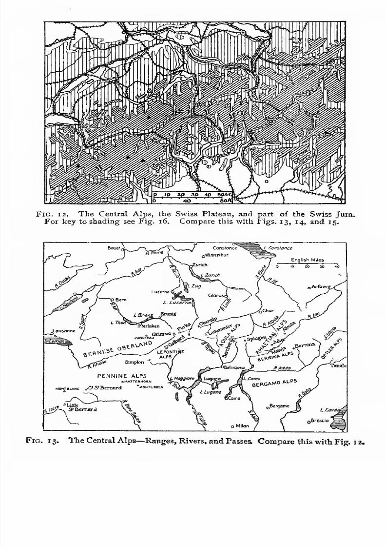
7/30/2019 The Senior Geography 1919
http://slidepdf.com/reader/full/the-senior-geography-1919 74/383
Fig. 12. The Central Alps, the Swiss Plateau, and part of the Swiss Jura.
For key to shading see Fig. 16. Compare this with Figs. 13, 14, and 15.
1 3. The Central Alps—Ranges, Rivers, and Passes, Compare this with Fig. 1 2.

7/30/2019 The Senior Geography 1919
http://slidepdf.com/reader/full/the-senior-geography-1919 75/383
NORTH OF THE MEDITERRANEAN 59
important at least since Roman times. The two great natural
routes are by the Rhone valley, from the Golfe du Lion in
the west, and by the Laibach plain, or Croatian Gate, from
Venetia to Hungary, in the east.
An understanding of the main features of the Alps is very
important, and a number of figures are inserted which should
be carefully studied.
?,w TSd,
KlausenPass
Oberalp.Pass
LukmanierPass
^M^^^^^^^^M.
„ SE.Rheinwaldhohe
I
S.BernardinoI Spli/gen
Metres000
20 30
Goschenen
1 1 1 1 1 1 1 1 1 1 rr
50 60Biases Bellinzona
FlG. 14. Section from north to south along the St. Gotthard Route. The white
line indicates the St. Gotthard tunnel. Cf. Figs. 12, 13, and 23.
The St. Gotthard Region. Figs. 12 and 13 show four
remarkable valleys opening from the St. Gotthard Alps to the
four points of the compass. The Rhine and Rhone flow in
opposite directions along a longitudinal furrow from west-south-
west to east-north-east. Both cut deep gorges north across the
mountains, the Rhine to Lake Constance, the Rhone to Lake
Geneva, south of which rises Mont Blanc, the highest mountain
of Europe (15,73° feet). Between these is the Swiss Plateau,
feet^o^letschhgr^Fjnsteraarhor^^^eMSS Metres000
Andermatt
Fig. 15. Section from west to east along the valleys of the Upper Rhone, Upper
Reuss, and Upper Rhine. Cf. Figs. 12 and 13.
bordered on the north-west by the Franco-Swiss Jura, across
the ends of which both rivers, after leaving the lakes, cut deep
valleys. The other two rivers flow north and south. The
Reuss, which rises in the same furrow as the Rhine and Rhone,
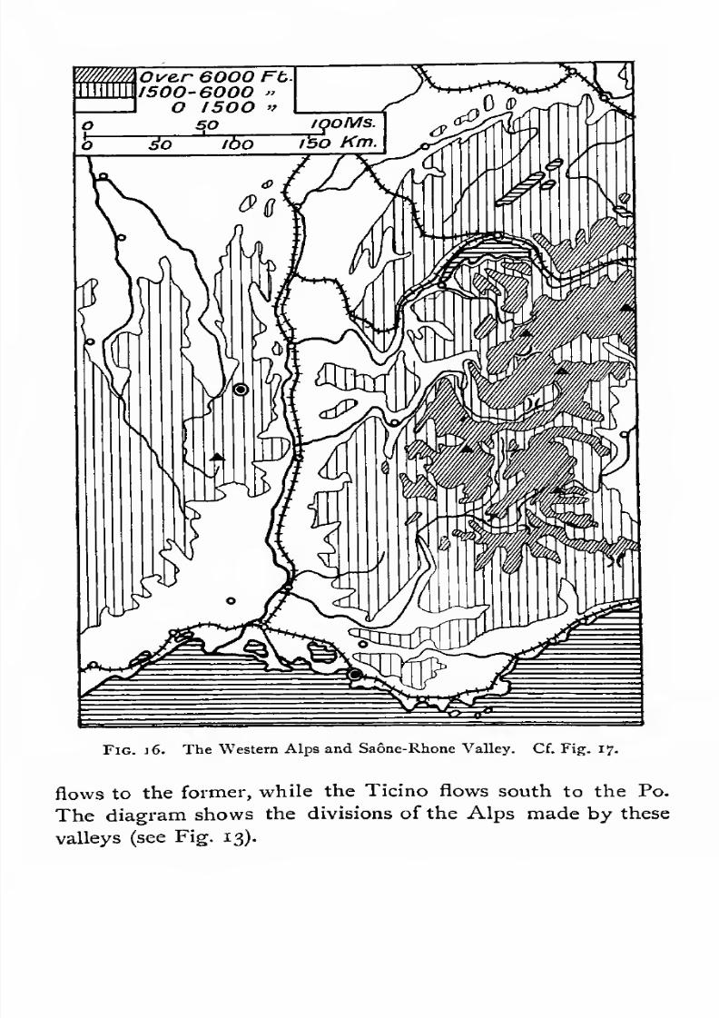
7/30/2019 The Senior Geography 1919
http://slidepdf.com/reader/full/the-senior-geography-1919 76/383
Fig. 16. The Western Alps and Saone-Rhone Valley. Cf. Fig. 17.
flows to the former, while the Ticino flows south to the Po.
The diagram shows the divisions of the Alps made by these
valleys (see Fig. 13).
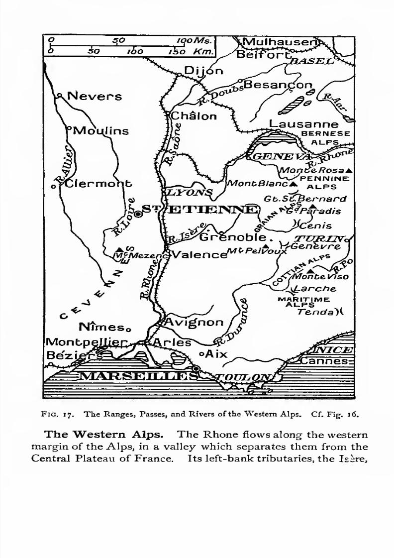
7/30/2019 The Senior Geography 1919
http://slidepdf.com/reader/full/the-senior-geography-1919 77/383
Fig. 17. The Ranges, Passes, and Rivers of the Western Alps. Cf. Fig. 16.
The Western Alps. The Rhone flows along the western
margin of the Alps, in a valley which separates them from the
Central Plateau of France. Its left-bank tributaries, the Isere,

7/30/2019 The Senior Geography 1919
http://slidepdf.com/reader/full/the-senior-geography-1919 78/383
62 THE MOUNTAIN BARRIER
which receives the Arc, and the Durance, which receives the
Ubaye, lead to relatively low passes communicating with the
Dora Baltea and Dora Riparia, left-bank tributaries of the
Po, and theStura, a right-bank tributary, all draining the
eastern slopes of the Western Alps. These valleys define
the principal mountain masses as shown in Fio-s. 16 17.
The Eastern Alps. East of the St. Gotthard the structure
is more complicated. The ranges become triple orquadruple.

7/30/2019 The Senior Geography 1919
http://slidepdf.com/reader/full/the-senior-geography-1919 79/383
NORTH OF THE MEDITERRANEAN 63
The first river to trace is the Inn. In its upper course it flows
north-east through the Engadine valley, between the Rhine
and Adda (Fig. 13). In its middle course it flows east-
north-east, crosses the northern range of the Alps in a
transverse valley, and flows north-east to the Danube. The
Danube receives many other tributaries, Iller, Lech, Isar, &c,
from the outer slopes of the Alps, all crossing the Swabian-
BavarianForeland, a continuation of the Swiss Plateau. South
7/30/2019 The Senior Geography 1919
http://slidepdf.com/reader/full/the-senior-geography-1919 80/383
64 THE MOUNTAIN BARRIER
of the middle Inn is the Adige valley (Ger. Etsch), leading to
the low Brenner pass, a very important route. The region
outlined by these valleys is shown in Figs. t8, 19.
East of the Brenner, notice the long line of the Tauern range,
with the Salzach and Enns valleys at the northern foot, and
the Drave at the southern. The two former pass in transverse
gorges across the Salzburg and Austrian Limestone Alps to
the Danube. The Drave runs east to the Danube, which it
joins in the Hungarian plain. In the east the Mur valley comes
between the Drave and the Enns, and the Save between the
Drave and the Venetian-Adriatic depression. The series of
parallel river valleys, running west and east, and their relation
to the mountains, is shown in Figs. 18, 19.
In the east the ranges sink beneath the Hungarian plain.
The Little Carpathians and the Bakony Forest link the
northern ranges of the Alps to the Carpathians, while the
Dinaric Alps continue the Southern Limestone Alps.
Alpine Passes. The western and central passes are
generally higher than the eastern. The most important are
followed by railway routes. East of the Brenner, where a
series of ranges are separated by valleys running east and
west, several passes must be crossed in the routes from north
to south.1
Alpine Railway Routes. The chief railway routes across
the Alps are :
(1) The Mont Cenis, by the Arc, with a tunnel under the
Col de Frejus, "i\ miles long, and 4,380 feet high, opening to
the Dora Riparia and Turin.
1 Alpine Passes and Routes. The principal passes of the Alps are best
remembered in connexion with their Italian terminus. Figs. 13, 17, and 19 should
be examined, and also the 01 ographical maps of Figs. 12, 16, and 1 8.
i. From Turin
(a) from the Po to the t Col dell' Altare (1,600) to Savona.
Mediterranean( Col di Tenda (6,150) to Ventimiglia.
' Col de Larche or d'Argentiere (6,545) by the Sturaand Ubaye valleys.
Mont Genevre (6,080) by the Dora Riparia andDurance.
(i) from the Po to the
Durance

7/30/2019 The Senior Geography 1919
http://slidepdf.com/reader/full/the-senior-geography-1919 81/383
NORTH OF THE MEDITERRANEAN 65
(a) The Simplon, from Lake Geneva, by the Rhone valley,
with a tunnel under the Simplon, z%% miles long and 2,260
feet high, to the Toce valley, Lago Maggiore, and Milan.
(3) The St. Gotthard, from Luzern by the Reuss valley,
with a tunnel below the St. Gotthard, 9^ miles long and 3,785
feet high, to the Ticino valley, Lakes Lugano and Como, and
Milan.
(4) The Brenner, from Munich to Innsbruck, and thence by
the Brenner pass down the Adige to Verona. No tunnel is
over half a mile long.
(5) The Semmering. The trend ofthe valleys of the Eastern
Alps makes communication between north and south difficult.
From Vienna the line goes by the Leitha valley, the Sem-
mering pass, the Mur and Graz, to the Drave, crosses a low
pass to the Save, follows that river to Laibach, and runs thence
to Trieste across the barren Karst. Another route from the
Mur crosses the Styrian Alps by the col at Neumarkt, andreaches Venice over the Col de Tarvis.
(6) The most important west-east route is from Zurich by
the Vorarlberg route, with a tunnel 6^ miles long and 4;3°°
feet high below the Arlberg pass, to the Inn and Innsbruck :
/ \ r .l t, , .v ! Mont Cenis (6,880) by the Dora Riparia and Arc.
(0 from the Po to theL
.
ule gt> Be-
rnard '(7,180) by the £ora Baltea andlsere
( Iserc.
(a) from the Po to the I Great St. Bernard (8,no) by the Dora Baltea to
Rhone ( Martigny.
2. From Milan
(a) from the Po lo I Simplon (6,Coo) by L. Maggiore and the Toce
the Rhone(
valley to Brieg.
St. Gotthard (6,935) hy the Ticino and Reuss valleys.
Lukmanier (6,290) by the Ticino and Vorder Khine.
Bernardino (6,765) by the Ticino and Hinter Rhine.
Spliigen (6,945) by the Adda valley and L. Como to
the Hinter Rhine.(c) from the Po to the I Maloja (5,940) ) by the Adda and L. Como lo the
Danube ( Bemina (7,640) jInn.*
3. From Venice to the Danube
(a) Reschenscheidegg (4,890) by the Adige to the Inn and thence by the Arl-
berg pass from the Inn to the Rhine.
(*) Brenner (4,500) by Verona and the Adige, Eisach and Inn valleys.
(c) Tarvis from the Tagliamento to the Drave.
* The Julier pass (7,500) from the upper Inn to the Rhine has been long used
in connexion with the Maloja.
sen. geog. '
(£) from the Po to the
Rhine
7/30/2019 The Senior Geography 1919
http://slidepdf.com/reader/full/the-senior-geography-1919 82/383
66 THE MOUNTAIN BARRIER
then by the Salzach and Enns, over the Schober pass to the
Mur, and over the Semmering pass to Vienna.
The influence of these routes has always been very great.
The number of routes connecting the Po and the Rhone madethe Romanization of Southern France easy. In more recent
times both slopes have been alternately French and Italian.
Milan, the terminus of routes by the Rhone, Rhine, and
Danube, has had many masters. The route to the Danube
used during the Austrian occupation was by the Adda valley
and the Stelvio pass to the Adige, and thence by the Brenner
or the Pusterthal to the Drave. The great trade routes of
the Middle Ages went by the Brenner and Seefeld passes to
the Isar, Lech, and Iller for Munich, Augsburg and Ulm,or
down the Inn for Munich and Regensburg (Ratisbon). The
Rhine traffic left the Danube at Ulm, following easy routes
to the Neckar and Rhine. The Danube traffic went down
stream by Regensburg to Vienna.Climate of the Alps. The higher the elevation the thinner
is the atmosphere. When we climb a high mountain we can
feel the effect of this. As less of the Sun's heat is lost in
passing through it, the rays have a greater heating power.
On the other hand, more heat is lost by radiation during the
night, for the atmospheric envelope retards radiation.
Mountain valleys have great daily variations of temperature.
The climate of the northern and southern slopes differs. Trfe
northern slopes receive less sunshine in the northern hemi-
sphere and more in the southern. On the northern slopes of
the Alps evergreen forests creep far down the valleys. At the
same elevation, on the southern slopes, the trees are deciduous,
and cereals can be grown.Air is heated by contact with the earth. Its temperature
diminishes with altitude. This is better seen by ascending a
solitary mountain than on a high plateau, because in the
latter case a larger surface of air is in contact with the earth.
In the northern hemisphere the diminution in temperature is
most marked in the early summer months, when the Sun's
7/30/2019 The Senior Geography 1919
http://slidepdf.com/reader/full/the-senior-geography-1919 83/383
NORTH OF THE MEDITERRANEAN 67
heat is absorbed in melting the snow rather than in warming
the surface of the Earth. The difference is least marked in
December, when the snow-line is lower, cooling the lower
levels.
Mountains are generally rainier than lowlands (see Pre-
liminary Geography\ pp. 57, 58). Up to a certain height rainfall
increases uniformly with elevation, but above that it diminishes
as the moisture in the air becomes exhausted. In the Alps,
the maximum rainfall is at about 6,500 feet. The snow-line
depends partly on rainfall, and partly on summer temperature.
It is lower on the northern than on the southern slope. In
the Tauern it is 8,500 feet on the northern and 9,250 feet on
the southern slope. On the wetter ranges to the west it is
much lower. It is lowest in the Alps in January, and highest
early in August.
TheFoehn. The foehn wind affects the climate of many
valleys. It blows strongly in the valleys opening north, and
is less felt in those opening south, east, and west. When the
barometer is low north of the Alps, air is drawn in, rain falls on
the southern slopes, and heat is set free. As the indrawn air
descends on the leeward side into regions where the atmospheric
envelope is thicker, it contracts and becomes more heated. It
can thus hold more moisture as vapour, and blows as a hot
dry foehn wind, which was long thought to come from the
Sahara. In a few hours the foehn does the work of days
of sunshine, and snow rapidly disappears. In some Alpine
valleys the early sowings depend entirely on the foehn. In
others it is counted on in autumn to ripen the grapes.
Glaciers andGlaciated Valleys. Above the snow-line
the steep ridges and slopes are often bare of snow, which
accumulates in the hollows. This snow, or ne've', gradually
changes by its pressure and by condensation and freezing
at its surface into grains of ice. The most important snow-
fields in the Alps are those of the Bernese Oberland, the
Pennine Alps 'and Mont Blanc. From these, great glaciers,
or ice rivers, crawl slowly the valleys. largest
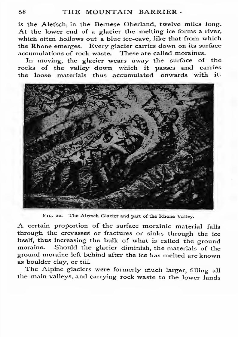
7/30/2019 The Senior Geography 1919
http://slidepdf.com/reader/full/the-senior-geography-1919 84/383
68 THE MOUNTAIN BARRIER
is the Alefsch, in the Bernese Oberland, twelve miles long.
At the lower end of a glacier the melting ice forms a river,
which often hollows out a blue ice-cave, like that from which
the Rhone emerges. Every glacier carries down on its surface
accumulations of rock waste. These are called moraines.
In moving, the glacier wears away the surface of the
rocks of the valley down which it passes and carries
the loose materials thus accumulated onwards with it.
Fig. 20. The Aletsch Glacier and part of the Rhone Valley.
A certain proportion of the surface morainic material falls
through the crevasses or fractures or sinks through the ice
itself, thus increasing the bulk of what is called the ground
moraine. Should the glacier diminish, the materials of the
ground moraine left behind after the ice has melted are known
as boulder clay, or till.
The Alpine glaciers were formerly much larger, filling all
the main valleys, and carrying rock waste to the lower lands
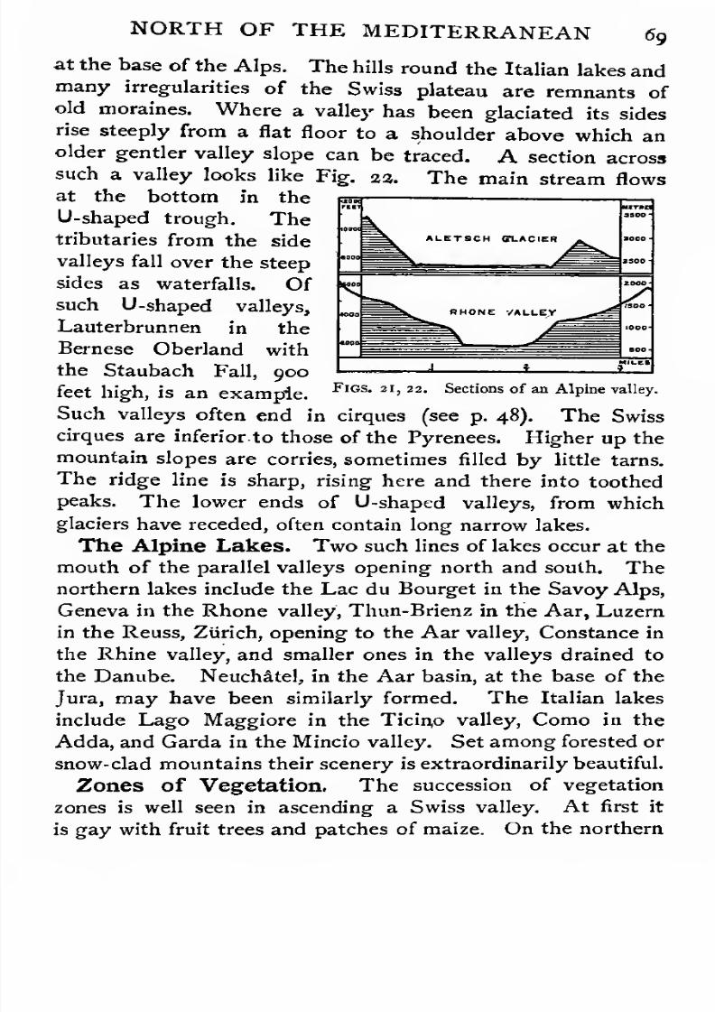
7/30/2019 The Senior Geography 1919
http://slidepdf.com/reader/full/the-senior-geography-1919 85/383
riir
7/30/2019 The Senior Geography 1919
http://slidepdf.com/reader/full/the-senior-geography-1919 86/383
70 THE MOUNTATN~KZVK.JR.mK
slopes maize and vines disappear about 2,ooo feet, cereals and
deciduous trees about 4,000 feet. Evergreen firs and pines
succeed, between 4,000 and 6,000 feet, with rich meadows
still higher, to which cattle are driven in summer. Above
7,500 feet isolated stunted trees are no longer seen, and
between 8,000 and 9,000 feet the vegetation recalls that of the
tundra. Above 9,000 feet is perpetual snow. All these zones
climb a little higher on the southern slopes.
Historical Summary. Three powers struggled in the
Middle Ages for the control of the Western Alps: (1) Savoy,
controlling the Mont Cenis route; (2) the Forest Cantons,
controlling the St. Gotthard route, and (3) the Habsburgs
in the Aar. The geographical superiority of the St. Gotthard
enabled the Swiss Cantons to expand by alliance or conquest
along all the routes opening from it. Savoy was pushed to the
plains of the Po, where it became an Italian power, and the
Habsburgs to the Danube, where the power of Austria
developed.
Switzerland. Switzerland consists of the Central Alps in
the south and of the Swiss plateau and Jura to the north
(see Figs, 13 and 13).
Economic Conditions. Alpine Switzerland subsists by
agriculture in the lower valleys, and cattle keeping in the
higher valleys. Of the dairy industries that of condensing
milk is most important. Villages are not found above
4,500 feet, but herdsmen's huts and hotels, both occupied
only in summer, are built almost up to the snow-line. Woodis used for building, for fuel, and for making fancy articles
in demand among tourists. Millions of persons visit the Alps
annually and give employment to thousands of persons in
varied capacities.
The plateau is an agricultural and manufacturing region.
It possesses abundant and cheap water power in the rivers,
a central position for obtaining raw materials, and intelligent
and skilful labour. Silk is manufactured at Basel and Zurich,
which procure raw silk from the Italian valleys by the
7/30/2019 The Senior Geography 1919
http://slidepdf.com/reader/full/the-senior-geography-1919 87/383

7/30/2019 The Senior Geography 1919
http://slidepdf.com/reader/full/the-senior-geography-1919 88/383
73 THE MOUNTAIN BARRIER
the Transylvanian Alps sink steeply on the south. On the
north they are connected with the Bihar Mountains.
The Danube. Though the waters it carries are chiefly
derived from Alpine snows the main stream of the Danube
is not of Alpine origin. It rises in the Schwarz Wald, or
Black Forest, which belongs to the Central European High-
lands. The west to east trend of its tributaries, of which
only the Inn comes from the Swiss Alps, has already been
noticed, and this is on the whole the direction of the main
stream. Its upper course separates the Alps from the Central
European Highlands, which approach the Alps closely in the
mountains of Bohemia. Here the river flows through the
Austrian Gate, a magnificent gorge opening to the plain of
Vienna, the key of the Danube. It leaves this plain by the
gorge of the Carpathian Gate, between the Alps and the
Little Carpathians, with Pressburg at its eastern end. The
river divides into three main streams across the upper or Little
Hungarian Plain, and flows through the Hungarian Gate
between the Bakony Forest, with the shallow lake Balaton
at its base, and the Hungarian Ore Mountains. Emerging
from the upper plain it turns abruptly south across the Great
Hungarian Plain. Budapest, the capital of Hungary, on spurs
commanding the entrance to this plain, is the key of the
middle Danube, and the converging point of many railways
and river routes (see Fig. 24). The river now winds across
a wide flood plain, till driven east by the coming in of the
Drave. It turns south where the Tisza {Germ. Theiss) enters
from the north from the Eastern Carpathians, rising near the
Magyar Gate. After receiving the Save from the Dinaric
Alps the river again trends east. The Hungarian bank is low
and liable to flood, while the opposite Serbian bank is high.
The same contrast between the north and south banks is seen
in the lower Danube, after it emerges from its last gorge, the
klisura, by which it breaks through the Carpathians. Atthe end of the klisura, below the rapids of the Iron Gate, now
rendered navigable, it enters the Valakhian plain, which forms

7/30/2019 The Senior Geography 1919
http://slidepdf.com/reader/full/the-senior-geography-1919 89/383
NORTH OF THE MEDITERRANEAN 73
part of the kingdom of Rumania. A small tributary leads
by the Teregova pass to the Iron Gate, and is the easiest
route from the Hungarian to the Valakhian plain. Flowing
east between this low and often swampy plain on the north,and the edge of the Balkan foreland, which forms its high
south bank, the Danube enters the Black Sea by a vast swampy
delta. (For the whole paragraph see Figs. 18, 24, 35.)
Austria-Hungary. With the exception of Bohemia,
Austria-Hungary belongs to the Alpine- Carpathian system.
The Alpine provinces, Tirol in the Inn and Adige valleysj
Salzburg round the Salzach, Styria in the Mur, Carinthia in
the Drave and Carniola in the Save basins, together with
the archduchies of Upper and Lower Austria, represent the
heritage of the reigning Habsburg house. The Dinaric lands
are Dalmatia, Bosnia-Herzegovina, and Croatia, the latter
Hungarian. The Carpathian lands are Moravia, Silesia,
Galicia and Bukovina on the northern foreland, and Hungary.The Alpine Provinces. The Alpine provinces resemble
Switzerland. The mountains, though less high, often rise
above the snow-line. The finest glacier scenery is round the
Gross Glockner, in Carinthia ; the finest rock scenery is in the
Dolomites. In the Etsch and other valleys opening south,
with warm winters, the vine and mulberry are cultivated. The
eastern valleys have severe winters, and produce cereals. The
valleys opening north have milder winters, but are too cold for
the vine, which is cultivated on the Alpine foreland, especially
in Styria. The provinces of the foreland, Upper and Lower
Austria, Eastern Styria and Carniola, are richer and more
populous than the mountain provinces of Tirol, Salzburg, and
Carinthia, where agriculture is possible only in the valleys. In
the higher pastures dairying is important in summer. The
fine scenery of many parts makes the tourist industry profitable
in summer. Minerals are fairly important. Salt is widely dis-
tributed, especially in the Salzkammergut ; iron is abundant in
Styria, especially round Eisenerz, and Carinthia; lead is found
at Bleiberg in Carinthia, and in Carniola, and lignite in Upper

7/30/2019 The Senior Geography 1919
http://slidepdf.com/reader/full/the-senior-geography-1919 90/383
74 THE MOUNTAIN BARRIER
Austria and Styria. Mercury is mined at Idria in Carniola.
Locally produced silk is manufactured in southern Tirol, round
Trent. Manufactures are also developing in the Vorarlberg
region, near the Swiss frontier (see Figs. 18 and 19).
The Alpine towns are connected with the chief routes.
Innsbruck, in the Inn valley, the capital of Tirol, commands
routes north and east by the Inn, west by the Arlberg pass,
and south by the Brenner. Trent is on the latter route.
Roads, Railways
5 MILES
Tunnels *" "^ „.»""
Fig. 23. St. Gotthard road and railway. Loop tunnels approaching o-reat
tunnel from north and south.
Salzburg, built where the Salzach enters the foreland, is the
centre for the beautiful scenery of the Salzkammero-ut.
Passau, at the confluence of the Inn and Danube, is the meet-ing place of routes converging on the Danube above its gorge.
Linz commands the entrance to the Austrian Gate. Vienna,
the capital of Austria, at the exit, commands routes by(1) the Austrian Gate to (a) Ulm, the Rhine, and SouthGermany, {b) by Regensburg and also by (c) Prag to
North Germany; (2) by the Moravian Gate (see Fig. 35) to
7/30/2019 The Senior Geography 1919
http://slidepdf.com/reader/full/the-senior-geography-1919 91/383
NORTH OF THE MEDITERRANEAN 75
the Oder, Baltic, and Petrograd; (3) by the Carpathian
Gate to Hungary, the Black Sea and Constantinople; and
(4) by the Semmering pass to the head of the Adriatic and
the eastern basin of the Mediterranean. It is thus one of the
keys of Europe, as well as a magnificent city, with great
manufacturing and trading interests. On the Semmering
route is Graz, the capital of Styria, where the Mur leaves the
mountains ; Laibach, the capital of Carniola, in the widest
part of the upper Save basin; and Trieste, the Adriatic ter-
minus and port. The only other important town of the Alps
is Klagenfurt, the capital of Carinthia, on a tributary of the
Drave, another important route centre.
The Dinaric Lands. The Adriatic coast has some good
harbours, but access to the interior is difficult. Much of the
region is of the karst type (see p. 32). Mulberries and
olives are cultivated in the coastal valleys, which belong to the
Mediterranean region. Fisheries are important in the Adriatic.
Much of the interior is only fitted for keeping animals. The
commerce of Trieste, the chief town and port, suffers from the
lack of good railway communication with Hungary.
Hungary. Hungary consists of the Danube plain from
the Carpathian Gate to the Iron Gate, and of the mountains
surrounding it. In the north the Tatra and Hungarian Ore
Mountains reach the Danube, where they meet the BakonyForest, an outlier of the Alps, dividing the plain of Hungary
into two unequal parts (see p. ffl).In the south the Transyl-
vanian Alps form the northern wall of the klisura. From the
Transylvanian Alps the Bihar Mountains project north, forming
the mountain province of Transylvania. In these mountain
areas forestry and mining and the pasturing of animals are the
occupations, and towns are few. Koloszvar (Germ. Klausen-
burg), the capital of Transylvania, is reached from Budapest by
a line which follows the parallel upper valleys of tributaries of
the Danube to Brasso (Germ. Kronstadt), whence it is carried
across the Transylvanian Alps into the Valakhian plain.
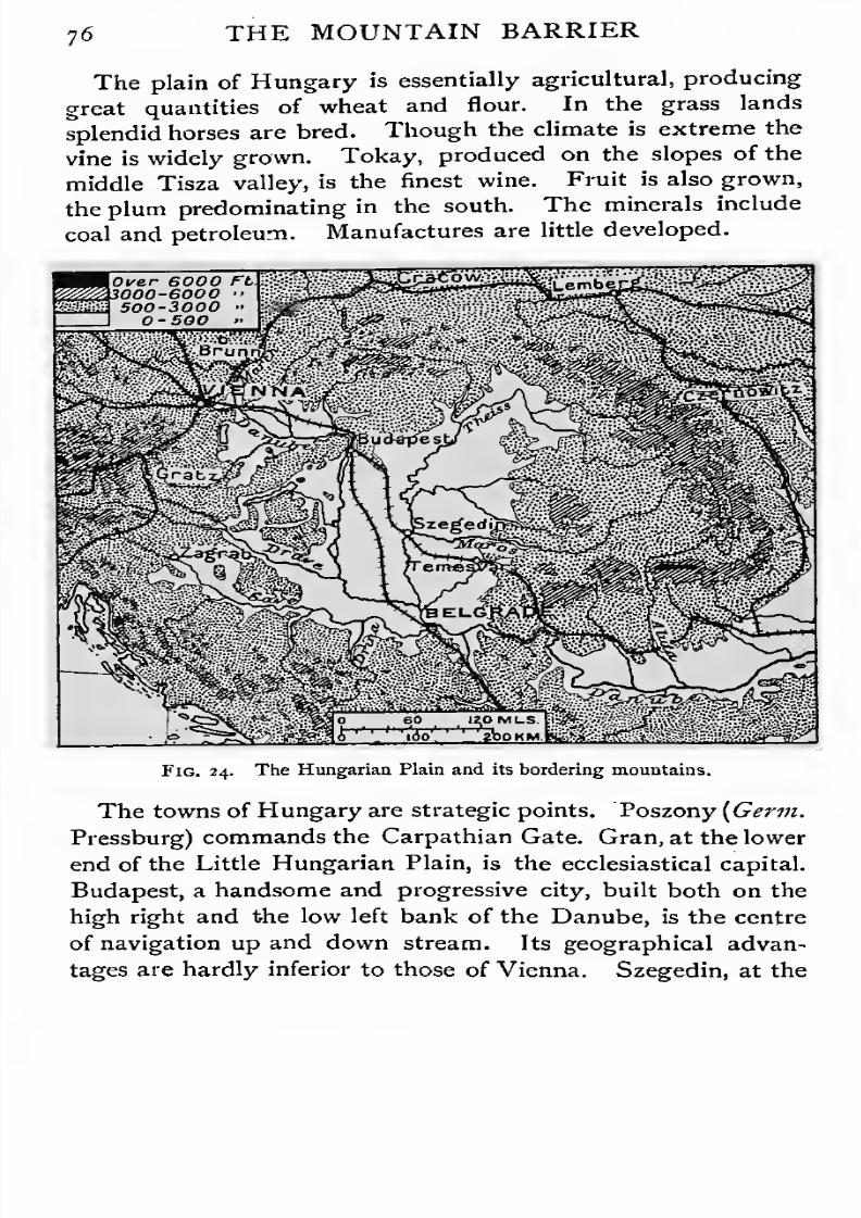
7/30/2019 The Senior Geography 1919
http://slidepdf.com/reader/full/the-senior-geography-1919 92/383
7 6 THE MOUNTAIN BARRIER
The plain of Hungary is essentially agricultural, producing
great quantities of wheat and flour. In the grass lands
splendid horses are bred. Though the climate is extreme the
vine is widely grown. Tokay, produced on the slopes of the
middle Tisza valley, is the finest wine. Fruit is also grown,
the plum predominating in the south. The minerals include
coal and petroleum. Manufactures are little developed.
Fig. 24. The Hungarian Plain and its bordering mountains.
The towns of Hungary are strategic points. Poszony [Germ.
Pressburg) commands the Carpathian Gate. Gran, at the lower
end of the Little Hungarian Plain, is the ecclesiastical capital.
Budapest, a handsome and progressive city, built both on the
high right and the low left bank of the Danube, is the centre
of navigation up and down stream. Its geographical advan-
tages are hardly inferior to those of Vienna. Szegedin, at the

7/30/2019 The Senior Geography 1919
http://slidepdf.com/reader/full/the-senior-geography-1919 93/383
7/30/2019 The Senior Geography 1919
http://slidepdf.com/reader/full/the-senior-geography-1919 94/383
7/30/2019 The Senior Geography 1919
http://slidepdf.com/reader/full/the-senior-geography-1919 95/383
CENTRAL AND NORTH-WEST EUROPE.Highlands and Lowlands. From the south-west of
Ireland two belts of higher ground diverge—one to the south-
east and east across Southern Great Britain and Central Europe,
forming the Central European Highlands, the other to the
north-east across Northern Great Britain and Scandinavia,
forming the North-western Highlands. Between them a region
of low heights, plains, and seas forms the Central Lowlands.
Both lines of highlands are twice interrupted by sea. The
first is broken by St. George's Channel, separating the
highlands of South Ireland from those of South Wales and
Southern England, and by the English Channel, separating
the latter from the highlands of Britanny. The North-
western Highlands are broken by the Irish Sea, separating
the Irish Highlands from the Northern and Central Highlands
of Great Britain, and by the North Sea, separating the Scottish
from the Scandinavian Highlands. The Central Lowlands
are broken by the North Sea, which cuts off the English
from the continental lowlands.
Central European Highlands. The continental Central
European Lowlands are further broken into djstinct masses,
joined by scarplands or separated by plains. The Britanny
peninsula sinks in the south-east to the Gate of Poitou, beyond
which rises the Central Plateau of France, drained by the
Loire and the Dordogne. Scarplands lie between this plateau
and the Channel, and between Britanny and the Ardennes and
Vosges. These Northern French Scarplands are drained by
the Seine and its tributaries. South-west of the Central
Plateau are the plains of Aquitaine, drained by the Garonne,
and leading by the Gate of Carcassonne to the Mediterranean.
East of the Central Plateau the Sadne-Rhone valley opens
routes at the western foot of the Alps from the Golfe du Lion

7/30/2019 The Senior Geography 1919
http://slidepdf.com/reader/full/the-senior-geography-1919 96/383
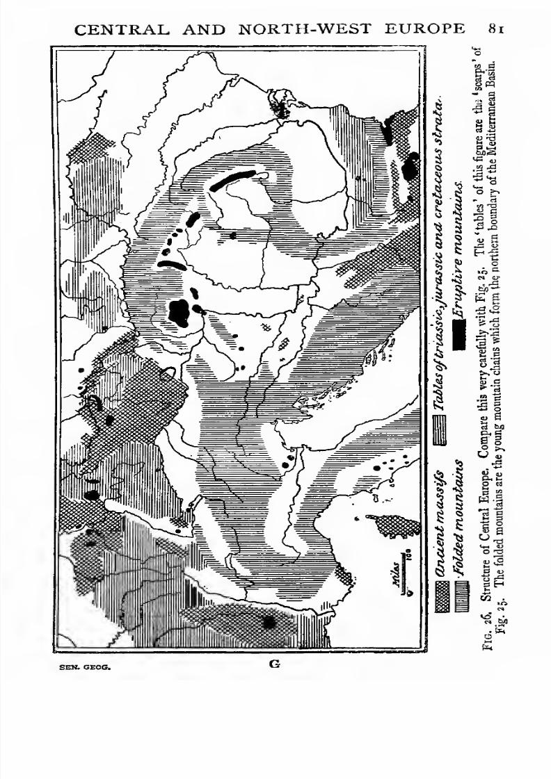
7/30/2019 The Senior Geography 1919
http://slidepdf.com/reader/full/the-senior-geography-1919 97/383
CENTRAL AND NORTH-WEST EUROPE 81

7/30/2019 The Senior Geography 1919
http://slidepdf.com/reader/full/the-senior-geography-1919 98/383
8a CENTRAL AND NORTH-WEST EUROPE
to (a) the North French Scarpland, or {b) between the Jura
and Vosges by the Burgundian Gate or the Gate of Belfort to
the Rhine Rift. This Rhine Rift is a long, flat, sunken area,
covered with fertile alluvium, between the Vosges on the west
and the Black Forest on the east. This the Rhine enters
from Switzerland round the eastern end of the Swiss Jura.
It leaves it by a narrow gorge cut through the Lower
Rhine Highlands, an eastern continuation of the Ardennes.
This steep-sided eroded gorge is very different from the wide
flat-floored valley of the Middle Rhine.
Corresponding to the French Scarps west of the Vosges are
the Franconian Scarps east ofthe Black Forest (Schwarz Wald).
These are drained by the Main, flowing from the Bohemian
Mountains, which form a diamond-shaped frame round the
Bohemian depression. In the south the Bohemian plain gives
place to highlands, higher in the Bohemian Forest (Bohmer
Wald) on the south-west, and lower in the Moravian Uplands
to the south-east, which are easily crossed to the Vienna Basin.
In the north the Erz Gebirge rise to the north-west and the
Sudetes to the north-east, the latter almost abutting against
the Carpathians at the Moravian"Gate. East of the Sudetes
the Oder flows in the Silesian plain, beyond which rise the
Polish Heights, drained to the Vistula at their eastern base.
Bohemia is almost entirely in the Elbe basin. The main
stream rises in the Sudetes, and receives the Moldau from
the south and the Eger from the west before it breaks through
the tabular hills of Saxon Switzerland to the plain. The
direction of the Sudetes can be traced in the Harz and Weser
Mountains, and that of the Bohemian Forest in the Thuringian
(Thuringer Wald) and Teutoburger Forests,the two converg-
ing in the north-west. The Saale drains the Saxon hills and
plains to the Elbe between the Erz and Harz. The Fulda
and Werra rise south of the Thuringian Forest and unite
north of it to form the Weser, which breaks through the
Weser Heights, forming the Westphalian Gate.
Notice the importance of the Fichtel Gebirge, the meeting-

7/30/2019 The Senior Geography 1919
http://slidepdf.com/reader/full/the-senior-geography-1919 99/383
CENTRAL AND NORTH-WEST EUROPE 83
place of the Erz, Bohemian Forest, Thuringian Forest, and
Franconian Scarps. Four rivers flow from it, the Naab, south
to the Danube, the Eger east and the Saale north to the
Elbe, and the Main west to the Rhine. It is thus a meeting-
place of important routes between west and east and between
north and south.
Pay special attention to the various lowlands and the gates
between them. At three points the Central Highlands
approach the mountains to the south, and the narrow passages
at these places have always been important. The Burgundian
Gate lies between the Vosges and the Swiss Jura, and leads
from the Saone-Rhone and Seine basins to the Middle Rhine
Plain and the Northern Alpine Foreland. The Austrian Gate is
the passage from this Alpine Foreland between the Bohemian
Forest and the Alps to the Vienna Basin, out of which the
Moravian Gate leads, between the Sudetes and the Carpa-
thians to the plains of Eastern Europe.
These highlands are formed of rounded heights separated by
valleys which form routes to the interior. The higher slopes
are covered with dark pine woods and the lower slopes with
deciduous forests. The valley floors are rich meadow or
cultivated land.
The Central Lowlands are not a continuous plain. The
west of the continental portion is low and marshy. 'Round the
Rhine and the Ems and Weser it is often beneath the level of
the sea, which is kept out by dykes. The Liineburg Heath
(Ltineburger Heide) comes between the Weser and the Elbe,
east of which the Central German Lowland, with valley-lines
converging on the Elbe and diverging to the east, must be dis-
tinguished from the Baltic Heights. The Baltic Heights are
a morainic, lake-studded, pine-covered region, drained to
south and north by the tributaries of the Trave, Oder,Vistula,
Niemen, and Western Dvina, which break them into different
masses.
The Northern Seas. Jutland and the islands of the
separate the two shallow basins of the North Sea and
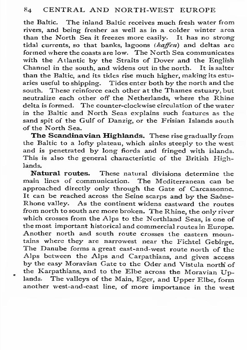
7/30/2019 The Senior Geography 1919
http://slidepdf.com/reader/full/the-senior-geography-1919 100/383
84 CENTRAL AND NORTH-WEST EUROPE
the Baltic. The inland Baltic receives much fresh water from
rivers, and being fresher as well as in a colder winter area
than the North Sea it freezes more easily. It has no strong
tidal currents, so that banks, lagoons (haffen) and deltas are
formed where the coasts are low. The North Sea communicates
with the Atlantic by the Straits of Dover and the English
Channel in the south, and widens out in the north. It is salter
than the Baltic, and its tides rise much higher, making its estu-
aries useful to shipping. Tides enter both by the north and the
south. These reinforce each other at the Thames estuary, but
neutralize each other off the Netherlands, where the Rhine
delta is formed. The counter-clockwise circulation of the water
in the Baltic and North Seas explains such features as the
sand spit of the Gulf of Danzig, or the Frisian Islands south
of the North Sea.
The Scandinavian Highlands. These rise gradually from
the Baltic to a lofty plateau, which sinks steeply to the west
and is penetrated by long fiords and fringed with islands.
This is also the general characteristic of the British High-
lands.
Natural routes. These natural divisions determine the
main lines of communication. The Mediterranean can be
approached directly only through the Gate of Carcassonne.
It can be reached across the Seine scarps and by the Sa6ne-
Rhone valley. As the continent widens eastward the routes
from north to south are more broken. The Rhine, the only river
which crosses from the Alps to the Northland Seas, is one of
the most important historical and commercial routes in Europe.
Another north and south route crosses the eastern moun-
tains where they are narrowestnear the Fichtel Gebirge.
The Danube forms a great east-and-west route north of the
Alps between the Alps and Carpathians, and gives access
by the easy Moravian Gate to the Oder and Vistula north' of
the Karpathians, and to the Elbe across the Moravian Up-lands. The valleys of the Main, Eger, and Upper Elbe, form
another west-and-east line, of more importance in the west
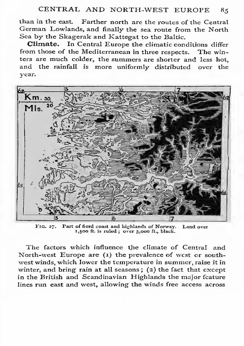
7/30/2019 The Senior Geography 1919
http://slidepdf.com/reader/full/the-senior-geography-1919 101/383
CENTRAL AND NORTH-WEST EUROPE 85
than in the east. Farther north are the routes of the Central
German Lowlands, and finally the sea route from the North
Sea by the Skagerak and Kattegat to the Baltic.
Climate. In Central Europe the climatic conditions differ
from those of the Mediterranean in three respects. The win-
ters are much colder, the summers are shorter and less hot,
and the rainfall is more uniformly distributed over the
year.
Fig. 27. Part of fiord coast and highlands of Norway. Land over
1,500 ft. is ruled ; over 3,000 ft., black.
The factors which influence the climate of Central and
North-west Europe are (i) the prevalence of west or south-
west winds, which lower the temperature in summer, raise it in
winter, and bring rain at all seasons; (2) the fact that except
in the British and Scandinavian Highlands the major feature
lines run east and west, allowing the winds free access across
7/30/2019 The Senior Geography 1919
http://slidepdf.com/reader/full/the-senior-geography-1919 102/383
86 CENTRAL AND NORTH-WEST EUROPE
the continent ; and (3) the presence of inland seas, which
reinforce these effects.
It is a fundamental fact in geography that oceans
and seas render the climate of surrounding countries equable.
In Central and North-western Europe the prevailing winds
come over the Atlantic Ocean, and reach Europe as cooling
winds in summer, and as warming winds in winter. The
isotherms for January over this region run almost north and
south, so that the temperature at London is the same as at
Lyon in the Rhone valley. Only in the east of the Scandina-
vian peninsula do they tend to run east and west.Else-
where, if we leave elevation out of consideration, the cold
increases almost uniformly with distance from the Atlantic;so
that the January isotherms are nearly parallel.
The isotherm of 32° F., that is freezing point, runs in January
south of Iceland to the Scandinavian coast, parallel to that
coast and Jutland, and across Central Europe, continuing
parallel to the line of the Dalmatian coast, the course of the
Danube, and the northern coast of the Black Sea. West of
this line, though frosts occur, they are rarely of long duration.
The summer isotherms, on the other hand, run roughly
parallel in an easterly and westerly direction, so that the
summer heat varies approximately with latitude, though also
to some degree with distance from the sea. The gradual rise
of the land towards the south tends to neutralize the influence
of latitude so that the differences of temperature are not so
great as the ordinary map (which shows isotherms reduced to
sea-level) appears to indicate.
Combining these results it follows that the climate of
North-western and Central Europe is on the whole equable.
In the north the winters are cold and the summers cool, but
over the greater part the winters are cool and the summers
warm.
The causes which make the climate uniform make the rain-
fall uniform. Except in Great Britain and Scandinavia, no
coastal highlands running north and south wring out the
7/30/2019 The Senior Geography 1919
http://slidepdf.com/reader/full/the-senior-geography-1919 103/383
CENTRAL AND NORTH-WEST EUROPE 87
moisture from the Atlantic winds. There is a considerable
difference between the rainfall of the west and east coasts of
Great Britain, but the area of that island is small and the seas
beyond are fairly wide, so that on reaching the continent the
winds still contain a considerable amount of moisture. In the
Scandinavian peninsula the land area is greater, the highlands
more extensive, and the seas to the east smaller. There is
a marked difference between the rainfall of Norway and
Sweden, and the rainfall of Finland is also reduced. There is
everywhere a perceptible diminution of rainfall from west to
east, but no part in which the rainfall is actually deficient.
Vegetation. Most of Central and North-western Europe
belongs to the West European region (see p. 3). In the
extreme north it passes into the tundra (see p. 1), thinly
peopled in summer by wandering Lapp herdsmen. The north
is the region of coniferous woods ; the south, of deciduous
woods in the lowlands and coniferous woods in the highlands.
Different trees characterize different landscapes. In England
the oak and elm predominate, in France the poplar, in
Germany the beech and the broad-leaved plane. In South
Germany the acacia is a common woodland tree.
The lowlands of Central Europe are cultivated wherever the
soil is sufficiently good. The moister west is the wheat-
growing area, while in the east, where the rainfall is scantiei
and the soil frequently of poorer quality, rye is the chief
cereal and the sugar beet an important crop. Hemp and
flax are largely grown round the Baltic. Fruits are every-
where important. The apple, which needs autumn rains to
swell the fruit, is the commonest orchard tree in England and
Northern France. Farther east it is replaced by the cherry
and other stone fruits. The vine is cultivated on the sunny
slopes of the hills as far north as the middle Rhine and middle
Seine valleys.
Minerals. The tin and lead mines of Britain and the amber
of the Eastern Baltic early led to trade between the Mediter-
ranean and Northern Europe. In Roman times gold, silver,

7/30/2019 The Senior Geography 1919
http://slidepdf.com/reader/full/the-senior-geography-1919 104/383
CENTRAL AND NORTH-WEST EUROPE
lead, and iron were obtained from Britain. When charcoal
was the only fuel, iron was smelted in forested districts,
as in the Weald. Charcoal is still used for smelting in
the forests of Sweden and Russia, producing a fine quality
of iron. The use of coal transferred the iron manufacture to the
coalfields, many of which are near ironfields. Coal is found
both in the North-western and the Central Highlands of
Europe. In the former it occurs in small fields in Central
S*t Co'UOientuZAii • CIA Coal Busuis. *&/ Zones o/LiUoraL OjuI Uo-jC^lj.
Fig. 28. The Coalfields of Central and Western Europe. The dotted belts
show the areas where coal was formed in a littoral area and the parallel lines
indicate where coal was formed in a continental area.
Scotland, and on the flanks of the Pennine and Welsh moun-
tains in Great Britain. In the Central Highlands it is found
along the northern margin in South Wales, France, and
Belgium, Westphalia, Saxony, Silesia, and Poland. In smaller
quantities it occurs in the heart of the highlands round the
Central Plateau of France and in the Saar Basin. Brown
coal, or lignite, is mined and used both in Germany and
Austria. The map of Fig. 28 shows approximately the

7/30/2019 The Senior Geography 1919
http://slidepdf.com/reader/full/the-senior-geography-1919 105/383
CENTRAL AND NORTH-WEST EUROPE 89
continental and littoral areas during the formation of the older
coal-beds.
Iron is found on the British, Franco-Belgian, Bohemian, and
Silesian coalfields. The chief iron centres are in Central and
Northern Sweden, round the margin of the Central Plateau
of France, and in Lorraine. Much of the ore smelted in
Britain and Central Europe comes from Spain. Zinc is found
in Silesia and the Rhine Provinces and in Belgium. A little is
found in Wales and Cumberland. Salt is found where old
$i& L/gnife Sasi'n-s
X //-on Ore
® Co/Cf C Z/nc€> $r/rer
t
o Ceao'O Qt//'c/rs/'/rer o Copper
oSa/rfrPotaJSicSa"'
Fig. 29. The Minerals of Central Europe.
desert-formed rocks have been preserved in the triassic strata
of England and Germany. Building stones and brick-clay
are found in most parts of Europe. See Fig. 29.
Economic Conditions. Most of this region is in an ad-
vanced stage of development. The forests have been ex-
tensively cleared, but forest industries are still important in
Scandinavia and the Central European Highlands. In all
highland regions the keeping of animals is more important

7/30/2019 The Senior Geography 1919
http://slidepdf.com/reader/full/the-senior-geography-1919 106/383
90 CENTRAL AND NORTH-WEST iiUKurt
than agriculture. In the valleys the woollen manufacture
often develops, as in Yorkshire or Saxony. Another industry
of the highlands is mining. In the lowlands agriculture is the
staple occupation outside the towns, which are the manu-
facturing and market centres. The most densely peopled
regions are the manufacturing towns situated on coalfields
(Lancashire, Belgium) and the ports. The river ports of the
Rhine are hardly inferior to seaports in importance.
FRANCE.
France. Franceis sea-girt
onthree sides
—(i)
bythe
Channel and the North Sea on the north, (2) by the Atlantic
on the west, (3) by the Mediterranean on the south-east. On
three sides it is land girt—(1) by the Pyrenees in the south, (2)
by the Alps on the south-east, and (3) by the Vosges and
Ardennes in the north-east.
The Lowlands of France. From the Central Plateau,
the core of France, lowlands open to each of the three seas.
In the south the lowlands of Languedoc and Provence open
between the Central Plateau and the Alps to the Mediter-
ranean. A route leads between the Plateau and the Pyrenees
by the Gate of Carcassonne to the western lowland ofAquitaine,
which opens to the Atlantic between the Pyrenees and a line
of high ground running from the Central Plateau to the
Britanny Highlands. Across this higher ground a route by
the Gate of Poitou leads to the French Scarplands. These rise
in the east to the Ardennes and Vosges, and command sea
routes east by the North Sea to the Baltic and northern
Europe, and west by the Channel to the Atlantic.
Each lowland has its characteristic climate. Provence and
Languedoc are Mediterranean. Aquitaine has milder winters
and cooler summers, and a heavier and more uniformly distri-
buted rainfall, marking the transition to the climate of north-
west Europe. In the French Scarplands the summers and
winters are cooler, and the rainfall is less than in Aquitaine, and
still more uniformly distributed throughout the year.

7/30/2019 The Senior Geography 1919
http://slidepdf.com/reader/full/the-senior-geography-1919 107/383
FRANCE9 ]
The Highlands of France. Only the Central Plateau
and the Britanny Highlands are wholly in France. The
Central Plateau has cold winters, hot summers, and rain at all
seasons, but most in summer. The Britanny Highlands have
milder winters, cooler summers, and most rain in winter. The
Fig. 30. Routesand
Townsof France.
climate of the Alps and Pyrenees has been described. The
Ardennes and Vosges have colder winters and warmer
summers than the adjacent scarplands.
Contrast between the Highlands and Lowlands.
Orographically and climatically the Central Plateau, or

7/30/2019 The Senior Geography 1919
http://slidepdf.com/reader/full/the-senior-geography-1919 108/383
9 2 FRANCE
Auvergne, and Britanny are distinguished from each other
and from the rest of France. Their tendency to individualism
in occupations, customs, and even in religious and political
ideas, is as marked as the tendency to solidarity in the low-
lands, where intercommunication is easy. In the latter the
convergence of routes on certain centres is accompanied by
a concentration of other influences and interests. Aquitaine
is focussed at Bordeaux the marginal and Toulouse the internal
centre ; the southern lowland at Marseille on the margin and
Lyon in the interior; and the French Scarplands at Rouen
and Paris. The natural centre of all these is Paris, thegeographical as well as the political capital.
Languedoc and Provence. Languedoc west and Pro-
vence east of the Rhone form an undulating lowland. The
coastal belt, rising in Provence to a hilly interior, passes west
of the Rhone delta into a wider belt of lowland bordered by
lagoons (etangs) with important fisheries. On this broad low-
land and the lower hill slopes to the north are vineyards and
oliveyards, with mulberries for silkworms at higher elevations.
The Rhone valley carries these Mediterranean conditions far
into the interior. Historically it has been closely connected
with the Mediterranean. In the south, it is accessible from
the Golfe du Lion, where Marseille is one of the oldest cities
of the Western Mediterranean. In the east, the routes fromItaly across the Alps converge on Lyon, in the centre, which
was the Roman capital. The Romanization was very com-
plete, the name of Provincia still surviving in Provence. The
Roman antiquities at Vienne, Orange, Aries, Nimes, &c, vie
with those of Italy. This close connexion with Italy lasted
into the Middle Ages. The Popes resided at Avignon for
the greater part of the fourteenth century, and the city belonged
to the Roman See till 179 1. Langue d'Oc and Provencal were
the languages in use, and both are still spoken and written
side by side with French. Next to Italian, Spanish influence
predominated (see p. 48). The plain of Roussillon, with
Perpignan, was alternately French and Spanish. Montpellier,
7/30/2019 The Senior Geography 1919
http://slidepdf.com/reader/full/the-senior-geography-1919 109/383
FRANCE93
with its famous schools of law and medicine, was included
in the kingdom of Aragon. This Spanish influence was
focussed at Narbonne. At a later date such, centres as
Montpellier andNimes were strongly favourable to Protes-
tantism.
The modern industries utilize either local products or the
tropical produce imported into Marseille. Lyon is the centre
of the silk manufacture, carried on both as a home industry and
in large factories supplied with coal from St. Etienne. Nimes,
south of the Alais coalfield, which supplies its factories, and
Avignon are other centres. Wine is made everywhere, but the
trade centres at Cette, which imports wine from other Mediter-
ranean countries to blend with local vintages. Marseille, on
a rocky and deeply indented shore, is the centre of French trade
with the tropics. Palm oil, copra, &c, are imported for the soap
and candle manufactures, which are the most important of
manyflourishing
industries. Toulon, with afine
harbour,is
the Mediterranean naval station. East of this is the Cote
dAzur, or Riviera, with Nice and other picturesque winter
cities, including Monaco, a small independent principality.
The steep mountain margins of the Alps and the Central
Plateau, the latter known as the Cevennes, are pastoral, the
flocks being driven up to the mountains in summer and down
to the Crau and Camargue plains in the Rhone delta in winter.
Local coal supplies Beziers and other small woollen manufactur-
ing towns of Western Languedoc. The great coalfield of St.
Etienne, in the north, is an industrial region engaged in mining,
iron manufactures of every kind, especially firearms, and ribbon
making. Gloves are made in many Alpine villages, of which
Grenoble is the market. Chambery, the second Alpine centre,
long the capital of Savoy, has silk and other manufactures as
a consequence of its position on the Mont Cenis route.
Aquitaine. The Garonne basin was also originally outside
France proper. Toulouse was the capital, first of the Roman
and later of the Visigothic conquerors. Gascony (Vasconia or
Basqueland), on the northern slopes of the Pyrenees, is ths

7/30/2019 The Senior Geography 1919
http://slidepdf.com/reader/full/the-senior-geography-1919 110/383
94 FRANCE
link between France and Spain, passing to the former late in
the sixteenth century. Guienne, to the north, held by England
for three centuries, was incorporated a century earlier. In this
transition region cereals are as important as tho vine. The
claret trade centres at Bordeaux, on the Gironde estuary.
La Rochelle is the port for the district north of the estuary.
South of the Gironde the coast is bordered by sand-dunes, or
landes, kept from creeping inland by planting pine forests,
which yield turpentine and protect vineyards. The people of
Gascony, a poor pastoral region, have always been adventurers.
Basque harpooners for centuries monopolized the Arctic whale
fisheries. Bayonne, in the south, controls the routes to Spain,
and to the health resorts of Biarritz and Pau.
Small coal and iron fields round the margin of the Central
Plateau support woollen, iron, and pottery manufactures, the
last important at Limoges.
TheCentral Plateau.
The ruggedcentral core of France
slopes gently to north and west, and steeply to south and east.
The rifts of the Loire, and its tributary the Allier, cut right
across the plateau, and afford the only practicable routes
across it to the Rhone valley. In the rainy north-west cattle
are kept on the granite pastures of the Millevaches plateau.
In the drier, more porous limestone regions, known as the
Causses, they are replaced by sheep. The Causses are of the
karst type (see p. 32). The rivers cut deep canyons, the most
famous being that of the Tarn, with its brilliantly coloured
rock walls, a quarter of a mile high and half a mile apart.
Subterranean rivers are common. The canyons are often
narrow, precipitous, and difficult of access, but elsewhere they
are broadenough
for villagesand orchards. The bleak
Causses above have hardly a habitation. Parts of the plateau
are volcanic, exhibiting the same contrast between the barren
lava flows and the valleys filled with deep fertile soil as in the
volcanic districts of Southern Italy. The richest valley is the
broad Limagne, or valley of the Upper Allier, growing vines
and cereals. Here is Clermont Ferrand,the chief town of the

7/30/2019 The Senior Geography 1919
http://slidepdf.com/reader/full/the-senior-geography-1919 111/383
FRANCE 95
plateau, near the base of the extinct Puy de D6me. In the
volcanic districts watering-places have grown up round mineral
springs, as at Vichy and Mont-Dore. Elsewhere the villages
are small, and life is simple, to the verge of rudeness.
Britanny. Britanny consists of three strips of lowland,
separated by belts of hills. The fertile strip along the Channel,
where fisheries are as important as agriculture, market -garden-
ing, and dairy-farming, has always been the populous part.
The Breton is a daring fisherman, going afield to the fisheries
of Newfoundland and the Arctic seas. Our British ancestors
are among the many races who have found asylum in these
highlands, leaving behind stone circles and other prehistoric
monuments, as well as strange legends and superstitions.
Except Rennes, the towns are ports. Brest, in the west, is
the Atlantic naval station. St. Malo, opposite the Channel
Islands, supplies the English market with early vegetables and
dairy produce.
The Lower Loire Provinces. The provinces of Anjou,
Maine, and Touraine are the garden of France. Orleannais,
farther east, is the link with the Seine, and Poitou with Aqui-
taine. Owing to the fact that the Loire flows over impermeable
rocks the river is liable to destructive floods, and is difficult of
navigation. The varied products include the vine and cereals.
This fertile region was once Norman, but later passed to
France, and became with the Seine basin the nucleus of modern
France. Its many towns, imposing chateaux, witness to long
prosperity and relative security. Orleans, Blois, and Tours
control the Loire. Angers commands the entrance to Maine.
Nantes, at the head of the estuary, is the chief port.
The Northern Scarplands and their Margins. Thispart of France hasresemblancesto Southern England,withwhich
it was once connected by land. The chalk formation of south-
east England is continued on the French side of the Channel,
succeeded in the south and east by limestone scarps like the
Cotswolds. Between these chalk and limestone heights are
clay plains, in which wheat-growing and dairy-farming are

7/30/2019 The Senior Geography 1919
http://slidepdf.com/reader/full/the-senior-geography-1919 112/383
96 FRANCE
important. The higher pastures graze sheep. The steep
southern scarps are terraced for the famous vineyards of
Champagne and of Burgundy. Only in the east, on the
borders of the highlands, where iron ores occur, are there
small industrial centres.
The broken formation of the Northern Scarplands favoured
the growth of independent powers—Normandy, Artois, Bur-
gundy, &c.—which were gradually absorbed by conquest or
inheritance into the expanding French monarchy.
Burgundy, established on the scarps overlooking the
Saone, and commanding the routes from the Rhine and the
Rhone to the Seine, was long a powerful rival to the power
centred at Paris. Dijon, the capital, on a tributary of the
Saone, controls the route from the Rhone, which climbs the
scarps and follows the Yonne and Seine to Paris. Farther
east the route from the Rhine by the Burgundian Gate, where
Belfort guards the passage between the Jura and the Vosges,
climbs to the plateau of Langres, and reaches Paris by Troyes
and the Seine.
Lorraine is isolated between the Vosges and the limestone
heights east of the Meuse. It connects the Seinelands with
the Rhinelands. Nancy in France and Metz in Germany, both
manufacturing centres, control the routes across it.
Champagne, a region of wet clays and dry chalk," lies
between Burgundy, Lorraine, and the heights which border
the He de France, It is a link between the vine-lands of
France and the down-lands of Northern France and Southern
England. Troyes and Chalons-sur-Marne in the chalk, and
Reims and Laon at the base of the He de France heights,
control the routes to Paris by the tributaries of the Seine.
The He de France is the geographical and historical
nucleus of France. All the river valleys converge on Paris,
which has grown up round islands in the Seine, here
encircled by easily fortified heights. The main routes con-
verging on the capital are shown in Fig. 31. The navigable
Seine links it with the sea.
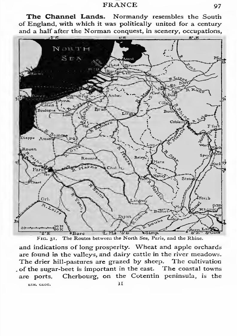
7/30/2019 The Senior Geography 1919
http://slidepdf.com/reader/full/the-senior-geography-1919 113/383

7/30/2019 The Senior Geography 1919
http://slidepdf.com/reader/full/the-senior-geography-1919 114/383
98 FRANCE
Channel naval station. Le Havre, where the Seine breaks
through the chalk heights to the sea, is ' the haven ' of Paris, as
well as of Normandy. Inland are many fine old towns and
famous cathedrals. Rouen, on the Seine, at the head of ocean
navigation, obtains cheap coal and raw material by water,
and has become the centre of the French cotton industry.
Amiens, manufacturing textiles on a smaller scale, is similarly
related to the Somme. Amiens controls the great routes to
the north. That to England runs by the Somme and the
coast to Boulogne and Calais ; that to Belgium passes by Lille
and the river Lys. A southern route to the east follows the
Oise and Sambre. East of the Seine are the ports of Dieppe,
Boulogne, Calais, and Dunkirk, the latter the outlet for the
industrial towns at the western end of the Franco-Belgian
coalfield, the French centre of which is round Valenciennes.
Lille, an engineering centre, is the industrial capital of the
north, and Roubaix a great textile centre. Famous old towns
are as numerous as in Normandy and Picardy.
The Channel Islands. Politically under the British
Crown, to which they passed at the Norman Conquest in 1066,
the Channel Islands, Jersey (45 square miles), Guernsey (35
square miles), Alderney (4 square miles), and Sark (if square
miles) are geographically part of France. They rise above
a shallow platform, which runs westwards from the Cotentin
peninsula. They are formed of old, hard rock, which weathers
into steep cliffs. Owing to this and to dangerous currents
they are very difficult of access. French blood predominates,
and a dialect of Norman French is spoken. Jersey, 15 miles
from the French coast and 88 from Portland Bill (capital
St. Helier), is engaged in dairy-farming, and the growing
of early fruits and vegetables. Fisheries and the tourist
industries are additional resources. Guernsey (capital St.
Peter Port) is similarly engaged, and has granite quarries.
All the islands, the last remnant of the once great English
possessions in France, have self-government.
Historical Summary. The Romanization of Gaul was

7/30/2019 The Senior Geography 1919
http://slidepdf.com/reader/full/the-senior-geography-1919 115/383
FRANCE 99
chiefly effected by the Alpine passes leading to the Rhone
valley. Hard fighting was necessary to secure the routes
round the Central Plateau. What Lyon, which commands
routes to the Mediterranean lands, was to Roman Gaul, Paris,
which commands routes to the lowlands of France and of the
North Sea lands, was to mediaeval and modern France.
Clovis (508) made Paris the capital of the Franks, who drove
the Visigoths to the Pyrenees and pushed back the Bur-
gundians. Charlemagne, or Charles the Great, extended his
dominions far beyond the Rhine into Switzerland, Austria-
Hungary, Italy and Spain (see p. 113). His empire was
divided among his grandsons in the middle of the ninth century.
The topography of France favoured the rise of great feudal
lords (Flanders, Champagne, Burgundy, Anjou, Aquitaine,
Normandy, Britanny, &c), who vied in power with the king.
The royal power, based on Paris, the geographical capital and
route centre, gradually absorbed these rivals andbecame
the
nucleus of modern France. It was specially vulnerable to
attacks from England, which from various dynastic causes
controlled many powerful French fiefs. This constant menace
indirectly contributed to the unification of the country. In the
thirteenth century the English power in France declined, but
in the middle of the fourteenth century a new tide of English
expansion in France led to the Hundred Years' War, during
which France was often in alliance with Scotland, on the
English rear, and England with Burgundy, then one of the
most powerful states of Europe, on the French flank. The
Hundred Years' War ended with the downfall of the English
power in France. The annexation of Burgundy in 1477,
which made France safe in the east, was soon followedby the acquisition of Britanny. In the seventeenth century
the debatable lands of Artois, Roussillon, and Alsace were
acquired. Expansion to the Rhine next became the aim of
French policy. This was achieved by Louis XIV and
Napoleon, but France was finally dislodged by the war of
1870. The expansion of France across the Mediterranean
1
7/30/2019 The Senior Geography 1919
http://slidepdf.com/reader/full/the-senior-geography-1919 116/383
ioo FRANCE
into Algeria may perhaps be compared with the mediaeval
expansion of England across the Channel into France.
Belgium. Belgium links Northern France to the lowlands
of the Rhine and North Germany. It consists of the plains of
Flanders and Brabant in the north, and of the wooded Ardennes
in the south. The plains rise gradually in the south to the
heights of Hainaut and Hesbaye, which are drained by north
flowing rivers to the Lys-Schelde and its tributary the Demer.
The coast is sandy, with no good natural harbours. Ostend, on
the coast, Bruges and Ghent 1 connected with it by canal, and
Antwerp, at the head of the dredged estuary of the Schelde,
are all artificially improved. Of these Antwerp 2is far the
most important. It is the nearest port both to the industrial
towns of the Lower Rhine, with which it is connected by rail
and canal, and to the Transatlantic sources of raw material,
which it imports in enormous quantities.
The resources of the Belgian plain are utilized to support
a very dense population. The soil is divided into small hold-
ings, cultivated to the highest degree of productiveness.
Cereals, sugar-beet, and flax are typical products. Cattle and
horses are bred in the rich water meadows. The lowlands are
covered with a network of railways and canals, providing cheap
transport. Belgium has long been noted for its manufactures,
of which lace and linens, made of local flax, carpets andtapestries, made from Ardennes wool, are examples. Water
power, so important in the Middle Ages, was supplied by the
streams from the Ardennes, and many rivers possessed special
bleaching properties, making its linens famous. The historic
industries are carried on at the old centres—Ghent, Bruges,
Brussels,3 the capital, Mechlin,4 Louvain, &c.—but the power is
now supplied from the Franco-Belgian coalfield, which runs
south of the Hainaut-Hesbaye Heights. Mons, Charleroi, and
Liege, in the centre of the mining districts, carry on iron
industries.
The Ardennes region of forests and pastures is less thickly
1 Fr. Gand. 2Fl. Antwerpen, Fr. Anvtrs.
3 Fr. Bruxelles. * Malines.

7/30/2019 The Senior Geography 1919
http://slidepdf.com/reader/full/the-senior-geography-1919 117/383
FRANCE 101
peopled. The Sambre-Meuse valley cuts its northern margin,
opening a route between Paris and the Rhine, which goes by
Namurand Liege to Aachen x and Coin.2 The struggles for this
east and west route have led to such military operations as the
campaigns of Marlborough and the battle of Waterloo.
The close relation between Belgium and the Rhine delta
or Holland, has led to an occasional union between the two
countries, which has never proved permanent. In the fifteenth
century both belonged to Burgundy and passed by the marriage
of the heiress to Spain. The Dutch Netherlands freed them-
selves in the sixteenth century, but the Belgian Netherlands
remained Spanish till 1713. In i8i5they wereagain united to
Holland, but in 1831 Belgium declared itself an independent
kingdom. Its neutrality was guaranteed by the European
powers.
HOLLAND, THE GERMAN EMPIRE, ANDBOHEMIA.
Natural Regions. The feature-lines of Europe north of
the Alps run east and west in parallel belts. These are (1) the
Alpine Foreland; (2) the Central Highlands
; (3) the Central
Lowlands; (4) the Baltic Heights. They are crossed by rivers
flowing from south to north—(1) the Rhine, crossing the first
three; (2) the Ems, Weser, and Elbe, crossing the second and
third ; and (3) the Oder and Vistula, crossing the last two.
The resulting natural regions are shown in Fig. 25.
These natural regions may be arranged in two groups—(1)
the Northern Lowlands, with low hills on their margin,
separated by a broad belt of highlands from (2) the more
isolated plains of the south, with higher hills on their margin.
The first are inhabited by the long-headed, fair-haired North
European race, the second by the round-headed, dark-haired
Alpine race, indicating that movement of races has been from
east to west rather than from north to south. Communication
1 Fr. Aix-la-chapelle.3 Fr. Cologne.

7/30/2019 The Senior Geography 1919
http://slidepdf.com/reader/full/the-senior-geography-1919 118/383
io* HOLLAND, THE GERMAN EMPIRE,
in the latter direction must follow either the Rhine, which
crosses the Central Highlands in a narrow defile, or the wooded
passes of Hesse and Eastern Thuringia. Of the three, the
Rhine is far the most important. Not merely does it link the
North Sea with the Alps, but with that section of the Alps
ay mls.
10 20 30 40 50 SO KMDykes i i i Canals =
Fig. 32. The Netherlands. Waterways and Dykes.
where the entire system can be crossed to the Mediterranean
by single passes, such as the St. Gotthard, or Splugen. That
it is not an ideal route between north and south, and that
political unification is easier from east to west, is shown byits divided political control, Swiss, German, and Dutch.
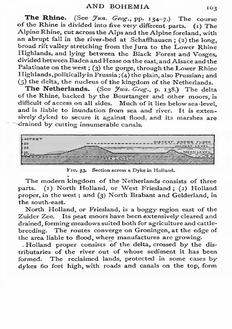
7/30/2019 The Senior Geography 1919
http://slidepdf.com/reader/full/the-senior-geography-1919 119/383
AND BOHEMIA 103
The Rhine. (See Jim. Geog., pp. 134-7.) The course
of the Rhine is divided into five very different parts. (1) TheAlpine Rhine, cut across the Alps and the Alpine foreland, with
an abrupt fall in the river-bed at Schaffhausen; (2) the long,
broad rift valley stretching from the Jura to the Lower Rhine
Highlands, and lying between the Black Forest and Vosges,
divided between Baden and Hesse on the east, and Alsace and the
Palatinate on the west; (3) the gorge, through the Lower Rhine
Highlands, politically in Prussia; (4) the plain, also Prussian; and
(5) ^e delta, the nucleus of the kingdom of the Netherlands.
TheNetherlands. (See Jim. Geog., p. 138.) The delta
of the Rhine, backed by the Bourtanger and other moors, is
difficult of access on all sides. Much of it lies below sea-level,
and is liable to inundation from sea and river. It is exten-
sively dyked to secure it against flood, and its marshes are
"drained by cutting innumerable canals.
HIGHEST KNOWN FLOOD
Fig. 33. Section across a Dyke in Holland.
The modern kingdom of the Netherlands consists of threeparts. (1) North Holland, or West Friesland; (2) Holland
proper, in the west ; and (3) North Brabant and Gelderland, in
the south-east.
North Holland, or Friesland, is a boggy region east of the
Zuider Zee. Its peat moors have been extensively cleared and
drained, forming meadows suited both for agriculture and cattle-
breeding. The routes converge on Groningen, at the edge of
the area liable to flood, where manufactures are growing.
. Holland proper consists of the delta, crossed by the dis-
tributaries of the river out of whose sediment it has been
formed. The reclaimed lands, protected in some cases by
dykes 60 feet high, with roads and canals on the top, form
7/30/2019 The Senior Geography 1919
http://slidepdf.com/reader/full/the-senior-geography-1919 120/383
io4 HOLLAND, THE GERMAN EMHKii,
polders of deep fertile soil. The work of reclaiming the shallow
Zuider Zee is in progress. The sea is bordered by sand-dunes,
and wooded beyond the Hague. The old river broke through
this coastal belt at Leiden. Two breaks of more commercial
importance are the North Sea Canal to Amsterdam, on the
Zuider Zee, and the Lek in the south, which has been canalized
to Rotterdam, the port of the Rhine. There is another
entrance at Flushing (Vlissingen), on the south arm of the
Schelde, which communicates by inland channels with the
Rhine by way of Dordrecht. The key of Holland is Utrecht,
on the old main stream, above the flood-level, from which the
low deltaic region can be inundated by opening the dykes.
The occupations of Holland are agriculture, dairy-farming,
and gardening. Some of the industries, e. g., printing at
Leiden, have long been famous. Many utilize the tropical pro-
duce brought from the Dutch colonial possessions, Fisheries
are important along the coast. They had their share in
training the seamen who laid the foundation of the Dutchoversea trade and colonization.
South-east Holland (North Brabant and Gelderland), a
drier, sandier region, is best suited for sheep-breeding.
Industries are developing in the towns near the rivers, the most
important of which is Maestricht, on the Maas^or Meuse.
Historical Summary. The marshes of the Rhine delta
favoured the independence of the tribes who inhabited them,
though these might own nominal allegiance toRoman, Frankish,
or Holy Roman Empire. For the same reason feudal barons
were able to make good their authority against outside
influence. The rich manufacturing cities, in their turn, were
virtually independent of their feudal superiors. Holland
formed part of the Burgundian dowry, which passed first
to Austria and then to Spain, by the marriage of the heiress
in the fifteenth century. Holland always resented the Spanish
yoke, and threw it off in 1579, forming itself into the Dutch
Republic. To the survival of this republic then, and in its
later form, the kingdom of the Netherlands, the geographical
7/30/2019 The Senior Geography 1919
http://slidepdf.com/reader/full/the-senior-geography-1919 121/383
AND BOHEMIA 105
position and cnaracter of the country largely contributed.
From their small, poor, seaside country the Dutch naturally
sent colonists overseas, to the West Indies, South Africa, and
the East Indies. In the seventeenth century Holland owned
more shipping than any European country. The maritime
power declined in the eighteenth century, at the close of which
Holland was seized by France, and soon after lost Ceylon and
South Africa to Britain. It was united with Belgium for a
few years after Waterloo, but the two countries are now
politically distinct.
The Westphalian and Prussian Rhine Plains andtheir Margin. These lie between the marshes of the Nether-
lands and the Lower Rhine Highlands to the south. They
are drained by the Ems in the north, and in the south by the
Rhine, and its tributaries, the Lippe and the Ruhr.
The Westphalian plain, a continuation of Holland, is
engaged in agriculture, and horse and sheep-breeding.
Miinster, the capital, has breweries, distilleries, and textile
industries. The Ruhr valley contains one of the richest
coalfields in Europe.
In the very similar Rhine plain the chief town is Coin
(Fr. Cologne), whose name represents the Roman Colonia
Agrippina. Situated not far below the exit from the Rhine
gorge, it is the crossing-point of routes from plain and high-
lands, and as such has been important from Roman times.
Under the Holy Roman Empire its prince-bishop possessed
large temporal powers, and a vote for the election of Emperor.
Later, the town became a member of the Hanseatic league.
It is now a great port, and the centre of a densely peopled
industrial region, which extends to the Ardennes in the west,
and over the Westphalian coalfield in the east. In the former
woollens, gloves, and leather, from raw materials originally
supplied from the Ardennes, are the chief manufactures at
Aachen {Fr. Aix-la-Chapelle), one of the oldest cities in
Germany. Crefeld, well situated for obtaining Westphalian
coal, is the centre of the German silk industry.
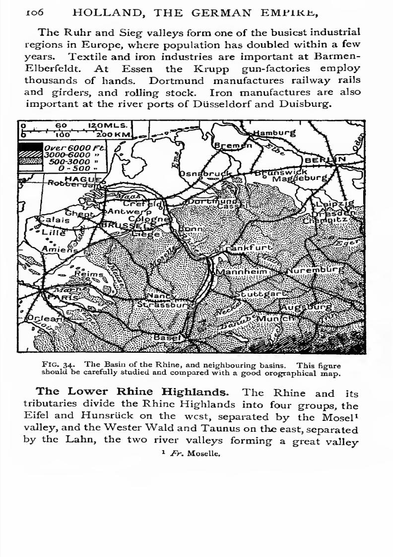
7/30/2019 The Senior Geography 1919
http://slidepdf.com/reader/full/the-senior-geography-1919 122/383

7/30/2019 The Senior Geography 1919
http://slidepdf.com/reader/full/the-senior-geography-1919 123/383
AND BOHEMIA 107
cutting the Rhine valley almost at right angles. This route
is controlled by Coblenz, at the confluence of the Mosel,
and Metz, where routes from France across Lorraine converge.
The Middle Rhine Plain. The broad middle plain of
the Rhine rises to the Vosges on the west, and the Black
Forest on the east, both with rounded summits and densely
forested slopes. The lower slopes are terraced for vineyards,
above which rich meadows rise to the forest edge. Agriculture
is the chief occupation. Industries are carried on by water-
power in many valleys as domestic industries, and in modern
factories in Miilhausen and other towns of the Vosges.
The Rhine forms a natural route between north and south,
and is followed by railways on both banks. The great port
of Mannheim, at the Neckar confluence, is artificially formed
on low-lying land protected by dykes from flood. Its
manufactures and commerce are very great. Of long-standing
importance are (1) Mainz,1 commanding the routes across the
Palatinate and Lower Lorraine, (2) Strassburg, guarding the
Saverne or Zabern pass into Upper Lorraine, and (3) Frankfurt,
which controls the routes north through Hesse, and south by the
Main to Bavaria and the Danube, (4) Karlsruhe, with engineer-
ing works, commands the route across the Neckar Plateau,
between the Oden Wald and Schwarz Wald 2, to the Danube.
Heidelberg, where the Neckar gorge opens to the Rhine, and
Freiburg, at the mouth of a lovely valley of the Schwarz Wald,
are university towns. Basel, the frontier town of Switzer-
land, commanding the route through the Burgundian Gate,
is the point at which traffic from all directions reaches the
Rhine.
The Franconian Scarps. The Franconian Scarps corre-
spond in the east to Lorraine in the west, but though they
are a larger, more self-contained region, they lead to less rich
lands. The alternation of limesjtone scarps and clay plains
recalls the Cotswolds and Upper Thames. The Neckar, on
which is Stuttgart, the capital of Wiirttemberg, forms a route
1 Fr. Mayencs. 2 Eng. Black Forest.
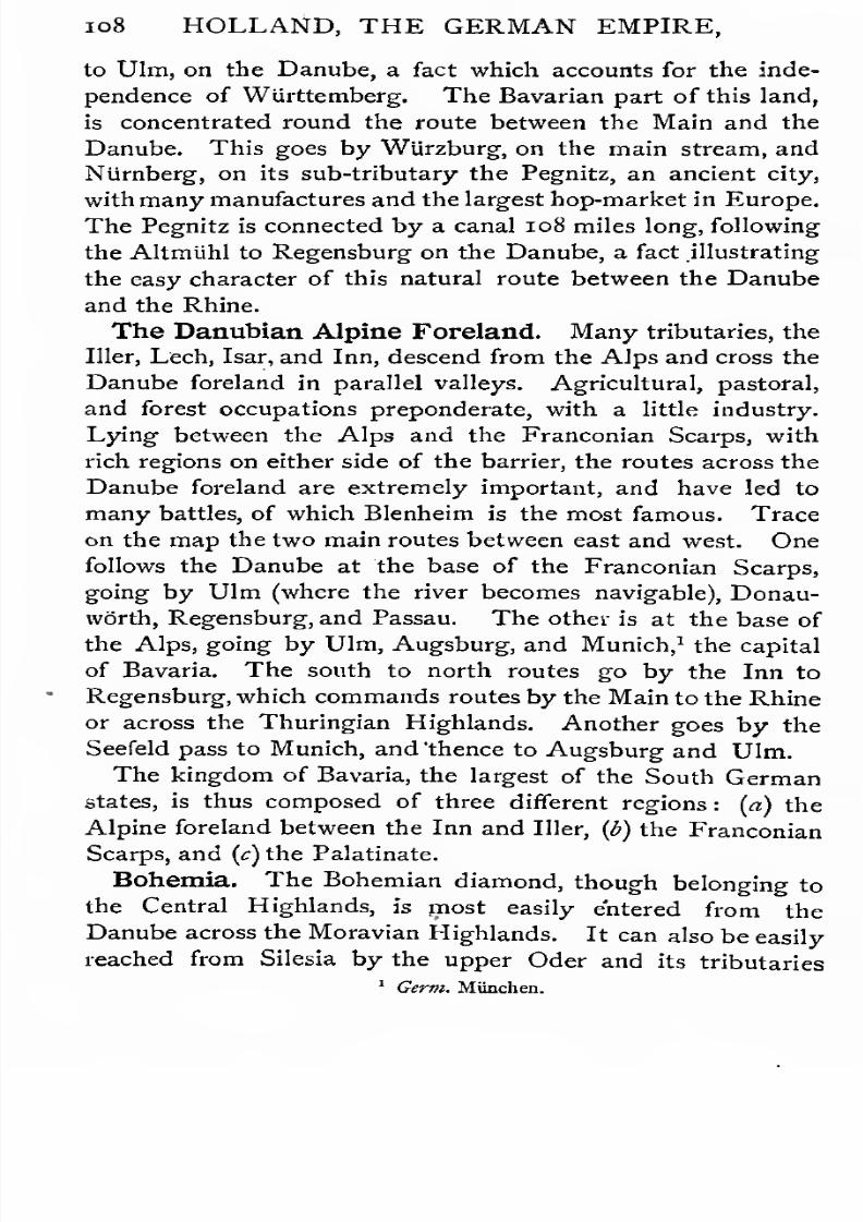
7/30/2019 The Senior Geography 1919
http://slidepdf.com/reader/full/the-senior-geography-1919 124/383
108 HOLLAND, THE GERMAN EMPIRE,
to Ulm, on the Danube, a fact which accounts for the inde-
pendence of Wurttemberg. The Bavarian part of this land,
is concentrated round the route between the Main and the
Danube. This goes by WUrzburg, on the main stream, and
Niimberg, on its sub-tributary the Pegnitz, an ancient city,
with many manufactures and the largest hop-market in Europe.
The Pegnitz is connected by a canal 108 miles long, following
the Altmuhl to Regensburg on the Danube, a fact illustrating
the easy character of this natural route between the Danube
and the Rhine.
The Danubian Alpine Foreland. Many tributaries, theIller, Lech, Isar, and Inn, descend from the Alps and cross the
Danube foreland in parallel valleys. Agricultural, pastoral,
and forest occupations preponderate, with a little industry.
Lying between the Alps and the Franconian Scarps, with
rich regions on either side of the barrier, the routes across the
Danube foreland are extremely important, and have led to
many battles, of which Blenheim is the most famous. Trace
on the map the two main routes between east and west. One
follows the Danube at the base of the Franconian Scarps,
going by Ulm (where the river becomes navigable), Donau-
worth, Regensburg, and Passau. The other is at the base of
the Alps, going by Ulm, Augsburg, and Munich,1the capital
of Bavaria. The south to north routes goby the Inn to
Regensburg, which commands routes by the Main to the Rhine
or across the Thuringian Highlands. Another goes by the
Seefeld pass to Munich, and 'thence to Augsburg and Ulm.
The kingdom of Bavaria, the largest of the South German
states, is thus composed of three different regions : (a) the
Alpine foreland between the Inn and Iller, {b) the Franconian
Scarps, and (c) the Palatinate.
Bohemia. The Bohemian diamond, though belonging to
the Central Highlands, is most easily entered from the
Danube across the Moravian Highlands. It can also be easily
reached from Silesia by the upper Oder and its tributaries
1 Germ. Munchen.
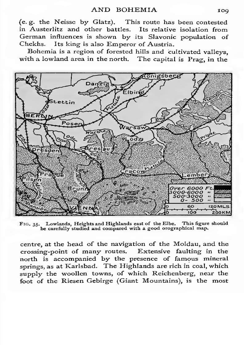
7/30/2019 The Senior Geography 1919
http://slidepdf.com/reader/full/the-senior-geography-1919 125/383
7/30/2019 The Senior Geography 1919
http://slidepdf.com/reader/full/the-senior-geography-1919 126/383
no HOLLAND, THE GERMAN EMPIRE,
important. The decomposing crystalline rocks make the
manufacture of glass and pottery important.
The Northern Margin of the Highlands. On the
northern margin of the Highlands are Saxony and the States
of Thuringia and the Hessian Hills.
Saxony. The kingdom of Saxony occupies the northern
slopes of the Erz Gebirge,1 whose name indicates the wealth of
minerals. Of these coal is now the most important, and has
greatly stimulated manufactures. The chief mining centres
are Freiberg and Chemnitz. , The iron industries are naturally
important. Saxony has long been famous for sheep, and its
woollens are renowned. Still more important is the cotton
textile industry at Chemnitz, Zwickau, and other centres. The
route between north and south goes by Voigt land, through
Hof, which is within Bavarian territory, to Leipzig, with its
famous printing industry. The capital is Dresden, where the
Elbe issues from the narrow gorge it has cut through the
picturesque region known as the Saxon Switzerland.
Thuringia. The region between the forested highlands of
Thuringia and the rounded, wooded Harz consists of fertile
valleys separated by more arid plateaus, or wooded hills.
The isolated Harz can be avoided by a detour, but the
Thuringian Forest must be crossed in going from north to
south. Hence the latter is divided into many petty states,
each owing its existence to the control of one or more routes.
Most valleys open north to the Saale, and near their mouths
are built the towns, of which Erfurt, Gotha, Weimar, and Jena
are the most important. Jena and Leipzig, on the main route
between south and north, were the scene of battles in
Napoleon's German campaigns.
The Harz is rich in minerals, which are mined in the lowei
valleys, at the mouth of each of which is a little town.
Hesse.,The Hessian hills and valleys in the south are
part of the Grand-duchy, the capital of which is' Darmstadt,
The rest form the Prussian province of the same name. Hesse1 Eng. Ore Mountains.

7/30/2019 The Senior Geography 1919
http://slidepdf.com/reader/full/the-senior-geography-1919 127/383
AND BOHEMIA in
is a wooded land drained south to the Main, west to the Lahn,
and north to the Fulda, one of the head streams of the Weser.
The routes across it are easier than those across Thuringia,
and converge on the growing town of Cassel, on the Fulda.
This river unites with the Werra from Thuringia to form the
Weser, which breaks through the north-west end ofthe High-
lands to the plain at Minden, forming the Westphalian Gate.
North Germany. Notice in Fig. 34 the rivers Weser and
Elbe flowing to the North Sea, and the converging lines of their
lower valleys. To the ports at the head of their estuaries,
Bremen on the Weser, and Hamburg on the Elbe, are brought
the raw material and grain for the industrial centres of the
interior, to be distributed up stream, and the agricultural and
manufactured products, and the timber which come down
stream. The next important line of towns- is where the
northern and southern routes given by these rivers are crossed
by the great routes running east and west. Thus Hanover is
the point where the eastern route to Berlin crosses the southern
route from Bremen to Cassel for the Hessian and Thuringian
lines. Magdeburg and Halle are points where it crosses the
routes from Hamburg to Leipzig, the junction for the lines of
Thuringia and Saxony. The growth of Atlantic trade has
greatly enhanced the prosperity of the North Sea ports. They
were formerly less important than the Baltic ports, Liibeck,
Stettin, on the Oder estuary, opening to the Stettiner Haff
and Danzig at the mouth of the Vistula. Other Baltic ports
are Konigsberg, at the mouth of the Pregel, opening to the
Frisches Haff, and Memel on the Memel or Niemen, opening
to the Kurisches Haff.
The Oder and Vistula routes inland converge on the Moravian
Gate, beyond which the route is continued by the March
tributary of the Danube. From Berlin three eastern routes
are important. The most northern crosses the Oder at
Kustrin, and the Vistula at Thorn;the second, farther south,
crosses the Oder at Frankfurt-on-the-Oder, and runs by Posen
to Warsaw, the capital of Poland, on the Vistula, for the

7/30/2019 The Senior Geography 1919
http://slidepdf.com/reader/full/the-senior-geography-1919 128/383
ii2 HOLLAND, THE GERMAN EMPIRE,
Russian lines ; the third follows the Oder through Breslau and
reaches the Vistula at Cracow (see Fig. 23).
The Oder-Vistula region is agricultural, growing rye, flax,
and potatoes, and breeding horses and cattle. The introduction
of the sugar-beet, and sugar refining, of which Frankfurt-on-
the-Oder is the centre,Jias contributed much to its prosperity.
Coal is found on the Silesian coalfield, which lies in Germany,
Austria, and Russian Poland, the centre of which is Konigshiitte.
Woollen manufactures are important round the margin of the
highlands, as at Leignitz, and at Lodz in Poland, the latter one
of the great cotton towns of the world and one of the mostpopulous cities in Russia.
The morainic heights along the Baltic are of little economic
importance. The different regions are isolated by difficulties
of communication across an infertile and often marshy region,
covered with small morainic lakes. Schleswig-Holstein,
Mecklenburg, Pomerania, and West and East Prussia, the
latter famous for its horses, are all thinly peopled, except along
the great valleys. The Prussian power, which has expanded
so remarkably in the last two centuries, "had its beginnings in
the Mark of Brandenburg. The capital is Berlin, on the
Spree, a sub-tributary of the Elbe, connected with the Oder
by canal. The importance of Berlin sprang from its command
of routes, and from the geographical causes which led to theexpansion of Prussia.
Historical Summary. It is impossible to give even an
outline of the history of this vast and geographically varied
region. The Roman power in Germany was based on the
Rhine. As the Empire weakened, many German tribes,
Goths, Burgundians, Vandals, Franks, and others, estab-
lished themselves within the Empire, which asserted a
nominal authority over them. In A. r>. 800 the great Frankish
warrior, Karl, or Charlemagne, was crowned Emperor of a
domain which included France, Germany, and Switzerland,
and extended into Spain, Italy, and Hungary. So vast an
empire could not long, with the means of communication of
7/30/2019 The Senior Geography 1919
http://slidepdf.com/reader/full/the-senior-geography-1919 129/383
AND BOHEMIA "3
that day, be held together. The next thousand years wit-
nessed a struggle between political and geographical conditions.
The political adjustments proved permanent only in so far as
they did not clash with geographical tendencies. The nominal
authority of an elected emperor survived till the beginning of
last century, but most of his feudal vassals, whether lords of
a vast territory or of a single town, were virtually independent.
The number of these, many of which survive to-day within
the reconstituted German Empire, show the extreme geo-
graphical complexity of this part of Central Europe.
The last two centuries have seen the rise of Prussia,
now the predominant State in the German Empire. For
centuries the lands round the Vistula, which lay outside the
Empire, were alternately under Teutonic and Polish control.
In 1618 Brandenburg was united with the Prussian duchy,
both acknowledging the feudal superiority of Poland. This
was remitted by Poland in- the middle of the seventeenth
century. Prussia then expanded rapidly over the routes
leading from Berlin, and at one time included Warsaw, which
is now Russian. After the war of 1866, in which many
German States sided with Austria, Prussia annexed Hesse-
Cassel, Hesse-Nassau, Hesse-Homburg, Frankfurt, Schleswig-
Holstcin, and Lauenburg. The war with France in 1871
gave Prussia no new territory (Alsace-Lorraine becoming an
Imperial land), but an enormous increase of prestige. The
King of Prussia assumed the title of German Emperor. The
German Empire consists of the kingdoms of Prussia, Bavaria,
Saxony, and Wurttemberg, the Grand-duchies of Baden, Hesse,
Mecklenburg-Schwerin and Mecklenburg-Strelitz, Saxe-
Weimar and Oldenburg, four duchies, seven principalities,
the free towns of Ltibeck, Bremen, and Hamburg, and the
Imperial land of Alsace-Lorraine.
DENMARK.
Denmark consists of the peninsula of Jutland, and of the
low islands (Zealand, Fyen, &c.) between it and Scandinavia.
S£N. GEOG. A
7/30/2019 The Senior Geography 1919
http://slidepdf.com/reader/full/the-senior-geography-1919 130/383
ii4 DENMARK
Jutland is noticeable among the peninsulas of the world for
running north. Structurally it is a continuation of the low
North, German Plain. The highest point, where the Baltic
Heights end, is only 560 feet high. The western coast is
bordered by sand-ridges and lagoons, but the east coast has
several good harbours. The climate resembles that of eastern
England. The soil is not very fertile, and oats, barley, and root
crops are more important than wheat. As in the other parts
of the Baltic Heights (see pp. 83, 11 1), large areas consist of
moor or bog, but much has been done in recent years towards
their reclamation. A great development of scientific dairy-farming has brought prosperity to a country not naturally rich.
The chief town is Copenhagen, on Zealand, commanding
the passage through the Sound into the Baltic. Tolls were
formerly taken of shipping, but since the opening of the new
route between the Elbe and the, Baltic by the Kiel Canal,
Copenhagen has been a free port. Railways and steam ferries^
which carry the trains across the straits, connect Copenhagen
by Gjedser. with Warnemunde or by Korsor with Kiel and
with Esbjerg. The latter is on the west coast of Jutland, and
is a packet-station for England.
THE BRITISH ISLES.
The British Isles rise above the continental shelf of Europe,which ends 100 miles west of Ireland. Great Britain, the
largest island, divided politically into England, Wales, and
Scotland, is separated from, France by the English Channel,
20 miles broad between Dover and Calais, but 100 miles
broad between Land's End and Britanny. The North Seaseparates it from Central Europe and Scandinavia, 400 miles
broad between the Wash and Denmark, 300 miles between
Buchan Ness and Norway, and 200 miles between the Shet-
lands and Norway.
Ireland, the second largest island, is separated from GreatBritain by the Irish Sea, 130 miles broad in the centre, butnarrowing to the North Channel in the north and the St.

7/30/2019 The Senior Geography 1919
http://slidepdf.com/reader/full/the-senior-geography-1919 131/383
THE BRITISH ISLES 115
George's Channel in the south. Both lead to the Atlantic,
which washes the west of Scotland, Ireland, and Southern
England.
Highlands and Lowlands. The south-east of England
is a scarpland. The highlands of Devon and Cornwall and
Wales jut out to the west, separated by the Bristol Channel.
A broad mass of uplands crosses Great Britain from sea to
sea, running north-east from the North Channel. These are
the Southern Uplands of Scotland, from which the Pennines
run south into England. The Pennines are flanked east and
west by lowlands, except where the Cumbrian Mountainsproject westward to the .Irish Sea. The rest of England is
a plain, crossed by heights running south-west to north-east.
The Scottish Lowlands, north of the Southern Uplands, are
also crossed by heights running in the same direction. Still
farther north are the Scottish Highlands, divided by the rift of
Glenmore, the Great Glen. Notice that it, too, runs south-
west to north-east, the direction of most of the feature-lines of
the island. The west coast is fringed by the Inner and Outer
Hebrides, separated by the Minch. The Orkneys and Shet-
lands in the north stretch towards Norway.
Ireland has highlands in the north and south, separated by
a central lowland running from sea to sea.
Great Britain, therefore, like France, has lowlands openingto three seas, the Channel, the North Sea, and the Atlantic.
In both communication with the Atlantic is relatively difficult.
In Great Britain, with the exception of the Severn, Dee, Mersey,
and Clyde, the western valleys lead to rugged highlands,
which bar the way to the lowlands beyond. In the east the
long slope gives many rivers an eastward course, and their
value as routes is increased by the long navigable estuaries
running far inland. Great Britain is thus a North Sea country,
and is closely connected physically and historically with
the neighbouring continent, of which it once formed part. In
the south, where Southampton Water faces the Seine estuary,
and Calais cliffs are visible from Dover, the French or Latin
I 1
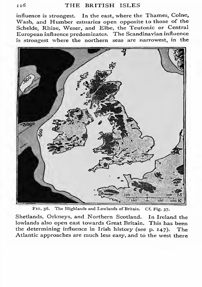
7/30/2019 The Senior Geography 1919
http://slidepdf.com/reader/full/the-senior-geography-1919 132/383

7/30/2019 The Senior Geography 1919
http://slidepdf.com/reader/full/the-senior-geography-1919 133/383
THE BRITISH ISLES ii7
is no land nearer than the New World. The southern valleys,
with good harbours, open towards the Northern coast of
Spain, over 600 miles distant. The .commercial relations with
Spain were important until the English supremacy was firmly
established.
The highlands of the British Isles are pastoral. The low-
Fig. 37. The Older and Younger Rocks of Britain. Over the black areas
rocks of carboniferous age or older appear at the surface, over the white areas
these older rocks are covered by rocks of a more recent age.
lands, except in the west, where they are too wet, are agri-
cultural. On the coasts fisheries are important. Mining has
developed round the margin of the highlands, and great
industrial regions have grown up where the mineral wealth
includes coal. Compare these conditions with those of France.
Climate. Climatically Britain is a link between Central
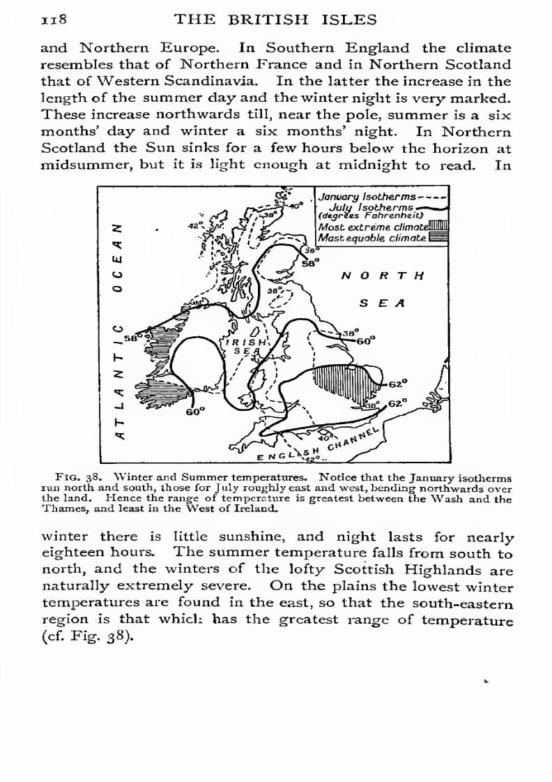
7/30/2019 The Senior Geography 1919
http://slidepdf.com/reader/full/the-senior-geography-1919 134/383
n8 THE BRITISH ISLES
and Northern Europe. In Southern England the climate
resembles that of Northern France and in Northern Scotland
that of Western Scandinavia. In the latter the increase in the
length of the summer day and the winter night is very marked.
These increase northwards till, near the pole, summer is a six
months' day and winter a six months' night. In Northern
Scotland the Sun sinks for a few hours below the horizon at
midsummer, but it is light enough at midnight to read. In
January Isotherms - -
July Isotherms,*-
(degrees Fahrenheit)
Most extreme climata
Most equable climate I
Fig. 38. Winter and Summer temperatures. Notice that the January isotherms
run north and south, those for July roughly east and west, bending northwards over
the land. Hence the range of temperature is greatest between the Wash and the
Thames, and least in the West of Ireland.
winter there is little sunshine, and night lasts for nearly
eighteen hours. The summer temperature falls from south to
north, and the winters of the lofty Scottish Highlands are
naturally extremely severe. On the plains the lowest winter
temperatures are found in the east, so that the south-eastern
region is that which has the greatest range of temperature
(cf.Fig.38).

7/30/2019 The Senior Geography 1919
http://slidepdf.com/reader/full/the-senior-geography-1919 135/383
THE BRITISH ISLES 119
The British Isles lie in the track of the south-west winds,
which bring rain at all seasons, but most in winter. This rain
falls most abundantly on the western Highlands. Ireland has
a higher average rainfall than Great Britain, and the west of
Great Britain than the east. These winds (see Jun. Geog.,
pp. 21-32) also render the climate equable, making the
summers cooler and the winters warmer than in corresponding
latitudes in the interior of Europe. For the same reason the
west has a more equable climate than the east.
Some diversity of occupations corresponds to difference in
rainfall.
The westis pastoral,
withcattle in the lowlands,
andsheep in the highlands, though the Vale of Hereford, in the
lee of the Welsh Mountains, is agricultural. The drier east
is agricultural.
The products of Britain also mark a transition from Central
to Northern Europe. Agriculture can hardly be carried on
above i,oco feet above sea-level. In the Scottish Lowlands,
north of which there is little agriculture, the hardier cereals
(barley, oats) are grown. Wheat is almost confined to the
agricultural lowlands of Eastern England. In Southern
England apple-orchards and hop-gardens recall Northern
France. The vine and apricot ripen, but are near their
northern limit. In Scotland the excellence of the strawberry
and other smallfruits
indicatesan approach to sub-arctic
conditions.
GREAT BRITAIN.
Devon and Cornwall. This hilly peninsula consists of
hard old red sandstones and granites. The former form high
belts south and north of the plain of Devon, culminating in
Exmoor (1,700 feet). Granite forms the high tors of Dartmoor
(2,000 feet), and Bodmin Moor. The Exe and Tamar rise in
the extreme north, and flow south. The Taw, from Dartmoor,
flows north. The bleak highlands pasture sheep, cattle, and
half-wild ponies. The valleys are fertile. Those opening
south, with a mild and rainy climate, produce early vegetables
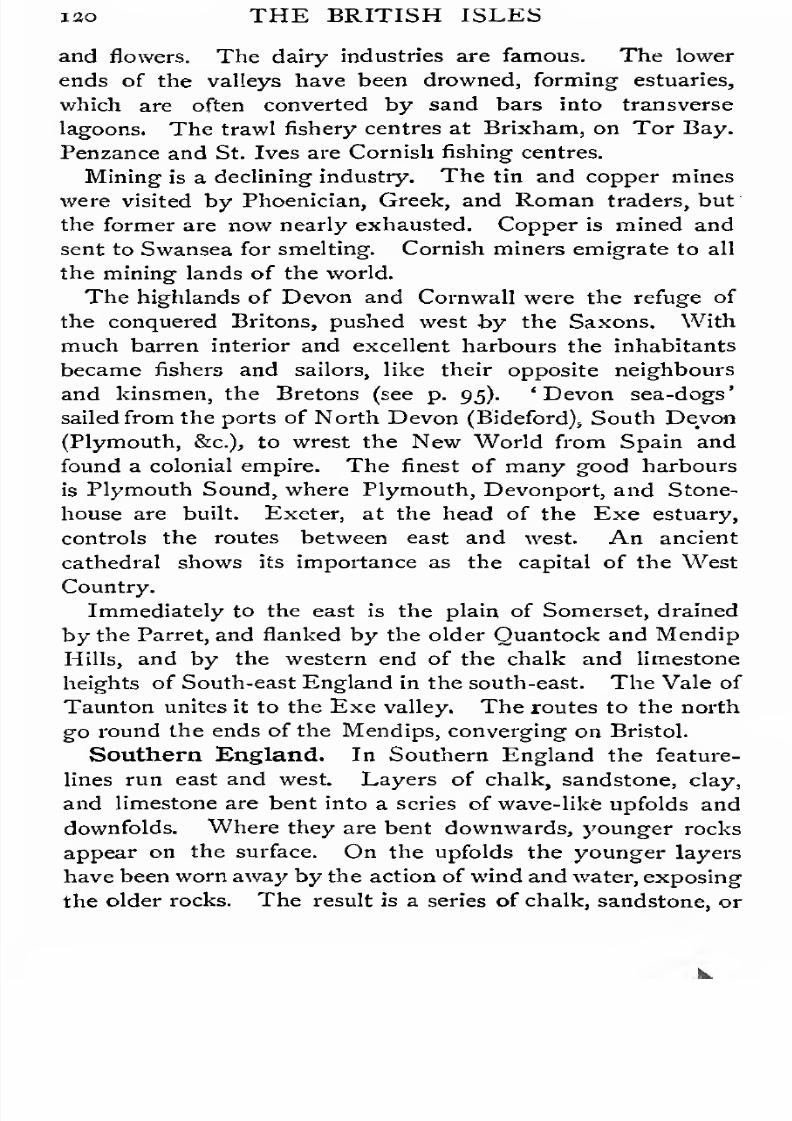
7/30/2019 The Senior Geography 1919
http://slidepdf.com/reader/full/the-senior-geography-1919 136/383
iao THE BRITISH ISLES
and flowers. The dairy industries are famous. The lower
ends of the valleys have been drowned, forming estuaries,
which are often converted by sand bars into transverse
lagoons. The trawl fishery centres at Brixham, on Tor Bay.
Penzance and St. Ives are Cornish fishing centres.
Mining is a declining industry. The tin and copper mines
were visited by Phoenician, Greek, and Roman traders, but
the former are now nearly exhausted. Copper is mined and
sent to Swansea for smelting. Cornish miners emigrate to all
the mining lands of the world.
The highlands of Devon and Cornwall were the refuge of
the conquered Britons, pushed west by the Saxons. With
much barren interior and excellent harbours the inhabitants
became fishers and sailors, like their opposite neighbours
and kinsmen, the Bretons (see p. 95). 'Devon sea-dogs'
sailed from the ports of North Devon (Bideford), South Devon
(Plymouth, &c), to wrest the New World from Spain and
found a colonial empire. The finest of many good harboursis Plymouth Sound, where Plymouth, Devonport, and Stone-
house are built. Exeter, at the head of the Exe estuary,
controls the routes between east and west. An ancient
cathedral shows its importance as the capital of the West
Country.
Immediately to the east is the plain of Somerset, drained
by the Parret, and flanked by the older Quantock and Mendip
Hills, and by the western end of the chalk and limestone
heights of South-east England in the south-east. The Vale of
Taunton unites it to the Exe valley. The routes to the north
go l'ound the ends of the Mendips, converging on Bristol.
Southern England. In Southern England the feature-
lines run east and west. Layers of chalk, sandstone, clay,
and limestone are bent into a series of wave-like upfolds and
downfolds. Where they are bent downwards, younger rocks
appear on the surface. On the upfolds the younger layers
have been worn away by the action of wind and water, exposing
the older rocks. The result is a series of chalk, sandstone, or
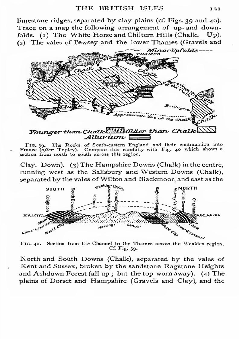
7/30/2019 The Senior Geography 1919
http://slidepdf.com/reader/full/the-senior-geography-1919 137/383
THE BRITISH ISLES 131
limestone ridges, separated by clay plains (cf. Figs. 39 and 40).
Trace on a map the following arrangement of up- and down-
folds. (1) The White Horse and Chiltem Hills (Chalk. Up).
(2) The vales of Pewsey and the lower Thames (Gravels and
MizurrUpfoL&a-THAMES '
,
Younger -than,ChaZtJMMOlcLer tharv CfvcOJoES3
Fig. 39. The Rocks of South-eastern England and their continuation into
France [after Topley). Compare this carefully with Fig. 40 which shows a
section from north to south across this region.
Clay. Down). (3) The Hampshire Downs (Chalk) in the centre,
running west as the Salisbury and Western Downs (Chalk),
separated by the vales of Wilton and Blackmoor, and east as the
SOUTHf&fyl/p,.
s NORTH
Fig. 40. Section from Cn Channel to the Thames across the Wealden region.
Cf. Fig. 39.
North and South Downs (Chalk), separated by the vales of
Kent and Sussex, broken by the sandstone Ragstone Heights
and Ashdown Forest (all up ; but the top worn away). (4) The
plains of Dorset and Hampshire (Gravels and Clay), and the

7/30/2019 The Senior Geography 1919
http://slidepdf.com/reader/full/the-senior-geography-1919 138/383
123 THE BRITISH ISLES
straits of the Solent and the Spithead. (5) The Downs of
Purbeck and the Isle of Wight (Limestone and Chalk. Up).
(Cf. Fig. 41.)
The chalk and limestone heights are sheep pastures. The
clay plains and the sandstone ridges are cultivated. In the
east are orchards and hop-fields, with market-gardens near
the towns. Ashdown Forest, between the vales of Kent and
Sussex, is a remnant of the forest of the Weald, which long
prevented communication except along the treeless chalk.
The. natural route from the Channel to the interior is by
Southampton Water,the estuary of the Itchen,
entered eitherfrom the Solent or Spithead. The tides come up the Spithead
later than up the Solent, causing four daily tides at South-
South North
^JfampsTiire Hampshire, JJOTldaTV
I ^ Basin Downs Sastrv
Sexi levels
ChalkChalk
Fig. 41. Section from the Channel to nearly the centre of the English Plain.
Cf. Fig. 40.
ampton, which is therefore peculiarly accessible to shipping.
Two roads lead north from it by gaps in the chalk, one by
Salisbury, the other by Winchester, both cathedral cities.
Near the former is the stone circle of Stonehenge, probably
the oldest human monument in our islands. The latter, on
the Itchen, was the capital of the West Saxons, who entered
Britain by Southampton Water. Later it became the capital
of England, and remained so as long as Southampton was the
principal route to the interior. Southampton has still a
vast commerce. It is a packet-station for France, and the
starting-point of many ocean routes. Portsmouth, farther east,
has become the chief naval station, because its excellent
harbour is easy of defence. The entrance "is commanded by
7/30/2019 The Senior Geography 1919
http://slidepdf.com/reader/full/the-senior-geography-1919 139/383
THE BRITISH ISLES 133
Portsdown Hill behind, and the heights of the Isle of Wight
in front, both strongly fortified.
The Thames estuary on the east coast is the best natural
route to the interior from the North Sea. London, like
Southampton, is very accessible to shipping. Two tides, one
by the North Sea, and one by the Strait of Dover, reinforce
each other, causing exceptionally strong and high tides at
London Bridge. Two contiguous cities grew up, one round
London Bridge, the other round Westminster ford, each with
its great church. As accessible as Southampton by sea,
London is infinitely better situated with regard to the interior.
It is in the centre of the scarplands, while Southampton is on
their margin. In this respect it may be compared with Paris.
A third port of early and enduring importance is Dover, at
the end of the North Downs, where the Channel is narrowest.
The Kentish ports were used by the Jutes and South Saxons,
the latter having left their name in Sussex. The obstructions
of theWeald and Romney Marsh prevented them from expand-
ing into the lower Thames, which was occupied by the Middle
Saxons (Middlesex).
The other coast towns of South-eastern England are (1)
fishing towns, small ports, and seaside resorts, the latter growing
with the growth of London (Margate, Ramsgate, Hastings,
Eastbourne, Brighton, Bournemouth), or (2) packet-stations
(Folkestone, Newhaven, Weymouth, &c). Thus the French
and English margins of the Channel have similar economic
interests, and a similar grouping of population. Inland is a
second series of towns, built at gaps in the chalk heights.
Lewes, in the Ouse gap, and Arundel, in the Arun gap, are
important in the South Downs. Commanding the gaps in the
North Downs are Canterbury on the Stour, Maidstone and
Rochester-Chatham on the Medway, and Guildford on the
Wey. Like the corresponding French inland towns, some
have fine churches and cathedrals.
The distribution of villages in this region is instructive, and
is well seen by comparing an ordnance with a geological map.
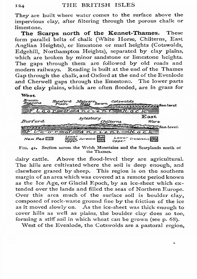
7/30/2019 The Senior Geography 1919
http://slidepdf.com/reader/full/the-senior-geography-1919 140/383
134 THE BRITISH ISLES
They are built where water comes to the surface above the
impervious clay, after filtering through the porous chalk or
limestone.
The Scarps north of the Kennet-Thames. These
form parallel belts of chalk (White Horse, Chilterns, East
Anglian Heights), or limestone or marl heights (Cotswolds,
Edgehill, Northampton Heights), separated by clay plains,
which are broken by minor sandstone or limestone heights.
The gaps through them are followed by old roads and
modern railways. Reading is built at the end of the Thames
Gap through the chalk, andOxford at the end of the Evenlode
and Cherwell gaps through the limestone. The lower parts
of the clay plains, which are often flooded, are in grass for
"West
lealtvet
JhtrforcLAylesbury
CluXternsEast
Ware'
VSea,leveL
Ne.v* fftdEHLowe-rMiddle, Jurassic ZZUpper
Low&ri
Upper
Fig. 42. Section across the Welsh Mountains and the Scarplands north of
the Thames.
dairy cattle. Above the flood-level they are agricultural.
The hills are cultivated where the soil is deep enough, and
elsewhere grazed by sheep. This region is on the southern
margin of an area which was covered at a remote period known
as the Ice Age, or Glacial Epoch, by an ice-sheet which ex-
tended over the lands and filled the seas of Northern Europe.
Over this area much of the surface soil is boulder clay,
composed of rock-waste ground fine by the friction of the ice
as it moved slowly on. As the ice-sheet was thick enough to
cover hills as well as plains, the boulder clay does so too,
forming a stiff soil in which wheat can be grown (see p. 68).
West of the Evenlode, the Cotswolds are a pastoral region,

7/30/2019 The Senior Geography 1919
http://slidepdf.com/reader/full/the-senior-geography-1919 141/383
THE BRITISH ISLES 125
with woollen manufactures at Stroud and elsewhere. The
capital is Bristol, on the tidal Avon, opening to the estuary
of the Severn, which is to the western scarplands what the
Thames estuary is to the eastern. The routes from the lower
Thames go north or south of the White Horse Downs to the
Avon, and thence by Bath to Bristol. Another set of routes
leads round the ends of the Mendips into Somerset. The
route from Bristol to the Midlands and the north follows the
Severn to Gloucester, where the river is bridged at the head
of tidal navigation, and either follows the Severn north or the
Avon east through thefertile
Vale of Evesham. With thiscontrol of routes inland Bristol early became an important
port. Some of its manufactures, e.g. cacao and tobacco,
depend on its imports of produce from hotter lands—but
tanning, boots and shoes, and paper are the most important.
East Anglia. Much of this region was settled by the
East Saxons and Angles, whose name is preserved in Essex
and East Anglia (Norfolk and Suffolk). Coming oversea, they
sailed up the many estuaries north of the Thames (Colne, Stour,
Yare). This region was isolated by the Chilterns and the Lea
marshes in the south, and by the Fens in the north, and a dis-
tinctive individuality resulted which has made East Anglians
pioneers in religious and political movements. The early
development of manufactures round Norwich wasdue
tovarious causes, including ease of communication by sea with
the manufacturing centres of the opposite coast. There are
ports and fishing centres on the coast or at the head of
estuaries (Norwich, Yarmouth, Harwich, Ipswich, Colchester).
The Fens. The Fens, which border the Wash, are crossed
by the lower courses of the Great Ouse, Nen, Welland, and
Witham, and form a low-lying marshy region, resembling
Holland. The rivers have been canalized and the marshes
are drained by ditches called dykes. The towns are (1) on
the Fen margin (Cambridge, Bedford, Peterborough), (2)
on low heights rising above them (Ely), (3) at the mouths
of the rivers (King's Lynn and Boston).

7/30/2019 The Senior Geography 1919
http://slidepdf.com/reader/full/the-senior-geography-1919 142/383
i 36 THE BRITISH ISLES
The Midlands. The Midlands are undulating lands of
marl or sandstone lying between the Upper Trent, the Severn,
and the Warwick Avon. Older harder rocks rise in Charn-
wood Forest, Cannock Chase, and the Lickey and Clent Hills.
The Midlands are a well-wooded pastoral region. Coal is
found on the margin of the highlands, on the coalfields of
North Staffordshire, Warwickshire, South Staffordshire, and
Leicestershire. On the first the towns of the Potteries (Stoke-
on-Trent, Hanley, Burslem, &c.) manufacture china and
earthenware, the clay being brought from Cornwall by sea and
canal. On the eastern margin is Burton-on-Trent, whose
breweries owe their excellence to the quality of the local water.
The Warwickshire coalfield has long been associated with the
iron manufacture. Leland, in the sixteenth century, called
Birmingham ' the abode of smiths and cutlers '. In the
Civil War of the next century it supplied the Parliamentary
army with swords. The Black Country towns (Birmingham,
Walsall, West Bromwich, Wolverhampton, Dudley, &c), manu-facture iron in forms too numerous to mention. On the
margin of this region Coventry manufactures motors and cycles.
On the Leicestershire coalfield, leather, abundant in a pastoral
region, is made into boots (Northampton). Hosiery, boots,
tobacco, and lace are also manufactured (Leicester).
This region was included in Mercia. The Angles reached
it by the Wash and its rivers, or by the Humber and Trent.
Forests and marshes led to the growth of many small centres
and prevented the consolidation of Mercia. One of the chief
route centres is Rugby. The south route reaches the Thames
at Oxford by the Cherwell valley. The north route follows
the Soar to Leicester, whence routes go to Nottingham, the
lower Trent, and Derby for the Pennine towns. Routes to the
west go by the Severn and Shrewsbury, and by the Stafford-
shire or Midland Gate, between the Pennines and the Welsh
Highlands, to the plains of Cheshire and Lancashire.
The Welsh Highlands and their Margin. Old hard
rocks cover most of the region west of the Severn and Dee,
7/30/2019 The Senior Geography 1919
http://slidepdf.com/reader/full/the-senior-geography-1919 143/383
THE BRITISH ISLES 127
forming the Welsh highlands. The valleys of the Towy,
Teify, Upper Severn, and Dee strike south-west and north-
east. The plain ofAnglesey is separated by the Menai Strait
from the Snowdon Mass (3,560 feet). This, like the Berwyn
Mountains between the Severn and Dee, the Mynydd Bach,
the Clun and Radnor Forests, and the South Shropshire Hills,
is drawn out in the same direction. The last four are drained
by the Teme, Wye, and Usk to the Severn or its estuary.
The Wye at first runs south-east, and crosses the broad plain
of Hereford, planted with orchards and hop-gardens. This
lies between the Welsh Highlands on the west, the SouthShropshire Hills on the north, the Malvern Hills on the east,
and the Forest of Dean, famous for ironworks since Roman
days, on the south. Across the latter the Wye cuts a gorge
to the sea. From this plain many routes lead east to the
Severn. They are commanded by Leominster, in the north,
Hereford in the centre, and Monmouth in the south.
The feature lines in South Wales run west-east, e.g. the
Pembroke and Gower peninsulas,, the Brecon Beacons, the
Gwent lowlands. The Usk, Taff, Tawe, and other rivers
drain the slopes of the Brecon Beacons, across the Highlands
of Glamorgan and West Monmouth rich in coal (Merthyr
Tydfil, Aberdare). They flow through the fertile Gwent 1
lowlands bordering the Bristol Channel, where great portshave grown at their mouths. Newport on Usk (Mon.),
Cardiff, Barry, and Port Talbot export smokeless coal, and
Swansea anthracite. Swansea has great smelting works, and
Llanelly is the centre of the tinplate industry.
Wales is easy of entrance along the coast, both in the north
and south. Edward I took the north coastal route. The
Irish Mail passes by it through Conway to Holyhead.
To overawe Wales three March or Border Earldoms were
created—(1) Chester, with the fortress ofjChester, commanding
the northern coast route, as well as that by the Dee valley; (2)
Shropshire, with the fortress of Shrewsbury controlling the
1 See Survey Atlas of England and Wales, Plate I.
7/30/2019 The Senior Geography 1919
http://slidepdf.com/reader/full/the-senior-geography-1919 144/383
128 THE BRITISH ISLES
Severn route, and {3) Hereford, commanding the Wye route.
1 he route by the Vale of Glamorgan was controlled by the
fortress of Cardiff. It could be reached by crossing the
Severn near the mouth of the Usk or at Gloucester, the
lowest point where the Severn was bridged. Gloucester played
an important part in the War of the Roses, when Wales was
Lancastrian, and in the Civil War, when it was Royalist. The
low part of Pembrokeshire, where Pembroke has now an
arsenal and dockyard, was called ' a little England below
Wales ', owing to its non-Keltic people and speech.
The Cheshire and LancashirePlains. These are rich
meadow lands drained by the Dee, Weaver, and Mersey,
with Chester, Manchester, and Liverpool as the chief centres.
The routes from the south and south-east have already been
described. There is an easy but narrow route north between
Rossendale and Bowman Forests and the sea to Lancaster,
through Preston, at the head of the Ribble estuary.
Liverpool, Preston, and Manchester, though physically of
the plain, are economically bound up with the great cotton and
iron industries which have developed on the coalfields along
the western margin of the Southern Pennines. Through Liver-
pool and Manchester, which was made a port by the cutting of
the Manchester Ship Canal, Lancashire obtains raw material
for its cotton industry. The damp climate favours this, as
threads break more easily if dry. Preston is an important
manufacturing and route town.
The Southern Pennines and their Margin. These
lie between the Trent and the Aire, where the Aire Gap,
leading to the Ribble valley, divides the Pennines into two
parts and forms the main route across them. The Southern
Pennines are an upfolded area, with older sandstones and lime-
stones in the centre, and younger rocks, including coal, on the
flanks. Where the sandstones are laid down horizontally, as in
the Peak, they weather into tables ; where inclined, as east of the
Derwent, into scarped ridges. The limestones form picturesque
scenery of the karst type. The centres of the latter region
are Buxton and Matlock, both with mineral springs.

7/30/2019 The Senior Geography 1919
http://slidepdf.com/reader/full/the-senior-geography-1919 145/383
THE BRITISH ISLES 129
The Southern Pennines are drained west to the Irish Sea
by the Mersey and Ribble, and east to the Ouse by the Don,
Calder, and Aire, flowing in steep, narrow dales. This is a
bleak, thinly peopled pastoral region, from which valleys rich
in coal open east, west, and south. Here a dense population
is engaged in industry.
The coal-measures of South Lancashire and Cheshire
support the vast cotton, engineering, chemical, glass and other
industries, which have concentrated into Blackburn, Bolton,
Burnley, Bury, Manchester, Oldham, Rochdale, St. Helens,
Stockport, Staleybridge, Warrington, and Wigan, a population
exceeded only by that of London. Industrial South Lan-
cashire is really one great town, covered with pit-shafts and
mill-chimneys.
The South Staffordshire coalfield has already been men-
tioned. On the eastern flanks of the Southern Pennines is the
York-Derby-Nottingham coalfield.
The Vales ofTrentand York and the Eastern Scarps.
East of the Pennines the lowlands are wider, and the routes to
the north easier. The lowlands do not reach the sea, which
is bordered by two lines of heights, (1) Lincoln Edge and the
York Moors (Limestone), and (2) the Lincoln and York Wolds
(Chalk). The line of the Aire is continued by the Humber,
to which flow the Trent, from the Vale ofNottingham, and the
Ouse, which gathers up the Pennine rivers, Swale, Ure, Nidd,
Wharfe, Aire, Calder, and Don. The only left bank tributary
of the Ouse is the Derwent, from the Vale of Pickering,
between the Moors and the Wolds. This region has been
heavily glaciated. The Derwent originally flowed to the
North Sea, but was dammedback
bymoraines and diverted
to the Ouse. Great moraines cross the Vale of York, deter-
mining the position of York.
The position of the county boundary is instructive. It lies
far west of the divide, showing that settlement and organiza-
tion have proceeded from the east, by the Humber and Ouse.
SEN. GEOG. K
7/30/2019 The Senior Geography 1919
http://slidepdf.com/reader/full/the-senior-geography-1919 146/383
I3Q THE BRITISH ISLES
The Humber. is obviously a natural route into the interior. It
was followed both by Angles and Danes. The former either
diverged south by the Trent into Mercia, or pressed north by
the Ouse valleys, which formed the kingdom of Deira. Deira
was later united with Bernicia, the coastal region north of
the Tees, to form Northumbria. Danish blood and influence
were less permanent, but are still traceable on the Yorkshire
coast.
That York is the natural centre is shown by its importance
during the Roman occupation as well as by its becoming the
ecclesiastical capital of Northern England. It controls routes(i) by the Trent, through Newark and Gainsborough, across
the Vale of Nottingham, with a branch to Lincoln in the
Witham Gap, (2) west by the Ouse tributaries, and the towns
built where they leave the highlands (Sheffield, Huddersfield,
Leeds, Harrogate, Ripon, Richmond), and (3) north by the
Northallerton Gate, where the invading Scots were turned
back at the battle of the Standard. The numerous battle-
fields in Yorkshire show how often these routes have been
contested. The eastern vales are thinly peopled, and towns
are few. The Humber ports are Goole, Hull, and Grimsby;
the North Sea coast towns Scarborough and Whitby.
The agricultural Vale of York becomes industrial along the
Pennine margin. The combinationof,
wool and water-powerled to the rise of the woollen manufacture in the Yorkshire
valleys, as in the Ardennes or the Cotswolds. This is now
concentrated round the Aire and Calder (Leeds, Bradford
Huddersfield, Wakefield), where coal is abundant. In the
Don valley the iron and steel industry has assumed gigantic
proportions at Sheffield, where the millstone grit of the
Pennines makes excellent grindstones. This industry is of
long standing, for Chaucer mentions a ' Sheffield whittle '.
The manufactures of the Trent or Nottingham-Derby coalfield
include lace and hosiery.
The Northern Pennines. These are drained east to the
North Sea by the Ouse tributaries and the parallel Tees,
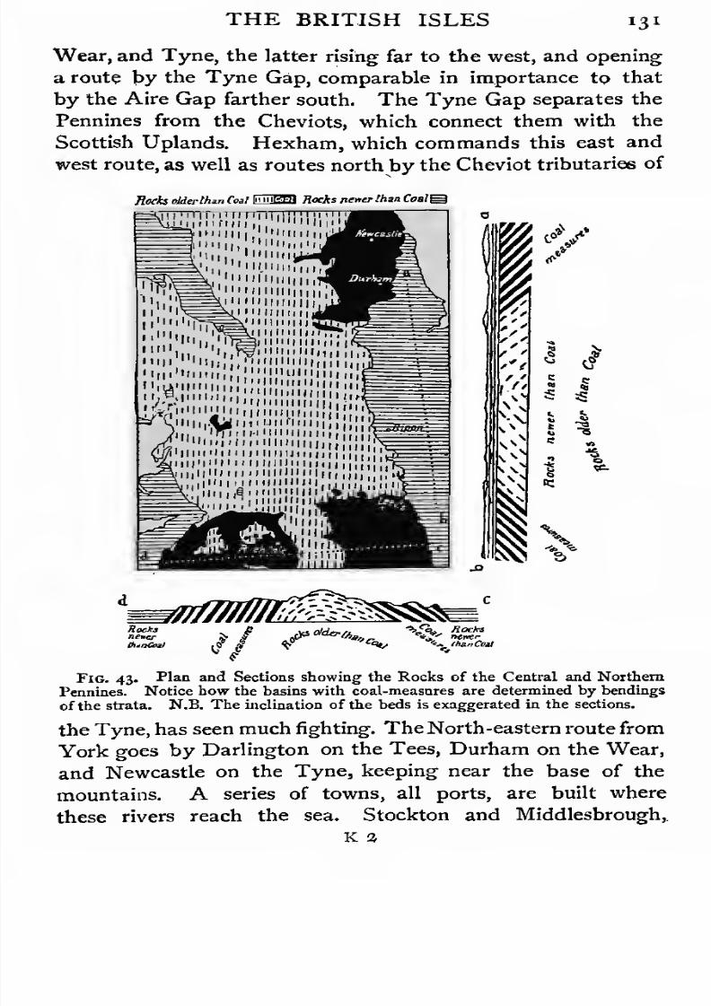
7/30/2019 The Senior Geography 1919
http://slidepdf.com/reader/full/the-senior-geography-1919 147/383
THE BRITISH ISLES I 3 I
Wear, and Tyne, the latter rising far to the west, and opening
a route by the Tyne Gap, comparable in importance to that
by the Aire Gap farther south. The Tyne Gap separates the
Pennines from the Cheviots, which connect them with the
Scottish Uplands. Hexham, which commands this east and
west route, as well as routes north by the Cheviot tributaries of
Reda tMtrthtn Coal «™ Hocks nener Ihm Coalg
Kin' '."""'hill',!!',1
iiuj 1 1 n f 1 1 11
1 ., """Hi
*/
Fig. 43. Plan and Sections showing the Rocks of the Central and Northern
Pennines. Notice how the basins with coal-measures are determined by bending:
of the strata. N.B. The inclination of the beds is exaggerated in the sections.
the Tyne, has seen much fighting. The North-eastern route from
York goes by Darlington on the Tees, Durham on the Wear,
and Newcastle on the Tyne, keeping near the base of the
mountains. A series of towns, all ports, are built where
these rivers reach the sea. Stockton and Middlesbrough,
a
7/30/2019 The Senior Geography 1919
http://slidepdf.com/reader/full/the-senior-geography-1919 148/383
132 THE BRITISH ISLES
the ports of the Tees, Hartlepool a little to the north,
Sunderland on the Wear, Newcastle, Tynemouth, South
Shields on the Tyne, are all engaged in iron industries,
shipbuilding and exporting coal.
West of the Pennines is a great fracture or fault. The
Pennines fall steeply to the Eden valley, beyond which rise
the lofty Cumbrian Mountains (3,200 feet). From the main
axis of these, which runs east and west, radiate glaciated
valleys, their upper ends filled by long narrow lakes of the
Swiss type. In this pastoral region boots and woollens are
manufactured round Kendal. Between the Cumbrian andPennine Mountains the Shap depression sinks to 1,000 feet,
forming a difficult route from the Lune and Ribble valleys to
the Eden valley and the lowlands round the Solway. Of these
lowlands Carlisle is the centre, commanding all the routes
between north and south.
Coal is found on both the eastern and western sides. The
Northumberland-Durham field, with its great engineering
industries and large export coal trade is the more important.
Middlesbrough-on-Tees, which smelts and manufactures iron
from the Cleveland Hills of North Yorkshire, has grown with
extraordinary rapidity into one of the great industrial centres
of the north. On the western margin Barrow-in-Furness
is another Middlesbrough. Coal is also abundant roundWorkington and Whitehaven.
The Southern Uplands. The Southern Uplands stretch
from sea to sea, varying in breadth from 50 miles in the centre
to 15 miles in the west and 10 miles in the east. They
consist of old, hard rocks, cut by river valleys into rounded
masses of fairly uniform height (Merrick, 2,765 feet, Broadlaw
2,750 feet). The surface is treeless moorland or poor pasture
but the lower valleys are wooded.
From the main mass, which runs from south-west to north-
east, the Cheviots project east into England, the Border
running for 40 miles along the divide. They are flanked east
and south-west by lowlands.
7/30/2019 The Senior Geography 1919
http://slidepdf.com/reader/full/the-senior-geography-1919 149/383
THE BRITISH ISLES 133
The lowland south-west of the Cheviots lies on both sides of
Solway Firth. On the other sides it is shut in by the Cumbrian
and Pennine Mountains, the Cheviots, and the Southern
Uplands. The routes converge on Carlisle, south of the Solway,
and Dumfries, to the north. That from England follows the
Eden to Carlisle, whence routes diverge north-east to the
Tweed, by the Esk and Teviot ; or north to the Clyde, by the
Annan, Nith, or Dee. The main railway route to the Clyde
follows the Annan, crosses Beattock summit (1,000 feet), and
descends to Clydesdale, the routes to Edinburgh and Glasgow
diverging at Carstairs. Another line reaches Glasgow by
Dumfries, the Nith, and Kilmarnock. A route also follows
the southern margin of the upland and the head of the estuaries
to Stranraer, for Ireland.
The difficulty of the routes has not prevented a fairly
close connexion between north and south. The valleys
of the Eden, Nith and Clyde, form a well-marked line
between south-east and north-west, continued north of the
Clyde estuary by the Leven, leading to Loch Lomond. On
this line was based the ancient kingdom of Strathclyde, the
capital of which was neither Carlisle nor Dumfries, but
Dumbarton, where the Leven reaches the Clyde. Such
coherence as Strathclyde possessed, it owed partly to the
difficulty of access by any other route. The absence of
important battlefields round the Solway lowland points to the
same fact, showing that neither England nor Scotland was
here specially vulnerable, as the Solway Moss blocked the
route.
The contrast presented in this respect by the eastern
Cheviot or Tweed lowlandis
shown by the manycastles and
battlefields round its margin. Its nucleus is the broad wedge
of lowland driven by the lower Tweed valley far into the
interior of the uplands, and known below the confluence of
the Leader as the Merse. This is continued to the south
between the Cheviots and the sea by the lowland of Northum-
bria, crossed by the Aln, Coquet, and other Cheviot streams.

7/30/2019 The Senior Geography 1919
http://slidepdf.com/reader/full/the-senior-geography-1919 150/383
i34 THE BRITISH ISLES
Nowhere less than 10 miles wide, it forms the eastern gateway
of Scotland, through which one of the great railway routes
from the south (East Coast) approaches Edinburgh. North
of the Merse the Lammermuirsreach the sea at St. Abb's
Head, near which an easy pass leads to the lowlands of the
Lothians. This route is commanded by Berwick in the south
and Dunbar at the northern end. The latter was the
obvious point to attack invaders (Edward I, Cromwell). Asecond and parallel route goes by the Till to the Tweed at
Coldstream. Halidon Hill and Flodden were fought to secure
it. A third route, by the Rede tributary of the Tyne to the
Teviot, was the scene of Otterburn or Chevy Chase.
These three routes lead from the Tyne to the Tweed, and
belong to the Cheviots. The route across the main mass of
the Southern Uplands, following their direction from south-
west to north-east, goes from Carlisle by the Esk and Teviot
to the Tweed at Kelso. As a route betweeneast
and west,this ranks next to those by the Aire and Tyne Gaps. The
Waverley route to Edinburgh runs parallel to it by the Liddle
to Hawick, on the Teviot, reaches the Tweed at Melrose,
climbs the Gala, and descends the Esk to Edinburgh, the
centre of the Lothians, and the capital of Scotland.
The Southern Uplands are a thinly-peopled pastoral region,
with fertile agricultural valleys, originally cultivated by the
monks of the many abbeys (Lincluden and Sweethearts in the
Solway lowland ; Melrose, Dryburgh, Kelso, Jedburgh in the
Tweed). The woollen manufacture developed in the valleys
round Dumfries in the south, and Hawick, Galashiels, Selkirk,,
and other small centres in the east.
The breadth of the Southern Uplands, and their scantypopulation, explains the division of Great Britain into two
independent kingdoms. Lancashire was not, till a century
ago, a populous region, and hundreds of miles of wild, almost
uninhabited, country separated the settled lowlands of England
and Scotland, Raids were common, but friendly intercourse
developed late. Scotland, with a much poorer country and

7/30/2019 The Senior Geography 1919
http://slidepdf.com/reader/full/the-senior-geography-1919 151/383
THE BRITISH ISLES *35
routes downhill, was early the aggressor. At the beginning'
of the second century A. D. Hadrian's Wall was built from the
Tyne to the Solway, to keep out marauding hill tribes.
Later the difficulties of communication favoured, as in
Thuringia (see p. no), the independence of many feudal barons
on both sides of the Border, where constant unrest prevailed,
especially in the east.
The Central Lowlands. The characteristic direction of
the Scottish feature-lines is well seen in the Scottish Low-
V<?^AS
^
Fig. 44. The Coal Basins of the Scottish Lowlands,
agrees with Fig. 43.
Notice how far this
lands, a rift valley 50 miles wide between the South Uplands
and the Highlands. Above its floor rise old hard igneous
rocks, forming isolated precipitous crags in the castle rocks of
Edinburgh, Stirling, and Dumbarton, and traceable as a double
line of heights along the northern and southern margins.
The southern line is represented by the Lanark' Moors
and the Pentlands. The northern, which runs parallel to
7/30/2019 The Senior Geography 1919
http://slidepdf.com/reader/full/the-senior-geography-1919 152/383
7/30/2019 The Senior Geography 1919
http://slidepdf.com/reader/full/the-senior-geography-1919 153/383

7/30/2019 The Senior Geography 1919
http://slidepdf.com/reader/full/the-senior-geography-1919 154/383
138 THE BRITISH ISLES
lands are a poor country, consisting of sheep-walks and deer-
forests. The extension of the latter is further depopulating
the Highlands. Fishing is important round the coasts. The
towns are either on the coast or at the entrance of important
valleys (Dunkeld, Callander, Crieff, on the southern margin,
Inverness and Fort William in Glenmore, &c).
The east is superior to the west both in climate and con-
figuration. .The lowlands are more extensive, the softer
sandstone weathers into a deeper, more fertile soil, and the
climate is drier. The Moray lowland is the most prosperous
part of the Highlands, a fact which explains the power ofthe rulers of Moray in early Scottish history. Between the
Moray Firth and Strathmore is the lower land of eastern
Aberdeen, a wooded pastoral region with granite quarries,
with fishing off the coasts. It forms the route between north
and south, and is controlled by Aberdeen, at the mouth
of the Dee and Don valleys. Elgin is the largest of the many
small towns, mostly on the coast (Peterhead, Fraserburgh,
Banff, Nairn), a fact which points to the relative poverty of
the interior even in this more prosperous region.
Inverness, built where Glenmore reaches the Moray Firth, is
the natural capital of the Highlands, controlling all the routes.
The Highlands and the Stuart cause were lost together when
the Hanoverians were victorious at Culloden in 1745. FromInverness the coastal route continues by Dingwall to Thurso
and Wick, both fishing ports, with steamer communication
with Kirkwall in the Orkneys, and Lerwick in the Shetlands.
Fishing and sheep-rearing support the scanty population of
these islands, where, as in the north-east of the neighbouring
mainland, Scandinavian blood predominates.
The routes from north to south across the Highlands are
blocked by the highest part of the Highlands, stretching from
Ben Nevis (4,440 feet) at the southern end of Glenmore, to
Cairngorm (4,300 feet) between the Dee and Spey. From
its centre diverge the Dee to the east, the Spey to the north,
the Spean to the west and the Tay tothe south. Communica-
7/30/2019 The Senior Geography 1919
http://slidepdf.com/reader/full/the-senior-geography-1919 155/383
THE BRITISH ISLES 139
tion between these valleys is very difficult. The Tay, Spey,
and Dee are separated by the high Cairngorm and Lochnagar
mountains, with no easy routes across them. All the traffic
from Strathmore passes by Dunkeld and the upper Tay and
Garry valleys, the latter flowing through the narrow ravine
of Killiecrankie, where a victorious army can hold the route.
The pass of Drumochter (1,500 feet) leads from the Garry to
the Spey, turning the Monadliath mountains between the
Spey and Glenmore. South of these an easy pass leads to the
Spean and Fort William, at the base of Ben Nevis. Inverness
can be reached from the Spey either by Grantown and Forres,
or by the difficult route of the Highland Railway, which leaves
the Spey at Aviemore, and crosses the upper valleys of the
Findhorn and Nairn, which flow to the Moray Firth.
The routes to the west are not easier. The most important
are from Crieff and Callander, where the Earn and Teith
respectively leave the Highlands, to Oban, the latter giving
access to Loch Katrine and the Trossachs, immortalized in
Scott's Lady of the Lake. The easiest routes to the West
Highlands from Glasgow are by sea, through the Crinan Canal,
which utilizes a depression in the Kintyre peninsula. East of
this are the islands of Bute and Arran. The West Highland
line, following difficult routes, is carried almost due north from
Glasgow to Spean Bridge and then west to Fort William and
Mallaig.
The value of Glenmore as a route across the Highlands is
lessened by the fact that it unites regions which can never be
anything but thinly peopled. The floor is partly filled by
Lakes Ness, Oich, and Lochy, now united by the Caledonian
Canal. The routeis controlled
byFort William in the south,
Fort Augustus in the centre, and Fort George (Inverness) in
the north, names dating from the days when the Highland
clans supported the Stuarts against the Hanoverian dynasty.
To facilitate the pacification of the Highlands roads were cut
in various directions from these centres.
The Highlands are neither physically nor economically

7/30/2019 The Senior Geography 1919
http://slidepdf.com/reader/full/the-senior-geography-1919 156/383
i4o THE BRITISH ISLES
favourable to unity. Only a very small population can be
supported, and this not concentrated into towns, but scattered
up and down valleys. Oban, the great tourist centre of the
West Highlands, has only about 5,000 inhabitants. These
small groups are further isolated from each other by the diffi-
culties of communication, especially in winter, when snow
blocks the passes. Hence clan feeling has always been
stronger than national, and old faiths and political ideals have
been long retained. The Roman Catholic religion remains
in certain districts, and the Highlands long upheld the
Stuartclaims.
Historical Summary. In Scotland, as in England, the
lowlands open east. The west is difficult of access, and thinly
peopled. Scottish history is the history of the struggle for
the lowlands. The Moray lowlands were a base of attack for
the Scandinavians, the Tweed lowlands for the English, the
larger, richer Central Lowlands being the objective of both.
This struggle was marked by such incidents as the murder
near Elgin, of the Lowland king Duncan, by Macbeth, the
hereditary lord of Moray, in 1040, or by the invasion of
Edward I, who pushed from the Tweed to the Lothians, from
the Lothians to Strathmore, and from Strathmore by Aberdeen
to the Moray lowland, in the thirteenth century.
Thevictory fell to neither of these marginal powers, but to
the Central Lowlands. In the ninth century the Highlands
and Lowlands were united, and Dunkeld, the key of the Tay,
became the ecclesiastical capital. The growing power of the
Scottish monarchy was based first on Strathmore (Perth^
Scone, Dunkeld), then on Fife (Stirling, Dunfermline, St.
Andrews), and finally on the Lothians (Edinburgh and
Linlithgow). The Scottish boundary reached the Tweedsoon after 1000 A. D. David I, in the first half of the twelfth
century, consolidated the kingdom by reducing Moray and
holding the Border lowlands as fiefs of the English crown.
By founding abbeys in all the lowlands he attached an agri-
cultural population to the soil, and secured an organized
7/30/2019 The Senior Geography 1919
http://slidepdf.com/reader/full/the-senior-geography-1919 157/383
THE BRITISH ISLES 141
resistance to invasion. Henceforward, the English might
harry Scotland, but they never succeeded in holding it. The
menace from England contributed to the concentration of the
Scottish power at Edinburgh, the best strategic point in the
country. The invaders could easily be checked at Dunbarthe capital,, built round a precipitous crag between the
mountains and the sea, could easily be defended ; and com-
munication with the continent through Leith was easy. The
constant menace of England threw Scotland into the arms
of France, enabling the common foe to be simultaneously
attacked in flank and rear.
Besides invasion by land Scotland was exposed to attack by
sea, especially after Norway secured the Faeroes, Shetlands,
Orkneys, Hebrides and Man (see p. 142). A final unsuccessful
attack on the mainland at Largs, at the mouth of the Clyde,
was repelled in 1263. Three years later the Hebrides were
annexed, but the Orkneys and Shetlands remained Norwegian
till 1468. In these islands the Scandinavian strain is still very
strong.
England, the southern half of Great Britain, was probably
settled in prehistoric times from the Continent of Europe,
possibly before the formation of the Channel. Historically,
Phoenician traders (see p. 21) may have reached the south-west
in search of tin, but no permanent settlement was made. The
Roman conquest was made across the Straits of Dover, and
pushed by various routes to the furthest extremities of the
lowlands. The Roman power outside the lowlands was
hardly more than nominal. The Saxon conquest was effected
by all the important sea gates of the east and south of
England. The influence of the topography on the political
divisions of the Heptarchy has already been alluded to. TheDanish conquest was similar in character, but less permanent.
Finally the Normans, a people of Scandinavian origin with
their capital at Rouen, on the Seine, attacked the vulnerable
south-east coast, fought a decisive battle near Hastings, secured
the Kentish seaports, and moved on London, crossing the

7/30/2019 The Senior Geography 1919
http://slidepdf.com/reader/full/the-senior-geography-1919 158/383
143 THE BRITISH . ISLES
Thames at Wallingford and advancing through the Aylesbury
Gap in the Chilterns. The Tower of London was built to
secure the Norman control of London Bridge and the routes
radiating from it. From this centre the lowlands were con-
quered and strongly fortified and the northern approaches to
Scotland laid waste. For a century and a half the southern
lowlands of England were closely connected with the French
shores of the Channel, and it was not till the middle of the
fifteenth century that the English power was expelled from
France. The internal history of England has at all times
been affected by the difference in economic interests between
the south-eastern lowlands and their highland margins.
THE ISLE OF MAN.
In the middle of the Irish Sea is Man (230 sq. miles), a
mountainous island (Snaefell, 3,030 ft.) with picturesque glens
opening to the sea. Fishing, lead-mining, sheep and cattle
rearing, and a little agriculture are the occupations. Douglas,
on the east coast, has an immense tourist traffic in summer,
chiefly from the opposite coast of Lancashire. The other
towns, Peel, Ramsey, and Castleton, are all on the coast.
Almost equidistant from Ireland, Wales, Scotland, and
England, and accessible to Norway through the North Channel,
Man has been influenced by all. It was evangelized from
Ireland, and ruled from the sixth century onwards from Wales.
The Scandinavian tide of conquest reached it at the end of the
ninth century, by way of the Faeroes and the Scottish islands.
In 1 266 it was ceded by Norway to Scotland, but a quarter of
a century later it obtained the protection of England. The
Crown granted it to the Stanleys, who became kings of Man.
After passing in the eighteenth century to a Scottish family Manwas bought by the British crown in 1829. The ancient open
air folk assembly of Northern Europe still survives, and meets
annually to hear new laws promulgated, after which they come
into force. Another historic survival is the bishopric of Sodor
and Man, dating from the days when Man was united with the
7/30/2019 The Senior Geography 1919
http://slidepdf.com/reader/full/the-senior-geography-1919 159/383
THE ISLE OF MAN 143
Sodoreys, or Southern Isles, the Scandinavian name of the
Hebrides.
IRELAND.
Configuration. Ireland differs greatly in configuration
from Great Britain. The mountains are arranged, not in a
well mai'ked backbone, but as a broken marginal fringe,
between whose detached masses narrow lowlands project
from the Central Lowland. These mountain groups form
projections of the coast in (1) South-west Kerry, (2) West
Connaught, (3) North-west Donegal, (4) North-east Antrim,
and (5) South-east Wicklow. Minor ranges rise on the edge
of the Central Plain.
South-west Ireland. The mountains of Cork and Kerry
are the most continuous in Ireland. They consist of parallel
ranges and valleys, which run from west to east, and recall the
mountains of South Wales. The western ends have been sub-
merged, so that long narrowing and shallowing inlets, or Has,penetrate far inland between long mountainous peninsulas
which project west into the Atlantic. In such inlets sheltered
harbours are found, as at Bere Haven, protected by Bere
Island, in Bantry Bay. Two small islands are important.
Clear Island has a lighthouse and signal station at the
southern end, which report the movements of Atlantic vessels.
Valentia Island, at the mouth of Dingle Bay, the most
westerly meteorological station in the British Isles, is the first
to announce the approach of storms from the west, the storm
quarter.
The climate is mild and equable. The summers are cool
but the winters are as mild as those of Southern Italy. The
abundant rain, brought by the Atlantic winds, keeps the
pastures green. Dairy-farming is therefore important. As
in southern England the vegetation of the valleys is richer
than in most parts of our islands, and many 'greenhouse'
plants can be grown in the open. In the mountains the
conditions of life are severe. The hard rock weathers slowly,
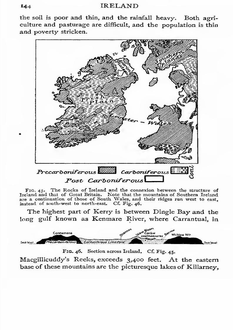
7/30/2019 The Senior Geography 1919
http://slidepdf.com/reader/full/the-senior-geography-1919 160/383
7/30/2019 The Senior Geography 1919
http://slidepdf.com/reader/full/the-senior-geography-1919 161/383
IRELAND 145
the upper lake a valley lake, the lower one a moraine-
dammed island-studded lake of the plains.
The valleys opening east are drained by the Blackwater,
Lee, and Bandon. Each of these rivers turns abruptly at right
angles, reaching the sea by a transverse gorge through the
mountains to the south and not through the eastern continua-
tion of its valley. The lower ends of these gorges are sub-
merged, forming the harbours of Kinsale, Cork, and Youghal.
Of these Cork Harbour is the largest. Queenstown, on an
island in it, is a port of call for Atlantic mail steamers. Cork,
in the fertile Lee valley, is the chief city of southern Ireland,
the market and port of an extensive region, which produces
bacon and dairy produce of all kinds. It is also engaged in
distilling and other industries. A gap in the mountains carries
the railway past Mallow, on the Blackwater, where it crosses
the Killarney-Waterford line, to the Central Plain.
There was early a considerable trade between these ports
and Spain, to which country Ireland frequently looked for
aid in her struggles with England as Scotland looked to
France.
South-east Ireland. The Galty and Knockmealdown
Mountains continue the line of the Kerry and Cork mountains
eastwards. They form the southern margin of the wide fertile
lowlands of the Golden Vale of Tipperary and Limerick,which extends from the Suir to the Shannon. The Suir
rises to the east of the Silvermine Mountains. It flows
first south and then east to Waterford Harbour, which
receives the united waters of the Nore and Barrow, from the
Slieve Bloom Mountains. Tipperary and Cashel are the chief
towns of the Golden Vale. The latter, with the famous Rock
of Cashel (300 feet), was the capital of the Kings of Munster,
whose ruined palace is one of the many antiquities of the town.
Clonmel and Carrick are the chief centres on the Lower Suir,
Kilkenny, on the Nore, near an anthracite coalfield, and
Carlow, on the Barrow, are in the centre of fertile valleys
which formed part of the powerful kingdom of Leinster. In
SEN. GEOG.
7/30/2019 The Senior Geography 1919
http://slidepdf.com/reader/full/the-senior-geography-1919 162/383
146 IRELAND
the Anglo-Norman period the vales of Tipperary and Kilkenny
were studded with castles and abbeys, most ofwhich were ruined
in the civil wars of the sixteenth and seventeenth centuries. The
outlet for the fertile valleys of this region is Waterford, near
the mouth of the Suir, a packet-station in regular com-
munication with England. It is now superseded for passenger
traffic by Rosslare, in south-east Wexford, the port for the
new express route to Fishguard in South Wales. Wexford, on
Wexford Harbour, is the outlet of the fertile valley of the
Slaney, which rises in the Wicklow Mountains, on the southern
margin of the Central Plain. The Wicklow Mountainsresemble those of North Wales, and reach 3,000 feet in
Lugnaquilla. They have been glaciated and contain pic-
turesque valleys and tarns. The most famous vales are those
of Avoca and Arklow.
The Central Lowland is a gently undulating limestone
area, covered by an almost continuous sheet of boulder clay,
the result of former glaciation. It is dotted with small
moraine-dammed lakes. Larger sheets of water occupy rock
hollows formed by the dissolution of the soluble limestone.
Much of the surface consists of bogs with clay bottoms. These
render communication difficult, and except for the peat, which
is cut for fuel, they are unproductive until reclaimed. In
these respects the Central Plain of Ireland is much less suited
for dense settlement than the Central Plain of England.
The Eastern Plain is the best and driest part of this
central lowland. The lakes are comparatively few, but the
Bog of Allen covers a large area in Kildare and Queen's
County. The Eastern Plain is drained east to the Irish Sea
by the Liffey, from the Wicklow Mountains, and the Boyne,
from the Bog of Allen. The Boyne, with its tributaries, is
wholly a river of the plain. Its basin forms the rich lowland
of Meath.
The winters of the Eastern Plain are cold, the summers are
warm, and the rainfall is much less than in the west. Oats,
barley, a little wheat, potatoes, and other root-crops are grown.
7/30/2019 The Senior Geography 1919
http://slidepdf.com/reader/full/the-senior-geography-1919 163/383
IRELAND 147
] n the pastoral districts horse-breeding and cattle-rearing are
important.
The Eastern Plain opens east to the Irish Sea, opposite to
the most westerly extension of the English Plain. It was thus
exposed to invasion from England as soon as a strong central
power was established in the English Plain. This did not
happen till the twelfth century, a century after the Norman
conquest. From the ninth century onwards, however, the shores
of Ireland were ravaged by the Danes, who forced their way
in by Dublin, where the Irish Sea is narrowest, and by such
sea-gates as Waterford in the south and the Shannon estuary
in the west. The Irish power was concentrated on the Eastern
Plain, and the battle which broke the Danish power was fought
at Clontarf, close to Dublin, in 1014. More than a century of
tribal wars followed, chiefly due to the geographical impedi-
ments to unity. The English attack was made when internal
jealousies rendered a combined resistance difficult. The
invaders pressed up the fertile valleys of Leinster to the rich
plains of Kildare and Meath. The choice of Dublin, at once
the nearest point to England and the key of the Eastern
Plain, as the centre of English rule, was due to the political
wisdom of Henry II.
The ebb and flow of English power in Ireland was largely
controlled by the geography of the country, even in its minor
details. The same causes which had led to the rise of rival
chiefs and tribal wars led in the Anglo-Norman period to the
rise of great feudal barons whose authority within their own
realms was more real than that of the King. The royal
authority was little more than nominal outside the Pale, which
roughly correspondedwith the Eastern Plain. The Pale was
but imperfectly defended by the Bog of Allen, and was
also exposed to attack from the south through the defiles of
the Wicklow Mountains, and from the north through the gate
of Dundalk. By the end of the fifteenth century the English
sphere of influence had contracted to a narrow coastal strip
between Dundalk and the Wicklow Mountains. So vital,
7/30/2019 The Senior Geography 1919
http://slidepdf.com/reader/full/the-senior-geography-1919 164/383

7/30/2019 The Senior Geography 1919
http://slidepdf.com/reader/full/the-senior-geography-1919 165/383
IRELAND 149
the Suck on the right, both draining many lakes. Round
Lough Derg is. a crescent of mountain masses, of which the
Slieve Aughty and Silvermine Mountains are the most impor-
tant. The Lower Shannon flows down a steep slope through
the heart of these heights to its long estuary. To explain its
course we must suppose that it originally flowed southwards
before these heights existed, and that it deepened its valley
as fast as they were formed. At the head of the estuary is
Limerick, probably founded by the Danes, engaged in flour-
milling, bacon-curing, and lace-making. It is a considerable
port, and an outlet of the Shannon and the Golden Vale.
As in Great Britain, lost causes have often maintained
themselves in the west, which were the last parts of Ireland to
be conquered by the English. Limerick was the last strong-
hold of James II in the struggle with William III.
In the pastoral region through which the Shannon flows
there are a number of small towns. Athlone, south of Lough
Ree, and Carrick-on-Shannon, at the confluence of the Shannon
and Boyle, control the possible crossing-places of the river
which is broad enough in most of its course to form an effec-
tive natural boundary, separating the provinces of Leinster
and Munster from Connaught (Connacht).
The Western Plain slopes to the west, where the large
lakes of Mask and Corrib, connected by a subterranean stream,
carry the drainage south to Galway Bay. Lough Conn dis-
charges its surplus waters by the Moy to Killala Bay. The
beds of all these lakes have been dissolved in the limestone.
This is a poor region, with a heavy rainfall, and a thin
unprosperous population. Access to the Atlantic is given by
Killala, Clew and Galway Bays, with Ballina, Westport, and
Galway as their respective ports. Galway formerly carried
on a large trade with Spain, and has dwindled in importance
since this ceased.
The Connemara Mountains south of Clew Bay and the
Nephin Beg Mountains north of it, the latter continued by the
rugged Achill Islands, belong to the next region.

7/30/2019 The Senior Geography 1919
http://slidepdf.com/reader/full/the-senior-geography-1919 166/383
150 IRELAND
The Northern Mountains. In this region the south-
west to north-east trend, so characteristic of the feature-lines
of Great Britain, is clearly traceable. The mountains are
much less continuous than in southern Ireland, forming
a number of separate groups with lowlands between.
The Northern Mountains of Ireland are of two different
types. Those in the west and north, bordering the ocean
from Galway Bay to the valley of the Bann, are composed of
old rocks, and resemble the Highlands of Scotland, of which
they are the broken continuation. East of the Bann the
mountains of the north-east are volcanic.
The mountains west of the Bann are broken into many
groups, (i) The boggy infertile Connemara Mountains
(2,400 feet), one of the poorest parts of Ireland, are separated
by {a) Clew Bay from (2) the Nephin Beg Highlands, and
these by {b) the Moy lowlands from (3) the Ox Mountains of
Sligo, between Killala and Sligo Bays. Beyond (c) the Erne
lowland, with Upper and Lower Lough Erne, leading from the
Central Plain to Donegal Bay, rise (4) the Donegal Mountains,
with Derryvreagh and Errigal (3,500 feet). These are sepa-
rated by Lough Swilly from the Innishowen peninsula and by
(d) the Foyle valley and lough from (5) the mountains of
Tyrone and Derry, of which the Sperrin Mountains may be
noted.
This region may be broadly compared with the Scottish
Highlands. Its much more broken character renders com-
munication easier, towns somewhat more numerous, and
population relatively greater. This population, however, is
almost confined to the intervening belts of lowland. Cattle
are bred in the valleys ; sheep are kept in the hill pastures.
In the Foyle valley agriculture is carried on. The moun-
tain regions are infertile and poor. The fine coast and
mountain scenery of Donegal is attracting tourists, and laying
the foundations of an organized tourist industry such as con-
tributes to the prosperity of the Scottish Highlands.
The lowlands afford natural routes, with which the towns
7/30/2019 The Senior Geography 1919
http://slidepdf.com/reader/full/the-senior-geography-1919 167/383
IRELAND 151
are associated. Westport and Ballina have already been
mentioned as gateways to the Central Plain. Sligo is at the
end of a route from the Shannon to Sligo Bay. Ballyshannon,
at the mouth of the Erne, is cut off by rapids from Lough Erne.
Donegal has access to Donegal Bay, and is the terminus of
a route from the Foyle. Londonderry is the outlet for the
Foyle lowland. All these towns are ports. The inland centres
are small. The most important are Enniskillen,between Upper
and Lower Lough Erne, and Strabane, in the Foyle valley.
The North-eastern Mountains and Lowlands. The
widest of the openings from the Central Plain to the north is
by the Bann lowland, where Lough Neagh, the largest lake in
the British Isles, fills an area of over 150 square miles in the
centre. The Bann lowland is blocked to the east by the lava-
capped plateau of Antrim, a continuation of the lava flows of
the Inner Hebrides of Scotland. South of this another low-
land gate opens by the loughs of Larne, Belfast, and Strangford,
the latter bounded by the Ards peninsula, between the Antrim
plateau and the much dissected granitic and volcanic Mourne
Mountains (Slieve Donard, 2,800 feet), which are separated by
Carlingford Lough from the Carlingford Mountains (Slieve
Gullion, 1,900 feet).
This volcanic region of tableland and mountain is a thinly-
peopled sheep-grazing region. The lowlands are cultivated
with cereals (oats, barley), root crops and flax. Fruit orchards
are numerous round Armagh. The linen manufacture is
important in most of the towns.
Associated with the northern gate are Coleraine, at the
mouth of the Bann, with Portrush to the east ; with the south-
western gate Armagh and Monaghan. Round Lough Neagh
or on it are Portadown, Lurgan, and Antrim. The towns of
the eastern gate are Lisburn, Belfast, Carrickfergus, and
Larne, the port for Scotland, and of the south-eastern gate
Newry and Greenore, the port for Holyhead. Canals run
from Lough Neagh by the Lagan to Belfast, to Newry and
westwards across Ulster.
7/30/2019 The Senior Geography 1919
http://slidepdf.com/reader/full/the-senior-geography-1919 168/383
15a IRELAND
The tourist traffic is developing in many seaside resorts,
especially in the Mourne Mountains. Dungannon is the centre
of a small but as yet unimportant coalfield. Most of the coal
and iron used in this region comes from Ayrshire and Cumber-
land through Belfast.
Belfast, the chief port and commercial city of Ireland, is
advantageously situated on the east coast. It obtains cheap
coal from the Scottish and English coalfields nearest to it,
and has easy water communication with many markets. For
the linen manufacture, its leading industry, Belfast has the
advantages of a moist climate suitable for spinning, and water
with fine bleaching properties. Flax is grown locally as well
as imported. Shipbuilding is also an important industry, the
iron being obtained from the Furness district. Distilling and
brewing are carried on with local and imported grain. The
rope manufacture, with hemp from the Baltic, and the tobacco
industry are also prosperous.
Ulster, which includes most of this and of the preceding
region, belonged to the O'Neill princes. At the end of the
sixteenth century O'Neill, Earl of Tyrone, headed a semi-
national movement against the English, and made a long and
obstinate resistance in the country round the south-western
gate, between Lough Neagh and the Erne, an intricate net-
work of rivers, lakes, and woods. Such a region is mosteasily reduced by the systematic devastation of the country
by fire and sword, a process in which the English were soon
aided by famine. To repopulate the country, to restore its
ruined prosperity, and to counterbalance Irish influence, the
best parts of the confiscated O'Neill lands in Armagh, Cavan,
Monaghan, Fermanagh, Tyrone, and Donegal were settled
with Scottish and English colonists. Down and Antrim, both
within a few miles of Scotland, had long attracted settlers
from that country. This plantation of Ulster at the beginning
of the seventeenth century led to economic progress, but sowed
the seeds of fresh trouble. Outside the poorer districts, which
were left to the Irish, Ulster has ever since been opposed to
7/30/2019 The Senior Geography 1919
http://slidepdf.com/reader/full/the-senior-geography-1919 169/383
IRELAND 153
the greater part of Ireland in religious and political sym-
pathies.
From time to time the Irish Catholics have risen in rebellion.
The revolt .which began in 1641 was severelyrepressed by Crom-
well, who extended the plantation system and strengthened
the Protestant ascendancy. The Irish Catholics declared for
the Stuarts at the time of the Revolution, while the Ulster
towns were on the Orange side. Enniskillen and Londonderry
were filled with refugee colonists, the latter city suffering a
long and memorable siege. The rebellion of 1798 was both
a religious and political civil war, in which the better organized
Protestants were victorious. The suppression of this rebellion
was followed by the Act of Union in 1801.
THE ISLANDS NORTH OF BRITAIN.
The recent volcanic rocks, which occur in Antrim and the
Outer Hebrides, can be traced northwards through the Faeroe
Islands and Iceland.
The Faeroe Islands, politically Danish, lie midway
between Scotland, Iceland, and Norway. They are moun-
tainous and rise steeply from the sea. The climate is equable
and wet. Barley and potatoes are the chief crops. Sheep
are kept in the hill pastures. The occupations are those
of the Norwegian coast (see p. 156), from which the Faeroes
were originally settled, but the life is of a more primitive
type.
Iceland lies nearly 600 miles from Norway, and only 150
miles from Greenland. It is larger than Ireland, but has only
one-hundredth part of the population. The coast is pierced
by fiords and bays, with many good harbours. The interior
is a volcanic highland, with peaks reaching 6,000 feet. Signs
of violent volcanic energy are shown by the active volcano of
Hekla (over 5,000 feet), the mud volcanoes, the geysers, or hot-
water volcanoes, and the vast lava-flows of older eruptions.
Owing to the high latitude the snow-line descends in the
7/30/2019 The Senior Geography 1919
http://slidepdf.com/reader/full/the-senior-geography-1919 170/383
154 THE ISLANDS NORTH OF BRITAIN
north-west to 1,500 feet and the valleys are filled with glaciers,
which creep down to the sea. The climate is cool at all
seasons, but the winters are least severe in the south owing to
the warm westerly drift. The island has been cleared of the
sub-arctic forest which once covered it and turf is burned for
fuel. Agriculture is limited to the growing of potatoes
and oats. There is good pasturage in summer, and sheep,
cattle and ponies are bred. Icelandic fishermen visit the
fisheries of the North Sea and of the Atlantic and Arctic
Oceans. The capital is Reykjavik, founded in the ninth
century near the mouth of a fiord on the south-west coast.
It is disputed whether Irish or Norwegian fishermen first
visited Iceland, but the effective colonization was from Norway.
The fisheries were very important in pre-Reformation days.
In the fourteenth century Iceland passed with Norway to
Denmark, which retained it when Norway was united to
Sweden. Iceland has a rich and ancient literature, which
includes the famous sagas or Scandinavian epic legends.
SCANDINAVIA.
The Scandinavian Peninsula. Scandinavia is the
mountainous north-western peninsula of Europe. Structur-
ally it is a link between the north-western highlands of
Britain and the lowlands of Eastern Europe.The Scandinavian peninsula is separated from the mainland
of Europe by the Skagerak and the Kattegat, which divide
it from peninsular Denmark. They lead by the straits of the
Great and Little Belts and the Sound between the Danish
Islands to the shallow Baltic Sea.
Configuration. The east and south are low and flat or
gently undulating. The land rises steadily westwards to a
highland whose western margin, deeply indented by innumer-
able fiords, falls steeply to the North Sea. This western
highland is highest in. the south, where the great masses of
the Hardanger Fjeld, Jostedals Brae, Jotun Fjeld, and Dovre
Fjeld, with Snaehatten (7,570 feet) form a bleak, unfertile, and
7/30/2019 The Senior Geography 1919
http://slidepdf.com/reader/full/the-senior-geography-1919 171/383
SCANDINAVIA 155
uninhabited region. North of the depression of Trondhjem
Fjord is Kjolen or the Keel, where the highland reaches
nearly 7,000 feet before it sinks to the Finmark plateau and
the Arctic Ocean.
The east and west of the Scandinavian peninsula present a
marked contrast. The whole peninsula was covered by the
ice sheet of the Ice Age. In the west and north the rocks
have been left bare, but much of the south and east is covered
with morainic deposits. Some of the low rocky islands of
the eastern skerry guard, or island fringe, have a morainic
covering. The western skerry guard is mountainous, and con-
sists of outlying parts of the mountainous peninsulas separated
from them by the sea, which converted depressions in the land
into sounds. In the north the lofty Lofoten Islands are cut
off from the mainland by the Vestfjord. They resemble the
Outer Hebrides in position and characteristics.
Climate. The contrast between the east and west of the
peninsula extends to the climate. That of the east is
continental, with very cold winters and hot summers. The
rainfall in the east is small and occurs mainly in summer. It
is greater in the south than in the north.
The west has the typical climate of the western storm belt,
with rain at all seasons but most in winter. Here the rainfall
is heaviest in the south, where the land is highest, and least in
the north, which is colder. The winters are remarkably mild
for the latitude. While the Baltic shores are frozen for many
months, those of the west are ice-free even in the extreme
north. This is due to the influence of the west winds which
drive waters from the warmer regions of the ocean in a north-
easterly direction, causing what is often called the Gulf Stream
Drift or the Westerly Wind Drift.
The interior is cool at all seasons and very cold in winter.
In the JStun Fjeld and Jostedals Brae the snow accumulates in
the higher valleys, which are filled by glaciers (see p. 68).
The relatively low Finmark plateau in the north is cold at all
seasons.

7/30/2019 The Senior Geography 1919
http://slidepdf.com/reader/full/the-senior-geography-1919 172/383
156 SCANDINAVIA
Western Scandinavia or Norway. Norway occupies
the steep western slope of the Scandinavian highland. The
fiords which dissect its coast are separated from each other
by high mountain walls, over which the short mountain
torrents fall in lofty cataracts. Communication by land is
extremely difficult. By sea, on the contrary, it is easy. The
skerry guard forms a natural breakwater, and the deep sounds
between the islands and the mainland are generally calm.
These sounds and the fiords opening from them are the real
roads of the country. Compare Fig. 27, p. 85. .
Except in the extreme north, where Finmark is passing into
tundra, agriculture and pasturage are carried on to the very
limited extent permitted by the bare and mountainous
character of the country. In the extreme south is a lower
undulating region, exposed to the westerly winds, where oats
and barley are cultivated in clearings of the heavily forested
land. The capital, Kristiania, at the head of Kristiania Fjord,
is in the centre of this richer . land, across which railways
radiate to the chief towns of Norway and Southern Sweden.
Norway offers an interesting parallel to ancient Phoenicia
( ;ee p. 21). In both cases the character of the interior pre-
vented expansion inland, and the sea offered at once the most
convenient highway and the best means of livelihood. The
Norsemen, like the Phoenicians, and for similar reasons, havebecome a nation of shipbuilders and traders, carrying goods
for countries possessed of greater natural resources. A large
proportion of Norwegian savings is invested in shipping,
and the mercantile marine is very large. The fisheries of the
Lofoten Islands and the more distant fishing-grounds visited
by Norse sailors, supply important exports. The iron mines
of Sweden also find an outlet by the ice-free port of Narvik,
on the Ofoten Fjord, the terminus of a railway from the Baltic.
Both Phoenicia and Norway had to provide for population
when it increased beyond the capacity of the limited home
area. The history of the Phoenician colonies has already
been traced (see p. 22). Similarly the Norsemen became
7/30/2019 The Senior Geography 1919
http://slidepdf.com/reader/full/the-senior-geography-1919 173/383
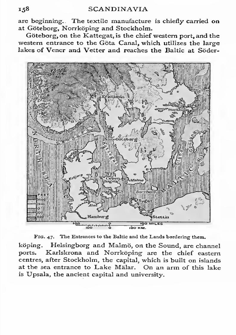
7/30/2019 The Senior Geography 1919
http://slidepdf.com/reader/full/the-senior-geography-1919 174/383
i58 SCANDINAVIA
are beginning. . The textile manufacture is chiefly carried on
at Goteborg, Norrkoping and Stockholm.
Goteborg, on the Kattegat, is the chief western port, and the
western entrance to the Gota Canal, which utilizes the large
lakes of Vener and Vetter and reaches the Baltic at Soder-
Stettin
1^0 MILES
Fig. 47. The Entrances to the Baltic and the Lands bordering them.
koping. Helsingborg and Malmo, on the Sound, are channel
ports. Karlskrona and Norrkoping are the chief eastern
centres, after Stockholm, the capital, which is built on islands
at the sea entrance to Lake Malar. On an arm of this lake
is Upsala, the ancient capital and university.
7/30/2019 The Senior Geography 1919
http://slidepdf.com/reader/full/the-senior-geography-1919 175/383
SCANDINAVIA 159
Throughout this region there is enough fall in the rivers to
give cheap electric power. This is used for various purposes
in towns, on the forest margin in sawmills, and in making
wood-pulp, paper, and joiner work, and above all in the iron
and electro- chemical industries.
North of Lake Malar Sweden consists of two different
regions. A densely forested lowland borders the Baltic.
Above this is a fairly well-marked escarpment, the eastern
edge of the Scandinavian Highlands, which rise through
forested lower slopes to the bare feld of the interior. The
eastern escarpment is notched by steep glaciated U-shaped
valleys (see p. 69). These valleys contain the heads of
picturesque lakes, which resemble Loch Lomond, and like it
are partly in the highland and partly in the lowland area.
North of Lake Malar are two rich iron-ore regions. The
southern lies between Lake Vener, Grangesberg, and Danne-
mora. The northern includes the districts of Gellivara and
Kirunavara, within the Arctic circle, with Lulea as the Baltic
port, and Narvik, in Norway, as the ice-free winter port. All
Lulea iron is manufactured with charcoal.
The Scandinavian Hansa Towns. The Baltic Sea,
which is connected by the straits already mentioned with the
North Sea, is a natural route penetrating far into Eastern
Europe. It forms a northern Mediterranean, but the climate
and character of the surrounding lands are much less favour-
able to dense settlement. From early times a considerable
overland trade was carried on between the Mediterranean and
the Baltic, furs and amber being among the goods carried. In
the Middle Ages the Hanseatic League was formed among the
trading cities of Northern Europe, largely as a protection
against the Scandinavian pirates who infested the North and
Baltic Seas. The Baltic trade was then very rich, for the
Baltic was the only outlet for the furs, hides, tallow, &c, of
Russia, for the metals and timber of Sweden, and for the rich
herring fisheries of the Sound. Visby, well situated on the
island of Gotland in the middle of the Baltic, was the great
7/30/2019 The Senior Geography 1919
http://slidepdf.com/reader/full/the-senior-geography-1919 176/383
i6o SCANDINAVIA
Hansa dep6t, and gave its name to an international maritime
code. Many causes led to the decline of the Hansa power in
the Baltic. The discovery of the sea route to Archangel in
the.middle of the sixteenth century gave Russia an alternative
outlet. Archangel was an important port until the founding
of St. Petersburg brought most of the Russian trade back to
the Baltic. In the fifteenth century the herring began to desert
the Baltic for the North Sea, greatly to the advantage of
Holland. The Reformation decreased the demand for fish,
and for tallow for church candles. Finally the discovery of
the New World made the North Sea ports prosperous at the
expense of their Baltic rivals.
Historical Summary. The history of the Baltic, like
that of the Mediterranean, is extremely complicated. The
ease of communication has led to a continual ebb and flow in
the balance of power. As Norway naturally sought to expand
in the lands bordering the North Sea, the Atlantic, and its
great Mediterranean gulf, so Sweden looked east to the
immense lowlands opening from the Baltic. Her rivals were
Denmark, which held Scania from the ninth to the seventeenth
century, Poland, which reached the Baltic by the Vistula, and
the power which ultimately became Russia (see p. 164). In
the seventeenth century Sweden was at the height of its pros-
perity and was the chief Baltic power, holding much of what is
now Prussia, and Esthonia and Livonia in what is now Russia.
This domain was too large, straggling, and thinly peopled to
be permanently held, and in a relatively short period Sweden
was stripped of the lands outside the peninsula. The founda-
tion of Petrograd was a defensive measure to prevent the
further expansion of Sweden in the eastern Baltic.
There has never been a permanent political union between
Sweden and Norway, which are separated, except in the south,
by a highland barrier, effective because of its infertility rather
than because of its height. Sweden, Norway, and Denmark
were united at the end of the fourteenth century, but in the
sixteenth century Sweden again became politically and econo-

7/30/2019 The Senior Geography 1919
http://slidepdf.com/reader/full/the-senior-geography-1919 177/383
SCANDINAVIA 161
mic^lly independent. At the beginning of the nineteenth
century Norway was separated from Denmark and united to
Sweden. This forced union was ended at the wish of Norway
in1905.
THE RUSSIAN LANDS.
Configuration. On the west, European Russia includes
(1) the eastern portions of the Baltic Heights, and (a) parts
of the Carpathian Foreland. Its geographical unity is based
on the great lowland which stretches from the White to the
Black Sea, and round the southern base of the Urals far into
Asia. The west is the region of diversity ; the centre and
east of uniformity.
The Russian lowland includes European Russia, Turan,
and Western Siberia. East of 90 E. Eastern Siberia rises
in the south to the Central Mountains of Asia, a higher,
broader continuation of the Central European Mountains,
and in the east to the Aldan and Stanovoi Highlands, which
form part of the Central Asiatic Highlands. These fall
steeply to the Sea of Okhotsk, which is enclosed on the
east by the high volcanic peninsula of Kamchatka, connected
through the Kurile Islands with Japan and the volcanic high-
lands of Eastern Asia.
Climateand Products.
Russia has a great range of
climate, from that of the tundra along the Arctic Ocean
to that of the Mediterranean in the south. Owing to the great
distance from the open ocean, and the extension of the land
mass across two continents, the climate is everywhere extreme.
The lowest winter temperatures on record are experienced at
Verkhoyansk in Eastern Siberia (67° 33' N. lat. 133° 51' E.
long.) where a temperature of — 92° F. has been recorded. This
is sometimes called the Earth's pole of cold. The January
isotherm of 3a F.vfrost) cuts the Black and 'Caspian Seas, and
the rivers flowing to them are ice-bound in winter. In Asia
it passes south of the southern border of the Empire. Over
much of the region the summer temperature is from 70 to
8o°. climate is everywhere dry.
7/30/2019 The Senior Geography 1919
http://slidepdf.com/reader/full/the-senior-geography-1919 178/383
i6a THE RUSSIAN LANDS
The zones of tundra (see p. i), taiga (p. 5) and steppe
(p. 5) are well marked, stretching as broad belts from west
to east. The northern limit of the forest is broadly that of
the glacial soil left by the European ice-sheet. The most
fertile part of the steppe is the Black Earth zone, south of
the forest belt, where- wheat and rye are grown—the former
for export, the latter for local consumption and distilling.
Round the depression of the Caspian and Aral Seas the
steppe is salt and infertile.
The Lowlands of European Russia. Russia is not
a uniform plain. The livers cut deep ravines and those
flowing south have usually a high right and a low left bank.
The low Valdai Hills (1,100 feet) form the orographical centre.
To them converge lines of low heights separating the river
basins. The Baltic Heights are continued east through
Kurland, Livonia, and Esthonia. Between the Pripet or
Rokitno swamp, drained to the Baltic and Black Seas, and
the Valdai Hills, are the low West Russian Heights, drained
to the Baltic by the Niemen, Western Dvina, and Volkhov,
and to the Black Sea by the Dnieper. East of the Valdai
the North Russian Heights can be traced to the Urals,
and separate the Northern Dvina and Pechora, flowing to
the Arctic Ocean, from the Volga, flowing to the Caspian.
Between the Volga and the Dnieper are the Central Russian
and Volga Heights, the latter forming the high right bank
of the Volga. Between them is the valley of the Don.
Though swellings rather than well-marked heights these
southern heights suffice to turn the Don and Dnieper east
in their southern courses, bringing the Don within 40 miles
of the Volga, and giving the landlocked Caspian relatively
easy communication with the Black and Mediterranean
Seas. Water communication is everywhere easy in Russia
in summer, the rivers either rising in the same marshes or
approaching each other in other parts of their course. This
has facilitated the construction of canals.
The chief obstructions to communication are forests and
7/30/2019 The Senior Geography 1919
http://slidepdf.com/reader/full/the-senior-geography-1919 179/383
7/30/2019 The Senior Geography 1919
http://slidepdf.com/reader/full/the-senior-geography-1919 180/383
i64 THE RUSSIAN LANDS
Volga as well as to the Baltic. It early became a Hansa
town, and the great market of north-east Europe. Kiev,
built on heights above the Dnieper, opposite the confluence
of the Desna, also had easy access to the Volga. Moscow,
the third centre, was founded by settlers from Kiev, on
heights above the Moskva, a sub-tributary of the Volga,
midway between the White, Baltic, Black, and Caspian Seas.
Six railways enter it to-day, a proof of its natural advantages
as a route centre. Its rapid «growth showed that there was
room for a power east of the existing European centres, with
the Volga as its highway. The picturesque Kremlin, with its
palaces, churches and forts, was built on a height on the left
bank in 1300, and a few years later Moscow became the
ecclesiastical capital. In the preceding century Mongol
invaders poured into Russia by the steppe and exacted
homage from the Russian princes. Their actual settlement
was confined to the steppe, where Kazan and Tsaritsin
were their centres. In the fourteenth century they lost Kiev
to the Lithuanians, then expanding along the Karpathian
foreland. In the fifteenth century Ivan the Great crushed
Novgorod and other rivals, revolted against the Mongols, and
made Moscow the capital of Muscovy, which extended to the
White Sea. In the following century Ivan the Terrible
assumed the title of Tsar, drove the Mongols from Kazanand Astrakhan, and extended his dominions to the Black and
Caspian Seas, and into Siberia. At the end of the sixteenth
century Russia marched with (1) Sweden, from whom the
Baltic provinces were won a century later, (a) Poland, whose
partition in the eighteenth century gave Russia the Vistula and
the Carpathian provinces, and (3) Turkey, at whose expense
Russia expanded to the B^ack Sea. Finland was added early
in the nineteenth century, since when Russian extension has
been chiefly in Asia.
Northern Russia. Northern Russia sinks from the North
Russian Heights to the depression between the Gulf of Finland
and the White Sea. The soil is cold and marshy, and the
7/30/2019 The Senior Geography 1919
http://slidepdf.com/reader/full/the-senior-geography-1919 181/383
THE RUSSIAN LANDS 165
climate severe. The southern part is forest, the northern
tundra. Archangel, long the only Russian port, is ice-bound
from September to July. It exports the produce of the
forests (timber, pitch, tar), fisheries (train oil), and grain
brought from Siberia by a line to Kotlas on the Northern
Dvina.
Finland. Finland is an undulating plateau, covered with
forests, lakes and swamps, and passing into tundra in the
north. The clearings are meadows, in which dairy cattle
are bred. In the north the reindeer is the only domesticated
animal. The rivers have sufficient fall to provide water and
electric power for saw, pulping, and paper-mills. Other forest
produce is timber, pitch, and resin. Helsingfors is the capital,
and Abo the second town and port.
The Baltic Provinces. These resemble the adjoining
parts of Germany, and consist of a forested lakeland, with
a poor glacial soil, in which coarser plants (hemp, sugar-beet,
rye) do best. The scanty population is confined to the valleys
and coast towns. From < the forests much timber is floated
down to the Baltic. Revel, in Esthonia, Riga, in Livonia,
and Libava, in Kurland, give Russia Baltic outlets for her
Siberian produce. To Russianize this region, then lately
conquered, Petrograd was built early in the eighteenth
century in the Neva marshes. It is now joined to the Gulf
of Finland by ship-canal. It is the capital and administrative
centre, and has important manufactures. The entrance
to the Neva, which is frozen in winter, is defended by
Kronstadt.
Poland, Volhynia, Podolia, Little Russia. Poland
consists of the plains of the Vistula at the base of the
Carpathian foreland. The forests send timber down the
Vistula to the Baltic. Flax and hemp are largely grown.
The minerals include coal, making Poland an industrial and
thickly-peopled region. Lodz is one of the great textile
centres of Europe. The capital is Warsaw, a centre of
routes, railways, and manufactures. Little Russia, including
7/30/2019 The Senior Geography 1919
http://slidepdf.com/reader/full/the-senior-geography-1919 182/383
166 THE RUSSIAN LANDS
Ukraine, is in the rich Black Earth zone, where vast crops of
cereals are grown. There is coal in the Donets basin, where
Kharkov is the chief manufacturing town.
New Russia. The steppes round the Black Sea are
less fertile, and the keeping of animals replaces agriculture.
Odessa, built on the high edge of the steppe where it reaches
the Black Sea, has an immense trade in steppe products.
The agricultural steppes supply grain, flour, and starch.
The pastoral steppes supply leather and soap, which is made
from mare's milk. Kherson, the outlet of the Dnieper, has
a great wool-cleaning industry, and manufactures soap andtallow. Rostov draws from the agricultural steppes the
raw material for maccaroni, and from the pastoral that for
its leather and soap manufactures.
Crimea. In the south the Crimea is mountainous, and
in the sheltered valleys which open to the south all kinds of
Mediterranean products flourish. It is the Riviera of Russia.
Sevastopol is a strongly fortified harbour at the western end
of the Yaila mountains.
Central Russia consists of heights drained north by the
Oka to the Volga. Orel, Tula, and Moscow are centres of an
industrial and thickly-peopled coalfield. The varied industries
of Moscow include textiles, especially cotton from Russian
Central Asia, metal industries, machinery and carriages, papermade of wood-pulp from the forest region, tanning and shoe
manufactures from hides from the steppes. It is also a great
distributing centre, especially for tea.
The Upper Volga and Kama Basin is a wedge of
lowland between the Urals, drained by the Kama, and the
North Russian and Volga Heights. It is in the heart of
the forest region, and rivers are the chief means of com-
munication. Much traffic comes down the Kama and Volga
for Moscow, on the margin of this region, and Petrograd,
which is connected with the Volga by canals. The towns are
all on rivers. Nizhni Novgorod, at the confluence of the Oka,
rose in commercial importance after the fall of Kazan. At

7/30/2019 The Senior Geography 1919
http://slidepdf.com/reader/full/the-senior-geography-1919 183/383
7/30/2019 The Senior Geography 1919
http://slidepdf.com/reader/full/the-senior-geography-1919 184/383
i68 THE RUSSIAN LANDS
Orenburg at the base of the Urals to the steppes of Central
Asia, and also on the great railway to Siberia. Saratov is in
the heart of the Black Earth region. Tsaritsin is only forty
miles from the Don, with which it is connected by rail. The
Volga is here sixty feet below sea-level, and enters the Caspian
by a marshy delta. The settled population of the Lower
Volga is small. Nomadic tribes follow their herds from
pasture to pasture. The sturgeon and seal fisheries of the
Caspian are important. Caviar, made from sturgeon roe, is
exported from Astrakhan, the port of the Caspian, which
is connected by river and canal with the distant Baltic.
The Caucasus and Transcaucasia. The depression
between the Azov and Caspian Seas rises in the south-west
to the Caucasus, which stretches from the Black to the
Caspian Sea, forming a formidable barrier between north
and south. It is a wild region of rugged parallel ranges,
densely forested in the valleys and on the southern slopes,
with glaciers in the higher valleys. Elbruz, an extinct
volcano (18,470 feet) is the highest point, but many summits
nearly reach 17,000 feet. Vladikavkaz, on the Terek, which
drains the steep northern face, is a Russian trade and military
centre. It commands the route by the Dariel or Cross
Mountain Pass to Tiflis, the old capital of Georgia, in the
ravine of the Kur, between the Caucasus and the ArmenianMountains. The lower Kur valley is a broad fertile lowland
opening to the Caspian, with Baku in the north as the outlet
for a rich oil region. At the Dariel Pass the Caucasus is
only sixty miles wide, but the railway from Vladikavkaz to
Tiflis has to skirt the northern and eastern base of the moun-
tains to Baku, and reach Tiflis up the Kur valley, a detour
of several hundred miles. From Tiflis the line is continued
west to the Rion valley for Poti and Batum, the Black Sea
ports. The Kur and Rion drain the high plateau of Georgia,
which connects the Caucasus with the Armenian Plateau.
Erivan, at the foot of Ararat, is the centre of difficult routes
between Asia Minor and Persia. Everywhere in this region
7/30/2019 The Senior Geography 1919
http://slidepdf.com/reader/full/the-senior-geography-1919 185/383

7/30/2019 The Senior Geography 1919
http://slidepdf.com/reader/full/the-senior-geography-1919 186/383
170 THE RUSSIAN LANDS
communication. These are the deserts and poor steppes round
the Caspian and Aral Seas in the north, and the high mountains
to the south and east. They thus form the easiest route
between the Caspian and the Far East. Beyond Ferghana
the route either passes to the Tarim basin of Chinese Turkestan
over high and difficult passes, or goes by Lake Balkash to the
Zungarian Gate between the Altai and the Tian Shan. The
former was the old trade route between Assyria and the jade
quarries in Southern Turkestan, which was followed and
described by the Venetian traveller Marco Polo in the
thirteenth century. Invaderafter
invader has sweptover the
oases of Turan, destroying and rebuilding their cities. Merv
is one of the oldest cities in Asia. Here the route from
Bokhara to Meshed, the capital of Khorasan, intersects that
from Khiva to Herat, in Afghanistan, the latter one of the keys
of India. The surrounding country is covered by the ruins of
its predecessors. Alexander the Great, who reached Turan
from Afghanistan (see p. 178), destroyed Samarkand and other
cities, and founded many others. The Arab conquest of the
eighth century A. D., was made by the passes from Khorasan.
Bokhara and Samarkand became centres of Mohammedan
learning, but during the Mongol invasions of the thirteenth
century their famous libraries were burned. Their glory revived
whenTamerlane, the greatest of the Mongols,
made Samarkandhis capital and adorned it with splendid buildings. In the
fifteenth century it had famous schools of astronomy and
mathematics. As the Mongol power declined their empire in
Turan broke into small units, each based on the possession of
an oasis. All these have been absorbed by Russia during the
last half century, the local ruler being in some cases recognized.
New Russian towns are growing up beside the old cities, whose
names they bear. The old caravan routes are largely super-
seded by the Transcaspian Railway.
Western Siberia. The Urals form the conventional
boundary between Europe and Asia, though they do not
interrupt the continuity of climate and vegetation in the low-

7/30/2019 The Senior Geography 1919
http://slidepdf.com/reader/full/the-senior-geography-1919 187/383
THE RUSSIAN LANDS 171
lands on either side. They rise gently on the European side,
but slope more steeply to the Siberian lowland on the east.
The passes across them are numerous and easy, and they offer
no serious obstruction to communication. The central Urals
are forested and are rich in minerals, especially gold, platinum,
and coal.
Roughly parallel to the Urals is the line of the Tobol and
Lower Ob, the lowest part of Western Siberia, to which flow,
from the Altai, the Irtish and Upper Ob, navigable respectively
to Semipalatinsk and Barnaul in the dry steppes at the base
of the mountains. As early as the sixteenth century the
Russians defeated the Mongols on the Tobol, and they never
lost the footing thus gained. Tobolsk was long the adminis-
trative centre of Siberia. Situated at the confluence of the
Tobol and Irtish, it commanded routes to the fertile Kirghiz
steppe as well as to the Zungarian Gate and the Far East.
The climate of Western Siberia resembles that of Russia,
but with greater extremes of climate, and still less rain. The
rain falls chiefly in summer. Along the Arctic Ocean the tundra
is inhabited by nomadic tribes, who live by keeping reindeer
and fishing. The forest zone supplies furs. As communications
improve the forests will yield valuable timber, but it cannot
be cheaply transported by floating down stream, as the rivers
flow away from the centres of population. The impedi-
ments to communication are forests and marshes. The whole
of Western Siberia is of comparatively recent formation, and
as yet imperfectly drained. The routes, therefore, whether of
the invading Mongols or of the modern railway, are forced
south to the firmer ground north of the Kirghiz steppe. This
the railway traverses, crossing the Irtish at Omsk. Omsk is
the centre of the agricultural region of Siberia, where rich
harvests are reaped in the virgin Black Earth. Stock-keeping
and dairy-farming "are rapidly developing, and excellent meat
and butter are exported. The nomadic Kirghiz, with their
primitive mode of life, are gradually being pressed south into
the less fertile steppes by Russian settlers.

7/30/2019 The Senior Geography 1919
http://slidepdf.com/reader/full/the-senior-geography-1919 188/383
l?3 THE RUSSIAN LANDS
Eastern Siberia. The divide between the Ob and the
Yenisei is close to the left bank of the latter, which runs almost
due north from the Sayan Mountains to the Arctic Ocean,
receiving all its tributaries from the east. The most important
is the Angara, which rises in the highlands north of Mongolia,
and flows through the rift filled by Lake Baikal, one of the
deepest freshwater lakes in the world. Close to its western
shores are the headwaters of the Lena, flowing first north-east
and then north to the Arctic Ocean, and like all Siberian rivers
receiving its principal tributaries from the east. Beyond the
Heights in feet above
iealevet
0-GOO600-3000
[
Over 3000
NovaZeirib]a
FIG. 49. Lowlands of Northern Asia.
Lena, in north-east Siberia, a crescent of mountains with the
long slope to the north is drained by considerable rivers to
the Arctic Ocean.
Eastern Siberia, between the Yenisei and the Lena, is a low
plateau, above which rise tabular volcanic heights. The climate
is dry and extreme. At Verkhoyansk, inside the mountain
crescent,the averageJanuarytemperature is — 6i-a°F., the lowest
in the world, the average July temperature is 58-6° F., and the
range is 120 F°., the greatest known. Eastern Siberia lies wholly
in the tundra and forest zones. In the south it rises rapidly to the
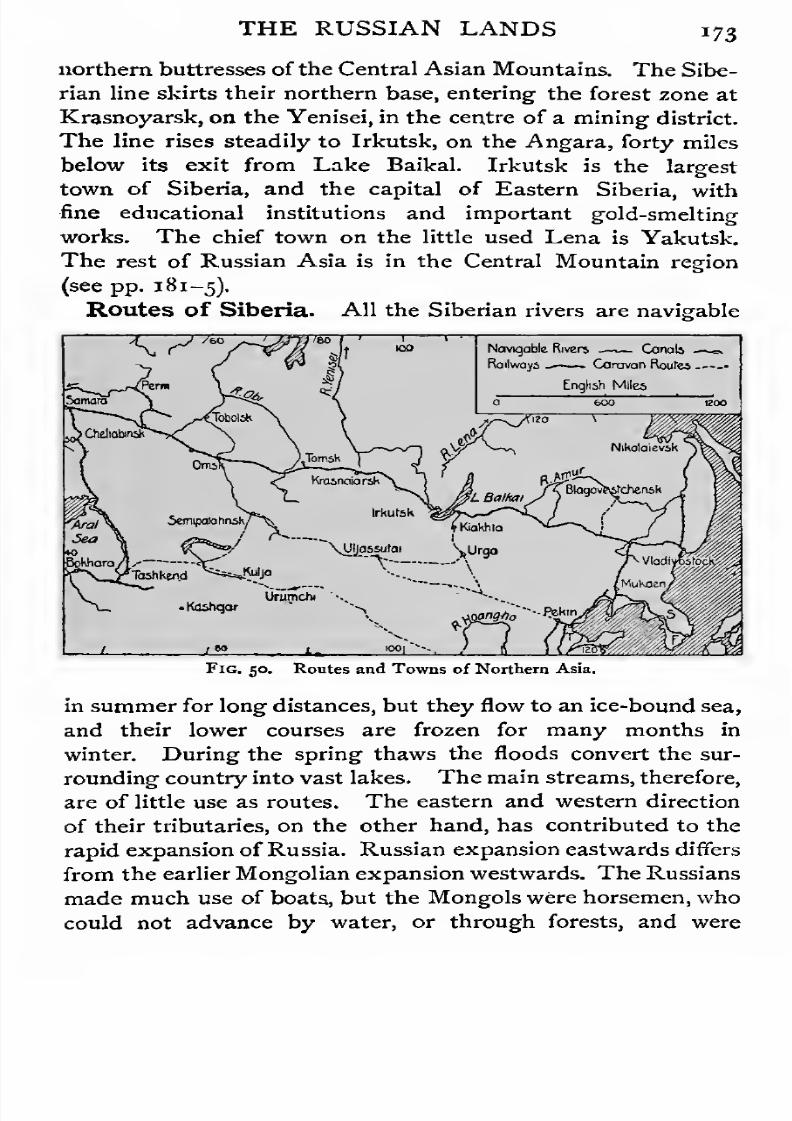
7/30/2019 The Senior Geography 1919
http://slidepdf.com/reader/full/the-senior-geography-1919 189/383
THE RUSSIAN LANDS 173
northern buttresses of the Central Asian Mountains. The Sibe-
rian line skirts their northern base, entering the forest zone at
Krasnoyarsk, on the Yenisei, in the centre of a mining district.
The line rises steadily to Irkutsk, on the Angara, forty miles
below its exit from Lake Baikal. Irkutsk is the largest
town of Siberia, and the capital of Eastern Siberia, with
fine educational institutions and important gold-smelting
works. The chief town on the little used Lena is Yakutsk.
The rest of Russian Asia is in the Central Mountain region
(see pp. 181-5).
Routes of Siberia. All the Siberian rivers are navigable
Fig. 50. Routes and Towns of Northern Asia.
in summer for long distances, but they flow to an ice-bound sea,
and their lower courses are frozen for many months in
winter. During the spring thaws the floods convert the sur-
rounding country into vast lakes. The main streams, therefore,
are of little use as routes. The eastern and western direction
of their tributaries, on the other hand, has contributed to the
rapid expansion of Russia. Russian expansion eastwards differs
from the earlier Mongolian expansion westwards. The Russians
made much use of boats., but the Mongols were horsemen, who
could not advance by water, or through forests, and were

7/30/2019 The Senior Geography 1919
http://slidepdf.com/reader/full/the-senior-geography-1919 190/383
i74 THE RUSSIAN LANDS
obliged to keep south along the steppe which supplied firm
ground and pasture.
The Siberian routes are difficult during the severe winters,
when the country is covered by snow. Water for the train
has to be brought hot, lest it should freeze on the way. Long
icicles of frozen steam gather on the engines. On the other
hand, meat and butter can be transported without refrigerating
cars, which are necessary in summer. In winter the steppe is
impassable for horsemen, and many nomadic tribes settle down
in rude villages.
THE CENTRAL MOUNTAIN BARRIER.
The Mid-World Mountains. Asia, like Europe, is crossed
from east to west by a mountain barrier which interrupts com-
munication between north and south. The Central Mountains
ofAsia are a continuation ofthose of Europe and North Africa,
the whole forming the Mid-World Mountain'System.
The Mid-World Mountains have already been traced from
the western extremity of the Mediterranean through the moun-
tains of Asia Minor to the Armenian Plateau, with which the
Caucasus is connected (see p. 168). In this Armenian moun-
tain centre the Euphrates and Tigris rise. Their broad
lower valleys form Mesopotamia, a fertile lowland opening tothe Persian Gulf between the tableland of Arabia and the
mountains of Western Iran. The breadth of the mountain
barrier between the lowlands of Turan and Mesopotamia is
under 400 miles.
Iran. Eastwards from the Armenian plateau ranges diverge
north and south, enclosing the lofty plateau of Iran, which
has an elevation of about 3,000 feet. Here the mountain barrier,
between Turan and the Arabian Gulf, is over 800 miles broad.
Iran is divided politically into Persia in the west, and
Afghanistan and British Baluchistan in the east.
Western Iran. The mountain barrier is difficult to cross.
Routes run from Trebizond, on the Black Sea, by Erzerum, and

7/30/2019 The Senior Geography 1919
http://slidepdf.com/reader/full/the-senior-geography-1919 191/383
THE CENTRAL MOUNTAIN BARRIER 175
from Tiflis by Erivan, to Tabriz (4,500 feet), the chief town of
Persian Armenia. On the north the Iran plateau is bordered
. 500 M.
BOO AC
Fig. 51, TheMountain
Barriers of CentralAsia
(western part).
by the Elburz Mountains, with the volcanic cone of Dema-
vend (19,000 feet). Sloping steeply to the Caspian Sea, this
? 3000-IZOOO "<?.. ffOJ^0-3OOQ "t> tt>() eooJC
Fig, 52. The Mountain Barriers of Central Asia (eastern part).
lofty range, which in parts is 306 miles broad, intercepts all
the rainy winds from the north, rendering the interior of Iran
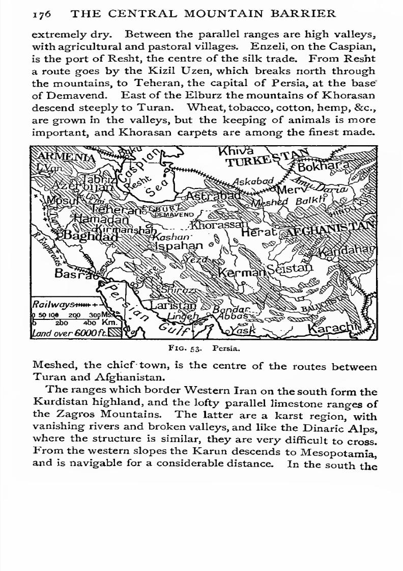
7/30/2019 The Senior Geography 1919
http://slidepdf.com/reader/full/the-senior-geography-1919 192/383
176 THE CENTRAL MOUNTAIN BARRIER
extremely dry. Between the parallel ranges are high valleys,
with agricultural and pastoral villages. Enzeli, on the Caspian,
is the port of Resht, the centre of the silk trade. From Resht
a route goes by the Kizil Uzen, which breaks north through
the mountains, to Teheran, the capital of Persia, at the base'
of Demavend. East of the Elburz the mountains of Khorasan
descend steeply to Turan. Wheat, tobacco, cotton, hemp, &c,
are grown in the valleys, but the keeping of animals is more
important, and Khorasan carpets are among the finest made.
Railwqystmn
a so iq» 200 3opMSq:
ti 2bo Abo Km.
Land over £000 ft.
Fig. 53. Persia.
Meshed, the chief- town, is the centre of the routes between
Turan and Afghanistan.
The ranges which border Western Iran on the south form the
Kurdistan highland, and the lofty parallel limestone ranges of
the Zagros Mountains. The latter are a karst region, with
vanishing rivers and broken valleys, and like the Dinaric Alps,
where the structure is similar, they are very difficult to cross.
From the western slopes the Karun descends to Mesopotamiaand is navigable for a considerable distance. In the south the
7/30/2019 The Senior Geography 1919
http://slidepdf.com/reader/full/the-senior-geography-1919 193/383
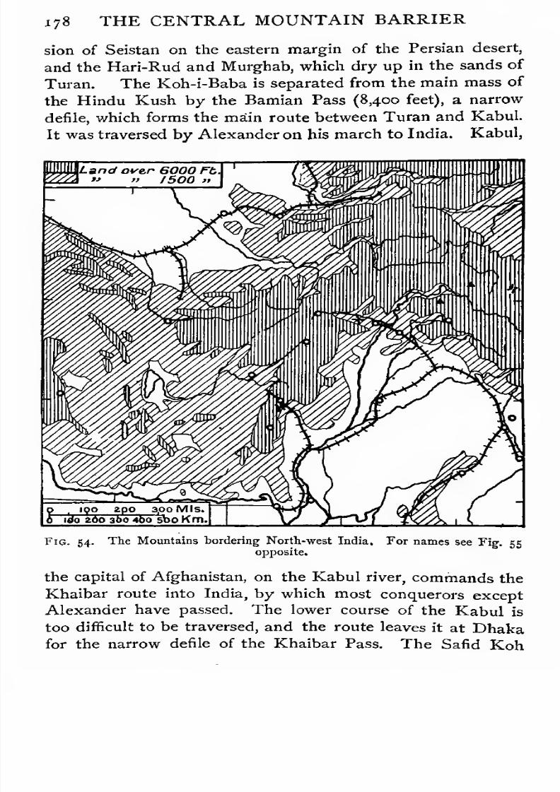
7/30/2019 The Senior Geography 1919
http://slidepdf.com/reader/full/the-senior-geography-1919 194/383
178 THE CENTRAL MOUNTAIN BARRIER
sion of Seistan on the eastern margin of the Persian desert,
and the Hari-Rud and Murghab, which dry up in the sands of
Turan. The Koh-i-Baba is separated from the main mass of
the Hindu Kush by the Bamian Pass (8,400 feet), a narrow
defile, which forms the main route between Turan and Kabul.
It was traversed by Alexander on his march to India. Kabul,
IQO 2p0 3,0 Mls<
tee zoo 300 4bo 500 Km.
Fig. 54. The Mountains bordering North-west India. For names see Fig. 55
opposite.
the capital of Afghanistan, on the Kabul river, commands the
Khaibar route into India, by which most conquerors except
Alexander have passed. The lower course of the Kabul is
too difficult to be traversed, and the route leaves it at Dhaka
for the narrow defile of the Khaibar Pass. The Sand Koh
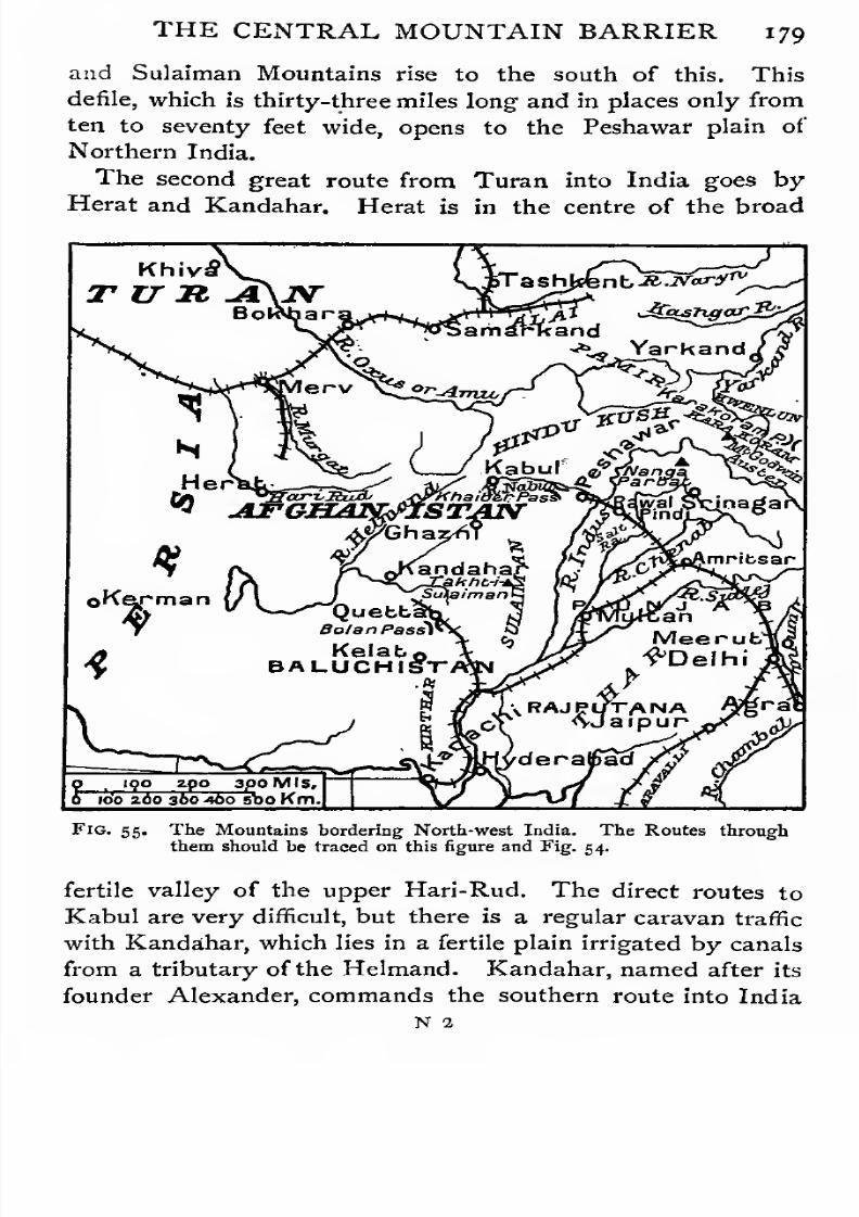
7/30/2019 The Senior Geography 1919
http://slidepdf.com/reader/full/the-senior-geography-1919 195/383
7/30/2019 The Senior Geography 1919
http://slidepdf.com/reader/full/the-senior-geography-1919 196/383
180 THE CENTRAL MOUNTAIN BARRIER
by Quetta, the capital of British Baluchistan, and the Bolan
Pass (5,800 feet) to the middle Indus. This route will ulti-
mately be followed by a railway. The British line from India
is already carried beyond Quetta, and there is a branch from
the Russian Transcaspian railway in the direction of Herat.
Climate and Products. The high elevation of Iran, from
which high mountains on every side exclude all rainy winds,
is everywhere dry and extreme. Enough snow falls on the
mountains to feed streams which almost without exception are
lost in the desert. Their upper courses are utilized for irriga-
tion by constructing underground channels, to prevent waste
through evaporation. This partly explains the high elevation
at which many towns are built (Ispahan and Kerman, 5,500
feet ; Teheran, 4,000 feet ; Kabul, 7,200 feet). When irri-
gated, the soil is very fertile, and fruits come to perfection
(vine, orange, pomegranate, mulberry, apricot, peach, quince,
plum, pear, almond, pistachio, walnut). The Persian roses are
famous. Except in the irrigated areas Iran, if inhabited at
all, is pastoral. The wool and hair of sheep, camels, and goats
is made into famous carpets and shawls. Trade is chiefly by
camel caravans, and roads hardly exist.
Historical Summary. Notwithstanding the difficulty of
the routes across and out of it, the Iran plateau early became
the seat of a great empire. Under Cyrus (about 550 B. C.) and
his successors the hardy mountain warriors pushed their way
by the routes described into the fertile lowlands beyond,
reaching the plains of India in the south-east, and Mesopo-
tamia, Asia Minor, Syria, and Egypt in the west. From Asia
Minor they crossed the Hellespont, and attacked Greece.
Victory would have given them the command of the Eastern
Mediterranean, but they were decisively defeated both on sea
and land at the beginning of the fifth century B. C. A century
and a half later Alexander extended his empire over Asia
Minor and Iran, and into the marginal lowlands ofTuran and
the Indus. Parthians, Saracens, Turks, and Mongols were
among the later conquerors. Whenever the power on the
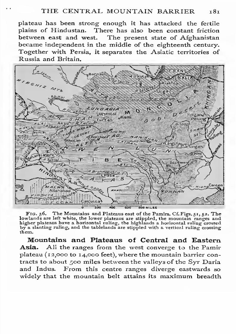
7/30/2019 The Senior Geography 1919
http://slidepdf.com/reader/full/the-senior-geography-1919 197/383
THE CENTRAL MOUNTAIN BARRIER
plateau has been strong enough it has attacked the fertile
plains of Hindustan. There has also been constant friction
between east and west. The present state of Afghanistan
became independent in the middle of the eighteenth century.Together with Persia, it separates the Asiatic territories of
Russia and Britain.
Fig. 56. The Mountains and Plateaus east of the Pamirs. Cf.Figs. 51, 52. Thelowlands are left white, the lower plateaus are stippled, the mountain ranges and
higher plateaus have a horizontal ruling, the highlands a horizontal ruling crossed
by a slanting ruling, and the tablelands are stippled with a vertical ruling crossing
them.
Mountains and Plateaus of Central and Eastern
Asia. All the ranges from the west converge to the Pamir
plateau (1 2,000 to 14,000 feet), where the mountain barrier con-
tracts to about 500 miles between the valleys of the Syr Daria
and Indus. From this centre ranges diverge eastwards so
widely that the mountain belt attains its maximum breadth
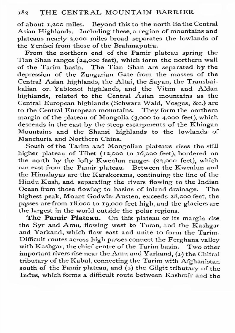
7/30/2019 The Senior Geography 1919
http://slidepdf.com/reader/full/the-senior-geography-1919 198/383
i8u THE CENTRAL MOUNTAIN BARRIER
of about 1,300 miles. Beyond this to the north lie the Central
Asian Highlands. Including these, a region of mountains and
plateaus nearly 2,000 miles broad separates the lowlands of
the Yenisei from those of the Brahmaputra.From the northern end of the Pamir plateau spring the
Tian Shan ranges (34,000 feet), which form the northern wall
of the Tarim basin. The Tian Shan are separated by the
depression of the Zungarian Gate from the masses of the
Central Asian highlands, the Altai, the Sayan, the Transbai-
kalian or. Yablonoi highlands, and the Vitim and Aldan
highlands, related to the Central Asian mountains as the
Central European highlands (Schwarz Wald, Vosges, &c.) are
to the Central European mountains. They form the northern
margin of the plateau of Mongolia (3,000 to 4,000 feet), which
descends in the east by the steep escarpments of the Khingan
Mountains and the Shansi highlands to the lowlands of
Manchuria and Northern China.
South of the Tarim and Mongolian plateaus rises the still
higher plateau of Tibet (12,000 to 16,000 feet), bordered on
the north by the lofty Kwenlun ranges (23,000 feet), which
run east from the Pamir plateau. Between the Kwenlun and
the Himalayas are the Karakorams, continuing the line of the
Hindu Kush, and separating the rivers flowing to the Indian
Ocean from those flowing to basins of inland drainage. The
highest peak, Mount Godwin-Austen, exceeds 28,000 feet, the
passes are from 18,000 to 19,000 feet high, and the glaciers are
the largest in the world outside the polar regions.
The Pamir Plateau. On this plateau or its margin rise
the Syr and Amu, flowing west to Turan, and the Kashgar
and Yarkand, which flow east and unite to form the Tarim.
Difficult routes across high passes connect the Ferghana valley
with Kashgar, the chief centre of the Tarim basin. Two other
important rivers rise near the Amu and Yarkand, (1) the Chitral
tributary of the Kabul, connecting the Tarim with Afghanistan
south of the Pamir plateau, and (2) the Gilgit tributary of the
Indus, which forms a difficult route between Kashmir and the
7/30/2019 The Senior Geography 1919
http://slidepdf.com/reader/full/the-senior-geography-1919 199/383

7/30/2019 The Senior Geography 1919
http://slidepdf.com/reader/full/the-senior-geography-1919 200/383
1 84 THE CENTRAL MOUNTAIN BARRIER
south it is crossed by the great loop of the middle Hwangho,
which surrounds the Ordos desert. Enclosed on all sides by
high mountains, Mongolia has a dry extreme climate. Much
of it is desert, as in the Gobi or Shamo. The rest is poorsteppe. The inhabitants are wandering pastoral tribes.
Urga, the only important town, is the northern capital of the
Buddhist faith.
Routes across the Northern Plateaus. Across these
desert plateaus the routes are followed from oasis to oasis by
camel caravans. The ancient jade route starts from Kashgar,
and goes by Yarkand and the oases at the northern base of the
Xwenlun to the Hwangho, which it crosses at Lanchou, where
the river leaves the Tibetan plateau. This route was followed
by Marco Polo in the thirteenth century. Another route
follows the oases south of the Tian Shan to Hami, where
it crosses the desert at its narrowest and least arid part, and
joins the southern route at the western end of the Nan Shan,an outlier of the Kwenlun. The third route is by Zungaria,
on which no passes need be crossed to reach the Mongolian
plateau from the steppes. This goes through Urumtsi and
the other oases north of the Tian Shan, and joins the second
route at Hami.
The route from Siberia to China is from Kiakhta, south of
Lake Baikal, by Urga across the desert to Kalgan, where the
descent begins to Peking and the plains of North China.
The Northern Plateaus in History. Northern Mon-
golia has always been the home of nomadic tribes, who, as
population increased, trekked off in great swarms, with their
families and their animals, to seek new homes. Accustomed
to the saddle, to tent life, and to simple fare, they proved veryformidable when they came in conflict with settled agricultural
peoples. The early middle ages saw a great outburst of
Mongol energy under a succession of capable leaders. Genghiz
Khan, early in the thirteenth century, established his perma-
nent camp at Karakoram, in Northern Mongolia, now buried
in the sands. He overran much of China, and pushed his way

7/30/2019 The Senior Geography 1919
http://slidepdf.com/reader/full/the-senior-geography-1919 201/383
THE CENTRAL MOUNTAIN BARRIER 185
west by Zungaria to the oases of Turan and the routes leading
from them. Following the richer steppes, the Mongols reached
Hungary and Moravia in the middle of the thirteenth century,
and overran Russia. A number of centres of Mongol powerwere thus formed, often hostile to each other. Another great
wave of conquest occurred in the following century, when
Tamerlane, whose capital was at Samarkand, reached the
Mediterranean and the Ganges. In the sixteenth century
Baber, a descendant of Genghiz Khan, invaded India, and
founded the Mogul Empire. The Mongols conquered rapidly
owing to their extreme mobility, but they failed to make
lasting conquests because they are not, like agricultural people,
rooted to the soil. The latter have always, after an interval,
either absorbed them or beaten them back to the poorer steppes,
where their mode of life suits the geographical conditions.
Thus the Chinese in the fifteenth century drove them out of
China and across Mongolia to the Altai, making Mongoliaa Chinese province. A century or so later Russia began
to push them east once more. A peaceful invasion is
now in progress. Chinese farmers are settling in the valleys
leading up to Mongolia. Another stream of colonization has
gradually crept across the desert to the Hi valley, where
Chinese are numerous. At the same time, Russian settlers
have pushed in from the north.
The Southern Plateau. The high passes of the Kwenlun
lead to Northern Tibet, a high, bleak, uninhabited region of
parallel mountains and valleys, swept by icy gales at all seasons.
In the east these parallel ranges begin to trend east and
south. They are separated by inaccessible and unexplored
gorges, filled by the upper tributaries of (1) the Hwangho, whichsoon turns north and east, (2) the Yangtsekiang, which also
eventually flows east, and (3) the Mekong and Salwin, which
flow south between the ranges of the mountainous peninsula of
Indo- China. The South China highlands lie south of the
Yangtse, but are not a "continuation of the Central Mountains.
The southern margin of Tibet is formed by the great range of

7/30/2019 The Senior Geography 1919
http://slidepdf.com/reader/full/the-senior-geography-1919 202/383
1 86 THE CENTRAL MOUNTAIN BARRIER
the Himalayas, which rise to about the height of the Alps
above the Tibetan plateau, but sink on the south for ao,ooo
feet or more to the plains of Hindustan. Near the middle of
the range, between the Central and Tibetan ranges, the Indusand the Sanpo, or Brahmaputra, rise near each other, but
flow in opposite directions. After a course of several hundred
miles, each begins to break south through the parallel ranges
in inaccessible gorges, reaching the plains of Hindustan at
points nearly 2,000 miles apart.
Only Southern Tibet is permanently inhabited. It contains
some level valleys opening to the Sanpo, and intermont plains,
like that in which Lhasa, the capital and centre of the Buddhist
faith, is situated. Notwithstanding the extreme climate, these
valleys are cultivated under irrigation with cereals, pulses,
peach and apricot. The Tibetans are a pastoral people.
Among their domesticated animals is the yak, a species of
ox, used as a beast of burden on the higher passes. In thefew village towns some artistic handicrafts are practised,
including skilful work in gold, silver, and turquoise, all found
in the mountains.
The routes across Tibet cross wide, uninhabited tracts by
numerous high and difficult passes. The tea route is by
Tachienlu, on the south-eastern margin of the plateau, where
the brick tea is transferred to yaks. The rest of the Chinese
trade follows the Wei tributary of the Hwangho by Lanchou
and Sining, in the north-east. Both these routes converge
on Lhasa, from which they either continue to Leh, on the
Indus, for Kashmir or Turkestan, or descend by the passes
of the Himalayas to Sikkim, Nepal, and Bhutan.
The Himalayas. The total length of the Himalayasdepends on the limits we give to the name, but it is generally
reckoned at about 1,500 miles eastwards from the transverse
valley of the Indus. The system is broadest in the west
(250-300 miles), and narrowest in the east (150 miles).
The average height of the higher ranges is about 16,000 or
1 8,000 feet, but at least forty summits exceed 24,000 feet.
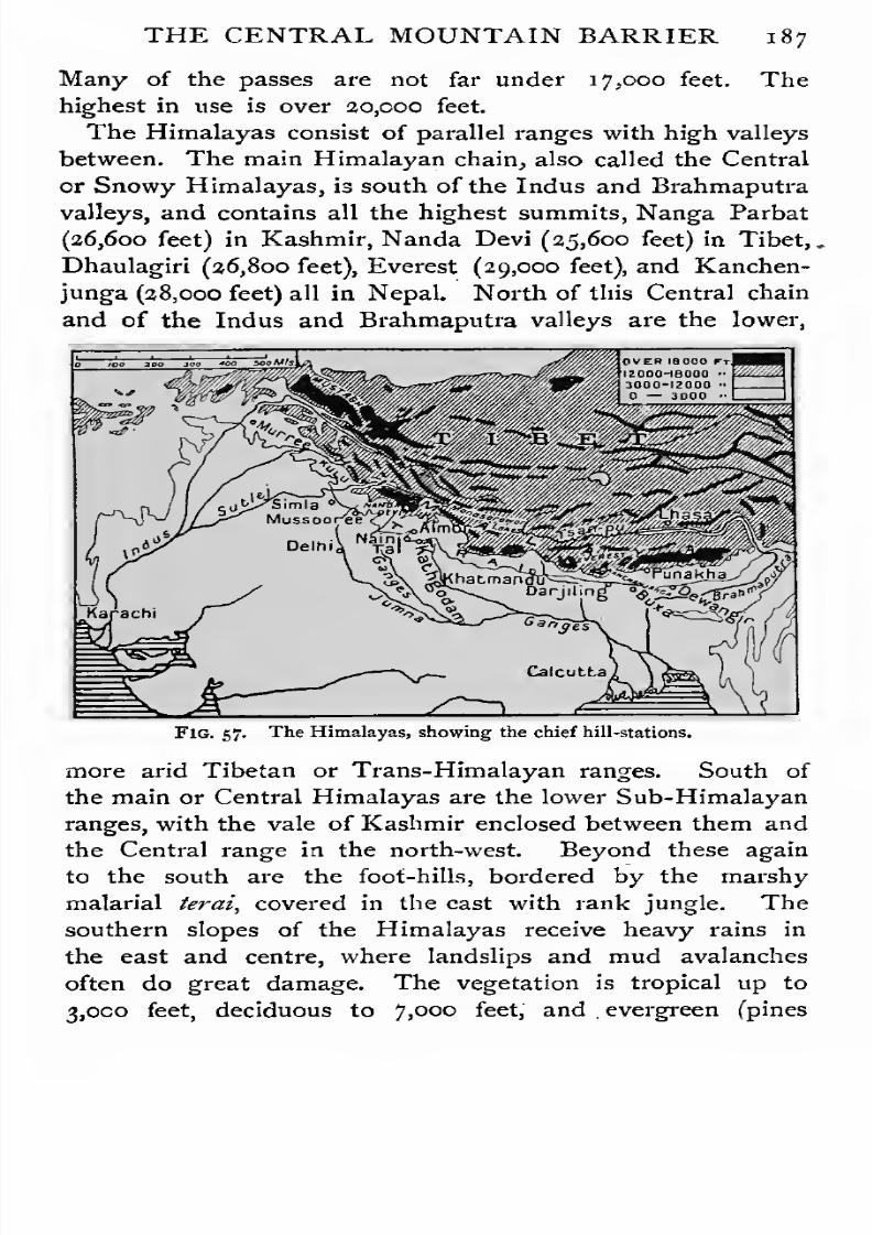
7/30/2019 The Senior Geography 1919
http://slidepdf.com/reader/full/the-senior-geography-1919 203/383
THE CENTRAL MOUNTAIN BARRIER 187
Many of the passes are not far under 17,000 feet. The
highest in use is over 20,000 feet.
The Himalayas consist of parallel ranges with high valleys
between. The main Himalayan chain, also called the Central
or Snowy Himalayas, is south of the Indus and Brahmaputra
valleys, and contains all the highest summits, Nanga Parbat
(26,600 feet) in Kashmir, Nanda Devi (25,600 feet) in Tibet,
,
Dhaulagiri (26,800 feet), Everest (29,000 feet), and Kanchen-
junga (28,000 feet) all in Nepal. North of this Central chain
and of the Indus and Brahmaputra valleys are the lower,
Fig. 57. The Himalayas, showing the chief hill-stations.
more arid Tibetan or Trans-Himalayan ranges. South of
the main or Central Himalayas are the lower Sub-Himalayan
ranges, with the vale of Kashmir enclosed between them and
the Central range in the north-west. Beyond these again
to the south are the foot-hills, bordered by the marshy
malarial terai, covered in the cast with rank jungle. The
southern slopes of the Himalayas receive heavy rains in
the east and centre, where landslips and mud avalanches
often do great damage. The vegetation is tropical up to
3,000 feet, deciduous to 7,000 feet, and.evergreen (pines

7/30/2019 The Senior Geography 1919
http://slidepdf.com/reader/full/the-senior-geography-1919 204/383
188 THE CENTRAL MOUNTAIN BARRIER
and cedars) to ia,ooo feet. Above this the trees become
stunted and pass into pastures, which become poorer towards
the snow-line (between 16,000 and 17,000 feet on the Indian
slopes). Between 7,000 and8,coo feet in the Sikkim Hima-
layas brilliantly coloured rhododendron forests contrast with
the glittering snow-peaks beyond. In the north-west the
rainfall is less, and in Kashmir the forests are denser on the
northern than on the southern slopes, as the snow lies later
into the summer, and the summer heat is less.
All the great rivers of the Himalayas rise between the
3aoooF.t-
MtErerest
29,000
.Muichmmjangn
24000 Ff
SeaLeuel.
Miles 250 500
Fig.58.
Comparative sectionsof the Himalayas, Alps and
ScottishHighlands.Note that the section is across the Himalayas but along the Alps.
Tibetan and the Central Himalayas. The sacred Manasa-
rowar lake, south-east of Kashmir, is near the headwaters
not only of the Indus and Brahmaputra, but also of the
Gogra, the longest of the feeders of the Ganges, and froms
it flows the Sutlej,
one of the great feeders of the Indus.The Sutlej, after a course parallel to that of the Indus,
breaks through the southern ranges in deep forested gorgesnorth-west of Simla, the hill-station of the Punjab.
The southern slopes of the Himalayas are under dividedcontrol. Kashmir in the north-west, between Afghanistanand Tibet, stretching north to the Karakorams and the frontiers
7/30/2019 The Senior Geography 1919
http://slidepdf.com/reader/full/the-senior-geography-1919 205/383
THE CENTRAL MOUNTAIN BARRIER 189
of Chinese Turkestan, is under British control. It is a land
of high mountains and deep river gorges. The most fertile
part is the vale of Kashmir (5,000 feet), the level valley of
the upper Jehlam, flowing to the Wular lake, near which is
Srinagar the capital. From the hair of its goats are made
the famous Kashmir shawls, and perfumes are distilled from
its roses. Difficult routes by the Sind tributary of the, Indus
lead to Leh in Ladak, in arid surroundings, where the Indus
valley widens. East of Kashmir, the provinces of Garhwal and
Kumaon are included in the North-west Provinces. Nepal,
with magnificent mountain, gorge, and forest scenery, but few
accessible routes, is independent. Sikkim, with the hill-
station of Darjiling, commands the Chumbi valley and other
routes to Lhasa, from which its northern frontier is only about
150 miles distant. East of Sikkim is the independent native
state of Bhutan, between the Central Himalayas and the
Lower Brahmaputra. In the extreme east is Assam traversed
by the Brahmaputra which comes from Tibet through inacces-
sible gorges and joins the Ganges delta. Beyond this the
southern trend of the Himalayan ranges becomes very marked.
The topography of the Himalayas is so complicated, and
the passes on the main routes so numerous, that they cannot
be enumerated. The chief routes between north and south
and east and west cross Kashmir, and many converge on Leh.
THE SOUTHERN AND EASTERN MARGINS OF
THE CENTRAL MOUNTAINS.
The Central Mountains occupy nearly half of Asia. Not
only do they make communication difficult for man, but they
form a barrier to plants and animals. The Indian elephant,
the rhinoceros, the tiger, and the ape appear on the farther
or oceanic margin, and teak and spices are among the new
plants. Asia, however, has long been the home of highly-
civilized races, with extensive trade relations. This has led
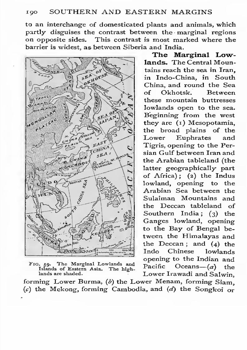
7/30/2019 The Senior Geography 1919
http://slidepdf.com/reader/full/the-senior-geography-1919 206/383
ijio SOUTHERN AND EASTERN MARGINS
to an interchange of domesticated plants and animals, which
partly disguises the contrast between the marginal regions
on opposite sides. This contrast is most marked where the
barrier is widest, as between Siberia and India.
The Marginal Low-
lands. The Central Moun-
tains reach the sea. in Iran,
in Indo-China, in South
China, and round the Sea
of Okhotsk. Between
these mountain buttresses
lowlands open to the sea.
Beginning from the west
they are (i) Mesopotamia,
the broad plains of the
Lower Euphrates and
Tigris, opening to the Per-
sian Gulf between Iran and
the Arabian tableland (the
latter geographically part
of Africa); (2) the Indus
lowland, opening to the
Arabian Sea between the
Sulaiman Mountains and
the Deccan tableland of
Southern India; (3) the
Ganges lowland, opening
to the Bay of Bengal be-
tween the Himalayas and
the Deccan ; and (4) the
Indo Chinese lowlands
opening to the Indian and
Pacific Oceans (a) the
Lower Irawadi and Salwin,
forming Lower Burma, (b) the Lower Menam, forming Siam,
(c) the Mekong, forming Cambodia, and (d) the Songkoi or
Fig. 59. The Marginal Lowlands and
Islands of Eastern Asia. The high-
lands are shaded.
7/30/2019 The Senior Geography 1919
http://slidepdf.com/reader/full/the-senior-geography-1919 207/383
OF THE CENTRAL MOUNTAINS 191
Red River, forming Tongking. In China are (5) the narrow
lowland of the Sikiang, separated from (6) the vast low-
lands of North China which extend inland up the Yangtse-
kiang and Hwangho to the base of the Central Mountains.They are separated by the Manchurian Highlands, a con-
tinuation of the Shansi Highlands from (7) the lowlands of
Manchuria and Amuria, at the base of the Khingan Mountains.
Manchuria is drained north to the Sea of Okhotsk by the
Amur and its tributaries, but there is an extremely important
opening in the south to the Yellow Sea by the Liaoho,
between outliers of the Khihgan Mountains and the moun-
tains of Korea, which with the Tatar mountains shut off
Manchuria from the Japanese sea and deflect the Amur
north. By this route Russia reached the ice-free Port
Arthur, since lost to Japan.
Eastern Asia is bordered by a chain of volcanic islands
defining marginal seas ; the Okhotsk Sea, between Kamchatka,the Kurile Islands and Sakhalin ; the Japanese Sea, between
Japan and Korea ; the East China Sea, between Korea, the
Luchu Islands and Formosa ; and the South China Sea,
formed by the Philippines, Borneo, and the Malay Peninsula.
The islands and seas of Malaysia stretch eastwards towards
Australia. The marginal Andaman Sea, west of the Indo-
Chinese Peninsula, is enclosed by the Andaman and Nikobar
Islands and Sumatra, the latter separated by the Malacca
Strait from the Malay Peninsula..The mountains of Sumatra
are continued by those of Java and the Sunda Islands, the
whole forming a spur of the Central Mountains extending far
south of the equator.
The Monsoons. Notice that these lowlands are isolated
from each other by mountains and seas, and that there are
no easy land routes between them. Each has thus developed
a characteristic civilization. Excluding the islands within io°
of the equator, a general similarity results from the monsoons,
the influence of which is most marked between the Hwangho
and the Indus.

7/30/2019 The Senior Geography 1919
http://slidepdf.com/reader/full/the-senior-geography-1919 208/383
ioa SOUTHERN AND EASTERN MARGINS
The difference between the heating capacity of sea and
land in summer and winter has very important results in
this region. From North China southwards the average
July temperature is at least 8o° F., with much highermaxima. The air over the land becomes intensely heated,
expands, becomes lighter, and rises, forming what is known
as an area of low air pressure. Over the sea, where the
»C, \k.
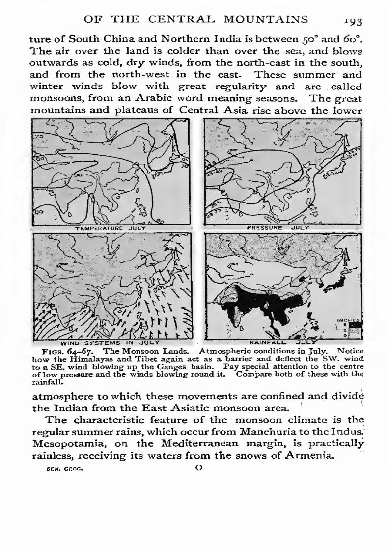
7/30/2019 The Senior Geography 1919
http://slidepdf.com/reader/full/the-senior-geography-1919 209/383

7/30/2019 The Senior Geography 1919
http://slidepdf.com/reader/full/the-senior-geography-1919 210/383
194 SOUTHERN AND EASTERN MARGINS
The regularity of the seasons is favourable to agriculture,
since it is easier to provide against drought recurring at stated
intervals than against deficiency or excess of rain at irregular
intervals. This has made the Asiatic monsoon area the mostdensely peopled in the world, as can be seen from Fig. 68. The
regularity of the winds has promoted intercourse by sea,
though typhoons and cyclones are common at the change of
monsoons.
Historical Summary. Except in Manchuria, an agri-
Fig. 68. Density of Population in the Monsoon Lands. White below 15 tothe square mile, vertical ruling 15 to 50, slanting ruling 50 to 100, black over ioo„Compare the limits of the areas with less than fifteen people to the square milewith orographical and rainfall maps. Figs. j6, 59, 63, 67.
cultural civilization early developed. Outside influences have
come either across the mountains or from overseas, Meso-potamia was the seat of the great
Assyrian civilization withNineveh as its capital, and of the Chaldaean Empire, with
Babylon. It is the most vulnerable of the lowlands, being
exposed to attack from the Arabian and Iranian plateaus,
from the Persian Gulf, the Mediterranean, and even from
Egypt. It has thus had many vicissitudes, the most fatal
being its conquest by a pastoral people (the Ottoman Turks),
7/30/2019 The Senior Geography 1919
http://slidepdf.com/reader/full/the-senior-geography-1919 211/383
OF THE CENTRAL MOUNTAINS 195
who neglected irrigation and closed the trade routes. TheIndo-Gangetic lowlands have been repeatedly invaded from
the north, and are now ruled by British invaders from overseas.
It is almost impossible to attack the Indo-Chinese lowlandsacross the mountains, but they are very vulnerable by sea.
In China civilization has followed the old jade route, which
early brought China into contact with Mesopotamia. Inter-
course with Europe in the Middle Ages followed the same
route and was also carried on by sea. Marco Polo originally
went to Ormuz, at the head of the Persian Gulf, intending to
proceed by sea. Invasions of China from the steppes and
deserts to the north-west have always been destructive of
civilization. They led to the building of the Great Wall in
the third century B.C. The last conquest was made by way of
the Liao lowland in the seventeenth century, setting the former
Manchu dynasty on the throne. Russia moved south by the
same route, but was checked by Japan.
AMURIA AND MANCHURIA.
The Amur rises as the Shilka and Argun in the Mongolian
plateau, and descends between the Khingan and Aldan High-
lands to Amuria, the Russian part of the Amur lowland.
From Manchuria, the Chinese portion, it receives the Sungari,
from the Manchurian Highlands, which forms part of the route
south by the Liao valley. The Amur forms a navigable route
from the plateau to the Okhotsk Sea, but its port, Nikolayevsk,
is icebound for many months in winter. The main route is by
the Usuri to Vladivostok, on a fine harbour, open for nine
months of the year.
Amuria has a severe climate. Much of it lies in the
northern forest zone, which supplies timber and furs. The
fertile valleys are cultivated with cereals. Gold mining is
important in the valleys of the tributaries from the north,
especially in that of the Zeya, near the confluence of which is
thecapital, Blagovyeshchensk.
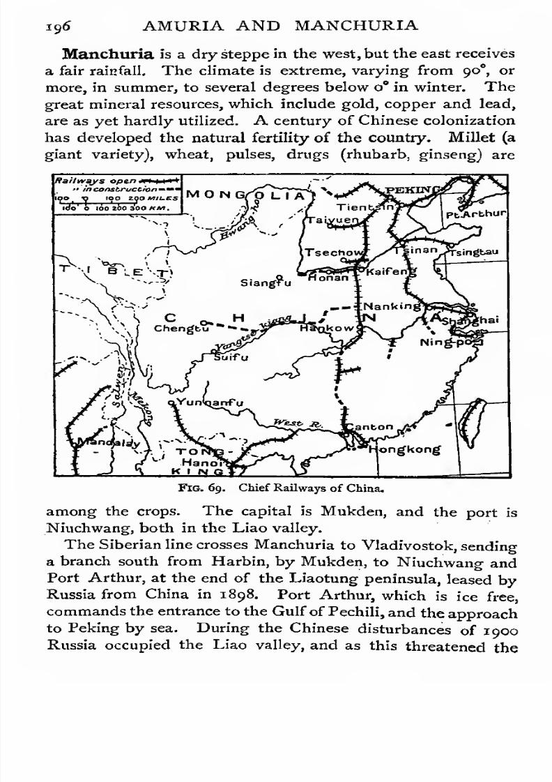
7/30/2019 The Senior Geography 1919
http://slidepdf.com/reader/full/the-senior-geography-1919 212/383
xg6 AMURIA AND MANCHURIA
Manchuria is a dry steppe in the west, but the east receives
a fair rainfall. The climate is extreme, varying from 90", or
more, in summer, to several degrees below o° in winter. The
great mineral resources, which include gold, copper and lead,are as yet hardly utilized. A century of Chinese colonization
has developed the natural fertility of the country. Millet (a
giant variety), wheat, pulses, drugs (rhubarb, ginseng) are
Railways open*» in construction*
Jv/l TOIWJ *• Hano^ K I NC
Fig. 69. Chief Railways of China.
among the crops. The capital is Mukden, and the port is
Niuchwang, both in the Liao valley.
The Siberian line crosses Manchuria to Vladivostok, sending
a branch south from Harbin, by Mukden, to Niuchwang and
Port Arthur, at the end of the Liaotung peninsula, leased by
Russia from China in 1898. Port Arthur, which is ice free,
commands the entrance to the Gulf of Pechili, and the approach
to Peking by sea. During the Chinese disturbances of 1900
Russia occupied the Liao valley, and as this threatened the
7/30/2019 The Senior Geography 1919
http://slidepdf.com/reader/full/the-senior-geography-1919 213/383
AMURIA AND MANCHURIA 197
other countries round the Yellow Sea, a war with Japan fol-
lowed, in which Russia lost Port Arthur and the footing gained
in Manchuria.
KOREA.
Korea is a mountainous peninsula, sinking steeply to the
Pacific. The lowlands open to the Yellow Sea. The climate
is extreme. The rains fall during the summer monsoon. The
mountains are forested, with clearings in which the hardier
cereals are grown in the north. The southern crops include
wheat, millet, pulses, ginseng, tobacco, hemp, cotton, &c.
Gold is abundant, and many concessions have been granted to
foreign syndicates. Though the natural routes open towards
China, Korea has been annexed by the Japanese, who call it
Cho-sen. A line runs from Fusan, the Pacific port opposite
Japan, by the capital, Seoul, and Chemulpho, the Yellow Sea
port, across the Yalu into Manchuria.
CHINA.
North China. North China consists of the lowlands of
the Hwangho, which rises in the heart of the Tibetan plateau,
and descends between the highlands of Shansi and Shensi from
Mongolia. The direct and historically most important route
from the Mongolian plateau is by the Wei tributary, which flows
along the northern base of the Tsingling Mountains, a con-
tinuation of the Kwenlun. The routes from Kulja, Kashgar,
and Yarkand converge on Singan, the chief commercial centre
of Shensi. After receiving the Wei the Hwangho is deflected
in ah easterly direction by the Tsingling Mountains, which
separate it from the Yangtse.
The lower course of the Hwangho crosses the yellow loess
basin of Northern China. The valleys and hills are covered
with a deep, porous yellow soil of great fertility, derived from
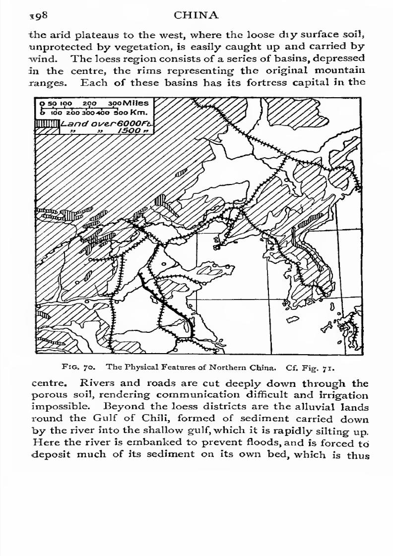
7/30/2019 The Senior Geography 1919
http://slidepdf.com/reader/full/the-senior-geography-1919 214/383
S9« CHINA
the arid plateaus to the west, where the loose diy surface soil,
unprotected by vegetation, is easily caught up and carried by
wind. The loess region consists of a series of basins, depressed
in the centre, the rims representing the original mountain
ranges. Each of these basins has its fortress capital in the
O 50 100 200 3poMlles
ioo zoo 300100 soo Km.
Fig. jo. The Physical Features of Northern China. Cf. Fig. 71.
centre. Rivers and roads arecut deeply down through the
porous soil, rendering communication difficult and irrigation
impossible. Beyond the loess districts are the alluvial lands
round the Gulf of Chili, formed of sediment carried down
by the river into the shallow gulf, which it is rapidly silting up.
Here the river is embanked to prevent floods, and is forced to
deposit much of its sediment on its own bed, which is thus

7/30/2019 The Senior Geography 1919
http://slidepdf.com/reader/full/the-senior-geography-1919 215/383

7/30/2019 The Senior Geography 1919
http://slidepdf.com/reader/full/the-senior-geography-1919 216/383

7/30/2019 The Senior Geography 1919
http://slidepdf.com/reader/full/the-senior-geography-1919 217/383
CHINA 20I
to the Hwangho basin. Access to the Yangtse basin was
rendered difficult by the forested mountain ranges of the
Tsingling, but was possibly accelerated in the end by the
steady pressure on Northern China of invaders from Mongolia.Middle China. The Yangtse, unlike the Hwangho,
affords a magnificent route from the sea to the interior. It
rises in Tibet, is deflected east by the highlands of Yunnan,
and takes a north-easterly course across the mountainous pro-
zoo 300 woKn
Fig. 73. Towns of Central and Sonthern China. Cf. Fig. 72.
vince of Sechwan, whose fertile ' Red Basin ' vies with the
'
Yellow Basin' of Northern China in fertility. Sechwan is
as large as England, with an extreme climate and a fair rain-
fall. Its rivers are fed by the snows of Tibet, and the harder
rock makes irrigation possible. This is carried out on an
elaborate scale on the Chengtu plain (3,500 feet), crossed by
the Min, a left bank tributary from Tibet. Spade agriculture
and terracing, which is carried to the height of several thou-
7/30/2019 The Senior Geography 1919
http://slidepdf.com/reader/full/the-senior-geography-1919 218/383
2oa CHINA
sand feet, are the laborious methods by which the land is
enabled to support its dense population. Rice, wheat, maize,
pulses, opium, indigo, sugar, hemp, tobacco, drugs, and mul-
berries aregrown
at varying elevations.
Teais
extensivelygrown on the hills. Coal and iron occur together over large
areas. The precious metals and copper are abundant on the
margin of the Tibetan plateau. The port of Sechwan is
Chungking, at the confluence of the Kialing, near the western
entrance to the Yangtse gorges through the Sechwan
Highlands. Below Ichang, at the eastern exit, the river is
navigable for 900 miles.
The Han, from the Tsingling, forms an important route
from north to south. The triple city of Hankow-Hanyang-
Wuchang, at the confluence, is a great commercial centre. Onthe right bank the Yuankiang and the SJangkiang, from Hunan,
a province rich in iron and anthracite coal, reach the river across
the sandy flats of LakeTungting. Lower, the Kan enters
across the Poyang lake. These lakes act as reservoirs when:
the river is high during the summer rains. A rise of 70 feet
is not exceptional, and the floods which result, though tempo-
rarily disastrous, greatly increase the fertility of the soil. The
lower basin of the Yangtse supplies tea, rice, and silk, and is
crowded with large towns. The port is Shanghai, the outlet
and route centre for the richest provinces of China. TheYangtse brings down vast quantities of sediment, and is gradu-
ally silting up Shanghai harbour.
The Chinese did not penetrate into the Yangtse basin for
nearly 3,000 years after the settlement of Northern China.
Once reached, its fertility and excellent water communication
made it the centre of wealth andpopulation. In the basin of
the Lower Yangtse are the old capitals of Nanking and
Hangchou (Kinsay), the latter the capital at the time of
Marco Polo's visit. Peking, in North China, only became the
capital after the Mongol conquest in the latter part of the
thirteenth century.
Southern China. The east coast has many excellent

7/30/2019 The Senior Geography 1919
http://slidepdf.com/reader/full/the-senior-geography-1919 219/383
CHINA *°3
harbours, but the interior consists of highlands. Rice, tea, and
silk are the chief products. Fuchou in Fukien is the chief
port. Population is in excess of the capacities of the region,
and there is much emigration to various parts of the Pacific.
South China is mountainous, rising through the South China
Highlands to the plateau of Tibet. Yunnan and Kweichou
are inhabited by many aboriginal tribes, at a low stage of
culture. The natural resources of both provinces are great,
including almost every kind of mineral wealth. They were
depopulated in the civil wars of half a century ago, and roads
have fallen into disrepair, increasing the natural difficulty of
communication. There are proposals for connecting Yunnan
by rail with Burma. The ancient trade route went from
Talifu, the western capital of Yunnan, to Bhamo, on the
Irawadi, but the many wide gorges and parallel mountain
ranges to be crossed, make this a difficult route for a railway.
A French line runs to Yunnan, the eastern capital, fromTongking.
The forests of Southern China supply camphor, spices, and
many valuable woods. Yunnan is a limestone plateau, with
fertile sunken basins, in which opium is grown. Rice is a
heavy crop in the broad valley bottoms of the Sikiang and its
tributaries. The coastal province of Kwangtung, with a rich
soil and a tropical climate, produces rice, silk, sugar, opium,
indigo, tea, oil seeds, and many fruits.
The Sikiang is the chief waterway of Southern China. Its
port is Canton, on the most navigable of the distributaries,
where the route from the west by the Si, and that from the
north by the Pe, converge. The island of Hongkong (capital
Victoria) is British, as are Kaoling and Mirs Bay on the oppo-
site mainland. The southern margin of South China is a
region of tropical forests; which also cover the little-known
island of Hainan.
7/30/2019 The Senior Geography 1919
http://slidepdf.com/reader/full/the-senior-geography-1919 220/383
204 THE JAPANESE EMPIRE
THE JAPANESE EMPIRE.
Japan and Eastern Asia. Japan is less closely connected
with Eastern Asia than appears at first sight. Between it
and the populous lowlands opening to the Yellow Sea the seas
are wide, and where the straits are narrow they separate regions
which are only sparsely peopled. Thus, while Japan has
shared the civilization of China, which reached it by Korea,
it has been sufficiently isolated to develop an independent
nationality. In this respect it may be compared with Britain,
which is similarly, but more closely, related to the continent
of Europe.
Configuration. The Japanese Archipelago extends from
the south of Kamchatka, in the latitude of London, to For-
mosa, which is crossed by the northern tropic. The main
islands, Hokkaido or Yezo, Honshiu, the largest, Shikoku,
and Kiushiu, lying between 30 and 45° N., sink in the west
to the Sea of Japan, and to the deep Pacific in the east.
All the Japanese islands are mountainous, with numerous
small isolated lowlands. In Hokkaido the valleys radiate
outwards from a mountain centre (8,000 feet), to which con-
verge ranges continuing the mountains of Sakhalin and of the
Kurile islands. There are several active volcanoes. In
northern Honshiu the valleys run north and south, and the
same direction is seen in the peninsulas and bays, the largest
of which is Tokyo. The island is crossed from north to south
by a rift valley, on the margin of which are the principal vol-
canoes, including the dormant Fujisan (12,400 feet) and the
active Asamayama (8,200 feet). From this rift valley the
feature-lines run east and west in two belts, the northern
forming the western prolongation of Honshiu, and the southern
the Kii peninsula and the islands of Shikoku and Kiushiu.
The rivers are short, swift, and often interrupted by falls, so
that they are rarely navigable, and do not serve to connect
the lowlands with each other. During the summer they fre-
quently flood the lowlands, and render communication almost

7/30/2019 The Senior Geography 1919
http://slidepdf.com/reader/full/the-senior-geography-1919 221/383
THE JAPANESE EMPIRE 305
impossible. Before the introduction of railways communica-
tion between lowland and lowland was chiefly by sea. The
Inland Sea, or Japanese Mediterranean, separating Honshiu
from Shikoku and Kiushiu, though difficult of navigation owingto the strong currents in the narrow straits leading to it, and
to the many islands and rocks, has contributed to the unity of
Japan, by connecting the lowlands of the most fertile part of
the empire.
Climate and Products. With its great extension from
Land over ISOOft. thus ^3*100 290 Miles
"[00 2E0 iBo Km.
Fig. 74. Surface Features and Chief Routes of Southern and Central Japan,
north to south Japan has a climate ranging from sub-arctic to
tropical. The western shores, along the Sea of Japan, havean extreme climate resembling that of North-eastern Asia.
The high latitude and the cold north-west winds from Siberia
make the winter climate of Hokkaido extremely severe, and
snow lies long. The eastern, or Pacific coast is protected
from these continental influences by high mountains, and has
a more equable climate. In Shikoku and Kiushiu the winters

7/30/2019 The Senior Geography 1919
http://slidepdf.com/reader/full/the-senior-geography-1919 222/383
206 THE JAPANESE EMPIRE
are mild and the summers hot. The climate of Formosa is
tropical.
All over Japan the rainfall is heavy, the lands round the
InlandSea
receiving least. Snow falls abundantly in winter
in Hokkaido, and occasionally in the other islands of Japan
proper. In the monsoon area, south of about $J°, the heaviest
rains are in June, at the rice-planting season, when they are
specially valuable.
Hokkaido and Northern Honshiu are forested, with few
clearings. South Honshiu, Shikoku, and Kiushiu are agricul-
tural, with forested highlands. Rice is the chief crop, as in all
monsoon lands. After it is harvested the wet fields are planted
with wheat, barley, or rape as winter crops. Beans are largely
grown. Tea, introduced from China more than a thousand
years ago, is the second staple, though the output is decreasing.
Mulberries are grown in plantations, and as boundary and shade
trees. Japanese silk has long been famous. Less important
crops are indigo, cotton, hemp, flax, tobacco, and sugar.
Japanese agriculture, like Chinese, is laborious and frugal.
In the valleys it is carried to the height of 7,000 or 8,000 feet
and the plough is not used.
Centres of Population. The centres of dense population
are (1) round Tokyo, with the northern port of Yokohama;
{%) along the northern shores of the Inland Sea, especially
round the manufacturing centres of Kobe and Ozaka ; and
(3) in western Kiushiu, round Nagasaki, the southern port.
Coal and iron are found, but not together. The richest
coalfields are in Hokkaido and Northern Kiushiu. Kaolin
clay is abundant, and Japanese porcelain is famous. Many
other art industries (lacquer, embroidery, enamelling,&c.)
are,
of great antiquity. All forms of modern industry have been
introduced during the last half-century, centring round Kobe
and Ozaka, where cotton and steel are manufactured.
The isolated glens and plains of Japan favoured the growth
of strong clan feeling under powerful feudal barons, against
whom the central power was often powerless. Kyoto was

7/30/2019 The Senior Geography 1919
http://slidepdf.com/reader/full/the-senior-geography-1919 223/383
THE JAPANESE EMPIRE 307
the old political and religious capital, and the residence of
the semi-divine Mikado. The influence of the clans led to the
concentration of military and administrative power under a
Shogun, whose capital was at Tokyo, then called Yeddo.The last clan which held the Shogunate introduced the policy
of refusing foreign intercourse in the seventeenth century.
This isolation broke down in the middle of last century, when
the United States insisted on commercial relations. Internal
convulsions ended in the abolition of the Shogunate, the
weakening of feudal power, and the restoration of power
to the Mikado, indicating the end of local as well as of
national isolation. In the last fifty years Japan has become
a great military and naval power, and has defeated China
and Russia, her rivals on the opposite side of the Yellow
Sea. Japan obtained Formosa after a successful war with
China (1894-5), and ten years later won from Russia
the southern half of Sakhalin, Port Arthur, and the chief
influence in Korea.
Formosa falls steeply to the Pacific in the east, and rises
inland to forested mountains (14,000 feet) which supply
camphor and other tropical forest produce. The lowlands
are in the west, opposite to China, from which they were
colonized. The products are those of the opposite mainland.
The largest centre is Taiwan (Taichu).
INDO-CHINA.
Configuration. From south-east Tibet three lines of
mountains can be traced. The easternmost runs through
Annam and is separated by the gorges of the Mekong from
the central line, which follows the trend of the Malay peninsula.
The gorges of the Salwin separate this from the westernmost,
or Arakan Mountains, which form the western boundary of
Burma.
The upper courses of the great rivers of Indo-China are
densely forested and difficult to penetrate. They form the
Shan States, which, whether nominally subject to China, Siam,

7/30/2019 The Senior Geography 1919
http://slidepdf.com/reader/full/the-senior-geography-1919 224/383
ao8 INDO-CHINA
or Britain, are in reality almost independent. The inhabitants
practise some agriculture, but subsist mainly by hunting arid
the collecting of forest produce. Mineral wealth, including
gems, is known to be abundant, and various schemes are
proposed for developing the natural resources and improving
the communications. The rivers, which are long and swift,
and loaded with sediment, have built up a series of rich
deltaic lowlands whose soil is deepened by periodic floods.
These are very similar to each other in climate. In all rice
is the staple agricultural product. Isolated from each other
by forested mountains, each of these lowlands became an
independent native state. The delta of the Songkoi, or Red
River, forms Tongking (French),with Hanoi as its capital, at the
head of the delta. In the delta of the Mekong are Cambodia
and Cochin China. The former was once a powerful kingdom,
centring round the great Tonle Sap Lake, which regulated
the summer floods of the Mekong. Here colossal ruins bear
witness to the existence of an early and wealthy civilization.
The present capital is Saigon, east of the delta. The moun-
tains and narrow coastal plains of Annam, with winter rains,
lie between Tongking and Cambodia. The capital is Hue.
All these are French. The delta of the Menam forms the
kingdom of Siam, with Bangkok as its capital. Lower Burma
consists of the deltas of the Salwin, with Moulmein, and of
the Irawadi, with Rangoon. While all the other lowlands are
deltaic the Irawadi lowland extends far inland into the high-
lands, forming Upper Burma. The old capital is Mandalay,
where the routes by the Irawadi, which is navigable up to
Bhamo, not far from the Chinese frontier, and by the parallel
Pegu lowland, converge.
The teak forests of Upper Burmaare among the most important of its resources.
The highlands of the Malay peninsula and the lowlands
along their margin form independent native states, many of
them under British protection. Lying in the equatorial belt,
with hot summers and winters with two rainy seasons (see
p. 5) they are densely forested. Tin-mining is important.
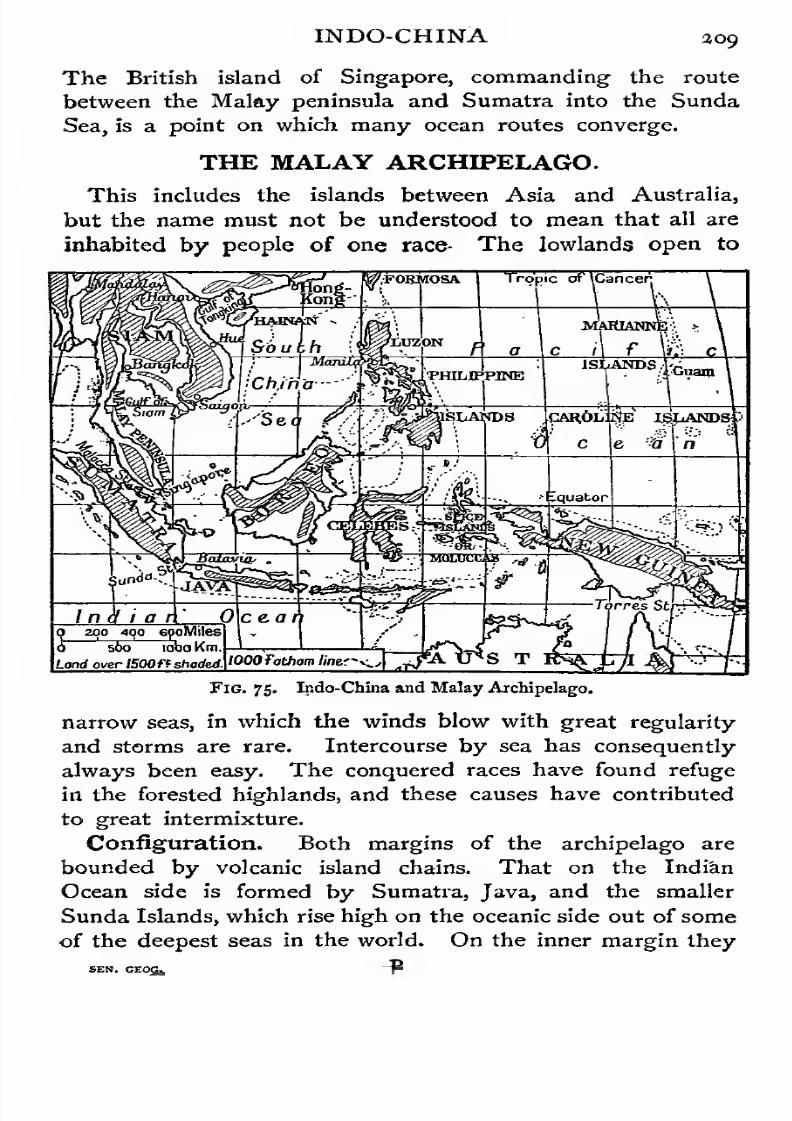
7/30/2019 The Senior Geography 1919
http://slidepdf.com/reader/full/the-senior-geography-1919 225/383
INDO-CHINA 309
The British island of Singapore, commanding the route
between the Malay peninsula and Sumatra into the Sunda
Sea, is a point on which many ocean routes converge.
THE MALAY ARCHIPELAGO.
This includes the islands between Asia and Australia,
but the name must not be understood to mean that all are
inhabited by people of one race- The lowlands open to
Indiano 200 490 6poMiles0"
560 ioboKm
Land oyer 1500ft shaded.
0\ce.a
lOOOTathom /inef^,[~y& U*S T
Fig. 75. Indo-China and Malay Archipelago.
narrow seas, in which the winds blow with great regularity
and storms are rare. Intercourse by sea has consequently
always been easy. The conquered races have found refuge
in the forested highlands, and these causes have contributed
to great intermixture.
Configuration. Both margins of the archipelago are
bounded by volcanic island chains. That on the Indian
Ocean side is formed by Sumatra, Java, and the smaller
Sunda Islands, which rise high on the oceanic side out of some
of the deepest seas in the world. the inner margin they

7/30/2019 The Senior Geography 1919
http://slidepdf.com/reader/full/the-senior-geography-1919 226/383
7/30/2019 The Senior Geography 1919
http://slidepdf.com/reader/full/the-senior-geography-1919 227/383
THE MALAY ARCHIPELAGO an
a great range of elevation, and a corresponding variety of
products, from rubber and coco-nut, in the hot coastal low-
lands, through zones in which sugar, coffee, cotton, quinine,
and other tropical plants are grown, to the temperate moun-tain slopes where temperate cereals do well. The staples are
rice, coffee and quinine. Sumatra and Borneo have petroleum
and minerals, and are gradually being opened up. The tin
of Banka and Billiton islands is important.
INDIA AND CEYLON.
Configuration. Geographically India consists of four
distinct regions (i) the northern mountains; (2) the Deccan
tableland of peninsular India; (3) the alluvial Indo-Gangetic
lowland between them, and (4) Ceylon.
Climate and Products. India is separated from con-
tinental Asia by a mountain wall three to six miles high, whose
height prevents any climatic communication. In winter theIndian isotherms run nearly along the parallels of latitude, and -
the temperature increases from the north, where the winters
are cool, to the south. The air-pressure diminishes from north
to south. The winds blow south towards the regions of lower
pressure, but are deflected by the Earth's rotation to the right
(being in the northern hemisphere) and blow as the north-east
monsoon or north-east trade winds. These are dry winds,
except where they have crossed seas. (Cf. Figs. 60 to 67,
and also Junior Geography, Figs. 110 and in.)
In early summer the hottest area is over the Deccan, but
by midsummer it has moved north to the Indus lowlands and
Baluchistan, where a vast low-pressure system is formed.
The winds blow in from the oceans to the south, but are
deflected by rotation, and blow as the south-west monsoon.
This brings very heavy rains to the Western Ghats, the steep
western escarpment of the Deccan, but passes inland as a dry
wind. East of the margin of the Western Deccan is an area
of low rainfall. On the east of the peninsula the south-west
monsoon blows across the Bay of Bengal, striking the hills of

7/30/2019 The Senior Geography 1919
http://slidepdf.com/reader/full/the-senior-geography-1919 228/383
213 INDIA AND CEYLON
The Bay and the Ganges valley, between the Himalayas and
the Deccan, form a line of least resistance, and the winds
follow the trend of the valley, blowing as a south-east
monsoon. They reach the Indus as dry winds, andas
thewet south-west winds from the Arabian Gulf are deflected
along the northern margin of the Deccan, the great Thar
desert is formed between the Indus and the Deccan.
The extreme south-east of India and the east of Ceylon
receive rains from the retreating south-west winds towards
the end of the year. Compare the winter rains of Annam.
The difference between the winter and summer temperature
of Northern and Southern India limits many species of palms
to Southern India and Ceylon, where the conditions are
tropical. The forests of the wet Western Ghats produce
teak and sal. The Himalayan forests have been described.
Except in Ceylon, where the conditions are almost
equatorial, the cultivated plants are those of all monsoonlands. Rice is grown in the areas with heavy summer rains,
or capable of abundant irrigation. Wheat in winter, millet
on poorer soils, pulses and oil-seeds, sugar-cane, indigo,
tobacco, and opium are typical crops. Tea is grown on
the hill-slopes of the lower Himalayas, especially in Assam,
and also in Ceylon. Coffee is cultivated on the lee slopes
of the Western Ghats, and in Ceylon. Cotton and jute are
the chief fibre plants. The latter is grown in the Ganges
delta. Much of the Deccan is covered with black volcanic
soil, which retains moisture and is especially suited for cotton.
The Northern Mountains. These have already been
described. The only practicable routes to the lowlands at
their base are in the north-west, where passes lead fromAfghanistan to the Indus. The Himalayan passes, all
extremely difficult, lead only to the bleak plateau of Tibet.
The Deccan. The Deccan, forming peninsular India, is
difficult of access. The Thar desert prevents access from the
Indus across the intervening lowlands. The steep, densely-
forested escarpment (Western Ghats) makes the interior

7/30/2019 The Senior Geography 1919
http://slidepdf.com/reader/full/the-senior-geography-1919 229/383
INDIA AND CEYLON 213
inaccessible from the Arabian Sea, and though the table-
land descends much less steeply to the Bay of Bengal, the
coast is sandy, surf-beaten, and harbourless.
The northern margin of the Deccan forms the Aravalli hills,
Fig. 76. The Configuration of India.
rising steeply above the Thar desert. The hydrographical
centre is in the north-east, from which the Narbada and
Tapti flow west, and the Son and the Mahanadi east. The
steepnorthern wall of the Narbada valley is formed by

7/30/2019 The Senior Geography 1919
http://slidepdf.com/reader/full/the-senior-geography-1919 230/383
a i4 INDIA AND CEYLON
the Vindhya Mountains, and the southern by the Mahadeo
and Satpura Mountains, separated by the Khandwa Gap.
This gap forms a route from the Narbada to the Tapti, which
follows the southern marginof the Satpura Mountains.
South of the Tapti the Godavari, Kistna, Cauvery and
other tributaries all flow east in steep inaccessible upper
§&d>y»
Fig. 77. Railways of India.
valleys, forming falls in their descent. Those of the Cauvery
are employed to generate electric power on a large scale.
In their lower courses these rivers form deltas, which have
long been irrigated for rice fields, and are densely peopled.
These are connected by a coastal lowland, which is broadest
south of the Godavari.
7/30/2019 The Senior Geography 1919
http://slidepdf.com/reader/full/the-senior-geography-1919 231/383
INDIA AND CEYLON 215
The east and west direction of the river-valleys renders
communication difficult between north and south, and has
favoured the growth of native states, of which Haidarabad
and Mysore are the most important. In the former coal
is abundant; in the latter gold.
On the west or Malabar coast important routes open from
the Gulf of Cambay, to which both the Narbada and Tapti flow.
One route goes between the northern base of the Aravalli
Hills and the southern margin of the Thar desert to Delhi
and the Ganges. The other is controlled by Surat, near
the mouth of the Tapti, where a British factory was estab-
lished early in the seventeenth century. The route across
the tableland follows the Tapti to the Khandwa Gap, by
which it reaches the upper Narbada, and crosses the northern
foreland of the Deccan to Allahabad, at the confluence of the
Jumna and the Ganges. Bombay leads to no natural route
up the Ghats, but has a fine harbour. Since first a road andthen a railway were carried up the escarpment and the Suez
Canal was opened, it has become the chief port of Western
India. Through it is exported a part of the cotton crop of
the Deccan and Gujarat, and it manufactures most of the
remainder into cotton yarns and cloth. Poona, close to
the western escarpment, commands all the routes across the
Deccan, and was long the centre of the Mahratta power.
In the extreme south Calicut commands the route by the
Palghat Gap (1,000 feet) between the Nilghiri and Anamali
Hills (about 8,oco feet).
The shallow Palk Strait between the mainland and Ceylon
cannot be navigated, and vessels bound for the Bay of Bengal
must round the island. On the Coromandel coast the chief
port is Madras, with an artificial harbour, but well situated in
the centre of the fertile lowlands at the point where the route
from the south by the Palghat Gap meets that from the north
by the upper Kistna and Penner. At the head of the Bay
of Bengal is the delta of the Ganges, entered by the Hughli
distributary, with Calcutta as its port.
7/30/2019 The Senior Geography 1919
http://slidepdf.com/reader/full/the-senior-geography-1919 232/383
ai6 INDIA AND CEYLON
The Indo-Gangetic Lowland. The Indo-Gangetic low-
land has been built up at the base of the northern mountains
out of the sediment brought down by the Indus, Ganges, and
their tributaries, in the same wayas the Po lowland at the
base of the Alps. As in the case of the Po the course of
the Ganges is pushed far south by the impetus of its
Himalayan tributaries, which is greater than that of the
Deccan tributaries (see p. 40). Notice that the lower course
of the Indus, which receives no tributaries from the moun-
tains, is much closer to their base.
A belt of slightly higher ground crosses the lowland, con-
necting the Himalayan with the Deccan foreland, and dividing
the lowland into an eastern and western half, corresponding to
the basins of the Ganges and Indus.
The Indus Lowland. The Indus receives all its important
tributaries from the Himalayas and the Hindu Kush. The
Jehlam, Chenab,Ravi, Beas,
andSutlej
waterthe
Punjab,or
Land of the Five Rivers. Nearly dry in spring, they become
broad, deep, swift rivers when the Himalayan snows melt in
summer. Much of their water is distributed by a network of
irrigation canals to the arid lands, or doabs, between them.
These are being transformed into a great wheat-producing
region, the produce of which is shipped from Karachi, the
port west of the delta.
The Punjab towns are associated either with the fertile
areas round the rivers or with the routes to these. Peshawar
commands the Indian exit from the Khaibar Pass, and Multan,
near the confluence of the Five Rivers, the routes between
north and south. Parallel to the base of the Himalayas,
on the upper courses of the five tributaries, is
aline
ofcities,
of which Lahore and Amritsar should be noted. The former
is the capital of the Punjab, an important centre of railways,
routes, and manufactures. Amritsar, the capital of the Sikhs,
manufactures silks and other textiles. Historically the most
important is Delhi, built where desert and fertile lands,
plains and highlands meet, thus controlling routes in all

7/30/2019 The Senior Geography 1919
http://slidepdf.com/reader/full/the-senior-geography-1919 233/383
INDIA AND CEYLON 417
directions, and in particular the route from the Indus to the
Ganges.
The importance of this latter route is due to the physical
conditions of the Lower Indus basin. This lies in the Thardesert, with the states of Rajputana round its oases, which are
along its southern margin at the base of the Deccan foreland.
All incoming peoples, after reaching the Indus by the north-
western passes, have been turned east by the desert towards
the Ganges, to reach which Delhi must be taken. Its selection
as the Mogul capital is thus explained.
The Lower Indus receives no tributaries of importance,
and except in summer carries little water. The only town of
consequence is Haidarabad, the capital of the arid province of
Sind, at the head of the delta, which is difficult of navigation.
The port is Karachi. The salt marshes of the Rann of Kutch,
south of the delta, are a continuation of the Thar desert.
The Ganges Lowland. The Ganges lowland presents
a striking contrast. It receives summer monsoon rains, and
can be irrigated on a large scale from the Ganges and its
tributaries. It is the natural objective of all routes from
the north, and early became the seat of a great agricultural
civilization, and of a dense population. Ancient and splendid
cities are numerous, many practising fine textile and metal
handicrafts, as well as modern industries. Its fertility has ex-
posed it to constant invasion from the north, but the latest
conquest, that by Britain, was made from the sea.
The Jumna, the chief tributary of the Ganges, flows west of
the main stream, past Delhi and Agra, both with splendid
monuments of the Mogul rule. Below Agra it receives the
Chambul from the Malwa plateau of the Deccan, where cotton
and opium are extensively grown. Allahabad, at its confluence
with the Ganges, where the route by the upper Narbada reaches
it, commands routes in all directions. Cawnpur, on the main
stream, is of modern growth. Lucknow, on a navigable
tributary, was the ancient capital of Oudh. Mirzapur, with
carpet and metal manufactures, was formerly the great grain

7/30/2019 The Senior Geography 1919
http://slidepdf.com/reader/full/the-senior-geography-1919 234/383
ai8 INDIA AND CEYLON
and cotton market, when these were carried by the Ganges.
At Benares many influences converge. It is the holy city of
Hinduism, and combines ancient handicrafts with modern
manufactures. Patna, in the rich opium, indigo, and rice
lands of the Lower Ganges, is on the site of one of the oldest
cities in India. The Ganges enters the sea by a vast delta,
continuous with that of the Brahmaputra, which flows from
Assam. The southern margin consists of densely forested
swamps, and islands (Sunderbunds), inhabited chiefly by beasts
of prey and reptiles. Calcutta, on the Hughli distributary
Fig. 78. Ceylon.
eighty miles from the sea, is the outlet from the Ganges
and Brahmaputra valley, and was the capital of British India
before Delhi took its place.
Ceylonis flat in the north,
whererice,
rubber, and coco-nut,&c, are cultivated. It is a lofty and much-dissected high-
land in the south, rising to 8,300 feet in Pedrotallagalla. Onthe slopes of well-watered valleys tea is cultivated, replacing
coffee, which has been largely rooted out owing to disease.
Quinine and cacao are also grown, all under European super-
vision. Kandy is the centre of this highland. Colombo on
7/30/2019 The Senior Geography 1919
http://slidepdf.com/reader/full/the-senior-geography-1919 235/383
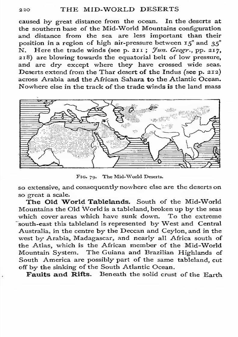
7/30/2019 The Senior Geography 1919
http://slidepdf.com/reader/full/the-senior-geography-1919 236/383
220 THE MID-WORLD DESERTS
caused by great distance from the ocean. In the deserts at
the southern base of the Mid-World Mountains configuration
and distance from the sea are less important than their
position in a region of high air-pressure between 15° and 35°
N. Here the trade winds (see p. 211; Jtm. Geogr., pp. 217,
218) are blowing towards the equatorial belt of low pressure,
and are dry except where they have crossed wide seas.
Deserts extend from the Thar desert of the Indus (see p. 212)
across Arabia and the African Sahara to the Atlantic Ocean.
Nowhere else in the track of the trade winds is the land mass
Fig. 79. The Mid-World Deserts.
so extensive, and consequently nowhere else are the deserts onso great a scale.
The Old World Tablelands. South of the Mid-World
Mountains the Old World is a tableland, broken up by the seas
which cover areas which have sunk down. To the extreme
"south-east this tableland is represented by West and Central
Australia, in the centre by the Deccan and Ceylon, and in the
west by Arabia, Madagascar, and nearly all Africa south of
the Atlas, which is the African member of the Mid-World
Mountain System. The Guiana and Brazilian Highlands of
South America are possibly part of the same tableland, cut
off by the sinking of the South Atlantic Ocean.
Faults and Rifts. Beneath the solid crust of the Earth

7/30/2019 The Senior Geography 1919
http://slidepdf.com/reader/full/the-senior-geography-1919 237/383
THE MID-WORLD DESERTS 22 1
internal forces are continually causing rearrangements of the
materials of which the Earth's interior is composed. This may
lead to the wrinkling of the crust into a series of crumplings
or foldings, as in all the mountain regions yet described.
Where the strata are too rigid to yield in this way they give
way or fracture under strain, forming what are called faults.
This has happened in the Old World Tablelands. Fault
lines are well seen along the sharp edge of the east coast of
Madagascar, or the western escarpment of the Deccan. The
strata retain their original horizontal direction, giving the
tabular configuration.
Faulting may take place along two parallel lines, and a rift
may then be formed by the sinking of the area between.
Such a rift extends across Syria (see p. 23) and is continued
by the Gulf of Akaba, between Arabia and the Sinai
Peninsula, to the Red Sea. From the Red Sea it can be
traced east and south of Abyssinia, through East Africa, where
it is filled by Lake Rudolph and other long, narrow lakes.
Lake Nyasa, further south, is either a separate rift or a con-
tinuation of the eastern rift. A parallel rift farther west
contains Lakes Albert, Albert Edward, and Tanganyika, all
with the typical long, narrow configuration of rift lakes and
seas. Along these rifts are many signs of volcanic activity, and
the western rift, south of Albert Edward Nyanza {nyanza—
lake), is overlooked by a group of active volcanoes.
The Red Sea rift and the narrow isthmus of Suez politically
separate the continents of Africa and Eurasia. From the
point of view of climate and products the boundary is rather
the Mesopotamian lowland and the Persian Gulf.
Arabia. On either side of the deep Red Sea the borders
of the tableland are high. They slope gradually away from it
to Mesopotamia in the east and to the Nile valley in the west.
West of the Syrian rift the tableland sinks to the fertile littoral
of the Mediterranean (see p. 24). Very little of Arabia is less
than 1,500 feet above sea-level, and in the extreme south, in
Yemen, in the centre, in Nejd, and in the south-east, in Oman,
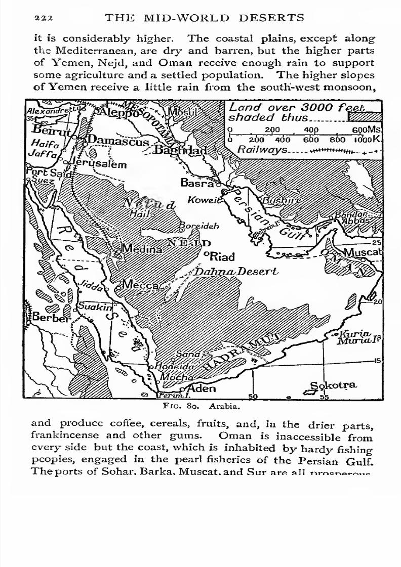
7/30/2019 The Senior Geography 1919
http://slidepdf.com/reader/full/the-senior-geography-1919 238/383
332 THE MID-WORLD DESERTS
it is considerably higher. The coastal plains, except along
the Mediterranean, are dry and barren, but the higher parts
of Yemen, Nejd, and Oman receive enough rain to support
some agriculture and a settled population. The higher slopesof Yemen receive a little rain from the south-west monsoon,
Land over 3000 feetshaded thus
2Wjm 6poMs
o 260 too ebo 8bo io'ooK
Railways «*«+"**«(+._.,.-+
Fig. 8o. Arabia.
and produce coffee, cereals, fruits, and, in the drier parts,
frankincense and other gums. Oman is inaccessible from
every side but the coast, which is inhabited by hardy fishing
peoples, engaged in the pearl fisheries of the Persian Gulf.
ports of Sohar. Barka, Muscat, Sur arp all nmar.A«-».<,

7/30/2019 The Senior Geography 1919
http://slidepdf.com/reader/full/the-senior-geography-1919 239/383
THE MID-WORLD DESERTS 343
The next zone is agricultural. The margin of the great
southern desert of A-rabia which separates Oman from both
Nejd and Yemen is pastoral. Nejd is a collection of many-
oases, set between two deserts. The northern desert, or Nefud,passes into the Syrian desert, which extends to Damascus.
Nejd is agricultural in the oases, in which the date is largely
cultivated, and pastoral on their margin. The desert proper here
and there affords occasional pasturage in favourable seasons.
It is crossed by camel routes from oasis to oasis. Otherwise
it is uninhabited. Nejd is most accessible from Mesopotamia.
It would never be crossed to the west but for the Moslem
pilgrimages to Mecca, where Mahomet was born, and Medina,
where he died. A route from Baghdad crosses Nejd, and there
is another route round the western margin of the desert from
Damascus, now partly followed by a railway. Mecca is
in arid surroundings, and lives only by the pilgrim traffic.
Medina is in an oasis. Jidda, the port for Mecca, also dependsentirely on the pilgrim traffic. In Yemen Hodeida has re-
placed Mocha as the chief port. Aden is a British coaling-
station, commanding the entrance to the Red Sea.
The Arabian deserts separate the fertile lands of Egypt and
Mesopotamia, and cut off the Mediterranean from the Indian
Ocean. Hence the great importance of the routes between east
and west and north and south, where the desert is narrowest. In
ancient times the most famous led from the Nile delta across
Palestine to Damascus and crossed, the Syrian desert at its
narrowest to the Euphrates. In modern times the main route
is by the ship-canal across the isthmus of Suez and the Red
Sea. The other routes from Egypt to the Red Sea were
important in ancient days when the north of the Red Seacould not be navigated owing to strong north winds.
Most of Arabia used to be included in the Turkish Empire,
but Nejd was practically independent under local chiefs, owing
to the difficulties of controlling it effectively across the desert.
Oman, which is still more effectively isolated, is independent.
7/30/2019 The Senior Geography 1919
http://slidepdf.com/reader/full/the-senior-geography-1919 240/383
S24 EGYPT
EGYPT.
Egypt nominally includes an area of 300,000 square miles,
but of this only about 11,000 square miles are habitable. In-
habited Egypt consists of the long, narrow valley of the Nile,
from five to thirty mileswide, enclosed on either side bythe high
edges of the tableland. The Nile enters the Mediterranean
by a delta, which, like the valley, has been gradually built up of
the sediment carried down by the river. This forms Lower
Egypt.
Egypt, like Mesopotamia, Gangetic India, and China, early
became the seat of a great agricultural civilization, which
depended for its existence on the summer Nile floods. As
Egypt is rainless, the cause of this annual rise was a mystery
to the ancients. It is now known to be due to the rains
brought by the summer monsoon to the lofty Abyssinian
Highlands, and carried down to the Nile by its Abyssinian
affluents, the Blue Nile and the Atbara. At Khartum, where
the muddy Blue Nile unites with the White Nile, the latter is
clear. It is to Abyssinia that Egypt owes the fertilizing mud
which covers the valley and delta to a depth of many feet,
and to which something is added in each successive flood.
Themain stream ofthe greatriverwhich has createdEgypt and
keeps it fertile, rises south ofthe equator at a height ofover 6,000feet, and descends by a series of lakes and rapids to the Sudan
(see p. 2<33)- From the confluence ofthe Blue Nile it falls nearly
1,000 feet, mainly by six cataracts, of which only the lowest,
or first cataract, is in Egypt. At the base of the first cataract
is Aswan, the ancient Syene, whose former grandeur is shown
by the ruins ofmagnificent temples. It communicates with the
Mediterranean by an unbroken navigable waterway, and also
commands a pass across the eastern hills to the Red Sea, where
the ancient port of Berenice was situated. Below the confluence
of the Atbara the Nile receives no tributaries, and its volume
diminishes. Of the seven mouths by which it anciently entered
the Mediterranean, all but the Rosetta and Damietta branches
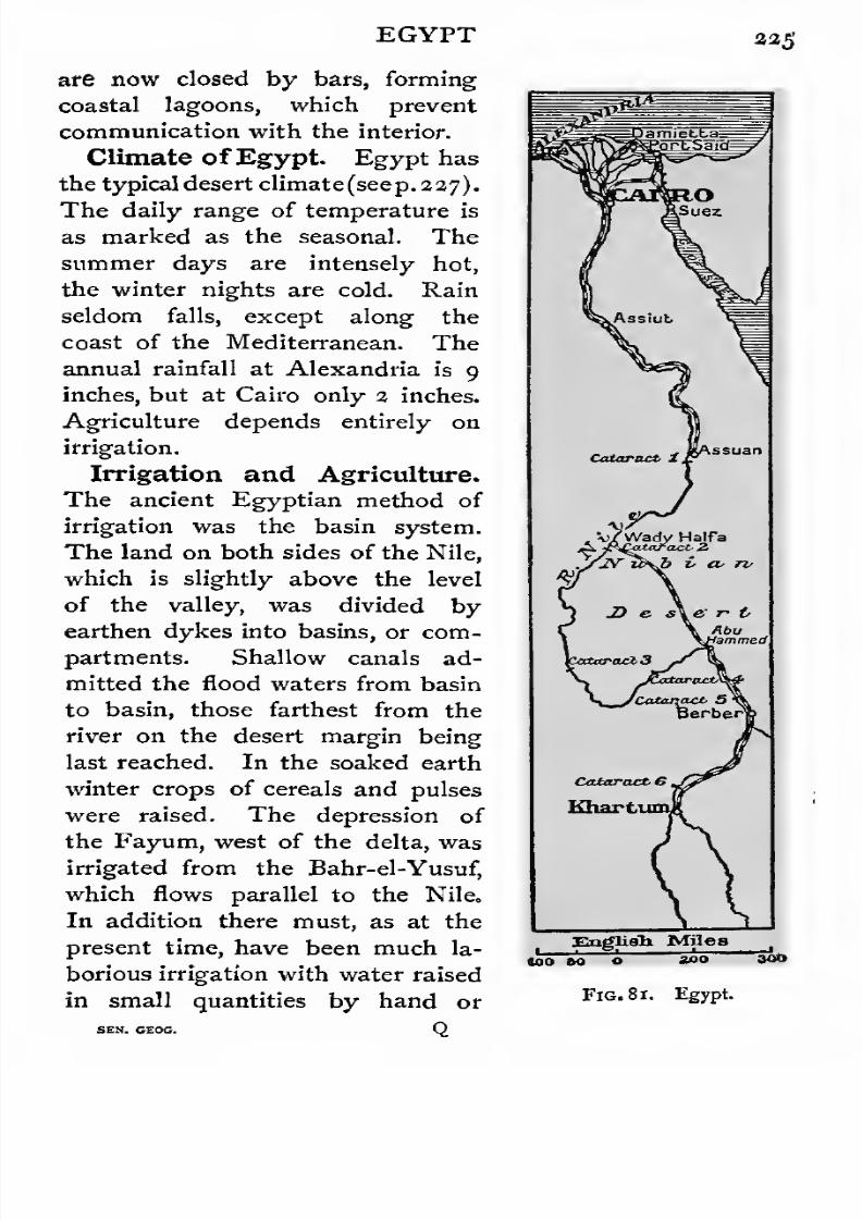
7/30/2019 The Senior Geography 1919
http://slidepdf.com/reader/full/the-senior-geography-1919 241/383
EGYPT 335
are now closed by bars, forming
coastal lagoons, which prevent
communication with the interior.
Climate ofEgypt. Egypt has
the typical desert climate(seep. 227).
The daily range of temperature is
as marked as the seasonal. The
summer days are intensely hot,
the winter nights are cold. Rain
seldom falls, except along the
coast of the Mediterranean. Theannual rainfall at Alexandria is 9
inches, but at Cairo only 2 inches.
Agriculture depends entirely on
irrigation.
Irrigation and Agriculture.
Theancient Egyptian
methodof
irrigation was the basin system.
The land on both sides of the Nile,
which is slightly above the level
of the valley, was divided by
earthen dykes into basins, or com-
partments. Shallow canals ad-
mitted the flood waters from basin
to basin, those farthest from the
river on the desert margin being
last reached. In the soaked earth
winter crops of cereals and pulses
were raised. The depression of
the Fayum, west of the delta, wasirrigated from the Bahr-el-Yusuf,
which flows parallel to the Nile.
In addition there must, as at the
present time, have been much la-
borious irrigation with water raised
in small quantities by hand or
, Haifa
Engliah Miles
Fig. 8 1. Egypt.
300
SEN. CEOG.
7/30/2019 The Senior Geography 1919
http://slidepdf.com/reader/full/the-senior-geography-1919 242/383
226 EGYPT
animal power. The modern method of irrigation allows
agriculture to be practised all the year round. The river
is dammed back to form a head of water, from which
water is drawn off by deep canals, and distributed to the
network of irrigation canals below the dam. Canals thus fed
can be kept full all the year. This method was first applied
to Lower Egypt by damming the Nile at the apex of the
delta. It is now extended to Upper Egypt. The river has
been dammed at Aswan, and a second regulating dam built
at Assiut. The sluices are shut down towards the end of the
Nile flood, and gradually opened as the next flood rises.
The Nile flood is highest at Aswan about the middle of
September, and at Cairo about a month later. The height
varies from year to year. A poor Nile rises about 21 feet at
Aswan, a good Nile from 26 to 27 feet, and a dangerous Nile
about 30 feet. The amount of land which can be irrigated
varies in proportion.
Egypt has three seasons. In the winter season the Nile is
falling, and the land under cultivation is at a maximum.
Wheat, barley, clover, and pulses are the chief winter crops.
In the summer season the Nile reaches its lowest, and only
the lands capable of perennial irrigation are under cultivation.
The crops are cotton, sugar, millet, rice, fruits, and vegetables.
In the flood season the Nile is high, and the crops are maize,millet, and rice.
Routes and Towns. Egypt is shut in by deserts except
on the north. It can be entered by two routes from the
Mediterranean, (1) west of the delta by Alexandria, and (2) east
of it from Port Said or Ismailia. It was for the control of the
latter route that the battle of Tel-el-Kebir was fought in 1882.
This was the route by which Egypt and the Mesopota-
mian empires repeatedly attacked each other, and by which
Arabs, Mongols, and Turks successively overran Egypt.
Except by these two entrances communication was anciently
prevented by the marshes of the delta, and now by the lagoons
and irrigation canals. The Egyptians were never a seafaring

7/30/2019 The Senior Geography 1919
http://slidepdf.com/reader/full/the-senior-geography-1919 243/383
EGYPT 237
people, and the foundation of Alexandria, the outlet for Egypt
and the chief port of the Eastern Mediterranean, was due to
Alexander. Port Said is the modern creation ofthe Suez Canal.
There has always been a great city at the apex of the delta,
where these routes converge. Cairo is the modern represen-
tative of Memphis and Heliopolis. The other centre of ancient
Egypt was Thebes (the modern Luxor), where the Nile most
nearly approaches the Red Sea. The strategic importance of
Aswan has already been noted. The modern representative
of the ancient route to the Red Sea from Syene is the railway
from Berber, between the fifth cataract and the confluence of
the Atbara, to Port Sudan, north of Suakin, across the desert
south of the Egyptian frontier. This is connected with the
railway which runs from the second cataract at Wadi Haifa
across the desert to Abu Hamed, and the line is continued
from Berber to Khartum.
THE SAHARA.
Configuration. The Sahara is a low tableland, most of
which is less than 1,000 feet above the sea. It is crossed from
north-west to south-east by a higher belt, highest in the south-
east in the Tibesti plateau (9,000 feet). This divides the
Sahara into a Western desert and an Eastern, or Libyan,
desert. There are numerous watercourses, but few are per-
manently filled with water. A number of short rivers flow
from the Atlas, fertilizing the oases at the base. Much of
the surface is rocky or stony, but over large areas it is covered
by sand-dunes. The formation of these is due to the peculi-
arities of the desert climate.
Climate. Where vegetation is present it prevents the soil
from being rapidly heated during the hours of sunlight, and as
rapidly chilled after sunset by radiation. The stony or rocky
plateaus of the Sahara have not this protective covering, and
experience great daily and seasonal variations of temperature.
In summer most of the Sahara has a temperature of over
90 F., and is the hottest part of Africa. The outer layers of
7/30/2019 The Senior Geography 1919
http://slidepdf.com/reader/full/the-senior-geography-1919 244/383
aa8 THE SAHARA
rock are alternately expanding and contracting with great
rapidity. In the process they split in all directions. Large
areas are covered with rock waste of this kind, forming stony
deserts. In the same way the smaller fragments are gradually
worn down into fine sand, which is caught up and carried by
the wind, and heaped into wave-like dunes, which may be
as much as i,ooo feet or more high. These dunes are imper-
ceptibly but steadily pushed on by the wind, and often
encroach on fertile oases.
There are three large areas of sand dunes in the Sahara ;
one in the east, covering the greater part of the Libyan desert
another, less continuous, in the centre, west of the Tibesti
plateau ; and a third in the Western desert, stretching south
of the Atlas almost unbroken towards the south-west.
The greater part of the Sahara is almost rainless. The Air
and Tibesti plateaus are high enough to receive occasional
violent rains,
andthese contain fertile tracts.
Vegetation and Oases. The lack of vegetation is due
to the lack of moisture. The soil is potentially very fertile.
A shower of rain or heavy fall of dew may stir into life
dormant seeds, and cover a considerable area with a blush of
green. If such showers occur fairly regularly from time to
time they may support a scrub of dwarf thorny plants (tama-
risk, gum acacia), adapted to resist long drought, or coarse
dry grasses on which animals can be grazed. Most of the
scanty moisture sinks through the soil, reappearing at a lower
level as wells or springs, round which oases develop.
In the oases agriculture and a scanty settled population are
found. The date palm is the most valuable product, and
without it the desert would hardly be habitable. In thelarger oases, which can be irrigated from permanent streams,
cereals and pulses are cultivated to a small extent. In the
better parts of the Sahara and on the margin of the oases, the
keeping of camels, goats, and sheep is the occupation of
nomadic tent-dwellers.
Oases and Routes. Some of the more important oases
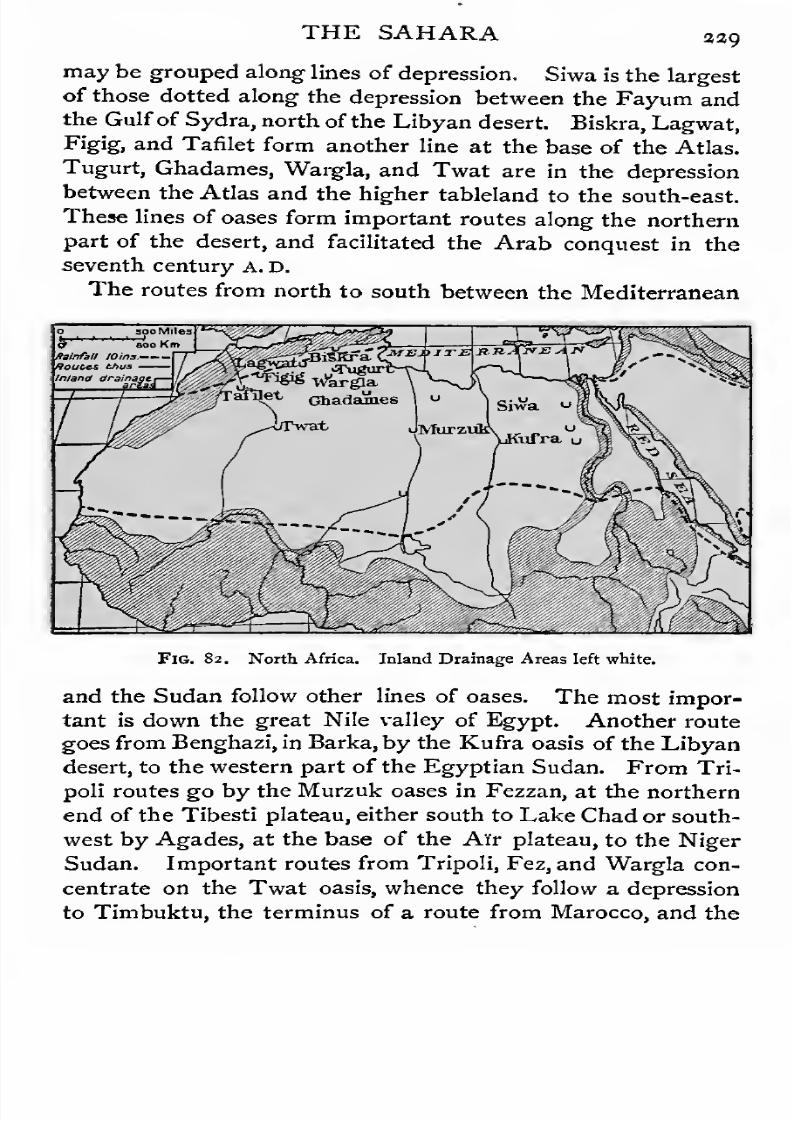
7/30/2019 The Senior Geography 1919
http://slidepdf.com/reader/full/the-senior-geography-1919 245/383
THE SAHARA 33Q
may be grouped along lines of depression. Siwa is the largest
of those dotted along the depression between the Fayum and
the Gulfof Sydra, north of the Libyan desert. Biskra, Lagwat,
Figig, and Tafilet form another line at thebase of the Atlas.
Tugurt, Ghadames, Wargla, and Twat are in the depression
between the Atlas and the higher tableland to the south-east.
These lines of oases form important routes along the northern
part of the desert, and facilitated the Arab conquest in the
seventh century A. D.
The routes from north to south between the Mediterranean
80o KmRainfall loins.
Routes thus
Inland drainage
FlG. 82. North Africa. Inland Drainage Areas left white.
and the Sudan follow other lines of oases. The most impor-
tant is down the great Nile valley of Egypt. Another route
goes from Benghazi, in Barka, by the Kufra oasis of the Libyan
desert, to the western part of the Egyptian Sudan. From Tri-
poli routes go by the Murzuk oases in Fezzan, at the northern
end of the Tibesti plateau, either south to Lake Chad or south-
west by Agades, at the base of the Air plateau, to the Niger
Sudan. Important routes from Tripoli, Fez, and Wargla con-
centrate on the Twat oasis, whence they follow a depression
to Timbuktu, the terminus of a route from Marocco, and the

7/30/2019 The Senior Geography 1919
http://slidepdf.com/reader/full/the-senior-geography-1919 246/383
230 THE SAHARA
link between the Western Sahara and Sudan. All these routes
are followed by camel caravans, which may take weeks or
months on the way, dividing the journey into stages where
food and water can be obtained. If delayed by sandstorms,
or if the wells are dry, a caravan may perish from thirst. The
trade between the Mediterranean and the Sudan is very ancient,
but it is beginning to decline as the Sudan finds outlets to
the south by sea.
THE SUDAN.
The Sudan. South of about 15° N. the year is divided
into a long dry season and a short wet summer season (see
p. 10), which becomes longer towards the south. The desert
gradually passes into a wooded grass land or savana (see p. 13).
This savana belt forms the Sudan, which extends from the
Atlantic nearly to the Red Sea. The southern limit is in
the west the divide between the Niger and the rivers flowing
directly to the Gulf of Guinea, in the centre the divide between
the Chad basin ofinland drainage and the Congo, and in the east
it approaches within about 5° of the equator. The Western
Sudan consists of the basins of the Senegal and Gambia and
of the Upper and Middle Niger, the Central Sudan of the Lake
Chad basin, and the Eastern Sudan of the basin of the Middle
Nile. Somaliland is outside the typical Sudan, but on its
eastern margin.
Western Sudan. The Futa Jallon Highlands,on the south-
west margin of the Sudan, form the hydrographical centre,
in or near which rise the Senegal and Gambia, flowing north
and west to the Atlantic, and the Niger. The Niger flows
north-east to the base of the highlands, and winds with a slight
slope across the Sudan to the margin of the Sahara, where
Timbuktu is built near the river. Here it turns south-east in
a gorge-like valley, interrupted by rapids as it descends the
terraces of the plateau. The navigation of all the African
rivers is interrupted in this way, owing to the tabular configu-
ration of the continent. Hence they do not form routes to
7/30/2019 The Senior Geography 1919
http://slidepdf.com/reader/full/the-senior-geography-1919 247/383
THE SUDAN 331
the interior, though they are often navigable for long distances
above and below the falls. On the left bank the Niger receives
the Kaduna and the Benue, separated by the Lanthan High-
lands. The northern slopes of these highlands are drainedeast by the Wobi to Lake Chad, a marshy lake of varying
dimensions, whose chief affluent is the Shari, from the wetter
regions to the south-east.
Climate. The Sudan has three seasons, a hot dry season
from February to June,, a hot wet season from July to Sep-
tember, and the season of the Harmattan, a dry, easterly, dust-
laden wind from the Sahara, from October to January. The
mean annual temperature is about 80° F., but temperatures of
over ioo" are common, while frost occasionally occurs through
the loss of heat by radiation. The daily range is often 30°.
The rainfall increases from about 10 inches per annum on the
desert margin, to 60 inches in the south, on the margin of the
equatorial wet belt. The Sudan is thus a transition region
between the desert, which is too dry for agriculture, and the
hot moist forests to the south, where excessive heat and damp
are also unfavourable to agriculture.
Products and Occupations. Except in the drier north
and east, the Sudan is essentially agricultural. Two crops of
dhurra millet, the chief cereal, can be grown in the best parts.
Other products are wheat, maize, rice, beans, cotton, indigo,
tobacco,and the kola nut, a powerful stimulant. Gum acacias
characterize the drier eastern region, especially round Lake
Chad. Yams, ground-nuts, pepper, the oil palm, the shea
butter tree, sandalwood, and rubber indicate the approach to
equatorial conditions. The soil is admirably suited to cotton,
which supplies an important native manufacture.
The high repute of the Sudan manufactures in North Africa
is one cause of the considerable caravan trade across the desert.
Marocco leather, made at Kano of skins imported from the
pastoral lands on the margin, is sent across the desert to
Tripoli, the market. Cotton cloths, dyed with native indigo,
are also in great demand.

7/30/2019 The Senior Geography 1919
http://slidepdf.com/reader/full/the-senior-geography-1919 248/383
033 THE SUDAN
Routes. The Upper Niger becomes very shallow as it
crosses the arid northern region, where it receives no tribu-
taries. It is continuously navigable only below the rapids,
near the southern margin of the Sudan. The Benue is the
main waterway to the interior, but it is unhealthy and infested
by the fatal tse-tse fly. Lake Chad is reached by the Wobi.
The French Sudan. The greater, though not the richer,
part of the Sudan is French. Northern Nigeria and the lower
Gambia (capital, Bathurst) are British. French expansion has
proceeded from the old colony of Senegambia, whose capital,
St. Louis, on the Senegal, is connected by rail with the much
Fig. 83. The Western Sudan and Upper Guinea. (Political divisions of 1914).
superior port of Dakar. The route to the interior is by the
Senegal to Kayes, by railway to the Niger at Kulikoro, and
by river to Timbuktu, the capital of the French Sudan, to
which routes across the Sahara converge. The region east of
Lake Chad is reached from French Congo, of which it forms
thenorthern part.
Nigeria. British Nigeria is the highest and most fertile
part of the Sudan. It has long been occupied by semi-civilized
agricultural tribes of mixed blood. The white strain predomi-
nates round Lake Chad, and on the northern margin, while on
the Middle Niger the Hausa, a negroid race of high type, is
the predominant element. This mixture of blood points to
7/30/2019 The Senior Geography 1919
http://slidepdf.com/reader/full/the-senior-geography-1919 249/383
THE SUDAN 333
a long struggle between north and south for the possession of
the fertile intermediate region. Through the north came
probably the civilization, and certainly the religion, which is
Mohammedan. The settled Hausas, skilful farmers, craftsmen,
and traders, were conquered by the pastoral Fulani in the
eighteenth century. A century later Hausa soldiers were led
by British officers from the south against Sokoto and Kano, the
chief Fulani centres. Sokoto is the centre of the Mohammedan
faith in the Western Sudan. Kano, in a highly fertile region
not far from the desert margin, has been for 1,000 years the
great market. It collects the produce of the Sudan and
forwards it by caravan to Tripoli. The other centres are more
modem. Lokoja, opposite the confluence of the Benue, is the
natural gateway of the Sudan on the south, and will grow as
the Benue route increases in importance. Zungeru must
become a considerable place from its position where the
route from the Niger to Kano crosses the Kaduna. Zaria
{a,ooo feet high), on the same route, is the healthiest place
in Nigeria. It is in the heart of a fertile region, and will
become an important centre. Railways are being extended
through this region.
The Anglo-Egyptian Sudan. This country is sur-
rounded by a horseshoe of heights which separate the Chad
and Congo basins from the Nile. In the east the great table-
land of Abyssinia rises to 15,000 feet. The tributaries from
the western curve of the horseshoe are carried to the Nile by
the Bahr-el-Ghazel, through great swamps. Nearly opposite
comes in the Sobat from Southern Abyssinia. The' centre
of the Nile basin is flat in the Sudan, though about 1,500 feet
above the sea. The rivers form great swamps many miles
wide, but are navigable except where impeded by the floating
vegetation known as sadd. The climate is that of the Western
Sudan, but drier.
The peoples of the Nile margin are fishers along its banks,
and herdsmen farther from the river. The highlands are
occupied not very advancedagricultural communities.

7/30/2019 The Senior Geography 1919
http://slidepdf.com/reader/full/the-senior-geography-1919 250/383
234 THE SUDAN
The southern and eastern margins of the Sudan are rich, but
in recent years they have been harried by the pastoral Der-
vishes, a fanatical Mohammedan sect strongly opposed to
European influence. In 1885 their leader, the Mahdi, took
and destroyed Khartum, and made his capital at the neigh-
bouring Omdurman, on the White Nile. Khartum, at the
confluence of the Blue and White Nile, where routes con-
verge from all directions on the margin of the desert, is the
key of the Eastern Sudan, and its possession is essential to
the security of Egypt. It was retaken by the battle of
Omdurman in 1898, and from that base the Egyptian Sudan
was gradually reconquered. The Dervish power is not crushed,
but it has been driven far west of the Nile, the only route
south of Khartum. Gondokoro on the southern margin of the
Sudan, lies at the end of the series of rapids which occur
between 4° and 5° N.
Abyssinia is a lofty tableland covered with hard volcanic
rock, in which the rivers cut deep narrow gorges. The
difficulty of crossing these deep fissures interrupts communica-
tions. The higher parts receive heavy summer rains, which
swell the shallow Blue Nile and Atbara to immense rivers,
and carry the loose volcanic soil to the plains.
Abyssinia has three zones of climate and products. Up to
5,oco feet both resemble those of the Sudan. From 5,000
to 9,000 feet is the warm belt, where the vine grows. Still
higher are the cool lands, cultivated with cereals. Most of
the country is pastoral.
The difficulty of communication has favoured the growth
of rival chiefs, and the capital has varied with the ascendancy
of different tribes. At present it is at AddisAbbaba,
in the
centre.
Abyssinia forms a difficult barrier between the Nile and
the Red Sea, and there are no easy routes across it. Routes
from Khartum and Berber converge on Gondar, the ecclesi-
astical capital, north of Lake Tana, a mountain-girt basin in
which the Blue Nile rises. From Gondar the route continues

7/30/2019 The Senior Geography 1919
http://slidepdf.com/reader/full/the-senior-geography-1919 251/383
THE SUDAN 235
north-east by Axum, a former capital, to Massawa, on the
Red Sea, in the Italian colony of Eritrea. A railway runs
inland from Massawa to Asmara and beyond. An eastern route
leads from Addis Abbaba to the Gulf of Aden. A line is
being built from Jibuti, in French Somaliland, by Harrar, the
largest town, to Addis Abbaba.
Somaliland. Somaliland, the Horn of Africa, is a transi-
tion region between the Sudan and Arabia, but more nearly
resembles the latter, from which it is separated by a strait
only fifteen miles wide. Too low to condense the monsoon
rains, it is a thinly-peopled pastoral region. Part of it belongs
to Abyssinia, the rest to Britain, France, and Italy. To the
European powers its value lies in its control of the route from
the Gulf of Aden to Abyssinia and the Nile. Italy appeared
likely to obtain the control of Abyssinia, but received a crushing
defeat at Adowa in 1896.
THE GUINEA LANDS.
The Guinea lands extend from the Futa Jallon Highlands
to south of the mouth of the Congo. The Niger delta divides
them into Upper and Lower Guinea.
Upper Guinea. Upper Guinea rises from a low, sandy,
surf-beaten coast, backed by swampy forests, to the forested
highlands which separate the rivers flowing south to the Gulf of
Guinea from the Niger. The former are short in the west but
longer in the centre, where the highlands recede from the coast.
Their deltas are covered with mangrove swamps, but they
are navigable for small boats to the base of the highlands (see
Fig. 83).
The climate is uniformly hot, and the range of temperature
small. An area of low pressure is formed over the land,
towards which the south-east trade winds are drawn north
across the equator and deflected to the right in the northern
hemisphere. Having crossed the seas they are moisture laden.
The Upper Guinea Highlands deflect them upwards, causing
7/30/2019 The Senior Geography 1919
http://slidepdf.com/reader/full/the-senior-geography-1919 252/383
336 THE GUINEA LANDS
heavy rains at all seasons. The only break is when the dry
Harmattan blows from the Sahara (see p. 331).
The influence of constant heat and moisture on forest growth
has already been described (see p. 15). The Guinea coast is
a typical equatorial forest region, difficult to penetrate except
by the creeks and streams. Rubber is found everywhere.
Ground-nuts are important in the west, and the oil palm in
the east, especially in Nigeria. The chief cultivated plants
are coffee and cotton. Trade is hampered by the difficulty
of bringing down produce through the forest and of shipping
it from a harbourless coast through dangerous surf.
Equatorial conditions are unfavourable to a high type of
civilization. The needs of life are few and simple. Only
small groups can be formed, and these are hostile to each
other. The dark forest affords cover for stealthy attack, and
creates a lurking dread of the unseen, whether human or
superhuman, which results in many degrading superstitions
and revolting practices. Such a region has no history as we
understand it.
Notwithstanding the difficulty of access various European
powers from the sixteenth century onwards maintained trading
factories at points on the coast. The nature of the produce
collected is indicated by the names Grain (spice grains), Ivory,
Gold, and Slave Coast. Only in recent years has the interior
been parcelled out. Liberia is a free negro republic. The
European powers are Britain, Portugal, and France. The
British colonies are Sierra Leone, with a good harbour of Free-
town, the Gold Coast, with Akra, leading to Ashanti, and the
southern part of Nigeria, including Lagos. Freetown and
Lagos are the chief markets of West Africa. Lines are being
built inland from the various coast ports, the most important
being those from Lagos by Ilorin towards the Niger, whose
densely forested delta forms a route to the interior continued
by the Benue (see p. 332) ; from Konakri in French Guinea
towards the Niger, and from Sekondi on the Gold Coast to
Kumasi, the capital of Ashanti (see also Fig. 83).
7/30/2019 The Senior Geography 1919
http://slidepdf.com/reader/full/the-senior-geography-1919 253/383
THE GUINEA LANDS 237
Lower Guinea. The Lower Guinea Highlands are the
high edge of the interior plateau. In the extreme north,
where the coast begins to trend south, the volcanic Kamerun
group exceeds 13,000 feet. The vegetation is tropical forestup to 5,000 feet, and temperate up to 7,000 feet, above which
are grass lands, passing into moorland. Above all these is the
ash cone.
The northern part of the Lower Guinea Highlands formed
the German Kamerun colony, with fertile clearings in which
cacao and coffee are grown, and with savanas above the forests.
French Congo is very similar in climate and products,
but has the advantage of access to the Congo, which forms
the frontier with the Congo Free Staterx Libreville, on the
Gabun estuary, has a fine harbour. Otherxentres are Loango
on the coast, and Brazzaville on Stanley Pool. The southern
part of these highlands forms Angola (Portuguese). Angola
is flat and arid on the coast, but rises inland to the plateau,which reaches 7,500 feet. The tropical forests of the lower
slopes produce rubber and palm oil. Coffee is exported from
Ambriz, Sao Paulo de Loanda, and Benguela. Cotton and
sugar are grown round Mossamedes in the south. Railways
are gradually being built.
The Congo Basin. The Congo basin is a circular plain-
like basin, 1,500 feet above the sea, surrounded on all sides by
the edges of higher plateaus. The only break is in the north,
where the Shari opens towards Lake Chad. To the east this
highland rim rises to the heights overlooking the Western
Rift Valley; in the south-west to those forming the Congo-
Zambezi divide. All these are in the wet belt and the tribu-
taries from them carry an enormous volume of water downto the main stream. The lowest elevation, to which both
tributaries and the main stream flow, crosses the circular basin
from north-east to south-west, and is indicated by the line
of the Ubangi-Congo.
The main stream rises in the highlands south of Lake
Tanganyika, and flows through Lakes Bangweolo and Mweru,
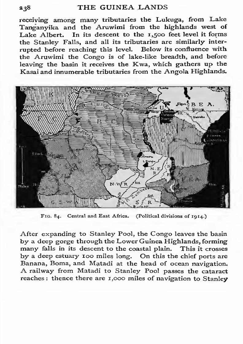
7/30/2019 The Senior Geography 1919
http://slidepdf.com/reader/full/the-senior-geography-1919 254/383
a38 THE GUINEA LANDS
receiving among many tributaries the Lukuga, from Lake
Tanganyika and the Aruwimi from the highlands west of
Lake Albert. In its descent to the 1,500 feet level it forms
the Stanley Falls, and all its tributaries are similarly inter-
rupted before reaching this level. Below its confluence with
the Aruwimi the Congo is of lake-like breadth, and before
leaving the basin it receives the Kwa, which gathers up the
Kasai and innumerable tributaries from the Angola Highlands.
"^mm
Fig. 84. Central and East Africa. (Political divisions of 19 14.)
After expanding to Stanley Pool, the Congo leaves the basin
by a deep gorge through the Lower Guinea Highlands, forming
many falls in its descent to the coastal plain. This it crosses
by a deep estuary 100 miles long. On this the chief ports are
Banana, Boma, and Matadi at the head of ocean navigation.
A railway from Matadi to Stanley Pool passes the cataract
reaches: thence there are 1,000 miles of navigation to Stanley
7/30/2019 The Senior Geography 1919
http://slidepdf.com/reader/full/the-senior-geography-1919 255/383
THE GUINEA LANDS 339
Falls ; above this there are drier stretches of railway avoiding
rapids, so that there is rail-river communication through to
Lake Tanganyika and to Rhodesia.
All the Congo basin is a typical equatorial forest region.
Stanley marched for more than five months through unbroken
forests on the Aruwimi, crossing streams every few hundred
yards. Rubber is the chief product yet utilized. It is the
staple of Belgian Congo.
As in Guinea the dense forest has definitely influenced the
civilization. Its impenetrability to pursuit has made it the
refuge of defeated peoples. The dwarf pygmies, who live byhunting with poisoned arrows, probably represent the most
primitive of African races. Other tribes, though much superior
physically, are otherwise debased. The forest supplies little
animal food, for which they have a craving, and this leads to
cannibalism.
THE EASTERN SAVANAS.
East Central Africa. East Central Africa rises from a
low, unhealthy coastal plain by steep terraced escarpments to
a tableland about 4,000 feet high. This is crossed from north
to south by two long rift valleys (see p. 2,0,1), with higher lands
along their margins, and many signs of volcanic activity. East
of the Eastern Rift are the great extinct volcanic masses of
Kenya (1 7,000 feet) and Kilimanjaro (19,300 feet). The extinct
Elgon (14,000 feet) rises west of this rift, north of Victoria
Nyanza, a basin lake, filling a square depression as large as
Scotland. The great mass of Ruwenzori (cir. 16,800 feet)
east of the Western Rift between Lakes Albert and Albert
Edward appears not to be ofvolcanic origin, but between Lakes
Albert Edward and Kivu the Western Rift is blocked by the
Mfumbiro group of active volcanoes (14,700 feet).
Lake Victoria and the Upper Nile. Lake Victoria, or
Victoria Nyanza, lies 3,700 feet above the sea. It receives
among other streams the Kagera from the west, the remotest

7/30/2019 The Senior Geography 1919
http://slidepdf.com/reader/full/the-senior-geography-1919 256/383
340 THE EASTERN SAVANAS
source of the Nile. Situated mainly south of the equator,
and fed by heavy equatorial rains, Lake Victoria is a great
reservoir whose waters keep the Nile from running dry in its
long course across the desert. So long as the equatorial lakes
are its chief feeders the Nile is low, the annual rise occurring
only when the Abyssinian tributaries carry down the summer
floods (see p. 334). The Nile leaves Lake Victoria at its
northern end over the shallow Ripon Falls, crosses a fairly
level swampy country and rushes over a series of falls, the
last known as the Murchison Falls (140 feet), to the Western
Riftand Lake Albert. Lake Albert (1,940 feet high) receives
the outflow of the higher Albert Edward (3,000 feet), by the
Semliki, which flows in the rift valley at the base of the snow
peaks of Ruwenzori. Leaving Lake Albert the Nile follows
the rift valley, now less well-marked, to the low plateau of
the Eastern Sudan, which it enters about lat. 5 N. Across
this it is navigable to the Sixth Cataract. Thus the Nile,
like the Congo (p. 238) and the Niger (p. 230), has a navigable
stretch of several hundred miles in its middle course above the
falls by which it descends the last terraces of the tableland.
The South and East of the Eastern Tableland. South
of Lake Victoria the tableland rises gradually to the Living-
stone Mountains (10,000 feet) north-east of Lake Nyasa. The
lake is drainedby
the Shire to the Zambezi.From the high-
lands which end in the eastern escarpment of the plateau
several large rivers descend to the Indian Ocean, but they are
of little use for navigation.
Climate. East Central Africa is much higher than the
Congo basin in the same latitudes, and the heat is therefore
not so great. Three regions may be distinguished, (a) that
round Lake Victoria, which receives heavy equatorial rains,
and (b) the low, hot coastal plain, also very wet. Between
the two is (c), a relatively dry area which is higher, cooler, and
healthier.
Vegetation. Dense forests are found in the coastal plains
and in the wet rift valleys. The banana grows profusely

7/30/2019 The Senior Geography 1919
http://slidepdf.com/reader/full/the-senior-geography-1919 257/383
THE EASTERN SAVANAS 441
round Lake Victoria, but not in the drier regions east of it,
which are open woodlands, with large areas of poor scrub.
The high peaks of Kenya and Kilimanjaro condense heavy
rains, and at their base a belt of agricultural land interrupts
the dry belt. Both on these mountains and on Ruwenzori,
all of which rise above the snow-line in the highest peaks,
there is the same succession of vegetation zones as in the
Kamerun peak (see p. 237).
Occupations. The inhabitants are negroes of the Bantu
stock. They are agricultural in the more fertile regions, and
pastoral elsewhere. The northern herdsmen of mixed Hamitic
white blood have often raided the settled peoples, and in
Uganda, as in Hausaland (see p. 333) became the ruling
aristocracy.
The Bantus have expanded widely over the savanas of
Central Africa, pushing the weaker races southwards towards
the southern deserts, and perhaps westwards into the equatorial
forests.
Routes. East Central Africa is almost inaccessible from
the west, from which it is cut off by high mountains and deep
rifts. In the north the Nile is a natural route to the base of
the higher tableland at Gondokoro, from which roads are
being made to Entebbe, the capital of Uganda (British), on the
northern shores of Lake Victoria. There is a considerable
steamer traffic on the lake. From Port Florence, on a north-
eastern bay, the Uganda railway runs east, descends to the
Eastern Rift valley, runs south along its floor till a suitable
ascent is found to the eastern plateau, passes Nairobi, and
descends to Mombasa, the chief port of British East Africa.
Farther south, off the coast of German East Africa, of which
the capital and port is Dar-es-Salaam, is the island of Zanzibar,
the great commercial centre of East Africa. Like the neigh-
bouring island of Pemba, it supplies the world with cloves,
and is British. Zanzibar, the capital, was the starting-point
of the old slave caravan route which crossed to the mainland,
climbed the escarpment in what is now German East Africa
7/30/2019 The Senior Geography 1919
http://slidepdf.com/reader/full/the-senior-geography-1919 258/383
34* THE EASTERN SAVANAS
to the Unyamwezi grass lands, where the route forked north to
Lake Victoria or west to Ujiji on Lake Tanganyika. In
Portuguese East Africa, the chief port is Mozambique,
where the seas between Madagascar and the mainland are
narrowest.
Savanas and Forests of the Zambezi. The Zambezi,
like the Niger, rises where the plateau is high enough for
savanas to replace forests. Its upper course trends away
from the equator towards the desert, which it almost reaches.
Its middle course is through the savanas of Rhodesia, and it
enters the sea through a delta covered with dense tropical
forest. Compare this with the very similar course of the
Niger (see p. 230). The savana belt extends across Africa
south of the Equator, in latitudes corresponding to those of
the Sudan, with which it may be compared. On the east
this savana belt is continuous from the Egyptian Sudan to
the Zambezi. This is an exceptional circumstance, due to
the elevation. The normal conditions are better seen in the
west, where the two savana belts are separated by equatorial
forests.
The Zambezi rises some 5,coo feet above the sea, near
feeders of the Congo, in the ill-marked Congo-Zambezi divide.
It crosses a flat, swampy, marshy region, and after receiving
the Chobe turns east across a plateau of basalt, a hard volcanic
rock, in which it has cut a narrow zigzag gorge 40 miles
long. To this it drops over the Victoria Falls (350 feet) con-
tracting from over a mile in breadth to little over 400 feet.
In its middle course it descends the plateau terraces in a
series of falls and rapids. Below the Kebrabasa Falls, the
lowest, it is navigable for 400 miles. The most accessible of
the distributaries of the delta is the mangrove-fringed Chinde.
The chief tributaries are all from the wetter north. The
basin of the Kafwe forms the savanas of North-west Rhodesia
and the Loangwa those of North-east Rhodesia, which is also
drained by the Chambezi or Upper Congo. The Shire drains
Lake Nyasa, west of which is the Nyasaland (formerly British

7/30/2019 The Senior Geography 1919
http://slidepdf.com/reader/full/the-senior-geography-1919 259/383
THE EASTERN SAVANAS 243
Central African) Protectorate. The Lower Zambezi, from the
Loangwa to the sea, is in Portuguese East Africa.
The natives of the Zambezi basin are mainly agricultural,
combining hoe cultivation with the keeping of animals. Thelatter is impossible in the lower valleys, which are infested
with the tse-tse fly, and very thinly peopled.
The lower Zambezi and its tributary the Shire* form the
best route to the interior. The middle course of the Shire
is interrupted by falls, but it is navigable above and below.
Theobstructions are
avoided by makingroads, which are
being replaced by railways. There is steamer communication
on Lake Nyasa, and the route is continued from its northern
end to Tanganyika by the Stevenson Road.
The highlands of the Nyasaland Protectorate resemble
those of Angola or Northern Nigeria. Coffee, cotton, and
wheat are cultivated. The chief settlement is Blantyre, and
the capital Zomba. Northern Rhodesia is known to possess
mineral in addition to other natural wealth. It is being rapidly
opened up by the development of communications. The
railway from Cape Town is now carried north of the Zambezi
Falls to the frontier of Belgian Congo.
AFRICA SOUTH OF THE ZAMBEZI.
Configuration. Africa, south of the Zambezi, has the
highest general configuration of any part of the continent.
Little of it is below 3,000 feet, and the average elevation is
from 4,000 to 5,000 feet. The valleys of the Zambezi, the
Limpopo, and the Molopo, the latter a tributary of the
Orange, form three lower belts, above which rise the South
Rhodesian Highlands, between the Zambezi and Limpopo
the Damara-Nama plateau, west of the Molopo, and the
High Veld (Hooge Veldt), in the south-east. Over most of
this region the rock strata are nearly horizontal, and weather
into flat-topped or pointed heights, as kopjes. In the
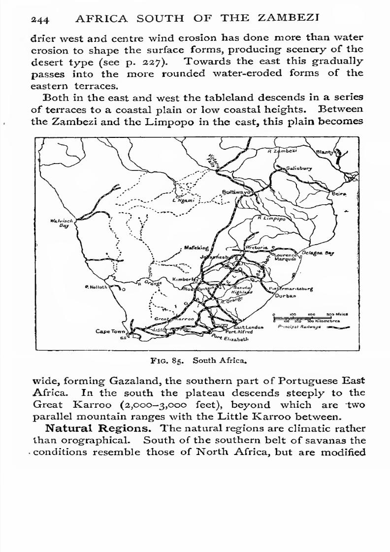
7/30/2019 The Senior Geography 1919
http://slidepdf.com/reader/full/the-senior-geography-1919 260/383
244 AFRICA SOUTH OF THE ZAMBEZI
drier west and centre wind erosion has done more than water
erosion to shape the surface forms, producing scenery of the
desert type (see p. 227). Towards the east this gradually
passes into the more rounded water-eroded forms of theeastern terraces.
Both in the east and west the tableland descends in a series
of terraces to a coastal plain or low coastal heights. Between
the Zambezi and the Limpopo in the east, this plain becomes
/x

7/30/2019 The Senior Geography 1919
http://slidepdf.com/reader/full/the-senior-geography-1919 261/383
AFRICA SOUTH OF THE ZAMBEZI 345
by (1) the narrowing of the continent;
(a) its greater eleva-
tion, and (3) the absence of a land mass on the windward
side, corresponding to Arabia on the north-east. For these
reasons, while the region as a whole is dry, the area of absolute
desert is much more restricted than in North Africa.
The eastern part of the South African tableland receives
summer rains from the south-east trade winds. These are
caused, like the north-east trades, by the inflowing of winds
from a high pressure system with its axis from 30 to 35°
towards thelow
pressure system round the equator. Being
in the southern hemisphere the southerly winds are deflected
by rotation to the left and blow as south-east winds. They
are passing from cooler to warmer regions, and bring little
rain except where they are forced upwards either by high-
lands or by ascending currents over the heated lands. Both
these conditions are fulfilled in South-east Africa. The
average elevation in the east is from 4,000 to 5,000 feet,
and in summer this is reinforced by the rising of air over
the heated surface of the relatively bare High Veld (see
p. 247). Rains occur in summer, diminishing from the eastern
margin of the High Veld towards the west. In winter the
air tends to move outwards from the cooled surface of the land
and this neutralizes the ascensioncaused
by the highlandsin the path of the trades. The winter rains are therefore
confined to the coast, and are slight. In winter the stormy
west winds come as far north as the extreme south of the
continent, bringing winter rains to the extreme south-west
and south coast, as in the Mediterranean. A small part
of the south coast thus receives rain at all seasons, from
the south-east trades in summer, and from the west winds
in winter.
Southern Rhodesia and its Margins. Southern Rho-
desia is a tableland about 4,000 feet high. The divide between
the rivers flowing" to the Zambezi and those flowing to the
Indian Ocean crosses it from south-west to north-east. Lying
within jo
c
of the equator it is at all seasons on the table-
7/30/2019 The Senior Geography 1919
http://slidepdf.com/reader/full/the-senior-geography-1919 262/383
346 AFRICA SOUTH OF THE ZAMBEZI
land but hot in the lowlands. The centre receives heavy
summer rains, diminishing towards the west and also towards
the coast. The relative dryness of Gazaland may be com-
pared with that of Somaliland.Southern
Rhodesiais
in thebelt of southern savanas, passing into dense wet forests on
the coastal lowlands of the east, which are in Portuguese
West Africa, and into desert on the west.
The native tribes are both agricultural and pastoral, but
crops are often ruined by swarms of locusts, one of the
scourges of South Africa. The tse-tse fly ravages the low-
lands. The region was raided early in the nineteenth century
by the Matabele Zulus, who were conquered by the British
at the end of the nineteenth century. The mineral wealth
is very great. Gold has been worked and exported for
several centuries and perhaps longer. The country is fit for
European settlement only above the fever-line, which reaches
4,000feet.
Agriculture is as yetlittle
developed and theprincipal occupation is mining.
In recent times the Rhodesian plateau has been reached
from the south both by the Zulus and by the British. The
main line from Cape Town runs to Bulawayo, and continues
across the Wankie Coalfields to the Victoria Falls and Northern
Rhodesia. From Bulawayo a line runs parallel to the divide
and west of it to Salisbury, the capital, whence it descends to
the Portuguese port of Beira, which has replaced the ancient
Sofala. This eastern entrance was the only one in use in the
Middle Ages, and by it the Portuguese obtained much gold
from the native tribes of the interior.
The South-West Deserts. The coastal strip is dry
from the Congo southwards. It broadens into a wide desertarea in the Damara-Nama plateau and in the Kalahari desert
and its margins (British Bechuanaland). Except on the higher
parts of the plateau rain seldom falls. The surface is covered
with a very sparse tufted vegetation, affording little nourish-
ment. Such plants as possess water-storing properties are
eagerly sought by the dwarf Bushmen, who are found in fast

7/30/2019 The Senior Geography 1919
http://slidepdf.com/reader/full/the-senior-geography-1919 263/383
AFRICA SOUTH OF THE ZAMBEZI 247
decreasing numbers in the desert. On its margin are pastoral
Hottentots and Bantus.
Walvisch Bay (British) is the only fair harbour. Farther
north is the port of Swakopmund, leading to Windhoek, the
capital of German South-west Africa until the Great War.
The northern part of Bechuanaland is a basin of inland
drainage to Ngami and other lakes. The eastern fertile
margin is crossed by the line to Rhodesia. The southern part is
in Cape Province. Mafeking is the chief town.
The High Veld. The High Veld is highest in the south-
east, in the Basuto Highlands, which form the hydrographiccentre. From Mont aux Sources (11,000 feet) the Tugela
flows east, the Orange south, the Caledon, a tributary of
the Orange, west and south-west, and the Wilge north to
the Vaal, which bends west and south-west to the Orange.
The united Vaal-Orange flows west to the Atlantic, in a
well-marked, steep-sided valley. Its volume diminishes
towards the coast, and it is interrupted by many falls. Like
all South African rivers it is rather a barrier than a route.
North of the Vaal three scarped ridges run east and west.
The most important is the Witwatersrand, or Rand, rich in
gold, in the south. Here rises the Crocodile, the head stream
of the Limpopo which drains the northern margin of the High
Veld. The eastern escarpment, known as the Drakensberg,
descends to a rolling coastal region, broken in the north by
the Lebombo Mountains, which form the eastern frontier
of the Transvaal. In the south the margin of the High
Veld is known under various names and descends to the
flat plain of the Great Karroo, which forms the southern
limit of the tableland. The highlands and plains south of
it are old mountains much dissected. The feature-lines in
the west run north and south. In the south they run from
east to west, forming the Zwartebergen, on the southern
margin of the Great Karroo, and the Langebergen, parallel
to it and the coast, with the Little Karroo between. The
topography of the south-west, where these two sets of feature-
lines cross is extremely complicated.

7/30/2019 The Senior Geography 1919
http://slidepdf.com/reader/full/the-senior-geography-1919 264/383
248 AFRICA SOUTH OF THE ZAMBEZI
The Karroos are dry regions, in which the rivers carry little
water except after rain, when they become swollen torrents
which rapidly deepen their valleys. The Gouritz breaks
across the parallel ranges to the sea, receiving tributaries
from between them (strike tributaries).
In the extreme south-west Table Mountain forms the north
of a small isolated tableland, ending in the Cape of Good
Hope (the Cape), with the Cape Flats between it and the
Drakenstein Mountains in the east.
Political Divisions of the High Veld and its Margins.
Politically the High Veld is divided into the Transvaal,
between the Limpopo and the Orange, the Orange Free
State, between the Vaal and the Orange, Basutoland, in
the Basuto Highlands, Natal and Zululand on the eastern
margin south of Portuguese East Africa, and the Cape of
Good Hope, south of the Orange River and Natal. Transvaal,
the Free State, Natal and the Cape are provinces of the Union,
of South Africa (British).
European settlements were originally made at suitable
points on the coast, as half-way houses on the long sea
route to India. The Portuguese settlements were at Algoa
Bay and Delagoa Bay. The Dutch station was at Cape
Town. Expansion inland was not originally contemplated,
and was hardly attempted except by the Dutch. The
anxiety of Britain to secure the Cape, which became British
early in the nineteenth century, was because of its relation
to the route to India.
Early Dutch expansion inland from Cape Town followed
the east and west lines of the southern ranges and the Little
Karroo. Much later there was a movement inland from Algoa
Bay, where the chief town is Port Elizabeth. This was chiefly
made by English and Germans.
Early white settlement hardly penetrated to the Great
Karroo and the tableland, which became the refuge of the
dispossessed Hottentots, pressed north by white expansion.
At the same time they were pressed west towards the desert
by Bantu tribes, who had followed the eastern savanasto
their
7/30/2019 The Senior Geography 1919
http://slidepdf.com/reader/full/the-senior-geography-1919 265/383
AFRICA SOUTH OF THE ZAMBEZI 249
With the growth of European colonization settlement
extended into the Karroos, which are too dry for agriculture.
A distinctively pastoral type developed, especially among the
Dutch, or Boer, settlers. The great mobility of the pastoraltype has already been noted (see p. 184). During the political
friction which followed the annexation of the Cape many
Dutch trekked north, reaching the High Veld, between the
Orange and the Vaal, which afterwards became the Orange
Free State. Some descended the Drakensberg to Natal,
where they were opposed by the Zulus and the English
traders at Durban. Driven from Natal they trekked north
into the High Veld north of the Vaal, which became the
Transvaal. Natal became British.
Modern South Africa has thus developed from five isolated
centres, Western Cape Colony, round Cape Town ; Eastern
Cape Colony round Port Elizabeth ; Natal on the east coast
and the two Dutch republics on the tableland. Everywherethe whites are in a minority, and except in the mining districts
the Dutch form the majority of the European population.
The Dutch republics were more isolated than any of the
others, having no access to the sea. Much of the grazing on
the High Veld is not rich, and each family requires a very
large acreage for its stock. The consequent isolation of farm
from farm helped to determine the peculiar independence and
great conservatism of the Boer character.
A great change began with the discovery of -the mineral
wealth of the country. The discovery of diamonds at
Kimberley in the sixties was soon followed by the extension
of the railway and the influx of a mining and speculating
population. This was intensified by the discovery of the
Rand goldfield in the eighties. Two opposite types of
civilization, with different ideals and needs, were thus brought
face to face. A long period of friction culminated in the
last Boer War (1899-1902) and the annexation of the Dutch
Republics by Britain. The Union of South Africa (see p. 248)
was formed in 19 10.

7/30/2019 The Senior Geography 1919
http://slidepdf.com/reader/full/the-senior-geography-1919 266/383
350 AFRICA SOUTH OF THE ZAMBEZI
bare High Veld, and the low unhealthy forested Low Veld
in the valleys. The chief settlements are in the south and
east. The latter has enough rain for agriculture, which is
practised in the south mainly where irrigation is possible.
Maize (mealies), tobacco, oranges, and lemons are grown.
The greater part of the country is pastoral. The capital is
Pretoria, but the largest town is Johannesburg, on the high
bare ridge of the Rand. Situated near the eastern end of
fifty miles of gold-bearing reef, and within easy reach of the
coal mines of the Eastern Rand, it is the centre of a very
dense population.
The natural port of the Transvaal is Lourenco Marquez,
on Delagoa Bay, but this is Portuguese. From it a line runs
near the Barberton goldfields and the Middelburg coalfields
to Pretoria. From Johannesburg lines run east to Durban, in
Natal, south to the Cape ports, and south-west at the foot of
the Rand to the main line from Cape Town.
The Orange Free State. This province consists entirely
of High Veld, and is pastoral except in the Caledon Valley,
where wheat is grown. Diamonds are found in the west.
The capital is Bloemfontein. The line from the Transvaal
passes through the colony, towards Port Elizabeth and East
London, with branches to Durban and Cape Town.
Basutoland. Basutoland is a Crown Colony, with hardly
any white inhabitants.
Natal. Natal consists of three zones : (i) the hot coastal
belt, where sugar, bananas, and sub-tropical fruits are grown,
as well as tea in the north; (2) the middle agricultural zone,
producing maize and other cereals ; and (3) the upper pastoral
zone, with some cereal cultivation.
In Natal the whites are far outnumbered by the Kaffirs
or Zulus, a Bantu people. The sugar and tea plantations
are worked by imported Indian coolies, who are as numerous
as the whites. Many of them are farmers and traders. The
chief port is Durban on Port Natal. From Durban one line
runs north and south along the coastal zone, another climbs

7/30/2019 The Senior Geography 1919
http://slidepdf.com/reader/full/the-senior-geography-1919 267/383
AFRICA SOUTH OF THE ZAMBEZI 351
a,
S
3o
2
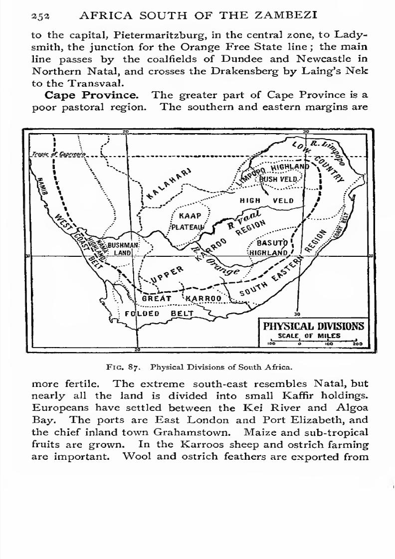
7/30/2019 The Senior Geography 1919
http://slidepdf.com/reader/full/the-senior-geography-1919 268/383
253 AFRICA SOUTH OF THE ZAMBEZI
to the capital, Pietermaritzburg, in the central zone, to Lady-
smith, the junction for the Orange Free State line ; the main
line passes by the coalfields of Dundee and Newcastle in
Northern Natal, and crosses the Drakensberg by Laing's Nek
to the Transvaal.
Cape Province. The greater part of Cape Province is a
poor pastoral region. The southern and eastern margins are
\ \ \
U*
KAAP
/PLATEAU/
/^ ; &JSH VELD.-'
HIGH VELD
01^^•.BUSHMAN:''•• / BASUTJ)
',
$/*'£*
fv,**
"s^Ji. 4—*'
GREAT '^ARROO
FOLDED BELT
PHYSICAL DIVISIONS
SCALE OF MILES
Fig. 87. Physical Divisions of South Africa.
more fertile. The extreme south-east resembles Natal, but
nearly all the land is divided into small Kaffir holdings.
Europeans have settled between the Kei River and Algoa
Bay. The ports are East London and Port Elizabeth, and
the chief inland town Grahamstown. Maize and sub-tropical
fruits are grown. In the Karroos sheep and ostrich farming
are important. Wool and ostrich feathers are exported from
7/30/2019 The Senior Geography 1919
http://slidepdf.com/reader/full/the-senior-geography-1919 269/383
AFRICA SOUTH OF THE ZAMBEZI 253
the ports, but these depend chiefly on the trade of the
Rand. On the south coast tobacco is grown. The south-west
is a typical Mediterranean region. Wheat is grown in the
Malmesbury plains, and the vine on the northern slopes of
the hills. Fruit cultivation under irrigation is increasing in
the Hex and other valleys. Cape Town, the capital, is the
nearest port to Europe, on a magnificent bay.
The main line from Cape Town crosses the Cape Flats,
turns into the Breede valley by the Tulbagh Kloof, follows
the Hex valley and winds up its steep sides to the Great
Karroo and the High Veld (cf. Fig. 87). This it crosses
to the diamond mines of Kimberley, and continues north
by Mafeking to Bulawayo.
AFRICAN ISLANDS.
The Western Islands are volcanic. The Azores, Ascen-
sion, Tristan dAcunha, and others rise from the mid-Atlantic
ridge. St. Helena is an isolated isle east of the ridge in
the south Atlantic. The Madeira, Canary, and Cape Verde
Islands all rise above relatively shallow seas off the coast, and
the Guinea Islands run south-westwards in the Bight of Biafra.
The Azores lie io° to 15 west of Portugal, of which state
they form a part.
Madeira and Porto Santo are also Portuguese. They
are rugged isles, cut by deep valleys or barranchos, with well-
wooded lower slopes (Madeira= forest), carefully cultivated, and
producing almost every kind of vegetable product of the hot
and warm belts. Madeira was discovered by the Portuguese
in 141 9, who introduced the vine and other fruit trees. The
capital is Funchal, from which wine and fruits are exported.
The Canaries, consisting of seven large and many small
islands, have similar characteristics. Tenerife, the largest
island, about the area of Warwickshire or Lanarkshire, rises
to ia,aoo feet in the Peak of Teyde. Santa Cruz, its port,
is the capital of the Canaries, which are Spanish. Las Palmas,
the largest town, is Canaria.longitude of the
7/30/2019 The Senior Geography 1919
http://slidepdf.com/reader/full/the-senior-geography-1919 270/383
»54 AFRICAN ISLANDS
westernmost island, Ferro, was once reckoned the zero
meridian. The Canaries are the Fortunate Isles of the
ancients, and as they lie close to the African coast were
reached earlier than Madeira in the Middle Ages.
The Cape Verde Islands are also volcanic, and, like
some of the Canaries, have been active in recent times. They
are in a much drier region, but produce similar products
where water can be obtained. Cattle-rearing is important, and
turtles are obtained in the surrounding seas. Porte Grande is
a coaling-station for British steamers.
Fernando Po (Spanish) rises to 10,000 feet above the
Gulf of Guinea, and has the same succession of vegetation
on its sides as the Kamerun Peak (see p. 237).
Principe and S. Thome (Portuguese) and Annobon(Spanish) are smaller islands in the Gulf of Guinea.
Ascension and St. Helena (British) were important as
calling-stations before the opening of the Suez Canal.James-
town, the capital of St. Helena, in the heart of the trade
wind region was touched at on the journey from India.
Madagascar is part of the great tableland of which
Africa is a part. The two are now separated by the Mozam-
bique channel, some 10,000 feet deep, which must have been
formed long ago, as the lion, elephant, monkeys, and many
other animals of Africa are not found in Madagascar. The
island is larger than France, to which it belongs.
From the western coastal plain the land rises in terraces
to the interior tableland, which sinks in steep escarpments
to the straight eastern coast. This steeper side faces the
trade winds and is the wettest, the south-west on the other
handbeing a comparatively
dry region.
Except inthe
south-west dense wet forests cover the lowlands, while the
upper parts of the tableland form a savana. The peoples
in the west are negroid, on the tableland in the east they are
of Malay origin. The chief town is Tananarivo or Antana-
narivo in the centre of the island, which is connected by road
with the east coast where Tamatave is the chief port. Majunga
7/30/2019 The Senior Geography 1919
http://slidepdf.com/reader/full/the-senior-geography-1919 271/383
AFRICAN ISLANDS 255
is the north-western port, opposite the Comores Islands, which
are also French. The mineral wealth is considerable.
Reunion (French), Mauritius, and Rodriguez (British)
are volcanic. Reunion (formerly called Bourbon) is very rugged,
rising to over io,oco feet, Mauritius (formerly called He de
France) is only a quarter this height. The islands lie east of
Madagascar in latitudes corresponding to those ofthe Canaries.
They receive more rain and are even more fertile. Sugar,
cultivated by Hindu coolies, is the chief crop. Port Louis,
the capital of Mauritius, has an excellent harbour.
The Seychelles and Admiralty Islands (British) are
attached to Mauritius. Mahe in the Seychelles is a good harbour.
Sokotra (British), an outlier of the Somali peninsula, which
it resembles in structure, climate, and products, rises to 4,600
feet. It commands the entrance to the Gulf of Aden.
AUSTRALIA.Australia. The Commonwealth of Australia includes part
of the island of New Guinea (total area 312,000 square miles)
in the north, the great island of Australia (3,000,000 square
miles) in the centre, and Tasmania (26,000 square miles) in the
south.
Excluding New Guinea, which is in the equatorial region,
Australia consists of three physical regions : (1) the West and
Central Tablelands, (2) the Central Lowlands, and (3) the
Eastern Highlands, including Tasmania, which is separated
from the mainland by Bass Strait.
Climate. Climatically Australia, excluding New Guinea,
is in four regions : (1) the monsoon region, with summer rains,
on the northern margin, (2) the region of the south-east trades,
in the east, (3) the region of the westerly storm-winds with
winter rains in the extreme south, and (4) the arid centre.
Plants and Animals. Australia originally formed part
of the Old World, but was separated from it at a very early
period, before the present Old-World Plants and animals had
developed. line through the SpiceIslands

7/30/2019 The Senior Geography 1919
http://slidepdf.com/reader/full/the-senior-geography-1919 272/383
25<> AUSTRALIA
Timor roughly separates the Australian flora and fauna
from the Oriental types of south-east Asia.
Australia has preserved many primitive forms of animal
life which have diedout elsewhere. Most of the animals
are marsupials, provided with a pouch for carrying their help-
less young. Of these the largest is the kangaroo. Other
animals lay eggs, like reptiles, and suckle their young like
mammals. Australia is lacking in the characteristic animals
Fig. 88. Australasia: Elevation and Sea-depth.
ofthe Old
and New Worlds. Hence at the time of its
discovery it had no domesticated animals.
The peculiarities of the Australian flora are less markedthan those of the animals, as seeds can be transported for long
distances by wind and water. The trees are for the most part
eucalyptus of various species, and acacias, or wattles. Owingto the Earth's elliptical orbit the southern hemisphere is

7/30/2019 The Senior Geography 1919
http://slidepdf.com/reader/full/the-senior-geography-1919 273/383
AUSTRALIA 257
nearer the Sun in the southern summer than is the northern
hemisphere in the northern summer. Hence the summer heat
is greater than in corresponding latitudes in the northern
hemisphere. As a protection the trees hang their leaves edge-
wise instead of spreading them out to the sun. This reduces
the evaporation. They shed their bark instead of their leaves.
feet 600 /sop 3000
1 i m -
Fig. 89. Relief of Australia.
New Guinea. In New Guinea the feature-lines run from
east to west. The centre and north are mountainous, with
two or more parallel ranges. The Bismarck and Owen Stanley-
Ranges are over 13,000 feet. The latter forms the long narrow
south-east peninsula, and a submerged range can be traced in
the D'Entrecasteaux Louisiade Islands. south is

7/30/2019 The Senior Geography 1919
http://slidepdf.com/reader/full/the-senior-geography-1919 274/383
258 AUSTRALIA
a lowland, sloping to Torres Strait and the seas which separate
New Guinea from Australia. It is drained by the Fly River.
The mountains form a climatic barrier separating the north,
which has very heavy monsoonal rains in the southern summer,
from the south, which receives winter rains from the south-east
trades when these are drawn north across the equator in the
northern summer (see p. 193). In the south the rainfall is
seventy-two inches per annum, but nearly twice as much falls
in the wettest parts of the monsoon area. The temperature is
everywhere high (cf. Figs. 137, 138 in Junior Geography).
New Guinea is densely forested, and as yet little progress
has been made into the interior. Tropical species are found
in the lowlands (coco-nut) and lower mountain slopes (cam-
phor), with open woodlands of the savana type higher. Owing
to the low latitude the mountains, notwithstanding their
height, are covered with vegetation to the summit.
As in all forested lands, the native population is distributed
in small groups, which practise some agriculture round their
villages. The pig is the chief domestic animal. Cannibalism
occasionally occurs. The coast tribes are adventurous seamen
and fishermen. Trading voyages to different parts of the
coast are regularly undertaken. The surrounding seas are
rich in pearls and in biche de mer, a species of sea-slug, which
is collected for the Chinese market, where it is esteemed
a delicacy. Throughout New Guinea there is much race
intermixture, chiefly with the mainland peoples in the west,
and with those of the Pacific Islands in the east. This points
to long and continuous communication by sea.
The white settlement of New Guinea is only beginning.
The west is Dutch and the east is British, with Port Moresby
as the capital. The chief products are sandalwood and copra,
the dried flesh of the coco-nut, which is in great demand for
making soap and candles. The mineral wealth is known to be
abundant and to include gold, but it cannot be exploited with-
out improved means of communication and a greater commandof labour.
7/30/2019 The Senior Geography 1919
http://slidepdf.com/reader/full/the-senior-geography-1919 275/383
AUSTRALIA 259
The Australian Tablelands. These form part of the
Old-World Tablelands (see p. 220). Notice the same com-
pactness of outline as in the other tablelands (the Deccan,
Arabia, Africa).
The average elevation of the Australian tableland is over
1,000 feet. There are several higher areas round the margin;
Arnhem Land in the north, the Kimberley region in the north-
west, the Western Plateau parallel to the west coast, and the
Central Plateau in the centre, with the Macdonnell and Mus-
grave ranges and Lake Amadeus between. In the south-
west the escarpments of the Darling range descend to a coastal
plain. Several short rivers descend from the western margin
of the Tableland to the Indian Ocean, but few carry much
water. The most important are the Fitzroy, from the Kim-
berley Plateau in the north, the Ashburton and Murchison in
the centre, and the Swan in the south. The interior is a basin
of inland drainage, with many salt lakes.
The North-west Margin of the Tableland. Western
Australia lies in the same latitudes as Africa south of the
Congo-Zambezi. The climatic differences between the two
regions are largely due to differences in the configuration of
sea and land. In latitudes where in Africa the western
desert is found Australia has a considerable breadth of open
woodlands, receiving rain from the north-west monsoon. This
is explained by the fact that north-west Australia presents the
conditions necessary for the developments of monsoon winds :
(1) the presence of seas on the equatorial margin of (2) a land
mass lying within the tropics, and (3) sufficiently heated in
summer to form a low-pressure area with inflowing moisture-
laden winds. In Africa, in the corresponding latitudeand
situation, (1) the continuity of the land from east to west
northwards to far beyond the equator, (2) the much greater
height of the tableland, and (3) the existence of a low-pressure
system over Upper Guinea, prevent the formation of monsoon
winds, and a desert results.
The north-west margin of the Australian Tableland is within
s a
7/30/2019 The Senior Geography 1919
http://slidepdf.com/reader/full/the-senior-geography-1919 276/383
260 AUSTRALIA
the tropics. The temperature is always high. The coastal
margin has large areas of dense forest along the north of
Arnhem Land, but generally the woods are of the open
savana type. Further inland are grass lands, passing into
desert.
Settlement is only beginning. The white population of
Darwin, on Port Darwin, is under a thousand. Darwin is the
terminus of an overland telegraph line from South Australia,
and of a short railway inland.
The Desert Tablelands. The tropic of Capricorn bisects
the Australian Tableland, as the tropic of Cancer bisects thatof the Sahara. The same causes which make the Sahara
a desert (see p. 230) make most of the Australian Tableland
a desert. It resembles the Sahara in (1) the great summer
heat, (2) the great range of daily and yearly temperature,
(3) the rapid weathering of the exposed rocks, and (4) the
formation of sandy and stony deserts. Australia, however,
has no Nile to form a fertile belt from north to south. There
are few fertile oases to facilitate communication. There is,
however, a less arid belt running from east to west across the
Tableland, separating the Sandy Desert in the north from the
Victoria Desert in the south. Communication is largely by
means of camels, which were introduced from Afghanistan
with Afghan drivers in the second half of last century. Thishas rendered it possible to extend the range of settlement
to fertile areas within the desert.
Gold is widely distributed over the Australian Tableland,
especially in the west. The Kalgoorlie, Murchison, and other
mines in the centre, 300 or 400 miles from the coast, are
extremely rich. They are some distance within the arid
region to which water must be carried in pipes from the coast.
The difficulty of obtaining water limits mining in the arid
region. If wells could be sunk to water-bearing strata, as in
some parts of Australia, and communications improved, the
mining industry and population would no doubt penetrate
farther inland. Unlike the South African goldfields, the
Australian mines are work*"1 »"•*' ™*>J+- uk„.._

7/30/2019 The Senior Geography 1919
http://slidepdf.com/reader/full/the-senior-geography-1919 277/383
AUSTRALIA 261
The South-west Margin. The south-west margin has
hot summers and cool winters. In winter it is within the
westerly storm-area, and like the Cape of Good Hope, which it
resembles, receives winter rains. Vines and wheat are cultivated,
but all Mediterranean products might be grown. The well-
watered area is larger than at the Cape, and has extensive
forests producing jarrah, and other hard woods. The drier
parts are pastoral. Coal is found round Bunbury, near the
coast. The ports are Albany, on King George's Sound, and
Fremantle,on
theSwan River, leading to Perth, the capital of
Western Australia. A line runs from the Bunbury coalfields
to Perth, and to Geraldton, the northern port and the outlet
for the Murchison goldfields. From Perth it is carried inland
to Coolgardie, Kalgoorlie, and Menzies, and a transcontinental
connexion has been built to South Australia.
The western half of the Tableland forms the State of
Western Australia (976,000 square miles). To the east of
this state lie the State of South Australia, and the Northern
Territory, which is administered by the Commonwealth
Government. The boundaries between them are quite artificial.
The Central Lowlands. The Central Lowlands stretch
from north to south across the island, between the Tableland
and the Eastern Highlands. They do not exceed 1,000 feet
except in isolated highland areas, of which the South Aus-
tralian Highlands are the most important. Between these
and the Western Tableland is the Great Valley of South
Australia, with Spencer Gulf in the south and Lake Torrens
in the north. Farther east the St. Vincent Gulf is formed
between two southern ranges of the South Australian High-
lands, and the Lake Frome basin opens north between two
similar ranges. The easternmost of these forms the Stanley
Mountains, or Barrier Range, separating the lowlands of the
Murray-Darling from the Great valley. The north coast is
broken by the shallow Gulf of Carpentaria, the submerged
northern part of the Central Lowlands.
lowland is lowest near the base of the Western Table-

7/30/2019 The Senior Geography 1919
http://slidepdf.com/reader/full/the-senior-geography-1919 278/383
7/30/2019 The Senior Geography 1919
http://slidepdf.com/reader/full/the-senior-geography-1919 279/383
AUSTRALIA 263
the country is pastoral. The mineral wealth is great, and
includes rich copper mines at Wallaroo.
The State of South Australia (900,000 square miles),
which extendsacross
Australia from north to south,originally
grew up round Adelaide and the settlements round Spencer
Gulf, which is still the only populous part of the colony.
From these centres it penetrated inland by the Great Valley,
till stopped by desert, which forms a broad belt by which the
northern part of the colony is completely cut off. With the
exception of the fertile area in the south, the largest and best
parts of the Central Lowlands are in the States of Victoria,
New South Wales, and Queensland.
The largest city in South Australia is Adelaide, the capital,
containing nearly half the population. It lies a little inland
from Port Adelaide. From Adelaide a line runs-east to Mel-
bourne, the capital of Victoria, at the southern base of the
Eastern Highlands. Another line runs north of the southernmargin and the drier lands between Lakes Torrens and Eyre,
to the margin of the desert.
The Eastern Highlands are lowest and widest in the
norths and narrower, more compact, and higher in the south.
The Northern Part of the Eastern Highlands forms
the Cape York peninsula. The main drainage is to the Gulf
of Carpentaria, to which the long rivers flow.
The Centre of the Eastern Highlands is drained to
the Pacific by the Burdekin and Fitzroy. Both these rivers
are formed by the union of long tributaries flowing from
north and south in valleys parallel to the coast. Below
their confluences they break through the Eastern Highlands
in transverse valleys.
The Southern Part of the Eastern Highlands rises
from a narrow coastal plain in steep escarpments. These are
known as the New England Range in the north, the Blue
Mountains in the centre, and in the southern and highest part,,
where Mount Townsend, in the Kosciusko group, reaches
7,300 feet, as the Australian Alps. They are continued south

7/30/2019 The Senior Geography 1919
http://slidepdf.com/reader/full/the-senior-geography-1919 280/383
264 AUSTRALIA
beyond Bass Strait (150 miles wide) by the mountains of Tas-
mania. On the mainland the Eastern Highlands trend west,
parallel to the south coast, and form the Victorian Highlands.
The southern part of the Eastern Highlands is very difficult
to cross. The Blue Mountains near Sydney are composed of
county
Fig. 90. South-eastern Australia,
horizontal sandstones, which weather into steep escarpments,
and the rivers flow in deep ravines.
The Murray-Darling. The long rivers of the Eastern
Highlands all flow west. The main valley-line runs from
north-east to south-west, and is followed by the CondamineT
Darling-Murray. To it flow all the rivers from thewestern

7/30/2019 The Senior Geography 1919
http://slidepdf.com/reader/full/the-senior-geography-1919 281/383
AUSTRALIA . 265
The most important are the Macquarie, a tributary of the
Darling, and the Murray, with its tributary, the Murrumhidgee.
The Murray, which leaves the high Kosciusko plateau, near
the frontiers of New South Wales and Victoria, carries mostwater, and though not the longest affluent is reckoned the
main stream. All these rivers have the greater part of
their course in the Central Lowlands. The Murray-Darling
is deflected south by the Mount Lofty Mountains, the southern
part of the South Australian Highlands. It enters the large
shallow lagoon of Lake Alexandrina, separated from the sea
by the long sandspit (100 miles) of the Coorong, through
a narrow breach in which it reaches the sea. [Owing to its
shallowness it is navigable only for small vessels.]
The coast of the Eastern Highlands is indented by numerous
excellent harbours, which have formed the bases of settle-
ment. The largest are Port Jackson, in the east, leading
to Sydney, and Port Phillip, in the south, leading to
Melbourne.
The seas east of the Eastern Highlands sink to great
depths in the south, but in the north the continental shelf
of Australia is wide. North of the tropic it is bordered
by the Great Barrier Coral Reef, 1,200 miles long and over
100 miles broad in the south. This is broken at various
points, the most important being opposite the Burdekin.
It forms a natural breakwater. The channel between it and
the mainland, which varies in width from 30 miles in the north
to 150 miles in the south, is always calm. Owing to the many
sunken reefs and islands it can only be safely navigated by
day, or with the aid of a powerful searchlight.
Climate of the Eastern Highlands. The north andmost of the central part are within the tropics, and have a high
temperature all the year round. The northern part, which is
surrounded by water on all sides but one, has a fair rainfall,
chiefly brought by the summer monsoon. In the centre,
where the highlands are wider, the coast receives rains from
the south-east trades, chiefly in summer. A» the highlands
7/30/2019 The Senior Geography 1919
http://slidepdf.com/reader/full/the-senior-geography-1919 282/383
266 AUSTRALIA
are relatively low and broken, the moist winds penetrate for
a considerable distance inland. In the south, where the high-
lands are narrowest and highest, the coastal ranges intercept
the winds, and the interior is dry. In the extreme south theAustralian Alps and the Grampians are in the winter track of
the westerly storms, and form a Mediterranean region of winter
rains. Tasmania has an equable climate, with rain at all
seasons, but most in winter. As in Britain, the west is-
wetter than the east, and for the same reason.
The products of the Eastern Highlands vary with the region.
The centre and north have dense tropical forests, or savana
woodlands. The coco-nut grows near the sea, and the banana
and all tropical fruits in the lowlands. Sugar is cultivated
round Mackay, a little north of the tropic. To the south there
is a gradual transition to warm, temperate conditions in a.
coastal region which may be compared with Natal. Maize is.
the chief cereal. The vine and orange are cultivated in theMediterranean region and its margin.
The Eastern Highlands are drier on their western slopes,
and form rich grassy downs, wooded in the river valleys.
Here sheep-farming, the chief occupation of Eastern Australia,
is carried on. It has been greatly injured by the introduction
of rabbits, imported a few years ago from Europe. These not
only destroy crops, but eat pasture so close that it is long in
recovering. The better parts are cultivated with fruits and
cereals. Still farther west are dry scrub lands extending into
the eastern part of the Central Lowlands. This is also a
pastoral region, but of a poorer type and more thinly settled.
Political Divisions. The north and centre of the High-
lands form Queensland. The south is in New South Wales,and the extreme south in Victoria. Each of these states
extends into the Central Lowlands, where the boundary with
South Australia is quite artificial. Enclosed in New South
Wales is the small Federal Territory, created to contain the
Commonwealth capital, Canberra.
Queensland (668,000 square miles) consists of tropical high-

7/30/2019 The Senior Geography 1919
http://slidepdf.com/reader/full/the-senior-geography-1919 283/383
AUSTRALIA 367
lands, sub-tropical highlands, and western plains. Tropical
agriculture is developing in the coastal belt, where sugar
and fruits are grown. Towns are numerous on the many
good harbours of the coast. Mining is important in the high-
lands. Sheep-farming is important on the inland plains of the
south; and cattle-farming almost throughout the state,
especially in the east, and on the interior plains of the north,
as cattle bear greater heat than sheep. The Darling and
other downs have a deep fertile soil, in which cereals and fruits
are being increasingly grown. The towns are small, but aregrowing.
The Queensland railways have been built in the first place
from seaports with easy routes to the interior. From Townsville,
north of the Burdekin, a line runs to the Charters Towers gold-
field, and is carried across the pastoral belt to the upper
Diamantina, which flows as the Warburton to Lake Eyre.
From Rockhampton a line runs to the Mount Morgan gold-
fields, one of the richest in the world, and thence to the pas-
toral lands of the upper Cooper's Creek. From Brisbane a
line is carried across the narrowest part of the Highlands to the
Darling Downs and the New South Wales border, and to the
region of artesian wells in the extreme south-west, where
settlement is very thin. Among other lines are those fromCooktown to the Palmer goldfields ; from Bowen and Mackay
through the sugar districts ; and from Rockhampton, along the
coastal plain by Maryborough, to Brisbane, the capital,
with a quarter of the population. Manufactures are develop-
ing here with coal from the neighbouring coalfield of
Ipswich.
New South Wales (310,000 square miles). The northern
part is warm on the coastal plain, where some sugar is grown.
Behind this rise the New England and Liverpool Ranges, the
western slopes of which form grassy downs continuing the
Darling Downs of Queensland. South of the Liverpool Range
the Hunter, flowing east, and the Macquarie, flowing west, form
a route to the interior, separate northern from southern
7/30/2019 The Senior Geography 1919
http://slidepdf.com/reader/full/the-senior-geography-1919 284/383
368 AUSTRALIA
New South Wales. This depression is followed by the line
to Brisbane. South of the Hunter the coastal plain is less rich
agriculturally, but coal is abundant round the Hunter and
Illawarra rivers. Gold and tin are important among other
minerals.
The western slopes of the Eastern Highlands descend to the
Riverina district, a pastoral region, fertile where irrigated.
Copper is mined at Cobar. At Broken Hill in the extreme
west are rich silver and zinc mines, but these find their natural
outlet through South Australia.
Sydney, the capital, the second city in Australia in popula-
tion, contains one-third of the population of the colony. It
has an unrivalled harbour, and is the centre of the railways of
the state. A line runs along the coast to Newcastle, the
port for the neighbouring coalfields, turns up the Hunter
valley past Maitland, and crossing the New England Range
joins the Queensland line to Brisbane. The main southern
route ascends the Blue Range to Goulburn and follows the
base of the Australian Alps to the Murray at Albury, where
it connects with the main line to Melbourne.
Victoria (88,000 square miles). The south coast is pas-
toral. The northern slopes of the mountains are planted with
olive and vine, and wine is becoming an important product.
Ballarat and Bendigo are the centres of the gold region.
The northern plains consist of poor scrub, and are pastoral
except where they can be irrigated. The Mildura region,
irrigated from the Murray, has fruit orchards. Dairy-farming
is developing in Gippsland, which is also rich in brown coal.
The chief occupation everywhere is sheep-farming.
Melbourne, the capital, with a fine harbour, has a population
of over half a million, considerably more than one-third of the
population of the colony. Railways radiate east to Gipps-
land ; north-east across the mountains to the Murray and
New South Wales ; north-west to Adelaide ; and south-west
to the stations of South-west Victoria.
Tasmania is a much dissected highland, with narrow fertile

7/30/2019 The Senior Geography 1919
http://slidepdf.com/reader/full/the-senior-geography-1919 285/383
AUSTRALIA 369
agricultural valleys, forested mountain slopes, and grassy hill
pastures. Tin, gold, silver, and coal are found in the high-
lands, especially in the west. The valleys of the Tamar,
flowing north, and the Clyde, flowing south, cross the middle
of the island. Launceston, on the Tamar estuary, in the north,
and Hobart, the capital, in the south, on the Derwent estuary,
are the chief towns. They are joined by a railway, with
branches to the east and west coast.
Historical Summary. Australia was known to the Por-
tuguese and Dutch at the beginning of the seventeenth century.
During that century the Dutch, pushing east and south from
their centres in the Malay archipelago, explored the Austra-
lian seas and discovered Tasmania. To Australia they gave
the name of New Holland. At the end of the eighteenth
century Captain Cook explored parts of its shores, and took
possession of it for Britain.
Australia, when discovered, possessed no animals suitablefor domestication, and was forested in the regions suited for
agriculture. It was thinly peopled by small tribes, who hunted
kangaroos and other game in the grass lands on the desert
margin. Weaker tribes were pushed into the forest or the
desert. In the latter food was very scarce, and water obtain-
able chiefly from the water-storing roots of various plants
(see p. 1 a). All the Australian tribes lived a wandering life,
and possessed only the most rudimentary arts.
The first British settlement was a convict station at Botany
Bay, south of Port Jackson, so called from the number of new
plant-species observed by its discoverers. This was at the
end of the eighteenth century, and may be taken as the found-
ing of New South Wales. Sydney, with its magnificentharbour, soon grew in importance, and settlements extended
thinly along the coastal plain. The route to the interior was
blocked by the Blue Mountains, across which no practicable
routes could be discovered for many years. This led to the
formation of. settlements in South Australia and Tasmania,
which were reached by sea. The mountain barrier behind
7/30/2019 The Senior Geography 1919
http://slidepdf.com/reader/full/the-senior-geography-1919 286/383
270 AUSTRALIA
Sydney was at last crossed to the Macquarie and the Lachlan,
a tributary of the Murrumbidgee, and the Central Lowlands
were thus reached from the east. The colony of Victoria was
incorporated in 1851. In that year the discovery of gold
brought a great influx of population, and led to the rapid
growth of Melbourne, the capital. North of Sydney the first
important settlement was at Moreton Bay, a good harbour
protected by an island. Here Brisbane was built, and became
the capital of Queensland, founded a few years later than
Victoria. As in Victoria, the discovery of gold caused an
immense influx of population, and indirectly stimulated de-velopment in other directions. West Australia is the youngest
colony. It remained stationary till the discovery of gold in
the nineties. All the states were federated in 1901 as a
Commonwealth.
As white settlements advanced it became evident that the
prosperity of the country would long depend on sheep-farming.
Large sheep-runs were occupied, and the wild game deliber-
ately killed off to secure more grazing for sheep. Thus the
natives found their hunting grounds contracted, and their game
destroyed. They retaliated by cattle stealing and murder, and
were often brutally punished by the whites. They are now
found chiefly on the desert margin, but they are dying out.
Along the margin of the pastoral lands settlement ebbs andflows. Australian weather is marked by cycles, a series of dry
years following a series of good years. During a cycle of good
years the relatively abundant pasture in an area which is now
desert attracted settlers towards the interior of Queensland,
New South Wales, Victoria, and South Australia. A series
of dry years followed, during which enormous numbers of
stock perished, and many stations were abandoned.
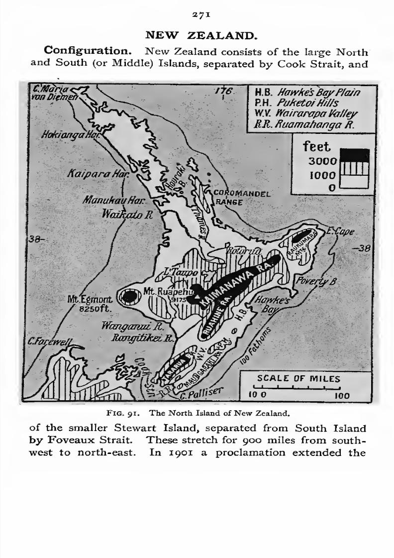
7/30/2019 The Senior Geography 1919
http://slidepdf.com/reader/full/the-senior-geography-1919 287/383

7/30/2019 The Senior Geography 1919
http://slidepdf.com/reader/full/the-senior-geography-1919 288/383
273 NEW ZEALAND
boundaries of the dominion to include the Cook Islands, west
of Tahiti. With these and other small islands the area is not
quite 105,000 square miles.
The main direction of the feature-lines is from south-west
I.K. Inland'liaikoura
S.K. SewardKaikoura
T.R Tokomairiro Plain
feet
3000
1000
MfbrdM
SCALE OF MILES
L-J
—1
—1
—1 L_J
10 . 100
Fig. 92. The Southern Islands of New Zealand.
to north-east. In the North Island a long narrow peninsula,
broken into many bays, runs north-west. These two directions
are also well marked in the submarine feature-lines.
7/30/2019 The Senior Geography 1919
http://slidepdf.com/reader/full/the-senior-geography-1919 289/383
NEW ZEALAND 373
In North Island there are volcanic areas in the north and
west. The cone of Mount Egmont (8,370 feet) forms a
western peninsula. In the centre are the active volcanoes of
Tongariro and Ruapehu (9,000 feet) south of Lake Taupo,
which is drained north by the Waikato, the largest river of
New Zealand. North of this is a region of geysers and hot
springs, which formerly contained the beautiful pink and
white sinter terraces, deposited by the water of the hot springs.
These were destroyed in the disastrous eruption of 1886. The
basin of the Thames, opening north to the Hauraki Gulf, i-s
the chief lowland. It is rich in gold. The eastern part of
North Island is formed by a ridge of mountains parallel to
the coast, broken by Hawke Bay.
This eastern range is continued south of Cook Strait, in the
parallel ranges of the north-eastern part of South Island.
These are separated by parallel valleys, the lower ends of
which have been drowned, forming beautiful rias, or sounds,
as they are locally called. The main mountain range of the
South Island is close to the west coast. It is highest in the
centre, where Aorangi, or Mount Cook, exceeds 13,000 feet.
These ranges form the Southern Alps of New Zealand. They
are remarkable for the number and size of their glaciers, some
of which descend as low as 1,000 feet above sea-level. In the
south, where the climate is coolest and the snow-line lowest,
signs of former glaciation on a great scale are seen in the
deep fiords of the west coast, and in the long narrow valley
lakes of the eastern slopes. Some of the largest, Lake
Wakatipu, Wanaka and Hawea, are drained south by the
Clutha, and the great Te Anau by the Waiau. The east of
the island is a rolling plain, broken by two volcanic
peninsulas, Banks peninsula, with the fine harbour of Port
Lyttelton, and Otago peninsula, with Otago harbour.
Climate. New Zealand is not the antipodes of Great
Britain. The extreme north of the North Island corresponds
in latitude to Malta, and the south of the South Island to
SEN. GEOG.

7/30/2019 The Senior Geography 1919
http://slidepdf.com/reader/full/the-senior-geography-1919 290/383
374 NEW ZEALAND
the Italian Lakes. The insular position, however, modifies
the climate, and renders it equable. The mean annual tem-
perature of Auckland, in the north of North Island, is 59° F.,
and thatof Dunedin, in the south of South Island,
50 F. Themean annual temperature and range are both less than in
other lands in the same latitudes. Combining all the advan-
tages of warm and cool temperate lands, New Zealand is a
colony ideally suited for North Europeans, and brings all the
products of Central Europe to perfection.
In the northern part of North Island winter rains are
heaviest, but, from its insular position, the summer drought
is less well-marked than other regions with a Mediterranean
climate. The rest of New Zealand is always in the region of
the westerly winds, which, owing to the relative proportion of
sea and land in the southern hemisphere, have a greater range
than in the northern hemisphere. Climatically, therefore, New
Zealand has someclaim to
beregarded as the antipodes of
Britain. The rains are everywhere heaviest on the west coast,
but in North Island, where there are no continuous western
mountains, the rainfall is fairly uniform over the whole
island. In South Island the western slopes of the western
mountains have a very heavy rainfall (80-100 inches), while
the eastern plains receive less than thirty inches.
Products. Most of North Island and the west of South
Island are densely forested. The northern forests produce
the kauri pine, which yields a valuable gum. Gum from the
kauri forests of remote ages is also obtained by digging over
their former sites. In all the New Zealand forests the tree
ferns are remarkable for their beauty, sometimes reaching a
height offifty
or sixtyfeet.
Theeastern slopes
and the openlands are covered with grass, or with the abundant New
Zealand flax. When first settled by Europeans New Zealand
had no domesticated animals, but these have now been intro-
duced. The upland meadows are stocked with cattle, and
the drier eastern plains with sheep. The most important
pastoral regions are the Canterbury Plains, and the eastern
7/30/2019 The Senior Geography 1919
http://slidepdf.com/reader/full/the-senior-geography-1919 291/383
NEW ZEALAND 373
part of North Island. Millions of sheep are grazed, supply-
ing not only wool, but also fine mutton, which is frozen and
exported.
In the Mediterranean region of North Island, the orange,
lemon and vine are cultivated. The temperate cereals and
fruits are cultivated in the other agricultural regions, and give
a very heavy yield per acre.
The mineral wealth of New Zealand is considerable. Coal
and gold are abundant. Both are found in the Thames
basin of North Island, and in the northern part of the western
mountains of South Island, round Westport, Greymouth, and
Hokitika. The sands of the Clutha and other rivers of the
southern part of the island are dredged for gold.
History. New Zealand was discovered by the Dutch
navigator Tasman in the middle of the seventeenth century,
and more thoroughly explored by Cook in the eighteenth
century. It was inhabited by the fine Maori race, a striking
contrast physically and mentally to the Australian aborigines.
British colonization began about 1840, and was vigorously
opposed by the Maoris, who showed considerable military skill.
In recent years the hostilitybetween the two races has vanished,
and the Maoris, who have adopted Christianity and to a large
degree civilization, are admitted to political rights.
The British settlement of New Zealand has proceeded
chiefly from three centres, Auckland in North Island, and
Christchurch and Dunedin in South Island. Auckland, built
on a narrow peninsula, has harbours on both seas, the more
exposed and western one being the nearest port to Australia.
The neighbourhood yields gold and coal. Auckland was
originally the capital, but the remoteness of its position in the
extreme north caused the transference of the administrative
power to Wellington, which is centrally situated on Port Nichol-
son, a bay of the North Island, opening from Cook Strait.
South Island was colonized by two distinct waves of settle-
ment. The English centre was Christchurch, on the Avon,
fewmiles inland. Among the typical English names in the
7/30/2019 The Senior Geography 1919
http://slidepdf.com/reader/full/the-senior-geography-1919 292/383
27© NEW ZEALAND
vicinity are those of Oxford, Lyttelton, the port of Christ-
church, and the Canterbury plains, for which Christchurch and
Lyttelton are the outlet Farther north such names as
Marlborough, Havelock, Nelson, and Collingwood indicate
another group of English influences. Scottish associations are
equally marked in the south round Dunedin, founded in 1848
by Scottish Presbyterians. The town is on a fine bay, now
made navigable for large vessels as far as Dunedin. The
Scottish influence is seen in such names as Port Chalmers,
originally the port of Dunedin, Roxburgh, Heriot, Dalhousie,
Lowther, and many others. Invercargill has growing saw,
woollen, and flour mills, boot and preserved meat factories,
and breweries.
PACIFIC ISLANDS.
The Pacific Islands lie mainly between the tropics in the
western half of the ocean. New Zealand and one or two smaller
groups and the islands bordering Asia and America are the
main exceptions. Most of the groups are arranged along a
NW.-SE. axis.
The majority of the islands are of coral origin or of volcanic
and coral origin. Only in the New Caledonia, New Britain
(Bismarck Archipelago), and the Solomon islands are ordinary
crystalline or sedimentary rocks found. The most important
of the volcanic islands are the New Hebrides, Fijian, Samoan,
Hawaiian, Society (Tahiti), and Marquesan groups.
Climate. The climate is wonderfully equable, and as most
of the islands are in the trade wind belt it is fresh, healthy,
and pleasant. Where the trades are not felt a more oppressive
and unhealthy climate prevails. This is common in the
more westerly equatorial islands where clouds and rain are
common. The temperature is remarkably uniform, rarely
varying 10° between the hottest and coldest months, while
the difference between the hottest day and the coldest night
7/30/2019 The Senior Geography 1919
http://slidepdf.com/reader/full/the-senior-geography-1919 293/383
PACIFIC ISLANDS 277
of the average year is not over 30° to 30 . The rains usually
fall in summer.
Products. Round the coasts and on the coral islands the
coco-nut palm is the chief tree and copra the chief product
The volcanic isles, with a more varied and fertile soil and
greater differences of level, have more diverse products, such
as sugar, rice, bananas, pineapples, coffee, cotton, and tobacco.
People. The islands are sometimes divided into Melanesian
and Polynesian, roughly divided by the meridian of 180 .
In the former the black, frizzy-haired Melanesians present
a striking contrast to the taller, lighter, wavy-haired Poly-
nesians, of whom the Maoris of New Zealand are a branch.
Political Divisions. The Ladrones, Caroline, Marshall,
Bismarck, and Samoa islands were German except two.
These are Guam, in the Ladrones, and Tutuila, in the Samoan
group, both with good harbours, belonging to the United
States, which also possesses the Hawaiian Islands. NewCaledonia, Loyalty, Society, Marquesas, Paumotu or Low
Archipelago, and other small islands are French. The New
Hebrides are under joint British and French control. The
rest are British.
New Caledonia is a long mountainous island the size of
Wales, rising to over5,000
feet. It is rich in minerals,
especially nickel, cobalt, chrome, antimony, gold, copper, coal,
and iron. The older rocks which form the axis of the
island do not yield a fertile soil. Stock-raising is one of the
chief occupations. In the more fertile soils coco-nut, sugar,
cotton, vanilla, coffee and cereals are cultivated. The island
is used as a penal settlement by the French. The capital
is Noumea, on an excellent harbour.
The Fiji Islands consist of two large volcanic islands,
Viti Levu and Vanua Levu, and numerous smaller ones
scattered over the Karo Sea. They are forested. Where
cultivated the fertile soil yields good crops of yams (the chief
food), banana, breadfruit and many other fruits, sugar, maize,
rice, cotton, tobacco, tea. capital is on Viti
7/30/2019 The Senior Geography 1919
http://slidepdf.com/reader/full/the-senior-geography-1919 294/383
378 PACIFIC ISLANDS
Levu, a calling-place for steamers between the west of North
America, New Zealand, and Australia.
Samoa consists of Savaii and Upolu, Tutuila, and smaller
islands. Its products are similar to those of Fiji. Copra andcacao are the chief exports. Its inhabitants are Polynesians,
those of Fiji being mainly Melanesians. The capital is Apia
on the north or lee side of Upolu. Samoa, like Fiji, is occa-
sionally ravaged by disastrous hurricanes. Tutuila belongs to
the United States.
The Hawaiian Islands were formerly called the Sandwich
Islands. The largest island is Hawaii, with two volcanoes,
Mauna Loa and Mauna Kea, both over 13,000 feet. At
4,400 feet on the flanks of Mauna Loa is the great crater of
Kilauea filled with hot lava. On Maui, the next island,
is another great crater some 8 miles in diameter and 10,000
feet above the sea. There are two other large and four
medium-sized islands. Of the former the most importantis Oahu on which is the port of Honolulu, the calling-place
for vessels plying between North America and Asia and
Australia. The islands are forested, and yield products similar
to those of Fiji, sugar being the most important. The in-
habitants are Polynesians, but large numbers of Portuguese,
Japanese, and Chinese have settled in the islands. The islands
are a territory of the United States.
Historical Note. The Pacific was first seen by Europeans
in 1513 (see p. 325). Magellan entered it through the straits
which now bear his name in 1520. The most important
expeditions to the Pacific were those of Tasman, who discovered
Fiji in 1643, Captain Cook (1768-79), who in three voyages
first set the limits to the southern ocean and to the east of
Australia, and was killed in Hawaii (Owhyhee) in 1779.
The development in recent years of lands bordering the
Pacific by Europeans, Japanese, and Chinese has led to
the islands becoming of importance strategetically, and they
are distributed between the British, French and American
powers.

7/30/2019 The Senior Geography 1919
http://slidepdf.com/reader/full/the-senior-geography-1919 295/383
879
THE NEW WORLD.
Configuration of the New World. The configuration
of the New World is very unlike that of the Old World. In
Fig. 93. The New World—Highland and Lowland,
the Old World, if we exclude Australia, the main feature-lines
run from east to west, and the natural topographical regions
coincide more or less closely with those determined by tem-

7/30/2019 The Senior Geography 1919
http://slidepdf.com/reader/full/the-senior-geography-1919 296/383
*8o THE NEW WORLD
perature, the subdivisions depending chiefly on the quantity
and seasonal distribution of the rainfall. In the New World the
feature-lines run north and south, across the temperature belts,
and the topographical divisions do not form natural regions.
The configuration of the New World, which consists of
the two great continental land masses of North and South
America, united by the isthmus of Central America, is very
simple in its general outline. The Pacific coast is bordered
by a broad lofty belt of mountains. In North America this is
known as the Rocky Mountain system, or North American Cor-
dillera, and in South America as the Andean system, or SouthAmerican Cordillera. These are linked together by the narrow
but mountainous region of Central America, which, however,
is not a continuation of either. Important breaks occur in the
low isthmuses of Tehuantepec and Panama, and in Nicaragua.
East of the Cordilleras are the Central Plains of North
and South America, separated by the American Midland Sea,
which is known as the Gulf of Mexico in the north and as the
Caribbean Sea in the south.
The eastern margin of America is bordered by highlands,
which are broken into several masses, giving access to the
Central Plains by the breaks between them. In North
America, excluding Greenland, the chief masses are (i) the
Baffin Highlands in the north, separated by Hudson Strait
leading to Hudson Bay, the submerged north-eastern part of
the Central Plains, from (2) the Labrador Highlands, sepa-
rated by the St. Lawrence from (3) the Appalachian Highlands
which trend gradually away from the Atlantic, leaving a coastal
plain which opens round their southern end to the Central
Plains. In South America they are represented by (1) the
Guiana Highlands, separated by the broad lowland of the
Amazon from (a) the Brazilian Highlands.
The Atlantic margin of the Midland Sea is formed in the
north by a chain of mountainous islands connected with the
mountains of Central America, and in the east by volcanic
or low limestone islands.
7/30/2019 The Senior Geography 1919
http://slidepdf.com/reader/full/the-senior-geography-1919 297/383
THE NEW WORLD a8i
NORTH AMERICA.
Natural Regions of North America. Compare the
map in Fig. I with the list of typical natural regions on p. I.
Greenland and the higher parts of the Arctic archipelago
represent the ice-cap or Polar highland type, and the lower parts
of the archipelago and the margins of Western Greenland and
theNorthAmerican mainland are ofthe tundra, or Polar lowland
type. Of the cool temperate regions (a) the West European
typeis
found along thePacific
from the Alaskan peninsula tothe mouth of the Columbia. The Cordillera to the east of this
is a variety of (d) the Altai, or interior highland type. The
Central Plain represents (c) the Siberian or interior lowland
type. The eastern margin or (b) Laurentian type includes
Southern Labrador and the Appalachians north of Chesapeake
Bay. The warm temperate regions are (a) the western
marginal or Mediterranean region of California;(d) the interior
highland or Iran region, including the Great Basin and the
Mexican plateau;(c) the high dry plains at the eastern base of
the southern half of the Rockies, a variety of the Turan, or
interior lowland type ; while (b) the eastern margin or China
type of warm temperate lands with summer rains is approxi-
matelyrepresented
bythe south-east United States, from
Chesapeake Bay to Mexico. Intertropical regions are repre-
sented by the coastal lowlands of Mexico (monsoon type).
Greenland and Arctic North America. The island
of Greenland (513,000 sq. miles) is only about 150 miles from
Iceland, and about 200 miles from Baffin Land, the nearest
and largest island of the Arctic archipelago. This archipelago
consists of many islands, separated from each other and from
the mainland by straits which are usually closed by ice.
Greenland is a highland sloping from east to west, and
varying from 5,000 to 10,000 feet in height. A thick undu-
lating ice-sheet has filled the valleys and covered the moun-
tains, masking the surface features. Great glaciers descend
to the sea as lofty ice cliffs from whichinnumerable icebergs

7/30/2019 The Senior Geography 1919
http://slidepdf.com/reader/full/the-senior-geography-1919 298/383

7/30/2019 The Senior Geography 1919
http://slidepdf.com/reader/full/the-senior-geography-1919 299/383
THE NEW WORLD 283
south-west, they are cold and diy. This dry cold weather
is often interrupted by less cold rainy winds from the Atlantic,
as the north-east winds of the front ofthe low-pressure systems
or cyclones gradually pass into the south-east winds of their
rear as the cyclones move onwards. The cyclones follow two
well-defined routes, one by the St. Lawrence valley and gulf,
and one parallel to the coast. The former cause a larger
proportion of the winds from the sea, but their influence is felt
mainly in the north. The coastal storms bring rain to the
eastern margin.
The Baffin Highlands are snowclad and unexplored, and
even their coasts are little known.
The Labrador Peninsula (500,000 square miles) is a
highland of the Scandinavian type. The high Atlantic
coast is indented with fiords, but the shores of Hudson Bay
are for the most part low. The interior is a little-known
forested plateau, passing into tundra in the north. The climate
is too severe for cereals to ripen, though barley is grown for
fodder. The coastal settlements are trading posts or Moravian
mission stations. A few hundred Eskimos and half-breeds
inhabit the north and west coasts. Wandering Indian tribes
hunt the caribou and other animals in the interior. The furs
are brought downto the coast, and exchanged for guns and
other necessaries. In summer the eastern seas are visited by
sealing, cod, and other fishing fleets.
Labrador, like Greenland, was originally discovered by the
Scandinavians. In 1500 it was rediscovered by the Portuguese,
who hoped to draw from it a supply of slave labour, a fact
still commemorated by the name Labrador. The Hudson
Bay Company received a charter from Charles II, and France
renounced all claims to Hudson Bay by the treaty of Utrecht
The Appalachian Highlands are part of a great denuda-
tion highland, which has been worn down into a series of
parallel ridges and/ valleys. The former are usually formed
the stable base of the downfold,the latter the less

7/30/2019 The Senior Geography 1919
http://slidepdf.com/reader/full/the-senior-geography-1919 300/383
384 THE NEW WORLD
stable top of the upfold. It may be divided into a northern
system consisting of (i) Newfoundland and (a) the Acadian
and New England Highlands, separated by the Hudson from
the southern system consisting of (3) the Central Appalachians
and (4) the Southern Appalachians.
Newfoundland (43,000 square miles). The north and
south direction of the ridges and valleys is well seen (1) in the
high straight west coast, (a) the range bordering it, which forms
Fig. 94. Newfoundland and the lower St. Lawrence.
the north peninsula, separated by Belleisle Strait from the
mainland, and(3)
in the bays and peninsulas of the east
Placentia Bay, where the submarine cables are landed, and
St. Mary's Bay, opening south, and Bonavista, Trinity and
Concepcion Bays, opening north. The interior, which is not
thoroughly explored, is an undulating plateau of no great
height, intersected by innumerable lakes, and drained by many
small rivers. The relatively equable insular climate and the
7/30/2019 The Senior Geography 1919
http://slidepdf.com/reader/full/the-senior-geography-1919 301/383
THE NEW WORLD 385
character of the soil are well suited to agriculture, though it is
yet little developed. Potatoes, fruits, and some cereals are
grown. There are large mills making pulp for paper from
the timber. The mineral wealth includes copper, iron ore andcoal. The capital is St. John's.
At the present time the wealth of Newfoundland is concen-
trated in its fisheries, which are the richest in the world. The
island was early known to the Norsemen, and was rediscovered
at the end of the fifteenth century by Cabot. Its rich fisheries
immediately attracted the fishermen of the maritime European
nations, who supplied Catholic Europe with dried and salt
fish. Newfoundland was settled by Devon men towards the
end of the sixteenth century, and by French fishermen,
probably Bretons. The possession of Newfoundland was
secured to Britain by the treaty of Utrecht, which gave to
France St. Pierre and Miquelon, the solitary remnants of her
once great possessions in North America. Disputes as to
fishing rights continued for two centuries, but were finally
settled by arbitration in 1904. The fisheries are carried on in
the shallow seas which cover the Grand Banks, a submarine
elevation off south-east Newfoundland, about 600 miles long
and 200 miles wide. Cold currents from the north bring down
small organisms which feed innumerable numbers of fish,
cod being the most abundant. The fishing season lasts from
June to November, during which months the banks are often
covered with dense fogs. Newfoundland fishing-boats also
visit the Labrador and other northern fisheries.
The Acadian and New England Highlands. The long
narrow Fundy Bay separates the Nova Scotia peninsula from
the main mass of these highlands. Its eastern arm, the MinasBasin, penetrates far into the heart of the peninsula, and is
remarkable for its high and dangerous tides, which at the
equinoxes reach fifty or seventy feet, about ten times as
high as at Halifax, on the east coast. The line of the
peninsula is continued by the Cape Breton Island, separated
by the Gut of Canso, and Prince Edward Island separated by
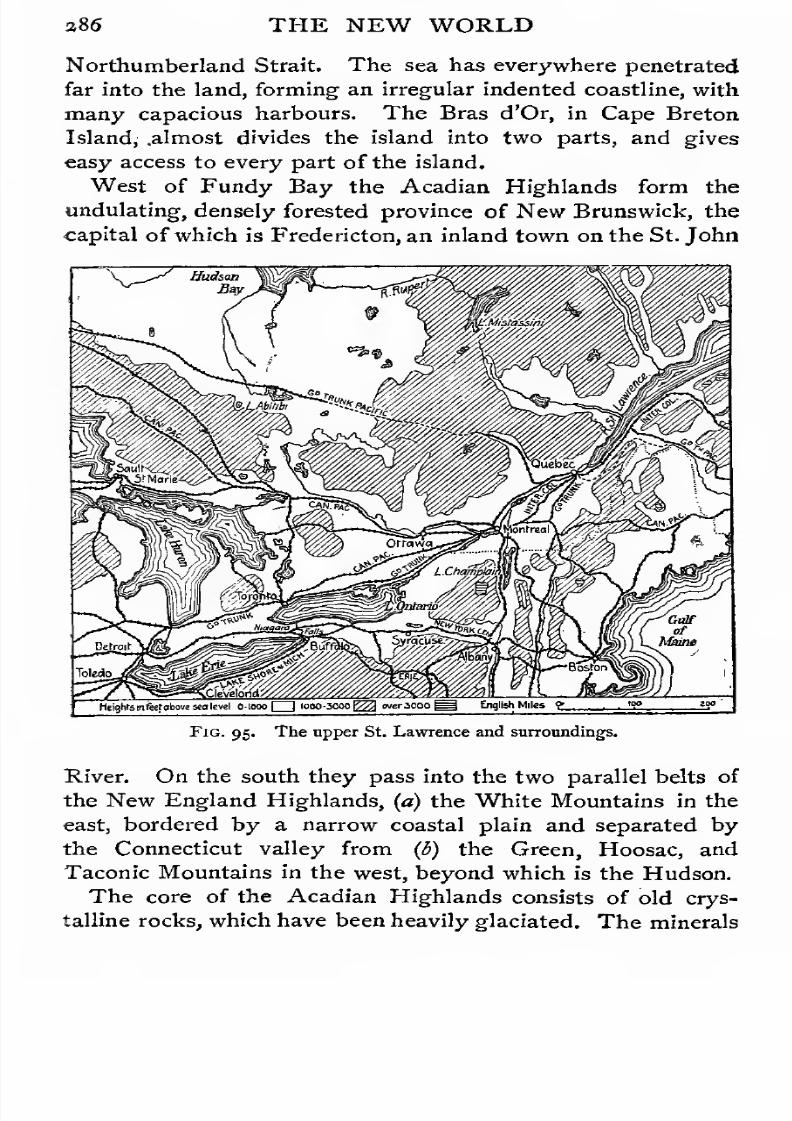
7/30/2019 The Senior Geography 1919
http://slidepdf.com/reader/full/the-senior-geography-1919 302/383
386 THE NEW WORLD
Northumberland Strait. The sea has everywhere penetrated
far into the land, forming an irregular indented coastline, with
many capacious harbours. The Bras d'Or, in Cape Breton
Island, .almost divides the island into two parts, and gives
easy access to every part of the island.
West of Fundy Bay the Acadian Highlands form the
undulating, densely forested province of New Brunswick, the
capital of which is Fredericton, an inland town on the St. John
Heights in feetabove sea level O-looo 1000-3000^ wer.1000^ English Miles <>. .
'9° *y
Fig. 95. The upper St. Lawrence and surroundings.
River. On the south they pass into the two parallel belts of
the New England Highlands, (a) the White Mountains in the
east, bordered by a narrow coastal plain and separated by
the Connecticut valley from (b) the Green, Hoosac, and
Taconic Mountains in the west, beyond which is the Hudson.
The core of the Acadian Highlands consists of old crys-
talline rocks, which have been heavily glaciated. The minerals

7/30/2019 The Senior Geography 1919
http://slidepdf.com/reader/full/the-senior-geography-1919 303/383
THE NEW WORLD 28.7
include iron and coal. Coal is worked at Cumberland and
Pictou in northern Nova Scotia, and at Sydney in Cape
Breton Island. The greater part of the region is forested.
Lumbering is important in the interior and shipbuilding onthe coast, which has many excellent harbours and rich
fisheries. Agriculture is developing. The plains round Fundy
Bay are engaged in dairy-farming. The fertile valley of
Annapolis in southern Nova Scotia is famous for apple
orchards. Prince Edward Island is also a flourishing agri-
cultural region, of which Charlottetown is the capital.
Halifax, on the east coast of Nova Scotia, with a magni-
ficent harbour, and St. John, in New Brunswick, on the tidal
estuary of the St. John river which enters Fundy Bay, are
terminal ports of the Canadian Pacific Railway. They are
specially important in winter, when the St. Lawrence ports are
frozen.
Acadia was settled by the French at the beginning of thesixteenth century. They were almost immediately followed
by Scottish settlers, who gave its name to Nova Scotia. France
renounced Acadia by the treaty of Utrecht, but the Acadian
sympathies remained so strongly French that many French
settlers were deported in the middle of the eighteenth century.
The union with the Dominion of Canada took place in 1867.
New England. New England resembles Acadia in natural
conditions, but is at a much later stage of economic develop-
ment. An indented coast is backed by a rugged forested
interior. This led to the early development of fisheries and
local shipbuilding, and later to extensive trade, as the small
fishing centres developed into ports, such as Portland (Me.), a
terminal port of the Grand Trunk and other railways. Therivers which descend from the highlands, supply cheap power,
giving rise to various manufactures. Cotton is cheaply procured
from the South Atlantic ports, and the cotton manufacture
has developed at Manchester (N.H.), Lowell (Mass.), on the
Merrimac, Providence (R.I.), and Fall River (Mass.). Fail
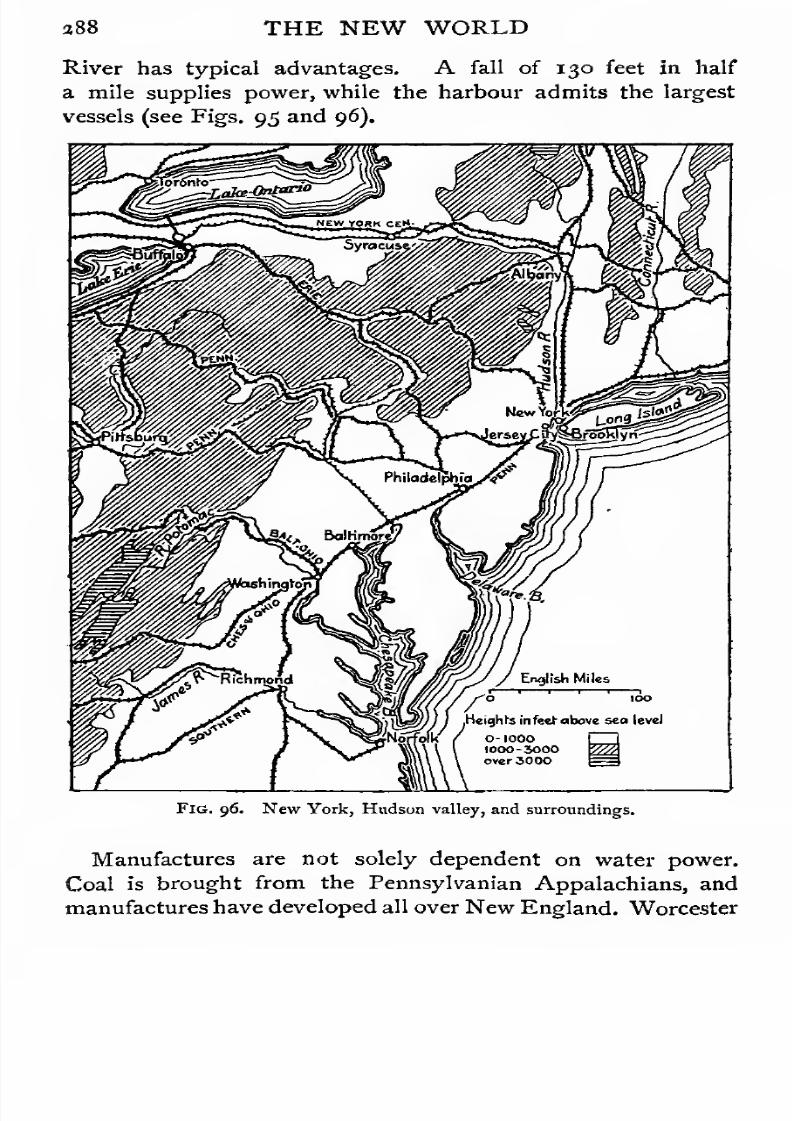
7/30/2019 The Senior Geography 1919
http://slidepdf.com/reader/full/the-senior-geography-1919 304/383
388 THE NEW WORLD
River has typical advantages. A fall of 130 feet in half
a mile supplies power, while the harbour admits the largest
vessels (see Figs. 95 and 96).
FIG. 96. New York, Hudson valley, and surroundings.
Manufactures are not solely dependent on water power.
Coal is brought from the Pennsylvanian Appalachians, and
manufactures have developed all over New England. Worcester
7/30/2019 The Senior Geography 1919
http://slidepdf.com/reader/full/the-senior-geography-1919 305/383
THE NEW WORLD 389
and Springfield (Mass.) manufacture every kind of machinery.
Hartford (Conn.) is similarly employed, and is also a market
for the fine tobacco of the fertile Connecticut valley. The
largest city of
NewEngland, Boston, the capital of
Massa-chusetts, is important as a port, a manufacturing town, and an
intellectual centre.
New England was settled in the seventeenth century,,byEnglish Puritans, mainly from East Anglia (see p. 125). In
1643 Massachusetts Bay, Plymouth, Connecticut and NewHaven styled themselves the United Colonies of New England.
Settlement spread from the coast up the valleys, the advance
inland leading to long Indian wars. The route to the west
was barred by the parallel north and south ranges, which
were not crossed till the nineteenth century. The railway
routes to the west are all difficult, the Hoosac Tunnel through
the Hoosac Mountains being the longest in the United States
(4J miles).
In the eighteenth and early nineteenth centuries Boston
ranked after Philadelphia as the second city of the United
States. Both are now far surpassed by New York and Chicago.
New England still retains the intellectual leadership, and is
the seat of the universities of Harvard (Boston) and Yale
{New Haven). Its agricultural prosperity has suffered by
the opening up of the west, but this has led to more rapid
industrial development. A large influx of Irish and French
Canadian factory hands has considerably modified the old
Puritan type, which is still preserved in remoter villages.
The Central Appalachians and their Margins.
The coastal margin of the Central Appalachians has three
importantopenings :
(1)the Hudson Valley, protected by Long
Island, leading across the highland barrier to the Great Lakes,
(2) the wider Delaware Bay and River, and (3) the still wider
and longer Chesapeake Bay, leading to the Susquehanna
Valley.
In the Central Appalachians the well-marked system of
parallel ridges and valleys is very difficult to cross. The
SEN. GEOG.

7/30/2019 The Senior Geography 1919
http://slidepdf.com/reader/full/the-senior-geography-1919 306/383
aoo THE NEW WORLD
Delaware, Susquehanna, and other rivers give access to the
Appalachian Valley which lies behind the eastern ridges. Until
their narrow gaps were followed by railways they were of little
use as routes to the Appalachian plateau, which rises on the
Western edge of the Appalachian Valley and slopes gradually
west, unbroken by parallel ridge and valley. This distinction
between the Appalachian ridges to the east and the Appalachian
Fig. 97. The Central Plains (southern part).
plateau (sometimes termed the Allegheny plateau) to the
west of the Appalachian Valley must be clearly understood.
The wide eastern lowlands, more fertile than those of the
north-east, were settled by a population composed of many
different elements. The Dutch founded New Amsterdam and
other trading posts on Manhattan Island, at the mouth of the
Hudson, and pushed up the river. They were followed by

7/30/2019 The Senior Geography 1919
http://slidepdf.com/reader/full/the-senior-geography-1919 307/383
THE NEW WORLD 391
the Englishj who took New Amsterdam and renamed it NewYork. Expansion up the Hudson towards the St. Lawrence
involved hostilities with the French, who were following that
route, and with powerful Indian tribes. The Delaware route
was followed by Quaker and other fugitives from the religious
persecutions of Charles II and James II. Philadelphia, on the
Delaware, immediately became important,and played a leading
part in early colonial history. Pennsylvania, the colony of
which it formed the nucleus, received a large influx of Germans
from the Palatinate, whose descendants form the Pennsylvanian
Dutch. The Chesapeake and Susquehanna route was followed
by Roman Catholic settlers, who named their colony Mary-
land, in honour of Queen Henrietta Maria. The capital,
Baltimore, at the head of a tidal estuary opening to Chesa-
peake Bay, was not founded till a century later.
The Episcopalian settlement, royalist in sympathies, was
chiefly in Virginia, which was named by Raleigh after the
Virgin Queen. It had access to the interior by the Chesapeake,
Potomac and James rivers. Richmond, on the James, at the
head of tidal navigation, the capital, was founded early in the
eighteenth century.
At the close of the War of Independence with the mother
country, a Federal Capital became necessary. To avoid
jealousy it was resolved to build one. The site chosen was
the head of tidal navigation on the Potomac, where Washington
was founded in 1 800. The surrounding country (sixty square
miles), ceded by Maryland and Virginia, became the District
of Columbia, a Federal Territory, independent of any state
control.
These five cities, New York, Philadelphia, Baltimore, Rich-
mond, and Washington, each with its special geographical and
historical significance, are the chief centres of the Central
Appalachians. Their prosperity originally depended on
that of the agricultural and maritime colonies. Though this
suffered as the virgin lands of the west were opened up, the
Atlantic centres increased in importance as links between
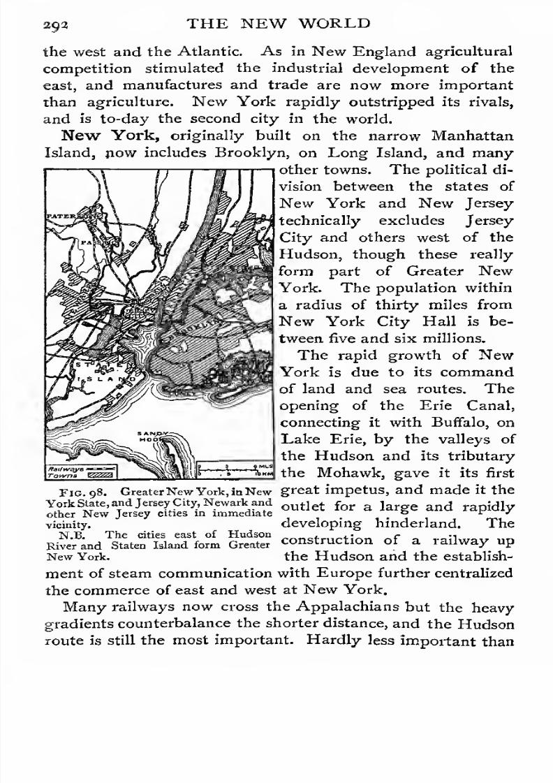
7/30/2019 The Senior Geography 1919
http://slidepdf.com/reader/full/the-senior-geography-1919 308/383
292 THE NEW WORLD
the west and the Atlantic. As in New England agricultural
competition stimulated the industrial development of the
east, and manufactures and trade are now more important
than agriculture. New York rapidly outstripped its rivals,
and is to-day the second city in the world.
New York, originally built on the narrow Manhattan
Island, now includes Brooklyn, on Long Island, and many
other towns. The political di-
vision between the states of
New York and New Jersey
technically excludes Jersey
City and others west of the
Hudson, though these really
form part of Greater New
York. The population within
a radius of thirty miles from
New York City Hallis
be-tween five and six millions.
The rapid growth of New
York is due to its command
of land and sea routes. The
opening of the Erie Canal,
connecting it with Buffalo, on
Lake Erie, by the valleys of
the Hudson and its tributary
the Mohawk, gave it its first
GreaterNew York, inNew great impetus, and made it the
ind Jersey City, Newark and
other New Jersey cities in immediate
Fig.
York State, and Jersey City, Newark andoutlet for & j an(j rap ;d lyfew Jersey cities in immediate r *
vicinity.
N.B. The cities east of Hudsondeveloping hinderland. The
K ine cities east 01 nuuson „„„„...„„<.,„ „r „ -i „
River and Staten Island form GreaterConstiuction
of a railway upNew York. the Hudson and the establish-
ment of steam communication with Europe further centralized
the commerce of east and west at New York.
Many railways now cross the Appalachians but the heavy
gradients counterbalance the shorter distance, and the Hudson
route is still the most important. Hardly less important than
7/30/2019 The Senior Geography 1919
http://slidepdf.com/reader/full/the-senior-geography-1919 309/383
THE NEW WORLD 393
the route west by the Mohawk to Lake Erie is that north by
the main valley to Lake Champlain and the St. Lawrence.
Albany, where these routes diverge at the head of tidal navi-
gation, is an important junction, and a receiving and distributing
centre for the produce of the northern forests and the western
plains (cf. Figs. 96 and 97).
New York is also the outlet for important industrial dis-
tricts. Coal is abundant in the Central Appalachians. The
anthracite or hard coal of the east led to the rise of Scranton
and Harrisburg in the Appalachian valley and of many other
centres. The west is rich in soft coal and petroleum, and
Pittsburg, on the Upper Ohio, is the centre of one of the
greatest industrial regions in the world. Except in relation
to New York and other eastern ports, which form its outlets,
it belongs rather to the central than to the Appalachian region.
Philadelphia as a port is far behind New York, though
hardly less importantindustrially. .
Its leadingindustries,
which are fed by the anthracite coal of Eastern Pennsylvania,
are the manufacture of locomotives and shipbuilding.
Baltimore has several important manufactures, including
cotton and iron. It is the northern port of a rich region,
where cotton becomes a staple product.
Richmond is the chief city of the Southern States, the key
to the southern coastal plain, and the great tobacco market of
the south.
All these cities are at the tidal head ofnavigation (cf. Fig. 96).
Trenton, similarly situated on the Delaware, manufactures fine
pottery from local clay and has many mechanical and engineer-
ing industries.
The possession of the region between the Hudson and theJames secures the possession of the whole coastal plain. In
the War of Independence everything turned on the possession
of the Hudson route. The control of this by the British would
have cut off New England from the other insurgent colonies
and would have enabled the British troops on the St. Lawrence
to co-operate with the forces invading from the coast. The

7/30/2019 The Senior Geography 1919
http://slidepdf.com/reader/full/the-senior-geography-1919 310/383
294 THE NEW WORLD
victory of the colonists at Saratoga Springs gave them the
control of the Hudson and of New York, and through New
York of the Chesapeake and other keys to the eastern plain.
The Southern Appalachians and their Margin. The
parallel ridges and valleys are well marked in the Southern
Appalachians, which are higher, broader, and a much more
formidable barrier than the Central Appalachians. The
Fig. 99. The North-west Mountain Routes.
eastern margin of the Appalachian Valley is formed by the
Blue Ridge and its continuation the Black Mountains of
North Carolina, which culminate in Black Dome (6,700 feet),
the highest mountain east of the Western Cordilleras. The
western wall of the Valley is formed by the Appalachian plateau,
rising in the steep escarpment of the Cumberland plateau.
Across this plateau the Tennessee, which drains the Appala-

7/30/2019 The Senior Geography 1919
http://slidepdf.com/reader/full/the-senior-geography-1919 311/383
THE NEW WORLD 295
chian Valley to the south, breaks to the Ohio. Long parallel
rivers flow from the Blue Ridge south-east to the Atlantic,
forming falls where they leave the harder rock for the fertile
Eastern Valley. Along this line, where navigation is inter-
Fig. 100. The South-eastern States.
rupted and power becomes available, Raleigh (N.C.), Columbia
(S.C.), Augusta (Ga.) and Montgomery (Ala.), are engaged in
manufactures, including cotton. The Eastern Valley runs
parallel to the coast, and is separated from it by sandy forested
7/30/2019 The Senior Geography 1919
http://slidepdf.com/reader/full/the-senior-geography-1919 312/383
296 THE NEW WORLD
heights which yield timber and turpentine. The coast
itself is low and fringed in the north with lagoons and
sandspits, the easternmost of which forms Cape Hatteras.
Farther south the famous sea-island cotton, exported from
Charleston (S.C.) and Savannah (Ga.), is grown on the coastal
islands.
Agricultural labour in the southern lowlands is very exhaust-
ing for whites. Early settlement was of the plantation type,
consisting of large estates on which cotton, sugar and tobacco
were grown by negro slaves. In the northern states, where
the climatic conditions were different, slavery was unnecessary
and unpopular. Nearly half a century ago the southern states,
believing that their right to control their internal affairs was
endangered by this feeling, seceded from the Union. Fight-
ing took place (i) on the coastal margin from Philadelphia to
Richmond, (2) in the parallel Appalachian Valley, reached
from the east through gaps, and (3) in the Mississippi Valley,
which controlled routes from the north to New Orleans, the
chief outlet for the southern states west of the Appalachians.
Chattanooga, on the Tennessee, at the end of the Appalachian
Valley, commanded routes from east and west, and was a place
of great importance in the struggle.
The Central Plain. It is possible to pass from the Arctic
Ocean (lat. 70 N.) to the Gulf of Mexico (lat. 30 N.) through
40 of latitude, or nearly 2,800 miles, by the Mackenzie, Red
and Mississippi rivers, without rising much over 1,000 feet in
elevation. From this the land rises west to the Rockies, and
in the south centre east to the Highlands, without the character
of the plain being broken. Such diversity as exists is due to
(1) the nature of the soil, (2) the kind of weathering, and
(3) the occasional occurrence of higher ground, as in the
Black Hills of Dakota and the Ozark Hills of Missouri and
Arkansas.
As in the Russian plain the sedimentary rocks lie
horizontally round a low, gently undulating area of old rock,
with a chain of lakes round the margin (Great Slave, Bear,
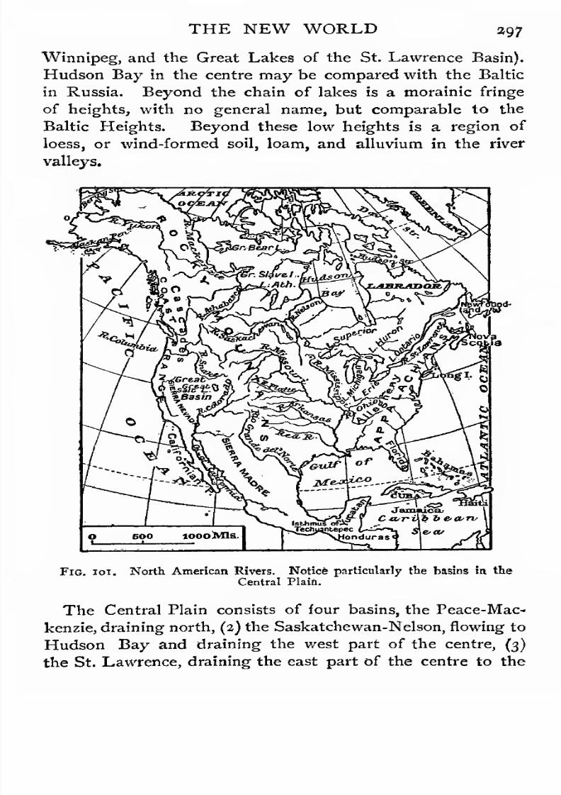
7/30/2019 The Senior Geography 1919
http://slidepdf.com/reader/full/the-senior-geography-1919 313/383
THE NEW WORLD 297
Winnipeg, and the Great Lakes of the St. Lawrence Basin).
Hudson Bay in the centre may be compared with the Baltic
in Russia. Beyond the chain of lakes is a morainic fringe
of heights, with no general name, but comparable to the
Baltic Heights. Beyond these low heights is a region of
loess, or wind-formed soil, loam, and alluvium in the river
valleys.
loooMIs
Fig. ioi. North American Rivers. Notice particularly the basins in the
Central Plain.
The Central Plain consists of four basins, the Peace-Mac-
kenzie, draining north, (2) the Saskatchewan-Nelson, flowing to
Hudson Bay and draining the west part of the centre, (3)
the St. Lawrence, draining the east part of the centre to the
7/30/2019 The Senior Geography 1919
http://slidepdf.com/reader/full/the-senior-geography-1919 314/383
398 THE NEW WORLD
Atlantic, and (4) the Missouri-Mississippi draining south to
the Gulf of Mexico. The first three filter through lakes but
the Mississippi lies outside the great lake region.
All four rivers are great waterways, but each has its special
disadvantage. The Peace-Mackenzie flows to a frozen sea
of no value as a means of communication. Hudson Bay,
to which flows the Saskatchewan-Nelson, is frozen except for
three months of the year, while the St. Lawrence Gulf is
closed by ice for over four months in winter. The Mississippi,
like the Hwangho, flows in its lower course over shallow deltaic
lands, where the river is difficult to regulate. Prevented asfar as possible by levies, or embankments, from flooding these
lowlands and thus disposing of the silt it carries the river has
gradually raised its bed above the level of the surrounding
country, and its distributaries are with difficulty kept deep
enough for navigation (see p. 311).
The Peace-Mackenzie and the Mississippi, which flow "north
and south, cross more zones than the other two systems, the
general direction of which is from west to east. Most of those
crossed by the Mackenzie, however, are of little economic
importance. Owing to the absence of natural barriers none
of the four basins forms a natural region. The divisions are
climatic, but;, as in the configuration, the transition is extremely
gradual.Climate. The Rocky Mountains exclude all western
oceanic influences from the Central Plain just as the
Himalayas exclude northern climatic influences from India.
The Eastern Highlands exclude the Atlantic influences, but
not so completely, as they are lower, narrower, and less
continuous. In the north all the land west of them may be
included in the continental area. Hudson Bay and the Great
Lakes cause only slight and local modifications. In the south,
the Gulf of Mexico causes the Atlantic oceanic influence to be
felt far inland. The direction of the winter storms, along the
Great Lake and the St. Lawrence, or along the western margin
of the Appalachians, also causes an indraught of warm moist
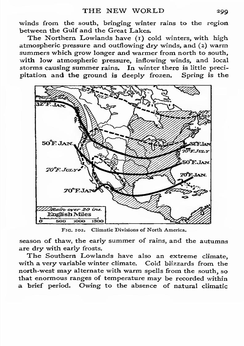
7/30/2019 The Senior Geography 1919
http://slidepdf.com/reader/full/the-senior-geography-1919 315/383
THE NEW WORLD 299
winds from the south, bringing winter rains to the region
between the Gulf and the Great Lakes.
The Northern Lowlands have (1) cold winters, with high
atmospheric pressure and outflowing dry winds, and (j) warmsummers which grow longer and warmer from north to south,
with low atmospheric pressure, inflowing winds, and local
storms causing summer rains. In winter there is little preci-
pitation and the ground is deeply frozen. Spring is the
—B^^^^-~\«^^^vv«r5'"^y/\\~m^ *^--_ \>>v>A "

7/30/2019 The Senior Geography 1919
http://slidepdf.com/reader/full/the-senior-geography-1919 316/383
300 THE NEW WORLD
barriers the winter frosts are felt far south, and the period
between the last frost of spring and the first frost of autumn
sets the limit to the cultivation of cotton. The summers are
much longer, hotter, and wetter than in the north and are
occasionally troubled by violent tornadoes.
The Western Plains have the extreme and more regular
temperature of the north, as the higher elevation neutralizes
the lower latitude. The rainfall is very scanty, owing to the
great distance from the sea. Near the base of the mountains
the chinook wind, or American foehn (see p. 67) leads to
a rapid melting of the snow.The natural divisions of the Central Plain are exhibited in
the vegetation which is largely controlled by these climatic
conditions.
The Northern Lowlands consist of tundra or ' barren lands
'
in the extreme north, succeeded to the south by forests, which
pass on the south and west into the wheat belt. The Western
Plains consist of more arid bad lands, and of less arid pasture
land. The Southern Lowlands consist of the maize belt in
the area liable to severe winter frosts, and of the cotton belt
in which these are absent for nearly eight months in the year.
The Tundra or Barren Grounds. The tundra of North
America has the typical long, cold, dark winter, when all growth
ceases, and a short, warm, light summer, whenit is
relativelyrapid. The vegetation has already been described (see p. a).
The caribou is the American reindeer, but it has not, as in the
Old World, been domesticated. Hence population in the
Barren Grounds is even scantier than in the tundra of the Old
World, and depends wholly on the hunting of the many fur
animals which move north in summer, or on fishing.
The Forest Belt. The forest belt runs west-north-west
and east-south-east. It almost covers the basins of the
Mackenzie, Lower Nelson and St. Lawrence, and a small
part of the eastern basin of the Upper Mississippi.
The Mackenzie rises as the Athabasca near Mount Columbia,
and flows north-east to the lake of that name, whose surplus
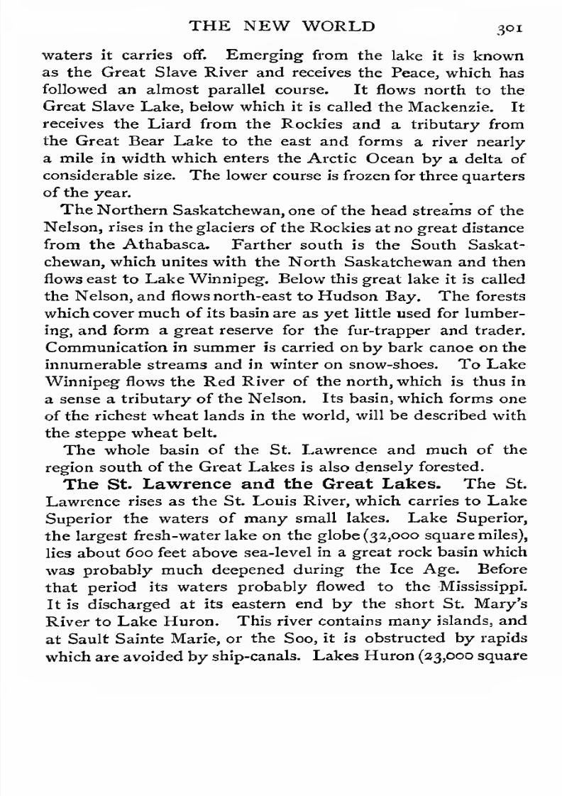
7/30/2019 The Senior Geography 1919
http://slidepdf.com/reader/full/the-senior-geography-1919 317/383
THE NEW WORLD 301
waters it carries off. Emerging from the lake it is known
as the Great Slave River and receives the Peace, which has
followed an almost parallel course. It flows north to the
Great Slave Lake, below which it is called the Mackenzie. It
receives the Liard from the Rockies and a tributary from
the Great Bear Lake to the east and forms a river nearly
a mile in width which enters the Arctic Ocean by a delta of
considerable size. The lower course is frozen for three quarters
of the year.
The Northern Saskatchewan, one of the head streams of the
Nelson, rises in the glaciers of the Rockies at no great distance
from the Athabasca. Farther south is the South Saskat-
chewan, which unites with the North Saskatchewan and then
flows east to Lake Winnipeg. Below this great lake it is called
the Nelson, and flows north-east to Hudson Bay. The forests
which cover much of its basin are as yet little used for lumber-
ing, and form a great reserve for the fur-trapper and trader.
Communication in summer is carried on by bark canoe on the
innumerable streams and in winter on snow-shoes. To Lake
Winnipeg flows the Red River of the north, which is thus in
a sense a tributary of the Nelson. Its basin, which forms one
of the richest wheat lands in the world, will be described with
the steppe wheat belt.
The whole basin of the St. Lawrence and much of the
region south of the Great Lakes is also densely forested.
The St. Lawrence and the Great Lakes. The St.
Lawrence rises as the St. Louis River, which carries to Lake
Superior the waters of many small lakes. Lake Superior,
the largest fresh-water lake on the globe (32,000 square miles),
lies about 600 feet above sea-level in a great rock basin whichwas probably much deepened during the Ice Age. Before
that period its waters probably flowed to the Mississippi.
It is discharged at its eastern end by the short St. Mary's
River to Lake Huron. This river contains many islands, and
at Sault Sainte Marie, or the Soo, it is obstructed by rapids
which are avoided by ship-canals. Lakes Huron (23,000 square
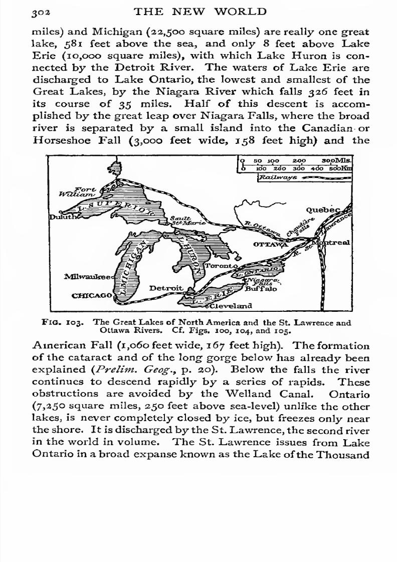
7/30/2019 The Senior Geography 1919
http://slidepdf.com/reader/full/the-senior-geography-1919 318/383
3°3 THE NEW WORLD
miles) and Michigan (22,500 square miles) are really one great
lake, 581 feet above the sea, and only 8 feet above Lake
Erie (10,000 square miles), with which Lake Huron is con-
nected by the Detroit River. The waters of Lake Erie are
discharged to Lake Ontario, the lowest and smallest of the
Great Lakes, by the Niagara River which falls 326 feet in
its course of 35 miles. Half of this descent is accom-
plished by the great leap over Niagara Falls, where the broad
river is separated by a small island into the Canadian or
Horseshoe Fall (3,000 feet wide, 158 feet high) and the
FlG. 103. The Great Lakes of North America and the St. Lawrence and
Ottawa Rivers. Cf. Figs. 100, 104, and 105.
American Fall (1,060 feet wide, 167 feet high). The formation
of the cataract and of the long gorge below has already been
explained (Prelim. Geog., p. 20). Below the falls the river
continues to descend rapidly by a series of rapids. These
obstructions are avoided by the Welland Canal. Ontario
(7,250 square miles, 250 feet above sea-level) unlike the other
lakes, is never completely closed by ice, but freezes only near
the shore. It is discharged by the St. Lawrence, the second river
in the world in volume. The St. Lawrence issues from Lake
Ontario in a broad expanse known as the Lake ofthe Thousand
7/30/2019 The Senior Geography 1919
http://slidepdf.com/reader/full/the-senior-geography-1919 319/383
THE NEW WORLD 303
Isles, below which it narrows, and forms many falls and rapids.
The lowest of these are the Lachine Rapids, avoided by the
Lachine Canal, immediately below which is the island of
Mount Royal, where the Ottawa enters the St. Lawrence fromthe north. A few miles lower down, the Richelieu River,
from Lake Champlain, enters on the right bank, forming
a route across the Appalachian barrier to the Hudson and
New York. The St. Lawrence, which is here only a few feet
above sea-level, expands into the shallow Lake St. Peter.
The river which flows out of this widens below the rock of
Quebec to a long deep estuary at the mouth of which is the
wooded island of Anticosti. This estuary represents a drowned
river valley, which has been traced along the floor of the sea
between Newfoundland and Cape Breton Island to the edge
of the continental shelf.
New France. The St. Lawrence was the gate by which
the French penetrated into North America and foundedNew France. It formed an easy route to the interior across
that Appalachian barrier which long penned in the British
colonies farther south. Two great names are associated with
the exploration of this route. Cartier ascended the St.
Lawrence as far as the Lachine Rapids in 1535. Champlain,
at the beginning of the seventeenth century, founded Quebec
on its Gibraltar-like heights and pushed exploration up the
various waterways into the interior. A vast domain was rapidly
opened up, but this was only thinly peopled by fishers and fur-
traders. Thus while the English colonies of the Atlantic sea-
board became firmly rooted to a limited area, France, with
greater facilities for movement, was but loosely attached to
a vast domain of river and forest. Such colonization is unstable,
and the capture of Quebec in the middle of the eighteenth
century involved the loss of the whole of Canada.
Quebec and Montreal. The two original French settle-
ments still retain their importance. Quebec, though not the
largest town, is the capital of the Province of Quebec, formerly
called Lower Canada, to distinguish it from the English-

7/30/2019 The Senior Geography 1919
http://slidepdf.com/reader/full/the-senior-geography-1919 320/383
3o4 THE NEW WORLD
speaking colony of Ontario or Upper Canada. Built on the
edge of the heights of the left bank, with the commercial city
round its base, it is the best example in North America
of a type of city familiar in the Old World, one whose
site was determined primarily by ease of defence. The in-
habitants both of the city and of the province are largely of
French descent, and speak French.
Montreal, the chief port and commercial centre of the
St. Lawrence, is built on the island of Mount Royal (Mont
Real), where many routes converge to the river at its
highest navigable point. Of these the most important are
those by the Ottawa to the north, to Georgian Bay, an arm
of Lake Huron, by the Richelieu to the Hudson, and by the
St. Lawrence to the Great Lakes and the Mississippi. Montreal
was first important as a fur-trading centre^ and it has grown
with the growth of wider economic relations. It is above the
tidal limit, but has been rendered accessible to the largest
vessels by the deepening of the channel. A series of canals
avoid the various rapids, and give through watercommunication
with Chicago at the southern extremity of Lake Michigan, and
Duluth at the western end of Lake Superior, the two great
inland ports of the St. Lawrence.
Modern Eastern Canada. The natural wealth of Canada
consists primarily of its rich fisheries and of the furs and
timber of its forests. The timber or lumber centres are
Quebec and Hull on the Ottawa, at the foot of the Chaudiere
Falls, which supply power for innumerable saw and pulping
mills. The fur trade is important throughout the forest regions
of Quebec and Ontario, and has its great market centre at
Montreal. The importance of the fisheries on the coasts of
Labrador, Nova Scotia, and Newfoundland has already beendescribed.
Agricultural Eastern Canada is a clearing in the vast forest.
The most fertile region is the Lake Peninsula of Southern
Ontario, with a climate which brings all fruits to perfection.
Unable to compete in wheat-growing with the newly-settled

7/30/2019 The Senior Geography 1919
http://slidepdf.com/reader/full/the-senior-geography-1919 321/383
THE NEW WORLD 3°5
West, the farmers ofEastern Ontario have paid special attention
to mixed and dairy farming, and to the cultivation of the vine,
peach, and other fruits in the Lake Peninsula. The chief
centres are Toronto, where the route from Georgian Bayreaches Lake Ontario, Hamilton, and Kingston, ports on Lake
Ontario, and Ottawa, the Dominion Capital. Eastern Ontario
is separated from the agricultural lands of the west by the
broad forest belt of Western Ontario, which is not yet opened
Heights in feet above sea level : 0-1000CD 1000-3000 ESI Qver3000 English Miles 9_
Fig. 104. The central plains west of the Great Lakes.
up. A similar forest belt to the east separates it from maritime
Canada. It is least isolated on the south, where Lakes Erie
and Ontario unite it closely with the United States.
Among the growing industries is mining. Vast deposits of
iron, copper, and other ores occur round Lake Superior,
especially in the United States. These are cheaply carried
by water to the furnaces of Chicago, Toledo, Cleveland, and
inland to Pittsburg. Silver is found in Ontario.
As in the Eastern United States, the agricultural competition

7/30/2019 The Senior Geography 1919
http://slidepdf.com/reader/full/the-senior-geography-1919 322/383
306 THE NEW WORLD
of the West has stimulated the industrial development of the
East. Montreal, which has special facilities for obtaining raw
materials and procures cheap power from the Lachine
Rapids, carries on very varied industries. Cotton, sugar, and
tobacco represent imports from the West Indies and the
Southern United States. Foundries and the manufacture of
locomotives, machinery, and hardware, indicate the combina-
tion of cheap power and proximity to mining districts.
Distilleries, breweries, and flourmills work up the produce
of the agricultural west. The cattle ranches of the Far West
supply raw materials for the manufacture of boots, shoes, and
candles, and the forests of Quebec and Ontario those for saw-
milling and paper-making. Quebec has less varied industries.
The forests supply tanning materials, and the Far West the
hides for the important leather manufactures. Cotton is also
manufactured.
Routes. The chief route to the south, by Lake Champlain,
Albany, and the Hudson, has already been described. The
Canadian Pacific Railway (C. P. R.) runs from Halifax and
St. John, the winter ports, to Quebec and Montreal, the
summer ports. From Montreal it follows the Ottawa River
to Ottawa, and then runs through the forest to the nickel
mines of Sudbury, and on to Port Arthur and Fort William
on Lake Superior. Thence it runs west by Winnipeg through
the agricultural and pastoral regions of the Central Plain.
The Grand Trunk and Canadian Northern also provide routes
to the west.
Grass Lands and Open Woods of the Central Plains.
Agriculture in Eastern Canada and the United States round
the Great Lakes involves as a preliminary the clearing of the
forest. This region, therefore, was relatively slowly settled.
West of the forest belt lie the open woods and grass land&
of the Middle West, where this initial labour is unnecessary,
and where the soil is extraordinarily fertile. This region,
both in Canada and the United States, has been rapidly
opened up during the last half century.
parallel of -*---:-*~- *i~- " -»
7/30/2019 The Senior Geography 1919
http://slidepdf.com/reader/full/the-senior-geography-1919 323/383
THE NEW WORLD 307
plains from the drier pastoral west, which can only be culti-
vated under irrigation. The agricultural lands east of 100° W.are cultivated with wheat in the north as far south as 4a N.,
withmaize between 4a and
37°N., and with cotton south of
37°. The wheat belt includes much of the Saskatchewan,
Nelson, and Upper Mississippi basins. The maize and tobacco
belt includes much of the Lower Missouri, the Middle Missis-
sippi, and the Ohio basins. The cotton belt includes the
Lower Mississippi and the Gulf and South Atlantic coastal
plains.
The Wheat Belt. The wheat belt includes great parts of
Manitoba, Saskatchewan and Alberta in Canada, and of
North and South Dakota and Minnesota in the United
States. Wheat is also grown along with maize in Kansas,
Nebraska, Ohio, and Indiana. The most fertile part of the
wheat belt is the valley of the Red River, a broad plain,
from thirty to thirty-five mileswide,
which was once thefloor of an old glacial lake, now represented by Winnipeg and
Winnipegosis.
The climate is extreme, with cold dry winters and warm
summers. A rainfall of one inch is equivalent to a snowfall
of nearly a foot, so that enough snow falls in winter to prevent
the soil from freezing to any great depth. The spring thaws
thoroughly moisten the soil, the summer rains fall when they
are needed to swell the ears, and the warm summers ripen the
grain. The farms are of large size, and the level character of
the country allows labour-saving machinery to be extensively
used.
The towns are storing and milling centres. The largest in
Manitoba is Winnipeg, where in harvest twenty miles ofsidings are filled with trains to carry the crops east. Brandon
is also a busy centre.
The chief city in the United States wheat belt is Minnea-
polis, at the St. Anthony Falls of the Mississippi, which
supply power. It is the greatest flourmilling centre in the
world, and has also an immense lumber trade. Together with
a

7/30/2019 The Senior Geography 1919
http://slidepdf.com/reader/full/the-senior-geography-1919 324/383
3o8 THE NEW WORLD
St. Paul, at the head of the Mississippi navigation, it forms
a great double city, with many manufactures. Milwaukee,
on Lake Michigan, the second milling centre, uses enormous
quantities of grain in its breweries. Wheat is shipped from
Duluth by the Great Lakes and the St, Lawrence. Duluth
English Miles
Fig. 105. The Central Plains (northern part).
is also the outlet for the stock-raising grass lands of the west
and for the mineral regions round Lake Superior.
The development of the wheat belt is due to the extension
of railways, which carry settlers west and produce east. In
7/30/2019 The Senior Geography 1919
http://slidepdf.com/reader/full/the-senior-geography-1919 325/383
THE NEW WORLD 309
1870 Minneapolis, which now has 275,000 people, had only
13,000. The growth in Canada is still more recent. In 1870
there were only 315 people in Winnipeg, where there are now
over 100,000. The scarcity of labour in a new country, and
the cost of transporting harvests to the nearest station, still
limit settlement to the immediate neighbourhood of the rail-
way. Every extension of the railway is followed by an
extension of the farming area, and this is proceeding so rapidly
that each year Canada becomes a more important source of
wheat. The Grand Trunk Pacific and Canadian Northern
lines, north of the Canadian Pacific, tap the north of the wheat
belt. The Grand Trunk follows the Yellowhead Pass and
reaches the Pacific port of Prince Rupert.
The Maize Belt. In the maize belt the summers are
sufficiently long and warm to ripen maize, or corn, as it is
called. A great variety of other crops are grown, including
wheat, oats, barley, buckwheat, roots, and tobacco.Iowa, Illinois, Kansas, Nebraska, Missouri, and Indiana lead
in growing maize. To reduce the cost of transport this is
largely used to fatten hogs, which are slaughtered and ' packed ',
or * canned ', at Chicago, Cincinnati, Indianapolis, St. Louis,
Kansas City, Omaha, and other large route centres.
Settlement reached this region by the Great Lakes and the
Ohio River. In the course of the eighteenth century forts and
trading posts were established at suitable sites, many of which
have developed into great cities. Among the oldest is Detroit,
founded by the French in 1701. Fort Duquesne, on the site
of the modern Pittsburg, where the Monongahela andAllegheny
rivers unite to form the Ohio, was established by the French in
1754. Here routes converge (1) from the coast by the Potomacand the Monongahela
;(a) from Lake Erie, by the Allegheny
river ; and (3) from the Gulf of Mexico by the Mississippi and
the Ohio. Fort Duquesne was taken by the English in 1 758,and
named after Pitt, the Prime Minister. Pittsburg has developed
into the greatest iron-manufacturing centre of the United States

7/30/2019 The Senior Geography 1919
http://slidepdf.com/reader/full/the-senior-geography-1919 326/383
310 THE NEW WORLD
because of the abundance of coal, natural gas, and petroleum in
the neighbourhood. Local ore was first smelted, but this is
now quite inadequate, and much is brought from Lake Superior
to Cleveland and other Lake Erie ports. The growth of Pitts-
burg has been much accelerated by its natural command of
routes in all directions. In 1764 St. Louis, at the confluence
of the Missouri and Mississippi, now the centre of many con-
verging waterways and railway lines, was founded as a fur-
trading post. Chicago, early visited by French explorers, was
a trading post (Fort Dearborn) at the beginning of the nine-
teenth century. Its position at the southern end of LakeMichigan, which stretches far south into the Central Plain,
makes it the centre to which many routes from east and west
converge. A very low divide, now crossed by a canal, sepa-
rates it from the Illinois and the Mississippi. Thus it is also
the point at which routes from the Gulf reach the Great Lakes.
It became a city in 1837, when its population was just over
4,000. Its population now is nearly 3,500,000. It is the
great market to which are consigned the cattle of the western
grass lands, the hogs of the maize belt, the grain of the agri-
cultural prairies, and the lumber of Michigan and Wisconsin.
Its slaughtering and canning industries are on an enormous
scale. Coal is cheaply obtained from the Illinois coalfields,
and iron from Lake Superior. Locomotives and railway
plant for its vast railway traffic, and agricultural machinery
for the development of the agricultural west, are among the
products of its immense steel and iron industry.
The eastern plains, especially on the western margin of
the Appalachians, which fifty years ago were hardly opened,
and which twenty-five years ago were still mainly agricultural,
are rapidly becoming industrial. Coal is widely distributed, raw
materials of all kinds can be cheaply obtained, and both eastern
and western markets are easily accessible. Cincinnati (O.),
on the Ohio, once exclusively a provision centre, has now 8,000
factories engaged in making locomotives, machinery, and
every form of steel and iron goods ; waggons, and every
7/30/2019 The Senior Geography 1919
http://slidepdf.com/reader/full/the-senior-geography-1919 327/383
THE NEW WORLD 311
kind of carriage ; furniture, and every kind of wooden article;
boots, shoes, and every kind of clothing ; breweries, distilleries,
potteries, fertilizer and manure works, soap works, and others,
tod numerous to mention. It is also a great grain, iron, and
horse market, and the converging point of many lines of rail.
Louisville (Ky.), lower down the Ohio, the great market for
leaf tobacco, has similar industries. Indianapolis, in a region
of natural gas and petroleum, is similarly engaged. Other
growing centres are Cairo (111.), where the Ohio joins the
Mississippi, and Nashville (Tenn.).
The Cotton Belt. The cotton belt extends from theAtlantic Ocean to the middle of Texas. Texas, Georgia,
Mississippi, and Alabama lead in the production of cotton,
which is also grown in the Carolinas, Florida, Louisiana,
Arkansas, Indian Territory, and Oklahoma. Rice is grown in
the coastal belt.
Most, of the cotton belt is a low-lying alluvial region,
bordered along the coast by sandspits enclosing lagoons.
Some of these are of what is called the liman type, the lagoon
being at right angles to the trend of the coast, as at the mouth
of the Alabama and Trinity rivers. The Mississippi forms
a great delta, intersected by distributaries called bayous.
Below the confluence of the Ohio its bed is above the level of
the surrounding country and is protected by embankments or
levees. Disastrous floods occur in the Lower Mississippi in
spring, when the melting snows swell the upper tributaries.
Thousands of square miles, cultivated with sugar and cotton,
are sometimes inundated, and so great is the damage done
that a special department has been organized to observe the
rise of the waters in the upper part of the basin and predict
the probable rise in the lower basin. In its lower course the
river frequently changes its direction, either by eating away
its banks, or by cutting across a peninsula enclosed by a loop
in its course (see Prel. Geog., p. 14).
The climate is hot in summer and warm in winter, with
occasional cold spells. Rain falls at all seasons. Cotton does
7/30/2019 The Senior Geography 1919
http://slidepdf.com/reader/full/the-senior-geography-1919 328/383
312 THE NEW WORLD
best on low-lying lands, which must not be too moist. Avariety which will grow on higher ground is cultivated to the
height of i,000 feet in Texas.
The cotton ports are Pensacola (Fla.), Mobile (Ala.), New
Orleans (La.), and Galveston (Tex.). Cotton is exported
chiefly to England and New England. The cotton manu-
facture is rapidly developing at the base of the Southern
Appalachians from Southern Virginia to Central Alabama,
and more especially in the Carolinas. In addition to cheap
water-power coal is abundant. Birmingham (Ala.) is the
centre of a coal and iron-mining district, and has large iron
and cotton manufactures. Memphis, the largest town on the
Mississippi between St. Louis and New Orleans is an important
cotton market and manufacturing centre. Vicksburg, lower
down the river, is similarly engaged (cf. Figs. 100 and no).
The Lower Mississippi was explored by the Spaniards in
the sixteenth century. French explorers from the St. Law-
rence descended it in the seventeenth century, and namedthe lower basin Louisiana, in honour of Louis XIV. New
Orleans was founded in 171 8. Louisiana was transferred to
Spain in 1763, restored to France in 1800, and purchased by
the United States in 1803. It included most of the present
United States between the Mississippi and the Rocky Moun-
tains, with the exception of Texas and part of New Mexico,
which then formed part of Mexico. The exploration of the
new territory was at once taken in hand. The various Indian
trails were followed and mapped, and the western tributaries
of the Mississippi traced through very difficult country to their
source. The Pacific was reached by way of the Jefferson
tributary of the Mississippi and the Snake tributary of the
Columbia in 1805. The construction of transcontinental rail-
ways followed.
The High Arid Western Plains. The upper half of the
basin of the Southern Saskatchewan, the Upper Missouri east
of the mountains, and almost all the land to the south between
the Rockies and iooc
W. consists of high plains which are too
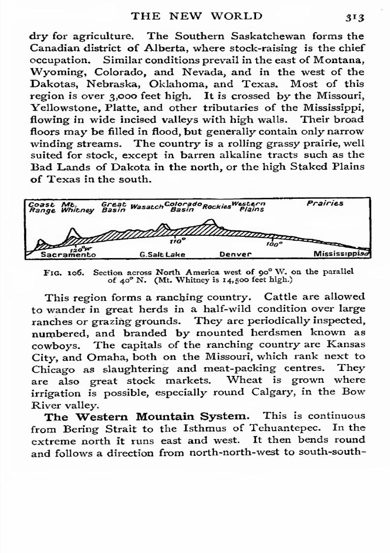
7/30/2019 The Senior Geography 1919
http://slidepdf.com/reader/full/the-senior-geography-1919 329/383
THE NEW WORLD 3*3
dry for agriculture. The Southern Saskatchewan forms the
Canadian district of Alberta, where stock-raising is the chief
occupation. Similar conditions prevail in the east of Montana,
Wyoming, Colorado, and Nevada, and in the west of the
Dakotas, Nebraska, Oklahoma, and Texas. Most of this
region is over 3,000 feet high. It is crossed by the Missouri,
Yellowstone, Platte, and other tributaries of the Mississippi,
flowing in wide incised valleys with high walls. Their broad
floors may be filled in flood, but generally contain only narrow
winding streams. The country is a rolling grassy prairie, well
suited for stock, except in barren alkaline tracts such as the
Bad Lands of Dakota in the north, or the high Staked Plains
of Texas in the south.
Coast Mb. Great wasatChCo'or?doPockiesw'S^rn
Range Whitney Basinwasa£C" Basin "0CK,li* Plains
Prairies
Fig. 106. Section across North America west of 90 W. on the parallel
of 40 N. (Mt. Whitney is 14,500 feet high.)
This region forms a ranching country. Cattle are allowed
to wander in great herds in a half-wild condition over large
ranches or grazing grounds. They are periodically inspected,
numbered, and branded by mounted herdsmen known as
cowboys. The capitals of the ranching country are Kansas
City, and Omaha, both on the Missouri, which rank next to
Chicago as slaughtering and meat-packing centres. They
are alsogreat stock markets. Wheat is grown where
irrigation is possible, especially round Calgary, in the Bow
River valley.
The Western Mountain System. This is continuous
from Bering Strait to the Isthmus of Tehuantepec. In the
extreme north it runs east and west. It then bends round
and follows a direction from north-north-west to south-south-
7/30/2019 The Senior Geography 1919
http://slidepdf.com/reader/full/the-senior-geography-1919 330/383
3i4 THE NEW WORLD
east. Its greatest breadth is not far short of 1,000 miles.
Many parts are as yet imperfectly known, especially in the
north.
As in the plains, there is a certain physical continuity
between north and south, but there is a greater diversity in
surface features. Other variations are due to difference in
elevation. Almost everywhere three principal chains can be
traced; (1) the Eastern or Rocky Mountains, rising steeply
above the high plains at their eastern base;(a) the Western
Chain, known under various names, and separated from the
Rockiesby
high plateaus, which are specially well developed
in the south-west of the United States ; and (3) the Coastal
Chain, partly on the mainland, partly on the bordering islands,
and separated from the Western Chain bv a deep and partly
submerged trough.
The system can be divided into a number of basins, each of
which broadly forms a natural physical and economic region.
They are (1) the Yukon Plateaus, including the Alaskan
Peninsula; (2) British Columbia, with the Skeena, Stikine,
Fraser, and the northern part of the Columbia and the Willa-
mette valleys,and the islands bordering the coast; (3) the Idaho
plateau, or Snake basin; (4) the Great Basin of inland drainage,
and its margin; (5) the Califorjjian Valley, or Sacramento
Basin; (6)
the Colorado Plateau and Basin ; and(7)
the
Mexican Plateau (see Figs. 107 to no).
The Yukon Plateau. The feature-lines run from east to
west, bending to the south-west in the Alaskan Peninsula, and
to the south-east in the Upper Yukon. The Yukon, whose
length exceeds 2,000 miles, flows across the middle of the
region to the lower west, and enters the shallow Bering Sea. It
is broken by many rapids in its upper course, but is navigable
in its lower course from June to October. During the winter
it forms a sledging route. The climate is extreme. The
winters are long and severe, but the summers are warm
enough for vegetables and the hardier cereals to be grown
with fair success. Most of the region is forested. It would

7/30/2019 The Senior Geography 1919
http://slidepdf.com/reader/full/the-senior-geography-1919 331/383
THE NEW WORLD 315
hardly have attracted attention but for its rich goldfields,
especially round the Klondike, a tributary of the Yukon.
The chief centre is Dawson City, at the confluence of the
Klondike and the Yukon, 1,500 miles from its mouth, and notfar from the frontier of the United States (Alaska), which is
formed by the meridian of 141 E.
Between the Yukon and the coast are the little-known Alas-
kan ranges, with Mount McKinley (20,500 feet), the highest
mountain of the continent. The heavily-glaciated coastal
range, with the volcanic Mount St. Elias (18,000 feet) and
other lofty summits, is broken into islands in the west and
east. From Dyea, in the east, at the head of the Lynn Canal,
a railway crosses the White Pass (2,900 feet) to the Upper
Yukon, known as the Lewis.
British Columbia. The coastal range is represented by
the forested Queen Charlotte and Vancouver Islands. These
fringe the fiord coast of the Northern Cascades, part of theWestern Chain. East of the Cascades the plateau of British
Columbia stretches east to the Gold Range, the westernmost
of a series of parallel ranges (Gold, Cariboo, Selkirk, &c),
enclosing the Upper Fraser and Columbia, and giving these
rivers a zig-zag course. The Rockies, or Eastern Chain, contain
many lofty summits (Mount Columbia, over 13,000 feet) and
great glaciers. The glaciated upper and forested lower slopes
form very picturesque scenery.
The climate of British Columbia is rendered equable by the
south-westerly winds from the Pacific. The rainfall is heavy
on the Pacific slopes, but diminishes rapidly towards the
interior, where the climate is also more extreme. Much of the
surface is densely forested, thecoastal forests containing
Douglas pines and other gigantic conifers. Lumbering is an
important occupation. The mineral wealth includes gold, but
except where railways have been built it is as yet inaccessible.
Rossland is the centre of a gold and silver-lead mining district.
Coal is found round the Crow's Nest Pass, and Vancouver
Island supplies most of the coal used along the Pacific coast.

7/30/2019 The Senior Geography 1919
http://slidepdf.com/reader/full/the-senior-geography-1919 332/383
3 l6 THE NEW WORLD
The best agricultural land is in the south of the interior
plateau. The narrow river valleys are also fertile.
The capital is Victoria, on Vancouver Island, with a magni-
ficent harbour and coaling facilities. Vancouver, another fine
Fig. 107. British Columbia andadjacent
lands. (Notethat
the narrowlowland is shaded with slanting lines.)
port on the mainland; on Burrard Inlet, is the terminus of the
Canadian Pacific Railway, which goes up the Fraser, crosses
the Selkirks and other parallel ranges, and climbs the Rockies
to the Kicking-Horse Pass (5,300 feet), and descends the Bow

7/30/2019 The Senior Geography 1919
http://slidepdf.com/reader/full/the-senior-geography-1919 333/383
THE NEW WORLD 3i7
River to Calgary, the centre of the rich ranching and agri-
cultural district of Alberta.
The boundary with the United States (49° N.) is purely
artificial. Puget Sound is continued in Willamette Valley,between the Coast and Cascade Ranges, across which the
Columbia breaks to the sea. This fertile valley, which is
about 200 miles long and thirty or forty miles wide, is a great
San Francisco 50
"Ijo"
OVER 50OO Ft3000 - 5000 •'
1000 - 3000 '
UNDER 1000 •>
100 2P0 300MStoo 400 500 K,
Fig. 108. The Western Mountain System (Seattle to San Francisco).
(Note that the narrow lowland is shaded with slanting lines.)
wheat-growing region. Its outlet is Portland (Ore.), on the
Columbia, a few miles below the confluence of the Willamette,
with an enormous trade in wheat, fruit, lumber, and the pro-
duct of the salmon fisheries of the Columbia, and with many
industries based on these. Farther north Seattle, on Puget
Sound, with similar occupations, is a port rapidly growing in

7/30/2019 The Senior Geography 1919
http://slidepdf.com/reader/full/the-senior-geography-1919 334/383
31 THE NEW WORLD
importance. Tacoma and Olympia are other outlets. Coal
and iron are mined in the neighbourhood. Shipbuilding is
developing.
The Idaho Plateau. The Northern Cascades of British
Columbia are replaced to the south by the Southern Cascades,
covered with volcanic rocks. In Idaho the plateau east of
the Cascades, a continuation of that of British Columbia, is
covered by a great lava-flow, which extends to the Rockies.
It is drained by the Snake tributary of the Columbia, which
flows in deep gorges, with the Shoshone and other fine falls as
it descends. The climate is dry, and large tracts are covered
with sage bush. In the more exposed, wetter districts,
wheat cultivation is beginning. East of the Rockies, in
Wyoming, is the Yellowstone National Park (5,500 square
miles), with great lava-flows, extinct volcanoes, and many
hot springs and geysers, all indications of comparatively
recent volcanic activity. The deep canyon of the Yellow-
stone, a tributary of the Missouri, with gorgeously coloured
rock walls from 600 to 1,500 feet high, is another of the
wonders of the Park.
This region was explored after the Louisiana purchase.
Previously it had been visited only by trappers from the east,
who followed Indian trails in search of beaver and other furs.
The Pacific coast of Oregon was visited by Drake, and the
region north of the Columbia consequently formed the subject
of disputes between Britain, which claimed it on that ground,
and the United States, which claimed that it was discovered
from the east by Boston fur-traders. In 1846 a compromise
was arrived at and the parallel of 49 N. was agreed on as the
boundary.
The Great Basin. The Great Basin of inland drainage
is a little-known region of parallel ridges and flat plains, with
depressions filled by salt lakes. The largest of these is the
Great Salt Lake. The region is too dry for agriculture, except
where it can be irrigated. Round Salt Lake City this has
been done with great success. The Wasatch Mountains form
7/30/2019 The Senior Geography 1919
http://slidepdf.com/reader/full/the-senior-geography-1919 335/383
THE NEW WORLD 319
the eastern boundary between the Great Basin and the
Colorado Plateau.
The Colorado Plateau is a dry region, where the rivers
have cut deep canyons through all the sedimentary strata
down to the underlying base of hard primitive rock.
The high plateau includes the eastern part of New Mexico
and Arizona, an arid, semi-desert region, falling in the west
to the still more arid lower basin of the Colorado, which
forms the Mohave Desert of California and the Gila Desert
of Arizona. These are the trade-wind deserts of North
America (see p. 10). Two depressions are below sea-level,
the Death Valley, east of the Sierra Nevada, and the Salton
Sink, near the mouth of the Colorado. In 1905 the Colorado
burst into the latter depression, forming a lake, which is
slowly growing in depth and area.
The Colorado Plateau is bordered to the east by the Rocky
Mountains, which are rich in minerals, especially gold andcopper. In Wyoming and Colorado the headwaters of the
rivers flow through high intermont plains, known as parks, in
which some stock-raising and agriculture are carried on. The
towns are chiefly at the opening of the valleys, and many of
them are on railway routes. Helena, on the Missouri, near its
point of issue from the mountains, is on the southern route
from Duluth to Seattle. Cheyenne is on the main line from
the east to Salt Lake City and San Francisco. Denver, on
the South Platte, the centre of the agricultural, stock-raising,
and mining districts of Colorado and New Mexico and engaged
in many industries depending on their products and needs, is
an important railway centre though not on any great through
route. Pueblo, on the Arkansas, with many metal industries,
is on the main route from the Mississippi (Kansas City) to
Salt Lake and San Francisco. Santa Fe, near the Rio Grande,
a town dating from the Spanish conquest, is on the southern
route between the same points. At El Paso, where the Rio
Grande descends from the mountains to the Mexican Plateau,
the Mexican and California!}, lines diverge.

7/30/2019 The Senior Geography 1919
http://slidepdf.com/reader/full/the-senior-geography-1919 336/383
3*° THE NEW WORLD
California. The valley between the Coastal Range and
the Western Range, or Sierra Nevada, widens to the broad
fertile valley of California. The Sierra Nevada slopes
steeply towards the east, but m6re gently to the west. The
rivers form lofty falls, of which those of the streams entering
the deep Yosemite Valley, are a type. Their waters, fed by
the abundant rain and snow of the Sierras, are used to
irrigate the plains below.
Los Angeles*
OVER 5000 Fb
30O0-5O0O "
IOOO -3000 "////hnunrB IOOO
so ipo zoo
Ido 2,'OQ iiOO 400 BOO.K.
Fig. log. The Western Mountain System (San Francisco to Gulf of California).
(Note that the narrow lowland is shaded with slanting lines.)
The Californian Valley is drained by the Sacramento from
the north and the San Joaquin from the south, both entering
the transverse gulf of San Francisco. The climate is that of
the Mediterranean (note the lat. 35° to 41 °), and all the Medi-
terranean fruits are grown. Wheat is largely grown in the
north.
San Francisco, the capital of the Pacific coast, is built on
a hilly peninsula between the Pacific and the Gulf of San
7/30/2019 The Senior Geography 1919
http://slidepdf.com/reader/full/the-senior-geography-1919 337/383
THE NEW WORLD 331
Francisco, which is entered by the Golden Gate. Though it
now carries on many great industries and an enormous com-
merce, it dates only from the gold rush of 1848. It is the
outlet for the whole of the fertile valley in which Sacramentoin the middle of the valley, is the second centre. The southern
port is Los Angeles.
California, which formed part of the Spanish empire of
Mexico, was reached from the Pacific. In the eighteenth
century the Franciscans established agricultural and com-
mercial missions, but the country as a whole remained
backward till the fall of the Spanish'power in 1821. Explora-
tion was then pushed east across the Sierra Nevada, and
population began to enter by that route. During the Mexican
War of 1846 the territory of Upper California passed to the
United States, though California was not formally admitted
till 1 850. The discovery of gold in 1 848 attracted pioneers
from all parts, and indirectly promoted settlement. The rich
gold mines are now worked by great mining companies,
but wheat is a still more valuable and permanent source of
wealth.
The Mexican Plateau. In Mexico the Gulf of California
is a continuation of the submerged trough east of the Coastal
Range (see p. 314) which is represented by the Californian Pe-
ninsula. The eastern and western chains rise above relatively
narrow coastal plains, enclosing the Mexican plateau between
them. This rises steeply southwards from the valleys of the
Gila and Rio Grande del Norte, and is highest in the west.
Intermittent streams flow to the Rio Grande, or to the east
coast. South of the deep Santiago valley, which opens to the
west, is a volcanic range extending from Colima in the westto Orizaba in the east, and including Popocatapetl and other
lofty summits.
North America ends at the isthmus of Tehuantepec, but
politically Mexico includes the low limestone peninsula of
Yucatan, which produces sisal-hemp or henequen, an.d the
north-west end of the Central American mountains.
SEN. GKOG.

7/30/2019 The Senior Geography 1919
http://slidepdf.com/reader/full/the-senior-geography-1919 338/383
332 THE NEW WORLD
The coastal plain and the lands below 3,000 feet form the
tierra caliente, or hot zone. This is hot and moist in the south,
drier in the north, and generally malarial. The forests produce
mahogany and other timber. Above this zone, where cacao,
sugar, rice, and cotton are grown, rise the cooler zones of
coffee, maize, and tobacco, succeeded by the wheat and
Fig. 110. Mexico and Central America.
pasture lands of the tierra templada, or temperate belt, with
considerable extremes of temperature and drought. Above
7,oco feet is the tierra fria, or cool belt, with magnificent
forests. The upper tree limit is 13,500 feet. The temperate
zone is very fertile where irrigated, as at the northern base of
the volcanic chain round Mexico City and Lake. The north
and centre of Mexico are arid and semi-desert. The cactus is

7/30/2019 The Senior Geography 1919
http://slidepdf.com/reader/full/the-senior-geography-1919 339/383
THE NEW WORLD 333
everywhere abundant, assuming characteristic forms at varying
elevations.
Mexico is rich in minerals. Silver, the most valuable, is
widely distributed, especially in the north-west, between the
Californian Gulf and the Middle Rio Grande del Norte,
round Parral, and in the east central region in the San Juan
basin, round Zacatecas, and Guanajuato. Copper, gold, and
lead are also valuable. There are great oilfields near Tampico
and Tuxpan on the Atlantic coast. The chief manufactures
are tobacco and distilling.
The Mexican Plateau is reached from the United States byseveral lines. One passes through the centre from El Paso by
Chihuahua and Zacatecas, and another in the east by Sal-
tillo, San Luis Potosi, and Guanajuato to Mexico City, the
capital. From Mexico City lines run by Guadalajara to
Manzanillo in the west and to Vera Cruz in the east. A line of
great importance crosses the Isthmus of Tehuantepec from
Puerto Mexico on the Atlantic southwards to Salina Cruz on
the Pacific.
Mexico was early invaded from Yucatan by the Spaniards,
who overthrew the native Aztec civilization, and concentrated
their energies on the mines. A fleet sailed annually from Aca-
pulco to the Philippines, which were long politically attached
to Mexico, under the name of New Spain. The Spanishpower lasted three centuries, but was overthrown early in the
nineteenth century. At present Mexico is a Federal Republic.
CENTRAL AMERICA.
Physical Features and Routes. The isthmus of Central
America extends from the isthmus of Tehuantepec to that of
Panama, running for about 1,200 miles in a direction WNW.to ESE. Its connexion with the continents which it unites
was made in comparatively recent geological times, and struc-
turally it is more closely related to the Antillean islands of
Cuba and Jamaica.
a

7/30/2019 The Senior Geography 1919
http://slidepdf.com/reader/full/the-senior-geography-1919 340/383
324 CENTRAL AMERICA
Central America consists of (i) a lofty volcanic belt, with
peaks reaching 14,000 feet, parallel to the Pacific coast, at no
great distance from it, (a) of the limestone plateau of Yucatan,
and (3) south of Yucatan and in Honduras and Nicaragua of
ranges running from east to west, fringed in the east by
malarial lowlands. The rivers to both oceans are short, and
of little use for communication (see Fig. no).
Central America, nowhere over 300 miles broad, has four
important narrowings, where the barrier between the Atlantic
and Pacific Oceans is reduced to a minimum. These largely
determine the lines of communication between the two oceans.
(1) The most northerly is the isthmus of Tehuantepec
(politically in Mexico), about 135 miles broad and under
400 feet high at its lowest. It is crossed by a railway
(see p. 3 a3). East of Tehuantepec Central America
widens rapidly, forming the Mexican states of Chiapas and
Yucatan, the independent republic of Guatemala, and the
colony of British Honduras. The second narrowing, (3)
Honduras, is about 180 miles wide, and very mountainous.
It is crossed by two lines, the Guatemalan line, running from
Puerto Barrios on the Atlantic by Guatemala city (5,000 feet),
to San Jose on the Pacific, and the Honduras line, from
Puerto Cortes on the Atlantic to La Brea on the Pacific.
Between the narrowings of (a) Honduras and (3) Nicaraguathe barrier again broadens, forming the independent republics
of Honduras, Salvador, and Nicaragua. At the Nicaraguan
narrowing the barrier between the two oceans is still 150 miles
wide, but the western half consists of a great depression, 100
feet above sea-level, occupied by Lakes Managua and Nica-
ragua, which are only about thirteen miles from the Pacific.
Connexion with the Atlantic is given by the San Juan river,
from the eastern end of Lake Nicaragua. This route has been
surveyed with a view to constructing a ship-canal, 1 85 miles
long, which would have utilized the canalized San Juan river
and Lake Nicaragua, with Pacific terminus at Brito, about

7/30/2019 The Senior Geography 1919
http://slidepdf.com/reader/full/the-senior-geography-1919 341/383
CENTRAL AMERICA . 325
fourteen miles from the lake. The route of the Panama Canal,
however, described below, was preferred.
South of the Nicaraguan narrowing Central America does
not again attain any considerable breadth, but its mountainous
character makes communication between the two oceans
difficult. A line is carried across the mountains of Costa Rica
from Puerto Limon on the Atlantic, by San Jose, to Punta
Arenas on the Pacific. The mountains of Costa Rica are
continued by those of Panama, which narrow to (4) the
isthmus of Panama, where the barrier is only thirty-five miles
wide, and the low Culebra saddle (under 300 feet), between
mountains 3,000 feet high, gives an easy route. The isthmus,
from which the Pacific was first seen by Cortes, is crossed by
a railway from Colon to Panama which utilizes the Culebra
depression. The Panama Canal has also been constructed, by
the United States, across this isthmus. It is entered by a
lock, and a cutting, 250 feet deep and seven miles long, carries
it across the mountains at Culebra. The opening of this
canal reduced by several, thousand miles the sea route between
the eastern and gulf ports of the United States and (1) San
Francisco and other western ports of the United States, (a)
the western ports of South America, and (3) the ports of China
and Japan. It gives Western Europe a shorter sea route to
the two former and an alternative route to the last. The canal,
since its opening in 1914, has sometimes been closed by land-
slips.
Climate and Vegetation. Central America lies chiefly
in the trade-wind area, the eastern or windward shores receiving
the heaviest rainfall. The south is near the equatorial belt, and
has a much heavier rainfall, with a dry season from January
to April. At Colon the annual rainfall exceeds 135 inches.
The range of elevation gives a corresponding range of climate.
The tierra caliente, tierra templada, and tierrafria correspond
with those of Mexico. The eastern lowlands, fringed with
malarial swamps and densely forested, are not so well suited

7/30/2019 The Senior Geography 1919
http://slidepdf.com/reader/full/the-senior-geography-1919 342/383
326 CENTRAL AMERICA
for cultivation and settlement as the valleys and mountain
slopes of the drier west. The tree-line is about 13,500 feet,
the height of the Bernese Alps. There are many high plateaus,
which form pastoral savana lands. The forests of the tierracaliente produce mahogany and other valuable woods, rubber,
and all tropical fruits. Cacao is the chief cultivated plant.
The tierra templada, from 3,000 to 7,000 feet, is forested in the
east, and a savana region in the west. Coffee is the chief
cultivated plant. The tierra fria, over 7,000 feet, produces
grain.
Civilization. The old civilizations of Guatemala and
Yucatan were destroyed by the Spanish conquest, which
became effective early in the sixteenth century. The two
races intermingled freely, and Spanish half-breeds now form
the bulk of the population. The Spanish yoke was thrown off
in the first quarter of last century, but there has been little
political stability. The difficulties of communication favoura divided political control, and impede the spread of education.
The chief occupation is agriculture.
THE WEST INDIES.
Physical Structure. The West Indies form the eastern
border of the Caribbean Sea. The large islands of the Great
Antilles, Cuba, Jamaica, Hispaniola, and Porto Rico stretch
east from Yucatan, while the Bahamas and the Lesser Antilles
run from the south of Florida to the delta of the Orinoco.
The Great Antilles are mountainous islands elongated from
east to west. In Hispaniola three ranges, north, central, and
southern, are well defined, the highest point exceeding 10,000
feet. In Porto Rico these unite to form one mountainous
mass, which runs from east to west, and nowhere reaches 4,000
feet. In Jamaica the southern range of Hispaniola is continued
westwards by the Blue Mountains (7,000 feet), which are
separated by a valley from the lower western limestone plateau,
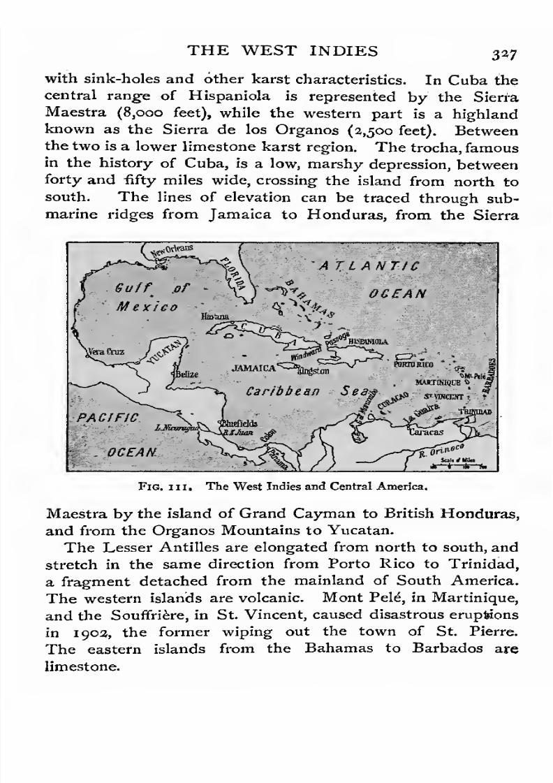
7/30/2019 The Senior Geography 1919
http://slidepdf.com/reader/full/the-senior-geography-1919 343/383
THE WEST INDIES 337
with sink-holes and other karst characteristics. In Cuba the
central range of Hispaniola is represented by the Sierra
Maestra (8,ooo feet), while the western part is a highland
known as theSierra de
los
Organos (3,500 feet). Betweenthe two is a lower limestone karst region. The trocha, famous
in the history of Cuba, is a low, marshy depression, between
forty and fifty miles wide, crossing the island from north to
south. The lines of elevation can be traced through sub-
marine ridges from Jamaica to Honduras, from the Sierra
PACIFIC
. OCEAN.
Fig. hi. The West Indies and Central America.
Maestra by the island of Grand Cayman to British Honduras,
and from the Organos Mountains to Yucatan.
The Lesser Antilles are elongated from north to south, and
stretch in the same direction from Porto Rico to Trinidad,
a fragment detached from the mainland of South America.
The western islands are volcanic. Mont Pele, in Martinique,
and the Souffriere, in St. Vincent, caused disastrous eruptions
in 1902, the former wiping out the town of St. Pierre.
The eastern islands from the Bahamas to Barbados are
limestone.

7/30/2019 The Senior Geography 1919
http://slidepdf.com/reader/full/the-senior-geography-1919 344/383
328 THE WEST INDIES
Climate. With the exception of the Bahamas, the West
Indies are entirely within the tropics. All have a typically
tropical climate, modified by their insular position. The
seasons are distinguished less by difference in temperature
than by difference of rainfall, the distinction between the dry,
or winter, season and the wet, or summer, season being well
marked. Except for violent hurricanes towards the end of
the rainy season storms are rare. These hurricanes do not
occur within io° of the equator, so that the southern islands
escape them.
The mean winter temperature of the West Indies is between
70 and 80° F. The summer temperature is over 8o°. The vary-
ing elevation gives a corresponding variety of climate in the
mountainous islands. The West Indies lie in the track of the
north-east trades, and receive a heavy rainfall on their windward
slopes, amounting in places to 100 inches. The interior and
the leeward slopes are much drier.
Vegetation and Occupations. The mountainous islands
show almost every type of vegetation, from the hot wet forests
of the windward slopes to the savanas of the higher drier
interior. The richness of the tropical forest is well seen in
Cuba and Hispaniola, which produce mahogany, cedar, ebony,
and other ornamental woods, fustic, logwood, and other dye-
woods, and every kind of tropical fruit. The royal palm of
Cuba is said to furnish the negro with all he needs both for
food and utensils. The cultivation of sugar, once the chief
agricultural interest, has greatly declined. Tropical fruits,
especially the banana, coffee, cacao, and tobacco are cultivated
in varying degrees in the different islands.
History. Columbus reached the Bahamas in 149a, and
the whole archipelago was soon discovered and claimed bySpain. The name West Indies perpetuates the belief of
Columbus that he had found a western route to India. Con-
trary to the expectations of the conquerors, no precious
metals were found. These were abundant on the adjacent
mainland of the Caribbean Sea, whence a plate fleet sailed
7/30/2019 The Senior Geography 1919
http://slidepdf.com/reader/full/the-senior-geography-1919 345/383
THE WEST INDIES 339
annually to Spain. The West Indies, which command the
routes to Europe, consequently became the resort of the
buccaneers who endeavoured to intercept it. The agricultural
resources of the West Indies proved very valuable, large sugarestates being cultivated by negro labour. As the Spanish
power declined other nations gained a footing, but many of
the islands frequently changed hands.
A century ago the West Indies were regarded as our most
valuable colonies, but the nineteenth century saw the gradual
decay of their prosperity. The emancipation of the slaves
made labour scarce, dear, and unreliable, while the growth of
the European beet-sugar industry reduced the price of sugar.
This industry dates from the Napoleonic wars, when British
goods were refused entrance to the continent. Careful atten-
tion to the best methods of cultivation and manufacture and
a system of bounties enabled it to compete successfully with
the sugar of the West Indies, where little attention was paidto economies of cultivation, preparation, or transport. Cuba,
which adopted a more progressive policy, remained prosperous
until the beginning of the long struggle with Spain which
ended in 1898. Prosperity is slowly reviving with improved
methods and the introduction of other staples.
Politically, Cuba and Hispaniola are independent. The
latter island is divided into two states, the Spanish-speaking
negro republic of Santo Domingo in the east, and the French-
speaking negro republic of Haiti in the west. Porto Rico
and some of the Virgin Islands belong to the United States.
Jamaica and most of the smaller islands are British. Guade-
loupe and Martinique are French, St. Eustace, Saba, Curacao,
and some other small islands are Dutch.Cuba. The tropical forests of Cuba have already been
mentioned. Tobacco of fine quality is grown on the Organos
Mountains and sugar in the central part of the island. Iron
ore is abundant in the Sierra Maestra. The capital is Havana,
immediately south of Florida, commanding the routes through
the straits of Florida and Yucatan. The second city is
7/30/2019 The Senior Geography 1919
http://slidepdf.com/reader/full/the-senior-geography-1919 346/383
330 THE WEST INDIES
Santiago de Cuba, on a magnificent harbour on the south
coast, commanding the route by the Windward Passage, but
separated from the interior by the lofty forested Sierra
Maestra.
Hispaniola has done little to develop its great forest and
agricultural resources in recent years. Coffee is the chief
cultivated product. The western part, now Haiti, passed to
France in the latter half of the seventeenth century and became
prosperous. At the end of the eighteenth century the slaves
rose against the planters, and after a long struggle regained
their independence. Santo Domingo became a republic in
1844. The capital of Haiti is Port au Prince. San Domingo,
founded in 1496, the capital of Santo Domingo, is one of the
original Spanish settlements in the New World.
Porto Rico has been largely cleared of its forests for the
cultivation of sugar. It passed from Spain to the United States
in 1898. The capital is San Juan.
Jamaica was discovered in 1494, and became British in
1655. Coffee is cultivated on the Blue Mountains. Bananas
are grown for the American and British markets. . Sugar,
cacao, tobacco, and various spices are also cultivated. The
capital is Kingston, at the base of the Blue Mountains
on a lagoon almost enclosed by a long sandspit, at the
extremity of which, commanding the entrance, was Port Royal,
famous in West Indian history. Kingston suffered severely
from an earthquake in 1907. A line from Kingston to
Port Antonio crosses the valley between the Blue Mountains
and the western plateau, over which the line is continued to
Montego.
TheBahamas are low coral or limestone islands, producing
sisal-hemp and pineapples. The capital is Nassau, on New
Providence.
The Lesser Antilles, nearly all British, are officially
divided into the Leeward Islands in the north, and the Wind-
ward Islands in the south, the former name being quite
inappropriate. Both consist of a double chain, volcanic in the
7/30/2019 The Senior Geography 1919
http://slidepdf.com/reader/full/the-senior-geography-1919 347/383
THE WEST INDIES 331
west and limestone in the east. Of the westerly volcanic
Leeward Islands the Virgin Islands, St. Kitts, Montserrat,
and Dominica, and in the eastern limestone islands Barbuda
and Antigua, are the most important. The two formations
converge in Guadeloupe (French), north of Dominica, which
is volcanic in the west and limestone in the east. In the Wind-
ward Islands Martinique (French), Santa Lucia, St. Vincent,
and Grenada are the largest of the volcanic western chain.
Barbados, further east, is limestone. The volcanic islands are
beautiful and fertile, but the limestone islands are healthier
and exposed to fewer risks. Sugar is grown in Barbados by
peasant proprietors with considerable success.
The South American Islands. Of these Tobago and
Trinidad are British. Trinidad is bordered north and south
by mountain chains, which project as peninsulas and enclose
the Gulf of Paria. On this gulf is the chief town, Port of
Spain, with a line running to the sugar and cacao plantations
of the interior. Near Brea, on the west coast, is the small but
famous pitch lake.
SOUTH AMERICA.
Natural Regions of South America. South America,
like Africa, is chiefly in the hot zone, only a small proportion
of the continent lying outside the area of hot summers.
Three configuration areas are well marked, (1) the lofty
mountain belt of the west, with summits exceeding 20,000 feet,
and with many high valleys and plateaus from 6,000 to 12,000
feet above the sea; (2) the eastern highlands, exceeding 6,ooo
feet and averaging from 2,000 to 3,000 feet high ; and (3) the
lowlands, rising to 600 or 1,000 feet. In this triple configura-
tion there is an obvious resemblance to that of North America,
though the continuity of the two continents is interrupted by
the Caribbean region.
The lowlands form four natural regions : (1) the densely
forested Amazon lowlands, hot and wet at all seasons; (2) the

7/30/2019 The Senior Geography 1919
http://slidepdf.com/reader/full/the-senior-geography-1919 348/383
332 SOUTH AMERICA
Orinoco lowlands, with summer rains and a rich savana vege-
tation; (3) the Plate lowlands, also savanas, with hot wet
summers and cooler dry winters ; and (4) the Patagonian
lowlands, with warm summers, cool winters, and little rain,
forming a steppe region.
The natural regions of the Eastern Highlands are (1) the
Guiana Highlands and (a) the Brazilian Highlands, both of
the Sudan type, with savana and open woods, and (3) what
may be termed the Plate Highlands, south of the tropic, with
cooler winters, and rain at all seasons, but most in summer.
These may be compared withToiimaj
, eastern New South Wales,
^/^N/V,. : southern Queensland, China,
C M Bogota, and the eastern United States.
Sorata, The Western Mountains, or
/vf^^e£>^^^ : Andes, extend for 4,500 miles
^ f —+•^~r~~=^ parallel to the Pacific coast.
In the centre, where they are
j^~3 broadest, they are between
400 and 500 miles wide. In
-t^f.
-..vs.-.
vspaiiat^p the south they are reduced toValparaiso Mendosw J
a single chain, but in theFig. 112. Three sections across the
, , r , .
Andes. The distance between the dots= north two, three, or four chains
1,000 metres or 3,300 feet. C = Cauca, ex jst< Linked with the AndesM = Magdalena..
by higher ground are the
Venezuelan chains which border the southern margin of the
Caribbean Sea.
The western mountain area may be divided into five natural
regions, (1) the Colombian or north-western region, (a) the
central or Bolivian region, (3) the western coastal desert region,
(4) the valley and mountains of Central Chile, Mediterranean
in type, and (5) the mountains and islands of Southern Chile,
of the North-west European type.
The Colombian Region. This is wider than the present
political division of Colombia. It includes Ecuador and the
mountainous western part of Venezuela, which lies outside the

7/30/2019 The Senior Geography 1919
http://slidepdf.com/reader/full/the-senior-geography-1919 349/383
SOUTH AMERICA333
Andes proper. The whole of the Colombian region, with an
elevation varying from sea-level to 20,000 feet above it, may-
be compared with Central America. Both exhibit the same
succession of climate and vegetation zones, with approximatelythe same cultivated plants in each. The high intermont
plateaus are either cultivated or form savana lands where
cattle are bred.
Venezuela. Three mountain ranges can be traced in
Venezuela. The two ranges which form the northern and
southern margins of Trinidad are continued by the north and
south ranges of Venezuela, while the third, which is partly
submerged, is represented by Tobago, Margarita, and other
islands off the north coast.
The important centres are in the fertile intermont plains.
Coffee and cacao are the chief cultivated plants. Sugar, cotton,
tobacco, indigo, cinchona, and sarsaparilla are also grown.
The capital, Caracas (4,000 feet), is separated by the Silla deCaracas (9,000 feet) from its port, La Guaira, one of the hottest
places in the world. The two towns, which are six miles
apart, are connected by a line twenty-three miles long, an
instance of the difficulties of communication in this part of
Venezuela. Other important towns are Merida (5,000 feet),
in the Sierra de Merida (15,400 feet), and Valencia.
The continuity of the northern range of Venezuela is inter-
rupted by the gulf and lagoon of Maracaibo. These are
separated by a bar where the town of Maracaibo is built.
West of the lagoon the northern range is continued by the
Sierra Nevada de Santa Marta. The Maracaibo lagoon pene-
trates far inland and forms the outlet for the Merida region.
Colombia. Colombia is traversed from north to south bya coastal range and three main chains of the Andes, containing
many extinct volcanoes. These chains converge at the knot
of Pasto. The long valleys between the Cordilleras or chains
are drained north to the Caribbean Sea by the Magdalena,
Cauca, and Atrato, flowing through marshy lowlands, but
forming the chief routes from the sea to the interior. The
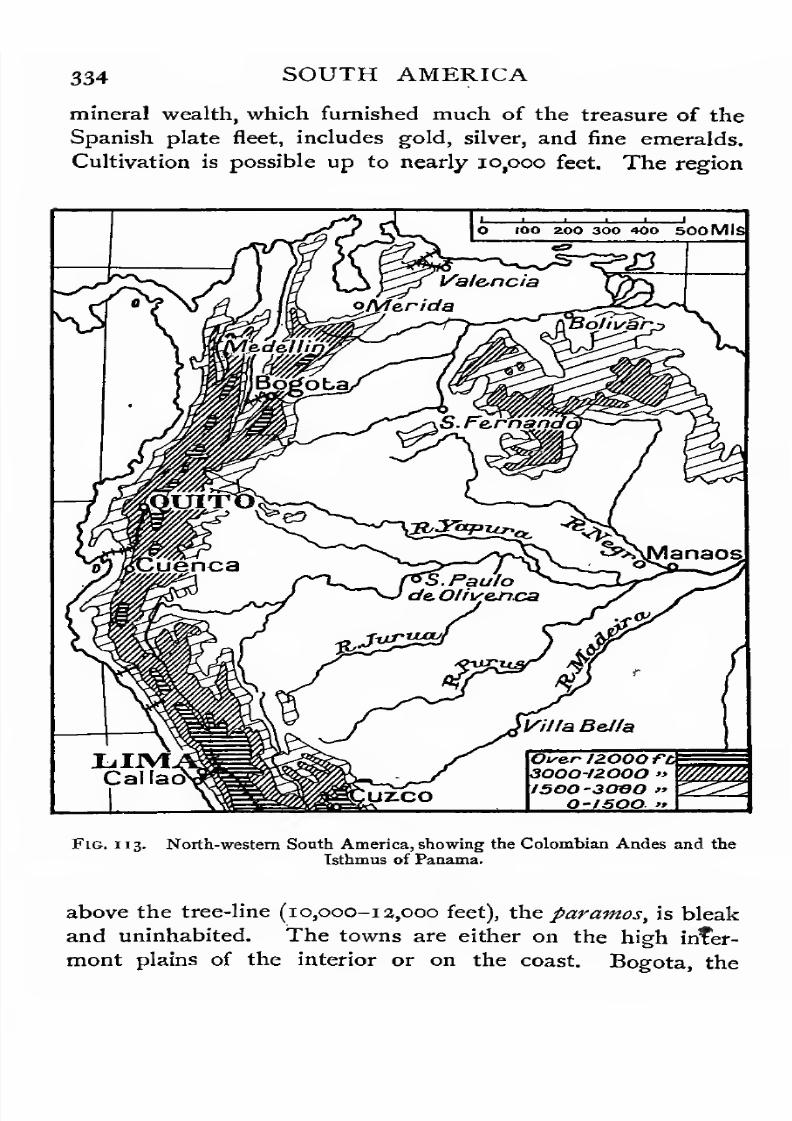
7/30/2019 The Senior Geography 1919
http://slidepdf.com/reader/full/the-senior-geography-1919 350/383
334 SOUTH AMERICA
mineral wealth, which furnished much of the treasure of the
Spanish plate fleet, includes gold, silver, and fine emeralds.
Cultivation is possible up to nearly io,ooo feet. The region
_i i i
O IOO 200 300 400 500 Mis
Oise.r 1ZOOO ft3O0O-/2O0O »
/SOOSOBO "O-ISOO »
Fig. 113. North-western South America, showing the Colombian Andes and the
Isthmus of Panama.
above the tree-line (10,000-13,000 feet), the paramos, is bleak
and uninhabited. The towns are either on the high infer-
mont plains of the interior or on the coast. Bogota, the
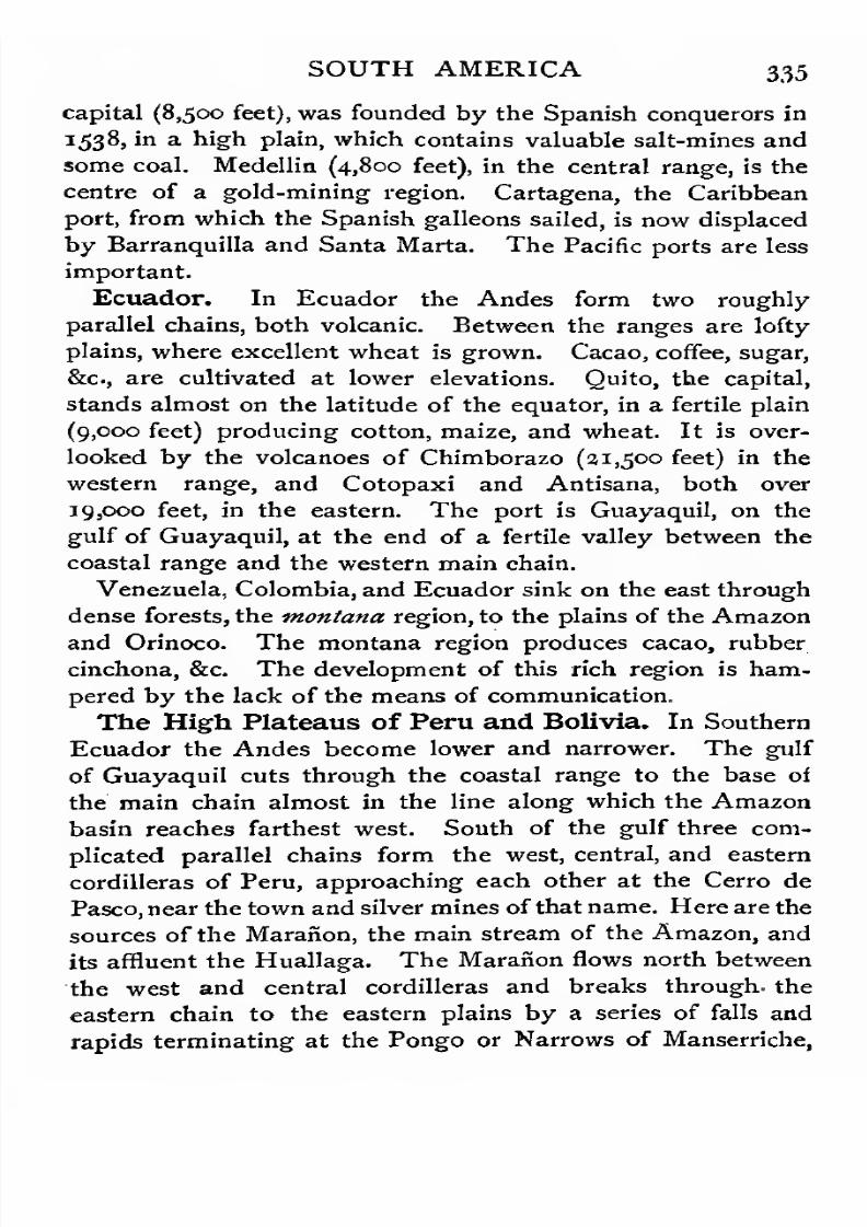
7/30/2019 The Senior Geography 1919
http://slidepdf.com/reader/full/the-senior-geography-1919 351/383
SOUTH AMERICA 335
capital (8,500 feet), was founded by the Spanish conquerors in
1538, in a high plain, which contains valuable salt-mines and
some coal. Medellin (4,800 feet), in the central range, is the
centre of a gold-mining region. Cartagena, the Caribbean
port, from which the Spanish galleons sailed, is now displaced
by Barranquilla and Santa Marta. The Pacific ports are less
important.
Ecuador. In Ecuador the Andes form two roughly
parallel chains, both volcanic. Between the ranges are lofty
plains, where excellent wheat is grown. Cacao, coffee, sugar,
&c, are cultivated at lower elevations. Quito, the capital,
stands almost on the latitude of the equator, in a fertile plain
(9,000 feet) producing cotton, maize, and wheat. It is over-
looked by the volcanoes of Chimborazo (21,500 feet) in the
western range, and Cotopaxi and Antisana, both over
19,000 feet, in the eastern. The port is Guayaquil, on the
gulf of Guayaquil, at the end of a fertile valley between the
coastal range and the western main chain.
Venezuela, Colombia, and Ecuador sink on the east through
dense forests, the montana region, to the plains of the Amazon
and Orinoco. The montana region produces cacao, rubber
cinchona, &c. The development of this rich region is ham-
pered by the lack of the means of communication.
The High Plateaus of Peru and Bolivia. In Southern
Ecuador the Andes become lower and narrower. The gulf
of Guayaquil cuts through the coastal range to the base of
the main chain almost in the line along which the Amazon
basin reaches farthest west. South of the gulf three com-
plicated parallel chains form the west, central, and eastern
cordilleras of Peru, approaching each other at the Cerro de
Pasco, near the town and silver mines ofthat name. Here are the
sources of the Maranon, the main stream of the Amazon, and
its affluent the Huallaga. The Maraiion flows north between
the west and central cordilleras and breaks through, the
eastern chain to the eastern plains by a series of falls and
rapids terminating at the Pongo or Narrows of Manserriche,
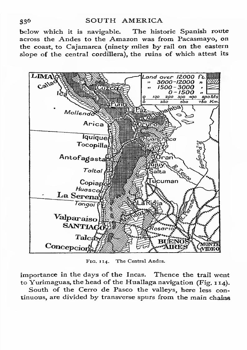
7/30/2019 The Senior Geography 1919
http://slidepdf.com/reader/full/the-senior-geography-1919 352/383
S36 SOUTH AMERICA
below which it is navigable. The historic Spanish route
across the Andes to the Amazon was from Pacasmayo, on
the coast, to Cajamarca (ninety miles by rail on the eastern
slope of the central cordillera), the ruins of which attest its
Land over 12.000 ft.
• 3000-12000 »
. 1500-3000 •
0-1500 «
Fig. 114. The Central Andes.
importance in the days of the Incas. Thence the trail went
to Yurimaguas, the head of the Huallaga navigation (Fig. 1 14).
South of the Cerro de Pasco the valleys, here less con-
tinuous, are divided by transverse spurs from the main chains
7/30/2019 The Senior Geography 1919
http://slidepdf.com/reader/full/the-senior-geography-1919 353/383
SOUTH AMERICA 337
into high intermont plains, of which Oroya (12,000 feet) and
Cuzco (11,400 feet) are the most important. Both are drained
to the Ucayali, the longest feeder of the Amazon, which flows
between the central and eastern chains, breaking through thelatter to its confluence with the Marafion, below which the
river is known as the Amazon. Cuzco was the capital of the
Inca power which preceded the Spanish conquest. It has
colossal Inca monuments and the remains of an ancient route
to the coast at Lima, 350 miles distant.
Oroya (12,000 feet), reached by a railway from Lima, is the
starting-point of a road to the head of navigation on the
Pichis tributary of the Ucayali. This is the route proposed
for a railway to the rubber districts of the upper Amazon, ot
which Iquitos is the centre. The route across the Andes to
the upper Amazon is so difficult that the journey is generally
made from Callao to Panama (1,570 miles), thence to New
York (2,030 miles), by sea to Para (3,coo miles), and up the
Amazon to Iquitos (2,300 miles), a detour of over 7,000
miles.
The largest plain in the Andes is the plateau of Bolivia
(12,000-13,000 feet), which is 500 miles long and over 100
miles broad at its broadest. It is enclosed between the
western Cordillera, and the higher eastern or Cordillera
Real, with the peaks of Sorata (21,500 feet) and Illimani
(21,200 feet). The daily range of temperature is very great.
Midday is very hot, but the nights are cold or even frosty.
The portions of the plateau capable of cultivation are called
punas, the higher, bleaker parts paramos. Outside the plateau
area cereals are cultivated in the tierra fria (9,000-i 1 ,000 feet).
In the zone below, down to 5,000 feet, are the great cinchona
forests of the eastern slopes of the Andes. Below 5,oco feet
the vegetation is tropical.
* The Bolivian plateau forms a basin of inland drainage.
In the northern half is Lake Titicaca, the largest lake of the
continent (12,500 feet; 3,200 square miles), drained south to
Lake Aullagas, or Poopo, which has no outlet. The chief

7/30/2019 The Senior Geography 1919
http://slidepdf.com/reader/full/the-senior-geography-1919 354/383
338 SOUTH AMERICA
town of the Titicaca region, and of Bolivia, is La Paz
(13,000 feet). Oruro (13,250 feet), with rich silver mines, is the
centre of the Aullagas region. The rich silver mines of
Potosi(13,300
feet) have been worked since the Spanish
conquest.
South of Lake Aullagas the plateau is more broken. The
vMonbevi.
,,, JLTI/A NT I CHamson
ontevideo
'Mardel Plata
$/G.ofiS^ George
OCEJLJST
Stateh/.
't!.CJJOTTV
Over12000 Ft
300012000isoo-iooo
o-isooioo top topMs
boo Km
Fig. 115. The South of South America.
western chain continues south, but the eastern breaks up into
parallel ranges enclosing intermont plains. Cochabamba and
Sucre are centres on the trade routes to the Amazon.
Peru and Bolivia, like the states of the Northern Andes,
sink in the east through the montana or forest region, to the
7/30/2019 The Senior Geography 1919
http://slidepdf.com/reader/full/the-senior-geography-1919 355/383
SOUTH AMERICA 339
plains of the 'Amazon. Rubber and cinchona, both very
abundant, are sent east by the Amazon, but railways to the
Pacific are spoken of.
The Coastal Desert. South of the gulf of Guayaquilthe narrow coastal strip at the western base of the Andes is
cooled by a cold current, which chills the winds passing over
it. Rain is rare on the lowlands, but fogs and heavy dews
occur. Snow and rain fall on the high Andes, feeding many
short rivers which cross the coastal plain in parallel valleys,
supplying water for irrigation. The Rimac, which falls
17,000 feet in its course of 80 miles to the sea at Callao,
irrigates the region round Lima, and supplies power for the
line connecting it with Callao, its port.
South of Arica 4he direction of the coast changes from
south-east to south, and it becomes more arid. Vegetation
disappears, except where irrigation is possible. The salts in
the soil, never being washed out by rain, accumulate in vast
deposits, forming the nitrate desert of Atacama. The nitrate
desert zone is about 450 miles, the deposits occurring at
a distance of from 15 to 90 miles from the coast, and at a
height of from 3,500 to 13,000 feet above the sea. The chief
nitrate ports are Iquique in the north and Copiapo in the
south of this desert, but many smaller ports are used.
Three railways climb from the Pacific coast to the high
Andes. In the north a line (136 miles) runs from Callao by
Lima to Oroya (12,000 feet), tunnelling through the Andes at
a height of 15,600 feet, the height of Mont Blanc. This is
now carried to the silver mines of Cerro de Pasco. Another
runs from Mollendo by Arequipa (7,640 feet) at the base of
the volcano El Misti (19,200 feet) and crosses the western
chain at a height of 14,500 feet to Puno on Lake Titicaca
(12,500 feet). Another line runs from Antofagasta, in Chile,
round the east of Lake Aullagas, to Oruro (12,250 feet),
tapping the gold, silver, and copper mining districts.
Historical Summary. The high plateaus of the Andes
were the seat of the ancient Inca civilization which was
7/30/2019 The Senior Geography 1919
http://slidepdf.com/reader/full/the-senior-geography-1919 356/383
34o SOUTH AMERICA
flourishing at the time of the Spanish discovery. Its capital
was at Cuzco, where imposing ruins still remain. The Inca
civilization was largely based on skilful irrigation. Remains
of former irrigation works, aqueducts, &c, still remain at
Cuzco and elsewhere. The Inca Empire was overthrown by
Pizarro (1531-1533). and the vice-royalty of Peru, which in-
cluded Ecuador, Peru, Bolivia, and Argentina, was established
on its ruins. The abundance of gold and silver which ori-
ginally attracted the Spanish conquerors led to the decline
of agriculture under Spanish rule. The Spanish yoke was
thrown off in the first quarter of last.century, Callao, the last
Spanish possession on the mainland being lost in 1826.
Hostilities and boundary disputes between the various re-
publics formed after the liberation have frequently occurred.
By the war of 1879-81 Bolivia lost her seaboard, but has a
right of access to the sea across Peruvian and Chilean
territory.
Central Chile. South of 30 S. the eastern cordillera
diminishes in height and breaks up into isolated ranges. The
western cordillera runs southwards as a continuous range,
culminating in Aconcagua (23,000 feet) and containing many
summits hardly lower. From Guayaquil southwards this
western chain has been remarkable for its continuity, height,
and the loftiness of its passes, few of which are lower than the
summit of the Alps. South of Aconcagua is the lower
and very important Cumbre or Uspallata Pass (12,800 feet),
leading from Chile to the Plate lands, and now being
tunnelled to carry the transcontinental line from Buenos Aires
to Valparaiso.
West of the western chain the coast is bordered by a coastal
range. Between the two is the Central Valley of Chile,
nearly 600 miles long, and averaging about 30 miles in
breadth. This valley is the most fertile and populous part of
Chile. The climate is of the Mediterranean type, with dry
summers. Under irrigation all Mediterranean products can
be grown, but the vine and orange are the most important.
7/30/2019 The Senior Geography 1919
http://slidepdf.com/reader/full/the-senior-geography-1919 357/383
SOUTH AMERICA 341
Wheat and barley are exported. Maize and linseed are also
grown. Lucerne or alfafa is grown for fodder.
La Serena is the port for the northern end of the valley.
The dangerous harbour of Valparaiso, themost important
Pacific port after San Francisco, is connected by rail across
the coastal range with the capital Santiago, in the centre of
the valley. La Concepcion and Valdivia are the ports of the
southern half of the valley. From Concepcion southwards
brown coal is abundant, but the chief mineral wealth of
Chile, after the nitrates of the Atacama desert, consists of
copper, which is widely distributed and exported in great
quantities.
Southern Chile. From the latitude of Valdivia south-
wards the Andes show many traces of glaciation. Long
narrow valley lakes are found on the eastern slopes of the
Andes and also on the western slopes in the north. The
snow-line, which in the Central Andes is as high as 17,000 or18,000 feet, rapidly descends. South of 4a S. the coastal
range is partly submerged and is represented by a long chain
of islands, the largest of which is Chiloe. The sounds between
these islands and the mainland continue the Central Valley
of Chile. The glaciated valleys of the main, range become
fiords in the southern area of submergence.
Lying in the track of the prevailing westerlies the climate
is wet and stormy, and the whole region may be compared
with the coast of Southern New Zealand, British Columbia,
western Scotland, and Norway. The mountain slopes, now
only a few thousand feet high, are densely forested. As
timber is scarce elsewhere on the Pacific coast of South
America, these forests are a valuable asset. The occupa-tions are sheep and cattle breeding, with fishing along the
coasts.
Magellan Strait is a fiord which has pierced the range,
cutting off the desolate island of Tierra del Fuego, and giving
direct communication by an intricate series of winding chan-
nels between the Atlantic and the Pacific Punta Arenas, on

7/30/2019 The Senior Geography 1919
http://slidepdf.com/reader/full/the-senior-geography-1919 358/383
342 SOUTH AMERICA
the mainland, is a coaling-station and the most southern town
in the world. The climate of Tierra del Fuego is cold and
wet. The forests are thin and stunted. Only the hardier
cereals ripen. The chief occupations are sheep-rearing and
gold-washing. The Fuegians number only a few hundreds.
The Falkland Islands. The Falkland Islands, con-
sisting of two large and about 200 smaller islands, lie 2,50 miles
north-east of Tierra del Fuego. They are treeless, probably
owing to the severe gales, but afford good sheep pasture.
At Port Stanley, on the east island, ships can repair after the
storms of Cape Horn or the Roaring Forties.
The Patagonian Plateau. East of the Southern Andes
the lands sink through the plateaus and plains of Patagonia
to the Atlantic. Many of the mountain valleys contain
picturesque long narrow lakes, formed by morainic dams.
The watershed lies, as a rule, east of the Andes, a circumstance
explained by the fact that the western rivers, with a steep
slope and a heavy rainfall, have eaten back their valleys and
tapped those of the eastern slope.
Near the base of the Andes the plateau is a steppe, well
adapted for grazing, or possibly for agriculture with the aid of
irrigation. The foehn or chinook wind (see p. 67) descends
from the Andes, rendering the climate dry and warm for the
latitude. Lying in the lee of the Andes, the whole region
has a scanty rainfall, and much of it is a shingle desert.
Sheep-rearing is the chief occupation in the steppes, and
mining is beginning to develop in the south, where gold is
found. A thin population of nomadic Indians lives by
hunting and fishing.
The Pampas.North of
40S. the dryness still continues,
but the climate is warmer. In the south the Colorado
and Limay rivers reach the sea, though parts of the upper
Colorado basin are a salt desert with giant cactus vege-
tation. In the centre and north the rivers disappear in the
plains. Agricultural settlement is confined to the base of
the Andes, where irrigation is possible and the vine and

7/30/2019 The Senior Geography 1919
http://slidepdf.com/reader/full/the-senior-geography-1919 359/383
SOUTH AMERICA 343
other Mediterranean products can be grown. Mendoza, in
the south, lies at the eastern base of the Andes on the
Uspallata route from Buenos Aires to Valparaiso, the railway
between which crosses the Andes through the Uspallata
tunnel. Tucuman and Salto lie farther north in intermont
valleys enclosed by eastern outliers of the Andes. Outside
q iqo zoo 300 400 spoMs.
2S0 sSo 7±o Km.
Fig. 116. Eastern South America : the Brazilian highlands.
the irrigated areas the Pampas are vast rolling grassy plains,
broken by the Sierra Cordoba (7,700 feet) in the centre, an
outlier of the Andes. At the eastern base is Cordoba, on the
margin of the great stock-raising Pampas, the cattle from
which are sent east to the meat cities of the Plate. In the
north the savana passes into the open woods of the Gran
Chaeo, a little-known forested region.
7/30/2019 The Senior Geography 1919
http://slidepdf.com/reader/full/the-senior-geography-1919 360/383
344 SOUTH AMERICA
The Plate Highlands and Lowlands. The region east
of the Pampas receives rain at all seasons, but chiefly in
summer. It consists of the Plate lowlands west and south,
and of the Plate highlands north of the Plate estuary.
The latter pass gradually into the highlands of Southern
Brazil.
The main lines of drainage are from north to south. The
Parana rises in the Brazilian highlands and flows roughly
parallel to the Atlantic coast to its Confluence with the Para-
guay, which has flowed almost due south from its source in
the lowheights south of the
Amazonbasin, receiving
onits
right bank the Pilcomayo, a long tributary from the Andes.
The Parana, the united river, retains the direction of the
Paraguay, and enters the long shallow estuary called the
Plate river, or Rio de la Plata. To this estuary also flows the
Uruguay from the southern Plate highlands.
The Plate Lowlands are agricultural, producing rich
harvests of maize and wheat. The level character of the
country has facilitated the growth of railways. These radiate
from Buenos Aires, which is the federal capital and the great
outlet for both the pastoral and agricultural districts of Argen-
tina. Rosario is a growing city on the Parana, at the head
of ocean navigation. It exports wheat. La Plata, a few
miles from Buenos Aires, is a rival port. Bahia Blanca is the
southern outlet of the agricultural region.
The lowlands north of the Pilcomayo form Paraguay. In
the southern part, which is low and swampy, rice is cultivated.
A valuable product is the yerba mate, or Paraguay tea, which
is used throughout South America. Other agricultural pro-
ducts are sugar, cotton, maize, and tobacco. Parts of the
Gran Chaco form dense forests, whose valuable products are
yet little utilized. On the grass lands cattle are raised, which
are slaughtered chiefly for their tallow, hides, bones, and
horns. The capital is Ascuncion, on the Paraguay.
The Southern Plate Highlands form Uruguay, which
may be compared with New South Wales in the same lati-
7/30/2019 The Senior Geography 1919
http://slidepdf.com/reader/full/the-senior-geography-1919 361/383
SOUTH AMERICA 345
tudes. It is mainly a pastoral region, though the agricultural
and mining resources are beginning to be developed. Meat
packing and the making of meat extracts are important at
Paysandu, Fray Bentos, and Montevideo.The
latter, on the
Plate estuary, is the capital and chief port.
The Northern Plate Highlands form part of Southern
Brazil. They are in the latitude of Southern Queensland,
with which they may be compared. They are more rugged
than the Southern Highlands, and are highest in the east,
where they form the Serra Geral. Numerous tributaries flow
west and south to the Uruguay and Parana, and shorter
rivers to the coast, which is fringed with lagoons. The largest
of these is the Patos lagoon, with Porte Alegre at the northern
and Rio Grande at the southern end.
The Northern Plate Highlands are a region of savanas and
open woods, chiefly engaged in cattle-raising. A number of
German agricultural settlements have been formed, e.g. atBlumenau and Curityba, and represent a highly progressive
element.
The Brazilian Highlands. The Brazilian highlands are
a tableland of the same type as the tablelands of the Old
World (see p. 220), dissected by many long narrow rivers.
The higher parts consist of savanas and open woods, known as
cataangas and campos. The lower slopes and valleys are
gradually being brought under cultivation, forming the
coffee district of Brazil, one of the chief sources of the world's
supply.
The tableland is highest near the coast, with many ranges
and valleys running parallel to it in the south, recalling those
of the south of Cape Colony. The coastal range, the Sierra
de Mar, is pierced by the magnificent mountain-girt harbour
of Rio de Janeiro, one of the finest in the world. Rio de
Janeiro, founded in 1567, is the federal capital and the great
rival of Buenos Aires.
Railways to the tableland are carried from Santos, the chief
coffee port, to Sao Paolo, on a tributary of the Parana, founded

7/30/2019 The Senior Geography 1919
http://slidepdf.com/reader/full/the-senior-geography-1919 362/383
34° SOUTH AMERICA
in the sixteenth century. Sao Paolo is the centre of the coffee
district and of a growing agricultural, mining, and industrial
region, in which the German element is strong. From
Sao Paolo the line runs parallel to the coast to Campos, near
the coast, in the centre of a sugar district. Behind the valley
followed by this line rises the Sierra de Mantiqueira, which
is climbed by railways to Campinos, in a sugar district, Ouro
Fig. 117. North-eastern South America.
Preto, and other centres of the forested mountain state of
Minas Geraes. This is the most populous state in Brazil, and
possesses gold and other mining .resources. Much stock is
raised on the savanas.
The chief river between the Plate and the Amazon is the
Sao Francisco, navigable for 900 miles above the magnificent
falls by which it descends from the tableland to the coast.
These are now avoided by a railway. Its basin is for the
7/30/2019 The Senior Geography 1919
http://slidepdf.com/reader/full/the-senior-geography-1919 363/383
SOUTH AMERICA 347
most part a forest or savana land, with some coffee and cotton
plantations in the river valleys and near the coast. Of the
many ports connected by rail with the interior, the most
important is Bahia (San Salvador), with one of the finest
harbours in the New World. It was founded a few years
after the discovery of the continent, and is the ecclesiastical
capital. North of the mouth of the Sao Francisco is the port
of Recife (Pernambuco), with railways running to important
coffee and cotton districts.
The western tablelands of Goyaz and Matto Grosso are
drained north by the Tocantins-Araguay system and by tribu-
taries ofthe Amazon, and south by tributaries of the Paraguay-
Parana. This forms a savana region, passing into tropical
forests in the valleys and on the Amazon margin. Cattle are
bred in the savanas, but the whole region is thinly populated
and little exploited. Cuyaba, on the Upper Paraguay, is the
chief centre.
The Amazon, The Amazon, the longest river of the
continent and perhaps of the world, rises some 150 miles from
the Pacific, but it is so shut off from that ocean by the triple
wall of the Andes that its waters are carried eastwards to the
Atlantic. This ocean the Amazon reaches nearly 3,000 miles
below the point at which it breaks eastwards through the
Andes.
The main streams of the Amazon are the Maranon (p. 335)
and the Ucayali (p. 337). The Ucayali is the longer, but the
Maranon carries more water, and Lake Lauricecha, near the
Cerro de Pasco, in which it rises, is usually considered the
source of the Amazon. From the Pongo de Manserriche
(p. 335) the main stream flows almost dueeast,
approachingnearer the equator towards its mouth.
The Amazon basin is the largest river basin in the world.
It is more than half the size of Europe without including the
basin of the Tocantins, which enters its estuary. Of this
a very large proportion is densely forested lowland. Owing
to the flatness of its bed and the volume of water carried the
7/30/2019 The Senior Geography 1919
http://slidepdf.com/reader/full/the-senior-geography-1919 364/383
348 SOUTH AMERICA
main stream is in many parts an intricate network of parallel
rivers {igarapes), separated by forested islands. So vast is
the Amazon lowland that the Purus tributary, which has its
entire course within it, is 1,850 miles long. The Madeira, from
the Bolivian Andes, is the longest tributary, joining the main
stream a little below the confluence of the Rio Negro, the
most important north bank affluent.
The divide between the tributaries of the upper Madeira and
those of the Paraguay is very indefinite, consisting of low
heights formed by the waste brought down by the upper
Madeira (Rio Grande), which formerly flowed to the south.The divide between the Amazon and the Orinoco is even
more indefinite, for the Cassiquiare, a sub-tributary of the
Negro, actually branches off from the main stream of the
Orinoco. This is probably an example of river capture in an
incomplete stage. Below the confluence of the Madeira the
Tapajoz, from the Matto Grosso tableland, enters the main
stream. All these tributaries form falls at the margin of the
older, harder, higher rocks over which they flow to the Amazon
lowlands. Above these falls they are generally navigable for
long stretches.
The circular shape of the Amazon basin and this fall line
may be compared with those of the Congo, remembering the
flat floor of the Amazon is almost at sea-level, while that of
the Congo is over 1,000 feet above it. In the lower part
of its course the Amazon basin narrows between the outliers
of the Brazilian and Guiana highlands, suggesting a comparison
with the narrowing of the Congo in its lower course. The
Amazon enters the Atlantic by a great estuary with numerous
islands at its mouth, of which the largest is Marajo. The
Para channel to the south of this island is used by ships,
as the bore formed by the heaping up of the tides in the
main estuaiy renders it dangerous. Into the Para channel
the Tocantins empties itself.
The Amazon drains one of the rainiest regions in the world.
Much of its basin lies in the region which has rain at all

7/30/2019 The Senior Geography 1919
http://slidepdf.com/reader/full/the-senior-geography-1919 365/383
SOUTH AMERICA 349
seasons, . with short breaks at the solstices. The southern
tributaries are flooded in the southern summer, the northern
tributaries in the northern summer, so that the mean level of
the main stream is fairly constant. The Amazon carries tothe ocean a greater volume of water than any other river, and
the freshening effect is felt over 200 miles out at sea. Owing
to the flatness of the Amazon valley the tide is felt as far as
Obidos, seventy-five miles above the confluence of the Tapajoz.
The Hot West Forests. The eastern slopes of the Andes
(tnentand) and the lowlands of the Amazon are covered with
dense primaeval equatorial forest (see p. 15). The most
valuable product is rubber, which is sent down stream and
exported from Manaos and Para. The supply from the more
accessible regions is falling off, but there are vast reserves in
the lowlands of the upper Amazon. Iquitos, in Peru, collects
the rubber of these regions. The ever-growing demand for
rubber is making this region of great value, and has led to
boundary disputes between Ecuador, Peru, Bolivia, and Brazil.
There are various projects for railways to the Pacific ports,
which are less than 900 miles from Iquitos, while Para is 3,300
miles distant.
The Amazon basin is very thinly peopled. A considerable
proportion of the scanty population are uncivilized Indian
tribes, who live by fishing. Only a fraction of the population
is of pure Portuguese blood, the majority being halfi-breeds of
Indian and negro blood, the latter due to the long prevalence
of negro slavery. Agricultural development is only beginning.
The settlements are nearly all river or coastal ports. In the
Jower Amazon the most important are Manaos, on the Rio
Negro, a few miles above its confluence, and Santarem, at the
confluence of the Tapajoz.
Historical Summary. The mainland of Brazil was dis-
covered in 1500. The Treaty of Tordesillas (1494), which
arbitrated between the claims of Spain and Portugal to the
newly-discovered lands on both sides of the Atlantic, fixed the
boundary 370 leagues west of the Cape Verde Islands, i.e.
7/30/2019 The Senior Geography 1919
http://slidepdf.com/reader/full/the-senior-geography-1919 366/383
7/30/2019 The Senior Geography 1919
http://slidepdf.com/reader/full/the-senior-geography-1919 367/383
SOUTH AMERICA 351
the Rio Negro (see p. 348). The main branch of the Orinoco
curves round the base of the Guiana highlands, from which it
receives many tributaries, and enters the Atlantic by a great
delta. The Meta, Apure, and other left-bank affluents, whichrise in the mountains of Venezuela and Colombia, are far
longer and more important. Except for occasional rapids
they flow smoothly across the lowlands and form routes to the
eastern base of the western mountain area. Except for the
Artures rapids the main stream of the Orinoco is navigable
nearly to its source, but is little used.
The lowlands of the Orinoco, known as llanos, are a typical
savana region. The grassy plains are interrupted here and
there by clumps of trees, and are crossed by river woods. The
whole region is admirably suited for cattle-raising. Bolivar,
a small river port on the Orinoco, is almost the only settlement.
The llanos belong in the north to Venezuela and in the south
to Colombia.
Conclusion. South America is a rich continent, in
great part undeveloped. The difficulty of communication
across the forests and mountains has retarded its opening
up. At the time of the Spanish discovery the most civilized
and thickly populated regions were the high plateaus of the
Andes, where irrigation and intensive agriculture were well
understood. The abundance of the precious metals diverted
the attention of the Spanish conquerors from permanent agri-
cultural settlement, and they remained to the end a numerically
small race of conquerors. The aboriginal peoples of the
Pacific slope retained their agricultural tradition, and still
form the predominant element in the population. Settlement
round the Atlantic was long confined to the coastal fringe and
hardly penetrated beyond the eastern highlands, except in
the Plate basin. The central lowlands are still very thinly
peopled, but population is gradually moving west in the Plate
basin. In the Amazon basin the demand for rubber may
attract pioneers to the west as the fur trade of Oregon did in
America in the middle of last century. The completion
7/30/2019 The Senior Geography 1919
http://slidepdf.com/reader/full/the-senior-geography-1919 368/383
352 SOUTH AMERICA
of the Uspallata tunnel, the construction of other trans-Andean
lines, and the opening of the Panama canal, give new outlets
to the Pacific, and will add to the growing commercial import-
ance of that ocean. A railway running along the western
mountain plateaus parallel to the coast is intended to connect
the present railways from the Pacific coast to Andean centres,
and to link up the railway communications and the commercial
interests of North and South America ; it has been built in
part. Climatic conditions render it probable that the bulk of
the population of South America will always belong to the
Latin race, though in Brazil South German colonists are suc-
ceeding well in tropical agriculture.

7/30/2019 The Senior Geography 1919
http://slidepdf.com/reader/full/the-senior-geography-1919 369/383
INDEXAachen, 105.
Abana R., 27.
Aberdare, 27.
Aberdeen, 138.
Abo, 165.
Abruzzi, 39, 45.
Abu Hamed, 227.
Abyssinia, 224, 234-5.
Abyssinian Highlands,
224, 234-S.
Acadia, Acadian High-lands, 2S2-8.
Acapulco, 323.
Achill I., 149.
Aconcagua, Mt., 340.Adda R., 63, 66.
Addis Abbaba, 234, 235.Adelaide, 263.
Aden, 223, 235.
Adige R., 40, 64, 66.
Admiralty Is., 255.
Adrianople, 31, 36.
Aemilian Way, 40.
Agades, 229,
Agra, 217.
Air plateau, 228, 229.
Airdrie, 130.
AireR., 138; Gap, 128.
Aix-la-Chapelle, 105.
Akaba, Gulf of, 25, 221.
Akra, 236.
Aksu, 183.
Alais, 93.
Alaska, 314,315.Albania, 34, 36.
Albany(Aus.),266;(N.J.),
293, 306.
Albert, L., 221,238, 239,240.
Albert Edward, L., 221,
239, 240.
Albert Edward Nyanza,see Albert Edward, L.
Albert Nyanza, see Al-
bert, L.Alberta, 31?, 317.
Aldan Highlands, 182,
Akferney, I., 98.
Aleppo, 22, 26.
Alessandria, 41.
Aletsch Glacier, 68.Alexandria, 26.
Alexandria, 24, 225, 226.
Alexandrina, L.t 265.
Algarve Mts., 50.Algeria,
54, S6.A gters, 54, 56.
Algoa, 248.
Alicante, 51.
Allahabad, 215, 217.
SEN. GEOC.
Allegheny Plateau, 290,
294 ; R., 309.Allen, L., 148 ; Bog, 146,
147.
AllierR., 94.
Almaden, 51.
Almeria, 51.
Aln R., 133.
Alpine Austria, 73-5.Alpine Lands, 56-79.
Alpine Passes, 64-6.Alps, 57-71 : Area, 57;Structure. 61-4 ; Passes
and Railways, 64-6Climate, 66-7; Glacia-
tion of, 67-9; Lakes,
69 ; Vegetation, 69Historical Geographyof
i °9i 77 » Political
Divisions, 69-79.Alps, Australian, 263;
265, 266, 268.
Alps, New Zealand, 273.Alsace-Lorraine, 113.
Altai Mts., 182.
Altai typeofNatural Re-gion, 6.
Altmuhl R.. 108.
Amadeus, L., 259.
Amazon Lowlands, 331R-, 335* 337. 347-9- ,
Amazon type of Natural
Region, 15-16.
Ambriz, 237.
America,2^9-352; North,
279-323; Central, 323-6
South, 331-52.
Amiens, 98.
Amritsar, 216.
Amu R-, 169, 182.
Amu Daria, see Amu R.Amur R., 191, 195.
Amuria, 191, 195.
Anamali Hills, 215.
Anatolia, 27.
Ancona, 44.
Andalusia, 49, 50, 51, 52.
Andaman Is., 191.
Andes, 332-9, 343.
Angara R., 173, 183.
Angers, 95.
Anglesey, I., 127.Angola, 237.
Angora, 29.
Anjou, 95.
Annam, 133, 207,208, 211.
Annapolis, 288.
AnnoDOn, 254.
Antananarivo, 254.
Antarctica, 2.
Anticosti, I., 303.
Antigua, 331.
Anti-Lebanon, Mts., 25.
Antilles, Great, 326-30Lesser, 330-1.
Antofagasta, 339.Antrim, 151.
Antwerp, ioi.
Aorangi, Mt., 273.
Apennine Mts.,38, 40,56.
Apia, I., 278.
Appalachian Highlands,290-6, 310; Valley, 294,
2q6 ; Plateau, 290, 294.Appenzell, 71.
Apulia, 39, 45.
Aquitaine, 79, 90, 95-4,
Arabia, 220, 221.
Arabian Sea, 213.
Arad R., 77.
Aragon, 48.
Arakan Mts., 207.
Ararat, Mt., 29, 168.
Aras R.j 29.
Aravalh Hills, 213, 214.
Arbroath, 157.
Arc R., 62.
Archangel, 165.
Ardennes Mts., 79, 90, 91.
Arequipa, 339.
Argentina, 344.Anca, 339.Arizona, 310.
Arkansas R.,319; (State)
296.
Armenia, 27, 29.
Arn hem Land, 259, 260.
Aruwimi R., 238, 239.
Asamayama, 204.
Ascension Is., 253-4.
Ascuncion, 344,Ashanti, 236.
Ashburton R., 259.
Ashdown Forest, 121,
127.
Asia Minor, 27-30.
Assam, 137, 189, 212, 217.
Assiut, 226.
Astrakhan, 168.
Ast urias, 50.
Aswan, 224, 226, 227.
Atacama Desert, 339.Atbara R., 224, 234.
Athabasca R., 300.
Athens, 37.
Athlone, 149.
Atlas Mts., 19,55, 57, 227.
Atrato R., 333.
Attica, Plain of, 32.
Auckland, 273, 275.
U 66, iAugsburg, 66, 108.
Augusta (Ga.), 295.
Aullagas, L., 337, 338,
339-Austerlitz (Battle), 220.
Australia, 220, 255-70.
Australian Alps,263, 265,
266, 268.
Australian desert, 260.
Austria, 75.
Austria-Hungary, 73-9..
Austrian Gate, 72, 74, 83..
Austrian LimestoneAlps^
64.
Auvergne, g2.
Avieir.ore, 139.
Avignon, 92, 93.
Avoca, Vale of, 146.
Avon (Bristol), 125 r
(Warwick), 126 ;(N.Z.),
A75'
1Awe, L., 137*Axurn, 235.
Ayr Coalfield, 156.
Azores Is., 253.
Babylon, 194.
Bad Lands, 313.
Baffin Highlands, 280.
Baghdad, 27, 29, 223.
Bahama Is., 326, 328,330.
Bahia, Gulf of, 347.Bahia Blanca, 344.Bahr-el-Ghazel, 233.
Bahr-el Jusuf, 225.
Baikal, L., 172.
Bakony Forest, 64, 72.
Baku, 168.
Balaton, L., 72.
Balbriggan, 148.
Balearic Is., 50.
Balkan Lands, 30-38.
Balkan Mts., 36, 57.
Balkash, L., 169.
Ballarat, 268.
Ballina, 149, 151.
Ballyshannon, 151.
Baltimore, 291, 293.
Baltic Heights, 83, 114,
162.
Baltic Sea, 83, 84 ;as a
route, 159.
Baluchistan, 211.Bamian Pass, 178.
Banana, 238.
Bandar Abbas, 177.
Bandon R., 145.
Banff, 138.
Bangkok, 208.
Bangweolo, L., 237.
Bank of Newfoundland
*«5-
A a

7/30/2019 The Senior Geography 1919
http://slidepdf.com/reader/full/the-senior-geography-1919 370/383
354 INDEX
Banks Peninsula, 273.
Bann R., 151.
Bannockburn (Battle),
136-
Bantry Bay, 143.
Bantus, 241, 247. *Barbados, 327, 331.
Barberton, 250.
Barbuda, I., 331.
Barcelona, 52.
Barcoo R., 262.
Bari, 46.
Barka, 222, 229.
"Barmen- Elberfeld, 106.
"Barranqu.il la, 335.Barren Lands, 300.
Barrow, 132 ; R., 145.
Barry, 127.
Basel, 70, 71, 107.
Bass St., 264.
Basutoland, 247, 248, 250.
Batavia, 210.
Bath, 125.
Bathgate, 125, 136.
Bathurst, 231, 267, 268.
Batum, 168.
Bayonne, 48.
Bayous, 311.
Bear Lake, 296.
Beas R., 216.
Beattock, 133.
Beaumaris, 127.
Bedford, 125.
Beira, 246.
Beirut, 26.
Belfast, 151, 152.
Belfort, Gate of, 82, 06.
Belgium, 100-1.
Belgrad, 30, 35, 77.
Belllsland, 285.
Belleisle Strait^ 284.
Benares, 217.
Bendigo, 268.
Benevento, 42, 45.Bengal, see Ganges.Bengal, Bay of, 211, 212.
Benghazi, 229.
Benguela, 237.
Benue R,, 231, 232, 233.
Berber, 227, 234.Berbers, 56.
Bere Is., 143.
Berenice, 224.
Bergen, 157.
Berlin, 1 12.
Bern, 71.
Bernardino Pass, 65.Bernina Pass, 65.Berwick, 134..
Berwyn Mts., 127.
Be*ziers, 93.Bhamo, 20^ 208.
Bhutan, 186.Biafra, Bight of, 253.Biarritz, 90.Bideford, 120.
Bihar Mts., 71, 72.
Bilbao, 52.
Birmingham, 126; (Al.),
312.
Biskra, 56, 229.
Bismarck, 257.
Bismarck Archipelago,
276-7.
Bizerta, 56.
Blackburn, 129.
Black Dome, 294.
Black Earth Lands, 162.
Black Forest Mts., 72,
82, 107.
Black Hills, 296.
Blackmoor Mts., Vale
of, 121.
Black Mountains, 294.Blackwater R., 145.
Blagovestschensk, 195.
Rleiberg, 73-
Blenheim (Battle), 108.
Blizzards, 299.
Bloemfontein, 250.
Blois, 95.
BlueMountains(N.S.W.)(
263,264,267,269; (Jam.),
326, 330.
Blue Nile, 224, 234.
Blue Ridge, 294, 295.
Blumenau, 345.Bodmin Moor, 119.
Boeotia, Plain of, 32.
Boers, 249.
Bog ot Allen, 146, 147.
Bag ota, 334.
Bohemia, 73, 82, 108-
110.
Bohemian Forest, 82.
BuhmerWald,jtffBohemForest.
Bokhara, 169, 170.
Bolan Pass, 180.
Bolivar, 351.
Bolivia, 337-9.Bolivian type of Natural
Region, 14-15.
Bologna, 40, 42.
Bolton, 129.
Bombay, 215, 219, 239.
Bona, 54.
Bonavista, 284.
Bordeaux, 92, 94,Borneo, 191, 210.
Bosnia-Herzegovina, 34,
J3 '
Bosporus, 30.
Boston (Eng.), 125
(Mass.), 289, 290.
Botany Bay, 269.
Bougie, 54.
Boulogne, 98.
Bournemouth, 123.
Boyne R., 140.
Bow R.,313, 317.Bowen, 267.
Bowman Forest, 128.
Brabant, 101, 104.Bradford, 130.
Brahmaputra R., 186,
187, 217.Braila, 78.
Brandenburg, 112, n a.
Bras d'Or, i86.
Brasso, 70.
Brazil, 34.5-9.
Brazilian Highlands, 220,
33 *•
Brazzaville, 237.
Brea, 331.
Brechin, 137.
Brecknock Beacons, 127.
Bremen, in, 113.
Brenner Pass, 41, 64, 65,
66.
Brenta R., 40.
Breslau, 77, in.Brighton, 123.
Brindisi, 46.
Brisbane, 267, 269.
Bristol, 125.
Britanny, 79, 05, go.Britanny Highlands, 91.
British Bechuanaland,
246, 247.
British Central African
Protectorate, 242.
British Columbia, 315-7.
British Guiana, 350.British Honduras, 324.
British Isles, 114-53.
Brito, 324.
Brixham, 120.
Broken Hill, 268.
Brooklyn,292.Bruges, 101.
Brusa, 29.
Brussels, 101.
Bucarest, 77, 78.
Budapest, 72, 77.
Buenos Aires, 344.Buffalo, 292.
Bukovina, 73, 77.
Bulawayo, 246, 253.
Bulgaria, 35.
Bunbury, 260.
Burdekin R., 263, 267.
Burgas, 35.
Burgos, $2.
Burgundian Gate, 82, 83,
96, 107.
Burgundy, 99.Burnley, 129.
Burrard Inlet, 316.
Burslem, 126.
Burton-on-Trent, 126.
Bury, 129.
Bushire, 177.
Bushmen, 247.Bute, 139.
Buxton, 128.
Cadiz, 51.
Cagliari, 46.
Cairngorm Mts., 138, 139.
Cairo,225, 226, 227; (111.),
3«.Cajamarca, 336.Calabria, 39.Calais, 98.
Calcutta, 215, 217.
Calder, 128, 129.
Caledon R. and V., 247,
250.
Caledonian Canal, 139.
Caleary, 313, 317.Calicut, 215, 219.
California, CalifornianValley, 314, 319.Callander, 128, 139.Callao, 337, 339, 340.Cambay, Gulf of, 215.
Cambodia, 190, 208.
Cambridge, 125.
Campania, 39, 45.Carapinos, 346.
C*mpos, 14, 345,3So.
Campsie Hills, 136.
Canada, 301-7, 315-7.
CanadianNorthern Rly.,
306, 309-
CanadianPaciBc R.,306".
Canary Is., 253.
Canberra, 266.
Canea, 37.
Caxnock Chase, 126.
Canso, *iut of, 285.
Cantabnan Mts., 48.
Canterbury, 123 ;(N.Z.),
274, 276.
Canton, 203.
Cape Breton I., 285, 286,
287, 288, 303.
Cape Flats, '253.
Cape ofGood Hope, 248.
Cape Province, 252-3.
Cape Town, 248,249,250,
253-
Cape Verde Is., 253-4.Capua, 45.
Caracas, 333.
Carcassonne,Gate of, 19,
, 79, 84, 90.
Caribbean Sea, 280.
Cariboo Range, 315.
Carinthia, 73.
Carlingford, Lough andMountains, 151.
Carlisle, 132, 133.
Carlow, 145.
Carniola, j%.
Carolina (N.S.), 311.
Caroline Is., 277.
Carpathian Mts., 57, 71.
Carpentaria,Gulf of, 261.
Carrantual, Mt., 144.
Carrick - on - shannon,
149; on Suir, 145.
Carrickfergus, 151.
Carse of Gowrie, 136.
Carstairs, 133.
Cartagena, 51, 335.
Cascade Mts., 315, 317,
318.
Cash el, 145.
Caspian Sea, 162.
Cassel, in.CassiqniareR.,348, 350.
Castile, 52.
Castleton, 142.
Cataangas, 345.
Catalonian Mts., 48.
Catania, 46.
Cattaro, 35.
Cauca R., 333.
Caucasus, 57, 168.
Causes, 94.
Cauveri R., 214-
Cawnpur, 217.
Cayenne, 350.
Celebes, 210.
Central Europe, 79-90.
Central Lowlands of
Scotland, 83, 135.
Central Plateau of
France, 79, 90, 92, 94.
Cephalonia, I., 33,Cerigo, I., 31.Cette, 93.Ccttinye, 35.

7/30/2019 The Senior Geography 1919
http://slidepdf.com/reader/full/the-senior-geography-1919 371/383
INDEX
Cevennes, 93.Ceylon, 1., 212, 217, 220.
Chad, L.f 229, 230, 231,
232, 237.
Chalons-sur-Marne, 96.Chambery, 93.
Chambezi R., 242.
Chambul R., 217.
Chamonix, 71.
Champagne, 96, 99.Champlain, L,, 293, 303,
306.
Channel Lands, 97Islands, 08.
Charleroi, 101.
Charleston (S.C.), 296.
Charnwood Forest, 126.
Chatham, 123.
Chattanooga, 296.
Chaudiere Falls, 304.
Chemnitz, no.Chemulpho, 197.
ChenabR., 216.
Chengtu Plain, 201.
Cherbourg, 97.
Cherchen, 183.
Cherekli, 29.
Cherwell R., 124, 126.
Chesapeake Bay, 290,
291 ; R., 294.
Cheshire Plain, 128.
Chester, 127, 128.
Cheviot Hills, 131, 132,
133.Chevy Chase (Battle),
Cheyenne, 319.
Chicago, 305, 309, 310.
Chile, 340-2.
Chiloe, I., 341.
Chiltern Hills, 121, 124,
125.
Chimborazo, Mt., 335.
China, 197-203 ; type of
Natural Region, 8-9.
Chinde R., 242.
Chinook winds, 300, 342.Chitral R, 182.
Chobe R., 242.
Christchurch (N.Z.), 275,
Chumbi Valley, 189.
Chungking, 202.
Cilician Gate, 28.
Cincinnati, 309, 310.
Cirques, 48, 69.
Clent Hills, 126.
Clermont Ferrand, 94.
Cleveland (Oh.), 310.
Cleveland Hills, 132.
Clew Bay, 149.
Clonmel, 145.
Clontarf, 147.
Cluny Forest, 127.
Clutha R., 273, 275.
Clyde R. (Sc.), "5i '33.
136; (Tas.), 269.
Coatbridge, 136.
Cobar, 207.
Coblenz, 107.
Cochabamba, 338.
Cochin China, 208.
Col dell' Altare, 64 ;d
Argentiere, 64 ;di
Tenda, 64.
Colchester, 125.
Cold Plateau regions, 10.
Coldstream, 134.
Coleraine, 151.
Colima, Mt., 321,
ColHngwood, 276.
Coin, 105.
Colne R., 105, 115, 125.
Colombia, 332, 333-5.Colombian Region, 332-
3-
Colombo, 218.
Colon, 325.
Colorado Basin, 314Plateau, 314, 319; R.,
319; (State), 313.
Columbia (Brit.\ 315-7
(District of J, 291 ; (Mt.),
300, 315; lR.), 314, 3*5,
317, 318.
Columbia (S.CA 295.Como, L., 65, 09.
Comores, 254.
Concepcion Bay, 284.
Condamine R., 264, 26$.
Congo, Belgian, 237, 238.
Congo R., 237-9, 24°*
Conn, L.. 149.
Connaught, 149.
Connecticut, 289.
Connecticut Valley, 286.
Conn emara M ts. , 1 49,
150.
Constance, L., 59, 69.Constantine, 56.
Constantinople, 31, 36.
Constantsa, 78.
Conway, 127.
Cook Is., 272.
Cook, Mt., 272.
Cook Strait, 271,273, 275.
Cooktown, 267.
Cool Temperate Lands,
3-6.
Coolgardie, 260-1.
Cooper's Creek, 262, 267.
Coorong, 265.Copenhagen, 114.
Copiapo, 339.
Coquet R., 133.
Cordilleras of America,
280.
Cordoba, 343-
Cordova, 51.
Corfu, 33, 37.
Corinth, 32.
Cork, 143, 145.
Cornish Heights, 115.
Cornwall, 119, 120.
Coromandel Coast, 215.
Corrib, L., 149-
Corries, 48.
Corsica, I., 47.
Coruna, 52.
Costa Rica, 325.
Cotopaxi, Mt., 335.
Cotswold Hills, 124, 125.
Coventry, 126.
Cracow, 77, 111.
Crefeld, 105.
Cremona, 40.
Crete, I., 36. 37-
Crieff, 138, 139-
Crimea, 166.
Crinan Canal, 139.
Croatia, 73.
Crocodile R.,247.
Crow's Nest Pass, 315.
Cuba, J., 326, 327, 328,
32Q-
Culebra depression, 32*.
Culloden (Battle), 138."
Cumberland, 287.
Cumbre Pass, 340.
Cumbrian MtsM 115, 132.
Curacao, 329.
Curityba, 345.Cuyaba, 347.Cuzco, 337, 340.
Cyclades Is., 33.
Cyclones, 283.
Cyprus, I., 30.
Dakka, 232.
Dakota, 307, 313; BadLands of, 313 ; BlackHills of. 206
Dalhousie (NX), 276.
Dalmatia, 73.
Damara-Nama Plateau,
243, 246.
Damascus, 25, 26,27, 223.
Damietta, 224.
Dannemora, 159.
Danube R., 72-3 ; as aroute, 84.
Dar-es-Salaam, 241.
Dariel Pass, 241.Darling R., 265 ; Mts.,
259 jDowns, 207.
Darlington, 131.
Darmstadt, no.Dartmoor, 119.
Dawson City, 315.
Dead Sea, 25.
Dean Forest, 127.
Death Valley, 319.t
Debreczin, 77.
Deccan, 190, 211, 212-5,
220.
Dee R., 115, 127, 128;(Sc.) 133, 138, 139-
Deira, 130.
Delagoa Bay, 248, 250.
Delaware R., 290, 291,
293.
Delhi, 215-9.
Demavend, Mt., 176.
Demer R., 101.
Denmark, 113-4.
D'EntrecasteauxIs.,257.
Denver, 319.
Derby, 126.
Derg, L., 148, H9'Derry, 150.
Derwent R. (Derb.), 128;
(Yks.) 129 ;(Tas.), 268.
Desert Regions, 10-12
Cause of, 10 ; of Asia,
219; ofAsia Minor, 28 ;
of Australia, 260; of
North America, 319;of South America, 339.
Detroit, 302, 309.
Devon, Devon High-
lands, 115, 119, 120.
Devonport, 120.
Dhaulagiri, Mt., 187.
355
Diamantina R., 267.
Dijon, 96.
Dinaric Alps, 34, 57, 64.
Dingwall, 138.
Dnieper R., 162.
Doabs,^ 216.
Dobruja Plateau,78.Dominica, I., 331.
Don R., 128, 129, 162.
Donauworth, 108
Donegal, 150, 151.
Donets Coalfield, 166.
Dora Baltea R., 62.
Dora Riparia R., 62.
Dordogne R., 79.
Dordrecht, 104.
Dorset, 121.
Dortmund, 106.
Douglas, 142.
Douro R., 51.
Dover, 114, 115, 123.
Dovre Field Mts., 154.
Downs, Northand South,
121. 123.
Drakensberg Mts., 247,.
252.
Drave R., 64, 65, 72.
Dresden, no.Drin R., 32, 33.
Drogheda, 148.
Drumochter Pass, 139.Dryburgh, 134.
Dublin, 47, 48.
Dudley, 126.Duisburg, 106.
Duluth, 304, 308.
Dumbarton, 133, 135, 136.
Dumfries, 133, 134.
Dflnaberg, 163.
Dunbar, 134, 141.
Dundalk, 147, 14S.
Dundee, 137, 252.
Dunedin (N.Z.), 273, 27-,
276.
Dunfermline, 137, 140.
Dungannon, 152.
Dunkeld, 138, 139, 140.Durance R., 62.
Durazzo, 31, 36.
Durban, 249, 250.
Durham, 131.
Diisseldorf, 106.
Dvina R., 162.
Dvinsk, 163.
Dyea, 315*
Earn R., 139.
East Anglia, 125.
East Anglian 'Heights,
124.
East China Sea, 191.
East London, 250, 252.
Eastbourne, 123.
Eastern Margin regions,
$ °*
Ebro R., 48, 51.
Ecuador, 332, 335.
Eden R., 132, 133.
Edgehill, 124.
Edinburgh, 135, 137.
Eger R., 82, 83.
Egmont, Mt., 273.
Egypt, 223, 224-6
Routes into, 226.

7/30/2019 The Senior Geography 1919
http://slidepdf.com/reader/full/the-senior-geography-1919 372/383
35* INDEX
Egyptian Irrigation, 225.
Eisenerz, 73.
El Misti, Mt., 339.El Paso, 319.
Elbe R., 82, 83.
Elbruz, Mt., ift8.
Elburz Mts., 175, 176.
Elche, 51.
Elevation and Tempera-ture, 2.
Elgin, 138.
Elgon, Mt., 239.
5lv' Hs'
Ems, 83.
English Channel, 114.
Enniskillen, 151.
Enns, R., 64.
Entebbe, 241.
Enzeli, 176.
Erfurt, no.
Erie, L., 293, 302, 305,309, 310; Canal, 292.
Eritraea, 235.
Erivan, 168.
Erne, L. and R., 150,
151.
Erz Gebirge, 82, 83, no.Erzerum, 29.
Esbjerg, 114.
Esk R., 133, 134.
Essen, 106.
Essex, 125.
Esthonia, 162.
Estremadura, 49, 51.Etangs, 92.
Etna, 39, 46.
Etsch R., 63, 73.
Euboea, 32, 37.
Euphrates, 25, 28.
Eurasia, 221.
Evenlode R., 124.
Everest, Mt., 187.
Evesham, 125.
Exe R., 120.
Exeter, iao.
Exmoor, no.Eyre, L., 202, 263, 267.
Paeroe Is., 153.
Falkirk, 136.
Falkland Is., 342.Fall R., 288.
Faults, 221.
Fayum, 225.
Fens, 125.
Ferghana, 169, 182.
Fernando Po, 254.
Ferro, 253.
Ferrol, 52.
Fez, 56.
Fezzan, 229.
Fichtel Gebirge, 84geographical impor-
tance of, 82, 83.
Fife Coalfield, 137.
Figig, 6, 229.
Fiji Is., 276, 277, 278.
Findhor R., 129.
Finland, 163, 165.
Finmark, 155, 156.
Fiords, 137, 154, 273, 315,
341 *
Fishguard, 146.
Fitzroy R., 259, 263.
Fiume, 77.
Flaminian Way, 44.
Flanders, 99, 101.
Flinders R., 262.
Flodden (Battle), 134.
Floods, 198, 199, 311.
Florence, 42.
Florida, 311, 330.
Flushing, 104.
Fly R., 257.
Foehn wind, 67, 300,
Folkestone, 123.
Formosa, 191, 206, 207.
Forres, 139.
Fort Augustus, 139.
Fort Dearborn, 310.
Fort Duquesne, 309.
Fort George, 139.
Fort William, 138, 139 ;
(Can.\ 306.
Forth R., 136.
Fortunate fs., 254.
Foveaux Strait, 271.
Foyle, L. and R., 150.
France, 90-101.
France, New, 303.
Franconian Scarps, 82,
83.
Frankfurt, 107 ;(Oder),
in, 112.
FraserR., 314, 315,316.
Fraserburgh,138.Fray Bentos, 345.
Fredericton, 286.
Freetown, 236.
Freiburg, 107. no.Fremantle, 261.
French Congo, 232, 237.
French Sudan, 232.
Friesland, 103.
Frisian Is., 84.
Fuchou, 203.
Fujtsan, 204.
Fukien, 203.
Fulani.233.
FuldaR., 82, in.Funchal, 253.
Pnudy Bay, 285, 287.
Fusan, 197.
Futa J allon Highlands,
230.
Fyen, 113.
Gainsborough, 130.
Gala R., 134.
Galashiels, 134.Galatz, 78.
Galicia, 73, 77.
Galty Mts., 145.
Galveston, 311.
Galway, 149.
Gambia (Col.), 232 ;R.,
230.
Ganges R., 212, 215, 217,
218, 210.
Garda, L., 66.
Garonne R., 79.
Garry R., iss8.
Gazaland, 244, 246.
Gediz R., 28.
Gefle, 159.
Gelderland, 104.
Gellivara, 159.
Geneva, 71 ; "L., 59, 69.
Genoa, 25, 42.
Georgetown, 350.
Georgia, 168.
Georgian Bay, 304, 305.
Geraldton, 261.
German Africa, 241, 246.German Empire, 105-8,
"0-3.Ghadames, 229.
Ghats (E. and W.), 211,
212, 213.
Ghent, 101.
Gijon, 52.
Gila R„ 321.
Gilgit R., 182.
Gippsland, 268.
Gironde Estuary, 94.
Gjedser, 114.
Glacial Epoch, 124, 155,
J07.Glaciation in Alps, 66-7
in Pyrenees, 48.
Glaciers, 66-9.
Glamorgan, 125, 128.
Glasgow, 130.
Glenmore, 115, 137.
Glommen R., J57.
Gloucester, 125, 128.
Gobi, Desert of, 184.
Godaveri RM 214.
Godwen-Austen,Mt.,i82.Gogra R., 188.
Gokcha, L., 29.
Gold Coast, 236.
Gold Range, 315.
Golden Gate, 321.
Golden Vale, 145, 149.
Gondar, 234.
Gondokoro, 234, 241.
Goole, 130.
G.'ita Canal, 158.
Goteborg, 157, 158.
Got ha, no.Gotland, I., 159.
Goulburn, 267, 268.
Gouritz R., 248.
Gowrie, Carse of, 136.
Grahamstown, 252.
Grain Coast, 236.
Grampian Mts. (Aus.),
264, 266.
Gran, 77.
Gran Canaria, I., 253.
Gran Chaco, 343, 344.Gran Sasso, Mt., 39, 44.Granada (Sp.), 5 1 ; (Nic),
325.
.Grand Cayman Is., 327.
Grand Trunk Rly., 287,
306, 309.
Grangemouth, 136.
Grantown, 139.
Graz, 65, 75/-
Great Barrier Reef, 265.
Great Basin, 314, 318.
Great Bear L., 301.
Great Britain, 114-42.
Great Kabyle, 56.
Great Lakes, 290, 297,
298, 301-3, 304, 308,
309,310.
Great Ouse R., 125.
Great Slave L., 296, 301
R., 301.
Great St. Bernard Pass,
65.
Grecian Alps, 31, 57.
Greece, 31, 36.
Green Mts., 286.
Greenland, 2, 281-2.Greenock, 136.
Greenore, 151.
Grenada. 331.
Grenoble, 93.
Grimsby, 130.
Groningen, 103.
Gross Glockner, Mt.,
"73-
Guadalajara, 323.
Guadalquivir R., 51.
Guadeloupe, 329, 331.
Guadiana R., 50.
Guam I., 277.Guanajuato, 323.
Guatemala, 334; City,
Guayaquil, 335, 339-
Guernsey, 98.
Guiana Highlands, 220,
a8o, 332, 35°-x«
Guianas, The, 350.
Guienne, 94.
Guildford, 123.
Guinea Lands, 235-9.
Gujarat, 215.
GulfStream Drift, 155.
Gwent, Plain of, 127.
Habsburg power, 70.
Hadrian's Wall, 135.
Haidarabad (Deccan),
21$; (Sind), 217.
Haifa, 26.
Hainan, 203.
Hainaut, 101.
Halidon Hill (Battle),
134.
Halifax (Yks.), 130;
(N.S.), 288, 306.
Halle, in.Hamburg, in, 113.
Hami, 183, 184.
Hamilton, 136; (Can.),
305.
Hampshire, 121.
Han R., 202.
Hangchow, 202.
Hankow, 200, 202.
Hanley, 126.
Hanoi, 208.
Hanover, in.Hansa Towns, 159, 164.
Harbin, 196.Hardanger Fjeld, 154.
Hari-Rud R., 178.
Harmattan wind, 231,
J36-Harrar, 335.
Harrisburg, 393.
Harrogate, 130.
Hartford (Conn.), 289.
Hartlepool, 132.
Harvard, 290.Harwich, 125.
Harz Mts., 82, no.
Hastings, 123.
7/30/2019 The Senior Geography 1919
http://slidepdf.com/reader/full/the-senior-geography-1919 373/383
INDEX 357
ill
Hauraki Gulf, 273.
Hauran, 25.
Hausas, 232.
Havana, 329.
Havelock, 276.
Havea, L., 273.
Hawaii, 276, 277, 278.
Hawick, 134.Hebrides, 115.
Heidelberg, 107.
Hekla, Mt., 153.
Helena, 319.
Heliopoli:-, 227.
Helmand R., 177, 179.
Helsingboi g, 150.
Helsingfors, 165.
Herat, 170, 179.
Hereford, 127.
Heriot (N.Z.), 276.
Hermupolis, 37.
Hesbaye, IOO.Hesse, no.Hex R., 252.
Hexham, 131.
High Plateau regions, 7.
High Veld, 243, 247, 253.
Himalayas, 186-9, 212 -
Hindu Kosh, 169, 177.
Hispaniola, 326,327, 328,
historical Geography of,
Acadia, 288 ; Africa
(South), 248-9 ; Alps,
70; America (North),
282, 283, 285, 289, 290,
292, 293, 294, 295; 303,
309-10, 312, 318, 319,
321, 323. (South), 336,
337.. 34o, 349-50,351-2;Arabia, 223 ; Asia (Cen-
tral), 177, 180-1, 184-5,
(East), 194-5, 167, 201,
202, 200, 207, (Minor;,
28, (South), 216-7, 219,
223 ; Australia, 269-70;
Austria-Hungary, 77-8
Balkan Peninsula, 5,
37-8; Baltic, 160; Bel-
gium, 101 ; Canada,
303 ;Central Asia, 1 77,
180-1, 184-5 ! China,
194-5, 197, 201, 202;
Denmark, 160 ; Egypt,
226-7 ; England, 120,
122, 1.23, 125, 126, 130,
131, 141-2 ; France, 92,
93. 95, 96, 98-9 ;Ger-
many, 105, 112-3 ; Great
Britain, 140-2; Green-
land, 282 , Guinea, 236,
239; Holland, 104-5;India, 216-7, 2I9; Ire"
land, 145, 147, H8,
152-3; I»aly, 40-2, 44-
5, 46, 47; J,apan,»'&*
7; Labrador, 283;
Man, I. of, 142; Medi-
terranean, 21-3; Mexi-
co, 323 ; New Zealand,
275-0; Newfoundland,
285 ; Norway, 156-7;
Russia, 163-4, J7°, I7 ,»
>73-4, ,194-5. J97
Scotland, 133, 134, *35»
138, 139, 140-x ; Spain
and Portugal, 48, 52-3Sudan, 232-3, 234;Sweden, 159-60; Syria)
27 ; United States, 289,
290-2, 293-4, 295, 300-
10, 312, 318, 319, 321
Wales, 127, 128 ; WestIndies, 328-9.
Hobart, 268.
Hodeida, 223.
Hof, no.Hokkaido, 204, 205, 206.
Holland, 103-5.
Holyhead, 127.
Honduras, 324.
Hongkong, I., 203.
Honolulu, 278.
Honshiu, 204, 206.
Hoosac Mis. , 290.
Hoosatonic Mts., 2S6.Horn, Cape, 342.
Hot Lands, 11-15.
Hottentots, 247.
Huallaga R., 335, 336.
Huddersfield, 130.
Hudson Bay, 280, 297,
298, 301.
Hudbon R.,282, 290, 291,
292, 293, 294,303, 304.
Hudson Strait, 280.
Hue, 208.
Huelva, 51.
HughliR., 215, 217.
Hull, 130 (Can.), 304.
I.lumber Estuary, 1 16,
126, 129.
Hungarian Gate, 72.
Hungarian Ore Mts., 71,
72, 75.
Hungary, 72, 75-7, 77-9.
Hunsruck Mts,, 106.
Hunter R., 267-8.
Huron, L., 301, 302, 304.
Hwangho R., 184, 185,
186, 191, 197, 198, 199,
200.
Iberian Peninsula, 47-
52-
Ice Age, 155, 301.
Iceland, 153.
Ichang, 202.
Idaho, 318.
Idria, 74.
lie de France, 96.
Hi R., 169, 184, 185.
Illamani, Mt., 337-
Illawarra R., 268.
Hler R., 63, 66, 108.
Illinois, 309, 310; R-,310.
Ilonn, 236.
India, 21 1-9.
Indian Territory, 311.
Indiana, 307, 309.
Indianopolis, 309, 31 1-
Indo-China, 190. 207-9.
Indo-Gangetic lowland,
211, 215.
Indus R., 187, 190, 212.
Indus lowlands, 211.
Inland Sea ofJapan, 205,
206.
Inn R., 6tt108.
Innsbruck, 65, 74.
Interior Highland re-
gions, 6.
Interior Lowland re
g ions 5, 9.
Interlaken, 71.
Invercargill, 276.
Inverness, 138, 139.
Ionian Is., 33.
Ipswich, 125 ;(Queens.),
267.
Iquique, 339.
Iquitos, 337, 349-Iran, 174-81.
Iran type of Natural
Region, 9.
Irawadi R., 190, 203, 208.
Ireland, 142-53.
Irish Mail route, 127.
Irkutsk, 173.Iron Gate, 72, 73.
Irrigation in Egypt, 225.
Irtish R., 171.
Isar R., 63, 66, 108.
Isere R., 61.
Isker R., 31.
Iskanderun, 26, 27.
lsmailia, 226.
Italy, 38-47.
Itchen R., 122.
Ivory Coast, 236.
Jade Route, 170, 184,
195-„
Jaffa, 26.
Jamaica, 326, 327, 328,
329. 330.
Tames R., 291.
Jamestown (St. He) .),
lapan, 204-7; Sea of, 191.
ava, 191, 209,210-
axartes, 169.
edburgn, 134, 216.eh lam R., 189, 216.
Jena, no.Jericho, 26.
Jersey, 98.
Jersey City, 292.
Jibuti, 235Jidda, 223.
Johannesburg, 250.
Jordan R„ 25.
jSstedals Brae, 154, 155,
156.
Jcitun Fjeld, 154, 155,
156.Julier Pass, 65.
Jumna R., 215, 217.
Jura Mts., 57, 82.
Jutland, 83, 114.
Kabul, 178, 180 jR., J77-
Kaduna R., 231, 233.
Kaffirs, 250.
Kafwe R., 242.
Kaifeng, 200.
Kaisariye, 29.
Kalgan, i84.
Kalgoorlie, 260V
Kama R., 166.
Kamchatka, 191.
Kamerun Peak, 237, 254.-
Kameruns (Ger.), 237.
Kandahar, 179.
Kandy, 217.
Kano, 231, 233.
Kansas (City), 309, 313 ;
(State), 307, 309-
Kaoling, 203.
Karachi, 216, 217.
Karakoram Mts., 182.
Karlsbad, 109.
Karlskrona, 158.
Karlsruhe, 107.
Karo Sea, 277.
Karroo, 244, 247, 248,
252, 253.Karst scenery, 33, 34, 35,
94, 128, 176, 327.
Karun R., 176.
Kashgar, 182, 183, 197;
R., 182.
Kashmir, 186, 187, 189.
Kattegat, 85, 154.
Kayes, 232.
Kazan, 164, 167.
Kebrabasa Falls, 242.
Kei R., 252.
Kells, 148.
Kelso, 134.
Kendal, 132.
Kenmare R., 144.
Kennet R., 124.
Kent, 122.
Kenya, Mt., 239, 241.
Kerman, 177, 180.
Kerry, 143.
Khaibar Pass, 178, 216.
Khandwa Gap, 213, 215.
Kharkov, 166.
Khartum, 224, 227, 234.
Kherson, 166.
Khingan Mts., 182, 191,
I95.
Khiva, 169, 170.
Khorasan, 169, 176, 177.
Khotan, 183.
Kia R., 202.
Kiakhta, 184.
Kialing R., 202.
Kiaochou, 200.
Kicking Horse Pass, 316.
Kiel Canal, 114.
Kiev, 163, 164.
Kilauea, 278.
Kildare, 146.
Kilimanjaro, Mt., 239,241.
Kilkenny, 145.
Kilmarnock, 133, 136.
Kimberley (S.A.), 249,
253 ;(Aus.), 259, 260.
King's Lynn, 125.
Kingston, 148 ;(Can.),
305; (Jam.), 330.Kin sale, 145.
Kintyre, 137, 139.
Kirghiz Steppe, 169, 171.
Kirkcaldy, 13aKirkwall,
130.
7/30/2019 The Senior Geography 1919
http://slidepdf.com/reader/full/the-senior-geography-1919 374/383
35* INDEX
Kifthaz Mts., 177.
Kiushiu, 204, 205, 206.
Kivu, L., 239.
Kizil Irmak R., 28, 29.
Kizil Uzen R., 176.
Kjalen, 155.
Klagenfurt, 75.
Klausenberg, 176.
Klisura, 72.
Klondike R., 315.
Knock meal down Mts.
*45-
Kobe, 206.
Kol-i-Baba Mts., 177,
178.
Koloszvar, 75.
Konakri, 236.
Konigsberg, in.Konigshiitte, 112.
Kopais, L., 37.
Kopjes, 243.
Korea, 191, 197.
Korsor, 114.
Kosciusko, Mt., 263.
Kossovo, 35.
Kotlas, 165.
Krasnovodsk, 169.
Krasnoyarsk, 179.
Kristiania, 156, 157.
Kristna R.t214, 215.
Kronstadt (Hung.), 76(Rus.), 165.
"Kufra, 229.
Kulikoro, 232.
Kulja, 183, 197.
Kumaon, 180.
Kumasi, 236.
Kur R., 29, 168.
Kurdistan, 27, 176, 177.
Kurile Is., 191, 204.
Kur land, 162.
Kustrin, in.Kutch, Rann of, 217.
Kwa R., 238.
Kwangtung, 203.
Kweichou, 203.
Kwenlun Mts., 182, 183,
185.
Labrador, 280, 282, 283.
La Brea, 324.
Lachine (Canal, Rapids),
303, 306.
Lachlan R., 270.
La Concepcion, 341.
Ladak, 189.
Lado, 234.
Ladoga, L., 163.
Ladrones Is., 277.
Laggan, Loch, 137.
Lagoons, 311.
Lagos, 236.
La Guaira, 333.
Lagwat, 209.
Lahn R., 106.
Lahore, 216.
Laibach, 6$, 75.
Laing's Nek, 252.
Lake Peninsula, 304,
305.
Lammermuir Hills, 104.
Lanark Moors, 135, 136.
Lancashire Coalfield,
128.
Lancaster, 128.
Lanchou, 184, 186.
Landes, 64.
Langebergen Mts., 247.
Langres, Plateau of, 96.
Languedoc,90,
92.
L anthan Highlands, 231.
Laon, 96.
La Paz, 338.
La Plata, 344.Largs, 141.
Lanssa, 31.
Lame, Lough, 151.
La Rochelle, 94.
La Serena, 341.
Las Palmas, 253.
Latium, 39, 44.Launceston, 268.
Lausanne, 71.
Lauterbrunnen, 69.
Lea Marshes, 125.
Leader R,, 133.
Lebanon, Mt., 247.
Lebombo Mts., 247.
Lech R., 63, 66, 108,
Lee R., 145.
Leeds, 130.
Leeward Is., 330.Leghorn, 42.
Leh, 186, 189.
Le Havre, 98.
Leicester, 126.
Leiden, 104.Leignitz, 112.
Leinster, 145.
Leipzig, no, in.Leith, 141.
Leitha R., 65.
Lemberg, 77.
Lena R., 172.
Leominster, 127.
Leon, So, 52.
Leontes R., 25.
Leopoldville, 238.
Lerwick, 138.
Levant, 22, 28.Levies, 298, 311.
Leven R., 133.
Lewes, 123.
Lewis R., 3 it,.
Lhasa, 186, 189.
Liaho R., 195, 196, 197.
Liard R., 301.
Libava, 165.
Liberia, 236.
Libreville, 237.
Libyan Desert, 227, 228,
229.
Liddle R., 134.
Lifege, 101.
Liney R., 146.
Liguria, 42.
Lifle, 98.
Lima, 337, 339.L 1mans, 311.
Limay R., 342.
Limerick, 145, 149.Limpopo R., 243, 244.
Lincoln, 130 ; Edge, 129Wolds, 129.
LippeR., 105.
Lisbura, 151.
Little Karpathian Mts.,
64, 71.
Little St. Bernard Pass,
6S.Liverpool, 128 ; Range,
267.
Livingstone Mts., 240.
Livonia, 162.
Llanos, 14, 351.
Loango, 237.
Loangwa R., 242.
Lochy, Loch, 139.
Lodz, 112, 165.
Lofoten Is., 156.
Loire R., 79, 94, 95.
Loiss Soil, 197, 198, 200.
Lokoja, 233.
Lombardy, 40.
Lomond, Loch, 133.
London, 123.
Lorraine, 96.
Los Angeles, 321.
Louisiade Is., 257.
Louisiana, 311.
Louisville, 311.
Lourenco Marques, 250.
Louvain, 101.
Lowell, 288.
Lower Archipelago, 277.
Lower Austria, 73.
Lower Guinea, 237.
Lowther (N.Z.), 276.
Loyalty Is., 277.
Lubeck, in, 113.
Lucca, 42.Luchu Is., 191.
Lucknow, 217.
Lugano, L., 65.
Lugnaquilla, Mt., 146.
Lukmanier Pass, 65.
Lukuga R., 238.
Lulea, 159.
Lund, 157.
Lune R., 132.
Luneburg Heath, 83.
Lurgan, 151.
Lusitama, 49.
Luxor,227.
Luzern, 67, 71.
Luzon, I., 210.
Lynn Canal, 315.
Lyon, 92, 03.
Lys R., 98.
Lys-Schelde, 101.
Lyttleton, 276.
Macdonnell Mts., 259.
Macedonia, 31, 36.
Mackay, 266, 207.
Mackenzie R., 296, 298,
300, 301.
Mackinley, Mt., 315.
Macquarie R., 265, 267,
270.
Madagascar, 220, 221,
2+2, ?54- ,
Madeira Is., 253 ;R.,
348.
Madras, 215, 219.
Madrid, 52.
Maestncht, 104.
Mafeking, 247, 253.
Magdalena R., 333.
Magdeburg, in.
Magellan Strait, 341.
Maggiore, L., 65, 69.
Magyar Gate, 72, 77.
Mahadeo Mts., 213.
Mahanadi R., 213, 219.
Mahe, 255.
Mahratta power, 215.
Maidstone, 123.
Main R., 82, 83.
Maine R., 95.
Mainz, 107.
Maitland, 268.
Majerda Valley, 55, 56.
Mamnga, 254.
Malabar Coast, 215.
Malacca Strait, 210.
Maladetta, Mt., 48.
Malaga, 51.
Malar, L., 157, 158, 159.
Malay Peninsula, 191,
209-1 1.
Mallaig, 139.
Mallow, 145.
Malmesbury Plains, 252.
Malmii, 158.
Maloja Pass, 65.
Malvern Hills, 127.
Malwa Plateau, 217.
Man, Isle of, 142.
Managua, L., 324.Manaos, 349.
Manasarowar, L., 188.
Manchester, 128, 129
Ship Canal, 128(U.S.A.), 288.
Manchuria, 191, 196-7.
Mandalay, 208.
Manhattan, I., 290.
Manila, 210.
Manitoba, 307.
Mannheim, 107.
Manserriche, Narrows°f. 335, 347-Mantua, 4.
Manzanillo, 323.
Maracaibo, Gulf of, 333.
Marajo, I., 348.Marakesh, 56.
Maraiion R.,335,337,347.March R., in.Margarita, I., 333.Margate, 123.
Mantsa R., 30, 31.
Marlborough, 276.
Marocco, 56, 229.
Maros R., 77.
Marquesas Is., 276-7.
Marseille, 24, 25, 92, 93.Marshall Is., 277.
Martinique,327, 329, 331.Maryborough, 267.
Maryland, 291.
Mask, L., 149.
Maskat, 222.
Massachusetts Bay, 289.
Massawa, 235.
Matadi, 238.
Matlock, 148.
Matto Grosso, 347.Maui, 278.
Mauna Kea, 278.
Mauna Loa, 278.
Mauritius, 255.
7/30/2019 The Senior Geography 1919
http://slidepdf.com/reader/full/the-senior-geography-1919 375/383
INDEX
Meath, 146, 148.
Mecca, 223.
Mechlin, 101.
Mecklenburg, 112, 113.
Medellin, 335/Medina, 223.
Mediterranean Lands,
1Q~56 ; Characteristicsof, 8-g ; Historical Geo-graphy of, 23-5 ; Routesof, 19-21.
Medway R., 123.
Mehadia Pass, 71.
Mekong R., 185, ioo,
207, 20S.
Melbourne, 263, 265,268,260.
Melrose, 134.
Memel, m; R,, m.
Memphis, 227, 312.
Menai Strait, 127.Menam, 190.
Menderes R., 28, 29.
Mendip Hills, 120.
Mendoza, 343.Menzies, 260.
Mequinez, 56.
Mercia, 126.
Merida, 333.Merrimac R,, 288.
Merse, 133,
Mersey R., 115, 128.
Merthyr Tydv'il, 127.
Meseta, 47, 48-50.Meshed, 176.
Mesopotamia, 190, 194,223.
Messina, 46.
Meta R., 351.
Methil, 137.
Metz, 107.
Mexican Plateau, 314.
Mexico, 321-3 ; City,
323 ; Gulf, 280.
Mfumbiro Mts., 239.
Michigan (L.), 302, 308(State), 310.
Middleburg, 250.
Middlesbrough, 131, 132.
Middlesex, 123.
Midland Gate, 126;
Coalfield, 126.
Midlands, English, 126.
Mid World Deserts, 219-
30.
Mid World Mountains,
56-79, 174-95-
Milan, 40,66.Mildura, 268.
Milwaukee, 308.
Min R.,201.Minas Geraes, 346.Minch, 137.
Mindanao I., 210.
Minden, 11 1.
Minho R., 51.
Minneapolis, 307, 308.
Miquelon, I., 285.
Mirs Bay, 203.
Mirzapur, 217.
Mississippi R., 296, 298,
304, 307, 308,309, 310,
311, 312, 313.
Missouri (R.), 296, 298,
?§/•.3io, 312, 3'3;
(State), 309.Mitylene, I., 30.Mobile, 312.
"
Mocha, 223.
Modena, 40.Mohawk R., 292.
Mojave Desert, 319.
Moldau R., 82, 109.Mollendo, 339.Molopo, 243.Molucca Is., 210.
Monadliath Mts., 138.
Monaghan, 151.
Monastir, 31, 35.Mongolia. 182, 183, 185.
Monmouth, 127.
Monongahela R., 309.Mons, 100.
Monsoon Lands, 12-13.
Monsoons, 191-4,211,212.Mont aux Sources, 247.Mont Blanc, 59.
Mont Cenis Route, 64.
Mont Dore, 95.Mont Genevre, 64.
Mont Pele", 327.
Mont Perdu, 48.
Montana, 313.
Montana region of the
Andes, 335, 338, 349.Montego, 330.
Montenegro, 34.
Montevideo, 345.Montgomery, 295.
MontpelUer, 93.
Montreal, 303, 304, 306.
Montrose, 137.
Montserrat, 331.
Morava R., 30, 34, 77.
Morava-Vardar Route,
30.
Moravia, 73.
Moravian Gate, 73, 74,
77, 82, 83, 84, in.Moravian Uplands, 82.
Moray Lowland, 138, 140.
Morea, 32.
Moreton Bay, 269.
Moscow, 164, 166.
Mosel R., 106.
Mossamedes, 2^y.
Mostar, 34.
Motherwell, 136.
Moulmein, 208.
Mount Lofty Range, 265.
Mount Morgan, 267.
Mourne Mts., 151.
Moy R., 149.
Mozambique, 242.
Mukden, 196.
Mulhausen, 107.
Multan, 216.
Munich, 66t108.
Miinster, 105.
Munster, 145.
Mur R., 64, 65. 66.
Murchison Fails, 240R., 259, 260, 261.
Murcia, 49, 51.
Murgab R., 169, 178.
Murray R., 265.
Murray-Darling R., 261,
262, 264-5.
Murrumbidgee R., 265,
270.
Murzak, 229.
Musgrove Mts., 257.
Mweru, L.( 237.
Mysore, 215.
Naab R., 83.
Nagasaki, 206.
Nairn, 138.
Nan Shan Mts., 184.
Nanda Devi, Mt., 187.
Nanga Parbat, Mt., 187.
Nanking, 202,
Nantes, 95.
Naples, 45.Narbada R., 213, 214,
215, 217.
Narbonne, 93.
Narenta R., 34.
Narvik, 156, 159.
Nassau, 330.
Natal, 248, 250-2.
Natural Regions of the
World, 2-17.
Neagh, Lough, 151.
Nebraska, 307, 309, 313.
Neckar R., 107.
Nefud, 223.
Negro R., 348, 349, 351.
Negroponte, 37.
Neid, 222, 223.
Nelson R., 276, 300, 301,3°7-Nen R., 125.
Nepal, 186, 189.
Nephin Beg Highlands,
149, ISO.
Ness, L., 13Q.
Netherlands, 103-5.
Neuchatel, 09.
Neumarkt, 6$,
Nevada, 313.
Nevis, Ben, 138.
New Amsterdam, 290.
New Britain, 276.
New Brunswick, 286.
New Caledonia, 276-7.
New Carolina, 294.New England, 288-90
;
Highlands, 282; Range,
263, 267, 268.
New France, 303.
New Guinea, I., 255, 257-
8.
New Haven, 289, 290.
New Hebrides Is., 276,
277.
New Holland, 126.
New Jersey, 292.
New Mexico, 319.
New Orleans, 296, 312.
New Providence, 330.New South Wales, 263,
267-8, 269,
New Spain, 323.
New World, 279-352.
New York, 291, 292, 294,
303 ;(State), 292.
New Zealand, 271-6.
Newark, 130.
Newcastle, 132; (Aus.),
252, 268.
359
Newfoundland, 284-5,
303 ; Banks, 285.
Newhaven, 123.
Newport (Mon.), 127.
Newry, 151.
Ngami, £., 247.
Niagara R., 302; Falls,
302.
Nicaragua, 280, 324
<r^ai 325 ;L., 324.
Nidd R., 129.
Niemen R., 82, 111, 162.
Niger R., 230-1, 232,
240.
Nigeria, 232, 236.
Nikobar Is., 191.
Nikolayevsk, 195.
Nikosia, 28.
Nile R., 224, 233-4Dams, 226
; Floods,
224, 226.
Nilghiri Hills, 215.
Nimes, 92, 93.
Nineveh, 194.Nish, 35.
Nishava R., 31.
Nith R., 133.
Niuchwang, 196.
Nizhni Novgorod, 166,
167.
Nore R., 145.
Norfolk, 125.
Normandy, 96, 99.
Normanton, 202.Norrkoping, 1^7, 158.
North America, 280-
33 1 -
North Downs, 121.
North Island, 271, 273.
North Sea, 83, 84, &c.
Northallerton Gate, 130.
Northampton, 126;
Heights. 124.
Northumberland - Dur-ham Coalfield, 132.
Norwich, 125.
Nottingham, Vale of,
129,130-
Nova Scotia, 287, 288.
Novgorod, 163, 164.Nurnberg, 108.
Nyasa, L., 221, 240.
Oahu, I., 278.
Oases, 11; of Sahara,
228;
in relation toSaharan routes, 220.
Ob R., 71.y
Oban, 139, 140.Obidos, 349.
Ochil Hills, 136.
Oden Wald Mts., 107.Oder R., 82, 8^.Oder-Vistula Basin, 112.
Odessa, 166.
Oeta, Mt., 31.
Ofoten Fjord, 156.
Ohio (R.), 293, 295, 309,JiO,3ii; (State), 307.Ohnda, L., 36.Oich, L., 139.Oka R., 166.
Okhotsk, Sea of, 190,
191, 195-

7/30/2019 The Senior Geography 1919
http://slidepdf.com/reader/full/the-senior-geography-1919 376/383
36° INDEX
Oklahoma, 311, 313.
Old Castile, 48. so.
Old World Tablelands,
220.
Oldenburg, 113.
Oldham, 120.
Olympus, Mt., 28, 31.
Omaha,309,
313.
Oman, 222, 223.
Omdurman, 234.
Omsk, 171.
Onega, L., 163.
Ontario (L.), 302, 305 ;
(Prov.), 304-6.
Oporto, 51.
Oran, 54.
Orange, 02.
Orange R., 243, 247.
Orange Free State, 248,
249, 250.
Ordos Desert, 1S4.
Oregon, 318.
Orefl 166.
Orenburg, 168, 169.
Orient Express Route, 29.
Orinoco R., 335.
Orinoco Lowlands, 332.
Orizaba, Mt., 321.
Orkney Is., 115, 116, 141.
Orleans, 95.
Orontes K., 25.
Oroya, 337* 339-
Oruro, 338.Orvieto, 44,
Osaka, 206.Ostend, 101.
Ostrovo, L., 31.
Oudh, 217.
Ouro Preto, 345.
Ouse (Sussex), 123;
(Yks.), 128, 129, 130.
Ox Mts., 150.
Oxford, 124 ;(N.Z.), 276.
Oxus R., 169, 177.
Owen Stanley Mts., 257.
Ozark Hills, 296.
Pacasmayo, 336.
Pacific Is., 276-8.
Padua, 41.
Paisley, 136.
Palatinate, 108.
Pale, The Irish, 147.
Palestine, 25-7.
Palghat Gap, 215.
Palk Strait, 215.
Palmerston, 260.
Pamir Plateau, Pamirs,
160, 177, 181-3.
Pampas, 14, 343.Panama, 280, 323, 325Canal, 325.
Fanmotu, 277.
Para, 348, 349.Paraguay, 344.Paraguay-Parana R.,
^47- ^Paramaribo, 350.
Paramos. 14, 334, 337.
Parana R., 344, 345.
Paria, Gull' of, 331.
Paris, 92, 99.
Parma, 40.
Parnassus, Mt., 31.
Parret R., 120.
Pasco, Cerro de, 335, 336,
Passau, 74, 108.
Passes ofthe Alps, 64-6of Pyrenees, 47-8.
Pasto, Knot of,
333.Pastoral Occupations, 6.
Patagonian Lowlands,
332.
Patagonian Plateau, 342.
Pau, 94.
Paysandu, 345.Peace R., 297-8, 301,
309-
Peace-MackenzieR.,297,
298.
Peak, The, 128.
Pechili, Gulf of, 197,198,
199.
Pechora R., 162.
Pedrotallagalla, 217.
Peel, 142.
Peking, 200, 202.
Peling Mts., 197.
Pemba, 241.
Pembroke, 128.
Pennar, 215.
Pennine Mts., 128-9,
130-2.
Pennsylvania, 291.
Pensacola, 312.
Pentland Hills, 135.
Penzance, 120.Perm, 167.
Pernambuco, 347.Perpignan, 92.
Persepolis, 177.
Perth (Sc), 140 ;(Aus.),
261.
Peru, 338.
Perugia, 44.Peshawar, 179, 210.
Peterborough, 125.
Peterhead, 138.
Petrograd, 75, 165.
Pewsey, Vale of, 121.Philadelphia, 291, 293,
296.
Philippine Is., 191, 210,
323.
Philippopolis, 31, 36.
Piacenza, 40, 42.
Pichis R., 337.
Pickering, Vale of, 129.
Picton, 287.
Piedmont, 40.
Pietermarit2burg, 252.
Pilcomayo R., 344.Pindus Mts., 33.
Piraeus, 37.
Pisa, 42, 44.Pittsburg, 293, 305, 309.
Placentia Bay, 284.
Plassy, Battle of, 219.
Plate Highlands, 332 ;
Lands, 344-5 ; Low-lands, 332 ; R., 344-5-
Plateau regions, 10.
Platte R., 313, 319.
Plymouth, 120;(Mass.),
289.
Po R., 40.
Poitou, Gate ot, 79, 90.
Poland, 165.
Polar Highlands, 2-3;
Lowlands, 1-2.
Polders, 104.
Polish Heights, 82.
Pomerania, 112.
Pondicherri, 219.
Pontic Mts., 22, 27.
Poona, 215, 219.
Poopo, L., 337.Popocatapetl Mt., 321.
Port Adelaide, 263.
Port Antonio, 330.
Port Arthur, 191, 196,
197, 198, 199.
Port au Prince, 330.
Fort Chalmers, 276.
Port Darwin, 260.
Port Elizabeth, 248, 249,
250, 252, 253.
Port Florence, 241.
Port Glasgow, 136.
Port Jackson, 269.
Port Louis, 255.
Port Lyttelton, 273.
Port Moresby, 258.
Port Natal, 250.
Port of Spain, 331.
Port Phillip, 265.
Port Royal, 330.Port Said, 226, 227.
Port Stanley, 342.
Port Sudan, 227.
Portadown, 151.Porte Alegre, 345.Portland (Me.), 288.
Portland (Or.), 317.
Porto Lagos, 35.
Porto Rico, 326, 329, 330.Porto Santo, 253.
Portrush, 151.
Portsmouth, 122.
Portuguese E.Africa,242.
Posen, in.
Poszony, 76.
Poti, 168.
Potomac R., 291, 309.Pqtosi, 338.
Potteries, The, 126.
Poyang, L., 202.
Prag, 74^ 109.
Presba, L., 36.
Pressburg, 72, 76.
Preston, 128.
Pretoria, 250.
Prevailing Westerlies. 3.
Prince Edward I., 285,
286, 287, 288.
Prince Rupert, 309.
Principe, 254.
Pripet Swamp, 162.
Provence, 90, 92.
Providence (R. I.), 288.
Prussia,112; Rhenish,i05,
Pruth R., 78.
Pueblo, 319.
Puerto Barrios, 324.
Puerto Cortes, 324.Puerto Mexico, 323.Puget Sound, 317.
Puna, 15, 337-
Punjab, 188, 216.
Puno, 339-
Punta Arenas, 341.
Purbeck Downs, 122.
Purus R., 348.Pusterthal, 66.
Puy de Ddme, Mt., 95.
Pyrenees, 47, 48, 57.
Quantook Hills, 120.
Quebec, 303, 304, 306.
Queen Charlotte Is., 315.
Queen's County, 146.
Queensland, 263, 260, 267,
269.
Queenstown, 145.
Quito, 335.
Rajputan a, 217.
Raleigh, 295.
Ramsey, 142.
Ramsgate, 123.
Rand, 247, 249, 250, 252.
Rangoon, 208.
Rannoch R., 137.
Rann of Kuich, 217.
Ratisbon, 66.
Ravi R., 216.
Reading, 124.
Recife, 347.
Red Basin of China, 201.
Red River (China), 208;
(U.S.A.), 296; of the
North, 301, 307Red Sea, 221.
Rede R., 134.
Ree, L., 148.Regensburg, 66
t 74, 108.
geggio, 40, 45-
Regions, Natural, 2-16.
Reichenberg, 109.
Reims, 90.
Renfrew Hills, 136.
Rennes, 95.
Reschenscheideg Pass,
Resht, 176.
Reunion, I., 255.
Reuss R., 59.
Revel, 165.Reykjavik, 153.
Rhine R., 59, 82, 102;
as a route, 84, 102.
Rhodes130.
Rhodesia, 242, 245, 246,
Rhodope Highlands, 31.
Rhone R., 59, 61, 62;
Historical Importance
of. 102.
Ribble R.,128, 132.
Richelieu R., 303, 304.
Richmond, 130 ;(U.S.A.),
291,293,296.Riesen Gebirge, Mt.,109.
Rift Valley of East
Africa, 221, 239; of
Japan,204; ofthe Rhine,
82 ; ofScotland, 135 ; of
Syria, 25.
Rifts, 221.
gjga, 165.
Rimac R., 339.Rimini, 44.Rio de Janeiro, 345.Rio Grande, 312, 321,
333, 345-

7/30/2019 The Senior Geography 1919
http://slidepdf.com/reader/full/the-senior-geography-1919 377/383
INDEX 361
Rio Tinto, si.
Rion R., 16S.
Ripon, 1 30; Palls, 240.
Riverina, 267.
Riviera, 43, 93.Rochdale, 129.
Rochester, 123.
Rockhampton, 267.
Rocky Mts., 296, 312,
Rokitno Swamp, 162-3.
Rome, 44.Romney Marsh, 123.
Roraas, 157.
Rosetta, 224.
Rossendale Forest, 128.
Rossiare, 146.
Rostov, 166.
Rotterdam, 104.
Roubabc, 98.
Rouen, 92, q8.Roussillon, Plain of, 48,
92.
Roxburgh (N.Z.), 276.
Ruapehu, 273.
Rudolph, L., 221.
Rugbv, 126.
Ruhr"R., 105, 106.
Rumania, 72, 78.
Rumelia, Eastern, 36.
Ruschuk, 35.
Russia, 161-74.
Ruwenzori Mts., 239,240,
241.
SaaleR., 82,83, 110.
Saba, 329.
Sacramento R., 321.
Safid Koh, 178, 179.
Sahara, 227-30 ; Routes
of, 229; type of Natural
Region, 10-12.
Said, Port, 227.
Saigon, 208.
Saima, L., 163.
St. Andrews, 140.
St.Anthony Falls,
307.St. Elias, Mt., 315.
St. Etienne, 93.
St. Eustace, I., 329.
St. Gallen, 71.
St. Gotthard as a route
centre, 59-61 ; Pass of,
41 ; strategic impor-
tance of, 6g.
St Helena, I., 253-4.
St Helens, 129.
St. Helier, 98.
St. Ives, 120.
St. John, 288, 306 ; R.,
306.
St. John's, 285.
St. Kitts, I., 331.
St Lawrence R., 293,
297, 298, 300, 301-6,
308.
St Louis, 301, 309, 310.
St Malo, 95.
St Mary (Bay), 284,
(R-), 301.
St. Paul, 338.
St Peter, L., 303.
St. Peter Port, 98.
St. Pierre, 285, 327.
St Vincent, I., 327, 331.
Sakaria R., 28, 29.
Sakhalin, I., 191, 204.
Salamanca, 52.
Sal ina Cruz, 323.
Salisbury (En?.), 122
(Rhod.), 246.
Salisbury Downs, 121.
Salonica, 30, 31, 36.
Salt Lake City, 318.
Saltilla, 323.
Salto, 343.Salton Sink, 319.Salvador, 324. -
Salwin R., 185, 199, 207,
208.
Salzach R., 64, 66.
Salzburg, 73, 74 ; Alps,
64.
Salzkammergut, 73.
Samara, 167.
Samarkand, 169, 170,
185.
Sambre - Meuse valley,
101.
Samoa Is., 276, 277, 278.
Samos, I., 30.
San Domingo, 330.San Francisco, 321, 330.
San Joaquin, 320.
San Jose, 324.
San Juan (Nic.), 324;(R.). 3=3-
.
San Luis Potosi, 323.San Salvador (BrO, 347.San Thome, 254.Sand dunes, 228.
Sandwich Is., 278.
Sandy desert, 260.
Sanpo R., see Brahma-putra.
Santa Cruz (Tenerife),
253.
Santa Fe", 319.
Santa Lucia, I., 331.
Santa Marta, 335.
Santander, 52.
Santarem, 349.Santiago, 321 ; de Cuba,
3*°' ^ .
Santo Domingo, 329,330.
Sao Francisco R., 340.
Sao Paolo, 346.
Sao Paulo de Loanda,
Saone-Rhone R., 79.
Saratoga Springs, 294.
Saratov, 168.
Sarawak, 210.
Sarayevo, 34.
Sardinia, I., 46.
Sark, 98.
Saskatchewan R., 301,
307,3i2,3i3-
Saskatchewan - Nelson
R.( 297, 298.
SatpuraMts., 213, 214.
SaultSainte Marie, 301.
Savanas, 13, 230-9, 246,
3S 1 -
Savannah (Ga.), 296.
Save R., 30, 64, 65, 72.
Savona, 42.
Saxe-Weimar, 113.
Saxon Switzerland, 82,
no.Saxony, no.Sayan Mts., 172, 182.
Scandinavia, 154-61.
Scania, 157.
Scarborough, 130.
Scarplands, 79, 80 ; of
England, 115, 129 ; of
France, 95.
Schaffhausen, Falls of,
103.
Schleswig-Holstein, 112.
Schwarz Wald Mts., 72,
107.
Scotland, 132-42.
Scranton, 293.
Seattle, 317.
Sechwan, 201, 202.
Seefeld Pass, 66, 108.
Seine R., 79, 96.Seistan, 178.
Sekondi, 236.
Selenga R., 183.
Selkirk, 134.
Selkirk Mts., 315, 316.
Semipalatinsk, 171, 183.
Semliki R., 240.
Semmering Pass, 65, 66,
Senegambia, 232.
Senegal R.f 230, 23 1, 232.
Seoul, 197.
Serbia, 35.Serra Geral Mts., 345.
Sevastopol, 166.
Severn R., 125, 126, 127.
Seville, 51.
Seychelles Is., 255.
Sfax, a6.Shamo, 184.
Shan States, 207.
Shanghai, 202.
Shannon R., 145.
Shansi Highlands, 182,
191.
Shantung, 109, 200.
Shap Fefi, 132.
Shari R., 231, 237.
Sheffield, 130.
Shensi Highlands, 197,
200.
Shetland Is., 115, 116,
141.
Shikoku, I., 204, 205, 206,
Shilka R., 183, 195.
Shiraz, 177.
Shire" R., 240, 242, 243.
Shoshone Falls, 318.
Shotts, ^5.
Shrewsbury, 126, 127.
Shropshire, 127.
Shyok R., 183.
Siam, 208.
Siangkang R., 202.
Siberia, 170-4.
Siberian Railway, 196.
Siberian type of Natural
Region, 5-6.
Sicily, I., 39, 46.
Sidlaw Hills, 136.
Siena, 42.
Sierra de Cordoba, 344.
Sierra de Gredos, 50.
Sierra de Guadarrama,
50-
Sierra de Mantiqueira,
346.Sierra de Mar, 345.
Sierra de Merida, 333.Sierra de los Organos,
3*7, 3*9-
Sierra Leone, 236.
Sierra Maestra, 327.
Sierra Morena, 49, 50.
Sierra Nevada, 50, 57(Cat-), 319; de SantaMarta, 333.
Sikiang R., 190, 203.
Sikkim, 186, 188, 189.
Silesia, 73, 82.
Silla de Caracas, 333.Silvermine Mts., 145,
149.
Simla, 188.Simplon Pass, 65.
Sinai Peninsula, 221.
Sinan, 200.
Sind, 216; R., 189.
Singan, 197.
Singapore, 209, 210.
Sivas, 29.
Siwa, 229.
Skagerak, 85, 154.
Skeena R., 314.Skutari 29, 36; L., 34.blaney R., 146.
Slave Coast, 236.SHeve AughtyMts., 149.Slieve Bloom Mts., 145.
Slieve Donard Mts., 151.
Sligo 157.
Smolensk, 165.
Smyrna, 23, 29.
Snaefell, Mt., 142.
Snaehatten, Mt, 154.
Snake R., 318.
Snowdon, 127.
Soar R., 126.
Sobat R., 233.
Society Is., 276-7.
Soderkoping, 158.
Sofala, 246.
Sofia, 31, 36.
Sohar, 222.
Sokoto, 233.
Sokotra, 25$.
Solent, 122.
Solomon Is., 276.
Solway Firth, 132, 133.
Somahland, 2$6,
Somerset, 126.
Somme R., 98.
Son R., 213.
Songkia R., 190, 208.Soo, The, 301.
Sound, The, 114.
South Africa, 243-53.
South America, 3.31-52.
South Australian Valley,
261, 263.
South China Sea, 191.
South Downs, 121.
South Shields, 132.
SouthamptonWater, 115,
122.
Southern Uplands of
Scotland, 132-5.

7/30/2019 The Senior Geography 1919
http://slidepdf.com/reader/full/the-senior-geography-1919 378/383
36a INDEX
Spain and Portugal, 47-
53-
Spain, New, 323.
Spean R., 137, 138
Bridge, 139.
Spencer Gulf, 261, 263.
Spey R., 137, 138, 139.
Spezia, 42.
Spithead, 122.
Splugen Pass, 65.
Spoleto, 42, 44.
Sporades Is., 33.
Spree R., 112.
Springfield (Mass.), 289.
Srinagar, 189.
Staffordshire, 126 ; Coal-
field, 129; Gate, 126.
Staked Plains, 313.
Staleybridge, 129.
Standard, Battle of, 130.
Stanley Falls, 238 ;Mts.,
261 ; Pool, 237, 238,
239-
Stavanger, 157.
Stelvio Pass, 66.
Steppes, 5, 162.
Stettin, in.
Stikine R., 314.
Stirling, 135, 136, 140.
Stirling - ClackmannanCoalfield, 136.
Stockholm, 157.
Stockport, 129.
Stockton-on-Tees, 131.
Stoke-on-Trent, 126.Stonehenge, 122.
Stour R., 123, 125.
Strabane, 151.
Strangford Lough, 151,
Stranraer, 133.
Strassburg, 107.
Strathclyde, 133, 136.
Strathmore, 136, i4<>-
Strike Tributaries, 248.
Stroud, 125.
Struma R., 30.
Stura R., 62.
Stuttgart 107.
Styrian Alps, 6$*
Suakin, 227.
Suck R., 149.
Sucre, 338.
Sudan, 230-5; Type of
Natural Region, 14-15-
Sudbury, 306.
Sudetes Mts., 82.
Suez Canal, 25, 223.
Suffolk, 125.
Suir R., 145.
Sulaiman Mts., 177, 178,
179, 190.
Sumatra, 191, 209.
Sundals., 191,209; Sea,
209 ; Strait, 210.
Sunderbunds, 217.
Sunderland, 132.
Superior, L., 301, 304,
308, 309, 310.
Sur, 222.
Surat, 215, 219.
Susquehanna Valley,
290, 291.
Sussex, 122.
SutleJR., 188,216.
Suva, 278.
Suvaii, 278.
Swabian-Bavarian Fore-
land, 63.
Swakopmund, 247.
Swale R., 129.
Swan R., 259, 260.
Swansea, 120, 127.
Swilly, Lough, 150.
Sydney, 265, 268, 269.
Syene, 224, 227.
Syr Daria R., 169, 182.
Syra, 37.
Syria, 25-7.
Syrian Desert, 223.
Syrian Gate, 26.
Szegedin, y6.
Tablelands of Africa,
224-34; of Arabia, 221
ofAustralia, 259-70 ; of
India, 212-15; oftheOldWorld, 220.
Table Mt., 248.
Tabriz, 29.
Taff R., 127.
Tafilet, 56, 229.
Tagliamento, 40.
Tagus R., 50, 51.
Tahiti I., 276.
Taiga, 5, 162.
Talifu, 203.
Tamar R., 119; (Tas.),
269.
Tampico, 323.Tana, L., 234.
Tananarivo, 254.
Tanaro R., 41.
Tanganyika,L., 221, 237,
238,243.
Tangiers, $^Tapajoz R., 348, 349.Tapti R., 213, 214, 215.
Tara, 148.
Taranto, 46.
Tarim, River and Basin,
170, 182, 183-5.
Tarn R., 94.
Tarragona, 52.
Tarvis Pass, 65.
Tashkent, 169.
Tasmania, 264, 266, 26S.
Tatra Mts., 71, 75.
Tauern Range, 04.
Taunton, Vale of, 120.
Taunus Mts., 106.
Taupo, L., 273.
Taurus Mts., 27, 29, 57.
Tay Gap, 136 ; Loch,
137; R., 137, 138, 139.
Te Anau, L., 273.
Teheran, 29, 176, 180.
Tehuantepec, Isthmus of,
280, 322, 323.
Teify R., 127.
Tel-el-Kebir, 226.
Tell, Algerian, 54, 55.
Teme R., 127.
Temesh R., 71.
Temperature and Eleva-
tion, 2.
Tenerife, I., 253.
Tennessee R., 294, 296^
Terai, 187.
Teregova Pass, 71, 73.
Terek R., 168.
Terrace agriculture, 24,
201.
Teutoburger Wald, 82.
Teviot R., 133, 134.
Texas, 312, 313.
Teyde, 'Peak of, 253.
Thames R., 116-42 (fre-
quently); (N.Z.), 273,
275.
Thar Desert, 212, 213,
215, 217.
Thebes, 227.
Theiss R., 72.
Thessaly, 31.
Thorn, in.Thracian Highlands, 29.
Thun-Brienz, L., 69.
Thuringer Wald Mts., 1.
Thuringia, no.
Thurso, 138.
Tian Shan Mts., 169, 182,
183.
Tibesti Plateau, 227, 228,
229.
Tibet, 15, 182, 185-6.
Ticino R., 6o, 65.
Tientsin, 200.
Tierra caliente, 13, 14,
322, 325, 326.
Tierra del Fuego, 342.
Tierra fria, 13, 14, 322,
325i 326, 337.
Tierra templada, 13, 14.322, 325, 326.
Tiflis, 168.
Till R.. 134.
Timbuktu, 229, 230, 232.
Tipperary, 145.
Tirol, 73.
Titicaca, L., 337, 338,
J3,9 " ,
Tobago I., 331,333.Tobol R., 171.
Tobolsk, 171.
Tocantins R., 347, 348.
Toce R., 65.
Tokay, 76.
Tokyo, 204, 206, 207.
Toledo, 52.
Tongariro, 273.
Tongking, 190, 203, 208.
Tonle Sap, 208.
Tor Bay, 120; R., 119.
Toronto, 305.
Torrens, L., 261, 263.
Torres Strait, 257.
Tors, 119.
Toulon, 93.
Toulouse, 92, 93.
Touraine, 95.
Townend, Mt., 263.
Townsville, 267.
Towy R., 127.
Trade winds, 219, 258.
Trajan's Gate, 31.
Transbaikalian High-
lands, 182.
Transvaal, 248, 249, 250.
Transylvanian Alps, 71,
1& 7&TTrasunene, L., 144.
Trave R., 83.
Trebizond, 29.
Trent R., 74, 126, 129;
Vale of, 129.
Trenton, 293.
Triest, 65, 75.
Trinidad I., 327, 331,
333-
Trinity Bay, 284.
Tripoli, 229, 231, 233.
Trondhjem, 157 ; Fjord
Troyes, 96.
Tsientsin, 164.
Tsingling Mts., 197, 199,
201, 202.
Tucuman, 343.Tugela R., 247.
Tugurt, 229.
Tufa, 166.
Tummel R., 137.
Tundra, 1-2, 162, 282,
283, 300.Tunis, 56.
Turan, 169 ; Type of
Natural Region, 9.
Turfan, 183.
Turin, 41.
Turkestan, Chinese, 183-
4; Russian, 169-70.
Turkey in Asia, 25-30,
221-3!in Europe, 36.
Tuscany, 39, 42.
Tuxpan, 323.
Tutuila, 277-8.Twat, 229.
Tweed Lowland, 133;
R., 133, 134.
Tyne Gap, 131; R., 131,
132.
Tynemouth, 132.
U-shaped valleys, 48-69,
159-
Ubangi R., 237.
Ucayali R., 337, 347.Ufa, 167.
Uganda, 241.
Uitji, 242.Ukraine, 166.
Ulm, 66, 75, 108.
Ulster, 152.
Umbria,'42.
Upernavik, 282.
Upper Austria, 73.
Upper Guinea, 239.
Upolu, 278.
Upsala, 157, 159.
Ural Mts., 171'.
Ure R., 129.
Urga, 184.
Urmi, L., 29.Uruguay, 345; R., 344345-
Urumtsi, 183, 184.
Usk R., 127.
Uskiib, 35.
Uspallata Pass, 340, 343.
Ust-Urt Plateau, 169.
Usuri R,, 195.
Vaal R., 247.
Valakhia, 71, 72.
Valdai Hills, 162.
Valdivia, 341.
7/30/2019 The Senior Geography 1919
http://slidepdf.com/reader/full/the-senior-geography-1919 379/383
INDEX 363
Valencia'(Spain), 49, 51,
52; (Venez.), 333.
Valenciennes, 98.Valentia, I., 143.Valladolid, 50, 52.
Van, L,., 29.
Vancouver, I., 315, 316.
Vardar R., 30.
Varna, 35.
Vegetation and Tempera-ture, 227.
Veld, Hjgh,«e HighVeld.Vener, £, 157.
Venetia, 40.
Venezuela, 332, 333, 351.
Venice, 41.
Vera Cruz, 323.
Verkhoyansk, 172.
Verona, 41.
Vestfjord, 1«Vesuvius, Mt., 39, 45.
Vetter, L., 157.Vicenza, 41.
Vichy, 95.
Vicksburg, 312.
Victoria, 263, 268, 270(Hongkong), 203 ; Falls,
242, 246 ; Lake, 239-40,241 ; Nyanza, see Cake.
Vienna, 66, 72 ; Routesfrom, 74.
Vienne, 92.
Vilna, 163.
Vindhya Mts.., 213.
Virgin Is., 329,331.Virginia, 291.
Visbv, 159.
Vistula R., 77, 82, 83.
Viti Levu, I., 277.
Vitim Highlands, 1S2.
Vladikavkaz, 168.
Vladivostok, 195, 196.
Volga R., 162, 166, 167.
Volkhov R., 162.
Volo, 31.
Vorarlberg route, 65.
Vosges Mts, 82, 90, 91.
Wadi Haifa, 227.
Waian R., 273.
Waikato, L., 273.
Wakatipu, L., 273.
Wakefield, 130.
Wales, 120-7.
Walleroo, 263.
Wallingford, 142.
Walsall, 126.
Walvisch Bay, 247.Wanaka, L., 273.
Wankie Coalfield, 246.
Warburton R., 267.
Wargla, 229.
Warrington, 129.
Warm Temperate Re-gions, 7-16.
Warnemunde, 114.
Warsaw, 77, 111
, 163,
165.
Warwickshire, 126.
Wasasch Mts., 318.
Wash, The, 116, 125, 126.
Washington, 291.
Waterford, 145, 146.Waterloo, Battle of, 101.
Waverley route, 134.
Weald, The, 122, 123.
Wear R., 131.
Weaver R., 128.
Wei R., 207.
Weihaiwei, 200.
Weimar, no.Welland Canal, 302 ; R.,
125.
Wellington (N.Z.), 275.
Welsh Highlands, 126-8.
WerraR., 82, in.Weser Heights, 82 ; R.,
82, 83, ui.West Bromwich, 126.
West Dvina, 83.
West Indies, 326, 331.
West Tropical Deserts,
11.
WesterWald (Mts.), 106.
Westerlies, Prevailing, 3.
Western Australia, 261,
270.
Western Margin regions,
8.
Westphalia, 105.
Westphalian Gate, 82,
Westport, 149, 151.
Wexford, 146.
Wey R., 123.
Weymouth, 123.
Wharfe R., 129.
Whitby, 130.
White Horse Downs, 121,
125, 129.
White Mts., 286.
White Nile, R., 224.
White Pass, 315.Whitehaven, 132.
Wick, 138.
Wicklow Mts,, 146.
Wielicza, 77.
Wigan, 129.
Wight, Isle of, 122.
Wilge, 247.
Willamette R., 314, 317.
Wilton, Vale of, 121.
Winchester, 122,
Windhoek, 247.Windward Is., 320; Pas-
sage, 330.
Winnipeg, 306 ; L., 297,
301, 306, 307, 308.
Wisconsin, 310.
Witham Gap, 130 ; R.,
125.
Witwatersrand, 247.
Wobi R., 231, 232.
Wolverhampton, 126.
Worcester (U.S.A.), 288.
Workington, 132.
Wuchang, 202.Wular, C., 189.
Wurttemberg, 107.
Wye R., 127.
Wyoming, 313, 318, 319.
Xeres, 51.
Yablonoi Highlands,
182.
Yakutsk, 173.
Yaila Mts., 57.
Yale, 289.
Yalu R., 197.
YangtseR., 185, 101,197,
201.
Yare R., 125.
Yarkand. 182, 183, 197.
Yarmouth, 125.
Yellow Basin of China,
198, 201.
Yellow Sea, 191.
Yellowhead Pass, 309.
Yellowstone Park, 318;R-, 313, 318.
Yemen, 222, 223.
Yenisei R., 172.
Yezd, 177.
Yezo, 204.
Yokohama, 206.
Yonne R., 96.
York, 129, 130; Cape,
263 ;Moors, 129 ; Vale
of, 130 ; Wolds, 129.
York-Derby-Nettinghamcoalfield, 129.
Yosemite Valley, 320.
Youghal, 145.
Yuankiang K., 202.Yucatan, 280, 330, 332,
333-
Yukon Plateau, 314-5;
R-i 314, 3<5-
Yunnan, 201, 203.
Yurimaguas, 330.
Zacatecas, 323.
Zagros Highlands, 176,
177.
Zambezi R., 242-3, 245.
Zante,Is.,
37.Zanzibar, 241.
Zaragoza, 52.
Zaria, 233.
Zealand, 131.
Zerafshan R.., 169.
Zeya R^ 95.
Zuider Zee, 104.
Zululand, 248.
Zungaria, 183, 184.
Zungarian Gate, 170, 171,
182.
Zungeru, 233.
Zurich, 65, 69, 70, 71.
Zwartebergen Mts., 247.
Zwickau, no.Zygos Pass, 33.

7/30/2019 The Senior Geography 1919
http://slidepdf.com/reader/full/the-senior-geography-1919 380/383
PRINTED IN ENGLAND
AT THE OXFORD UNIVERSITY TRESS

7/30/2019 The Senior Geography 1919
http://slidepdf.com/reader/full/the-senior-geography-1919 381/383

7/30/2019 The Senior Geography 1919
http://slidepdf.com/reader/full/the-senior-geography-1919 382/383

7/30/2019 The Senior Geography 1919
http://slidepdf.com/reader/full/the-senior-geography-1919 383/383