the scott base redevelopment: ross sea geological hazards
TRANSCRIPT

Paper 135
NZSEE 2020 Annual Conference
The Scott Base redevelopment: Ross Sea geological hazards D. Burbidge, W. Power, A. Gusman, X. Wang, B. Lukovic, J. Black & A.P Martin GNS Science, New Zealand.
W. Parker & J. Lester WSP Opus, Christchurch.
ABSTRACT To inform Scott Base development planning, we discuss the effects of historical earthquakes, tsunamis and volcanism on Antarctica and then focus on assessing the potential hazard from future tsunamis in the Ross Sea region. Historically, there have not been many earthquakes, tsunamis or eruptions reported in Antarctica, which may in part be due to the continent being sparsely and recently populated. Mount Erebus has an actively convecting lava lake from which two phreatic eruptions occurred in 1993 and an ash eruption in 1997. Lava flows and Strombolian eruptions from Mount Erebus pose little threat to the Base, but a Plinian eruption, one of which is known to have occurred at about 39,000 years ago, could deposit ash at Scott Base with favourable wind conditions. To examine the possibility of a future large tsunami in the area we use numerical modelling to establish the sensitivity of the Ross Sea region to distant-source tsunamis caused by earthquakes on the Pacific Rim. We demonstrate that a large earthquake on the south Mexico coast could produce a much larger tsunami than anything observed historically. The coast of Antarctica, and the Ross Sea in particular, is fringed by seasonally-variable floating sea ice and permanent floating ice shelves. We consider the effect of the ice on tsunami propagation. Finally, we consider the potential for locally generated earthquakes and tsunamis. We also discuss the possibility that some sources of local tsunami may become more active with changing climate and ice-retreat.
1 INTRODUCTION This paper summarises some of the work done to assess the potential geological hazards faced by Scott Base in Antarctica (Figure 1). This was done to help inform the Base’s planned redevelopment. Many of the detail of the hazards described in this paper are more fully covered in Power et al (2019). Further details of the redevelopment are presented in an accompany paper (Lester et al 2020).

Paper 135 – The Scott Base redevelopment: Ross Sea geological hazards
NZSEE 2020 Annual Conference
Scott Base lies at 77°50′57″S 166°46′06″E on the Hut Point Peninsula on the southern side of Ross Island, a volcanic island in the Ross Sea. Scott Base lies close to the boundary between McMurdo Sound which is seasonally covered by sea ice and the Ross Ice Shelf (Figure 1). The Base potentially faces a range of geological hazards. Here we examine the potential hazard from distant source tsunami, local earthquakes and tsunamis and volcanic eruptions.
Figure 1: Map of McMurdo Sound that provides open sea access presents for tsunamis to Scott Base coast (map credit: USGS). The McMurdo Ice Shelf is the name given to the part of the Ross Ice Shelf that lies south and west of Ross Island. Also shown is the location of the Cape Roberts Tidal Gauge.
2 TSUNAMI HAZARD
2.1 Distant Source Tsunami Source
To identify possible sources of distant tsunami (i.e. those with more than 3 hours travel time to the coast) we searched an existing database of tsunami scenarios to identify those that might be capable of producing large tsunamis in the Ross Island region. The database was originally developed to inform tsunami forecasts in the event of a large earthquake on the subduction zone of the Pacific Rim. The database was undergoing an update at the time of this study, so one of the changes we included in the update was to incorporate the coast of Antarctica in the modelling domain so it could also be used for this project. Further details of the updated database can be found in Gusman et al (2019).
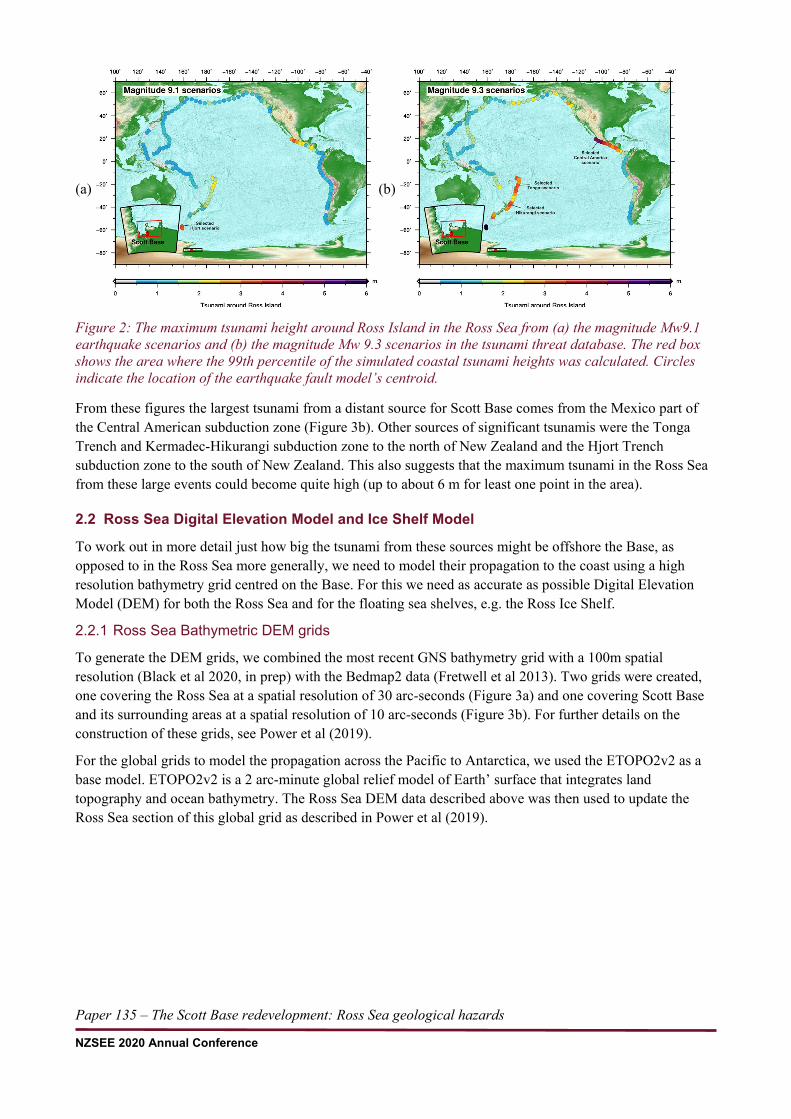
To find the potential tsunamigenic earthquake sources that pose the greatest threat to Scott Base, we extracted the simulated tsunami amplitudes along the coast around Ross Island within 72°–80°S and 162°–176°N for every scenario in the database. We then calculated the 99th percentile of the amplitude in this area to estimate the maximum tsunami without including any outliers. The maximum tsunami around Scott Base from the all the scenarios of magnitude Mw 9.1 and 9.3 is shown in Figure 2. The circles represent the centre of the earthquake fault scenario and the colour of the circles represent the maximum simulated coastal tsunami around Scott Base within the red box shown in the figures.
Cape Roberts Tidal Gauge
Paper 135 – The Scott Base redevelopment: Ross Sea geological hazards
NZSEE 2020 Annual Conference
(a) (b)
Figure 2: The maximum tsunami height around Ross Island in the Ross Sea from (a) the magnitude Mw9.1 earthquake scenarios and (b) the magnitude Mw 9.3 scenarios in the tsunami threat database. The red box shows the area where the 99th percentile of the simulated coastal tsunami heights was calculated. Circles indicate the location of the earthquake fault model’s centroid.
From these figures the largest tsunami from a distant source for Scott Base comes from the Mexico part of the Central American subduction zone (Figure 3b). Other sources of significant tsunamis were the Tonga Trench and Kermadec-Hikurangi subduction zone to the north of New Zealand and the Hjort Trench subduction zone to the south of New Zealand. This also suggests that the maximum tsunami in the Ross Sea from these large events could become quite high (up to about 6 m for least one point in the area).
2.2 Ross Sea Digital Elevation Model and Ice Shelf Model
To work out in more detail just how big the tsunami from these sources might be offshore the Base, as opposed to in the Ross Sea more generally, we need to model their propagation to the coast using a high resolution bathymetry grid centred on the Base. For this we need as accurate as possible Digital Elevation Model (DEM) for both the Ross Sea and for the floating sea shelves, e.g. the Ross Ice Shelf.
2.2.1 Ross Sea Bathymetric DEM grids
To generate the DEM grids, we combined the most recent GNS bathymetry grid with a 100m spatial resolution (Black et al 2020, in prep) with the Bedmap2 data (Fretwell et al 2013). Two grids were created, one covering the Ross Sea at a spatial resolution of 30 arc-seconds (Figure 3a) and one covering Scott Base and its surrounding areas at a spatial resolution of 10 arc-seconds (Figure 3b). For further details on the construction of these grids, see Power et al (2019).
For the global grids to model the propagation across the Pacific to Antarctica, we used the ETOPO2v2 as a base model. ETOPO2v2 is a 2 arc-minute global relief model of Earth’ surface that integrates land topography and ocean bathymetry. The Ross Sea DEM data described above was then used to update the Ross Sea section of this global grid as described in Power et al (2019).

Paper 135 – The Scott Base redevelopment: Ross Sea geological hazards
NZSEE 2020 Annual Conference
(a) (b)
Figure 3: (a) Bathymetry data covering the Ross Sea at a grid spacing of 30 arc-seconds (about 500 m at Scott Base); (b) bathymetry data covering the surrounding area of Ross Island at a grid spacing of 10 arc seconds (about 100 m at Scott Base). Colour scale illustrates elevations of the landward areas (fixed at 200 m above MSL) and the seaward areas of ice shelf grounding lines in metres.
2.2.2 Ross Ice Shelf
The Ross Ice Shelf is the world’s largest body of floating ice, lying at the head of the Ross Sea with an estimated area of roughly 500,809 km2 and is about 800 km across (Rignot et al 2013). The nearly vertical ice front to the open sea is more than 600 km long and between 15 and 50 m high above the water surface (Scheffel et al 1980). The shelf’s mean ice thickness is about 330 m along a line at about 79°S latitude (Rafferty 2011). Figure 4 shows the extent and spatial distribution of ice shelf coverage layer we have developed for this project using the data of the floating ice shelves in Bedmap2 (Fretwell et al 2013) together with our Ross Sea DEM grid.
Figure 4: Coverage of floating ice shelves in the Ross Sea (in white). Black lines outline the grounding lines of floating ice shelves and the coastal lines in the areas without ice. Green colour illustrates the landward area of ice shelf grounding lines. Blue colour indicates water areas without ice shelves. Also shown is Ross Island and Cape Ross on the mainland.
Ross Island
Cape Ross

Paper 135 – The Scott Base redevelopment: Ross Sea geological hazards
NZSEE 2020 Annual Conference
An additional ice tongue, Erebus Glacier Tongue west of Hutt Point Peninsula of Ross Island (Figure 4), was also added to our ice shelf coverage layer as it may have potential effects on tsunamis traveling through McMurdo Sound toward Scott Base. Further details on the construction of this model are again provided in Power et al (2019).
2.3 Hydrodynamic and Ice Shelf Modelling
For this study we will use the numerical simulation model, COMCOT (Cornell Multi-Grid Coupled Tsunami model) to simulate tsunami generations and propagations from their sources to the Antarctic coast. COMCOT was originally developed at Cornell University, USA in the 1990s (Liu et al 1998; Wang 2008) and since 2009 it has been under development at GNS Science, New Zealand (Wang & Power 2011). For this study we needed to use a spherical coordinate system to simulate the tsunami at such a high latitude. Details of how this was done is provided in Power et al (2019).
The other unique factor of this study is the potential effect of the ice shelf on tsunamis traveling in the Ross Sea. The bedrock beneath the Ross Ice Shelf can be as deep as 1 km from the Mean Sea Level and the ice shelf only grounds on a few high points within the sub ice shelf cavity. It is challenging to try to model tsunami wave propagation into an ice shelf cavity. In this study we consider three types of ice boundary conditions to model the effect of the ice: 1. Ice Boundary Condition 1 (BC1): which assumes that the Ross Ice Shelf front is a fixed wall boundary
(i.e. this assumes that the ice shelf grounded to the bedrock at its present day frontal margin); 2. Ice Boundary Condition 2 (BC2): which assumes that the West Antarctic Ice Sheet (WAIS) grounding
line is a fixed wall boundary (i.e. complete ‘removal’ of the ice shelf); 3. Ice Boundary Condition 3 (BC3): which assumes that the wave attenuates from the outer edge of Ross
Ice Shelf through to a fixed wall boundary at the WAIS grounding line and tries to approximate the energy dissipation effect of the floating ice shelf. Two dissipating effects are considered in this study: wave reflection by the nearly vertical frontal edge of ice shelf facing to open sea and wave dissipation by the floating ice shelf as tsunamis travel further beneath it.
Details of how all these Boundary Conditions were included, and their limitations, are in Power et al (2019).
2.4 Model validation
Observed tsunami waveforms recorded at tide gauges or offshore sea bottom pressure gauges are typically used to validate/calibrate a tsunami numerical model and its modelling setup. For this study we used the tide gauge record of the 2011 Tohoku tsunami recorded on the station at Cape Roberts near Scott Base (Figure 1). This record shows that the Tohoku tsunami arrived at Cape Roberts approximately 20 hours after the earthquake with a very small amplitude less than 5 cm (Figure 5). However, clear and larger wave amplitudes appear in later waves. The maximum amplitude of the later phases is about 10 cm and the oscillations lasted for at least 40 hours after the first arrival. The wave signals recorded at -5 and 15 hours after the earthquake are probably not generated by the 2011 Tohoku earthquake as the tsunami should theoretically arrived at the station ~20 hours after the earthquake.

Paper 135 – The Scott Base redevelopment: Ross Sea geological hazards
NZSEE 2020 Annual Conference
Figure 5: a) Tide gauge record at Cape Roberts during the 2011 Tohoku tsunami. The x-axis is for time after the earthquake start time in hour. b) Tsunami waveform of the 2011 Tohoku earthquake recorded at Cape Roberts after de-tiding.
To test the accuracy of our model and the effect of the different boundary conditions, we use the 2011 Tohoku earthquake source model by Gusman et al (2012) to model the tsunami to the gauge. To simulate the resulting tsunami propagation, we use COMCOT to model the tsunami using three different boundary conditions assumed for the ice shelf and then apply the phase correction method of Watada et al (2014) to include the effects from the dispersion of the surface gravity wave, elastic loading, gravitational potential change and seawater compressibility. These are not included in COMCOT but can be important for modelling tsunamis that have travelled large distances.
The general patterns of the simulated tsunami waveforms from the three boundary conditions (BC1, BC2, and BC3) are similar (Figure 6). The simulated tsunami waveforms from all three boundary conditions can all approximately reproduce the observed tsunami waveforms. Only through careful inspection can we notice small differences in the wave amplitude for the different BCs. The maximum simulated tsunami amplitude within the 72 hours of simulation time for BC1, BC2, and BC3 were 0.129, 0.140, and 0.104 m, respectively.
All models slightly underpredict the largest tsunami wave that arrived 24.5 hours after the earthquake occurred. This peak may have been caused by resonant oscillations in bays close to Cape Roberts which may not have been well represented in the relatively low-quality bathymetric data. The same may be true of the slightly-larger peak occurring after approximately 33 hours (Figure 5) which was also slightly underpredicted. However, given the uncertainties in both the source and bathymetry we feel that the fit to observations is accurate enough for an initial pilot study into the potential tsunami hazard faced by the base.
Figure 6: Comparison of observed (black lines) and simulated tsunami waveforms (blue lines) from the source model for the 2011 Tohoku earthquake with the three different model boundary conditions for the Ross Ice Shelf (BC1, BC2, and BC3).

Paper 135 – The Scott Base redevelopment: Ross Sea geological hazards
NZSEE 2020 Annual Conference
2.5 Distant source tsunami scenarios
We then did detailed modelling for four tsunami scenarios originating from the four subduction-zone earthquake sources listed above, Central America, Tonga-Kermadec, Hikurangi and Hjort. This was done as a pilot study to assess the potential tsunami hazard to the base. The magnitude and centroid location of each scenario is shown in Table 1. The other details of the earthquake source parameters are in Power et al (2019). Table 1 also shows the maximum tsunami amplitude (zmax) observed off the coast of Scott Base for each scenario and boundary condition combination.
All these events have very large magnitudes, much larger than any earthquake that has been observed for that particular subduction zone. Since they are so large, it is hard to estimate the probability of these events with any confidence, but it is likely to be very low. The magnitude-frequency distribution for earthquakes on subduction zones is not well constrained for any zone in the world, including these ones. For example, in Berryman et al (2015) the maximum possible magnitude (Mmax) estimate for these particular zones goes from as low as Mw7.2 (the minimum Mmax estimated for Hjort) to as high as Mw9.6 (the maximum Mmax estimated for Hikurangi-Kermadec or Central America). So at one extreme, these earthquakes could be above the maximum possible magnitude for the zone concerned and so the probability of an event of this size could potentially be zero. Even if these earthquakes are possible, they are still not very likely to be very frequent and probably have return intervals of at least several thousand years or potentially much more. However, as this is a pilot study, it is still useful to model them as it gives a reasonable upper plausible limit to the potential size of a distant tsunami that could affect the Ross Sea.
Table 1: The subduction zone name, centroid location, magntiude and the maximum tsunami elevation (zmax) off the coast of Scott Base for the four distant source tsunami scenarios. The zmax value is calculated using the three different boundary conditions (BC1,2 or 3). See text for details.
Subduction Zone Name Centroid Longitude
Centroid Latitude
Magnitude (Mw)
BC1 zmax (m)
BC2 zmax (m)
BC3 zmax (m)
Central America 103.3°W 18.0°N 9.3 1.44 0.95 0.81
Hjort 158.5°W 56.9°S 9.1 0.78 0.46 0.36
Hikurangi-Kermadec 179.9°E 37.1°S 9.3 0.73 0.63 0.61
Kermadec-Tonga 173.6°W 20.7°S 9.3 0.69 0.61 0.44
For all scenarios, BC1 consistently produced the highest zmax near Scott Base and BC3 the lowest. The Mw9.3 off the Central American coast had consistently higher zmax values than any other scenario considered here. Figure 7 shows the zmax across the Pacific for this event using BC1. Figures showing the other zmax plots for all the other scenarios and boundary conditions are in Power et al (2019).
A tsunami of about 1.4m offshore is a potential tsunami inundation hazard. In New Zealand, any tsunami with a zmax over 1m would trigger an onshore evacuation. Without detailed modelling of the inundation, not done here, it is not possible to precisely estimate whether the base itself would be inundated by this tsunami. In addition to the tsunami itself, the amount of inundation would also depend on the tide at the time of the tsunami and any potential sea level rise due to global warning. However, it is large enough to suggest that a tsunami from a distant source could be a very rare, but plausible, onshore tsunami hazard to the base. A marine threat tsunami, mainly hazardous to people or boats in the water due to the unusual currents, is more likely and a range of different sources could produce such a tsunami. In New Zealand, any tsunami

Paper 135 – The Scott Base redevelopment: Ross Sea geological hazards
NZSEE 2020 Annual Conference
amplitude between about 0.3 and 1m offshore is classified as a potential marine threat. That would true for all the scenarios considered here.
(a) (b)
Figure 7 The simulated maximum tsunami in (a) the Pacific Ocean or (b) near Scott Base from a Mw9.3 earthquake off the Mexican coast with BC1 boundary condition.
2.6 Local tsunami sources
In addition to the hazard posed by distant earthquakes, tsunamis may also be generated from the following sources: • Rockfall and icefall landslides into the sea from Ross Island or Victoria Land • Submarine landslides on the continental shelf edge • Volcanic events on Ross Island or Victoria Land volcanoes • Glacier or ice shelf calving events, and iceberg capsizing. • Local earthquakes The absence of historically recorded tsunamis in McMurdo Sound from these sources, and the very few reports of similar tsunami-causing events elsewhere in Antarctica, provides some reassurance that the current-day hazard posed by these sources to Scott Base is likely to be low. This must be interpreted in the context that the historic record is relatively short as McMurdo Sound has only been continuously occupied for ~75 years, and that in Antarctica generally the population and instrumentation is quite sparsely distributed, so local tsunamis could have been missed. Consequently, few conclusions can be made about less frequent tsunami-causing events such as volcanic eruptions and submarine landslides.
Also, several of the above processes may become more frequent due to climate change: • Rock and ice falls: if melting and refreezing of ice happens more frequently and more likely late in the
summer each year • Submarine landslides: if the nature and volume of sediment deposition changes due to retreat of ice
shelves and deglaciation • Volcanic events: due to isostatic rebound and/or changes in sub-surface pressure if the weight of ice
reduces • Glacier or ice shelf calving: if the calving process accelerates and/or changes in style. The anticipated time frames over which these processes take place is quite variable; changes to patterns of freezing-thawing and to ice calving may respond fairly-quickly to climate change, while isostatic rebound

Paper 135 – The Scott Base redevelopment: Ross Sea geological hazards
NZSEE 2020 Annual Conference
and changes to sediment accumulation are cumulative environmental responses to climate change that may take place over decades or centuries. Many of these processes are only poorly understood.
3 LOCAL EARTHQUAKE HAZARD In addition to these sources of geological hazard, there is both a potential earthquake shaking and a tsunami hazard to the Base from local earthquake sources. The Antarctic plate is unusual in that it is almost completely surrounded by divergent or conservative margins. It is viewed as relatively seismically inactive for a continental plate (Reading 2002), although studies have shown that its seismic activity is still comparable to that of other plates of similar size and kinematics (Okal 1981). Ice may play a role in supressing earthquakes (Reading 2007). The apparent lack of activity is also due at least in part to the lack of seismic stations (see USGS 2019).
The largest instrumentally recorded earthquakes on the Antarctic plate have occurred at its offshore boundaries. On 25 March 1998 a M 8.1 earthquake occurred near the Balleny Islands, and in 17 November 2013 a M 7.7 earthquake occurred in the Scotia Sea, both produced small instrumentally observed tsunamis at distant tide-gauge stations. In the western Ross Sea, the largest earthquakes have been a M 5.5 in 1993 and a M 5.1 in 2012. A M 6.0 earthquake also occurred in northern Victoria Land in 1952 (United States Geological Survey earthquake catalogue online search).
Henrys et al (2008), identified several normal faults in the Ross Sea rift basin west and northwest of Ross Island in seismic data. In particular, there is a small normal fault just east of the Hut Point Peninsula, which has may be associated with the line of volcanism passing through Mt Erebus and Mt Bird and to the area of rifting north of Ross Island (Naish et al 2007).
3.1.1 Potential effect of isostatic rebound
If significant loss of ice were to occur from the ice sheets, the isostatic rebound effect may lead to additional earthquakes (McGuire 2012). This is generally thought to be a relatively slow process operating on timescales of centuries. Isostatic rebound from an earlier phase of ice retreat appears to be currently ongoing.
Several raised beach ridges have been identified both on the west side of McMurdo Sound and on Ross Island. These probably reflect deposits from past storm events, but that they are raised above the modern-day storm line suggests that they indicate changes in past local sea level (Butler 1999), probably a consequence of isostatic rebound (Butler 1999; Hall et al 2004). The ridges may also reflect tectonic movement (Cox et al 2012), perhaps on faults related to the rifting of McMurdo Sound. The highest preserved beach ridges on the Scott Coast are at 34m at Cape Ross (Figure 4), with the maximum ridge height reducing towards the south to about 8 m at Granite Harbour. Individual ridges show up to about 2 m of relief (Hall et al 2004). The origin of the ridges is considered to be isostatic and/or tectonic uplift following deglaciation and grounded ice retreat in this part of McMurdo Sound about 6500 years ago – this process appears to be continuing to the present day though at a lower rate than initially after the ice retreat (see Figure 5 of Hall et al 2004). Butler (1999) suggests that the raised beaches are storm beaches, deposited and stranded as the land rebounded.
The presence of normal faults in McMurdo Sound as identified by Henrys et al (2008), and the raised beach ridges of up to 2m high (Hall et al 2004), raise the question of earthquake and possible tsunami generation by local fault movement. An alternative to the explanation of the beach ridges by stranded storm deposits is that some of the raised beaches may indicate discrete uplift events due to isostatic rebound in the form of earthquakes. It appears plausible that the isostatic rebound could take the form of movement on pre-existing faults such as the normal fault that runs parallel to the Victoria Land coast about 15 km offshore. The rate of isostatic rebound (and therefore of potentially associated earthquakes) has reduced since the grounded ice shelf retreated from this coast approximately 6500 years ago, but continues to the present day at a reduced rate. Consequently, the possibility of further earthquakes of this type remains. An earthquake capable of 2m

Paper 135 – The Scott Base redevelopment: Ross Sea geological hazards
NZSEE 2020 Annual Conference
of uplift (under the precautionary assumption that this is the origin of some of the raised beaches) would likely be much larger than any historically recorded earthquake in the interior of Antarctica and, assuming the deformation continues offshore, would be tsunamigenic. The amount of shaking and size of tsunami generated would depend on the details of the earthquake.
The beach ridges on the western side of McMurdo Sound may provide an indication of the future course of events further south if the grounded ice shelf retreats further from its current position. In other words, seismic activity due to isostatic rebound may occur in areas from which the grounded ice shelf retreats and/or onland glaciers retreat. Faults associated with rifting occur south of Ross Island (Naish et al 2007) and these might become more active if the stresses on them change due to reduced weight of ice in this area.
4 VOLCANIC HAZARD
4.1 Volcanic Eruption
Figure 8 Aerial photograph of the Mt Erebus summit looking south along Hut Point Peninsula to Scott Base. Steam can be seen rising out of the main crater. Photo: Christopher Dean, National Science Foundation.
Mt Erebus volcano above Scott Base is active. There is a convecting lava lake in the main crater (Figure 8) and a historic and ancient record of explosive eruption. The periodicity of eruption before 1972 is poorly known (Harpel et al 2004). Strombolian eruptions in the main crater that eject material a few hundred metres have been commonly observed since regular monitoring commenced in 1972 (Caldwell and Kyle 1994). Occasionally, such as in 1984, the frequency and energy of the Strombolian eruptions increase to eject material up to 1 km from the vent in the main crater. In 1993, two phreatomagmatic eruptions were recorded that ejected material over the rim of the main crater and excavated a new, c. 80 m-wide vent, likely caused by steam build-up associated with melting snow in the crater. Ash erupted from the main crater on 15 December 1997 (Harpel et al 2008). Ten lava flows have been recorded in the rock-record post-caldera collapse, and are dated between 8.5 and 4.5 ka during a period of effusive eruption (Parmelee et al 2015).
Additionally, 37 phreatomagmatic eruptions are recorded in englacial tephra on Mt Erebus, erupted between 71 ± 5 ka, up to several hundred years ago. These eruptions were found between 2 and 20 km from the main crater, which are the minimum distances covered by each eruption. One eruption in this sequence at 39 ka is thought to be Plinian in scale, affecting areas up to 200 km away in East Antarctica (Harpel et al 2008). A theoretical eruption with 5 km high plume erupting 1x10¹⁰ kg of material has been modelled to deliver 0.5 – 1 cm of ash to Scott Base under favourable wind and wind speed conditions (Gilles 2017). Plume heights during the 1993 phreatic eruptions were estimated at 2 km with an unknown volume of material.
At Mt Erebus, changes in eruption frequency and intensity have been linked to changing magma chemistry or vent geometry, and under future climate scenarios may also be affected by ice de-loading. Ballistic ejecta from Strombolian eruptions and lava flows are unlikely to pose a hazard to Scott Base, but ash fall from

Paper 135 – The Scott Base redevelopment: Ross Sea geological hazards
NZSEE 2020 Annual Conference
phreatomagmatic eruptions can have a potential effect. This is supported by rare yet important occurrences in the tephra record and preliminary modelling. A volcanic hazard model does not yet exist for Mt Erebus.
4.2 Volcanic Tsunami
There are many volcanoes in Antarctica, but little is known regarding their potential to cause tsunamis. Tsunamis caused by eruptions and slope failures are inferred to have occurred on Deception Island in the South Shetland Islands of Antarctica (Bartolini et al 2014), the evidence for this is a raised beach area of abundant driftwood thought to be a consequence of tsunami waves caused by an eruption in 1969 (Smellie 2002). Seiching has also been observed on Deception Island caused by volcanic activity in 1967 (Smellie 2002).
5 CONCLUSIONS In this paper we summarise what is known about the potential geological hazards in the Ross Sea, particularly near Scott Base. There is much we do not know about geological hazards in this area, but there are clearly a number of potential hazards in the area including: • distant source tsunami from around the Pacific, particularly from the Central American subduction zone
near Mexico • local tsunami from rockfall and icefall landslides, submarine landslides, volcanic events, glacier or ice
shelf calving events, iceberg capsizing or tectonic motions caused by local earthquakes • damaging ground shaking from local earthquakes and • volcanic eruption Several of these sources may be affected by climate change. Further study would be needed to try to estimate the likelihood and extent of the influence of that on the various types of hazards.
6 ACKNOWLEDGEMENTS The authors would like to thank Antarctica New Zealand for funding much of the work on which this paper is based. We would also like to thank an anonymous reviewer for their comments to improve the paper.
REFERENCES Bartolini S. Geyer A. Martí J. Pedrazzi D. Aguirre-Díaz G. 2014. Volcanic hazard on Deception Island (South Shetland
Islands, Antarctica). Journal of Volcanology and Geothermal Research. 285:150–168. doi:10.1016/j.jvolgeores.2014.08.009.
Berryman K., Wallace L., Hayes G., Bird P., Wang K., Basili R., Lay T., Pagani M., Stein R., Sagiya T., Rubin C., Barreintos S., Kreemer C., Litchfield N., Stirling M., Gledhill K., Haller K., Costa C. 2015. The GEM Faulted Earth Subduction Interface Characterisation Project. Version 2.0, April 2015, GEM Faulted Earth Project.
Black, J.A., Stagpoole V.M., Woodward D.J., Henrys, S.A., Davey F.J. (2020, in prep.) Bathymetry of the Ross Dependency and adjacent Southern Ocean, version 2.0. GNS Science report 2020.
Butler E.R.T. 1999. Process environments on modern and raised beaches in McMurdo Sound, Antarctica. Marine Geology. 162(1):105–120. doi:https://doi.org/10.1016/S0025-3227(99)00061-4.
Caldwell, D.A. & Kyle, P.R., 1994. Mineralogy and Geochemistry of Ejecta Erupted from Mount Erebus, Antarctica, between 1972 and 1986. In: Kyle, P.R. (Ed.), Volcanological and Environmental Studies of Mount Erebus, Antarctica. American Geophysical Union, Washington, DC, pp. 147-162.
Cox S.C. Turnbull I.M. Isaac M.J. Townsend D.B. Smith Lyttle B. 2012. Geology of southern Victoria Land Antarctica [map]. Lower Hutt (NZ): GNS Science. 1 map + 135 pp. Institute of Geological & Nuclear Sciences 1:250,000 Geological Map. 22.

Paper 135 – The Scott Base redevelopment: Ross Sea geological hazards
NZSEE 2020 Annual Conference
Fretwell, P. Pritchard, H.D. Vaughan, D.G. Bamber, J.L. Barrand, N.E. Bell, R. Bianchi, C. Bingham, R.G. Blankenship, D.D. & Casassa G. 2013. Bedmap2: improved ice bed, surface and thickness datasets for Antarctica. The Cryosphere. 7(1):375–393. doi:10.5194/tc-7-375-2013.
Gilles, J.K. 2017. Living in the shadow of a volcano, University of Canterbury. Postgraduate Certificate, 32 pp.
Gusman A.R. Tanioka Y. Sakai S. & Tsushima H. 2012. Source model of the great 2011 Tohoku earthquake estimated from tsunami waveforms and crustal deformation data. Earth and Planetary Science Letters. 341-344:234–242. doi:10.1016/j.epsl.2012.06.006.
Gusman, A.R. Wang, X. Power, W.L. Lukovic, B. Mueller, C. & Burbidge, D.R. 2019. Tsunami threat level database update. GNS Science report 2019/67. 110 p. doi: 10.21420/QM31-NA61.
Hall, B.L. Baroni, C. Denton, G.H. 2004. Holocene relative sea-level history of the Southern Victoria Land Coast, Antarctica, Global and Planetary Change, 42, 241-263.
Harpel, C.J. Kyle, P.R. Esser, R.P. McIntosh, W.C. & Caldwell, D.A. 2004. 40Ar/39Ar dating of the eruptive history of Mount Erebus, Antarctica: summit flows, tephra, and caldera collapse. Bulletin of Volcanology, 66(8): 687-702.
Henrys, S. A. Wilson, T. J. Fielding, C. R. Hall, J. Naish, T.R. 2008. Tectonic history of mid-Miocene to present southern Victoria Land Basin, inferred from seismic stratigraphy in McMurdo Sound, Antarctica. Earth and Atmospheric Sciences. 285. http://digitalcommons.unl.edu/geosciencefacpub/285.
Liu P.L.F. Woo S.B. & Cho Y.S. 1998. Computer programs for tsunami propagation and inundation. Ithaca (NY): Cornell University. Technical Report.
Lester, J. Larson, B. and Parker, W. 2020. The Scott Base Redevelopment: Design Response to Natural Hazards. New Zealand Society of Earthquake Engineering Conference 2020 (this volume).
McGuire, B. Waking the Giant: How a Changing Climate Triggers Earthquakes, Tsunamis and Volcanoes. 2012. Oxford University Press, 303 pp.
Naish T.R. Powell R.D. Levy R.H. 2007. Background to the ANDRILL McMurdo Ice Shelf Project (Antarctica) and initial science volume. ANDRILL Research and Publications. 29. http://digitalcommons.unl.edu/andrillrespub/29.
Okal, E. A. 1981. Intraplate seismicity of Antarctica and tectonic implications. Earth and Planetary Science Letters, 52, 397-409.
Parmelee, D.E.F. Kyle, P.R. Kurz, M.D. Marrero, S.M. & Phillips, F.M. 2015. A new Holocene eruptive history of Erebus volcano, Antarctica using cosmogenic 3He and 36Cl exposure ages. Quaternary Geochronology, 30(Part A): 114-131.
Power, W.L. Gusman, A.R. Wang, X. Lukovic, & B. Black, J.A. 2019. Pilot tsunami hazard study for Scott Base in Antarctica. GNS Science Consultancy Report 2019/113, 60 p.
Rafferty JP, editor. 2011. Glaciers, sea ice, and ice formation. Chicago (IL): Britannica Educational Publishers. 255 p.
Reading A.M. 2002. Antarctic seismicity and neotectonics. In: Gamble J.A. Skinner D.N.B. Henrys S.A. editors. Antarctica at the close of a millennium: proceedings of the 8th International Symposium on Antarctic Earth Sciences, Wellington, 1999. Wellington (NZ): Royal Society of New Zealand. p. 479-484. Bulletin if the Royal Society of New Zealand, 35.
Reading A.M. 2007. The seismicity of the Antarctic plate. In: Mazzotti S. S., editor. Continental intraplate earthquakes: science, hazard, and policy issues Boulder (CO): Geological Society of America. p. 285. Special papers Geological Society of America; 425.
Rignot, E. Jacobs, S. Mouginot, J. & Scheuchl, B. 2013. Ice-shelf melting around antarctica. Science. 341(6143):266–270. doi:10.1126/science.1235798.
Scheffel R.L. & Wernet S.J. editors. 1980. Natural wonders of the world. Pleasantville (NY): Reader's Digest Association. 463 p.
Smellie J.L. 2002. The 1969 subglacial eruption on Deception Island (Antarctica): events and processes during an eruption beneath a thin glacier and implications for volcanic hazards. In: Smellie J.L. & Chapman M.G. (eds) Volcano–ice interaction on Earth and Mars. Geological Society of London Special Publication 202(1): pp. 59–79. doi: https://doi.org/10.1144/GSL.SP.2002.202.01.04.
Stagpoole, V.M. 2004. Bathymetry of the Ross Dependency and adjacent Southern Ocean [map]. Institute of Geological & Nuclear Sciences geophysical map 17.
USGS 2019. Do earthquakes occur in Antartica? [place unknown]: USGS; [accessed 2019 Jul]. https://www.usgs.gov/faqs/do-earthquakes-occur-antarctica?qt-news_science_products=0#qt-news_science_products.

Paper 135 – The Scott Base redevelopment: Ross Sea geological hazards
NZSEE 2020 Annual Conference
Wang X. 2008. Numerical modelling of surface and internal waves over shallow and intermediate water [PhD thesis]. Ithaca (NY): Cornell University.
Wang X. & Power W.L. 2011. COMCOT: a tsunami generation, propagation and run-up model. Lower Hutt (NZ): GNS Science. 121 p. GNS Science report 2011/43.