the routes listed below meet the time/distance ... · this list is not exhaustive and all gold...
TRANSCRIPT
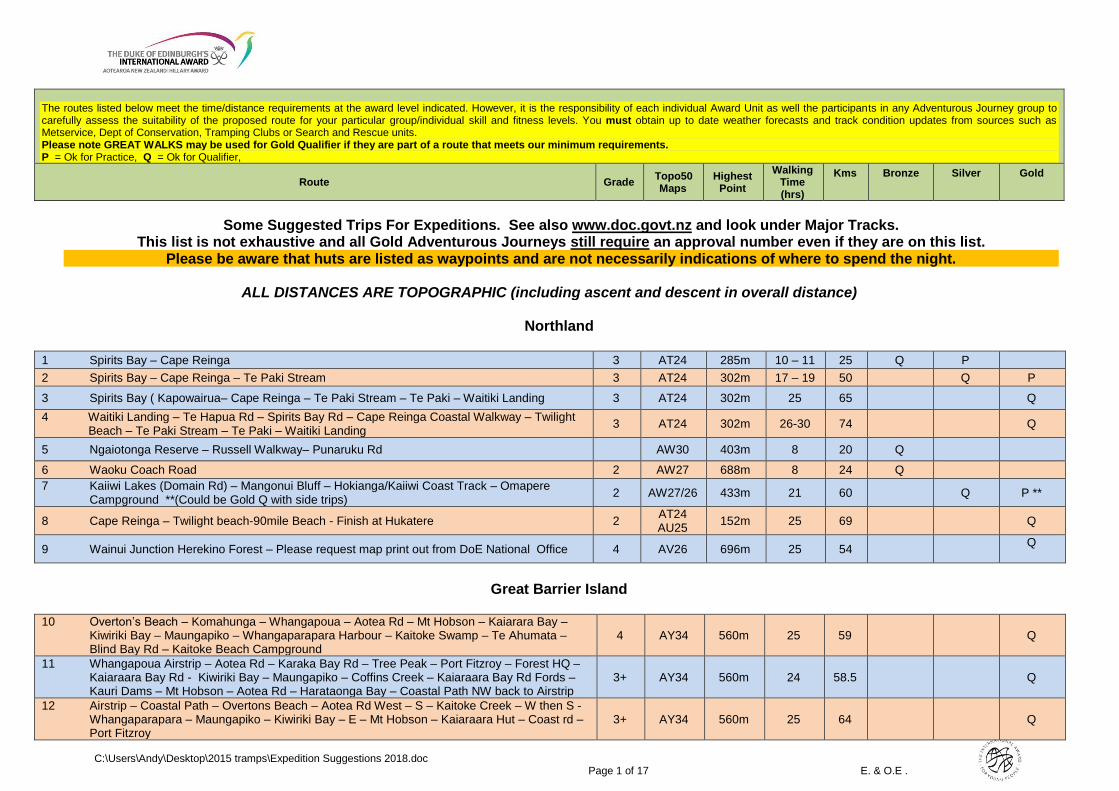
The routes listed below meet the time/distance requirements at the award level indicated. However, it is the responsibility of each individual Award Unit as well the participants in any Adventurous Journey group to carefully assess the suitability of the proposed route for your particular group/individual skill and fitness levels. You must obtain up to date weather forecasts and track condition updates from sources such as Metservice, Dept of Conservation, Tramping Clubs or Search and Rescue units. Please note GREAT WALKS may be used for Gold Qualifier if they are part of a route that meets our minimum requirements. P = Ok for Practice, Q = Ok for Qualifier,
Route Grade Topo50 Maps
Highest Point
Walking Time (hrs)
Kms
Bronze
Silver
Gold
C:\Users\Andy\Desktop\2015 tramps\Expedition Suggestions 2018.doc Page 1 of 17 E. & O.E .
Some Suggested Trips For Expeditions. See also www.doc.govt.nz and look under Major Tracks. This list is not exhaustive and all Gold Adventurous Journeys still require an approval number even if they are on this list.
Please be aware that huts are listed as waypoints and are not necessarily indications of where to spend the night.
ALL DISTANCES ARE TOPOGRAPHIC (including ascent and descent in overall distance)
Northland
1 Spirits Bay – Cape Reinga 3 AT24 285m 10 – 11 25 Q P 2 Spirits Bay – Cape Reinga – Te Paki Stream 3 AT24 302m 17 – 19 50 Q P
3 Spirits Bay ( Kapowairua– Cape Reinga – Te Paki Stream – Te Paki – Waitiki Landing 3 AT24 302m 25 65 Q
4 Waitiki Landing – Te Hapua Rd – Spirits Bay Rd – Cape Reinga Coastal Walkway – Twilight Beach – Te Paki Stream – Te Paki – Waitiki Landing
3 AT24 302m 26-30 74 Q
5 Ngaiotonga Reserve – Russell Walkway– Punaruku Rd AW30 403m 8 20 Q
6 Waoku Coach Road 2 AW27 688m 8 24 Q 7 Kaiiwi Lakes (Domain Rd) – Mangonui Bluff – Hokianga/Kaiiwi Coast Track – Omapere Campground **(Could be Gold Q with side trips) 2 AW27/26 433m 21 60 Q P **
8 Cape Reinga – Twilight beach-90mile Beach - Finish at Hukatere 2 AT24 AU25
152m 25 69 Q
9 Wainui Junction Herekino Forest – Please request map print out from DoE National Office 4 AV26 696m 25 54 Q
Great Barrier Island
10 Overton’s Beach – Komahunga – Whangapoua – Aotea Rd – Mt Hobson – Kaiarara Bay – Kiwiriki Bay – Maungapiko – Whangaparapara Harbour – Kaitoke Swamp – Te Ahumata – Blind Bay Rd – Kaitoke Beach Campground
4 AY34 560m 25 59 Q
11 Whangapoua Airstrip – Aotea Rd – Karaka Bay Rd – Tree Peak – Port Fitzroy – Forest HQ – Kaiaraara Bay Rd - Kiwiriki Bay – Maungapiko – Coffins Creek – Kaiaraara Bay Rd Fords – Kauri Dams – Mt Hobson – Aotea Rd – Harataonga Bay – Coastal Path NW back to Airstrip
3+ AY34 560m 24 58.5 Q
12 Airstrip – Coastal Path – Overtons Beach – Aotea Rd West – S – Kaitoke Creek – W then S - Whangaparapara – Maungapiko – Kiwiriki Bay – E – Mt Hobson – Kaiaraara Hut – Coast rd – Port Fitzroy
3+ AY34 560m 25 64 Q
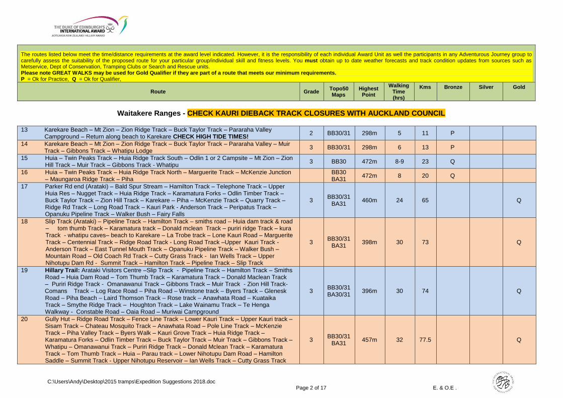
The routes listed below meet the time/distance requirements at the award level indicated. However, it is the responsibility of each individual Award Unit as well the participants in any Adventurous Journey group to carefully assess the suitability of the proposed route for your particular group/individual skill and fitness levels. You must obtain up to date weather forecasts and track condition updates from sources such as Metservice, Dept of Conservation, Tramping Clubs or Search and Rescue units. Please note GREAT WALKS may be used for Gold Qualifier if they are part of a route that meets our minimum requirements. P = Ok for Practice, Q = Ok for Qualifier,
Route Grade Topo50 Maps
Highest Point
Walking Time (hrs)
Kms
Bronze
Silver
Gold
C:\Users\Andy\Desktop\2015 tramps\Expedition Suggestions 2018.doc Page 2 of 17 E. & O.E .
Waitakere Ranges - CHECK KAURI DIEBACK TRACK CLOSURES WITH AUCKLAND COUNCIL
13 Karekare Beach – Mt Zion – Zion Ridge Track – Buck Taylor Track – Pararaha Valley Campground – Return along beach to Karekare CHECK HIGH TIDE TIMES!
2 BB30/31 298m 5 11 P
14 Karekare Beach – Mt Zion – Zion Ridge Track – Buck Taylor Track – Pararaha Valley – Muir Track – Gibbons Track – Whatipu Lodge
3 BB30/31 298m 6 13 P
15 Huia – Twin Peaks Track – Huia Ridge Track South – Odlin 1 or 2 Campsite – Mt Zion – Zion Hill Track – Muir Track – Gibbons Track - Whatipu
3 BB30 472m 8-9 23 Q
16 Huia – Twin Peaks Track – Huia Ridge Track North – Marguerite Track – McKenzie Junction – Maungaroa Ridge Track – Piha
BB30 BA31
472m 8 20 Q
17 Parker Rd end (Arataki) – Bald Spur Stream – Hamilton Track – Telephone Track – Upper Huia Res – Nugget Track – Huia Ridge Track – Karamatura Forks – Odlin Timber Track – Buck Taylor Track – Zion Hill Track – Karekare – Piha – McKenzie Track – Quarry Track – Ridge Rd Track – Long Road Track – Kauri Park - Anderson Track – Peripatus Track – Opanuku Pipeline Track – Walker Bush – Fairy Falls
3 BB30/31
BA31 460m 24 65 Q
18 Slip Track (Arataki) – Pipeline Track – Hamilton Track – smiths road – Huia dam track & road – tom thumb Track – Karamatura track – Donald mclean Track – puriri ridge Track – kura Track - whatipu caves– beach to Karekare – La Trobe track – Lone Kauri Road – Marguerite Track – Centennial Track – Ridge Road Track - Long Road Track –Upper Kauri Track - Anderson Track – East Tunnel Mouth Track – Opanuku Pipeline Track – Walker Bush – Mountain Road – Old Coach Rd Track – Cutty Grass Track - Ian Wells Track – Upper Nihotupu Dam Rd - Summit Track – Hamilton Track – Pipeline Track – Slip Track
3 BB30/31
BA31 398m 30 73 Q
19 Hillary Trail: Arataki Visitors Centre –Slip Track - Pipeline Track – Hamilton Track – Smiths Road – Huia Dam Road – Tom Thumb Track – Karamatura Track – Donald Maclean Track – Puriri Ridge Track - Omanawanui Track – Gibbons Track – Muir Track - Zion Hill Track- Comans Track – Log Race Road – Piha Road – Winstone track – Byers Track – Glenesk Road – Piha Beach – Laird Thomson Track – Rose track – Anawhata Road – Kuataika Track – Smythe Ridge Track – Houghton Track – Lake Wainamu Track – Te Henga Walkway - Constable Road – Oaia Road – Muriwai Campground
3 BB30/31 BA30/31
396m 30 74 Q
20 Gully Hut – Ridge Road Track – Fence Line Track – Lower Kauri Track – Upper Kauri track – Sisam Track – Chateau Mosquito Track – Anawhata Road – Pole Line Track – McKenzie Track – Piha Valley Track – Byers Walk – Kauri Grove Track – Huia Ridge Track – Karamatura Forks – Odlin Timber Track – Buck Taylor Track – Muir Track – Gibbons Track – Whatipu – Omanawanui Track – Puriri Ridge Track – Donald Mclean Track – Karamatura Track – Tom Thumb Track – Huia – Parau track – Lower Nihotupu Dam Road – Hamilton Saddle – Summit Track - Upper Nihotupu Reservoir – Ian Wells Track – Cutty Grass Track
3 BB30/31
BA31 457m 32 77.5 Q

The routes listed below meet the time/distance requirements at the award level indicated. However, it is the responsibility of each individual Award Unit as well the participants in any Adventurous Journey group to carefully assess the suitability of the proposed route for your particular group/individual skill and fitness levels. You must obtain up to date weather forecasts and track condition updates from sources such as Metservice, Dept of Conservation, Tramping Clubs or Search and Rescue units. Please note GREAT WALKS may be used for Gold Qualifier if they are part of a route that meets our minimum requirements. P = Ok for Practice, Q = Ok for Qualifier,
Route Grade Topo50 Maps
Highest Point
Walking Time (hrs)
Kms
Bronze
Silver
Gold
C:\Users\Andy\Desktop\2015 tramps\Expedition Suggestions 2018.doc Page 3 of 17 E. & O.E .
Hunua Ranges
21 Ness Valley – Thousand Acres Campground – Waharau Loop to Carpark - Workman Campground –Upper Mangatawahiri Dam Campground – Hunua Falls
3 BB33 688m 24 65 Q
22 Waharau Campground – Puriri Grove Track – Waharau Ridge Track – Workman Track – Mangatangi Dam – ARA Track – Moumoukai – Repeater Road – Wairoa Loop Track - Suspension Bridge Track – Wairoa Cosseys Track – Massey Track – Hunua Falls
3 BB33 480m 17 43 Q P
Puketi / Omahuta Forest
23 Waipapa River (Start or Finish at Forestry Hut) 4 AV28 320m 13 23 Q
Coromandel Forest Park
24 Kauaeranga Rd end – Pinnacles Hut – (Via Webb Creek Track) - Kauaeranga Rd end (Via Billy Goat Track) Trip status has been revised is now qualifier 2 BB35 759m 6.5 20 Q
Pirongia Forest Park
25 Karamu Limeworks Rd – Bell Track – Pahautea Hut – Tahuanui Track – Karamu Limeworks Rd
3 BE33 959m 12 24 Q
26 Waite Rd to - Summit & Hut - via Ruapane - return via Mahaukura - Grey Rd 3 BE33 959m 8 17 P
27 Port Waikato – Off Track following coastline – Waimai Stream (Junction Te Akau/Waimai Valley Rds)
4 BC31 BD31
165m 24 40 Q
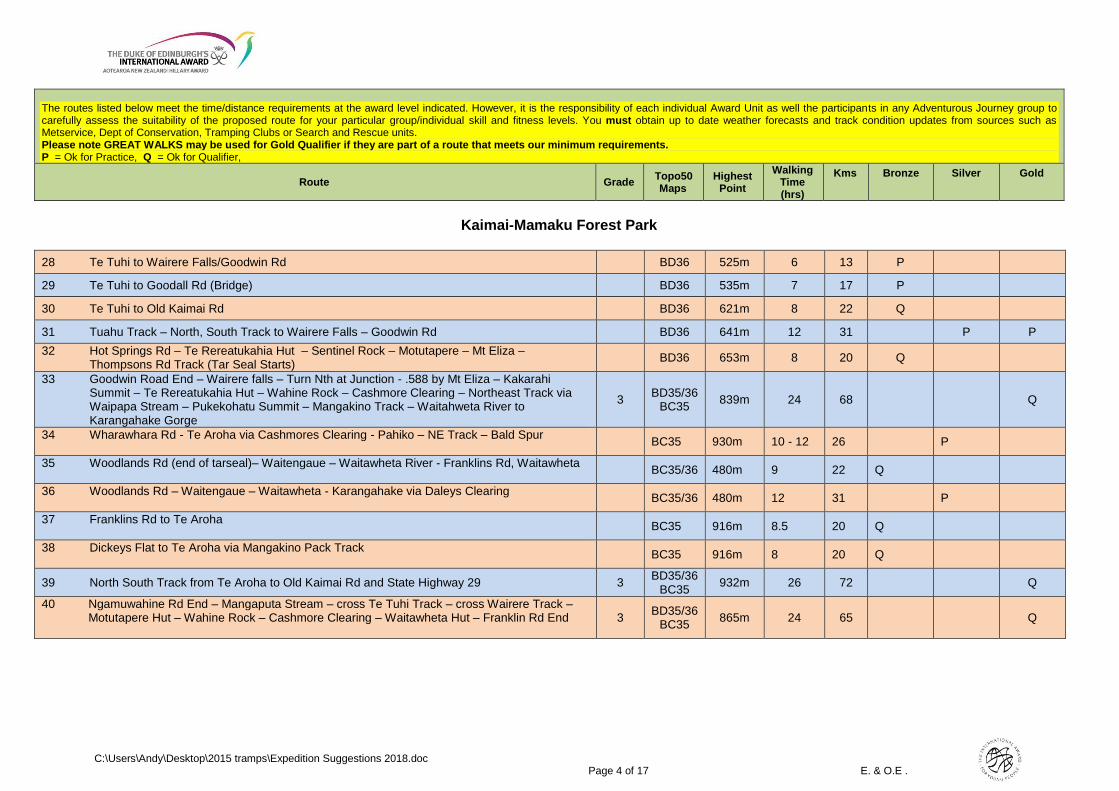
The routes listed below meet the time/distance requirements at the award level indicated. However, it is the responsibility of each individual Award Unit as well the participants in any Adventurous Journey group to carefully assess the suitability of the proposed route for your particular group/individual skill and fitness levels. You must obtain up to date weather forecasts and track condition updates from sources such as Metservice, Dept of Conservation, Tramping Clubs or Search and Rescue units. Please note GREAT WALKS may be used for Gold Qualifier if they are part of a route that meets our minimum requirements. P = Ok for Practice, Q = Ok for Qualifier,
Route Grade Topo50 Maps
Highest Point
Walking Time (hrs)
Kms
Bronze
Silver
Gold
C:\Users\Andy\Desktop\2015 tramps\Expedition Suggestions 2018.doc Page 4 of 17 E. & O.E .
Kaimai-Mamaku Forest Park
28 Te Tuhi to Wairere Falls/Goodwin Rd BD36 525m 6 13 P
29 Te Tuhi to Goodall Rd (Bridge) BD36 535m 7 17 P
30 Te Tuhi to Old Kaimai Rd BD36 621m 8 22 Q
31 Tuahu Track – North, South Track to Wairere Falls – Goodwin Rd BD36 641m 12 31 P P
32 Hot Springs Rd – Te Rereatukahia Hut – Sentinel Rock – Motutapere – Mt Eliza – Thompsons Rd Track (Tar Seal Starts)
BD36 653m 8 20 Q
33 Goodwin Road End – Wairere falls – Turn Nth at Junction - .588 by Mt Eliza – Kakarahi Summit – Te Rereatukahia Hut – Wahine Rock – Cashmore Clearing – Northeast Track via Waipapa Stream – Pukekohatu Summit – Mangakino Track – Waitahweta River to Karangahake Gorge
3 BD35/36
BC35 839m 24 68 Q
34 Wharawhara Rd - Te Aroha via Cashmores Clearing - Pahiko – NE Track – Bald Spur
BC35 930m 10 - 12 26 P
35 Woodlands Rd (end of tarseal)– Waitengaue – Waitawheta River - Franklins Rd, Waitawheta
BC35/36 480m 9 22 Q
36 Woodlands Rd – Waitengaue – Waitawheta - Karangahake via Daleys Clearing
BC35/36 480m 12 31 P
37 Franklins Rd to Te Aroha
BC35 916m 8.5 20 Q
38 Dickeys Flat to Te Aroha via Mangakino Pack Track
BC35 916m 8 20 Q
39 North South Track from Te Aroha to Old Kaimai Rd and State Highway 29 3 BD35/36
BC35 932m 26 72 Q
40 Ngamuwahine Rd End – Mangaputa Stream – cross Te Tuhi Track – cross Wairere Track – Motutapere Hut – Wahine Rock – Cashmore Clearing – Waitawheta Hut – Franklin Rd End
3 BD35/36
BC35 865m 24 65 Q

The routes listed below meet the time/distance requirements at the award level indicated. However, it is the responsibility of each individual Award Unit as well the participants in any Adventurous Journey group to carefully assess the suitability of the proposed route for your particular group/individual skill and fitness levels. You must obtain up to date weather forecasts and track condition updates from sources such as Metservice, Dept of Conservation, Tramping Clubs or Search and Rescue units. Please note GREAT WALKS may be used for Gold Qualifier if they are part of a route that meets our minimum requirements. P = Ok for Practice, Q = Ok for Qualifier,
Route Grade Topo50 Maps
Highest Point
Walking Time (hrs)
Kms
Bronze
Silver
Gold
C:\Users\Andy\Desktop\2015 tramps\Expedition Suggestions 2018.doc Page 5 of 17 E. & O.E .
Rotorua
This is the information and contact details for the campground at Tarawera outlet and all bookings re tramps 41 and 42. Te Mana o Ngati Rangitihi Trust, 3 Onewairere Place, Matata (07)3222452
and http://www.whakarewarewa.com/Tarawera/Hot+Water+Beach+-+Campground.html
41 Tarawera Falls – Northern Tarawera Track – Otangimoana Bay – Eastern Okataina Walkway – Lake Okataina Outdoor Ed Centre – Whakapoungakau – Pukahu Stream – Millar Rd – Okareka Loop Rd – Blue Lake – Green Lake (Nth Shore) – Kakapiko – Hemo Gorge
2 BE37/38 758m 24 65 Q
42 Tarawera Falls – Northern Tarawera Track – Otangimoana Bay – Eastern Okataina Walkway Rongomai Track – Western Okataina Track - Te Ruato Bay – Western Okataina Track – Pukahu Stream – Millar Rd – Okareka Loop Rd – Blue Lake – Pipeline Rd – Nursery Rd – Long Mile Rd
2 BE37/38 720m 28 71 Q
Urewera National Park
43 Pukehou Rd – Pukehou – Te Tawa - Waihua Hut – Galatea Rd via point 651 (left fork after point 601)
2 BF39 670m 7.5 20 Q
44 Tramp 30 (above) Plus Casino Bivvy – return 3 BF39 430m 14 32 P
45 Galatea Rd – Mangamako Hut – return 2 BF39 433m 7 17 P
46 Galatea Rd – Mangamako Hut – Casino Bivvy – return 2 BF39 615m 13 30 P
47 Galatea Rd – Waihua Hut – Casino Bivvy – Mangamako Hut – Galatea Rd 2 BF39 430m 13 ½ 32 P
48 Galatea Rd – Waihua Hut – Casino Bivvy – Duckville Bivvy – Troutbeck Rd 2 BF39 813m 17 ½ 40 Q
49 Troutbeck Rd – Duckville Bivvy – return 2 BF39 400m 11 26 Q
50 Galatea Rd – Mangamako Hut - Duckville Bivvy – Troutbeck Rd 2 BF39 400m 13 29 Q P
51 Ruatahuna (Mataatua Rd end) - Tawhiwhi Hut – Ngahirimai Hut – Hanamahihi Hut – Waikare Junction Hut – Ohora Hut – Ruatoki Rd end
1 – 3 BF39 438m 20 57 Q
52 Mataatua Marae – Tawhiwhi Hut – Takurua Hut – Waikare -Whenua Hut – Hanamahihi Hut – 1 – 3 BF39 651m 25 68 Q
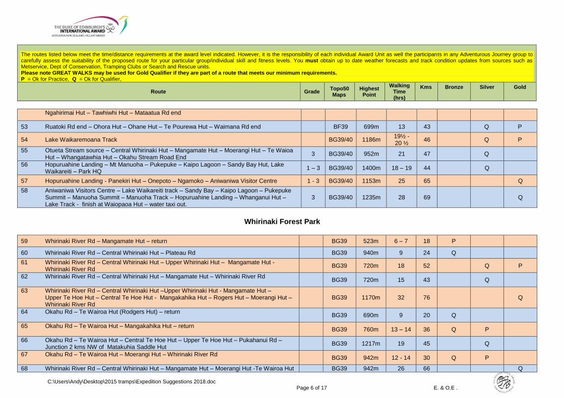
The routes listed below meet the time/distance requirements at the award level indicated. However, it is the responsibility of each individual Award Unit as well the participants in any Adventurous Journey group to carefully assess the suitability of the proposed route for your particular group/individual skill and fitness levels. You must obtain up to date weather forecasts and track condition updates from sources such as Metservice, Dept of Conservation, Tramping Clubs or Search and Rescue units. Please note GREAT WALKS may be used for Gold Qualifier if they are part of a route that meets our minimum requirements. P = Ok for Practice, Q = Ok for Qualifier,
Route Grade Topo50 Maps
Highest Point
Walking Time (hrs)
Kms
Bronze
Silver
Gold
C:\Users\Andy\Desktop\2015 tramps\Expedition Suggestions 2018.doc Page 6 of 17 E. & O.E .
Ngahirimai Hut – Tawhiwhi Hut – Mataatua Rd end
53 Ruatoki Rd end – Ohora Hut – Ohane Hut – Te Pourewa Hut – Waimana Rd end BF39 699m 13 43 Q P
54 Lake Waikaremoana Track BG39/40 1186m 19½ - 20 ½
46 Q P
55 Otueta Stream source – Central Whirinaki Hut – Mangamate Hut – Moerangi Hut – Te Waioa Hut – Whangatawhia Hut – Okahu Stream Road End
3 BG39/40 952m 21 47 Q
56 Hopuruahine Landing – Mt Manuoha – Pukepuke – Kaipo Lagoon – Sandy Bay Hut, Lake Waikareiti – Park HQ
1 – 3 BG39/40 1400m 18 – 19 44 Q
57 Hopuruahine Landing - Panekiri Hut – Onepoto – Ngamoko – Aniwaniwa Visitor Centre 1 - 3 BG39/40 1153m 25 65 Q
58 Aniwaniwa Visitors Centre – Lake Waikareiti track – Sandy Bay – Kaipo Lagoon – Pukepuke Summit – Manuoha Summit – Manuoha Track – Hopuruahine Landing – Whanganui Hut – Lake Track - finish at Waiopaoa Hut – water taxi out.
3 BG39/40 1235m 28 69 Q
Whirinaki Forest Park
59 Whirinaki River Rd – Mangamate Hut – return BG39 523m 6 – 7 18 P
60 Whirinaki River Rd – Central Whirinaki Hut – Plateau Rd BG39 940m 9 24 Q
61 Whirinaki River Rd – Central Whirinaki Hut – Upper Whirinaki Hut – Mangamate Hut - Whirinaki River Rd
BG39 720m 18 52 Q P
62 Whirinaki River Rd – Central Whirinaki Hut – Mangamate Hut – Whirinaki River Rd
BG39 720m 15 43 Q
63 Whirinaki River Rd – Central Whirinaki Hut –Upper Whirinaki Hut - Mangamate Hut – Upper Te Hoe Hut – Central Te Hoe Hut - Mangakahika Hut – Rogers Hut – Moerangi Hut – Whirinaki River Rd
BG39 1170m 32 76 Q
64 Okahu Rd – Te Wairoa Hut (Rodgers Hut) – return
BG39 690m 9 20 Q
65 Okahu Rd – Te Wairoa Hut – Mangakahika Hut – return
BG39 760m 13 – 14 36 Q P
66 Okahu Rd – Te Wairoa Hut – Central Te Hoe Hut – Upper Te Hoe Hut – Pukahanui Rd – Junction 2 kms NW of Matakuhia Saddle Hut
BG39 1217m 19 45 Q
67 Okahu Rd – Te Wairoa Hut – Moerangi Hut – Whirinaki River Rd
BG39 942m 12 - 14 30 Q P
68 Whirinaki River Rd – Central Whirinaki Hut – Mangamate Hut – Moerangi Hut -Te Wairoa Hut BG39 942m 26 66 Q
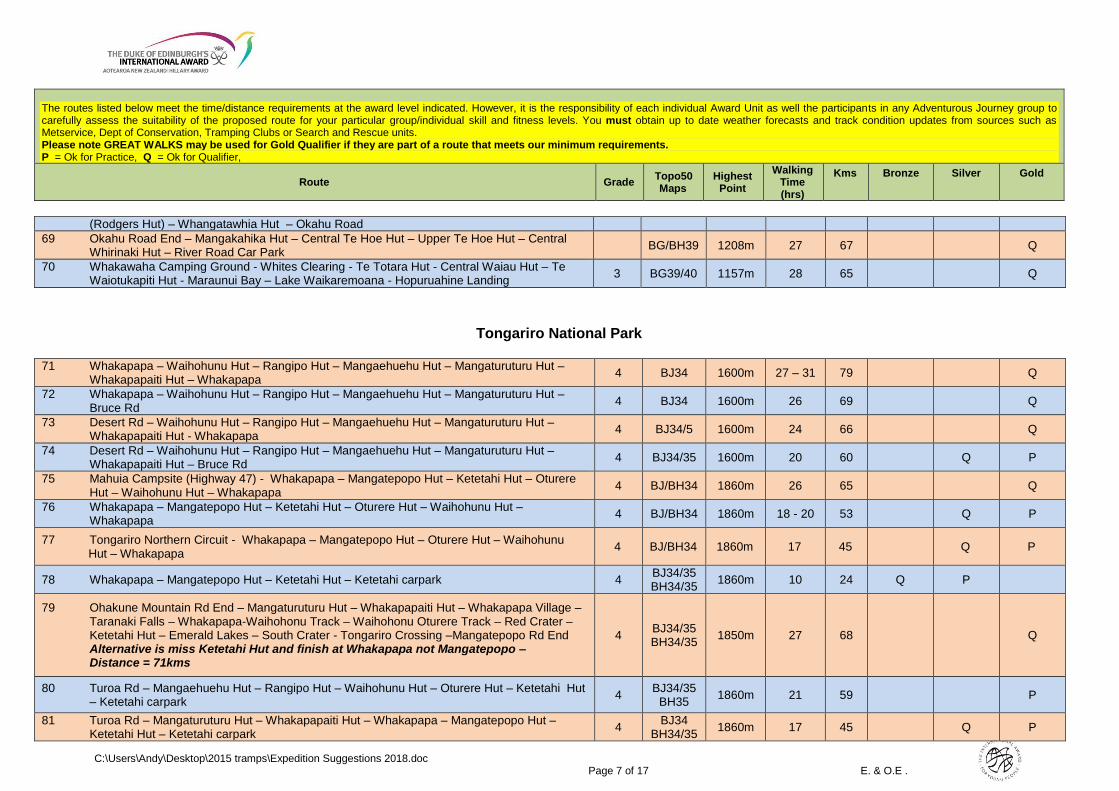
The routes listed below meet the time/distance requirements at the award level indicated. However, it is the responsibility of each individual Award Unit as well the participants in any Adventurous Journey group to carefully assess the suitability of the proposed route for your particular group/individual skill and fitness levels. You must obtain up to date weather forecasts and track condition updates from sources such as Metservice, Dept of Conservation, Tramping Clubs or Search and Rescue units. Please note GREAT WALKS may be used for Gold Qualifier if they are part of a route that meets our minimum requirements. P = Ok for Practice, Q = Ok for Qualifier,
Route Grade Topo50 Maps
Highest Point
Walking Time (hrs)
Kms
Bronze
Silver
Gold
C:\Users\Andy\Desktop\2015 tramps\Expedition Suggestions 2018.doc Page 7 of 17 E. & O.E .
(Rodgers Hut) – Whangatawhia Hut – Okahu Road
69 Okahu Road End – Mangakahika Hut – Central Te Hoe Hut – Upper Te Hoe Hut – Central Whirinaki Hut – River Road Car Park
BG/BH39 1208m 27 67 Q
70 Whakawaha Camping Ground - Whites Clearing - Te Totara Hut - Central Waiau Hut – Te Waiotukapiti Hut - Maraunui Bay – Lake Waikaremoana - Hopuruahine Landing
3 BG39/40 1157m 28 65 Q
Tongariro National Park
71 Whakapapa – Waihohunu Hut – Rangipo Hut – Mangaehuehu Hut – Mangaturuturu Hut – Whakapapaiti Hut – Whakapapa
4 BJ34 1600m 27 – 31 79 Q
72 Whakapapa – Waihohunu Hut – Rangipo Hut – Mangaehuehu Hut – Mangaturuturu Hut – Bruce Rd
4 BJ34 1600m 26 69 Q
73 Desert Rd – Waihohunu Hut – Rangipo Hut – Mangaehuehu Hut – Mangaturuturu Hut – Whakapapaiti Hut - Whakapapa
4 BJ34/5 1600m 24 66 Q
74 Desert Rd – Waihohunu Hut – Rangipo Hut – Mangaehuehu Hut – Mangaturuturu Hut – Whakapapaiti Hut – Bruce Rd
4 BJ34/35 1600m 20 60 Q P
75 Mahuia Campsite (Highway 47) - Whakapapa – Mangatepopo Hut – Ketetahi Hut – Oturere Hut – Waihohunu Hut – Whakapapa
4 BJ/BH34 1860m 26 65 Q
76 Whakapapa – Mangatepopo Hut – Ketetahi Hut – Oturere Hut – Waihohunu Hut – Whakapapa
4 BJ/BH34 1860m 18 - 20 53 Q P
77 Tongariro Northern Circuit - Whakapapa – Mangatepopo Hut – Oturere Hut – Waihohunu Hut – Whakapapa
4 BJ/BH34 1860m 17 45 Q P
78 Whakapapa – Mangatepopo Hut – Ketetahi Hut – Ketetahi carpark 4 BJ34/35 BH34/35
1860m 10 24 Q P
79 Ohakune Mountain Rd End – Mangaturuturu Hut – Whakapapaiti Hut – Whakapapa Village – Taranaki Falls – Whakapapa-Waihohonu Track – Waihohonu Oturere Track – Red Crater – Ketetahi Hut – Emerald Lakes – South Crater - Tongariro Crossing –Mangatepopo Rd End Alternative is miss Ketetahi Hut and finish at Whakapapa not Mangatepopo – Distance = 71kms
4 BJ34/35 BH34/35
1850m 27 68 Q
80 Turoa Rd – Mangaehuehu Hut – Rangipo Hut – Waihohunu Hut – Oturere Hut – Ketetahi Hut – Ketetahi carpark
4 BJ34/35
BH35 1860m 21 59 P
81 Turoa Rd – Mangaturuturu Hut – Whakapapaiti Hut – Whakapapa – Mangatepopo Hut – Ketetahi Hut – Ketetahi carpark
4 BJ34
BH34/35 1860m 17 45 Q P
The routes listed below meet the time/distance requirements at the award level indicated. However, it is the responsibility of each individual Award Unit as well the participants in any Adventurous Journey group to carefully assess the suitability of the proposed route for your particular group/individual skill and fitness levels. You must obtain up to date weather forecasts and track condition updates from sources such as Metservice, Dept of Conservation, Tramping Clubs or Search and Rescue units. Please note GREAT WALKS may be used for Gold Qualifier if they are part of a route that meets our minimum requirements. P = Ok for Practice, Q = Ok for Qualifier,
Route Grade Topo50 Maps
Highest Point
Walking Time (hrs)
Kms
Bronze
Silver
Gold
C:\Users\Andy\Desktop\2015 tramps\Expedition Suggestions 2018.doc Page 8 of 17 E. & O.E .
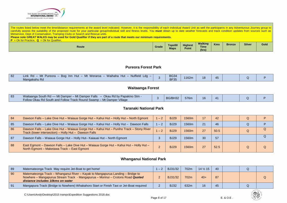
Pureora Forest Park
82 Link Rd – Mt Pureora – Bog Inn Hut – Mt Weraroa – Waihaha Hut – Nuffield Ldg –
Mangakahu Rd 3
BG34 BF35
1162m 18 45 Q P
Waitaanga Forest
83 Waitaanga South Rd –– Mt Damper – Mt Damper Falls – Okau Rd by Papakino Stm - Follow Okau Rd South and Follow Track Round Swamp – Mt Damper Village
3 BG/BH32 576m 16 41 Q P
Taranaki National Park
84 Dawson Falls – Lake Dive Hut – Waiaua Gorge Hut – Kahui Hut – Holly Hut – North Egmont 1 – 2 BJ29 1560m 17 42 Q P
85 Dawson Falls – Lake Dive Hut – Waiaua Gorge Hut – Kahui Hut – Holly Hut – Dawson Falls 1 – 2 BJ29 1560m 21 46 Q P
86 Dawson Falls – Lake Dive Hut – Waiaua Gorge Hut – Kahui Hut – Puniho Track – Stony River Track (lower intersection) – Holly Hut – Dawson Falls
1 – 2 BJ29 1560m 27 50.5 Q Q
87 Dawson Falls – Waiaua Gorge Hut – Holly Hut– Kaiauai Hut – North Egmont 3 BJ29 1560m 30 57 Q
88 East Egmont – Dawson Falls – Lake Dive Hut – Waiaua Gorge Hut – Kahui Hut – Holly Hut – North Egmont – Maketawa Track – East Egmont
2 BJ29 1560m 27 52.5 Q
Q
Whanganui National Park
89 Matemateonga Track May require Jet-Boat to get home! 1 – 2 BJ31/32 702m 14 ½ 15 40 Q
90 Matemateonga Track – Whanganui River – Kayak to Mangapurua Landing – Bridge to Nowhere – Mangapurua Stream Track - Mangapurua – Morinui – Crotons Road Quoted distance includes 10kms on water
2 BJ31/32 702m 40+ 87 Q
91 Mangapura Track (Bridge to Nowhere) Whakahoro Start or Finish Taxi or Jet-Boat required 2 BJ32 632m 16 45 Q
The routes listed below meet the time/distance requirements at the award level indicated. However, it is the responsibility of each individual Award Unit as well the participants in any Adventurous Journey group to carefully assess the suitability of the proposed route for your particular group/individual skill and fitness levels. You must obtain up to date weather forecasts and track condition updates from sources such as Metservice, Dept of Conservation, Tramping Clubs or Search and Rescue units. Please note GREAT WALKS may be used for Gold Qualifier if they are part of a route that meets our minimum requirements. P = Ok for Practice, Q = Ok for Qualifier,
Route Grade Topo50 Maps
Highest Point
Walking Time (hrs)
Kms
Bronze
Silver
Gold
C:\Users\Andy\Desktop\2015 tramps\Expedition Suggestions 2018.doc Page 9 of 17 E. & O.E .
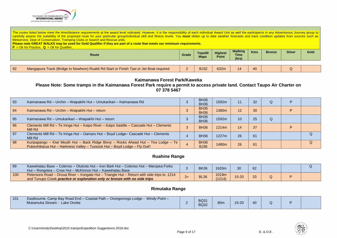
92 Mangapura Track (Bridge to Nowhere) Ruatiti Rd Start or Finish Taxi or Jet-Boat required 2 BJ32 632m 14 40 Q
Kaimanawa Forest Park/Kaweka
Please Note: Some tramps in the Kaimanawa Forest Park require a permit to access private land. Contact Taupo Air Charter on 07 378 5467
93 Kaimanawa Rd – Urchin – Waipakihi Hut – Umukarikari – Kaimanawa Rd 3 BH35 BH36
1592m 11 32 Q P
94 Kaimanawa Rd – Urchin – Waipakihi Hut – return 3 BH35 BH36
1380m 12 30 P
95 Kaimanawa Rd – Umukarikari – Waipakihi Hut – return 3 BH35 BH36 1592m 10 25 Q
96 Clements Mill Rd – Te Iringa Hut – Kaipo River – Kaipo Saddle – Cascade Hut – Clements Mill Rd
3 BH36 1214m 14 37 P
97 Clements Mill Rd – Te Iringa Hut – Oamaru Hut – Boyd Lodge– Cascade Hut – Clements Mill Rd
4 BH36 1227m 26 61 Q
98 Kuripapango – Kiwi Mouth Hut – Back Ridge Bivvy – Rocks Ahead Hut – Tira Lodge – Te Pukeohikarua Hut – Harkness Valley – Tussock Hut – Boyd Lodge – Fly Out!!
4 BH36 BJ36
1480m 26 61 Q
Ruahine Range
99 Kawwhatau Base – Colenso – Otukota Hut – Iron Bark Hut – Colenso Hut – Maropea Forks Hut – Rongotea – Crow Hut – McKinnon Hut – Kawwhatau Base
3 BK36 1620m 30 62 Q
100 Petersons Road – Oroua River – Irongate Hut – Triangle Hut – Return with side trips to .1214 and Tunupo Creek practice or exploration only or bronze with no side trips
3+ BL36 1019m (1214)
15-20 33 Q P
Rimutaka Range
101 Eastbourne, Camp Bay Road End – Coastal Path – Orongorongo Lodge - Windy Point – Mukamuka Stream - Lake Onoke
2 BQ31 BQ32
80m 15-20 40 Q P

The routes listed below meet the time/distance requirements at the award level indicated. However, it is the responsibility of each individual Award Unit as well the participants in any Adventurous Journey group to carefully assess the suitability of the proposed route for your particular group/individual skill and fitness levels. You must obtain up to date weather forecasts and track condition updates from sources such as Metservice, Dept of Conservation, Tramping Clubs or Search and Rescue units. Please note GREAT WALKS may be used for Gold Qualifier if they are part of a route that meets our minimum requirements. P = Ok for Practice, Q = Ok for Qualifier,
Route Grade Topo50 Maps
Highest Point
Walking Time (hrs)
Kms
Bronze
Silver
Gold
C:\Users\Andy\Desktop\2015 tramps\Expedition Suggestions 2018.doc Page 10 of 17 E. & O.E .
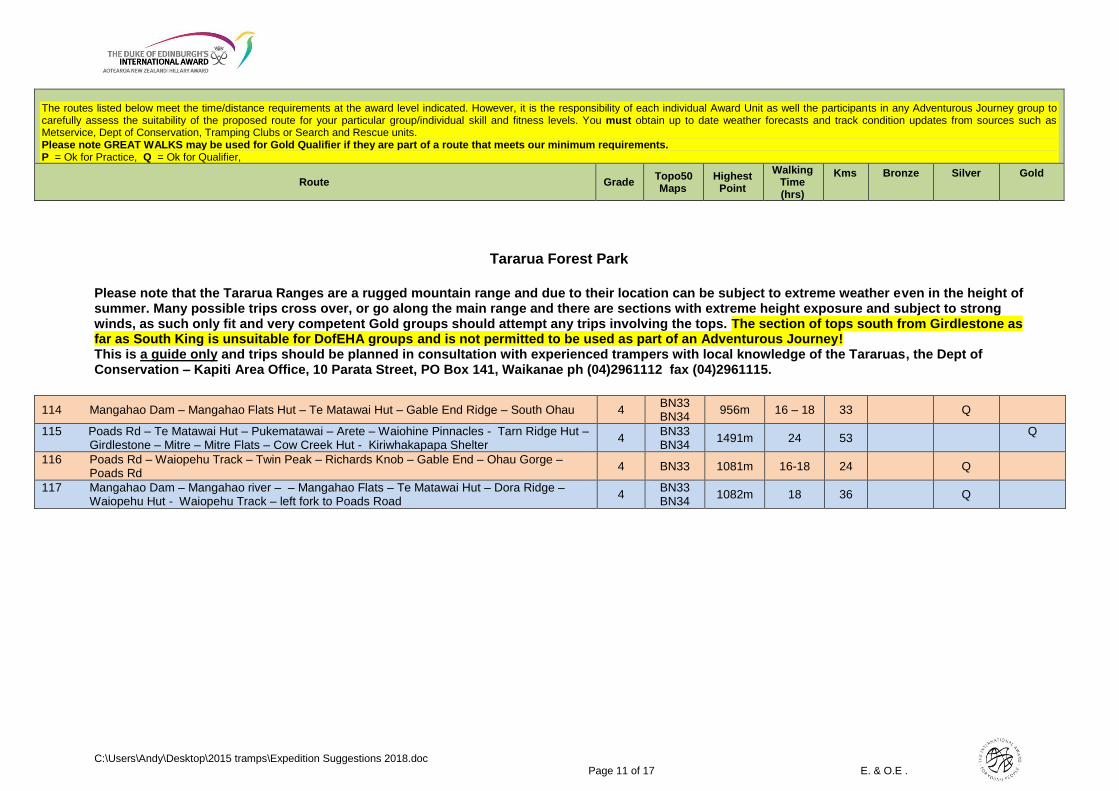
Tararua Forest Park Please note that the Tararua Ranges are a rugged mountain range and due to their location can be subject to extreme weather even in the height of summer. Many possible trips cross over, or go along the main range and there are sections with extreme height exposure and subject to strong winds, as such only fit and very competent Gold groups should attempt any trips involving the tops The section of tops south from Girdlestone as far as South King is unsuitable for DofEHA groups and is not permitted to be used as part of an Adventurous Journey! This is a guide only and trips should be planned in consultation with experienced trampers with local knowledge of the Tararuas, the Dept of Conservation – Kapiti Area Office, 10 Parata Street, PO Box 141, Waikanae ph (04)2961112 fax (04)2961115.
102 Otaki Forks – Field Hut – Kime Hut – Alpha Hut – Kaitoke Shelter 4 BP33 1520m 14 - 16 38 Q
103 Otaki Forks – Field Hut – Kime Hut – Peaks Ladder – Maungahuka Hut – Andersons Hut - Waitewaewae Hut – Otaki forks
4+ BP33 1408m 20 – 29 50 Q
104 Kaitoke – Tutuwai Hut - Totara Flats Hut – Mitre Flats – The Pines (via Barra Track) 4 BP33/34 765m 25 56 Q
105 Waiohine Valley Rd – via Reeves track to Tutuwai Hut – Totara Flats Hut – Mitre Flats – The Pines (via Barra Track)
4 BP33/34 899m 22 52 Q
106 Kaitoke – Tutuwai Hut - Totara Flats Hut – Jumbo Hut – Holdsworth Carpark via Atiwhakatu 4 BP33/34 1460m 22 52 Q
107 Otaki Forks – Renata Hut via Waiotauru River – Alpha Hut – Totara Flats – Holdsworth Carpark via Gentle Annie Track
3+ BP33/34 1360m 26 65 Q
108 Otaki Forks – Renata Hut via Waiotauru River – Alpha Hut – Cone Hut – Tauherenikau Track - Pahuratahi
3+ BP33/34 1345m 24 57 Q
109 Gladstone Road (South Ohau) - Waiopehu Hut – Te Matawai Hut – Arete (Arete Biv for lunch) and return to Te Matawai Hut – Te Matawai – Gladstone Road via Yeates Track/South Ohau NO TRACK FROM SOUTH OHAU HUT TO GLADSTONE RD AND IMPASSABLE AFTER HEAVY RAIN!
4++ BN33 1485m 20 – 30 41 Q
110 Holdsworth Lodge – Atiwhakatu Track – Barton Track – Waingawa River Track – Cow Creek Hut – Arete Forks – Cow Creek Hut – Te Mara – Kiriwhakapapa Shelter
3 BP34 BN34
1042m 18 39.5 Q P
111 Holdsworth Lodge – Mt Holdsworth Track – Totara Creek Track – Totara Flats Hut – Cone Ridge – Concertina Knob - Maungahuka Hut – Wright – Aokaparangi – Mt Holdsworth – East Holdsworth Track – Holdsworth Lodge
4 BP33 BP34
1462m 20+ 46 Q
112 Mangahao Dam – Mangahao Flats Hut – Te Matawai Hut – Arete – Tarn Ridge – Tarn Ridge Hut – Mitre Flats Hut – The Pines (via Barra Track) CAUTION WEATHER!!
4++ BN33 BP34
1547m 20+ 49 Q
113 Waiohine Valley Rd - via Reeves track to Tutuwai Hut – Totara Flats Hut to Mitre Flats Hut (via Mountain House) – Cow Creek Hut to Kiriwhakapapa Shelter
3+ BP33 BP34
1034m 29 68 Q
The routes listed below meet the time/distance requirements at the award level indicated. However, it is the responsibility of each individual Award Unit as well the participants in any Adventurous Journey group to carefully assess the suitability of the proposed route for your particular group/individual skill and fitness levels. You must obtain up to date weather forecasts and track condition updates from sources such as Metservice, Dept of Conservation, Tramping Clubs or Search and Rescue units. Please note GREAT WALKS may be used for Gold Qualifier if they are part of a route that meets our minimum requirements. P = Ok for Practice, Q = Ok for Qualifier,
Route Grade Topo50 Maps
Highest Point
Walking Time (hrs)
Kms
Bronze
Silver
Gold
C:\Users\Andy\Desktop\2015 tramps\Expedition Suggestions 2018.doc Page 11 of 17 E. & O.E .
Tararua Forest Park
Please note that the Tararua Ranges are a rugged mountain range and due to their location can be subject to extreme weather even in the height of summer. Many possible trips cross over, or go along the main range and there are sections with extreme height exposure and subject to strong winds, as such only fit and very competent Gold groups should attempt any trips involving the tops. The section of tops south from Girdlestone as far as South King is unsuitable for DofEHA groups and is not permitted to be used as part of an Adventurous Journey! This is a guide only and trips should be planned in consultation with experienced trampers with local knowledge of the Tararuas, the Dept of Conservation – Kapiti Area Office, 10 Parata Street, PO Box 141, Waikanae ph (04)2961112 fax (04)2961115.
114 Mangahao Dam – Mangahao Flats Hut – Te Matawai Hut – Gable End Ridge – South Ohau 4 BN33 BN34
956m 16 – 18 33 Q
115 Poads Rd – Te Matawai Hut – Pukematawai – Arete – Waiohine Pinnacles - Tarn Ridge Hut – Girdlestone – Mitre – Mitre Flats – Cow Creek Hut - Kiriwhakapapa Shelter
4 BN33 BN34
1491m 24 53 Q
116 Poads Rd – Waiopehu Track – Twin Peak – Richards Knob – Gable End – Ohau Gorge – Poads Rd
4 BN33 1081m 16-18 24 Q
117 Mangahao Dam – Mangahao river – – Mangahao Flats – Te Matawai Hut – Dora Ridge – Waiopehu Hut - Waiopehu Track – left fork to Poads Road
4 BN33 BN34
1082m 18 36 Q

The routes listed below meet the time/distance requirements at the award level indicated. However, it is the responsibility of each individual Award Unit as well the participants in any Adventurous Journey group to carefully assess the suitability of the proposed route for your particular group/individual skill and fitness levels. You must obtain up to date weather forecasts and track condition updates from sources such as Metservice, Dept of Conservation, Tramping Clubs or Search and Rescue units. Please note GREAT WALKS may be used for Gold Qualifier if they are part of a route that meets our minimum requirements. P = Ok for Practice, Q = Ok for Qualifier,
Route Grade Topo50 Maps
Highest Point
Walking Time (hrs)
Kms
Bronze
Silver
Gold
C:\Users\Andy\Desktop\2015 tramps\Expedition Suggestions 2018.doc Page 12 of 17 E. & O.E .
SOUTH ISLAND
Queen Charlotte Sound
118 Queen Charlotte Walkway 2 BP29
BQ28/29 451m 24 66 Q
Kahurangi National Park
119 Heaphy Track 2 BP22 BP23
990m 26 77 Q
120 Wangapeka Track – Finish at Kongahu Swamp Rd 2 BQ22 BQ23
1101m 26 67 Q
121 Cobb Road end – Fenella Hut – return 2 BP23 BP24
1100m 7 13 P
Abel Tasman National Park
122 Clifton, Bird Rd End – Wainui Track – Inland Track – Centre Peak – Whariwharangi Hut – Anapai Bay Track – Totaranui Beach – Awaroa Hut caution low tide estuary crossing – Awaroa Lodge – Tonga Saddle – Coast Track – Bark Bay Hut – Torrent Bay – Holyoak Clearing or Coast Track – Marahau Education Centre
3 BP25 BN25
1018m 26-32 73-79
Q
Nelson Lakes National Park
123 Travers – Sabine Circuit (via Mt Cedric and Lake Angelus) * Add 15km if doing Blue Lake side trip and a further 16km if not using water taxi to & from Lakehead hut
2 – 4 BS24 1800m 26 65* Q
124 Travers – Sabine Circuit (via Speargrass Hut) Start Lakehead Hut – Finish Mt Robert Carpark *Add 15km if doing Blue Lake side trip and a further 8km if not using water taxi to Lakehead hut
2 – 3 BS24 1800m 24+ 66* Q
125 Mt Robert Carpark – Speargrass – Sabine – Angelus circuit *Add 8km if not using water taxi from Lakehead Hut
2 – 4 BS24 1770m 16 40* Q P
The routes listed below meet the time/distance requirements at the award level indicated. However, it is the responsibility of each individual Award Unit as well the participants in any Adventurous Journey group to carefully assess the suitability of the proposed route for your particular group/individual skill and fitness levels. You must obtain up to date weather forecasts and track condition updates from sources such as Metservice, Dept of Conservation, Tramping Clubs or Search and Rescue units. Please note GREAT WALKS may be used for Gold Qualifier if they are part of a route that meets our minimum requirements. P = Ok for Practice, Q = Ok for Qualifier,
Route Grade Topo50 Maps
Highest Point
Walking Time (hrs)
Kms
Bronze
Silver
Gold
C:\Users\Andy\Desktop\2015 tramps\Expedition Suggestions 2018.doc Page 13 of 17 E. & O.E .
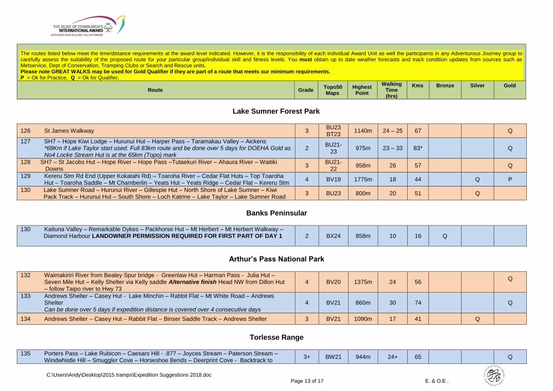
Lake Sumner Forest Park
126 St James Walkway 3 BU23 BT23
1140m 24 – 25 67 Q
127 SH7 – Hope Kiwi Lodge – Hurunui Hut – Harper Pass – Taramakau Valley – Aickens *68Km if Lake Taylor start used. Full 83km route and be done over 5 days for DOEHA Gold as No4 Locke Stream Hut is at the 65km (Topo) mark
2 BU21-
23 975m 23 – 33 83* Q
128 SH7 – St Jacobs Hut – Hope River – Hope Pass –Tutaekuri River – Ahaura River – Waitiki Downs
3 BU21-
22 958m 26 57 Q
129 Kereru Stm Rd End (Upper Kokatahi Rd) – Toaroha River – Cedar Flat Huts – Top Toaroha Hut – Toaroha Saddle – Mt Chamberlin – Yeats Hut – Yeats Ridge – Cedar Flat – Kereru Stm
4 BV19 1775m 18 44 Q P
130 Lake Sumner Road – Hurunui River – Gillespie Hut – North Shore of Lake Sumner – Kiwi Pack Track – Hurunui Hut – South Shore – Loch Katrine – Lake Taylor – Lake Sumner Road
3 BU23 800m 20 51 Q
Banks Peninsular
130 Kaituna Valley – Remarkable Dykes – Packhorse Hut – Mt Herbert – Mt Herbert Walkway – Diamond Harbour LANDOWNER PERMISSION REQUIRED FOR FIRST PART OF DAY 1
2 BX24 858m 10 16 Q
Arthur’s Pass National Park
132 Waimakiriri River from Bealey Spur bridge - Greenlaw Hut – Harman Pass - Julia Hut – Seven Mile Hut – Kelly Shelter via Kelly saddle Alternative finish Head NW from Dillon Hut – follow Taipo river to Hwy 73
4 BV20 1375m 24 56 Q
133 Andrews Shelter – Casey Hut - Lake Minchin – Rabbit Flat – Mt White Road – Andrews Shelter Can be done over 5 days if expedition distance is covered over 4 consecutive days
4 BV21 860m 30 74 Q
134 Andrews Shelter – Casey Hut – Rabbit Flat – Binser Saddle Track – Andrews Shelter 3 BV21 1090m 17 41 Q
Torlesse Range
135 Porters Pass – Lake Rubicon – Caesars Hill - .877 – Joyces Stream – Paterson Stream – Windwhistle Hill – Smuggler Cove – Horseshoe Bends – Deerprint Cove - Backtrack to
3+ BW21 944m 24+ 65 Q
The routes listed below meet the time/distance requirements at the award level indicated. However, it is the responsibility of each individual Award Unit as well the participants in any Adventurous Journey group to carefully assess the suitability of the proposed route for your particular group/individual skill and fitness levels. You must obtain up to date weather forecasts and track condition updates from sources such as Metservice, Dept of Conservation, Tramping Clubs or Search and Rescue units. Please note GREAT WALKS may be used for Gold Qualifier if they are part of a route that meets our minimum requirements. P = Ok for Practice, Q = Ok for Qualifier,
Route Grade Topo50 Maps
Highest Point
Walking Time (hrs)
Kms
Bronze
Silver
Gold
C:\Users\Andy\Desktop\2015 tramps\Expedition Suggestions 2018.doc Page 14 of 17 E. & O.E .
Kowai Bush Spur – Contour to south of .877 – cross Rubicon Rd – finish Kowai rd
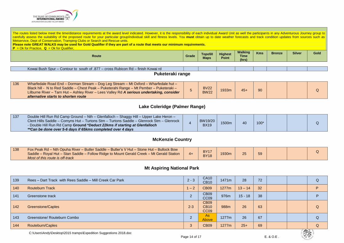
Puketeraki range
136 Wharfedale Road End – Dorman Stream – Dog Leg Stream – Mt Oxford – Wharfedale hut – Black hill - N to Red Saddle – Chest Peak – Puketerahi Range – Mt Pember – Puketeraki – Lilburne River – Tarn Hut – Ashley River – Lees Valley Rd A serious undertaking, consider alternative starts to shorten route
5 BV22 BW22
1933m 45+ 90 Q
Lake Coleridge (Palmer Range)
137 Double Hill Run Rd Camp Ground – Nth – Glenfalloch – Shaggy Hill – Upper Lake Heron – Clent Hills Saddle – Comyns Hut – Turtons Stm – Turtons Saddle – Glenrock Stm – Glenrock - Double Hill Run Rd Camp Ground *Deduct 22kms if starting at Glenfalloch **Can be done over 5-6 days if 65kms completed over 4 days
4 BW19/20
BX19 1500m 40 100* Q
McKenzie Country
138 Fox Peak Rd – Nth Opuha River – Butler Saddle – Butler’s V Hut – Stone Hut – Bullock Bow Saddle – Royal Hut – Stan Saddle – Follow Ridge to Mount Gerald Creek – Mt Gerald Station Most of this route is off-track
4+ BY17 BY18
1930m 25 59 Q
Mt Aspiring National Park
139 Rees – Dart Track with Rees Saddle – Mill Creek Car Park 2 - 3 CA10 CB10
1471m 28 72 Q
140 Routeburn Track 1 – 2 CB09 1277m 13 – 14 32 P
141 Greenstone track 2 CB09 CC09
976m 15 - 18 38 P
142 Greenstone/Caples 2-3 CB09 CB10 CC09
988m 26 63 Q
143 Greenstone/ Routeburn Combo 2 As
Above 1277m 26 67 Q
144 Routeburn/Caples 3 CB09 1277m 25+ 69 Q

The routes listed below meet the time/distance requirements at the award level indicated. However, it is the responsibility of each individual Award Unit as well the participants in any Adventurous Journey group to carefully assess the suitability of the proposed route for your particular group/individual skill and fitness levels. You must obtain up to date weather forecasts and track condition updates from sources such as Metservice, Dept of Conservation, Tramping Clubs or Search and Rescue units. Please note GREAT WALKS may be used for Gold Qualifier if they are part of a route that meets our minimum requirements. P = Ok for Practice, Q = Ok for Qualifier,
Route Grade Topo50 Maps
Highest Point
Walking Time (hrs)
Kms
Bronze
Silver
Gold
C:\Users\Andy\Desktop\2015 tramps\Expedition Suggestions 2018.doc Page 15 of 17 E. & O.E .
CB10
145 Mavora Walkway – Elfin Bay 2 See 141 765m 15+ 51 Q P
146 Mavora/Greenstone – Finish at Divide Shelter 2-3 CB09 CC09
976 25 66 Q
147 Young- Wilkin via Gillespie Pass (jet boat required) Add 16kms if walking to/from Kerin Forks Can be used at Gold if Siberia Hut to Crucible Lake Side Trip added
4 BZ12 1500m 16 - 25 40S 65G
Q Q
Fiordland National Park
148 Milford Track 1 – 2 CB08 1150m 18 54 Q P
149 Kepler Track (start at Control Gates, finish at camp ground) 1 – 2 CD07 CD08
1406m 25 65 Q
150 Hollyford Track (road end to Martins Bay then return on jet boat to Lake Alabaster) 1 – 2 CA09 CB09
168m 22 52 Q P
151 Dusky Track (Lake Manapouri – Supper Cove then fly out) 4+ CE05 CE06 CD06
1050m 20 – 22 40 Q
152 Dusky Track (Lake Hauroko – Supper Cove – Lake Manapouri) 4+ CE05 CE06 CD06
1121m 37 - 44 82 Q
153 Dusky Track (Lake Hauroko – Loch Maree – Lake Manapouri) 4+ CD/CE06 1121m 25 – 30 56 Q
154 Hump Ridge Track (Papatotara Coast Rd-Track Burn-Okaka Hut- Percy Burn Viaduct-Port Craig Village Return) or reverse.
3 CG07 970m 24 58 Q
155 Manapouri - Hope Arm – Rakatu – Black Valley - Manapouri 1 CD/CE07 210m 8 - 10 30 Q
156 Manapouri (opposite Pearl Harbour) - Hope Arm Hut – South to Garnock burn – Snow White Clearing – South at 698 Grid Line to point 920 – point 1109 – North Borland Hut – Borland Lodge
3 CE07 20 - 22 40 Q P

The routes listed below meet the time/distance requirements at the award level indicated. However, it is the responsibility of each individual Award Unit as well the participants in any Adventurous Journey group to carefully assess the suitability of the proposed route for your particular group/individual skill and fitness levels. You must obtain up to date weather forecasts and track condition updates from sources such as Metservice, Dept of Conservation, Tramping Clubs or Search and Rescue units. Please note GREAT WALKS may be used for Gold Qualifier if they are part of a route that meets our minimum requirements. P = Ok for Practice, Q = Ok for Qualifier,
Route Grade Topo50 Maps
Highest Point
Walking Time (hrs)
Kms
Bronze
Silver
Gold
C:\Users\Andy\Desktop\2015 tramps\Expedition Suggestions 2018.doc Page 16 of 17 E. & O.E .
Central Otago
157 Arrowtown – German Hill – Big Hill Walkway – Macetown – 8 Mile Hut – Hayes Creek – Arrow River - Arrowtown
2 CB11 1051m 12 31 Q P
158 Arrowtown – Motatapu Walkway – Big Hill – Macetown – side trip to Homeward Bound Battery area – Roses Hut – Highland Creek Hut – Fern Burn Car Park check doc site for route
4 CB11 CB12
1523m 32 56 Q
159 Shotover River: Wong Gong Creek - Stockyard Creek (Campbells Saddle) – Sixteen Mile Huts
- Pine Creek Flat - Sixteen Mile Huts – Campbells Saddle Check vehicular access before planning
3 CA11 CB11
733m 24 70 Q
Dunedin
160 Semple Road – Silver Peaks Route – Jubilee Hut – The Gap – Yellow Hut – point 419 – Mountain Track Road
2 CE17 777m 10 26 Q
Catlins
161 The Wisp 2 CG14 200m 5 13 P
Southland
162 Kiwiburn – Whitestone River - Return 2 CD09 779m 8 - 9 25 Q
Stewart Island
163 Rakiura track **Could be Qualifier with side trips 2 CH09 300m 15 37 Q P**
164 Stewart Island Circuit * It may be possible to do both practice and qualifier on the Circuit. Check with National Office for requirements
3
CH08 CH09 CJ08 CJ09
388m 45+ 127 Q*

The routes listed below meet the time/distance requirements at the award level indicated. However, it is the responsibility of each individual Award Unit as well the participants in any Adventurous Journey group to carefully assess the suitability of the proposed route for your particular group/individual skill and fitness levels. You must obtain up to date weather forecasts and track condition updates from sources such as Metservice, Dept of Conservation, Tramping Clubs or Search and Rescue units. Please note GREAT WALKS may be used for Gold Qualifier if they are part of a route that meets our minimum requirements. P = Ok for Practice, Q = Ok for Qualifier,
Route Grade Topo50 Maps
Highest Point
Walking Time (hrs)
Kms
Bronze
Silver
Gold
C:\Users\Andy\Desktop\2015 tramps\Expedition Suggestions 2018.doc Page 17 of 17 E. & O.E .