the romano-british exploitation of coastal wetlands: survey and … · 2019. 9. 13. · roman...
TRANSCRIPT

ORE Open Research Exeter
TITLE
The Romano-British Exploitation of Coastal Wetlands Survey and Excavation on the North SomersetLevels 1993-7
AUTHORS
Rippon Stephen
JOURNAL
Britannia
DEPOSITED IN ORE
03 March 2008
This version available at
httphdlhandlenet1003619573
COPYRIGHT AND REUSE
Open Research Exeter makes this work available in accordance with publisher policies
A NOTE ON VERSIONS
The version presented here may differ from the published version If citing you are advised to consult the published version for pagination volumeissue and date ofpublication
The Romano-British Exploitation of Coastal Wetlands Survey and Excavation onthe North Somerset Levels 1993-7
Stephen Rippon G Aalbersberg J R L Allen S Allen N Cameron C Gleed-Owen PDavies S Hamilton-Dyer S Haslett J Heathcote J Jones A Margetts D Richards N ShielD Smith J Smith J Timby H Tinsley H Williams Julie Jones Nigel Cameron Paul DaviesSimon Dobinson Chris Gleed-Owen Simon Haslett Jen Heathcote Anthony Margetts DavidSmith Heather Tinsley Huw Williams Gerard Aalbersberg Sheila Hamilton-Dyer Jane TimbyNorman Shiel David Richards Steven Allen
Britannia Vol 31 (2000) pp 69-200
Stable URL
httplinksjstororgsicisici=0068-113X28200029313C693ATREOCW3E20CO3B2-W
Britannia is currently published by Society for the Promotion of Roman Studies
Your use of the JSTOR archive indicates your acceptance of JSTORs Terms and Conditions of Use available athttpwwwjstororgabouttermshtml JSTORs Terms and Conditions of Use provides in part that unless you have obtainedprior permission you may not download an entire issue of a journal or multiple copies of articles and you may use content inthe JSTOR archive only for your personal non-commercial use
Please contact the publisher regarding any further use of this work Publisher contact information may be obtained athttpwwwjstororgjournalssprshtml
Each copy of any part of a JSTOR transmission must contain the same copyright notice that appears on the screen or printedpage of such transmission
The JSTOR Archive is a trusted digital repository providing for long-term preservation and access to leading academicjournals and scholarly literature from around the world The Archive is supported by libraries scholarly societies publishersand foundations It is an initiative of JSTOR a not-for-profit organization with a mission to help the scholarly community takeadvantage of advances in technology For more information regarding JSTOR please contact supportjstororg
httpwwwjstororgSun Mar 2 082155 2008
The Romano-British Exploitation of Coastal Wetlands Survey and Excavation
on the North Somerset Levels 1993-7 By STEPHEN RIPPON
with contributions by G Aalbersberg JRL Allen S Allen N Cameron C Gleed-Owen P Davies S Hamilton-Dyer S Haslett J Heathcote J Jones A Margetts D Richards N Shiel D Smith J Smith J Timby H Tinsley
and H Williams
INTRODUCTION THE ROMANO-BRITISH EXPLOITATION OF COASTAL WETLANDS
Areas of coastal marshland formed an important and distinctive part of the landscape of Roman Britain and current work is showing that different wetlands were utilised in very different ways Some areas for example in Essex and Kent were simply exploited for
their natural resources to produce salt and support seasonal grazing Parts of Fenland were also used in this way though the higher coastal siltlands were modified through the creation of drainage systems in order to improve agricultural opportunities within a landscape that was still liable to tidal flooding A third strategy towards wetland exploitation is reclamation a major transformation of the natural environment involving the construction of a sea wall along the coast to keep tidal waters out and a system of drainage ditches cut into the surface of the former saltmarsh to lower the water table and remove surface run-off from the surrounding uplands
One example of this strategy towards wetland exploitation was the Wentlooge Level adjacent to the Severn Estuary in South-East Wales where up to c 27 km2 were embanked and systematically drained with a carefully-planned system of long narrow fields probably to provide meadow land for the military establishment at Caerleon4 (FIG 1 ) Similar work may have been undertaken in the western part of the adjacent Caldicot Level where parts of a buried Roman drainage system have recently been uncovered close to where an inscription was found during the nineteenth century recording work by legionaries on a linear earthwork presumably a sea wa1lj Across the Estuary in the Central Somerset Levels it appears that a conscious decision was made to divide the coastal marshes and exploit their potential in two different ways6 The area between the rivers Axe and Parrett was divided by a now extinct river (named i n a Saxon charter as the Siger) The area to the south (towards the Parrett Estuary) was left as a tidally inundated marsh used to produce salt possibly in order to supply the military establishment in South Wales The latter also received
I Fawn el al 1990 Wilkinson and Murphy 1995 Cunliffe 1988a Reeves 1995 Crowson 1994 Leah 1992 Murphy 1992 1993 1994 Allen and Fulford 1986 Fulford e1 al 1994 Rippon 1996a 25-32 Bell 1994 Knight 1962 Locock 1996 1997 Rippon 1996a 32-5
6 Rippon 1995b 1997a 65-77
STEPHEN RIPPON
FIG 1 The Severn Estuary and adjacent wetlands
71 ROMANO-BRITISH EXPLOITATION OF COASTAL WETLANDS NORTH SOMERSET LEVELS
pottery from Dorset (BBI) shipped via a port at Crandon Bridge lying near the mouth of the Parrett In contrast the marshes to the north of the Sigeraround Brent Knoll were reclaimed and saw the construction of several substantial stone buildings including a possible villa at Lakehouse Farm
The process of reclamation involves a considerable investment of manpower and materials alongside the conscious substitution of one set of resources (such as the opportunity for salt production) with another (for example a longer grazing season and a more suitable environment for arable farming) The decision whether to exploit modify or transform an area of marshland should reflect wider socio-economic trends within a region including the perceived relative value of natural resources and the demand for increased agricultural production Therefore as a contribution to our understanding of Romano-British attitudes to the landscape the programme of fieldwork reported here was designed to examine when and why the decision was taken to reclaim one of the coastal wetlands that border the Severn Estuary in South-West Britain the North Somerset Levels near Weston-super-Mare
THE NORTH SOMERSET LEVELS PROJECT
One of the major problems with investigating Romano-British landscapes on the Severn Estuary Levels is that in most places they are sealed by c 05-15 m of later alluvium By contrast various surface finds of material from the North Somerset Levels made during the 1950-60s suggested that the Romano-British ground surface lay within reach of the p l o ~ g h ~ while several undated earthwork complexes that formed extensive relict landscapes on a different orientation to the present pattern of fields and roads could potentially have been Romano-British9 (FIG 2) This made it an ideal area in which to investigate the Romano-British use of coastal wetlands
The North Somerset Levels comprise c 100 km2 of low-lying ground near Weston-super- Mare on the eastern side of the Severn Estuary (FIG 2) The surface deposits mostly comprise bluelgrey silty clays of the Wentlooge Formation deposited in a mudflatlsaltmarsh environment though at the inland margins of the Levels in the lowest-lying backfens there are areas of surface peatI0 Parts of the coast between the bedrock outcrops at Uphill Worlebury and Middle- hope are currently protected by sand dunes and observations in Weston-super-Mare indicate that this natural coastal barrier has existed since before the Roman period There is no evidence whether the remaining stretch of coastline between Middlehope and Clevedon has ever been protected by a natural barrier and a substantial earthen sea wall currently keeps the tide at bay Any Romano-British sea wall is likely to have been lost to erosion which on the Welsh side of the Estuary has caused the coast to retreat by up to c 08 km since the Roman periodI2 It has been estimated that Roman MHWST (Mean High Water Spring Tides) at this point in the Estuary (c 56 m OD) was similar to the contemporary ground surface towards the coast (c 55 m OD) but up to c 1 m above the height of the Romano-British landscapes several miles inland (c 45-48 m OD)
Analogy with parts of the English FenlandI4 and the North German wetlandsI5 suggests that
Allen and Fulford 1996 Clarke 1974 1975 1976a b 1980 Lilly and Usher 1972 Broomhead 1994 and unpublished survey of Congresbury Parish Gardner 1985 McDonnell 1988
l o Butler 1987 Gilbertson and Hawkins 1978 Rippon 199421-34 1995a 3 5 4 7 Rippon 1997a 35
l 2 Allen 1990 13-28 Allen and Rippon 1997a l 3 Rippon 1997a 109-10 l 4 See note 3 I s Korber-GrOhne I98 1
72 S T E P H E N RIPPON
alluvium pottery scatter
BANWELL MOOR 0
FIG 2 The North Somerset Levels Major Romano-British sites including the relict landscapes
agricultural settlements associated with ditched field-systems need not imply a reclaimed landscape complete with a sea wall it is quite possible to practise a mixed agricultural economy on a high saltmarsh though the drainage ditches would have been subject to tidal influence and thus contained a brackish environment Therefore one of the key questions to be answered for the North Somerset Levels was whether the relict landscapes there were Romano-British in date and if so whether they lay in an intertidal environment as was the case in the Fenland or in a reclaimed landscape similar to that of today If the latter was the case then when did this major transformation of the landscape take place and who was responsible
73 ROMANO-BRITISHEXPLOITATION OF C04ST4LWETLANDS NORTH SOMERSET LEVELS
Two of the best preserved relict landscapes on the North Somerset Levels on Banwell and Kenn Moors weye chosen for this programme of survey and excavation with very limited work carried out on a third at Puxton A pottery assemblage from an old excavation on the fourth landscape at Manor Farm Kenn was also examined The aim was to obtain a plan of each relict landscape to establish their character and broad chronological development and to investigate their wider landscape context to establish in particular whether they lay in a saltmarsh or a freshwater (ie reclaimed) environment Each site was under a mixture of arable and pasture and a wide range of survey techniques were applied as appropriate (aerial reconnaissance earthwork survey and fieldwalking with certain areas selected for metal detecting and geophysics) This led to a series of carefully targeted small-scale excavations which enabled the collection of material culture and palaeoenvironmental assemblages
The following report is divided into three sections Firstly the evidence from Banwell Kenn Moor and Puxton is described with comments on the character and date of each landscape Secondly the environmental data are brought together and arranged in a chronological discussion based around the major environmental and cultural changes in the landscape his is followed by the specialist reports relating to the environmental and artefactual material and finally a general discussion
S U R V E Y AND EXCAVATION AT BANWELL MOOR
The Romano-British landscape on Banwell Moor (NGR c ST 390 617) is situated c 07 km north-west of the fen-edge at Woolvershill and 25 km north-west of the Romano-British villa and modern village of Banwell (FIG 2) The relict landscape lies on an area of estuarine alluv- ium in one of the lowest-lying parts of the North Somerset Levels which during the medieval period was left as common pasture and was only enclosed through Parliamentary Act in 1797 The Romano-British ground surface lies at c 45-51 m OD compared to the modern ground surface at 48-53 m OD making it the lowest-lying of the three Romano-British landscapes examined
The Romano-British settlement on Banwell Moor was discovered by Marie Clarke in 1974 when trenches for tile under-drainage produced a small amount of Romano-British pottery and a scatter of stone rubble in the western half of Twenty Acres Field by Waterloo Farm (FIG 3V PL I) subsequent ploughing failed to produce any further materialI6 An antiquarian reference also refers to the discovery of an undated human skeleton around 1800 at Taggs Hatch in the western part of Banwell Moor17 The location of this burial is unknown though it is interesting to note that a fragment of human bone was recovered during the excavation of Trench I1 (see Hamilton-Dyer below)
A series of low-level air photographs taken in 1946 and 195018 reveals the earthworks of an extensive relict landscape in the same area large parts of which have now been ploughed flat These early photographs along with further aerial reconnaissance as part of this project ground- survey in those fields where earthworks survive and two resistivity surveys enabled the plan of this relict landscape to be established (FIG 3) To the north and west there were several clusters of enclosures slight platforms and small paddocks set within larger rectilinear fields Three possible farmstead complexes can be identified to the north and east of Cannaways Farm (FIG 3 I 11 and III) with two others to the south-east of Waterloo Farm adjacent to a complex of palaeo-
6 Clarke 1974 1 l 7 Clarke 1977 1-2
1946 RAF 3GTUDIUK1521 Part 11 1950 R4F 541414260 1995and 1996 flights by the author
74 STEPHEN RIPPON
edge o f Banwel l l l o o r 1797
en r t l~work ( f rom air photograph)
ear thwork ( f rom ground s u n eb )
palaeochannel ( f rom ai r photograpli)
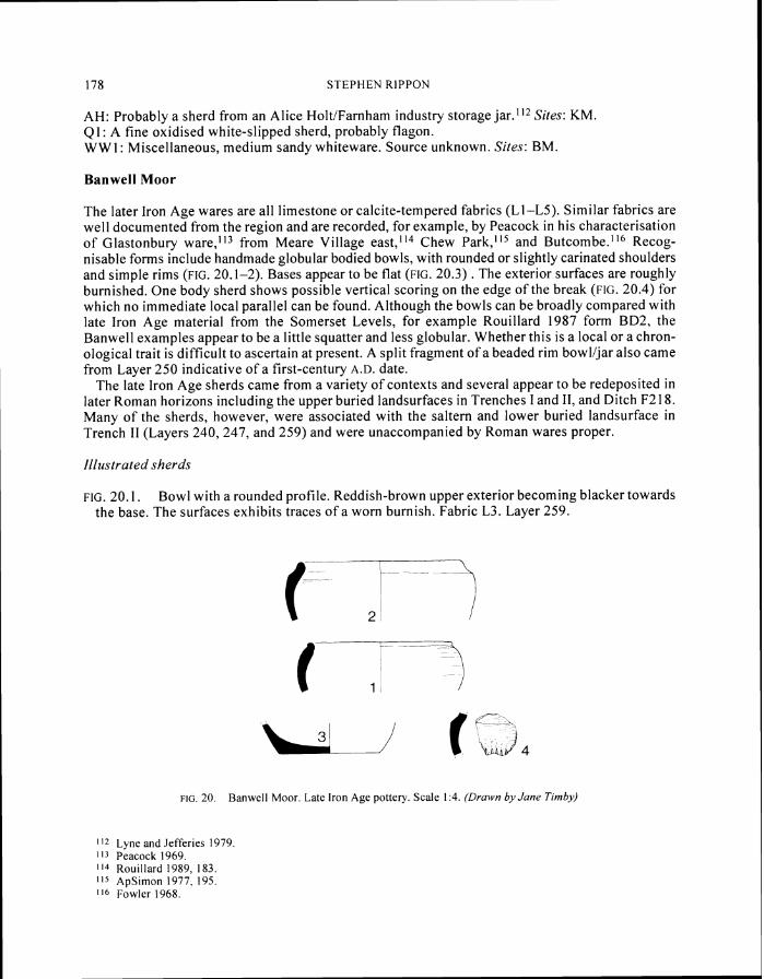
FIG 3 Banwell Moor Plan o f relict landscape from air photograph~c transcription and ground survey Six potential farmstead complexes are marked I-VI
channels (FIG 3 V and VI) Between Cannaways and Waterloo Farm lies an apparently fairly isolated roughly square enclosure associated with a double-ditched feature (FIG 3 IV) Each of these complexes has a broadly co-axial layout though there is little evidence for any overall land- scape planning or systematic reclamation as seen on the Wentlooge Level a process of gradual piecemeal colonisation is suggested
The opportunity arose to fieldwalk five fields in the western part of this relict landscape Very little material was recovered (as was the case in 1974 see above) apart from a small and discrete concentration of later Roman pottery on the western side of West Moor Rhyne (FIG 4)19 The scarcity of Roman material in the ploughsoil is partly explained by the fact that in some areas the Roman landsurface is buried by later alluvium though this is not always the case However where this buried landsurface has been excavated in Trenches I and 11 it was found to contain very little pottery and so in part the lack of material recovered through fieldwalking may genuinely reflect low-intensity off-site activity such as manuring (especially compared to Kenn Moor and Puxton see below)
9 See Rippon 1997b for the detailed fieldwalking results
75 ROMANO-BRITISH EXPLOITATION OF COASTAL WETLANDS NORTH SOMERSET LEVELS
FIG 4 Banwell Moor Plan of relict landscape in Fields 4 and 7 (potential farmstead complexes IV and V on FIG 3) from air photographic transcription and resistivity survey
TRENCH I (FIGS 4 and 6)
A combination of earthwork and resistivity surveyZ0 showed that the enclosure in Field 4 was c 30 m square and lay to the north-east o f a slightly curvilinear double-ditched feature which can be traced on the 1946 air photographs for some 70 m Fieldwalking produced just four sherds from the area of the enclosure while a soil chemistry survey by Andrew Jackson also indicated a relatively low level of human activity Concentrations of settlement-indicative copper lead and zinc were evident over the enclosure ditches while there were slightly higher than average levels
20 The resistivity survey was carried out by Kerry Ely Richard McConnell and Alex Turner using a Geoscan RM15 resistance meter operated in the twin electrode configuration with a mobile probe spacing of 05 m Readings were collected at 10 m intervals along zig-zag traverses 10 m apart The data was down-loaded to a desk-top PC and processed using Cieoplot 20 This is consistent with attested problems with this prospection method which can often return average to poor responses over certain geologies such as alluvium and mudstoneslclay (English Heritage Geophys~cal Survey rn Archaeological Field Evaluation 1995 10-1 1)
76 STEPHEN RIPPON
Minimum 43 Standard Maximum 86 Deviation Mean 623
FIG 5 Banwell Moor Results of resistivity survey in the western part of Field 7 (for location see FIG 4)
77 ROMANO-BRITISH EXPLOITATION O F COASTAL WETLANDS NORTH SOMERSET LEVELS
of chromium cobalt manganese and nickel in the general vicinity though far lower than has been recorded at known settlement sites2
Trench I showed that the two parallel ditches were just c 3 m apart presumably defining a trackway Each ditch (F2 and F4) had a shallow U-shaped profile c 26 m wide and at least 07 m deep they could not be bottomed due to a high natural watertable though their profile suggests an original depth of c 08-10 m Each contained two fills a lower light-to-mid-bluelgrey silty clay (F2 35 F4 3 I) and an upper more oxidised mid-bluelbrown silty clay (F2 3 F4 5) These were separated by a thin layer of mid-to-dark bluelgrey slightly silty clay (F2 17 F4 16) which rose up the sides of each ditch before levelling out to form a roughly horizontal buried land surface
The ditch forming the south-east side of this enclosure was also sectioned (F6) It was c 35 m wide and at least 07 m deep it could not be bottomed due to the high watertable but its profile suggests that it may have been c 1 O-12 m deep The basal fill (48) comprised an organically rich black silty clay overlain by a mid-bluelgrey silty clay (38) very similar to Layers 35 and 3 1 in F2 and F4 This was sealed by a dark horizon (29) which probably equates with that seen in F2 and F4 though in F6 it was much thicker darker and located lower down in the ditch profile This in turn was overlain by a relatively dark organically rich bluelgrey silty clay (28) and finally a more oxidised mid-bluelbrown silty clay (7) very similar to Layers 3 and 5 in F2 and F4 Ditches F2 F4 and F6 were extensively sampled for palaeoenvironmental analysis Beetles plant macrofossils pollen and snails from the lower fills of each ditch and the absence of foraminifera (microscopic marine protozoa (animals) that possess tests (shells) that are preservable in the fossillarchaeol- ogical record) suggest a freshwater pastoral landscape with some disturbed or trampled ground while the upper more oxidised silty clays yielded evidence for more brackish conditions
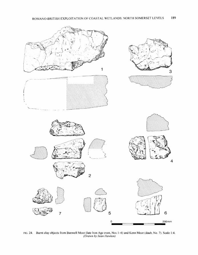
The dark horizon seen within each of the ditches equates with a buried landsurface traces of which were recorded outside the enclosure However inside the enclosure this surface was truncated by ploughing suggesting that it lay on a very slightly raised area of natural alluvium Those areas inside the enclosure that were excavated proved to be largely devoid of features apart from a shallow hollow (F8) containing numerous small fragments of stone burnt clayldaub and charcoal The absence of other features may reflect a low level of activity which is also suggested by the scarcity of material culture in the ploughsoil and ditches F2 F4 and F6
To the south-east of the enclosure the buried landsurface reappeared A sterile natural alluvium (50) was sealed by a mid-greylbrown silty clay (I 1134) which appeared to form a buried landsurface from which was cut a series of small gullies (F24 F43 F41 F39 and F32) all oriented SW-NE (parallel with the south-eastern side of the enclosure) Each gully had a steep-sided flat-bottomed profile c 04-05 m deep c 04-05 m wide at the top and c 03 m wide at the base and were all filled with mid-greylbrown silty clays The profile of these features is very similar to spade-dug gullies known as gripes that still provide surface drainage on many parts of the Levels Both the buried landsurface (1 1134) and the silted-up gullies were sealed by a dark-bluelgrey slightly silty clay (13146) very similar to the dark horizon seen in the three ditches forming an undulating surface at 49-51 m OD This in tum was sealed by sterile alluvium (an oxidised mid-bluelbrown silty clay Layer 1247) only the upper part of which was truncated by modem ploughing and which equates with Layers 3 5 and 7 in Ditches F2 F4 and F6 This buried landsurface was investigated further in Trench 11 where soil micromorphology established that it represents the development of a stable soil horizon during a pronounced pause in sediment accretion
The small amount of pottery from Trench I comprised small and abraded sherds It includes a mixture of material from the Late Iron Age through to later Roman wares including South-East Dorset BB I and local Congresbury grey ware
2 Jackson 1997 R ~ p p o n1996a 50-4
78 STEPHEN RIPPON
FIG 6 Banwell Moor Trench I (Field 4) South-east- and south-west-facing sections through the major ditches and the buried landsurface with its associated gullies
TRENCH I1 (FIGS 4 5 and 7 PL IIIA)
The complex of paddocks and enclosures marked V on FIG 4 was sectioned by Trench 11 This revealed evidence for two buried landsurfaces intercalated with sterile alluvium the earlier associated with a late Iron Age saltem the later with a Romano-British ditched-drainage system (PL IIIA)
The earliest undulating landsurface (244) lay at a depth of c 07-09 m (425 to 445 m OD) and
---- - - - --
79 ROMANO-BRITISH EXPLOITATION O F C O A S T A L WEI LANDS NORTH SOMERSET LEVELS
NE
F4
[ r 4 hmit of excavation n I environmental samples I i Lmodem ploughs011
buried landsurface
ditch fills (line density reflects organlc content)
sterile alluvium
] bumt debrls
NtV C u v r $ I I 1
I _ _ _ _ _ _ - - - - -__- - --------- ----- 4- - - - - - - - - -
1 I 1134 m- _ ~ r - - ~ - _ l ~I - 1 -~cI-=-50--- - - - - - - - - - -_____________
F32
was marked by a very slight darkening of the natural alluvium and occasional fragments of stone burnt clay and charcoal The only feature recorded was a shallow depression (F281) filled with layers of Late Iron Age pottery slightly burnt clay oven fragments briquetage charcoal and ashy debris from salt production (Layers 2591279) Around 7 m to the south there was a second dump of burnt material (2401247) associated with a spread of stone rubble (250) which was truncated by one of the later Roman drainage ditches (F208) Environmental evidence points to a high saltmarsh environment
S T E P H E N RIPPON
rlc 7 Banwell Moor Trench I 1 (Field 7) East-facing section through the late Iron Age saltern (240 247 and F281) and part of the later Romano-British buried landsurface with its associated bank (F206) and ditches (F208 and F212) For key see FIG 6 Note that this section is not at right angles to
the line of the later Romano-British ditches (see FIG 4)
This late prehistoric landscape was buried by a c 02-04 m thick layer of sterile alluvium (2051253) representing a return to gradual sediment accretion though this appears to have been primarily in a freshwater environment This marsh was in turn sealed by a second buried landsurface at c 48-49 m OD marked by a very dark-blueiblack horizon (203121 0126 1 ) identical to that recorded in Trench I At the southern end of Trench 11 this dark horizon overlay a mid-greylbrown silty clay (204) very similar to Layer 34 in Trench I which was associated with small abraded fragments of stone burnt clay animal bone and later Roman pottery
Trench I1 sectioned six later Romano-British ditches (F218 F208 F2 12 F255 F2 14 and F245) all of which were cut from immediately below the dark horizon (203) Each ditch apart from F208 had a similar sequence of fills to those in Trench I a lower light-to-mid-bluelgrey silty clay below an organically rich dark horizon which was continuous with the buried landsurface 203 and an upper more oxidised mid-bluelbrown silty clay that sealed the entire late Romano-British landscape in Trench 11 (eg F212 FIG 7) While most of the ditches had largely silted up by the time that the dark horizon formed across the site F208 was clearly still open as it contained a different sequence of sediment organically rich mid-to-light bluelgrey silty clays (269 238) followed by a light-bluelgrey silty clay (2 1 I ) with no dark horizon
Ditch F208 lay c 25 m to the south of F2 12 and may have defined a trackway very similar to that
ROMANO-BRITISH EXPLOITATION O F COASTAL WETLANDS NORTH SOMERSET LEVELS 81
I
in Trench I Traces of a slight bank (F206) to the south of F208 along with the greater concentration of domestic refuse towards the southern end of Trench 11 suggest that the settlement focus lay in the large ditched enclosure in the south-west corner of Field 7 defined by F208lF2 12 to the north-west and a palaeochannel to the south-east (FIG 4) Two ditches F2 14 and F2 18 contained moderate amounts of pottery animal bone and burnt clay along with charred plant remains Analysis of the cereals and the associated weeds suggests that they had been grown locally though the environmental evidence otherwise points to a largely pastoral landscape The abundant and diverse palaeoenvironmental evidence suggests a wholly freshwater ecology until the deposition of the upper clay 2021209i2131260
SURVEY A N D EXCAVATION A T KENN MOOR
The Romano-British landscape at Kenn Moor is situated c 05 km to the north of a bedrock ridge at Ham Farm in the parishes of Kenn and Yatton (NGR c ST 423 677) It mostly lies on an area of low-lying estuarine alluvium though a small outcrop of bedrock was located through resistivity survey just below the surface of Field 5 (at 53-550 m OD) (PL 11)
82 STEPHEN RIPPON
The plan o f the relict landscape was established through a combination o f air-photographic transcription and earthwork survey carried out by the RCHME (FIG 8)13 The complex comprises a roughly rectilinear system of enclosures with two clusters of smaller paddocks and platforms which have the appearance o f small farm complexes similar to those on Banwell Moor Like Banwell the Kenn Moor relict landscape has a broadly coaxial plan but it is quite unlike the carefully planned layout on Wentlooge Most of the earthworks have been ploughed out but within three fields (6-8) the southern possible farmstead complex survives as a well-preserved group of earthworks (PL I I ) ~ ~Faint traces o f several features were identified during the field survey of this area which are on a different alignment to and clearly pre-date the main system o f earthworks though because they are not visible on the available air photographs their original extent could not be determined A fourth field (3) at the northern edge o f the relict landscape also still contains well-preserved earthworks in the form o f a sub-rectangular mound surrounded by a slight ditch adjacent to a palaeochannel which could be traced for c 07 km In order to enhance the plan of the northern farmstead complex (in Field 5) a resitivity survey was carried out by Kerry Ely Richard McConnell and Alex Turner (FIG 10) This confirmed the presence o f a complex o f small paddocks and enclosures probably representing a farmstead
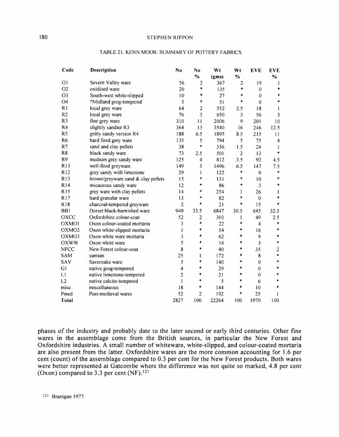
Further information about the extent and character o f t h e Kenn Moor landscape was provided by fieldwalking (FIG 9) Three densities o f material were identified which may be interpreted as midden dumping close to the settlement focus a heavily manured area to the north and west and a more lightly manured zone beyond this The edge of the Romano-British settlement was located to the east (Field 16) and west (Field 4) where sherd densities o f up to one sherd per m 2 were attained excavation in Field 16 confirmed that this was part o f the main settlement focus which was abandoned and then used for the dumping o f midden debris Fields 9 21 22 and 28 produced a lighter scatter of material with an average of 0007 sherds per square metre indicative of fairly heavy manuring for either arable cultivation or the improvement o f meadowipasture Fields 1 2 and 27 and the northern parts o f Fields 4 and 21 were largely devoid o f Romano-British material (apart from a discrete scatter o f pottery and stone from a low mound in Field 1) The odd sherds that were recovered are indicative o f much lighter manuring perhaps in an infield-outfield system Few diagnostic sherds were recovered from the fieldwalking with B B l and local Congresbury grey wares predominating A broadly late Romano-British (third- t o fourth-century) date can be applied to most of the material though Field 16 produced a noticeably greater number of fourth-century regional imports (including Oxfordshire colour-coated ware and m ~ r t a r i a ) ~
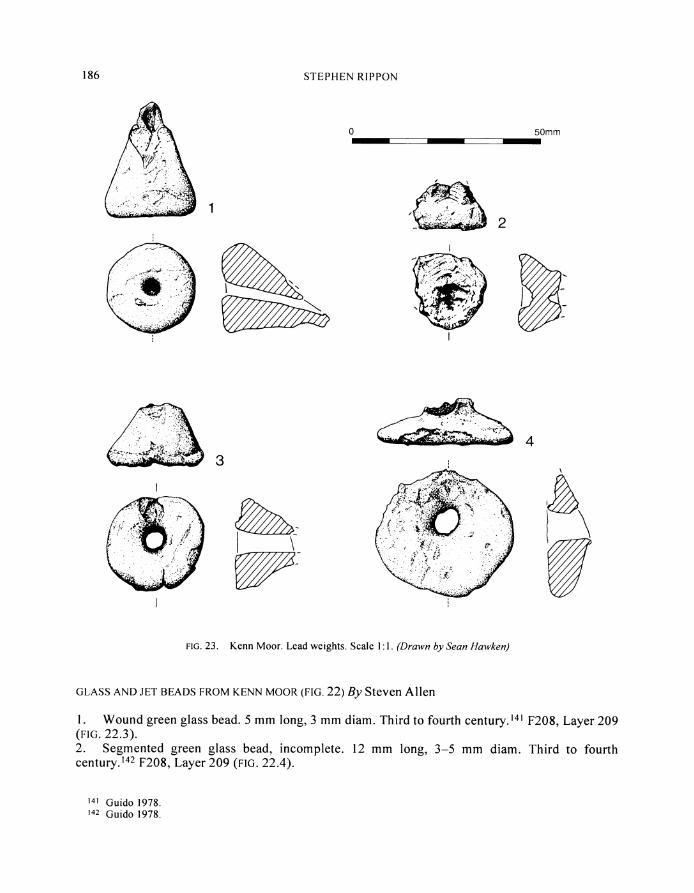
Field 16 was also subjected to a metal-detector survey carried out by Martin Tobitt John Pears and Richard Pitcairn The finds were plotted individually and their distribution conformed to that o f the pottery recovered through fieldwalking (cf F IGS 9 and 10) A total of thirty-three Roman bronze coins was found all of which date between the later third and mid-fourth centuries Other finds included four lead weights (FIG 23) a possible knife or razor handle (FIG 221) and a small amount o f lead- tin- and copper-working debris
The site at Kenn Moor was first excavated by the North Somerset Archaeological Research
2 Thefielduorhwascarr~edoutbqL4 R Millson-North 5 A J Probert H Rile M J Fletcher and H Chapman I he alr photograph~c transcrlptlon was carrled out b) C Der were prepared b Archlbe plans and publlcatlon ~ l lu s t r a t~ons P Newman The a r c h ~ v e report trom u h ~ c h this account has been derlved was wrltten bq W R L4 11son-North and edlted b) M J Fletcher
z 4 Rlppon 1994 fig I 5 2 5 In a d d ~ t ~ o n an amount of p r e h ~ s t o r ~ c and post-med~eval rnater~al u a s to the Romano-Brltlsh potter medlebal
recovered There are hmts of preh~storlc actlvlt) on the edge ot the bedrock In Fleld 28 where two posslbl) Bronze Age f l~n t s were tound a blade measurlng 3211315 mm In tresh condltlon and partl) retouched (from ST 4208 6764) and a truncated flake wlth retouch at both ends (at one end atter breakage) and poss~bl) used as a scraper (from ST 4195 6770) A truncated blade measurlng 2665 mm with traces of retouch at the unbrohen end ma be Mesollthlc (from ST 4213 6766) A late prehlstorlc sherd u a s also recovered from the same part of the field (ST 4192 6775)
83 ROMANO-BRITISH EXPLOITATION OF COASTAL WETLANDS NORTH SOMERSET LEVELS
FIG 8 Kenn Moor Plan of relict landscape from air photographic transcription and ground survey (copyright RCHME)
FIG 9 Kenn Moor Plan of rel~ct landscape and results of fieldwalking survey
ROMANO-BRITISH EXPLOITATION O F COASTAL WETLANDS NORTH SOMERSET LEVELS 85
Group (FIG In 1959 they trenched the sub-rectangular mound on the northern edge of the relict landscape revealing a stone structure interpreted at the time as a corn-drier (see Trench A below) In 1960 earthmoving in Field 5 to the south revealed a number of floors and pits and the two trenches that were subsequently dug revealed several spreads of stone one of which appeared to be a collapsed drystone wall In 1962 two further small excavations investigated slightly raised areas which probing indicated were also associated with stone rubble The southern trench revealed an inhumation which from the waist upwards was enclosed in a roughly built cist of stone slabs just c 01-015 m below the present ground surface A second trench revealed an inhumation lying on and partly sealed by a spread of stone rubble c 01-02 m below the surface This burial and the associated rubble was said to have lain on a slightly raised and possibly ditched mound Both burials appear to have been oriented roughly north-south28
In 1994 and 1995 eleven trenches were excavated in the northern potential farm complex Five trenches (G H I J and K) were positioned in order to section major elements of the enclosure complex Trenches A B and F investigated the sub-rectangular mound in Field 3 on the northern edge of the complex while Trench C (in the same field) sectioned an element of the relict landscape whose orientation did not conform to the rest Finally Trenches D and E sectioned two ditches on the edge of the southern potential farmstead complex All the ditches contained a similar tripartite sequence of fills unless otherwise stated a lower light-to-mid-bluelgrey silty clay sealed by a dark bluelgrey slightly silty clay and an upper mid-bluelbrown silty clay
TRENCH G (FIGS 10-1 I )
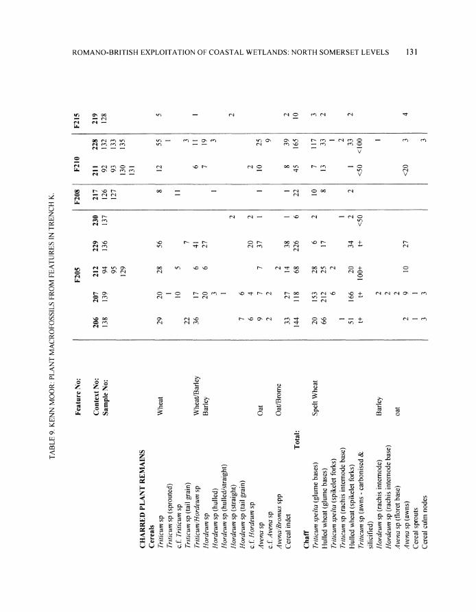
Trench G was located in the north-west corner of the northern enclosure-complex sectioning a slightly raised rectangular platform and its N E (F105) and N W (F143) boundary ditches Ditch F105 was 25 m wide and 06 m deep with a shallow U-shaped profile Ditch F143 was approximately 13 m wide and 065 m deep though its U-shaped profile was somewhat distorted by slumping Neither feature contained much domestic debris Gust a few scraps of bone and several stone slabs in the lower fills) though a small assemblage of carbonised plant remains from F143 included a single oat grain a few elements of wheat chaff and a limited range of weed seeds primarily associated with meadowlgrassland Foraminifera were absent from F143 and diatoms (microscopic algae (plants) various species of which live in fresh brackish and marine water and which possess shells comprising two valves that are preservable in the fossillarchaeologicaI record) were poorly preserved but indicative of freshwater conditions
The lower-lying ground to the west of Ditch F143 was covered by a spread of local Triassic sandstone rubble (108) animal bone and late third- to fourth-century pottery at 49 m OD which was in turn sealed by a dark bluelgrey slightly silty clay (109) This layer of rubble had no structure to it and none of the stones appeared to have been worked (apart from a fragment of a quernstone) though several stones had been burnt
The platform bounded by F105 and F143 was c 08 m (c 57 m OD) above the adjacent spread of stone rubble and consisted of a heavily oxidisedldesiccated light-to-mid-brown silty clay (1 37 and 141) that appears to have been dumped possibly when the adjacent ditches were dug Its surface was largely devoid of features apart from two shallow linear hollows F15 1 was 17 m wide and 015 m deep and contained a small assemblage of animal bone F157 was 24 m wide 015 m deep
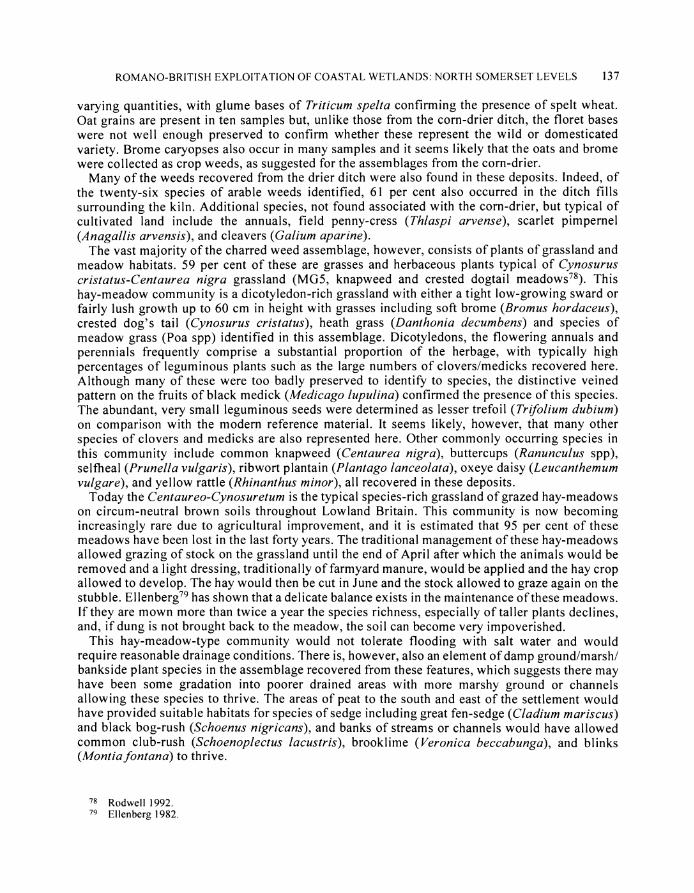
26 Lilly and Usher 1972 site 6 27 Norman Quinnell of the Ordnance Survey visited the site two years later and noted the location of the trenches at ST
4231 6776 and ST 4233 6777 The resistivity survey carried out as part of this project indicated areas of high resistance at both locations
28 Contemporary photographs taken by Derek Lilly
86 STEPHEN RIPION
earthwork plotted from
1960 trench Field 16
Romano-British metalwork (from metal-detecting)
spread of stone rubble
0
FIG 10 Kenn Moor Plan o f northern farmstead complex (focused on Field 5 ) from air photographic earthwork and resistivity surveys along with the results of the metal detector survey in Field 16
ROMAYO-BRITISH EXPLOITATIOU OF COASTAL WETLANDS UOKTH SOMERSET LEVELS 87
n SE h W I i I
I 2- y lt r I 5 2 1 m O D 1 0 0 1
n---L---T--I37 2 1 0 7 - - - - - 1 0 9 7 ~ ~ 2zxc2r--T-7 - - I - - J7+7136 1 I Y I
I YF143 Y7-ltgt
NE SW
5 1 3 1 n O D Ik I
- - -7T -
F105
TRENCH G F143 - -iEz- J
0 10 mPLANS - - -SECTIONS 2 ~ n0
c--
SE NTV
5 3 0 1 n O D J
77 --103 7r - - - - - - 7 - - _ - _ - _ - - - -- - _ _ _ _ _
----------_ - - - - -
- ---7-113 I --- rB 1 I T-]QmeF112 1 1 2 9
1-y i
NV SE-
F159 L-- -
F110 I F159 --- 1r--1-~--~rg- ~ I J
FIG 11 Kenn Moor Plan of Trenches G and 1 with sections through the ~najor features For ke see FIG 12
88 S T E P H E N RIPPON
and filled with a dark brown silty clay loam containing a considerable amount of stone charcoal (including silicified wheat awns) burnt clay and bone along with a small amount of iron-working slag
TRENCH H (FIGS 10 and 12)
Trench H was laid out to investigate the eastern side ofthe enclosure (Ditch F 1 19) which measured 18 m wide and 06 m deep and ran along the edge of the small bedrock outcrop in Field 5 There was a sequence of four fills the lowest comprising a thin (007 m) layer of light bluelgrey slightly silty clay representing a brief period of flooding (166) This was sealed by a thick (02 m) deposit of mid-to-dark reddish brown loam (165) largely derived from material washed in from the bedrock sides of the ditch but with a little water-borne mid-bluelgrey silty clay This was sealed by similar material but with a greater alluvial content (Layer 142) which in turn was sealed by a mid-bluelbrown silty clay (1 18) Another ditch F 1 17 lay 8 m to the west of F 1 19 Though 17 m wide it was just 035 m deep with straight sides and a flat bottom and contained a similar sequence of fills to F1 17 The only other feature in Trench H was a shallow steep-sided and flat-bottomed gullyslot 020 m wide and 008 m deep (F169) parallel with and 14 m to the west of Ditch F1 17 The function of this feature is unclear there was no sign of any post- or stake-holes along its line and so it may have housed a sill beam or served as an eaves-drip gully
TRENCH I (FIGS 10 and 12)
Trench I sectioned a series of ditches in the south-eastern part of the enclosure complex in Field 5 Ditch F130 represents the continuation of F119 in Trench H though in Trench I it was both wider (21 m) and deeper (09 m) probably reflecting the fact that its upper half was cut into alluvial clay rather than Triassic bedrock The lowest fill (164) comprised a light-to-mid-bluelgrey slightly silty clay with a dump of Triassic sandstone rubble pottery and animal bone towards the bottom This alluvium must have been deposited fairly quickly as there was very little trace of sandier material having been washed in from the bedrock into which the lower part of the ditch was dug This was sealed by a mid-to-dark bluelgrey slightly silty clay (132) and finally a mid-bluelbrown slightly loamy clay (13 1)
Ditch F147 was laid out at right angles to F1171130 and was cut wholly into alluvium Its U-shaped profile was relatively steep sided though the western side in particular showed signs of slumping The sequence of fills was very similar to F130 (Layers 168 161 and 148) but with greater amounts of midden debris Ditch F147 produced an important range of palaeoenviron- mental evidence The plant macrofossils include wheat barley and broad beans along with weed seeds of arable and meadowlgrassland communities The diatoms indicate freshwater to slightly brackish conditions in a ditch which was prone to drying out or had an input of eroded terrestrial material In contrast foraminifera were also recovered which suggest a very brackish and non-vegetated environment most likely a tidal channel with a clastic (mudlsilt) bed rather than a saltmarsh
Just 15 m to the west of Ditch F147 lay a parallel gully (F145) 04 m wide and 018 m deep and not dissimilar in profile to those in Trench C (see below) Its fill comprised a mid-to-dark bluelgrey silty clay and contained a relatively large amount of stone rubble The whole of the lowest-lying (southern) end of Trench I below 52 m OD (including both F147 and F145) was subsequently sealed by a sterile mid-bluelbrown alluvium though there was no trace of a buried soil corresponding to the horizon from which F147 and F145 were cut (c 04 m below the present ground surface at 51 m OD)
90 STEPHEN RlPPON
The north-eastern arm of Trench I was positioned across a NW-SE oriented ditch which appeared on the air-photographic transcription though no trace of an earthwork or vegetation mark was visible on the ground in 1995 However only a shallow linear depression c 07 m wide and c 01 m deep (F149) and containing a few scraps of pottery and bone was located at this point The only other feature in this part of Trench I was a linear gully (F133) on a different alignment to the other elements of the relict landscape It was 04 m wide 01-015 m deep with a U-shaped profile cut by F149 A short stretch of a second gully FI 63 ran south and at right angles from F133
TRENCH J (FIGS 10-1 1 )
Trench J was positioned in the south-west comer of the relict landscape in Field 5 and was designed to provide a second section of the ditch forming the north-western boundary of the main enclosure complex (the other being F143 in Trench G) In Trench J the ditch (FI 12) was 37 m wide and 085 m deep (the largest on site) The lowest fill comprised light-to-mid-bluelgrey slightly silty clay containing a few fragments of pottery bone and stone (Layer 129) This was partly sealed by a thin layer of dark bluelgrey slightly silty clay containing occasional flecks of charcoal (Layer 162) When it had largely silted up the ditch was recut with a similarly wide but rather shallower profile This was filled with a uniformly mottled mid-bluelbrown silty clay (Layer 113) Diatoms from all three layers suggest a largely freshwater environment though with a slightly brackish element while the snails suggest fairly still freshwater conditions Foraminifera were absent
To the north-west of Ditch F1 12 lay a curious cut feature 03 m deep and with steep sides and flat bottom (Fl 14) It contained a large slab of sandstone (061 x 052 x 005 m) inclined at 45 degrees and sealing a cows scapula This stone may have been a boundary marker or a rubbing-stone for livestock (both of which can still be seen on the Levels today) though the possibility that this was some form of ritual deposit cannot be ruled out
The southern arm of Trench J sectioned a shallow linear hollow perpendicular to FI 12 15 m wide and 01-015 m deep (F1 lo) filled with a mottled mid-bluelbrown slightly silty clay (Layer 1 1 I) and containing a few sherds of pottery of later second-century date To the north-east lay an extensive spread of Triassic sandstone rubble (Layer 171) which like that in Trench G had no structure Further to the north-east lay a ditch (F159) 12 m wide and 03 m deep running north-south on a different orientation to the rest of the landscape though aligned with F13 in Trench C (see below) All these features in the south-west arm of Trench J (below 52 m OD) including the spread of stone rubble at c 51 m OD were sealed by sterile alluvium (Layer 138) similar to Layers 109 and 135 in Trenches G and I
TRENCH K (FIGS 10 and 13)
Trench K in Field 16 examined the north-east comer of the enclosure complex where the fieldwalking and metal-detector surveys had shown a marked concentration of Romano-British material Removal of the ploughsoil revealed a highly oxidised and disturbed light brown silty clay containing pottery bone stone and flecks of burnticlay charcoal (Layer 222) This material was similar to that which makes up the corn-drier mound (see below) and the platform sectioned in Trench G (see above) Layer 222 also appears to have been dumped as it sealed a small steep-sided gully (06 m wide and 027 m deep F23 1) and in several places covered a mid-bluelgrey silty clay with occasional flecks of charcoal (Layer 238) suggestive of a buried ground surface at 49 m OD
Apart from the gully F23 1 the earliest group of features in Trench K comprised three shallow
_ _
- - - -
ROMANO-BRITISH EXPLOITATION OF COASTAL WETLANDS NORTH SOMERSET LEVELS 91
-r T Oamp$ -~4
I
sw - - 7 - --- 20-
0 PLAN -
TRENCHK NE NW facing section SW facing section - ~ - 7 4 9 1--7 I---- --
j r v _ - __r---r
- 1 I - - 217 - - -
213 0Dm
- i - -0 SECTIONS 2 nl IJ F208 J
FIG 13 Kenn Moor Plan of Trench K with sections through F205 and F208 For key see FIG 12
irregularly-shaped pits (F203 F215 F220) whose fills contained just occasional flecks of charcoal and burnt clay and relatively little bone and pottery (mostly third-century) A second later group of features was filled with distinctive midden-type material dating to the fourth century (F20I F205 F208 F210) Ditch F208 is the continuation of F105 in Trench G and appears to mark the north-eastern edge of the enclosure complex F208 was 13 m wide 07 m deep with steep sides and a flat bottom It was backfilled with three layers of very organically rich midden-type material all of which contained abundant pottery animal bone stone charcoal and burnt clay (Layers 209 2 13 and 2 17) The large assemblage of fresh unabraded pottery suggests a terminus post quem of AD 33015 for its filling The charred plant macrofossils included grains of wheat barley and oats while weeds included those of cultivated land and particularly grasslandihay meadows A shallow linear hollow 11 m wide and 015 m deep (F201) on the same orientation as Ditch F208 crossed the south-west corner of the trench It was filled with a mid-to-dark bluelgrey silty clay and contained a fair amount of stone burnt clay and flecks of charcoal though there was little pottery and no bone (Layer 202)
The other important features in Trench K were two square pits F205 was 21 m square 034 m deep with near-vertical sides and a flat bottom It was filled with a complex sequence of very dark organic-rich layers and dumps of clay The lowest fill (230) was a slightly greenish-yellow crumbly silty clay resembling cess though wet-sieving failed to find any mineralised seeds It sealed the whole of the base of the pit lapping up against the sides Its surface followed the contours of the bottom rather than forming a flat surface as would be expected if this had been deposited as a liquidlsluny It was sealed by a complex sequence of intercalated lenses of charcoal bluelgrey and greyibrown clays that had clearly been dumped (229 214 212 207 206) The charred plant remains from F205 were similar to those in the ditch F208 while the pottery suggests a date of filling in the early fourth century
The other square pit F2 10 which cut F2 15 could only be partly excavated as it extended beyond the edge of the trench The one complete side measured 18 m while the profile had sloping sides 04 m deep and a flat bottom very similar to F205 There were three fills two layers of very dark midden material (2 1 1 and 228) separated by a deposit of dumped clay (226) There was none of the yellow material seen in F205 though the wet sieving did produce mineralised seeds Once again
---- I
92 STEPHEN RIPPON
the charred plant remains were similar to F208 while the pottery suggests a date of back-filling in the early to mid-fourth century The function of these two pits remains unclear Their basic form is suggestive of cess pits though their dimensions would appear to be too shallow and such features would not be expected on a rural site since such material would be disposed of on the fields29 A range of other functions can be postulated such as storage or retting flax (though there is no palaeoenvironmental evidence for flax on the site)
A spread of Triassic sandstone rubble survived just below the ploughsoil to the west of and tipping into F205 In common with similar spreads in Trenches G and J it had no apparent structure and none of the stone seemed to have been worked The subsoil in an area of c 9 m2 to the south of Pit F210 appeared particularly disturbed and following repeated cleaning a range of minor features was revealed A single line of stake-holes ran east-west with a double line of holes running north-south towards F208 while to the east lay a shallow curving gully (F224) 012 m deep and 005 m deep with steep but sloping sides and a flat bottom
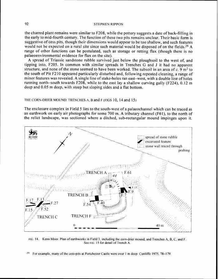
THE CORN-DRIER MOUND TRENCHES A B and F (FIGS 10 14 and 15)
The enclosure complex in Field 5 lies to the south-west of a palaeochannel which can be traced as an earthwork on early air photographs for some 700 m A tributary channel (F61) to the north of the relict landscape was sectioned where a ditched sub-rectangular mound impinges upon it
I-t 1 -- YHM spread of stone rubble
I -i fl-
- C
excavated feature I
t
- - stone all traced through probing
-1 I I
FIG 14 Kenn Moor Plan of earthworks in Field 3 including the corn-drier mound and Trenches A B C and F See FIG 15 for detail of Trench A
Z9 For example many of the cess-pits at Portchester Castle were over 1 m deep Cunliffe 1975 78-1 79
ROMANO-BRITISH EXPLOITATION O F COASTAL WETLANDS NORTH SOMERSET LEVELS 93
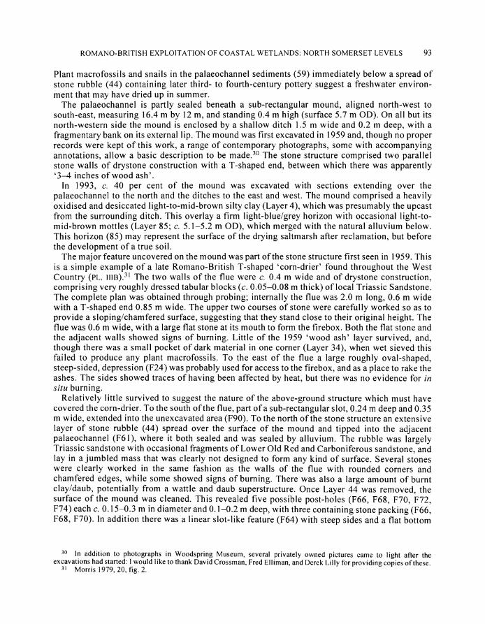
Plant macrofossils and snails in the palaeochannel sediments (59) immediately below a spread of stone rubble (44) containing later third- to fourth-century pottery suggest a freshwater environ- ment that may have dried up in summer
The palaeochannel is partly sealed beneath a sub-rectangular mound aligned north-west to south-east measuring 164 m by 12 m and standing 04 m high (surface 57 m OD) On all but its north-western side the mound is enclosed by a shallow ditch 15 m wide and 02 m deep with a fragmentary bank on its external lip The mound was first excavated in 1959 and though no proper records were kept of this work a range of contemporary photographs some with accompanying annotations allow a basic description to be made30 The stone structure comprised two parallel stone walls of drystone construction with a T-shaped end between which there was apparently 3 4 inches of wood ash
In 1993 c 40 per cent of the mound was excavated with sections extending over the palaeochannel to the north and the ditches to the east and west The mound comprised a heavily oxidised and desiccated light-to-mid-brown silty clay (Layer 4) which was presumably the upcast from the surrounding ditch This overlay a firm light-bluelgrey horizon with occasional light-to- mid-brown mottles (Layer 85 c 51-52 m OD) which merged with the natural alluvium below This horizon (85) may represent the surface of the drying saltmarsh after reclamation but before the development of a true soil
The major feature uncovered on the mound was part of the stone structure first seen in 1959 This is a simple example of a late Romano-British T-shaped corn-drier found throughout the West Country (PL i ~ i ~ ) ~ The two walls of the flue were c 04 m wide and of drystone construction comprising very roughly dressed tabular blocks (c 005-008 m thick) of local Triassic Sandstone The complete plan was obtained through probing internally the flue was 20 m long 06 m wide with a T-shaped end 085 m wide The upper two courses of stone were carefully worked so as to provide a slopinglchamfered surface suggesting that they stand close to their original height The flue was 06 m wide with a large flat stone at its mouth to form the firebox Both the flat stone and the adjacent walls showed signs of burning Little of the 1959 wood ash layer survived and though there was a small pocket of dark material in one corner (Layer 34) when wet sieved this failed to produce any plant macrofossils To the east of the flue a large roughly oval-shaped steep-sided depression (F24) was probably used for access to the firebox and as a place to rake the ashes The sides showed traces of having been affected by heat but there was no evidence for rn situ burning
Relatively little survived to suggest the nature of the above-ground structure which must have covered the corn-drier To the south of the flue part of a sub-rectangular slot 024 m deep and 035 m wide extended into the unexcavated area (F90) To the north of the stone structure an extensive layer of stone rubble (44) spread over the surface of the mound and tipped into the adjacent palaeochannel (F61) where it both sealed and was sealed by alluvium The rubble was largely Triassic sandstone with occasional fragments of Lower Old Red and Carboniferous sandstone and lay in a jumbled mass that was clearly not designed to form any kind of surface Several stones were clearly worked in the same fashion as the walls of the flue with rounded corners and chamfered edges while some showed signs of burning There was also a large amount of burnt clayldaub potentially from a wattle and daub superstructure Once Layer 44 was removed the surface of the mound was cleaned This revealed five possible post-holes (F66 F68 F70 F72 F74) each c 015-03 m in diameter and 01-02 m deep with three containing stone packing (F66 F68 F70) In addition there was a linear slot-like feature (F64) with steep sides and a flat bottom
30 In addition to photographs in Woodspring Museum several privately owned pictures came to light after the excavations had started I would like to thank David Crossman Fred Elliman and Derek Lilly for providing copies of these
3 Morris 1979 20 fig 2
94 S T E P H E N R I P P O N
J F 72
I
hM SE I 5 34 n1 O D - - - I _-
- 7T Plan of features north of corn drler after the removal of rubble 44
SECTIOUS 0---2 n1
FIG 15 Kenn Moor Trench A and sections through F7 and F40
95 ROMANO-BRITISH EXPLOITATION OF COASTAL WETLANDS NORTH SOMERSET LEVELS
on the same orientation as the lines of possible post-holes measuring 03 m wide 002 m deep it was traced for 075 m The rest of the mound both in Trenches A and B appeared to have been devoid of features
On three sides the mound is surrounded by a ditch which presumably provided material with which to construct the mound and subsequently aided its drainage A section excavated to the east (F7) revealed a U-shaped ditch with fairly steep sides 09 m deep and 18 m wide (PL IVA) The lowest fill (89) comprised a mid-bluelgrey clay with several fine lenses of charcoal burnt grain and chaff representing waste fuel from the corn-drier This was sealed by a series of alternating and intercalated layers of charcoallburnt grain (35 and 42) and sterile lenses of light-to-mid-bluet grey silty clay (39 and 41) Intruding into this sequence from the west was a mid-brown silty clay (62) indistinguishable from the material that made up the mound (Layer 4) It may represent a combination of slumping and deliberate dumping to maintain the edges of the platform The ditch was subsequently recut and began to silt up with a dark bluelgrey silty clay with occasional thin lenses of charcoal (Layer 19) It was then recut again and subsequently partly backfilled with a dump of stone rubble and a lens of yellowlbrown clay (38) Natural siltation resumed the depos- ition of mid-to-dark bluelbrown silty clays (8 and 3) which merged with the upper fill of the palaeochannel to the north (Layer 2) As these layers lacked charcoal they were presumably deposited after the corn-drier had ceased to function
The ditch to the west of the mound (F40) sectioned in Trench B had a similar sequence to the first cut of Ditch F7 a basal fill of blue clay with very fine lenses of charcoal (83) followed by a sequence of intercalated lenses of charcoal (56 and 58) and bluelgrey silty clay (57) sealed by mid-to-dark bluelgrey slightly silty clays (5 and 45) Curiously there were no signs of this ditch having been recut Diatoms suggest that the alluvial deposits represent a freshwaterlslightly brackish environment foraminifera were absent
The only other features in Trenches A and B were two shallow gullies and an amorphous hollow One gully F54 (in Trench B) had steep sides and flat-bottomed profile c 03 m wide and c 01 m deep It ran westwards from and exactly perpendicular to Ditch F40 Gully F9 in Trench A had a shallow and irregular profile with an average width of c 075 m and depth of c 01-015 m It was cut by Ditch F7 and was on a very different alignment to the rest of the Romano-British field-system An amorphous hollow (FI 1) was also excavated to the east of Ditch F7 It was devoid of finds apart from a stone slab and several pieces of burnt clay possibly from a furnace-lining
The RCHME survey had suggested that there was a slight bank around the ditch that surrounded the mound with a break to the south-west Trench F sectioned both the bank and this break Beneath c 025 m of topsoil lay a mixed deposit of mid-to-dark bluelbrown silty clay with frequent charcoal Spreads of stone rubble lay under the bank while the gap was devoid of stone
DRAINAGE FEATURES TRENCH C (FIGS 10 and 14)
Trench C also in Field 3 was designed to section the earthworks of a north-south oriented ditch (F13) at variance to the rest of the relict landscape but in line with F159 in Trench J The earliest cut of F 13 was c 11 m wide and c 05 m deep with steep sides and a flat bottom and filled with a light-to-mid-brown silty clay (49150) After it had virtually silted-up this ditch was recut with a narrower more V-shaped profile filled with mid-bluelbrown silty clay (48) and an upper mid-to-dark brown silty clay (14) Snails indicate an initially open relatively dry ditch becoming well-vegetated and with a greater flow of water
Three shallow gullies appear to have respected F13 The curving F17 had a shallow U-shaped profile c 035-040 m wide and c 006 m deep whereas F15 and F27 had steep sides and flat bottoms c 040 m wide and c 016 m deep the line of F27 marks a continuation of F54 in Trench B Snails from F15 and F27 indicate shallow thickly vegetated freshwater conditions
96 STEPHEN RIPPON
The third set of features in Trench C comprised a line of four steep-sided features each c 08 m apart The western three were oval in plan 02-03 m in diameter and 015-25 m deep (F3 1 F35 F46) F29 was a little different to the rest being rectangular in plan (028 by 035 m) and just 008 m deep Though there was no evidence of stone packing the regular spacing and alignment of these features suggests they formed a fence line (F52) approximately perpendicular to the ditch F13
None of the features in Trench C produced much in the way of dating evidence Ditch F13 contained no pottery but appears to pre-date the gullies and represents one of a small group of early features that do not correspond to the predominant SW-NE orientation of the Romano- British landscape Gullies F15 and F17 produced a handful of small abraded Romano-British sherds but nothing later Gullies F15 F 17 and F54 (in Trench B) may in fact be one feature with a break as it crosses F13 and together they form an alignment perpendicular to the corn-drier mound and roughly parallel to the palaeochannel which does conform to the overall SW-NE orientation of the Romano-British enclosure system
TRENCHES D A N D E (FIG 10)
Two trenches were excavated in Field 10 in order to section elements of the relict landscape which appeared to form part of the southern settlement focus comprising a complex of small platforms paddocks and slightly larger enclosures Trench D ran across one of the major SW-NE oriented axial elements of the landscape The earliest phase of ditch (F302) was c 15 m wide and 065 m deep with a U-shaped profile and a fairly flat bottom The lower fill comprised mid-bluelgrey clay with some mixed stone rubble (305) from which a small assemblage of snails suggests a largely freshwater environment The upper fill comprised a dark brown organic rich silty clay (304) After F302 had virtually silted up it was recut by F306 which was filled with mid-to-dark brown organically rich silty clay (303) Both features produced late third- to early fourth-century pottery
Trench E sectioned one of the minor SE-NW oriented boundaries of the relict landscape This comprised a broad linear hollow (F3 12) rather than a more narrowly defined ditch possibly due to its sides being trampled by livestock seeking drinking-water Such waterings are still found besides ditches on the Levels and are now usually revetted with stone or concrete to prevent such damage to the ditch sides32 F312 was filled with mid-bluegrey silty clay with several bands of brown mottling (310 and 31 I) and a considerable amount of largely limestone rubble bone relatively unabraded pottery (late third- to fourth-century) and a single coin (dated AD 270-73)
SURVEY A N D EXCAVATION AT PUXTON (FIG 16)
The third Romano-British relict landscape on the North Somerset Levels at Puxton (NGR ST 415 630) lies c 3 km north of the fen-edge at Banwell (FIG 16) The Romano-British ground surface is within the modem ploughsoil the surface of which lies at c 50-52 m OD
The earthworks in this area have been the subject of some discussion as they pre-date an area of medieval common meadow known as the dolmoors and W i ~ k h a m ~ ~ Though a number of Romano-British sherds are reported to have come from the general area the dating of these earthworks as Romano-British relies upon their morphological similarity to those at Banwell and
32 Rippon 1996a 60 33 Gardner 1985 13-20 34 Broomhead 1994Clarke 1980 1-4
97 ROMANO-BRITISH EXPLOITATION OF COASTAL WETLANDS NORTH SOMERSET LEVELS
FIG 6 Puxton Plan of relict landscape froni air photographic transcription and location of trench in Church Field
Kenn Moor The plan of this landscape derived from air-photographic evidence35 comprises a complex of small platforms paddocks and enclosures surrounded by slightly larger fields on a broadly SSW-NNE orientation The earthworks lie either side of a substantial palaeochannel complex around which the enclosure systeni appears to have been laid out One field has been walked to the west of the earthworks and immediately south of Puxton church This revealed a light scatter of Romano-British pottery showing a slightly increased density in the eastern part of the field (ie towards the main earthwork complex) with an average density of 00125 sherds per m2 comparable to the heavily manured zone around the settlement at Kenn Moor (see above) The diagnostic sherds from the fieldwalking are all later Roman and include South-East Dorset BB I local Congresbury grey ware and one possible sherd of Oxfordshire ware An abraded fragment of box-flue tile was also found
Excavations in this field during 1996 revealed several Romano-British features sealed beneath an early medieval bank A small ditch F160 (060-085 m wide and 055 m deep) was oriented SW-NE ( F I G 16) To the west ran a slightly curving SE-NW oriented gully (F156) 045 m wide and 018 m deep whose steep sides and flat bottom suggest it was spade-cut To the north of F156 and parallel with F160 lay a SW-NE oriented gully (FI 58) just 025 m wide and 016 m deep but also with a spade-cut profile All three features were filled with a similar mid-to-light blueigrey silty clay Gully F156 produced a small freshwater snail assemblage
3 RAF 541141 1257 and 5411257 3232 West A I ~ 32903 photographs bq the author 6 R ~ p p o n 1996b 39-52 37 R ~ p p o n 1996b fig 9 Trench 3
S T E P H E N K l P P O N
PAL4tOENVIRONRIENPAI R E C O h S T R U C I ION
Bj3Julie Jones Nigel Cameron Paul Davies Simon Dobinson Chris Gleed-Owen Simon Haslett Jen Heathcote Anthony Margetts David Smith Heather Tinsley and Huw Williams
A critical part o f this programme o f fieldwork was the acquisition o f palaeoenvironrnental material with which to reconstruct the environmental setting o f the Romano-British landscapes at Banwell and Kenn Moor Samples were taken from a wide range o f contexts including the buried land- surfaces midden deposits and various elements o f the drainage system (the palaeochannel ditches and gullies) Specialist reports have been produced by the following authors David Smith (beetles) Nigel Cameron and Simon Dobinson (diatoms) Simon Haslett Anthony Margetts and Huw Williams (foraminifera) Julie Jones (plant macrofossils) Heather Tinsley (pollen) Sheila Hamilton-Dyer (small mammals) Chris Gleed-Owen (amphibian bones) Paul Davies and Joanne Smith (snails) and Jen Heathcote (soil micromorphology) Full details o f sampling strategies methodologies used and species lists can be found in the specialist reports
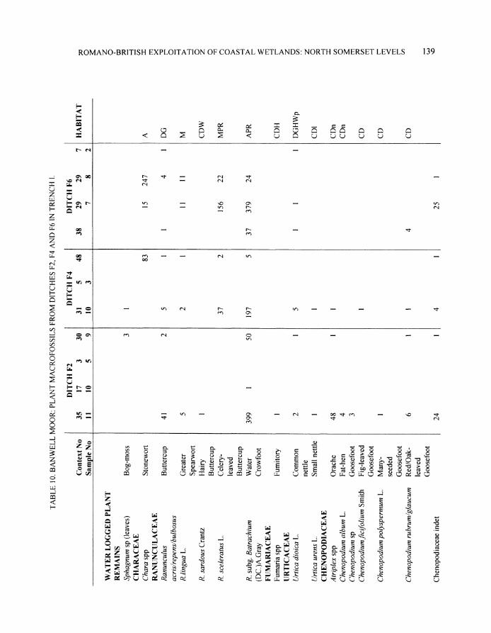
Coastal wetlands are highly dynamic environments and the contexts from which the environ- mental samples were taken need careful consideration Sediment accretion on active saltmarshes is a continuous but slow process though fluctuations in relative sea level can lead to variations in the rate o f build up the lower buried landsurface at Banwell Moor occurred in just such a gradually accreting environment Reclamation cuts off tidal sediment supply leading to a stabilisation o f the land surface though precipitation and freshwater run-off from the adjacent uplands means that any ditches dug into the surface o f a reclaimed marsh would be subject to some silting particularly as they become clogged with vegetation The late Roman ditched-drainage systems at Banwell Kenn and Puxton were in such a landscape and therefore the lower fills o f these ditches will reflect the contemporary environment During the latelpost-Roman period this formerly freshwater reclaimed landscape was once again subjected to tidal flooding and sediment accretion as a result o f the failure of the sea walls This accounts for the alluvium that seals parts o f the relict land- scapes at Banwell and Kenn and fills the upper parts o f many o f the late Roman drainage ditches
In attempting to reconstruct the palaeoenvironment of the North Somerset Levels during the Roman period it is clearly important to distinguish between sediments laid down during the active use of a landscape (that will reflect the contemporary environment) and material deposited after that landscape was abandoned The former were derived from a number of sources Most of the snails waterlogged plant macrofossils beetles small mammals and benthonic diatoms and foraminifera will reflect actual water conditions in the drainage ditches while they were in use Each species has a particular ecological preference (eg freshwater brackish intertidal etc) and though many can tolerate very occasional environmental changes such as a brief influx of salt water due to a flood event they will reflect the normal water conditions However some species of all these groups will have been washed into the ditches from the immediately adjacent areas and reflect the ground conditions beside the ditches Pollen can be very local or blown in from rather greater distances Planktonic diatoms and foraminifera can be derived from short termflood events but can be easily distinguished from in situ assemblages A proportion of the diatoms foraminifera and snails may also have eroded out of the natural alluvium into which the ditches were cut and so bear no relationship to the contemporary environment of that ditch though these can often be distinguished due to their poor condition Finally some material was dumped into the ditches in the form o f midden debris by the human communities living nearby This is particularly true of the burnt crops and hay recovered from both Banwell and Kenn Moor and could potentially represent local cultivation practices In the following section the palaeoenvironmental material is discussed in terms o f the contexts from which it was recovered with a broadly chronological approach
1 The environmental setting o f the late Iron Age saltern and its subsequent inundation
99 ROMANO-BRITISH EXPLOITATION O F COASTAL WETLANDS NORTH SOMERSET LEVELS
2 The ecology of the late Romano-British landscape and its associated ditched-drainage system 3 The late Roman buried landsurface at Banwell 4 The post-Roman inundation
1 ENVIRONMENTAL SETTING THE LATE IRON AGE AND EARLY ROMANO-BRITISH INUNDATIONS
During the first millennium BC most of the North Somerset Levels appear to have been intertidal mudflats and saltmarshes The upper part of the alluvial sequence that was laid down at this time representing pre-occupation sediment upon which the later Romano-British landscape rested was sampled for foraminifera at Kenn Moor (Trench K) The lower samples were dominated by Elphidizdm williamsoni which indicates low marshihigh mud flat deposition but an increase in the abundance of Hqnesinagermanica a species more typical o f a depositional position lower in the tidal frame occurs in the upper levels shortly before the Roman reclamation (although Elphidium williamsoni remains common) These results imply general deposition on a non-vegetated high intertidal mudflat with a change to more saline conditions This increase in marine influence is supported by the occurrence (albeit rare) of the marine species Rosalina williamsoni in the topmost sample Therefore prior to reclamation this was probably an area of non-vegetated mudflat during a period of transgression reflecting relative sea-level rise
At Banwell slight darkening of the natural alluvium associated with fragments of burnt clay and charcoal represented a buried landsurface Soil micromorphology shows that this horizon repres- ents a pause in sediment accretion followed by drying of the marsh surface This was associated with features relating to a saltern of first century Bcfirst century AD date The snail assemb- lages from this landsurface and the saltern debris comprise roughly equal numbers of Hydrobia ventrosa and Hydrobia ulvae indicative of intertidal saltmarshes Pollen preservation in the landsurface was poor although taxa which could indicate halophytic conditions such as sea- plantain (Plantago maritima) bucks-horn plantain (Plantago coronopus) and the Chenopod- iaceae (Goosefoot family) occur as occasional grains also indicating brackish conditions
There is some evidence of the wider landscape A large number of terrestrial snails from the saltern notably Vertigo pygmaea and Pupilla muscorum are indicative of rather drier conditions while Vallonia pulchella inhabits wet meadows and marshes The pollen taxa present are domin- ated by grasses with a range of indicators of weedy ground and possibly disturbance suggestive of pastoralism notably ribwort plantain (Plantago lanceolata) and dandelion-type (Cichorium intybzds) Such species are early colonists and may also have been growing on the saltem mound itself The plant macrofossils although limited are also typical of disturbed weedy ground and include dandelion (Tarmacztm) common nettle (Urtica dioica) and common chickweed (Stellaria media) Tree pollen percentages are low indicating an open environment Overall it would appear that the late Iron Age saltern lay in a weedy grassland which may have been used for grazing close to an upper saltmarsh limit Sea water would have reached the saltem via tidal creeks which rarely suffered over-bank flooding so the wider landscape would not have been regularly inundated
The saltern debris also produced hard black amorphous lumps containing the compressed remains of organic material and impressions of fruits including great fen-sedge (Cladium marisczts) It is thought that this material is burnt peat and relates to fuel used in the saltmaking process Only small quantities of charcoal fragments were noted and this suggests that wood was not a major source of fuel Similar lumps of carbonised material were recovered from the excavation of a salt-making mound at East Huntspill (in the Central Somerset Levels) where the remains of Sphagnum Calluna Erica and Eriophorum confirm that raised bog peat was used as fuel in the salt extraction process38
j8 Leech ef a1 1983
100 STEPHEN RIPPON
The alluvium sealing the late Iron Age saltern produced limited plant macrofossil pollen and snail assemblages Although pollen preservation was poor grasses and some indicators of disturbance suggestive of pastoralism notably ribwort plantain and dandelion-type could be identified There is no noticeable increase in pollen of halophytic taxa which continue to be repres- ented as occasional grains The plant macrofossil assemblage contained occasional fragments of bulrush (Typha) duckweed (Lemna) and water crowfoot (Ranunculus subg Batrachium) more typical of freshwater environments though the dominance of rush (Juncus spp) could indicate marshy and potentially brackish conditions The very small snail assemblage is difficult to interpret though the presence of Bithynia tentaculata and very low numbers of Hydrobia suggest mainly freshwater conditions with just a little brackish influence
Overall it would appear that the alluvium overlying the late Iron Age saltern at Banwell was deposited in a largely freshwater environment though towards the coast more brackish conditions presumably prevailed This sediment accretion was in the context of the continuing post-glacial rise in sea level though the episode of salt production at Banwell appears to have occured during a brief pause in this continuing rise in water levels since a landsurface had time to develop Pottery from the late Iron Age saltern at Banwell suggests a terminus post quem of the first century ~ c ea r lyfirst century AD for the resumption of sediment deposition and around the third century AD for its cessation
2 THE ECOLOGY OF THE LATE ROMANO-BRITISH LANDSCAPE AND ITS ASSOCIATED DITCHED- DRAINAGE SYSTEM
Around the third century extensive ditched-drainage systems were dug at Banwell Kenn Moor and Puxton A wide range of features including ditches and gullies were extensively sampled from these sites to help build up a picture of both the local and wider environment which existed in the later Romano-British period In particular sediments from the lower fills of the ditched-drainage systems at Banwell produced a rich suite of floral and faunal remains whose accumulation is attributable to a number of different sources The pollen and plant macrofossils represent the vegetation growing in the ditch itself in the fields around the ditch and in the wider region with all these elements providing hosts to a range of beetle species The snails present will also either have inhabited the ditches or reflect conditions in the surrounding landscape
The local environment of the ditches
The lower f i l l of the three main ditches (F2 F4 and F6) in Trench 1 and the lower fills of Ditches F208 F212 and F218 in Trench I1 at Banwell produced an abundance of plants pollen beetles and snails typical of a freshwater environment Several distinct communities of plants with their associated fauna typical of a lowland pond or ditch could be distinguished A series of ecological zones has therefore been suggested for the local environment around the ditched-drainage system at Banwell These are illustrated in FIG 17 with many of the species recovered shown in Table 1
Much of the evidence reflects the vegetation communities and water conditions which would have existed in the ditches Many of the plants represented here are true aquatics which would live either free-floating or anchored in the muds at the base of the ditch These include water crowfoot and water-cress (Rorippa nasturtium-aquaticum) The presence of duckweed which often forms dense carpets on the water surface suggests still or slow-moving water while horned pondweed (Zanichellia palustris) and the algae stonewort (Chara) both of which grow entirely submerged suggest that some depth of water existed in the ditch for at least part of the year Characeae are often the first plants to colonise newly dug or cleared ditches and ponds and some species are characteristic of ephemeral bodies of water which dry up completely in summer Most charophytes
--
I
ROMANO-BRITISH EXPLOITATION OF COASTAL WETLANDS NORTH SOMERSET LEVELS 101
THE WIDER EhlROhMEYT THE LOCAL EVIRONMEIT
I WOODLAND DlSTLRBEDGROlND GRASSLAND MARSH SWAMP FLOATING-LEAVED FLOATING TOTALLY
PLANTS PLANTS PLAYTS PLANTS SLBMERGED ROOTED PLAhTS
FIG 17 The later Romano-British landscape and its associated ditched-drainage system at Banwell Moor zonation of plant communities and associated beetle and snail faunas (Drawn by Julie Jones)
THE WIDER ENVIRONMENT THE LOCAL ENVIRONMENT WOODLAND DISTURBED GROUND GRASSLAND MARSH SWAMP FLOATINGLEAVED FLOATlUG TOTALLY
PLANTS PLANTS PLANTS PLANTS SUBMERGED
TABLE 1 BANWELL MOOR THE LATER ROMANO-BRITISH LANDSCAPE AND ITS ASSOCIATED DITCHED DRAINAGE SYSTEM ZONATION OF PLANT COMMUNITIES AND ASSOCIATED BEETLE
SMALL MAMMAL AND SNAIL FAUNA
are found in still fresh water although several s~ec ies can tolerate brackish conditions The majority of the bektle species present aye water beeiles which would have lived in standing water within the ditch itself A few species such as the diving water beetles Agabus and Dysticus favour
102 S T E P H E N R I P P O N
open water as does the Gyrinus or whirligig species Other water-beetles present such as Hydraena testacea Ochthebius minimus and the Cercyon species are associated with shallow freshwaters and mud usually around the base of aquatic plants Bembidion assimile Dryops species and Trogophloeus bilineatus are often found amongst rich vegetation on the muddy banks of small bodies of still water It is clear that this body of water was not saline as there are a wide range of beetle and insect species which exploit such conditions none o f which were recovered here Remains o f watervole were also recovered which is commonly found associated with densely vegetated ditches and river banks
The snails recovered from these lower ditch fills at Banwell with further evidence from a series o f ditches and gullies at Kenn Moor provide additional information regarding conditions and water quality Many o f the samples from both sites have slightly contrasting assemblages with both freshwater terrestrial and some brackish species Most contain a relatively high proportion o f the slum species Anisus leucostonla which lives in ponds ditches and marshes and is resistant t o its habitat drying out while Bithynia tentaculata prefers better water conditions in slow rivers and ditches it never occurs in small closed stagnant ponds A very small number o f brackish and saltmarsh species (notably Hydrobia ventrosa) were identified in a number o f the field ditches The significance o f this tiny brackish component can be put into perspective by contrasting it with that from the later fills of the Banwell ditches in which all the snails were Hydrobia Clearly during their active lives the settlements at Banwell and Kenn Moor lay in an environment with no direct tidal access
There is further evidence o f the vegetation which would have grown on the ditch sides where the ground would have been covered with water at all except the driest t imes o f year Bulrush common club-rush (Schoenoplectuslacz~stris)water plantain (Alisma plantago-aquatics) and branched bur-reed (Sparganium erectum) found in either the macrofossil o r pollen record are all typical swamp plants Many of the plants recovered are more typical o f the marshy area which often exists some distance from the water but which would nearly always be moist Species such as water mint (Mentha aquatics) common fleabane (Pulicaria dysentrica) gipsywort (Lycopus europaeus) and fools watercress (Apium nodiflorum) would have grown in such conditions The insects recovered provide strong evidence for a relatively rich flora of emergent and water-side plants local to the ditch The presence of reed is indicated by the beetle Donacia clavipes which feeds on Phragmites communis although there was no macrofossil evidence for this Demetrias imperialis is also associated with stands of this plant and with Typha reed mace Other aquatic plants such as the floating grasses Glyceria and aquatic Umbelliferae the host plants o f Notaris acridulus and Prasocuris phellandri respectively were also present Only one species of insect Phyllodeta vulgatissima indicates any presence of tree cover and given that the host plant of this species is willow (Salix) it probably lived close to the water course itself Many of the drainage ditches on the Levels today are lined with trees most notably willow or hedges usually dominated by hawthorn There is nothing in the pollen or plant macrofossil record to indicate that the same was the case in the Roman period suggesting that the landscape was much more open than is the case today
The fill o f the palaeochannel at Kenn Moor which ran adjacent to the corn-drier produced abundant waterlogged fruits and seeds of aquatic duckweeds the algae stonewort water crowfoot and rushes suggesting a freshwater environment Characeae are found in diverse aquatic habitats and while most species grow in freshwater several can tolerate brackish conditions and can be found in situations which are subject to periodic saltwater inundation The snail assemblage contained a relatively high percentage o f Lymnaea peregra which can tolerate a wide range of habitats including slightly brackish conditions However the smaller numbers of Bithynia tentaculata and Planorbis planorbis suggest a slow flow of fresh water in a well-vegetated channel The assemblage from towards the centre of the channel contained a high percentage of Bathyomphalus contortus along with Bithynia tentaculata Lymnaea peregra Armiger crista and
ROMANO-BRITISH EXPLOITATION O F COASTAL WETLANDS NORTH SOMERSET LEVELS 103
Planorbis planorbis Some Aplexa hypnorum Planorbis corneus and Anisus leucostoma were also present indicating clean flowing freshwater Though two brackish species were present (Hydrobia ulvae and Hydrobia ventrosa) they accounted for just eleven individuals out of the total sample of c 3000 Both can survive at low salinities and while they may represent temporary brackish condit- ions perhaps due t o the breaching of sea walls by a storm they equally could have been brought to the site on the feet of sea birds or have been washed out of the natural estuarine alluvium
Diatoms were very poorly preserved at Banwell though several assemblages were recovered from Kenn Moor However the dominant taxa in one o f the ditches (F40) to the west o f the corn- drier mound were consistent with a predominantly freshwater-to-slightly brackish water environ- ment Most of the diatoms are non-planktonic species that live attached to surfaces particularly epiphytic on aquatic macrophytes The dominance of these non-planktonic life-forms is consistent with a shallow-water environment The diatoms from Ditch FI 12 are dominated by brackish and freshwater taxa with a significant oligohalobous indifferent (freshwater) component The oligohalobous species include a number of taxa with wide salinity tolerances but nevertheless with optimum growth in freshwater The polyhalobous (marine) element is very small and is represented only by fragments o f the planktonic species Paralia sulcata and Podosira stelligera which are likely t o be allochthonous
Ditch 147 in the Kenn Moor enclosure complex contained both diatom and foraminifera assemblages The diatoms are dominated by mesohalobous (brackish) and halophilous (freshwater t o slightly brackish) species In particular a single halophilous species Navicula cincta constit-utes 59 per cent o f the diatom assemblage The brackish and freshwater taxa are almost all benthic specieswhich are less likely to be traisported any distance from their lifetime habitats Poly- halobous (marine) diatoms are rare and all the taxa recorded are planktonic or semi-planktonic and are therefore more likely to have been transported Ditch F147 was the only feature at Kenn Moor t o yield foraminifera and presents something of an anomaly The samples are characterised by Elphidium williamsoni but also with significant numbers of Haynesina germanica and Ammonia beccarii which appear analogous to modern high mudflatilow marsh faunas Due t o the lack of any agglutinating species it is likely that the depositional environment was non-vegetated This ditch is therefore interpreted as representing a tidal channel with a clastic (mudjsilt) bed rather than a saltmarsh O n e possible explanation is that the sediments filling F147 were deposited during flooding events during which the estuarine waters were prevented from flowing into other parts o f the drainage system through a system o f sluices though if this was the case then a stronger storm signature might b e expected including higher foraminifera diversity including planktonic species
Discussion
The Banwell and Kenn Moor palaeoenvironmental assemblages in general represent freshwater conditions and are suggestive of ditches with a range of environments from open to well-vegetated with slow-moving to stagnant water All the ditches would be liable to dry out and there may have been periodic inputs o f brackish waters but n o direct tidal access (though F147 remains an anomaly)
The interpretation o f a freshwater environment in the Romano-British period is confirmed by comparing the snail assemblages with that in todays landscape Species such as Anisus leucostoma Bathyomphalus contortus Bithynia tentaculata Lymnaea palustris Lymnaea peregra Valvata cristata Planorbis planorbis and Sphaerium corneum are still very common on the North Somerset Levels while Hydrobia ulvae is virtually absent Drake has identified six
39 Anderson er a[ 1993
104 S T E P H E N RIPPON
types o f watercourse on the Gwent Levels on the opposite side o f the Severn Estuary those with slightly saline conditions (such as the back ditch) major rivers regularly cleaned ditches more densely vegetated ditches which had not been cleaned for up to ten years and neglected ditches choked with vegetation The slightly saline ditches have a distinctive snail assemblage and recent survey data from the Gwent Levels indicate that otherwise common snails such as Bithynia tentaculata are conspicuously scarce or absent40 The excavated assemblages at Banwell and Kenn Moor compare best with the regularly cleaned and densely vegetated ditches while those with an abundance ofAnisus leucostoma are similar to the neglected ditches Thus the comparison of the Romano-British and modern assemblages suggests the Roman landscape was much like that of today a wholly freshwater reclaimed environment drained through a well-maintained hierarchy o f gullies and ditches some of which were relatively open with a through-flow of water with others being well-vegetated or even overgrown and stagnant
The presence of a small marine component in some of the diatom assemblages reflects either a contemporary tidal input or the introduction of valves by sediment-mixing processes Given that the ditches lie on or within estuarine alluvium of the Wentlooge Formation the latter is a probability As might be expected Wentlooge muds have been shown to contain high concentrations o f poly- halobous diatoms such as Para l ia sulcata4 Even if there had been an occasional inundation of the ditches by estuarine water the traces of marine diatoms from the Estuary are exceptionally limited Here it is perhaps useful to compare diatom assemblages from the ditches at Kenn Moor with the palaeochannel investigated at Barlands Farm and at Caldicot on the Gwent level^^ At Barlands Farm for example palaeochannel sediments contained a diversity of types of diatom assemblage some comparable with the mesohalobous1halophilous assemblages represented at Kenn Moor However during the marine transgressive phases recognised at Barlands Farm the assemblages were dominated (gt80 per cent) by polyhalobous taxa Whether as a result of occasional intrusion into a dominantly brackish water environment o r of full tidal conditions the presence of marine diatoms is numerically much greater than in the Kenn Moor assemblages The diatom assemblages at Kenn Moor are therefore consistent with the hypothesis that the ditches existed on a reclaimed saltmarsh Although there were fluctuations in salinity within the channels the water varied from fresh through slightly brackish to brackish suggesting that the ditches may have been infrequently subject to the higher salinities associated with tides from the Estuary
The wider landscape
The features examined at Banwell and Kenn Moor provided additional evidence of the ground adjacent to the ditches and o f the wider landscape The pollen in the lower sediments o f F6 at Banwell is dominated by grasses and sedges with weed types such as ribwort plantain and buttercup (Ranunculaceae) present at low frequencies These taxa are typical o f reclaimed marsh grassland which tends to be rather weedy although these weeds are also associated with pastoralism Grassland is also indicated by the presence of seeds of buttercup (Ranunculus acrisrepensbulbosus) daisy (Bellis perennis) dandelion (Taruxacum sect Ruderalia) hedge bedstraw (Galium mollugo) yellow rattle (Rhinanthus minor) and hawkbit (Leontodon) Some of the beetles present include species which feed on plants commonly found as weeds in grassland For example Gymnetron labile and Gpascuorum live on ribwort plantain and Sitona humeralis is associated with medicks (Medicago) The most direct evidence of pasture is the presence ofAphodius beetles which are associated with herbivore dung lying in the open
a Drake 1986 Cameron 1993 1997 42 Cameron 1996 20 1997
ROMANO-BRITISH EXPLOITATION O F COASTAL WETLANDS NORTH SOMERSET LEVELS 105
The land snails from Kenn Moor also indicate short-turved slightly damp grassland The small assemblage from the palaeochannel included Pupilla muscorum and Vallonia pulchella along with smaller numbers of Trichia hispida and Vertigo pygmaea A limited assemblage of small mammal bones from both Banwell and Kenn also indicates an essentially freshwater environment Most of the species present woodmouse (Apodemus sp) short-tailed vole (Microtus agrestis) shrew (Sorex sp) and mole (Talps europaea) are highly adaptable though all prefer areas with a good vegetation cover Rough grazing with some scrub would suit both woodmouse and short-tailed vole while moles cannot survive in areas prone to regular or prolonged flooding as their feeding galleries would flood The latter also indicate the development of a soil with earthworms which are intolerant of saline conditions Amphibians include both frog and toad (including the common toad)
Higher up the ditch profiles at Banwell there is evidence for an increase in the intensity of pastoral use of the area with higher percentages of pollen of weeds of pastoralism and a whole range of indicators of disturbance There is also a background element in the macrofossil record of species more typical of disturbed ground often associated with cultivation These include both prickly and smooth sow-thistle (Sonchus asper) chickweed (Stellaria media) fools parsley (Aethusa cynapium) hairy buttercup (Ranunculus sardous) narrow-fruited cornsalad scentless mayweed (Tripleurospermum inodorum) and redloak-leaved goosefoot (Chenopodium rubrum glaucum) Pollen of Brassicaceae (cabbage family) and Chenopodiaceae (goosefoot family) could also be representative of weeds of crops
A further group of plants typical of heath and bog communities was recovered from the ditch fills at Banwell but is unlikely to have grown in the locality of the enclosure This includes heather (Calluna vulgaris) bell heather (Erica cinerea) and cross-leaved heather (Erica tetralix) A number of leaves of Sphagnum were also recovered as well as gorse spines (Ulex sp) This material may have been collected for domestic use such as animal feed or bedding and become incorporated as waste material into the ditch fills In addition to the waterlogged macrofossils Ditch F214 also produced a considerable quantity of midden debris and a low abundance of charred plant macro- fossils was found in several of the other ditch fills This midden material represents domestic waste and is likely to have originated from occupation nearby Many of the charred weed seeds associated with the cereal waste are the same as those recovered from the ditch fills preserved in a waterlogged form which may suggest that the local soils would have been suitable for agriculture and that wheat and barley crops were being cultivated locally rather than elsewhere
The low tree pollen frequencies which occur at Banwell throughout the pollen diagram from the ditch suggest that there was very little woodland in the local area during the period in which these sediments accumulated The absence of any arboreal species of beetle also suggests to some extent a predominantly cleared landscape Oak is the main tree pollen type with other species recorded at less than 2 per cent of total land pollen These include pine (Pinus) beech (Fagus) hazel (Corylus) and maple (Acer) The source of these tree pollen taxa must have been the higher land around the Levels
Summary
Following a period of inundation and sediment deposition that sealed the late Iron Age landscape a stable environment was established at Banwell Moor The beetles plants macrofossils pollen snails and small mammals associated with the complex of drainage ditches suggest that the later Romano-British landscape was dominated by open possibly rather weedy grassland or meadow which was subject to some disturbance probably by grazing There was some arable at both Banwell and Kenn Moor and hay meadows at least at Kenn The network of drainage ditches associated with this landscape was predominantly freshwater and supported a rich and varied community of plant and animal life
106 STEPHEN RlPPON
This type of environment may have become established fairly quickly once the area had been reclaimed The most obvious effect of reclamation on saltmarshes is to remove them fairly suddenly from tidal inundation Once the marsh surface is exposed in this way the natural process of ripening already in train in upper saltmarshes is accelerated and drying out occurs (Ranwell in prep) Marine sediments are gradually converted to workable alluvial gleys and this process can be hastened by the construction of drainage channels Colonisation by plants can be fairly rapid with early colonists often those annuals which are readily dispersed by wind and rain The early vegetation cover is therefore often a rather weedy grassland which can contain opportunists of both saltmarsh brackish or more terrestrial habitats The traditional use of much of the reclaimed land in Britain and Europe both today and in the past is as pasture although conversion to arable land further diversifies the habitat This conversion can be fairly rapid cultivation today with modem methods occurring within eighteen months In the Wash in the 1930s the practice was to plough after only ten years of grazing43
3 LATER ROMANO-BRITISH RECLAMATION THE UPPER BURIED LANDSURFACE AT BANWELL
At Banwell the drainage ditches were associated with a buried landsurface represented by a dark bluelgrey silty clay associated with fragments of pottery animal bone stone and burnt clay The surface sealed the partly silted up ditches although Ditch F208 appears to have remained open The upper buried landsurface was investigated through soil micromorphology plant macrofossil pollen and snail analyses Loss-on-ignition tests suggest that the dark colour of this horizon is due to the presence of higher amounts of organic material including relatively high concentrations of charcoal compared to the alluvium both above and below
The formation of a stable soil is represented by humification of organic material decalcification biological activity and clay translocation This soil horizon originally included a surface A horizon which is only present in a remnant form evidenced by small fragments in Layer 203 The intimate mixing of these two fabrics suggests strong biological reworking during the period of soil development A burning event occurred at some point in the soils history producing large quant- ities of finely fragmented charcoal which became reworked into the underlying soil horizons 203 and 204 through biological activity Redeposition of dirty clay to form textural pedofeatures had occurred within Layer 203 which attest to a period of sparse vegetation or disturbed ground This may have been during the initial stages of ripening and pedogenesis occurring within the freshly deposited sediment or may have occurred at some later period when the established vegetation was cleared The latter explanation seems more likely as many of the clay coatings contain frag- ments of finely divided charcoal and so must have been translocated after the burning event that formed the charcoal
Subsequent flooding led to the deposition of further sterile alluvium (202) and erosion of the A horizon The nature of the interface between Layers 202 and 203 indicates that a strong degree of erosional mixing took place both contemporary with the accretion of this alluvium and in the immediate post-burial period which is indicated by small rounded fragments of the buried landsurface~(203) and pieces of charcoal incorporated into the base of the overlying alluvium Biological activity continued for a time at the interface between the buried landsurface (203) and the overburden (202)
The buried soil itself (203 and 204) was extensively sampled for plant macrofossils pollen and snails However only limited assemblages were recovered with seeds and pollen of largely freshwater taxa such as bulrushlbur-reed water crowfoot water mint and duckweed Pollen
43 Gray 1977
ROMANO-BRITISH EXPLOITATION O F COASTAL WETLANDS NORTH SOMERSET LEVELS 107
preservation was generally rather poor and of the taxa which could be identified grasses are dominant along with a range o f indicators o f disturbance suggestive o f pastoralism The snails present had a wide range o f habitat preferences including grassland Tree pollen percentages are low indicating an open environment Charred remains were also recovered and included wheat and barley chaff as well as weeds o f grassland and damp places
The origin o f the charcoal in the buried landsurface is an enigma Surfaces of a similar nature which appear as dark horizons in the alluvium have been recorded at various locations in the North Somerset and Avonmouth Levels and can extend over considerable areas44 Clearly a t Banwell charcoal was incorporated into the upper surface at some point in the development o f the soil but whether this occurred as a result o f burning in situ o r was washed or blown in is unclear
4 THE POST-ROMAN INUNDATION
The inundation o f the later Romano-British landsurface led to the deposition of a layer o f sterile alluvium over the lower-lying parts o f the landscape at Banwell Moor Samples taken from the upper fills o f Ditches F2 F4 F6 F208 and F212 at Banwell Moor for foraminifera show the marked change o f environment Just three species occur here (above the dark horizon) Ammonia beccarii Elphidium williamsoni and Haynesina germanica all o f which indicate marine deposit- ion in a low-saltmarsh t o high-mudflat intertidal environment Generally there appears to be a similar record from each ditch fill with the lower sediments lacking foraminifera Either late in the formation o f the dark horizon (F4) or shortly after (F2) there was increased tidal influence and the creation o f a mud-flat environment which as tidal influence decreased was generally replaced by a low saltmarshlhigh mudflat environment The snails confirm the pattern suggested by the foram- inifera All the samples produced large brackishlestuarine assemblages dominated by Hydrobia ventrosa and Hydrobia zrlvae
Ditch F208 in Trench 11 at Banwell was the only one not to be sealed by the dark horizon suggest- ing that it was open during the flooding episode that buried the later Romano-British landscape Foraminifera indicate full marine tidal conditions while the snail assemblage is dominated by Hydrobia ventrosa Hydrobia ulvae and Ovatella myosotis suggesting an open muddy estuarine ditch The pollen also contains evidence for increased marine influence with sea plantain which occurs in saltmarshes and short turf near the sea and reached a peak of 10 per cent total land pollen
Sediment grain size analysis suggests that Banwell Moor was close to the inland limit of the estuarine incursion but was not totally flooded with tidal waters The botanical evidence also indicates that some freshwater conditions continued locally Plant macrofossils from the alluvium sealing the later Romano-British landscape were dominated by rush seeds with a few fragments of hemp agrimony bulrush and water plantain along with dandelion (Taraxacum sect Ruderalia) dock (Rumex spp) and common nettle (Urt ica dioica) The pollen assemblage from the upper ditch fill also showed an increase in tree pollen principally oak which suggests some woodland regeneration on the dryland slopes adjacent to the North Somerset Levels
SPECIALIST REPORTS
SOIL MICROMORPHOLOGY By Jen Heathcote
A monolith sample (05 m long) was taken from the southern end o f Trench I 1 at Banwell Moor through the latelpost-Romano-British alluvium (202) the probable (upper) buried landsurface
108 STEPHEN RIPPON
(203) and the underlying disturbed (204) and undisturbed (205) late Iron Ageiearly Romano- British alluvium The purpose of the analysis was to assess the evidence for interpreting Context 203 as a buried landsurface and to determine the likely depositional and post-depositional history of the sequence
The sample was consolidated with Crystic resin and three thin sections manufactured to produce a continuous set of samples representing Contexts 202 to 205 The thin sections were analysed using a binocular polarising-light microscope at a series of magnifications between x l and x250 The descriptive terminology follows Bullock et al (1985) and formal descriptions are available in the archive Table 2 summarises the key characteristics of each context and Table 3 presents the descriptions and mode of formation of pedogenic features observed
Overview
The composite properties of Contexts 203 204 and 205 indicate that they represent a soil profile developed within an alluvial parent material that shows two episodes of sediment accretion The first episode laid down Context 205 The second deposited material of a similar mineralogical and particle size composition which was altered through subsequent pedological processes (see below) to become Contexts 203 and 204 These two contexts therefore represent soil horizons rather than discrete sedimentological events A further episode of sediment accretion deposited Context 202 that buried the soil profile The initial stages of this event caused minor truncation of the soil profile by partially eroding and reworking the upper part of the soil A horizon
The lower alluvium late Iron Agelearly Romano-British inundation
Context 205 comprises a moderately-sorted silty clay loam alluvium that following deposition underwent a period of stabilisation Drying of the sediment allowed a weak prismatic structure to develop indicated by the strong vertical orientation of the planar voids present in this unit During the stable period surface sediment became preferentially sorted through low-energy inundation events and slaking of this material created inwash features close to the surface These are expressed as planar voids infilled with non-laminated greyish brown silty clay A number of these features show fragmentation and partial incorporation into the groundmass probably due to biological activity contemporary with the later soil development
The upper buried landsurface and associated soil horizons later Romano-British reclamation
Contexts 203 and 204 consist of a moderately sorted silty clay loam alluvium within which horizon development has occurred due to a number of pedogenic processes acting on a stable land- surface Under low magnification (x5) two markedly different microfabric types (defined as the natural and microscopic arrangement of mineral and organic components) are readily discernible in Context 203
The dominant microfabric (2032) that accounts for 75 per cent of the context is characterised by a pale grey-brown (PPL) greyish white (OIL) colouration imparted by its predominantly minerogenic nature The organic component is rare (lt 5 per cent total) and consists of highly comminuted plant tissue fragments showing poor internal preservation Charcoal fragments are few (c 10 per cent) and randomly distributed through the groundmass The other microfabric type (2031) exists as rounded fragments at the upper limit of Context 203 and embedded within microfabric 2032 It shows marked organic pigmentation of the groundmass imparting a dark brown (PPL) brown (OIL) colouration that indicates a strong degree of humification of the organic component Charcoal fragments are common (c 30 per cent) and are randomly dispersed
N N 0 0
N N
u e W No o
m m n 5
89 8 8 9 IIrF F
8 I
N N i
7
unit (context)
organic content (LOI)
m~crostructure
total poroslty
m~crofabr~ctypes
planar volds
lt channeislchambers P
a i
vughs u
0
2 u
gio
2 u
3 m
-2 5 a8
or 2 9
ves~cles
2
2 5
4 m m m m n n v a n
2
g g g g( P m I D aa a a a
9 z m 9 nL = 3 8
3 I D I D X o o a 0
7 7 7
(D
3 2 or
b-fabric
organlc content (visual est~mate)
m N undlfferentlated 2
fract~ons 0 0
i
3 -4 3 i
9 9 9 9
D0 -- g g$ wg - -
0
organlc p~gmentatlonof groundmass 2
3 coarse amorphous fine (ratlo of fractions) 9
E
charcoal
textural
crysta~ne u a 4 2 5
a m o r p h o u s ~ c ~ p t ~ s t a l l ~ n e
excrement
n l s 0
0 (P
$
110 STEPHEN RIPPON
TABLE 3 BANWELL MOOR SOIL MICROMORPHOLOGY PEDOGENIC FEATURES REPRESENTED IEu SAMPLED CONTEXTS AND THEIR MODE OF FORMATION
Kind G r o u p Type Description Code Interpretation
Textural coating typic non-laminated impure grey T I illuviation of silty clay silty clay up to 20pm thick on from overlying unit void walls
infilling continuous laminated impure grey silty T2 build-up of illuviated clay void infill clay within lower soil
horizon
coating t ~ p i c greyish brown fine silty clay T3 surface slaking and intilling voids and coating redeposition in cracks aggregate surfaces of fine material during
low energy flood events
infilling discontinuous fragments of greyish brown T4 disruption of feature fine silty clay incorporated into T3 by biological groundmass activity during soil
formation period of the profile
Crystalline nodule nodules of interlinked euhedral C I biogenic granules sparite and microsparite thought to be crystals produced by
earthworms
coating coatings of microsparite C2 reprecipitation of crystals around void walls calcium carbonate
mobilised from surface horizons by leaching at lower horizon in base- saturated conditions
Amorphous1 impregnative mottle orange (PPL and OIL) diffuse ACI iron segregation cryptocrystal weak impregnation through mechanism of line ~ e t t i n gand drying
probably due to groundwater fluctuations
impregnative mottle dark brown (PPL and OIL) AC2 manganese sharp high contrast segregation caused by
wettlng and drying probably due to groundwater fluctuations
Excrement elliptical organo-mineral c El excrement produced 100~1mdiameter by soil fauna probably
Orabitid mites due to slze and morphology
ROMANO-BRITISH EXPLOITATION O F COASTAL WETLANDS NORTH SOMERSET LEVELS 1 1 1
throughout the groundmass Both have a stipple-speckled b-fabric and contain slightly weathered sparite and microsparite grains
The properties and spatial relationship of the two microfabric types indicate that 2031 represents a remnant A horizon and 2032 a B horizon The intimate mixing of these fabrics suggests strong biological reworking at this depth during the period of soil development
Further evidence for the interpretation of the fabrics in Context 203 forming beneath a stable landsurface is the slight decalcification indicated by the stipple-speckled nature of the b-fabric (observed under cross-polarised light) and the weathering of sparite grains The inherent nature of the b-fabric of the alluvium is crystallitic due to the presence of microcrystalline calcium carbonate (calcite) in the fine fraction of the parent material (as evidenced by the underlying horizon Context 204) Dissolution of the microcrystalline calcite by percolation of slightly acidic soil water (leaching) means that the nature of the b-fabric is imparted only by the orientation of clay domains resulting in the observed stipple-speckled effect Re-precipitation of mobilised calcium carbonate from the slightly decalcified upper horizons of the soil profile is evidenced by rare thin (c 40pm thick) microsparite coatings of some voids in the base-saturated conditions of Contexts 204 and 205
The amount of fine charcoal present within Contexts 203 and 204 (particularly in Fabric 2032 the remnant A horizon) indicates that an intense burning event occurred on the landsurface at or close to the point where the sequence was sampled The well-dispersed charcoal fragments contribute to the dark colouration ofthe contexts observed both in the field descriptions and-in thin section It is not clear whether the charcoal is essentially in situ or whether it has been redeposited by wind or water activity The lack of any burnt soil fragments might initially suggest a redeposit- ion agency but the uppermost landsurface deposits are only partially preserved and therefore it is possible that any traces of surface burning (such as soil reddening) may have been removed during the erosional episode that truncated the soil profile Internal slaking is evidenced by rare dirty clay coatings of void walls and attests to a period of disturbed ground with little or no vegetation cover As many of the clay coatings include fine fragments of charcoal it is clear that the slaking event(s) occurred subsequent to the burning episode and attendant charcoal deposition It is possible to suggest that the burning event may have been intended to clear vegetation or prepare the land for cultivation
Limited clay mobilisation translocation and redeposition (clay illuviation) is exhibited in Context 204 in the form of thin (lt20 pm) oriented clay coatings of many void walls Biological activity is indicated throughout Context 204 and into the upper 70 mm of Context 205 It is evidenced by the presence of nodules of interlinked euhedral sparite and microsparite crystals comparable to those produced by earthworms In addition there is an example of a laminated dirty clay infilling of an earthworm channel extending for 20 mm into the top of Context 205
The upper alluvium latetpost-Roman inundation
The unit comprises a well-sorted calcareous fine silty clay with shell fragments and exhibits primarily sedimentary characteristics Only a slight degree of diagenetic alteration is indicated in the form of limited biological activity evidenced by rare smooth-walled channels that contain few soil fauna excrements as a loose discontinous infill The organic matter content is low (lt5 per cent) and is in a highly comminuted form most of which occurs within the soil fauna excrements The excrements are elliptical organo-mineral approximately 100 pm diameter and are most probably produced by Orabitid mites (Bullock et al 1985)
The initial stages of the inundation event that deposited Context 202 is thought to have disrupted the underlying ground surface The nature of the boundary between the post-Roman alluvium (202) and the late Romano-British landsurface (203) indicates a strong degree of mixing took place both contemporary with the accretion of 202 and in the immediate post-burial period
112 S T E P H E N RlPPON
Disruption and reworking of the landsurface horizon during the initial stages of sediment accretion is indicated by the fragmentary nature of Fabric 2032 pieces of which are incorporated into the base of the overlying alluvium together with charcoal Following burial biological activity appears to have continued for a time causing reworking of both 203 and 202 across the boundary acting to increase its graded nature
Summary
The presence of a buried landsurface at c 04 m beneath the current ground level was confirmed The soil profile that developed contemporary with this surface was approximately 03 m deep and extended into Context 205 (the lower alluvium) indicating a significant period of stability During this time humification of organic material decalcification of the parent material biological reworking and clay translocation were operating to create horizon differentiation within a calcareous silty clay parent material that was laid down in two separate alluviation events
PARTICLE SIZE DlSTRlBUTlON ANALYSIS By Gerard Aalbersberg
Twenty-one samples from Ditches F2 F4 and F6 were taken for particle size distribution analysis Sample preparation followed a modification of the British standard procedure Organic matter was removed from air-dried samples using hydrogen peroxide (H202) and the remaining fraction was screened over a 600 pm mesh sieve The fraction finer than 600 pm was centrifuged washed with methylated spirit centrifuged again and dried overnight at 45degC After weighing the dried residue was resuspended in a 04 per cent sodium hexametaphosphate ((NaPO)) and sodium carbonate (NaCO) solution After stirring in the samples in an ultrasound bath particle size distributions were measured on a Malvem Mastersizer MS20 with a measuring range of 1 2400 pm
The samples clearly divide into two groups The three samples from the top of the fill contain slightly more clay (0-2 pm) and fine silt (2-16 pm) compared to the samples from the lower fills suggesting deposition in different environments The samples from F4 and F6 show a similar division between the lower and upper parts of the fills but not as clearly as F2
As to the nature of these environments little can be deduced from the analysis only that none of the samples shows a bimodal distribution pattern which might be indicative of tidal influences The increase in finer sediment in the top three samples suggests that deposition took place from water with a higher suspended sediment load though there was little or no current allowing the fine fractions to settle out without being eroded again
BEETLES By David Smith
Coleoptera (beetles) were recovered through wet-sieving the waterlogged lower fills of Ditches F2 (Layer 35) F4 (Layer 3 1) and F6 (Layer 29) in Banwell Moor Trench I The flots and residues were sent to the Department of Ancient History and Archaeology the University of Birmingham and processed using the standard method of paraffin flotation as outlined in Kenward et a145The insect taxa are listed in Table 4 using the taxonomy used by L ~ c h t ~ AS a result of poor preservation and the small sample size the faunas recovered probably should be considered incomplete
Despite the limited number and poor preservation of these insects they do provide some useful information There appears to be little difference between the three assemblages recovered and as
45 Kenward et a 1980 3-15 46 Lucht 1987
ROMANO-BRITISH EXPLOITATION O F COASTAL WETLANDS NORTH SOMERSET LEVELS 113
TABLE 4 BANWELL MOOR BEETLES FROM DITCHES F2 F4 AND F6
Djsch~rius globosus (Hbst) Bemb~d~onobliquum Strum B assrm~leGyll B spp Prerotrchus strenuus (Panz) P nrger (Schall) Demetrias rmperralrs (Germ) Haliplidae Haliplus spp Dytiscidae Agabus spp D~t~scusspp Cyrinidae Gjrrnus sp Hydraenidae H1draena testacea Curt H sp Ochthebius mrnimus (F) 0 spp L~mneblussp tIJdrochus angustatus Germ Heloporus spp Hydrophilidae Cerc)on convexruscul~~s Steph C sternalis Shp C (aquatic) spp hfegasterum boleotophagum (Marsh) H~drobiusjus~pes(L) Laccobius sp Orthoperidae Orthoperus spp Staphylinidae Lesteva spp Trogophloeus bilineatzis (Steph) Oxytelus rugosus (F) 0 sp Stenus spp Strlrcus orbrczrlatus (Payk) Larhrobium spp Xantholrnus sp Philonthus spp Helodidae Helodidae Gen amp spp Indet Dryopidae Dtyops sp Cryptophagidae Atomarra sp Lathridiidae Lathrrd~us mrnutus (group) Scarabaeidae Aphodrus ater (Cieer) A granarrus (L)
Ditch F2 Ditch F4 Ditch F6 (context 35) (context 31) (context 29)
I 2 1 3
3 2 1
114 S T E P H E N RIPPON
Table 4 cont inued Ditch F2 Ditch F1 Ditch F6 (context 35) (context 31) (context 29)
Ch)rsomelidae Donacla clavrpes F D SPP Lemna spp Phyllodecta vulgat~ssrma (L Prasocurrs phellandrr (L ) Phjllotreta spp Cuculionidae Aplon spp Sltona humeral~s Steph Bagous spp otar~s acr~dulus (L ) Thyrogenes spp Gymnetron labrle (Hbst ) G pascuorum (Gyll)
a result they will be discussed together The majority of the species present are water beetles which had been living in standing fresh water within the ditches A few species such as the diving water beetles Agabus and Dysticus favour open water as does the Gyrinus or whirligig species47 Other water beetles present such as Hydraena testacea Ochthebius minimus and the Cercyon species are associated with shallow freshwaters and mud usually around the base of aquatic plants48 as is the small Bagous weevil species Hydrochus angustus is found in a similar situation but rather more stagnant waters49 Other species present are often found amongst rich vegetation on the muddy banks of small bodies of still water In particular this is the environment favoured by Bembidion assimile Dryops species and Trogophloeus b i l i n e a t ~ s ~ ~ groundOne beetle Bembidion obliquum is found in this environment but is normally associated with rather acidic water^^ What is clear is that this body of water was not saline as there are a wide range of beetle
and insect species which exploit such conditions of which none was present in the ditches at Banwell Moor
The insects recovered provide strong evidence for a relatively rich flora of emergent and water-side plants local to the ditch The presence of reed is indicated by Donacia clavipes which feeds on Phragmites ~ o m m u n i s ~ ~ Demetrias imperialis is also associated with stands of this plant and with Typha reed mace53 Other aquatic plants such as the floating grasses Glyceria and aquatic Umbelliferue the host plants of Notaris acridulus and Prasocuris phellandri r e ~ p e c t i v e l y ~ ~were also present in the area Only one species of insect Phyllodeta vulgatissima indicates any presence of tree cover Given that the host plant of this species is willow (Salix) it probably grew close to the water course itself The absence of any other arboreal species does suggest to some extent the presence of a predominantly cleared landscape
A limited number of the species provide some information on the nature and land-use of the ground adjacent to the ditches There is some evidence for surrounding grassland or pasture in the form of beetles which feed on plants commonly found as weeds in grassland For example both
Friday 1988 Hansen 1987 Hansen 1987 Harde 1984 Lindroth 1974 Tottenham 1954 Lindroth 1974 Koch 1992 Lindroth 1974 Koch 1992
ROMANO-BRITISH EXPLOITATION OF COASTAL WETLANDS NORTH SOMERSET LEVELS 1 1 5
Gymnetron labile and G pascuorum live on ribwort plantain (Plantago lanceolata) Another species found in a similar habitat is Sitona humeralis which is associated with medicks (Medicago) Perhaps the best indicators for the presence of pasture are the few individuals of Aphodius beetles which are associated with herbivore dung lying in the open usually in grassland55 However these species do have a strong flight potential and could possibly have entered the ditch from further afield
There are no species of insect present which are directly associated with human occupation settlement or buildings This suggests that there was no major settlement in the direct area and that settlement waste had not contributed to the fill of these ditches
DIATOMSBy Nigel Cameron with Simon Dobinson
Samples for diatom analysis were collected at both Banwell and Kenn Moor Sample and slide preparation followed standard technique^^^ Where diatoms were present in sufficient concentrations percentage counts were made and given the relatively low diversity of diatom species a counting sum of c 200 valves per sample was adequate The principle source of data on species ecology used was deny^^ while diatom species salinity preferences were summarised using the halobian groups of Hustedt
1 Polyhalobian gt30 g 1-I 2 Mesohalobian 02-30g I- 3 Oligohalobian - Halophilous growth optimum in slightly brackish water 4Oligohalobian - Indifferent growth optimum in freshwater but tolerant of slightly
brackish water 5 Halophobous exclusively freshwater 6 Unknown taxa of unknown salinity preference
Banwell Moor Trench I1
Diatoms were absent from the alluvial sequence above and below the late Iron Age saltern (Layers 243 2401247 244 276) and Ditch F212Diatoms were poorly preserved in Ditch F208though examples of Caloneis sp Fragilaria brevistriata and Gyrosigma sp were recovered from the lowest excavated f i l l (269) indicating freshwater conditions A single valve of the common planktonic estuarineibrackish water species Cyclotella striata was present in Layer 238 whose presence may be attributed to a possible influx of allochtonous valves via tidal currents or flooding59
Kenn Moor Trenches A B and F
A number of layers were sampled for diatoms around the corn-drier mound Diatoms were absent from F7 and F9 and the palaeochannel F6lthough the diatom assemblages from Layers 58 and 83 in Ditch 40 contained just over 100 valves per sample These are consistent with a predominantly high conductivity (salinity) freshwater to slightly brackish water environment The dominant taxa in both samples are mesohalobous and oligohabolous halophilous species groups which are
5 5 Jessop 1986 56 Battarbee 1986 57 Denys 1992 58 Hustedt 1953 1957 199 59 Beyens and Denys 1982
116 STEPHEN RIPPON
brackish or freshwater species with growth optima at high conductivities There are also significant numbers of oligohabolous-indifferent freshwater species With the exception of Cj~clotella meneginiana the diatoms are non-planktonic species that live attached to surfaces particularly epiphytes on aquatic macrophytes (consistent with a ditch environment)
True marine diatoms (polyhalobous and polyhalobous to mesohalobous groups) represent only a minor component in both of the assemblages though the origin ofthese few valves raises a critical question It is possible that they were introduced by estuarine flood events although at such a low concentration there is a possibility that the valves have been eroded from the natural alluvium or are contaminants for example in laboratory preparation (though this is very unlikely) Had the ditches been inundated by many tides (maybe more than once a year) one would expect there to be a substantial estuarineimarine component in the diatom assemblages
Kenn Moor Trenches G-J
A total of twenty samples was prepared for diatom analysis from three ditches in Field 5 F 1 12 in Trench J F143 in Trench G and F147 in Trench I As a result of poor diatom preservation low valve concentrations and low species diversity only three samples were suitable for diatom counting (two from F112 and one from F147) However poorly preserved diatoms were present at low concentrations in a number of other samples and useful information could be derived from species presence alone (F147 and F112)
The diatom assemblages recovered from Ditch F 1 12 (Trench J) are dominated by mesohalobous and halophilous taxa with a significant oligohalobous indifferent (freshwater) component The oligohalobous species include those with wide salinity tolerances but nevertheless with growth optima in fresh water The polyhalobous (marine) element is very small and is represented only by fragments of planktonic species (Paralia sulcata Podosira stelligera) which are likely to be a l l o c h t h o n o ~ s ~ ~It was possible to make percentage analyses for two samples (1 00 and 10 1 from Layer 129 FIG l 8)6 These showed similar overall compositions in terms of halobian groups but had slightly different species compositions Sample 10 1 was dominated by the benthic halophilous species Navrcula veneta and the planktonic halophilous species Cyclotella meneghiniana was also abundant In Sample 100 Cyclotella meneghiniana becomes the dominant species along with a number of oligohalobous indifferent taxa whilst the percentage of iliavicula veneta decreases This change in species composition is difficult to interpret but suggests either an ecological change such as a change in water quality other than salinity or a change in the source of the diatom assemblage Water conductivity however remains at approximately the same slightly brackish level Overall in Samples 100 and 101 the true brackish (mesohalobous) species are less abundant than halophilous and oligohalobous indifferent (freshwater) species
Diatom preservation in Ditch F143 Trench G was very poor Six samples were prepared and examined Layer 136 yielded a single fragment of the mesohalobous species Bacillaria paradoxa and two fragments of Pinnularia sp (probably freshwater taxa) Layer 144 contained a single broken valve of Hantzschia amphioxys This freshwater species is usually associated with semi- terrestrial habitats and is tolerant of desiccation
Seven samples were prepared from Ditch F147 (Samples 112-1 18) Of these only Sample 1 15 (from Layer 161)was suitable for diatom counting (FIG IS) though it was possible to comment on species presence for all samples from this feature The dominant groups of diatoms in all four layers examined from F147 (Layers 135 148 161 168) are mesohalobous and halophilous taxa Polyhalobous (marine) taxa are rare and despite their generally robust structure are present only
60 See for example Sherrod e l al 1989 Vos and de Wolf 1993 61 We mish to thank Cath Pyke for preparing this figure
ROMANO-BRITISH EXPLOITATION O F COASTAL WETLANDS NORTH SOMERSET LEVELS 117
118 STEPHEN RIPPON
as valve fragments in Layers 161 and 168 The brackish water and halophilous taxa are almost all benthic species which are less likely to be transported any distance from their lifetime habitats In contrast all the marine taxa recorded are planktonic or semi-planktonic and are therefore more likely to have been transported There is also a significant oligohalobous indifferent (freshwater) component in the diatom assemblages These oligohalobous indifferent species include taxa for example Fragilaria construens var venter which have wide lifetime ranges and are tolerant to some degree of higher salinities Notably six of the seven samples contain Hantzschia amphioxys often associated with terrestrial or semi-terrestrial habitats and probably reflecting either frequent drying out or an input of eroded terrestrial material as would be expected in a ditch Percentage analysis of Sample 115 supports the conclusion that mesohalobous and halophilous taxa are the dominant (gt70 per cent) species of the assemblage In particular a single halophilous species Navicula cincta constitutes 59 per cent of the diatom assemblage It is a benthic brackish water taxon likely to be autochthonous but is heavily silicified and therefore robust so may therefore be somewhat over-represented in sediments close to its lifetime range
Discussion
The absence or poor preservation of diatom valves in the majority of samples probably reflects an unsuitable preservational environment for diatoms rather than an initial absence of diatoms from the sediments In alkaline environments (pH gt 9) silica dissolution is rapid and even in alkaline environments below this pH silica dissolution occurs gradually The likelihood of alkaline conditions is indicated by the survival of coccolith scales derived from Carboniferous limestone in many samples Variable preservation of diatom assemblages has also been found in samples examined from other sites on estuarine alluvium around the Severn E ~ t u a r y ~ ~ Given the poor preservation of whole diatom sequences it is unfortunately not possible to detail changes in diatom assemblages through time though with the limited assemblages available it is clear that there are shifts in species composition related to environmental change
The presence of a small marine component in some of the diatom assemblages reflects either a contemporary tidal input or the introduction of valves by sediment mixing processes though given that the ditches lie on or within estuarine alluvium of the Wentlooge Formation the latter is a strong possibility As might be expected Wentlooge muds have been shown to contain high concentrations of polyhalobous diatoms such as Paralia ~ u l c a t a ~ ~ anHowever if there was occasional inundation of the ditches by estuarine water this must have been extremely limited as marine diatoms were extremely scarce The diatom assemblages in the ditches at Kenn Moor and probably Banwell are therefore consistent with a reclaimed landscape
FORAMINIFERA By Simon Haslett Anthony Margetts and Huw Williams64
The Upper Wentlooge alluvium at Kenn Moor By Simon Haslett
The upper part of the alluvial sequence upon which the later Romano-British landscape rested was sampled for foraminifera at Kenn Moor The following sequence was observed in Trench K
0-022 m (53 1-509 m OD) plough soil 022-026 m (509-505 m OD) Layer 233 -mid-to-light brown silty clay possibly redeposited
6 2 Crabtree 1990 Cameron unpublished results from Avonmouth and Brean Down Haslett e f a l 1998 63 Cameron 1993 1994 Haslett eral 1998 64 We wish to thank Pat Brunt and Kate Howard for their assistance in the prepatation of this report
ROMANO-BRITISH EXPLOITATION O F COASTAL WETLANDS NORTH SOMERSET LEVELS 119
026-080 m (505-45 1 m OD) Layer 234 - light brown (with slight-bluelgrey mottling) very silty clay
080-087 m (45 1 4 4 4 m OD) Layer 235 -mid-greylbrown silty clay (stable land surface) 087-(105+) m (444-(426) m OD) Layer 236 -mid-bluelgrey silty clay
Samples were taken at depths of 064 m (4674 m OD) 0725 m (4589 m OD) 0803 m (4489 m OD) 0885 (4429 m OD) and 0965 m (4349 m OD) below the current ground surface The lower three samples (Layers 235 and 236) were dominated by Elphidizrm williamsoni with very few Haynesina germanica The upper two samples (Layer 234) however were characterised by an increase in the abundance of Huynesina germanica although Elphidizrm williamsoni remained common Ammonia beccarii was scarce throughout the section These results imply general deposition on a non-vegetated high intertidal mudflat with a distinct superimposed up-section shift to more saline conditions andlor less subaerial exposure -this is coincident with the lithological change from Layer 235 to Layer 234 This increase in marine influence is supported by the occurrence (albeit rare) of the marine species Rosalina williamsoni in the topmost sample Therefore prior to reclamation there appears to have been a period of marine transgression reflecting relative sea-level rise
The later Romano-British ditched-drainage systems at Kenn Moor By Simon Haslett
The following features at Kenn Moor were analysed for foraminifera Ditch F7 (Trench A) Gully F9 (Trench A) Ditch F40 (Trench B) the palaeochannel F6 1 (Trench A) Ditch F 143 (Trench G) Layer 109 (Trench G) and Ditch F112 (Trench J) None yielded foraminifera and so are considered to be non-marine deposits
Ditch F147 in Trench I was the only feature to yield foraminifera (Table 5) Samples were collected at 01 m intervals down the excavated section The samples are characterised by a low diversity assemblage dominated by Elphidium williamsoni but also with significant numbers of Haynesina germanica and Ammonia beccarii This assemblage appears analogous to modern high mudflatllow marsh faunas but due to the lack of any agglutinating species it is likely that the depositional environmental was non-vegetated A change in assemblage composition occurs upward through the sequence with a fluctuating decline in Ammonia beccarii and a complement- ary increase in Haynesina germanica and Elphidium williamsoni This change probably represents a slight regression to lower salinity levels andor greater subaerial exposure up-section Therefore the ditch may have acted as a tidal channel that either silted up elevating the depositional surface in relation to the tidal frame or had the flood tide controlled artificially
The absence of foraminifera from most of the ditches at Kenn Moor and the lower fills of the ditches at Banwell (see below) can be taken as suggesting freshwater conditions Ditch F147 is therefore a marked anomaly since this one assemblage indicates a very brackish and non-vegetated environment most likely a tidal channel with a clastic (mudisilt) bed rather than a saltmarsh The diatom assemblage does indicate some brackish water though the marine element is very limited
The later Romano-British ditched-drainage systems at Banwell Moor By Simon Haslett Anthony Margetts and Huw Williams
Samples taken for foraminifera from Ditches F2 F4 and F6 in Trench 1 clearly illustrate the major change of environment marked by the inundation of the later Romano-British landsurface (Table 5) Just three species occur in the upper fills of these ditches (above the dark horizon) Ammonia beccarii Elphidium williamsoni and Haynesina germanica all of which indicate marine deposition in a low saltmarsh to high mudflat intertidal environment Generally there appears to be a similar record from each ditch fill with the lower sediments (Layers 3 1 35 and 38) lacking foraminifera
S T E P H E N R I P P O N
TABLE 5 BANWELL MOOR AND KENN MOOR FORAMINIFERA
NB samples from Kenn Moor Ditches F7 F9 F40 FI 12 F143 and Palaeochannel F61 were devoid of foraminifera suggesting non-marine conditions
Banwell Moor F2 2 1 3 060 MHWNT low marshltidal
mudflat lt MHWNT high mudflatilow
marsh non marine non marine non marlne non marine non marine
MHWNT low marsh MHWNT low marshlhigh
mudflat lt MHWNT mudflat non marine non marine non marine
non marine non marine MHWNT low marsh MHWNT low marshlhigh
mudflat lt MHWNT high mudflatilow
marsh MHWNT low marshlhigh
mudflat lt MHWNT () mudflat non marine non marine
MHWNT low marshitidal mudflat
MHWNT low marshltidal mudflat
MH WNT low marshltidal mudflat
MHWNT low marshltidal mudflat
non marine ()MHWNT low marshltidal
mudflat
ROMANO-BRITISH EXPLOITATION O F COASTAL WETLANDS NORTH SOMERSET LEVELS 121
Table 5 continued
Kenn Moor F147 119
w Z w c5 s 2 5 E
MHWNT
MHWNT
non marine MHWNT
MHWNT
non marine MHWNT
MHWNT
MHWNT
MHWNT
MHWNT
MHWNT
MHWNT
MHW MHWNT
MHWNT
cw
5 e-W
low marshltidal mudflat low rnarshltidal mudflat
low rnarshltidal mudflat low marshltidal mudflat
low marshltidal mudflat low rnarshltidal mudflat low marshltidal mudflat
low rnarshltidal mudflat low marshltidal mudflat low marshitidal mudflat low rnarshltidal mudflat lowlmid-marsh low marshltidal mudflat low rnarshltidal mudflat
which may indicate non-marine conditions Either late in the formation of the dark horizon (F4) or shortly after (F2) there was increased tidal influence and the creation of a mudflat environment which as tidal influence decreased was generally replaced by a low saltmarshhigh mudflat environment
In Ditch F208 (Trench II) foraminifera were absent in the lowest samples and very rare in the one above (both from Layer 269) These few foraminifera may indicate a minor input of estuarine water during the active life of the ditch though such small numbers of foraminifera could have been washed out of the natural alluvium Either way the ditch must have largely contained a freshwater environment This changed dramatically with the deposition of the overlying Layer 238 which saw the onset of fully marine tidal conditions and the species present most likely indicate a non-vegetated tidal surface indicating that this artificial drainage ditch now acted as a tidal creek The marine influence prevails throughout the remainder of the section without changes in depositional environment but perhaps weakening in the uppermost sample where foraminifera abundance declines slightly
In Ditch F212 a similar pattern of initially low foraminifera abundance followed by a barren sample occurs (Layer 271) The overlying context (239) contains foraminifera in low abundance but probably indicating tidal conditions once more The buried soil horizon (Layer 229) is barren
122 S T E P H E N R I P P O N
of foraminifera in contrast to 213 above which saw a return to tidal conditions perhaps in a channel at the inland limits of the creek system
PLANT MACROFOSSILS By Julie Jones
The corn-drier and its associated palaeochannel at Kenn Moor along with the enclosure complexes at Kenn and Banwell were extensively sampled for the retrieval of plant macrofossil remains Previous sampling in deposits of estuarine alluvium has shown that concentrations of plant remains are generally low in these types of deposits so samples as large as possible were taken Despite the relatively large initial sample size floats and residues remaining after processing were generally small Samples were soaked in hot water before wet sieving to a 250 micron float and 500 micron residue The resulting floats were examined wet under a binocular microscope at x10 magnification though the charred remains were dried before examination Nomenclature and habitat information follows S t a ~ e ~ ~ and grain and chaff determinations are based on J a ~ o m e t ~ ~
The Kenn Moor corn-drier complex (Table 6)
Flue deposits Most of the original fill of the corn-drier was removed during the 1959 excavations and although there was a record of a layer of 3-4 inches of wood ash this was not analysed at the time How- ever two samples were recovered from the area of the flue in 1994 which it was thought repres- ented a trace of the original deposit left in situ (Layer 34) but unfortunately they produced no plant macrofossils A small cut to the south of the flue (F24 Layer 5 1) contained a few examples of poorly preserved wheat and barley grain and chaff
The ditch deposits The ditch surrounding the mound was sectioned in two places F7 on the east side of the mound contained two major charcoal-rich lenses (35 and 42) as well as scatters and minor lenses in Layer 19 above F40 on the west side of the mound also contained two major lenses of charcoal (56 and 58) The charred remains recovered from the ditch deposits are fairly uniform from both sections Concentrations of macrofossils were high although preservation was variable Overall the cereal grains were in very poor condition with surfaces badly pitted and outer layers burnt away while other grains were distorted making identification difficult This accounts for the large number of grains determined as wheatlbarley or unidentifiable In contrast the chaff and weed seeds were well preserved
Wheat and barley grains were recovered with more barley than wheat in ten out of twelve samples analysed How reliable a figure this is remains doubtful in view of the large number of grains determined as wheatlbarley However some barley was well enough preserved to confirm hulled barley was present and it was possible in some cases to identify straight grains suggesting both two and six row forms may have been present Only fourteen sprouted grains were noted in total with fifty-four detached cereal sprouts (coleoptiles) counted although this only represents 18 per cent of the total number of wheatlbarley grains In Layer 42 twelve brome caryopses had sprouted
Well-preserved glume bases and spikelet forks with the typical sharp keel and clear lengthwise
6 s Stace 1991 66 Jacomet 1987
ROMANO-BRITISH EXPLOITATION O F COASTAL WETLANDS NORTH SOMERSET LEVELS 123
TABLE 6 KENN MOOR PLANT MACROFOSSiLS FROM CORN-DRIER COMPLEX
Ditch F7 Ditch F40 Context No 19 35 42 56 58 Sample No 1 24 35 4 1 43
21 27 42 44
CHARRED PLANT REMAINS GRAIN Trrtrcum sp Wheat Trrtrcum sp (sprouted) Trrtrcum sp (tail grain) Trrtrcurn cf drcoccum TrrtrcumSecaie sp WheatJRye cf Trrtrcum sp TrrtrcumHordeum sp WheatJBarley Ffordeum sp Barley Ffordeum sp (stra~ght) Hordeum sp (Hulled) Hulled Barley Hordeum sp (Hulledlstraight) Hordeum sp (Hulledlsprouted) Hordeum sp (tail grain) Hordeum sp (naked - tail grain) Naked Barley cf Hordeum sp Avena sp Oat Avena sp (sprouted) ilvenaRromus sp OatBrome c f Avena sp Cereal indet Total
CHAFF Trrtrcum spelia (glume bases) Spelt Wheat Hulled wheat (glume bases) Wheat Trrtrcum spelta (spikelet forks) Hulled wheat (spikelet fork) Trrticum sp (rachis internode base) Trrtrcltrn sp (basal rachis internode) Trrricltm sp (awns -carbonked amp s~licified) Hordeum sp (rachis internode) Barley Hordeum sp (rachis internode with several segments) (estimated no internodes) Hordeltm sp ( r ach~s internode base) Avena sp (floret base) Oat Avena sp (floret base) Wild oat Avena sp (awns) Cereal embryos Cereal sprouts Culnl nodes
124 STEPHEN RIPPON
Table 6 continued
WEEDS RANUNCULACEAE Ranunculus acrrsZepens~bulbosus URTICACEAE Lrrtrca drorca L CHENOPODIACEAE Atrrp1er spp Chenopodium album L C ~ficlfoliutn Smith
Chenopodrutn spp CARYOPHYLLACEAE Agrostemtna grthago L LychnrsJos-cucirlr L POLYGONACEAE Fallopra convolvuhts (L ) A Love PoIgonum avrculare L
P lapathtjolra L)Gray P mac~tlosaGray Rumex spp BRASSJCACEAE Brassrca cf nigra (L)Woch BrassrcaXinapis spp
Raphanus raphanrstrum ssp raplianisfrum (pod frag) FABACEAE Lathyrus cf nrssolra L LathyrusIicia spp Trrfolium~Medicagospp LINACEAE Linum sp LAMIACEAE Galeopsrs tetrahit L
Orrganltm vltlgare L Prunrl la vzrlgarrs L PLANTAGINACEAE Plantago lanceolata L SCROPHULARIACEAE Euphrasra Odontrtes spp ASTERACEAE Anthemrs cotula L Cenlaurea nrgra L Creprs spp Lapsana comnzunrs L Leucanthemun~ vulgare Lam
Context No Sample No
Ditch F7 19 35
1 24 21 27
42 35
MeadowICreep~ngl Bulbous Buttercup
Common nettle
Orache Fat Hen Fig-leaved Goosefoot RedJOak-leaved Goosefoot Goosefoot
Corncockle Ragged Robin
Knotgrass
Pale Persicaria Redshank Dock
Black Mustard MustardRapeCole etc Wild Radish
Grass Vetchling Vetch CloveriMedick
Flax
Common Hemp- nettle Wild Marjoram Seltheal
Ribwort Plantain
Stinking Chamomile Cotnmon Knapweed Hawks-beard Nipplewort Oxeye Daisy
Ditch F40 56 58 4 1 43 42 44
7 6 1
1
62
I I
3
27 2
73
3
I +f
2 20 4
1
I
37
2
35
20
3
2 1
1
8
I
24
2
HABITAT
DG
DGHWp
CDn CDn C D
CDs
C GMSw
C D
C D
CDow CDo
DRWs
CD
G DG DG
G
CW
HSGd DG
G
C D
CDd DG DG DH G
ROMANO-BRITISH EXPLOITATION O F COASTAL WETLANDS NORTH SOMERSET LEVELS 125
fable 6 continued Ditch F7 Ditch F40 HABITAT Context No 19 35 42 56 58 Sample No 1 24 35 41 43
21 27 42 44 26 28
Senecro Spp Ragwort 1 CDPRW Tr~pleurospermun~inodorum Scentless Mayweed 1 1 C D (L)Schultz-Bip JUNCACEAE Juncus sp Rush GMRw CYPERACEAE Carex spp Sedge 4 1 GM Eleocharls palustris~unrg1umis Spike Rush MPw Schoenoplectus lacustr~s Common Club-rush PR [L)Palla POACEAE Bromus cf Smoothsoftrye 995 5 5 C DG racemosus~hordaceus~secalinus Brome Bromus spp Brome C D Bromus spp [sprouted) C D cf Bromus spp 39 12 C D Cynosurus crrstatus L Crested Dogs-tail G Poa spp Meadow-grass C DG Poaceae indet Grass 47 3 1 CDG lndet 8 4
Total 1403 221
WATERLOGGED PLANT REhlAlNS Ci-IARACEAE Chara spp Stonewort A RANUNCULACEAE Rantmctrlus subg Batrach~um Water Crowfoot APR (DC)AGray LEMNACEAE Lemna spp Duckweed A JUNCACEAE Jzmclis spp Rush GMRw
HABITAT GROIJPS A Aquatic C CultivatedIArable D Disturbed G Grassland H Hedgerow M Marsh P Ponds ditches-stagnantislow flowing water R Rivers and streams S Scrub WWoodland n nitrogen rich soil o open habitats p phosphate rich soils s coastal w wetldamp soils
striations confirmed the presence of spelt wheat Many glume bases and spikelet forks determined as hulled wheat because of poor preservation may also represent spelt Rachis internode bases and basal rachis internodes (the point at which the rachis joins the stem) were also found No tough rachjs internodes of free-threshing wheat were identified Barley rachis internodes some consisting of several segments and internode bases were equally abundant Silicified and carbonised awns of wheatlbarley were present and were notably abundant in F40
Oat grains were consistently present three of these having sprouted Some of the oat floret bases had the horseshoe-shaped suckermouth scar typical of wild oats but none more typical of the domesticated variety suggesting that the oats were a crop weed Equally the large numbers of brome caryopses are likely to represent crop weeds The brome has been identified as smoothsoft rye brome (Bromus racemosushordaceussecalinus) and although the first two species are more typical of grassy places rye brome is a typical weed of cereals marginal and waste ground
Many of the other weed seeds recovered are also likely to have been growing with the cereals Knotgrass (Polygonum aviculare) and black bindweed (Fallopia convolvulus) are typical of disturbed and cultivated ground and would have been gathered with the crops at harvest A few occurrences of sedges (Carex spp) spike-rush (Eleocharis palustrisuniglumis) and rush (Juncus sp) indicate areas of damper ground
Discussion the environment of cultivation Spelt is a hardy cereal ideal for winter sowing and thrives on heavy soils Weeds of autumn-sown grain crops such as wheat (the Secalietea) germinate in the autumn and grow rapidly in the spring along with the crop and are then harvested with the cereals This group includes stinking chamomile (Anthemis cotula) wild radish (Raphanus raphanistrum) and some species of vetch Stinking chamomile suggests the tillage of heavier soils Weed communities of spring-sown crops (the Chenopodietea) such as barley and oats peas and beans are adapted to different circumstances These need greater warmth and nutrients to encourage germination This community includes many species of the Goosefoot family (Chenopodium and Atriplex spp) There does tend to be some mixing between these spring and autumn germinating weed communities especially with crop rotation and fallowing which would have allowed the establishment of longer-lived weeds and grassland plants
Kenn Moor is situated on marine alluvium which consists of deep stoneless mainly calcareous clayey soils of the Newchurch 2 Soil Association It is an area of flat land with risk of flooding and today is mostly under permanent grassland with winter cereals To the east and south-east is the Downholland I Soil Association on marine alluvium and peat with deep humose clayey soils Two bands of drift over Permo-Triassic reddish mudstone ofthe Whimple I Soil Association also occur to the south and east of the Romano-British settlement and are also susceptible to seasonal waterlogging (Soil Survey of England amp Wales 1983)
The cereal and weed assemblages associated with the corn-drier could have grown in the immediate vicinity of Kenn Moor in much the same way as crops are grown today However the land would need to have been well drained to allow cultivation as the cereals would not tolerate waterlogged soils and winter flooding that must have occurred in this low-lying ground if suitable drainage was not carried out Crops would also suffer from any saltwater inundation None of the weed seeds have specific habitat requirements such as a preference for more sandy or limestone soils which would suggest the cereals were being grown elsewhere so it seems possible to suggest that cultivation was local
Experiments have been carried out in the Netherlands on the viability of growing crops on soils susceptible to flooding from brackish waters This followed discoveries of the remains of crop plants from settlement sites located in former saltmarsh areas by Korber-Grohne6 in the Feddersen Wierde in NW Germany and Van Zeist in the coastal area of the Netherlands They questioned whether the crops found there including barley emmer (Triticum dicoccum) gold of pleasure (Camelina sativa) flax (Linum usitatissimum) and horsebean (Vicia faba) were brought into the site or whether they could have been grown on the saltmarsh adjacent to the settlements In the trials carried out over two seasons by Korber-Grilhne the same species recovered as fossils
67 Korber-Grohne 1981 van Zeist 1974
ROMANO-BRITISH EXPLOITATION OF COASTAL WETLANDS NORTH SOMERSET LEVELS 127
were planted in the saltmarsh (Juncetum gerardii grassland) In spite of the slightly salty water the crops grew well until in each summer the plots were washed over by storm floods which caused considerable damage Barley and gold of pleasure were the least sensitive to occasional flooding whereas oats horsebean and flax would stand inundation with salt water less well resulting in partial or complete crop failure It was concluded that only on the highest parts of an unprotected saltmarsh could crops be planted with the weed seeds recovered suggesting that only summer crops were grown as storm floods over the winter months would have made cultivation of winter crops unsuitable However the weeds at Kenn Moor (and indeed Banwell) were not of this saltmarsh variety indicating that the crops were grown in a freshwater reclaimed landscape
Discussion the function of the corn-drier Corn-driers have been well studied and although several types have been distinguished the most common is the T-shaped flue design recorded at Kenn Moor with a stoking area flues and drying floor The majority seem to belong to the third and fourth centuries A D ~ ~ These structures have been shown to be either kilns for the drying of ears of cereals partially or fully-processed grain or malting floors for the manufacture of ale The make up of assemblages of charred plant remains will vary according to the purposes for which kilns were used70 Reynolds7 points out the impracticability of attempting to dry several tons of grain (an annual harvests worth from a few hectares) in a corn-drier and concludes that malting was a more likely function Such malting ovens are indeed sometimes associated with finds of extensively germinated spelt as recovered at the Romano-British village at C a t ~ g o r e ~ ~
Ethnographic evidence suggests that another function of corn-driers was to parch grain prior to milling73 In the case of barley and oats this would have freed them from their enclosing husks and as with all grain would have made milling more efficient Damp grain tends to crush and smear between millstones rather than grinding to a flour Processing of cereal crops after harvest follows a series of well defined stages described by hill mar^^ where the product (the prime grain) and the various by-products (chaff straw and weed seeds) are separated from one another The carbonised remains of these products and by-products recovered from corn-driers can be recog- nised by their specific composition and different functions have been suggested These range from drying of whole ears parching or drying of fully ripe spikelets or fully processed grain to malting
Unfortunately the material from the corn-drier at Kenn Moor was recovered from the ditch a secondary context and thus is likely to represent a mixture of residues from more than one usage with sweepings from the different elements ofthe kiln (ie the stokehole firebox and flue) It does seem clear however that in view of the low concentration of sprouted grains and detached coleoptiles recovered the use of the kiln for malting can be ruled out Table 7 shows the low percentage of germinated grains represented and also the ratio of glume bases to wheat grains clearly illustrating the predominance of glumes over grains
Parching of fully ripe spikelets of glume wheats such as spelt is necessary in damp climates to render the glumes brittle in order to facilitate their removal by pounding and winnowing This also applies to free-threshing cereals such as hulled barley to facilitate the removal of the lemma The drying of fully processed grain prior to bulk storage would have been undertaken to prevent further spoilage such as germination or insect attack although too much drying kills the grain making it unsuitable for seed corn Storage of grain as semi-cleaned spikelets helps prevent spoilage of the
69 Morris 1979 7 0 van der Veen 1989 7 1 Reynolds 1981 72 H~llman 1982 73 Fenton 1978 74 Hillman 1981
128 STEPHEN RIPPON
TABLE 7 KENN MOOR PERCENTAGE OF GERMINATED GRAINS AND RATIO OF GLUME BASES TO WHEAT GRAINS FROM SAMPLES TAKEN FROM F7 AND F40 (DITCHES AROUND THE CORN-DRIER MOUND)
Context 1911 1921 1926 3524 3527 3528 4235 5140 5641 5642 5843 5844 sample ratioglume 61l l5 l 11l 35l 17l 25l 80l 4l 8l 9 l 16l 501 baseswheat grains percentage 1 0 4 7 2 4 6 0 2 05 4 2 germinated grains
grain as the glumes protect the grain If cereals were dried to prevent further spoilage some germinated grains would be expected Some examples of germinated grains are present not only of the wheat and barley but also oats and brome In addition many of the unidentifiable grains were distorted which may have been due to their high moisture content on charring
There is documentary evidence that the favourite fuel used for all forms of grain parching was a mixture of chaff and straw with some wood andlor peat75 The ashes of the stoke pit are likely to have included many fragments of chaff -glume bases rachis internodes awns and weed seeds -all recovered at Kenn The presence of silicified remains of wheatlbarley awns also points to the use of chaff as fuel Robinson and Straker76 have shown that the presence of silicified remains suggest high temperature oxidising conditions which are required to burn out all the carbon and leave only the silica skeleton of remains such as cereal chaff Such conditions are typical of a bonfire that had burnt down to a heap of glowing charcoal and are likely to have existed in the stoke pit
In summary although it is thought to be possible to determine the function of corn-driers from the com~osit ion of the charred remains in the case of Kenn Moor this has proved difficult in view of the secondary nature ofthe deposits However it seems clear that this was not a malting-oven in view of the low percentage of germinated grains recovered The high ratio of glume bases to grain and the presence of silicified chaff make it likely that the bulk of the material examined relates to fuel which had been cleared from the oven and deposited in the surrounding ditch The grains recovered could have trickled down from the drying floor and become incorporated with the fuel Much larger quantities of grain would be expected if this represented an accidental burning of a crop being dried or parched Therefore while it is not possible to be definite from the evidence recovered it seems likely the Kenn Moor oven was used for the parching of spikelets of spelt wheat and barley prior to milling or for the drying of spikelets prior to storage
The palaeochannel (F61) (Table 6) The fill of the palaeochannel (59) which lay adjacent to the corn-drier was also sampled and produced a similar range of charred remains to those recovered from the ditches surrounding the mound The silty clay within the palaeochannel also contained abundant waterlogged fruits and seeds of the aquatic species duckweed (Lemna spp) and water crowfoot (Ranunculus subg Batrach- ium) which along with several hundred rush (Juncus spp) seeds indicates freshwater Duckweed suggests still freshwater conditions although one species will tolerate brackish conditions Hundreds
75 Hillman 1982 76 Robinson and Straker 1991
ROMANO-BRITISH EXPLOITATION O F COASTAL WETLANDS NORTH SOMERSET LEVELS 129
of oospores of the aquatic algae stonewort (Chara spp) were also recovered Characeae are found in diverse aquatic habitats including ditches streams and puddles They are often the first plants to colonise newly dug or cleared ponds and ditches and some species are characteristic of ephemeral water bodies which dry up completely in summer A few species are found in slow-flowing water although the majority are confined to still water Most species grow in freshwater although several species can tolerate brackish water and can be found in situations which are subject to periodic saltwater i n ~ n d a t i o n ~ ~ The different lines of evidence recovered from the palaeochannel suggest a predominantly freshwater environment but subject to periodic marine flooding or possibly backing up of salt water at especially high tides
The Kenn Moor enclosure complex (Tables 8-9)
The secondary fill of Ditch F143 in Trench G was sampled but contained only a single oat grain a few elements of wheat chaff and a limited range of weed seeds primarily associated with meadow1 grassland communities One of two shallow linear hollows (F157) which contained a considerable amount of charcoal and burnt clay was also sampled but only produced silicified wheat awns
Two samples recovered from midden material (161) dumped into Ditch F147 in Trench I produced grains of wheat and barley with the presence of spelt wheat confirmed by glume bases Oat grains were recovered with a single floret base of wild oat suggesting some oats may have occurred as crop weeds Other arable weeds include docks and cleavers Seven charred seeds of celticlhorse bean (Vicia faba) may suggest this crop was also being cultivated Most of the other weeds such as clover1 medick vetch and grasses are more typical of meadowlgrassland communities They are similar to those recovered in quantity from features in Field 16 discussed later in more detail Gully F145 only produced a few hulled wheat glume bases a single oat awn and a vetch
Three features in Trench K were sampled a ditch (F208) and two steep-sided flat-bottomed pits (F205 and F210) All of these features were backfilled with midden material including animal bone charcoal burnt clay and daub as well as large amounts of fresh unabraded pottery The charred macrofossils recovered from all three features are fairly consistent with the range of grain and chaff found similar to those recovered from the corn drier Wheat and barley grains occur in
TABLE 8 KENN MOOR PLANT MACROF0SSILS FROM FEATURES IN TRENCHES G-J
Feature No Fl43 F157 F145 F147
Context No 134 158 146 161 Sample No 72 134 74 73
76 CHARRED PLAYT REMAINS Cereals Trltrcum sp Wheat c f Trrtlcum sp Hordeum sp Barley c f Hordeum sp lvena sp Oat c f lvena sp Cereal ~ n d e t
Total
77 Moore 1986
STEPHEN RIPPON
Table 8 continued Feature Ro Context No Sample No
Chaff Trrtrcum spelta (glume bases) Spelt Wheat Hulled wheat (glume bases) Hulled wheat (spikelet forks) Tritlcum sp (rachis internode base) wheat Trrtrcum sp (awns - carbonised amp silicified) Avena sp (floret base - wild) oat Avena sp (awns)
Cultivated Plants l rcra faba L CelticiHorse Bean
Weeds DlSTllRBED GROlINDARABLE POLYGONACEAE Rumex spp Dock RUBIACEAE Galium aparrne L Cleavers ASTERACEAE Lapsana conimunrs L Nipplewort
GRASSLAUDMEADOW POLYGONACEAE Rumer spp Dock FABACEAE Lathjrus Ircra spp Vetch Trrfol~unzc f dubrum S ~ b t h Leser Trefoil TrrfolrumMedrcago spp CloveriMedick APIACEAE Pltnp~nellac f major (L )I-luds Greater Bumet-
Saxihage PLANTAGINACEAE Plantago lanceolatu L Ribwort Plantain ASTERACEAE Leontodon spp Hawkbit CYPERACEAE Carex Sedge POACEAE Brotnus c f racemosus hordaceussecalmus sp Smoothisoftirye Brome c f Bronius sp Brome Cynosurus crrslatus 1- Crested Dogs-tail Poa spp meadow grass Poaceae ~ n d e t grass
DAMP GROUND MARSHBANKSIDE JUNCACEAE Juncus spp Rush CYPERACEAE Carex spp Sedge Schoenus nigrrcans L Black Bog-rush lndet
Total ir occurring in more than one habitat group species typical of Cynosurus cristatus -Centaurea nrgra
- -
ROMANO-BRITISH EXPLOITATION OF COASTAL WETLANDS NORTH SOMERSET LEVELS 133
r - m m
STEPHEN RIPPON
ROMANO-BRITISH EXPLOITATION OF COASTAL WETLANDS NORTH SOMERSET LEVELS 135
00 b a r - - N a 0a z c z 0-
Table 9 cont inued
MINERALISED PLANT REMAINS RANIJNCU1ACEAE Ranunculu5 sp CI IENOPODIACEAE Atrrplex spp Chenopodrum spp POLYGONACEAE Rumex spp BKASSICACEAE RrassrcaSinaprs spp APIACEAE Aplaceae ~ n d e t PRIMULACEAE Pr~mulaceae ~nde t LAMIACEAE Prunella vulgararw L PIAN rAGINACEAE Plantago lanceolula L Plantago major I SCROPI-IULARIACEAE OdontrtesEuphrasra spp Rhrnanthus mrnor I AS rERACEAE Centaurea sp (rrsrutn(brduus sp CYPERACEAE Cares spp Eleocharrs palu~lrrsirnrglun~rs POACEAE Bromus sp Poaceae ~nde t
lndet
Feature No
Context No Sample No
Buttercup
Orache Goosefoot
Dock
MustardRapeCole etc
carrot family
primrose family
Selfheal
Ribwort Plantain Greater Plantain
BartsiaIEyebright Yellow-rattle
Knapweed Thistle
Sedge Spike Rush
Brome Grass
occuring in more than one habitat group species typical of (ynosurus crislalus - (enlaurea nfgra
I
ROMANO-BRITISH EXPLOITATION O F COASTAL WETLANDS NORTH SOMERSET LEVELS 137
varying quantities with glume bases of Triticum spelta confirming the presence of spelt wheat Oat grains are present in ten samples but unlike those from the corn-drier ditch the floret bases were not well enough preserved to confirm whether these represent the wild or domesticated variety Brome caryopses also occur in many samples and it seems likely that the oats and brome were collected as crop weeds as suggested for the assemblages from the corn-drier
Many of the weeds recovered from the drier ditch were also found in these deposits Indeed of the twenty-six species of arable weeds identified 61 per cent also occurred in the ditch fills surrounding the kiln Additional species not found associated with the corn-drier but typical of cultivated land include the annuals field penny-cress (Thlaspi arvense) scarlet pimpernel (Anagallis arvensis) and cleavers (Galium aparine)
The vast majority of the charred weed assemblage however consists of plants of grassland and meadow habitats 59 per cent of these are grasses and herbaceous plants typical of Cynosurus cristatus-Centaurea nigra grassland (MG5 knapweed and crested dogtail meadow^^) This hay-meadow community is a dicotyledon-rich grassland with either a tight low-growing sward or fairly lush growth up to 60 cm in height with grasses including soft brome (Bromus hordaceus) crested dogs tail (Cynosurus cristatus) heath grass (Danthonia decumbens) and species of meadow grass (Poa spp) identified in this assemblage Dicotyledons the flowering annuals and perennials frequently comprise a substantial proportion of the herbage with typically high percentages of leguminous plants such as the large numbers of cloversmedicks recovered here Although many of these were too badly preserved to identify to species the distinctive veined pattern on the fruits of black medick (Medicago lupulina) confirmed the presence of this species The abundant very small leguminous seeds were determined as lesser trefoil (Trifolium dubium) on comparison with the modern reference material It seems likely however that many other species of clovers and medicks are also represented here Other commonly occurring species in this community include common knapweed (Centaurea nigra) buttercups (Ranunculus spp) selfheal (Prunella vulgaris) ribwort plantain (Plantago lanceolata) oxeye daisy (Leucanthemum vulgare) and yellow rattle (Rhinanthus minor) all recovered in these deposits
Today the Centaureo-Cynosuretum is the typical species-rich grassland of grazed hay-meadows on circum-neutral brown soils throughout Lowland Britain This community is now becoming increasingly rare due to agricultural improvement and it is estimated that 95 per cent of these meadows have been lost in the last forty years The traditional management of these hay-meadows allowed grazing of stock on the grassland until the end of April after which the animals would be removed and a light dressing traditionally of farmyard manure would be applied and the hay crop allowed to develop The hay would then be cut in June and the stock allowed to graze again on the stubble Ellenberg79 has shown that a delicate balance exists in the maintenance of these meadows If they are mown more than twice a year the species richness especially of taller plants declines and if dung is not brought back to the meadow the soil can become very impoverished
This hay-meadow-type community would not tolerate flooding with salt water and would require reasonable drainage conditions There is however also an element of damp groundmarsh bankside plant species in the assemblage recovered from these features which suggests there may have been some gradation into poorer drained areas with more marshy ground or channels allowing these species to thrive The areas of peat to the south and east of the settlement would have provided suitable habitats for species of sedge including great fen-sedge (Cladium mariscus) and black bog-rush (Schoenus nigricans) and banks of streams or channels would have allowed common club-rush (Schoenoplectus lacustris) brooklime (Veronica beccabunga) and blinks (Montia fontana) to thrive
Rodwell 1992 79 Ellenberg 1982
138 STEPHEN RIPPON
If drainage conditions were suitable land would have been available around the settlement for hay-meadows This type of grassland is interesting as it grows on land that is also suitable for arable farming indicating both activities may have been carried out locally The hay is likely to have been cut and t rans~or ted to the settlement for use as fodder or the macrofossils recovered could represent the remains of grazed hay transported in the guts of stock subsequently used as fertiliser to manure the fields If animals were also fed on straw weeds of arable land would be added to the dung heap such a nutrient-rich substrate in turn providing an ideal habitat upon which weeds such as members of the Goosefoot family (~henobod ium spp) would have grown prolifically
When the two shallow flat-bottomed pits were excavated the base of Pit F205 was seen to contain a thin layer of yellow to olive-green crumbly silty clay with the appearance of cess but no further evidence to confirm this was forthcoming once the sample was processed However two samples from Pit F210 (Layer 228) contained conglomerated lumps of cess-like material with an assemblage of mineralised seeds Mineralisation occurs where there is replacement of the organic structure by mineral salts chiefly carbonates and phosphates in solution This often occurs in latrines and cess pits which have high concentrations of phosphates and water to dissolve the minerals and permeate the organic material This suggests that some cess was being deposited into this pit at some point but in view of its shallow nature it seems unlikely that this was the primary function of these features The mineralised seeds and fruits identified are all species which were also recovered charred from these features typical of hay meadow and arable habitats There is no indication of food plants such as soft fruits and berries which are often associated with cess material
The Banwell enclosure complex Trench I (Table 10)
Ditch 2 Three layers were sampled from the top (3) and base (35) of this ditch as well as from the thin black horizon (1 7) between the two The base of the ditch produced an abundance of plants typical of a freshwater environment with a range of aquatic swamp and marsh plants often found on ditch or streamlriver sides Aquatics those plants which would have grown either rooted in the muds or free-floating in the water include water crowfoot (Ranunculus subg Batrachium) water-cress (Rorippa nasturtium-aquaticum) and homed pondweed (Zanichellia palustris) Taller swamp plants which inhabit the areas at the edge of the water include water plantain (Alisma plantago- aquatica) and common club-rush (Schoenoplectus lacustris) Many of the plants recovered are more typical of the marshy area which often exists some distance from the water but which would nearly~always be moist Species such as sedge (Carex spp) water mint (Mentha aquatica) common fleabane (Pulicaria dysentrica) gipsywort (Lycopus europaeus) and fools watercress (Apium nodiflorum) would have grown in such conditions There is also a small background element of a group of plants which are more typical of disturbed ground and are often associated with cultivated land These include members of the Goosefoot family (Chenopodiaceae) such as redloak-leaved goosefoot (Chenopodium rubrurnglaucum) and orache (Atriplex spp) as well as chickweed (Cerastium sp) fools parsley (Aethusa cynapium) and prickly sow-thistle (Sonchus asper) A few charcoal fragments were noted as well as charred wheat grain a single oat awn and a few charred vetch (LathyrusVicia) seeds A further group recovered also represented by low numbers is more typical of grassy places and includes buttercup (Ranunculus acrisrepens bulbosus) hedge bedstraw (Galium mollugo) and yellow rattle (Rhinanthus minor)
The thin black lens (17) produced a much smaller assemblage of macrofossils predominantly rush seeds (Juncus spp) with evidence from a limited number of species of freshwater plants similar to those recovered from the base of the ditch Many fragmented remains of hemp agrimony (Eupatorium cannabinum) a plant found in all sorts of wet places were also found A single heather (Erica sp) flower was present
~ ~ ~ ~ ~ i ~ ~ o ~ ~
ROMANO-BRITISH EXPLOITATION O F COASTAL WETLANDS NORTH SOMERSET LEVELS 139
m--0 S F 2 n
3 r 3 c -6 8 8 5 - i
3 2 amp _ amp e 6 3 s gt e e m E u =
C ~ m ~ ~8 3 ~ c ~ ~ n m 3 a g z m o E u c $ h a2 5 5 m u - - g z m 2~ - S T 2 5 i $
n z n 5 z r n ~ 2 n 3 b2 u E ~o ~ u c u ~ a a - a
STEPHEN RlPPON
Table I0 cont~nued
ROSACEAE Porentilla spp Ruhus sect Glandulosus WimmerampGrab FABACEAE Ulex sp (spine) APIACEAE Aethusa cynapium L
Aprum nodrjlorum (L)Lag
Hydrocotyle vulgarrs L
SOIANACEAE Solanum dulcamara L MENYANTHACEAE Menyanthes lrlfolrata L LAMIACEAE BaNota nrgra L
Lycopus europaeus 1 h4enrha aquatrca L Prunella vulgaris L Lamiaceae indet 11IPPURIDACEAE Hrppurrs vulgarrs L P1ANTAGINACEAE Plantago major L
SCKOPHIILARIACEAE Rhrnanrhus mrnor L
Ceronica heccabunga L
Context No Sample No
Cinquefoil Bramble
Gorse
Fools Parsley Fools Watercress Marsh Pennywort Hedge-parsley
Bittersweet
Bogbean
Black l lorehound Gipsywort Water Mint Selfheal
Mares-tail
Greater Plantain
Yellow Rattle Brooklime
DITCH F2 DITCH F4 35 17 3 30 3 1 5 4 8 11 10 5 9 10 3
HABITAT
IgtHSW
EG Wo
C
PM
FM
CGIIW
DHS
F
IIW
FRw MPw DG
APK
CDGTo
C
BPR
Table I0 continued
RlIBIACEAE Galium mollugo L
CAPKlFOLlACEAE Sambucus nrgra L DIPSACACEAE Drpsacus fullonum L ASTEKACEAE Bellrs perennrs L Crrsrum spp CrrsrumCarduus spp Eu~alorrum cannahrnum L
Leontodon spp Ircrrs echrordes L
Pulrcarra d~aenterica (L)Bemh Sonchus asper (L)Hill
Sonchus oleraceus Id
7braxacum sect Ruderalra Trrpleurospermum rnodorum (L)Schultz-Blp ALISMATACEAE Alrsma plantago-aquatrca L
POTAMOGEIONACEAE Polamogelon spp ZANNICHELLIACEAE Zannrchellra palustrrs L
LEMNACEAE Lemna spp
Context No Sample No
Hedge Bedstraw
Elder
Wild Teasel
Daisy Thistle Thistle Hemp-agrimony Hawkhit Bristly Oxtongue Common Fleabane Prickly Sow-thistle Smooth Sow-thistle Dandelion Scentless Mayweed
Water Plantain
Pondweed
I-lomed Pondweed
Duckweed
2 22 2 1 I
7+ few f 4 few f I freq f
1 I
HABITAT
GI 1
Dl lSWn
DKW
G DGMW DGMW w
G DHWc
MIIP
C D
CDW
DG-dampw C D
APR
APK
APK
A
- P w
ROMANO-BRITISH EXPLOITATION OF COASTAL WETLANDS NORTH SOMERSET LEVELS 143
STEPHEN RIPPON
ROMANO-BRITISH EXPLOITATION O F COASTAL WETLANDS NORTH SOMERSET LEVELS 145
The top of the ditch (Layer 3) was also dominated by rush seeds with a few fragments of hemp agrimony and bulrush (Typha sp) A single leaf ofcross-leaved heather (Erica tetralix) was present
Ditch F4 Three samples were recovered from this ditch two from the base of the ditch (Layers 30 and 3 1) and one from the top (Layer 5) Layers 30 and 3 1 produced assemblages of plant macrofossils similar to those in Ditch F2 with a predominance of plants typical of a freshwater ditch and adjacent marshy area Seeds of rushes not found at the base of F2 were present here as well as duckweed (Lemna sp) a free-floating aquatic which often forms extensive carpets on the surface of the water A limited number of disturbed ground plants is again present including fig-leaved goosefoot (Chenopodium ficifolium) orache (Atriplex spp) scentless mayweed (Tripleurospermum inodorum) and prickly sow-thistle (Sonchus asper) Charcoal fragments also regularly occur although most are too small for identification (less than 2 mm overall dimensions) A single charred oat and a few charred weed seeds were also recovered A further small assemblage of plants from Layers 30 and 3 1 belongs to the heather family and includes the leaves seeds and flower of heather (Calluna vulgaris) leaves and seeds of bell heather (Erica cinerea) and cross-leaved heather (Erica tetralix) A number of leaves of Sphagnum were also recovered as well as single spines of gorse (Ulex sp) from each layer These plants are typical ofheath and bog communities This group of plants is unlikely to have grown in the locality ofthe enclosure and may have been collected for domestic use such as animal feed or bedding
The top of the ditch as in Ditch 2 produced a very small assemblage of macrofossils dominated by rush seeds and the fragmented remains of hemp agrimony with occurrences of bulrush and water plantain
Ditch F6 Samples were recovered from the basal f i l l of this ditch (48) the dark horizon which represents a continuation of the buried landsurface (29) and the overlying alluvium (7) All the samples from the lowest levels in this ditch are again dominated by the freshwater aquatic bankside and marsh plants present in the other ditch fills though some variations in species composition can be seen Oospores of stoneworts a group of non-flowering algae which grows entirely submerged in still or slowly running water occur in F6 Duckweed continues to be present and is also indicative of still waters Bulrush seeds are present in greater quantities as well as bogbean (Menyanthes trifoliata) a plant of swamps and shallow waters
The top of the ditch (Layer 7) was again dominated by seeds of rushes as well as bulrush with a limited group of plants likely to have been growing nearby including dandelion (Taraxacum sect Ruderalia) dock (Rumex spp) and common nettle (Urtica dioica)
The Banwell enclosure complex Trench I1
The lower buried landsurface (Table I I ) The earliest undulating landscape lay at a depth of 07-09 m (4 25445 m OD) and was assoc- iated with a shallow depression (F281) containing saltworking debris together with a second dump of burnt material (2401247) associated with a spread of stone rubble Although limited the macrofossils are typical of disturbed ground (Taraxacum Urtica dioica and Stellaria media) Single occurrences of water crowfoot (Ranunculus subg Batrachium) are suggestive of freshwater ditches The water crowfoot group contains thirteen species only one of which brackish water-crowfoot (Ranunculus baudotii) is often found near the sea
The residues also contained hard black amorphous lumps which appeared to contain the compressed remains of organic material Plant impressions could be detected and a number of fruits of great fen-sedge (Cladium mariscus) were recovered It is thought that this material is burnt peat and may relate to the fuel used in the saltmaking process The occurrence of other
146 STEPHEN RIPPON
TABLE 11 BANWELL MOOR PLANT MACROFOSSILS FROM LATE IRON AGE SALTERN IN TRENCH I 1
WATERLOGGED PLANT REMAINS CHARACEAE Chara spp (oospores) RANUNCLTLACEAE Ranunculus subg Batrachium ljRTICACEAE Urtica dioica L
CHENOPODIACEAE Atrrplex sp CARIOPHILLACEAE Stellarra medra (L )V~llars
POLYGONACEAE Run~exsp ROSACEAE Frlrpendula ulmarra (L)Maxim Rubus sect Glandulosus Wimmer amp Grab ASTERACEAE
Tararacum sect Ruderal~a POTAMOGETONACEAE Potanlogelon spp JUllCACEAE Juncus spp C PERACEAE Carer spp POACEAE Poa Phleum spp
CHARRED PLANT REMAIVS FABACEAE Trrfolrzinz Lledrcago spp SCROPHlJLARlACEAE OdontiiesEuphrasra spp Ceronrca beccabunga L POTAMOGETONACEAE Potan~ogetonsp CYPERACEAE Cladru~nn~arrscu~(L )Pohl POACEAE Poaceae lndet
Other remains Burnt clay Burnt peat Charcoal
Context no Sample no
Stonewort
Water Crowfoot
Common nettle
Common Chickweed
Dock
Meadowsueet Bramble
Stinklng Chamomile Dandelion
Pondweed
Rush
Sedge
Meadow-grass1Cats-tail Total
BartsialEyebright Brooklime
Great Fen-sedge
Grass Total
259 259 279 247 Habitat 164 165 199 150
200
abun abun abun vfreq vfreq vfreq
few few fen few
ROMANO-BRITISH EXPLOITATION OF COASTAL WETLANDS NORTH SOMERSET LEVELS 147
charred remains in the residue including further examples of Cladium brooklime (Veronica beccabunga) and pondweed (Potamogeton sp) are also likely to have originated from the fuel and suggest the use of Cladium peat Only small quantities of charcoal fragments were noted and suggest that wood was not a major source of fuel
Later Romano-British ditchfills (Table 12) The ditch assemblages (F208 Layer 238 F212 Layer 239 F218 Layer 225) are dominated by an abundance of plants typical of a freshwater environment very similar to those recovered from the ditches in Trench I They include a range of species of aquatic swamp and marsh environments frequently found on ditch or streamlriversides These include water crowfoot (Ranunculus subg Batrachium) water plantain (Alismaplantago-aquatics) horned pondweed (Zanichellia palustris) mares-tail (Hippuris vulgaris) gipsywort (Lycopus europaeus) rushes (Juncus) and sedges (Carex) The presence of duckweed (Lemna spp) a floating aquatic particularly notable in F208 suggests still water conditions Ditch F208 does not appear to have the black horizon which sealed the other ditches and this suggests that this was still open when the black horizon was forming The upper fill of this ditch (Layer 21 I) a light-bluelgrey silty clay was sampled and produced a similar but more limited assemblage of freshwater and disturbed ground species as recovered in the lower fills of the other ditches
A further group of plants represented is typical of disturbed ground which was also noted from the ditch fills in Trench I These plants include fools parsley (Aethusa cynapium) redloak-leaved goosefoot (Chenopodium rubrumglaucum) chickweed (Stellaria media) and prickly sow-thistle (Sonchus asper) Other species such as thistles (CirsiumCarduus spp) greater plantain (Plantago major) and buttercup (Ranunculus acrisrepensbulbosus) are typical of grassy places
The lower fill of F2 18 (Layer 225) also contained charred plant remains The charred remains include low numbers of grains of wheat barley and oats with a few glume bases of Triticum spelta confirming the presence of spelt wheat The weed seeds include arable weeds such as dock (Rumex spp) and bartsialeyebright (OdontitesEuphrasia) but also species more typical of grassy places such as ribwort plantain (Plantago lanceolata) and selfheal (Prunella vulgaris) with others from wet marshy habitats including spike-rush (Eleocharis palustrisuniglumis) lesser spearwort (Ranunculusflammula) and common club-rush (Schoenoplectus lacustris)
TABLE 12 BANWELL MOOR PLANT MACROFOSSILS FROM LATER ROMANO-BRITISH DITCHES IN TRENCH I 1
Ditch F208 Ditch F212 Ditch F214 Ditch F218
Context No 238 211 239 229 224 215 225 HABITAT Sample No 141 137 143 138 134 133 136
142 144 135 139 140
WATERLOGGED PLANT REMAINS CHARACEAE Chara spp 14 I 1 A R 4 V I NCULACEAE Ranunculus Buttercup I 4 48 3 D G acrrs repens bulbosus Ranunculusflatnmula L Lesser Speanvort I 20 M P R w R lrngua L Greater Speamort I M R sardozrs Crantz R subg Batracllrum
H ~ I QButtercup Water Cronfoot 93 4 153 10
29 124 7
2 1400
C D W A P R
(DC )A Gray
148 STEPHEN RIPPON
Table 12 continued Ditch F208 Ditch F212 Ditch F2l4 Ditch F218
Context No 238 211 239 229 224 215 225 HABITAT Sample No 141 137 143 138 134 133 136
142 144 135 139 140
lJRTICACEAE Urtica drorca L Common nettle 2 1 I 7 D G H W
P BETlJLACEAE Betula pendula Roth Silver Birch E W I a Betula sp Birch s W CHENOPODIACEAE Airrpleu spp Orache 4 C D n Chenopodrum album L Fat-hen C D n Chenopodrum ficijolrum Fig-leaved 1 22 C D Smlth Goosefoot Chenopodrum RedIOak-leaved 66 C D rubrumglaucum Goosefoot Chenopodlaceae lndet 2 10 CAR OPHYLLACEAE Cerastrunr spp Chickweed 2 10 2 C D G Stellarra granrrnea L Lesser Stitchwort E G S I Siellarra medra (L)Villars Common 1 7 C D
Chickweed POLYGONACEAE Polygonurn avrculare L Knotgrass 20 C D Rumex conglomeratus Clustered Dock 4 B G w Murray Runrex spp Dock 4 2 1 20 2 BRASSICACEAE Brassrca nigra (L)Koch Black Mustard D R Ws Capsella bursa-pasioris Shepherds Purse 2 c 0
(L)Medikus Coronopus squanralus Swine Cress 12 7 D To (Forsskaol)Asch ROSACEAE Potentilla erecia Tormentil 1 E G a (L)Raeusch Rubus sect Glandulosus Bramble 1 30 1 D H S W Wimmer amp Grab APIACEAE Aethusa cynaprum L Fools Parsley 131 40 C Anetllum graveolens L Dill 7 C D Aprum nodrjlorum (L)Lag Fools Watercress 3 P M Berula erecta (Hudson)Cov Lesser Water- 1 M P w
parsnip Conrum maculatum L Hemlock 1 3 0 35 B w c f Foenrculum vulgare Fennel 8 D o s Miller Oenanthefisiulosa L Tubular Water- 1 M P w
dropwort Umbelllferae lndet 1 SOLAVACEAE Hyoscyamus nrger L 1 B w
ROMANO-BRITISH EXPLOITATION OF COASTAL WETLANDS NORTH SOMERSET LEVELS 149
Table 12 continued
LAMIACEAE Ballora nlgra L Lamrum album L Lycoplis europaeus L hlentha aquar~ca L hlentha sp HlPPl RIDACEAE ffrppurls vulgarrs L CALLITRICHACEAE Callrtrrche sp PLANTAGIVACEAE Plantago major L SCROPHllLARIACEAE Odont~tes Euphrasra spp Rhrnanthus mrnor L CAPRIFOLIACEAE Sambucus nrgra L
VALERIANACEAE Calerranella denrara (L)Pollich ASTERACEAE Bidens cernua L
Brdens trrparrrra L Bldens spp Clrsrum paluslreanense
Cirslum spp Cirs~umKrduusspp Euparorrum cannab~num L Leontodon spp Seneclo aquatrcus Hill Sonchus asper (L)Hill Sonchus oleraceus L
Taraxacum sect Ruderal~a 4LISbIATACEAE 1lrsma plantago-aquatrca L Alrsma sp JlINCAGIACEAE Trlglochln marrtrmum L Trrglochrn sp ZANNICHELLIACEAE Zannrchellra palustrrs L LEMACEAE Lemna spp JI VCACE4E Juncus spp
Context No Sample S o
Black Horehound White Dead-nettle Gipsywort Water M ~ n t Mint
Greater Plantain
BartsiafEyebright Yellow Rattle
Elder
Narrow-fruited Comsalad
Nodding Burmarigold Trifid Burmarigold Bur-marigold MarshICreeping Thistle Thistle Thistle Hemp-agrimony Hawkbit Marsh Ragwort Pricklq Sow-thistle Smooth Sow- thistle Dandelion
Water Plantam Water Plantam
Sea Arrowgrass Arrowgrass
Horned Pondweed
Duckweed
Rush
Ditch F208
L
1
1
2
1 1 1
2
2 3
frags
Ditch F212 Ditch F214
1 vfreq
Ditch F218
225 136 139 140
9 133
3
4
3
12
26 1800
1
37
HABITAT
H w
F R u M P u
A P R
A
C D G To
C D G
D H S W n
C D
M P R
M P R M P R G M P M
w0
D G M w D G M w U
G M P R M
C D C D w
D G d amp u
A P R
G M s
A P R
A
G M R M
150 STEPHEN RIPPON
Table 12 continued
CYPERACEAE Carex spp Eleocharrs palustr~s~uniglum~s Schoenoplectus lacustris (L)Palla Schoenoplectus tabernaemontani (CGmelin)Palla Schoenoplectus spp POACEAE Glycerraflurtans (L)RBr
Glycerra notata Chevall
Glycerra spp Poa Phleum spp
Poaceae indet TlPHACEAE Typha sp
lndet
CHARRED PLAST REMAISS Cereals Grain Trrtrcum sp Trrticzim cf drcoccum Triticum sp (tail grain) cf Trrtrcurn sp Hordezim sp Hordeum sp (straight) Hordeum sp (hulled) Hordeum sp (hulledistraight) Hordeum sp (sprouted) Hordezim sp (tail grain) cf Hordeum sp Avena sp cf Avena sp Cereal indet
Chaff Trrtrcum spelfa (glume base) Trrl~czrmsp (glume base) Trrtrcrim spelta (spikelet fork)
Context No Sample S o
Common Club- rush Grey Club-rush
Floating Sweet- grass Plicate Sweet-grass
Sweet-grasses Meadow-grassCat3s-tail Grass
Bulrush
Total (minimum)
Wheat Emmer wheat
Barley
Hulled Barley
Oat
Total
Wheat
Ditch F208
238 211 141 137 142
12 1
3
121
2
10 2
17
3
1 1137 116
Ditch F212 Ditch F214 Ditch F218
239 229 224 215 225 HABITAT 143 138 I34 133 136 144 135 139
140
3 43 1 3 G M R h
3 8 1 M P u
6 B P R shalloh
3 B P R s
3
M P R shalloh MP R shallow
2 B M P R 5 I 1 I G
I
1 4 7 P R
I 3 2 424 99 680 273 3565
234 2 4
25 23 3 27 1
3 5 9 2
19 3
161 1 I I 2
I05 4 629 4 13
337 2 895 13 29 27 1
ROMANO-BRITISH EXPLOITATION OF COASTAL WETLANDS NORTH SOMERSET LEVELS 151
Table 12 continued
Trrfrcumsp (sp~helet fork) Trrfrcumsp ( r ach~s Internode base) Trrtrcum drcoccum (sp~kelet torh) Trrtrcum drcoccum (term~nal Internode) Trrtrcum sp (free-threshing Internodes) TrrrrcumHordeum sp (awns - s~ l l c~ f i ed ) Hordeum sp ( r ach~s Internode) Hordeum sp ( r ach~s ~nternode base) Hordeum sp ( r ach~s Internode with several segments) Atena satrva (floret base) 4tenafatua (floret base) Atena sp (floret base) Atena sp (ped~cels) Atena sp (awn) Cereal ~ n d e t ( r ach~s base) Cereal embryo CerealIPoaceae (culm node) CerealIPoaceae (culm node - s ~ l ~ c ~ f i e d ) Weeds RAN[IVCIIL ACEAE Ranuncrrlus acrrs repens hulhosus Ranunculus~atnmulaL Ranunculris sardolis Crantz CHEOPODIACEAE Atrrplex spp POLYGOVACEAE Fallopra convolvulus (L )A Love Polygonurn avrculare L Rumex conglomerarus M urraq Rumex sp BRASSICACEAE Brassrca nrgra (L )koch Coronoprts syuamafus (Forsshaol)Asch PRIMILACEAE 4nagallrs anlensrs L
Ditch F208 Ditch F212 Ditch F214 Ditch F218
Context No 225 Sample S o 136
139 140
210 3 8 29 3
Emmer 16
Emmer 1
Hexaploid bread 11 wheat WheaUBarley abun
Barley 6 2
129 2
5
Cultivated Oat 5 Wild oat 5 Oat 8
6 13 20
5 1 few few
Buttercup 1
Lesser Spearwort 1 Hairy Buttercup
Orache
Black-bindweed
Knotgrass Clustered Dock
Dock 10
Black Mustard Swine Cress
Scarlet Pinipernel
152 STEPHEN RIPPON
Table 12 continued
FABACEAE Lathjsrus Ircra spp Lledrcago lupulrna L Trrfolium Medrcago spp Trrfolrumc f dubrum Sibth Ircra faba L APIACEAE
Bupleurum rotund~yoiium L LASIIACEAE Prunella vulgaris L PLANTAGINACEAE Plantago lanceolata L Plantago major L
SCROPAILARIACEAE Odonl[lesEuphrasrasp R t BlACEAE Galrum aparrne L WALERIAhELLIACE4E 1alerianella dentata ( L )Poll~ch ASTERACEAE Centaurea c f nrgra L
Cbntaurea sp Hypochaerrs radicata L Leontodon sp Picrrs hieracioides L
JUNCACEAE Juncus spp (capsules with numerous seeds attached) CYPERACEAE Carex spp Ciadium marrscus (L)Pohl Eleocharis palustr~ouniglumis Schoenoplectus lacusfrrs (L)Palla (nutlets) Schoenoplectus Iacus~rrs (inflorescence with many nutlets attached)
Ditch F208 Ditch F212 Ditch F214 Ditch
Context No Sample No
238 141 142
211 137
239 143 144
229 138 1 224
134 135
21s 133
F218 225 136 139 140
HABITAT
Vetch Black Medick CloverIMedick Lesser Trefoil CelticIHorse Bean
53 7
69 6
12
1
Fools Parsley Thorow-was
I I
Selfheal 1
Ribwort Plantain Greater Plantain
7 3
I 3 3
Cleavers IS
Narrow-fruited Cornsalad
3
Common Knapweed Knapweed Cats-ear FIawkbit Hawkweed Oxtongue
I
5 1 2 1
G W G D G 0
Rush 3 7 I G M R
Sedge Great Fen-sedge Spike-rush
18
2
J
1
7
2
G M R w F R w M P w
Common Club- rush
34
1
1 1 B P R shallow
ROMANO-BRITISH EXPLOITATION O F COASTAL WETLANDS NORTH SOMERSET LEVELS 153
Table 12 continued Ditch F208 Ditch F 2 l 2 Ditch F214 Ditch F218
Context No 225 I-IABITAT Sample No 136
139 140
POACEAE Bronius hordaceussecalmus Brotne 2 Cynosurus crrstatus L Crested Dogs-tail I G PoalPhleum spp Meadon- 2
grass1Cats-tail Poaceae ~ n d e t Grass 67 4 14 G Poaceae ~ n d e t (stem freq fragments)
Indet 14 4 Charcoal fragments few abun vfreq
OTHER REMAINS Caddis fly larvae freq Cladoceran ephyppia Water-flea egg abun freq few
cases Foraminifera few Insects abun Leech coccoons vfreq Molluscs freq freq Ostracods vfreq few
Habitats A Aquatic B Bankside C CultivatediArable D Disturbed E HeathIMoor F FeniBogs G Grassland H Hedgerow M Marsh P Ponds ditches - stagnantslow flowing water R Riversistreams S Scrub T PathsIGateways W Woodland d drq soils I light soils n nitrogen rich soils o open habitats p phosphate rich soils s coastal M wet soils f = fiagments
Ditch F2 I4 (Table 12) The lower f i l l of F214 (Layer 224) was different to that in the other ditches Whereas in most of the ditches the sediment appeared to have accumulated naturally the lowest excavated fill of F2 14 comprising a black organic rich silty clay seemed to have been dumped into the ditch This black clay contained an assemblage of freshwater disturbed ground and grassland species similar to the other ditch fills with a few additional species These included bramble (Rubus sect Glandulosus) dill (Anethum graveolens) and possible fennel (Foeniculum vulgare) - the latter were very poorly preserved The presence of these species represents domestic use of these herbs with the blackberries also possibly used for culinary purposes
In addition to the waterlogged plant remains there was also a large deposit of charred macrofossils including cereal grains chaff and a large assemblage of weed seeds The cereals are dominated by wheat grains represented by both the oval parallel-sided grains characteristic of spelt (Triticum spelta) and the more rounded grains typical of the free-threshing bread wheats (Triticum aestivum type) Numerous glume bases and spikelet forks confirm the dominance of spelt wheat with a number of spikelet forks of Triticum dicoccum showing the presence of emmer wheat Free-threshing internodes confirm the presence of a hexaploid bread wheat type Hulled
154 STFPflEN RIPPON
TABLE 13 BANWELL MOOR PLANT MACROFOSSILS FROM THE LATER ROMANO-BRITISH BURIED SOIL
WATERLOGGED PLAUT REhlAllrS CHARACEAE Cl7ara spp R 4 h l l U C l LACEAE R suhg Batracliiltm (DC )A Gray BETllLACEAE Betula pmdula Roth Betula sp CHENOPODIACEAE Clienopodium album L CARkOPHk LLACEAE Stellaria graminea L Stellaria medla (L )V~llars POL GONACEAE Rumer spp BRASSICACEAE Capsella bursa-pastoris (L )Med~hus LAMIACEAE Wentha sp HlPPl RIDACEAE H~ppuris vulgaris L CALLITRICHACEAE Callitrrche sp ASTER4CEAE Eupatorium cannabrnum L LEMNACEAE Lemna spp JC1CACE4E Juncus spp Ck PERACEAE Schoenoplectus spp TYPHACEAE Tjpl7a sp
CHARRED PLANT REMAINS Triticum sp cf Triticutfi sp Avena sp
Chaff Triticunz sp (glunie base) Tritrczrm sp (spikelet fork) Triticum sp (rachis internode base) Hordeum sp (rachis internode base)
IN TRENCH 11
Context No HABITAT Sample S o
Stonewort
Water Crowfoot
1 Silver Birch Birch
Lesser S t i t c h ~ o r t Common Chickweed
I Shepherds Purse
Mint
IIemp-agrimony few
Duckweed
Bulrush Total (minimum)
Wheat1 o a t Total
Barley
ROMANO-BRITISH EXPLOITATION OF COASTAL WETLANDS NORTH SOMERSET LEVELS 155
Table 13 continued Context No 243 204 Sample No 145 I30
203 HABITAT 1281
Weeds RANUNCC LACEAE Ranunculus acrrs repens bulbosus Buttercup D G POLYGONACEAE Rumex sp Dock FABACEAE Trlfolrum tfedrcago spp CloverlMed~ck C D LAMIACEAE Prunella vulgarrs L Seltheal PLANTAGINACEAE Plantago lanceolata L R~bwort Plantain G C PERACEAE Carex spp Sedge G M R w Cladrum marrscus (L )Pohl Great Fen-sedge F R w Eleocliarrs palustrrs unrglumrs Spike-rush M P w Sclioenoplectus lacustrrs (L )Palla Common Club-rush B P R (nutlets) shallow lndet 2 Charcoal fragments vfreq
Habitats A Aquatic B Bankside C CultivatedIArable D Disturbed E HeathIMoor FFenBogs G Grassland HHedgerow M Marsh P Ponds ditches - stagnantislow flowing water R R~verslstreams S Scrub T Paths1Gatewa)s W Woodland d dry soils I light soils n nitrogen rich soils o open habitats p phosphate rich soils s coastal w wet soils f = fragments
barley grains several of which had sprouted with accompanying rachis internodes and oat grain and chaff illustrate the presence of these additional crops The oat floret bases confirm the presence of both domesticated and wild oats In addition to the charred remains there was an abundance of silicified awns of wheatlbarley as well as a few cereallgrass culm nodes These silicified remains suggest burning in high temperature oxidising conditions and may indicate the use of this cereal chaff as a fuel Many of the weed seeds recovered are typical of cultivated ground and are likely to have been growing with the cereal crops and therefore would have been collected at harvest These include black bindweed (Fallopia convolvulus) brome (Bromus spp) docks (Rumex spp) and narrow-fruited cornsalad (Valerianella dentata) Other species commonly occurring are more typical of grassy places including buttercup (Ranunculus spp) cloversimedick (Trifolium Medic- ago) ribwort plantain (Plantago lanceolata) and hawkbit (Leontodon spp) The vetches recovered were in poor condition having mostly lost their outer surface and diagnostic hilum so identification to species was not possible However many species of vetch are also typical of grassy places and could have been collected as hay for animal fodder The presence of Vicia faba (celticlhorse bean) is more likely to represent an additional cultivated crop
The upper buried landsurface (Table 13) This second buried landsurface was marked by a very dark blueiblack layer (203) which at the northern end of the trench formed a fairly thin and ephemeral horizon gradually becoming thicker and darker towards the southern end of the site where it overlay a mid-bluelbrown horizon (204)
156 STEPHEN RIPPON
representing the upper zone of the underlying alluvium (205) Along most of the trench this horizon appears to represent a fairly stable ground surface although in places it slumps into the tops of the largely silted up ditches Both layers had substantial samples taken from them (281 kg133 litres from 203 and 302 kg136 litres from 204) Despite the large size of the initial sample the floats produced were relatively small (180 and 170 ml respectively) although a similar more limited assemblage of largely freshwater and disturbed ground species to that found in the ditch fills is again present These include water crowfoot water mint duckweed and stonewort as well as chickweed fat hen and docks Layer 203 yielded a few charred remains with 204 producing a greater range of species notwithstanding still relatively small totals as well as a few very small fragments of charcoal The charred remains are similar to the midden debris in Ditch F214 with wheat and barley chaff as well as weeds of grassland and damp places The black horizon was also sampled in the top of F212 (Layer 229) This produced a small assemblage including water crowfoot mares tail hemp agrimony (Eupatorium cannabinum) duckweed and rushes as well as abundant small fragments of charcoal
THE POLLEN By Heather Tinsley
No pollen was preserved at Kenn Moor At Banwell Moor three pollen monoliths were examined in Ditches F2 and F6 in Trench I and Ditch F212 in Trench 11 with a fourth monolith sampling the upper part of the alluvial sequence including the two buried landsurfaces between F208 and F2 12 in Trench 11 All samples were prepared for analysis using standard techniques80 Samples were counted at a magnification of x400 with x1000 magnification used for critical determinations The aim was to count at least 500 land pollen grains per sample Spores were counted outside this total as were any degraded or crumpled grains which could not be identified The pollen preservation and concentration in F6 was good though in the buried land surfaces in F2 F212 and between F208 and F2 12 preservation was generally rather poor and full counts were not achieved In addition to pollen the presence of algal zygospores was noted and charcoal fragments with long axes greater than 50 microns in length were counted Plant nomenclature follows S t a ~ e ~ The taxonomic level to which pollen grains can be identified varies some can be identified to species level others to family and others to group this report follows the conventions used by Bennett82
Banwell Moor Ditch F6 (FIG 19 and Table 14)
The stratigraphy in F6 was as follows 0000-0160 m -topsoil 0160-1045 m -mid-bluelbrown silty clay (Layer 7) 1045-1060 m -transition between Layers 7 and 28 (base of Layer 7) 1045-1060 m -dark organically rich bluelgrey silty clay (Layer 28) 1060-11 10 m -organically rich black slightly silty clay (Layer 29) 1110-c 120 m -mid-bluelgrey silty clay (Layer 38) c 120- -dark organic rich silty clay (Layer 48)
Samples for pollen analysis were taken at the following intervals 068-069 m 089-090 m 102-103 m 104-105 m 106-107 m 109-110 m 1125-1135 m and 114-115 m One
Moore et ul I991 S l Stace 1991 82 Bennett 1994
ROMANO-BRITISH EXPLOITATION OF COASTAL WETLANDS NORTH SOMERSET L E V E L S 157
additional sample was taken from a bulk bag of black organic clay sediment (Layer 48) from below the level of the base of the monolith tin This was extracted in the field from under water in the bottom of the ditch and the context is assumed to be the earliest ditch fill at this site The exact depth of this sample in relation to the bottom of the monolith is not known
The results are presented in the accompanying pollen diagram (FIG 19) and in Table 14 The data in the pollen diagram are expressed as percentages of total land pollen excluding aquatics (TLP)
3 ond Herbs
36- 9 37- -----38- - ~
I I 1 39 ~-= - I I
I i 4 - 42- I E N 3
+a--SzEz -I43-=r ~
a r r - I I i 8 f5= _ _ amp-- -
+ euro ~ I I I I
4 - D l l l -I I
I M I I I ~ M Z
+ 8 ~ II I 8 8 I I a I -
49-
5C I I 8 1
i I
-~~331c - - - I - - - - I - - 12 5 3 9 Z C
Trees ond Shrubs
FIG 19 Banwell Moor Pollen diagram from F6
STEPHEN RlPPON
TABLE 14 BANWELL MOOR POLLEN FROM UPPER FILL OF F6
Sample depth 068-069 m 089-090 m Context 7 7 Pollen grains counted 47 5 1 Traverses 10 10
Trees Prnus (pine) 2 0 Quercus (oak) 4 4 Alnus (alder) 4 3 Coryiord (hazel) 2 4
Herbs Poaceae undiff (grasses) 7 23 Cyperaceae (sedge) 1 3
d Planlago lanceolaia 3 2 d Planlago major 2 0 d Planiago medra 1 0 d Solidago vrrgaurea type 1 4 d Cichorium mtybus type I I d Ranunculaceae 1 0
Ericaceae 2 0 Planrago marrfrma 5 3 Chenopodiaceae 6 6
Degraded grains I 3 Charcoal particles 2 2 Ditch F218 very low very low Pollen preservation poor poor
d indicators of disturbance and pastoralism halophytic conditions
The diagram has been zoned to give a series of local pollen assemblage zones Banwell Moor 1 4 (BM 1-4) Table 14 summarises the results from the samples from the upper grey clay (Layer 7) where pollen concentrations were so low that they could only be assessed and so are not included in the diagram The spot sample from the basal ditch fill is shown on the pollen diagram below the bottom of the depth scale
Local pollen assemblage zone BM I Layer 48 The pollen assemblage from this the earliest ditch fill was entirely dominated by non-tree pollen principally Poaceae (grasses) 74 per cent TLP and Cyperaceae (sedges) 12 per cent TLP Tree pollen comprised lt10 per cent TLP principally Quercus (oak) at 48 per cent Betula (birch) Pinus (pine) Alnus (Alder) Fagus (beech) Corylus (hazel) and Acer (maple) all occurred at values of 2 per cent or less A range of weed types indicative of pastoral agriculture or disturbed edges of pathways and fields was noted83 including Ranunculaceae (buttercup family) Plantago lanceolata (ribwort plantain) Rumex obtusfolius type (broad-leaved dock and other types) Solidago virgaurea type (aster daisy and related types) all at values of lt 1 per cent TLP Pollen of Typha angustfolia type (lesser bulrush bur reed) and Typha latfolia (bulrush) was also found in this assemblage both of which were probably growing in the ditch itself which may also have been the habitat for Lysimachia (loosestrife) and Menyanthes (bogbean) (both lt06 per cent) Fern spores (largely undifferentiated) were common in this assemblage Abundant fragments of charcoal were recorded
8 3 Behre 1986
R O M A N O - B R I T I S H EXPIOITATION O F C O A S T A L W E 1 L A N D S WORTH S O M E R S E T L E V E L S 159
Local pollen assemblage zone BM 2 Layer 38 In this assemblage the grasses had fallen to 65 per cent TLP whilst the sedges had risen slightly Tree pollen remained low (lt 6 per cent TLP) Weed pollen types increased in this zone which is characterised by peaks in Cichorium intybz~s type (dandelion and related types) (59 per cent) and Brassicaceae (cabbage family) (29 per cent) buttercup ribwort plantain aster type Rzrmex acetosella (sheeps sorrel) Persicaria historla (knotweed) Cirsium (thistle) Centaurea scabiosa (greater knap- weed) and Artemisia (mugwort) were all present at values lt 1 per cent TLP According to Behre84 Cichorium intybzrs type is associated with grazed environments whilst the Brassicaceae may be linked with a variety of man-managed habitats -fields of summer cereals and root crops fallow land paths and trampled areas In the light of the lack of cereal pollen in this assemblage it seems most likely that at this site the Brassicaceae peak represents disturbed or trampled habitats The whole suite of weed taxa suggests significant disturbance and exploitation of the surrounding area in this zone The ditch types bulrush and lesser bulrush noted in Zone BM 1 were still present and occasional grains of 4lisma (water plantain) and Veronica type (speedwell family eg brooklime) may also be attributable to plants from this habitat In contrast to Zone BM 1 fern spores were present in low numbers and only occasional charcoal fragments were noted
Local pollen assemblage zone BM 3 Layer 29 In this zone the pollen assemblage was entirely dominated by the pollen of grasses (gt85 per cent TLP) Tree pollen percentages remained lt 6 per cent TLP Weed pollen types continued to be represented but at lower frequencies than in the previous zone The ditch types noted in Zones BM 1 and BM 2 were still present This assemblage suggests a decrease in the intensity of disturbance in the surrounding area compared to the previous zone Fern spores were again present only in low numbers (lt2 per cent TLP) Charcoal fragments were recorded quite frequently
Local pollen assemblage zone BM 4 Layer 28 The uppermost pollen assemblage showed an increase in tree pollen principally oak which reached 13 per cent TLP in the top sample Hazel comprised 3 4 per cent TLP and pine alder ash beech and Clmus (elm) were all present at low frequencies The non-tree pollen was still dominated by grasses but these had begun to decline in this zone Some herbaceous taxa most notably the plantains reached markedly higher values than in earlier zones P maritrma (sea plantain) reaches a peak of 10 per cent TLP Sea plantain can be identified reliably to a group which includes P maritima and P arenarla 85 arenaria is not native to Britain and according to S t a ~ e ~ ~ P has a scattered distribution confined to southern Britain and focused on East Anglia P marrtrnza however is a common native plant growing in saltmarshes and short turf near the sea A few grains of Plantago coronoplts (bucks-horn plantain) another species which occurs mostly near the sea were also found In the uppermost sample from this zone there was also a small peak in pollen of Chenopodiaceae (goosefoot) (76 per cent) whose family is very large Some members such as Salrcornia spp (the glassworts) Szraeda spp (the sea-blites) and some Atrrplexes (the oraches) are halophytes but many others are not and unfortunately members of the family cannot be distinguished on the basis of pollen type The occurrence of sea plantain bucks-horn plantain and the Chenopodiaceae peaking all together possibly suggests increasing marine intluence in Zone BM 4 At the same time small peaks occurred in ribwort plantain dandelion type and other ind~cators of pastoralism Five grains of cereal type pollen were recorded in this assemblage but these may be attributable to Glyceria (sweet grass) which is commonly found in ditches (Glvcerra pollen grains show the same morphological features as some of the cereals) For this reason these have not been separated from the Poaceae in the pollen
8ehre 1986 85 Moore ei a I 9 9 1 86 Stace 1991
160 STEPHEN RIPPON
diagram A few grains of bulrush and pondweed were also noted which suggests that freshwater communities persisted into this zone Fern spores increased to frequencies similar to those in Zone BM 1 Charcoal fragments were recorded quite frequently
It is interesting to note that all samples below 091 m contained quadrangular fossils between 35 and 40 microns in diameter which were identified as zygospores of the Zygnemataceae (unbranched filamentous green algae)87 These algae are common in shallow stagnant water where they form slimy green masses on the surface A few species inhabit salt water lakes but there are no marine representative^^^ These zygospores which are distinctive were quite frequent in Zones BM 1 2 and 3 but only occurred occasionally in Zone BM 4 Clearly they represent part of the freshwater ditch flora at this site
The two samples examined from above 09 m in the upper clay (Layer 7) could not contribute to the pollen diagram as the pollen concentrations were very low and the pollen poorly preserved The results are shown in Table 14 The pollen assemblages in the two samples were very similar Both were dominated by herbaceous pollen principally grasses with small peaks in Cheno- podiaceae (10 per cent) and sea plantain (5 per cent) A range of other weed pollen types was also noted including ribwort plantain buttercup and dandelion type The pollen counts are so low that no reliable ecological interpretation can be made though the assemblage seems to be similar to that of Zone BM 4
Interpretation The stratigraphy of this site suggests that the ditch infilled with water-deposited sediments (the grey clays) and organic sediments (the darker clays) The grey clays could either have originated by fluvial erosion of the ditch sides and surrounding land due to the action of drainage water or have been deposited as a result of tidal incursions The high percentage of fern spores in Zone BM 1 tends to support the interpretation that the basal ditch sediments contain eroded terrestrial soil (fern spores are often characteristic of the lower horizons of soils and they are generally more resistant to decay than pollen grains) The abundant charcoal fragments must also have been washed into these basal ditch sediments The black organic clay is most likely to be the result of plants colonising the ditch bottom where their remains accumulated within the ditch-bottom muds
The pollen accumulating in these ditch sediments will have three possible sources and elements attributable to all three can be identified in the assemblages described above
1 The vegetation growing in the ditch itself 2 The vegetation growing in the fields around the ditch 3 The vegetation growing in the wider region this will include pollen blown and washed
into the ditch
A freshwater ditch flora can be recognised in all four local pollen assemblage zones notably taxa such as the bulrushes water plantain pond weed and bogbean Veronica (speedwell family including species such as brooklime) may also have grown here Poaceae pollen which is present in high frequencies throughout the diagram encompasses the pollen of all non-cultivated grasses including the common reed Phragmites communis which may also have grown along the margins of the ditch The zygospores of the Zygnemataceae indicate the presence of filamentous green algae suggesting very slow moving or stagnant water These zygospores were frequent in the lower assemblages but only one was found in the uppermost sample It appears that fresh water persisted in the ditch throughout the accumulation of much of this sedimentary sequence but the increase in
87 van Gel and Grenfell 1996 Kadlubowska 1984
ROMANO-BRITISH EXPLOITATION O F COASTAL WETLANDS NORTH SOMERSET LEVELS 161
frequency of halophytic taxa in the upper clay (7) suggests a change in the ditch environment towards the top of the sequence These halophytic pollen types which are found in Zone BM 4 may have blown into the site or been carried in by water and should not necessarily be interpreted as evidence for saltmarsh immediately around the ditch or even of brackish water in the ditch However pollen from halophytic communities does appear to have been reaching the site when the upper sediments were accumulating
In Zone BM 1 the vegetation growing on the land drained by the ditch was dominated by grasses and sedges This area may have been subject to limited grazing as the weed types which are present at low frequencies are largely those associated with pastoral activity such as ribwort plantain and buttercup These same taxa are also typical of reclaimed marsh grassland which tends to be rather weed^^ Bv Zone BM 2 the intensitv of ~as to ra l use of the area had increased This is suggested by thedhighamp percentages of pollen of weeds of pastoralism and by a whole range of indicators of disturbance The intensity of pastoral activity seems to have declined in Zone BM 3 weed types are still present and their diversity is quite high but overall percentages are lower and the grasses are overwhelmingly dominant The start of Zone BM 4 coincides with the change from organic rich sediments to grey clay Weeds of pastoralism increase again in particular dandelion and ribwort plantain and suggest increased grazing activity and human influence Equally there is the suggestion that marine influences are beginning to be felt in the area
The low tree-pollen frequencies which occur throughout the pollen diagram suggest that there was very little woodland in the local area during the period in which these sediments accumulated Oak is the main tree pollen type noted and the source of this and the other tree pollens must have been the higher land around the North Somerset Levels The increase in tree pollen particularly oak which occurs in local pollen Zone BM 4 must reflect some regeneration of woodland in this wider area
In summary over the period of time in which this ditch fill accumulated Banwell Moor appears to have been used as grazing land though the intensity of use seems to have varied The pollen evidence suggests that at the time of accumulation of the lowest fill sampled the area was already reclaimed from saltmarsh and there is no convincing evidence of halophytes By the time of the accumulation of the upper grey clay halophytic communities were growing in the wider area though freshwater aquatic taxa were still present at or close to the site
Banwell Moor the buried landsurfaces (Tables 15-17)
The upper buried landsurface in Trenches I and I1 was sampled in two further monoliths as it crossed ditches F2 (Table 15) in Trench I and F2 12 in Trench I1 (Table 16) Both the upper and lower buried landsurfaces in Trench I1 were sampled in a fourth monolith between F208 and F212 (Table 17) In all the samples preservation was poor and an assessment only was carried out As a result any ecological interpretations must be treated with caution
There is an increase in the concentration of pollen associated with the dark horizons In F2 the peak in pollen concentration is clear and lies in the 10 mm thick dark horizon (Layer 17) However in the other two monoliths the relationship is less clear cut though pollen concentrations do rise in the lower part of the dark horizon in F212 In the monolith which contains both buried surfaces (Table 17) pollen concentrations do not peak until just below the darkest sediments of the upper buried surface though higher concentrations of pollen are clearly associated with the lower buried land surface as well The pollen assemblages found in all the samples are very similar to those from Ditch F6 The taxa present are dominated by grasses with a range of indicators of disturbance that are suggestive of pastoralism these are particularly prominent in the lower buried surface
89 Rodwell pers cornrn
STEPHEN RIPPON
TABLE 15 BANWELL MOOR POLLEN FROM DITCH F2
Sample depth 074-075 m 078-079 m 081-082 m Context 3 17 35 Pollen grains counted 1 I0 612 112 Traverses 5 5 10
Trees Prnus (pine) 5 3 0 Quercus (oak) Alnus (alder) Coylord (hazel) Trlia (lime) Fraxrnus (ash) 2 0 0
Herbs Poaceae undiff ((grasses) - 29 460 4 1 Ponceae Hordeu~n type 3 2 0 Cyperaceae (sedge) 15 30 28
d Plantago lanceolata 4 4 2 d Plantago major 3 3 0 d Plantago ~nedm 0 5 0 d Solidago virgauren type 2 2 5 d Cichorlum ~ n p b u s type 0 9 16 d Brassicaceae 0 4 4 d Runiex acetosella 0 0 2 d Ranunculaceae 0 1 0
Silene type 0 4 1 Cirsiu~ntype 0 0 0 4piacene Heracleum 0 1 0 Fabaceae undiff 1 0 0
Plantago mnriti~na 1 0 0 Plantago coronopus 6 0 0 Chenopodiaceae 6 5 2
Ditch herbs Typha nngustijolia type 1 54 7 Typha latgtolia I I 0
Ferns and Undifferentiated 17 13 7 mosses Pteridlum nquil~num 24 13 7
Polypodiaceae 3 6 0 Sphagnaceae 2 0 0
Degraded grains 6 6 0 Charcoal particles 14 183 2 1 Pollen concentration Ion high low Pollen preservation poor fairly good poor d ~ndicators of disturbance and pastoralism halophytic conditions
Tree pollen percentages are low indicating an open environment The ditch herbs are represented at low frequencies though Layer 17 in F2 has quite significant frequencies of bulrushbur reed pollen (10 per cent) Those taxa which could indicate halophytic conditions Plantago maritrma Plantago coronopus and the Chenopodiaceae occur as occasional grains but there is no convincing evidence associating them with the clays immediately above any of the dark horizons and hence no real suggestion from the pollen evidence of increasing marine influences above these surfaces
One explanation for the colour of these dark horizons could be the presence of charcoal found in high concentration in the dark horizons in both F2 and F212 whereas charcoal counts from
ROMANO-BRITISH EXPLOITATION OF COASTAL WETLANDS NORTH SOMERSET LEVELS 163
TABLE 16 BANWELL MOOR POLLEN FROM DITCH F212
Sample depth 070-071 071-072 074-075 078-079 083-084 m m m m m
Context 213 229 229 239 Pollen grains counted 44 39 68 73 122
Traverses 10 10 10 10 10 Trees Pinus (pine) 2 0 4 1 1
Ulmus (elm) Quercus (oak) Alnus (alder) Carpinus (hornbeam) Cotyloid (hazel) Sorbus type (rowan) Sambucus (elder) Tilia (lime) Fraxinus (ash) 2 0 0
Herbs Poaceae undiff (grasses) 19 26 28 13 49 Poaceae Hordeum type I 0 0 I 0 Cyperaceae (sedge) 1 3 6 I I 14
d Plantago lanceolata 0 0 0 2 9 d Plantago major 0 0 0 0 0 d Plantago media 0 5 0 0 0 d Solidago virgaurea type 0 1 3 3 4 d Cichorium intybus type 3 8 2 1 19 I8 d Polygonum aviculare type 0 0 0 2 5 d Brassicaceae 0 0 1 6 7 d Rutnex acetosella 0 0 0 0 0 d Ranunculaceae 0 0 0 0 I
Silene type 0 0 0 1 1
Cirsizcm type 0 0 0 0 2 Apiaceae Heracleum 0 0 0 0 0 Fabaceae undiff 0 0 0 0 2 Erica 0 0 0 1 0 Calluna 2 I 0 I 0
Plantago maritima 0 1 0 0 0 Plantago coronopus 0 0 0 0 0 Chenopodiaceae 2 I 0 4 3
Ditch herbs Typha angustfolia type 1 0 1 I 0 Typha latifolia 1 1 0 0 0 Veronica type 0 0 0 1 0 Alisma 0 0 I 0 0
Ferns and Undifferentiated 4 12 15 9 I I mosses Pteridium aquilinum 6 4 3 6 3
Polypodiaceae I 0 7 2 6 Sphagnaceae 1 1 0 0 I
Degraded grains 2 7 4 3 9 Charcoal particles 33 141 215 7 1 3 1 Pollen concentration low low low low moderate Pollen preservation v poor v poor v poor v poor poor d indicators of disturbance and pastoralism halophytic conditions
164 STEPHEN RIPPON
TABLE 17 BANWELL MOOR POLLEN FROM UPPER AND LOWER BURIED LANDSURFACES BETWEEN F208 AND F212
Sample depth 053-054m 055-056m 057-058111 061-062111 089-090111 091-092m 093-094m Context 2091213 210 210 243 244 244 276 Pollen grains counted 18 8 19 96 17 115 86 Traverses 10 10 10 10 10 10 10
Trees Berula (birch) 0 0 1 0 0 0 0 Prnus (plne) 2 0 0 2 1 3 1 tiltnus (elm) 0 0 0 0 0 0 0 Quercus (oak) 0 0 0 5 0 I 4 Alnus (alder) 0 1 0 2 1 2 I Carprnus (hombeam) 0 0 0 0 0 0 0 Cotylord (hazel) 2 1 0 2 I 4 1 Salrx (M IIIOM) 0 0 1 I 0 0 0 Sorbus type (rowan) 0 0 0 0 0 0 0 Satnbucus (elder) 0 0 0 0 0 0 0 Trlra (Ilme) 0 0 0 0 0 0 0 Fraxrnus (ash) 2 0 0 0 0 0 0
Herbs Poaceae undlff (grasses) 8 4 8 2 5 4 18 4 Poaceae Hordeum tqpe 1 0 0 0 0 0 0 Cyperaceae (sedge) 0 0 0 4 2 6 5
d Planlago lanceolala I 1 1 2 2 3 8 27 d Planlago tnajor 0 0 0 0 0 0 0 d Plantago tnedla 0 0 0 0 0 0 0 d Sol~dagovrrgaurea type 0 0 2 3 1 5 1 d Crchorrum m ~ b u s type 0 0 2 20 2 24 4 1 d Polygonlrm avrculare 0 0 0 8 1 0 0
tqpe d Brass~caceae 0 0 0 10 0 I 0 d Rumex acelosella 0 0 0 0 0 0 0 d Ranunculaceae 0 0 0 0 0 0 0
Srlene tqpe 0 0 0 1 0 0 0 Crrsrum type 0 0 0 0 1 0 0 Spergula type 0 0 0 0 0 0 3 Sculellarra type 0 0 0 0 0 0 3 Succrsa pratensrs 0 0 I 0 0 0 0 Rosa type 0 0 0 0 0 0 2 Ap~aceaeHeracleutn 0 0 0 0 0 0 0 Fabaceae undlff 0 0 0 0 0 0 0 Errca 0 0 0 0 0 0 0 Calluna 0 0 0 I 0 1 0
Planlago marrlrma 0 0 0 0 0 0 0 Planlago coronopus Chenopod~aceae
0 1
0 0
0 0 0 0 3 I I 2 4
0 0
Ditch Tjpha anguslgfolra type 2 0 0 0 0 0 0 herbs Tjpha latgfofoha I 1 0 0 0 0 0
Veron~ca type 0 0 0 0 0 0 0 Allsma 0 0 0 0 0 0 0
Ferns and Und~fferent~ated 4 9 14 27 15 42 2 1 mosses Plerrdrutn aqurlrnum 1 4 2 10 6 2 7 9
Polypod~aceae 2 1 1 6 7 10 13 Sphagnaceae 0 0 0 2 2 3 0
Degraded grains 7 6 4 8 5 16 28 Charcoal particles 16 46 6 98 20 77 62 Pollen concentration v low v low v low moderate low moderate low Pollen preservation v poor v poor v poor poor v poor poor v poor
d indicators of disturbance and pastoralism halophytic conditions
ROMANO-BRITISH EXPLOITATION O F COASTAL WETLANDS NORTH SOMERSET LEVELS 165
samples on either side of the buried land surface are low In the monolith from between F208 and F2 12 a peak of charcoal concentration occurs just below the upper dark horizon at the same level as the highest pollen frequencies and a second peak occurs in the lower buried land surface associated with the saltem If these are all true buried soils it maybe that there has been some disturbance of the upper surface in places which could account for both the distribution of charcoal and of pollen and also for the rather diffuse nature of the dark horizon at some locations
Overall all the dark horizons seem likely to be buried soils and to represent periods of stabilisation of the land surface The environment of these stable periods appears to have been one of open grassland or meadow which was subject to some disturbance probably by grazing with some burning occurring in the area
THE SNAILS By Paul Davies (Tables 18-1 9)
Contexts at Banwell Moor Kenn Moor and Puxton were sampled for snails wherever macro- scopic inspection suggested they were present and sieved through a 05 mm mesh
Banwell Moor buried landsurfaces
The snail assemblage from the late Iron Age landsurface at Banwell comprises roughly equal numbers of Hydrobia ventrosa and Hydrobia ulvae indicative of quiet creeks in a brackish saltmarsh (see Table 18) Snails from the saltern debris (279) in the shallow depression (F28 1) are also indicative of brackish conditions surrounding the mound with the aquatic species once again dominated by Hydrobia ventrosa and Hydrobia ulvae Large numbers of terrestrial species notably Vertigo pygmaea Pupilla muscorum and Valloniapulchella were also recovered which are indicative of rather drier conditions presumably on the saltern itself
The preservation of snails in the upper buried landsurface at Banwell was poor (Table 18) The dark horizon (Layer 17) in Ditch F2 produced a small (but wholly freshwater) assemblage while the buried landsurface to the south-east of the enclosure in Trench I produced seventeen examples of Cepaea nemoralishortensis and single Helix aspersa both terrestrial snails with wide vegetated habitat preferences including grassland
Banwell and Puxton enclosure complex
Preservation of snails in the ditches and gullies at Banwell Kenn and Puxton was generally good A small assemblage of sixty snails was recovered from Gully F156 at Puxton of which fifty-nine were Succineidae and one Cepaea hortensisnemoralis The former are terrestrial marsh species that prefer damp freshwater places alongside aquatic plants The lower fills of Ditches F2 and F4 at Banwell Moor contained slightly contrasting snail assemblages (no snails were recovered from F6) (Table 18) Layer 35 in F2 produced a mixed assemblage of freshwater and terrestrial snails with the former dominated by Bithynia tentaculata and Anisus leucostoma there were no brackish species The lower f i l l of F4 (Layer 30) produced a large and mixed assemblage of 17 per cent brackish species (notably Hydrobia ventrosa) 41 per cent freshwater species (notably Anisus leucostoma and Armiger crista) and 42 per cent terrestrial species Layer 31 produced a far smaller assemblage though this wholly comprised the brackish species Hydrobia ventrosa The lower fill of Ditch F2 18 in Trench I1 yielded a mixed assemblage of 53 per cent freshwater species (dominated by Armiger crista Anisus leucostoma and Lymnaeaperegra) 43 per cent terrestrial species dominated by Vallonia sp and just 4 per cent brackish species (Hydrobia ventrosa) Layer 2 15 in Ditch F2 14 produced a small assemblage dominated by Anisus leucostoma and Lymnaea truncatula suggesting a largely silted-up ditch with a poor (muddy) wet-ground surface Overall the assemblage suggests predominantly freshwater
S T E P H E N RIPPON
TABLE 18 BANWELL MOOR SNAILS FROM TRENCHES I AND I1
Ditch F2 Ditch F4 Ditch F6
Context 3 17 7 Calvata crislala Hydrobia ventrosa 173 Hydrobia ulvae 1 Ovatella myosotis Brrhynra lenlaculara Physu fonlmalrs Lymnaea truncarzila Lymnaea peregra Anrsus leucosloma Armrger crisla
Succineidae Cochlicopa lubrica Ierlrgo pygmaea Pupilla muscorum Iallonra coslata Cbllonia sp Trichia hrsprda Cepaea nemoralis~hortensis
Late Iron Age Saltern Context 279 244 243
1 alvala cristata Hydrobia ventrosa 28 42 1 Hydrobia ulvae 13 5 0 Ovatella myosolrs 3 Brthynia tentaczilata 5 P h p fontinalrs Lymnaea truncattrla I Lymnaea peregra 3 Aniszw leucostoma 4 Armrger crista 1
Carychium minrmum Cochlicopa lzibrica Verligo pygmaea Pupilla muscorzim Callonra costa~a Iallonia pulchella Iallonia excentrica Cbllonia sp Oxychilus sp Trrchia h~spida CepaeaArianla
brackish freshwater terrestrial
ROMANO-BRITISH EXPLOITATION OF COASTAL WETLANDS NORTH SOMERSET LEVELS 167
probably well-vegetated ditches with little water movement There may have been some brackish influence The terrestrial molluscs indicate open dry grassland adjacent to the marshy ditch edge
Snails from the upper fills of ditches F2 F4 and F6 (Layers 3 5 and 7) at Banwell all produced large brackishlestuarine assemblages dominated by Hydrobia ventrosa and Hydrobia ulvae Layer 7 produced a tiny number of freshwater examples though in such a low proportion that they could easily have been washed in from elsewhere or eroded out of earlier sediments Ditch F208 in Trench I1 at Banwell was the only one not to be sealed by the dark horizon suggesting that it was open during the flooding episode that buried the later Romano-British landscape The snail assem- blage was dominated by Hydrobia ventrosa Hydrobia ulvae and Ovatella myosotis suggesting an open muddy estuarine ditch
Kenn Moor enclosure complex
At Kenn Moor snail assemblages were recovered from Ditches F7 F13 F112 F159 and F302 and Gullies F15 and F27 (Table 19) The sample taken from towards the bottom of Ditch F13 (06 m) contained a relatively high proportion of the slum species Anisus leucostoma which lives in ponds ditches and marshes and is resistant to its habitat drying out Bathyomphalus contortus and Lymnaea peregra live in diverse habitats while Bithynia tentaculata prefers quiet waters There are noticeably few ditch or slow-moving water species Overall the evidence suggests an open ditch with slow-moving water prone to drying The sample from higher up (05 m) shows a decline in slum species while Bithynia tentaculata Valvata cristata and Planorbis planorbis all increase indicating a greater flow of water in a well-vegetated ditch At 045 m Bithynia tentaculata is dominant which along with Planorbis planorbis suggests that there was still a body of freshwater along with thick vegetation Anisus leucostoma may indicate muddier conditions at the edges The assemblage from 04 m shows a marked change in the molluscan assemblage with Gyraulus laevis appearing for the first time indicating a well-vegetated environment The rest of the assemblage comprised the catholic species Lymnaea peregra and Bathyomphalus contortus
The snail assemblage from Gully F 15 was dominated by Bithynia tentaculata Lymnaeaperegra Anisus leucostoma and Bathyomphalus contortus indicating a quiet body of fresh water while that from Gully F27 was dominated by Bithynia tentaculata and Lymnaea peregra Overall it would appear that when open these gullies served a drainage function
A very small assemblage was recovered from the bottom of Ditch F7 which included Planorbis planorbis with Lymnaeaperegra and Bithynia tentaculata indicating freshwater conditions The small assemblage from F302 in Trench D was dominated by Lymnaea peregra and Anisus leucostoma There was a very small number of brackish snails (Hydrobia ulvae and Hydrobia ventrosa) which could have been transported to the site through occasional storm flooding or on the feet of sea birds or may have been eroded out of the natural alluvium
The small assemblage from Ditch F112 in Trench J was dominated by Anisus leucostoma and Segmentina nitida indicating areas of still or stagnant freshwater that was prone to drying The single example of Lymnaea palustris supports an essentially freshwater environment though Lymnaeaperegra can live in fresh or brackish conditions Once again there was a small number of Hydrobia ventrosa The assemblage from Ditch F159 that lay on a different orientation to the rest of the Roman landscape was once again dominated by Anisus leucostoma with a lesser number of Segmentina nitida suggesting still or stagnant freshwater This is supported by the single example of Sphaerium corneum which had the two valves still attached Once again a slight brackish element might be indicated by the small number of Hydrobia ventrosa
A large snail assemblage was also recovered from the palaeochannel adjacent to the corn-drier complex at Kenn Moor The assemblage from below the layer (44) of stone rubble contained a relatively high percentage of Lymnaeaperegra which can tolerate a very wide range of habitats including slightly brackish conditions However the smaller numbers of Bithynia tentaculata and
Context number Depth Weight Ialvala crrstata Hydrobra ventrosa Hydrobra ulvue Bithynra renraculata Lytnnaea truncatula Lytnnaea palustris Ljvnnaea stagnalrs Lytnnaea peregra Planorbrs planorhis Anisus leucosroma Bathyomphalus contortus Gyraulus laeils Segtnentrna nitida Sphaerium corneutn Prsrdrunt casertanunt Plsidium personatum Succmea fantib Pupilla muscorum Cepaea sp
Total
STEPHEN RIPPON
TABLE 19 KENN MOOR SNAILS
l k g 0 8kg 0 0 0 0 4 40 0 0 0 0 0 1 4 62 0 7 0 43 0 3 1 1 1
F302 Context number 305 Weight 1 4 k g Ialvata cristata 0 Hydrohla ventrosa 1 Hydrobra ulvae 3 Blthj~nia tentaculata 0 Lymnaea truncatula 0 Ljmnaea palustris 0 Ljwtnaea stagnal~s Lyrnnaea peregra Planorbis planorhis Anrsus leucostoma Bath~~omphaluscontor Gj~rauluslaevts Segntentina nitida Sphaerium corneunt Pisidrunt casertanum Pisidrum personatunt Sucotrea fat tr i~~ Pupilla muscorum Cepaea sp 0
Total 20 17 65
ROMANO-BRITISH EXPLOITATION OF COASTAL WETLANDS NORTH SOMERSET LEVELS 169
Planorbis planorbis suggest a slow flow of fresh water in a well vegetated channel Slum species (Anisus leucostoma and Lymnaea truncatula) were a small part of the assemblage The assemblage from towards the centre of the channel contained a high percentage of Bathyomphalus contortus along with Bithynia tentaculata Lymnaea peregra Armiger crista and Planorbis planorbis Some Aplexa hypnorum and Planorbis corneus were also present indicating clean flowing freshwater Though two brackish species were present (Hydrobia ulvae and Hydrobia ventrosa) they accounted for just eleven individuals out of the total sample of c 3000
As might be expected from what was obviously a largely silted-up watercourse the assemblage from the sediments over-lying the spread of stone rubble (Layer 2) contained a relatively high proportion of the slum species Anisus leucostoma The smaller numbers of Planorbis planorbis and Valvata cristata could also have lived in rather marshy conditions or small bodies of slow movingistagnant water though there was still a significant number of snails preferring more open bodies of water notably Bithynia tentaculata A small number of land snails were also present in the mollusc assemblage from the palaeochannel notably Pupilla muscorum and Vallonia pulchella along with smaller numbers of Trichis hispida and Vertigo pygmaea These species indicate short-turved slightly damp grassland
Discussion
The Banwell Kenn Moor and Puxton assemblages are overwhelmingly freshwater and suggest- ive of ditches with a range of environments open to well-vegetated slow-moving to stagnant and liable to dry out revealing muddy sides The catholic freshwater species Lymnaea peregra and Bathyomphalus contortus were dominant though a number of more habitat-specific species were also present in significant numbers Anisus leucostoma prefers stagnant and drying ponds ditches and marshes while Bithynia tentaculata prefers better water conditions in slow rivers and ditches it never occurs in small closed stagnant ponds90 A very small number of brackish and saltmarsh species were also identified in a number of the field ditches The significance of this brackish component can be put into perspective by contrasting it with that from the upper fills of the Banwell ditches which were dominated by Hydrobia ventrosa Clearly during their active lives the areas around the settlements at Banwell Kenn Moor and Puxton represented a very different environment with no direct tidal access
ANIMAL BONES By Sheila Hamilton-Dyer
Introduction
Small animal bone assemblages were recovered from Banwell and Kenn Moor The bone from most features was collected by hand though some layers were sieved particularly Pits F205 F2 10 and Ditch F208 in Kenn Moor Trench K and F214 in Banwell Moor Trench 11 The bones from topsoil contexts and surface cleaning of stratified deposits have been included in the analysis as the general appearance of these fragments is similar to material from secure Romano-British contexts most are cattle or sheep-sized fragments and do not differ substantially from the rest of the material Ovicaprid bones were checked for goat9 though none were identified whereas several sheep bones were positively identified and it is assumed that most or all ovicaprid bones are of sheep Many small fragments particularly of limb shaft ribs and vertebrae were difficult to identify to species and so these have been classed as cattle-sized and sheep-sized only Other material could not
90 Boycott 1936 140 91 Boessneck 1969 Payne 1985
170 STEPHEN RIPPON
be identified even to this level and has been recorded as mammalian only Recently broken bones have been joined where possible and counted as single fragments The few measurements follow von den Drieschg2 and are in millimetres unless otherwise stated
Banwell Moor
A total of 183 bone fragments was recovered for analysis from 3 1 layers Preservation is moderate but adequate for observation of butchery and other surface features Six bones were recovered from the late Iron Age saltern in Trench 11 (4 sheep and 2 cattle) One of the cattle bones a jaw had been cut The 77 bones recovered from around the enclosure in Trench I are mostly of cattle and sheep (12 identified bones each) and fragments of this size There are more sheep-sized fragments than cattle-sized (23 and 17 fragments respectively) mainly due to the presence of some broken limb shaft fragments in Layer 17 (F2) which are probably from a single bone There are also two horse teeth a pig phalanx and a watervole jaw Although no dog was identified three other bones had been gnawed There are 95 fragments from the late Roman contexts in Trench 11 mainly of cattle and sheep ( 1 1 and 22 respectively) with similar numbers of cattle-and sheep-sized fragments (30 and 27 respectively) Other bones include two of pig and one each of horse and hare (or perhaps cat) A fragment of human femur came from the top of Ditch F214 Although no dog bones were identified a canine presence is suggested by gnawing on eleven bones while the single pig bone has the appearance suggestive of partial digestion
Kenn Moor (Table 20)
A far larger assemblage was recovered from Kenn Moor where a total of 2002 bone fragments came from 78 contexts Several hundred of these were very small scraps of unclassified mammalian bone recovered from the sieved samples The majority of the faunal material was recovered from Trench K particularly from Pits F205 and F2 10 The condition of the bones varies with 28 per cent of the fragments eroded and 20 per cent burnt Charred and calcined fragments are particularly noticeable in the assemblage from Trench K at 262 per cent In the other trenches only 75 per cent of the bones are affected The incidence of gnawed bones at 43 (2 per cent) is lower than at many sites Surface preservation on all but the most eroded and gnawed bones was usually sufficient for observation of fine details such as knife marks Species identification was impeded by the high incidence of fragmentation 63 per cent of the bones were between 10-50 mm in size and only twenty-five bones (12 per cent) were over 100 mm This also reduced the amount of metrical and other information available The high fragmentation is also illustrated by the anatomical element distribution many fragments are of limb shaft which could not be certainly attributed to element or species and small fragments of rib Skull fragments are poorly represented but jaws and loose teeth are common Of the fifteen cattle and nine sheep jaws only two contain teeth Teeth also represent seventeen of the twenty-five horse bones recovered
The overall species distribution is broadly similar for all features with cattle dominant sheep of secondary importance and much lesser amounts of horse and pig while remains of other mammals and birds are very few All of the fish small mammal and amphibian bones were retrieved from the sieved samples
The total number of bones from all contexts in Trenches A-J amounted to just 612 fragments 30 per cent of the overall total Most contexts contain less than thirty bones some only one or two Bones identified to species number 142 mainly of cattle and sheep with horse and pig also present Bird bones are present one fragment (Trench G Layer 108) could be identified as goose two could
92 von den Driesch 1976
ROMANO-BRITISH EXPLOITATION OF COASTAL WETLANDS NORTH SOMERSET LEVELS 171
TABLE 20 KENN MOOR ANIMAL BONES -ANATOMICAL DlSTRIBljTION (ALL CONTEXTS)
Horse Cattle Sheepl Pig Cattle Sheepl Total Goat sized pig
sized skull 0 6 1 1 7 I 16
maxilla~premaxilla 0 1 1 0 0 0 2
j a14 3 15 9 2 I 0 3 0
loose teeth 17 5 4 25 6 0 0 102
atlas 0 0 0 0 0 0 0
axis 0 0 0 0 0 0 0
other vertebrae 0 0 0 0 10 12 22
ribs 0 4 0 1 60 26 9 1
scapula 1 1 1 5 0 I 0 18
pelvis 2 2 4 0 0 0 8
humerus 0 3 5 0 0 0 8
radius 0 3 9 1 0 0 13
ulna 0 4 2 0 0 0 6
femur 0 3 1 0 0 0 4
tibia 0 4 15 0 0 0 19
astragalus 0 2 5 0 0 0 7
calcaneum 0 2 2 I 0 0 5
other carpalltarsal 0 5 6 0 0 0 I I
metacarpus 0 6 3 1 0 0 10
metatarsus 0 12 I I I 0 0 24
phalanges 2 9 4 I 0 0 16
shaft fragments 0 0 0 0 186 168 354
other 0 I 0 1 121 6 129
Total 2 5 147 108 16 386 213 895
not be positively identified but are probably of fowl Sieving in Trench I recovered an amphibian bone from Gully F145 and several more from Ditch F147 Butchery marks were observed on nine bones in Trenches A-J These include a cattle scapula with a long defleshing knife cut along the spine and a horse acetabulum probably cut while disarticulating the femur Other marks were chops on various bones including sheep tibia cattle humerus and cattle-sized ribs Ageing information is sparse only one jaw contains teeth and most bone fragments do not include the epiphysial surface Most of the fragments with information are mature fused bones but Ditch F147 in Trench I contained two bones of a calf foot Similarly few bones are sufficiently complete for measurement but a complete cattle metacarpus (Trench J Ditch F129) offers an estimated withers height of 1072 m (based on factors recommended by von den Driesch and Boes~neck)~ The bone is slender the index of length against distal breadth is only 027 suggesting that the bone is of a cow94 Similar small animals have been recorded from the region for example at Frocester C ~ u r t ~
Most of the assemblage in Trench K derives from the two square pits F205 and F210 whose contents were extensively sieved The assemblages from both are numerically dominated by small fragments (ltI 00 mm long) of unclassified mammal bone recovered from the sieving The general
93 Driesch and Boessneck 1974 94 Howard 1963 95 Noddle 1979
172 STEPHEN RIPPON
impression of the bone material is that the two groups are very similar dominated by cattle and sheep with small numbers of pig bone The cattle bone in Pit F2 10 includes three bones of calf one of which is from a neonate The assemblage from Pit F2 10 contains a few bones of other species two horse teeth a dog jaw and three bones of domestic fowl The fish bones are all very small In both pits eel and stickleback are present and in Pit F205 there are three vertebrae of a small flat-fish probably flounder Woodmouse and short-tailed vole occur in both assemblages while in Pit F210 shrew and mole are also present The bones are well preserved and show little sign of erosion and only a few bones have gnawing damage In Pit F205 a sheep astragalus and calcaneum and three small fragments have eroded surfaces consistent with dog digestion The amphibian bones are reported by Gleed-Owen below
There is a conspicuous amount of burning in both groups in comparison with all other material from Kenn Moor 34 per cent of fragments in these pits are burnt whereas less than 1 per cent of bone is affected from all other contexts The proportion of burnt fragments is not the same in the two pits in Pit F205 almost half the fragments (48 per cent) are affected while in Pit F2 I0 the amount is much less (12 per cent) though still higher than for other features Charred and calcined bone is prone to f r a g m e n t a t i ~ n ~ ~ and the results could be biased in favour of the small fragments recovered from sieved samples However this is not the case as burnt fragments are equally present in the unsieved material and many of the smallest fragments in the sieved samples are not burnt Like much of the other bone the burnt fragments are mainly of unclassified mammal bone and cattle- and sheep-sized fragments Burnt ungulate bone identified to species includes sheep foot jaw and limb bones a cattle fibula and ribs and a pig tooth In addition to these there are several burnt amphibian and small mammal bones he-occurrence of these animals in pits is usually explained as accidental the animals having fallen in and died in situ but these two features are however less than 05 m deep and seem unlikely to have proved an obstacle to small animals nor was there any sign of in situ burning
It seems likely therefore that the material in these two pits is of similar origin and from mixed sources Some bone is burnt a few fragments were exposed long enough for dogs to have gnawed1 swallowed though most is in good condition and was probably buried soon after being discarded Given the shallow depth of the two pits it is unlikely that their primary use was for cess or rubbish disposal and it is probable that they were filled with refuse when no longer required for their original function
Less bone was recovered from other contexts in Trench K The topsoil contained 255 bone fragments which appeared to be of the same size and appearance as those from secure contexts but may contain later material Of the 65 identified to species 27 are of cattle skull and loose teeth and are probably from one head One of the fragments of cattle scapula has several butchery marks common in Roman assemblages the spine has been removed there are knife marks down the length of the blade and a number of bone slivers have been removed from the bone at the articular end97 The only evidence of deer was also recovered from this context in the form of three small sawn offcuts of red deer antler
The single fragment recovered from Gully F23 1 is a horse jaw The canine tooth indicates that this was a male animal and the molar crown heights suggest an age of about twelve years at death98 The third premolar has an uneven wear pattern which may have resulted from wearing a bit Few of the large mammal bones from Ditch F208 were identified to species three fragments each of cattle and sheep and one of horse One of the cattle bones is of a neonate A puppy femur was recovered from the sieved material the second of the two dog bones from the site Sieving also recovered a small mammal phalanx and twenty-five fish bones probably all stickleback
96 McKinley 1993 97 Maltby 1989 98 Levine 1982
ROMANO-BRITISH EXPLOITATION OF COASTAL WETLANDS NORTH SOMERSET LEVELS 173
Discussion At both Banwell and Kenn Moor the identified mammal remains are almost entirely of the domestic ungulates cattle and sheep with some pig and horse There is no evidence for exploitation of wild mammals (apart from the three antler fragments from Kenn and a possible hare bone from Banwell) and there are very few bird bones The fish represented here are small but edible and could be human food remains From an environmental point of view they do not give positive evidence of marine or freshwater conditions Sticklebacks are usually associated with freshwater streams but can be found in brackish even coastal waters In a similar manner flounder can be found in freshwater bodies some distance from the sea and eels are found in both salt and fresh water Fish bones are rarely reported from Romano-British excavations other than major urban and military sites such as S i l ~ h e s t e r ~ ~ and Yorklo Their recovery is largely dep- D o r ~ h e s t e r ~ ~ endent on sieving and all of the fish amphibian and small mammal bones at Kenn Moor were recov- ered from such samples This gives a more complete picture of the species present than at unsieved sites and similar work in the future may reveal that many rural sites do have a fish component in the assemblage albeit a minor one
Comparing the relative proportions of cattle sheep and pig with those on the tripole graph given by KingIo2 the figures for Kenn Moor overall and for Trench K specifically lie within the area of overlap between villas Romanised and un-Romanised settlements The only other pub- lished assemblage of animal bone from a Roman site on the Severn Estuary Levels is at Rumney Great Wharf on the Gwent L e ~ e l s ~ ~ h h i c h lies wholly within the polygon for un-Romanised settlements Urban and military material tends to have more cattle and pig while rural settle- ments have more sheep It should be remembered however that such broad analysis can be used only as a guide and both of these assemblages are small In addition the local geography may play a considerable part in influencing the stock proportions and the low-lying pasture at both sites is more suitable for raising cattle than sheep and pigs Rural assemblages also tend to have relatively high percentages of horse over 10 per cent of the horseicattle totallo4 The individual feature totals are too small to analyse at Kenn Moor but the overall figure is 15 per cent consistent with a rural assemblage This is still much lower than the very high percentage (59 per cent) at Rumney (from an admittedly small assemblage) where a military interpretation of the site has been offeredIo5
AMPFIIBIAN BONES By Chris Gleed-owen
The wet sieving of midden material in the pits F205 and F210 in Kenn Moor Trench K produced fourteen amphibian bones three Bufo bufo (common toad) five Bufo sp two Rana sp (frog) and four Anura indet
MARINE MOLLUSCS
There were very few marine molluscs recovered from Kenn Moor and none from Banwell The shells comprised one complete limpet two complete and three fragments of oyster shell
99 Hamilton-Dyer (nd) 00 Hamilton-Dyer 1993 l o Jones 1988 1deg2 King 1988 I o 3 Hamilton-Dyer 1994 197-200207 l o W a l t b y 1994 0 5 Fulford e al 1994 206-1 1
174 STEPHEN RIPPON
THE POTTERY By Jane Timby
The excavations at Kenn Moor produced some 2800 sherds (c 223 kg) while the assemblages from Banwell and Puxton were much smaller (304 and 38 sherds respectively) In addition a small collection of pottery from an earlier excavation on the Manor Farm site in Kenn was also scanned The material was sorted into fabrics and quantified by sherd count weight and rim estimated vessel equivalence (eve) for each context The following fabrics are based on macroscopic observations aided with the use of a binocular microscope (x20 magnification) Site codes BM Banwell Moor KM Kenn Moor (see Table 2 1) PX Puxton
Description of fabrics
Native wares
LI Limestone-tempered Fabric Moderately soft brown ware with a grey core The paste contains a scatter of sub-rounded limestone fragments up to 15 nim across Smooth soapy fabric Form Handmade closed form Sites BM KM
L2 Calcite-tempered with limestone Fabric Black with brownish core or reddish brown to black throughout The matrix contains a moderate frequency of finely crushed calcite and irregularly-shaped grey limestone inclusions up to 15-20 mm in size Occasional rounded grains of brown iron Cf Meare fabric 2bIo6 Form Handmade jar globular bowl with burnished finish Sites BM KM
L3 Calcite-tempered Fabric Reddish-brown to black exterior with a black core and interior The paste contains a moderate frequency of ill-sorted angular calcite the largest fragments reaching 1 mm in size No other macroscopically visible inclusions Cf Meare fabric 2cIo7 Peacock (1969) Group 3 Form Handmade globular bowl with a burnished finish Site BM
L4 Limestone-tempered Fabric A white leached fabric with numerous surface voids The cream fabric is mottled with redlbrown patches and red or black iron grains The voids are suggestive of a decayed calcareous temper A possible similar fabric from Meare is suggested to have contained a fine argillaceous temper which was readily susceptible to leaching108 Form Handmade necked bowl Site BM
L5 Limestone-tempered Fabric Dark greyish-brown in colour Tempered with a common frequency of rounded fragments of white decaying limestone up to 15 mm across The larger fragments are surrounded by numerous fine white calcareous specks in a black background Form Handmade bowl with a slightly expanded rim Site BM
G 1 Grog-tempered Fabric A soft friable brownish-black fabric The clay is poorly wedged and contains a scatter of fine quartz and coarser grits and occasional sub-rounded grey pellets (grogclay pellets) Form Handmade closed form Sites KM
0 6 Rouillard 1989 183 I o 7 Rouillard 1989 184
Rouillard 1989 fabric 3a
ROMANO-BRITISH EXPLOITATION OF COASTAL WETLANDS NORTH SOMERSET LEVELS 175
Oxidised wares
SVWIO 1 Severn Valley ware Fabric Cf Webster 197609 SVWs are notoriously susceptible to soil conditions and can deteriorate very quickly All sherds with a soft orange fabric not distinctive in any other way have been subsumed into this category Forms The only recognisable featured sherds include a flat rimmed bowl (KM 102) a tankard (KM 138) and a jar (KM 108) Source Lower Sevem Valley Sites BM KM PX
0 2 Oxidised ware Fabric A moderately hard red-brown fabric with a greenish-grey core and a laminar fracture The smooth soapy paste shows no macroscopically visible inclusions although a scatter of very fine quartz is visible at x20 Forms Wheelmade vessels no featured sherds Source Unknown Sites KM
0 3 South-west white-slipped ware Fabric An orange sandy ware usually with a white surface slip although this is absent with most of the Kenn Moor sherds Forms No featured sherds but generally found as small flagons and beakers dating to the later second to third centuries Sites KM
0 4 Midlands grog-tempered ware Fabric Booth and Green 1989Il0 Form Handmade storage jars Present only as body sherds Third to fourth century Sites KM
Grey wares
R 1 Fabric A dark-bluelgrey fabric with smooth surfaces At x20 the matrix shows a sparse scatter of very fine sub-angular quartz with occasional larger grains Forms Wheelmade jars Source North SornersetlCongresbury Ware Sites BM KM PX
R2 Fabric A harder-fired sandier version of R1 Probably from the same source as Rl lRl llR17 Forms Jars jugs plain-rimmed dishes Source North SomersetICongresbury Ware Sites KM
R3 Fabric Fine pale grey very finely micaceous fabric with a slightly powdery feel The paste contains a sparse scatter of very fine quartz sand only occasional grains are visible and a scatter of rounded pale argillaceous inclusions clay pellets up to 1 mm across in size Forms Jars colanders flanged bowls Source North SomersetICongresbury Ware Sites BM KM
R4 Fabric Pale grey slightly micaceous As R3 but with slightly more fine rounded quartz sand giving a gritty feel Forms Wheelmade vessels mainly everted rim jars Also plain-rimmed dishes jugs and beakers Source North SomersetICongresbury Ware Sites BM KM
R5 Fabric Pale to darker grey As R4 but with a common frequency of fine quartz sand Occasionally claylferruginous pellets Forms Everted rim jars jugs plain-rimmed dishes and tankards Source North SornersetlCongresbury Ware Sites BM KM
Io9Webster 1976 I0 Booth and Green 1989
176 STEPHEN RIPPON
R6 Fabric Fine pale grey ware with a distinctive red-brown or sandwiched brownlgrey core Finely micaceous clay with a scatter of fine quartz sand Probably related to R3 Forms Jars jugs plain-rimmed dishes Sites KM
R7 Fabric A grey or brown slightly gritty miscellaneous category The paste contains a scatter of ill-sorted rounded quartz the grains often standing proud of the softer matrix Forms Jars and plain-rimmed dishes Sites BM KM
R8 Fabric A dark grey-black sandy ware The paste contains a moderate frequency of ill-sorted sub- angular to rounded quartz sand up to 15 mm across accompanied by rare rounded clay-pellets Forms Jars imitating BB1 forms plain-rimmed dishes colander Sites BM KM PX
R9 Fabric A grey sandy ware Pale to dark grey fabric containing a moderate to common frequency of fine rounded quartz sand Distinctive sandy texture A slightly coarser handmade storage jar fabric (SI) is included here Forms Jars flanged bowls and a single tankard (FIG 213) Sites BM KM PX
R11 Fabric Dark grey very well-fired hard fabric almost vitrified Dark grey core or sandwiched red-brown and grey Probably a harder fired version of R I The paste contains a scatter of fine sub-angular quartz sand Forms Closed vessels jars jugs Source North SomersetCongresbury Ware Sites BM KM
R12 Fabric A hard grey sandy ware with a moderate frequency of fine quartz sand fine white lime- stone and dark grey pellets Form Closed form and dishes Sites BM KM
R13 Fabric A brown orange or grey ware with a grey inner core characterised by a moderate scatter of rounded argillaceous inclusions and fine ill-sorted quartz sand Forms Jars Sites BM KM PX
R 14 Fabric A fine or sandy grey ware characterised by distinct presence of white mica flecks (muscovite) Quartz sand varies from sparse to common Possibly related to Gloucester TF 5 Form Closed forms Sites BM KM
R15 Fabric A grey or pale brown ware with a grey core Smooth slightly laminar fabric characterised by a moderate frequency of rounded pale coloured argillaceous inclusions and a scatter of fine quartz sand Probably related to R3-5 Forms Closed vessels plain-rimmed dish Sites BM KM
1 Ireland 1983 96-123
ROMANO-BRITISH EXPLOITATION OF COASTAL WETLANDS NORTH SOMERSET LEVELS 177
R17 Fabric A very hard granular grey ware with a red-brown sandwiched core The paste contains a common frequency of ill-sorted rounded to sub-angular quartz A coarser version of Fabric R11 Forms Closed forms Source North SomersetCongresbury Ware Sites BM KM
R18 Fabric A mottled grey reddish-brown ware with a grey core The paste is characterised by black organic voids and black inclusions charcoal A hard fabric with a slightly sandy texture Forms Jug Sites KM
R19 Fabric Dark grey surfaces with a pinkish-brown core and buff inner core The paste contains a scatter of fine-medium rounded quartz red iron and occasional rounded argillaceous inclusions Form bowl Sites BM
R20 Fabric Fine ware with sandy texture A fine paste with mica Black surfaces with a brown core Form thin-walled wheelmade forms including necked bowls Probably early Roman Sites BM
Traded wares
DORBB 1 Dorset Black-burnished ware Fabric Williams 1977 Holbrook and Bidwell 1990 A small number of South-West slipped vessels are also present alongside the more common Wareham-Poole harbour wares Forms Plain-rimmed dishes flanged conical bowls and jars Sites BM KM PX
Oxfordshire industries Fabric Young 1977
OXCC Oxfordshire colour-coated ware Forms Recognisable forms include Young bowls dishes types C5 1 C45 beakers Date AD 240-400+ OXMOI Oxfordshire colour-coated mortaria Date AD 240400+ OXM02 Oxfordshire white-slipped mortaria Date AD 240400+ OXM03 Oxfordshire whiteware mortaria Forms Young M22 Date AD 240400+
Sites KM
NFCC New Forest colour-coated ware Fabric Fulford 1975 Forms Mainly found as beakers Date AD 3 0 0 4 0 0 Sites KM
SAMCG Samian Central Gaulish ware Forms Dragendorff forms 3 I 33 37 Sites KM PX
SAV Savernake ware Fabric Annable 1972 Forms Handmade storage jars No featured sherds A long-lived form dating from the first century onwards Sites KM
Miscellaneous
Single examples occurred of the following
178 STEPHEN RlPPON
AH Probably a sherd from an Alice HoltIFarnham industry storage jarI2 Sites KM Q1 A fine oxidised white-slipped sherd probably flagon WWl Miscellaneous medium sandy whiteware Source unknown Sites BM
Banwell Moor
The later Iron Age wares are all limestone or calcite-tempered fabrics (Ll-L5) Similar fabrics are well documented from the region and are recorded for example by Peacock in his characterisation of Glastonbury ware3 from Meare Village eastIl4 Chew ParkIl5 and B ~ t c o m b e ~ ~ ~ Recog-nisable forms include handmade globular bodied bowls with rounded or slightly carinated shoulders and simple rims (FIG 201-2) Bases appear to be flat (FIG 203) The exterior surfaces are roughly burnished One body sherd shows possible vertical scoring on the edge of the break (FIG 204) for which no immediate local parallel can be found Although the bowls can be broadly compared with late Iron Age material from the Somerset Levels for example Rouillard 1987 form BD2 the Banwell examples appear to be a little squatter and less globular Whether this is a local or a chron- ological trait is difficult to ascertain at present A split fragment of a beaded rim bowlljar also came from Layer 250 indicative of a first-century AD date
The late Iron Age sherds came from a variety of contexts and several appear to be redeposited in later Roman horizons including the upper buried landsurfaces in Trenches I and 11 and Ditch F218 Many of the sherds however were associated with the saltern and lower buried landsurface in Trench 11 (Layers 240 247 and 259) and were unaccompanied by Roman wares proper
Illustrated sherds
FIG 201 Bowl with a rounded profile Reddish-brown upper exterior becoming blacker towards the base The surfaces exhibits traces of a worn burnish Fabric L3 Layer 259
FIG 20 Banwell Moor Late Iron Age pottery Scale 14 (Drawn by Jane Timby)
112 Lyne and Jefferies 1979 ) I 3 Peacock 1969 ~~ouil lard 1989 183 5 ApSimon 1977 195 116 Fowler 1968
ROMANO-BRITISH EXPLOITATION OF COASTAL WETLANDS NORTH SOMERSET LEVELS 179
FIG 202 Bowl with a slight shoulder carination and simple rim Mid-brown to black in colour with a roughly burnished surface Fabric L2 Layer 259
FIG 203 Base sherd probably from a bowl Smoothed exterior surface originally burnished Fabric L2 Layer 259
FIG 204 Body sherd from a bowl with a slight shoulder carination A black fabric with a burnished exterior and traces of vertical scoring on the lower part of the vessel Fabric L3 Layer 259
Most of the Roman fabrics can be dated to the third century though R20 a thin-walled sandy ware with black surfaces may be later first-century in date Sherds of this were recovered from the lower fill of enclosure ditch F6 along with a single limestone-tempered sherd (Fabric L4) Further probable redeposited finds came from Ditches F2 14 and F218 and the upper buried landsurface other pottery from these contexts suggests a third-century date Most of the Roman wares are grey sandy fabrics probably from the nearby Congresbury kilns Traded wares were poorly represented with just seventeen sherds of Dorset BB 1 and a single sherd of Oxfordshire colour-coated ware The form repertoire is limited to jars with everted flaring or slightly thickened rounded rims bowls straight-sided dishes and a single sherd of a colander
Kenn Moor (Table 2 1)
In terms of detailed analysis the Kenn Moor material presents some problems as a high proportion of the sherds are in poor condition (small pieces with abraded edges) Most of the colour-coated sherds have lost their surfaces and several of the wares characterised by finer softer fabrics are poorly preserved Featured sherds are limited and the typological range appears very restricted Part of the reason for the overall poor condition of the assemblage is accounted for by the fact that 5 1 per cent by weight (46 per cent by sherd count) derives from the topsoil The remaining 49 per cent comes from cut features or layers Of the thirty negative features producing pottery only eight produced in excess of twenty sherds and five between ten and twenty sherds thus limiting the validity of any detailed chronological assessment
Table 21 summarises the overall quantities of each defined fabric at Kenn Moor Grey wares account for 61 per cent by weight of the total assemblage These proved particularly difficult to discriminate and many of the apparent visual and textural differences are probably due to firing or post-depositional change rather than source It is likely that most of the greywares derive from the local area notably the Congresbury kilns17
The second most common ware encountered is Dorset black burnished ware (BBI) which accounted for 31 per cent by weight The majority of this appears to derive from the Wareham-Poole Harbour area although a small amount of the South-Western slipped variety was presentI8 At Gatcombe Dorset BBI was the commonest fabric present with 498 per cent compared to 3 16 per cent for the grey wares (Congresbury kiln ware)lI9 Dorset BBI was also the dominant coarseware fabric at Lamyatt Beacon Catsgore and Bradley Hill Only at the former site were grey wares present in a significant amount but even then only 33 per cent compared to 65 per cent BB1I2O This undoubtedly reflects the different geographical position of the two sites in relation to the two industries
The only foreign import present is a small quantity of samian All examples came from the later
I l 7 Usher and Lilly 1964 1 7 2 4 I 8 Holbrook and Bidwell 1990 I 9 Branigan 1977
Leech 1986
STEPHEN RIPPON
TABLE 21 KENN MOOR SUMMARY OF POTTERY FABRICS
Code Description Ut Wt EVE EVE (grns) O h
01 0 2
Sevem Valley ware oxidized ware
367 135
2
19 0
1
0 3 0 4
South-west white-slipped Midland grog-tempered
27 5 1
0 0
R 1 local grey ware 552 25 18 R2 local grey ware 650 3 56 R3 fine grey ware 2006 9 201 R4 slightly sandier R3 3540 16 246 R5 gritty sandy version R4 1895 85 215 R6 hard fired grey Rare 794 5 75 R7 sand and clay pellets 356 15 24 R8 black sandy ware 501 2 I3 R9 medium grey sandy ware 812 35 92 RI 1 R12 R13 R14
well-fired greyware grey sand) with limestone brownlgre)ware sand amp clay pellets micaceous sandy ware
1496 122 131 86
65
147 0
10 3
R15 R17 R18
grey ware with clay pellets hard granular ware charcoal-tempered greyware
254 82 2 1
1
26 0
15 BB I Dorset black-burnished ware 6847 305 645 OXCC OXMOl
Oxfordshire colour-coat Oxon colour-coated mortaria
303 22
1
49 4
OXM02 OXM03 OXWW
Oxon white-slipped mortaria Oxon white ware mortaria Oxon white ware
54 62 14
16 9 3
NFCC New Forest colour-coat 40 35 SAM samian 172 8 S AV G 1 L1 L2 misc
Savemake ware native grog-tempered native limestone-tempered native calcite-tempered miscellaneous
140 29 2 1
5 144
0 0 0 6
10 Pmed Post-medieval wares 192 25 Total 22264 100 1970
phases of the industry and probably date to the later second or early third centuries Other fine wares in the assemblage come from the British sources in particular the New Forest and Oxfordshire industries A small number of whiteware white-slipped and colour-coated mortaria are also present from the latter Oxfordshire wares are the more common accounting for 16 per cent (count) of the assemblage compared to 03 per cent for the New Forest products Both wares were better represented at Gatcombe where the difference was not quite so marked 48 per cent (Oxon) compared to 33 per cent (NF)I2
1 2 Branigan 1977
ROMANO-BRITISH EXPLOITATION O F COASTAL WETLANDS NORTH SOMERSET LEVELS 181
Illustrated sherds FIG 2 11 Everted rim handmade jar Fabric L2 F 130 (1 64) F I G 212 Narrow-necked everted rim jar Fabric R6 F159 (160) FIG 213 Tankard Fabric R9 F147 (148) FIG 214 Large everted rim jar Fabric R5 F147 (148) F IG 215 Wide-mouthed jar with a slight shoulder carination Fabric R5 F205 (207) FIG 216 Flanged rim dish Fabric R9 F205 (207) FIG 217 Bifid rim jug with burnished line decoration Fabric R1 1 F208 (209) FIG 218 Everted rim bowl with a lid-seating Fabric R3 F208 (209) FIG 219 Everted rim jar Fabric R4 F208 (213) FIG 2 110 Plain-rimmed dish Fabric BB 1 F208 (2 13) FIG 2 11 1 Brownish-orange colour-coated beaker Fabric NFCC F208 (2 13) FIG 2112 Everted rim BBI jar F210 (21 1) FIG 2 113 Black-slipped South-Western BB 1 flanged dish F2 10 (2 1 1) FIG 2 114 Plain-rimmed dish Fabric R4 F2 10 (2 1 1) FIG 2 115 Everted rim large jar Fabric R4 F210 (2 1 1) FIG 2 116 Jug Fabric R6 F210 (21 1) FIG 2 117 Grey ware colander Fabric R3 F2 15 (2 16)
Manor Farm Kenn
The material removed from the section placed across one of the ditches in the Manor Farm relict land- scape mirrored the same general range of fabrics found at Kenn Moor The latest datable wares in the collection New Forest colour-coated sherds are unlikely to have been deposited much before AD 330+
Puxton
A small assemblage of 37 sherds (35 1 g) was recovered from Puxton Most of this came from the topsoil with just one sherd of Dorset BBI from Ditch F158 and two very small undiagnostic body sherds from Ditch F160 Most of the topsoil finds can be paralleled at Banwell and Kenn The group is dominated by sherds of Dorset BBl and local grey wares suggestive of a date in the third century onwards A sherd of late samian would also suit a late second-early third-century date
General discussion
None of the sites reported here appear to have been occupied before the late Iron Age Banwell shows clear evidence of activity in the late Iron Age and into the first century AD but was sub- sequently abandoned At Kenn Moor a very small number of grog- limestone- and calcite-tempered wares could indicate first-century AD activity somewhere in the locality but as they are likely to represent redeposited finds the evidence is equivocal
The pottery assemblage from all the sites examined suggests renewed occupation possibly from the later second centuryiearly third century but with the main focus of activity from the mid-third century The Kenn Moor assemblage is the most informative Grey wares dominate and most of these undoubtedly originate from either the Congresbury Brue Valley or other North Somerset kilns Similar grey wares feature across the region for example at Chew Valley122 Butcombe and G a t ~ 0 m b e I ~ ~Unfortunately the third and fourth centuries are a period notoriously conservative in
1 2 2 Rahtz and Greenfield 1977 1 2 Branigan 1977
182 STEPHEN RlPPON
FIG 21 Kenn Moor Romano-British pottery Scale 14 (Drawn by Jane Trtnby)
pottery styles and this is reflected in the large number of everted rim jars at Kenn Moor Other popular forms include plain-rimmed and flanged dishes and bifid rim jugs The latter are a distinctive product of the region and the examples from Kenn can be paralleled with the well groups from Chew Valley and Pagans Hill In the former report it was noted that a significant difference between the jugs from the two groups was the absence of vertical burnishing or scoring on the Pagan Hill vessels perhaps suggestive of a slightly earlier date (earlier fourth century as opposed to mid-fourth century)24 The Kenn Moor sherds do not generally show the vertical burnishing although in some cases the evidence may have been lost
The BBI form repertoire at Kenn Moor is surprisingly restricted and common second- to early third-century forms such as flat or grooved rim dishes are absent A similar absence was noticed at the farmstead at Bradley Hill north of I l ~ h e s t e r ~ ~ taken to indicate a lack of occupation of this date at the site This leaves the problem of explaining the samian and other early wares at Kenn Moor It could be argued that the absence may be reflective of marketing or field sample bias Alternatively it could be suggested that the Kenn Moor assemblage represents two periods of
2 4 Rahtz and Greenfield 1977 25 Leech 198 1
ROMANO-BRITISH EXPLOITATION OF COASTAL WETLANDS NORTH SOMERSET LEVELS 183
occupation with a break in the late second to mid-third century This would account for the smattering of earlier wares of late first-second-century date (Fabrics G 1 L1 L2 SAM SAV and 0 3 amongst others) and the dominance of later third- to early fourth-century wares The generally small size of the present assemblage its condition and the generally conservative nature of the wares prevent further pursuit of this theory at present
Most of the wares found at Kenn Moor can be paralleled at nearby sites such as Henley Wood Chew Valley and Gatcombe which in fact all show a wider diversity of products The generally homogeneous character of the Kenn Moor assemblage may in part reflect a slightly more restricted chronological range compared to other nearby sites and perhaps its rural nature Most rural establishments tend to show a dominance of jar forms especially storage jars The absence of products of the late Roman colour-coated industries from Puxton and the single sherd from Banwell along with the absence of late wares belonging to the Dorset BBI industry such as conical flanged bowls may reflect a date of abandonment at both sites before the fourth century However it should be stressed that the Puxton assemblage is very small and that an absence of fine wares could be related to socio-economic factors
It is possible on the basis of the absence of certain fabrics characteristic of the later fourth century that occupation at Kenn Moor did not continue much after the mid-fourth century In particular late Roman shelly wares present on most other late Roman sites in the region for example Henley Wood Roman temple Bradley Hi11l2 Gatcombelz8 Brean Down Lamyatt Beaconi29 and I l ~ h e s t e r ~ ~are absent However it should be noted that only a single sherd of shelly ware was pres- ent in an assemblage of 25000 sherds from the agricultural settlement at Catsgore north of Ilchester known to be occupied until at least AD 400 while just a handful of sherds was recovered from the temple site at Henley Wood Although it might therefore be suggested that Kenn Moor had been abandoned by c AD 36070 the evidence is at present equivocal
COINS By Norman Shiel
Just one coin of Tetricus 1 (270-273) was recovered from an excavated context (Kenn Moor Ditch F3 12) A total of thirty-three bronze coins were recovered through metal-detecting in Field 16 All were very worn andlor showed signs of severe corrosion and most cannot be closely identified A total of ten coins date to the late third century including two of Claudius 11 (268-270) one probably of Victorinus (268-270) five of Tetricus I (270-273) one of Carausius (287-293) and one barbarous radiate Ten coins date to the first half of the fourth century including six of Constantine I (307-337) one of Maxentius (as Caesar 306) and two of Constantine 11 (337-340) the latest identifiable coin is of the FelTernpReparatio series minted after 346 but no later than c 355-360
IRON OBJECTS FROM KENN MOOR By David Richards
Fragments of nine iron nails were recovered notably from the midden-material in Pits F205 and F210 One had a lump of slightly vesicular slag adhering to the head (F1451Layer 146) This represents a meagre ironwork assemblage for a Romano-British rural settlement especially
Watts and Leach 1996 2 Leech 198 I 238 I Branigan 1977 1 2 9 Leech 1986 I 3 O Leech 1982 143 1 3 Leech 1982 Ellis 1984 1 3 2 Watts and Leach 1996 99
184 STEPHEN RIPPON
considering the volume of midden-type material that was sieved In particular the lack of nails is puzzling considering the abundance of burnt clayldaub indicating the probable presence of timber buildings The answer may in part lie in the severe corrosion which many of the pieces have suffered from as far from being anaerobic conditions in the cut features were strongly aggressive
BRONZE OBJECTS FROM KENN MOOR (FIG 22) By Stephen Rippon
Fragments of two bronze brooches were recovered during the metal-detector survey along with a possible knife fitting133
1 Field 16 Cast tapering hollow rectangular box of copper alloy with moulded rib decoration at each end Widest end solid with two protruding attachment points Single slot on each of the narrower faces rear face heavily damaged 45 mm long 17-23 mm wide 12-14 mm thick Roman or medieval Possibly a knife or razor handle134 (FIG 221) 2 Field 16 Fragment of Colchester-derivative Dolphin brooch mid-first to early second century (FIG 222) 3 Field 28 Fragment of bow brooch including foot knob probably first to second century
LEAD OBJECTS FROM KENN MOOR (FIG 23) By Stephen Rippon
A total of twenty-five pieces of lead (402 g) was recovered during the metal-detector survey of Field 16 whose distribution corresponds exactly to that of the Roman pottery and coins Most of the pieces comprised the waste products from lead and tin working (see below) while five pieces were recognisable objects
1 Conical weight basal diam 27 mm height 3 1 mm central hole 3 mm diam 57 g (FIG 231) 2 Roughly made conical weight basal diam 20 mm height c 13 mm (apex broken) central hole 3 mm diam 14 g (FIG 232) 3 Roughly made conical weight basal diam 25 mm height 17 mm flat apex I 1 mm diam central hole 5 mm diam 32 g (FIG 233) 4 Roughly made flat-conical weight basal diam 35 mm height 10 mm central hole 9 mm diam Lip rises around central hole to height of 3 mm 43 g (FIG 234) 5 Fragment of lead sheet rectangular shape 31 mm long and 24 mm wide with two of the comers folded
It is difficult to find parallels for the four weights None contained evidence of an iron shaft from the apex and so are unlikely to have been used as plumb-bobs hanging weights or in a steel- yard135 One of the Kenn weights (No 4) is similar to the slightly conical examples recovered from Bath Thornwell Farm near Chepstow in South-East Wales and Prestatyn in North Wales138 The other Kenn examples are more cone-shaped similar to an example from Caer1e0n I~~ The
133 1 would like to thank John Creighton for his identifications -I34 Crummy 1983 110
cf Colchester Crummy 1983 101 no 2510 Gorhambury Neal etal 1990 155 nos 92amp1 Marshfield Blockley 1985 Portchester Cunliffe 1975 232 Uley Woodward and Leach 1993 192
136 Cunliffe 1988b 57 1) Hughes 1996 77 1 3 Blockley 1989 104-6 no 10 139 Evans and Metcalf 1992
ROMANO-BRITISH EXPLOITATION OF COASTAL WETLANDS NORTH SOMERSET LEVELS 185
I 1
FIG 22 Kenn Moor B r o n x bone glass jet and shale small finds Scale I 1 Drawti by Steve Illen)
holes suggest that they may have been used as fishing-weights Lead fishing-weights were certainly used in great numbers during the medieval period with a great variety of shapes and sizes including roughly conical forrnsl4O
I 4 O Steane and Foreman 1988 1991 fig 125
STEPHEN RIPPON
FIG 23 Kenn Moor Lead weights Scale 11 (Drawn by Sean Hawken)
GLASS AND JET BEADS FROM KENN MOOR (FIG 22) By Steven Allen
1 Wound green glass bead 5 mm long 3 mm diam Third to fourth century141 F208 Layer 209 ( F I G 223) 2 Segmented green glass bead incomplete 12 mm long 3-5 mm diam Third to fourth century142 F208 Layer 209 (FIG 224)
I d Guido 1978 I d 2 Guido 1978
ROMANO-BRITISH EXPLOITATION OF COASTAI WETLANDS NORTH SOMERSET LEVELS 187
3 Cylindrical jet bead incomplete 7 mm long 3 mm diam Third to fourth centuryI4 Layer 222 (FIG 225) 4 Blue glass bead rectangular in section with parallel groves on two opposing sides and tapering at one end 9 mm long 3 mm wide 25 mm thick F210 Layer 228 5 Very small fragment of blue glass probably derived from bead similar to 4 F210 Layer 228 6 Very small fragment of blue glass probably derived from bead similar to 4 F205 Layer 206
OBJECTS OF BONE AND SHALE FROM KENN MOOR (FIG 22) BJ~Steven Allen
1 Bone or antler comb fragment Central part of a tooth plate from a double-sided composite comb Part of a rivet-hole present on one edge Probably third century or lateri44 21 mm long 16 mm wide 3 mm thick Teeth range from 5 to 6 per I0 mm F6 1 Layer 2 (FIG 226) 2 A small fragment of a bone pin 25 mm long 45 mm wide 25 mm thick F61 Layer 2 3 A small fragment of a bone pin 13 mm long 35 mm wide 45 mm thick Topsoil in Trench K 4 Fragment of a bone pin including point which has been burnt 43 mm long 3 mm wide 3 mm thick Layer 229 (F205 Trench K) 5 Two joining fragments of worked bone object Four cut grooves towards intact end as it currently survives From a cylindrical object possibly a knife handlej5 22 mm long 133 mm wide 4 mm thick Topsoil in Trench K (FIG 227) 6 Shale bracelet fragment Part of an ()annular bracelet with a medial rib cut to form a polygon around its circumference some shallow notched decoration Roman possibly third to fourth century 30 mm long 8 mm wide 5 mm thick Layer 108 Trench G (FIG 228)
METALWORKING DEBRIS FROM K E N N MOOR By JRLAllen
A total of 18 pieces of lead and tin working debris was recovered from metal-detecting in Field 16 (total weight 173 g) and examined as hand specimens Of these twelve pieces were pure lead (1 80 g) two pieces leadltin alloy (3 g) four pieces of leadltin alloy with a high tin content (52 g) and one piece of pure tin (ltI g) Most pieces were droplets formed from molten metal flowing or splashing onto irregular surfaces while the most interesting item was a small funnel of lead which had formed at the mouth of a mould Another fragment appears to have been cut by a chisel-headed hammer A small fragment of furnace or crucible lining was also recovered from this area with traces of copper or copper alloy It is impossible to determine whether this represents smelting or foundry waste though the latter is most likely copper ores are known from the Mendips though it is improbable that they would have been transported to Kenn There is no evidence of copper and tin being worked into bronze (all the tin recovered was alloyed with lead) though the small size of the assemblage must be acknowledged An assemblage of non-ferrous foundry waste has been recovered from another Romano-British settlement on the Severn Estuary Levels at Oldbury in South G l o u ~ e s t e r s h i r e ~ ~ which included evidence for both lead and tin working though no alloys
A small amount of iron-working debris including tap slag and furnace lining was recovered from a variety of stratified layers at Kenn Moor A small fragment (142 g) of sheet tap slag was found from low down in Ditch F40 (Layer 45) while a slightly larger piece (1 70 g) came from the upper f i l l (Layer 5) A piece of tap slag (171 g) was also recovered from the nearby undisturbed
14 Guido 1978 4 4 MacGregor 1985 14 cf Uley Woodward and Leach 1993 46 Allen and Fulford 1992 see also Allen and Rippon 1997b
188 STEPHEN RIPPON
spread of material in Trench F (Layer 79) Four fragments of burnt sandy clay (I 35 g) possibly furnace lining were collected from FI 1 to the east of the corn-drier mound In Trench C a fragment of heavily burnt clay (12 g) probably from the lining of a furnace and a large piece of tap slag (188 g) were recovered from two of the gullies (F15 and F17) Five fragments of iron-working slag (1 71 g total) were also recovered from one of the shallow ditches (F157) in Trench G associated with a large amount of charcoal The head of an iron nail with adhering vesicular slag was found in the small gully (F145) in Trench I
QUERNSTONES FROM KENN MOOR By JRL Allen
1 Fieldwalking Field 16 fragment of upper quernstone of pebbly quartzite Quartz conglomerate Upper Old Red Sandstone 2 Fieldwalking Field 16 fragment of upper quernstone possibly later used as a sharpening stone Probably a Carboniferous Sandstone 3 Fragment of upper quernstone from surface of corn-drier mound in Trench 4 (Layer 4) Later third to fourth century Sandstone from the Upper Old Red Sandstone 4 Fragment of lower quernstone forming part of the spread of stone rubble in Trench G (Layer 108) Later third to fourth century Pebbly quartzite Quartz conglomerate Upper Old Red Sandstone
BURNT CLAY (FIG 24) By Stephen Rippon
Saltern debrisI4
The lower buried landsurface (244) and saltern deposits in Banwell Trench I1 were associated with a large amount of burnt debris including amorphous lumps of semi-burnt clay In addition there were two categories of featured burnt clay briquetage and oven fragments Most of the briquetage comprised very small fragments of a soft-to-medium-fired very pale grey-brown fabric with frequent-to-abundant chaff tempering and very occasional grains of sand None of the fragments was sufficiently large to say whether they were from vessels pedestals or tanks
There was also a number of amorphous fragments of very pale orangelbrown clay but with smoothed surfaces that tended to have a whitelpale yellow colouration probably derived from contact with salt water and subsequent heating (FIG 24) Fragments of what appear to be substantial pedestals (at least 02 m diameter FIG 246) bars (FIG 242) and wedges (FIG 245) were noted The most substantial fragment 013 m thick with two smoothed surfaces may be from the oven wall (FIG 241) A discrete dump of such fragments was recovered from the lower buried ground surface (244) while others were recovered from Layers 2591279 in F281 (the saltern) These appear to be frcm an oven or kiln-like structure used to evaporate the water from brine
Daub
A large amount of burnt clay was recovered from contexts throughout the excavations at Banwell and Kenn Moor Typically it consisted of a soft slightly pinkish-orange to pinkish-grey fabric with occasional tempering (fine sand quartz 1-2 mm vegetable matter) Many fragments showed a colour graduation from orange through deep red to dark grey denoting burning while occasional fragments bore the impression of wood notably roundwood c 3 4 mm diameter One fragment bore the impression of a larger fragment of cut timber such as from a door or window frame (FIG 247)
147 1 would like to thank Elaine Morris for commenting on this material
ROMANO-BRITISH EXPLOlTATlON OF COASTAL WET1ANDS NORTH SOMERSET LEVELS 189
FIG 24 Burnt clay objects from Banwell Moor (late Iron Age oven Nos 1-6) and Kenn Moor (daub No 7) Scale 14 (Drait~nby Seat lairken)
STEPHEN RIPPON
DISCUSSION ROMANO-BRITISH EXPLOITATION OF THE NORTH SOMERSET LEVELS
Coastal marshlands represent a distinctive type of landscape which can be utilised in a number of ways exploitation of the natural resources mod$cation of the local drainage system in order to improve agricultural productivity and finally a wholesale transformation of the landscape through the construction of a sea wall and subsequent digging of a drainage system (reclamation) The latter represents a major investment of resources in restructuring the landscape and would not have been undertaken lightly This clearly reflects how different communities perceived the relative values of natural wetland resources and the opportunity to increase agricultural production and is seen most clearly in the Central Somerset Levels where half of the coastal marshland was reclaimed while the other half was left as an intertidal marsh and reserved for salt p r o d ~ c t i o n ~ ~ The fieldwork reported here aimed to investigate these strategies towards landscape utilisation and in particular when the decision was taken to reclaim the saltmarshes
A RECONSTRUCTION OF THE LANDSCAPE (FIG 25)
Analogy with the Welsh side of the Severn Estuary suggests that the Romano-British shoreline along the North Somerset coast is likely to have been eroded away At Magor Pill on the Gwent Levels for example it has been calculated that the Iron Age and Roman coast lay at least 800 m out into the E ~ t u a r y ~ ~ The coast between Uphill and Middlehope may well have been protected by a belt of natural sand dunes as is the case today Roman occupation horizons stratified within the dune sequence at Weston-super-Mare certainly establish their existence to the south of Worlebury by the early first millennium AD ~ There is no evidence for dunes along the coast between Middlehope and Clevedon and there cannot have been a continuous natural barrier as several freshwater rivers flowing off the adjacent uplands must discharge their waters into the Severn Estuary It would appear therefore that if the North Somerset Levels were to be protected from tidal inundation there must have been a set of sea walls and sluice gates along this stretch of coast
The discovery of a saltern at Banwell along with palaeoenvironmental analysis of the pre-late Roman sediments at Banwell and Kenn Moor prove that the Levels were an intertidal landscape during the late Iron Age but by the third century AD these estuarine conditions were replaced by a freshwater environment In certain circumstances such a change could be brought about through natural causes notably a fall in relative sea level though for a number of reasons this is unlikley to be the sole explantion in the case of the North Somerset Levels The late Roman environmental assemblages from Banwell Kenn and Puxton suggest an almost wholly freshwater environment in the drainage ditches with just occasional influxes of slightly brackish water such conditions could not have prevailed unless tidal waters were prevented from penetrating up the river system The presence of cereal cultivation at Banwell and Kenn does not in itself prove reclamation since experiments have shown that arable agriculture is possible on saltmarshes so long as the crops are not inundated at the seedling stage barley is most tolerant of brackish water but wheat oats and broad beans much less soI5 However the weeds associated with cereals at Banwell and Kenn are far more habitat-specific and all point to a wholly freshwater and therefore reclaimed landscape The same is true of the hay meadows at Kenn Moor which would not have tolerated flooding by salt water Finally it is extremely unlikely that the villa at Wemberham with its under-floor heating and mosaic pavements would have been built in a landscape liable to flood suggesting
l a Rippon 1997a 65-77 149 Allen and Rippon 1997a 356 and see Fulford et ai 1994 Rippon l996a I s 0 Rippon 1997a 35 Rhoades e t a1992 table 13 Korber-Grohne I98 I van Zeist 1974
popad UVUIOX 1alt1 aql Zu~np syueq p o o ~ Lq pal3alold uaaq aitq lsnlu s1aiza-l laslatuos y u o ~ aql l a ~ a l gas aizlt1a1 Bullq j o popad e Bupnp $no BulClp seM leql put[ j o eaJe ue Zuaq u ~ q l laylel leql
papooM uaaq aAeq Lew q s ~ q ~ auolsawlS I I ~ paps-daals oluo payseq male asaqL palenl~s klqeqoid seM puel alqeie poo8 aql J O $sow aiaqM s11qlooj 8u11oi kllua8 kq pa8u11~ aiaM s p a - [ aq l jo $sou male pueldip Bupunoiins aql u o saunp pues aql pulqaq palsxa Llqeqoid osle a8eueip iood L i a ~ j o eaie ue pue suajyseq Bukl-lsa~ol aql padnsso Llqeqoid lead ialeMqsaqjo S a i V q q e i e awos q l ~ q8noq) Mopeaw pue ainlsed leAnlle uaaq aAeq plnoM uo~lepunu~ sale8 asnls q8noiql lepl u o y palsaloid os puel a q l j o ISOW
slleM eas ayl iapun sialem iaql pa8ieqssp aAeq plnoM lo payueqma uaaq aAey i a q l ~ a lsnw siaAi io[ew ayL uMouyun s uolsod aspaid asoyM s~uawyueqwa Lq palsaloid uaaq aAeq lsnw a d o q a l p p ~ pue uopaAal3 uaaMlaq lseos uadojo qaa i l s aqL a d o q a l p p ~ pue llqdn uaaMlaq saunp pues kq pa8uy klqeqoid SGM pue Lienlsg aql olu 1110 iaqpnj w 008 $seal le uaaq aAey plnoM au~llseoo a y l a v Onluao piql ialel ayl 8uinp slaAal ~ a s i a w o g q l i o ~ aql j o uolsni lsuosa~ S Z 913
HOON 7 7 3 M N V 8
a i i ru~e~p sP3w~ o o d j o
saunp purs
192 STEPHEN R I P P O N
It appears therefore that the North Somerset Levels were protected from tidal inundation during the later Roman period representing a conscious decision to replace the natural resources with an agricultural landscape he date of this transformation of the landscape appears to be the mid-third century AD After the late Iron Age activity at Banwell there is a marked hiatus in the ceramic sequence until the late secondiearly third century with just a handful of possibly first-century sherds at Banwell all in residual contexts However the vast majority of the pottery from both Banwell and Kenn along with the smaller assemblages from Manor Farm (Kenn) and Puxton all dates from the mid-third century with early third-century forms of BB 1 notably absent The small assemblage of twenty-one dated coins from Kenn Moor corresponds with the pottery evidence in that the earliest example dates to the late 260s The small amount of late second-early third-century pottery could have been heirlooms (notably the samian) or may suggest a slightly earlier phase of occupation which has left few traces At Kenn Moor fragments of an earlier system of ditches and gullies were recovered both in the earthwork survey and excavation most notably F159 in Trench J which aligns with F13 in Trench C and the shallow gullies F1331169 in Trench I This pottery and coin evidence relates to the settlement of the reclaimed marsh which could conceivably have occurred some considerable time after its reclamation However the palaeoenvironmental evidence from later third-century contexts at Banwell in particular points to a largely treeless landscape with weedy pasture that is more suggestive of a recently reclaimed landscape than one that had been embanked for several centuries Thus the main episode of drainage on the North Somerset Levels as represented by the relict landscapes at Banwell Kenn and Puxton appears to be later third-century
The thin layer of alluvium that blankets the late Roman ground surface over most of the North Somerset Levels makes it difficult to reconstruct the landscape in detail The environmental evidence from Banwell and Puxton suggests extensive areas of pasture and meadow on alluvial soils derived from the earlier saltmarshes though with some arable cultivation probably close to the settlements (see below) The lowest-lying areas of the Levels were probably covered by peat though its extent has probably been diminished through desiccation and peat-cutting Areas of particularly poor drainage probably existed behind the sand dunes where the discharge of freshwater run-off from the adjacent high ground was seriously impeded The Levels were fringed by low-lying foothills that would have afforded good arable land and it is here that the highest settlement density including most ofthe local villas is found (FIG 2) These foothills were backed by steep-sided limestone hills where most of the oak woodland recorded in the Banwell pollen diagram was probably located
THE AGRARIAN ECONOMY
Reclamation represents a major investment both in terms of manpower and resources and even when embanked such areas remained vulnerable to flooding Therefore in order to have embarked upon this high-cost and high-risk approach to landscape utilisation there must have been a high return on the investment The evidence from North Somerset not surprisingly suggests that the newly reclaimed land was quickly used for mixed agriculture The overall densities of material retrieved through fieldwalking and metal-detecting at Kenn point to a three-fold zonation of activity around that settlement An area of intense midden dumping clearly existed in the south-west comer of Field 16 and this appears to relate to the farmstead complex that extends into Field 5 Excavation of features in Trench K suggests that this very high density of material including the large amounts of burnt bone represents the dumping of midden debris and sweepings in part of the settlement that had been abandoned The fall-off of material to the east of this farmstead complex was very abrupt (not a single sherd was recovered from Field 2) whereas to the west an area within a radius of c 200-300 m appears to have been quite heavily manured
ROMANO-BRITISII EXPLOITATION O F C O A S T A L WETLANDS NORTH SOMERSET LEVELS 193
possibly indicating arable fields or the improvement of pasture and meadow Once tidal flooding of the marshes had ceased due to reclamation manuring would have helped maintain soil fertility and as such represents another form of investment in this landscape Unfortunately these fields had been ploughed flat before the earliest air photographs were taken so the character of any fields in this area is not known Beyond this zone manuring was far less intense perhaps indicating an area of permanent pasture
Cereal remains were recovered from both Banwell and Kenn and the associated weed seeds suggest that they were grown locally rather than on the adjacent drier soils beyond the fen-edge The wheat was largely spelt with some emmer and bread wheat while both two- and six-row hulled barley were present At Kenn most samples from around the corn-drier contained more barley than wheat though in the smaller assemblages from elsewhere around the site barley and wheat were present in roughly equal numbers At Banwell wheat was dominant perhaps because it was more suited to the lower-lying and presumably wetter ground there Oats were present at both sites At Kenn it was impossible to say whether they were wild or cultivated though at Banwell cultivated oats were positively identified Horselceltic beans were also cultivated while bramble dill and possibly fennel may have been used for culinarq purposes The stone structure excavated at Kenn Moor is a simple example of a corn-drier of a type found throughout late Roman Britain The function of such structures has been reviewed above and Jones concluded that parching spikelets of spelt wheat and barley prior to milling or storage may have been its primary function Very few grains were sprouted which rules out its use for malting
The palaeoenvironmental evidence at both Banwell and Kenn also points to abundant pasture and hay meadow Hay was cropped at Kenn from meadows while vetch another fodder crop is present at Banwell The Romano-British animal bones at Banwell contained roughly equal numbers of cattle and sheep bones (78 cattle and cattle-sized bones 76 sheep and sheep-sized bones) in contrast to Kenn Moor where cattle are clearly dominant (533 cattle and cattle-sized bones compared to 2 13 sheep and sheep-sized bones) However what is not clear is whether these bones reflect the composition of the livestock raised around these settlements or bought at a local market If the former is the case then the explanation for the difference may lie in the landscape Atjust c 48-51 n~ OD the Roman ground surface at Banwell Moor was lower than at Kenn Moor (c 49-52 m OD) and Puxton (c 50-52 m OD) and so may have been more poorly drained
Although the weed species and crop-processing debris found at both Banwell and Kenn suggest cultivation at both sites at Banwell the pollen and plant macrofossil evidence indicates that this arable was verv limited c o m ~ a r e d to Kenn Moor The enclosure in Banwell Moor Field 4 in particular may have been used primarily for stock management The few scraps of potterq and animal bone along with moderate quantities of stone and burnt clay may indicate some sort of structure maybe a stockmans or shepherds hut though the low level of settlement-indicative metals in the soil lack of domestic debris and absence of beetles associated with human occupation does not suggest permanent occupation Weed pollen of species favouring disturbed and trampled ground along with Aphodizrs beetles that are associated with herbivore dung would also suggest a role in livestock management There is no evidence for cereals in the pollen record (apart from a few grains in Zone BM 4 and these cannot positively be distingished from Glyceria) and while some species of the Brassicaceae Chenopodiaceae nettle and thistle families may indicate cultivated or otherwise disturbed ground just a single grain of wheat a grain and awn of oat and a few charred vetch seeds were recovered
T H E NON-AGRARIAN LCONOMY
Small amounts of iron slag and furnace lining were recovered from a number of features in the Kenn Moor enclosure complex (Trenches B C and G) while the head of a nail with slag adhering
was recovered from Trench I The presence of furnace lining and tap slag suggests that iron smelting was being carried out Leadltin working debris and a single piece of furnacelcrucible lining with copperlcopper alloy working residue occur in a discrete concentration in Field 16 Apart from the four weights most if not all of the lead appears to be foundry waste in the form of driblets off-cuts and sheet fragments Metalworking is also a common activity on Romano-British sites further up the Severn Estuary such as O l d b ~ r y ~ ~
THE MARSHLAND COMMUNITIES
The settlements at Banwell Kenn and Puxton appear to have been of low status judging by the poor range of material culture The pottery assemblages are markedly impoverished with a far smaller proportion of regional imports compared to other sites in the region (eg Gatcombe and Henley Wood both in Somerset) A wide range of contexts was excavated by hand and bulk samples of the midden deposits were wet sieved yet no vessel glass and very few items of personal adornment were recovered (one fragment of shale bracelet six glasslshale beads three fragments of bone pins and two brooch fragments both from metal detecting) Just one coin was recovered through excavation and none were found through wet sieving though thirty-three were discovered through metal detecting
These communities also do not appear to have been exploiting the natural wetland resources A very small number of marine molluscs were recovered from Kenn Moor and none from Banwell which can be contrasted with the possible villa at Lakehouse Farm (near Brent Knoll in the Central Somerset Levels FIG 1) where cockles limpets mussels oysters and whelks were recovered The bone assemblages from Banwell and Kenn contained no indication of wildfowling and there are relatively few fish bones though the latter are generally rare on Romano-British rural sitesI5
The low status of these settlements as indicated by the material culture along with the limited access of natural resources in the region and potentially specialised economy of the settlement at Banwell raises the question ofwhether these communities were pioneering farmers who colonised the newly reclaimed marshland or were tenants of villa-based estates whose owners may well have been responsible for the initial act of reclamation Reclamation is a costly activity Medieval sources show that it required considerable amounts of manpower and materials in order to construct the sea walls and sluice-gates in the first place and then maintain those flood defences and drainage ditchesIs4 Reclamation is also a high-risk undertaking as the threat of flooding is ever present and so the scale of investment in water management seen around the Severn suggests considerable economic confidence By the third century the North Somerset Levels were ringed by villas such as at Locking Banwell and Wraxall and possible examples at Congresbury and C l e ~ e d o n ~ ~It may have been one or more of these estate-owners who decided to undertake the reclamation of the North Somerset Levels Alternatively the work may have been undertaken by the owner of the villa at Wemberham significantly located at the very centre of the Levels All the relict landscapes on the North Somerset Levels are morphologically similar several small clusters of paddocks enclosures and slightly raised platforms within a complex of larger rectangular fields The tendency is for a broadly coaxial plan with a common alignment of the major boundaries though there is no sign of large-scale planning like that seen on the Wentlooge Level the North Somerset Levels appear to have been drained in a piecemeal fashion in a similar way to the Fenland Therefore the settlement and drainage-system morphology clearly suggests that the
152 Allen and Fulford 1987 Allen and Rippon 1997 1 Grant 1989 1 3 5 4 6 54 eg Rippon 1996a 68-72 155 Rippon 1997a 80-91
ROMANO-BRITISH EXPLOITATION OF COASTAL WETLANDS NORTH SOMERSET LEVELS 195
enclosure of the recently embanked marshland was a piecemeal process undertaken by individual farming communities rather than a coordinated attempt at drainage on the part of some central authority
ABANDONMENT AND POST-ROMAN FLOODING
The dating evidence from settlements on the North Somerset Levels suggests that their occupation was not a very long-lived enterprise At Banwell there is no pottery that necessarily dates to the fourth century while at Kenn Moor the coin and pottery assemblages do not continue after the mid- fourth century This confirms the impression gained from a number of sites on the Severn Estuary Levels that these coastal marshes were abandoned well before the end of the Roman period56
After their abandonment parts of the late Roman landscapes at Banwell Moor and Kenn Moor were sealed with c 01-02 m of alluvium marking a return to intertidal conditions As is to be expected the depth of post-Roman alluvium is greater towards the coast for example c 05 m at Rust Bridge (16 km west of Kenn Moor)I5 and c 02-06 in Kingston Seymour58 Only Banwell produced palaeoenvironmental material from these post-Roman sediments The pollen and plant macrofossils suggest that the site lay at the very inland limit of tidal flooding while the snails and foraminifera inidicate an environment around Mean High Water Neap Tide level The relict landscapes at Kenn Moor and Puxton survive because they largely lay beyond the limits of these flood waters whereas at Banwell the Roman landscape was buried under a thin layer of sediments Even so the consolidation of ditch sediments caused this relatively thin blanket of overlying alluvium to subside thus creating earthworks
This episode of tidal flooding suggests that the coastal barrier (either natural or man-made) had been breached This may have been due to the cumulative effect of gradually rising relative sea level overcoming increasingly inadequate sea defences but this is very unlikely since sea level rise was a relatively slow process and embankments could easily be heightened It is also possible that a sudden storm breached the coastal barrier as has recently occured on the west Somerset coast at Porlock though once again the damage could have been repaired Therefore in both cases these natural processes may account for the sealing of the Romano-British landscape with estuarine alluvium but not why it was allowed to happen human communities had been maintaining the drainage system and flood defences for around a hundred years so why were they abandoned now It is interesting to note that local pollen zone BM 4 which corresponds to the intial period of flooding also sees a marked rise in tree pollen Since this is largely oak which would have grown on the adjacent dryland areas it appears that during the latest Roman period the landscape of north-east Somerset as a whole was being used less intensively
ACKNOWLEDGEMENTS
This project was generously funded by the British Academy Haverfield Bequest Maltwood Fund Roman Research Trust Royal Archaeological Institute Society of Antiquaries and Universities of Exeter and Reading I would like to thank all those landowners who kindly allowed us to carry out the fieldwork reported here and particularly David Crossman Michael Heal and Derek Mead for their help with the excavations Conditions in the field were often very difficult and I must pay tribute to the endurance of all the students from the Universities of Reading and Exeter and in particular the supervisors Anthony Sibthorpe Jamie Preston Sean Goddard Mike Rouillard and Colin Humphreys I am also grateful to the
R ~ p p o n 1997a 124-7 l s 7 Hurne 1992 I s 8 Lilly and Usher 1972 39
196 S T E P H E N R I P P O N
various environmental specialists who gave advice in the field including John Allen Paul Davies Simon Haslett Julie Jones Vanessa Straker and Heather Tinsley Finally I would like to thank all my colleagues at Reading and Exeter and Keith Gardner of Backwell for their help in making this project a success
Department of Archaeology University of Exeter
This paper is published with the aid of a grant from The Council for British Archaeology
BIBLIOGRAPHY
Allen JRL 1990 The Severn Estuary in south-west Britain its retreat under marine transgression and fine sediment regime Sedimentary Geology 66 13-28
Allen JRL and Fulford MG 1986 The Wentlooge Level a Romano-British saltmarsh reclamation in south-east Wales Britannia 17 91-1 17
Allen JRL and Fulford MG 1987 Romano-British settlement and industry on the wetlands of the Severn Estuary Antiq J 67 (ii) 237-89
Allen JRL and Fulford MG 1992 Romano-British and later geoarchaeology at Oldbury Flats reclamation and settlement on the changeable coast of the Severn Estuary South-West Britain Arch J 149 82-123
Allen JRL and Fulford MG 1996 The distribution of South-East Dorset Black Burnished Category I pottery in South-West Britain Britannia 27 223-81
Allen JRL and Rippon SJ 1997a Iron Age to early modern activity and palaeochannels at Magor Pill Gwent an exercise in lowland coastal-zone geoarchaeology Antiq J 77 327-70
Allen JRL and Rippon SJ 1997b A Romano-British shaft of dressed stone and the settlement at Oldbury-on-Severn County of Avon Trans Bristol and Gloucestershire Archaeol Soc 1 15 19-27
Anderson M Hill-Cottingham P Smith AG and Duff AG 1993 Avon Levels and Moors Survey of Aquatic Llollusca unpub report to English Nature
Annable FK 1961 A Romano-British pottery in Savernake Forest kilns 1-2 Wiltshire ArchaeoL Natur Hist Llag 58 142-55
ApSimon AM 1977 Iron Age in Rahtz and Greenfield 1977 193-200 Barnes I 1993 Second Severn crossing English approaches - an interim statement on the 1992193
fieldwork Archaeol in the Severn Estuary 19935-29 Battarbee RW 1986 Diatom analysis in BE Berglund (ed) Handbook of Holocene Palaeoecology
and Palaeolydrology Chichester 527-70 Behre KE 1986 Anthropogenic Indicators in Pollen Diagrams Balkema Bell M 1994 Field survey and excavation at Goldcliff Gwent 1994 Archaeology in the Severn Estuary
1994 1 1 5 4 4 Bennett KD 1994 Annotated Catalogue ofPollen and Pteridoplzyte Spores of the British Isles University
of Cambridge Beyens L and Denys L 1982 Problems in diatom analysis of deposits allochtonous valves and
fragmentation Geologie en Mijnbotlw 61 159-62 Blockley K 1985 htarshfield Ironmongers Piece Ewcavations 1982-3 An lron Age and Romano-British
Settlement in the South Cotswolds BAR Brit Ser 141 Oxford Blockley K 1989 Prestatyn 1984-5 An lron Age Farmstead and Romano-British Industrial Settlement in
ilorth Males BAR Brit Ser 2 10 Oxford Boessneck J 1969 Oesteological differences between sheep (Ovis aries Linne) and goat (Capra hircus
Linne) in D Brothwell and ES Higgs (eds) Science in Archaeology London 33 1-58 Boon GC 1978 Excavation on the site of a Roman quay at Caerleon and its significance in GC Boon
(ed) Monographs and Collections I Roman Sites Cardiff 1-24 Booth PM and Green S 1989 The nature and distribution of certain pink grog-tempered vessels J
Roman Pottery Studies 2 77-84 Boycott AE 1936 The habitats of freshwater mollusca in Britain J ofAnima1 Ecology 5 116-86 Branigan K 1977 Gatcombe Roman Iilla BAR Brit Ser 44 Oxford Broomhead RA 1994 Archaeological Assessment of Woodspring Palm Resort Bristol and Region
Archaeol Services Rep BAlC073
ROMANO-BRITISH EXPLOITATION O F COASTAL WETLANDS NORTH SOMERSET LEVELS 197
Bullock P Federoff N Jongerius A Stoops G and Tursina T 1985 Handbookfor Soil Thin Section Description Wolverhampton
Butler S 1987 Coastal change since 6000 BP and the presence of man at Kenn Moor Avon Somerset Archneol Nut Hist 13 1 1-1 1
Cameron NG 1993 Diatom analysis of the Oscar 3 profile in S Godbold and RC Turner Second Severn Crossing Archaeological Response Phase I - The Intertidal Zone in Wales Cardiff 6 1 4
Cameron NG 1996 Diatom Analysis ofSediments from Barlands Farm tlagor (Severn Estuary) Report to the Glamorgan Gwent Archaeological Trust Environmental Change Research Centre Univ Coll London Res Rep 20
Cameron N 1997 The diatom evidence in N Nayling and A Caseldine (eds) Excavations at Caldicot Gwent Bronze Age Palaeochannels in the Lower Nedern Ialley CBA Res Rep 108 York
Clarke M 1974 Another Roman find Banwell Soc ofArchaeology Newsletter April 1974 1 Clarke M 1975 Old Yeo Roman villa Banwell Soc ofArchaeology Vewsletter June 1975 Clarke M 1976a The house on the moor Banwell Soc ofArcl~aeology Vewsletter October 1976 Clarke M 1976b Congresbury Moor Banwell Soc ofArchaeology hiewsletter November 1976 Clarke M 1977 Taggs Hatch Banwell Soc ofArchaeology Newsletter February 1977 Clarke M 1980 Puxton Axbridge Archaeol and Local Hist Soc Newsheet 38 14 Clevedon-Brown J 1965 A Romano-British site at St Marys Lane Portishead Proc Unhv Bristol
Speleol Soc 8 1 19-23 Corbet GB and Harris S 1991 Tlie Handbook ofBritish Mammals Oxford Crabtree K 1990 Diatoms in M Bell Brean Down Excavations 1983-1987 English Heritage Arch Rep
No 15 London 207-8 Crowson A 1994 Excavations on the Fen Causeway at Straw Hill Farm Downham West Fenland
Research 9 24-5 Crummy N 1983 The Roman Small Findsfrom Excavations in Colchester 1971-9 Colchester Archaeol
Rep 2 Colchester Cunliffe B 1975 Excavations at Portcl~ester Castle Lolume I Roman Rep Res Comm Soc of Antiq of
London 32 London Cunliffe B 1988a The Roman period in J Eddison and C Green (eds) Romney iLfarsh Evolution
Occlipation Reclamation Oxford Univ Comm Archaeol Monograph 24 Oxford 83-7 Cunliffe B 1988b The Temple of Sulis Minerva at Bath Colume 2 The Finds from tile Sacred Spring
Oxford Univ Comm Archaeol Monograph 16 Oxford Denys L 1992 A Check List ofthe Diatoms in the Holocene Deposits ofthe Western Belgian Coastal Plain
with a Survey of their Apparent Ecological Requirements I Introduction Ecological Code and Complete List Service Geologique de Belgique Professional Paper No 246 Brussels
Drake CM 1986 4 Survey ofthe Invertebrates of the Gwent Levels Nature Conservancy Council unpub report Driesch A von den 1976 A Guide to the Measlirement of Animal Bones f iom Arciiaeological Sites
Peabody Museum Bulletin 1 Harvard Driesch A von den and Boessneck J 1974 Kritische Anmerkungen zur Uiderristhohenberechnung aus
LangenmaBen vor- und fruhgeschichtlicher Tierknochen Saugetierkundliche tlitteilungen 22 3 2 5 4 8 Ellenberg H 1982 Cegetation Mitteleuropas mit den Alpen 3rd edn Stuttgart Ellis P 1984 Catsgore 1979 - Further Excavations o f t h e Romano-British Cillage Western Archaeol
Trust Rep 7 Bristol Evans DR and Metcalf VM 1992 Roman Gates Caerleon Oxford Everton A and Everton R 1981 Romano-British occupation at Crooks Marsh Farm Avonmouth
Bristol Archaeol Res Group Rev 2 57-8 Fawn AJ Evans K McMaster I and Davies GMR 1990 The Red Hills ofEssex Colchester Fenton A 1978 Tile Aorthern Isles Orkney and Shetland Edinburgh Fowler PJ 1968 Excavation of a Romano-British settlement at Row of Ashes Farm Butcombe North
Somerset Interim report 1966-67 Proc Univ Bristol Spelaeol Soc I l(iii) 209-36 Friday LE 1988 A Key to the Adlilts o f the British Water Beetles Field Studies 7 Dorchester Fulford MG 1975 Kew Forest Roman Pottery BAR Brit Ser 17 Oxford Fulford MG Allen JRL and Rippon S 1994 The settlement and drainage of the Wentlooge Level
Gwent excavation and survey at Rumney Great Wharf 1992 Britannia 25 175-21 1 Gardner K 1985 Apples in the landscape Bristol and Avon Archaeology 4 13-20
198 S T E P H E N R I P P O N
Gilbertson DD and Hawkins AB 1978 The Pleistocene Succession at Kenn Somerset Bull Geol Suwey of Great Britain 66
Grant A 1989 Animal resources in M Todd (ed) Research on Rotnan Britain 1960-89 Britannia Mongraph 1 1 London 1 3 5 4 6
Gray AJ 1977 Reclaimed land in RSK Barnes (ed) The Coastline London Greig J 1988 Some evidence of the development of grassland communities in M Jones (ed)
Archaeology and the Flora of the British Isles Oxford 39-54 Guido M 1978 The Glass Beads of the Prehistoric and Roman Periods in Britain and Ireland Soc of
Antiq Res Rep 35 London Hamilton-Dyer S 1993 The fish remains in PJ Woodward SM Davies and AH Graham (eds)
Excavations at the Old Methodist Chapel and Greyholind Yard Dorchester 1981-1984 Dorset Nat Hist and Archaeol Soc Monograph 12 Dorchester
Hamilton-Dyer S 1994 Animal bones in Fulford et 01 1994 197-200 Hamilton-Dyer S nd Fish Remainsfrom the Roman Basilica at Silchester Hansen M 1987 The Hydrophiloidea (Coleoptera) of Fennoscandia and Denmark Fauna Enfomologica
Scandinavica Vol 18 Leiden amp Copenhagen Harde KW 1984 A Field Gliide in Colour to Beetles London Haslett SK Davies P Curr RHF Davies CFC Kennington K King CP and Margetts AJ
1998 Evaluating late Holocene relative sea-level change in the Somerset Levels south-west Britain The Holocene 8 197-207
Heighway C 1983 The East and ilorth Gates of Gloucester and Associated Sites Excavations 1974-81 Western Archaeol Trust Excavation Monograph 4 Bristol
Hillman G 198 1 Reconstructing crop husbandry practices from charred remains of crops in R Mercer Farming Practice in British Prehistory Edinburgh 1 2 3 4 2
Hillman G 1982 The evidence for spelting malt in R Leech Excavations at Catsgore 1970-3 A Romano-British Cillage Bristol 1 3 7 4 1
Holbrook N and Bidwell PT 1990 Ronzan Findsfrom Exeter Exeter Howard MM 1963 The metrical determination of the metapodials and skulls of cattle in AE Mourant
and FE Zeuner Man and Cattle Royal Anthropological Institute Occasional Paper 18 London 91-101 Hughes G 1996 The Excavations o f a Late Prehistoric and Romano-British Settlement at Thornwell
Farm Chepstow Gwent 1992 BAR Brit Ser 244 Oxford Hume L 1992 Oldblity on Severn Silt Lagoon Arciaeological Salvage Recording Avon Archaeology Report Husted F 1953 Die Systematik der Diatomeen in ihren Beziehungen zur Geologie und Okologie nebst
einer Revision des Halodien-systems SC Bot Tidskr 47 509-19 Husted F 1957 Die Diatomeenflora des Fluss-systems der Weser im Gebiet der Hansestadt Bremen Ab
naturw Ier Bremen 34 1 8 1 4 4 0 Ireland C 1983 The Roman pottery in Heighway 1983 96-124 Jackson AW 1997 The Application of Geo-chemical Soil Analysis to Interpret Early Historic Landscapes
in Somerset unpub MA dissertation University of Bristol Jacomet S 1987 Prahistorische Getreidefitnde A Guide to the identification of Prehistoric Wheat and
Barley Finds Basel Jessop L 1986 Dung Beetles and Chafers Coleoptera Scarabaeoidea Handbooks for the identification of
British Insects V part 1 (I) London Jones AK 1988 The fish in TP OConnor (ed) Bones from the General Accident Site Tanner Row
The Archaeology of York Lol 15 The Animal Bones fasciczcle 2 London Jones M and Dimbleby G 1981 The Environment ofMan the Iron Age to the Anglo-Saxon Period BAR
Brit Ser 87 Oxford Juggins S 1982 The Geoarchaeology of Hallen Marsh unpub report in Avon County SMR Kadlubowska JZ 1984 Conjugatophyceae I Zygnemales Szcsswasserflora von Mitteleuropa Band 16 Kenward HK Hall AR and Jones AKG 1980 A tested set of techniques for the extraction of plant
and animal macrofossils from waterlogged archaeological deposits ScientiJic Archaeology 22 3-1 5 King A 1988 Villas and animal bones in K Branigan and D Miles (eds) The Economies of Romano-
British Cillas Sheffield 5 1-9 Knorzer KH 1979 Verkohlte Reste von Viehfutteraus einen Stall des romischen Reiterlagers von
Dormagen Rheinische Ausgrabungen 20 1 3 C 7
ROMANO-BRITISH EXPLOITATION O F COASTAL WETLANDS NORTH SOMERSET LEVELS 199
Knight J 1962 The Cioldcliff Stone a reconsideration Monmolithshire Antiq 1(2) 4 3 4 Koch K 1992 Die Kafer Mittelezlropzis Okologie Band 3 Krefeld Korber-Grohne L 1981 C r o p husbandary and environmental change in the Feddersen Wierde near
Bremerhaven North Germany in Jones and Dimbleby 1981 287-307 Leah M 1992 The Fenland management prqject Norfolk Fenland Research 749-59 Leech R 1981 The excavations of a Romano-British farmstead and cemetery on Bradley Hill Somerton
Somerset Britannia 12 177-252 Leech R 1982 Eucavations at Catsgore 1970-~73 Western Archaeol Trust Excavation Mongraph 2 Bristol Leech R 1986 The excavation of a Romano-Celtic temple and later cemetery on Lamyatt Beacon
Somerset Britannia 17 259-328 Leech R Bell M and Evans J 1983 The sectioning of a Romano-British saltmaking mound at East
Huntspill Sonzerset 1evels Papers 9 74-80 Levine MA 1982 The use of crown height measurments and eruption-wear sequences to age horse
teeth in BWilson CGrigson and SPayne (eds) Ageing trndSexingAnima1 Bones from Archaeological Sites BAR Brit Ser 109 Oxford 223-50
Lilly D and Usher G 1972 Romano-British sites on the North Somerset Levels Proc Oniv Bristol Speleo Soc 13(I) 37-40
Lindroth CH 1974 Coleoptern Carnbidae Iiandbooks for the Identification of British Insects 4 (2) London Locock M 1996 Hill Farm Goldcliff a field evaluation on the proposed Gwent Levels Nature Reserve
Archaeology in the Severn Estuary 7 5 9 4 6 Locock M 1997 The Gwent Levels Wetland Reserve Hill Farm Goldcliff excavations 1997
Archaeology in the Severn Estuary 8 55-65 Lucht WH 1987 Die K a p r littelezcropas Katalog Krefeld Lqne MAB and JefTeries RS 1979 The Alice Holtarnham Roman Potter-) Indzcstty CBA Res Rep 30 London MacGregor A 1985 Bone Antler Ivory and I-lorn The Techno100 of Skeletal Material since the Roman
Period London Maltby JM 1989 Urban-rural variations in the butchering of cattle in Romano-British Hampshire in D
Serjeantson and T Waldron (eds) Diet and Crafts in Towns BAR Brit Ser 199 Oxford 75-106 Maltby J M 1994 The meat supply in Roman Dorchester and Winchester in AR Hall and HK
Kenward (eds) Urban-rural Connexions Perspectivesfrom Environmental Archaeology Oxbow Mono- graph 47 Oxford 85-102
McDonnell RRJ 1988 Archaeological Survey in the Avon Levels Part 1 1986-1987 Szcmmary Report report prepared for Avon County Council
McKinley JI 1994 Bone fragment size in British cremation burials and its implications for pyre technology and ritual J of Archaeol Science 21 2 2 9 4 2
Moore J A 1986 Charophytes ofGreat Britain and Ireland BSBI Handbook No 5 London Moore PD Webb JA and Collinson h4E 1991 Pollen Analysis 2nd edn Oxford Morris P 1979 lgricultziral Buildings in Roman Britain BAR Brit Ser 70 Oxford Murphy P 1992 Environmental archaeology a review of progress Fenland Research 7 35-9 Murphy P 1993 Environmental archaeology second progress report Fenland Research 835-9 Murphy P 1994 Environmental archaeology third progress report Fenland Research 9 26-9 Nayling N Maynard D and McGrail S 1994 Barlands Farm Magor Gwent a Romano-Celtic boat
Antiquity 68 5 9 6 4 0 3 Neal DS Wardle A and Hunn J 1990 Excavations ofthe Iron Age Roman and Medieval Settlement at
Goriiambury St Albans London Noddle BA 1979 The animal bones in HS Gracie and EG Price Frocester Court Roman Villa
second report Trans Bristol and Glozlcestershire Archaeol Society 47 5 1 4 1 OLeary TJ 1989 Pentre Farm Flint 1976-81 An Official Building in the Ronzan Lead Mining District
BAR Brit Ser 207 Oxford Payne S 1985 Morphological distinctions between the mandibular teeth of young sheep J ofArchaeo1
Science 12 1 3 9 4 7 Peacock DPS 1969 A contribution to the study of Glastonbury ware from south-western Britain Antiq
J 49(1) 4 1 4 0 Rahtz PA and Greenfield E 1977 Excavtrtions at Chew Callej~ Lake Somerset Dept of the Envt
Archaeol Rep 8 London
200 STEPHEN RIPPON
Reeves A 1995 Romney Marsh the fieldwalking evidence in J Eddison and C Green (eds) Romney Marsh Evolution Occupation Reclamation Oxford Univ Comm for Archaeol monograph 24 Oxford 83-7
Reynolds PJ 1981 New approaches to familiar problems in Jones and Dimbleby 1981 19-49 Rhoades JD Kandiah A and Mashali AM 1992 The lise ofsaline Waters for Crop Production Food
and Agriculture Organisation of the United Nations Irrigation and Drainage Papers 48 Rippon S 1994 The Roman settlement and landscape at Kenn Moor Avon interim report on survey and
excavation 199314 Archaeology in the Severn Estuary 1994 21-34 Rippon S 1995a The Roman settlement and landscape at Kenn Moor Avon second interim report on
survey and excavation 199415 Archaeology in the Severn Estuary 1995 35-47 Rippon S 1995b Roman settlement and salt production on the Somerset coast the work of Samuel
Nash Somerset Archaeol and Xat Hist 13999-117 Rippon S 1996a The Gwent Levels The Evolzction o f a Wetland Landscape CBA Res Rep 105 York Rippon S 1996b Roman and medieval settlement on the North Somerset Levels survey and excavation
at Banwell and Puxton 1996 Archaeology in the Severn Estuary 739-52 Rippon S 1997a The Severn Estuary Landscape Evolution and Wetland Reclamation Leicester Rippon S 1997b Roman and medieval settlement on the North Somerset Levels survey and excavation
at Banwell and Puxton 1997 Archaeology in the Severn Estuary 841-54 Rippon S forthcoming The Transformation ofCoastal Wetlands Exploitation and Management oflarsh-
land Landscapes in horth West Europe during the Roman and Medieval Periods British Academy London Robinson M and Straker V 1991 Charophytes ofGreat Britain andlreland BSBI Handbook No 5 London Rodwell JS 1992 British Plant Communities Vol 3 Cambridge Rouillard SE 1989 The Iron Age pottery from Meare Village East in JM Coles (ed) Meare Village
East the excavations of A Bulleid and H St George Gray 1932-56 Somerset Levels Papers 13 183-22 1 Sherrod BL Rollins HB and Kennedy SK 1989 Subrecent intertidal diatoms from St Catherines
Island Georgia taphonomic implications J ofCoastal Research 5665-77 Sparks BW 1961 The ecological interpretation of Quaternary non-marine mollusca Proc of the
Linnean Soc of London 172 71-81 Stace C 199 1 hew Flora of the British Isles Cambridge Steane JM and Foreman M 1988 Medieval fishing tackle in M Aston (ed) Medieval Fish Fisheries
and Fishponds in England BAR Brit Ser 182(i) Oxford 137-8 1 Steane JM and Foreman M 1991 The archaeology of medieval fishing tackle in GL Good RH
Jones and MW Ponsford (eds) Waterfront Archaeology CBA Res Rep 74 London 88-102 Tottenham CE 1954 Coleoptera Staphylinidae Section fa) Piestinae to Euaesthetinae Handbooks for the
identification of British Insects IV part 8(a) London Usher G and Lilly D 1964 Congresbury Yew Tree Farm Archaeol Rev (CBA Groups XXllandXIII) 124 van Gel B and Grenfell HR 1996 Spores of Zygnemataceae in J Jansonius and DC McGregor (eds)
Palynology Principles and Applications American Ass of Stratigraphic Palynologists Foundation Vol 1 van der Veen M 1989 Charred grain assemblages from Roman period corn-driers in Britain Archaeol
146302-19 van Zeist W 1974 Palaeobotanical studies of settlements in the coastal area of the Netherlands
Palaeohistoria 16223-371 Vos PC and Wolf H de 1993 Diatoms as a tool for reconstructing sedimentary environments in coastal
wetlands Hydrobiologia 2691270 285-96 Watts L and Leach P 1996 Henley Wood Temples and Cemetery Excavations 1962-69 by the late
Ernest Greenfield and others CBA Res Rep 99 York Webster PV 1976 Severn Valley Ware Trans Bristol Gloucestershire Archaeol Soc 94 1 8 4 6 Wilkinson TJ and Murphy PL 1995 The Archaeology o f the Essex Coast Iolume I The Hullbridge
Survey East Anglian Archaeol 71 Williams DF 1977 The Romano-British black-burnished industry an essay in characterisation by heavy
mineral analysis in DPS Peacock (ed) Pottery and Early Commerce Characterisation and Trade in Roman and Later Ceramics London
Wilson DG 1979 Horse dung from Roman Lancaster Archaeo-Physica 8331-50 Woodward A and Leach P 1993 The Uley Shrines Excavation o f a Ritual Complex on West Hill (iley
Gloucestershire 1977-9 London Young CJ 1977 Oxfordshire Roman Pottery BAR Brit Ser 43 Oxford
- C
PLATE I11
A Southern end of Banwell Moor Trench 11 showing box section through the modern topsoillploughsoil (top) sterile latelpost-Roman alluvium and the dark later Romano-British buried soil One of the third-century ditches (F218) cuts
diagonally across the trench and is sealed by the buried soil (pp 78-81)
3 d m -
B Kenn Moor Trench A corn-drier looking west The plan of that part of the structure that was not excavated was established through probing (p 93)
PLATE IV
1
A Kenn Moor Trench A box section across Ditch F7 on the eastern side of the corn-drier mound looking south (p 95)
(Crown copyright RCAHMS)
B Dullatur aerial view of the excavations from the south looking towards Dullatur House at centre top and The Lane the tree-lined avenue (p 249)
You have printed the following article
The Romano-British Exploitation of Coastal Wetlands Survey and Excavation on the NorthSomerset Levels 1993-7Stephen Rippon G Aalbersberg J R L Allen S Allen N Cameron C Gleed-Owen PDavies S Hamilton-Dyer S Haslett J Heathcote J Jones A Margetts D Richards N ShielD Smith J Smith J Timby H Tinsley H Williams Julie Jones Nigel Cameron Paul DaviesSimon Dobinson Chris Gleed-Owen Simon Haslett Jen Heathcote Anthony Margetts DavidSmith Heather Tinsley Huw Williams Gerard Aalbersberg Sheila Hamilton-Dyer Jane TimbyNorman Shiel David Richards Steven AllenBritannia Vol 31 (2000) pp 69-200Stable URL
httplinksjstororgsicisici=0068-113X28200029313C693ATREOCW3E20CO3B2-W
This article references the following linked citations If you are trying to access articles from anoff-campus location you may be required to first logon via your library web site to access JSTOR Pleasevisit your librarys website or contact a librarian to learn about options for remote access to JSTOR
Bibliography
The Wentlooge Level A Romano-British Saltmarsh Reclamation in Southeast WalesJ R L Allen M G FulfordBritannia Vol 17 (1986) pp 91-117Stable URL
httplinksjstororgsicisici=0068-113X28198629173C913ATWLARS3E20CO3B2-X
The Distribution of South-East Dorset Black Burnished Category I Pottery in South-WestBritainJ R L Allen M G FulfordBritannia Vol 27 (1996) pp 223-281Stable URL
httplinksjstororgsicisici=0068-113X28199629273C2233ATDOSDB3E20CO3B2-J
httpwwwjstororg
LINKED CITATIONS- Page 1 of 2 -
The Settlement and Drainage of the Wentlooge Level Gwent Excavation and Survey atRumney Great Wharf 1992M G Fulford J R L Allen S J Rippon J P Wild S H R Aldhouse-Green S Hamilton-DyerM Keith-Lucas M Robinson Rowena GaleBritannia Vol 25 (1994) pp 175-211Stable URL
httplinksjstororgsicisici=0068-113X28199429253C1753ATSADOT3E20CO3B2-Y
The Excavation of a Romano-British Farmstead and Cemetery on Bradley Hill SomertonSomersetRoger Leech E M Besly R F Everton Elizabeth FowlerBritannia Vol 12 (1981) pp 177-252Stable URL
httplinksjstororgsicisici=0068-113X28198129123C1773ATEOARF3E20CO3B2-D
The Excavation of a Romano-Celtic Temple and a Later Cemetery on Lamyatt BeaconSomersetRoger Leech Martin Henig Frank Jenkins Margaret Guido Dorothy Charlesworth E M Besly SA Butcher R H Leech R F EvertonBritannia Vol 17 (1986) pp 259-328Stable URL
httplinksjstororgsicisici=0068-113X28198629173C2593ATEOART3E20CO3B2-S
httpwwwjstororg
LINKED CITATIONS- Page 2 of 2 -

The Romano-British Exploitation of Coastal Wetlands Survey and Excavation onthe North Somerset Levels 1993-7
Stephen Rippon G Aalbersberg J R L Allen S Allen N Cameron C Gleed-Owen PDavies S Hamilton-Dyer S Haslett J Heathcote J Jones A Margetts D Richards N ShielD Smith J Smith J Timby H Tinsley H Williams Julie Jones Nigel Cameron Paul DaviesSimon Dobinson Chris Gleed-Owen Simon Haslett Jen Heathcote Anthony Margetts DavidSmith Heather Tinsley Huw Williams Gerard Aalbersberg Sheila Hamilton-Dyer Jane TimbyNorman Shiel David Richards Steven Allen
Britannia Vol 31 (2000) pp 69-200
Stable URL
httplinksjstororgsicisici=0068-113X28200029313C693ATREOCW3E20CO3B2-W
Britannia is currently published by Society for the Promotion of Roman Studies
Your use of the JSTOR archive indicates your acceptance of JSTORs Terms and Conditions of Use available athttpwwwjstororgabouttermshtml JSTORs Terms and Conditions of Use provides in part that unless you have obtainedprior permission you may not download an entire issue of a journal or multiple copies of articles and you may use content inthe JSTOR archive only for your personal non-commercial use
Please contact the publisher regarding any further use of this work Publisher contact information may be obtained athttpwwwjstororgjournalssprshtml
Each copy of any part of a JSTOR transmission must contain the same copyright notice that appears on the screen or printedpage of such transmission
The JSTOR Archive is a trusted digital repository providing for long-term preservation and access to leading academicjournals and scholarly literature from around the world The Archive is supported by libraries scholarly societies publishersand foundations It is an initiative of JSTOR a not-for-profit organization with a mission to help the scholarly community takeadvantage of advances in technology For more information regarding JSTOR please contact supportjstororg
httpwwwjstororgSun Mar 2 082155 2008
The Romano-British Exploitation of Coastal Wetlands Survey and Excavation
on the North Somerset Levels 1993-7 By STEPHEN RIPPON
with contributions by G Aalbersberg JRL Allen S Allen N Cameron C Gleed-Owen P Davies S Hamilton-Dyer S Haslett J Heathcote J Jones A Margetts D Richards N Shiel D Smith J Smith J Timby H Tinsley
and H Williams
INTRODUCTION THE ROMANO-BRITISH EXPLOITATION OF COASTAL WETLANDS
Areas of coastal marshland formed an important and distinctive part of the landscape of Roman Britain and current work is showing that different wetlands were utilised in very different ways Some areas for example in Essex and Kent were simply exploited for
their natural resources to produce salt and support seasonal grazing Parts of Fenland were also used in this way though the higher coastal siltlands were modified through the creation of drainage systems in order to improve agricultural opportunities within a landscape that was still liable to tidal flooding A third strategy towards wetland exploitation is reclamation a major transformation of the natural environment involving the construction of a sea wall along the coast to keep tidal waters out and a system of drainage ditches cut into the surface of the former saltmarsh to lower the water table and remove surface run-off from the surrounding uplands
One example of this strategy towards wetland exploitation was the Wentlooge Level adjacent to the Severn Estuary in South-East Wales where up to c 27 km2 were embanked and systematically drained with a carefully-planned system of long narrow fields probably to provide meadow land for the military establishment at Caerleon4 (FIG 1 ) Similar work may have been undertaken in the western part of the adjacent Caldicot Level where parts of a buried Roman drainage system have recently been uncovered close to where an inscription was found during the nineteenth century recording work by legionaries on a linear earthwork presumably a sea wa1lj Across the Estuary in the Central Somerset Levels it appears that a conscious decision was made to divide the coastal marshes and exploit their potential in two different ways6 The area between the rivers Axe and Parrett was divided by a now extinct river (named i n a Saxon charter as the Siger) The area to the south (towards the Parrett Estuary) was left as a tidally inundated marsh used to produce salt possibly in order to supply the military establishment in South Wales The latter also received
I Fawn el al 1990 Wilkinson and Murphy 1995 Cunliffe 1988a Reeves 1995 Crowson 1994 Leah 1992 Murphy 1992 1993 1994 Allen and Fulford 1986 Fulford e1 al 1994 Rippon 1996a 25-32 Bell 1994 Knight 1962 Locock 1996 1997 Rippon 1996a 32-5
6 Rippon 1995b 1997a 65-77
STEPHEN RIPPON
FIG 1 The Severn Estuary and adjacent wetlands
71 ROMANO-BRITISH EXPLOITATION OF COASTAL WETLANDS NORTH SOMERSET LEVELS
pottery from Dorset (BBI) shipped via a port at Crandon Bridge lying near the mouth of the Parrett In contrast the marshes to the north of the Sigeraround Brent Knoll were reclaimed and saw the construction of several substantial stone buildings including a possible villa at Lakehouse Farm
The process of reclamation involves a considerable investment of manpower and materials alongside the conscious substitution of one set of resources (such as the opportunity for salt production) with another (for example a longer grazing season and a more suitable environment for arable farming) The decision whether to exploit modify or transform an area of marshland should reflect wider socio-economic trends within a region including the perceived relative value of natural resources and the demand for increased agricultural production Therefore as a contribution to our understanding of Romano-British attitudes to the landscape the programme of fieldwork reported here was designed to examine when and why the decision was taken to reclaim one of the coastal wetlands that border the Severn Estuary in South-West Britain the North Somerset Levels near Weston-super-Mare
THE NORTH SOMERSET LEVELS PROJECT
One of the major problems with investigating Romano-British landscapes on the Severn Estuary Levels is that in most places they are sealed by c 05-15 m of later alluvium By contrast various surface finds of material from the North Somerset Levels made during the 1950-60s suggested that the Romano-British ground surface lay within reach of the p l o ~ g h ~ while several undated earthwork complexes that formed extensive relict landscapes on a different orientation to the present pattern of fields and roads could potentially have been Romano-British9 (FIG 2) This made it an ideal area in which to investigate the Romano-British use of coastal wetlands
The North Somerset Levels comprise c 100 km2 of low-lying ground near Weston-super- Mare on the eastern side of the Severn Estuary (FIG 2) The surface deposits mostly comprise bluelgrey silty clays of the Wentlooge Formation deposited in a mudflatlsaltmarsh environment though at the inland margins of the Levels in the lowest-lying backfens there are areas of surface peatI0 Parts of the coast between the bedrock outcrops at Uphill Worlebury and Middle- hope are currently protected by sand dunes and observations in Weston-super-Mare indicate that this natural coastal barrier has existed since before the Roman period There is no evidence whether the remaining stretch of coastline between Middlehope and Clevedon has ever been protected by a natural barrier and a substantial earthen sea wall currently keeps the tide at bay Any Romano-British sea wall is likely to have been lost to erosion which on the Welsh side of the Estuary has caused the coast to retreat by up to c 08 km since the Roman periodI2 It has been estimated that Roman MHWST (Mean High Water Spring Tides) at this point in the Estuary (c 56 m OD) was similar to the contemporary ground surface towards the coast (c 55 m OD) but up to c 1 m above the height of the Romano-British landscapes several miles inland (c 45-48 m OD)
Analogy with parts of the English FenlandI4 and the North German wetlandsI5 suggests that
Allen and Fulford 1996 Clarke 1974 1975 1976a b 1980 Lilly and Usher 1972 Broomhead 1994 and unpublished survey of Congresbury Parish Gardner 1985 McDonnell 1988
l o Butler 1987 Gilbertson and Hawkins 1978 Rippon 199421-34 1995a 3 5 4 7 Rippon 1997a 35
l 2 Allen 1990 13-28 Allen and Rippon 1997a l 3 Rippon 1997a 109-10 l 4 See note 3 I s Korber-GrOhne I98 1
72 S T E P H E N RIPPON
alluvium pottery scatter
BANWELL MOOR 0
FIG 2 The North Somerset Levels Major Romano-British sites including the relict landscapes
agricultural settlements associated with ditched field-systems need not imply a reclaimed landscape complete with a sea wall it is quite possible to practise a mixed agricultural economy on a high saltmarsh though the drainage ditches would have been subject to tidal influence and thus contained a brackish environment Therefore one of the key questions to be answered for the North Somerset Levels was whether the relict landscapes there were Romano-British in date and if so whether they lay in an intertidal environment as was the case in the Fenland or in a reclaimed landscape similar to that of today If the latter was the case then when did this major transformation of the landscape take place and who was responsible
73 ROMANO-BRITISHEXPLOITATION OF C04ST4LWETLANDS NORTH SOMERSET LEVELS
Two of the best preserved relict landscapes on the North Somerset Levels on Banwell and Kenn Moors weye chosen for this programme of survey and excavation with very limited work carried out on a third at Puxton A pottery assemblage from an old excavation on the fourth landscape at Manor Farm Kenn was also examined The aim was to obtain a plan of each relict landscape to establish their character and broad chronological development and to investigate their wider landscape context to establish in particular whether they lay in a saltmarsh or a freshwater (ie reclaimed) environment Each site was under a mixture of arable and pasture and a wide range of survey techniques were applied as appropriate (aerial reconnaissance earthwork survey and fieldwalking with certain areas selected for metal detecting and geophysics) This led to a series of carefully targeted small-scale excavations which enabled the collection of material culture and palaeoenvironmental assemblages
The following report is divided into three sections Firstly the evidence from Banwell Kenn Moor and Puxton is described with comments on the character and date of each landscape Secondly the environmental data are brought together and arranged in a chronological discussion based around the major environmental and cultural changes in the landscape his is followed by the specialist reports relating to the environmental and artefactual material and finally a general discussion
S U R V E Y AND EXCAVATION AT BANWELL MOOR
The Romano-British landscape on Banwell Moor (NGR c ST 390 617) is situated c 07 km north-west of the fen-edge at Woolvershill and 25 km north-west of the Romano-British villa and modern village of Banwell (FIG 2) The relict landscape lies on an area of estuarine alluv- ium in one of the lowest-lying parts of the North Somerset Levels which during the medieval period was left as common pasture and was only enclosed through Parliamentary Act in 1797 The Romano-British ground surface lies at c 45-51 m OD compared to the modern ground surface at 48-53 m OD making it the lowest-lying of the three Romano-British landscapes examined
The Romano-British settlement on Banwell Moor was discovered by Marie Clarke in 1974 when trenches for tile under-drainage produced a small amount of Romano-British pottery and a scatter of stone rubble in the western half of Twenty Acres Field by Waterloo Farm (FIG 3V PL I) subsequent ploughing failed to produce any further materialI6 An antiquarian reference also refers to the discovery of an undated human skeleton around 1800 at Taggs Hatch in the western part of Banwell Moor17 The location of this burial is unknown though it is interesting to note that a fragment of human bone was recovered during the excavation of Trench I1 (see Hamilton-Dyer below)
A series of low-level air photographs taken in 1946 and 195018 reveals the earthworks of an extensive relict landscape in the same area large parts of which have now been ploughed flat These early photographs along with further aerial reconnaissance as part of this project ground- survey in those fields where earthworks survive and two resistivity surveys enabled the plan of this relict landscape to be established (FIG 3) To the north and west there were several clusters of enclosures slight platforms and small paddocks set within larger rectilinear fields Three possible farmstead complexes can be identified to the north and east of Cannaways Farm (FIG 3 I 11 and III) with two others to the south-east of Waterloo Farm adjacent to a complex of palaeo-
6 Clarke 1974 1 l 7 Clarke 1977 1-2
1946 RAF 3GTUDIUK1521 Part 11 1950 R4F 541414260 1995and 1996 flights by the author
74 STEPHEN RIPPON
edge o f Banwel l l l o o r 1797
en r t l~work ( f rom air photograph)
ear thwork ( f rom ground s u n eb )
palaeochannel ( f rom ai r photograpli)
FIG 3 Banwell Moor Plan o f relict landscape from air photograph~c transcription and ground survey Six potential farmstead complexes are marked I-VI
channels (FIG 3 V and VI) Between Cannaways and Waterloo Farm lies an apparently fairly isolated roughly square enclosure associated with a double-ditched feature (FIG 3 IV) Each of these complexes has a broadly co-axial layout though there is little evidence for any overall land- scape planning or systematic reclamation as seen on the Wentlooge Level a process of gradual piecemeal colonisation is suggested
The opportunity arose to fieldwalk five fields in the western part of this relict landscape Very little material was recovered (as was the case in 1974 see above) apart from a small and discrete concentration of later Roman pottery on the western side of West Moor Rhyne (FIG 4)19 The scarcity of Roman material in the ploughsoil is partly explained by the fact that in some areas the Roman landsurface is buried by later alluvium though this is not always the case However where this buried landsurface has been excavated in Trenches I and 11 it was found to contain very little pottery and so in part the lack of material recovered through fieldwalking may genuinely reflect low-intensity off-site activity such as manuring (especially compared to Kenn Moor and Puxton see below)
9 See Rippon 1997b for the detailed fieldwalking results
75 ROMANO-BRITISH EXPLOITATION OF COASTAL WETLANDS NORTH SOMERSET LEVELS
FIG 4 Banwell Moor Plan of relict landscape in Fields 4 and 7 (potential farmstead complexes IV and V on FIG 3) from air photographic transcription and resistivity survey
TRENCH I (FIGS 4 and 6)
A combination of earthwork and resistivity surveyZ0 showed that the enclosure in Field 4 was c 30 m square and lay to the north-east o f a slightly curvilinear double-ditched feature which can be traced on the 1946 air photographs for some 70 m Fieldwalking produced just four sherds from the area of the enclosure while a soil chemistry survey by Andrew Jackson also indicated a relatively low level of human activity Concentrations of settlement-indicative copper lead and zinc were evident over the enclosure ditches while there were slightly higher than average levels
20 The resistivity survey was carried out by Kerry Ely Richard McConnell and Alex Turner using a Geoscan RM15 resistance meter operated in the twin electrode configuration with a mobile probe spacing of 05 m Readings were collected at 10 m intervals along zig-zag traverses 10 m apart The data was down-loaded to a desk-top PC and processed using Cieoplot 20 This is consistent with attested problems with this prospection method which can often return average to poor responses over certain geologies such as alluvium and mudstoneslclay (English Heritage Geophys~cal Survey rn Archaeological Field Evaluation 1995 10-1 1)
76 STEPHEN RIPPON
Minimum 43 Standard Maximum 86 Deviation Mean 623
FIG 5 Banwell Moor Results of resistivity survey in the western part of Field 7 (for location see FIG 4)
77 ROMANO-BRITISH EXPLOITATION O F COASTAL WETLANDS NORTH SOMERSET LEVELS
of chromium cobalt manganese and nickel in the general vicinity though far lower than has been recorded at known settlement sites2
Trench I showed that the two parallel ditches were just c 3 m apart presumably defining a trackway Each ditch (F2 and F4) had a shallow U-shaped profile c 26 m wide and at least 07 m deep they could not be bottomed due to a high natural watertable though their profile suggests an original depth of c 08-10 m Each contained two fills a lower light-to-mid-bluelgrey silty clay (F2 35 F4 3 I) and an upper more oxidised mid-bluelbrown silty clay (F2 3 F4 5) These were separated by a thin layer of mid-to-dark bluelgrey slightly silty clay (F2 17 F4 16) which rose up the sides of each ditch before levelling out to form a roughly horizontal buried land surface
The ditch forming the south-east side of this enclosure was also sectioned (F6) It was c 35 m wide and at least 07 m deep it could not be bottomed due to the high watertable but its profile suggests that it may have been c 1 O-12 m deep The basal fill (48) comprised an organically rich black silty clay overlain by a mid-bluelgrey silty clay (38) very similar to Layers 35 and 3 1 in F2 and F4 This was sealed by a dark horizon (29) which probably equates with that seen in F2 and F4 though in F6 it was much thicker darker and located lower down in the ditch profile This in turn was overlain by a relatively dark organically rich bluelgrey silty clay (28) and finally a more oxidised mid-bluelbrown silty clay (7) very similar to Layers 3 and 5 in F2 and F4 Ditches F2 F4 and F6 were extensively sampled for palaeoenvironmental analysis Beetles plant macrofossils pollen and snails from the lower fills of each ditch and the absence of foraminifera (microscopic marine protozoa (animals) that possess tests (shells) that are preservable in the fossillarchaeol- ogical record) suggest a freshwater pastoral landscape with some disturbed or trampled ground while the upper more oxidised silty clays yielded evidence for more brackish conditions
The dark horizon seen within each of the ditches equates with a buried landsurface traces of which were recorded outside the enclosure However inside the enclosure this surface was truncated by ploughing suggesting that it lay on a very slightly raised area of natural alluvium Those areas inside the enclosure that were excavated proved to be largely devoid of features apart from a shallow hollow (F8) containing numerous small fragments of stone burnt clayldaub and charcoal The absence of other features may reflect a low level of activity which is also suggested by the scarcity of material culture in the ploughsoil and ditches F2 F4 and F6
To the south-east of the enclosure the buried landsurface reappeared A sterile natural alluvium (50) was sealed by a mid-greylbrown silty clay (I 1134) which appeared to form a buried landsurface from which was cut a series of small gullies (F24 F43 F41 F39 and F32) all oriented SW-NE (parallel with the south-eastern side of the enclosure) Each gully had a steep-sided flat-bottomed profile c 04-05 m deep c 04-05 m wide at the top and c 03 m wide at the base and were all filled with mid-greylbrown silty clays The profile of these features is very similar to spade-dug gullies known as gripes that still provide surface drainage on many parts of the Levels Both the buried landsurface (1 1134) and the silted-up gullies were sealed by a dark-bluelgrey slightly silty clay (13146) very similar to the dark horizon seen in the three ditches forming an undulating surface at 49-51 m OD This in tum was sealed by sterile alluvium (an oxidised mid-bluelbrown silty clay Layer 1247) only the upper part of which was truncated by modem ploughing and which equates with Layers 3 5 and 7 in Ditches F2 F4 and F6 This buried landsurface was investigated further in Trench 11 where soil micromorphology established that it represents the development of a stable soil horizon during a pronounced pause in sediment accretion
The small amount of pottery from Trench I comprised small and abraded sherds It includes a mixture of material from the Late Iron Age through to later Roman wares including South-East Dorset BB I and local Congresbury grey ware
2 Jackson 1997 R ~ p p o n1996a 50-4
78 STEPHEN RIPPON
FIG 6 Banwell Moor Trench I (Field 4) South-east- and south-west-facing sections through the major ditches and the buried landsurface with its associated gullies
TRENCH I1 (FIGS 4 5 and 7 PL IIIA)
The complex of paddocks and enclosures marked V on FIG 4 was sectioned by Trench 11 This revealed evidence for two buried landsurfaces intercalated with sterile alluvium the earlier associated with a late Iron Age saltem the later with a Romano-British ditched-drainage system (PL IIIA)
The earliest undulating landsurface (244) lay at a depth of c 07-09 m (425 to 445 m OD) and
---- - - - --
79 ROMANO-BRITISH EXPLOITATION O F C O A S T A L WEI LANDS NORTH SOMERSET LEVELS
NE
F4
[ r 4 hmit of excavation n I environmental samples I i Lmodem ploughs011
buried landsurface
ditch fills (line density reflects organlc content)
sterile alluvium
] bumt debrls
NtV C u v r $ I I 1
I _ _ _ _ _ _ - - - - -__- - --------- ----- 4- - - - - - - - - -
1 I 1134 m- _ ~ r - - ~ - _ l ~I - 1 -~cI-=-50--- - - - - - - - - - -_____________
F32
was marked by a very slight darkening of the natural alluvium and occasional fragments of stone burnt clay and charcoal The only feature recorded was a shallow depression (F281) filled with layers of Late Iron Age pottery slightly burnt clay oven fragments briquetage charcoal and ashy debris from salt production (Layers 2591279) Around 7 m to the south there was a second dump of burnt material (2401247) associated with a spread of stone rubble (250) which was truncated by one of the later Roman drainage ditches (F208) Environmental evidence points to a high saltmarsh environment
S T E P H E N RIPPON
rlc 7 Banwell Moor Trench I 1 (Field 7) East-facing section through the late Iron Age saltern (240 247 and F281) and part of the later Romano-British buried landsurface with its associated bank (F206) and ditches (F208 and F212) For key see FIG 6 Note that this section is not at right angles to
the line of the later Romano-British ditches (see FIG 4)
This late prehistoric landscape was buried by a c 02-04 m thick layer of sterile alluvium (2051253) representing a return to gradual sediment accretion though this appears to have been primarily in a freshwater environment This marsh was in turn sealed by a second buried landsurface at c 48-49 m OD marked by a very dark-blueiblack horizon (203121 0126 1 ) identical to that recorded in Trench I At the southern end of Trench 11 this dark horizon overlay a mid-greylbrown silty clay (204) very similar to Layer 34 in Trench I which was associated with small abraded fragments of stone burnt clay animal bone and later Roman pottery
Trench I1 sectioned six later Romano-British ditches (F218 F208 F2 12 F255 F2 14 and F245) all of which were cut from immediately below the dark horizon (203) Each ditch apart from F208 had a similar sequence of fills to those in Trench I a lower light-to-mid-bluelgrey silty clay below an organically rich dark horizon which was continuous with the buried landsurface 203 and an upper more oxidised mid-bluelbrown silty clay that sealed the entire late Romano-British landscape in Trench 11 (eg F212 FIG 7) While most of the ditches had largely silted up by the time that the dark horizon formed across the site F208 was clearly still open as it contained a different sequence of sediment organically rich mid-to-light bluelgrey silty clays (269 238) followed by a light-bluelgrey silty clay (2 1 I ) with no dark horizon
Ditch F208 lay c 25 m to the south of F2 12 and may have defined a trackway very similar to that
ROMANO-BRITISH EXPLOITATION O F COASTAL WETLANDS NORTH SOMERSET LEVELS 81
I
in Trench I Traces of a slight bank (F206) to the south of F208 along with the greater concentration of domestic refuse towards the southern end of Trench 11 suggest that the settlement focus lay in the large ditched enclosure in the south-west corner of Field 7 defined by F208lF2 12 to the north-west and a palaeochannel to the south-east (FIG 4) Two ditches F2 14 and F2 18 contained moderate amounts of pottery animal bone and burnt clay along with charred plant remains Analysis of the cereals and the associated weeds suggests that they had been grown locally though the environmental evidence otherwise points to a largely pastoral landscape The abundant and diverse palaeoenvironmental evidence suggests a wholly freshwater ecology until the deposition of the upper clay 2021209i2131260
SURVEY A N D EXCAVATION A T KENN MOOR
The Romano-British landscape at Kenn Moor is situated c 05 km to the north of a bedrock ridge at Ham Farm in the parishes of Kenn and Yatton (NGR c ST 423 677) It mostly lies on an area of low-lying estuarine alluvium though a small outcrop of bedrock was located through resistivity survey just below the surface of Field 5 (at 53-550 m OD) (PL 11)
82 STEPHEN RIPPON
The plan o f the relict landscape was established through a combination o f air-photographic transcription and earthwork survey carried out by the RCHME (FIG 8)13 The complex comprises a roughly rectilinear system of enclosures with two clusters of smaller paddocks and platforms which have the appearance o f small farm complexes similar to those on Banwell Moor Like Banwell the Kenn Moor relict landscape has a broadly coaxial plan but it is quite unlike the carefully planned layout on Wentlooge Most of the earthworks have been ploughed out but within three fields (6-8) the southern possible farmstead complex survives as a well-preserved group of earthworks (PL I I ) ~ ~Faint traces o f several features were identified during the field survey of this area which are on a different alignment to and clearly pre-date the main system o f earthworks though because they are not visible on the available air photographs their original extent could not be determined A fourth field (3) at the northern edge o f the relict landscape also still contains well-preserved earthworks in the form o f a sub-rectangular mound surrounded by a slight ditch adjacent to a palaeochannel which could be traced for c 07 km In order to enhance the plan of the northern farmstead complex (in Field 5) a resitivity survey was carried out by Kerry Ely Richard McConnell and Alex Turner (FIG 10) This confirmed the presence o f a complex o f small paddocks and enclosures probably representing a farmstead
Further information about the extent and character o f t h e Kenn Moor landscape was provided by fieldwalking (FIG 9) Three densities o f material were identified which may be interpreted as midden dumping close to the settlement focus a heavily manured area to the north and west and a more lightly manured zone beyond this The edge of the Romano-British settlement was located to the east (Field 16) and west (Field 4) where sherd densities o f up to one sherd per m 2 were attained excavation in Field 16 confirmed that this was part o f the main settlement focus which was abandoned and then used for the dumping o f midden debris Fields 9 21 22 and 28 produced a lighter scatter of material with an average of 0007 sherds per square metre indicative of fairly heavy manuring for either arable cultivation or the improvement o f meadowipasture Fields 1 2 and 27 and the northern parts o f Fields 4 and 21 were largely devoid o f Romano-British material (apart from a discrete scatter o f pottery and stone from a low mound in Field 1) The odd sherds that were recovered are indicative o f much lighter manuring perhaps in an infield-outfield system Few diagnostic sherds were recovered from the fieldwalking with B B l and local Congresbury grey wares predominating A broadly late Romano-British (third- t o fourth-century) date can be applied to most of the material though Field 16 produced a noticeably greater number of fourth-century regional imports (including Oxfordshire colour-coated ware and m ~ r t a r i a ) ~
Field 16 was also subjected to a metal-detector survey carried out by Martin Tobitt John Pears and Richard Pitcairn The finds were plotted individually and their distribution conformed to that o f the pottery recovered through fieldwalking (cf F IGS 9 and 10) A total of thirty-three Roman bronze coins was found all of which date between the later third and mid-fourth centuries Other finds included four lead weights (FIG 23) a possible knife or razor handle (FIG 221) and a small amount o f lead- tin- and copper-working debris
The site at Kenn Moor was first excavated by the North Somerset Archaeological Research
2 Thefielduorhwascarr~edoutbqL4 R Millson-North 5 A J Probert H Rile M J Fletcher and H Chapman I he alr photograph~c transcrlptlon was carrled out b) C Der were prepared b Archlbe plans and publlcatlon ~ l lu s t r a t~ons P Newman The a r c h ~ v e report trom u h ~ c h this account has been derlved was wrltten bq W R L4 11son-North and edlted b) M J Fletcher
z 4 Rlppon 1994 fig I 5 2 5 In a d d ~ t ~ o n an amount of p r e h ~ s t o r ~ c and post-med~eval rnater~al u a s to the Romano-Brltlsh potter medlebal
recovered There are hmts of preh~storlc actlvlt) on the edge ot the bedrock In Fleld 28 where two posslbl) Bronze Age f l~n t s were tound a blade measurlng 3211315 mm In tresh condltlon and partl) retouched (from ST 4208 6764) and a truncated flake wlth retouch at both ends (at one end atter breakage) and poss~bl) used as a scraper (from ST 4195 6770) A truncated blade measurlng 2665 mm with traces of retouch at the unbrohen end ma be Mesollthlc (from ST 4213 6766) A late prehlstorlc sherd u a s also recovered from the same part of the field (ST 4192 6775)
83 ROMANO-BRITISH EXPLOITATION OF COASTAL WETLANDS NORTH SOMERSET LEVELS
FIG 8 Kenn Moor Plan of relict landscape from air photographic transcription and ground survey (copyright RCHME)
FIG 9 Kenn Moor Plan of rel~ct landscape and results of fieldwalking survey
ROMANO-BRITISH EXPLOITATION O F COASTAL WETLANDS NORTH SOMERSET LEVELS 85
Group (FIG In 1959 they trenched the sub-rectangular mound on the northern edge of the relict landscape revealing a stone structure interpreted at the time as a corn-drier (see Trench A below) In 1960 earthmoving in Field 5 to the south revealed a number of floors and pits and the two trenches that were subsequently dug revealed several spreads of stone one of which appeared to be a collapsed drystone wall In 1962 two further small excavations investigated slightly raised areas which probing indicated were also associated with stone rubble The southern trench revealed an inhumation which from the waist upwards was enclosed in a roughly built cist of stone slabs just c 01-015 m below the present ground surface A second trench revealed an inhumation lying on and partly sealed by a spread of stone rubble c 01-02 m below the surface This burial and the associated rubble was said to have lain on a slightly raised and possibly ditched mound Both burials appear to have been oriented roughly north-south28
In 1994 and 1995 eleven trenches were excavated in the northern potential farm complex Five trenches (G H I J and K) were positioned in order to section major elements of the enclosure complex Trenches A B and F investigated the sub-rectangular mound in Field 3 on the northern edge of the complex while Trench C (in the same field) sectioned an element of the relict landscape whose orientation did not conform to the rest Finally Trenches D and E sectioned two ditches on the edge of the southern potential farmstead complex All the ditches contained a similar tripartite sequence of fills unless otherwise stated a lower light-to-mid-bluelgrey silty clay sealed by a dark bluelgrey slightly silty clay and an upper mid-bluelbrown silty clay
TRENCH G (FIGS 10-1 I )
Trench G was located in the north-west corner of the northern enclosure-complex sectioning a slightly raised rectangular platform and its N E (F105) and N W (F143) boundary ditches Ditch F105 was 25 m wide and 06 m deep with a shallow U-shaped profile Ditch F143 was approximately 13 m wide and 065 m deep though its U-shaped profile was somewhat distorted by slumping Neither feature contained much domestic debris Gust a few scraps of bone and several stone slabs in the lower fills) though a small assemblage of carbonised plant remains from F143 included a single oat grain a few elements of wheat chaff and a limited range of weed seeds primarily associated with meadowlgrassland Foraminifera were absent from F143 and diatoms (microscopic algae (plants) various species of which live in fresh brackish and marine water and which possess shells comprising two valves that are preservable in the fossillarchaeologicaI record) were poorly preserved but indicative of freshwater conditions
The lower-lying ground to the west of Ditch F143 was covered by a spread of local Triassic sandstone rubble (108) animal bone and late third- to fourth-century pottery at 49 m OD which was in turn sealed by a dark bluelgrey slightly silty clay (109) This layer of rubble had no structure to it and none of the stones appeared to have been worked (apart from a fragment of a quernstone) though several stones had been burnt
The platform bounded by F105 and F143 was c 08 m (c 57 m OD) above the adjacent spread of stone rubble and consisted of a heavily oxidisedldesiccated light-to-mid-brown silty clay (1 37 and 141) that appears to have been dumped possibly when the adjacent ditches were dug Its surface was largely devoid of features apart from two shallow linear hollows F15 1 was 17 m wide and 015 m deep and contained a small assemblage of animal bone F157 was 24 m wide 015 m deep
26 Lilly and Usher 1972 site 6 27 Norman Quinnell of the Ordnance Survey visited the site two years later and noted the location of the trenches at ST
4231 6776 and ST 4233 6777 The resistivity survey carried out as part of this project indicated areas of high resistance at both locations
28 Contemporary photographs taken by Derek Lilly
86 STEPHEN RIPION
earthwork plotted from
1960 trench Field 16
Romano-British metalwork (from metal-detecting)
spread of stone rubble
0
FIG 10 Kenn Moor Plan o f northern farmstead complex (focused on Field 5 ) from air photographic earthwork and resistivity surveys along with the results of the metal detector survey in Field 16
ROMAYO-BRITISH EXPLOITATIOU OF COASTAL WETLANDS UOKTH SOMERSET LEVELS 87
n SE h W I i I
I 2- y lt r I 5 2 1 m O D 1 0 0 1
n---L---T--I37 2 1 0 7 - - - - - 1 0 9 7 ~ ~ 2zxc2r--T-7 - - I - - J7+7136 1 I Y I
I YF143 Y7-ltgt
NE SW
5 1 3 1 n O D Ik I
- - -7T -
F105
TRENCH G F143 - -iEz- J
0 10 mPLANS - - -SECTIONS 2 ~ n0
c--
SE NTV
5 3 0 1 n O D J
77 --103 7r - - - - - - 7 - - _ - _ - _ - - - -- - _ _ _ _ _
----------_ - - - - -
- ---7-113 I --- rB 1 I T-]QmeF112 1 1 2 9
1-y i
NV SE-
F159 L-- -
F110 I F159 --- 1r--1-~--~rg- ~ I J
FIG 11 Kenn Moor Plan of Trenches G and 1 with sections through the ~najor features For ke see FIG 12
88 S T E P H E N RIPPON
and filled with a dark brown silty clay loam containing a considerable amount of stone charcoal (including silicified wheat awns) burnt clay and bone along with a small amount of iron-working slag
TRENCH H (FIGS 10 and 12)
Trench H was laid out to investigate the eastern side ofthe enclosure (Ditch F 1 19) which measured 18 m wide and 06 m deep and ran along the edge of the small bedrock outcrop in Field 5 There was a sequence of four fills the lowest comprising a thin (007 m) layer of light bluelgrey slightly silty clay representing a brief period of flooding (166) This was sealed by a thick (02 m) deposit of mid-to-dark reddish brown loam (165) largely derived from material washed in from the bedrock sides of the ditch but with a little water-borne mid-bluelgrey silty clay This was sealed by similar material but with a greater alluvial content (Layer 142) which in turn was sealed by a mid-bluelbrown silty clay (1 18) Another ditch F 1 17 lay 8 m to the west of F 1 19 Though 17 m wide it was just 035 m deep with straight sides and a flat bottom and contained a similar sequence of fills to F1 17 The only other feature in Trench H was a shallow steep-sided and flat-bottomed gullyslot 020 m wide and 008 m deep (F169) parallel with and 14 m to the west of Ditch F1 17 The function of this feature is unclear there was no sign of any post- or stake-holes along its line and so it may have housed a sill beam or served as an eaves-drip gully
TRENCH I (FIGS 10 and 12)
Trench I sectioned a series of ditches in the south-eastern part of the enclosure complex in Field 5 Ditch F130 represents the continuation of F119 in Trench H though in Trench I it was both wider (21 m) and deeper (09 m) probably reflecting the fact that its upper half was cut into alluvial clay rather than Triassic bedrock The lowest fill (164) comprised a light-to-mid-bluelgrey slightly silty clay with a dump of Triassic sandstone rubble pottery and animal bone towards the bottom This alluvium must have been deposited fairly quickly as there was very little trace of sandier material having been washed in from the bedrock into which the lower part of the ditch was dug This was sealed by a mid-to-dark bluelgrey slightly silty clay (132) and finally a mid-bluelbrown slightly loamy clay (13 1)
Ditch F147 was laid out at right angles to F1171130 and was cut wholly into alluvium Its U-shaped profile was relatively steep sided though the western side in particular showed signs of slumping The sequence of fills was very similar to F130 (Layers 168 161 and 148) but with greater amounts of midden debris Ditch F147 produced an important range of palaeoenviron- mental evidence The plant macrofossils include wheat barley and broad beans along with weed seeds of arable and meadowlgrassland communities The diatoms indicate freshwater to slightly brackish conditions in a ditch which was prone to drying out or had an input of eroded terrestrial material In contrast foraminifera were also recovered which suggest a very brackish and non-vegetated environment most likely a tidal channel with a clastic (mudlsilt) bed rather than a saltmarsh
Just 15 m to the west of Ditch F147 lay a parallel gully (F145) 04 m wide and 018 m deep and not dissimilar in profile to those in Trench C (see below) Its fill comprised a mid-to-dark bluelgrey silty clay and contained a relatively large amount of stone rubble The whole of the lowest-lying (southern) end of Trench I below 52 m OD (including both F147 and F145) was subsequently sealed by a sterile mid-bluelbrown alluvium though there was no trace of a buried soil corresponding to the horizon from which F147 and F145 were cut (c 04 m below the present ground surface at 51 m OD)
90 STEPHEN RlPPON
The north-eastern arm of Trench I was positioned across a NW-SE oriented ditch which appeared on the air-photographic transcription though no trace of an earthwork or vegetation mark was visible on the ground in 1995 However only a shallow linear depression c 07 m wide and c 01 m deep (F149) and containing a few scraps of pottery and bone was located at this point The only other feature in this part of Trench I was a linear gully (F133) on a different alignment to the other elements of the relict landscape It was 04 m wide 01-015 m deep with a U-shaped profile cut by F149 A short stretch of a second gully FI 63 ran south and at right angles from F133
TRENCH J (FIGS 10-1 1 )
Trench J was positioned in the south-west comer of the relict landscape in Field 5 and was designed to provide a second section of the ditch forming the north-western boundary of the main enclosure complex (the other being F143 in Trench G) In Trench J the ditch (FI 12) was 37 m wide and 085 m deep (the largest on site) The lowest fill comprised light-to-mid-bluelgrey slightly silty clay containing a few fragments of pottery bone and stone (Layer 129) This was partly sealed by a thin layer of dark bluelgrey slightly silty clay containing occasional flecks of charcoal (Layer 162) When it had largely silted up the ditch was recut with a similarly wide but rather shallower profile This was filled with a uniformly mottled mid-bluelbrown silty clay (Layer 113) Diatoms from all three layers suggest a largely freshwater environment though with a slightly brackish element while the snails suggest fairly still freshwater conditions Foraminifera were absent
To the north-west of Ditch F1 12 lay a curious cut feature 03 m deep and with steep sides and flat bottom (Fl 14) It contained a large slab of sandstone (061 x 052 x 005 m) inclined at 45 degrees and sealing a cows scapula This stone may have been a boundary marker or a rubbing-stone for livestock (both of which can still be seen on the Levels today) though the possibility that this was some form of ritual deposit cannot be ruled out
The southern arm of Trench J sectioned a shallow linear hollow perpendicular to FI 12 15 m wide and 01-015 m deep (F1 lo) filled with a mottled mid-bluelbrown slightly silty clay (Layer 1 1 I) and containing a few sherds of pottery of later second-century date To the north-east lay an extensive spread of Triassic sandstone rubble (Layer 171) which like that in Trench G had no structure Further to the north-east lay a ditch (F159) 12 m wide and 03 m deep running north-south on a different orientation to the rest of the landscape though aligned with F13 in Trench C (see below) All these features in the south-west arm of Trench J (below 52 m OD) including the spread of stone rubble at c 51 m OD were sealed by sterile alluvium (Layer 138) similar to Layers 109 and 135 in Trenches G and I
TRENCH K (FIGS 10 and 13)
Trench K in Field 16 examined the north-east comer of the enclosure complex where the fieldwalking and metal-detector surveys had shown a marked concentration of Romano-British material Removal of the ploughsoil revealed a highly oxidised and disturbed light brown silty clay containing pottery bone stone and flecks of burnticlay charcoal (Layer 222) This material was similar to that which makes up the corn-drier mound (see below) and the platform sectioned in Trench G (see above) Layer 222 also appears to have been dumped as it sealed a small steep-sided gully (06 m wide and 027 m deep F23 1) and in several places covered a mid-bluelgrey silty clay with occasional flecks of charcoal (Layer 238) suggestive of a buried ground surface at 49 m OD
Apart from the gully F23 1 the earliest group of features in Trench K comprised three shallow
_ _
- - - -
ROMANO-BRITISH EXPLOITATION OF COASTAL WETLANDS NORTH SOMERSET LEVELS 91
-r T Oamp$ -~4
I
sw - - 7 - --- 20-
0 PLAN -
TRENCHK NE NW facing section SW facing section - ~ - 7 4 9 1--7 I---- --
j r v _ - __r---r
- 1 I - - 217 - - -
213 0Dm
- i - -0 SECTIONS 2 nl IJ F208 J
FIG 13 Kenn Moor Plan of Trench K with sections through F205 and F208 For key see FIG 12
irregularly-shaped pits (F203 F215 F220) whose fills contained just occasional flecks of charcoal and burnt clay and relatively little bone and pottery (mostly third-century) A second later group of features was filled with distinctive midden-type material dating to the fourth century (F20I F205 F208 F210) Ditch F208 is the continuation of F105 in Trench G and appears to mark the north-eastern edge of the enclosure complex F208 was 13 m wide 07 m deep with steep sides and a flat bottom It was backfilled with three layers of very organically rich midden-type material all of which contained abundant pottery animal bone stone charcoal and burnt clay (Layers 209 2 13 and 2 17) The large assemblage of fresh unabraded pottery suggests a terminus post quem of AD 33015 for its filling The charred plant macrofossils included grains of wheat barley and oats while weeds included those of cultivated land and particularly grasslandihay meadows A shallow linear hollow 11 m wide and 015 m deep (F201) on the same orientation as Ditch F208 crossed the south-west corner of the trench It was filled with a mid-to-dark bluelgrey silty clay and contained a fair amount of stone burnt clay and flecks of charcoal though there was little pottery and no bone (Layer 202)
The other important features in Trench K were two square pits F205 was 21 m square 034 m deep with near-vertical sides and a flat bottom It was filled with a complex sequence of very dark organic-rich layers and dumps of clay The lowest fill (230) was a slightly greenish-yellow crumbly silty clay resembling cess though wet-sieving failed to find any mineralised seeds It sealed the whole of the base of the pit lapping up against the sides Its surface followed the contours of the bottom rather than forming a flat surface as would be expected if this had been deposited as a liquidlsluny It was sealed by a complex sequence of intercalated lenses of charcoal bluelgrey and greyibrown clays that had clearly been dumped (229 214 212 207 206) The charred plant remains from F205 were similar to those in the ditch F208 while the pottery suggests a date of filling in the early fourth century
The other square pit F2 10 which cut F2 15 could only be partly excavated as it extended beyond the edge of the trench The one complete side measured 18 m while the profile had sloping sides 04 m deep and a flat bottom very similar to F205 There were three fills two layers of very dark midden material (2 1 1 and 228) separated by a deposit of dumped clay (226) There was none of the yellow material seen in F205 though the wet sieving did produce mineralised seeds Once again
---- I
92 STEPHEN RIPPON
the charred plant remains were similar to F208 while the pottery suggests a date of back-filling in the early to mid-fourth century The function of these two pits remains unclear Their basic form is suggestive of cess pits though their dimensions would appear to be too shallow and such features would not be expected on a rural site since such material would be disposed of on the fields29 A range of other functions can be postulated such as storage or retting flax (though there is no palaeoenvironmental evidence for flax on the site)
A spread of Triassic sandstone rubble survived just below the ploughsoil to the west of and tipping into F205 In common with similar spreads in Trenches G and J it had no apparent structure and none of the stone seemed to have been worked The subsoil in an area of c 9 m2 to the south of Pit F210 appeared particularly disturbed and following repeated cleaning a range of minor features was revealed A single line of stake-holes ran east-west with a double line of holes running north-south towards F208 while to the east lay a shallow curving gully (F224) 012 m deep and 005 m deep with steep but sloping sides and a flat bottom
THE CORN-DRIER MOUND TRENCHES A B and F (FIGS 10 14 and 15)
The enclosure complex in Field 5 lies to the south-west of a palaeochannel which can be traced as an earthwork on early air photographs for some 700 m A tributary channel (F61) to the north of the relict landscape was sectioned where a ditched sub-rectangular mound impinges upon it
I-t 1 -- YHM spread of stone rubble
I -i fl-
- C
excavated feature I
t
- - stone all traced through probing
-1 I I
FIG 14 Kenn Moor Plan of earthworks in Field 3 including the corn-drier mound and Trenches A B C and F See FIG 15 for detail of Trench A
Z9 For example many of the cess-pits at Portchester Castle were over 1 m deep Cunliffe 1975 78-1 79
ROMANO-BRITISH EXPLOITATION O F COASTAL WETLANDS NORTH SOMERSET LEVELS 93
Plant macrofossils and snails in the palaeochannel sediments (59) immediately below a spread of stone rubble (44) containing later third- to fourth-century pottery suggest a freshwater environ- ment that may have dried up in summer
The palaeochannel is partly sealed beneath a sub-rectangular mound aligned north-west to south-east measuring 164 m by 12 m and standing 04 m high (surface 57 m OD) On all but its north-western side the mound is enclosed by a shallow ditch 15 m wide and 02 m deep with a fragmentary bank on its external lip The mound was first excavated in 1959 and though no proper records were kept of this work a range of contemporary photographs some with accompanying annotations allow a basic description to be made30 The stone structure comprised two parallel stone walls of drystone construction with a T-shaped end between which there was apparently 3 4 inches of wood ash
In 1993 c 40 per cent of the mound was excavated with sections extending over the palaeochannel to the north and the ditches to the east and west The mound comprised a heavily oxidised and desiccated light-to-mid-brown silty clay (Layer 4) which was presumably the upcast from the surrounding ditch This overlay a firm light-bluelgrey horizon with occasional light-to- mid-brown mottles (Layer 85 c 51-52 m OD) which merged with the natural alluvium below This horizon (85) may represent the surface of the drying saltmarsh after reclamation but before the development of a true soil
The major feature uncovered on the mound was part of the stone structure first seen in 1959 This is a simple example of a late Romano-British T-shaped corn-drier found throughout the West Country (PL i ~ i ~ ) ~ The two walls of the flue were c 04 m wide and of drystone construction comprising very roughly dressed tabular blocks (c 005-008 m thick) of local Triassic Sandstone The complete plan was obtained through probing internally the flue was 20 m long 06 m wide with a T-shaped end 085 m wide The upper two courses of stone were carefully worked so as to provide a slopinglchamfered surface suggesting that they stand close to their original height The flue was 06 m wide with a large flat stone at its mouth to form the firebox Both the flat stone and the adjacent walls showed signs of burning Little of the 1959 wood ash layer survived and though there was a small pocket of dark material in one corner (Layer 34) when wet sieved this failed to produce any plant macrofossils To the east of the flue a large roughly oval-shaped steep-sided depression (F24) was probably used for access to the firebox and as a place to rake the ashes The sides showed traces of having been affected by heat but there was no evidence for rn situ burning
Relatively little survived to suggest the nature of the above-ground structure which must have covered the corn-drier To the south of the flue part of a sub-rectangular slot 024 m deep and 035 m wide extended into the unexcavated area (F90) To the north of the stone structure an extensive layer of stone rubble (44) spread over the surface of the mound and tipped into the adjacent palaeochannel (F61) where it both sealed and was sealed by alluvium The rubble was largely Triassic sandstone with occasional fragments of Lower Old Red and Carboniferous sandstone and lay in a jumbled mass that was clearly not designed to form any kind of surface Several stones were clearly worked in the same fashion as the walls of the flue with rounded corners and chamfered edges while some showed signs of burning There was also a large amount of burnt clayldaub potentially from a wattle and daub superstructure Once Layer 44 was removed the surface of the mound was cleaned This revealed five possible post-holes (F66 F68 F70 F72 F74) each c 015-03 m in diameter and 01-02 m deep with three containing stone packing (F66 F68 F70) In addition there was a linear slot-like feature (F64) with steep sides and a flat bottom
30 In addition to photographs in Woodspring Museum several privately owned pictures came to light after the excavations had started I would like to thank David Crossman Fred Elliman and Derek Lilly for providing copies of these
3 Morris 1979 20 fig 2
94 S T E P H E N R I P P O N
J F 72
I
hM SE I 5 34 n1 O D - - - I _-
- 7T Plan of features north of corn drler after the removal of rubble 44
SECTIOUS 0---2 n1
FIG 15 Kenn Moor Trench A and sections through F7 and F40
95 ROMANO-BRITISH EXPLOITATION OF COASTAL WETLANDS NORTH SOMERSET LEVELS
on the same orientation as the lines of possible post-holes measuring 03 m wide 002 m deep it was traced for 075 m The rest of the mound both in Trenches A and B appeared to have been devoid of features
On three sides the mound is surrounded by a ditch which presumably provided material with which to construct the mound and subsequently aided its drainage A section excavated to the east (F7) revealed a U-shaped ditch with fairly steep sides 09 m deep and 18 m wide (PL IVA) The lowest fill (89) comprised a mid-bluelgrey clay with several fine lenses of charcoal burnt grain and chaff representing waste fuel from the corn-drier This was sealed by a series of alternating and intercalated layers of charcoallburnt grain (35 and 42) and sterile lenses of light-to-mid-bluet grey silty clay (39 and 41) Intruding into this sequence from the west was a mid-brown silty clay (62) indistinguishable from the material that made up the mound (Layer 4) It may represent a combination of slumping and deliberate dumping to maintain the edges of the platform The ditch was subsequently recut and began to silt up with a dark bluelgrey silty clay with occasional thin lenses of charcoal (Layer 19) It was then recut again and subsequently partly backfilled with a dump of stone rubble and a lens of yellowlbrown clay (38) Natural siltation resumed the depos- ition of mid-to-dark bluelbrown silty clays (8 and 3) which merged with the upper fill of the palaeochannel to the north (Layer 2) As these layers lacked charcoal they were presumably deposited after the corn-drier had ceased to function
The ditch to the west of the mound (F40) sectioned in Trench B had a similar sequence to the first cut of Ditch F7 a basal fill of blue clay with very fine lenses of charcoal (83) followed by a sequence of intercalated lenses of charcoal (56 and 58) and bluelgrey silty clay (57) sealed by mid-to-dark bluelgrey slightly silty clays (5 and 45) Curiously there were no signs of this ditch having been recut Diatoms suggest that the alluvial deposits represent a freshwaterlslightly brackish environment foraminifera were absent
The only other features in Trenches A and B were two shallow gullies and an amorphous hollow One gully F54 (in Trench B) had steep sides and flat-bottomed profile c 03 m wide and c 01 m deep It ran westwards from and exactly perpendicular to Ditch F40 Gully F9 in Trench A had a shallow and irregular profile with an average width of c 075 m and depth of c 01-015 m It was cut by Ditch F7 and was on a very different alignment to the rest of the Romano-British field-system An amorphous hollow (FI 1) was also excavated to the east of Ditch F7 It was devoid of finds apart from a stone slab and several pieces of burnt clay possibly from a furnace-lining
The RCHME survey had suggested that there was a slight bank around the ditch that surrounded the mound with a break to the south-west Trench F sectioned both the bank and this break Beneath c 025 m of topsoil lay a mixed deposit of mid-to-dark bluelbrown silty clay with frequent charcoal Spreads of stone rubble lay under the bank while the gap was devoid of stone
DRAINAGE FEATURES TRENCH C (FIGS 10 and 14)
Trench C also in Field 3 was designed to section the earthworks of a north-south oriented ditch (F13) at variance to the rest of the relict landscape but in line with F159 in Trench J The earliest cut of F 13 was c 11 m wide and c 05 m deep with steep sides and a flat bottom and filled with a light-to-mid-brown silty clay (49150) After it had virtually silted-up this ditch was recut with a narrower more V-shaped profile filled with mid-bluelbrown silty clay (48) and an upper mid-to-dark brown silty clay (14) Snails indicate an initially open relatively dry ditch becoming well-vegetated and with a greater flow of water
Three shallow gullies appear to have respected F13 The curving F17 had a shallow U-shaped profile c 035-040 m wide and c 006 m deep whereas F15 and F27 had steep sides and flat bottoms c 040 m wide and c 016 m deep the line of F27 marks a continuation of F54 in Trench B Snails from F15 and F27 indicate shallow thickly vegetated freshwater conditions
96 STEPHEN RIPPON
The third set of features in Trench C comprised a line of four steep-sided features each c 08 m apart The western three were oval in plan 02-03 m in diameter and 015-25 m deep (F3 1 F35 F46) F29 was a little different to the rest being rectangular in plan (028 by 035 m) and just 008 m deep Though there was no evidence of stone packing the regular spacing and alignment of these features suggests they formed a fence line (F52) approximately perpendicular to the ditch F13
None of the features in Trench C produced much in the way of dating evidence Ditch F13 contained no pottery but appears to pre-date the gullies and represents one of a small group of early features that do not correspond to the predominant SW-NE orientation of the Romano- British landscape Gullies F15 and F17 produced a handful of small abraded Romano-British sherds but nothing later Gullies F15 F 17 and F54 (in Trench B) may in fact be one feature with a break as it crosses F13 and together they form an alignment perpendicular to the corn-drier mound and roughly parallel to the palaeochannel which does conform to the overall SW-NE orientation of the Romano-British enclosure system
TRENCHES D A N D E (FIG 10)
Two trenches were excavated in Field 10 in order to section elements of the relict landscape which appeared to form part of the southern settlement focus comprising a complex of small platforms paddocks and slightly larger enclosures Trench D ran across one of the major SW-NE oriented axial elements of the landscape The earliest phase of ditch (F302) was c 15 m wide and 065 m deep with a U-shaped profile and a fairly flat bottom The lower fill comprised mid-bluelgrey clay with some mixed stone rubble (305) from which a small assemblage of snails suggests a largely freshwater environment The upper fill comprised a dark brown organic rich silty clay (304) After F302 had virtually silted up it was recut by F306 which was filled with mid-to-dark brown organically rich silty clay (303) Both features produced late third- to early fourth-century pottery
Trench E sectioned one of the minor SE-NW oriented boundaries of the relict landscape This comprised a broad linear hollow (F3 12) rather than a more narrowly defined ditch possibly due to its sides being trampled by livestock seeking drinking-water Such waterings are still found besides ditches on the Levels and are now usually revetted with stone or concrete to prevent such damage to the ditch sides32 F312 was filled with mid-bluegrey silty clay with several bands of brown mottling (310 and 31 I) and a considerable amount of largely limestone rubble bone relatively unabraded pottery (late third- to fourth-century) and a single coin (dated AD 270-73)
SURVEY A N D EXCAVATION AT PUXTON (FIG 16)
The third Romano-British relict landscape on the North Somerset Levels at Puxton (NGR ST 415 630) lies c 3 km north of the fen-edge at Banwell (FIG 16) The Romano-British ground surface is within the modem ploughsoil the surface of which lies at c 50-52 m OD
The earthworks in this area have been the subject of some discussion as they pre-date an area of medieval common meadow known as the dolmoors and W i ~ k h a m ~ ~ Though a number of Romano-British sherds are reported to have come from the general area the dating of these earthworks as Romano-British relies upon their morphological similarity to those at Banwell and
32 Rippon 1996a 60 33 Gardner 1985 13-20 34 Broomhead 1994Clarke 1980 1-4
97 ROMANO-BRITISH EXPLOITATION OF COASTAL WETLANDS NORTH SOMERSET LEVELS
FIG 6 Puxton Plan of relict landscape froni air photographic transcription and location of trench in Church Field
Kenn Moor The plan of this landscape derived from air-photographic evidence35 comprises a complex of small platforms paddocks and enclosures surrounded by slightly larger fields on a broadly SSW-NNE orientation The earthworks lie either side of a substantial palaeochannel complex around which the enclosure systeni appears to have been laid out One field has been walked to the west of the earthworks and immediately south of Puxton church This revealed a light scatter of Romano-British pottery showing a slightly increased density in the eastern part of the field (ie towards the main earthwork complex) with an average density of 00125 sherds per m2 comparable to the heavily manured zone around the settlement at Kenn Moor (see above) The diagnostic sherds from the fieldwalking are all later Roman and include South-East Dorset BB I local Congresbury grey ware and one possible sherd of Oxfordshire ware An abraded fragment of box-flue tile was also found
Excavations in this field during 1996 revealed several Romano-British features sealed beneath an early medieval bank A small ditch F160 (060-085 m wide and 055 m deep) was oriented SW-NE ( F I G 16) To the west ran a slightly curving SE-NW oriented gully (F156) 045 m wide and 018 m deep whose steep sides and flat bottom suggest it was spade-cut To the north of F156 and parallel with F160 lay a SW-NE oriented gully (FI 58) just 025 m wide and 016 m deep but also with a spade-cut profile All three features were filled with a similar mid-to-light blueigrey silty clay Gully F156 produced a small freshwater snail assemblage
3 RAF 541141 1257 and 5411257 3232 West A I ~ 32903 photographs bq the author 6 R ~ p p o n 1996b 39-52 37 R ~ p p o n 1996b fig 9 Trench 3
S T E P H E N K l P P O N
PAL4tOENVIRONRIENPAI R E C O h S T R U C I ION
Bj3Julie Jones Nigel Cameron Paul Davies Simon Dobinson Chris Gleed-Owen Simon Haslett Jen Heathcote Anthony Margetts David Smith Heather Tinsley and Huw Williams
A critical part o f this programme o f fieldwork was the acquisition o f palaeoenvironrnental material with which to reconstruct the environmental setting o f the Romano-British landscapes at Banwell and Kenn Moor Samples were taken from a wide range o f contexts including the buried land- surfaces midden deposits and various elements o f the drainage system (the palaeochannel ditches and gullies) Specialist reports have been produced by the following authors David Smith (beetles) Nigel Cameron and Simon Dobinson (diatoms) Simon Haslett Anthony Margetts and Huw Williams (foraminifera) Julie Jones (plant macrofossils) Heather Tinsley (pollen) Sheila Hamilton-Dyer (small mammals) Chris Gleed-Owen (amphibian bones) Paul Davies and Joanne Smith (snails) and Jen Heathcote (soil micromorphology) Full details o f sampling strategies methodologies used and species lists can be found in the specialist reports
Coastal wetlands are highly dynamic environments and the contexts from which the environ- mental samples were taken need careful consideration Sediment accretion on active saltmarshes is a continuous but slow process though fluctuations in relative sea level can lead to variations in the rate o f build up the lower buried landsurface at Banwell Moor occurred in just such a gradually accreting environment Reclamation cuts off tidal sediment supply leading to a stabilisation o f the land surface though precipitation and freshwater run-off from the adjacent uplands means that any ditches dug into the surface o f a reclaimed marsh would be subject to some silting particularly as they become clogged with vegetation The late Roman ditched-drainage systems at Banwell Kenn and Puxton were in such a landscape and therefore the lower fills o f these ditches will reflect the contemporary environment During the latelpost-Roman period this formerly freshwater reclaimed landscape was once again subjected to tidal flooding and sediment accretion as a result o f the failure of the sea walls This accounts for the alluvium that seals parts o f the relict land- scapes at Banwell and Kenn and fills the upper parts o f many o f the late Roman drainage ditches
In attempting to reconstruct the palaeoenvironment of the North Somerset Levels during the Roman period it is clearly important to distinguish between sediments laid down during the active use of a landscape (that will reflect the contemporary environment) and material deposited after that landscape was abandoned The former were derived from a number of sources Most of the snails waterlogged plant macrofossils beetles small mammals and benthonic diatoms and foraminifera will reflect actual water conditions in the drainage ditches while they were in use Each species has a particular ecological preference (eg freshwater brackish intertidal etc) and though many can tolerate very occasional environmental changes such as a brief influx of salt water due to a flood event they will reflect the normal water conditions However some species of all these groups will have been washed into the ditches from the immediately adjacent areas and reflect the ground conditions beside the ditches Pollen can be very local or blown in from rather greater distances Planktonic diatoms and foraminifera can be derived from short termflood events but can be easily distinguished from in situ assemblages A proportion of the diatoms foraminifera and snails may also have eroded out of the natural alluvium into which the ditches were cut and so bear no relationship to the contemporary environment of that ditch though these can often be distinguished due to their poor condition Finally some material was dumped into the ditches in the form o f midden debris by the human communities living nearby This is particularly true of the burnt crops and hay recovered from both Banwell and Kenn Moor and could potentially represent local cultivation practices In the following section the palaeoenvironmental material is discussed in terms o f the contexts from which it was recovered with a broadly chronological approach
1 The environmental setting o f the late Iron Age saltern and its subsequent inundation
99 ROMANO-BRITISH EXPLOITATION O F COASTAL WETLANDS NORTH SOMERSET LEVELS
2 The ecology of the late Romano-British landscape and its associated ditched-drainage system 3 The late Roman buried landsurface at Banwell 4 The post-Roman inundation
1 ENVIRONMENTAL SETTING THE LATE IRON AGE AND EARLY ROMANO-BRITISH INUNDATIONS
During the first millennium BC most of the North Somerset Levels appear to have been intertidal mudflats and saltmarshes The upper part of the alluvial sequence that was laid down at this time representing pre-occupation sediment upon which the later Romano-British landscape rested was sampled for foraminifera at Kenn Moor (Trench K) The lower samples were dominated by Elphidizdm williamsoni which indicates low marshihigh mud flat deposition but an increase in the abundance of Hqnesinagermanica a species more typical o f a depositional position lower in the tidal frame occurs in the upper levels shortly before the Roman reclamation (although Elphidium williamsoni remains common) These results imply general deposition on a non-vegetated high intertidal mudflat with a change to more saline conditions This increase in marine influence is supported by the occurrence (albeit rare) of the marine species Rosalina williamsoni in the topmost sample Therefore prior to reclamation this was probably an area of non-vegetated mudflat during a period of transgression reflecting relative sea-level rise
At Banwell slight darkening of the natural alluvium associated with fragments of burnt clay and charcoal represented a buried landsurface Soil micromorphology shows that this horizon repres- ents a pause in sediment accretion followed by drying of the marsh surface This was associated with features relating to a saltern of first century Bcfirst century AD date The snail assemb- lages from this landsurface and the saltern debris comprise roughly equal numbers of Hydrobia ventrosa and Hydrobia ulvae indicative of intertidal saltmarshes Pollen preservation in the landsurface was poor although taxa which could indicate halophytic conditions such as sea- plantain (Plantago maritima) bucks-horn plantain (Plantago coronopus) and the Chenopod- iaceae (Goosefoot family) occur as occasional grains also indicating brackish conditions
There is some evidence of the wider landscape A large number of terrestrial snails from the saltern notably Vertigo pygmaea and Pupilla muscorum are indicative of rather drier conditions while Vallonia pulchella inhabits wet meadows and marshes The pollen taxa present are domin- ated by grasses with a range of indicators of weedy ground and possibly disturbance suggestive of pastoralism notably ribwort plantain (Plantago lanceolata) and dandelion-type (Cichorium intybzds) Such species are early colonists and may also have been growing on the saltem mound itself The plant macrofossils although limited are also typical of disturbed weedy ground and include dandelion (Tarmacztm) common nettle (Urtica dioica) and common chickweed (Stellaria media) Tree pollen percentages are low indicating an open environment Overall it would appear that the late Iron Age saltern lay in a weedy grassland which may have been used for grazing close to an upper saltmarsh limit Sea water would have reached the saltem via tidal creeks which rarely suffered over-bank flooding so the wider landscape would not have been regularly inundated
The saltern debris also produced hard black amorphous lumps containing the compressed remains of organic material and impressions of fruits including great fen-sedge (Cladium marisczts) It is thought that this material is burnt peat and relates to fuel used in the saltmaking process Only small quantities of charcoal fragments were noted and this suggests that wood was not a major source of fuel Similar lumps of carbonised material were recovered from the excavation of a salt-making mound at East Huntspill (in the Central Somerset Levels) where the remains of Sphagnum Calluna Erica and Eriophorum confirm that raised bog peat was used as fuel in the salt extraction process38
j8 Leech ef a1 1983
100 STEPHEN RIPPON
The alluvium sealing the late Iron Age saltern produced limited plant macrofossil pollen and snail assemblages Although pollen preservation was poor grasses and some indicators of disturbance suggestive of pastoralism notably ribwort plantain and dandelion-type could be identified There is no noticeable increase in pollen of halophytic taxa which continue to be repres- ented as occasional grains The plant macrofossil assemblage contained occasional fragments of bulrush (Typha) duckweed (Lemna) and water crowfoot (Ranunculus subg Batrachium) more typical of freshwater environments though the dominance of rush (Juncus spp) could indicate marshy and potentially brackish conditions The very small snail assemblage is difficult to interpret though the presence of Bithynia tentaculata and very low numbers of Hydrobia suggest mainly freshwater conditions with just a little brackish influence
Overall it would appear that the alluvium overlying the late Iron Age saltern at Banwell was deposited in a largely freshwater environment though towards the coast more brackish conditions presumably prevailed This sediment accretion was in the context of the continuing post-glacial rise in sea level though the episode of salt production at Banwell appears to have occured during a brief pause in this continuing rise in water levels since a landsurface had time to develop Pottery from the late Iron Age saltern at Banwell suggests a terminus post quem of the first century ~ c ea r lyfirst century AD for the resumption of sediment deposition and around the third century AD for its cessation
2 THE ECOLOGY OF THE LATE ROMANO-BRITISH LANDSCAPE AND ITS ASSOCIATED DITCHED- DRAINAGE SYSTEM
Around the third century extensive ditched-drainage systems were dug at Banwell Kenn Moor and Puxton A wide range of features including ditches and gullies were extensively sampled from these sites to help build up a picture of both the local and wider environment which existed in the later Romano-British period In particular sediments from the lower fills of the ditched-drainage systems at Banwell produced a rich suite of floral and faunal remains whose accumulation is attributable to a number of different sources The pollen and plant macrofossils represent the vegetation growing in the ditch itself in the fields around the ditch and in the wider region with all these elements providing hosts to a range of beetle species The snails present will also either have inhabited the ditches or reflect conditions in the surrounding landscape
The local environment of the ditches
The lower f i l l of the three main ditches (F2 F4 and F6) in Trench 1 and the lower fills of Ditches F208 F212 and F218 in Trench I1 at Banwell produced an abundance of plants pollen beetles and snails typical of a freshwater environment Several distinct communities of plants with their associated fauna typical of a lowland pond or ditch could be distinguished A series of ecological zones has therefore been suggested for the local environment around the ditched-drainage system at Banwell These are illustrated in FIG 17 with many of the species recovered shown in Table 1
Much of the evidence reflects the vegetation communities and water conditions which would have existed in the ditches Many of the plants represented here are true aquatics which would live either free-floating or anchored in the muds at the base of the ditch These include water crowfoot and water-cress (Rorippa nasturtium-aquaticum) The presence of duckweed which often forms dense carpets on the water surface suggests still or slow-moving water while horned pondweed (Zanichellia palustris) and the algae stonewort (Chara) both of which grow entirely submerged suggest that some depth of water existed in the ditch for at least part of the year Characeae are often the first plants to colonise newly dug or cleared ditches and ponds and some species are characteristic of ephemeral bodies of water which dry up completely in summer Most charophytes
--
I
ROMANO-BRITISH EXPLOITATION OF COASTAL WETLANDS NORTH SOMERSET LEVELS 101
THE WIDER EhlROhMEYT THE LOCAL EVIRONMEIT
I WOODLAND DlSTLRBEDGROlND GRASSLAND MARSH SWAMP FLOATING-LEAVED FLOATING TOTALLY
PLANTS PLANTS PLAYTS PLANTS SLBMERGED ROOTED PLAhTS
FIG 17 The later Romano-British landscape and its associated ditched-drainage system at Banwell Moor zonation of plant communities and associated beetle and snail faunas (Drawn by Julie Jones)
THE WIDER ENVIRONMENT THE LOCAL ENVIRONMENT WOODLAND DISTURBED GROUND GRASSLAND MARSH SWAMP FLOATINGLEAVED FLOATlUG TOTALLY
PLANTS PLANTS PLANTS PLANTS SUBMERGED
TABLE 1 BANWELL MOOR THE LATER ROMANO-BRITISH LANDSCAPE AND ITS ASSOCIATED DITCHED DRAINAGE SYSTEM ZONATION OF PLANT COMMUNITIES AND ASSOCIATED BEETLE
SMALL MAMMAL AND SNAIL FAUNA
are found in still fresh water although several s~ec ies can tolerate brackish conditions The majority of the bektle species present aye water beeiles which would have lived in standing water within the ditch itself A few species such as the diving water beetles Agabus and Dysticus favour
102 S T E P H E N R I P P O N
open water as does the Gyrinus or whirligig species Other water-beetles present such as Hydraena testacea Ochthebius minimus and the Cercyon species are associated with shallow freshwaters and mud usually around the base of aquatic plants Bembidion assimile Dryops species and Trogophloeus bilineatus are often found amongst rich vegetation on the muddy banks of small bodies of still water It is clear that this body of water was not saline as there are a wide range of beetle and insect species which exploit such conditions none o f which were recovered here Remains o f watervole were also recovered which is commonly found associated with densely vegetated ditches and river banks
The snails recovered from these lower ditch fills at Banwell with further evidence from a series o f ditches and gullies at Kenn Moor provide additional information regarding conditions and water quality Many o f the samples from both sites have slightly contrasting assemblages with both freshwater terrestrial and some brackish species Most contain a relatively high proportion o f the slum species Anisus leucostonla which lives in ponds ditches and marshes and is resistant t o its habitat drying out while Bithynia tentaculata prefers better water conditions in slow rivers and ditches it never occurs in small closed stagnant ponds A very small number o f brackish and saltmarsh species (notably Hydrobia ventrosa) were identified in a number o f the field ditches The significance o f this tiny brackish component can be put into perspective by contrasting it with that from the later fills of the Banwell ditches in which all the snails were Hydrobia Clearly during their active lives the settlements at Banwell and Kenn Moor lay in an environment with no direct tidal access
There is further evidence o f the vegetation which would have grown on the ditch sides where the ground would have been covered with water at all except the driest t imes o f year Bulrush common club-rush (Schoenoplectuslacz~stris)water plantain (Alisma plantago-aquatics) and branched bur-reed (Sparganium erectum) found in either the macrofossil o r pollen record are all typical swamp plants Many of the plants recovered are more typical o f the marshy area which often exists some distance from the water but which would nearly always be moist Species such as water mint (Mentha aquatics) common fleabane (Pulicaria dysentrica) gipsywort (Lycopus europaeus) and fools watercress (Apium nodiflorum) would have grown in such conditions The insects recovered provide strong evidence for a relatively rich flora of emergent and water-side plants local to the ditch The presence of reed is indicated by the beetle Donacia clavipes which feeds on Phragmites communis although there was no macrofossil evidence for this Demetrias imperialis is also associated with stands of this plant and with Typha reed mace Other aquatic plants such as the floating grasses Glyceria and aquatic Umbelliferae the host plants o f Notaris acridulus and Prasocuris phellandri respectively were also present Only one species of insect Phyllodeta vulgatissima indicates any presence of tree cover and given that the host plant of this species is willow (Salix) it probably lived close to the water course itself Many of the drainage ditches on the Levels today are lined with trees most notably willow or hedges usually dominated by hawthorn There is nothing in the pollen or plant macrofossil record to indicate that the same was the case in the Roman period suggesting that the landscape was much more open than is the case today
The fill o f the palaeochannel at Kenn Moor which ran adjacent to the corn-drier produced abundant waterlogged fruits and seeds of aquatic duckweeds the algae stonewort water crowfoot and rushes suggesting a freshwater environment Characeae are found in diverse aquatic habitats and while most species grow in freshwater several can tolerate brackish conditions and can be found in situations which are subject to periodic saltwater inundation The snail assemblage contained a relatively high percentage o f Lymnaea peregra which can tolerate a wide range of habitats including slightly brackish conditions However the smaller numbers of Bithynia tentaculata and Planorbis planorbis suggest a slow flow of fresh water in a well-vegetated channel The assemblage from towards the centre of the channel contained a high percentage of Bathyomphalus contortus along with Bithynia tentaculata Lymnaea peregra Armiger crista and
ROMANO-BRITISH EXPLOITATION O F COASTAL WETLANDS NORTH SOMERSET LEVELS 103
Planorbis planorbis Some Aplexa hypnorum Planorbis corneus and Anisus leucostoma were also present indicating clean flowing freshwater Though two brackish species were present (Hydrobia ulvae and Hydrobia ventrosa) they accounted for just eleven individuals out of the total sample of c 3000 Both can survive at low salinities and while they may represent temporary brackish condit- ions perhaps due t o the breaching of sea walls by a storm they equally could have been brought to the site on the feet of sea birds or have been washed out of the natural estuarine alluvium
Diatoms were very poorly preserved at Banwell though several assemblages were recovered from Kenn Moor However the dominant taxa in one o f the ditches (F40) to the west o f the corn- drier mound were consistent with a predominantly freshwater-to-slightly brackish water environ- ment Most of the diatoms are non-planktonic species that live attached to surfaces particularly epiphytic on aquatic macrophytes The dominance of these non-planktonic life-forms is consistent with a shallow-water environment The diatoms from Ditch FI 12 are dominated by brackish and freshwater taxa with a significant oligohalobous indifferent (freshwater) component The oligohalobous species include a number of taxa with wide salinity tolerances but nevertheless with optimum growth in freshwater The polyhalobous (marine) element is very small and is represented only by fragments o f the planktonic species Paralia sulcata and Podosira stelligera which are likely t o be allochthonous
Ditch 147 in the Kenn Moor enclosure complex contained both diatom and foraminifera assemblages The diatoms are dominated by mesohalobous (brackish) and halophilous (freshwater t o slightly brackish) species In particular a single halophilous species Navicula cincta constit-utes 59 per cent o f the diatom assemblage The brackish and freshwater taxa are almost all benthic specieswhich are less likely to be traisported any distance from their lifetime habitats Poly- halobous (marine) diatoms are rare and all the taxa recorded are planktonic or semi-planktonic and are therefore more likely to have been transported Ditch F147 was the only feature at Kenn Moor t o yield foraminifera and presents something of an anomaly The samples are characterised by Elphidium williamsoni but also with significant numbers of Haynesina germanica and Ammonia beccarii which appear analogous to modern high mudflatilow marsh faunas Due t o the lack of any agglutinating species it is likely that the depositional environment was non-vegetated This ditch is therefore interpreted as representing a tidal channel with a clastic (mudjsilt) bed rather than a saltmarsh O n e possible explanation is that the sediments filling F147 were deposited during flooding events during which the estuarine waters were prevented from flowing into other parts o f the drainage system through a system o f sluices though if this was the case then a stronger storm signature might b e expected including higher foraminifera diversity including planktonic species
Discussion
The Banwell and Kenn Moor palaeoenvironmental assemblages in general represent freshwater conditions and are suggestive of ditches with a range of environments from open to well-vegetated with slow-moving to stagnant water All the ditches would be liable to dry out and there may have been periodic inputs o f brackish waters but n o direct tidal access (though F147 remains an anomaly)
The interpretation o f a freshwater environment in the Romano-British period is confirmed by comparing the snail assemblages with that in todays landscape Species such as Anisus leucostoma Bathyomphalus contortus Bithynia tentaculata Lymnaea palustris Lymnaea peregra Valvata cristata Planorbis planorbis and Sphaerium corneum are still very common on the North Somerset Levels while Hydrobia ulvae is virtually absent Drake has identified six
39 Anderson er a[ 1993
104 S T E P H E N RIPPON
types o f watercourse on the Gwent Levels on the opposite side o f the Severn Estuary those with slightly saline conditions (such as the back ditch) major rivers regularly cleaned ditches more densely vegetated ditches which had not been cleaned for up to ten years and neglected ditches choked with vegetation The slightly saline ditches have a distinctive snail assemblage and recent survey data from the Gwent Levels indicate that otherwise common snails such as Bithynia tentaculata are conspicuously scarce or absent40 The excavated assemblages at Banwell and Kenn Moor compare best with the regularly cleaned and densely vegetated ditches while those with an abundance ofAnisus leucostoma are similar to the neglected ditches Thus the comparison of the Romano-British and modern assemblages suggests the Roman landscape was much like that of today a wholly freshwater reclaimed environment drained through a well-maintained hierarchy o f gullies and ditches some of which were relatively open with a through-flow of water with others being well-vegetated or even overgrown and stagnant
The presence of a small marine component in some of the diatom assemblages reflects either a contemporary tidal input or the introduction of valves by sediment-mixing processes Given that the ditches lie on or within estuarine alluvium of the Wentlooge Formation the latter is a probability As might be expected Wentlooge muds have been shown to contain high concentrations o f poly- halobous diatoms such as Para l ia sulcata4 Even if there had been an occasional inundation of the ditches by estuarine water the traces of marine diatoms from the Estuary are exceptionally limited Here it is perhaps useful to compare diatom assemblages from the ditches at Kenn Moor with the palaeochannel investigated at Barlands Farm and at Caldicot on the Gwent level^^ At Barlands Farm for example palaeochannel sediments contained a diversity of types of diatom assemblage some comparable with the mesohalobous1halophilous assemblages represented at Kenn Moor However during the marine transgressive phases recognised at Barlands Farm the assemblages were dominated (gt80 per cent) by polyhalobous taxa Whether as a result of occasional intrusion into a dominantly brackish water environment o r of full tidal conditions the presence of marine diatoms is numerically much greater than in the Kenn Moor assemblages The diatom assemblages at Kenn Moor are therefore consistent with the hypothesis that the ditches existed on a reclaimed saltmarsh Although there were fluctuations in salinity within the channels the water varied from fresh through slightly brackish to brackish suggesting that the ditches may have been infrequently subject to the higher salinities associated with tides from the Estuary
The wider landscape
The features examined at Banwell and Kenn Moor provided additional evidence of the ground adjacent to the ditches and o f the wider landscape The pollen in the lower sediments o f F6 at Banwell is dominated by grasses and sedges with weed types such as ribwort plantain and buttercup (Ranunculaceae) present at low frequencies These taxa are typical o f reclaimed marsh grassland which tends to be rather weedy although these weeds are also associated with pastoralism Grassland is also indicated by the presence of seeds of buttercup (Ranunculus acrisrepensbulbosus) daisy (Bellis perennis) dandelion (Taruxacum sect Ruderalia) hedge bedstraw (Galium mollugo) yellow rattle (Rhinanthus minor) and hawkbit (Leontodon) Some of the beetles present include species which feed on plants commonly found as weeds in grassland For example Gymnetron labile and Gpascuorum live on ribwort plantain and Sitona humeralis is associated with medicks (Medicago) The most direct evidence of pasture is the presence ofAphodius beetles which are associated with herbivore dung lying in the open
a Drake 1986 Cameron 1993 1997 42 Cameron 1996 20 1997
ROMANO-BRITISH EXPLOITATION O F COASTAL WETLANDS NORTH SOMERSET LEVELS 105
The land snails from Kenn Moor also indicate short-turved slightly damp grassland The small assemblage from the palaeochannel included Pupilla muscorum and Vallonia pulchella along with smaller numbers of Trichia hispida and Vertigo pygmaea A limited assemblage of small mammal bones from both Banwell and Kenn also indicates an essentially freshwater environment Most of the species present woodmouse (Apodemus sp) short-tailed vole (Microtus agrestis) shrew (Sorex sp) and mole (Talps europaea) are highly adaptable though all prefer areas with a good vegetation cover Rough grazing with some scrub would suit both woodmouse and short-tailed vole while moles cannot survive in areas prone to regular or prolonged flooding as their feeding galleries would flood The latter also indicate the development of a soil with earthworms which are intolerant of saline conditions Amphibians include both frog and toad (including the common toad)
Higher up the ditch profiles at Banwell there is evidence for an increase in the intensity of pastoral use of the area with higher percentages of pollen of weeds of pastoralism and a whole range of indicators of disturbance There is also a background element in the macrofossil record of species more typical of disturbed ground often associated with cultivation These include both prickly and smooth sow-thistle (Sonchus asper) chickweed (Stellaria media) fools parsley (Aethusa cynapium) hairy buttercup (Ranunculus sardous) narrow-fruited cornsalad scentless mayweed (Tripleurospermum inodorum) and redloak-leaved goosefoot (Chenopodium rubrum glaucum) Pollen of Brassicaceae (cabbage family) and Chenopodiaceae (goosefoot family) could also be representative of weeds of crops
A further group of plants typical of heath and bog communities was recovered from the ditch fills at Banwell but is unlikely to have grown in the locality of the enclosure This includes heather (Calluna vulgaris) bell heather (Erica cinerea) and cross-leaved heather (Erica tetralix) A number of leaves of Sphagnum were also recovered as well as gorse spines (Ulex sp) This material may have been collected for domestic use such as animal feed or bedding and become incorporated as waste material into the ditch fills In addition to the waterlogged macrofossils Ditch F214 also produced a considerable quantity of midden debris and a low abundance of charred plant macro- fossils was found in several of the other ditch fills This midden material represents domestic waste and is likely to have originated from occupation nearby Many of the charred weed seeds associated with the cereal waste are the same as those recovered from the ditch fills preserved in a waterlogged form which may suggest that the local soils would have been suitable for agriculture and that wheat and barley crops were being cultivated locally rather than elsewhere
The low tree pollen frequencies which occur at Banwell throughout the pollen diagram from the ditch suggest that there was very little woodland in the local area during the period in which these sediments accumulated The absence of any arboreal species of beetle also suggests to some extent a predominantly cleared landscape Oak is the main tree pollen type with other species recorded at less than 2 per cent of total land pollen These include pine (Pinus) beech (Fagus) hazel (Corylus) and maple (Acer) The source of these tree pollen taxa must have been the higher land around the Levels
Summary
Following a period of inundation and sediment deposition that sealed the late Iron Age landscape a stable environment was established at Banwell Moor The beetles plants macrofossils pollen snails and small mammals associated with the complex of drainage ditches suggest that the later Romano-British landscape was dominated by open possibly rather weedy grassland or meadow which was subject to some disturbance probably by grazing There was some arable at both Banwell and Kenn Moor and hay meadows at least at Kenn The network of drainage ditches associated with this landscape was predominantly freshwater and supported a rich and varied community of plant and animal life
106 STEPHEN RlPPON
This type of environment may have become established fairly quickly once the area had been reclaimed The most obvious effect of reclamation on saltmarshes is to remove them fairly suddenly from tidal inundation Once the marsh surface is exposed in this way the natural process of ripening already in train in upper saltmarshes is accelerated and drying out occurs (Ranwell in prep) Marine sediments are gradually converted to workable alluvial gleys and this process can be hastened by the construction of drainage channels Colonisation by plants can be fairly rapid with early colonists often those annuals which are readily dispersed by wind and rain The early vegetation cover is therefore often a rather weedy grassland which can contain opportunists of both saltmarsh brackish or more terrestrial habitats The traditional use of much of the reclaimed land in Britain and Europe both today and in the past is as pasture although conversion to arable land further diversifies the habitat This conversion can be fairly rapid cultivation today with modem methods occurring within eighteen months In the Wash in the 1930s the practice was to plough after only ten years of grazing43
3 LATER ROMANO-BRITISH RECLAMATION THE UPPER BURIED LANDSURFACE AT BANWELL
At Banwell the drainage ditches were associated with a buried landsurface represented by a dark bluelgrey silty clay associated with fragments of pottery animal bone stone and burnt clay The surface sealed the partly silted up ditches although Ditch F208 appears to have remained open The upper buried landsurface was investigated through soil micromorphology plant macrofossil pollen and snail analyses Loss-on-ignition tests suggest that the dark colour of this horizon is due to the presence of higher amounts of organic material including relatively high concentrations of charcoal compared to the alluvium both above and below
The formation of a stable soil is represented by humification of organic material decalcification biological activity and clay translocation This soil horizon originally included a surface A horizon which is only present in a remnant form evidenced by small fragments in Layer 203 The intimate mixing of these two fabrics suggests strong biological reworking during the period of soil development A burning event occurred at some point in the soils history producing large quant- ities of finely fragmented charcoal which became reworked into the underlying soil horizons 203 and 204 through biological activity Redeposition of dirty clay to form textural pedofeatures had occurred within Layer 203 which attest to a period of sparse vegetation or disturbed ground This may have been during the initial stages of ripening and pedogenesis occurring within the freshly deposited sediment or may have occurred at some later period when the established vegetation was cleared The latter explanation seems more likely as many of the clay coatings contain frag- ments of finely divided charcoal and so must have been translocated after the burning event that formed the charcoal
Subsequent flooding led to the deposition of further sterile alluvium (202) and erosion of the A horizon The nature of the interface between Layers 202 and 203 indicates that a strong degree of erosional mixing took place both contemporary with the accretion of this alluvium and in the immediate post-burial period which is indicated by small rounded fragments of the buried landsurface~(203) and pieces of charcoal incorporated into the base of the overlying alluvium Biological activity continued for a time at the interface between the buried landsurface (203) and the overburden (202)
The buried soil itself (203 and 204) was extensively sampled for plant macrofossils pollen and snails However only limited assemblages were recovered with seeds and pollen of largely freshwater taxa such as bulrushlbur-reed water crowfoot water mint and duckweed Pollen
43 Gray 1977
ROMANO-BRITISH EXPLOITATION O F COASTAL WETLANDS NORTH SOMERSET LEVELS 107
preservation was generally rather poor and of the taxa which could be identified grasses are dominant along with a range o f indicators o f disturbance suggestive o f pastoralism The snails present had a wide range o f habitat preferences including grassland Tree pollen percentages are low indicating an open environment Charred remains were also recovered and included wheat and barley chaff as well as weeds o f grassland and damp places
The origin o f the charcoal in the buried landsurface is an enigma Surfaces of a similar nature which appear as dark horizons in the alluvium have been recorded at various locations in the North Somerset and Avonmouth Levels and can extend over considerable areas44 Clearly a t Banwell charcoal was incorporated into the upper surface at some point in the development o f the soil but whether this occurred as a result o f burning in situ o r was washed or blown in is unclear
4 THE POST-ROMAN INUNDATION
The inundation o f the later Romano-British landsurface led to the deposition of a layer o f sterile alluvium over the lower-lying parts o f the landscape at Banwell Moor Samples taken from the upper fills o f Ditches F2 F4 F6 F208 and F212 at Banwell Moor for foraminifera show the marked change o f environment Just three species occur here (above the dark horizon) Ammonia beccarii Elphidium williamsoni and Haynesina germanica all o f which indicate marine deposit- ion in a low-saltmarsh t o high-mudflat intertidal environment Generally there appears to be a similar record from each ditch fill with the lower sediments lacking foraminifera Either late in the formation o f the dark horizon (F4) or shortly after (F2) there was increased tidal influence and the creation o f a mud-flat environment which as tidal influence decreased was generally replaced by a low saltmarshlhigh mudflat environment The snails confirm the pattern suggested by the foram- inifera All the samples produced large brackishlestuarine assemblages dominated by Hydrobia ventrosa and Hydrobia zrlvae
Ditch F208 in Trench 11 at Banwell was the only one not to be sealed by the dark horizon suggest- ing that it was open during the flooding episode that buried the later Romano-British landscape Foraminifera indicate full marine tidal conditions while the snail assemblage is dominated by Hydrobia ventrosa Hydrobia ulvae and Ovatella myosotis suggesting an open muddy estuarine ditch The pollen also contains evidence for increased marine influence with sea plantain which occurs in saltmarshes and short turf near the sea and reached a peak of 10 per cent total land pollen
Sediment grain size analysis suggests that Banwell Moor was close to the inland limit of the estuarine incursion but was not totally flooded with tidal waters The botanical evidence also indicates that some freshwater conditions continued locally Plant macrofossils from the alluvium sealing the later Romano-British landscape were dominated by rush seeds with a few fragments of hemp agrimony bulrush and water plantain along with dandelion (Taraxacum sect Ruderalia) dock (Rumex spp) and common nettle (Urt ica dioica) The pollen assemblage from the upper ditch fill also showed an increase in tree pollen principally oak which suggests some woodland regeneration on the dryland slopes adjacent to the North Somerset Levels
SPECIALIST REPORTS
SOIL MICROMORPHOLOGY By Jen Heathcote
A monolith sample (05 m long) was taken from the southern end o f Trench I 1 at Banwell Moor through the latelpost-Romano-British alluvium (202) the probable (upper) buried landsurface
108 STEPHEN RIPPON
(203) and the underlying disturbed (204) and undisturbed (205) late Iron Ageiearly Romano- British alluvium The purpose of the analysis was to assess the evidence for interpreting Context 203 as a buried landsurface and to determine the likely depositional and post-depositional history of the sequence
The sample was consolidated with Crystic resin and three thin sections manufactured to produce a continuous set of samples representing Contexts 202 to 205 The thin sections were analysed using a binocular polarising-light microscope at a series of magnifications between x l and x250 The descriptive terminology follows Bullock et al (1985) and formal descriptions are available in the archive Table 2 summarises the key characteristics of each context and Table 3 presents the descriptions and mode of formation of pedogenic features observed
Overview
The composite properties of Contexts 203 204 and 205 indicate that they represent a soil profile developed within an alluvial parent material that shows two episodes of sediment accretion The first episode laid down Context 205 The second deposited material of a similar mineralogical and particle size composition which was altered through subsequent pedological processes (see below) to become Contexts 203 and 204 These two contexts therefore represent soil horizons rather than discrete sedimentological events A further episode of sediment accretion deposited Context 202 that buried the soil profile The initial stages of this event caused minor truncation of the soil profile by partially eroding and reworking the upper part of the soil A horizon
The lower alluvium late Iron Agelearly Romano-British inundation
Context 205 comprises a moderately-sorted silty clay loam alluvium that following deposition underwent a period of stabilisation Drying of the sediment allowed a weak prismatic structure to develop indicated by the strong vertical orientation of the planar voids present in this unit During the stable period surface sediment became preferentially sorted through low-energy inundation events and slaking of this material created inwash features close to the surface These are expressed as planar voids infilled with non-laminated greyish brown silty clay A number of these features show fragmentation and partial incorporation into the groundmass probably due to biological activity contemporary with the later soil development
The upper buried landsurface and associated soil horizons later Romano-British reclamation
Contexts 203 and 204 consist of a moderately sorted silty clay loam alluvium within which horizon development has occurred due to a number of pedogenic processes acting on a stable land- surface Under low magnification (x5) two markedly different microfabric types (defined as the natural and microscopic arrangement of mineral and organic components) are readily discernible in Context 203
The dominant microfabric (2032) that accounts for 75 per cent of the context is characterised by a pale grey-brown (PPL) greyish white (OIL) colouration imparted by its predominantly minerogenic nature The organic component is rare (lt 5 per cent total) and consists of highly comminuted plant tissue fragments showing poor internal preservation Charcoal fragments are few (c 10 per cent) and randomly distributed through the groundmass The other microfabric type (2031) exists as rounded fragments at the upper limit of Context 203 and embedded within microfabric 2032 It shows marked organic pigmentation of the groundmass imparting a dark brown (PPL) brown (OIL) colouration that indicates a strong degree of humification of the organic component Charcoal fragments are common (c 30 per cent) and are randomly dispersed
N N 0 0
N N
u e W No o
m m n 5
89 8 8 9 IIrF F
8 I
N N i
7
unit (context)
organic content (LOI)
m~crostructure
total poroslty
m~crofabr~ctypes
planar volds
lt channeislchambers P
a i
vughs u
0
2 u
gio
2 u
3 m
-2 5 a8
or 2 9
ves~cles
2
2 5
4 m m m m n n v a n
2
g g g g( P m I D aa a a a
9 z m 9 nL = 3 8
3 I D I D X o o a 0
7 7 7
(D
3 2 or
b-fabric
organlc content (visual est~mate)
m N undlfferentlated 2
fract~ons 0 0
i
3 -4 3 i
9 9 9 9
D0 -- g g$ wg - -
0
organlc p~gmentatlonof groundmass 2
3 coarse amorphous fine (ratlo of fractions) 9
E
charcoal
textural
crysta~ne u a 4 2 5
a m o r p h o u s ~ c ~ p t ~ s t a l l ~ n e
excrement
n l s 0
0 (P
$
110 STEPHEN RIPPON
TABLE 3 BANWELL MOOR SOIL MICROMORPHOLOGY PEDOGENIC FEATURES REPRESENTED IEu SAMPLED CONTEXTS AND THEIR MODE OF FORMATION
Kind G r o u p Type Description Code Interpretation
Textural coating typic non-laminated impure grey T I illuviation of silty clay silty clay up to 20pm thick on from overlying unit void walls
infilling continuous laminated impure grey silty T2 build-up of illuviated clay void infill clay within lower soil
horizon
coating t ~ p i c greyish brown fine silty clay T3 surface slaking and intilling voids and coating redeposition in cracks aggregate surfaces of fine material during
low energy flood events
infilling discontinuous fragments of greyish brown T4 disruption of feature fine silty clay incorporated into T3 by biological groundmass activity during soil
formation period of the profile
Crystalline nodule nodules of interlinked euhedral C I biogenic granules sparite and microsparite thought to be crystals produced by
earthworms
coating coatings of microsparite C2 reprecipitation of crystals around void walls calcium carbonate
mobilised from surface horizons by leaching at lower horizon in base- saturated conditions
Amorphous1 impregnative mottle orange (PPL and OIL) diffuse ACI iron segregation cryptocrystal weak impregnation through mechanism of line ~ e t t i n gand drying
probably due to groundwater fluctuations
impregnative mottle dark brown (PPL and OIL) AC2 manganese sharp high contrast segregation caused by
wettlng and drying probably due to groundwater fluctuations
Excrement elliptical organo-mineral c El excrement produced 100~1mdiameter by soil fauna probably
Orabitid mites due to slze and morphology
ROMANO-BRITISH EXPLOITATION O F COASTAL WETLANDS NORTH SOMERSET LEVELS 1 1 1
throughout the groundmass Both have a stipple-speckled b-fabric and contain slightly weathered sparite and microsparite grains
The properties and spatial relationship of the two microfabric types indicate that 2031 represents a remnant A horizon and 2032 a B horizon The intimate mixing of these fabrics suggests strong biological reworking at this depth during the period of soil development
Further evidence for the interpretation of the fabrics in Context 203 forming beneath a stable landsurface is the slight decalcification indicated by the stipple-speckled nature of the b-fabric (observed under cross-polarised light) and the weathering of sparite grains The inherent nature of the b-fabric of the alluvium is crystallitic due to the presence of microcrystalline calcium carbonate (calcite) in the fine fraction of the parent material (as evidenced by the underlying horizon Context 204) Dissolution of the microcrystalline calcite by percolation of slightly acidic soil water (leaching) means that the nature of the b-fabric is imparted only by the orientation of clay domains resulting in the observed stipple-speckled effect Re-precipitation of mobilised calcium carbonate from the slightly decalcified upper horizons of the soil profile is evidenced by rare thin (c 40pm thick) microsparite coatings of some voids in the base-saturated conditions of Contexts 204 and 205
The amount of fine charcoal present within Contexts 203 and 204 (particularly in Fabric 2032 the remnant A horizon) indicates that an intense burning event occurred on the landsurface at or close to the point where the sequence was sampled The well-dispersed charcoal fragments contribute to the dark colouration ofthe contexts observed both in the field descriptions and-in thin section It is not clear whether the charcoal is essentially in situ or whether it has been redeposited by wind or water activity The lack of any burnt soil fragments might initially suggest a redeposit- ion agency but the uppermost landsurface deposits are only partially preserved and therefore it is possible that any traces of surface burning (such as soil reddening) may have been removed during the erosional episode that truncated the soil profile Internal slaking is evidenced by rare dirty clay coatings of void walls and attests to a period of disturbed ground with little or no vegetation cover As many of the clay coatings include fine fragments of charcoal it is clear that the slaking event(s) occurred subsequent to the burning episode and attendant charcoal deposition It is possible to suggest that the burning event may have been intended to clear vegetation or prepare the land for cultivation
Limited clay mobilisation translocation and redeposition (clay illuviation) is exhibited in Context 204 in the form of thin (lt20 pm) oriented clay coatings of many void walls Biological activity is indicated throughout Context 204 and into the upper 70 mm of Context 205 It is evidenced by the presence of nodules of interlinked euhedral sparite and microsparite crystals comparable to those produced by earthworms In addition there is an example of a laminated dirty clay infilling of an earthworm channel extending for 20 mm into the top of Context 205
The upper alluvium latetpost-Roman inundation
The unit comprises a well-sorted calcareous fine silty clay with shell fragments and exhibits primarily sedimentary characteristics Only a slight degree of diagenetic alteration is indicated in the form of limited biological activity evidenced by rare smooth-walled channels that contain few soil fauna excrements as a loose discontinous infill The organic matter content is low (lt5 per cent) and is in a highly comminuted form most of which occurs within the soil fauna excrements The excrements are elliptical organo-mineral approximately 100 pm diameter and are most probably produced by Orabitid mites (Bullock et al 1985)
The initial stages of the inundation event that deposited Context 202 is thought to have disrupted the underlying ground surface The nature of the boundary between the post-Roman alluvium (202) and the late Romano-British landsurface (203) indicates a strong degree of mixing took place both contemporary with the accretion of 202 and in the immediate post-burial period
112 S T E P H E N RlPPON
Disruption and reworking of the landsurface horizon during the initial stages of sediment accretion is indicated by the fragmentary nature of Fabric 2032 pieces of which are incorporated into the base of the overlying alluvium together with charcoal Following burial biological activity appears to have continued for a time causing reworking of both 203 and 202 across the boundary acting to increase its graded nature
Summary
The presence of a buried landsurface at c 04 m beneath the current ground level was confirmed The soil profile that developed contemporary with this surface was approximately 03 m deep and extended into Context 205 (the lower alluvium) indicating a significant period of stability During this time humification of organic material decalcification of the parent material biological reworking and clay translocation were operating to create horizon differentiation within a calcareous silty clay parent material that was laid down in two separate alluviation events
PARTICLE SIZE DlSTRlBUTlON ANALYSIS By Gerard Aalbersberg
Twenty-one samples from Ditches F2 F4 and F6 were taken for particle size distribution analysis Sample preparation followed a modification of the British standard procedure Organic matter was removed from air-dried samples using hydrogen peroxide (H202) and the remaining fraction was screened over a 600 pm mesh sieve The fraction finer than 600 pm was centrifuged washed with methylated spirit centrifuged again and dried overnight at 45degC After weighing the dried residue was resuspended in a 04 per cent sodium hexametaphosphate ((NaPO)) and sodium carbonate (NaCO) solution After stirring in the samples in an ultrasound bath particle size distributions were measured on a Malvem Mastersizer MS20 with a measuring range of 1 2400 pm
The samples clearly divide into two groups The three samples from the top of the fill contain slightly more clay (0-2 pm) and fine silt (2-16 pm) compared to the samples from the lower fills suggesting deposition in different environments The samples from F4 and F6 show a similar division between the lower and upper parts of the fills but not as clearly as F2
As to the nature of these environments little can be deduced from the analysis only that none of the samples shows a bimodal distribution pattern which might be indicative of tidal influences The increase in finer sediment in the top three samples suggests that deposition took place from water with a higher suspended sediment load though there was little or no current allowing the fine fractions to settle out without being eroded again
BEETLES By David Smith
Coleoptera (beetles) were recovered through wet-sieving the waterlogged lower fills of Ditches F2 (Layer 35) F4 (Layer 3 1) and F6 (Layer 29) in Banwell Moor Trench I The flots and residues were sent to the Department of Ancient History and Archaeology the University of Birmingham and processed using the standard method of paraffin flotation as outlined in Kenward et a145The insect taxa are listed in Table 4 using the taxonomy used by L ~ c h t ~ AS a result of poor preservation and the small sample size the faunas recovered probably should be considered incomplete
Despite the limited number and poor preservation of these insects they do provide some useful information There appears to be little difference between the three assemblages recovered and as
45 Kenward et a 1980 3-15 46 Lucht 1987
ROMANO-BRITISH EXPLOITATION O F COASTAL WETLANDS NORTH SOMERSET LEVELS 113
TABLE 4 BANWELL MOOR BEETLES FROM DITCHES F2 F4 AND F6
Djsch~rius globosus (Hbst) Bemb~d~onobliquum Strum B assrm~leGyll B spp Prerotrchus strenuus (Panz) P nrger (Schall) Demetrias rmperralrs (Germ) Haliplidae Haliplus spp Dytiscidae Agabus spp D~t~scusspp Cyrinidae Gjrrnus sp Hydraenidae H1draena testacea Curt H sp Ochthebius mrnimus (F) 0 spp L~mneblussp tIJdrochus angustatus Germ Heloporus spp Hydrophilidae Cerc)on convexruscul~~s Steph C sternalis Shp C (aquatic) spp hfegasterum boleotophagum (Marsh) H~drobiusjus~pes(L) Laccobius sp Orthoperidae Orthoperus spp Staphylinidae Lesteva spp Trogophloeus bilineatzis (Steph) Oxytelus rugosus (F) 0 sp Stenus spp Strlrcus orbrczrlatus (Payk) Larhrobium spp Xantholrnus sp Philonthus spp Helodidae Helodidae Gen amp spp Indet Dryopidae Dtyops sp Cryptophagidae Atomarra sp Lathridiidae Lathrrd~us mrnutus (group) Scarabaeidae Aphodrus ater (Cieer) A granarrus (L)
Ditch F2 Ditch F4 Ditch F6 (context 35) (context 31) (context 29)
I 2 1 3
3 2 1
114 S T E P H E N RIPPON
Table 4 cont inued Ditch F2 Ditch F1 Ditch F6 (context 35) (context 31) (context 29)
Ch)rsomelidae Donacla clavrpes F D SPP Lemna spp Phyllodecta vulgat~ssrma (L Prasocurrs phellandrr (L ) Phjllotreta spp Cuculionidae Aplon spp Sltona humeral~s Steph Bagous spp otar~s acr~dulus (L ) Thyrogenes spp Gymnetron labrle (Hbst ) G pascuorum (Gyll)
a result they will be discussed together The majority of the species present are water beetles which had been living in standing fresh water within the ditches A few species such as the diving water beetles Agabus and Dysticus favour open water as does the Gyrinus or whirligig species47 Other water beetles present such as Hydraena testacea Ochthebius minimus and the Cercyon species are associated with shallow freshwaters and mud usually around the base of aquatic plants48 as is the small Bagous weevil species Hydrochus angustus is found in a similar situation but rather more stagnant waters49 Other species present are often found amongst rich vegetation on the muddy banks of small bodies of still water In particular this is the environment favoured by Bembidion assimile Dryops species and Trogophloeus b i l i n e a t ~ s ~ ~ groundOne beetle Bembidion obliquum is found in this environment but is normally associated with rather acidic water^^ What is clear is that this body of water was not saline as there are a wide range of beetle
and insect species which exploit such conditions of which none was present in the ditches at Banwell Moor
The insects recovered provide strong evidence for a relatively rich flora of emergent and water-side plants local to the ditch The presence of reed is indicated by Donacia clavipes which feeds on Phragmites ~ o m m u n i s ~ ~ Demetrias imperialis is also associated with stands of this plant and with Typha reed mace53 Other aquatic plants such as the floating grasses Glyceria and aquatic Umbelliferue the host plants of Notaris acridulus and Prasocuris phellandri r e ~ p e c t i v e l y ~ ~were also present in the area Only one species of insect Phyllodeta vulgatissima indicates any presence of tree cover Given that the host plant of this species is willow (Salix) it probably grew close to the water course itself The absence of any other arboreal species does suggest to some extent the presence of a predominantly cleared landscape
A limited number of the species provide some information on the nature and land-use of the ground adjacent to the ditches There is some evidence for surrounding grassland or pasture in the form of beetles which feed on plants commonly found as weeds in grassland For example both
Friday 1988 Hansen 1987 Hansen 1987 Harde 1984 Lindroth 1974 Tottenham 1954 Lindroth 1974 Koch 1992 Lindroth 1974 Koch 1992
ROMANO-BRITISH EXPLOITATION OF COASTAL WETLANDS NORTH SOMERSET LEVELS 1 1 5
Gymnetron labile and G pascuorum live on ribwort plantain (Plantago lanceolata) Another species found in a similar habitat is Sitona humeralis which is associated with medicks (Medicago) Perhaps the best indicators for the presence of pasture are the few individuals of Aphodius beetles which are associated with herbivore dung lying in the open usually in grassland55 However these species do have a strong flight potential and could possibly have entered the ditch from further afield
There are no species of insect present which are directly associated with human occupation settlement or buildings This suggests that there was no major settlement in the direct area and that settlement waste had not contributed to the fill of these ditches
DIATOMSBy Nigel Cameron with Simon Dobinson
Samples for diatom analysis were collected at both Banwell and Kenn Moor Sample and slide preparation followed standard technique^^^ Where diatoms were present in sufficient concentrations percentage counts were made and given the relatively low diversity of diatom species a counting sum of c 200 valves per sample was adequate The principle source of data on species ecology used was deny^^ while diatom species salinity preferences were summarised using the halobian groups of Hustedt
1 Polyhalobian gt30 g 1-I 2 Mesohalobian 02-30g I- 3 Oligohalobian - Halophilous growth optimum in slightly brackish water 4Oligohalobian - Indifferent growth optimum in freshwater but tolerant of slightly
brackish water 5 Halophobous exclusively freshwater 6 Unknown taxa of unknown salinity preference
Banwell Moor Trench I1
Diatoms were absent from the alluvial sequence above and below the late Iron Age saltern (Layers 243 2401247 244 276) and Ditch F212Diatoms were poorly preserved in Ditch F208though examples of Caloneis sp Fragilaria brevistriata and Gyrosigma sp were recovered from the lowest excavated f i l l (269) indicating freshwater conditions A single valve of the common planktonic estuarineibrackish water species Cyclotella striata was present in Layer 238 whose presence may be attributed to a possible influx of allochtonous valves via tidal currents or flooding59
Kenn Moor Trenches A B and F
A number of layers were sampled for diatoms around the corn-drier mound Diatoms were absent from F7 and F9 and the palaeochannel F6lthough the diatom assemblages from Layers 58 and 83 in Ditch 40 contained just over 100 valves per sample These are consistent with a predominantly high conductivity (salinity) freshwater to slightly brackish water environment The dominant taxa in both samples are mesohalobous and oligohabolous halophilous species groups which are
5 5 Jessop 1986 56 Battarbee 1986 57 Denys 1992 58 Hustedt 1953 1957 199 59 Beyens and Denys 1982
116 STEPHEN RIPPON
brackish or freshwater species with growth optima at high conductivities There are also significant numbers of oligohabolous-indifferent freshwater species With the exception of Cj~clotella meneginiana the diatoms are non-planktonic species that live attached to surfaces particularly epiphytes on aquatic macrophytes (consistent with a ditch environment)
True marine diatoms (polyhalobous and polyhalobous to mesohalobous groups) represent only a minor component in both of the assemblages though the origin ofthese few valves raises a critical question It is possible that they were introduced by estuarine flood events although at such a low concentration there is a possibility that the valves have been eroded from the natural alluvium or are contaminants for example in laboratory preparation (though this is very unlikely) Had the ditches been inundated by many tides (maybe more than once a year) one would expect there to be a substantial estuarineimarine component in the diatom assemblages
Kenn Moor Trenches G-J
A total of twenty samples was prepared for diatom analysis from three ditches in Field 5 F 1 12 in Trench J F143 in Trench G and F147 in Trench I As a result of poor diatom preservation low valve concentrations and low species diversity only three samples were suitable for diatom counting (two from F112 and one from F147) However poorly preserved diatoms were present at low concentrations in a number of other samples and useful information could be derived from species presence alone (F147 and F112)
The diatom assemblages recovered from Ditch F 1 12 (Trench J) are dominated by mesohalobous and halophilous taxa with a significant oligohalobous indifferent (freshwater) component The oligohalobous species include those with wide salinity tolerances but nevertheless with growth optima in fresh water The polyhalobous (marine) element is very small and is represented only by fragments of planktonic species (Paralia sulcata Podosira stelligera) which are likely to be a l l o c h t h o n o ~ s ~ ~It was possible to make percentage analyses for two samples (1 00 and 10 1 from Layer 129 FIG l 8)6 These showed similar overall compositions in terms of halobian groups but had slightly different species compositions Sample 10 1 was dominated by the benthic halophilous species Navrcula veneta and the planktonic halophilous species Cyclotella meneghiniana was also abundant In Sample 100 Cyclotella meneghiniana becomes the dominant species along with a number of oligohalobous indifferent taxa whilst the percentage of iliavicula veneta decreases This change in species composition is difficult to interpret but suggests either an ecological change such as a change in water quality other than salinity or a change in the source of the diatom assemblage Water conductivity however remains at approximately the same slightly brackish level Overall in Samples 100 and 101 the true brackish (mesohalobous) species are less abundant than halophilous and oligohalobous indifferent (freshwater) species
Diatom preservation in Ditch F143 Trench G was very poor Six samples were prepared and examined Layer 136 yielded a single fragment of the mesohalobous species Bacillaria paradoxa and two fragments of Pinnularia sp (probably freshwater taxa) Layer 144 contained a single broken valve of Hantzschia amphioxys This freshwater species is usually associated with semi- terrestrial habitats and is tolerant of desiccation
Seven samples were prepared from Ditch F147 (Samples 112-1 18) Of these only Sample 1 15 (from Layer 161)was suitable for diatom counting (FIG IS) though it was possible to comment on species presence for all samples from this feature The dominant groups of diatoms in all four layers examined from F147 (Layers 135 148 161 168) are mesohalobous and halophilous taxa Polyhalobous (marine) taxa are rare and despite their generally robust structure are present only
60 See for example Sherrod e l al 1989 Vos and de Wolf 1993 61 We mish to thank Cath Pyke for preparing this figure
ROMANO-BRITISH EXPLOITATION O F COASTAL WETLANDS NORTH SOMERSET LEVELS 117
118 STEPHEN RIPPON
as valve fragments in Layers 161 and 168 The brackish water and halophilous taxa are almost all benthic species which are less likely to be transported any distance from their lifetime habitats In contrast all the marine taxa recorded are planktonic or semi-planktonic and are therefore more likely to have been transported There is also a significant oligohalobous indifferent (freshwater) component in the diatom assemblages These oligohalobous indifferent species include taxa for example Fragilaria construens var venter which have wide lifetime ranges and are tolerant to some degree of higher salinities Notably six of the seven samples contain Hantzschia amphioxys often associated with terrestrial or semi-terrestrial habitats and probably reflecting either frequent drying out or an input of eroded terrestrial material as would be expected in a ditch Percentage analysis of Sample 115 supports the conclusion that mesohalobous and halophilous taxa are the dominant (gt70 per cent) species of the assemblage In particular a single halophilous species Navicula cincta constitutes 59 per cent of the diatom assemblage It is a benthic brackish water taxon likely to be autochthonous but is heavily silicified and therefore robust so may therefore be somewhat over-represented in sediments close to its lifetime range
Discussion
The absence or poor preservation of diatom valves in the majority of samples probably reflects an unsuitable preservational environment for diatoms rather than an initial absence of diatoms from the sediments In alkaline environments (pH gt 9) silica dissolution is rapid and even in alkaline environments below this pH silica dissolution occurs gradually The likelihood of alkaline conditions is indicated by the survival of coccolith scales derived from Carboniferous limestone in many samples Variable preservation of diatom assemblages has also been found in samples examined from other sites on estuarine alluvium around the Severn E ~ t u a r y ~ ~ Given the poor preservation of whole diatom sequences it is unfortunately not possible to detail changes in diatom assemblages through time though with the limited assemblages available it is clear that there are shifts in species composition related to environmental change
The presence of a small marine component in some of the diatom assemblages reflects either a contemporary tidal input or the introduction of valves by sediment mixing processes though given that the ditches lie on or within estuarine alluvium of the Wentlooge Formation the latter is a strong possibility As might be expected Wentlooge muds have been shown to contain high concentrations of polyhalobous diatoms such as Paralia ~ u l c a t a ~ ~ anHowever if there was occasional inundation of the ditches by estuarine water this must have been extremely limited as marine diatoms were extremely scarce The diatom assemblages in the ditches at Kenn Moor and probably Banwell are therefore consistent with a reclaimed landscape
FORAMINIFERA By Simon Haslett Anthony Margetts and Huw Williams64
The Upper Wentlooge alluvium at Kenn Moor By Simon Haslett
The upper part of the alluvial sequence upon which the later Romano-British landscape rested was sampled for foraminifera at Kenn Moor The following sequence was observed in Trench K
0-022 m (53 1-509 m OD) plough soil 022-026 m (509-505 m OD) Layer 233 -mid-to-light brown silty clay possibly redeposited
6 2 Crabtree 1990 Cameron unpublished results from Avonmouth and Brean Down Haslett e f a l 1998 63 Cameron 1993 1994 Haslett eral 1998 64 We wish to thank Pat Brunt and Kate Howard for their assistance in the prepatation of this report
ROMANO-BRITISH EXPLOITATION O F COASTAL WETLANDS NORTH SOMERSET LEVELS 119
026-080 m (505-45 1 m OD) Layer 234 - light brown (with slight-bluelgrey mottling) very silty clay
080-087 m (45 1 4 4 4 m OD) Layer 235 -mid-greylbrown silty clay (stable land surface) 087-(105+) m (444-(426) m OD) Layer 236 -mid-bluelgrey silty clay
Samples were taken at depths of 064 m (4674 m OD) 0725 m (4589 m OD) 0803 m (4489 m OD) 0885 (4429 m OD) and 0965 m (4349 m OD) below the current ground surface The lower three samples (Layers 235 and 236) were dominated by Elphidizrm williamsoni with very few Haynesina germanica The upper two samples (Layer 234) however were characterised by an increase in the abundance of Huynesina germanica although Elphidizrm williamsoni remained common Ammonia beccarii was scarce throughout the section These results imply general deposition on a non-vegetated high intertidal mudflat with a distinct superimposed up-section shift to more saline conditions andlor less subaerial exposure -this is coincident with the lithological change from Layer 235 to Layer 234 This increase in marine influence is supported by the occurrence (albeit rare) of the marine species Rosalina williamsoni in the topmost sample Therefore prior to reclamation there appears to have been a period of marine transgression reflecting relative sea-level rise
The later Romano-British ditched-drainage systems at Kenn Moor By Simon Haslett
The following features at Kenn Moor were analysed for foraminifera Ditch F7 (Trench A) Gully F9 (Trench A) Ditch F40 (Trench B) the palaeochannel F6 1 (Trench A) Ditch F 143 (Trench G) Layer 109 (Trench G) and Ditch F112 (Trench J) None yielded foraminifera and so are considered to be non-marine deposits
Ditch F147 in Trench I was the only feature to yield foraminifera (Table 5) Samples were collected at 01 m intervals down the excavated section The samples are characterised by a low diversity assemblage dominated by Elphidium williamsoni but also with significant numbers of Haynesina germanica and Ammonia beccarii This assemblage appears analogous to modern high mudflatllow marsh faunas but due to the lack of any agglutinating species it is likely that the depositional environmental was non-vegetated A change in assemblage composition occurs upward through the sequence with a fluctuating decline in Ammonia beccarii and a complement- ary increase in Haynesina germanica and Elphidium williamsoni This change probably represents a slight regression to lower salinity levels andor greater subaerial exposure up-section Therefore the ditch may have acted as a tidal channel that either silted up elevating the depositional surface in relation to the tidal frame or had the flood tide controlled artificially
The absence of foraminifera from most of the ditches at Kenn Moor and the lower fills of the ditches at Banwell (see below) can be taken as suggesting freshwater conditions Ditch F147 is therefore a marked anomaly since this one assemblage indicates a very brackish and non-vegetated environment most likely a tidal channel with a clastic (mudisilt) bed rather than a saltmarsh The diatom assemblage does indicate some brackish water though the marine element is very limited
The later Romano-British ditched-drainage systems at Banwell Moor By Simon Haslett Anthony Margetts and Huw Williams
Samples taken for foraminifera from Ditches F2 F4 and F6 in Trench 1 clearly illustrate the major change of environment marked by the inundation of the later Romano-British landsurface (Table 5) Just three species occur in the upper fills of these ditches (above the dark horizon) Ammonia beccarii Elphidium williamsoni and Haynesina germanica all of which indicate marine deposition in a low saltmarsh to high mudflat intertidal environment Generally there appears to be a similar record from each ditch fill with the lower sediments (Layers 3 1 35 and 38) lacking foraminifera
S T E P H E N R I P P O N
TABLE 5 BANWELL MOOR AND KENN MOOR FORAMINIFERA
NB samples from Kenn Moor Ditches F7 F9 F40 FI 12 F143 and Palaeochannel F61 were devoid of foraminifera suggesting non-marine conditions
Banwell Moor F2 2 1 3 060 MHWNT low marshltidal
mudflat lt MHWNT high mudflatilow
marsh non marine non marine non marlne non marine non marine
MHWNT low marsh MHWNT low marshlhigh
mudflat lt MHWNT mudflat non marine non marine non marine
non marine non marine MHWNT low marsh MHWNT low marshlhigh
mudflat lt MHWNT high mudflatilow
marsh MHWNT low marshlhigh
mudflat lt MHWNT () mudflat non marine non marine
MHWNT low marshitidal mudflat
MHWNT low marshltidal mudflat
MH WNT low marshltidal mudflat
MHWNT low marshltidal mudflat
non marine ()MHWNT low marshltidal
mudflat
ROMANO-BRITISH EXPLOITATION O F COASTAL WETLANDS NORTH SOMERSET LEVELS 121
Table 5 continued
Kenn Moor F147 119
w Z w c5 s 2 5 E
MHWNT
MHWNT
non marine MHWNT
MHWNT
non marine MHWNT
MHWNT
MHWNT
MHWNT
MHWNT
MHWNT
MHWNT
MHW MHWNT
MHWNT
cw
5 e-W
low marshltidal mudflat low rnarshltidal mudflat
low rnarshltidal mudflat low marshltidal mudflat
low marshltidal mudflat low rnarshltidal mudflat low marshltidal mudflat
low rnarshltidal mudflat low marshltidal mudflat low marshitidal mudflat low rnarshltidal mudflat lowlmid-marsh low marshltidal mudflat low rnarshltidal mudflat
which may indicate non-marine conditions Either late in the formation of the dark horizon (F4) or shortly after (F2) there was increased tidal influence and the creation of a mudflat environment which as tidal influence decreased was generally replaced by a low saltmarshhigh mudflat environment
In Ditch F208 (Trench II) foraminifera were absent in the lowest samples and very rare in the one above (both from Layer 269) These few foraminifera may indicate a minor input of estuarine water during the active life of the ditch though such small numbers of foraminifera could have been washed out of the natural alluvium Either way the ditch must have largely contained a freshwater environment This changed dramatically with the deposition of the overlying Layer 238 which saw the onset of fully marine tidal conditions and the species present most likely indicate a non-vegetated tidal surface indicating that this artificial drainage ditch now acted as a tidal creek The marine influence prevails throughout the remainder of the section without changes in depositional environment but perhaps weakening in the uppermost sample where foraminifera abundance declines slightly
In Ditch F212 a similar pattern of initially low foraminifera abundance followed by a barren sample occurs (Layer 271) The overlying context (239) contains foraminifera in low abundance but probably indicating tidal conditions once more The buried soil horizon (Layer 229) is barren
122 S T E P H E N R I P P O N
of foraminifera in contrast to 213 above which saw a return to tidal conditions perhaps in a channel at the inland limits of the creek system
PLANT MACROFOSSILS By Julie Jones
The corn-drier and its associated palaeochannel at Kenn Moor along with the enclosure complexes at Kenn and Banwell were extensively sampled for the retrieval of plant macrofossil remains Previous sampling in deposits of estuarine alluvium has shown that concentrations of plant remains are generally low in these types of deposits so samples as large as possible were taken Despite the relatively large initial sample size floats and residues remaining after processing were generally small Samples were soaked in hot water before wet sieving to a 250 micron float and 500 micron residue The resulting floats were examined wet under a binocular microscope at x10 magnification though the charred remains were dried before examination Nomenclature and habitat information follows S t a ~ e ~ ~ and grain and chaff determinations are based on J a ~ o m e t ~ ~
The Kenn Moor corn-drier complex (Table 6)
Flue deposits Most of the original fill of the corn-drier was removed during the 1959 excavations and although there was a record of a layer of 3-4 inches of wood ash this was not analysed at the time How- ever two samples were recovered from the area of the flue in 1994 which it was thought repres- ented a trace of the original deposit left in situ (Layer 34) but unfortunately they produced no plant macrofossils A small cut to the south of the flue (F24 Layer 5 1) contained a few examples of poorly preserved wheat and barley grain and chaff
The ditch deposits The ditch surrounding the mound was sectioned in two places F7 on the east side of the mound contained two major charcoal-rich lenses (35 and 42) as well as scatters and minor lenses in Layer 19 above F40 on the west side of the mound also contained two major lenses of charcoal (56 and 58) The charred remains recovered from the ditch deposits are fairly uniform from both sections Concentrations of macrofossils were high although preservation was variable Overall the cereal grains were in very poor condition with surfaces badly pitted and outer layers burnt away while other grains were distorted making identification difficult This accounts for the large number of grains determined as wheatlbarley or unidentifiable In contrast the chaff and weed seeds were well preserved
Wheat and barley grains were recovered with more barley than wheat in ten out of twelve samples analysed How reliable a figure this is remains doubtful in view of the large number of grains determined as wheatlbarley However some barley was well enough preserved to confirm hulled barley was present and it was possible in some cases to identify straight grains suggesting both two and six row forms may have been present Only fourteen sprouted grains were noted in total with fifty-four detached cereal sprouts (coleoptiles) counted although this only represents 18 per cent of the total number of wheatlbarley grains In Layer 42 twelve brome caryopses had sprouted
Well-preserved glume bases and spikelet forks with the typical sharp keel and clear lengthwise
6 s Stace 1991 66 Jacomet 1987
ROMANO-BRITISH EXPLOITATION O F COASTAL WETLANDS NORTH SOMERSET LEVELS 123
TABLE 6 KENN MOOR PLANT MACROFOSSiLS FROM CORN-DRIER COMPLEX
Ditch F7 Ditch F40 Context No 19 35 42 56 58 Sample No 1 24 35 4 1 43
21 27 42 44
CHARRED PLANT REMAINS GRAIN Trrtrcum sp Wheat Trrtrcum sp (sprouted) Trrtrcum sp (tail grain) Trrtrcurn cf drcoccum TrrtrcumSecaie sp WheatJRye cf Trrtrcum sp TrrtrcumHordeum sp WheatJBarley Ffordeum sp Barley Ffordeum sp (stra~ght) Hordeum sp (Hulled) Hulled Barley Hordeum sp (Hulledlstraight) Hordeum sp (Hulledlsprouted) Hordeum sp (tail grain) Hordeum sp (naked - tail grain) Naked Barley cf Hordeum sp Avena sp Oat Avena sp (sprouted) ilvenaRromus sp OatBrome c f Avena sp Cereal indet Total
CHAFF Trrtrcum spelia (glume bases) Spelt Wheat Hulled wheat (glume bases) Wheat Trrtrcum spelta (spikelet forks) Hulled wheat (spikelet fork) Trrticum sp (rachis internode base) Trrtrcltrn sp (basal rachis internode) Trrricltm sp (awns -carbonked amp s~licified) Hordeum sp (rachis internode) Barley Hordeum sp (rachis internode with several segments) (estimated no internodes) Hordeltm sp ( r ach~s internode base) Avena sp (floret base) Oat Avena sp (floret base) Wild oat Avena sp (awns) Cereal embryos Cereal sprouts Culnl nodes
124 STEPHEN RIPPON
Table 6 continued
WEEDS RANUNCULACEAE Ranunculus acrrsZepens~bulbosus URTICACEAE Lrrtrca drorca L CHENOPODIACEAE Atrrp1er spp Chenopodium album L C ~ficlfoliutn Smith
Chenopodrutn spp CARYOPHYLLACEAE Agrostemtna grthago L LychnrsJos-cucirlr L POLYGONACEAE Fallopra convolvuhts (L ) A Love PoIgonum avrculare L
P lapathtjolra L)Gray P mac~tlosaGray Rumex spp BRASSJCACEAE Brassrca cf nigra (L)Woch BrassrcaXinapis spp
Raphanus raphanrstrum ssp raplianisfrum (pod frag) FABACEAE Lathyrus cf nrssolra L LathyrusIicia spp Trrfolium~Medicagospp LINACEAE Linum sp LAMIACEAE Galeopsrs tetrahit L
Orrganltm vltlgare L Prunrl la vzrlgarrs L PLANTAGINACEAE Plantago lanceolata L SCROPHULARIACEAE Euphrasra Odontrtes spp ASTERACEAE Anthemrs cotula L Cenlaurea nrgra L Creprs spp Lapsana comnzunrs L Leucanthemun~ vulgare Lam
Context No Sample No
Ditch F7 19 35
1 24 21 27
42 35
MeadowICreep~ngl Bulbous Buttercup
Common nettle
Orache Fat Hen Fig-leaved Goosefoot RedJOak-leaved Goosefoot Goosefoot
Corncockle Ragged Robin
Knotgrass
Pale Persicaria Redshank Dock
Black Mustard MustardRapeCole etc Wild Radish
Grass Vetchling Vetch CloveriMedick
Flax
Common Hemp- nettle Wild Marjoram Seltheal
Ribwort Plantain
Stinking Chamomile Cotnmon Knapweed Hawks-beard Nipplewort Oxeye Daisy
Ditch F40 56 58 4 1 43 42 44
7 6 1
1
62
I I
3
27 2
73
3
I +f
2 20 4
1
I
37
2
35
20
3
2 1
1
8
I
24
2
HABITAT
DG
DGHWp
CDn CDn C D
CDs
C GMSw
C D
C D
CDow CDo
DRWs
CD
G DG DG
G
CW
HSGd DG
G
C D
CDd DG DG DH G
ROMANO-BRITISH EXPLOITATION O F COASTAL WETLANDS NORTH SOMERSET LEVELS 125
fable 6 continued Ditch F7 Ditch F40 HABITAT Context No 19 35 42 56 58 Sample No 1 24 35 41 43
21 27 42 44 26 28
Senecro Spp Ragwort 1 CDPRW Tr~pleurospermun~inodorum Scentless Mayweed 1 1 C D (L)Schultz-Bip JUNCACEAE Juncus sp Rush GMRw CYPERACEAE Carex spp Sedge 4 1 GM Eleocharls palustris~unrg1umis Spike Rush MPw Schoenoplectus lacustr~s Common Club-rush PR [L)Palla POACEAE Bromus cf Smoothsoftrye 995 5 5 C DG racemosus~hordaceus~secalinus Brome Bromus spp Brome C D Bromus spp [sprouted) C D cf Bromus spp 39 12 C D Cynosurus crrstatus L Crested Dogs-tail G Poa spp Meadow-grass C DG Poaceae indet Grass 47 3 1 CDG lndet 8 4
Total 1403 221
WATERLOGGED PLANT REhlAlNS Ci-IARACEAE Chara spp Stonewort A RANUNCULACEAE Rantmctrlus subg Batrach~um Water Crowfoot APR (DC)AGray LEMNACEAE Lemna spp Duckweed A JUNCACEAE Jzmclis spp Rush GMRw
HABITAT GROIJPS A Aquatic C CultivatedIArable D Disturbed G Grassland H Hedgerow M Marsh P Ponds ditches-stagnantislow flowing water R Rivers and streams S Scrub WWoodland n nitrogen rich soil o open habitats p phosphate rich soils s coastal w wetldamp soils
striations confirmed the presence of spelt wheat Many glume bases and spikelet forks determined as hulled wheat because of poor preservation may also represent spelt Rachis internode bases and basal rachis internodes (the point at which the rachis joins the stem) were also found No tough rachjs internodes of free-threshing wheat were identified Barley rachis internodes some consisting of several segments and internode bases were equally abundant Silicified and carbonised awns of wheatlbarley were present and were notably abundant in F40
Oat grains were consistently present three of these having sprouted Some of the oat floret bases had the horseshoe-shaped suckermouth scar typical of wild oats but none more typical of the domesticated variety suggesting that the oats were a crop weed Equally the large numbers of brome caryopses are likely to represent crop weeds The brome has been identified as smoothsoft rye brome (Bromus racemosushordaceussecalinus) and although the first two species are more typical of grassy places rye brome is a typical weed of cereals marginal and waste ground
Many of the other weed seeds recovered are also likely to have been growing with the cereals Knotgrass (Polygonum aviculare) and black bindweed (Fallopia convolvulus) are typical of disturbed and cultivated ground and would have been gathered with the crops at harvest A few occurrences of sedges (Carex spp) spike-rush (Eleocharis palustrisuniglumis) and rush (Juncus sp) indicate areas of damper ground
Discussion the environment of cultivation Spelt is a hardy cereal ideal for winter sowing and thrives on heavy soils Weeds of autumn-sown grain crops such as wheat (the Secalietea) germinate in the autumn and grow rapidly in the spring along with the crop and are then harvested with the cereals This group includes stinking chamomile (Anthemis cotula) wild radish (Raphanus raphanistrum) and some species of vetch Stinking chamomile suggests the tillage of heavier soils Weed communities of spring-sown crops (the Chenopodietea) such as barley and oats peas and beans are adapted to different circumstances These need greater warmth and nutrients to encourage germination This community includes many species of the Goosefoot family (Chenopodium and Atriplex spp) There does tend to be some mixing between these spring and autumn germinating weed communities especially with crop rotation and fallowing which would have allowed the establishment of longer-lived weeds and grassland plants
Kenn Moor is situated on marine alluvium which consists of deep stoneless mainly calcareous clayey soils of the Newchurch 2 Soil Association It is an area of flat land with risk of flooding and today is mostly under permanent grassland with winter cereals To the east and south-east is the Downholland I Soil Association on marine alluvium and peat with deep humose clayey soils Two bands of drift over Permo-Triassic reddish mudstone ofthe Whimple I Soil Association also occur to the south and east of the Romano-British settlement and are also susceptible to seasonal waterlogging (Soil Survey of England amp Wales 1983)
The cereal and weed assemblages associated with the corn-drier could have grown in the immediate vicinity of Kenn Moor in much the same way as crops are grown today However the land would need to have been well drained to allow cultivation as the cereals would not tolerate waterlogged soils and winter flooding that must have occurred in this low-lying ground if suitable drainage was not carried out Crops would also suffer from any saltwater inundation None of the weed seeds have specific habitat requirements such as a preference for more sandy or limestone soils which would suggest the cereals were being grown elsewhere so it seems possible to suggest that cultivation was local
Experiments have been carried out in the Netherlands on the viability of growing crops on soils susceptible to flooding from brackish waters This followed discoveries of the remains of crop plants from settlement sites located in former saltmarsh areas by Korber-Grohne6 in the Feddersen Wierde in NW Germany and Van Zeist in the coastal area of the Netherlands They questioned whether the crops found there including barley emmer (Triticum dicoccum) gold of pleasure (Camelina sativa) flax (Linum usitatissimum) and horsebean (Vicia faba) were brought into the site or whether they could have been grown on the saltmarsh adjacent to the settlements In the trials carried out over two seasons by Korber-Grilhne the same species recovered as fossils
67 Korber-Grohne 1981 van Zeist 1974
ROMANO-BRITISH EXPLOITATION OF COASTAL WETLANDS NORTH SOMERSET LEVELS 127
were planted in the saltmarsh (Juncetum gerardii grassland) In spite of the slightly salty water the crops grew well until in each summer the plots were washed over by storm floods which caused considerable damage Barley and gold of pleasure were the least sensitive to occasional flooding whereas oats horsebean and flax would stand inundation with salt water less well resulting in partial or complete crop failure It was concluded that only on the highest parts of an unprotected saltmarsh could crops be planted with the weed seeds recovered suggesting that only summer crops were grown as storm floods over the winter months would have made cultivation of winter crops unsuitable However the weeds at Kenn Moor (and indeed Banwell) were not of this saltmarsh variety indicating that the crops were grown in a freshwater reclaimed landscape
Discussion the function of the corn-drier Corn-driers have been well studied and although several types have been distinguished the most common is the T-shaped flue design recorded at Kenn Moor with a stoking area flues and drying floor The majority seem to belong to the third and fourth centuries A D ~ ~ These structures have been shown to be either kilns for the drying of ears of cereals partially or fully-processed grain or malting floors for the manufacture of ale The make up of assemblages of charred plant remains will vary according to the purposes for which kilns were used70 Reynolds7 points out the impracticability of attempting to dry several tons of grain (an annual harvests worth from a few hectares) in a corn-drier and concludes that malting was a more likely function Such malting ovens are indeed sometimes associated with finds of extensively germinated spelt as recovered at the Romano-British village at C a t ~ g o r e ~ ~
Ethnographic evidence suggests that another function of corn-driers was to parch grain prior to milling73 In the case of barley and oats this would have freed them from their enclosing husks and as with all grain would have made milling more efficient Damp grain tends to crush and smear between millstones rather than grinding to a flour Processing of cereal crops after harvest follows a series of well defined stages described by hill mar^^ where the product (the prime grain) and the various by-products (chaff straw and weed seeds) are separated from one another The carbonised remains of these products and by-products recovered from corn-driers can be recog- nised by their specific composition and different functions have been suggested These range from drying of whole ears parching or drying of fully ripe spikelets or fully processed grain to malting
Unfortunately the material from the corn-drier at Kenn Moor was recovered from the ditch a secondary context and thus is likely to represent a mixture of residues from more than one usage with sweepings from the different elements ofthe kiln (ie the stokehole firebox and flue) It does seem clear however that in view of the low concentration of sprouted grains and detached coleoptiles recovered the use of the kiln for malting can be ruled out Table 7 shows the low percentage of germinated grains represented and also the ratio of glume bases to wheat grains clearly illustrating the predominance of glumes over grains
Parching of fully ripe spikelets of glume wheats such as spelt is necessary in damp climates to render the glumes brittle in order to facilitate their removal by pounding and winnowing This also applies to free-threshing cereals such as hulled barley to facilitate the removal of the lemma The drying of fully processed grain prior to bulk storage would have been undertaken to prevent further spoilage such as germination or insect attack although too much drying kills the grain making it unsuitable for seed corn Storage of grain as semi-cleaned spikelets helps prevent spoilage of the
69 Morris 1979 7 0 van der Veen 1989 7 1 Reynolds 1981 72 H~llman 1982 73 Fenton 1978 74 Hillman 1981
128 STEPHEN RIPPON
TABLE 7 KENN MOOR PERCENTAGE OF GERMINATED GRAINS AND RATIO OF GLUME BASES TO WHEAT GRAINS FROM SAMPLES TAKEN FROM F7 AND F40 (DITCHES AROUND THE CORN-DRIER MOUND)
Context 1911 1921 1926 3524 3527 3528 4235 5140 5641 5642 5843 5844 sample ratioglume 61l l5 l 11l 35l 17l 25l 80l 4l 8l 9 l 16l 501 baseswheat grains percentage 1 0 4 7 2 4 6 0 2 05 4 2 germinated grains
grain as the glumes protect the grain If cereals were dried to prevent further spoilage some germinated grains would be expected Some examples of germinated grains are present not only of the wheat and barley but also oats and brome In addition many of the unidentifiable grains were distorted which may have been due to their high moisture content on charring
There is documentary evidence that the favourite fuel used for all forms of grain parching was a mixture of chaff and straw with some wood andlor peat75 The ashes of the stoke pit are likely to have included many fragments of chaff -glume bases rachis internodes awns and weed seeds -all recovered at Kenn The presence of silicified remains of wheatlbarley awns also points to the use of chaff as fuel Robinson and Straker76 have shown that the presence of silicified remains suggest high temperature oxidising conditions which are required to burn out all the carbon and leave only the silica skeleton of remains such as cereal chaff Such conditions are typical of a bonfire that had burnt down to a heap of glowing charcoal and are likely to have existed in the stoke pit
In summary although it is thought to be possible to determine the function of corn-driers from the com~osit ion of the charred remains in the case of Kenn Moor this has proved difficult in view of the secondary nature ofthe deposits However it seems clear that this was not a malting-oven in view of the low percentage of germinated grains recovered The high ratio of glume bases to grain and the presence of silicified chaff make it likely that the bulk of the material examined relates to fuel which had been cleared from the oven and deposited in the surrounding ditch The grains recovered could have trickled down from the drying floor and become incorporated with the fuel Much larger quantities of grain would be expected if this represented an accidental burning of a crop being dried or parched Therefore while it is not possible to be definite from the evidence recovered it seems likely the Kenn Moor oven was used for the parching of spikelets of spelt wheat and barley prior to milling or for the drying of spikelets prior to storage
The palaeochannel (F61) (Table 6) The fill of the palaeochannel (59) which lay adjacent to the corn-drier was also sampled and produced a similar range of charred remains to those recovered from the ditches surrounding the mound The silty clay within the palaeochannel also contained abundant waterlogged fruits and seeds of the aquatic species duckweed (Lemna spp) and water crowfoot (Ranunculus subg Batrach- ium) which along with several hundred rush (Juncus spp) seeds indicates freshwater Duckweed suggests still freshwater conditions although one species will tolerate brackish conditions Hundreds
75 Hillman 1982 76 Robinson and Straker 1991
ROMANO-BRITISH EXPLOITATION O F COASTAL WETLANDS NORTH SOMERSET LEVELS 129
of oospores of the aquatic algae stonewort (Chara spp) were also recovered Characeae are found in diverse aquatic habitats including ditches streams and puddles They are often the first plants to colonise newly dug or cleared ponds and ditches and some species are characteristic of ephemeral water bodies which dry up completely in summer A few species are found in slow-flowing water although the majority are confined to still water Most species grow in freshwater although several species can tolerate brackish water and can be found in situations which are subject to periodic saltwater i n ~ n d a t i o n ~ ~ The different lines of evidence recovered from the palaeochannel suggest a predominantly freshwater environment but subject to periodic marine flooding or possibly backing up of salt water at especially high tides
The Kenn Moor enclosure complex (Tables 8-9)
The secondary fill of Ditch F143 in Trench G was sampled but contained only a single oat grain a few elements of wheat chaff and a limited range of weed seeds primarily associated with meadow1 grassland communities One of two shallow linear hollows (F157) which contained a considerable amount of charcoal and burnt clay was also sampled but only produced silicified wheat awns
Two samples recovered from midden material (161) dumped into Ditch F147 in Trench I produced grains of wheat and barley with the presence of spelt wheat confirmed by glume bases Oat grains were recovered with a single floret base of wild oat suggesting some oats may have occurred as crop weeds Other arable weeds include docks and cleavers Seven charred seeds of celticlhorse bean (Vicia faba) may suggest this crop was also being cultivated Most of the other weeds such as clover1 medick vetch and grasses are more typical of meadowlgrassland communities They are similar to those recovered in quantity from features in Field 16 discussed later in more detail Gully F145 only produced a few hulled wheat glume bases a single oat awn and a vetch
Three features in Trench K were sampled a ditch (F208) and two steep-sided flat-bottomed pits (F205 and F210) All of these features were backfilled with midden material including animal bone charcoal burnt clay and daub as well as large amounts of fresh unabraded pottery The charred macrofossils recovered from all three features are fairly consistent with the range of grain and chaff found similar to those recovered from the corn drier Wheat and barley grains occur in
TABLE 8 KENN MOOR PLANT MACROF0SSILS FROM FEATURES IN TRENCHES G-J
Feature No Fl43 F157 F145 F147
Context No 134 158 146 161 Sample No 72 134 74 73
76 CHARRED PLAYT REMAINS Cereals Trltrcum sp Wheat c f Trrtlcum sp Hordeum sp Barley c f Hordeum sp lvena sp Oat c f lvena sp Cereal ~ n d e t
Total
77 Moore 1986
STEPHEN RIPPON
Table 8 continued Feature Ro Context No Sample No
Chaff Trrtrcum spelta (glume bases) Spelt Wheat Hulled wheat (glume bases) Hulled wheat (spikelet forks) Tritlcum sp (rachis internode base) wheat Trrtrcum sp (awns - carbonised amp silicified) Avena sp (floret base - wild) oat Avena sp (awns)
Cultivated Plants l rcra faba L CelticiHorse Bean
Weeds DlSTllRBED GROlINDARABLE POLYGONACEAE Rumex spp Dock RUBIACEAE Galium aparrne L Cleavers ASTERACEAE Lapsana conimunrs L Nipplewort
GRASSLAUDMEADOW POLYGONACEAE Rumer spp Dock FABACEAE Lathjrus Ircra spp Vetch Trrfol~unzc f dubrum S ~ b t h Leser Trefoil TrrfolrumMedrcago spp CloveriMedick APIACEAE Pltnp~nellac f major (L )I-luds Greater Bumet-
Saxihage PLANTAGINACEAE Plantago lanceolatu L Ribwort Plantain ASTERACEAE Leontodon spp Hawkbit CYPERACEAE Carex Sedge POACEAE Brotnus c f racemosus hordaceussecalmus sp Smoothisoftirye Brome c f Bronius sp Brome Cynosurus crrslatus 1- Crested Dogs-tail Poa spp meadow grass Poaceae ~ n d e t grass
DAMP GROUND MARSHBANKSIDE JUNCACEAE Juncus spp Rush CYPERACEAE Carex spp Sedge Schoenus nigrrcans L Black Bog-rush lndet
Total ir occurring in more than one habitat group species typical of Cynosurus cristatus -Centaurea nrgra
- -
ROMANO-BRITISH EXPLOITATION OF COASTAL WETLANDS NORTH SOMERSET LEVELS 133
r - m m
STEPHEN RIPPON
ROMANO-BRITISH EXPLOITATION OF COASTAL WETLANDS NORTH SOMERSET LEVELS 135
00 b a r - - N a 0a z c z 0-
Table 9 cont inued
MINERALISED PLANT REMAINS RANIJNCU1ACEAE Ranunculu5 sp CI IENOPODIACEAE Atrrplex spp Chenopodrum spp POLYGONACEAE Rumex spp BKASSICACEAE RrassrcaSinaprs spp APIACEAE Aplaceae ~ n d e t PRIMULACEAE Pr~mulaceae ~nde t LAMIACEAE Prunella vulgararw L PIAN rAGINACEAE Plantago lanceolula L Plantago major I SCROPI-IULARIACEAE OdontrtesEuphrasra spp Rhrnanthus mrnor I AS rERACEAE Centaurea sp (rrsrutn(brduus sp CYPERACEAE Cares spp Eleocharrs palu~lrrsirnrglun~rs POACEAE Bromus sp Poaceae ~nde t
lndet
Feature No
Context No Sample No
Buttercup
Orache Goosefoot
Dock
MustardRapeCole etc
carrot family
primrose family
Selfheal
Ribwort Plantain Greater Plantain
BartsiaIEyebright Yellow-rattle
Knapweed Thistle
Sedge Spike Rush
Brome Grass
occuring in more than one habitat group species typical of (ynosurus crislalus - (enlaurea nfgra
I
ROMANO-BRITISH EXPLOITATION O F COASTAL WETLANDS NORTH SOMERSET LEVELS 137
varying quantities with glume bases of Triticum spelta confirming the presence of spelt wheat Oat grains are present in ten samples but unlike those from the corn-drier ditch the floret bases were not well enough preserved to confirm whether these represent the wild or domesticated variety Brome caryopses also occur in many samples and it seems likely that the oats and brome were collected as crop weeds as suggested for the assemblages from the corn-drier
Many of the weeds recovered from the drier ditch were also found in these deposits Indeed of the twenty-six species of arable weeds identified 61 per cent also occurred in the ditch fills surrounding the kiln Additional species not found associated with the corn-drier but typical of cultivated land include the annuals field penny-cress (Thlaspi arvense) scarlet pimpernel (Anagallis arvensis) and cleavers (Galium aparine)
The vast majority of the charred weed assemblage however consists of plants of grassland and meadow habitats 59 per cent of these are grasses and herbaceous plants typical of Cynosurus cristatus-Centaurea nigra grassland (MG5 knapweed and crested dogtail meadow^^) This hay-meadow community is a dicotyledon-rich grassland with either a tight low-growing sward or fairly lush growth up to 60 cm in height with grasses including soft brome (Bromus hordaceus) crested dogs tail (Cynosurus cristatus) heath grass (Danthonia decumbens) and species of meadow grass (Poa spp) identified in this assemblage Dicotyledons the flowering annuals and perennials frequently comprise a substantial proportion of the herbage with typically high percentages of leguminous plants such as the large numbers of cloversmedicks recovered here Although many of these were too badly preserved to identify to species the distinctive veined pattern on the fruits of black medick (Medicago lupulina) confirmed the presence of this species The abundant very small leguminous seeds were determined as lesser trefoil (Trifolium dubium) on comparison with the modern reference material It seems likely however that many other species of clovers and medicks are also represented here Other commonly occurring species in this community include common knapweed (Centaurea nigra) buttercups (Ranunculus spp) selfheal (Prunella vulgaris) ribwort plantain (Plantago lanceolata) oxeye daisy (Leucanthemum vulgare) and yellow rattle (Rhinanthus minor) all recovered in these deposits
Today the Centaureo-Cynosuretum is the typical species-rich grassland of grazed hay-meadows on circum-neutral brown soils throughout Lowland Britain This community is now becoming increasingly rare due to agricultural improvement and it is estimated that 95 per cent of these meadows have been lost in the last forty years The traditional management of these hay-meadows allowed grazing of stock on the grassland until the end of April after which the animals would be removed and a light dressing traditionally of farmyard manure would be applied and the hay crop allowed to develop The hay would then be cut in June and the stock allowed to graze again on the stubble Ellenberg79 has shown that a delicate balance exists in the maintenance of these meadows If they are mown more than twice a year the species richness especially of taller plants declines and if dung is not brought back to the meadow the soil can become very impoverished
This hay-meadow-type community would not tolerate flooding with salt water and would require reasonable drainage conditions There is however also an element of damp groundmarsh bankside plant species in the assemblage recovered from these features which suggests there may have been some gradation into poorer drained areas with more marshy ground or channels allowing these species to thrive The areas of peat to the south and east of the settlement would have provided suitable habitats for species of sedge including great fen-sedge (Cladium mariscus) and black bog-rush (Schoenus nigricans) and banks of streams or channels would have allowed common club-rush (Schoenoplectus lacustris) brooklime (Veronica beccabunga) and blinks (Montia fontana) to thrive
Rodwell 1992 79 Ellenberg 1982
138 STEPHEN RIPPON
If drainage conditions were suitable land would have been available around the settlement for hay-meadows This type of grassland is interesting as it grows on land that is also suitable for arable farming indicating both activities may have been carried out locally The hay is likely to have been cut and t rans~or ted to the settlement for use as fodder or the macrofossils recovered could represent the remains of grazed hay transported in the guts of stock subsequently used as fertiliser to manure the fields If animals were also fed on straw weeds of arable land would be added to the dung heap such a nutrient-rich substrate in turn providing an ideal habitat upon which weeds such as members of the Goosefoot family (~henobod ium spp) would have grown prolifically
When the two shallow flat-bottomed pits were excavated the base of Pit F205 was seen to contain a thin layer of yellow to olive-green crumbly silty clay with the appearance of cess but no further evidence to confirm this was forthcoming once the sample was processed However two samples from Pit F210 (Layer 228) contained conglomerated lumps of cess-like material with an assemblage of mineralised seeds Mineralisation occurs where there is replacement of the organic structure by mineral salts chiefly carbonates and phosphates in solution This often occurs in latrines and cess pits which have high concentrations of phosphates and water to dissolve the minerals and permeate the organic material This suggests that some cess was being deposited into this pit at some point but in view of its shallow nature it seems unlikely that this was the primary function of these features The mineralised seeds and fruits identified are all species which were also recovered charred from these features typical of hay meadow and arable habitats There is no indication of food plants such as soft fruits and berries which are often associated with cess material
The Banwell enclosure complex Trench I (Table 10)
Ditch 2 Three layers were sampled from the top (3) and base (35) of this ditch as well as from the thin black horizon (1 7) between the two The base of the ditch produced an abundance of plants typical of a freshwater environment with a range of aquatic swamp and marsh plants often found on ditch or streamlriver sides Aquatics those plants which would have grown either rooted in the muds or free-floating in the water include water crowfoot (Ranunculus subg Batrachium) water-cress (Rorippa nasturtium-aquaticum) and homed pondweed (Zanichellia palustris) Taller swamp plants which inhabit the areas at the edge of the water include water plantain (Alisma plantago- aquatica) and common club-rush (Schoenoplectus lacustris) Many of the plants recovered are more typical of the marshy area which often exists some distance from the water but which would nearly~always be moist Species such as sedge (Carex spp) water mint (Mentha aquatica) common fleabane (Pulicaria dysentrica) gipsywort (Lycopus europaeus) and fools watercress (Apium nodiflorum) would have grown in such conditions There is also a small background element of a group of plants which are more typical of disturbed ground and are often associated with cultivated land These include members of the Goosefoot family (Chenopodiaceae) such as redloak-leaved goosefoot (Chenopodium rubrurnglaucum) and orache (Atriplex spp) as well as chickweed (Cerastium sp) fools parsley (Aethusa cynapium) and prickly sow-thistle (Sonchus asper) A few charcoal fragments were noted as well as charred wheat grain a single oat awn and a few charred vetch (LathyrusVicia) seeds A further group recovered also represented by low numbers is more typical of grassy places and includes buttercup (Ranunculus acrisrepens bulbosus) hedge bedstraw (Galium mollugo) and yellow rattle (Rhinanthus minor)
The thin black lens (17) produced a much smaller assemblage of macrofossils predominantly rush seeds (Juncus spp) with evidence from a limited number of species of freshwater plants similar to those recovered from the base of the ditch Many fragmented remains of hemp agrimony (Eupatorium cannabinum) a plant found in all sorts of wet places were also found A single heather (Erica sp) flower was present
~ ~ ~ ~ ~ i ~ ~ o ~ ~
ROMANO-BRITISH EXPLOITATION O F COASTAL WETLANDS NORTH SOMERSET LEVELS 139
m--0 S F 2 n
3 r 3 c -6 8 8 5 - i
3 2 amp _ amp e 6 3 s gt e e m E u =
C ~ m ~ ~8 3 ~ c ~ ~ n m 3 a g z m o E u c $ h a2 5 5 m u - - g z m 2~ - S T 2 5 i $
n z n 5 z r n ~ 2 n 3 b2 u E ~o ~ u c u ~ a a - a
STEPHEN RlPPON
Table I0 cont~nued
ROSACEAE Porentilla spp Ruhus sect Glandulosus WimmerampGrab FABACEAE Ulex sp (spine) APIACEAE Aethusa cynapium L
Aprum nodrjlorum (L)Lag
Hydrocotyle vulgarrs L
SOIANACEAE Solanum dulcamara L MENYANTHACEAE Menyanthes lrlfolrata L LAMIACEAE BaNota nrgra L
Lycopus europaeus 1 h4enrha aquatrca L Prunella vulgaris L Lamiaceae indet 11IPPURIDACEAE Hrppurrs vulgarrs L P1ANTAGINACEAE Plantago major L
SCKOPHIILARIACEAE Rhrnanrhus mrnor L
Ceronica heccabunga L
Context No Sample No
Cinquefoil Bramble
Gorse
Fools Parsley Fools Watercress Marsh Pennywort Hedge-parsley
Bittersweet
Bogbean
Black l lorehound Gipsywort Water Mint Selfheal
Mares-tail
Greater Plantain
Yellow Rattle Brooklime
DITCH F2 DITCH F4 35 17 3 30 3 1 5 4 8 11 10 5 9 10 3
HABITAT
IgtHSW
EG Wo
C
PM
FM
CGIIW
DHS
F
IIW
FRw MPw DG
APK
CDGTo
C
BPR
Table I0 continued
RlIBIACEAE Galium mollugo L
CAPKlFOLlACEAE Sambucus nrgra L DIPSACACEAE Drpsacus fullonum L ASTEKACEAE Bellrs perennrs L Crrsrum spp CrrsrumCarduus spp Eu~alorrum cannahrnum L
Leontodon spp Ircrrs echrordes L
Pulrcarra d~aenterica (L)Bemh Sonchus asper (L)Hill
Sonchus oleraceus Id
7braxacum sect Ruderalra Trrpleurospermum rnodorum (L)Schultz-Blp ALISMATACEAE Alrsma plantago-aquatrca L
POTAMOGEIONACEAE Polamogelon spp ZANNICHELLIACEAE Zannrchellra palustrrs L
LEMNACEAE Lemna spp
Context No Sample No
Hedge Bedstraw
Elder
Wild Teasel
Daisy Thistle Thistle Hemp-agrimony Hawkhit Bristly Oxtongue Common Fleabane Prickly Sow-thistle Smooth Sow-thistle Dandelion Scentless Mayweed
Water Plantain
Pondweed
I-lomed Pondweed
Duckweed
2 22 2 1 I
7+ few f 4 few f I freq f
1 I
HABITAT
GI 1
Dl lSWn
DKW
G DGMW DGMW w
G DHWc
MIIP
C D
CDW
DG-dampw C D
APR
APK
APK
A
- P w
ROMANO-BRITISH EXPLOITATION OF COASTAL WETLANDS NORTH SOMERSET LEVELS 143
STEPHEN RIPPON
ROMANO-BRITISH EXPLOITATION O F COASTAL WETLANDS NORTH SOMERSET LEVELS 145
The top of the ditch (Layer 3) was also dominated by rush seeds with a few fragments of hemp agrimony and bulrush (Typha sp) A single leaf ofcross-leaved heather (Erica tetralix) was present
Ditch F4 Three samples were recovered from this ditch two from the base of the ditch (Layers 30 and 3 1) and one from the top (Layer 5) Layers 30 and 3 1 produced assemblages of plant macrofossils similar to those in Ditch F2 with a predominance of plants typical of a freshwater ditch and adjacent marshy area Seeds of rushes not found at the base of F2 were present here as well as duckweed (Lemna sp) a free-floating aquatic which often forms extensive carpets on the surface of the water A limited number of disturbed ground plants is again present including fig-leaved goosefoot (Chenopodium ficifolium) orache (Atriplex spp) scentless mayweed (Tripleurospermum inodorum) and prickly sow-thistle (Sonchus asper) Charcoal fragments also regularly occur although most are too small for identification (less than 2 mm overall dimensions) A single charred oat and a few charred weed seeds were also recovered A further small assemblage of plants from Layers 30 and 3 1 belongs to the heather family and includes the leaves seeds and flower of heather (Calluna vulgaris) leaves and seeds of bell heather (Erica cinerea) and cross-leaved heather (Erica tetralix) A number of leaves of Sphagnum were also recovered as well as single spines of gorse (Ulex sp) from each layer These plants are typical ofheath and bog communities This group of plants is unlikely to have grown in the locality ofthe enclosure and may have been collected for domestic use such as animal feed or bedding
The top of the ditch as in Ditch 2 produced a very small assemblage of macrofossils dominated by rush seeds and the fragmented remains of hemp agrimony with occurrences of bulrush and water plantain
Ditch F6 Samples were recovered from the basal f i l l of this ditch (48) the dark horizon which represents a continuation of the buried landsurface (29) and the overlying alluvium (7) All the samples from the lowest levels in this ditch are again dominated by the freshwater aquatic bankside and marsh plants present in the other ditch fills though some variations in species composition can be seen Oospores of stoneworts a group of non-flowering algae which grows entirely submerged in still or slowly running water occur in F6 Duckweed continues to be present and is also indicative of still waters Bulrush seeds are present in greater quantities as well as bogbean (Menyanthes trifoliata) a plant of swamps and shallow waters
The top of the ditch (Layer 7) was again dominated by seeds of rushes as well as bulrush with a limited group of plants likely to have been growing nearby including dandelion (Taraxacum sect Ruderalia) dock (Rumex spp) and common nettle (Urtica dioica)
The Banwell enclosure complex Trench I1
The lower buried landsurface (Table I I ) The earliest undulating landscape lay at a depth of 07-09 m (4 25445 m OD) and was assoc- iated with a shallow depression (F281) containing saltworking debris together with a second dump of burnt material (2401247) associated with a spread of stone rubble Although limited the macrofossils are typical of disturbed ground (Taraxacum Urtica dioica and Stellaria media) Single occurrences of water crowfoot (Ranunculus subg Batrachium) are suggestive of freshwater ditches The water crowfoot group contains thirteen species only one of which brackish water-crowfoot (Ranunculus baudotii) is often found near the sea
The residues also contained hard black amorphous lumps which appeared to contain the compressed remains of organic material Plant impressions could be detected and a number of fruits of great fen-sedge (Cladium mariscus) were recovered It is thought that this material is burnt peat and may relate to the fuel used in the saltmaking process The occurrence of other
146 STEPHEN RIPPON
TABLE 11 BANWELL MOOR PLANT MACROFOSSILS FROM LATE IRON AGE SALTERN IN TRENCH I 1
WATERLOGGED PLANT REMAINS CHARACEAE Chara spp (oospores) RANUNCLTLACEAE Ranunculus subg Batrachium ljRTICACEAE Urtica dioica L
CHENOPODIACEAE Atrrplex sp CARIOPHILLACEAE Stellarra medra (L )V~llars
POLYGONACEAE Run~exsp ROSACEAE Frlrpendula ulmarra (L)Maxim Rubus sect Glandulosus Wimmer amp Grab ASTERACEAE
Tararacum sect Ruderal~a POTAMOGETONACEAE Potanlogelon spp JUllCACEAE Juncus spp C PERACEAE Carer spp POACEAE Poa Phleum spp
CHARRED PLANT REMAIVS FABACEAE Trrfolrzinz Lledrcago spp SCROPHlJLARlACEAE OdontiiesEuphrasra spp Ceronrca beccabunga L POTAMOGETONACEAE Potan~ogetonsp CYPERACEAE Cladru~nn~arrscu~(L )Pohl POACEAE Poaceae lndet
Other remains Burnt clay Burnt peat Charcoal
Context no Sample no
Stonewort
Water Crowfoot
Common nettle
Common Chickweed
Dock
Meadowsueet Bramble
Stinklng Chamomile Dandelion
Pondweed
Rush
Sedge
Meadow-grass1Cats-tail Total
BartsialEyebright Brooklime
Great Fen-sedge
Grass Total
259 259 279 247 Habitat 164 165 199 150
200
abun abun abun vfreq vfreq vfreq
few few fen few
ROMANO-BRITISH EXPLOITATION OF COASTAL WETLANDS NORTH SOMERSET LEVELS 147
charred remains in the residue including further examples of Cladium brooklime (Veronica beccabunga) and pondweed (Potamogeton sp) are also likely to have originated from the fuel and suggest the use of Cladium peat Only small quantities of charcoal fragments were noted and suggest that wood was not a major source of fuel
Later Romano-British ditchfills (Table 12) The ditch assemblages (F208 Layer 238 F212 Layer 239 F218 Layer 225) are dominated by an abundance of plants typical of a freshwater environment very similar to those recovered from the ditches in Trench I They include a range of species of aquatic swamp and marsh environments frequently found on ditch or streamlriversides These include water crowfoot (Ranunculus subg Batrachium) water plantain (Alismaplantago-aquatics) horned pondweed (Zanichellia palustris) mares-tail (Hippuris vulgaris) gipsywort (Lycopus europaeus) rushes (Juncus) and sedges (Carex) The presence of duckweed (Lemna spp) a floating aquatic particularly notable in F208 suggests still water conditions Ditch F208 does not appear to have the black horizon which sealed the other ditches and this suggests that this was still open when the black horizon was forming The upper fill of this ditch (Layer 21 I) a light-bluelgrey silty clay was sampled and produced a similar but more limited assemblage of freshwater and disturbed ground species as recovered in the lower fills of the other ditches
A further group of plants represented is typical of disturbed ground which was also noted from the ditch fills in Trench I These plants include fools parsley (Aethusa cynapium) redloak-leaved goosefoot (Chenopodium rubrumglaucum) chickweed (Stellaria media) and prickly sow-thistle (Sonchus asper) Other species such as thistles (CirsiumCarduus spp) greater plantain (Plantago major) and buttercup (Ranunculus acrisrepensbulbosus) are typical of grassy places
The lower fill of F2 18 (Layer 225) also contained charred plant remains The charred remains include low numbers of grains of wheat barley and oats with a few glume bases of Triticum spelta confirming the presence of spelt wheat The weed seeds include arable weeds such as dock (Rumex spp) and bartsialeyebright (OdontitesEuphrasia) but also species more typical of grassy places such as ribwort plantain (Plantago lanceolata) and selfheal (Prunella vulgaris) with others from wet marshy habitats including spike-rush (Eleocharis palustrisuniglumis) lesser spearwort (Ranunculusflammula) and common club-rush (Schoenoplectus lacustris)
TABLE 12 BANWELL MOOR PLANT MACROFOSSILS FROM LATER ROMANO-BRITISH DITCHES IN TRENCH I 1
Ditch F208 Ditch F212 Ditch F214 Ditch F218
Context No 238 211 239 229 224 215 225 HABITAT Sample No 141 137 143 138 134 133 136
142 144 135 139 140
WATERLOGGED PLANT REMAINS CHARACEAE Chara spp 14 I 1 A R 4 V I NCULACEAE Ranunculus Buttercup I 4 48 3 D G acrrs repens bulbosus Ranunculusflatnmula L Lesser Speanvort I 20 M P R w R lrngua L Greater Speamort I M R sardozrs Crantz R subg Batracllrum
H ~ I QButtercup Water Cronfoot 93 4 153 10
29 124 7
2 1400
C D W A P R
(DC )A Gray
148 STEPHEN RIPPON
Table 12 continued Ditch F208 Ditch F212 Ditch F2l4 Ditch F218
Context No 238 211 239 229 224 215 225 HABITAT Sample No 141 137 143 138 134 133 136
142 144 135 139 140
lJRTICACEAE Urtica drorca L Common nettle 2 1 I 7 D G H W
P BETlJLACEAE Betula pendula Roth Silver Birch E W I a Betula sp Birch s W CHENOPODIACEAE Airrpleu spp Orache 4 C D n Chenopodrum album L Fat-hen C D n Chenopodrum ficijolrum Fig-leaved 1 22 C D Smlth Goosefoot Chenopodrum RedIOak-leaved 66 C D rubrumglaucum Goosefoot Chenopodlaceae lndet 2 10 CAR OPHYLLACEAE Cerastrunr spp Chickweed 2 10 2 C D G Stellarra granrrnea L Lesser Stitchwort E G S I Siellarra medra (L)Villars Common 1 7 C D
Chickweed POLYGONACEAE Polygonurn avrculare L Knotgrass 20 C D Rumex conglomeratus Clustered Dock 4 B G w Murray Runrex spp Dock 4 2 1 20 2 BRASSICACEAE Brassrca nigra (L)Koch Black Mustard D R Ws Capsella bursa-pasioris Shepherds Purse 2 c 0
(L)Medikus Coronopus squanralus Swine Cress 12 7 D To (Forsskaol)Asch ROSACEAE Potentilla erecia Tormentil 1 E G a (L)Raeusch Rubus sect Glandulosus Bramble 1 30 1 D H S W Wimmer amp Grab APIACEAE Aethusa cynaprum L Fools Parsley 131 40 C Anetllum graveolens L Dill 7 C D Aprum nodrjlorum (L)Lag Fools Watercress 3 P M Berula erecta (Hudson)Cov Lesser Water- 1 M P w
parsnip Conrum maculatum L Hemlock 1 3 0 35 B w c f Foenrculum vulgare Fennel 8 D o s Miller Oenanthefisiulosa L Tubular Water- 1 M P w
dropwort Umbelllferae lndet 1 SOLAVACEAE Hyoscyamus nrger L 1 B w
ROMANO-BRITISH EXPLOITATION OF COASTAL WETLANDS NORTH SOMERSET LEVELS 149
Table 12 continued
LAMIACEAE Ballora nlgra L Lamrum album L Lycoplis europaeus L hlentha aquar~ca L hlentha sp HlPPl RIDACEAE ffrppurls vulgarrs L CALLITRICHACEAE Callrtrrche sp PLANTAGIVACEAE Plantago major L SCROPHllLARIACEAE Odont~tes Euphrasra spp Rhrnanthus mrnor L CAPRIFOLIACEAE Sambucus nrgra L
VALERIANACEAE Calerranella denrara (L)Pollich ASTERACEAE Bidens cernua L
Brdens trrparrrra L Bldens spp Clrsrum paluslreanense
Cirslum spp Cirs~umKrduusspp Euparorrum cannab~num L Leontodon spp Seneclo aquatrcus Hill Sonchus asper (L)Hill Sonchus oleraceus L
Taraxacum sect Ruderal~a 4LISbIATACEAE 1lrsma plantago-aquatrca L Alrsma sp JlINCAGIACEAE Trlglochln marrtrmum L Trrglochrn sp ZANNICHELLIACEAE Zannrchellra palustrrs L LEMACEAE Lemna spp JI VCACE4E Juncus spp
Context No Sample S o
Black Horehound White Dead-nettle Gipsywort Water M ~ n t Mint
Greater Plantain
BartsiafEyebright Yellow Rattle
Elder
Narrow-fruited Comsalad
Nodding Burmarigold Trifid Burmarigold Bur-marigold MarshICreeping Thistle Thistle Thistle Hemp-agrimony Hawkbit Marsh Ragwort Pricklq Sow-thistle Smooth Sow- thistle Dandelion
Water Plantam Water Plantam
Sea Arrowgrass Arrowgrass
Horned Pondweed
Duckweed
Rush
Ditch F208
L
1
1
2
1 1 1
2
2 3
frags
Ditch F212 Ditch F214
1 vfreq
Ditch F218
225 136 139 140
9 133
3
4
3
12
26 1800
1
37
HABITAT
H w
F R u M P u
A P R
A
C D G To
C D G
D H S W n
C D
M P R
M P R M P R G M P M
w0
D G M w D G M w U
G M P R M
C D C D w
D G d amp u
A P R
G M s
A P R
A
G M R M
150 STEPHEN RIPPON
Table 12 continued
CYPERACEAE Carex spp Eleocharrs palustr~s~uniglum~s Schoenoplectus lacustris (L)Palla Schoenoplectus tabernaemontani (CGmelin)Palla Schoenoplectus spp POACEAE Glycerraflurtans (L)RBr
Glycerra notata Chevall
Glycerra spp Poa Phleum spp
Poaceae indet TlPHACEAE Typha sp
lndet
CHARRED PLAST REMAISS Cereals Grain Trrtrcum sp Trrticzim cf drcoccum Triticum sp (tail grain) cf Trrtrcurn sp Hordezim sp Hordeum sp (straight) Hordeum sp (hulled) Hordeum sp (hulledistraight) Hordeum sp (sprouted) Hordezim sp (tail grain) cf Hordeum sp Avena sp cf Avena sp Cereal indet
Chaff Trrtrcum spelfa (glume base) Trrl~czrmsp (glume base) Trrtrcrim spelta (spikelet fork)
Context No Sample S o
Common Club- rush Grey Club-rush
Floating Sweet- grass Plicate Sweet-grass
Sweet-grasses Meadow-grassCat3s-tail Grass
Bulrush
Total (minimum)
Wheat Emmer wheat
Barley
Hulled Barley
Oat
Total
Wheat
Ditch F208
238 211 141 137 142
12 1
3
121
2
10 2
17
3
1 1137 116
Ditch F212 Ditch F214 Ditch F218
239 229 224 215 225 HABITAT 143 138 I34 133 136 144 135 139
140
3 43 1 3 G M R h
3 8 1 M P u
6 B P R shalloh
3 B P R s
3
M P R shalloh MP R shallow
2 B M P R 5 I 1 I G
I
1 4 7 P R
I 3 2 424 99 680 273 3565
234 2 4
25 23 3 27 1
3 5 9 2
19 3
161 1 I I 2
I05 4 629 4 13
337 2 895 13 29 27 1
ROMANO-BRITISH EXPLOITATION OF COASTAL WETLANDS NORTH SOMERSET LEVELS 151
Table 12 continued
Trrfrcumsp (sp~helet fork) Trrfrcumsp ( r ach~s Internode base) Trrtrcum drcoccum (sp~kelet torh) Trrtrcum drcoccum (term~nal Internode) Trrtrcum sp (free-threshing Internodes) TrrrrcumHordeum sp (awns - s~ l l c~ f i ed ) Hordeum sp ( r ach~s Internode) Hordeum sp ( r ach~s ~nternode base) Hordeum sp ( r ach~s Internode with several segments) Atena satrva (floret base) 4tenafatua (floret base) Atena sp (floret base) Atena sp (ped~cels) Atena sp (awn) Cereal ~ n d e t ( r ach~s base) Cereal embryo CerealIPoaceae (culm node) CerealIPoaceae (culm node - s ~ l ~ c ~ f i e d ) Weeds RAN[IVCIIL ACEAE Ranuncrrlus acrrs repens hulhosus Ranunculus~atnmulaL Ranunculris sardolis Crantz CHEOPODIACEAE Atrrplex spp POLYGOVACEAE Fallopra convolvulus (L )A Love Polygonurn avrculare L Rumex conglomerarus M urraq Rumex sp BRASSICACEAE Brassrca nrgra (L )koch Coronoprts syuamafus (Forsshaol)Asch PRIMILACEAE 4nagallrs anlensrs L
Ditch F208 Ditch F212 Ditch F214 Ditch F218
Context No 225 Sample S o 136
139 140
210 3 8 29 3
Emmer 16
Emmer 1
Hexaploid bread 11 wheat WheaUBarley abun
Barley 6 2
129 2
5
Cultivated Oat 5 Wild oat 5 Oat 8
6 13 20
5 1 few few
Buttercup 1
Lesser Spearwort 1 Hairy Buttercup
Orache
Black-bindweed
Knotgrass Clustered Dock
Dock 10
Black Mustard Swine Cress
Scarlet Pinipernel
152 STEPHEN RIPPON
Table 12 continued
FABACEAE Lathjsrus Ircra spp Lledrcago lupulrna L Trrfolium Medrcago spp Trrfolrumc f dubrum Sibth Ircra faba L APIACEAE
Bupleurum rotund~yoiium L LASIIACEAE Prunella vulgaris L PLANTAGINACEAE Plantago lanceolata L Plantago major L
SCROPAILARIACEAE Odonl[lesEuphrasrasp R t BlACEAE Galrum aparrne L WALERIAhELLIACE4E 1alerianella dentata ( L )Poll~ch ASTERACEAE Centaurea c f nrgra L
Cbntaurea sp Hypochaerrs radicata L Leontodon sp Picrrs hieracioides L
JUNCACEAE Juncus spp (capsules with numerous seeds attached) CYPERACEAE Carex spp Ciadium marrscus (L)Pohl Eleocharis palustr~ouniglumis Schoenoplectus lacusfrrs (L)Palla (nutlets) Schoenoplectus Iacus~rrs (inflorescence with many nutlets attached)
Ditch F208 Ditch F212 Ditch F214 Ditch
Context No Sample No
238 141 142
211 137
239 143 144
229 138 1 224
134 135
21s 133
F218 225 136 139 140
HABITAT
Vetch Black Medick CloverIMedick Lesser Trefoil CelticIHorse Bean
53 7
69 6
12
1
Fools Parsley Thorow-was
I I
Selfheal 1
Ribwort Plantain Greater Plantain
7 3
I 3 3
Cleavers IS
Narrow-fruited Cornsalad
3
Common Knapweed Knapweed Cats-ear FIawkbit Hawkweed Oxtongue
I
5 1 2 1
G W G D G 0
Rush 3 7 I G M R
Sedge Great Fen-sedge Spike-rush
18
2
J
1
7
2
G M R w F R w M P w
Common Club- rush
34
1
1 1 B P R shallow
ROMANO-BRITISH EXPLOITATION O F COASTAL WETLANDS NORTH SOMERSET LEVELS 153
Table 12 continued Ditch F208 Ditch F 2 l 2 Ditch F214 Ditch F218
Context No 225 I-IABITAT Sample No 136
139 140
POACEAE Bronius hordaceussecalmus Brotne 2 Cynosurus crrstatus L Crested Dogs-tail I G PoalPhleum spp Meadon- 2
grass1Cats-tail Poaceae ~ n d e t Grass 67 4 14 G Poaceae ~ n d e t (stem freq fragments)
Indet 14 4 Charcoal fragments few abun vfreq
OTHER REMAINS Caddis fly larvae freq Cladoceran ephyppia Water-flea egg abun freq few
cases Foraminifera few Insects abun Leech coccoons vfreq Molluscs freq freq Ostracods vfreq few
Habitats A Aquatic B Bankside C CultivatediArable D Disturbed E HeathIMoor F FeniBogs G Grassland H Hedgerow M Marsh P Ponds ditches - stagnantslow flowing water R Riversistreams S Scrub T PathsIGateways W Woodland d drq soils I light soils n nitrogen rich soils o open habitats p phosphate rich soils s coastal M wet soils f = fiagments
Ditch F2 I4 (Table 12) The lower f i l l of F214 (Layer 224) was different to that in the other ditches Whereas in most of the ditches the sediment appeared to have accumulated naturally the lowest excavated fill of F2 14 comprising a black organic rich silty clay seemed to have been dumped into the ditch This black clay contained an assemblage of freshwater disturbed ground and grassland species similar to the other ditch fills with a few additional species These included bramble (Rubus sect Glandulosus) dill (Anethum graveolens) and possible fennel (Foeniculum vulgare) - the latter were very poorly preserved The presence of these species represents domestic use of these herbs with the blackberries also possibly used for culinary purposes
In addition to the waterlogged plant remains there was also a large deposit of charred macrofossils including cereal grains chaff and a large assemblage of weed seeds The cereals are dominated by wheat grains represented by both the oval parallel-sided grains characteristic of spelt (Triticum spelta) and the more rounded grains typical of the free-threshing bread wheats (Triticum aestivum type) Numerous glume bases and spikelet forks confirm the dominance of spelt wheat with a number of spikelet forks of Triticum dicoccum showing the presence of emmer wheat Free-threshing internodes confirm the presence of a hexaploid bread wheat type Hulled
154 STFPflEN RIPPON
TABLE 13 BANWELL MOOR PLANT MACROFOSSILS FROM THE LATER ROMANO-BRITISH BURIED SOIL
WATERLOGGED PLAUT REhlAllrS CHARACEAE Cl7ara spp R 4 h l l U C l LACEAE R suhg Batracliiltm (DC )A Gray BETllLACEAE Betula pmdula Roth Betula sp CHENOPODIACEAE Clienopodium album L CARkOPHk LLACEAE Stellaria graminea L Stellaria medla (L )V~llars POL GONACEAE Rumer spp BRASSICACEAE Capsella bursa-pastoris (L )Med~hus LAMIACEAE Wentha sp HlPPl RIDACEAE H~ppuris vulgaris L CALLITRICHACEAE Callitrrche sp ASTER4CEAE Eupatorium cannabrnum L LEMNACEAE Lemna spp JC1CACE4E Juncus spp Ck PERACEAE Schoenoplectus spp TYPHACEAE Tjpl7a sp
CHARRED PLANT REMAINS Triticum sp cf Triticutfi sp Avena sp
Chaff Triticunz sp (glunie base) Tritrczrm sp (spikelet fork) Triticum sp (rachis internode base) Hordeum sp (rachis internode base)
IN TRENCH 11
Context No HABITAT Sample S o
Stonewort
Water Crowfoot
1 Silver Birch Birch
Lesser S t i t c h ~ o r t Common Chickweed
I Shepherds Purse
Mint
IIemp-agrimony few
Duckweed
Bulrush Total (minimum)
Wheat1 o a t Total
Barley
ROMANO-BRITISH EXPLOITATION OF COASTAL WETLANDS NORTH SOMERSET LEVELS 155
Table 13 continued Context No 243 204 Sample No 145 I30
203 HABITAT 1281
Weeds RANUNCC LACEAE Ranunculus acrrs repens bulbosus Buttercup D G POLYGONACEAE Rumex sp Dock FABACEAE Trlfolrum tfedrcago spp CloverlMed~ck C D LAMIACEAE Prunella vulgarrs L Seltheal PLANTAGINACEAE Plantago lanceolata L R~bwort Plantain G C PERACEAE Carex spp Sedge G M R w Cladrum marrscus (L )Pohl Great Fen-sedge F R w Eleocliarrs palustrrs unrglumrs Spike-rush M P w Sclioenoplectus lacustrrs (L )Palla Common Club-rush B P R (nutlets) shallow lndet 2 Charcoal fragments vfreq
Habitats A Aquatic B Bankside C CultivatedIArable D Disturbed E HeathIMoor FFenBogs G Grassland HHedgerow M Marsh P Ponds ditches - stagnantislow flowing water R R~verslstreams S Scrub T Paths1Gatewa)s W Woodland d dry soils I light soils n nitrogen rich soils o open habitats p phosphate rich soils s coastal w wet soils f = fragments
barley grains several of which had sprouted with accompanying rachis internodes and oat grain and chaff illustrate the presence of these additional crops The oat floret bases confirm the presence of both domesticated and wild oats In addition to the charred remains there was an abundance of silicified awns of wheatlbarley as well as a few cereallgrass culm nodes These silicified remains suggest burning in high temperature oxidising conditions and may indicate the use of this cereal chaff as a fuel Many of the weed seeds recovered are typical of cultivated ground and are likely to have been growing with the cereal crops and therefore would have been collected at harvest These include black bindweed (Fallopia convolvulus) brome (Bromus spp) docks (Rumex spp) and narrow-fruited cornsalad (Valerianella dentata) Other species commonly occurring are more typical of grassy places including buttercup (Ranunculus spp) cloversimedick (Trifolium Medic- ago) ribwort plantain (Plantago lanceolata) and hawkbit (Leontodon spp) The vetches recovered were in poor condition having mostly lost their outer surface and diagnostic hilum so identification to species was not possible However many species of vetch are also typical of grassy places and could have been collected as hay for animal fodder The presence of Vicia faba (celticlhorse bean) is more likely to represent an additional cultivated crop
The upper buried landsurface (Table 13) This second buried landsurface was marked by a very dark blueiblack layer (203) which at the northern end of the trench formed a fairly thin and ephemeral horizon gradually becoming thicker and darker towards the southern end of the site where it overlay a mid-bluelbrown horizon (204)
156 STEPHEN RIPPON
representing the upper zone of the underlying alluvium (205) Along most of the trench this horizon appears to represent a fairly stable ground surface although in places it slumps into the tops of the largely silted up ditches Both layers had substantial samples taken from them (281 kg133 litres from 203 and 302 kg136 litres from 204) Despite the large size of the initial sample the floats produced were relatively small (180 and 170 ml respectively) although a similar more limited assemblage of largely freshwater and disturbed ground species to that found in the ditch fills is again present These include water crowfoot water mint duckweed and stonewort as well as chickweed fat hen and docks Layer 203 yielded a few charred remains with 204 producing a greater range of species notwithstanding still relatively small totals as well as a few very small fragments of charcoal The charred remains are similar to the midden debris in Ditch F214 with wheat and barley chaff as well as weeds of grassland and damp places The black horizon was also sampled in the top of F212 (Layer 229) This produced a small assemblage including water crowfoot mares tail hemp agrimony (Eupatorium cannabinum) duckweed and rushes as well as abundant small fragments of charcoal
THE POLLEN By Heather Tinsley
No pollen was preserved at Kenn Moor At Banwell Moor three pollen monoliths were examined in Ditches F2 and F6 in Trench I and Ditch F212 in Trench 11 with a fourth monolith sampling the upper part of the alluvial sequence including the two buried landsurfaces between F208 and F2 12 in Trench 11 All samples were prepared for analysis using standard techniques80 Samples were counted at a magnification of x400 with x1000 magnification used for critical determinations The aim was to count at least 500 land pollen grains per sample Spores were counted outside this total as were any degraded or crumpled grains which could not be identified The pollen preservation and concentration in F6 was good though in the buried land surfaces in F2 F212 and between F208 and F2 12 preservation was generally rather poor and full counts were not achieved In addition to pollen the presence of algal zygospores was noted and charcoal fragments with long axes greater than 50 microns in length were counted Plant nomenclature follows S t a ~ e ~ The taxonomic level to which pollen grains can be identified varies some can be identified to species level others to family and others to group this report follows the conventions used by Bennett82
Banwell Moor Ditch F6 (FIG 19 and Table 14)
The stratigraphy in F6 was as follows 0000-0160 m -topsoil 0160-1045 m -mid-bluelbrown silty clay (Layer 7) 1045-1060 m -transition between Layers 7 and 28 (base of Layer 7) 1045-1060 m -dark organically rich bluelgrey silty clay (Layer 28) 1060-11 10 m -organically rich black slightly silty clay (Layer 29) 1110-c 120 m -mid-bluelgrey silty clay (Layer 38) c 120- -dark organic rich silty clay (Layer 48)
Samples for pollen analysis were taken at the following intervals 068-069 m 089-090 m 102-103 m 104-105 m 106-107 m 109-110 m 1125-1135 m and 114-115 m One
Moore et ul I991 S l Stace 1991 82 Bennett 1994
ROMANO-BRITISH EXPLOITATION OF COASTAL WETLANDS NORTH SOMERSET L E V E L S 157
additional sample was taken from a bulk bag of black organic clay sediment (Layer 48) from below the level of the base of the monolith tin This was extracted in the field from under water in the bottom of the ditch and the context is assumed to be the earliest ditch fill at this site The exact depth of this sample in relation to the bottom of the monolith is not known
The results are presented in the accompanying pollen diagram (FIG 19) and in Table 14 The data in the pollen diagram are expressed as percentages of total land pollen excluding aquatics (TLP)
3 ond Herbs
36- 9 37- -----38- - ~
I I 1 39 ~-= - I I
I i 4 - 42- I E N 3
+a--SzEz -I43-=r ~
a r r - I I i 8 f5= _ _ amp-- -
+ euro ~ I I I I
4 - D l l l -I I
I M I I I ~ M Z
+ 8 ~ II I 8 8 I I a I -
49-
5C I I 8 1
i I
-~~331c - - - I - - - - I - - 12 5 3 9 Z C
Trees ond Shrubs
FIG 19 Banwell Moor Pollen diagram from F6
STEPHEN RlPPON
TABLE 14 BANWELL MOOR POLLEN FROM UPPER FILL OF F6
Sample depth 068-069 m 089-090 m Context 7 7 Pollen grains counted 47 5 1 Traverses 10 10
Trees Prnus (pine) 2 0 Quercus (oak) 4 4 Alnus (alder) 4 3 Coryiord (hazel) 2 4
Herbs Poaceae undiff (grasses) 7 23 Cyperaceae (sedge) 1 3
d Planlago lanceolaia 3 2 d Planlago major 2 0 d Planiago medra 1 0 d Solidago vrrgaurea type 1 4 d Cichorium mtybus type I I d Ranunculaceae 1 0
Ericaceae 2 0 Planrago marrfrma 5 3 Chenopodiaceae 6 6
Degraded grains I 3 Charcoal particles 2 2 Ditch F218 very low very low Pollen preservation poor poor
d indicators of disturbance and pastoralism halophytic conditions
The diagram has been zoned to give a series of local pollen assemblage zones Banwell Moor 1 4 (BM 1-4) Table 14 summarises the results from the samples from the upper grey clay (Layer 7) where pollen concentrations were so low that they could only be assessed and so are not included in the diagram The spot sample from the basal ditch fill is shown on the pollen diagram below the bottom of the depth scale
Local pollen assemblage zone BM I Layer 48 The pollen assemblage from this the earliest ditch fill was entirely dominated by non-tree pollen principally Poaceae (grasses) 74 per cent TLP and Cyperaceae (sedges) 12 per cent TLP Tree pollen comprised lt10 per cent TLP principally Quercus (oak) at 48 per cent Betula (birch) Pinus (pine) Alnus (Alder) Fagus (beech) Corylus (hazel) and Acer (maple) all occurred at values of 2 per cent or less A range of weed types indicative of pastoral agriculture or disturbed edges of pathways and fields was noted83 including Ranunculaceae (buttercup family) Plantago lanceolata (ribwort plantain) Rumex obtusfolius type (broad-leaved dock and other types) Solidago virgaurea type (aster daisy and related types) all at values of lt 1 per cent TLP Pollen of Typha angustfolia type (lesser bulrush bur reed) and Typha latfolia (bulrush) was also found in this assemblage both of which were probably growing in the ditch itself which may also have been the habitat for Lysimachia (loosestrife) and Menyanthes (bogbean) (both lt06 per cent) Fern spores (largely undifferentiated) were common in this assemblage Abundant fragments of charcoal were recorded
8 3 Behre 1986
R O M A N O - B R I T I S H EXPIOITATION O F C O A S T A L W E 1 L A N D S WORTH S O M E R S E T L E V E L S 159
Local pollen assemblage zone BM 2 Layer 38 In this assemblage the grasses had fallen to 65 per cent TLP whilst the sedges had risen slightly Tree pollen remained low (lt 6 per cent TLP) Weed pollen types increased in this zone which is characterised by peaks in Cichorium intybz~s type (dandelion and related types) (59 per cent) and Brassicaceae (cabbage family) (29 per cent) buttercup ribwort plantain aster type Rzrmex acetosella (sheeps sorrel) Persicaria historla (knotweed) Cirsium (thistle) Centaurea scabiosa (greater knap- weed) and Artemisia (mugwort) were all present at values lt 1 per cent TLP According to Behre84 Cichorium intybzrs type is associated with grazed environments whilst the Brassicaceae may be linked with a variety of man-managed habitats -fields of summer cereals and root crops fallow land paths and trampled areas In the light of the lack of cereal pollen in this assemblage it seems most likely that at this site the Brassicaceae peak represents disturbed or trampled habitats The whole suite of weed taxa suggests significant disturbance and exploitation of the surrounding area in this zone The ditch types bulrush and lesser bulrush noted in Zone BM 1 were still present and occasional grains of 4lisma (water plantain) and Veronica type (speedwell family eg brooklime) may also be attributable to plants from this habitat In contrast to Zone BM 1 fern spores were present in low numbers and only occasional charcoal fragments were noted
Local pollen assemblage zone BM 3 Layer 29 In this zone the pollen assemblage was entirely dominated by the pollen of grasses (gt85 per cent TLP) Tree pollen percentages remained lt 6 per cent TLP Weed pollen types continued to be represented but at lower frequencies than in the previous zone The ditch types noted in Zones BM 1 and BM 2 were still present This assemblage suggests a decrease in the intensity of disturbance in the surrounding area compared to the previous zone Fern spores were again present only in low numbers (lt2 per cent TLP) Charcoal fragments were recorded quite frequently
Local pollen assemblage zone BM 4 Layer 28 The uppermost pollen assemblage showed an increase in tree pollen principally oak which reached 13 per cent TLP in the top sample Hazel comprised 3 4 per cent TLP and pine alder ash beech and Clmus (elm) were all present at low frequencies The non-tree pollen was still dominated by grasses but these had begun to decline in this zone Some herbaceous taxa most notably the plantains reached markedly higher values than in earlier zones P maritrma (sea plantain) reaches a peak of 10 per cent TLP Sea plantain can be identified reliably to a group which includes P maritima and P arenarla 85 arenaria is not native to Britain and according to S t a ~ e ~ ~ P has a scattered distribution confined to southern Britain and focused on East Anglia P marrtrnza however is a common native plant growing in saltmarshes and short turf near the sea A few grains of Plantago coronoplts (bucks-horn plantain) another species which occurs mostly near the sea were also found In the uppermost sample from this zone there was also a small peak in pollen of Chenopodiaceae (goosefoot) (76 per cent) whose family is very large Some members such as Salrcornia spp (the glassworts) Szraeda spp (the sea-blites) and some Atrrplexes (the oraches) are halophytes but many others are not and unfortunately members of the family cannot be distinguished on the basis of pollen type The occurrence of sea plantain bucks-horn plantain and the Chenopodiaceae peaking all together possibly suggests increasing marine intluence in Zone BM 4 At the same time small peaks occurred in ribwort plantain dandelion type and other ind~cators of pastoralism Five grains of cereal type pollen were recorded in this assemblage but these may be attributable to Glyceria (sweet grass) which is commonly found in ditches (Glvcerra pollen grains show the same morphological features as some of the cereals) For this reason these have not been separated from the Poaceae in the pollen
8ehre 1986 85 Moore ei a I 9 9 1 86 Stace 1991
160 STEPHEN RIPPON
diagram A few grains of bulrush and pondweed were also noted which suggests that freshwater communities persisted into this zone Fern spores increased to frequencies similar to those in Zone BM 1 Charcoal fragments were recorded quite frequently
It is interesting to note that all samples below 091 m contained quadrangular fossils between 35 and 40 microns in diameter which were identified as zygospores of the Zygnemataceae (unbranched filamentous green algae)87 These algae are common in shallow stagnant water where they form slimy green masses on the surface A few species inhabit salt water lakes but there are no marine representative^^^ These zygospores which are distinctive were quite frequent in Zones BM 1 2 and 3 but only occurred occasionally in Zone BM 4 Clearly they represent part of the freshwater ditch flora at this site
The two samples examined from above 09 m in the upper clay (Layer 7) could not contribute to the pollen diagram as the pollen concentrations were very low and the pollen poorly preserved The results are shown in Table 14 The pollen assemblages in the two samples were very similar Both were dominated by herbaceous pollen principally grasses with small peaks in Cheno- podiaceae (10 per cent) and sea plantain (5 per cent) A range of other weed pollen types was also noted including ribwort plantain buttercup and dandelion type The pollen counts are so low that no reliable ecological interpretation can be made though the assemblage seems to be similar to that of Zone BM 4
Interpretation The stratigraphy of this site suggests that the ditch infilled with water-deposited sediments (the grey clays) and organic sediments (the darker clays) The grey clays could either have originated by fluvial erosion of the ditch sides and surrounding land due to the action of drainage water or have been deposited as a result of tidal incursions The high percentage of fern spores in Zone BM 1 tends to support the interpretation that the basal ditch sediments contain eroded terrestrial soil (fern spores are often characteristic of the lower horizons of soils and they are generally more resistant to decay than pollen grains) The abundant charcoal fragments must also have been washed into these basal ditch sediments The black organic clay is most likely to be the result of plants colonising the ditch bottom where their remains accumulated within the ditch-bottom muds
The pollen accumulating in these ditch sediments will have three possible sources and elements attributable to all three can be identified in the assemblages described above
1 The vegetation growing in the ditch itself 2 The vegetation growing in the fields around the ditch 3 The vegetation growing in the wider region this will include pollen blown and washed
into the ditch
A freshwater ditch flora can be recognised in all four local pollen assemblage zones notably taxa such as the bulrushes water plantain pond weed and bogbean Veronica (speedwell family including species such as brooklime) may also have grown here Poaceae pollen which is present in high frequencies throughout the diagram encompasses the pollen of all non-cultivated grasses including the common reed Phragmites communis which may also have grown along the margins of the ditch The zygospores of the Zygnemataceae indicate the presence of filamentous green algae suggesting very slow moving or stagnant water These zygospores were frequent in the lower assemblages but only one was found in the uppermost sample It appears that fresh water persisted in the ditch throughout the accumulation of much of this sedimentary sequence but the increase in
87 van Gel and Grenfell 1996 Kadlubowska 1984
ROMANO-BRITISH EXPLOITATION O F COASTAL WETLANDS NORTH SOMERSET LEVELS 161
frequency of halophytic taxa in the upper clay (7) suggests a change in the ditch environment towards the top of the sequence These halophytic pollen types which are found in Zone BM 4 may have blown into the site or been carried in by water and should not necessarily be interpreted as evidence for saltmarsh immediately around the ditch or even of brackish water in the ditch However pollen from halophytic communities does appear to have been reaching the site when the upper sediments were accumulating
In Zone BM 1 the vegetation growing on the land drained by the ditch was dominated by grasses and sedges This area may have been subject to limited grazing as the weed types which are present at low frequencies are largely those associated with pastoral activity such as ribwort plantain and buttercup These same taxa are also typical of reclaimed marsh grassland which tends to be rather weed^^ Bv Zone BM 2 the intensitv of ~as to ra l use of the area had increased This is suggested by thedhighamp percentages of pollen of weeds of pastoralism and by a whole range of indicators of disturbance The intensity of pastoral activity seems to have declined in Zone BM 3 weed types are still present and their diversity is quite high but overall percentages are lower and the grasses are overwhelmingly dominant The start of Zone BM 4 coincides with the change from organic rich sediments to grey clay Weeds of pastoralism increase again in particular dandelion and ribwort plantain and suggest increased grazing activity and human influence Equally there is the suggestion that marine influences are beginning to be felt in the area
The low tree-pollen frequencies which occur throughout the pollen diagram suggest that there was very little woodland in the local area during the period in which these sediments accumulated Oak is the main tree pollen type noted and the source of this and the other tree pollens must have been the higher land around the North Somerset Levels The increase in tree pollen particularly oak which occurs in local pollen Zone BM 4 must reflect some regeneration of woodland in this wider area
In summary over the period of time in which this ditch fill accumulated Banwell Moor appears to have been used as grazing land though the intensity of use seems to have varied The pollen evidence suggests that at the time of accumulation of the lowest fill sampled the area was already reclaimed from saltmarsh and there is no convincing evidence of halophytes By the time of the accumulation of the upper grey clay halophytic communities were growing in the wider area though freshwater aquatic taxa were still present at or close to the site
Banwell Moor the buried landsurfaces (Tables 15-17)
The upper buried landsurface in Trenches I and I1 was sampled in two further monoliths as it crossed ditches F2 (Table 15) in Trench I and F2 12 in Trench I1 (Table 16) Both the upper and lower buried landsurfaces in Trench I1 were sampled in a fourth monolith between F208 and F212 (Table 17) In all the samples preservation was poor and an assessment only was carried out As a result any ecological interpretations must be treated with caution
There is an increase in the concentration of pollen associated with the dark horizons In F2 the peak in pollen concentration is clear and lies in the 10 mm thick dark horizon (Layer 17) However in the other two monoliths the relationship is less clear cut though pollen concentrations do rise in the lower part of the dark horizon in F212 In the monolith which contains both buried surfaces (Table 17) pollen concentrations do not peak until just below the darkest sediments of the upper buried surface though higher concentrations of pollen are clearly associated with the lower buried land surface as well The pollen assemblages found in all the samples are very similar to those from Ditch F6 The taxa present are dominated by grasses with a range of indicators of disturbance that are suggestive of pastoralism these are particularly prominent in the lower buried surface
89 Rodwell pers cornrn
STEPHEN RIPPON
TABLE 15 BANWELL MOOR POLLEN FROM DITCH F2
Sample depth 074-075 m 078-079 m 081-082 m Context 3 17 35 Pollen grains counted 1 I0 612 112 Traverses 5 5 10
Trees Prnus (pine) 5 3 0 Quercus (oak) Alnus (alder) Coylord (hazel) Trlia (lime) Fraxrnus (ash) 2 0 0
Herbs Poaceae undiff ((grasses) - 29 460 4 1 Ponceae Hordeu~n type 3 2 0 Cyperaceae (sedge) 15 30 28
d Plantago lanceolata 4 4 2 d Plantago major 3 3 0 d Plantago ~nedm 0 5 0 d Solidago virgauren type 2 2 5 d Cichorlum ~ n p b u s type 0 9 16 d Brassicaceae 0 4 4 d Runiex acetosella 0 0 2 d Ranunculaceae 0 1 0
Silene type 0 4 1 Cirsiu~ntype 0 0 0 4piacene Heracleum 0 1 0 Fabaceae undiff 1 0 0
Plantago mnriti~na 1 0 0 Plantago coronopus 6 0 0 Chenopodiaceae 6 5 2
Ditch herbs Typha nngustijolia type 1 54 7 Typha latgtolia I I 0
Ferns and Undifferentiated 17 13 7 mosses Pteridlum nquil~num 24 13 7
Polypodiaceae 3 6 0 Sphagnaceae 2 0 0
Degraded grains 6 6 0 Charcoal particles 14 183 2 1 Pollen concentration Ion high low Pollen preservation poor fairly good poor d ~ndicators of disturbance and pastoralism halophytic conditions
Tree pollen percentages are low indicating an open environment The ditch herbs are represented at low frequencies though Layer 17 in F2 has quite significant frequencies of bulrushbur reed pollen (10 per cent) Those taxa which could indicate halophytic conditions Plantago maritrma Plantago coronopus and the Chenopodiaceae occur as occasional grains but there is no convincing evidence associating them with the clays immediately above any of the dark horizons and hence no real suggestion from the pollen evidence of increasing marine influences above these surfaces
One explanation for the colour of these dark horizons could be the presence of charcoal found in high concentration in the dark horizons in both F2 and F212 whereas charcoal counts from
ROMANO-BRITISH EXPLOITATION OF COASTAL WETLANDS NORTH SOMERSET LEVELS 163
TABLE 16 BANWELL MOOR POLLEN FROM DITCH F212
Sample depth 070-071 071-072 074-075 078-079 083-084 m m m m m
Context 213 229 229 239 Pollen grains counted 44 39 68 73 122
Traverses 10 10 10 10 10 Trees Pinus (pine) 2 0 4 1 1
Ulmus (elm) Quercus (oak) Alnus (alder) Carpinus (hornbeam) Cotyloid (hazel) Sorbus type (rowan) Sambucus (elder) Tilia (lime) Fraxinus (ash) 2 0 0
Herbs Poaceae undiff (grasses) 19 26 28 13 49 Poaceae Hordeum type I 0 0 I 0 Cyperaceae (sedge) 1 3 6 I I 14
d Plantago lanceolata 0 0 0 2 9 d Plantago major 0 0 0 0 0 d Plantago media 0 5 0 0 0 d Solidago virgaurea type 0 1 3 3 4 d Cichorium intybus type 3 8 2 1 19 I8 d Polygonum aviculare type 0 0 0 2 5 d Brassicaceae 0 0 1 6 7 d Rutnex acetosella 0 0 0 0 0 d Ranunculaceae 0 0 0 0 I
Silene type 0 0 0 1 1
Cirsizcm type 0 0 0 0 2 Apiaceae Heracleum 0 0 0 0 0 Fabaceae undiff 0 0 0 0 2 Erica 0 0 0 1 0 Calluna 2 I 0 I 0
Plantago maritima 0 1 0 0 0 Plantago coronopus 0 0 0 0 0 Chenopodiaceae 2 I 0 4 3
Ditch herbs Typha angustfolia type 1 0 1 I 0 Typha latifolia 1 1 0 0 0 Veronica type 0 0 0 1 0 Alisma 0 0 I 0 0
Ferns and Undifferentiated 4 12 15 9 I I mosses Pteridium aquilinum 6 4 3 6 3
Polypodiaceae I 0 7 2 6 Sphagnaceae 1 1 0 0 I
Degraded grains 2 7 4 3 9 Charcoal particles 33 141 215 7 1 3 1 Pollen concentration low low low low moderate Pollen preservation v poor v poor v poor v poor poor d indicators of disturbance and pastoralism halophytic conditions
164 STEPHEN RIPPON
TABLE 17 BANWELL MOOR POLLEN FROM UPPER AND LOWER BURIED LANDSURFACES BETWEEN F208 AND F212
Sample depth 053-054m 055-056m 057-058111 061-062111 089-090111 091-092m 093-094m Context 2091213 210 210 243 244 244 276 Pollen grains counted 18 8 19 96 17 115 86 Traverses 10 10 10 10 10 10 10
Trees Berula (birch) 0 0 1 0 0 0 0 Prnus (plne) 2 0 0 2 1 3 1 tiltnus (elm) 0 0 0 0 0 0 0 Quercus (oak) 0 0 0 5 0 I 4 Alnus (alder) 0 1 0 2 1 2 I Carprnus (hombeam) 0 0 0 0 0 0 0 Cotylord (hazel) 2 1 0 2 I 4 1 Salrx (M IIIOM) 0 0 1 I 0 0 0 Sorbus type (rowan) 0 0 0 0 0 0 0 Satnbucus (elder) 0 0 0 0 0 0 0 Trlra (Ilme) 0 0 0 0 0 0 0 Fraxrnus (ash) 2 0 0 0 0 0 0
Herbs Poaceae undlff (grasses) 8 4 8 2 5 4 18 4 Poaceae Hordeum tqpe 1 0 0 0 0 0 0 Cyperaceae (sedge) 0 0 0 4 2 6 5
d Planlago lanceolala I 1 1 2 2 3 8 27 d Planlago tnajor 0 0 0 0 0 0 0 d Plantago tnedla 0 0 0 0 0 0 0 d Sol~dagovrrgaurea type 0 0 2 3 1 5 1 d Crchorrum m ~ b u s type 0 0 2 20 2 24 4 1 d Polygonlrm avrculare 0 0 0 8 1 0 0
tqpe d Brass~caceae 0 0 0 10 0 I 0 d Rumex acelosella 0 0 0 0 0 0 0 d Ranunculaceae 0 0 0 0 0 0 0
Srlene tqpe 0 0 0 1 0 0 0 Crrsrum type 0 0 0 0 1 0 0 Spergula type 0 0 0 0 0 0 3 Sculellarra type 0 0 0 0 0 0 3 Succrsa pratensrs 0 0 I 0 0 0 0 Rosa type 0 0 0 0 0 0 2 Ap~aceaeHeracleutn 0 0 0 0 0 0 0 Fabaceae undlff 0 0 0 0 0 0 0 Errca 0 0 0 0 0 0 0 Calluna 0 0 0 I 0 1 0
Planlago marrlrma 0 0 0 0 0 0 0 Planlago coronopus Chenopod~aceae
0 1
0 0
0 0 0 0 3 I I 2 4
0 0
Ditch Tjpha anguslgfolra type 2 0 0 0 0 0 0 herbs Tjpha latgfofoha I 1 0 0 0 0 0
Veron~ca type 0 0 0 0 0 0 0 Allsma 0 0 0 0 0 0 0
Ferns and Und~fferent~ated 4 9 14 27 15 42 2 1 mosses Plerrdrutn aqurlrnum 1 4 2 10 6 2 7 9
Polypod~aceae 2 1 1 6 7 10 13 Sphagnaceae 0 0 0 2 2 3 0
Degraded grains 7 6 4 8 5 16 28 Charcoal particles 16 46 6 98 20 77 62 Pollen concentration v low v low v low moderate low moderate low Pollen preservation v poor v poor v poor poor v poor poor v poor
d indicators of disturbance and pastoralism halophytic conditions
ROMANO-BRITISH EXPLOITATION O F COASTAL WETLANDS NORTH SOMERSET LEVELS 165
samples on either side of the buried land surface are low In the monolith from between F208 and F2 12 a peak of charcoal concentration occurs just below the upper dark horizon at the same level as the highest pollen frequencies and a second peak occurs in the lower buried land surface associated with the saltem If these are all true buried soils it maybe that there has been some disturbance of the upper surface in places which could account for both the distribution of charcoal and of pollen and also for the rather diffuse nature of the dark horizon at some locations
Overall all the dark horizons seem likely to be buried soils and to represent periods of stabilisation of the land surface The environment of these stable periods appears to have been one of open grassland or meadow which was subject to some disturbance probably by grazing with some burning occurring in the area
THE SNAILS By Paul Davies (Tables 18-1 9)
Contexts at Banwell Moor Kenn Moor and Puxton were sampled for snails wherever macro- scopic inspection suggested they were present and sieved through a 05 mm mesh
Banwell Moor buried landsurfaces
The snail assemblage from the late Iron Age landsurface at Banwell comprises roughly equal numbers of Hydrobia ventrosa and Hydrobia ulvae indicative of quiet creeks in a brackish saltmarsh (see Table 18) Snails from the saltern debris (279) in the shallow depression (F28 1) are also indicative of brackish conditions surrounding the mound with the aquatic species once again dominated by Hydrobia ventrosa and Hydrobia ulvae Large numbers of terrestrial species notably Vertigo pygmaea Pupilla muscorum and Valloniapulchella were also recovered which are indicative of rather drier conditions presumably on the saltern itself
The preservation of snails in the upper buried landsurface at Banwell was poor (Table 18) The dark horizon (Layer 17) in Ditch F2 produced a small (but wholly freshwater) assemblage while the buried landsurface to the south-east of the enclosure in Trench I produced seventeen examples of Cepaea nemoralishortensis and single Helix aspersa both terrestrial snails with wide vegetated habitat preferences including grassland
Banwell and Puxton enclosure complex
Preservation of snails in the ditches and gullies at Banwell Kenn and Puxton was generally good A small assemblage of sixty snails was recovered from Gully F156 at Puxton of which fifty-nine were Succineidae and one Cepaea hortensisnemoralis The former are terrestrial marsh species that prefer damp freshwater places alongside aquatic plants The lower fills of Ditches F2 and F4 at Banwell Moor contained slightly contrasting snail assemblages (no snails were recovered from F6) (Table 18) Layer 35 in F2 produced a mixed assemblage of freshwater and terrestrial snails with the former dominated by Bithynia tentaculata and Anisus leucostoma there were no brackish species The lower f i l l of F4 (Layer 30) produced a large and mixed assemblage of 17 per cent brackish species (notably Hydrobia ventrosa) 41 per cent freshwater species (notably Anisus leucostoma and Armiger crista) and 42 per cent terrestrial species Layer 31 produced a far smaller assemblage though this wholly comprised the brackish species Hydrobia ventrosa The lower fill of Ditch F2 18 in Trench I1 yielded a mixed assemblage of 53 per cent freshwater species (dominated by Armiger crista Anisus leucostoma and Lymnaeaperegra) 43 per cent terrestrial species dominated by Vallonia sp and just 4 per cent brackish species (Hydrobia ventrosa) Layer 2 15 in Ditch F2 14 produced a small assemblage dominated by Anisus leucostoma and Lymnaea truncatula suggesting a largely silted-up ditch with a poor (muddy) wet-ground surface Overall the assemblage suggests predominantly freshwater
S T E P H E N RIPPON
TABLE 18 BANWELL MOOR SNAILS FROM TRENCHES I AND I1
Ditch F2 Ditch F4 Ditch F6
Context 3 17 7 Calvata crislala Hydrobia ventrosa 173 Hydrobia ulvae 1 Ovatella myosotis Brrhynra lenlaculara Physu fonlmalrs Lymnaea truncarzila Lymnaea peregra Anrsus leucosloma Armrger crisla
Succineidae Cochlicopa lubrica Ierlrgo pygmaea Pupilla muscorum Iallonra coslata Cbllonia sp Trichia hrsprda Cepaea nemoralis~hortensis
Late Iron Age Saltern Context 279 244 243
1 alvala cristata Hydrobia ventrosa 28 42 1 Hydrobia ulvae 13 5 0 Ovatella myosolrs 3 Brthynia tentaczilata 5 P h p fontinalrs Lymnaea truncattrla I Lymnaea peregra 3 Aniszw leucostoma 4 Armrger crista 1
Carychium minrmum Cochlicopa lzibrica Verligo pygmaea Pupilla muscorzim Callonra costa~a Iallonia pulchella Iallonia excentrica Cbllonia sp Oxychilus sp Trrchia h~spida CepaeaArianla
brackish freshwater terrestrial
ROMANO-BRITISH EXPLOITATION OF COASTAL WETLANDS NORTH SOMERSET LEVELS 167
probably well-vegetated ditches with little water movement There may have been some brackish influence The terrestrial molluscs indicate open dry grassland adjacent to the marshy ditch edge
Snails from the upper fills of ditches F2 F4 and F6 (Layers 3 5 and 7) at Banwell all produced large brackishlestuarine assemblages dominated by Hydrobia ventrosa and Hydrobia ulvae Layer 7 produced a tiny number of freshwater examples though in such a low proportion that they could easily have been washed in from elsewhere or eroded out of earlier sediments Ditch F208 in Trench I1 at Banwell was the only one not to be sealed by the dark horizon suggesting that it was open during the flooding episode that buried the later Romano-British landscape The snail assem- blage was dominated by Hydrobia ventrosa Hydrobia ulvae and Ovatella myosotis suggesting an open muddy estuarine ditch
Kenn Moor enclosure complex
At Kenn Moor snail assemblages were recovered from Ditches F7 F13 F112 F159 and F302 and Gullies F15 and F27 (Table 19) The sample taken from towards the bottom of Ditch F13 (06 m) contained a relatively high proportion of the slum species Anisus leucostoma which lives in ponds ditches and marshes and is resistant to its habitat drying out Bathyomphalus contortus and Lymnaea peregra live in diverse habitats while Bithynia tentaculata prefers quiet waters There are noticeably few ditch or slow-moving water species Overall the evidence suggests an open ditch with slow-moving water prone to drying The sample from higher up (05 m) shows a decline in slum species while Bithynia tentaculata Valvata cristata and Planorbis planorbis all increase indicating a greater flow of water in a well-vegetated ditch At 045 m Bithynia tentaculata is dominant which along with Planorbis planorbis suggests that there was still a body of freshwater along with thick vegetation Anisus leucostoma may indicate muddier conditions at the edges The assemblage from 04 m shows a marked change in the molluscan assemblage with Gyraulus laevis appearing for the first time indicating a well-vegetated environment The rest of the assemblage comprised the catholic species Lymnaea peregra and Bathyomphalus contortus
The snail assemblage from Gully F 15 was dominated by Bithynia tentaculata Lymnaeaperegra Anisus leucostoma and Bathyomphalus contortus indicating a quiet body of fresh water while that from Gully F27 was dominated by Bithynia tentaculata and Lymnaea peregra Overall it would appear that when open these gullies served a drainage function
A very small assemblage was recovered from the bottom of Ditch F7 which included Planorbis planorbis with Lymnaeaperegra and Bithynia tentaculata indicating freshwater conditions The small assemblage from F302 in Trench D was dominated by Lymnaea peregra and Anisus leucostoma There was a very small number of brackish snails (Hydrobia ulvae and Hydrobia ventrosa) which could have been transported to the site through occasional storm flooding or on the feet of sea birds or may have been eroded out of the natural alluvium
The small assemblage from Ditch F112 in Trench J was dominated by Anisus leucostoma and Segmentina nitida indicating areas of still or stagnant freshwater that was prone to drying The single example of Lymnaea palustris supports an essentially freshwater environment though Lymnaeaperegra can live in fresh or brackish conditions Once again there was a small number of Hydrobia ventrosa The assemblage from Ditch F159 that lay on a different orientation to the rest of the Roman landscape was once again dominated by Anisus leucostoma with a lesser number of Segmentina nitida suggesting still or stagnant freshwater This is supported by the single example of Sphaerium corneum which had the two valves still attached Once again a slight brackish element might be indicated by the small number of Hydrobia ventrosa
A large snail assemblage was also recovered from the palaeochannel adjacent to the corn-drier complex at Kenn Moor The assemblage from below the layer (44) of stone rubble contained a relatively high percentage of Lymnaeaperegra which can tolerate a very wide range of habitats including slightly brackish conditions However the smaller numbers of Bithynia tentaculata and
Context number Depth Weight Ialvala crrstata Hydrobra ventrosa Hydrobra ulvue Bithynra renraculata Lytnnaea truncatula Lytnnaea palustris Ljvnnaea stagnalrs Lytnnaea peregra Planorbrs planorhis Anisus leucosroma Bathyomphalus contortus Gyraulus laeils Segtnentrna nitida Sphaerium corneutn Prsrdrunt casertanunt Plsidium personatum Succmea fantib Pupilla muscorum Cepaea sp
Total
STEPHEN RIPPON
TABLE 19 KENN MOOR SNAILS
l k g 0 8kg 0 0 0 0 4 40 0 0 0 0 0 1 4 62 0 7 0 43 0 3 1 1 1
F302 Context number 305 Weight 1 4 k g Ialvata cristata 0 Hydrohla ventrosa 1 Hydrobra ulvae 3 Blthj~nia tentaculata 0 Lymnaea truncatula 0 Ljmnaea palustris 0 Ljwtnaea stagnal~s Lyrnnaea peregra Planorbis planorhis Anrsus leucostoma Bath~~omphaluscontor Gj~rauluslaevts Segntentina nitida Sphaerium corneunt Pisidrunt casertanum Pisidrum personatunt Sucotrea fat tr i~~ Pupilla muscorum Cepaea sp 0
Total 20 17 65
ROMANO-BRITISH EXPLOITATION OF COASTAL WETLANDS NORTH SOMERSET LEVELS 169
Planorbis planorbis suggest a slow flow of fresh water in a well vegetated channel Slum species (Anisus leucostoma and Lymnaea truncatula) were a small part of the assemblage The assemblage from towards the centre of the channel contained a high percentage of Bathyomphalus contortus along with Bithynia tentaculata Lymnaea peregra Armiger crista and Planorbis planorbis Some Aplexa hypnorum and Planorbis corneus were also present indicating clean flowing freshwater Though two brackish species were present (Hydrobia ulvae and Hydrobia ventrosa) they accounted for just eleven individuals out of the total sample of c 3000
As might be expected from what was obviously a largely silted-up watercourse the assemblage from the sediments over-lying the spread of stone rubble (Layer 2) contained a relatively high proportion of the slum species Anisus leucostoma The smaller numbers of Planorbis planorbis and Valvata cristata could also have lived in rather marshy conditions or small bodies of slow movingistagnant water though there was still a significant number of snails preferring more open bodies of water notably Bithynia tentaculata A small number of land snails were also present in the mollusc assemblage from the palaeochannel notably Pupilla muscorum and Vallonia pulchella along with smaller numbers of Trichis hispida and Vertigo pygmaea These species indicate short-turved slightly damp grassland
Discussion
The Banwell Kenn Moor and Puxton assemblages are overwhelmingly freshwater and suggest- ive of ditches with a range of environments open to well-vegetated slow-moving to stagnant and liable to dry out revealing muddy sides The catholic freshwater species Lymnaea peregra and Bathyomphalus contortus were dominant though a number of more habitat-specific species were also present in significant numbers Anisus leucostoma prefers stagnant and drying ponds ditches and marshes while Bithynia tentaculata prefers better water conditions in slow rivers and ditches it never occurs in small closed stagnant ponds90 A very small number of brackish and saltmarsh species were also identified in a number of the field ditches The significance of this brackish component can be put into perspective by contrasting it with that from the upper fills of the Banwell ditches which were dominated by Hydrobia ventrosa Clearly during their active lives the areas around the settlements at Banwell Kenn Moor and Puxton represented a very different environment with no direct tidal access
ANIMAL BONES By Sheila Hamilton-Dyer
Introduction
Small animal bone assemblages were recovered from Banwell and Kenn Moor The bone from most features was collected by hand though some layers were sieved particularly Pits F205 F2 10 and Ditch F208 in Kenn Moor Trench K and F214 in Banwell Moor Trench 11 The bones from topsoil contexts and surface cleaning of stratified deposits have been included in the analysis as the general appearance of these fragments is similar to material from secure Romano-British contexts most are cattle or sheep-sized fragments and do not differ substantially from the rest of the material Ovicaprid bones were checked for goat9 though none were identified whereas several sheep bones were positively identified and it is assumed that most or all ovicaprid bones are of sheep Many small fragments particularly of limb shaft ribs and vertebrae were difficult to identify to species and so these have been classed as cattle-sized and sheep-sized only Other material could not
90 Boycott 1936 140 91 Boessneck 1969 Payne 1985
170 STEPHEN RIPPON
be identified even to this level and has been recorded as mammalian only Recently broken bones have been joined where possible and counted as single fragments The few measurements follow von den Drieschg2 and are in millimetres unless otherwise stated
Banwell Moor
A total of 183 bone fragments was recovered for analysis from 3 1 layers Preservation is moderate but adequate for observation of butchery and other surface features Six bones were recovered from the late Iron Age saltern in Trench 11 (4 sheep and 2 cattle) One of the cattle bones a jaw had been cut The 77 bones recovered from around the enclosure in Trench I are mostly of cattle and sheep (12 identified bones each) and fragments of this size There are more sheep-sized fragments than cattle-sized (23 and 17 fragments respectively) mainly due to the presence of some broken limb shaft fragments in Layer 17 (F2) which are probably from a single bone There are also two horse teeth a pig phalanx and a watervole jaw Although no dog was identified three other bones had been gnawed There are 95 fragments from the late Roman contexts in Trench 11 mainly of cattle and sheep ( 1 1 and 22 respectively) with similar numbers of cattle-and sheep-sized fragments (30 and 27 respectively) Other bones include two of pig and one each of horse and hare (or perhaps cat) A fragment of human femur came from the top of Ditch F214 Although no dog bones were identified a canine presence is suggested by gnawing on eleven bones while the single pig bone has the appearance suggestive of partial digestion
Kenn Moor (Table 20)
A far larger assemblage was recovered from Kenn Moor where a total of 2002 bone fragments came from 78 contexts Several hundred of these were very small scraps of unclassified mammalian bone recovered from the sieved samples The majority of the faunal material was recovered from Trench K particularly from Pits F205 and F2 10 The condition of the bones varies with 28 per cent of the fragments eroded and 20 per cent burnt Charred and calcined fragments are particularly noticeable in the assemblage from Trench K at 262 per cent In the other trenches only 75 per cent of the bones are affected The incidence of gnawed bones at 43 (2 per cent) is lower than at many sites Surface preservation on all but the most eroded and gnawed bones was usually sufficient for observation of fine details such as knife marks Species identification was impeded by the high incidence of fragmentation 63 per cent of the bones were between 10-50 mm in size and only twenty-five bones (12 per cent) were over 100 mm This also reduced the amount of metrical and other information available The high fragmentation is also illustrated by the anatomical element distribution many fragments are of limb shaft which could not be certainly attributed to element or species and small fragments of rib Skull fragments are poorly represented but jaws and loose teeth are common Of the fifteen cattle and nine sheep jaws only two contain teeth Teeth also represent seventeen of the twenty-five horse bones recovered
The overall species distribution is broadly similar for all features with cattle dominant sheep of secondary importance and much lesser amounts of horse and pig while remains of other mammals and birds are very few All of the fish small mammal and amphibian bones were retrieved from the sieved samples
The total number of bones from all contexts in Trenches A-J amounted to just 612 fragments 30 per cent of the overall total Most contexts contain less than thirty bones some only one or two Bones identified to species number 142 mainly of cattle and sheep with horse and pig also present Bird bones are present one fragment (Trench G Layer 108) could be identified as goose two could
92 von den Driesch 1976
ROMANO-BRITISH EXPLOITATION OF COASTAL WETLANDS NORTH SOMERSET LEVELS 171
TABLE 20 KENN MOOR ANIMAL BONES -ANATOMICAL DlSTRIBljTION (ALL CONTEXTS)
Horse Cattle Sheepl Pig Cattle Sheepl Total Goat sized pig
sized skull 0 6 1 1 7 I 16
maxilla~premaxilla 0 1 1 0 0 0 2
j a14 3 15 9 2 I 0 3 0
loose teeth 17 5 4 25 6 0 0 102
atlas 0 0 0 0 0 0 0
axis 0 0 0 0 0 0 0
other vertebrae 0 0 0 0 10 12 22
ribs 0 4 0 1 60 26 9 1
scapula 1 1 1 5 0 I 0 18
pelvis 2 2 4 0 0 0 8
humerus 0 3 5 0 0 0 8
radius 0 3 9 1 0 0 13
ulna 0 4 2 0 0 0 6
femur 0 3 1 0 0 0 4
tibia 0 4 15 0 0 0 19
astragalus 0 2 5 0 0 0 7
calcaneum 0 2 2 I 0 0 5
other carpalltarsal 0 5 6 0 0 0 I I
metacarpus 0 6 3 1 0 0 10
metatarsus 0 12 I I I 0 0 24
phalanges 2 9 4 I 0 0 16
shaft fragments 0 0 0 0 186 168 354
other 0 I 0 1 121 6 129
Total 2 5 147 108 16 386 213 895
not be positively identified but are probably of fowl Sieving in Trench I recovered an amphibian bone from Gully F145 and several more from Ditch F147 Butchery marks were observed on nine bones in Trenches A-J These include a cattle scapula with a long defleshing knife cut along the spine and a horse acetabulum probably cut while disarticulating the femur Other marks were chops on various bones including sheep tibia cattle humerus and cattle-sized ribs Ageing information is sparse only one jaw contains teeth and most bone fragments do not include the epiphysial surface Most of the fragments with information are mature fused bones but Ditch F147 in Trench I contained two bones of a calf foot Similarly few bones are sufficiently complete for measurement but a complete cattle metacarpus (Trench J Ditch F129) offers an estimated withers height of 1072 m (based on factors recommended by von den Driesch and Boes~neck)~ The bone is slender the index of length against distal breadth is only 027 suggesting that the bone is of a cow94 Similar small animals have been recorded from the region for example at Frocester C ~ u r t ~
Most of the assemblage in Trench K derives from the two square pits F205 and F210 whose contents were extensively sieved The assemblages from both are numerically dominated by small fragments (ltI 00 mm long) of unclassified mammal bone recovered from the sieving The general
93 Driesch and Boessneck 1974 94 Howard 1963 95 Noddle 1979
172 STEPHEN RIPPON
impression of the bone material is that the two groups are very similar dominated by cattle and sheep with small numbers of pig bone The cattle bone in Pit F2 10 includes three bones of calf one of which is from a neonate The assemblage from Pit F2 10 contains a few bones of other species two horse teeth a dog jaw and three bones of domestic fowl The fish bones are all very small In both pits eel and stickleback are present and in Pit F205 there are three vertebrae of a small flat-fish probably flounder Woodmouse and short-tailed vole occur in both assemblages while in Pit F210 shrew and mole are also present The bones are well preserved and show little sign of erosion and only a few bones have gnawing damage In Pit F205 a sheep astragalus and calcaneum and three small fragments have eroded surfaces consistent with dog digestion The amphibian bones are reported by Gleed-Owen below
There is a conspicuous amount of burning in both groups in comparison with all other material from Kenn Moor 34 per cent of fragments in these pits are burnt whereas less than 1 per cent of bone is affected from all other contexts The proportion of burnt fragments is not the same in the two pits in Pit F205 almost half the fragments (48 per cent) are affected while in Pit F2 I0 the amount is much less (12 per cent) though still higher than for other features Charred and calcined bone is prone to f r a g m e n t a t i ~ n ~ ~ and the results could be biased in favour of the small fragments recovered from sieved samples However this is not the case as burnt fragments are equally present in the unsieved material and many of the smallest fragments in the sieved samples are not burnt Like much of the other bone the burnt fragments are mainly of unclassified mammal bone and cattle- and sheep-sized fragments Burnt ungulate bone identified to species includes sheep foot jaw and limb bones a cattle fibula and ribs and a pig tooth In addition to these there are several burnt amphibian and small mammal bones he-occurrence of these animals in pits is usually explained as accidental the animals having fallen in and died in situ but these two features are however less than 05 m deep and seem unlikely to have proved an obstacle to small animals nor was there any sign of in situ burning
It seems likely therefore that the material in these two pits is of similar origin and from mixed sources Some bone is burnt a few fragments were exposed long enough for dogs to have gnawed1 swallowed though most is in good condition and was probably buried soon after being discarded Given the shallow depth of the two pits it is unlikely that their primary use was for cess or rubbish disposal and it is probable that they were filled with refuse when no longer required for their original function
Less bone was recovered from other contexts in Trench K The topsoil contained 255 bone fragments which appeared to be of the same size and appearance as those from secure contexts but may contain later material Of the 65 identified to species 27 are of cattle skull and loose teeth and are probably from one head One of the fragments of cattle scapula has several butchery marks common in Roman assemblages the spine has been removed there are knife marks down the length of the blade and a number of bone slivers have been removed from the bone at the articular end97 The only evidence of deer was also recovered from this context in the form of three small sawn offcuts of red deer antler
The single fragment recovered from Gully F23 1 is a horse jaw The canine tooth indicates that this was a male animal and the molar crown heights suggest an age of about twelve years at death98 The third premolar has an uneven wear pattern which may have resulted from wearing a bit Few of the large mammal bones from Ditch F208 were identified to species three fragments each of cattle and sheep and one of horse One of the cattle bones is of a neonate A puppy femur was recovered from the sieved material the second of the two dog bones from the site Sieving also recovered a small mammal phalanx and twenty-five fish bones probably all stickleback
96 McKinley 1993 97 Maltby 1989 98 Levine 1982
ROMANO-BRITISH EXPLOITATION OF COASTAL WETLANDS NORTH SOMERSET LEVELS 173
Discussion At both Banwell and Kenn Moor the identified mammal remains are almost entirely of the domestic ungulates cattle and sheep with some pig and horse There is no evidence for exploitation of wild mammals (apart from the three antler fragments from Kenn and a possible hare bone from Banwell) and there are very few bird bones The fish represented here are small but edible and could be human food remains From an environmental point of view they do not give positive evidence of marine or freshwater conditions Sticklebacks are usually associated with freshwater streams but can be found in brackish even coastal waters In a similar manner flounder can be found in freshwater bodies some distance from the sea and eels are found in both salt and fresh water Fish bones are rarely reported from Romano-British excavations other than major urban and military sites such as S i l ~ h e s t e r ~ ~ and Yorklo Their recovery is largely dep- D o r ~ h e s t e r ~ ~ endent on sieving and all of the fish amphibian and small mammal bones at Kenn Moor were recov- ered from such samples This gives a more complete picture of the species present than at unsieved sites and similar work in the future may reveal that many rural sites do have a fish component in the assemblage albeit a minor one
Comparing the relative proportions of cattle sheep and pig with those on the tripole graph given by KingIo2 the figures for Kenn Moor overall and for Trench K specifically lie within the area of overlap between villas Romanised and un-Romanised settlements The only other pub- lished assemblage of animal bone from a Roman site on the Severn Estuary Levels is at Rumney Great Wharf on the Gwent L e ~ e l s ~ ~ h h i c h lies wholly within the polygon for un-Romanised settlements Urban and military material tends to have more cattle and pig while rural settle- ments have more sheep It should be remembered however that such broad analysis can be used only as a guide and both of these assemblages are small In addition the local geography may play a considerable part in influencing the stock proportions and the low-lying pasture at both sites is more suitable for raising cattle than sheep and pigs Rural assemblages also tend to have relatively high percentages of horse over 10 per cent of the horseicattle totallo4 The individual feature totals are too small to analyse at Kenn Moor but the overall figure is 15 per cent consistent with a rural assemblage This is still much lower than the very high percentage (59 per cent) at Rumney (from an admittedly small assemblage) where a military interpretation of the site has been offeredIo5
AMPFIIBIAN BONES By Chris Gleed-owen
The wet sieving of midden material in the pits F205 and F210 in Kenn Moor Trench K produced fourteen amphibian bones three Bufo bufo (common toad) five Bufo sp two Rana sp (frog) and four Anura indet
MARINE MOLLUSCS
There were very few marine molluscs recovered from Kenn Moor and none from Banwell The shells comprised one complete limpet two complete and three fragments of oyster shell
99 Hamilton-Dyer (nd) 00 Hamilton-Dyer 1993 l o Jones 1988 1deg2 King 1988 I o 3 Hamilton-Dyer 1994 197-200207 l o W a l t b y 1994 0 5 Fulford e al 1994 206-1 1
174 STEPHEN RIPPON
THE POTTERY By Jane Timby
The excavations at Kenn Moor produced some 2800 sherds (c 223 kg) while the assemblages from Banwell and Puxton were much smaller (304 and 38 sherds respectively) In addition a small collection of pottery from an earlier excavation on the Manor Farm site in Kenn was also scanned The material was sorted into fabrics and quantified by sherd count weight and rim estimated vessel equivalence (eve) for each context The following fabrics are based on macroscopic observations aided with the use of a binocular microscope (x20 magnification) Site codes BM Banwell Moor KM Kenn Moor (see Table 2 1) PX Puxton
Description of fabrics
Native wares
LI Limestone-tempered Fabric Moderately soft brown ware with a grey core The paste contains a scatter of sub-rounded limestone fragments up to 15 nim across Smooth soapy fabric Form Handmade closed form Sites BM KM
L2 Calcite-tempered with limestone Fabric Black with brownish core or reddish brown to black throughout The matrix contains a moderate frequency of finely crushed calcite and irregularly-shaped grey limestone inclusions up to 15-20 mm in size Occasional rounded grains of brown iron Cf Meare fabric 2bIo6 Form Handmade jar globular bowl with burnished finish Sites BM KM
L3 Calcite-tempered Fabric Reddish-brown to black exterior with a black core and interior The paste contains a moderate frequency of ill-sorted angular calcite the largest fragments reaching 1 mm in size No other macroscopically visible inclusions Cf Meare fabric 2cIo7 Peacock (1969) Group 3 Form Handmade globular bowl with a burnished finish Site BM
L4 Limestone-tempered Fabric A white leached fabric with numerous surface voids The cream fabric is mottled with redlbrown patches and red or black iron grains The voids are suggestive of a decayed calcareous temper A possible similar fabric from Meare is suggested to have contained a fine argillaceous temper which was readily susceptible to leaching108 Form Handmade necked bowl Site BM
L5 Limestone-tempered Fabric Dark greyish-brown in colour Tempered with a common frequency of rounded fragments of white decaying limestone up to 15 mm across The larger fragments are surrounded by numerous fine white calcareous specks in a black background Form Handmade bowl with a slightly expanded rim Site BM
G 1 Grog-tempered Fabric A soft friable brownish-black fabric The clay is poorly wedged and contains a scatter of fine quartz and coarser grits and occasional sub-rounded grey pellets (grogclay pellets) Form Handmade closed form Sites KM
0 6 Rouillard 1989 183 I o 7 Rouillard 1989 184
Rouillard 1989 fabric 3a
ROMANO-BRITISH EXPLOITATION OF COASTAL WETLANDS NORTH SOMERSET LEVELS 175
Oxidised wares
SVWIO 1 Severn Valley ware Fabric Cf Webster 197609 SVWs are notoriously susceptible to soil conditions and can deteriorate very quickly All sherds with a soft orange fabric not distinctive in any other way have been subsumed into this category Forms The only recognisable featured sherds include a flat rimmed bowl (KM 102) a tankard (KM 138) and a jar (KM 108) Source Lower Sevem Valley Sites BM KM PX
0 2 Oxidised ware Fabric A moderately hard red-brown fabric with a greenish-grey core and a laminar fracture The smooth soapy paste shows no macroscopically visible inclusions although a scatter of very fine quartz is visible at x20 Forms Wheelmade vessels no featured sherds Source Unknown Sites KM
0 3 South-west white-slipped ware Fabric An orange sandy ware usually with a white surface slip although this is absent with most of the Kenn Moor sherds Forms No featured sherds but generally found as small flagons and beakers dating to the later second to third centuries Sites KM
0 4 Midlands grog-tempered ware Fabric Booth and Green 1989Il0 Form Handmade storage jars Present only as body sherds Third to fourth century Sites KM
Grey wares
R 1 Fabric A dark-bluelgrey fabric with smooth surfaces At x20 the matrix shows a sparse scatter of very fine sub-angular quartz with occasional larger grains Forms Wheelmade jars Source North SornersetlCongresbury Ware Sites BM KM PX
R2 Fabric A harder-fired sandier version of R1 Probably from the same source as Rl lRl llR17 Forms Jars jugs plain-rimmed dishes Source North SomersetICongresbury Ware Sites KM
R3 Fabric Fine pale grey very finely micaceous fabric with a slightly powdery feel The paste contains a sparse scatter of very fine quartz sand only occasional grains are visible and a scatter of rounded pale argillaceous inclusions clay pellets up to 1 mm across in size Forms Jars colanders flanged bowls Source North SomersetICongresbury Ware Sites BM KM
R4 Fabric Pale grey slightly micaceous As R3 but with slightly more fine rounded quartz sand giving a gritty feel Forms Wheelmade vessels mainly everted rim jars Also plain-rimmed dishes jugs and beakers Source North SomersetICongresbury Ware Sites BM KM
R5 Fabric Pale to darker grey As R4 but with a common frequency of fine quartz sand Occasionally claylferruginous pellets Forms Everted rim jars jugs plain-rimmed dishes and tankards Source North SornersetlCongresbury Ware Sites BM KM
Io9Webster 1976 I0 Booth and Green 1989
176 STEPHEN RIPPON
R6 Fabric Fine pale grey ware with a distinctive red-brown or sandwiched brownlgrey core Finely micaceous clay with a scatter of fine quartz sand Probably related to R3 Forms Jars jugs plain-rimmed dishes Sites KM
R7 Fabric A grey or brown slightly gritty miscellaneous category The paste contains a scatter of ill-sorted rounded quartz the grains often standing proud of the softer matrix Forms Jars and plain-rimmed dishes Sites BM KM
R8 Fabric A dark grey-black sandy ware The paste contains a moderate frequency of ill-sorted sub- angular to rounded quartz sand up to 15 mm across accompanied by rare rounded clay-pellets Forms Jars imitating BB1 forms plain-rimmed dishes colander Sites BM KM PX
R9 Fabric A grey sandy ware Pale to dark grey fabric containing a moderate to common frequency of fine rounded quartz sand Distinctive sandy texture A slightly coarser handmade storage jar fabric (SI) is included here Forms Jars flanged bowls and a single tankard (FIG 213) Sites BM KM PX
R11 Fabric Dark grey very well-fired hard fabric almost vitrified Dark grey core or sandwiched red-brown and grey Probably a harder fired version of R I The paste contains a scatter of fine sub-angular quartz sand Forms Closed vessels jars jugs Source North SomersetCongresbury Ware Sites BM KM
R12 Fabric A hard grey sandy ware with a moderate frequency of fine quartz sand fine white lime- stone and dark grey pellets Form Closed form and dishes Sites BM KM
R13 Fabric A brown orange or grey ware with a grey inner core characterised by a moderate scatter of rounded argillaceous inclusions and fine ill-sorted quartz sand Forms Jars Sites BM KM PX
R 14 Fabric A fine or sandy grey ware characterised by distinct presence of white mica flecks (muscovite) Quartz sand varies from sparse to common Possibly related to Gloucester TF 5 Form Closed forms Sites BM KM
R15 Fabric A grey or pale brown ware with a grey core Smooth slightly laminar fabric characterised by a moderate frequency of rounded pale coloured argillaceous inclusions and a scatter of fine quartz sand Probably related to R3-5 Forms Closed vessels plain-rimmed dish Sites BM KM
1 Ireland 1983 96-123
ROMANO-BRITISH EXPLOITATION OF COASTAL WETLANDS NORTH SOMERSET LEVELS 177
R17 Fabric A very hard granular grey ware with a red-brown sandwiched core The paste contains a common frequency of ill-sorted rounded to sub-angular quartz A coarser version of Fabric R11 Forms Closed forms Source North SomersetCongresbury Ware Sites BM KM
R18 Fabric A mottled grey reddish-brown ware with a grey core The paste is characterised by black organic voids and black inclusions charcoal A hard fabric with a slightly sandy texture Forms Jug Sites KM
R19 Fabric Dark grey surfaces with a pinkish-brown core and buff inner core The paste contains a scatter of fine-medium rounded quartz red iron and occasional rounded argillaceous inclusions Form bowl Sites BM
R20 Fabric Fine ware with sandy texture A fine paste with mica Black surfaces with a brown core Form thin-walled wheelmade forms including necked bowls Probably early Roman Sites BM
Traded wares
DORBB 1 Dorset Black-burnished ware Fabric Williams 1977 Holbrook and Bidwell 1990 A small number of South-West slipped vessels are also present alongside the more common Wareham-Poole harbour wares Forms Plain-rimmed dishes flanged conical bowls and jars Sites BM KM PX
Oxfordshire industries Fabric Young 1977
OXCC Oxfordshire colour-coated ware Forms Recognisable forms include Young bowls dishes types C5 1 C45 beakers Date AD 240-400+ OXMOI Oxfordshire colour-coated mortaria Date AD 240400+ OXM02 Oxfordshire white-slipped mortaria Date AD 240400+ OXM03 Oxfordshire whiteware mortaria Forms Young M22 Date AD 240400+
Sites KM
NFCC New Forest colour-coated ware Fabric Fulford 1975 Forms Mainly found as beakers Date AD 3 0 0 4 0 0 Sites KM
SAMCG Samian Central Gaulish ware Forms Dragendorff forms 3 I 33 37 Sites KM PX
SAV Savernake ware Fabric Annable 1972 Forms Handmade storage jars No featured sherds A long-lived form dating from the first century onwards Sites KM
Miscellaneous
Single examples occurred of the following
178 STEPHEN RlPPON
AH Probably a sherd from an Alice HoltIFarnham industry storage jarI2 Sites KM Q1 A fine oxidised white-slipped sherd probably flagon WWl Miscellaneous medium sandy whiteware Source unknown Sites BM
Banwell Moor
The later Iron Age wares are all limestone or calcite-tempered fabrics (Ll-L5) Similar fabrics are well documented from the region and are recorded for example by Peacock in his characterisation of Glastonbury ware3 from Meare Village eastIl4 Chew ParkIl5 and B ~ t c o m b e ~ ~ ~ Recog-nisable forms include handmade globular bodied bowls with rounded or slightly carinated shoulders and simple rims (FIG 201-2) Bases appear to be flat (FIG 203) The exterior surfaces are roughly burnished One body sherd shows possible vertical scoring on the edge of the break (FIG 204) for which no immediate local parallel can be found Although the bowls can be broadly compared with late Iron Age material from the Somerset Levels for example Rouillard 1987 form BD2 the Banwell examples appear to be a little squatter and less globular Whether this is a local or a chron- ological trait is difficult to ascertain at present A split fragment of a beaded rim bowlljar also came from Layer 250 indicative of a first-century AD date
The late Iron Age sherds came from a variety of contexts and several appear to be redeposited in later Roman horizons including the upper buried landsurfaces in Trenches I and 11 and Ditch F218 Many of the sherds however were associated with the saltern and lower buried landsurface in Trench 11 (Layers 240 247 and 259) and were unaccompanied by Roman wares proper
Illustrated sherds
FIG 201 Bowl with a rounded profile Reddish-brown upper exterior becoming blacker towards the base The surfaces exhibits traces of a worn burnish Fabric L3 Layer 259
FIG 20 Banwell Moor Late Iron Age pottery Scale 14 (Drawn by Jane Timby)
112 Lyne and Jefferies 1979 ) I 3 Peacock 1969 ~~ouil lard 1989 183 5 ApSimon 1977 195 116 Fowler 1968
ROMANO-BRITISH EXPLOITATION OF COASTAL WETLANDS NORTH SOMERSET LEVELS 179
FIG 202 Bowl with a slight shoulder carination and simple rim Mid-brown to black in colour with a roughly burnished surface Fabric L2 Layer 259
FIG 203 Base sherd probably from a bowl Smoothed exterior surface originally burnished Fabric L2 Layer 259
FIG 204 Body sherd from a bowl with a slight shoulder carination A black fabric with a burnished exterior and traces of vertical scoring on the lower part of the vessel Fabric L3 Layer 259
Most of the Roman fabrics can be dated to the third century though R20 a thin-walled sandy ware with black surfaces may be later first-century in date Sherds of this were recovered from the lower fill of enclosure ditch F6 along with a single limestone-tempered sherd (Fabric L4) Further probable redeposited finds came from Ditches F2 14 and F218 and the upper buried landsurface other pottery from these contexts suggests a third-century date Most of the Roman wares are grey sandy fabrics probably from the nearby Congresbury kilns Traded wares were poorly represented with just seventeen sherds of Dorset BB 1 and a single sherd of Oxfordshire colour-coated ware The form repertoire is limited to jars with everted flaring or slightly thickened rounded rims bowls straight-sided dishes and a single sherd of a colander
Kenn Moor (Table 2 1)
In terms of detailed analysis the Kenn Moor material presents some problems as a high proportion of the sherds are in poor condition (small pieces with abraded edges) Most of the colour-coated sherds have lost their surfaces and several of the wares characterised by finer softer fabrics are poorly preserved Featured sherds are limited and the typological range appears very restricted Part of the reason for the overall poor condition of the assemblage is accounted for by the fact that 5 1 per cent by weight (46 per cent by sherd count) derives from the topsoil The remaining 49 per cent comes from cut features or layers Of the thirty negative features producing pottery only eight produced in excess of twenty sherds and five between ten and twenty sherds thus limiting the validity of any detailed chronological assessment
Table 21 summarises the overall quantities of each defined fabric at Kenn Moor Grey wares account for 61 per cent by weight of the total assemblage These proved particularly difficult to discriminate and many of the apparent visual and textural differences are probably due to firing or post-depositional change rather than source It is likely that most of the greywares derive from the local area notably the Congresbury kilns17
The second most common ware encountered is Dorset black burnished ware (BBI) which accounted for 31 per cent by weight The majority of this appears to derive from the Wareham-Poole Harbour area although a small amount of the South-Western slipped variety was presentI8 At Gatcombe Dorset BBI was the commonest fabric present with 498 per cent compared to 3 16 per cent for the grey wares (Congresbury kiln ware)lI9 Dorset BBI was also the dominant coarseware fabric at Lamyatt Beacon Catsgore and Bradley Hill Only at the former site were grey wares present in a significant amount but even then only 33 per cent compared to 65 per cent BB1I2O This undoubtedly reflects the different geographical position of the two sites in relation to the two industries
The only foreign import present is a small quantity of samian All examples came from the later
I l 7 Usher and Lilly 1964 1 7 2 4 I 8 Holbrook and Bidwell 1990 I 9 Branigan 1977
Leech 1986
STEPHEN RIPPON
TABLE 21 KENN MOOR SUMMARY OF POTTERY FABRICS
Code Description Ut Wt EVE EVE (grns) O h
01 0 2
Sevem Valley ware oxidized ware
367 135
2
19 0
1
0 3 0 4
South-west white-slipped Midland grog-tempered
27 5 1
0 0
R 1 local grey ware 552 25 18 R2 local grey ware 650 3 56 R3 fine grey ware 2006 9 201 R4 slightly sandier R3 3540 16 246 R5 gritty sandy version R4 1895 85 215 R6 hard fired grey Rare 794 5 75 R7 sand and clay pellets 356 15 24 R8 black sandy ware 501 2 I3 R9 medium grey sandy ware 812 35 92 RI 1 R12 R13 R14
well-fired greyware grey sand) with limestone brownlgre)ware sand amp clay pellets micaceous sandy ware
1496 122 131 86
65
147 0
10 3
R15 R17 R18
grey ware with clay pellets hard granular ware charcoal-tempered greyware
254 82 2 1
1
26 0
15 BB I Dorset black-burnished ware 6847 305 645 OXCC OXMOl
Oxfordshire colour-coat Oxon colour-coated mortaria
303 22
1
49 4
OXM02 OXM03 OXWW
Oxon white-slipped mortaria Oxon white ware mortaria Oxon white ware
54 62 14
16 9 3
NFCC New Forest colour-coat 40 35 SAM samian 172 8 S AV G 1 L1 L2 misc
Savemake ware native grog-tempered native limestone-tempered native calcite-tempered miscellaneous
140 29 2 1
5 144
0 0 0 6
10 Pmed Post-medieval wares 192 25 Total 22264 100 1970
phases of the industry and probably date to the later second or early third centuries Other fine wares in the assemblage come from the British sources in particular the New Forest and Oxfordshire industries A small number of whiteware white-slipped and colour-coated mortaria are also present from the latter Oxfordshire wares are the more common accounting for 16 per cent (count) of the assemblage compared to 03 per cent for the New Forest products Both wares were better represented at Gatcombe where the difference was not quite so marked 48 per cent (Oxon) compared to 33 per cent (NF)I2
1 2 Branigan 1977
ROMANO-BRITISH EXPLOITATION O F COASTAL WETLANDS NORTH SOMERSET LEVELS 181
Illustrated sherds FIG 2 11 Everted rim handmade jar Fabric L2 F 130 (1 64) F I G 212 Narrow-necked everted rim jar Fabric R6 F159 (160) FIG 213 Tankard Fabric R9 F147 (148) FIG 214 Large everted rim jar Fabric R5 F147 (148) F IG 215 Wide-mouthed jar with a slight shoulder carination Fabric R5 F205 (207) FIG 216 Flanged rim dish Fabric R9 F205 (207) FIG 217 Bifid rim jug with burnished line decoration Fabric R1 1 F208 (209) FIG 218 Everted rim bowl with a lid-seating Fabric R3 F208 (209) FIG 219 Everted rim jar Fabric R4 F208 (213) FIG 2 110 Plain-rimmed dish Fabric BB 1 F208 (2 13) FIG 2 11 1 Brownish-orange colour-coated beaker Fabric NFCC F208 (2 13) FIG 2112 Everted rim BBI jar F210 (21 1) FIG 2 113 Black-slipped South-Western BB 1 flanged dish F2 10 (2 1 1) FIG 2 114 Plain-rimmed dish Fabric R4 F2 10 (2 1 1) FIG 2 115 Everted rim large jar Fabric R4 F210 (2 1 1) FIG 2 116 Jug Fabric R6 F210 (21 1) FIG 2 117 Grey ware colander Fabric R3 F2 15 (2 16)
Manor Farm Kenn
The material removed from the section placed across one of the ditches in the Manor Farm relict land- scape mirrored the same general range of fabrics found at Kenn Moor The latest datable wares in the collection New Forest colour-coated sherds are unlikely to have been deposited much before AD 330+
Puxton
A small assemblage of 37 sherds (35 1 g) was recovered from Puxton Most of this came from the topsoil with just one sherd of Dorset BBI from Ditch F158 and two very small undiagnostic body sherds from Ditch F160 Most of the topsoil finds can be paralleled at Banwell and Kenn The group is dominated by sherds of Dorset BBl and local grey wares suggestive of a date in the third century onwards A sherd of late samian would also suit a late second-early third-century date
General discussion
None of the sites reported here appear to have been occupied before the late Iron Age Banwell shows clear evidence of activity in the late Iron Age and into the first century AD but was sub- sequently abandoned At Kenn Moor a very small number of grog- limestone- and calcite-tempered wares could indicate first-century AD activity somewhere in the locality but as they are likely to represent redeposited finds the evidence is equivocal
The pottery assemblage from all the sites examined suggests renewed occupation possibly from the later second centuryiearly third century but with the main focus of activity from the mid-third century The Kenn Moor assemblage is the most informative Grey wares dominate and most of these undoubtedly originate from either the Congresbury Brue Valley or other North Somerset kilns Similar grey wares feature across the region for example at Chew Valley122 Butcombe and G a t ~ 0 m b e I ~ ~Unfortunately the third and fourth centuries are a period notoriously conservative in
1 2 2 Rahtz and Greenfield 1977 1 2 Branigan 1977
182 STEPHEN RlPPON
FIG 21 Kenn Moor Romano-British pottery Scale 14 (Drawn by Jane Trtnby)
pottery styles and this is reflected in the large number of everted rim jars at Kenn Moor Other popular forms include plain-rimmed and flanged dishes and bifid rim jugs The latter are a distinctive product of the region and the examples from Kenn can be paralleled with the well groups from Chew Valley and Pagans Hill In the former report it was noted that a significant difference between the jugs from the two groups was the absence of vertical burnishing or scoring on the Pagan Hill vessels perhaps suggestive of a slightly earlier date (earlier fourth century as opposed to mid-fourth century)24 The Kenn Moor sherds do not generally show the vertical burnishing although in some cases the evidence may have been lost
The BBI form repertoire at Kenn Moor is surprisingly restricted and common second- to early third-century forms such as flat or grooved rim dishes are absent A similar absence was noticed at the farmstead at Bradley Hill north of I l ~ h e s t e r ~ ~ taken to indicate a lack of occupation of this date at the site This leaves the problem of explaining the samian and other early wares at Kenn Moor It could be argued that the absence may be reflective of marketing or field sample bias Alternatively it could be suggested that the Kenn Moor assemblage represents two periods of
2 4 Rahtz and Greenfield 1977 25 Leech 198 1
ROMANO-BRITISH EXPLOITATION OF COASTAL WETLANDS NORTH SOMERSET LEVELS 183
occupation with a break in the late second to mid-third century This would account for the smattering of earlier wares of late first-second-century date (Fabrics G 1 L1 L2 SAM SAV and 0 3 amongst others) and the dominance of later third- to early fourth-century wares The generally small size of the present assemblage its condition and the generally conservative nature of the wares prevent further pursuit of this theory at present
Most of the wares found at Kenn Moor can be paralleled at nearby sites such as Henley Wood Chew Valley and Gatcombe which in fact all show a wider diversity of products The generally homogeneous character of the Kenn Moor assemblage may in part reflect a slightly more restricted chronological range compared to other nearby sites and perhaps its rural nature Most rural establishments tend to show a dominance of jar forms especially storage jars The absence of products of the late Roman colour-coated industries from Puxton and the single sherd from Banwell along with the absence of late wares belonging to the Dorset BBI industry such as conical flanged bowls may reflect a date of abandonment at both sites before the fourth century However it should be stressed that the Puxton assemblage is very small and that an absence of fine wares could be related to socio-economic factors
It is possible on the basis of the absence of certain fabrics characteristic of the later fourth century that occupation at Kenn Moor did not continue much after the mid-fourth century In particular late Roman shelly wares present on most other late Roman sites in the region for example Henley Wood Roman temple Bradley Hi11l2 Gatcombelz8 Brean Down Lamyatt Beaconi29 and I l ~ h e s t e r ~ ~are absent However it should be noted that only a single sherd of shelly ware was pres- ent in an assemblage of 25000 sherds from the agricultural settlement at Catsgore north of Ilchester known to be occupied until at least AD 400 while just a handful of sherds was recovered from the temple site at Henley Wood Although it might therefore be suggested that Kenn Moor had been abandoned by c AD 36070 the evidence is at present equivocal
COINS By Norman Shiel
Just one coin of Tetricus 1 (270-273) was recovered from an excavated context (Kenn Moor Ditch F3 12) A total of thirty-three bronze coins were recovered through metal-detecting in Field 16 All were very worn andlor showed signs of severe corrosion and most cannot be closely identified A total of ten coins date to the late third century including two of Claudius 11 (268-270) one probably of Victorinus (268-270) five of Tetricus I (270-273) one of Carausius (287-293) and one barbarous radiate Ten coins date to the first half of the fourth century including six of Constantine I (307-337) one of Maxentius (as Caesar 306) and two of Constantine 11 (337-340) the latest identifiable coin is of the FelTernpReparatio series minted after 346 but no later than c 355-360
IRON OBJECTS FROM KENN MOOR By David Richards
Fragments of nine iron nails were recovered notably from the midden-material in Pits F205 and F210 One had a lump of slightly vesicular slag adhering to the head (F1451Layer 146) This represents a meagre ironwork assemblage for a Romano-British rural settlement especially
Watts and Leach 1996 2 Leech 198 I 238 I Branigan 1977 1 2 9 Leech 1986 I 3 O Leech 1982 143 1 3 Leech 1982 Ellis 1984 1 3 2 Watts and Leach 1996 99
184 STEPHEN RIPPON
considering the volume of midden-type material that was sieved In particular the lack of nails is puzzling considering the abundance of burnt clayldaub indicating the probable presence of timber buildings The answer may in part lie in the severe corrosion which many of the pieces have suffered from as far from being anaerobic conditions in the cut features were strongly aggressive
BRONZE OBJECTS FROM KENN MOOR (FIG 22) By Stephen Rippon
Fragments of two bronze brooches were recovered during the metal-detector survey along with a possible knife fitting133
1 Field 16 Cast tapering hollow rectangular box of copper alloy with moulded rib decoration at each end Widest end solid with two protruding attachment points Single slot on each of the narrower faces rear face heavily damaged 45 mm long 17-23 mm wide 12-14 mm thick Roman or medieval Possibly a knife or razor handle134 (FIG 221) 2 Field 16 Fragment of Colchester-derivative Dolphin brooch mid-first to early second century (FIG 222) 3 Field 28 Fragment of bow brooch including foot knob probably first to second century
LEAD OBJECTS FROM KENN MOOR (FIG 23) By Stephen Rippon
A total of twenty-five pieces of lead (402 g) was recovered during the metal-detector survey of Field 16 whose distribution corresponds exactly to that of the Roman pottery and coins Most of the pieces comprised the waste products from lead and tin working (see below) while five pieces were recognisable objects
1 Conical weight basal diam 27 mm height 3 1 mm central hole 3 mm diam 57 g (FIG 231) 2 Roughly made conical weight basal diam 20 mm height c 13 mm (apex broken) central hole 3 mm diam 14 g (FIG 232) 3 Roughly made conical weight basal diam 25 mm height 17 mm flat apex I 1 mm diam central hole 5 mm diam 32 g (FIG 233) 4 Roughly made flat-conical weight basal diam 35 mm height 10 mm central hole 9 mm diam Lip rises around central hole to height of 3 mm 43 g (FIG 234) 5 Fragment of lead sheet rectangular shape 31 mm long and 24 mm wide with two of the comers folded
It is difficult to find parallels for the four weights None contained evidence of an iron shaft from the apex and so are unlikely to have been used as plumb-bobs hanging weights or in a steel- yard135 One of the Kenn weights (No 4) is similar to the slightly conical examples recovered from Bath Thornwell Farm near Chepstow in South-East Wales and Prestatyn in North Wales138 The other Kenn examples are more cone-shaped similar to an example from Caer1e0n I~~ The
133 1 would like to thank John Creighton for his identifications -I34 Crummy 1983 110
cf Colchester Crummy 1983 101 no 2510 Gorhambury Neal etal 1990 155 nos 92amp1 Marshfield Blockley 1985 Portchester Cunliffe 1975 232 Uley Woodward and Leach 1993 192
136 Cunliffe 1988b 57 1) Hughes 1996 77 1 3 Blockley 1989 104-6 no 10 139 Evans and Metcalf 1992
ROMANO-BRITISH EXPLOITATION OF COASTAL WETLANDS NORTH SOMERSET LEVELS 185
I 1
FIG 22 Kenn Moor B r o n x bone glass jet and shale small finds Scale I 1 Drawti by Steve Illen)
holes suggest that they may have been used as fishing-weights Lead fishing-weights were certainly used in great numbers during the medieval period with a great variety of shapes and sizes including roughly conical forrnsl4O
I 4 O Steane and Foreman 1988 1991 fig 125
STEPHEN RIPPON
FIG 23 Kenn Moor Lead weights Scale 11 (Drawn by Sean Hawken)
GLASS AND JET BEADS FROM KENN MOOR (FIG 22) By Steven Allen
1 Wound green glass bead 5 mm long 3 mm diam Third to fourth century141 F208 Layer 209 ( F I G 223) 2 Segmented green glass bead incomplete 12 mm long 3-5 mm diam Third to fourth century142 F208 Layer 209 (FIG 224)
I d Guido 1978 I d 2 Guido 1978
ROMANO-BRITISH EXPLOITATION OF COASTAI WETLANDS NORTH SOMERSET LEVELS 187
3 Cylindrical jet bead incomplete 7 mm long 3 mm diam Third to fourth centuryI4 Layer 222 (FIG 225) 4 Blue glass bead rectangular in section with parallel groves on two opposing sides and tapering at one end 9 mm long 3 mm wide 25 mm thick F210 Layer 228 5 Very small fragment of blue glass probably derived from bead similar to 4 F210 Layer 228 6 Very small fragment of blue glass probably derived from bead similar to 4 F205 Layer 206
OBJECTS OF BONE AND SHALE FROM KENN MOOR (FIG 22) BJ~Steven Allen
1 Bone or antler comb fragment Central part of a tooth plate from a double-sided composite comb Part of a rivet-hole present on one edge Probably third century or lateri44 21 mm long 16 mm wide 3 mm thick Teeth range from 5 to 6 per I0 mm F6 1 Layer 2 (FIG 226) 2 A small fragment of a bone pin 25 mm long 45 mm wide 25 mm thick F61 Layer 2 3 A small fragment of a bone pin 13 mm long 35 mm wide 45 mm thick Topsoil in Trench K 4 Fragment of a bone pin including point which has been burnt 43 mm long 3 mm wide 3 mm thick Layer 229 (F205 Trench K) 5 Two joining fragments of worked bone object Four cut grooves towards intact end as it currently survives From a cylindrical object possibly a knife handlej5 22 mm long 133 mm wide 4 mm thick Topsoil in Trench K (FIG 227) 6 Shale bracelet fragment Part of an ()annular bracelet with a medial rib cut to form a polygon around its circumference some shallow notched decoration Roman possibly third to fourth century 30 mm long 8 mm wide 5 mm thick Layer 108 Trench G (FIG 228)
METALWORKING DEBRIS FROM K E N N MOOR By JRLAllen
A total of 18 pieces of lead and tin working debris was recovered from metal-detecting in Field 16 (total weight 173 g) and examined as hand specimens Of these twelve pieces were pure lead (1 80 g) two pieces leadltin alloy (3 g) four pieces of leadltin alloy with a high tin content (52 g) and one piece of pure tin (ltI g) Most pieces were droplets formed from molten metal flowing or splashing onto irregular surfaces while the most interesting item was a small funnel of lead which had formed at the mouth of a mould Another fragment appears to have been cut by a chisel-headed hammer A small fragment of furnace or crucible lining was also recovered from this area with traces of copper or copper alloy It is impossible to determine whether this represents smelting or foundry waste though the latter is most likely copper ores are known from the Mendips though it is improbable that they would have been transported to Kenn There is no evidence of copper and tin being worked into bronze (all the tin recovered was alloyed with lead) though the small size of the assemblage must be acknowledged An assemblage of non-ferrous foundry waste has been recovered from another Romano-British settlement on the Severn Estuary Levels at Oldbury in South G l o u ~ e s t e r s h i r e ~ ~ which included evidence for both lead and tin working though no alloys
A small amount of iron-working debris including tap slag and furnace lining was recovered from a variety of stratified layers at Kenn Moor A small fragment (142 g) of sheet tap slag was found from low down in Ditch F40 (Layer 45) while a slightly larger piece (1 70 g) came from the upper f i l l (Layer 5) A piece of tap slag (171 g) was also recovered from the nearby undisturbed
14 Guido 1978 4 4 MacGregor 1985 14 cf Uley Woodward and Leach 1993 46 Allen and Fulford 1992 see also Allen and Rippon 1997b
188 STEPHEN RIPPON
spread of material in Trench F (Layer 79) Four fragments of burnt sandy clay (I 35 g) possibly furnace lining were collected from FI 1 to the east of the corn-drier mound In Trench C a fragment of heavily burnt clay (12 g) probably from the lining of a furnace and a large piece of tap slag (188 g) were recovered from two of the gullies (F15 and F17) Five fragments of iron-working slag (1 71 g total) were also recovered from one of the shallow ditches (F157) in Trench G associated with a large amount of charcoal The head of an iron nail with adhering vesicular slag was found in the small gully (F145) in Trench I
QUERNSTONES FROM KENN MOOR By JRL Allen
1 Fieldwalking Field 16 fragment of upper quernstone of pebbly quartzite Quartz conglomerate Upper Old Red Sandstone 2 Fieldwalking Field 16 fragment of upper quernstone possibly later used as a sharpening stone Probably a Carboniferous Sandstone 3 Fragment of upper quernstone from surface of corn-drier mound in Trench 4 (Layer 4) Later third to fourth century Sandstone from the Upper Old Red Sandstone 4 Fragment of lower quernstone forming part of the spread of stone rubble in Trench G (Layer 108) Later third to fourth century Pebbly quartzite Quartz conglomerate Upper Old Red Sandstone
BURNT CLAY (FIG 24) By Stephen Rippon
Saltern debrisI4
The lower buried landsurface (244) and saltern deposits in Banwell Trench I1 were associated with a large amount of burnt debris including amorphous lumps of semi-burnt clay In addition there were two categories of featured burnt clay briquetage and oven fragments Most of the briquetage comprised very small fragments of a soft-to-medium-fired very pale grey-brown fabric with frequent-to-abundant chaff tempering and very occasional grains of sand None of the fragments was sufficiently large to say whether they were from vessels pedestals or tanks
There was also a number of amorphous fragments of very pale orangelbrown clay but with smoothed surfaces that tended to have a whitelpale yellow colouration probably derived from contact with salt water and subsequent heating (FIG 24) Fragments of what appear to be substantial pedestals (at least 02 m diameter FIG 246) bars (FIG 242) and wedges (FIG 245) were noted The most substantial fragment 013 m thick with two smoothed surfaces may be from the oven wall (FIG 241) A discrete dump of such fragments was recovered from the lower buried ground surface (244) while others were recovered from Layers 2591279 in F281 (the saltern) These appear to be frcm an oven or kiln-like structure used to evaporate the water from brine
Daub
A large amount of burnt clay was recovered from contexts throughout the excavations at Banwell and Kenn Moor Typically it consisted of a soft slightly pinkish-orange to pinkish-grey fabric with occasional tempering (fine sand quartz 1-2 mm vegetable matter) Many fragments showed a colour graduation from orange through deep red to dark grey denoting burning while occasional fragments bore the impression of wood notably roundwood c 3 4 mm diameter One fragment bore the impression of a larger fragment of cut timber such as from a door or window frame (FIG 247)
147 1 would like to thank Elaine Morris for commenting on this material
ROMANO-BRITISH EXPLOlTATlON OF COASTAL WET1ANDS NORTH SOMERSET LEVELS 189
FIG 24 Burnt clay objects from Banwell Moor (late Iron Age oven Nos 1-6) and Kenn Moor (daub No 7) Scale 14 (Drait~nby Seat lairken)
STEPHEN RIPPON
DISCUSSION ROMANO-BRITISH EXPLOITATION OF THE NORTH SOMERSET LEVELS
Coastal marshlands represent a distinctive type of landscape which can be utilised in a number of ways exploitation of the natural resources mod$cation of the local drainage system in order to improve agricultural productivity and finally a wholesale transformation of the landscape through the construction of a sea wall and subsequent digging of a drainage system (reclamation) The latter represents a major investment of resources in restructuring the landscape and would not have been undertaken lightly This clearly reflects how different communities perceived the relative values of natural wetland resources and the opportunity to increase agricultural production and is seen most clearly in the Central Somerset Levels where half of the coastal marshland was reclaimed while the other half was left as an intertidal marsh and reserved for salt p r o d ~ c t i o n ~ ~ The fieldwork reported here aimed to investigate these strategies towards landscape utilisation and in particular when the decision was taken to reclaim the saltmarshes
A RECONSTRUCTION OF THE LANDSCAPE (FIG 25)
Analogy with the Welsh side of the Severn Estuary suggests that the Romano-British shoreline along the North Somerset coast is likely to have been eroded away At Magor Pill on the Gwent Levels for example it has been calculated that the Iron Age and Roman coast lay at least 800 m out into the E ~ t u a r y ~ ~ The coast between Uphill and Middlehope may well have been protected by a belt of natural sand dunes as is the case today Roman occupation horizons stratified within the dune sequence at Weston-super-Mare certainly establish their existence to the south of Worlebury by the early first millennium AD ~ There is no evidence for dunes along the coast between Middlehope and Clevedon and there cannot have been a continuous natural barrier as several freshwater rivers flowing off the adjacent uplands must discharge their waters into the Severn Estuary It would appear therefore that if the North Somerset Levels were to be protected from tidal inundation there must have been a set of sea walls and sluice gates along this stretch of coast
The discovery of a saltern at Banwell along with palaeoenvironmental analysis of the pre-late Roman sediments at Banwell and Kenn Moor prove that the Levels were an intertidal landscape during the late Iron Age but by the third century AD these estuarine conditions were replaced by a freshwater environment In certain circumstances such a change could be brought about through natural causes notably a fall in relative sea level though for a number of reasons this is unlikley to be the sole explantion in the case of the North Somerset Levels The late Roman environmental assemblages from Banwell Kenn and Puxton suggest an almost wholly freshwater environment in the drainage ditches with just occasional influxes of slightly brackish water such conditions could not have prevailed unless tidal waters were prevented from penetrating up the river system The presence of cereal cultivation at Banwell and Kenn does not in itself prove reclamation since experiments have shown that arable agriculture is possible on saltmarshes so long as the crops are not inundated at the seedling stage barley is most tolerant of brackish water but wheat oats and broad beans much less soI5 However the weeds associated with cereals at Banwell and Kenn are far more habitat-specific and all point to a wholly freshwater and therefore reclaimed landscape The same is true of the hay meadows at Kenn Moor which would not have tolerated flooding by salt water Finally it is extremely unlikely that the villa at Wemberham with its under-floor heating and mosaic pavements would have been built in a landscape liable to flood suggesting
l a Rippon 1997a 65-77 149 Allen and Rippon 1997a 356 and see Fulford et ai 1994 Rippon l996a I s 0 Rippon 1997a 35 Rhoades e t a1992 table 13 Korber-Grohne I98 I van Zeist 1974
popad UVUIOX 1alt1 aql Zu~np syueq p o o ~ Lq pal3alold uaaq aitq lsnlu s1aiza-l laslatuos y u o ~ aql l a ~ a l gas aizlt1a1 Bullq j o popad e Bupnp $no BulClp seM leql put[ j o eaJe ue Zuaq u ~ q l laylel leql
papooM uaaq aAeq Lew q s ~ q ~ auolsawlS I I ~ paps-daals oluo payseq male asaqL palenl~s klqeqoid seM puel alqeie poo8 aql J O $sow aiaqM s11qlooj 8u11oi kllua8 kq pa8u11~ aiaM s p a - [ aq l jo $sou male pueldip Bupunoiins aql u o saunp pues aql pulqaq palsxa Llqeqoid osle a8eueip iood L i a ~ j o eaie ue pue suajyseq Bukl-lsa~ol aql padnsso Llqeqoid lead ialeMqsaqjo S a i V q q e i e awos q l ~ q8noq) Mopeaw pue ainlsed leAnlle uaaq aAeq plnoM uo~lepunu~ sale8 asnls q8noiql lepl u o y palsaloid os puel a q l j o ISOW
slleM eas ayl iapun sialem iaql pa8ieqssp aAeq plnoM lo payueqma uaaq aAey i a q l ~ a lsnw siaAi io[ew ayL uMouyun s uolsod aspaid asoyM s~uawyueqwa Lq palsaloid uaaq aAeq lsnw a d o q a l p p ~ pue uopaAal3 uaaMlaq lseos uadojo qaa i l s aqL a d o q a l p p ~ pue llqdn uaaMlaq saunp pues kq pa8uy klqeqoid SGM pue Lienlsg aql olu 1110 iaqpnj w 008 $seal le uaaq aAey plnoM au~llseoo a y l a v Onluao piql ialel ayl 8uinp slaAal ~ a s i a w o g q l i o ~ aql j o uolsni lsuosa~ S Z 913
HOON 7 7 3 M N V 8
a i i ru~e~p sP3w~ o o d j o
saunp purs
192 STEPHEN R I P P O N
It appears therefore that the North Somerset Levels were protected from tidal inundation during the later Roman period representing a conscious decision to replace the natural resources with an agricultural landscape he date of this transformation of the landscape appears to be the mid-third century AD After the late Iron Age activity at Banwell there is a marked hiatus in the ceramic sequence until the late secondiearly third century with just a handful of possibly first-century sherds at Banwell all in residual contexts However the vast majority of the pottery from both Banwell and Kenn along with the smaller assemblages from Manor Farm (Kenn) and Puxton all dates from the mid-third century with early third-century forms of BB 1 notably absent The small assemblage of twenty-one dated coins from Kenn Moor corresponds with the pottery evidence in that the earliest example dates to the late 260s The small amount of late second-early third-century pottery could have been heirlooms (notably the samian) or may suggest a slightly earlier phase of occupation which has left few traces At Kenn Moor fragments of an earlier system of ditches and gullies were recovered both in the earthwork survey and excavation most notably F159 in Trench J which aligns with F13 in Trench C and the shallow gullies F1331169 in Trench I This pottery and coin evidence relates to the settlement of the reclaimed marsh which could conceivably have occurred some considerable time after its reclamation However the palaeoenvironmental evidence from later third-century contexts at Banwell in particular points to a largely treeless landscape with weedy pasture that is more suggestive of a recently reclaimed landscape than one that had been embanked for several centuries Thus the main episode of drainage on the North Somerset Levels as represented by the relict landscapes at Banwell Kenn and Puxton appears to be later third-century
The thin layer of alluvium that blankets the late Roman ground surface over most of the North Somerset Levels makes it difficult to reconstruct the landscape in detail The environmental evidence from Banwell and Puxton suggests extensive areas of pasture and meadow on alluvial soils derived from the earlier saltmarshes though with some arable cultivation probably close to the settlements (see below) The lowest-lying areas of the Levels were probably covered by peat though its extent has probably been diminished through desiccation and peat-cutting Areas of particularly poor drainage probably existed behind the sand dunes where the discharge of freshwater run-off from the adjacent high ground was seriously impeded The Levels were fringed by low-lying foothills that would have afforded good arable land and it is here that the highest settlement density including most ofthe local villas is found (FIG 2) These foothills were backed by steep-sided limestone hills where most of the oak woodland recorded in the Banwell pollen diagram was probably located
THE AGRARIAN ECONOMY
Reclamation represents a major investment both in terms of manpower and resources and even when embanked such areas remained vulnerable to flooding Therefore in order to have embarked upon this high-cost and high-risk approach to landscape utilisation there must have been a high return on the investment The evidence from North Somerset not surprisingly suggests that the newly reclaimed land was quickly used for mixed agriculture The overall densities of material retrieved through fieldwalking and metal-detecting at Kenn point to a three-fold zonation of activity around that settlement An area of intense midden dumping clearly existed in the south-west comer of Field 16 and this appears to relate to the farmstead complex that extends into Field 5 Excavation of features in Trench K suggests that this very high density of material including the large amounts of burnt bone represents the dumping of midden debris and sweepings in part of the settlement that had been abandoned The fall-off of material to the east of this farmstead complex was very abrupt (not a single sherd was recovered from Field 2) whereas to the west an area within a radius of c 200-300 m appears to have been quite heavily manured
ROMANO-BRITISII EXPLOITATION O F C O A S T A L WETLANDS NORTH SOMERSET LEVELS 193
possibly indicating arable fields or the improvement of pasture and meadow Once tidal flooding of the marshes had ceased due to reclamation manuring would have helped maintain soil fertility and as such represents another form of investment in this landscape Unfortunately these fields had been ploughed flat before the earliest air photographs were taken so the character of any fields in this area is not known Beyond this zone manuring was far less intense perhaps indicating an area of permanent pasture
Cereal remains were recovered from both Banwell and Kenn and the associated weed seeds suggest that they were grown locally rather than on the adjacent drier soils beyond the fen-edge The wheat was largely spelt with some emmer and bread wheat while both two- and six-row hulled barley were present At Kenn most samples from around the corn-drier contained more barley than wheat though in the smaller assemblages from elsewhere around the site barley and wheat were present in roughly equal numbers At Banwell wheat was dominant perhaps because it was more suited to the lower-lying and presumably wetter ground there Oats were present at both sites At Kenn it was impossible to say whether they were wild or cultivated though at Banwell cultivated oats were positively identified Horselceltic beans were also cultivated while bramble dill and possibly fennel may have been used for culinarq purposes The stone structure excavated at Kenn Moor is a simple example of a corn-drier of a type found throughout late Roman Britain The function of such structures has been reviewed above and Jones concluded that parching spikelets of spelt wheat and barley prior to milling or storage may have been its primary function Very few grains were sprouted which rules out its use for malting
The palaeoenvironmental evidence at both Banwell and Kenn also points to abundant pasture and hay meadow Hay was cropped at Kenn from meadows while vetch another fodder crop is present at Banwell The Romano-British animal bones at Banwell contained roughly equal numbers of cattle and sheep bones (78 cattle and cattle-sized bones 76 sheep and sheep-sized bones) in contrast to Kenn Moor where cattle are clearly dominant (533 cattle and cattle-sized bones compared to 2 13 sheep and sheep-sized bones) However what is not clear is whether these bones reflect the composition of the livestock raised around these settlements or bought at a local market If the former is the case then the explanation for the difference may lie in the landscape Atjust c 48-51 n~ OD the Roman ground surface at Banwell Moor was lower than at Kenn Moor (c 49-52 m OD) and Puxton (c 50-52 m OD) and so may have been more poorly drained
Although the weed species and crop-processing debris found at both Banwell and Kenn suggest cultivation at both sites at Banwell the pollen and plant macrofossil evidence indicates that this arable was verv limited c o m ~ a r e d to Kenn Moor The enclosure in Banwell Moor Field 4 in particular may have been used primarily for stock management The few scraps of potterq and animal bone along with moderate quantities of stone and burnt clay may indicate some sort of structure maybe a stockmans or shepherds hut though the low level of settlement-indicative metals in the soil lack of domestic debris and absence of beetles associated with human occupation does not suggest permanent occupation Weed pollen of species favouring disturbed and trampled ground along with Aphodizrs beetles that are associated with herbivore dung would also suggest a role in livestock management There is no evidence for cereals in the pollen record (apart from a few grains in Zone BM 4 and these cannot positively be distingished from Glyceria) and while some species of the Brassicaceae Chenopodiaceae nettle and thistle families may indicate cultivated or otherwise disturbed ground just a single grain of wheat a grain and awn of oat and a few charred vetch seeds were recovered
T H E NON-AGRARIAN LCONOMY
Small amounts of iron slag and furnace lining were recovered from a number of features in the Kenn Moor enclosure complex (Trenches B C and G) while the head of a nail with slag adhering
was recovered from Trench I The presence of furnace lining and tap slag suggests that iron smelting was being carried out Leadltin working debris and a single piece of furnacelcrucible lining with copperlcopper alloy working residue occur in a discrete concentration in Field 16 Apart from the four weights most if not all of the lead appears to be foundry waste in the form of driblets off-cuts and sheet fragments Metalworking is also a common activity on Romano-British sites further up the Severn Estuary such as O l d b ~ r y ~ ~
THE MARSHLAND COMMUNITIES
The settlements at Banwell Kenn and Puxton appear to have been of low status judging by the poor range of material culture The pottery assemblages are markedly impoverished with a far smaller proportion of regional imports compared to other sites in the region (eg Gatcombe and Henley Wood both in Somerset) A wide range of contexts was excavated by hand and bulk samples of the midden deposits were wet sieved yet no vessel glass and very few items of personal adornment were recovered (one fragment of shale bracelet six glasslshale beads three fragments of bone pins and two brooch fragments both from metal detecting) Just one coin was recovered through excavation and none were found through wet sieving though thirty-three were discovered through metal detecting
These communities also do not appear to have been exploiting the natural wetland resources A very small number of marine molluscs were recovered from Kenn Moor and none from Banwell which can be contrasted with the possible villa at Lakehouse Farm (near Brent Knoll in the Central Somerset Levels FIG 1) where cockles limpets mussels oysters and whelks were recovered The bone assemblages from Banwell and Kenn contained no indication of wildfowling and there are relatively few fish bones though the latter are generally rare on Romano-British rural sitesI5
The low status of these settlements as indicated by the material culture along with the limited access of natural resources in the region and potentially specialised economy of the settlement at Banwell raises the question ofwhether these communities were pioneering farmers who colonised the newly reclaimed marshland or were tenants of villa-based estates whose owners may well have been responsible for the initial act of reclamation Reclamation is a costly activity Medieval sources show that it required considerable amounts of manpower and materials in order to construct the sea walls and sluice-gates in the first place and then maintain those flood defences and drainage ditchesIs4 Reclamation is also a high-risk undertaking as the threat of flooding is ever present and so the scale of investment in water management seen around the Severn suggests considerable economic confidence By the third century the North Somerset Levels were ringed by villas such as at Locking Banwell and Wraxall and possible examples at Congresbury and C l e ~ e d o n ~ ~It may have been one or more of these estate-owners who decided to undertake the reclamation of the North Somerset Levels Alternatively the work may have been undertaken by the owner of the villa at Wemberham significantly located at the very centre of the Levels All the relict landscapes on the North Somerset Levels are morphologically similar several small clusters of paddocks enclosures and slightly raised platforms within a complex of larger rectangular fields The tendency is for a broadly coaxial plan with a common alignment of the major boundaries though there is no sign of large-scale planning like that seen on the Wentlooge Level the North Somerset Levels appear to have been drained in a piecemeal fashion in a similar way to the Fenland Therefore the settlement and drainage-system morphology clearly suggests that the
152 Allen and Fulford 1987 Allen and Rippon 1997 1 Grant 1989 1 3 5 4 6 54 eg Rippon 1996a 68-72 155 Rippon 1997a 80-91
ROMANO-BRITISH EXPLOITATION OF COASTAL WETLANDS NORTH SOMERSET LEVELS 195
enclosure of the recently embanked marshland was a piecemeal process undertaken by individual farming communities rather than a coordinated attempt at drainage on the part of some central authority
ABANDONMENT AND POST-ROMAN FLOODING
The dating evidence from settlements on the North Somerset Levels suggests that their occupation was not a very long-lived enterprise At Banwell there is no pottery that necessarily dates to the fourth century while at Kenn Moor the coin and pottery assemblages do not continue after the mid- fourth century This confirms the impression gained from a number of sites on the Severn Estuary Levels that these coastal marshes were abandoned well before the end of the Roman period56
After their abandonment parts of the late Roman landscapes at Banwell Moor and Kenn Moor were sealed with c 01-02 m of alluvium marking a return to intertidal conditions As is to be expected the depth of post-Roman alluvium is greater towards the coast for example c 05 m at Rust Bridge (16 km west of Kenn Moor)I5 and c 02-06 in Kingston Seymour58 Only Banwell produced palaeoenvironmental material from these post-Roman sediments The pollen and plant macrofossils suggest that the site lay at the very inland limit of tidal flooding while the snails and foraminifera inidicate an environment around Mean High Water Neap Tide level The relict landscapes at Kenn Moor and Puxton survive because they largely lay beyond the limits of these flood waters whereas at Banwell the Roman landscape was buried under a thin layer of sediments Even so the consolidation of ditch sediments caused this relatively thin blanket of overlying alluvium to subside thus creating earthworks
This episode of tidal flooding suggests that the coastal barrier (either natural or man-made) had been breached This may have been due to the cumulative effect of gradually rising relative sea level overcoming increasingly inadequate sea defences but this is very unlikely since sea level rise was a relatively slow process and embankments could easily be heightened It is also possible that a sudden storm breached the coastal barrier as has recently occured on the west Somerset coast at Porlock though once again the damage could have been repaired Therefore in both cases these natural processes may account for the sealing of the Romano-British landscape with estuarine alluvium but not why it was allowed to happen human communities had been maintaining the drainage system and flood defences for around a hundred years so why were they abandoned now It is interesting to note that local pollen zone BM 4 which corresponds to the intial period of flooding also sees a marked rise in tree pollen Since this is largely oak which would have grown on the adjacent dryland areas it appears that during the latest Roman period the landscape of north-east Somerset as a whole was being used less intensively
ACKNOWLEDGEMENTS
This project was generously funded by the British Academy Haverfield Bequest Maltwood Fund Roman Research Trust Royal Archaeological Institute Society of Antiquaries and Universities of Exeter and Reading I would like to thank all those landowners who kindly allowed us to carry out the fieldwork reported here and particularly David Crossman Michael Heal and Derek Mead for their help with the excavations Conditions in the field were often very difficult and I must pay tribute to the endurance of all the students from the Universities of Reading and Exeter and in particular the supervisors Anthony Sibthorpe Jamie Preston Sean Goddard Mike Rouillard and Colin Humphreys I am also grateful to the
R ~ p p o n 1997a 124-7 l s 7 Hurne 1992 I s 8 Lilly and Usher 1972 39
196 S T E P H E N R I P P O N
various environmental specialists who gave advice in the field including John Allen Paul Davies Simon Haslett Julie Jones Vanessa Straker and Heather Tinsley Finally I would like to thank all my colleagues at Reading and Exeter and Keith Gardner of Backwell for their help in making this project a success
Department of Archaeology University of Exeter
This paper is published with the aid of a grant from The Council for British Archaeology
BIBLIOGRAPHY
Allen JRL 1990 The Severn Estuary in south-west Britain its retreat under marine transgression and fine sediment regime Sedimentary Geology 66 13-28
Allen JRL and Fulford MG 1986 The Wentlooge Level a Romano-British saltmarsh reclamation in south-east Wales Britannia 17 91-1 17
Allen JRL and Fulford MG 1987 Romano-British settlement and industry on the wetlands of the Severn Estuary Antiq J 67 (ii) 237-89
Allen JRL and Fulford MG 1992 Romano-British and later geoarchaeology at Oldbury Flats reclamation and settlement on the changeable coast of the Severn Estuary South-West Britain Arch J 149 82-123
Allen JRL and Fulford MG 1996 The distribution of South-East Dorset Black Burnished Category I pottery in South-West Britain Britannia 27 223-81
Allen JRL and Rippon SJ 1997a Iron Age to early modern activity and palaeochannels at Magor Pill Gwent an exercise in lowland coastal-zone geoarchaeology Antiq J 77 327-70
Allen JRL and Rippon SJ 1997b A Romano-British shaft of dressed stone and the settlement at Oldbury-on-Severn County of Avon Trans Bristol and Gloucestershire Archaeol Soc 1 15 19-27
Anderson M Hill-Cottingham P Smith AG and Duff AG 1993 Avon Levels and Moors Survey of Aquatic Llollusca unpub report to English Nature
Annable FK 1961 A Romano-British pottery in Savernake Forest kilns 1-2 Wiltshire ArchaeoL Natur Hist Llag 58 142-55
ApSimon AM 1977 Iron Age in Rahtz and Greenfield 1977 193-200 Barnes I 1993 Second Severn crossing English approaches - an interim statement on the 1992193
fieldwork Archaeol in the Severn Estuary 19935-29 Battarbee RW 1986 Diatom analysis in BE Berglund (ed) Handbook of Holocene Palaeoecology
and Palaeolydrology Chichester 527-70 Behre KE 1986 Anthropogenic Indicators in Pollen Diagrams Balkema Bell M 1994 Field survey and excavation at Goldcliff Gwent 1994 Archaeology in the Severn Estuary
1994 1 1 5 4 4 Bennett KD 1994 Annotated Catalogue ofPollen and Pteridoplzyte Spores of the British Isles University
of Cambridge Beyens L and Denys L 1982 Problems in diatom analysis of deposits allochtonous valves and
fragmentation Geologie en Mijnbotlw 61 159-62 Blockley K 1985 htarshfield Ironmongers Piece Ewcavations 1982-3 An lron Age and Romano-British
Settlement in the South Cotswolds BAR Brit Ser 141 Oxford Blockley K 1989 Prestatyn 1984-5 An lron Age Farmstead and Romano-British Industrial Settlement in
ilorth Males BAR Brit Ser 2 10 Oxford Boessneck J 1969 Oesteological differences between sheep (Ovis aries Linne) and goat (Capra hircus
Linne) in D Brothwell and ES Higgs (eds) Science in Archaeology London 33 1-58 Boon GC 1978 Excavation on the site of a Roman quay at Caerleon and its significance in GC Boon
(ed) Monographs and Collections I Roman Sites Cardiff 1-24 Booth PM and Green S 1989 The nature and distribution of certain pink grog-tempered vessels J
Roman Pottery Studies 2 77-84 Boycott AE 1936 The habitats of freshwater mollusca in Britain J ofAnima1 Ecology 5 116-86 Branigan K 1977 Gatcombe Roman Iilla BAR Brit Ser 44 Oxford Broomhead RA 1994 Archaeological Assessment of Woodspring Palm Resort Bristol and Region
Archaeol Services Rep BAlC073
ROMANO-BRITISH EXPLOITATION O F COASTAL WETLANDS NORTH SOMERSET LEVELS 197
Bullock P Federoff N Jongerius A Stoops G and Tursina T 1985 Handbookfor Soil Thin Section Description Wolverhampton
Butler S 1987 Coastal change since 6000 BP and the presence of man at Kenn Moor Avon Somerset Archneol Nut Hist 13 1 1-1 1
Cameron NG 1993 Diatom analysis of the Oscar 3 profile in S Godbold and RC Turner Second Severn Crossing Archaeological Response Phase I - The Intertidal Zone in Wales Cardiff 6 1 4
Cameron NG 1996 Diatom Analysis ofSediments from Barlands Farm tlagor (Severn Estuary) Report to the Glamorgan Gwent Archaeological Trust Environmental Change Research Centre Univ Coll London Res Rep 20
Cameron N 1997 The diatom evidence in N Nayling and A Caseldine (eds) Excavations at Caldicot Gwent Bronze Age Palaeochannels in the Lower Nedern Ialley CBA Res Rep 108 York
Clarke M 1974 Another Roman find Banwell Soc ofArchaeology Newsletter April 1974 1 Clarke M 1975 Old Yeo Roman villa Banwell Soc ofArchaeology Vewsletter June 1975 Clarke M 1976a The house on the moor Banwell Soc ofArcl~aeology Vewsletter October 1976 Clarke M 1976b Congresbury Moor Banwell Soc ofArchaeology hiewsletter November 1976 Clarke M 1977 Taggs Hatch Banwell Soc ofArchaeology Newsletter February 1977 Clarke M 1980 Puxton Axbridge Archaeol and Local Hist Soc Newsheet 38 14 Clevedon-Brown J 1965 A Romano-British site at St Marys Lane Portishead Proc Unhv Bristol
Speleol Soc 8 1 19-23 Corbet GB and Harris S 1991 Tlie Handbook ofBritish Mammals Oxford Crabtree K 1990 Diatoms in M Bell Brean Down Excavations 1983-1987 English Heritage Arch Rep
No 15 London 207-8 Crowson A 1994 Excavations on the Fen Causeway at Straw Hill Farm Downham West Fenland
Research 9 24-5 Crummy N 1983 The Roman Small Findsfrom Excavations in Colchester 1971-9 Colchester Archaeol
Rep 2 Colchester Cunliffe B 1975 Excavations at Portcl~ester Castle Lolume I Roman Rep Res Comm Soc of Antiq of
London 32 London Cunliffe B 1988a The Roman period in J Eddison and C Green (eds) Romney iLfarsh Evolution
Occlipation Reclamation Oxford Univ Comm Archaeol Monograph 24 Oxford 83-7 Cunliffe B 1988b The Temple of Sulis Minerva at Bath Colume 2 The Finds from tile Sacred Spring
Oxford Univ Comm Archaeol Monograph 16 Oxford Denys L 1992 A Check List ofthe Diatoms in the Holocene Deposits ofthe Western Belgian Coastal Plain
with a Survey of their Apparent Ecological Requirements I Introduction Ecological Code and Complete List Service Geologique de Belgique Professional Paper No 246 Brussels
Drake CM 1986 4 Survey ofthe Invertebrates of the Gwent Levels Nature Conservancy Council unpub report Driesch A von den 1976 A Guide to the Measlirement of Animal Bones f iom Arciiaeological Sites
Peabody Museum Bulletin 1 Harvard Driesch A von den and Boessneck J 1974 Kritische Anmerkungen zur Uiderristhohenberechnung aus
LangenmaBen vor- und fruhgeschichtlicher Tierknochen Saugetierkundliche tlitteilungen 22 3 2 5 4 8 Ellenberg H 1982 Cegetation Mitteleuropas mit den Alpen 3rd edn Stuttgart Ellis P 1984 Catsgore 1979 - Further Excavations o f t h e Romano-British Cillage Western Archaeol
Trust Rep 7 Bristol Evans DR and Metcalf VM 1992 Roman Gates Caerleon Oxford Everton A and Everton R 1981 Romano-British occupation at Crooks Marsh Farm Avonmouth
Bristol Archaeol Res Group Rev 2 57-8 Fawn AJ Evans K McMaster I and Davies GMR 1990 The Red Hills ofEssex Colchester Fenton A 1978 Tile Aorthern Isles Orkney and Shetland Edinburgh Fowler PJ 1968 Excavation of a Romano-British settlement at Row of Ashes Farm Butcombe North
Somerset Interim report 1966-67 Proc Univ Bristol Spelaeol Soc I l(iii) 209-36 Friday LE 1988 A Key to the Adlilts o f the British Water Beetles Field Studies 7 Dorchester Fulford MG 1975 Kew Forest Roman Pottery BAR Brit Ser 17 Oxford Fulford MG Allen JRL and Rippon S 1994 The settlement and drainage of the Wentlooge Level
Gwent excavation and survey at Rumney Great Wharf 1992 Britannia 25 175-21 1 Gardner K 1985 Apples in the landscape Bristol and Avon Archaeology 4 13-20
198 S T E P H E N R I P P O N
Gilbertson DD and Hawkins AB 1978 The Pleistocene Succession at Kenn Somerset Bull Geol Suwey of Great Britain 66
Grant A 1989 Animal resources in M Todd (ed) Research on Rotnan Britain 1960-89 Britannia Mongraph 1 1 London 1 3 5 4 6
Gray AJ 1977 Reclaimed land in RSK Barnes (ed) The Coastline London Greig J 1988 Some evidence of the development of grassland communities in M Jones (ed)
Archaeology and the Flora of the British Isles Oxford 39-54 Guido M 1978 The Glass Beads of the Prehistoric and Roman Periods in Britain and Ireland Soc of
Antiq Res Rep 35 London Hamilton-Dyer S 1993 The fish remains in PJ Woodward SM Davies and AH Graham (eds)
Excavations at the Old Methodist Chapel and Greyholind Yard Dorchester 1981-1984 Dorset Nat Hist and Archaeol Soc Monograph 12 Dorchester
Hamilton-Dyer S 1994 Animal bones in Fulford et 01 1994 197-200 Hamilton-Dyer S nd Fish Remainsfrom the Roman Basilica at Silchester Hansen M 1987 The Hydrophiloidea (Coleoptera) of Fennoscandia and Denmark Fauna Enfomologica
Scandinavica Vol 18 Leiden amp Copenhagen Harde KW 1984 A Field Gliide in Colour to Beetles London Haslett SK Davies P Curr RHF Davies CFC Kennington K King CP and Margetts AJ
1998 Evaluating late Holocene relative sea-level change in the Somerset Levels south-west Britain The Holocene 8 197-207
Heighway C 1983 The East and ilorth Gates of Gloucester and Associated Sites Excavations 1974-81 Western Archaeol Trust Excavation Monograph 4 Bristol
Hillman G 198 1 Reconstructing crop husbandry practices from charred remains of crops in R Mercer Farming Practice in British Prehistory Edinburgh 1 2 3 4 2
Hillman G 1982 The evidence for spelting malt in R Leech Excavations at Catsgore 1970-3 A Romano-British Cillage Bristol 1 3 7 4 1
Holbrook N and Bidwell PT 1990 Ronzan Findsfrom Exeter Exeter Howard MM 1963 The metrical determination of the metapodials and skulls of cattle in AE Mourant
and FE Zeuner Man and Cattle Royal Anthropological Institute Occasional Paper 18 London 91-101 Hughes G 1996 The Excavations o f a Late Prehistoric and Romano-British Settlement at Thornwell
Farm Chepstow Gwent 1992 BAR Brit Ser 244 Oxford Hume L 1992 Oldblity on Severn Silt Lagoon Arciaeological Salvage Recording Avon Archaeology Report Husted F 1953 Die Systematik der Diatomeen in ihren Beziehungen zur Geologie und Okologie nebst
einer Revision des Halodien-systems SC Bot Tidskr 47 509-19 Husted F 1957 Die Diatomeenflora des Fluss-systems der Weser im Gebiet der Hansestadt Bremen Ab
naturw Ier Bremen 34 1 8 1 4 4 0 Ireland C 1983 The Roman pottery in Heighway 1983 96-124 Jackson AW 1997 The Application of Geo-chemical Soil Analysis to Interpret Early Historic Landscapes
in Somerset unpub MA dissertation University of Bristol Jacomet S 1987 Prahistorische Getreidefitnde A Guide to the identification of Prehistoric Wheat and
Barley Finds Basel Jessop L 1986 Dung Beetles and Chafers Coleoptera Scarabaeoidea Handbooks for the identification of
British Insects V part 1 (I) London Jones AK 1988 The fish in TP OConnor (ed) Bones from the General Accident Site Tanner Row
The Archaeology of York Lol 15 The Animal Bones fasciczcle 2 London Jones M and Dimbleby G 1981 The Environment ofMan the Iron Age to the Anglo-Saxon Period BAR
Brit Ser 87 Oxford Juggins S 1982 The Geoarchaeology of Hallen Marsh unpub report in Avon County SMR Kadlubowska JZ 1984 Conjugatophyceae I Zygnemales Szcsswasserflora von Mitteleuropa Band 16 Kenward HK Hall AR and Jones AKG 1980 A tested set of techniques for the extraction of plant
and animal macrofossils from waterlogged archaeological deposits ScientiJic Archaeology 22 3-1 5 King A 1988 Villas and animal bones in K Branigan and D Miles (eds) The Economies of Romano-
British Cillas Sheffield 5 1-9 Knorzer KH 1979 Verkohlte Reste von Viehfutteraus einen Stall des romischen Reiterlagers von
Dormagen Rheinische Ausgrabungen 20 1 3 C 7
ROMANO-BRITISH EXPLOITATION O F COASTAL WETLANDS NORTH SOMERSET LEVELS 199
Knight J 1962 The Cioldcliff Stone a reconsideration Monmolithshire Antiq 1(2) 4 3 4 Koch K 1992 Die Kafer Mittelezlropzis Okologie Band 3 Krefeld Korber-Grohne L 1981 C r o p husbandary and environmental change in the Feddersen Wierde near
Bremerhaven North Germany in Jones and Dimbleby 1981 287-307 Leah M 1992 The Fenland management prqject Norfolk Fenland Research 749-59 Leech R 1981 The excavations of a Romano-British farmstead and cemetery on Bradley Hill Somerton
Somerset Britannia 12 177-252 Leech R 1982 Eucavations at Catsgore 1970-~73 Western Archaeol Trust Excavation Mongraph 2 Bristol Leech R 1986 The excavation of a Romano-Celtic temple and later cemetery on Lamyatt Beacon
Somerset Britannia 17 259-328 Leech R Bell M and Evans J 1983 The sectioning of a Romano-British saltmaking mound at East
Huntspill Sonzerset 1evels Papers 9 74-80 Levine MA 1982 The use of crown height measurments and eruption-wear sequences to age horse
teeth in BWilson CGrigson and SPayne (eds) Ageing trndSexingAnima1 Bones from Archaeological Sites BAR Brit Ser 109 Oxford 223-50
Lilly D and Usher G 1972 Romano-British sites on the North Somerset Levels Proc Oniv Bristol Speleo Soc 13(I) 37-40
Lindroth CH 1974 Coleoptern Carnbidae Iiandbooks for the Identification of British Insects 4 (2) London Locock M 1996 Hill Farm Goldcliff a field evaluation on the proposed Gwent Levels Nature Reserve
Archaeology in the Severn Estuary 7 5 9 4 6 Locock M 1997 The Gwent Levels Wetland Reserve Hill Farm Goldcliff excavations 1997
Archaeology in the Severn Estuary 8 55-65 Lucht WH 1987 Die K a p r littelezcropas Katalog Krefeld Lqne MAB and JefTeries RS 1979 The Alice Holtarnham Roman Potter-) Indzcstty CBA Res Rep 30 London MacGregor A 1985 Bone Antler Ivory and I-lorn The Techno100 of Skeletal Material since the Roman
Period London Maltby JM 1989 Urban-rural variations in the butchering of cattle in Romano-British Hampshire in D
Serjeantson and T Waldron (eds) Diet and Crafts in Towns BAR Brit Ser 199 Oxford 75-106 Maltby J M 1994 The meat supply in Roman Dorchester and Winchester in AR Hall and HK
Kenward (eds) Urban-rural Connexions Perspectivesfrom Environmental Archaeology Oxbow Mono- graph 47 Oxford 85-102
McDonnell RRJ 1988 Archaeological Survey in the Avon Levels Part 1 1986-1987 Szcmmary Report report prepared for Avon County Council
McKinley JI 1994 Bone fragment size in British cremation burials and its implications for pyre technology and ritual J of Archaeol Science 21 2 2 9 4 2
Moore J A 1986 Charophytes ofGreat Britain and Ireland BSBI Handbook No 5 London Moore PD Webb JA and Collinson h4E 1991 Pollen Analysis 2nd edn Oxford Morris P 1979 lgricultziral Buildings in Roman Britain BAR Brit Ser 70 Oxford Murphy P 1992 Environmental archaeology a review of progress Fenland Research 7 35-9 Murphy P 1993 Environmental archaeology second progress report Fenland Research 835-9 Murphy P 1994 Environmental archaeology third progress report Fenland Research 9 26-9 Nayling N Maynard D and McGrail S 1994 Barlands Farm Magor Gwent a Romano-Celtic boat
Antiquity 68 5 9 6 4 0 3 Neal DS Wardle A and Hunn J 1990 Excavations ofthe Iron Age Roman and Medieval Settlement at
Goriiambury St Albans London Noddle BA 1979 The animal bones in HS Gracie and EG Price Frocester Court Roman Villa
second report Trans Bristol and Glozlcestershire Archaeol Society 47 5 1 4 1 OLeary TJ 1989 Pentre Farm Flint 1976-81 An Official Building in the Ronzan Lead Mining District
BAR Brit Ser 207 Oxford Payne S 1985 Morphological distinctions between the mandibular teeth of young sheep J ofArchaeo1
Science 12 1 3 9 4 7 Peacock DPS 1969 A contribution to the study of Glastonbury ware from south-western Britain Antiq
J 49(1) 4 1 4 0 Rahtz PA and Greenfield E 1977 Excavtrtions at Chew Callej~ Lake Somerset Dept of the Envt
Archaeol Rep 8 London
200 STEPHEN RIPPON
Reeves A 1995 Romney Marsh the fieldwalking evidence in J Eddison and C Green (eds) Romney Marsh Evolution Occupation Reclamation Oxford Univ Comm for Archaeol monograph 24 Oxford 83-7
Reynolds PJ 1981 New approaches to familiar problems in Jones and Dimbleby 1981 19-49 Rhoades JD Kandiah A and Mashali AM 1992 The lise ofsaline Waters for Crop Production Food
and Agriculture Organisation of the United Nations Irrigation and Drainage Papers 48 Rippon S 1994 The Roman settlement and landscape at Kenn Moor Avon interim report on survey and
excavation 199314 Archaeology in the Severn Estuary 1994 21-34 Rippon S 1995a The Roman settlement and landscape at Kenn Moor Avon second interim report on
survey and excavation 199415 Archaeology in the Severn Estuary 1995 35-47 Rippon S 1995b Roman settlement and salt production on the Somerset coast the work of Samuel
Nash Somerset Archaeol and Xat Hist 13999-117 Rippon S 1996a The Gwent Levels The Evolzction o f a Wetland Landscape CBA Res Rep 105 York Rippon S 1996b Roman and medieval settlement on the North Somerset Levels survey and excavation
at Banwell and Puxton 1996 Archaeology in the Severn Estuary 739-52 Rippon S 1997a The Severn Estuary Landscape Evolution and Wetland Reclamation Leicester Rippon S 1997b Roman and medieval settlement on the North Somerset Levels survey and excavation
at Banwell and Puxton 1997 Archaeology in the Severn Estuary 841-54 Rippon S forthcoming The Transformation ofCoastal Wetlands Exploitation and Management oflarsh-
land Landscapes in horth West Europe during the Roman and Medieval Periods British Academy London Robinson M and Straker V 1991 Charophytes ofGreat Britain andlreland BSBI Handbook No 5 London Rodwell JS 1992 British Plant Communities Vol 3 Cambridge Rouillard SE 1989 The Iron Age pottery from Meare Village East in JM Coles (ed) Meare Village
East the excavations of A Bulleid and H St George Gray 1932-56 Somerset Levels Papers 13 183-22 1 Sherrod BL Rollins HB and Kennedy SK 1989 Subrecent intertidal diatoms from St Catherines
Island Georgia taphonomic implications J ofCoastal Research 5665-77 Sparks BW 1961 The ecological interpretation of Quaternary non-marine mollusca Proc of the
Linnean Soc of London 172 71-81 Stace C 199 1 hew Flora of the British Isles Cambridge Steane JM and Foreman M 1988 Medieval fishing tackle in M Aston (ed) Medieval Fish Fisheries
and Fishponds in England BAR Brit Ser 182(i) Oxford 137-8 1 Steane JM and Foreman M 1991 The archaeology of medieval fishing tackle in GL Good RH
Jones and MW Ponsford (eds) Waterfront Archaeology CBA Res Rep 74 London 88-102 Tottenham CE 1954 Coleoptera Staphylinidae Section fa) Piestinae to Euaesthetinae Handbooks for the
identification of British Insects IV part 8(a) London Usher G and Lilly D 1964 Congresbury Yew Tree Farm Archaeol Rev (CBA Groups XXllandXIII) 124 van Gel B and Grenfell HR 1996 Spores of Zygnemataceae in J Jansonius and DC McGregor (eds)
Palynology Principles and Applications American Ass of Stratigraphic Palynologists Foundation Vol 1 van der Veen M 1989 Charred grain assemblages from Roman period corn-driers in Britain Archaeol
146302-19 van Zeist W 1974 Palaeobotanical studies of settlements in the coastal area of the Netherlands
Palaeohistoria 16223-371 Vos PC and Wolf H de 1993 Diatoms as a tool for reconstructing sedimentary environments in coastal
wetlands Hydrobiologia 2691270 285-96 Watts L and Leach P 1996 Henley Wood Temples and Cemetery Excavations 1962-69 by the late
Ernest Greenfield and others CBA Res Rep 99 York Webster PV 1976 Severn Valley Ware Trans Bristol Gloucestershire Archaeol Soc 94 1 8 4 6 Wilkinson TJ and Murphy PL 1995 The Archaeology o f the Essex Coast Iolume I The Hullbridge
Survey East Anglian Archaeol 71 Williams DF 1977 The Romano-British black-burnished industry an essay in characterisation by heavy
mineral analysis in DPS Peacock (ed) Pottery and Early Commerce Characterisation and Trade in Roman and Later Ceramics London
Wilson DG 1979 Horse dung from Roman Lancaster Archaeo-Physica 8331-50 Woodward A and Leach P 1993 The Uley Shrines Excavation o f a Ritual Complex on West Hill (iley
Gloucestershire 1977-9 London Young CJ 1977 Oxfordshire Roman Pottery BAR Brit Ser 43 Oxford
- C
PLATE I11
A Southern end of Banwell Moor Trench 11 showing box section through the modern topsoillploughsoil (top) sterile latelpost-Roman alluvium and the dark later Romano-British buried soil One of the third-century ditches (F218) cuts
diagonally across the trench and is sealed by the buried soil (pp 78-81)
3 d m -
B Kenn Moor Trench A corn-drier looking west The plan of that part of the structure that was not excavated was established through probing (p 93)
PLATE IV
1
A Kenn Moor Trench A box section across Ditch F7 on the eastern side of the corn-drier mound looking south (p 95)
(Crown copyright RCAHMS)
B Dullatur aerial view of the excavations from the south looking towards Dullatur House at centre top and The Lane the tree-lined avenue (p 249)
You have printed the following article
The Romano-British Exploitation of Coastal Wetlands Survey and Excavation on the NorthSomerset Levels 1993-7Stephen Rippon G Aalbersberg J R L Allen S Allen N Cameron C Gleed-Owen PDavies S Hamilton-Dyer S Haslett J Heathcote J Jones A Margetts D Richards N ShielD Smith J Smith J Timby H Tinsley H Williams Julie Jones Nigel Cameron Paul DaviesSimon Dobinson Chris Gleed-Owen Simon Haslett Jen Heathcote Anthony Margetts DavidSmith Heather Tinsley Huw Williams Gerard Aalbersberg Sheila Hamilton-Dyer Jane TimbyNorman Shiel David Richards Steven AllenBritannia Vol 31 (2000) pp 69-200Stable URL
httplinksjstororgsicisici=0068-113X28200029313C693ATREOCW3E20CO3B2-W
This article references the following linked citations If you are trying to access articles from anoff-campus location you may be required to first logon via your library web site to access JSTOR Pleasevisit your librarys website or contact a librarian to learn about options for remote access to JSTOR
Bibliography
The Wentlooge Level A Romano-British Saltmarsh Reclamation in Southeast WalesJ R L Allen M G FulfordBritannia Vol 17 (1986) pp 91-117Stable URL
httplinksjstororgsicisici=0068-113X28198629173C913ATWLARS3E20CO3B2-X
The Distribution of South-East Dorset Black Burnished Category I Pottery in South-WestBritainJ R L Allen M G FulfordBritannia Vol 27 (1996) pp 223-281Stable URL
httplinksjstororgsicisici=0068-113X28199629273C2233ATDOSDB3E20CO3B2-J
httpwwwjstororg
LINKED CITATIONS- Page 1 of 2 -
The Settlement and Drainage of the Wentlooge Level Gwent Excavation and Survey atRumney Great Wharf 1992M G Fulford J R L Allen S J Rippon J P Wild S H R Aldhouse-Green S Hamilton-DyerM Keith-Lucas M Robinson Rowena GaleBritannia Vol 25 (1994) pp 175-211Stable URL
httplinksjstororgsicisici=0068-113X28199429253C1753ATSADOT3E20CO3B2-Y
The Excavation of a Romano-British Farmstead and Cemetery on Bradley Hill SomertonSomersetRoger Leech E M Besly R F Everton Elizabeth FowlerBritannia Vol 12 (1981) pp 177-252Stable URL
httplinksjstororgsicisici=0068-113X28198129123C1773ATEOARF3E20CO3B2-D
The Excavation of a Romano-Celtic Temple and a Later Cemetery on Lamyatt BeaconSomersetRoger Leech Martin Henig Frank Jenkins Margaret Guido Dorothy Charlesworth E M Besly SA Butcher R H Leech R F EvertonBritannia Vol 17 (1986) pp 259-328Stable URL
httplinksjstororgsicisici=0068-113X28198629173C2593ATEOART3E20CO3B2-S
httpwwwjstororg
LINKED CITATIONS- Page 2 of 2 -
STEPHEN RIPPON
FIG 1 The Severn Estuary and adjacent wetlands
71 ROMANO-BRITISH EXPLOITATION OF COASTAL WETLANDS NORTH SOMERSET LEVELS
pottery from Dorset (BBI) shipped via a port at Crandon Bridge lying near the mouth of the Parrett In contrast the marshes to the north of the Sigeraround Brent Knoll were reclaimed and saw the construction of several substantial stone buildings including a possible villa at Lakehouse Farm
The process of reclamation involves a considerable investment of manpower and materials alongside the conscious substitution of one set of resources (such as the opportunity for salt production) with another (for example a longer grazing season and a more suitable environment for arable farming) The decision whether to exploit modify or transform an area of marshland should reflect wider socio-economic trends within a region including the perceived relative value of natural resources and the demand for increased agricultural production Therefore as a contribution to our understanding of Romano-British attitudes to the landscape the programme of fieldwork reported here was designed to examine when and why the decision was taken to reclaim one of the coastal wetlands that border the Severn Estuary in South-West Britain the North Somerset Levels near Weston-super-Mare
THE NORTH SOMERSET LEVELS PROJECT
One of the major problems with investigating Romano-British landscapes on the Severn Estuary Levels is that in most places they are sealed by c 05-15 m of later alluvium By contrast various surface finds of material from the North Somerset Levels made during the 1950-60s suggested that the Romano-British ground surface lay within reach of the p l o ~ g h ~ while several undated earthwork complexes that formed extensive relict landscapes on a different orientation to the present pattern of fields and roads could potentially have been Romano-British9 (FIG 2) This made it an ideal area in which to investigate the Romano-British use of coastal wetlands
The North Somerset Levels comprise c 100 km2 of low-lying ground near Weston-super- Mare on the eastern side of the Severn Estuary (FIG 2) The surface deposits mostly comprise bluelgrey silty clays of the Wentlooge Formation deposited in a mudflatlsaltmarsh environment though at the inland margins of the Levels in the lowest-lying backfens there are areas of surface peatI0 Parts of the coast between the bedrock outcrops at Uphill Worlebury and Middle- hope are currently protected by sand dunes and observations in Weston-super-Mare indicate that this natural coastal barrier has existed since before the Roman period There is no evidence whether the remaining stretch of coastline between Middlehope and Clevedon has ever been protected by a natural barrier and a substantial earthen sea wall currently keeps the tide at bay Any Romano-British sea wall is likely to have been lost to erosion which on the Welsh side of the Estuary has caused the coast to retreat by up to c 08 km since the Roman periodI2 It has been estimated that Roman MHWST (Mean High Water Spring Tides) at this point in the Estuary (c 56 m OD) was similar to the contemporary ground surface towards the coast (c 55 m OD) but up to c 1 m above the height of the Romano-British landscapes several miles inland (c 45-48 m OD)
Analogy with parts of the English FenlandI4 and the North German wetlandsI5 suggests that
Allen and Fulford 1996 Clarke 1974 1975 1976a b 1980 Lilly and Usher 1972 Broomhead 1994 and unpublished survey of Congresbury Parish Gardner 1985 McDonnell 1988
l o Butler 1987 Gilbertson and Hawkins 1978 Rippon 199421-34 1995a 3 5 4 7 Rippon 1997a 35
l 2 Allen 1990 13-28 Allen and Rippon 1997a l 3 Rippon 1997a 109-10 l 4 See note 3 I s Korber-GrOhne I98 1
72 S T E P H E N RIPPON
alluvium pottery scatter
BANWELL MOOR 0
FIG 2 The North Somerset Levels Major Romano-British sites including the relict landscapes
agricultural settlements associated with ditched field-systems need not imply a reclaimed landscape complete with a sea wall it is quite possible to practise a mixed agricultural economy on a high saltmarsh though the drainage ditches would have been subject to tidal influence and thus contained a brackish environment Therefore one of the key questions to be answered for the North Somerset Levels was whether the relict landscapes there were Romano-British in date and if so whether they lay in an intertidal environment as was the case in the Fenland or in a reclaimed landscape similar to that of today If the latter was the case then when did this major transformation of the landscape take place and who was responsible
73 ROMANO-BRITISHEXPLOITATION OF C04ST4LWETLANDS NORTH SOMERSET LEVELS
Two of the best preserved relict landscapes on the North Somerset Levels on Banwell and Kenn Moors weye chosen for this programme of survey and excavation with very limited work carried out on a third at Puxton A pottery assemblage from an old excavation on the fourth landscape at Manor Farm Kenn was also examined The aim was to obtain a plan of each relict landscape to establish their character and broad chronological development and to investigate their wider landscape context to establish in particular whether they lay in a saltmarsh or a freshwater (ie reclaimed) environment Each site was under a mixture of arable and pasture and a wide range of survey techniques were applied as appropriate (aerial reconnaissance earthwork survey and fieldwalking with certain areas selected for metal detecting and geophysics) This led to a series of carefully targeted small-scale excavations which enabled the collection of material culture and palaeoenvironmental assemblages
The following report is divided into three sections Firstly the evidence from Banwell Kenn Moor and Puxton is described with comments on the character and date of each landscape Secondly the environmental data are brought together and arranged in a chronological discussion based around the major environmental and cultural changes in the landscape his is followed by the specialist reports relating to the environmental and artefactual material and finally a general discussion
S U R V E Y AND EXCAVATION AT BANWELL MOOR
The Romano-British landscape on Banwell Moor (NGR c ST 390 617) is situated c 07 km north-west of the fen-edge at Woolvershill and 25 km north-west of the Romano-British villa and modern village of Banwell (FIG 2) The relict landscape lies on an area of estuarine alluv- ium in one of the lowest-lying parts of the North Somerset Levels which during the medieval period was left as common pasture and was only enclosed through Parliamentary Act in 1797 The Romano-British ground surface lies at c 45-51 m OD compared to the modern ground surface at 48-53 m OD making it the lowest-lying of the three Romano-British landscapes examined
The Romano-British settlement on Banwell Moor was discovered by Marie Clarke in 1974 when trenches for tile under-drainage produced a small amount of Romano-British pottery and a scatter of stone rubble in the western half of Twenty Acres Field by Waterloo Farm (FIG 3V PL I) subsequent ploughing failed to produce any further materialI6 An antiquarian reference also refers to the discovery of an undated human skeleton around 1800 at Taggs Hatch in the western part of Banwell Moor17 The location of this burial is unknown though it is interesting to note that a fragment of human bone was recovered during the excavation of Trench I1 (see Hamilton-Dyer below)
A series of low-level air photographs taken in 1946 and 195018 reveals the earthworks of an extensive relict landscape in the same area large parts of which have now been ploughed flat These early photographs along with further aerial reconnaissance as part of this project ground- survey in those fields where earthworks survive and two resistivity surveys enabled the plan of this relict landscape to be established (FIG 3) To the north and west there were several clusters of enclosures slight platforms and small paddocks set within larger rectilinear fields Three possible farmstead complexes can be identified to the north and east of Cannaways Farm (FIG 3 I 11 and III) with two others to the south-east of Waterloo Farm adjacent to a complex of palaeo-
6 Clarke 1974 1 l 7 Clarke 1977 1-2
1946 RAF 3GTUDIUK1521 Part 11 1950 R4F 541414260 1995and 1996 flights by the author
74 STEPHEN RIPPON
edge o f Banwel l l l o o r 1797
en r t l~work ( f rom air photograph)
ear thwork ( f rom ground s u n eb )
palaeochannel ( f rom ai r photograpli)
FIG 3 Banwell Moor Plan o f relict landscape from air photograph~c transcription and ground survey Six potential farmstead complexes are marked I-VI
channels (FIG 3 V and VI) Between Cannaways and Waterloo Farm lies an apparently fairly isolated roughly square enclosure associated with a double-ditched feature (FIG 3 IV) Each of these complexes has a broadly co-axial layout though there is little evidence for any overall land- scape planning or systematic reclamation as seen on the Wentlooge Level a process of gradual piecemeal colonisation is suggested
The opportunity arose to fieldwalk five fields in the western part of this relict landscape Very little material was recovered (as was the case in 1974 see above) apart from a small and discrete concentration of later Roman pottery on the western side of West Moor Rhyne (FIG 4)19 The scarcity of Roman material in the ploughsoil is partly explained by the fact that in some areas the Roman landsurface is buried by later alluvium though this is not always the case However where this buried landsurface has been excavated in Trenches I and 11 it was found to contain very little pottery and so in part the lack of material recovered through fieldwalking may genuinely reflect low-intensity off-site activity such as manuring (especially compared to Kenn Moor and Puxton see below)
9 See Rippon 1997b for the detailed fieldwalking results
75 ROMANO-BRITISH EXPLOITATION OF COASTAL WETLANDS NORTH SOMERSET LEVELS
FIG 4 Banwell Moor Plan of relict landscape in Fields 4 and 7 (potential farmstead complexes IV and V on FIG 3) from air photographic transcription and resistivity survey
TRENCH I (FIGS 4 and 6)
A combination of earthwork and resistivity surveyZ0 showed that the enclosure in Field 4 was c 30 m square and lay to the north-east o f a slightly curvilinear double-ditched feature which can be traced on the 1946 air photographs for some 70 m Fieldwalking produced just four sherds from the area of the enclosure while a soil chemistry survey by Andrew Jackson also indicated a relatively low level of human activity Concentrations of settlement-indicative copper lead and zinc were evident over the enclosure ditches while there were slightly higher than average levels
20 The resistivity survey was carried out by Kerry Ely Richard McConnell and Alex Turner using a Geoscan RM15 resistance meter operated in the twin electrode configuration with a mobile probe spacing of 05 m Readings were collected at 10 m intervals along zig-zag traverses 10 m apart The data was down-loaded to a desk-top PC and processed using Cieoplot 20 This is consistent with attested problems with this prospection method which can often return average to poor responses over certain geologies such as alluvium and mudstoneslclay (English Heritage Geophys~cal Survey rn Archaeological Field Evaluation 1995 10-1 1)
76 STEPHEN RIPPON
Minimum 43 Standard Maximum 86 Deviation Mean 623
FIG 5 Banwell Moor Results of resistivity survey in the western part of Field 7 (for location see FIG 4)
77 ROMANO-BRITISH EXPLOITATION O F COASTAL WETLANDS NORTH SOMERSET LEVELS
of chromium cobalt manganese and nickel in the general vicinity though far lower than has been recorded at known settlement sites2
Trench I showed that the two parallel ditches were just c 3 m apart presumably defining a trackway Each ditch (F2 and F4) had a shallow U-shaped profile c 26 m wide and at least 07 m deep they could not be bottomed due to a high natural watertable though their profile suggests an original depth of c 08-10 m Each contained two fills a lower light-to-mid-bluelgrey silty clay (F2 35 F4 3 I) and an upper more oxidised mid-bluelbrown silty clay (F2 3 F4 5) These were separated by a thin layer of mid-to-dark bluelgrey slightly silty clay (F2 17 F4 16) which rose up the sides of each ditch before levelling out to form a roughly horizontal buried land surface
The ditch forming the south-east side of this enclosure was also sectioned (F6) It was c 35 m wide and at least 07 m deep it could not be bottomed due to the high watertable but its profile suggests that it may have been c 1 O-12 m deep The basal fill (48) comprised an organically rich black silty clay overlain by a mid-bluelgrey silty clay (38) very similar to Layers 35 and 3 1 in F2 and F4 This was sealed by a dark horizon (29) which probably equates with that seen in F2 and F4 though in F6 it was much thicker darker and located lower down in the ditch profile This in turn was overlain by a relatively dark organically rich bluelgrey silty clay (28) and finally a more oxidised mid-bluelbrown silty clay (7) very similar to Layers 3 and 5 in F2 and F4 Ditches F2 F4 and F6 were extensively sampled for palaeoenvironmental analysis Beetles plant macrofossils pollen and snails from the lower fills of each ditch and the absence of foraminifera (microscopic marine protozoa (animals) that possess tests (shells) that are preservable in the fossillarchaeol- ogical record) suggest a freshwater pastoral landscape with some disturbed or trampled ground while the upper more oxidised silty clays yielded evidence for more brackish conditions
The dark horizon seen within each of the ditches equates with a buried landsurface traces of which were recorded outside the enclosure However inside the enclosure this surface was truncated by ploughing suggesting that it lay on a very slightly raised area of natural alluvium Those areas inside the enclosure that were excavated proved to be largely devoid of features apart from a shallow hollow (F8) containing numerous small fragments of stone burnt clayldaub and charcoal The absence of other features may reflect a low level of activity which is also suggested by the scarcity of material culture in the ploughsoil and ditches F2 F4 and F6
To the south-east of the enclosure the buried landsurface reappeared A sterile natural alluvium (50) was sealed by a mid-greylbrown silty clay (I 1134) which appeared to form a buried landsurface from which was cut a series of small gullies (F24 F43 F41 F39 and F32) all oriented SW-NE (parallel with the south-eastern side of the enclosure) Each gully had a steep-sided flat-bottomed profile c 04-05 m deep c 04-05 m wide at the top and c 03 m wide at the base and were all filled with mid-greylbrown silty clays The profile of these features is very similar to spade-dug gullies known as gripes that still provide surface drainage on many parts of the Levels Both the buried landsurface (1 1134) and the silted-up gullies were sealed by a dark-bluelgrey slightly silty clay (13146) very similar to the dark horizon seen in the three ditches forming an undulating surface at 49-51 m OD This in tum was sealed by sterile alluvium (an oxidised mid-bluelbrown silty clay Layer 1247) only the upper part of which was truncated by modem ploughing and which equates with Layers 3 5 and 7 in Ditches F2 F4 and F6 This buried landsurface was investigated further in Trench 11 where soil micromorphology established that it represents the development of a stable soil horizon during a pronounced pause in sediment accretion
The small amount of pottery from Trench I comprised small and abraded sherds It includes a mixture of material from the Late Iron Age through to later Roman wares including South-East Dorset BB I and local Congresbury grey ware
2 Jackson 1997 R ~ p p o n1996a 50-4
78 STEPHEN RIPPON
FIG 6 Banwell Moor Trench I (Field 4) South-east- and south-west-facing sections through the major ditches and the buried landsurface with its associated gullies
TRENCH I1 (FIGS 4 5 and 7 PL IIIA)
The complex of paddocks and enclosures marked V on FIG 4 was sectioned by Trench 11 This revealed evidence for two buried landsurfaces intercalated with sterile alluvium the earlier associated with a late Iron Age saltem the later with a Romano-British ditched-drainage system (PL IIIA)
The earliest undulating landsurface (244) lay at a depth of c 07-09 m (425 to 445 m OD) and
---- - - - --
79 ROMANO-BRITISH EXPLOITATION O F C O A S T A L WEI LANDS NORTH SOMERSET LEVELS
NE
F4
[ r 4 hmit of excavation n I environmental samples I i Lmodem ploughs011
buried landsurface
ditch fills (line density reflects organlc content)
sterile alluvium
] bumt debrls
NtV C u v r $ I I 1
I _ _ _ _ _ _ - - - - -__- - --------- ----- 4- - - - - - - - - -
1 I 1134 m- _ ~ r - - ~ - _ l ~I - 1 -~cI-=-50--- - - - - - - - - - -_____________
F32
was marked by a very slight darkening of the natural alluvium and occasional fragments of stone burnt clay and charcoal The only feature recorded was a shallow depression (F281) filled with layers of Late Iron Age pottery slightly burnt clay oven fragments briquetage charcoal and ashy debris from salt production (Layers 2591279) Around 7 m to the south there was a second dump of burnt material (2401247) associated with a spread of stone rubble (250) which was truncated by one of the later Roman drainage ditches (F208) Environmental evidence points to a high saltmarsh environment
S T E P H E N RIPPON
rlc 7 Banwell Moor Trench I 1 (Field 7) East-facing section through the late Iron Age saltern (240 247 and F281) and part of the later Romano-British buried landsurface with its associated bank (F206) and ditches (F208 and F212) For key see FIG 6 Note that this section is not at right angles to
the line of the later Romano-British ditches (see FIG 4)
This late prehistoric landscape was buried by a c 02-04 m thick layer of sterile alluvium (2051253) representing a return to gradual sediment accretion though this appears to have been primarily in a freshwater environment This marsh was in turn sealed by a second buried landsurface at c 48-49 m OD marked by a very dark-blueiblack horizon (203121 0126 1 ) identical to that recorded in Trench I At the southern end of Trench 11 this dark horizon overlay a mid-greylbrown silty clay (204) very similar to Layer 34 in Trench I which was associated with small abraded fragments of stone burnt clay animal bone and later Roman pottery
Trench I1 sectioned six later Romano-British ditches (F218 F208 F2 12 F255 F2 14 and F245) all of which were cut from immediately below the dark horizon (203) Each ditch apart from F208 had a similar sequence of fills to those in Trench I a lower light-to-mid-bluelgrey silty clay below an organically rich dark horizon which was continuous with the buried landsurface 203 and an upper more oxidised mid-bluelbrown silty clay that sealed the entire late Romano-British landscape in Trench 11 (eg F212 FIG 7) While most of the ditches had largely silted up by the time that the dark horizon formed across the site F208 was clearly still open as it contained a different sequence of sediment organically rich mid-to-light bluelgrey silty clays (269 238) followed by a light-bluelgrey silty clay (2 1 I ) with no dark horizon
Ditch F208 lay c 25 m to the south of F2 12 and may have defined a trackway very similar to that
ROMANO-BRITISH EXPLOITATION O F COASTAL WETLANDS NORTH SOMERSET LEVELS 81
I
in Trench I Traces of a slight bank (F206) to the south of F208 along with the greater concentration of domestic refuse towards the southern end of Trench 11 suggest that the settlement focus lay in the large ditched enclosure in the south-west corner of Field 7 defined by F208lF2 12 to the north-west and a palaeochannel to the south-east (FIG 4) Two ditches F2 14 and F2 18 contained moderate amounts of pottery animal bone and burnt clay along with charred plant remains Analysis of the cereals and the associated weeds suggests that they had been grown locally though the environmental evidence otherwise points to a largely pastoral landscape The abundant and diverse palaeoenvironmental evidence suggests a wholly freshwater ecology until the deposition of the upper clay 2021209i2131260
SURVEY A N D EXCAVATION A T KENN MOOR
The Romano-British landscape at Kenn Moor is situated c 05 km to the north of a bedrock ridge at Ham Farm in the parishes of Kenn and Yatton (NGR c ST 423 677) It mostly lies on an area of low-lying estuarine alluvium though a small outcrop of bedrock was located through resistivity survey just below the surface of Field 5 (at 53-550 m OD) (PL 11)
82 STEPHEN RIPPON
The plan o f the relict landscape was established through a combination o f air-photographic transcription and earthwork survey carried out by the RCHME (FIG 8)13 The complex comprises a roughly rectilinear system of enclosures with two clusters of smaller paddocks and platforms which have the appearance o f small farm complexes similar to those on Banwell Moor Like Banwell the Kenn Moor relict landscape has a broadly coaxial plan but it is quite unlike the carefully planned layout on Wentlooge Most of the earthworks have been ploughed out but within three fields (6-8) the southern possible farmstead complex survives as a well-preserved group of earthworks (PL I I ) ~ ~Faint traces o f several features were identified during the field survey of this area which are on a different alignment to and clearly pre-date the main system o f earthworks though because they are not visible on the available air photographs their original extent could not be determined A fourth field (3) at the northern edge o f the relict landscape also still contains well-preserved earthworks in the form o f a sub-rectangular mound surrounded by a slight ditch adjacent to a palaeochannel which could be traced for c 07 km In order to enhance the plan of the northern farmstead complex (in Field 5) a resitivity survey was carried out by Kerry Ely Richard McConnell and Alex Turner (FIG 10) This confirmed the presence o f a complex o f small paddocks and enclosures probably representing a farmstead
Further information about the extent and character o f t h e Kenn Moor landscape was provided by fieldwalking (FIG 9) Three densities o f material were identified which may be interpreted as midden dumping close to the settlement focus a heavily manured area to the north and west and a more lightly manured zone beyond this The edge of the Romano-British settlement was located to the east (Field 16) and west (Field 4) where sherd densities o f up to one sherd per m 2 were attained excavation in Field 16 confirmed that this was part o f the main settlement focus which was abandoned and then used for the dumping o f midden debris Fields 9 21 22 and 28 produced a lighter scatter of material with an average of 0007 sherds per square metre indicative of fairly heavy manuring for either arable cultivation or the improvement o f meadowipasture Fields 1 2 and 27 and the northern parts o f Fields 4 and 21 were largely devoid o f Romano-British material (apart from a discrete scatter o f pottery and stone from a low mound in Field 1) The odd sherds that were recovered are indicative o f much lighter manuring perhaps in an infield-outfield system Few diagnostic sherds were recovered from the fieldwalking with B B l and local Congresbury grey wares predominating A broadly late Romano-British (third- t o fourth-century) date can be applied to most of the material though Field 16 produced a noticeably greater number of fourth-century regional imports (including Oxfordshire colour-coated ware and m ~ r t a r i a ) ~
Field 16 was also subjected to a metal-detector survey carried out by Martin Tobitt John Pears and Richard Pitcairn The finds were plotted individually and their distribution conformed to that o f the pottery recovered through fieldwalking (cf F IGS 9 and 10) A total of thirty-three Roman bronze coins was found all of which date between the later third and mid-fourth centuries Other finds included four lead weights (FIG 23) a possible knife or razor handle (FIG 221) and a small amount o f lead- tin- and copper-working debris
The site at Kenn Moor was first excavated by the North Somerset Archaeological Research
2 Thefielduorhwascarr~edoutbqL4 R Millson-North 5 A J Probert H Rile M J Fletcher and H Chapman I he alr photograph~c transcrlptlon was carrled out b) C Der were prepared b Archlbe plans and publlcatlon ~ l lu s t r a t~ons P Newman The a r c h ~ v e report trom u h ~ c h this account has been derlved was wrltten bq W R L4 11son-North and edlted b) M J Fletcher
z 4 Rlppon 1994 fig I 5 2 5 In a d d ~ t ~ o n an amount of p r e h ~ s t o r ~ c and post-med~eval rnater~al u a s to the Romano-Brltlsh potter medlebal
recovered There are hmts of preh~storlc actlvlt) on the edge ot the bedrock In Fleld 28 where two posslbl) Bronze Age f l~n t s were tound a blade measurlng 3211315 mm In tresh condltlon and partl) retouched (from ST 4208 6764) and a truncated flake wlth retouch at both ends (at one end atter breakage) and poss~bl) used as a scraper (from ST 4195 6770) A truncated blade measurlng 2665 mm with traces of retouch at the unbrohen end ma be Mesollthlc (from ST 4213 6766) A late prehlstorlc sherd u a s also recovered from the same part of the field (ST 4192 6775)
83 ROMANO-BRITISH EXPLOITATION OF COASTAL WETLANDS NORTH SOMERSET LEVELS
FIG 8 Kenn Moor Plan of relict landscape from air photographic transcription and ground survey (copyright RCHME)
FIG 9 Kenn Moor Plan of rel~ct landscape and results of fieldwalking survey
ROMANO-BRITISH EXPLOITATION O F COASTAL WETLANDS NORTH SOMERSET LEVELS 85
Group (FIG In 1959 they trenched the sub-rectangular mound on the northern edge of the relict landscape revealing a stone structure interpreted at the time as a corn-drier (see Trench A below) In 1960 earthmoving in Field 5 to the south revealed a number of floors and pits and the two trenches that were subsequently dug revealed several spreads of stone one of which appeared to be a collapsed drystone wall In 1962 two further small excavations investigated slightly raised areas which probing indicated were also associated with stone rubble The southern trench revealed an inhumation which from the waist upwards was enclosed in a roughly built cist of stone slabs just c 01-015 m below the present ground surface A second trench revealed an inhumation lying on and partly sealed by a spread of stone rubble c 01-02 m below the surface This burial and the associated rubble was said to have lain on a slightly raised and possibly ditched mound Both burials appear to have been oriented roughly north-south28
In 1994 and 1995 eleven trenches were excavated in the northern potential farm complex Five trenches (G H I J and K) were positioned in order to section major elements of the enclosure complex Trenches A B and F investigated the sub-rectangular mound in Field 3 on the northern edge of the complex while Trench C (in the same field) sectioned an element of the relict landscape whose orientation did not conform to the rest Finally Trenches D and E sectioned two ditches on the edge of the southern potential farmstead complex All the ditches contained a similar tripartite sequence of fills unless otherwise stated a lower light-to-mid-bluelgrey silty clay sealed by a dark bluelgrey slightly silty clay and an upper mid-bluelbrown silty clay
TRENCH G (FIGS 10-1 I )
Trench G was located in the north-west corner of the northern enclosure-complex sectioning a slightly raised rectangular platform and its N E (F105) and N W (F143) boundary ditches Ditch F105 was 25 m wide and 06 m deep with a shallow U-shaped profile Ditch F143 was approximately 13 m wide and 065 m deep though its U-shaped profile was somewhat distorted by slumping Neither feature contained much domestic debris Gust a few scraps of bone and several stone slabs in the lower fills) though a small assemblage of carbonised plant remains from F143 included a single oat grain a few elements of wheat chaff and a limited range of weed seeds primarily associated with meadowlgrassland Foraminifera were absent from F143 and diatoms (microscopic algae (plants) various species of which live in fresh brackish and marine water and which possess shells comprising two valves that are preservable in the fossillarchaeologicaI record) were poorly preserved but indicative of freshwater conditions
The lower-lying ground to the west of Ditch F143 was covered by a spread of local Triassic sandstone rubble (108) animal bone and late third- to fourth-century pottery at 49 m OD which was in turn sealed by a dark bluelgrey slightly silty clay (109) This layer of rubble had no structure to it and none of the stones appeared to have been worked (apart from a fragment of a quernstone) though several stones had been burnt
The platform bounded by F105 and F143 was c 08 m (c 57 m OD) above the adjacent spread of stone rubble and consisted of a heavily oxidisedldesiccated light-to-mid-brown silty clay (1 37 and 141) that appears to have been dumped possibly when the adjacent ditches were dug Its surface was largely devoid of features apart from two shallow linear hollows F15 1 was 17 m wide and 015 m deep and contained a small assemblage of animal bone F157 was 24 m wide 015 m deep
26 Lilly and Usher 1972 site 6 27 Norman Quinnell of the Ordnance Survey visited the site two years later and noted the location of the trenches at ST
4231 6776 and ST 4233 6777 The resistivity survey carried out as part of this project indicated areas of high resistance at both locations
28 Contemporary photographs taken by Derek Lilly
86 STEPHEN RIPION
earthwork plotted from
1960 trench Field 16
Romano-British metalwork (from metal-detecting)
spread of stone rubble
0
FIG 10 Kenn Moor Plan o f northern farmstead complex (focused on Field 5 ) from air photographic earthwork and resistivity surveys along with the results of the metal detector survey in Field 16
ROMAYO-BRITISH EXPLOITATIOU OF COASTAL WETLANDS UOKTH SOMERSET LEVELS 87
n SE h W I i I
I 2- y lt r I 5 2 1 m O D 1 0 0 1
n---L---T--I37 2 1 0 7 - - - - - 1 0 9 7 ~ ~ 2zxc2r--T-7 - - I - - J7+7136 1 I Y I
I YF143 Y7-ltgt
NE SW
5 1 3 1 n O D Ik I
- - -7T -
F105
TRENCH G F143 - -iEz- J
0 10 mPLANS - - -SECTIONS 2 ~ n0
c--
SE NTV
5 3 0 1 n O D J
77 --103 7r - - - - - - 7 - - _ - _ - _ - - - -- - _ _ _ _ _
----------_ - - - - -
- ---7-113 I --- rB 1 I T-]QmeF112 1 1 2 9
1-y i
NV SE-
F159 L-- -
F110 I F159 --- 1r--1-~--~rg- ~ I J
FIG 11 Kenn Moor Plan of Trenches G and 1 with sections through the ~najor features For ke see FIG 12
88 S T E P H E N RIPPON
and filled with a dark brown silty clay loam containing a considerable amount of stone charcoal (including silicified wheat awns) burnt clay and bone along with a small amount of iron-working slag
TRENCH H (FIGS 10 and 12)
Trench H was laid out to investigate the eastern side ofthe enclosure (Ditch F 1 19) which measured 18 m wide and 06 m deep and ran along the edge of the small bedrock outcrop in Field 5 There was a sequence of four fills the lowest comprising a thin (007 m) layer of light bluelgrey slightly silty clay representing a brief period of flooding (166) This was sealed by a thick (02 m) deposit of mid-to-dark reddish brown loam (165) largely derived from material washed in from the bedrock sides of the ditch but with a little water-borne mid-bluelgrey silty clay This was sealed by similar material but with a greater alluvial content (Layer 142) which in turn was sealed by a mid-bluelbrown silty clay (1 18) Another ditch F 1 17 lay 8 m to the west of F 1 19 Though 17 m wide it was just 035 m deep with straight sides and a flat bottom and contained a similar sequence of fills to F1 17 The only other feature in Trench H was a shallow steep-sided and flat-bottomed gullyslot 020 m wide and 008 m deep (F169) parallel with and 14 m to the west of Ditch F1 17 The function of this feature is unclear there was no sign of any post- or stake-holes along its line and so it may have housed a sill beam or served as an eaves-drip gully
TRENCH I (FIGS 10 and 12)
Trench I sectioned a series of ditches in the south-eastern part of the enclosure complex in Field 5 Ditch F130 represents the continuation of F119 in Trench H though in Trench I it was both wider (21 m) and deeper (09 m) probably reflecting the fact that its upper half was cut into alluvial clay rather than Triassic bedrock The lowest fill (164) comprised a light-to-mid-bluelgrey slightly silty clay with a dump of Triassic sandstone rubble pottery and animal bone towards the bottom This alluvium must have been deposited fairly quickly as there was very little trace of sandier material having been washed in from the bedrock into which the lower part of the ditch was dug This was sealed by a mid-to-dark bluelgrey slightly silty clay (132) and finally a mid-bluelbrown slightly loamy clay (13 1)
Ditch F147 was laid out at right angles to F1171130 and was cut wholly into alluvium Its U-shaped profile was relatively steep sided though the western side in particular showed signs of slumping The sequence of fills was very similar to F130 (Layers 168 161 and 148) but with greater amounts of midden debris Ditch F147 produced an important range of palaeoenviron- mental evidence The plant macrofossils include wheat barley and broad beans along with weed seeds of arable and meadowlgrassland communities The diatoms indicate freshwater to slightly brackish conditions in a ditch which was prone to drying out or had an input of eroded terrestrial material In contrast foraminifera were also recovered which suggest a very brackish and non-vegetated environment most likely a tidal channel with a clastic (mudlsilt) bed rather than a saltmarsh
Just 15 m to the west of Ditch F147 lay a parallel gully (F145) 04 m wide and 018 m deep and not dissimilar in profile to those in Trench C (see below) Its fill comprised a mid-to-dark bluelgrey silty clay and contained a relatively large amount of stone rubble The whole of the lowest-lying (southern) end of Trench I below 52 m OD (including both F147 and F145) was subsequently sealed by a sterile mid-bluelbrown alluvium though there was no trace of a buried soil corresponding to the horizon from which F147 and F145 were cut (c 04 m below the present ground surface at 51 m OD)
90 STEPHEN RlPPON
The north-eastern arm of Trench I was positioned across a NW-SE oriented ditch which appeared on the air-photographic transcription though no trace of an earthwork or vegetation mark was visible on the ground in 1995 However only a shallow linear depression c 07 m wide and c 01 m deep (F149) and containing a few scraps of pottery and bone was located at this point The only other feature in this part of Trench I was a linear gully (F133) on a different alignment to the other elements of the relict landscape It was 04 m wide 01-015 m deep with a U-shaped profile cut by F149 A short stretch of a second gully FI 63 ran south and at right angles from F133
TRENCH J (FIGS 10-1 1 )
Trench J was positioned in the south-west comer of the relict landscape in Field 5 and was designed to provide a second section of the ditch forming the north-western boundary of the main enclosure complex (the other being F143 in Trench G) In Trench J the ditch (FI 12) was 37 m wide and 085 m deep (the largest on site) The lowest fill comprised light-to-mid-bluelgrey slightly silty clay containing a few fragments of pottery bone and stone (Layer 129) This was partly sealed by a thin layer of dark bluelgrey slightly silty clay containing occasional flecks of charcoal (Layer 162) When it had largely silted up the ditch was recut with a similarly wide but rather shallower profile This was filled with a uniformly mottled mid-bluelbrown silty clay (Layer 113) Diatoms from all three layers suggest a largely freshwater environment though with a slightly brackish element while the snails suggest fairly still freshwater conditions Foraminifera were absent
To the north-west of Ditch F1 12 lay a curious cut feature 03 m deep and with steep sides and flat bottom (Fl 14) It contained a large slab of sandstone (061 x 052 x 005 m) inclined at 45 degrees and sealing a cows scapula This stone may have been a boundary marker or a rubbing-stone for livestock (both of which can still be seen on the Levels today) though the possibility that this was some form of ritual deposit cannot be ruled out
The southern arm of Trench J sectioned a shallow linear hollow perpendicular to FI 12 15 m wide and 01-015 m deep (F1 lo) filled with a mottled mid-bluelbrown slightly silty clay (Layer 1 1 I) and containing a few sherds of pottery of later second-century date To the north-east lay an extensive spread of Triassic sandstone rubble (Layer 171) which like that in Trench G had no structure Further to the north-east lay a ditch (F159) 12 m wide and 03 m deep running north-south on a different orientation to the rest of the landscape though aligned with F13 in Trench C (see below) All these features in the south-west arm of Trench J (below 52 m OD) including the spread of stone rubble at c 51 m OD were sealed by sterile alluvium (Layer 138) similar to Layers 109 and 135 in Trenches G and I
TRENCH K (FIGS 10 and 13)
Trench K in Field 16 examined the north-east comer of the enclosure complex where the fieldwalking and metal-detector surveys had shown a marked concentration of Romano-British material Removal of the ploughsoil revealed a highly oxidised and disturbed light brown silty clay containing pottery bone stone and flecks of burnticlay charcoal (Layer 222) This material was similar to that which makes up the corn-drier mound (see below) and the platform sectioned in Trench G (see above) Layer 222 also appears to have been dumped as it sealed a small steep-sided gully (06 m wide and 027 m deep F23 1) and in several places covered a mid-bluelgrey silty clay with occasional flecks of charcoal (Layer 238) suggestive of a buried ground surface at 49 m OD
Apart from the gully F23 1 the earliest group of features in Trench K comprised three shallow
_ _
- - - -
ROMANO-BRITISH EXPLOITATION OF COASTAL WETLANDS NORTH SOMERSET LEVELS 91
-r T Oamp$ -~4
I
sw - - 7 - --- 20-
0 PLAN -
TRENCHK NE NW facing section SW facing section - ~ - 7 4 9 1--7 I---- --
j r v _ - __r---r
- 1 I - - 217 - - -
213 0Dm
- i - -0 SECTIONS 2 nl IJ F208 J
FIG 13 Kenn Moor Plan of Trench K with sections through F205 and F208 For key see FIG 12
irregularly-shaped pits (F203 F215 F220) whose fills contained just occasional flecks of charcoal and burnt clay and relatively little bone and pottery (mostly third-century) A second later group of features was filled with distinctive midden-type material dating to the fourth century (F20I F205 F208 F210) Ditch F208 is the continuation of F105 in Trench G and appears to mark the north-eastern edge of the enclosure complex F208 was 13 m wide 07 m deep with steep sides and a flat bottom It was backfilled with three layers of very organically rich midden-type material all of which contained abundant pottery animal bone stone charcoal and burnt clay (Layers 209 2 13 and 2 17) The large assemblage of fresh unabraded pottery suggests a terminus post quem of AD 33015 for its filling The charred plant macrofossils included grains of wheat barley and oats while weeds included those of cultivated land and particularly grasslandihay meadows A shallow linear hollow 11 m wide and 015 m deep (F201) on the same orientation as Ditch F208 crossed the south-west corner of the trench It was filled with a mid-to-dark bluelgrey silty clay and contained a fair amount of stone burnt clay and flecks of charcoal though there was little pottery and no bone (Layer 202)
The other important features in Trench K were two square pits F205 was 21 m square 034 m deep with near-vertical sides and a flat bottom It was filled with a complex sequence of very dark organic-rich layers and dumps of clay The lowest fill (230) was a slightly greenish-yellow crumbly silty clay resembling cess though wet-sieving failed to find any mineralised seeds It sealed the whole of the base of the pit lapping up against the sides Its surface followed the contours of the bottom rather than forming a flat surface as would be expected if this had been deposited as a liquidlsluny It was sealed by a complex sequence of intercalated lenses of charcoal bluelgrey and greyibrown clays that had clearly been dumped (229 214 212 207 206) The charred plant remains from F205 were similar to those in the ditch F208 while the pottery suggests a date of filling in the early fourth century
The other square pit F2 10 which cut F2 15 could only be partly excavated as it extended beyond the edge of the trench The one complete side measured 18 m while the profile had sloping sides 04 m deep and a flat bottom very similar to F205 There were three fills two layers of very dark midden material (2 1 1 and 228) separated by a deposit of dumped clay (226) There was none of the yellow material seen in F205 though the wet sieving did produce mineralised seeds Once again
---- I
92 STEPHEN RIPPON
the charred plant remains were similar to F208 while the pottery suggests a date of back-filling in the early to mid-fourth century The function of these two pits remains unclear Their basic form is suggestive of cess pits though their dimensions would appear to be too shallow and such features would not be expected on a rural site since such material would be disposed of on the fields29 A range of other functions can be postulated such as storage or retting flax (though there is no palaeoenvironmental evidence for flax on the site)
A spread of Triassic sandstone rubble survived just below the ploughsoil to the west of and tipping into F205 In common with similar spreads in Trenches G and J it had no apparent structure and none of the stone seemed to have been worked The subsoil in an area of c 9 m2 to the south of Pit F210 appeared particularly disturbed and following repeated cleaning a range of minor features was revealed A single line of stake-holes ran east-west with a double line of holes running north-south towards F208 while to the east lay a shallow curving gully (F224) 012 m deep and 005 m deep with steep but sloping sides and a flat bottom
THE CORN-DRIER MOUND TRENCHES A B and F (FIGS 10 14 and 15)
The enclosure complex in Field 5 lies to the south-west of a palaeochannel which can be traced as an earthwork on early air photographs for some 700 m A tributary channel (F61) to the north of the relict landscape was sectioned where a ditched sub-rectangular mound impinges upon it
I-t 1 -- YHM spread of stone rubble
I -i fl-
- C
excavated feature I
t
- - stone all traced through probing
-1 I I
FIG 14 Kenn Moor Plan of earthworks in Field 3 including the corn-drier mound and Trenches A B C and F See FIG 15 for detail of Trench A
Z9 For example many of the cess-pits at Portchester Castle were over 1 m deep Cunliffe 1975 78-1 79
ROMANO-BRITISH EXPLOITATION O F COASTAL WETLANDS NORTH SOMERSET LEVELS 93
Plant macrofossils and snails in the palaeochannel sediments (59) immediately below a spread of stone rubble (44) containing later third- to fourth-century pottery suggest a freshwater environ- ment that may have dried up in summer
The palaeochannel is partly sealed beneath a sub-rectangular mound aligned north-west to south-east measuring 164 m by 12 m and standing 04 m high (surface 57 m OD) On all but its north-western side the mound is enclosed by a shallow ditch 15 m wide and 02 m deep with a fragmentary bank on its external lip The mound was first excavated in 1959 and though no proper records were kept of this work a range of contemporary photographs some with accompanying annotations allow a basic description to be made30 The stone structure comprised two parallel stone walls of drystone construction with a T-shaped end between which there was apparently 3 4 inches of wood ash
In 1993 c 40 per cent of the mound was excavated with sections extending over the palaeochannel to the north and the ditches to the east and west The mound comprised a heavily oxidised and desiccated light-to-mid-brown silty clay (Layer 4) which was presumably the upcast from the surrounding ditch This overlay a firm light-bluelgrey horizon with occasional light-to- mid-brown mottles (Layer 85 c 51-52 m OD) which merged with the natural alluvium below This horizon (85) may represent the surface of the drying saltmarsh after reclamation but before the development of a true soil
The major feature uncovered on the mound was part of the stone structure first seen in 1959 This is a simple example of a late Romano-British T-shaped corn-drier found throughout the West Country (PL i ~ i ~ ) ~ The two walls of the flue were c 04 m wide and of drystone construction comprising very roughly dressed tabular blocks (c 005-008 m thick) of local Triassic Sandstone The complete plan was obtained through probing internally the flue was 20 m long 06 m wide with a T-shaped end 085 m wide The upper two courses of stone were carefully worked so as to provide a slopinglchamfered surface suggesting that they stand close to their original height The flue was 06 m wide with a large flat stone at its mouth to form the firebox Both the flat stone and the adjacent walls showed signs of burning Little of the 1959 wood ash layer survived and though there was a small pocket of dark material in one corner (Layer 34) when wet sieved this failed to produce any plant macrofossils To the east of the flue a large roughly oval-shaped steep-sided depression (F24) was probably used for access to the firebox and as a place to rake the ashes The sides showed traces of having been affected by heat but there was no evidence for rn situ burning
Relatively little survived to suggest the nature of the above-ground structure which must have covered the corn-drier To the south of the flue part of a sub-rectangular slot 024 m deep and 035 m wide extended into the unexcavated area (F90) To the north of the stone structure an extensive layer of stone rubble (44) spread over the surface of the mound and tipped into the adjacent palaeochannel (F61) where it both sealed and was sealed by alluvium The rubble was largely Triassic sandstone with occasional fragments of Lower Old Red and Carboniferous sandstone and lay in a jumbled mass that was clearly not designed to form any kind of surface Several stones were clearly worked in the same fashion as the walls of the flue with rounded corners and chamfered edges while some showed signs of burning There was also a large amount of burnt clayldaub potentially from a wattle and daub superstructure Once Layer 44 was removed the surface of the mound was cleaned This revealed five possible post-holes (F66 F68 F70 F72 F74) each c 015-03 m in diameter and 01-02 m deep with three containing stone packing (F66 F68 F70) In addition there was a linear slot-like feature (F64) with steep sides and a flat bottom
30 In addition to photographs in Woodspring Museum several privately owned pictures came to light after the excavations had started I would like to thank David Crossman Fred Elliman and Derek Lilly for providing copies of these
3 Morris 1979 20 fig 2
94 S T E P H E N R I P P O N
J F 72
I
hM SE I 5 34 n1 O D - - - I _-
- 7T Plan of features north of corn drler after the removal of rubble 44
SECTIOUS 0---2 n1
FIG 15 Kenn Moor Trench A and sections through F7 and F40
95 ROMANO-BRITISH EXPLOITATION OF COASTAL WETLANDS NORTH SOMERSET LEVELS
on the same orientation as the lines of possible post-holes measuring 03 m wide 002 m deep it was traced for 075 m The rest of the mound both in Trenches A and B appeared to have been devoid of features
On three sides the mound is surrounded by a ditch which presumably provided material with which to construct the mound and subsequently aided its drainage A section excavated to the east (F7) revealed a U-shaped ditch with fairly steep sides 09 m deep and 18 m wide (PL IVA) The lowest fill (89) comprised a mid-bluelgrey clay with several fine lenses of charcoal burnt grain and chaff representing waste fuel from the corn-drier This was sealed by a series of alternating and intercalated layers of charcoallburnt grain (35 and 42) and sterile lenses of light-to-mid-bluet grey silty clay (39 and 41) Intruding into this sequence from the west was a mid-brown silty clay (62) indistinguishable from the material that made up the mound (Layer 4) It may represent a combination of slumping and deliberate dumping to maintain the edges of the platform The ditch was subsequently recut and began to silt up with a dark bluelgrey silty clay with occasional thin lenses of charcoal (Layer 19) It was then recut again and subsequently partly backfilled with a dump of stone rubble and a lens of yellowlbrown clay (38) Natural siltation resumed the depos- ition of mid-to-dark bluelbrown silty clays (8 and 3) which merged with the upper fill of the palaeochannel to the north (Layer 2) As these layers lacked charcoal they were presumably deposited after the corn-drier had ceased to function
The ditch to the west of the mound (F40) sectioned in Trench B had a similar sequence to the first cut of Ditch F7 a basal fill of blue clay with very fine lenses of charcoal (83) followed by a sequence of intercalated lenses of charcoal (56 and 58) and bluelgrey silty clay (57) sealed by mid-to-dark bluelgrey slightly silty clays (5 and 45) Curiously there were no signs of this ditch having been recut Diatoms suggest that the alluvial deposits represent a freshwaterlslightly brackish environment foraminifera were absent
The only other features in Trenches A and B were two shallow gullies and an amorphous hollow One gully F54 (in Trench B) had steep sides and flat-bottomed profile c 03 m wide and c 01 m deep It ran westwards from and exactly perpendicular to Ditch F40 Gully F9 in Trench A had a shallow and irregular profile with an average width of c 075 m and depth of c 01-015 m It was cut by Ditch F7 and was on a very different alignment to the rest of the Romano-British field-system An amorphous hollow (FI 1) was also excavated to the east of Ditch F7 It was devoid of finds apart from a stone slab and several pieces of burnt clay possibly from a furnace-lining
The RCHME survey had suggested that there was a slight bank around the ditch that surrounded the mound with a break to the south-west Trench F sectioned both the bank and this break Beneath c 025 m of topsoil lay a mixed deposit of mid-to-dark bluelbrown silty clay with frequent charcoal Spreads of stone rubble lay under the bank while the gap was devoid of stone
DRAINAGE FEATURES TRENCH C (FIGS 10 and 14)
Trench C also in Field 3 was designed to section the earthworks of a north-south oriented ditch (F13) at variance to the rest of the relict landscape but in line with F159 in Trench J The earliest cut of F 13 was c 11 m wide and c 05 m deep with steep sides and a flat bottom and filled with a light-to-mid-brown silty clay (49150) After it had virtually silted-up this ditch was recut with a narrower more V-shaped profile filled with mid-bluelbrown silty clay (48) and an upper mid-to-dark brown silty clay (14) Snails indicate an initially open relatively dry ditch becoming well-vegetated and with a greater flow of water
Three shallow gullies appear to have respected F13 The curving F17 had a shallow U-shaped profile c 035-040 m wide and c 006 m deep whereas F15 and F27 had steep sides and flat bottoms c 040 m wide and c 016 m deep the line of F27 marks a continuation of F54 in Trench B Snails from F15 and F27 indicate shallow thickly vegetated freshwater conditions
96 STEPHEN RIPPON
The third set of features in Trench C comprised a line of four steep-sided features each c 08 m apart The western three were oval in plan 02-03 m in diameter and 015-25 m deep (F3 1 F35 F46) F29 was a little different to the rest being rectangular in plan (028 by 035 m) and just 008 m deep Though there was no evidence of stone packing the regular spacing and alignment of these features suggests they formed a fence line (F52) approximately perpendicular to the ditch F13
None of the features in Trench C produced much in the way of dating evidence Ditch F13 contained no pottery but appears to pre-date the gullies and represents one of a small group of early features that do not correspond to the predominant SW-NE orientation of the Romano- British landscape Gullies F15 and F17 produced a handful of small abraded Romano-British sherds but nothing later Gullies F15 F 17 and F54 (in Trench B) may in fact be one feature with a break as it crosses F13 and together they form an alignment perpendicular to the corn-drier mound and roughly parallel to the palaeochannel which does conform to the overall SW-NE orientation of the Romano-British enclosure system
TRENCHES D A N D E (FIG 10)
Two trenches were excavated in Field 10 in order to section elements of the relict landscape which appeared to form part of the southern settlement focus comprising a complex of small platforms paddocks and slightly larger enclosures Trench D ran across one of the major SW-NE oriented axial elements of the landscape The earliest phase of ditch (F302) was c 15 m wide and 065 m deep with a U-shaped profile and a fairly flat bottom The lower fill comprised mid-bluelgrey clay with some mixed stone rubble (305) from which a small assemblage of snails suggests a largely freshwater environment The upper fill comprised a dark brown organic rich silty clay (304) After F302 had virtually silted up it was recut by F306 which was filled with mid-to-dark brown organically rich silty clay (303) Both features produced late third- to early fourth-century pottery
Trench E sectioned one of the minor SE-NW oriented boundaries of the relict landscape This comprised a broad linear hollow (F3 12) rather than a more narrowly defined ditch possibly due to its sides being trampled by livestock seeking drinking-water Such waterings are still found besides ditches on the Levels and are now usually revetted with stone or concrete to prevent such damage to the ditch sides32 F312 was filled with mid-bluegrey silty clay with several bands of brown mottling (310 and 31 I) and a considerable amount of largely limestone rubble bone relatively unabraded pottery (late third- to fourth-century) and a single coin (dated AD 270-73)
SURVEY A N D EXCAVATION AT PUXTON (FIG 16)
The third Romano-British relict landscape on the North Somerset Levels at Puxton (NGR ST 415 630) lies c 3 km north of the fen-edge at Banwell (FIG 16) The Romano-British ground surface is within the modem ploughsoil the surface of which lies at c 50-52 m OD
The earthworks in this area have been the subject of some discussion as they pre-date an area of medieval common meadow known as the dolmoors and W i ~ k h a m ~ ~ Though a number of Romano-British sherds are reported to have come from the general area the dating of these earthworks as Romano-British relies upon their morphological similarity to those at Banwell and
32 Rippon 1996a 60 33 Gardner 1985 13-20 34 Broomhead 1994Clarke 1980 1-4
97 ROMANO-BRITISH EXPLOITATION OF COASTAL WETLANDS NORTH SOMERSET LEVELS
FIG 6 Puxton Plan of relict landscape froni air photographic transcription and location of trench in Church Field
Kenn Moor The plan of this landscape derived from air-photographic evidence35 comprises a complex of small platforms paddocks and enclosures surrounded by slightly larger fields on a broadly SSW-NNE orientation The earthworks lie either side of a substantial palaeochannel complex around which the enclosure systeni appears to have been laid out One field has been walked to the west of the earthworks and immediately south of Puxton church This revealed a light scatter of Romano-British pottery showing a slightly increased density in the eastern part of the field (ie towards the main earthwork complex) with an average density of 00125 sherds per m2 comparable to the heavily manured zone around the settlement at Kenn Moor (see above) The diagnostic sherds from the fieldwalking are all later Roman and include South-East Dorset BB I local Congresbury grey ware and one possible sherd of Oxfordshire ware An abraded fragment of box-flue tile was also found
Excavations in this field during 1996 revealed several Romano-British features sealed beneath an early medieval bank A small ditch F160 (060-085 m wide and 055 m deep) was oriented SW-NE ( F I G 16) To the west ran a slightly curving SE-NW oriented gully (F156) 045 m wide and 018 m deep whose steep sides and flat bottom suggest it was spade-cut To the north of F156 and parallel with F160 lay a SW-NE oriented gully (FI 58) just 025 m wide and 016 m deep but also with a spade-cut profile All three features were filled with a similar mid-to-light blueigrey silty clay Gully F156 produced a small freshwater snail assemblage
3 RAF 541141 1257 and 5411257 3232 West A I ~ 32903 photographs bq the author 6 R ~ p p o n 1996b 39-52 37 R ~ p p o n 1996b fig 9 Trench 3
S T E P H E N K l P P O N
PAL4tOENVIRONRIENPAI R E C O h S T R U C I ION
Bj3Julie Jones Nigel Cameron Paul Davies Simon Dobinson Chris Gleed-Owen Simon Haslett Jen Heathcote Anthony Margetts David Smith Heather Tinsley and Huw Williams
A critical part o f this programme o f fieldwork was the acquisition o f palaeoenvironrnental material with which to reconstruct the environmental setting o f the Romano-British landscapes at Banwell and Kenn Moor Samples were taken from a wide range o f contexts including the buried land- surfaces midden deposits and various elements o f the drainage system (the palaeochannel ditches and gullies) Specialist reports have been produced by the following authors David Smith (beetles) Nigel Cameron and Simon Dobinson (diatoms) Simon Haslett Anthony Margetts and Huw Williams (foraminifera) Julie Jones (plant macrofossils) Heather Tinsley (pollen) Sheila Hamilton-Dyer (small mammals) Chris Gleed-Owen (amphibian bones) Paul Davies and Joanne Smith (snails) and Jen Heathcote (soil micromorphology) Full details o f sampling strategies methodologies used and species lists can be found in the specialist reports
Coastal wetlands are highly dynamic environments and the contexts from which the environ- mental samples were taken need careful consideration Sediment accretion on active saltmarshes is a continuous but slow process though fluctuations in relative sea level can lead to variations in the rate o f build up the lower buried landsurface at Banwell Moor occurred in just such a gradually accreting environment Reclamation cuts off tidal sediment supply leading to a stabilisation o f the land surface though precipitation and freshwater run-off from the adjacent uplands means that any ditches dug into the surface o f a reclaimed marsh would be subject to some silting particularly as they become clogged with vegetation The late Roman ditched-drainage systems at Banwell Kenn and Puxton were in such a landscape and therefore the lower fills o f these ditches will reflect the contemporary environment During the latelpost-Roman period this formerly freshwater reclaimed landscape was once again subjected to tidal flooding and sediment accretion as a result o f the failure of the sea walls This accounts for the alluvium that seals parts o f the relict land- scapes at Banwell and Kenn and fills the upper parts o f many o f the late Roman drainage ditches
In attempting to reconstruct the palaeoenvironment of the North Somerset Levels during the Roman period it is clearly important to distinguish between sediments laid down during the active use of a landscape (that will reflect the contemporary environment) and material deposited after that landscape was abandoned The former were derived from a number of sources Most of the snails waterlogged plant macrofossils beetles small mammals and benthonic diatoms and foraminifera will reflect actual water conditions in the drainage ditches while they were in use Each species has a particular ecological preference (eg freshwater brackish intertidal etc) and though many can tolerate very occasional environmental changes such as a brief influx of salt water due to a flood event they will reflect the normal water conditions However some species of all these groups will have been washed into the ditches from the immediately adjacent areas and reflect the ground conditions beside the ditches Pollen can be very local or blown in from rather greater distances Planktonic diatoms and foraminifera can be derived from short termflood events but can be easily distinguished from in situ assemblages A proportion of the diatoms foraminifera and snails may also have eroded out of the natural alluvium into which the ditches were cut and so bear no relationship to the contemporary environment of that ditch though these can often be distinguished due to their poor condition Finally some material was dumped into the ditches in the form o f midden debris by the human communities living nearby This is particularly true of the burnt crops and hay recovered from both Banwell and Kenn Moor and could potentially represent local cultivation practices In the following section the palaeoenvironmental material is discussed in terms o f the contexts from which it was recovered with a broadly chronological approach
1 The environmental setting o f the late Iron Age saltern and its subsequent inundation
99 ROMANO-BRITISH EXPLOITATION O F COASTAL WETLANDS NORTH SOMERSET LEVELS
2 The ecology of the late Romano-British landscape and its associated ditched-drainage system 3 The late Roman buried landsurface at Banwell 4 The post-Roman inundation
1 ENVIRONMENTAL SETTING THE LATE IRON AGE AND EARLY ROMANO-BRITISH INUNDATIONS
During the first millennium BC most of the North Somerset Levels appear to have been intertidal mudflats and saltmarshes The upper part of the alluvial sequence that was laid down at this time representing pre-occupation sediment upon which the later Romano-British landscape rested was sampled for foraminifera at Kenn Moor (Trench K) The lower samples were dominated by Elphidizdm williamsoni which indicates low marshihigh mud flat deposition but an increase in the abundance of Hqnesinagermanica a species more typical o f a depositional position lower in the tidal frame occurs in the upper levels shortly before the Roman reclamation (although Elphidium williamsoni remains common) These results imply general deposition on a non-vegetated high intertidal mudflat with a change to more saline conditions This increase in marine influence is supported by the occurrence (albeit rare) of the marine species Rosalina williamsoni in the topmost sample Therefore prior to reclamation this was probably an area of non-vegetated mudflat during a period of transgression reflecting relative sea-level rise
At Banwell slight darkening of the natural alluvium associated with fragments of burnt clay and charcoal represented a buried landsurface Soil micromorphology shows that this horizon repres- ents a pause in sediment accretion followed by drying of the marsh surface This was associated with features relating to a saltern of first century Bcfirst century AD date The snail assemb- lages from this landsurface and the saltern debris comprise roughly equal numbers of Hydrobia ventrosa and Hydrobia ulvae indicative of intertidal saltmarshes Pollen preservation in the landsurface was poor although taxa which could indicate halophytic conditions such as sea- plantain (Plantago maritima) bucks-horn plantain (Plantago coronopus) and the Chenopod- iaceae (Goosefoot family) occur as occasional grains also indicating brackish conditions
There is some evidence of the wider landscape A large number of terrestrial snails from the saltern notably Vertigo pygmaea and Pupilla muscorum are indicative of rather drier conditions while Vallonia pulchella inhabits wet meadows and marshes The pollen taxa present are domin- ated by grasses with a range of indicators of weedy ground and possibly disturbance suggestive of pastoralism notably ribwort plantain (Plantago lanceolata) and dandelion-type (Cichorium intybzds) Such species are early colonists and may also have been growing on the saltem mound itself The plant macrofossils although limited are also typical of disturbed weedy ground and include dandelion (Tarmacztm) common nettle (Urtica dioica) and common chickweed (Stellaria media) Tree pollen percentages are low indicating an open environment Overall it would appear that the late Iron Age saltern lay in a weedy grassland which may have been used for grazing close to an upper saltmarsh limit Sea water would have reached the saltem via tidal creeks which rarely suffered over-bank flooding so the wider landscape would not have been regularly inundated
The saltern debris also produced hard black amorphous lumps containing the compressed remains of organic material and impressions of fruits including great fen-sedge (Cladium marisczts) It is thought that this material is burnt peat and relates to fuel used in the saltmaking process Only small quantities of charcoal fragments were noted and this suggests that wood was not a major source of fuel Similar lumps of carbonised material were recovered from the excavation of a salt-making mound at East Huntspill (in the Central Somerset Levels) where the remains of Sphagnum Calluna Erica and Eriophorum confirm that raised bog peat was used as fuel in the salt extraction process38
j8 Leech ef a1 1983
100 STEPHEN RIPPON
The alluvium sealing the late Iron Age saltern produced limited plant macrofossil pollen and snail assemblages Although pollen preservation was poor grasses and some indicators of disturbance suggestive of pastoralism notably ribwort plantain and dandelion-type could be identified There is no noticeable increase in pollen of halophytic taxa which continue to be repres- ented as occasional grains The plant macrofossil assemblage contained occasional fragments of bulrush (Typha) duckweed (Lemna) and water crowfoot (Ranunculus subg Batrachium) more typical of freshwater environments though the dominance of rush (Juncus spp) could indicate marshy and potentially brackish conditions The very small snail assemblage is difficult to interpret though the presence of Bithynia tentaculata and very low numbers of Hydrobia suggest mainly freshwater conditions with just a little brackish influence
Overall it would appear that the alluvium overlying the late Iron Age saltern at Banwell was deposited in a largely freshwater environment though towards the coast more brackish conditions presumably prevailed This sediment accretion was in the context of the continuing post-glacial rise in sea level though the episode of salt production at Banwell appears to have occured during a brief pause in this continuing rise in water levels since a landsurface had time to develop Pottery from the late Iron Age saltern at Banwell suggests a terminus post quem of the first century ~ c ea r lyfirst century AD for the resumption of sediment deposition and around the third century AD for its cessation
2 THE ECOLOGY OF THE LATE ROMANO-BRITISH LANDSCAPE AND ITS ASSOCIATED DITCHED- DRAINAGE SYSTEM
Around the third century extensive ditched-drainage systems were dug at Banwell Kenn Moor and Puxton A wide range of features including ditches and gullies were extensively sampled from these sites to help build up a picture of both the local and wider environment which existed in the later Romano-British period In particular sediments from the lower fills of the ditched-drainage systems at Banwell produced a rich suite of floral and faunal remains whose accumulation is attributable to a number of different sources The pollen and plant macrofossils represent the vegetation growing in the ditch itself in the fields around the ditch and in the wider region with all these elements providing hosts to a range of beetle species The snails present will also either have inhabited the ditches or reflect conditions in the surrounding landscape
The local environment of the ditches
The lower f i l l of the three main ditches (F2 F4 and F6) in Trench 1 and the lower fills of Ditches F208 F212 and F218 in Trench I1 at Banwell produced an abundance of plants pollen beetles and snails typical of a freshwater environment Several distinct communities of plants with their associated fauna typical of a lowland pond or ditch could be distinguished A series of ecological zones has therefore been suggested for the local environment around the ditched-drainage system at Banwell These are illustrated in FIG 17 with many of the species recovered shown in Table 1
Much of the evidence reflects the vegetation communities and water conditions which would have existed in the ditches Many of the plants represented here are true aquatics which would live either free-floating or anchored in the muds at the base of the ditch These include water crowfoot and water-cress (Rorippa nasturtium-aquaticum) The presence of duckweed which often forms dense carpets on the water surface suggests still or slow-moving water while horned pondweed (Zanichellia palustris) and the algae stonewort (Chara) both of which grow entirely submerged suggest that some depth of water existed in the ditch for at least part of the year Characeae are often the first plants to colonise newly dug or cleared ditches and ponds and some species are characteristic of ephemeral bodies of water which dry up completely in summer Most charophytes
--
I
ROMANO-BRITISH EXPLOITATION OF COASTAL WETLANDS NORTH SOMERSET LEVELS 101
THE WIDER EhlROhMEYT THE LOCAL EVIRONMEIT
I WOODLAND DlSTLRBEDGROlND GRASSLAND MARSH SWAMP FLOATING-LEAVED FLOATING TOTALLY
PLANTS PLANTS PLAYTS PLANTS SLBMERGED ROOTED PLAhTS
FIG 17 The later Romano-British landscape and its associated ditched-drainage system at Banwell Moor zonation of plant communities and associated beetle and snail faunas (Drawn by Julie Jones)
THE WIDER ENVIRONMENT THE LOCAL ENVIRONMENT WOODLAND DISTURBED GROUND GRASSLAND MARSH SWAMP FLOATINGLEAVED FLOATlUG TOTALLY
PLANTS PLANTS PLANTS PLANTS SUBMERGED
TABLE 1 BANWELL MOOR THE LATER ROMANO-BRITISH LANDSCAPE AND ITS ASSOCIATED DITCHED DRAINAGE SYSTEM ZONATION OF PLANT COMMUNITIES AND ASSOCIATED BEETLE
SMALL MAMMAL AND SNAIL FAUNA
are found in still fresh water although several s~ec ies can tolerate brackish conditions The majority of the bektle species present aye water beeiles which would have lived in standing water within the ditch itself A few species such as the diving water beetles Agabus and Dysticus favour
102 S T E P H E N R I P P O N
open water as does the Gyrinus or whirligig species Other water-beetles present such as Hydraena testacea Ochthebius minimus and the Cercyon species are associated with shallow freshwaters and mud usually around the base of aquatic plants Bembidion assimile Dryops species and Trogophloeus bilineatus are often found amongst rich vegetation on the muddy banks of small bodies of still water It is clear that this body of water was not saline as there are a wide range of beetle and insect species which exploit such conditions none o f which were recovered here Remains o f watervole were also recovered which is commonly found associated with densely vegetated ditches and river banks
The snails recovered from these lower ditch fills at Banwell with further evidence from a series o f ditches and gullies at Kenn Moor provide additional information regarding conditions and water quality Many o f the samples from both sites have slightly contrasting assemblages with both freshwater terrestrial and some brackish species Most contain a relatively high proportion o f the slum species Anisus leucostonla which lives in ponds ditches and marshes and is resistant t o its habitat drying out while Bithynia tentaculata prefers better water conditions in slow rivers and ditches it never occurs in small closed stagnant ponds A very small number o f brackish and saltmarsh species (notably Hydrobia ventrosa) were identified in a number o f the field ditches The significance o f this tiny brackish component can be put into perspective by contrasting it with that from the later fills of the Banwell ditches in which all the snails were Hydrobia Clearly during their active lives the settlements at Banwell and Kenn Moor lay in an environment with no direct tidal access
There is further evidence o f the vegetation which would have grown on the ditch sides where the ground would have been covered with water at all except the driest t imes o f year Bulrush common club-rush (Schoenoplectuslacz~stris)water plantain (Alisma plantago-aquatics) and branched bur-reed (Sparganium erectum) found in either the macrofossil o r pollen record are all typical swamp plants Many of the plants recovered are more typical o f the marshy area which often exists some distance from the water but which would nearly always be moist Species such as water mint (Mentha aquatics) common fleabane (Pulicaria dysentrica) gipsywort (Lycopus europaeus) and fools watercress (Apium nodiflorum) would have grown in such conditions The insects recovered provide strong evidence for a relatively rich flora of emergent and water-side plants local to the ditch The presence of reed is indicated by the beetle Donacia clavipes which feeds on Phragmites communis although there was no macrofossil evidence for this Demetrias imperialis is also associated with stands of this plant and with Typha reed mace Other aquatic plants such as the floating grasses Glyceria and aquatic Umbelliferae the host plants o f Notaris acridulus and Prasocuris phellandri respectively were also present Only one species of insect Phyllodeta vulgatissima indicates any presence of tree cover and given that the host plant of this species is willow (Salix) it probably lived close to the water course itself Many of the drainage ditches on the Levels today are lined with trees most notably willow or hedges usually dominated by hawthorn There is nothing in the pollen or plant macrofossil record to indicate that the same was the case in the Roman period suggesting that the landscape was much more open than is the case today
The fill o f the palaeochannel at Kenn Moor which ran adjacent to the corn-drier produced abundant waterlogged fruits and seeds of aquatic duckweeds the algae stonewort water crowfoot and rushes suggesting a freshwater environment Characeae are found in diverse aquatic habitats and while most species grow in freshwater several can tolerate brackish conditions and can be found in situations which are subject to periodic saltwater inundation The snail assemblage contained a relatively high percentage o f Lymnaea peregra which can tolerate a wide range of habitats including slightly brackish conditions However the smaller numbers of Bithynia tentaculata and Planorbis planorbis suggest a slow flow of fresh water in a well-vegetated channel The assemblage from towards the centre of the channel contained a high percentage of Bathyomphalus contortus along with Bithynia tentaculata Lymnaea peregra Armiger crista and
ROMANO-BRITISH EXPLOITATION O F COASTAL WETLANDS NORTH SOMERSET LEVELS 103
Planorbis planorbis Some Aplexa hypnorum Planorbis corneus and Anisus leucostoma were also present indicating clean flowing freshwater Though two brackish species were present (Hydrobia ulvae and Hydrobia ventrosa) they accounted for just eleven individuals out of the total sample of c 3000 Both can survive at low salinities and while they may represent temporary brackish condit- ions perhaps due t o the breaching of sea walls by a storm they equally could have been brought to the site on the feet of sea birds or have been washed out of the natural estuarine alluvium
Diatoms were very poorly preserved at Banwell though several assemblages were recovered from Kenn Moor However the dominant taxa in one o f the ditches (F40) to the west o f the corn- drier mound were consistent with a predominantly freshwater-to-slightly brackish water environ- ment Most of the diatoms are non-planktonic species that live attached to surfaces particularly epiphytic on aquatic macrophytes The dominance of these non-planktonic life-forms is consistent with a shallow-water environment The diatoms from Ditch FI 12 are dominated by brackish and freshwater taxa with a significant oligohalobous indifferent (freshwater) component The oligohalobous species include a number of taxa with wide salinity tolerances but nevertheless with optimum growth in freshwater The polyhalobous (marine) element is very small and is represented only by fragments o f the planktonic species Paralia sulcata and Podosira stelligera which are likely t o be allochthonous
Ditch 147 in the Kenn Moor enclosure complex contained both diatom and foraminifera assemblages The diatoms are dominated by mesohalobous (brackish) and halophilous (freshwater t o slightly brackish) species In particular a single halophilous species Navicula cincta constit-utes 59 per cent o f the diatom assemblage The brackish and freshwater taxa are almost all benthic specieswhich are less likely to be traisported any distance from their lifetime habitats Poly- halobous (marine) diatoms are rare and all the taxa recorded are planktonic or semi-planktonic and are therefore more likely to have been transported Ditch F147 was the only feature at Kenn Moor t o yield foraminifera and presents something of an anomaly The samples are characterised by Elphidium williamsoni but also with significant numbers of Haynesina germanica and Ammonia beccarii which appear analogous to modern high mudflatilow marsh faunas Due t o the lack of any agglutinating species it is likely that the depositional environment was non-vegetated This ditch is therefore interpreted as representing a tidal channel with a clastic (mudjsilt) bed rather than a saltmarsh O n e possible explanation is that the sediments filling F147 were deposited during flooding events during which the estuarine waters were prevented from flowing into other parts o f the drainage system through a system o f sluices though if this was the case then a stronger storm signature might b e expected including higher foraminifera diversity including planktonic species
Discussion
The Banwell and Kenn Moor palaeoenvironmental assemblages in general represent freshwater conditions and are suggestive of ditches with a range of environments from open to well-vegetated with slow-moving to stagnant water All the ditches would be liable to dry out and there may have been periodic inputs o f brackish waters but n o direct tidal access (though F147 remains an anomaly)
The interpretation o f a freshwater environment in the Romano-British period is confirmed by comparing the snail assemblages with that in todays landscape Species such as Anisus leucostoma Bathyomphalus contortus Bithynia tentaculata Lymnaea palustris Lymnaea peregra Valvata cristata Planorbis planorbis and Sphaerium corneum are still very common on the North Somerset Levels while Hydrobia ulvae is virtually absent Drake has identified six
39 Anderson er a[ 1993
104 S T E P H E N RIPPON
types o f watercourse on the Gwent Levels on the opposite side o f the Severn Estuary those with slightly saline conditions (such as the back ditch) major rivers regularly cleaned ditches more densely vegetated ditches which had not been cleaned for up to ten years and neglected ditches choked with vegetation The slightly saline ditches have a distinctive snail assemblage and recent survey data from the Gwent Levels indicate that otherwise common snails such as Bithynia tentaculata are conspicuously scarce or absent40 The excavated assemblages at Banwell and Kenn Moor compare best with the regularly cleaned and densely vegetated ditches while those with an abundance ofAnisus leucostoma are similar to the neglected ditches Thus the comparison of the Romano-British and modern assemblages suggests the Roman landscape was much like that of today a wholly freshwater reclaimed environment drained through a well-maintained hierarchy o f gullies and ditches some of which were relatively open with a through-flow of water with others being well-vegetated or even overgrown and stagnant
The presence of a small marine component in some of the diatom assemblages reflects either a contemporary tidal input or the introduction of valves by sediment-mixing processes Given that the ditches lie on or within estuarine alluvium of the Wentlooge Formation the latter is a probability As might be expected Wentlooge muds have been shown to contain high concentrations o f poly- halobous diatoms such as Para l ia sulcata4 Even if there had been an occasional inundation of the ditches by estuarine water the traces of marine diatoms from the Estuary are exceptionally limited Here it is perhaps useful to compare diatom assemblages from the ditches at Kenn Moor with the palaeochannel investigated at Barlands Farm and at Caldicot on the Gwent level^^ At Barlands Farm for example palaeochannel sediments contained a diversity of types of diatom assemblage some comparable with the mesohalobous1halophilous assemblages represented at Kenn Moor However during the marine transgressive phases recognised at Barlands Farm the assemblages were dominated (gt80 per cent) by polyhalobous taxa Whether as a result of occasional intrusion into a dominantly brackish water environment o r of full tidal conditions the presence of marine diatoms is numerically much greater than in the Kenn Moor assemblages The diatom assemblages at Kenn Moor are therefore consistent with the hypothesis that the ditches existed on a reclaimed saltmarsh Although there were fluctuations in salinity within the channels the water varied from fresh through slightly brackish to brackish suggesting that the ditches may have been infrequently subject to the higher salinities associated with tides from the Estuary
The wider landscape
The features examined at Banwell and Kenn Moor provided additional evidence of the ground adjacent to the ditches and o f the wider landscape The pollen in the lower sediments o f F6 at Banwell is dominated by grasses and sedges with weed types such as ribwort plantain and buttercup (Ranunculaceae) present at low frequencies These taxa are typical o f reclaimed marsh grassland which tends to be rather weedy although these weeds are also associated with pastoralism Grassland is also indicated by the presence of seeds of buttercup (Ranunculus acrisrepensbulbosus) daisy (Bellis perennis) dandelion (Taruxacum sect Ruderalia) hedge bedstraw (Galium mollugo) yellow rattle (Rhinanthus minor) and hawkbit (Leontodon) Some of the beetles present include species which feed on plants commonly found as weeds in grassland For example Gymnetron labile and Gpascuorum live on ribwort plantain and Sitona humeralis is associated with medicks (Medicago) The most direct evidence of pasture is the presence ofAphodius beetles which are associated with herbivore dung lying in the open
a Drake 1986 Cameron 1993 1997 42 Cameron 1996 20 1997
ROMANO-BRITISH EXPLOITATION O F COASTAL WETLANDS NORTH SOMERSET LEVELS 105
The land snails from Kenn Moor also indicate short-turved slightly damp grassland The small assemblage from the palaeochannel included Pupilla muscorum and Vallonia pulchella along with smaller numbers of Trichia hispida and Vertigo pygmaea A limited assemblage of small mammal bones from both Banwell and Kenn also indicates an essentially freshwater environment Most of the species present woodmouse (Apodemus sp) short-tailed vole (Microtus agrestis) shrew (Sorex sp) and mole (Talps europaea) are highly adaptable though all prefer areas with a good vegetation cover Rough grazing with some scrub would suit both woodmouse and short-tailed vole while moles cannot survive in areas prone to regular or prolonged flooding as their feeding galleries would flood The latter also indicate the development of a soil with earthworms which are intolerant of saline conditions Amphibians include both frog and toad (including the common toad)
Higher up the ditch profiles at Banwell there is evidence for an increase in the intensity of pastoral use of the area with higher percentages of pollen of weeds of pastoralism and a whole range of indicators of disturbance There is also a background element in the macrofossil record of species more typical of disturbed ground often associated with cultivation These include both prickly and smooth sow-thistle (Sonchus asper) chickweed (Stellaria media) fools parsley (Aethusa cynapium) hairy buttercup (Ranunculus sardous) narrow-fruited cornsalad scentless mayweed (Tripleurospermum inodorum) and redloak-leaved goosefoot (Chenopodium rubrum glaucum) Pollen of Brassicaceae (cabbage family) and Chenopodiaceae (goosefoot family) could also be representative of weeds of crops
A further group of plants typical of heath and bog communities was recovered from the ditch fills at Banwell but is unlikely to have grown in the locality of the enclosure This includes heather (Calluna vulgaris) bell heather (Erica cinerea) and cross-leaved heather (Erica tetralix) A number of leaves of Sphagnum were also recovered as well as gorse spines (Ulex sp) This material may have been collected for domestic use such as animal feed or bedding and become incorporated as waste material into the ditch fills In addition to the waterlogged macrofossils Ditch F214 also produced a considerable quantity of midden debris and a low abundance of charred plant macro- fossils was found in several of the other ditch fills This midden material represents domestic waste and is likely to have originated from occupation nearby Many of the charred weed seeds associated with the cereal waste are the same as those recovered from the ditch fills preserved in a waterlogged form which may suggest that the local soils would have been suitable for agriculture and that wheat and barley crops were being cultivated locally rather than elsewhere
The low tree pollen frequencies which occur at Banwell throughout the pollen diagram from the ditch suggest that there was very little woodland in the local area during the period in which these sediments accumulated The absence of any arboreal species of beetle also suggests to some extent a predominantly cleared landscape Oak is the main tree pollen type with other species recorded at less than 2 per cent of total land pollen These include pine (Pinus) beech (Fagus) hazel (Corylus) and maple (Acer) The source of these tree pollen taxa must have been the higher land around the Levels
Summary
Following a period of inundation and sediment deposition that sealed the late Iron Age landscape a stable environment was established at Banwell Moor The beetles plants macrofossils pollen snails and small mammals associated with the complex of drainage ditches suggest that the later Romano-British landscape was dominated by open possibly rather weedy grassland or meadow which was subject to some disturbance probably by grazing There was some arable at both Banwell and Kenn Moor and hay meadows at least at Kenn The network of drainage ditches associated with this landscape was predominantly freshwater and supported a rich and varied community of plant and animal life
106 STEPHEN RlPPON
This type of environment may have become established fairly quickly once the area had been reclaimed The most obvious effect of reclamation on saltmarshes is to remove them fairly suddenly from tidal inundation Once the marsh surface is exposed in this way the natural process of ripening already in train in upper saltmarshes is accelerated and drying out occurs (Ranwell in prep) Marine sediments are gradually converted to workable alluvial gleys and this process can be hastened by the construction of drainage channels Colonisation by plants can be fairly rapid with early colonists often those annuals which are readily dispersed by wind and rain The early vegetation cover is therefore often a rather weedy grassland which can contain opportunists of both saltmarsh brackish or more terrestrial habitats The traditional use of much of the reclaimed land in Britain and Europe both today and in the past is as pasture although conversion to arable land further diversifies the habitat This conversion can be fairly rapid cultivation today with modem methods occurring within eighteen months In the Wash in the 1930s the practice was to plough after only ten years of grazing43
3 LATER ROMANO-BRITISH RECLAMATION THE UPPER BURIED LANDSURFACE AT BANWELL
At Banwell the drainage ditches were associated with a buried landsurface represented by a dark bluelgrey silty clay associated with fragments of pottery animal bone stone and burnt clay The surface sealed the partly silted up ditches although Ditch F208 appears to have remained open The upper buried landsurface was investigated through soil micromorphology plant macrofossil pollen and snail analyses Loss-on-ignition tests suggest that the dark colour of this horizon is due to the presence of higher amounts of organic material including relatively high concentrations of charcoal compared to the alluvium both above and below
The formation of a stable soil is represented by humification of organic material decalcification biological activity and clay translocation This soil horizon originally included a surface A horizon which is only present in a remnant form evidenced by small fragments in Layer 203 The intimate mixing of these two fabrics suggests strong biological reworking during the period of soil development A burning event occurred at some point in the soils history producing large quant- ities of finely fragmented charcoal which became reworked into the underlying soil horizons 203 and 204 through biological activity Redeposition of dirty clay to form textural pedofeatures had occurred within Layer 203 which attest to a period of sparse vegetation or disturbed ground This may have been during the initial stages of ripening and pedogenesis occurring within the freshly deposited sediment or may have occurred at some later period when the established vegetation was cleared The latter explanation seems more likely as many of the clay coatings contain frag- ments of finely divided charcoal and so must have been translocated after the burning event that formed the charcoal
Subsequent flooding led to the deposition of further sterile alluvium (202) and erosion of the A horizon The nature of the interface between Layers 202 and 203 indicates that a strong degree of erosional mixing took place both contemporary with the accretion of this alluvium and in the immediate post-burial period which is indicated by small rounded fragments of the buried landsurface~(203) and pieces of charcoal incorporated into the base of the overlying alluvium Biological activity continued for a time at the interface between the buried landsurface (203) and the overburden (202)
The buried soil itself (203 and 204) was extensively sampled for plant macrofossils pollen and snails However only limited assemblages were recovered with seeds and pollen of largely freshwater taxa such as bulrushlbur-reed water crowfoot water mint and duckweed Pollen
43 Gray 1977
ROMANO-BRITISH EXPLOITATION O F COASTAL WETLANDS NORTH SOMERSET LEVELS 107
preservation was generally rather poor and of the taxa which could be identified grasses are dominant along with a range o f indicators o f disturbance suggestive o f pastoralism The snails present had a wide range o f habitat preferences including grassland Tree pollen percentages are low indicating an open environment Charred remains were also recovered and included wheat and barley chaff as well as weeds o f grassland and damp places
The origin o f the charcoal in the buried landsurface is an enigma Surfaces of a similar nature which appear as dark horizons in the alluvium have been recorded at various locations in the North Somerset and Avonmouth Levels and can extend over considerable areas44 Clearly a t Banwell charcoal was incorporated into the upper surface at some point in the development o f the soil but whether this occurred as a result o f burning in situ o r was washed or blown in is unclear
4 THE POST-ROMAN INUNDATION
The inundation o f the later Romano-British landsurface led to the deposition of a layer o f sterile alluvium over the lower-lying parts o f the landscape at Banwell Moor Samples taken from the upper fills o f Ditches F2 F4 F6 F208 and F212 at Banwell Moor for foraminifera show the marked change o f environment Just three species occur here (above the dark horizon) Ammonia beccarii Elphidium williamsoni and Haynesina germanica all o f which indicate marine deposit- ion in a low-saltmarsh t o high-mudflat intertidal environment Generally there appears to be a similar record from each ditch fill with the lower sediments lacking foraminifera Either late in the formation o f the dark horizon (F4) or shortly after (F2) there was increased tidal influence and the creation o f a mud-flat environment which as tidal influence decreased was generally replaced by a low saltmarshlhigh mudflat environment The snails confirm the pattern suggested by the foram- inifera All the samples produced large brackishlestuarine assemblages dominated by Hydrobia ventrosa and Hydrobia zrlvae
Ditch F208 in Trench 11 at Banwell was the only one not to be sealed by the dark horizon suggest- ing that it was open during the flooding episode that buried the later Romano-British landscape Foraminifera indicate full marine tidal conditions while the snail assemblage is dominated by Hydrobia ventrosa Hydrobia ulvae and Ovatella myosotis suggesting an open muddy estuarine ditch The pollen also contains evidence for increased marine influence with sea plantain which occurs in saltmarshes and short turf near the sea and reached a peak of 10 per cent total land pollen
Sediment grain size analysis suggests that Banwell Moor was close to the inland limit of the estuarine incursion but was not totally flooded with tidal waters The botanical evidence also indicates that some freshwater conditions continued locally Plant macrofossils from the alluvium sealing the later Romano-British landscape were dominated by rush seeds with a few fragments of hemp agrimony bulrush and water plantain along with dandelion (Taraxacum sect Ruderalia) dock (Rumex spp) and common nettle (Urt ica dioica) The pollen assemblage from the upper ditch fill also showed an increase in tree pollen principally oak which suggests some woodland regeneration on the dryland slopes adjacent to the North Somerset Levels
SPECIALIST REPORTS
SOIL MICROMORPHOLOGY By Jen Heathcote
A monolith sample (05 m long) was taken from the southern end o f Trench I 1 at Banwell Moor through the latelpost-Romano-British alluvium (202) the probable (upper) buried landsurface
108 STEPHEN RIPPON
(203) and the underlying disturbed (204) and undisturbed (205) late Iron Ageiearly Romano- British alluvium The purpose of the analysis was to assess the evidence for interpreting Context 203 as a buried landsurface and to determine the likely depositional and post-depositional history of the sequence
The sample was consolidated with Crystic resin and three thin sections manufactured to produce a continuous set of samples representing Contexts 202 to 205 The thin sections were analysed using a binocular polarising-light microscope at a series of magnifications between x l and x250 The descriptive terminology follows Bullock et al (1985) and formal descriptions are available in the archive Table 2 summarises the key characteristics of each context and Table 3 presents the descriptions and mode of formation of pedogenic features observed
Overview
The composite properties of Contexts 203 204 and 205 indicate that they represent a soil profile developed within an alluvial parent material that shows two episodes of sediment accretion The first episode laid down Context 205 The second deposited material of a similar mineralogical and particle size composition which was altered through subsequent pedological processes (see below) to become Contexts 203 and 204 These two contexts therefore represent soil horizons rather than discrete sedimentological events A further episode of sediment accretion deposited Context 202 that buried the soil profile The initial stages of this event caused minor truncation of the soil profile by partially eroding and reworking the upper part of the soil A horizon
The lower alluvium late Iron Agelearly Romano-British inundation
Context 205 comprises a moderately-sorted silty clay loam alluvium that following deposition underwent a period of stabilisation Drying of the sediment allowed a weak prismatic structure to develop indicated by the strong vertical orientation of the planar voids present in this unit During the stable period surface sediment became preferentially sorted through low-energy inundation events and slaking of this material created inwash features close to the surface These are expressed as planar voids infilled with non-laminated greyish brown silty clay A number of these features show fragmentation and partial incorporation into the groundmass probably due to biological activity contemporary with the later soil development
The upper buried landsurface and associated soil horizons later Romano-British reclamation
Contexts 203 and 204 consist of a moderately sorted silty clay loam alluvium within which horizon development has occurred due to a number of pedogenic processes acting on a stable land- surface Under low magnification (x5) two markedly different microfabric types (defined as the natural and microscopic arrangement of mineral and organic components) are readily discernible in Context 203
The dominant microfabric (2032) that accounts for 75 per cent of the context is characterised by a pale grey-brown (PPL) greyish white (OIL) colouration imparted by its predominantly minerogenic nature The organic component is rare (lt 5 per cent total) and consists of highly comminuted plant tissue fragments showing poor internal preservation Charcoal fragments are few (c 10 per cent) and randomly distributed through the groundmass The other microfabric type (2031) exists as rounded fragments at the upper limit of Context 203 and embedded within microfabric 2032 It shows marked organic pigmentation of the groundmass imparting a dark brown (PPL) brown (OIL) colouration that indicates a strong degree of humification of the organic component Charcoal fragments are common (c 30 per cent) and are randomly dispersed
N N 0 0
N N
u e W No o
m m n 5
89 8 8 9 IIrF F
8 I
N N i
7
unit (context)
organic content (LOI)
m~crostructure
total poroslty
m~crofabr~ctypes
planar volds
lt channeislchambers P
a i
vughs u
0
2 u
gio
2 u
3 m
-2 5 a8
or 2 9
ves~cles
2
2 5
4 m m m m n n v a n
2
g g g g( P m I D aa a a a
9 z m 9 nL = 3 8
3 I D I D X o o a 0
7 7 7
(D
3 2 or
b-fabric
organlc content (visual est~mate)
m N undlfferentlated 2
fract~ons 0 0
i
3 -4 3 i
9 9 9 9
D0 -- g g$ wg - -
0
organlc p~gmentatlonof groundmass 2
3 coarse amorphous fine (ratlo of fractions) 9
E
charcoal
textural
crysta~ne u a 4 2 5
a m o r p h o u s ~ c ~ p t ~ s t a l l ~ n e
excrement
n l s 0
0 (P
$
110 STEPHEN RIPPON
TABLE 3 BANWELL MOOR SOIL MICROMORPHOLOGY PEDOGENIC FEATURES REPRESENTED IEu SAMPLED CONTEXTS AND THEIR MODE OF FORMATION
Kind G r o u p Type Description Code Interpretation
Textural coating typic non-laminated impure grey T I illuviation of silty clay silty clay up to 20pm thick on from overlying unit void walls
infilling continuous laminated impure grey silty T2 build-up of illuviated clay void infill clay within lower soil
horizon
coating t ~ p i c greyish brown fine silty clay T3 surface slaking and intilling voids and coating redeposition in cracks aggregate surfaces of fine material during
low energy flood events
infilling discontinuous fragments of greyish brown T4 disruption of feature fine silty clay incorporated into T3 by biological groundmass activity during soil
formation period of the profile
Crystalline nodule nodules of interlinked euhedral C I biogenic granules sparite and microsparite thought to be crystals produced by
earthworms
coating coatings of microsparite C2 reprecipitation of crystals around void walls calcium carbonate
mobilised from surface horizons by leaching at lower horizon in base- saturated conditions
Amorphous1 impregnative mottle orange (PPL and OIL) diffuse ACI iron segregation cryptocrystal weak impregnation through mechanism of line ~ e t t i n gand drying
probably due to groundwater fluctuations
impregnative mottle dark brown (PPL and OIL) AC2 manganese sharp high contrast segregation caused by
wettlng and drying probably due to groundwater fluctuations
Excrement elliptical organo-mineral c El excrement produced 100~1mdiameter by soil fauna probably
Orabitid mites due to slze and morphology
ROMANO-BRITISH EXPLOITATION O F COASTAL WETLANDS NORTH SOMERSET LEVELS 1 1 1
throughout the groundmass Both have a stipple-speckled b-fabric and contain slightly weathered sparite and microsparite grains
The properties and spatial relationship of the two microfabric types indicate that 2031 represents a remnant A horizon and 2032 a B horizon The intimate mixing of these fabrics suggests strong biological reworking at this depth during the period of soil development
Further evidence for the interpretation of the fabrics in Context 203 forming beneath a stable landsurface is the slight decalcification indicated by the stipple-speckled nature of the b-fabric (observed under cross-polarised light) and the weathering of sparite grains The inherent nature of the b-fabric of the alluvium is crystallitic due to the presence of microcrystalline calcium carbonate (calcite) in the fine fraction of the parent material (as evidenced by the underlying horizon Context 204) Dissolution of the microcrystalline calcite by percolation of slightly acidic soil water (leaching) means that the nature of the b-fabric is imparted only by the orientation of clay domains resulting in the observed stipple-speckled effect Re-precipitation of mobilised calcium carbonate from the slightly decalcified upper horizons of the soil profile is evidenced by rare thin (c 40pm thick) microsparite coatings of some voids in the base-saturated conditions of Contexts 204 and 205
The amount of fine charcoal present within Contexts 203 and 204 (particularly in Fabric 2032 the remnant A horizon) indicates that an intense burning event occurred on the landsurface at or close to the point where the sequence was sampled The well-dispersed charcoal fragments contribute to the dark colouration ofthe contexts observed both in the field descriptions and-in thin section It is not clear whether the charcoal is essentially in situ or whether it has been redeposited by wind or water activity The lack of any burnt soil fragments might initially suggest a redeposit- ion agency but the uppermost landsurface deposits are only partially preserved and therefore it is possible that any traces of surface burning (such as soil reddening) may have been removed during the erosional episode that truncated the soil profile Internal slaking is evidenced by rare dirty clay coatings of void walls and attests to a period of disturbed ground with little or no vegetation cover As many of the clay coatings include fine fragments of charcoal it is clear that the slaking event(s) occurred subsequent to the burning episode and attendant charcoal deposition It is possible to suggest that the burning event may have been intended to clear vegetation or prepare the land for cultivation
Limited clay mobilisation translocation and redeposition (clay illuviation) is exhibited in Context 204 in the form of thin (lt20 pm) oriented clay coatings of many void walls Biological activity is indicated throughout Context 204 and into the upper 70 mm of Context 205 It is evidenced by the presence of nodules of interlinked euhedral sparite and microsparite crystals comparable to those produced by earthworms In addition there is an example of a laminated dirty clay infilling of an earthworm channel extending for 20 mm into the top of Context 205
The upper alluvium latetpost-Roman inundation
The unit comprises a well-sorted calcareous fine silty clay with shell fragments and exhibits primarily sedimentary characteristics Only a slight degree of diagenetic alteration is indicated in the form of limited biological activity evidenced by rare smooth-walled channels that contain few soil fauna excrements as a loose discontinous infill The organic matter content is low (lt5 per cent) and is in a highly comminuted form most of which occurs within the soil fauna excrements The excrements are elliptical organo-mineral approximately 100 pm diameter and are most probably produced by Orabitid mites (Bullock et al 1985)
The initial stages of the inundation event that deposited Context 202 is thought to have disrupted the underlying ground surface The nature of the boundary between the post-Roman alluvium (202) and the late Romano-British landsurface (203) indicates a strong degree of mixing took place both contemporary with the accretion of 202 and in the immediate post-burial period
112 S T E P H E N RlPPON
Disruption and reworking of the landsurface horizon during the initial stages of sediment accretion is indicated by the fragmentary nature of Fabric 2032 pieces of which are incorporated into the base of the overlying alluvium together with charcoal Following burial biological activity appears to have continued for a time causing reworking of both 203 and 202 across the boundary acting to increase its graded nature
Summary
The presence of a buried landsurface at c 04 m beneath the current ground level was confirmed The soil profile that developed contemporary with this surface was approximately 03 m deep and extended into Context 205 (the lower alluvium) indicating a significant period of stability During this time humification of organic material decalcification of the parent material biological reworking and clay translocation were operating to create horizon differentiation within a calcareous silty clay parent material that was laid down in two separate alluviation events
PARTICLE SIZE DlSTRlBUTlON ANALYSIS By Gerard Aalbersberg
Twenty-one samples from Ditches F2 F4 and F6 were taken for particle size distribution analysis Sample preparation followed a modification of the British standard procedure Organic matter was removed from air-dried samples using hydrogen peroxide (H202) and the remaining fraction was screened over a 600 pm mesh sieve The fraction finer than 600 pm was centrifuged washed with methylated spirit centrifuged again and dried overnight at 45degC After weighing the dried residue was resuspended in a 04 per cent sodium hexametaphosphate ((NaPO)) and sodium carbonate (NaCO) solution After stirring in the samples in an ultrasound bath particle size distributions were measured on a Malvem Mastersizer MS20 with a measuring range of 1 2400 pm
The samples clearly divide into two groups The three samples from the top of the fill contain slightly more clay (0-2 pm) and fine silt (2-16 pm) compared to the samples from the lower fills suggesting deposition in different environments The samples from F4 and F6 show a similar division between the lower and upper parts of the fills but not as clearly as F2
As to the nature of these environments little can be deduced from the analysis only that none of the samples shows a bimodal distribution pattern which might be indicative of tidal influences The increase in finer sediment in the top three samples suggests that deposition took place from water with a higher suspended sediment load though there was little or no current allowing the fine fractions to settle out without being eroded again
BEETLES By David Smith
Coleoptera (beetles) were recovered through wet-sieving the waterlogged lower fills of Ditches F2 (Layer 35) F4 (Layer 3 1) and F6 (Layer 29) in Banwell Moor Trench I The flots and residues were sent to the Department of Ancient History and Archaeology the University of Birmingham and processed using the standard method of paraffin flotation as outlined in Kenward et a145The insect taxa are listed in Table 4 using the taxonomy used by L ~ c h t ~ AS a result of poor preservation and the small sample size the faunas recovered probably should be considered incomplete
Despite the limited number and poor preservation of these insects they do provide some useful information There appears to be little difference between the three assemblages recovered and as
45 Kenward et a 1980 3-15 46 Lucht 1987
ROMANO-BRITISH EXPLOITATION O F COASTAL WETLANDS NORTH SOMERSET LEVELS 113
TABLE 4 BANWELL MOOR BEETLES FROM DITCHES F2 F4 AND F6
Djsch~rius globosus (Hbst) Bemb~d~onobliquum Strum B assrm~leGyll B spp Prerotrchus strenuus (Panz) P nrger (Schall) Demetrias rmperralrs (Germ) Haliplidae Haliplus spp Dytiscidae Agabus spp D~t~scusspp Cyrinidae Gjrrnus sp Hydraenidae H1draena testacea Curt H sp Ochthebius mrnimus (F) 0 spp L~mneblussp tIJdrochus angustatus Germ Heloporus spp Hydrophilidae Cerc)on convexruscul~~s Steph C sternalis Shp C (aquatic) spp hfegasterum boleotophagum (Marsh) H~drobiusjus~pes(L) Laccobius sp Orthoperidae Orthoperus spp Staphylinidae Lesteva spp Trogophloeus bilineatzis (Steph) Oxytelus rugosus (F) 0 sp Stenus spp Strlrcus orbrczrlatus (Payk) Larhrobium spp Xantholrnus sp Philonthus spp Helodidae Helodidae Gen amp spp Indet Dryopidae Dtyops sp Cryptophagidae Atomarra sp Lathridiidae Lathrrd~us mrnutus (group) Scarabaeidae Aphodrus ater (Cieer) A granarrus (L)
Ditch F2 Ditch F4 Ditch F6 (context 35) (context 31) (context 29)
I 2 1 3
3 2 1
114 S T E P H E N RIPPON
Table 4 cont inued Ditch F2 Ditch F1 Ditch F6 (context 35) (context 31) (context 29)
Ch)rsomelidae Donacla clavrpes F D SPP Lemna spp Phyllodecta vulgat~ssrma (L Prasocurrs phellandrr (L ) Phjllotreta spp Cuculionidae Aplon spp Sltona humeral~s Steph Bagous spp otar~s acr~dulus (L ) Thyrogenes spp Gymnetron labrle (Hbst ) G pascuorum (Gyll)
a result they will be discussed together The majority of the species present are water beetles which had been living in standing fresh water within the ditches A few species such as the diving water beetles Agabus and Dysticus favour open water as does the Gyrinus or whirligig species47 Other water beetles present such as Hydraena testacea Ochthebius minimus and the Cercyon species are associated with shallow freshwaters and mud usually around the base of aquatic plants48 as is the small Bagous weevil species Hydrochus angustus is found in a similar situation but rather more stagnant waters49 Other species present are often found amongst rich vegetation on the muddy banks of small bodies of still water In particular this is the environment favoured by Bembidion assimile Dryops species and Trogophloeus b i l i n e a t ~ s ~ ~ groundOne beetle Bembidion obliquum is found in this environment but is normally associated with rather acidic water^^ What is clear is that this body of water was not saline as there are a wide range of beetle
and insect species which exploit such conditions of which none was present in the ditches at Banwell Moor
The insects recovered provide strong evidence for a relatively rich flora of emergent and water-side plants local to the ditch The presence of reed is indicated by Donacia clavipes which feeds on Phragmites ~ o m m u n i s ~ ~ Demetrias imperialis is also associated with stands of this plant and with Typha reed mace53 Other aquatic plants such as the floating grasses Glyceria and aquatic Umbelliferue the host plants of Notaris acridulus and Prasocuris phellandri r e ~ p e c t i v e l y ~ ~were also present in the area Only one species of insect Phyllodeta vulgatissima indicates any presence of tree cover Given that the host plant of this species is willow (Salix) it probably grew close to the water course itself The absence of any other arboreal species does suggest to some extent the presence of a predominantly cleared landscape
A limited number of the species provide some information on the nature and land-use of the ground adjacent to the ditches There is some evidence for surrounding grassland or pasture in the form of beetles which feed on plants commonly found as weeds in grassland For example both
Friday 1988 Hansen 1987 Hansen 1987 Harde 1984 Lindroth 1974 Tottenham 1954 Lindroth 1974 Koch 1992 Lindroth 1974 Koch 1992
ROMANO-BRITISH EXPLOITATION OF COASTAL WETLANDS NORTH SOMERSET LEVELS 1 1 5
Gymnetron labile and G pascuorum live on ribwort plantain (Plantago lanceolata) Another species found in a similar habitat is Sitona humeralis which is associated with medicks (Medicago) Perhaps the best indicators for the presence of pasture are the few individuals of Aphodius beetles which are associated with herbivore dung lying in the open usually in grassland55 However these species do have a strong flight potential and could possibly have entered the ditch from further afield
There are no species of insect present which are directly associated with human occupation settlement or buildings This suggests that there was no major settlement in the direct area and that settlement waste had not contributed to the fill of these ditches
DIATOMSBy Nigel Cameron with Simon Dobinson
Samples for diatom analysis were collected at both Banwell and Kenn Moor Sample and slide preparation followed standard technique^^^ Where diatoms were present in sufficient concentrations percentage counts were made and given the relatively low diversity of diatom species a counting sum of c 200 valves per sample was adequate The principle source of data on species ecology used was deny^^ while diatom species salinity preferences were summarised using the halobian groups of Hustedt
1 Polyhalobian gt30 g 1-I 2 Mesohalobian 02-30g I- 3 Oligohalobian - Halophilous growth optimum in slightly brackish water 4Oligohalobian - Indifferent growth optimum in freshwater but tolerant of slightly
brackish water 5 Halophobous exclusively freshwater 6 Unknown taxa of unknown salinity preference
Banwell Moor Trench I1
Diatoms were absent from the alluvial sequence above and below the late Iron Age saltern (Layers 243 2401247 244 276) and Ditch F212Diatoms were poorly preserved in Ditch F208though examples of Caloneis sp Fragilaria brevistriata and Gyrosigma sp were recovered from the lowest excavated f i l l (269) indicating freshwater conditions A single valve of the common planktonic estuarineibrackish water species Cyclotella striata was present in Layer 238 whose presence may be attributed to a possible influx of allochtonous valves via tidal currents or flooding59
Kenn Moor Trenches A B and F
A number of layers were sampled for diatoms around the corn-drier mound Diatoms were absent from F7 and F9 and the palaeochannel F6lthough the diatom assemblages from Layers 58 and 83 in Ditch 40 contained just over 100 valves per sample These are consistent with a predominantly high conductivity (salinity) freshwater to slightly brackish water environment The dominant taxa in both samples are mesohalobous and oligohabolous halophilous species groups which are
5 5 Jessop 1986 56 Battarbee 1986 57 Denys 1992 58 Hustedt 1953 1957 199 59 Beyens and Denys 1982
116 STEPHEN RIPPON
brackish or freshwater species with growth optima at high conductivities There are also significant numbers of oligohabolous-indifferent freshwater species With the exception of Cj~clotella meneginiana the diatoms are non-planktonic species that live attached to surfaces particularly epiphytes on aquatic macrophytes (consistent with a ditch environment)
True marine diatoms (polyhalobous and polyhalobous to mesohalobous groups) represent only a minor component in both of the assemblages though the origin ofthese few valves raises a critical question It is possible that they were introduced by estuarine flood events although at such a low concentration there is a possibility that the valves have been eroded from the natural alluvium or are contaminants for example in laboratory preparation (though this is very unlikely) Had the ditches been inundated by many tides (maybe more than once a year) one would expect there to be a substantial estuarineimarine component in the diatom assemblages
Kenn Moor Trenches G-J
A total of twenty samples was prepared for diatom analysis from three ditches in Field 5 F 1 12 in Trench J F143 in Trench G and F147 in Trench I As a result of poor diatom preservation low valve concentrations and low species diversity only three samples were suitable for diatom counting (two from F112 and one from F147) However poorly preserved diatoms were present at low concentrations in a number of other samples and useful information could be derived from species presence alone (F147 and F112)
The diatom assemblages recovered from Ditch F 1 12 (Trench J) are dominated by mesohalobous and halophilous taxa with a significant oligohalobous indifferent (freshwater) component The oligohalobous species include those with wide salinity tolerances but nevertheless with growth optima in fresh water The polyhalobous (marine) element is very small and is represented only by fragments of planktonic species (Paralia sulcata Podosira stelligera) which are likely to be a l l o c h t h o n o ~ s ~ ~It was possible to make percentage analyses for two samples (1 00 and 10 1 from Layer 129 FIG l 8)6 These showed similar overall compositions in terms of halobian groups but had slightly different species compositions Sample 10 1 was dominated by the benthic halophilous species Navrcula veneta and the planktonic halophilous species Cyclotella meneghiniana was also abundant In Sample 100 Cyclotella meneghiniana becomes the dominant species along with a number of oligohalobous indifferent taxa whilst the percentage of iliavicula veneta decreases This change in species composition is difficult to interpret but suggests either an ecological change such as a change in water quality other than salinity or a change in the source of the diatom assemblage Water conductivity however remains at approximately the same slightly brackish level Overall in Samples 100 and 101 the true brackish (mesohalobous) species are less abundant than halophilous and oligohalobous indifferent (freshwater) species
Diatom preservation in Ditch F143 Trench G was very poor Six samples were prepared and examined Layer 136 yielded a single fragment of the mesohalobous species Bacillaria paradoxa and two fragments of Pinnularia sp (probably freshwater taxa) Layer 144 contained a single broken valve of Hantzschia amphioxys This freshwater species is usually associated with semi- terrestrial habitats and is tolerant of desiccation
Seven samples were prepared from Ditch F147 (Samples 112-1 18) Of these only Sample 1 15 (from Layer 161)was suitable for diatom counting (FIG IS) though it was possible to comment on species presence for all samples from this feature The dominant groups of diatoms in all four layers examined from F147 (Layers 135 148 161 168) are mesohalobous and halophilous taxa Polyhalobous (marine) taxa are rare and despite their generally robust structure are present only
60 See for example Sherrod e l al 1989 Vos and de Wolf 1993 61 We mish to thank Cath Pyke for preparing this figure
ROMANO-BRITISH EXPLOITATION O F COASTAL WETLANDS NORTH SOMERSET LEVELS 117
118 STEPHEN RIPPON
as valve fragments in Layers 161 and 168 The brackish water and halophilous taxa are almost all benthic species which are less likely to be transported any distance from their lifetime habitats In contrast all the marine taxa recorded are planktonic or semi-planktonic and are therefore more likely to have been transported There is also a significant oligohalobous indifferent (freshwater) component in the diatom assemblages These oligohalobous indifferent species include taxa for example Fragilaria construens var venter which have wide lifetime ranges and are tolerant to some degree of higher salinities Notably six of the seven samples contain Hantzschia amphioxys often associated with terrestrial or semi-terrestrial habitats and probably reflecting either frequent drying out or an input of eroded terrestrial material as would be expected in a ditch Percentage analysis of Sample 115 supports the conclusion that mesohalobous and halophilous taxa are the dominant (gt70 per cent) species of the assemblage In particular a single halophilous species Navicula cincta constitutes 59 per cent of the diatom assemblage It is a benthic brackish water taxon likely to be autochthonous but is heavily silicified and therefore robust so may therefore be somewhat over-represented in sediments close to its lifetime range
Discussion
The absence or poor preservation of diatom valves in the majority of samples probably reflects an unsuitable preservational environment for diatoms rather than an initial absence of diatoms from the sediments In alkaline environments (pH gt 9) silica dissolution is rapid and even in alkaline environments below this pH silica dissolution occurs gradually The likelihood of alkaline conditions is indicated by the survival of coccolith scales derived from Carboniferous limestone in many samples Variable preservation of diatom assemblages has also been found in samples examined from other sites on estuarine alluvium around the Severn E ~ t u a r y ~ ~ Given the poor preservation of whole diatom sequences it is unfortunately not possible to detail changes in diatom assemblages through time though with the limited assemblages available it is clear that there are shifts in species composition related to environmental change
The presence of a small marine component in some of the diatom assemblages reflects either a contemporary tidal input or the introduction of valves by sediment mixing processes though given that the ditches lie on or within estuarine alluvium of the Wentlooge Formation the latter is a strong possibility As might be expected Wentlooge muds have been shown to contain high concentrations of polyhalobous diatoms such as Paralia ~ u l c a t a ~ ~ anHowever if there was occasional inundation of the ditches by estuarine water this must have been extremely limited as marine diatoms were extremely scarce The diatom assemblages in the ditches at Kenn Moor and probably Banwell are therefore consistent with a reclaimed landscape
FORAMINIFERA By Simon Haslett Anthony Margetts and Huw Williams64
The Upper Wentlooge alluvium at Kenn Moor By Simon Haslett
The upper part of the alluvial sequence upon which the later Romano-British landscape rested was sampled for foraminifera at Kenn Moor The following sequence was observed in Trench K
0-022 m (53 1-509 m OD) plough soil 022-026 m (509-505 m OD) Layer 233 -mid-to-light brown silty clay possibly redeposited
6 2 Crabtree 1990 Cameron unpublished results from Avonmouth and Brean Down Haslett e f a l 1998 63 Cameron 1993 1994 Haslett eral 1998 64 We wish to thank Pat Brunt and Kate Howard for their assistance in the prepatation of this report
ROMANO-BRITISH EXPLOITATION O F COASTAL WETLANDS NORTH SOMERSET LEVELS 119
026-080 m (505-45 1 m OD) Layer 234 - light brown (with slight-bluelgrey mottling) very silty clay
080-087 m (45 1 4 4 4 m OD) Layer 235 -mid-greylbrown silty clay (stable land surface) 087-(105+) m (444-(426) m OD) Layer 236 -mid-bluelgrey silty clay
Samples were taken at depths of 064 m (4674 m OD) 0725 m (4589 m OD) 0803 m (4489 m OD) 0885 (4429 m OD) and 0965 m (4349 m OD) below the current ground surface The lower three samples (Layers 235 and 236) were dominated by Elphidizrm williamsoni with very few Haynesina germanica The upper two samples (Layer 234) however were characterised by an increase in the abundance of Huynesina germanica although Elphidizrm williamsoni remained common Ammonia beccarii was scarce throughout the section These results imply general deposition on a non-vegetated high intertidal mudflat with a distinct superimposed up-section shift to more saline conditions andlor less subaerial exposure -this is coincident with the lithological change from Layer 235 to Layer 234 This increase in marine influence is supported by the occurrence (albeit rare) of the marine species Rosalina williamsoni in the topmost sample Therefore prior to reclamation there appears to have been a period of marine transgression reflecting relative sea-level rise
The later Romano-British ditched-drainage systems at Kenn Moor By Simon Haslett
The following features at Kenn Moor were analysed for foraminifera Ditch F7 (Trench A) Gully F9 (Trench A) Ditch F40 (Trench B) the palaeochannel F6 1 (Trench A) Ditch F 143 (Trench G) Layer 109 (Trench G) and Ditch F112 (Trench J) None yielded foraminifera and so are considered to be non-marine deposits
Ditch F147 in Trench I was the only feature to yield foraminifera (Table 5) Samples were collected at 01 m intervals down the excavated section The samples are characterised by a low diversity assemblage dominated by Elphidium williamsoni but also with significant numbers of Haynesina germanica and Ammonia beccarii This assemblage appears analogous to modern high mudflatllow marsh faunas but due to the lack of any agglutinating species it is likely that the depositional environmental was non-vegetated A change in assemblage composition occurs upward through the sequence with a fluctuating decline in Ammonia beccarii and a complement- ary increase in Haynesina germanica and Elphidium williamsoni This change probably represents a slight regression to lower salinity levels andor greater subaerial exposure up-section Therefore the ditch may have acted as a tidal channel that either silted up elevating the depositional surface in relation to the tidal frame or had the flood tide controlled artificially
The absence of foraminifera from most of the ditches at Kenn Moor and the lower fills of the ditches at Banwell (see below) can be taken as suggesting freshwater conditions Ditch F147 is therefore a marked anomaly since this one assemblage indicates a very brackish and non-vegetated environment most likely a tidal channel with a clastic (mudisilt) bed rather than a saltmarsh The diatom assemblage does indicate some brackish water though the marine element is very limited
The later Romano-British ditched-drainage systems at Banwell Moor By Simon Haslett Anthony Margetts and Huw Williams
Samples taken for foraminifera from Ditches F2 F4 and F6 in Trench 1 clearly illustrate the major change of environment marked by the inundation of the later Romano-British landsurface (Table 5) Just three species occur in the upper fills of these ditches (above the dark horizon) Ammonia beccarii Elphidium williamsoni and Haynesina germanica all of which indicate marine deposition in a low saltmarsh to high mudflat intertidal environment Generally there appears to be a similar record from each ditch fill with the lower sediments (Layers 3 1 35 and 38) lacking foraminifera
S T E P H E N R I P P O N
TABLE 5 BANWELL MOOR AND KENN MOOR FORAMINIFERA
NB samples from Kenn Moor Ditches F7 F9 F40 FI 12 F143 and Palaeochannel F61 were devoid of foraminifera suggesting non-marine conditions
Banwell Moor F2 2 1 3 060 MHWNT low marshltidal
mudflat lt MHWNT high mudflatilow
marsh non marine non marine non marlne non marine non marine
MHWNT low marsh MHWNT low marshlhigh
mudflat lt MHWNT mudflat non marine non marine non marine
non marine non marine MHWNT low marsh MHWNT low marshlhigh
mudflat lt MHWNT high mudflatilow
marsh MHWNT low marshlhigh
mudflat lt MHWNT () mudflat non marine non marine
MHWNT low marshitidal mudflat
MHWNT low marshltidal mudflat
MH WNT low marshltidal mudflat
MHWNT low marshltidal mudflat
non marine ()MHWNT low marshltidal
mudflat
ROMANO-BRITISH EXPLOITATION O F COASTAL WETLANDS NORTH SOMERSET LEVELS 121
Table 5 continued
Kenn Moor F147 119
w Z w c5 s 2 5 E
MHWNT
MHWNT
non marine MHWNT
MHWNT
non marine MHWNT
MHWNT
MHWNT
MHWNT
MHWNT
MHWNT
MHWNT
MHW MHWNT
MHWNT
cw
5 e-W
low marshltidal mudflat low rnarshltidal mudflat
low rnarshltidal mudflat low marshltidal mudflat
low marshltidal mudflat low rnarshltidal mudflat low marshltidal mudflat
low rnarshltidal mudflat low marshltidal mudflat low marshitidal mudflat low rnarshltidal mudflat lowlmid-marsh low marshltidal mudflat low rnarshltidal mudflat
which may indicate non-marine conditions Either late in the formation of the dark horizon (F4) or shortly after (F2) there was increased tidal influence and the creation of a mudflat environment which as tidal influence decreased was generally replaced by a low saltmarshhigh mudflat environment
In Ditch F208 (Trench II) foraminifera were absent in the lowest samples and very rare in the one above (both from Layer 269) These few foraminifera may indicate a minor input of estuarine water during the active life of the ditch though such small numbers of foraminifera could have been washed out of the natural alluvium Either way the ditch must have largely contained a freshwater environment This changed dramatically with the deposition of the overlying Layer 238 which saw the onset of fully marine tidal conditions and the species present most likely indicate a non-vegetated tidal surface indicating that this artificial drainage ditch now acted as a tidal creek The marine influence prevails throughout the remainder of the section without changes in depositional environment but perhaps weakening in the uppermost sample where foraminifera abundance declines slightly
In Ditch F212 a similar pattern of initially low foraminifera abundance followed by a barren sample occurs (Layer 271) The overlying context (239) contains foraminifera in low abundance but probably indicating tidal conditions once more The buried soil horizon (Layer 229) is barren
122 S T E P H E N R I P P O N
of foraminifera in contrast to 213 above which saw a return to tidal conditions perhaps in a channel at the inland limits of the creek system
PLANT MACROFOSSILS By Julie Jones
The corn-drier and its associated palaeochannel at Kenn Moor along with the enclosure complexes at Kenn and Banwell were extensively sampled for the retrieval of plant macrofossil remains Previous sampling in deposits of estuarine alluvium has shown that concentrations of plant remains are generally low in these types of deposits so samples as large as possible were taken Despite the relatively large initial sample size floats and residues remaining after processing were generally small Samples were soaked in hot water before wet sieving to a 250 micron float and 500 micron residue The resulting floats were examined wet under a binocular microscope at x10 magnification though the charred remains were dried before examination Nomenclature and habitat information follows S t a ~ e ~ ~ and grain and chaff determinations are based on J a ~ o m e t ~ ~
The Kenn Moor corn-drier complex (Table 6)
Flue deposits Most of the original fill of the corn-drier was removed during the 1959 excavations and although there was a record of a layer of 3-4 inches of wood ash this was not analysed at the time How- ever two samples were recovered from the area of the flue in 1994 which it was thought repres- ented a trace of the original deposit left in situ (Layer 34) but unfortunately they produced no plant macrofossils A small cut to the south of the flue (F24 Layer 5 1) contained a few examples of poorly preserved wheat and barley grain and chaff
The ditch deposits The ditch surrounding the mound was sectioned in two places F7 on the east side of the mound contained two major charcoal-rich lenses (35 and 42) as well as scatters and minor lenses in Layer 19 above F40 on the west side of the mound also contained two major lenses of charcoal (56 and 58) The charred remains recovered from the ditch deposits are fairly uniform from both sections Concentrations of macrofossils were high although preservation was variable Overall the cereal grains were in very poor condition with surfaces badly pitted and outer layers burnt away while other grains were distorted making identification difficult This accounts for the large number of grains determined as wheatlbarley or unidentifiable In contrast the chaff and weed seeds were well preserved
Wheat and barley grains were recovered with more barley than wheat in ten out of twelve samples analysed How reliable a figure this is remains doubtful in view of the large number of grains determined as wheatlbarley However some barley was well enough preserved to confirm hulled barley was present and it was possible in some cases to identify straight grains suggesting both two and six row forms may have been present Only fourteen sprouted grains were noted in total with fifty-four detached cereal sprouts (coleoptiles) counted although this only represents 18 per cent of the total number of wheatlbarley grains In Layer 42 twelve brome caryopses had sprouted
Well-preserved glume bases and spikelet forks with the typical sharp keel and clear lengthwise
6 s Stace 1991 66 Jacomet 1987
ROMANO-BRITISH EXPLOITATION O F COASTAL WETLANDS NORTH SOMERSET LEVELS 123
TABLE 6 KENN MOOR PLANT MACROFOSSiLS FROM CORN-DRIER COMPLEX
Ditch F7 Ditch F40 Context No 19 35 42 56 58 Sample No 1 24 35 4 1 43
21 27 42 44
CHARRED PLANT REMAINS GRAIN Trrtrcum sp Wheat Trrtrcum sp (sprouted) Trrtrcum sp (tail grain) Trrtrcurn cf drcoccum TrrtrcumSecaie sp WheatJRye cf Trrtrcum sp TrrtrcumHordeum sp WheatJBarley Ffordeum sp Barley Ffordeum sp (stra~ght) Hordeum sp (Hulled) Hulled Barley Hordeum sp (Hulledlstraight) Hordeum sp (Hulledlsprouted) Hordeum sp (tail grain) Hordeum sp (naked - tail grain) Naked Barley cf Hordeum sp Avena sp Oat Avena sp (sprouted) ilvenaRromus sp OatBrome c f Avena sp Cereal indet Total
CHAFF Trrtrcum spelia (glume bases) Spelt Wheat Hulled wheat (glume bases) Wheat Trrtrcum spelta (spikelet forks) Hulled wheat (spikelet fork) Trrticum sp (rachis internode base) Trrtrcltrn sp (basal rachis internode) Trrricltm sp (awns -carbonked amp s~licified) Hordeum sp (rachis internode) Barley Hordeum sp (rachis internode with several segments) (estimated no internodes) Hordeltm sp ( r ach~s internode base) Avena sp (floret base) Oat Avena sp (floret base) Wild oat Avena sp (awns) Cereal embryos Cereal sprouts Culnl nodes
124 STEPHEN RIPPON
Table 6 continued
WEEDS RANUNCULACEAE Ranunculus acrrsZepens~bulbosus URTICACEAE Lrrtrca drorca L CHENOPODIACEAE Atrrp1er spp Chenopodium album L C ~ficlfoliutn Smith
Chenopodrutn spp CARYOPHYLLACEAE Agrostemtna grthago L LychnrsJos-cucirlr L POLYGONACEAE Fallopra convolvuhts (L ) A Love PoIgonum avrculare L
P lapathtjolra L)Gray P mac~tlosaGray Rumex spp BRASSJCACEAE Brassrca cf nigra (L)Woch BrassrcaXinapis spp
Raphanus raphanrstrum ssp raplianisfrum (pod frag) FABACEAE Lathyrus cf nrssolra L LathyrusIicia spp Trrfolium~Medicagospp LINACEAE Linum sp LAMIACEAE Galeopsrs tetrahit L
Orrganltm vltlgare L Prunrl la vzrlgarrs L PLANTAGINACEAE Plantago lanceolata L SCROPHULARIACEAE Euphrasra Odontrtes spp ASTERACEAE Anthemrs cotula L Cenlaurea nrgra L Creprs spp Lapsana comnzunrs L Leucanthemun~ vulgare Lam
Context No Sample No
Ditch F7 19 35
1 24 21 27
42 35
MeadowICreep~ngl Bulbous Buttercup
Common nettle
Orache Fat Hen Fig-leaved Goosefoot RedJOak-leaved Goosefoot Goosefoot
Corncockle Ragged Robin
Knotgrass
Pale Persicaria Redshank Dock
Black Mustard MustardRapeCole etc Wild Radish
Grass Vetchling Vetch CloveriMedick
Flax
Common Hemp- nettle Wild Marjoram Seltheal
Ribwort Plantain
Stinking Chamomile Cotnmon Knapweed Hawks-beard Nipplewort Oxeye Daisy
Ditch F40 56 58 4 1 43 42 44
7 6 1
1
62
I I
3
27 2
73
3
I +f
2 20 4
1
I
37
2
35
20
3
2 1
1
8
I
24
2
HABITAT
DG
DGHWp
CDn CDn C D
CDs
C GMSw
C D
C D
CDow CDo
DRWs
CD
G DG DG
G
CW
HSGd DG
G
C D
CDd DG DG DH G
ROMANO-BRITISH EXPLOITATION O F COASTAL WETLANDS NORTH SOMERSET LEVELS 125
fable 6 continued Ditch F7 Ditch F40 HABITAT Context No 19 35 42 56 58 Sample No 1 24 35 41 43
21 27 42 44 26 28
Senecro Spp Ragwort 1 CDPRW Tr~pleurospermun~inodorum Scentless Mayweed 1 1 C D (L)Schultz-Bip JUNCACEAE Juncus sp Rush GMRw CYPERACEAE Carex spp Sedge 4 1 GM Eleocharls palustris~unrg1umis Spike Rush MPw Schoenoplectus lacustr~s Common Club-rush PR [L)Palla POACEAE Bromus cf Smoothsoftrye 995 5 5 C DG racemosus~hordaceus~secalinus Brome Bromus spp Brome C D Bromus spp [sprouted) C D cf Bromus spp 39 12 C D Cynosurus crrstatus L Crested Dogs-tail G Poa spp Meadow-grass C DG Poaceae indet Grass 47 3 1 CDG lndet 8 4
Total 1403 221
WATERLOGGED PLANT REhlAlNS Ci-IARACEAE Chara spp Stonewort A RANUNCULACEAE Rantmctrlus subg Batrach~um Water Crowfoot APR (DC)AGray LEMNACEAE Lemna spp Duckweed A JUNCACEAE Jzmclis spp Rush GMRw
HABITAT GROIJPS A Aquatic C CultivatedIArable D Disturbed G Grassland H Hedgerow M Marsh P Ponds ditches-stagnantislow flowing water R Rivers and streams S Scrub WWoodland n nitrogen rich soil o open habitats p phosphate rich soils s coastal w wetldamp soils
striations confirmed the presence of spelt wheat Many glume bases and spikelet forks determined as hulled wheat because of poor preservation may also represent spelt Rachis internode bases and basal rachis internodes (the point at which the rachis joins the stem) were also found No tough rachjs internodes of free-threshing wheat were identified Barley rachis internodes some consisting of several segments and internode bases were equally abundant Silicified and carbonised awns of wheatlbarley were present and were notably abundant in F40
Oat grains were consistently present three of these having sprouted Some of the oat floret bases had the horseshoe-shaped suckermouth scar typical of wild oats but none more typical of the domesticated variety suggesting that the oats were a crop weed Equally the large numbers of brome caryopses are likely to represent crop weeds The brome has been identified as smoothsoft rye brome (Bromus racemosushordaceussecalinus) and although the first two species are more typical of grassy places rye brome is a typical weed of cereals marginal and waste ground
Many of the other weed seeds recovered are also likely to have been growing with the cereals Knotgrass (Polygonum aviculare) and black bindweed (Fallopia convolvulus) are typical of disturbed and cultivated ground and would have been gathered with the crops at harvest A few occurrences of sedges (Carex spp) spike-rush (Eleocharis palustrisuniglumis) and rush (Juncus sp) indicate areas of damper ground
Discussion the environment of cultivation Spelt is a hardy cereal ideal for winter sowing and thrives on heavy soils Weeds of autumn-sown grain crops such as wheat (the Secalietea) germinate in the autumn and grow rapidly in the spring along with the crop and are then harvested with the cereals This group includes stinking chamomile (Anthemis cotula) wild radish (Raphanus raphanistrum) and some species of vetch Stinking chamomile suggests the tillage of heavier soils Weed communities of spring-sown crops (the Chenopodietea) such as barley and oats peas and beans are adapted to different circumstances These need greater warmth and nutrients to encourage germination This community includes many species of the Goosefoot family (Chenopodium and Atriplex spp) There does tend to be some mixing between these spring and autumn germinating weed communities especially with crop rotation and fallowing which would have allowed the establishment of longer-lived weeds and grassland plants
Kenn Moor is situated on marine alluvium which consists of deep stoneless mainly calcareous clayey soils of the Newchurch 2 Soil Association It is an area of flat land with risk of flooding and today is mostly under permanent grassland with winter cereals To the east and south-east is the Downholland I Soil Association on marine alluvium and peat with deep humose clayey soils Two bands of drift over Permo-Triassic reddish mudstone ofthe Whimple I Soil Association also occur to the south and east of the Romano-British settlement and are also susceptible to seasonal waterlogging (Soil Survey of England amp Wales 1983)
The cereal and weed assemblages associated with the corn-drier could have grown in the immediate vicinity of Kenn Moor in much the same way as crops are grown today However the land would need to have been well drained to allow cultivation as the cereals would not tolerate waterlogged soils and winter flooding that must have occurred in this low-lying ground if suitable drainage was not carried out Crops would also suffer from any saltwater inundation None of the weed seeds have specific habitat requirements such as a preference for more sandy or limestone soils which would suggest the cereals were being grown elsewhere so it seems possible to suggest that cultivation was local
Experiments have been carried out in the Netherlands on the viability of growing crops on soils susceptible to flooding from brackish waters This followed discoveries of the remains of crop plants from settlement sites located in former saltmarsh areas by Korber-Grohne6 in the Feddersen Wierde in NW Germany and Van Zeist in the coastal area of the Netherlands They questioned whether the crops found there including barley emmer (Triticum dicoccum) gold of pleasure (Camelina sativa) flax (Linum usitatissimum) and horsebean (Vicia faba) were brought into the site or whether they could have been grown on the saltmarsh adjacent to the settlements In the trials carried out over two seasons by Korber-Grilhne the same species recovered as fossils
67 Korber-Grohne 1981 van Zeist 1974
ROMANO-BRITISH EXPLOITATION OF COASTAL WETLANDS NORTH SOMERSET LEVELS 127
were planted in the saltmarsh (Juncetum gerardii grassland) In spite of the slightly salty water the crops grew well until in each summer the plots were washed over by storm floods which caused considerable damage Barley and gold of pleasure were the least sensitive to occasional flooding whereas oats horsebean and flax would stand inundation with salt water less well resulting in partial or complete crop failure It was concluded that only on the highest parts of an unprotected saltmarsh could crops be planted with the weed seeds recovered suggesting that only summer crops were grown as storm floods over the winter months would have made cultivation of winter crops unsuitable However the weeds at Kenn Moor (and indeed Banwell) were not of this saltmarsh variety indicating that the crops were grown in a freshwater reclaimed landscape
Discussion the function of the corn-drier Corn-driers have been well studied and although several types have been distinguished the most common is the T-shaped flue design recorded at Kenn Moor with a stoking area flues and drying floor The majority seem to belong to the third and fourth centuries A D ~ ~ These structures have been shown to be either kilns for the drying of ears of cereals partially or fully-processed grain or malting floors for the manufacture of ale The make up of assemblages of charred plant remains will vary according to the purposes for which kilns were used70 Reynolds7 points out the impracticability of attempting to dry several tons of grain (an annual harvests worth from a few hectares) in a corn-drier and concludes that malting was a more likely function Such malting ovens are indeed sometimes associated with finds of extensively germinated spelt as recovered at the Romano-British village at C a t ~ g o r e ~ ~
Ethnographic evidence suggests that another function of corn-driers was to parch grain prior to milling73 In the case of barley and oats this would have freed them from their enclosing husks and as with all grain would have made milling more efficient Damp grain tends to crush and smear between millstones rather than grinding to a flour Processing of cereal crops after harvest follows a series of well defined stages described by hill mar^^ where the product (the prime grain) and the various by-products (chaff straw and weed seeds) are separated from one another The carbonised remains of these products and by-products recovered from corn-driers can be recog- nised by their specific composition and different functions have been suggested These range from drying of whole ears parching or drying of fully ripe spikelets or fully processed grain to malting
Unfortunately the material from the corn-drier at Kenn Moor was recovered from the ditch a secondary context and thus is likely to represent a mixture of residues from more than one usage with sweepings from the different elements ofthe kiln (ie the stokehole firebox and flue) It does seem clear however that in view of the low concentration of sprouted grains and detached coleoptiles recovered the use of the kiln for malting can be ruled out Table 7 shows the low percentage of germinated grains represented and also the ratio of glume bases to wheat grains clearly illustrating the predominance of glumes over grains
Parching of fully ripe spikelets of glume wheats such as spelt is necessary in damp climates to render the glumes brittle in order to facilitate their removal by pounding and winnowing This also applies to free-threshing cereals such as hulled barley to facilitate the removal of the lemma The drying of fully processed grain prior to bulk storage would have been undertaken to prevent further spoilage such as germination or insect attack although too much drying kills the grain making it unsuitable for seed corn Storage of grain as semi-cleaned spikelets helps prevent spoilage of the
69 Morris 1979 7 0 van der Veen 1989 7 1 Reynolds 1981 72 H~llman 1982 73 Fenton 1978 74 Hillman 1981
128 STEPHEN RIPPON
TABLE 7 KENN MOOR PERCENTAGE OF GERMINATED GRAINS AND RATIO OF GLUME BASES TO WHEAT GRAINS FROM SAMPLES TAKEN FROM F7 AND F40 (DITCHES AROUND THE CORN-DRIER MOUND)
Context 1911 1921 1926 3524 3527 3528 4235 5140 5641 5642 5843 5844 sample ratioglume 61l l5 l 11l 35l 17l 25l 80l 4l 8l 9 l 16l 501 baseswheat grains percentage 1 0 4 7 2 4 6 0 2 05 4 2 germinated grains
grain as the glumes protect the grain If cereals were dried to prevent further spoilage some germinated grains would be expected Some examples of germinated grains are present not only of the wheat and barley but also oats and brome In addition many of the unidentifiable grains were distorted which may have been due to their high moisture content on charring
There is documentary evidence that the favourite fuel used for all forms of grain parching was a mixture of chaff and straw with some wood andlor peat75 The ashes of the stoke pit are likely to have included many fragments of chaff -glume bases rachis internodes awns and weed seeds -all recovered at Kenn The presence of silicified remains of wheatlbarley awns also points to the use of chaff as fuel Robinson and Straker76 have shown that the presence of silicified remains suggest high temperature oxidising conditions which are required to burn out all the carbon and leave only the silica skeleton of remains such as cereal chaff Such conditions are typical of a bonfire that had burnt down to a heap of glowing charcoal and are likely to have existed in the stoke pit
In summary although it is thought to be possible to determine the function of corn-driers from the com~osit ion of the charred remains in the case of Kenn Moor this has proved difficult in view of the secondary nature ofthe deposits However it seems clear that this was not a malting-oven in view of the low percentage of germinated grains recovered The high ratio of glume bases to grain and the presence of silicified chaff make it likely that the bulk of the material examined relates to fuel which had been cleared from the oven and deposited in the surrounding ditch The grains recovered could have trickled down from the drying floor and become incorporated with the fuel Much larger quantities of grain would be expected if this represented an accidental burning of a crop being dried or parched Therefore while it is not possible to be definite from the evidence recovered it seems likely the Kenn Moor oven was used for the parching of spikelets of spelt wheat and barley prior to milling or for the drying of spikelets prior to storage
The palaeochannel (F61) (Table 6) The fill of the palaeochannel (59) which lay adjacent to the corn-drier was also sampled and produced a similar range of charred remains to those recovered from the ditches surrounding the mound The silty clay within the palaeochannel also contained abundant waterlogged fruits and seeds of the aquatic species duckweed (Lemna spp) and water crowfoot (Ranunculus subg Batrach- ium) which along with several hundred rush (Juncus spp) seeds indicates freshwater Duckweed suggests still freshwater conditions although one species will tolerate brackish conditions Hundreds
75 Hillman 1982 76 Robinson and Straker 1991
ROMANO-BRITISH EXPLOITATION O F COASTAL WETLANDS NORTH SOMERSET LEVELS 129
of oospores of the aquatic algae stonewort (Chara spp) were also recovered Characeae are found in diverse aquatic habitats including ditches streams and puddles They are often the first plants to colonise newly dug or cleared ponds and ditches and some species are characteristic of ephemeral water bodies which dry up completely in summer A few species are found in slow-flowing water although the majority are confined to still water Most species grow in freshwater although several species can tolerate brackish water and can be found in situations which are subject to periodic saltwater i n ~ n d a t i o n ~ ~ The different lines of evidence recovered from the palaeochannel suggest a predominantly freshwater environment but subject to periodic marine flooding or possibly backing up of salt water at especially high tides
The Kenn Moor enclosure complex (Tables 8-9)
The secondary fill of Ditch F143 in Trench G was sampled but contained only a single oat grain a few elements of wheat chaff and a limited range of weed seeds primarily associated with meadow1 grassland communities One of two shallow linear hollows (F157) which contained a considerable amount of charcoal and burnt clay was also sampled but only produced silicified wheat awns
Two samples recovered from midden material (161) dumped into Ditch F147 in Trench I produced grains of wheat and barley with the presence of spelt wheat confirmed by glume bases Oat grains were recovered with a single floret base of wild oat suggesting some oats may have occurred as crop weeds Other arable weeds include docks and cleavers Seven charred seeds of celticlhorse bean (Vicia faba) may suggest this crop was also being cultivated Most of the other weeds such as clover1 medick vetch and grasses are more typical of meadowlgrassland communities They are similar to those recovered in quantity from features in Field 16 discussed later in more detail Gully F145 only produced a few hulled wheat glume bases a single oat awn and a vetch
Three features in Trench K were sampled a ditch (F208) and two steep-sided flat-bottomed pits (F205 and F210) All of these features were backfilled with midden material including animal bone charcoal burnt clay and daub as well as large amounts of fresh unabraded pottery The charred macrofossils recovered from all three features are fairly consistent with the range of grain and chaff found similar to those recovered from the corn drier Wheat and barley grains occur in
TABLE 8 KENN MOOR PLANT MACROF0SSILS FROM FEATURES IN TRENCHES G-J
Feature No Fl43 F157 F145 F147
Context No 134 158 146 161 Sample No 72 134 74 73
76 CHARRED PLAYT REMAINS Cereals Trltrcum sp Wheat c f Trrtlcum sp Hordeum sp Barley c f Hordeum sp lvena sp Oat c f lvena sp Cereal ~ n d e t
Total
77 Moore 1986
STEPHEN RIPPON
Table 8 continued Feature Ro Context No Sample No
Chaff Trrtrcum spelta (glume bases) Spelt Wheat Hulled wheat (glume bases) Hulled wheat (spikelet forks) Tritlcum sp (rachis internode base) wheat Trrtrcum sp (awns - carbonised amp silicified) Avena sp (floret base - wild) oat Avena sp (awns)
Cultivated Plants l rcra faba L CelticiHorse Bean
Weeds DlSTllRBED GROlINDARABLE POLYGONACEAE Rumex spp Dock RUBIACEAE Galium aparrne L Cleavers ASTERACEAE Lapsana conimunrs L Nipplewort
GRASSLAUDMEADOW POLYGONACEAE Rumer spp Dock FABACEAE Lathjrus Ircra spp Vetch Trrfol~unzc f dubrum S ~ b t h Leser Trefoil TrrfolrumMedrcago spp CloveriMedick APIACEAE Pltnp~nellac f major (L )I-luds Greater Bumet-
Saxihage PLANTAGINACEAE Plantago lanceolatu L Ribwort Plantain ASTERACEAE Leontodon spp Hawkbit CYPERACEAE Carex Sedge POACEAE Brotnus c f racemosus hordaceussecalmus sp Smoothisoftirye Brome c f Bronius sp Brome Cynosurus crrslatus 1- Crested Dogs-tail Poa spp meadow grass Poaceae ~ n d e t grass
DAMP GROUND MARSHBANKSIDE JUNCACEAE Juncus spp Rush CYPERACEAE Carex spp Sedge Schoenus nigrrcans L Black Bog-rush lndet
Total ir occurring in more than one habitat group species typical of Cynosurus cristatus -Centaurea nrgra
- -
ROMANO-BRITISH EXPLOITATION OF COASTAL WETLANDS NORTH SOMERSET LEVELS 133
r - m m
STEPHEN RIPPON
ROMANO-BRITISH EXPLOITATION OF COASTAL WETLANDS NORTH SOMERSET LEVELS 135
00 b a r - - N a 0a z c z 0-
Table 9 cont inued
MINERALISED PLANT REMAINS RANIJNCU1ACEAE Ranunculu5 sp CI IENOPODIACEAE Atrrplex spp Chenopodrum spp POLYGONACEAE Rumex spp BKASSICACEAE RrassrcaSinaprs spp APIACEAE Aplaceae ~ n d e t PRIMULACEAE Pr~mulaceae ~nde t LAMIACEAE Prunella vulgararw L PIAN rAGINACEAE Plantago lanceolula L Plantago major I SCROPI-IULARIACEAE OdontrtesEuphrasra spp Rhrnanthus mrnor I AS rERACEAE Centaurea sp (rrsrutn(brduus sp CYPERACEAE Cares spp Eleocharrs palu~lrrsirnrglun~rs POACEAE Bromus sp Poaceae ~nde t
lndet
Feature No
Context No Sample No
Buttercup
Orache Goosefoot
Dock
MustardRapeCole etc
carrot family
primrose family
Selfheal
Ribwort Plantain Greater Plantain
BartsiaIEyebright Yellow-rattle
Knapweed Thistle
Sedge Spike Rush
Brome Grass
occuring in more than one habitat group species typical of (ynosurus crislalus - (enlaurea nfgra
I
ROMANO-BRITISH EXPLOITATION O F COASTAL WETLANDS NORTH SOMERSET LEVELS 137
varying quantities with glume bases of Triticum spelta confirming the presence of spelt wheat Oat grains are present in ten samples but unlike those from the corn-drier ditch the floret bases were not well enough preserved to confirm whether these represent the wild or domesticated variety Brome caryopses also occur in many samples and it seems likely that the oats and brome were collected as crop weeds as suggested for the assemblages from the corn-drier
Many of the weeds recovered from the drier ditch were also found in these deposits Indeed of the twenty-six species of arable weeds identified 61 per cent also occurred in the ditch fills surrounding the kiln Additional species not found associated with the corn-drier but typical of cultivated land include the annuals field penny-cress (Thlaspi arvense) scarlet pimpernel (Anagallis arvensis) and cleavers (Galium aparine)
The vast majority of the charred weed assemblage however consists of plants of grassland and meadow habitats 59 per cent of these are grasses and herbaceous plants typical of Cynosurus cristatus-Centaurea nigra grassland (MG5 knapweed and crested dogtail meadow^^) This hay-meadow community is a dicotyledon-rich grassland with either a tight low-growing sward or fairly lush growth up to 60 cm in height with grasses including soft brome (Bromus hordaceus) crested dogs tail (Cynosurus cristatus) heath grass (Danthonia decumbens) and species of meadow grass (Poa spp) identified in this assemblage Dicotyledons the flowering annuals and perennials frequently comprise a substantial proportion of the herbage with typically high percentages of leguminous plants such as the large numbers of cloversmedicks recovered here Although many of these were too badly preserved to identify to species the distinctive veined pattern on the fruits of black medick (Medicago lupulina) confirmed the presence of this species The abundant very small leguminous seeds were determined as lesser trefoil (Trifolium dubium) on comparison with the modern reference material It seems likely however that many other species of clovers and medicks are also represented here Other commonly occurring species in this community include common knapweed (Centaurea nigra) buttercups (Ranunculus spp) selfheal (Prunella vulgaris) ribwort plantain (Plantago lanceolata) oxeye daisy (Leucanthemum vulgare) and yellow rattle (Rhinanthus minor) all recovered in these deposits
Today the Centaureo-Cynosuretum is the typical species-rich grassland of grazed hay-meadows on circum-neutral brown soils throughout Lowland Britain This community is now becoming increasingly rare due to agricultural improvement and it is estimated that 95 per cent of these meadows have been lost in the last forty years The traditional management of these hay-meadows allowed grazing of stock on the grassland until the end of April after which the animals would be removed and a light dressing traditionally of farmyard manure would be applied and the hay crop allowed to develop The hay would then be cut in June and the stock allowed to graze again on the stubble Ellenberg79 has shown that a delicate balance exists in the maintenance of these meadows If they are mown more than twice a year the species richness especially of taller plants declines and if dung is not brought back to the meadow the soil can become very impoverished
This hay-meadow-type community would not tolerate flooding with salt water and would require reasonable drainage conditions There is however also an element of damp groundmarsh bankside plant species in the assemblage recovered from these features which suggests there may have been some gradation into poorer drained areas with more marshy ground or channels allowing these species to thrive The areas of peat to the south and east of the settlement would have provided suitable habitats for species of sedge including great fen-sedge (Cladium mariscus) and black bog-rush (Schoenus nigricans) and banks of streams or channels would have allowed common club-rush (Schoenoplectus lacustris) brooklime (Veronica beccabunga) and blinks (Montia fontana) to thrive
Rodwell 1992 79 Ellenberg 1982
138 STEPHEN RIPPON
If drainage conditions were suitable land would have been available around the settlement for hay-meadows This type of grassland is interesting as it grows on land that is also suitable for arable farming indicating both activities may have been carried out locally The hay is likely to have been cut and t rans~or ted to the settlement for use as fodder or the macrofossils recovered could represent the remains of grazed hay transported in the guts of stock subsequently used as fertiliser to manure the fields If animals were also fed on straw weeds of arable land would be added to the dung heap such a nutrient-rich substrate in turn providing an ideal habitat upon which weeds such as members of the Goosefoot family (~henobod ium spp) would have grown prolifically
When the two shallow flat-bottomed pits were excavated the base of Pit F205 was seen to contain a thin layer of yellow to olive-green crumbly silty clay with the appearance of cess but no further evidence to confirm this was forthcoming once the sample was processed However two samples from Pit F210 (Layer 228) contained conglomerated lumps of cess-like material with an assemblage of mineralised seeds Mineralisation occurs where there is replacement of the organic structure by mineral salts chiefly carbonates and phosphates in solution This often occurs in latrines and cess pits which have high concentrations of phosphates and water to dissolve the minerals and permeate the organic material This suggests that some cess was being deposited into this pit at some point but in view of its shallow nature it seems unlikely that this was the primary function of these features The mineralised seeds and fruits identified are all species which were also recovered charred from these features typical of hay meadow and arable habitats There is no indication of food plants such as soft fruits and berries which are often associated with cess material
The Banwell enclosure complex Trench I (Table 10)
Ditch 2 Three layers were sampled from the top (3) and base (35) of this ditch as well as from the thin black horizon (1 7) between the two The base of the ditch produced an abundance of plants typical of a freshwater environment with a range of aquatic swamp and marsh plants often found on ditch or streamlriver sides Aquatics those plants which would have grown either rooted in the muds or free-floating in the water include water crowfoot (Ranunculus subg Batrachium) water-cress (Rorippa nasturtium-aquaticum) and homed pondweed (Zanichellia palustris) Taller swamp plants which inhabit the areas at the edge of the water include water plantain (Alisma plantago- aquatica) and common club-rush (Schoenoplectus lacustris) Many of the plants recovered are more typical of the marshy area which often exists some distance from the water but which would nearly~always be moist Species such as sedge (Carex spp) water mint (Mentha aquatica) common fleabane (Pulicaria dysentrica) gipsywort (Lycopus europaeus) and fools watercress (Apium nodiflorum) would have grown in such conditions There is also a small background element of a group of plants which are more typical of disturbed ground and are often associated with cultivated land These include members of the Goosefoot family (Chenopodiaceae) such as redloak-leaved goosefoot (Chenopodium rubrurnglaucum) and orache (Atriplex spp) as well as chickweed (Cerastium sp) fools parsley (Aethusa cynapium) and prickly sow-thistle (Sonchus asper) A few charcoal fragments were noted as well as charred wheat grain a single oat awn and a few charred vetch (LathyrusVicia) seeds A further group recovered also represented by low numbers is more typical of grassy places and includes buttercup (Ranunculus acrisrepens bulbosus) hedge bedstraw (Galium mollugo) and yellow rattle (Rhinanthus minor)
The thin black lens (17) produced a much smaller assemblage of macrofossils predominantly rush seeds (Juncus spp) with evidence from a limited number of species of freshwater plants similar to those recovered from the base of the ditch Many fragmented remains of hemp agrimony (Eupatorium cannabinum) a plant found in all sorts of wet places were also found A single heather (Erica sp) flower was present
~ ~ ~ ~ ~ i ~ ~ o ~ ~
ROMANO-BRITISH EXPLOITATION O F COASTAL WETLANDS NORTH SOMERSET LEVELS 139
m--0 S F 2 n
3 r 3 c -6 8 8 5 - i
3 2 amp _ amp e 6 3 s gt e e m E u =
C ~ m ~ ~8 3 ~ c ~ ~ n m 3 a g z m o E u c $ h a2 5 5 m u - - g z m 2~ - S T 2 5 i $
n z n 5 z r n ~ 2 n 3 b2 u E ~o ~ u c u ~ a a - a
STEPHEN RlPPON
Table I0 cont~nued
ROSACEAE Porentilla spp Ruhus sect Glandulosus WimmerampGrab FABACEAE Ulex sp (spine) APIACEAE Aethusa cynapium L
Aprum nodrjlorum (L)Lag
Hydrocotyle vulgarrs L
SOIANACEAE Solanum dulcamara L MENYANTHACEAE Menyanthes lrlfolrata L LAMIACEAE BaNota nrgra L
Lycopus europaeus 1 h4enrha aquatrca L Prunella vulgaris L Lamiaceae indet 11IPPURIDACEAE Hrppurrs vulgarrs L P1ANTAGINACEAE Plantago major L
SCKOPHIILARIACEAE Rhrnanrhus mrnor L
Ceronica heccabunga L
Context No Sample No
Cinquefoil Bramble
Gorse
Fools Parsley Fools Watercress Marsh Pennywort Hedge-parsley
Bittersweet
Bogbean
Black l lorehound Gipsywort Water Mint Selfheal
Mares-tail
Greater Plantain
Yellow Rattle Brooklime
DITCH F2 DITCH F4 35 17 3 30 3 1 5 4 8 11 10 5 9 10 3
HABITAT
IgtHSW
EG Wo
C
PM
FM
CGIIW
DHS
F
IIW
FRw MPw DG
APK
CDGTo
C
BPR
Table I0 continued
RlIBIACEAE Galium mollugo L
CAPKlFOLlACEAE Sambucus nrgra L DIPSACACEAE Drpsacus fullonum L ASTEKACEAE Bellrs perennrs L Crrsrum spp CrrsrumCarduus spp Eu~alorrum cannahrnum L
Leontodon spp Ircrrs echrordes L
Pulrcarra d~aenterica (L)Bemh Sonchus asper (L)Hill
Sonchus oleraceus Id
7braxacum sect Ruderalra Trrpleurospermum rnodorum (L)Schultz-Blp ALISMATACEAE Alrsma plantago-aquatrca L
POTAMOGEIONACEAE Polamogelon spp ZANNICHELLIACEAE Zannrchellra palustrrs L
LEMNACEAE Lemna spp
Context No Sample No
Hedge Bedstraw
Elder
Wild Teasel
Daisy Thistle Thistle Hemp-agrimony Hawkhit Bristly Oxtongue Common Fleabane Prickly Sow-thistle Smooth Sow-thistle Dandelion Scentless Mayweed
Water Plantain
Pondweed
I-lomed Pondweed
Duckweed
2 22 2 1 I
7+ few f 4 few f I freq f
1 I
HABITAT
GI 1
Dl lSWn
DKW
G DGMW DGMW w
G DHWc
MIIP
C D
CDW
DG-dampw C D
APR
APK
APK
A
- P w
ROMANO-BRITISH EXPLOITATION OF COASTAL WETLANDS NORTH SOMERSET LEVELS 143
STEPHEN RIPPON
ROMANO-BRITISH EXPLOITATION O F COASTAL WETLANDS NORTH SOMERSET LEVELS 145
The top of the ditch (Layer 3) was also dominated by rush seeds with a few fragments of hemp agrimony and bulrush (Typha sp) A single leaf ofcross-leaved heather (Erica tetralix) was present
Ditch F4 Three samples were recovered from this ditch two from the base of the ditch (Layers 30 and 3 1) and one from the top (Layer 5) Layers 30 and 3 1 produced assemblages of plant macrofossils similar to those in Ditch F2 with a predominance of plants typical of a freshwater ditch and adjacent marshy area Seeds of rushes not found at the base of F2 were present here as well as duckweed (Lemna sp) a free-floating aquatic which often forms extensive carpets on the surface of the water A limited number of disturbed ground plants is again present including fig-leaved goosefoot (Chenopodium ficifolium) orache (Atriplex spp) scentless mayweed (Tripleurospermum inodorum) and prickly sow-thistle (Sonchus asper) Charcoal fragments also regularly occur although most are too small for identification (less than 2 mm overall dimensions) A single charred oat and a few charred weed seeds were also recovered A further small assemblage of plants from Layers 30 and 3 1 belongs to the heather family and includes the leaves seeds and flower of heather (Calluna vulgaris) leaves and seeds of bell heather (Erica cinerea) and cross-leaved heather (Erica tetralix) A number of leaves of Sphagnum were also recovered as well as single spines of gorse (Ulex sp) from each layer These plants are typical ofheath and bog communities This group of plants is unlikely to have grown in the locality ofthe enclosure and may have been collected for domestic use such as animal feed or bedding
The top of the ditch as in Ditch 2 produced a very small assemblage of macrofossils dominated by rush seeds and the fragmented remains of hemp agrimony with occurrences of bulrush and water plantain
Ditch F6 Samples were recovered from the basal f i l l of this ditch (48) the dark horizon which represents a continuation of the buried landsurface (29) and the overlying alluvium (7) All the samples from the lowest levels in this ditch are again dominated by the freshwater aquatic bankside and marsh plants present in the other ditch fills though some variations in species composition can be seen Oospores of stoneworts a group of non-flowering algae which grows entirely submerged in still or slowly running water occur in F6 Duckweed continues to be present and is also indicative of still waters Bulrush seeds are present in greater quantities as well as bogbean (Menyanthes trifoliata) a plant of swamps and shallow waters
The top of the ditch (Layer 7) was again dominated by seeds of rushes as well as bulrush with a limited group of plants likely to have been growing nearby including dandelion (Taraxacum sect Ruderalia) dock (Rumex spp) and common nettle (Urtica dioica)
The Banwell enclosure complex Trench I1
The lower buried landsurface (Table I I ) The earliest undulating landscape lay at a depth of 07-09 m (4 25445 m OD) and was assoc- iated with a shallow depression (F281) containing saltworking debris together with a second dump of burnt material (2401247) associated with a spread of stone rubble Although limited the macrofossils are typical of disturbed ground (Taraxacum Urtica dioica and Stellaria media) Single occurrences of water crowfoot (Ranunculus subg Batrachium) are suggestive of freshwater ditches The water crowfoot group contains thirteen species only one of which brackish water-crowfoot (Ranunculus baudotii) is often found near the sea
The residues also contained hard black amorphous lumps which appeared to contain the compressed remains of organic material Plant impressions could be detected and a number of fruits of great fen-sedge (Cladium mariscus) were recovered It is thought that this material is burnt peat and may relate to the fuel used in the saltmaking process The occurrence of other
146 STEPHEN RIPPON
TABLE 11 BANWELL MOOR PLANT MACROFOSSILS FROM LATE IRON AGE SALTERN IN TRENCH I 1
WATERLOGGED PLANT REMAINS CHARACEAE Chara spp (oospores) RANUNCLTLACEAE Ranunculus subg Batrachium ljRTICACEAE Urtica dioica L
CHENOPODIACEAE Atrrplex sp CARIOPHILLACEAE Stellarra medra (L )V~llars
POLYGONACEAE Run~exsp ROSACEAE Frlrpendula ulmarra (L)Maxim Rubus sect Glandulosus Wimmer amp Grab ASTERACEAE
Tararacum sect Ruderal~a POTAMOGETONACEAE Potanlogelon spp JUllCACEAE Juncus spp C PERACEAE Carer spp POACEAE Poa Phleum spp
CHARRED PLANT REMAIVS FABACEAE Trrfolrzinz Lledrcago spp SCROPHlJLARlACEAE OdontiiesEuphrasra spp Ceronrca beccabunga L POTAMOGETONACEAE Potan~ogetonsp CYPERACEAE Cladru~nn~arrscu~(L )Pohl POACEAE Poaceae lndet
Other remains Burnt clay Burnt peat Charcoal
Context no Sample no
Stonewort
Water Crowfoot
Common nettle
Common Chickweed
Dock
Meadowsueet Bramble
Stinklng Chamomile Dandelion
Pondweed
Rush
Sedge
Meadow-grass1Cats-tail Total
BartsialEyebright Brooklime
Great Fen-sedge
Grass Total
259 259 279 247 Habitat 164 165 199 150
200
abun abun abun vfreq vfreq vfreq
few few fen few
ROMANO-BRITISH EXPLOITATION OF COASTAL WETLANDS NORTH SOMERSET LEVELS 147
charred remains in the residue including further examples of Cladium brooklime (Veronica beccabunga) and pondweed (Potamogeton sp) are also likely to have originated from the fuel and suggest the use of Cladium peat Only small quantities of charcoal fragments were noted and suggest that wood was not a major source of fuel
Later Romano-British ditchfills (Table 12) The ditch assemblages (F208 Layer 238 F212 Layer 239 F218 Layer 225) are dominated by an abundance of plants typical of a freshwater environment very similar to those recovered from the ditches in Trench I They include a range of species of aquatic swamp and marsh environments frequently found on ditch or streamlriversides These include water crowfoot (Ranunculus subg Batrachium) water plantain (Alismaplantago-aquatics) horned pondweed (Zanichellia palustris) mares-tail (Hippuris vulgaris) gipsywort (Lycopus europaeus) rushes (Juncus) and sedges (Carex) The presence of duckweed (Lemna spp) a floating aquatic particularly notable in F208 suggests still water conditions Ditch F208 does not appear to have the black horizon which sealed the other ditches and this suggests that this was still open when the black horizon was forming The upper fill of this ditch (Layer 21 I) a light-bluelgrey silty clay was sampled and produced a similar but more limited assemblage of freshwater and disturbed ground species as recovered in the lower fills of the other ditches
A further group of plants represented is typical of disturbed ground which was also noted from the ditch fills in Trench I These plants include fools parsley (Aethusa cynapium) redloak-leaved goosefoot (Chenopodium rubrumglaucum) chickweed (Stellaria media) and prickly sow-thistle (Sonchus asper) Other species such as thistles (CirsiumCarduus spp) greater plantain (Plantago major) and buttercup (Ranunculus acrisrepensbulbosus) are typical of grassy places
The lower fill of F2 18 (Layer 225) also contained charred plant remains The charred remains include low numbers of grains of wheat barley and oats with a few glume bases of Triticum spelta confirming the presence of spelt wheat The weed seeds include arable weeds such as dock (Rumex spp) and bartsialeyebright (OdontitesEuphrasia) but also species more typical of grassy places such as ribwort plantain (Plantago lanceolata) and selfheal (Prunella vulgaris) with others from wet marshy habitats including spike-rush (Eleocharis palustrisuniglumis) lesser spearwort (Ranunculusflammula) and common club-rush (Schoenoplectus lacustris)
TABLE 12 BANWELL MOOR PLANT MACROFOSSILS FROM LATER ROMANO-BRITISH DITCHES IN TRENCH I 1
Ditch F208 Ditch F212 Ditch F214 Ditch F218
Context No 238 211 239 229 224 215 225 HABITAT Sample No 141 137 143 138 134 133 136
142 144 135 139 140
WATERLOGGED PLANT REMAINS CHARACEAE Chara spp 14 I 1 A R 4 V I NCULACEAE Ranunculus Buttercup I 4 48 3 D G acrrs repens bulbosus Ranunculusflatnmula L Lesser Speanvort I 20 M P R w R lrngua L Greater Speamort I M R sardozrs Crantz R subg Batracllrum
H ~ I QButtercup Water Cronfoot 93 4 153 10
29 124 7
2 1400
C D W A P R
(DC )A Gray
148 STEPHEN RIPPON
Table 12 continued Ditch F208 Ditch F212 Ditch F2l4 Ditch F218
Context No 238 211 239 229 224 215 225 HABITAT Sample No 141 137 143 138 134 133 136
142 144 135 139 140
lJRTICACEAE Urtica drorca L Common nettle 2 1 I 7 D G H W
P BETlJLACEAE Betula pendula Roth Silver Birch E W I a Betula sp Birch s W CHENOPODIACEAE Airrpleu spp Orache 4 C D n Chenopodrum album L Fat-hen C D n Chenopodrum ficijolrum Fig-leaved 1 22 C D Smlth Goosefoot Chenopodrum RedIOak-leaved 66 C D rubrumglaucum Goosefoot Chenopodlaceae lndet 2 10 CAR OPHYLLACEAE Cerastrunr spp Chickweed 2 10 2 C D G Stellarra granrrnea L Lesser Stitchwort E G S I Siellarra medra (L)Villars Common 1 7 C D
Chickweed POLYGONACEAE Polygonurn avrculare L Knotgrass 20 C D Rumex conglomeratus Clustered Dock 4 B G w Murray Runrex spp Dock 4 2 1 20 2 BRASSICACEAE Brassrca nigra (L)Koch Black Mustard D R Ws Capsella bursa-pasioris Shepherds Purse 2 c 0
(L)Medikus Coronopus squanralus Swine Cress 12 7 D To (Forsskaol)Asch ROSACEAE Potentilla erecia Tormentil 1 E G a (L)Raeusch Rubus sect Glandulosus Bramble 1 30 1 D H S W Wimmer amp Grab APIACEAE Aethusa cynaprum L Fools Parsley 131 40 C Anetllum graveolens L Dill 7 C D Aprum nodrjlorum (L)Lag Fools Watercress 3 P M Berula erecta (Hudson)Cov Lesser Water- 1 M P w
parsnip Conrum maculatum L Hemlock 1 3 0 35 B w c f Foenrculum vulgare Fennel 8 D o s Miller Oenanthefisiulosa L Tubular Water- 1 M P w
dropwort Umbelllferae lndet 1 SOLAVACEAE Hyoscyamus nrger L 1 B w
ROMANO-BRITISH EXPLOITATION OF COASTAL WETLANDS NORTH SOMERSET LEVELS 149
Table 12 continued
LAMIACEAE Ballora nlgra L Lamrum album L Lycoplis europaeus L hlentha aquar~ca L hlentha sp HlPPl RIDACEAE ffrppurls vulgarrs L CALLITRICHACEAE Callrtrrche sp PLANTAGIVACEAE Plantago major L SCROPHllLARIACEAE Odont~tes Euphrasra spp Rhrnanthus mrnor L CAPRIFOLIACEAE Sambucus nrgra L
VALERIANACEAE Calerranella denrara (L)Pollich ASTERACEAE Bidens cernua L
Brdens trrparrrra L Bldens spp Clrsrum paluslreanense
Cirslum spp Cirs~umKrduusspp Euparorrum cannab~num L Leontodon spp Seneclo aquatrcus Hill Sonchus asper (L)Hill Sonchus oleraceus L
Taraxacum sect Ruderal~a 4LISbIATACEAE 1lrsma plantago-aquatrca L Alrsma sp JlINCAGIACEAE Trlglochln marrtrmum L Trrglochrn sp ZANNICHELLIACEAE Zannrchellra palustrrs L LEMACEAE Lemna spp JI VCACE4E Juncus spp
Context No Sample S o
Black Horehound White Dead-nettle Gipsywort Water M ~ n t Mint
Greater Plantain
BartsiafEyebright Yellow Rattle
Elder
Narrow-fruited Comsalad
Nodding Burmarigold Trifid Burmarigold Bur-marigold MarshICreeping Thistle Thistle Thistle Hemp-agrimony Hawkbit Marsh Ragwort Pricklq Sow-thistle Smooth Sow- thistle Dandelion
Water Plantam Water Plantam
Sea Arrowgrass Arrowgrass
Horned Pondweed
Duckweed
Rush
Ditch F208
L
1
1
2
1 1 1
2
2 3
frags
Ditch F212 Ditch F214
1 vfreq
Ditch F218
225 136 139 140
9 133
3
4
3
12
26 1800
1
37
HABITAT
H w
F R u M P u
A P R
A
C D G To
C D G
D H S W n
C D
M P R
M P R M P R G M P M
w0
D G M w D G M w U
G M P R M
C D C D w
D G d amp u
A P R
G M s
A P R
A
G M R M
150 STEPHEN RIPPON
Table 12 continued
CYPERACEAE Carex spp Eleocharrs palustr~s~uniglum~s Schoenoplectus lacustris (L)Palla Schoenoplectus tabernaemontani (CGmelin)Palla Schoenoplectus spp POACEAE Glycerraflurtans (L)RBr
Glycerra notata Chevall
Glycerra spp Poa Phleum spp
Poaceae indet TlPHACEAE Typha sp
lndet
CHARRED PLAST REMAISS Cereals Grain Trrtrcum sp Trrticzim cf drcoccum Triticum sp (tail grain) cf Trrtrcurn sp Hordezim sp Hordeum sp (straight) Hordeum sp (hulled) Hordeum sp (hulledistraight) Hordeum sp (sprouted) Hordezim sp (tail grain) cf Hordeum sp Avena sp cf Avena sp Cereal indet
Chaff Trrtrcum spelfa (glume base) Trrl~czrmsp (glume base) Trrtrcrim spelta (spikelet fork)
Context No Sample S o
Common Club- rush Grey Club-rush
Floating Sweet- grass Plicate Sweet-grass
Sweet-grasses Meadow-grassCat3s-tail Grass
Bulrush
Total (minimum)
Wheat Emmer wheat
Barley
Hulled Barley
Oat
Total
Wheat
Ditch F208
238 211 141 137 142
12 1
3
121
2
10 2
17
3
1 1137 116
Ditch F212 Ditch F214 Ditch F218
239 229 224 215 225 HABITAT 143 138 I34 133 136 144 135 139
140
3 43 1 3 G M R h
3 8 1 M P u
6 B P R shalloh
3 B P R s
3
M P R shalloh MP R shallow
2 B M P R 5 I 1 I G
I
1 4 7 P R
I 3 2 424 99 680 273 3565
234 2 4
25 23 3 27 1
3 5 9 2
19 3
161 1 I I 2
I05 4 629 4 13
337 2 895 13 29 27 1
ROMANO-BRITISH EXPLOITATION OF COASTAL WETLANDS NORTH SOMERSET LEVELS 151
Table 12 continued
Trrfrcumsp (sp~helet fork) Trrfrcumsp ( r ach~s Internode base) Trrtrcum drcoccum (sp~kelet torh) Trrtrcum drcoccum (term~nal Internode) Trrtrcum sp (free-threshing Internodes) TrrrrcumHordeum sp (awns - s~ l l c~ f i ed ) Hordeum sp ( r ach~s Internode) Hordeum sp ( r ach~s ~nternode base) Hordeum sp ( r ach~s Internode with several segments) Atena satrva (floret base) 4tenafatua (floret base) Atena sp (floret base) Atena sp (ped~cels) Atena sp (awn) Cereal ~ n d e t ( r ach~s base) Cereal embryo CerealIPoaceae (culm node) CerealIPoaceae (culm node - s ~ l ~ c ~ f i e d ) Weeds RAN[IVCIIL ACEAE Ranuncrrlus acrrs repens hulhosus Ranunculus~atnmulaL Ranunculris sardolis Crantz CHEOPODIACEAE Atrrplex spp POLYGOVACEAE Fallopra convolvulus (L )A Love Polygonurn avrculare L Rumex conglomerarus M urraq Rumex sp BRASSICACEAE Brassrca nrgra (L )koch Coronoprts syuamafus (Forsshaol)Asch PRIMILACEAE 4nagallrs anlensrs L
Ditch F208 Ditch F212 Ditch F214 Ditch F218
Context No 225 Sample S o 136
139 140
210 3 8 29 3
Emmer 16
Emmer 1
Hexaploid bread 11 wheat WheaUBarley abun
Barley 6 2
129 2
5
Cultivated Oat 5 Wild oat 5 Oat 8
6 13 20
5 1 few few
Buttercup 1
Lesser Spearwort 1 Hairy Buttercup
Orache
Black-bindweed
Knotgrass Clustered Dock
Dock 10
Black Mustard Swine Cress
Scarlet Pinipernel
152 STEPHEN RIPPON
Table 12 continued
FABACEAE Lathjsrus Ircra spp Lledrcago lupulrna L Trrfolium Medrcago spp Trrfolrumc f dubrum Sibth Ircra faba L APIACEAE
Bupleurum rotund~yoiium L LASIIACEAE Prunella vulgaris L PLANTAGINACEAE Plantago lanceolata L Plantago major L
SCROPAILARIACEAE Odonl[lesEuphrasrasp R t BlACEAE Galrum aparrne L WALERIAhELLIACE4E 1alerianella dentata ( L )Poll~ch ASTERACEAE Centaurea c f nrgra L
Cbntaurea sp Hypochaerrs radicata L Leontodon sp Picrrs hieracioides L
JUNCACEAE Juncus spp (capsules with numerous seeds attached) CYPERACEAE Carex spp Ciadium marrscus (L)Pohl Eleocharis palustr~ouniglumis Schoenoplectus lacusfrrs (L)Palla (nutlets) Schoenoplectus Iacus~rrs (inflorescence with many nutlets attached)
Ditch F208 Ditch F212 Ditch F214 Ditch
Context No Sample No
238 141 142
211 137
239 143 144
229 138 1 224
134 135
21s 133
F218 225 136 139 140
HABITAT
Vetch Black Medick CloverIMedick Lesser Trefoil CelticIHorse Bean
53 7
69 6
12
1
Fools Parsley Thorow-was
I I
Selfheal 1
Ribwort Plantain Greater Plantain
7 3
I 3 3
Cleavers IS
Narrow-fruited Cornsalad
3
Common Knapweed Knapweed Cats-ear FIawkbit Hawkweed Oxtongue
I
5 1 2 1
G W G D G 0
Rush 3 7 I G M R
Sedge Great Fen-sedge Spike-rush
18
2
J
1
7
2
G M R w F R w M P w
Common Club- rush
34
1
1 1 B P R shallow
ROMANO-BRITISH EXPLOITATION O F COASTAL WETLANDS NORTH SOMERSET LEVELS 153
Table 12 continued Ditch F208 Ditch F 2 l 2 Ditch F214 Ditch F218
Context No 225 I-IABITAT Sample No 136
139 140
POACEAE Bronius hordaceussecalmus Brotne 2 Cynosurus crrstatus L Crested Dogs-tail I G PoalPhleum spp Meadon- 2
grass1Cats-tail Poaceae ~ n d e t Grass 67 4 14 G Poaceae ~ n d e t (stem freq fragments)
Indet 14 4 Charcoal fragments few abun vfreq
OTHER REMAINS Caddis fly larvae freq Cladoceran ephyppia Water-flea egg abun freq few
cases Foraminifera few Insects abun Leech coccoons vfreq Molluscs freq freq Ostracods vfreq few
Habitats A Aquatic B Bankside C CultivatediArable D Disturbed E HeathIMoor F FeniBogs G Grassland H Hedgerow M Marsh P Ponds ditches - stagnantslow flowing water R Riversistreams S Scrub T PathsIGateways W Woodland d drq soils I light soils n nitrogen rich soils o open habitats p phosphate rich soils s coastal M wet soils f = fiagments
Ditch F2 I4 (Table 12) The lower f i l l of F214 (Layer 224) was different to that in the other ditches Whereas in most of the ditches the sediment appeared to have accumulated naturally the lowest excavated fill of F2 14 comprising a black organic rich silty clay seemed to have been dumped into the ditch This black clay contained an assemblage of freshwater disturbed ground and grassland species similar to the other ditch fills with a few additional species These included bramble (Rubus sect Glandulosus) dill (Anethum graveolens) and possible fennel (Foeniculum vulgare) - the latter were very poorly preserved The presence of these species represents domestic use of these herbs with the blackberries also possibly used for culinary purposes
In addition to the waterlogged plant remains there was also a large deposit of charred macrofossils including cereal grains chaff and a large assemblage of weed seeds The cereals are dominated by wheat grains represented by both the oval parallel-sided grains characteristic of spelt (Triticum spelta) and the more rounded grains typical of the free-threshing bread wheats (Triticum aestivum type) Numerous glume bases and spikelet forks confirm the dominance of spelt wheat with a number of spikelet forks of Triticum dicoccum showing the presence of emmer wheat Free-threshing internodes confirm the presence of a hexaploid bread wheat type Hulled
154 STFPflEN RIPPON
TABLE 13 BANWELL MOOR PLANT MACROFOSSILS FROM THE LATER ROMANO-BRITISH BURIED SOIL
WATERLOGGED PLAUT REhlAllrS CHARACEAE Cl7ara spp R 4 h l l U C l LACEAE R suhg Batracliiltm (DC )A Gray BETllLACEAE Betula pmdula Roth Betula sp CHENOPODIACEAE Clienopodium album L CARkOPHk LLACEAE Stellaria graminea L Stellaria medla (L )V~llars POL GONACEAE Rumer spp BRASSICACEAE Capsella bursa-pastoris (L )Med~hus LAMIACEAE Wentha sp HlPPl RIDACEAE H~ppuris vulgaris L CALLITRICHACEAE Callitrrche sp ASTER4CEAE Eupatorium cannabrnum L LEMNACEAE Lemna spp JC1CACE4E Juncus spp Ck PERACEAE Schoenoplectus spp TYPHACEAE Tjpl7a sp
CHARRED PLANT REMAINS Triticum sp cf Triticutfi sp Avena sp
Chaff Triticunz sp (glunie base) Tritrczrm sp (spikelet fork) Triticum sp (rachis internode base) Hordeum sp (rachis internode base)
IN TRENCH 11
Context No HABITAT Sample S o
Stonewort
Water Crowfoot
1 Silver Birch Birch
Lesser S t i t c h ~ o r t Common Chickweed
I Shepherds Purse
Mint
IIemp-agrimony few
Duckweed
Bulrush Total (minimum)
Wheat1 o a t Total
Barley
ROMANO-BRITISH EXPLOITATION OF COASTAL WETLANDS NORTH SOMERSET LEVELS 155
Table 13 continued Context No 243 204 Sample No 145 I30
203 HABITAT 1281
Weeds RANUNCC LACEAE Ranunculus acrrs repens bulbosus Buttercup D G POLYGONACEAE Rumex sp Dock FABACEAE Trlfolrum tfedrcago spp CloverlMed~ck C D LAMIACEAE Prunella vulgarrs L Seltheal PLANTAGINACEAE Plantago lanceolata L R~bwort Plantain G C PERACEAE Carex spp Sedge G M R w Cladrum marrscus (L )Pohl Great Fen-sedge F R w Eleocliarrs palustrrs unrglumrs Spike-rush M P w Sclioenoplectus lacustrrs (L )Palla Common Club-rush B P R (nutlets) shallow lndet 2 Charcoal fragments vfreq
Habitats A Aquatic B Bankside C CultivatedIArable D Disturbed E HeathIMoor FFenBogs G Grassland HHedgerow M Marsh P Ponds ditches - stagnantislow flowing water R R~verslstreams S Scrub T Paths1Gatewa)s W Woodland d dry soils I light soils n nitrogen rich soils o open habitats p phosphate rich soils s coastal w wet soils f = fragments
barley grains several of which had sprouted with accompanying rachis internodes and oat grain and chaff illustrate the presence of these additional crops The oat floret bases confirm the presence of both domesticated and wild oats In addition to the charred remains there was an abundance of silicified awns of wheatlbarley as well as a few cereallgrass culm nodes These silicified remains suggest burning in high temperature oxidising conditions and may indicate the use of this cereal chaff as a fuel Many of the weed seeds recovered are typical of cultivated ground and are likely to have been growing with the cereal crops and therefore would have been collected at harvest These include black bindweed (Fallopia convolvulus) brome (Bromus spp) docks (Rumex spp) and narrow-fruited cornsalad (Valerianella dentata) Other species commonly occurring are more typical of grassy places including buttercup (Ranunculus spp) cloversimedick (Trifolium Medic- ago) ribwort plantain (Plantago lanceolata) and hawkbit (Leontodon spp) The vetches recovered were in poor condition having mostly lost their outer surface and diagnostic hilum so identification to species was not possible However many species of vetch are also typical of grassy places and could have been collected as hay for animal fodder The presence of Vicia faba (celticlhorse bean) is more likely to represent an additional cultivated crop
The upper buried landsurface (Table 13) This second buried landsurface was marked by a very dark blueiblack layer (203) which at the northern end of the trench formed a fairly thin and ephemeral horizon gradually becoming thicker and darker towards the southern end of the site where it overlay a mid-bluelbrown horizon (204)
156 STEPHEN RIPPON
representing the upper zone of the underlying alluvium (205) Along most of the trench this horizon appears to represent a fairly stable ground surface although in places it slumps into the tops of the largely silted up ditches Both layers had substantial samples taken from them (281 kg133 litres from 203 and 302 kg136 litres from 204) Despite the large size of the initial sample the floats produced were relatively small (180 and 170 ml respectively) although a similar more limited assemblage of largely freshwater and disturbed ground species to that found in the ditch fills is again present These include water crowfoot water mint duckweed and stonewort as well as chickweed fat hen and docks Layer 203 yielded a few charred remains with 204 producing a greater range of species notwithstanding still relatively small totals as well as a few very small fragments of charcoal The charred remains are similar to the midden debris in Ditch F214 with wheat and barley chaff as well as weeds of grassland and damp places The black horizon was also sampled in the top of F212 (Layer 229) This produced a small assemblage including water crowfoot mares tail hemp agrimony (Eupatorium cannabinum) duckweed and rushes as well as abundant small fragments of charcoal
THE POLLEN By Heather Tinsley
No pollen was preserved at Kenn Moor At Banwell Moor three pollen monoliths were examined in Ditches F2 and F6 in Trench I and Ditch F212 in Trench 11 with a fourth monolith sampling the upper part of the alluvial sequence including the two buried landsurfaces between F208 and F2 12 in Trench 11 All samples were prepared for analysis using standard techniques80 Samples were counted at a magnification of x400 with x1000 magnification used for critical determinations The aim was to count at least 500 land pollen grains per sample Spores were counted outside this total as were any degraded or crumpled grains which could not be identified The pollen preservation and concentration in F6 was good though in the buried land surfaces in F2 F212 and between F208 and F2 12 preservation was generally rather poor and full counts were not achieved In addition to pollen the presence of algal zygospores was noted and charcoal fragments with long axes greater than 50 microns in length were counted Plant nomenclature follows S t a ~ e ~ The taxonomic level to which pollen grains can be identified varies some can be identified to species level others to family and others to group this report follows the conventions used by Bennett82
Banwell Moor Ditch F6 (FIG 19 and Table 14)
The stratigraphy in F6 was as follows 0000-0160 m -topsoil 0160-1045 m -mid-bluelbrown silty clay (Layer 7) 1045-1060 m -transition between Layers 7 and 28 (base of Layer 7) 1045-1060 m -dark organically rich bluelgrey silty clay (Layer 28) 1060-11 10 m -organically rich black slightly silty clay (Layer 29) 1110-c 120 m -mid-bluelgrey silty clay (Layer 38) c 120- -dark organic rich silty clay (Layer 48)
Samples for pollen analysis were taken at the following intervals 068-069 m 089-090 m 102-103 m 104-105 m 106-107 m 109-110 m 1125-1135 m and 114-115 m One
Moore et ul I991 S l Stace 1991 82 Bennett 1994
ROMANO-BRITISH EXPLOITATION OF COASTAL WETLANDS NORTH SOMERSET L E V E L S 157
additional sample was taken from a bulk bag of black organic clay sediment (Layer 48) from below the level of the base of the monolith tin This was extracted in the field from under water in the bottom of the ditch and the context is assumed to be the earliest ditch fill at this site The exact depth of this sample in relation to the bottom of the monolith is not known
The results are presented in the accompanying pollen diagram (FIG 19) and in Table 14 The data in the pollen diagram are expressed as percentages of total land pollen excluding aquatics (TLP)
3 ond Herbs
36- 9 37- -----38- - ~
I I 1 39 ~-= - I I
I i 4 - 42- I E N 3
+a--SzEz -I43-=r ~
a r r - I I i 8 f5= _ _ amp-- -
+ euro ~ I I I I
4 - D l l l -I I
I M I I I ~ M Z
+ 8 ~ II I 8 8 I I a I -
49-
5C I I 8 1
i I
-~~331c - - - I - - - - I - - 12 5 3 9 Z C
Trees ond Shrubs
FIG 19 Banwell Moor Pollen diagram from F6
STEPHEN RlPPON
TABLE 14 BANWELL MOOR POLLEN FROM UPPER FILL OF F6
Sample depth 068-069 m 089-090 m Context 7 7 Pollen grains counted 47 5 1 Traverses 10 10
Trees Prnus (pine) 2 0 Quercus (oak) 4 4 Alnus (alder) 4 3 Coryiord (hazel) 2 4
Herbs Poaceae undiff (grasses) 7 23 Cyperaceae (sedge) 1 3
d Planlago lanceolaia 3 2 d Planlago major 2 0 d Planiago medra 1 0 d Solidago vrrgaurea type 1 4 d Cichorium mtybus type I I d Ranunculaceae 1 0
Ericaceae 2 0 Planrago marrfrma 5 3 Chenopodiaceae 6 6
Degraded grains I 3 Charcoal particles 2 2 Ditch F218 very low very low Pollen preservation poor poor
d indicators of disturbance and pastoralism halophytic conditions
The diagram has been zoned to give a series of local pollen assemblage zones Banwell Moor 1 4 (BM 1-4) Table 14 summarises the results from the samples from the upper grey clay (Layer 7) where pollen concentrations were so low that they could only be assessed and so are not included in the diagram The spot sample from the basal ditch fill is shown on the pollen diagram below the bottom of the depth scale
Local pollen assemblage zone BM I Layer 48 The pollen assemblage from this the earliest ditch fill was entirely dominated by non-tree pollen principally Poaceae (grasses) 74 per cent TLP and Cyperaceae (sedges) 12 per cent TLP Tree pollen comprised lt10 per cent TLP principally Quercus (oak) at 48 per cent Betula (birch) Pinus (pine) Alnus (Alder) Fagus (beech) Corylus (hazel) and Acer (maple) all occurred at values of 2 per cent or less A range of weed types indicative of pastoral agriculture or disturbed edges of pathways and fields was noted83 including Ranunculaceae (buttercup family) Plantago lanceolata (ribwort plantain) Rumex obtusfolius type (broad-leaved dock and other types) Solidago virgaurea type (aster daisy and related types) all at values of lt 1 per cent TLP Pollen of Typha angustfolia type (lesser bulrush bur reed) and Typha latfolia (bulrush) was also found in this assemblage both of which were probably growing in the ditch itself which may also have been the habitat for Lysimachia (loosestrife) and Menyanthes (bogbean) (both lt06 per cent) Fern spores (largely undifferentiated) were common in this assemblage Abundant fragments of charcoal were recorded
8 3 Behre 1986
R O M A N O - B R I T I S H EXPIOITATION O F C O A S T A L W E 1 L A N D S WORTH S O M E R S E T L E V E L S 159
Local pollen assemblage zone BM 2 Layer 38 In this assemblage the grasses had fallen to 65 per cent TLP whilst the sedges had risen slightly Tree pollen remained low (lt 6 per cent TLP) Weed pollen types increased in this zone which is characterised by peaks in Cichorium intybz~s type (dandelion and related types) (59 per cent) and Brassicaceae (cabbage family) (29 per cent) buttercup ribwort plantain aster type Rzrmex acetosella (sheeps sorrel) Persicaria historla (knotweed) Cirsium (thistle) Centaurea scabiosa (greater knap- weed) and Artemisia (mugwort) were all present at values lt 1 per cent TLP According to Behre84 Cichorium intybzrs type is associated with grazed environments whilst the Brassicaceae may be linked with a variety of man-managed habitats -fields of summer cereals and root crops fallow land paths and trampled areas In the light of the lack of cereal pollen in this assemblage it seems most likely that at this site the Brassicaceae peak represents disturbed or trampled habitats The whole suite of weed taxa suggests significant disturbance and exploitation of the surrounding area in this zone The ditch types bulrush and lesser bulrush noted in Zone BM 1 were still present and occasional grains of 4lisma (water plantain) and Veronica type (speedwell family eg brooklime) may also be attributable to plants from this habitat In contrast to Zone BM 1 fern spores were present in low numbers and only occasional charcoal fragments were noted
Local pollen assemblage zone BM 3 Layer 29 In this zone the pollen assemblage was entirely dominated by the pollen of grasses (gt85 per cent TLP) Tree pollen percentages remained lt 6 per cent TLP Weed pollen types continued to be represented but at lower frequencies than in the previous zone The ditch types noted in Zones BM 1 and BM 2 were still present This assemblage suggests a decrease in the intensity of disturbance in the surrounding area compared to the previous zone Fern spores were again present only in low numbers (lt2 per cent TLP) Charcoal fragments were recorded quite frequently
Local pollen assemblage zone BM 4 Layer 28 The uppermost pollen assemblage showed an increase in tree pollen principally oak which reached 13 per cent TLP in the top sample Hazel comprised 3 4 per cent TLP and pine alder ash beech and Clmus (elm) were all present at low frequencies The non-tree pollen was still dominated by grasses but these had begun to decline in this zone Some herbaceous taxa most notably the plantains reached markedly higher values than in earlier zones P maritrma (sea plantain) reaches a peak of 10 per cent TLP Sea plantain can be identified reliably to a group which includes P maritima and P arenarla 85 arenaria is not native to Britain and according to S t a ~ e ~ ~ P has a scattered distribution confined to southern Britain and focused on East Anglia P marrtrnza however is a common native plant growing in saltmarshes and short turf near the sea A few grains of Plantago coronoplts (bucks-horn plantain) another species which occurs mostly near the sea were also found In the uppermost sample from this zone there was also a small peak in pollen of Chenopodiaceae (goosefoot) (76 per cent) whose family is very large Some members such as Salrcornia spp (the glassworts) Szraeda spp (the sea-blites) and some Atrrplexes (the oraches) are halophytes but many others are not and unfortunately members of the family cannot be distinguished on the basis of pollen type The occurrence of sea plantain bucks-horn plantain and the Chenopodiaceae peaking all together possibly suggests increasing marine intluence in Zone BM 4 At the same time small peaks occurred in ribwort plantain dandelion type and other ind~cators of pastoralism Five grains of cereal type pollen were recorded in this assemblage but these may be attributable to Glyceria (sweet grass) which is commonly found in ditches (Glvcerra pollen grains show the same morphological features as some of the cereals) For this reason these have not been separated from the Poaceae in the pollen
8ehre 1986 85 Moore ei a I 9 9 1 86 Stace 1991
160 STEPHEN RIPPON
diagram A few grains of bulrush and pondweed were also noted which suggests that freshwater communities persisted into this zone Fern spores increased to frequencies similar to those in Zone BM 1 Charcoal fragments were recorded quite frequently
It is interesting to note that all samples below 091 m contained quadrangular fossils between 35 and 40 microns in diameter which were identified as zygospores of the Zygnemataceae (unbranched filamentous green algae)87 These algae are common in shallow stagnant water where they form slimy green masses on the surface A few species inhabit salt water lakes but there are no marine representative^^^ These zygospores which are distinctive were quite frequent in Zones BM 1 2 and 3 but only occurred occasionally in Zone BM 4 Clearly they represent part of the freshwater ditch flora at this site
The two samples examined from above 09 m in the upper clay (Layer 7) could not contribute to the pollen diagram as the pollen concentrations were very low and the pollen poorly preserved The results are shown in Table 14 The pollen assemblages in the two samples were very similar Both were dominated by herbaceous pollen principally grasses with small peaks in Cheno- podiaceae (10 per cent) and sea plantain (5 per cent) A range of other weed pollen types was also noted including ribwort plantain buttercup and dandelion type The pollen counts are so low that no reliable ecological interpretation can be made though the assemblage seems to be similar to that of Zone BM 4
Interpretation The stratigraphy of this site suggests that the ditch infilled with water-deposited sediments (the grey clays) and organic sediments (the darker clays) The grey clays could either have originated by fluvial erosion of the ditch sides and surrounding land due to the action of drainage water or have been deposited as a result of tidal incursions The high percentage of fern spores in Zone BM 1 tends to support the interpretation that the basal ditch sediments contain eroded terrestrial soil (fern spores are often characteristic of the lower horizons of soils and they are generally more resistant to decay than pollen grains) The abundant charcoal fragments must also have been washed into these basal ditch sediments The black organic clay is most likely to be the result of plants colonising the ditch bottom where their remains accumulated within the ditch-bottom muds
The pollen accumulating in these ditch sediments will have three possible sources and elements attributable to all three can be identified in the assemblages described above
1 The vegetation growing in the ditch itself 2 The vegetation growing in the fields around the ditch 3 The vegetation growing in the wider region this will include pollen blown and washed
into the ditch
A freshwater ditch flora can be recognised in all four local pollen assemblage zones notably taxa such as the bulrushes water plantain pond weed and bogbean Veronica (speedwell family including species such as brooklime) may also have grown here Poaceae pollen which is present in high frequencies throughout the diagram encompasses the pollen of all non-cultivated grasses including the common reed Phragmites communis which may also have grown along the margins of the ditch The zygospores of the Zygnemataceae indicate the presence of filamentous green algae suggesting very slow moving or stagnant water These zygospores were frequent in the lower assemblages but only one was found in the uppermost sample It appears that fresh water persisted in the ditch throughout the accumulation of much of this sedimentary sequence but the increase in
87 van Gel and Grenfell 1996 Kadlubowska 1984
ROMANO-BRITISH EXPLOITATION O F COASTAL WETLANDS NORTH SOMERSET LEVELS 161
frequency of halophytic taxa in the upper clay (7) suggests a change in the ditch environment towards the top of the sequence These halophytic pollen types which are found in Zone BM 4 may have blown into the site or been carried in by water and should not necessarily be interpreted as evidence for saltmarsh immediately around the ditch or even of brackish water in the ditch However pollen from halophytic communities does appear to have been reaching the site when the upper sediments were accumulating
In Zone BM 1 the vegetation growing on the land drained by the ditch was dominated by grasses and sedges This area may have been subject to limited grazing as the weed types which are present at low frequencies are largely those associated with pastoral activity such as ribwort plantain and buttercup These same taxa are also typical of reclaimed marsh grassland which tends to be rather weed^^ Bv Zone BM 2 the intensitv of ~as to ra l use of the area had increased This is suggested by thedhighamp percentages of pollen of weeds of pastoralism and by a whole range of indicators of disturbance The intensity of pastoral activity seems to have declined in Zone BM 3 weed types are still present and their diversity is quite high but overall percentages are lower and the grasses are overwhelmingly dominant The start of Zone BM 4 coincides with the change from organic rich sediments to grey clay Weeds of pastoralism increase again in particular dandelion and ribwort plantain and suggest increased grazing activity and human influence Equally there is the suggestion that marine influences are beginning to be felt in the area
The low tree-pollen frequencies which occur throughout the pollen diagram suggest that there was very little woodland in the local area during the period in which these sediments accumulated Oak is the main tree pollen type noted and the source of this and the other tree pollens must have been the higher land around the North Somerset Levels The increase in tree pollen particularly oak which occurs in local pollen Zone BM 4 must reflect some regeneration of woodland in this wider area
In summary over the period of time in which this ditch fill accumulated Banwell Moor appears to have been used as grazing land though the intensity of use seems to have varied The pollen evidence suggests that at the time of accumulation of the lowest fill sampled the area was already reclaimed from saltmarsh and there is no convincing evidence of halophytes By the time of the accumulation of the upper grey clay halophytic communities were growing in the wider area though freshwater aquatic taxa were still present at or close to the site
Banwell Moor the buried landsurfaces (Tables 15-17)
The upper buried landsurface in Trenches I and I1 was sampled in two further monoliths as it crossed ditches F2 (Table 15) in Trench I and F2 12 in Trench I1 (Table 16) Both the upper and lower buried landsurfaces in Trench I1 were sampled in a fourth monolith between F208 and F212 (Table 17) In all the samples preservation was poor and an assessment only was carried out As a result any ecological interpretations must be treated with caution
There is an increase in the concentration of pollen associated with the dark horizons In F2 the peak in pollen concentration is clear and lies in the 10 mm thick dark horizon (Layer 17) However in the other two monoliths the relationship is less clear cut though pollen concentrations do rise in the lower part of the dark horizon in F212 In the monolith which contains both buried surfaces (Table 17) pollen concentrations do not peak until just below the darkest sediments of the upper buried surface though higher concentrations of pollen are clearly associated with the lower buried land surface as well The pollen assemblages found in all the samples are very similar to those from Ditch F6 The taxa present are dominated by grasses with a range of indicators of disturbance that are suggestive of pastoralism these are particularly prominent in the lower buried surface
89 Rodwell pers cornrn
STEPHEN RIPPON
TABLE 15 BANWELL MOOR POLLEN FROM DITCH F2
Sample depth 074-075 m 078-079 m 081-082 m Context 3 17 35 Pollen grains counted 1 I0 612 112 Traverses 5 5 10
Trees Prnus (pine) 5 3 0 Quercus (oak) Alnus (alder) Coylord (hazel) Trlia (lime) Fraxrnus (ash) 2 0 0
Herbs Poaceae undiff ((grasses) - 29 460 4 1 Ponceae Hordeu~n type 3 2 0 Cyperaceae (sedge) 15 30 28
d Plantago lanceolata 4 4 2 d Plantago major 3 3 0 d Plantago ~nedm 0 5 0 d Solidago virgauren type 2 2 5 d Cichorlum ~ n p b u s type 0 9 16 d Brassicaceae 0 4 4 d Runiex acetosella 0 0 2 d Ranunculaceae 0 1 0
Silene type 0 4 1 Cirsiu~ntype 0 0 0 4piacene Heracleum 0 1 0 Fabaceae undiff 1 0 0
Plantago mnriti~na 1 0 0 Plantago coronopus 6 0 0 Chenopodiaceae 6 5 2
Ditch herbs Typha nngustijolia type 1 54 7 Typha latgtolia I I 0
Ferns and Undifferentiated 17 13 7 mosses Pteridlum nquil~num 24 13 7
Polypodiaceae 3 6 0 Sphagnaceae 2 0 0
Degraded grains 6 6 0 Charcoal particles 14 183 2 1 Pollen concentration Ion high low Pollen preservation poor fairly good poor d ~ndicators of disturbance and pastoralism halophytic conditions
Tree pollen percentages are low indicating an open environment The ditch herbs are represented at low frequencies though Layer 17 in F2 has quite significant frequencies of bulrushbur reed pollen (10 per cent) Those taxa which could indicate halophytic conditions Plantago maritrma Plantago coronopus and the Chenopodiaceae occur as occasional grains but there is no convincing evidence associating them with the clays immediately above any of the dark horizons and hence no real suggestion from the pollen evidence of increasing marine influences above these surfaces
One explanation for the colour of these dark horizons could be the presence of charcoal found in high concentration in the dark horizons in both F2 and F212 whereas charcoal counts from
ROMANO-BRITISH EXPLOITATION OF COASTAL WETLANDS NORTH SOMERSET LEVELS 163
TABLE 16 BANWELL MOOR POLLEN FROM DITCH F212
Sample depth 070-071 071-072 074-075 078-079 083-084 m m m m m
Context 213 229 229 239 Pollen grains counted 44 39 68 73 122
Traverses 10 10 10 10 10 Trees Pinus (pine) 2 0 4 1 1
Ulmus (elm) Quercus (oak) Alnus (alder) Carpinus (hornbeam) Cotyloid (hazel) Sorbus type (rowan) Sambucus (elder) Tilia (lime) Fraxinus (ash) 2 0 0
Herbs Poaceae undiff (grasses) 19 26 28 13 49 Poaceae Hordeum type I 0 0 I 0 Cyperaceae (sedge) 1 3 6 I I 14
d Plantago lanceolata 0 0 0 2 9 d Plantago major 0 0 0 0 0 d Plantago media 0 5 0 0 0 d Solidago virgaurea type 0 1 3 3 4 d Cichorium intybus type 3 8 2 1 19 I8 d Polygonum aviculare type 0 0 0 2 5 d Brassicaceae 0 0 1 6 7 d Rutnex acetosella 0 0 0 0 0 d Ranunculaceae 0 0 0 0 I
Silene type 0 0 0 1 1
Cirsizcm type 0 0 0 0 2 Apiaceae Heracleum 0 0 0 0 0 Fabaceae undiff 0 0 0 0 2 Erica 0 0 0 1 0 Calluna 2 I 0 I 0
Plantago maritima 0 1 0 0 0 Plantago coronopus 0 0 0 0 0 Chenopodiaceae 2 I 0 4 3
Ditch herbs Typha angustfolia type 1 0 1 I 0 Typha latifolia 1 1 0 0 0 Veronica type 0 0 0 1 0 Alisma 0 0 I 0 0
Ferns and Undifferentiated 4 12 15 9 I I mosses Pteridium aquilinum 6 4 3 6 3
Polypodiaceae I 0 7 2 6 Sphagnaceae 1 1 0 0 I
Degraded grains 2 7 4 3 9 Charcoal particles 33 141 215 7 1 3 1 Pollen concentration low low low low moderate Pollen preservation v poor v poor v poor v poor poor d indicators of disturbance and pastoralism halophytic conditions
164 STEPHEN RIPPON
TABLE 17 BANWELL MOOR POLLEN FROM UPPER AND LOWER BURIED LANDSURFACES BETWEEN F208 AND F212
Sample depth 053-054m 055-056m 057-058111 061-062111 089-090111 091-092m 093-094m Context 2091213 210 210 243 244 244 276 Pollen grains counted 18 8 19 96 17 115 86 Traverses 10 10 10 10 10 10 10
Trees Berula (birch) 0 0 1 0 0 0 0 Prnus (plne) 2 0 0 2 1 3 1 tiltnus (elm) 0 0 0 0 0 0 0 Quercus (oak) 0 0 0 5 0 I 4 Alnus (alder) 0 1 0 2 1 2 I Carprnus (hombeam) 0 0 0 0 0 0 0 Cotylord (hazel) 2 1 0 2 I 4 1 Salrx (M IIIOM) 0 0 1 I 0 0 0 Sorbus type (rowan) 0 0 0 0 0 0 0 Satnbucus (elder) 0 0 0 0 0 0 0 Trlra (Ilme) 0 0 0 0 0 0 0 Fraxrnus (ash) 2 0 0 0 0 0 0
Herbs Poaceae undlff (grasses) 8 4 8 2 5 4 18 4 Poaceae Hordeum tqpe 1 0 0 0 0 0 0 Cyperaceae (sedge) 0 0 0 4 2 6 5
d Planlago lanceolala I 1 1 2 2 3 8 27 d Planlago tnajor 0 0 0 0 0 0 0 d Plantago tnedla 0 0 0 0 0 0 0 d Sol~dagovrrgaurea type 0 0 2 3 1 5 1 d Crchorrum m ~ b u s type 0 0 2 20 2 24 4 1 d Polygonlrm avrculare 0 0 0 8 1 0 0
tqpe d Brass~caceae 0 0 0 10 0 I 0 d Rumex acelosella 0 0 0 0 0 0 0 d Ranunculaceae 0 0 0 0 0 0 0
Srlene tqpe 0 0 0 1 0 0 0 Crrsrum type 0 0 0 0 1 0 0 Spergula type 0 0 0 0 0 0 3 Sculellarra type 0 0 0 0 0 0 3 Succrsa pratensrs 0 0 I 0 0 0 0 Rosa type 0 0 0 0 0 0 2 Ap~aceaeHeracleutn 0 0 0 0 0 0 0 Fabaceae undlff 0 0 0 0 0 0 0 Errca 0 0 0 0 0 0 0 Calluna 0 0 0 I 0 1 0
Planlago marrlrma 0 0 0 0 0 0 0 Planlago coronopus Chenopod~aceae
0 1
0 0
0 0 0 0 3 I I 2 4
0 0
Ditch Tjpha anguslgfolra type 2 0 0 0 0 0 0 herbs Tjpha latgfofoha I 1 0 0 0 0 0
Veron~ca type 0 0 0 0 0 0 0 Allsma 0 0 0 0 0 0 0
Ferns and Und~fferent~ated 4 9 14 27 15 42 2 1 mosses Plerrdrutn aqurlrnum 1 4 2 10 6 2 7 9
Polypod~aceae 2 1 1 6 7 10 13 Sphagnaceae 0 0 0 2 2 3 0
Degraded grains 7 6 4 8 5 16 28 Charcoal particles 16 46 6 98 20 77 62 Pollen concentration v low v low v low moderate low moderate low Pollen preservation v poor v poor v poor poor v poor poor v poor
d indicators of disturbance and pastoralism halophytic conditions
ROMANO-BRITISH EXPLOITATION O F COASTAL WETLANDS NORTH SOMERSET LEVELS 165
samples on either side of the buried land surface are low In the monolith from between F208 and F2 12 a peak of charcoal concentration occurs just below the upper dark horizon at the same level as the highest pollen frequencies and a second peak occurs in the lower buried land surface associated with the saltem If these are all true buried soils it maybe that there has been some disturbance of the upper surface in places which could account for both the distribution of charcoal and of pollen and also for the rather diffuse nature of the dark horizon at some locations
Overall all the dark horizons seem likely to be buried soils and to represent periods of stabilisation of the land surface The environment of these stable periods appears to have been one of open grassland or meadow which was subject to some disturbance probably by grazing with some burning occurring in the area
THE SNAILS By Paul Davies (Tables 18-1 9)
Contexts at Banwell Moor Kenn Moor and Puxton were sampled for snails wherever macro- scopic inspection suggested they were present and sieved through a 05 mm mesh
Banwell Moor buried landsurfaces
The snail assemblage from the late Iron Age landsurface at Banwell comprises roughly equal numbers of Hydrobia ventrosa and Hydrobia ulvae indicative of quiet creeks in a brackish saltmarsh (see Table 18) Snails from the saltern debris (279) in the shallow depression (F28 1) are also indicative of brackish conditions surrounding the mound with the aquatic species once again dominated by Hydrobia ventrosa and Hydrobia ulvae Large numbers of terrestrial species notably Vertigo pygmaea Pupilla muscorum and Valloniapulchella were also recovered which are indicative of rather drier conditions presumably on the saltern itself
The preservation of snails in the upper buried landsurface at Banwell was poor (Table 18) The dark horizon (Layer 17) in Ditch F2 produced a small (but wholly freshwater) assemblage while the buried landsurface to the south-east of the enclosure in Trench I produced seventeen examples of Cepaea nemoralishortensis and single Helix aspersa both terrestrial snails with wide vegetated habitat preferences including grassland
Banwell and Puxton enclosure complex
Preservation of snails in the ditches and gullies at Banwell Kenn and Puxton was generally good A small assemblage of sixty snails was recovered from Gully F156 at Puxton of which fifty-nine were Succineidae and one Cepaea hortensisnemoralis The former are terrestrial marsh species that prefer damp freshwater places alongside aquatic plants The lower fills of Ditches F2 and F4 at Banwell Moor contained slightly contrasting snail assemblages (no snails were recovered from F6) (Table 18) Layer 35 in F2 produced a mixed assemblage of freshwater and terrestrial snails with the former dominated by Bithynia tentaculata and Anisus leucostoma there were no brackish species The lower f i l l of F4 (Layer 30) produced a large and mixed assemblage of 17 per cent brackish species (notably Hydrobia ventrosa) 41 per cent freshwater species (notably Anisus leucostoma and Armiger crista) and 42 per cent terrestrial species Layer 31 produced a far smaller assemblage though this wholly comprised the brackish species Hydrobia ventrosa The lower fill of Ditch F2 18 in Trench I1 yielded a mixed assemblage of 53 per cent freshwater species (dominated by Armiger crista Anisus leucostoma and Lymnaeaperegra) 43 per cent terrestrial species dominated by Vallonia sp and just 4 per cent brackish species (Hydrobia ventrosa) Layer 2 15 in Ditch F2 14 produced a small assemblage dominated by Anisus leucostoma and Lymnaea truncatula suggesting a largely silted-up ditch with a poor (muddy) wet-ground surface Overall the assemblage suggests predominantly freshwater
S T E P H E N RIPPON
TABLE 18 BANWELL MOOR SNAILS FROM TRENCHES I AND I1
Ditch F2 Ditch F4 Ditch F6
Context 3 17 7 Calvata crislala Hydrobia ventrosa 173 Hydrobia ulvae 1 Ovatella myosotis Brrhynra lenlaculara Physu fonlmalrs Lymnaea truncarzila Lymnaea peregra Anrsus leucosloma Armrger crisla
Succineidae Cochlicopa lubrica Ierlrgo pygmaea Pupilla muscorum Iallonra coslata Cbllonia sp Trichia hrsprda Cepaea nemoralis~hortensis
Late Iron Age Saltern Context 279 244 243
1 alvala cristata Hydrobia ventrosa 28 42 1 Hydrobia ulvae 13 5 0 Ovatella myosolrs 3 Brthynia tentaczilata 5 P h p fontinalrs Lymnaea truncattrla I Lymnaea peregra 3 Aniszw leucostoma 4 Armrger crista 1
Carychium minrmum Cochlicopa lzibrica Verligo pygmaea Pupilla muscorzim Callonra costa~a Iallonia pulchella Iallonia excentrica Cbllonia sp Oxychilus sp Trrchia h~spida CepaeaArianla
brackish freshwater terrestrial
ROMANO-BRITISH EXPLOITATION OF COASTAL WETLANDS NORTH SOMERSET LEVELS 167
probably well-vegetated ditches with little water movement There may have been some brackish influence The terrestrial molluscs indicate open dry grassland adjacent to the marshy ditch edge
Snails from the upper fills of ditches F2 F4 and F6 (Layers 3 5 and 7) at Banwell all produced large brackishlestuarine assemblages dominated by Hydrobia ventrosa and Hydrobia ulvae Layer 7 produced a tiny number of freshwater examples though in such a low proportion that they could easily have been washed in from elsewhere or eroded out of earlier sediments Ditch F208 in Trench I1 at Banwell was the only one not to be sealed by the dark horizon suggesting that it was open during the flooding episode that buried the later Romano-British landscape The snail assem- blage was dominated by Hydrobia ventrosa Hydrobia ulvae and Ovatella myosotis suggesting an open muddy estuarine ditch
Kenn Moor enclosure complex
At Kenn Moor snail assemblages were recovered from Ditches F7 F13 F112 F159 and F302 and Gullies F15 and F27 (Table 19) The sample taken from towards the bottom of Ditch F13 (06 m) contained a relatively high proportion of the slum species Anisus leucostoma which lives in ponds ditches and marshes and is resistant to its habitat drying out Bathyomphalus contortus and Lymnaea peregra live in diverse habitats while Bithynia tentaculata prefers quiet waters There are noticeably few ditch or slow-moving water species Overall the evidence suggests an open ditch with slow-moving water prone to drying The sample from higher up (05 m) shows a decline in slum species while Bithynia tentaculata Valvata cristata and Planorbis planorbis all increase indicating a greater flow of water in a well-vegetated ditch At 045 m Bithynia tentaculata is dominant which along with Planorbis planorbis suggests that there was still a body of freshwater along with thick vegetation Anisus leucostoma may indicate muddier conditions at the edges The assemblage from 04 m shows a marked change in the molluscan assemblage with Gyraulus laevis appearing for the first time indicating a well-vegetated environment The rest of the assemblage comprised the catholic species Lymnaea peregra and Bathyomphalus contortus
The snail assemblage from Gully F 15 was dominated by Bithynia tentaculata Lymnaeaperegra Anisus leucostoma and Bathyomphalus contortus indicating a quiet body of fresh water while that from Gully F27 was dominated by Bithynia tentaculata and Lymnaea peregra Overall it would appear that when open these gullies served a drainage function
A very small assemblage was recovered from the bottom of Ditch F7 which included Planorbis planorbis with Lymnaeaperegra and Bithynia tentaculata indicating freshwater conditions The small assemblage from F302 in Trench D was dominated by Lymnaea peregra and Anisus leucostoma There was a very small number of brackish snails (Hydrobia ulvae and Hydrobia ventrosa) which could have been transported to the site through occasional storm flooding or on the feet of sea birds or may have been eroded out of the natural alluvium
The small assemblage from Ditch F112 in Trench J was dominated by Anisus leucostoma and Segmentina nitida indicating areas of still or stagnant freshwater that was prone to drying The single example of Lymnaea palustris supports an essentially freshwater environment though Lymnaeaperegra can live in fresh or brackish conditions Once again there was a small number of Hydrobia ventrosa The assemblage from Ditch F159 that lay on a different orientation to the rest of the Roman landscape was once again dominated by Anisus leucostoma with a lesser number of Segmentina nitida suggesting still or stagnant freshwater This is supported by the single example of Sphaerium corneum which had the two valves still attached Once again a slight brackish element might be indicated by the small number of Hydrobia ventrosa
A large snail assemblage was also recovered from the palaeochannel adjacent to the corn-drier complex at Kenn Moor The assemblage from below the layer (44) of stone rubble contained a relatively high percentage of Lymnaeaperegra which can tolerate a very wide range of habitats including slightly brackish conditions However the smaller numbers of Bithynia tentaculata and
Context number Depth Weight Ialvala crrstata Hydrobra ventrosa Hydrobra ulvue Bithynra renraculata Lytnnaea truncatula Lytnnaea palustris Ljvnnaea stagnalrs Lytnnaea peregra Planorbrs planorhis Anisus leucosroma Bathyomphalus contortus Gyraulus laeils Segtnentrna nitida Sphaerium corneutn Prsrdrunt casertanunt Plsidium personatum Succmea fantib Pupilla muscorum Cepaea sp
Total
STEPHEN RIPPON
TABLE 19 KENN MOOR SNAILS
l k g 0 8kg 0 0 0 0 4 40 0 0 0 0 0 1 4 62 0 7 0 43 0 3 1 1 1
F302 Context number 305 Weight 1 4 k g Ialvata cristata 0 Hydrohla ventrosa 1 Hydrobra ulvae 3 Blthj~nia tentaculata 0 Lymnaea truncatula 0 Ljmnaea palustris 0 Ljwtnaea stagnal~s Lyrnnaea peregra Planorbis planorhis Anrsus leucostoma Bath~~omphaluscontor Gj~rauluslaevts Segntentina nitida Sphaerium corneunt Pisidrunt casertanum Pisidrum personatunt Sucotrea fat tr i~~ Pupilla muscorum Cepaea sp 0
Total 20 17 65
ROMANO-BRITISH EXPLOITATION OF COASTAL WETLANDS NORTH SOMERSET LEVELS 169
Planorbis planorbis suggest a slow flow of fresh water in a well vegetated channel Slum species (Anisus leucostoma and Lymnaea truncatula) were a small part of the assemblage The assemblage from towards the centre of the channel contained a high percentage of Bathyomphalus contortus along with Bithynia tentaculata Lymnaea peregra Armiger crista and Planorbis planorbis Some Aplexa hypnorum and Planorbis corneus were also present indicating clean flowing freshwater Though two brackish species were present (Hydrobia ulvae and Hydrobia ventrosa) they accounted for just eleven individuals out of the total sample of c 3000
As might be expected from what was obviously a largely silted-up watercourse the assemblage from the sediments over-lying the spread of stone rubble (Layer 2) contained a relatively high proportion of the slum species Anisus leucostoma The smaller numbers of Planorbis planorbis and Valvata cristata could also have lived in rather marshy conditions or small bodies of slow movingistagnant water though there was still a significant number of snails preferring more open bodies of water notably Bithynia tentaculata A small number of land snails were also present in the mollusc assemblage from the palaeochannel notably Pupilla muscorum and Vallonia pulchella along with smaller numbers of Trichis hispida and Vertigo pygmaea These species indicate short-turved slightly damp grassland
Discussion
The Banwell Kenn Moor and Puxton assemblages are overwhelmingly freshwater and suggest- ive of ditches with a range of environments open to well-vegetated slow-moving to stagnant and liable to dry out revealing muddy sides The catholic freshwater species Lymnaea peregra and Bathyomphalus contortus were dominant though a number of more habitat-specific species were also present in significant numbers Anisus leucostoma prefers stagnant and drying ponds ditches and marshes while Bithynia tentaculata prefers better water conditions in slow rivers and ditches it never occurs in small closed stagnant ponds90 A very small number of brackish and saltmarsh species were also identified in a number of the field ditches The significance of this brackish component can be put into perspective by contrasting it with that from the upper fills of the Banwell ditches which were dominated by Hydrobia ventrosa Clearly during their active lives the areas around the settlements at Banwell Kenn Moor and Puxton represented a very different environment with no direct tidal access
ANIMAL BONES By Sheila Hamilton-Dyer
Introduction
Small animal bone assemblages were recovered from Banwell and Kenn Moor The bone from most features was collected by hand though some layers were sieved particularly Pits F205 F2 10 and Ditch F208 in Kenn Moor Trench K and F214 in Banwell Moor Trench 11 The bones from topsoil contexts and surface cleaning of stratified deposits have been included in the analysis as the general appearance of these fragments is similar to material from secure Romano-British contexts most are cattle or sheep-sized fragments and do not differ substantially from the rest of the material Ovicaprid bones were checked for goat9 though none were identified whereas several sheep bones were positively identified and it is assumed that most or all ovicaprid bones are of sheep Many small fragments particularly of limb shaft ribs and vertebrae were difficult to identify to species and so these have been classed as cattle-sized and sheep-sized only Other material could not
90 Boycott 1936 140 91 Boessneck 1969 Payne 1985
170 STEPHEN RIPPON
be identified even to this level and has been recorded as mammalian only Recently broken bones have been joined where possible and counted as single fragments The few measurements follow von den Drieschg2 and are in millimetres unless otherwise stated
Banwell Moor
A total of 183 bone fragments was recovered for analysis from 3 1 layers Preservation is moderate but adequate for observation of butchery and other surface features Six bones were recovered from the late Iron Age saltern in Trench 11 (4 sheep and 2 cattle) One of the cattle bones a jaw had been cut The 77 bones recovered from around the enclosure in Trench I are mostly of cattle and sheep (12 identified bones each) and fragments of this size There are more sheep-sized fragments than cattle-sized (23 and 17 fragments respectively) mainly due to the presence of some broken limb shaft fragments in Layer 17 (F2) which are probably from a single bone There are also two horse teeth a pig phalanx and a watervole jaw Although no dog was identified three other bones had been gnawed There are 95 fragments from the late Roman contexts in Trench 11 mainly of cattle and sheep ( 1 1 and 22 respectively) with similar numbers of cattle-and sheep-sized fragments (30 and 27 respectively) Other bones include two of pig and one each of horse and hare (or perhaps cat) A fragment of human femur came from the top of Ditch F214 Although no dog bones were identified a canine presence is suggested by gnawing on eleven bones while the single pig bone has the appearance suggestive of partial digestion
Kenn Moor (Table 20)
A far larger assemblage was recovered from Kenn Moor where a total of 2002 bone fragments came from 78 contexts Several hundred of these were very small scraps of unclassified mammalian bone recovered from the sieved samples The majority of the faunal material was recovered from Trench K particularly from Pits F205 and F2 10 The condition of the bones varies with 28 per cent of the fragments eroded and 20 per cent burnt Charred and calcined fragments are particularly noticeable in the assemblage from Trench K at 262 per cent In the other trenches only 75 per cent of the bones are affected The incidence of gnawed bones at 43 (2 per cent) is lower than at many sites Surface preservation on all but the most eroded and gnawed bones was usually sufficient for observation of fine details such as knife marks Species identification was impeded by the high incidence of fragmentation 63 per cent of the bones were between 10-50 mm in size and only twenty-five bones (12 per cent) were over 100 mm This also reduced the amount of metrical and other information available The high fragmentation is also illustrated by the anatomical element distribution many fragments are of limb shaft which could not be certainly attributed to element or species and small fragments of rib Skull fragments are poorly represented but jaws and loose teeth are common Of the fifteen cattle and nine sheep jaws only two contain teeth Teeth also represent seventeen of the twenty-five horse bones recovered
The overall species distribution is broadly similar for all features with cattle dominant sheep of secondary importance and much lesser amounts of horse and pig while remains of other mammals and birds are very few All of the fish small mammal and amphibian bones were retrieved from the sieved samples
The total number of bones from all contexts in Trenches A-J amounted to just 612 fragments 30 per cent of the overall total Most contexts contain less than thirty bones some only one or two Bones identified to species number 142 mainly of cattle and sheep with horse and pig also present Bird bones are present one fragment (Trench G Layer 108) could be identified as goose two could
92 von den Driesch 1976
ROMANO-BRITISH EXPLOITATION OF COASTAL WETLANDS NORTH SOMERSET LEVELS 171
TABLE 20 KENN MOOR ANIMAL BONES -ANATOMICAL DlSTRIBljTION (ALL CONTEXTS)
Horse Cattle Sheepl Pig Cattle Sheepl Total Goat sized pig
sized skull 0 6 1 1 7 I 16
maxilla~premaxilla 0 1 1 0 0 0 2
j a14 3 15 9 2 I 0 3 0
loose teeth 17 5 4 25 6 0 0 102
atlas 0 0 0 0 0 0 0
axis 0 0 0 0 0 0 0
other vertebrae 0 0 0 0 10 12 22
ribs 0 4 0 1 60 26 9 1
scapula 1 1 1 5 0 I 0 18
pelvis 2 2 4 0 0 0 8
humerus 0 3 5 0 0 0 8
radius 0 3 9 1 0 0 13
ulna 0 4 2 0 0 0 6
femur 0 3 1 0 0 0 4
tibia 0 4 15 0 0 0 19
astragalus 0 2 5 0 0 0 7
calcaneum 0 2 2 I 0 0 5
other carpalltarsal 0 5 6 0 0 0 I I
metacarpus 0 6 3 1 0 0 10
metatarsus 0 12 I I I 0 0 24
phalanges 2 9 4 I 0 0 16
shaft fragments 0 0 0 0 186 168 354
other 0 I 0 1 121 6 129
Total 2 5 147 108 16 386 213 895
not be positively identified but are probably of fowl Sieving in Trench I recovered an amphibian bone from Gully F145 and several more from Ditch F147 Butchery marks were observed on nine bones in Trenches A-J These include a cattle scapula with a long defleshing knife cut along the spine and a horse acetabulum probably cut while disarticulating the femur Other marks were chops on various bones including sheep tibia cattle humerus and cattle-sized ribs Ageing information is sparse only one jaw contains teeth and most bone fragments do not include the epiphysial surface Most of the fragments with information are mature fused bones but Ditch F147 in Trench I contained two bones of a calf foot Similarly few bones are sufficiently complete for measurement but a complete cattle metacarpus (Trench J Ditch F129) offers an estimated withers height of 1072 m (based on factors recommended by von den Driesch and Boes~neck)~ The bone is slender the index of length against distal breadth is only 027 suggesting that the bone is of a cow94 Similar small animals have been recorded from the region for example at Frocester C ~ u r t ~
Most of the assemblage in Trench K derives from the two square pits F205 and F210 whose contents were extensively sieved The assemblages from both are numerically dominated by small fragments (ltI 00 mm long) of unclassified mammal bone recovered from the sieving The general
93 Driesch and Boessneck 1974 94 Howard 1963 95 Noddle 1979
172 STEPHEN RIPPON
impression of the bone material is that the two groups are very similar dominated by cattle and sheep with small numbers of pig bone The cattle bone in Pit F2 10 includes three bones of calf one of which is from a neonate The assemblage from Pit F2 10 contains a few bones of other species two horse teeth a dog jaw and three bones of domestic fowl The fish bones are all very small In both pits eel and stickleback are present and in Pit F205 there are three vertebrae of a small flat-fish probably flounder Woodmouse and short-tailed vole occur in both assemblages while in Pit F210 shrew and mole are also present The bones are well preserved and show little sign of erosion and only a few bones have gnawing damage In Pit F205 a sheep astragalus and calcaneum and three small fragments have eroded surfaces consistent with dog digestion The amphibian bones are reported by Gleed-Owen below
There is a conspicuous amount of burning in both groups in comparison with all other material from Kenn Moor 34 per cent of fragments in these pits are burnt whereas less than 1 per cent of bone is affected from all other contexts The proportion of burnt fragments is not the same in the two pits in Pit F205 almost half the fragments (48 per cent) are affected while in Pit F2 I0 the amount is much less (12 per cent) though still higher than for other features Charred and calcined bone is prone to f r a g m e n t a t i ~ n ~ ~ and the results could be biased in favour of the small fragments recovered from sieved samples However this is not the case as burnt fragments are equally present in the unsieved material and many of the smallest fragments in the sieved samples are not burnt Like much of the other bone the burnt fragments are mainly of unclassified mammal bone and cattle- and sheep-sized fragments Burnt ungulate bone identified to species includes sheep foot jaw and limb bones a cattle fibula and ribs and a pig tooth In addition to these there are several burnt amphibian and small mammal bones he-occurrence of these animals in pits is usually explained as accidental the animals having fallen in and died in situ but these two features are however less than 05 m deep and seem unlikely to have proved an obstacle to small animals nor was there any sign of in situ burning
It seems likely therefore that the material in these two pits is of similar origin and from mixed sources Some bone is burnt a few fragments were exposed long enough for dogs to have gnawed1 swallowed though most is in good condition and was probably buried soon after being discarded Given the shallow depth of the two pits it is unlikely that their primary use was for cess or rubbish disposal and it is probable that they were filled with refuse when no longer required for their original function
Less bone was recovered from other contexts in Trench K The topsoil contained 255 bone fragments which appeared to be of the same size and appearance as those from secure contexts but may contain later material Of the 65 identified to species 27 are of cattle skull and loose teeth and are probably from one head One of the fragments of cattle scapula has several butchery marks common in Roman assemblages the spine has been removed there are knife marks down the length of the blade and a number of bone slivers have been removed from the bone at the articular end97 The only evidence of deer was also recovered from this context in the form of three small sawn offcuts of red deer antler
The single fragment recovered from Gully F23 1 is a horse jaw The canine tooth indicates that this was a male animal and the molar crown heights suggest an age of about twelve years at death98 The third premolar has an uneven wear pattern which may have resulted from wearing a bit Few of the large mammal bones from Ditch F208 were identified to species three fragments each of cattle and sheep and one of horse One of the cattle bones is of a neonate A puppy femur was recovered from the sieved material the second of the two dog bones from the site Sieving also recovered a small mammal phalanx and twenty-five fish bones probably all stickleback
96 McKinley 1993 97 Maltby 1989 98 Levine 1982
ROMANO-BRITISH EXPLOITATION OF COASTAL WETLANDS NORTH SOMERSET LEVELS 173
Discussion At both Banwell and Kenn Moor the identified mammal remains are almost entirely of the domestic ungulates cattle and sheep with some pig and horse There is no evidence for exploitation of wild mammals (apart from the three antler fragments from Kenn and a possible hare bone from Banwell) and there are very few bird bones The fish represented here are small but edible and could be human food remains From an environmental point of view they do not give positive evidence of marine or freshwater conditions Sticklebacks are usually associated with freshwater streams but can be found in brackish even coastal waters In a similar manner flounder can be found in freshwater bodies some distance from the sea and eels are found in both salt and fresh water Fish bones are rarely reported from Romano-British excavations other than major urban and military sites such as S i l ~ h e s t e r ~ ~ and Yorklo Their recovery is largely dep- D o r ~ h e s t e r ~ ~ endent on sieving and all of the fish amphibian and small mammal bones at Kenn Moor were recov- ered from such samples This gives a more complete picture of the species present than at unsieved sites and similar work in the future may reveal that many rural sites do have a fish component in the assemblage albeit a minor one
Comparing the relative proportions of cattle sheep and pig with those on the tripole graph given by KingIo2 the figures for Kenn Moor overall and for Trench K specifically lie within the area of overlap between villas Romanised and un-Romanised settlements The only other pub- lished assemblage of animal bone from a Roman site on the Severn Estuary Levels is at Rumney Great Wharf on the Gwent L e ~ e l s ~ ~ h h i c h lies wholly within the polygon for un-Romanised settlements Urban and military material tends to have more cattle and pig while rural settle- ments have more sheep It should be remembered however that such broad analysis can be used only as a guide and both of these assemblages are small In addition the local geography may play a considerable part in influencing the stock proportions and the low-lying pasture at both sites is more suitable for raising cattle than sheep and pigs Rural assemblages also tend to have relatively high percentages of horse over 10 per cent of the horseicattle totallo4 The individual feature totals are too small to analyse at Kenn Moor but the overall figure is 15 per cent consistent with a rural assemblage This is still much lower than the very high percentage (59 per cent) at Rumney (from an admittedly small assemblage) where a military interpretation of the site has been offeredIo5
AMPFIIBIAN BONES By Chris Gleed-owen
The wet sieving of midden material in the pits F205 and F210 in Kenn Moor Trench K produced fourteen amphibian bones three Bufo bufo (common toad) five Bufo sp two Rana sp (frog) and four Anura indet
MARINE MOLLUSCS
There were very few marine molluscs recovered from Kenn Moor and none from Banwell The shells comprised one complete limpet two complete and three fragments of oyster shell
99 Hamilton-Dyer (nd) 00 Hamilton-Dyer 1993 l o Jones 1988 1deg2 King 1988 I o 3 Hamilton-Dyer 1994 197-200207 l o W a l t b y 1994 0 5 Fulford e al 1994 206-1 1
174 STEPHEN RIPPON
THE POTTERY By Jane Timby
The excavations at Kenn Moor produced some 2800 sherds (c 223 kg) while the assemblages from Banwell and Puxton were much smaller (304 and 38 sherds respectively) In addition a small collection of pottery from an earlier excavation on the Manor Farm site in Kenn was also scanned The material was sorted into fabrics and quantified by sherd count weight and rim estimated vessel equivalence (eve) for each context The following fabrics are based on macroscopic observations aided with the use of a binocular microscope (x20 magnification) Site codes BM Banwell Moor KM Kenn Moor (see Table 2 1) PX Puxton
Description of fabrics
Native wares
LI Limestone-tempered Fabric Moderately soft brown ware with a grey core The paste contains a scatter of sub-rounded limestone fragments up to 15 nim across Smooth soapy fabric Form Handmade closed form Sites BM KM
L2 Calcite-tempered with limestone Fabric Black with brownish core or reddish brown to black throughout The matrix contains a moderate frequency of finely crushed calcite and irregularly-shaped grey limestone inclusions up to 15-20 mm in size Occasional rounded grains of brown iron Cf Meare fabric 2bIo6 Form Handmade jar globular bowl with burnished finish Sites BM KM
L3 Calcite-tempered Fabric Reddish-brown to black exterior with a black core and interior The paste contains a moderate frequency of ill-sorted angular calcite the largest fragments reaching 1 mm in size No other macroscopically visible inclusions Cf Meare fabric 2cIo7 Peacock (1969) Group 3 Form Handmade globular bowl with a burnished finish Site BM
L4 Limestone-tempered Fabric A white leached fabric with numerous surface voids The cream fabric is mottled with redlbrown patches and red or black iron grains The voids are suggestive of a decayed calcareous temper A possible similar fabric from Meare is suggested to have contained a fine argillaceous temper which was readily susceptible to leaching108 Form Handmade necked bowl Site BM
L5 Limestone-tempered Fabric Dark greyish-brown in colour Tempered with a common frequency of rounded fragments of white decaying limestone up to 15 mm across The larger fragments are surrounded by numerous fine white calcareous specks in a black background Form Handmade bowl with a slightly expanded rim Site BM
G 1 Grog-tempered Fabric A soft friable brownish-black fabric The clay is poorly wedged and contains a scatter of fine quartz and coarser grits and occasional sub-rounded grey pellets (grogclay pellets) Form Handmade closed form Sites KM
0 6 Rouillard 1989 183 I o 7 Rouillard 1989 184
Rouillard 1989 fabric 3a
ROMANO-BRITISH EXPLOITATION OF COASTAL WETLANDS NORTH SOMERSET LEVELS 175
Oxidised wares
SVWIO 1 Severn Valley ware Fabric Cf Webster 197609 SVWs are notoriously susceptible to soil conditions and can deteriorate very quickly All sherds with a soft orange fabric not distinctive in any other way have been subsumed into this category Forms The only recognisable featured sherds include a flat rimmed bowl (KM 102) a tankard (KM 138) and a jar (KM 108) Source Lower Sevem Valley Sites BM KM PX
0 2 Oxidised ware Fabric A moderately hard red-brown fabric with a greenish-grey core and a laminar fracture The smooth soapy paste shows no macroscopically visible inclusions although a scatter of very fine quartz is visible at x20 Forms Wheelmade vessels no featured sherds Source Unknown Sites KM
0 3 South-west white-slipped ware Fabric An orange sandy ware usually with a white surface slip although this is absent with most of the Kenn Moor sherds Forms No featured sherds but generally found as small flagons and beakers dating to the later second to third centuries Sites KM
0 4 Midlands grog-tempered ware Fabric Booth and Green 1989Il0 Form Handmade storage jars Present only as body sherds Third to fourth century Sites KM
Grey wares
R 1 Fabric A dark-bluelgrey fabric with smooth surfaces At x20 the matrix shows a sparse scatter of very fine sub-angular quartz with occasional larger grains Forms Wheelmade jars Source North SornersetlCongresbury Ware Sites BM KM PX
R2 Fabric A harder-fired sandier version of R1 Probably from the same source as Rl lRl llR17 Forms Jars jugs plain-rimmed dishes Source North SomersetICongresbury Ware Sites KM
R3 Fabric Fine pale grey very finely micaceous fabric with a slightly powdery feel The paste contains a sparse scatter of very fine quartz sand only occasional grains are visible and a scatter of rounded pale argillaceous inclusions clay pellets up to 1 mm across in size Forms Jars colanders flanged bowls Source North SomersetICongresbury Ware Sites BM KM
R4 Fabric Pale grey slightly micaceous As R3 but with slightly more fine rounded quartz sand giving a gritty feel Forms Wheelmade vessels mainly everted rim jars Also plain-rimmed dishes jugs and beakers Source North SomersetICongresbury Ware Sites BM KM
R5 Fabric Pale to darker grey As R4 but with a common frequency of fine quartz sand Occasionally claylferruginous pellets Forms Everted rim jars jugs plain-rimmed dishes and tankards Source North SornersetlCongresbury Ware Sites BM KM
Io9Webster 1976 I0 Booth and Green 1989
176 STEPHEN RIPPON
R6 Fabric Fine pale grey ware with a distinctive red-brown or sandwiched brownlgrey core Finely micaceous clay with a scatter of fine quartz sand Probably related to R3 Forms Jars jugs plain-rimmed dishes Sites KM
R7 Fabric A grey or brown slightly gritty miscellaneous category The paste contains a scatter of ill-sorted rounded quartz the grains often standing proud of the softer matrix Forms Jars and plain-rimmed dishes Sites BM KM
R8 Fabric A dark grey-black sandy ware The paste contains a moderate frequency of ill-sorted sub- angular to rounded quartz sand up to 15 mm across accompanied by rare rounded clay-pellets Forms Jars imitating BB1 forms plain-rimmed dishes colander Sites BM KM PX
R9 Fabric A grey sandy ware Pale to dark grey fabric containing a moderate to common frequency of fine rounded quartz sand Distinctive sandy texture A slightly coarser handmade storage jar fabric (SI) is included here Forms Jars flanged bowls and a single tankard (FIG 213) Sites BM KM PX
R11 Fabric Dark grey very well-fired hard fabric almost vitrified Dark grey core or sandwiched red-brown and grey Probably a harder fired version of R I The paste contains a scatter of fine sub-angular quartz sand Forms Closed vessels jars jugs Source North SomersetCongresbury Ware Sites BM KM
R12 Fabric A hard grey sandy ware with a moderate frequency of fine quartz sand fine white lime- stone and dark grey pellets Form Closed form and dishes Sites BM KM
R13 Fabric A brown orange or grey ware with a grey inner core characterised by a moderate scatter of rounded argillaceous inclusions and fine ill-sorted quartz sand Forms Jars Sites BM KM PX
R 14 Fabric A fine or sandy grey ware characterised by distinct presence of white mica flecks (muscovite) Quartz sand varies from sparse to common Possibly related to Gloucester TF 5 Form Closed forms Sites BM KM
R15 Fabric A grey or pale brown ware with a grey core Smooth slightly laminar fabric characterised by a moderate frequency of rounded pale coloured argillaceous inclusions and a scatter of fine quartz sand Probably related to R3-5 Forms Closed vessels plain-rimmed dish Sites BM KM
1 Ireland 1983 96-123
ROMANO-BRITISH EXPLOITATION OF COASTAL WETLANDS NORTH SOMERSET LEVELS 177
R17 Fabric A very hard granular grey ware with a red-brown sandwiched core The paste contains a common frequency of ill-sorted rounded to sub-angular quartz A coarser version of Fabric R11 Forms Closed forms Source North SomersetCongresbury Ware Sites BM KM
R18 Fabric A mottled grey reddish-brown ware with a grey core The paste is characterised by black organic voids and black inclusions charcoal A hard fabric with a slightly sandy texture Forms Jug Sites KM
R19 Fabric Dark grey surfaces with a pinkish-brown core and buff inner core The paste contains a scatter of fine-medium rounded quartz red iron and occasional rounded argillaceous inclusions Form bowl Sites BM
R20 Fabric Fine ware with sandy texture A fine paste with mica Black surfaces with a brown core Form thin-walled wheelmade forms including necked bowls Probably early Roman Sites BM
Traded wares
DORBB 1 Dorset Black-burnished ware Fabric Williams 1977 Holbrook and Bidwell 1990 A small number of South-West slipped vessels are also present alongside the more common Wareham-Poole harbour wares Forms Plain-rimmed dishes flanged conical bowls and jars Sites BM KM PX
Oxfordshire industries Fabric Young 1977
OXCC Oxfordshire colour-coated ware Forms Recognisable forms include Young bowls dishes types C5 1 C45 beakers Date AD 240-400+ OXMOI Oxfordshire colour-coated mortaria Date AD 240400+ OXM02 Oxfordshire white-slipped mortaria Date AD 240400+ OXM03 Oxfordshire whiteware mortaria Forms Young M22 Date AD 240400+
Sites KM
NFCC New Forest colour-coated ware Fabric Fulford 1975 Forms Mainly found as beakers Date AD 3 0 0 4 0 0 Sites KM
SAMCG Samian Central Gaulish ware Forms Dragendorff forms 3 I 33 37 Sites KM PX
SAV Savernake ware Fabric Annable 1972 Forms Handmade storage jars No featured sherds A long-lived form dating from the first century onwards Sites KM
Miscellaneous
Single examples occurred of the following
178 STEPHEN RlPPON
AH Probably a sherd from an Alice HoltIFarnham industry storage jarI2 Sites KM Q1 A fine oxidised white-slipped sherd probably flagon WWl Miscellaneous medium sandy whiteware Source unknown Sites BM
Banwell Moor
The later Iron Age wares are all limestone or calcite-tempered fabrics (Ll-L5) Similar fabrics are well documented from the region and are recorded for example by Peacock in his characterisation of Glastonbury ware3 from Meare Village eastIl4 Chew ParkIl5 and B ~ t c o m b e ~ ~ ~ Recog-nisable forms include handmade globular bodied bowls with rounded or slightly carinated shoulders and simple rims (FIG 201-2) Bases appear to be flat (FIG 203) The exterior surfaces are roughly burnished One body sherd shows possible vertical scoring on the edge of the break (FIG 204) for which no immediate local parallel can be found Although the bowls can be broadly compared with late Iron Age material from the Somerset Levels for example Rouillard 1987 form BD2 the Banwell examples appear to be a little squatter and less globular Whether this is a local or a chron- ological trait is difficult to ascertain at present A split fragment of a beaded rim bowlljar also came from Layer 250 indicative of a first-century AD date
The late Iron Age sherds came from a variety of contexts and several appear to be redeposited in later Roman horizons including the upper buried landsurfaces in Trenches I and 11 and Ditch F218 Many of the sherds however were associated with the saltern and lower buried landsurface in Trench 11 (Layers 240 247 and 259) and were unaccompanied by Roman wares proper
Illustrated sherds
FIG 201 Bowl with a rounded profile Reddish-brown upper exterior becoming blacker towards the base The surfaces exhibits traces of a worn burnish Fabric L3 Layer 259
FIG 20 Banwell Moor Late Iron Age pottery Scale 14 (Drawn by Jane Timby)
112 Lyne and Jefferies 1979 ) I 3 Peacock 1969 ~~ouil lard 1989 183 5 ApSimon 1977 195 116 Fowler 1968
ROMANO-BRITISH EXPLOITATION OF COASTAL WETLANDS NORTH SOMERSET LEVELS 179
FIG 202 Bowl with a slight shoulder carination and simple rim Mid-brown to black in colour with a roughly burnished surface Fabric L2 Layer 259
FIG 203 Base sherd probably from a bowl Smoothed exterior surface originally burnished Fabric L2 Layer 259
FIG 204 Body sherd from a bowl with a slight shoulder carination A black fabric with a burnished exterior and traces of vertical scoring on the lower part of the vessel Fabric L3 Layer 259
Most of the Roman fabrics can be dated to the third century though R20 a thin-walled sandy ware with black surfaces may be later first-century in date Sherds of this were recovered from the lower fill of enclosure ditch F6 along with a single limestone-tempered sherd (Fabric L4) Further probable redeposited finds came from Ditches F2 14 and F218 and the upper buried landsurface other pottery from these contexts suggests a third-century date Most of the Roman wares are grey sandy fabrics probably from the nearby Congresbury kilns Traded wares were poorly represented with just seventeen sherds of Dorset BB 1 and a single sherd of Oxfordshire colour-coated ware The form repertoire is limited to jars with everted flaring or slightly thickened rounded rims bowls straight-sided dishes and a single sherd of a colander
Kenn Moor (Table 2 1)
In terms of detailed analysis the Kenn Moor material presents some problems as a high proportion of the sherds are in poor condition (small pieces with abraded edges) Most of the colour-coated sherds have lost their surfaces and several of the wares characterised by finer softer fabrics are poorly preserved Featured sherds are limited and the typological range appears very restricted Part of the reason for the overall poor condition of the assemblage is accounted for by the fact that 5 1 per cent by weight (46 per cent by sherd count) derives from the topsoil The remaining 49 per cent comes from cut features or layers Of the thirty negative features producing pottery only eight produced in excess of twenty sherds and five between ten and twenty sherds thus limiting the validity of any detailed chronological assessment
Table 21 summarises the overall quantities of each defined fabric at Kenn Moor Grey wares account for 61 per cent by weight of the total assemblage These proved particularly difficult to discriminate and many of the apparent visual and textural differences are probably due to firing or post-depositional change rather than source It is likely that most of the greywares derive from the local area notably the Congresbury kilns17
The second most common ware encountered is Dorset black burnished ware (BBI) which accounted for 31 per cent by weight The majority of this appears to derive from the Wareham-Poole Harbour area although a small amount of the South-Western slipped variety was presentI8 At Gatcombe Dorset BBI was the commonest fabric present with 498 per cent compared to 3 16 per cent for the grey wares (Congresbury kiln ware)lI9 Dorset BBI was also the dominant coarseware fabric at Lamyatt Beacon Catsgore and Bradley Hill Only at the former site were grey wares present in a significant amount but even then only 33 per cent compared to 65 per cent BB1I2O This undoubtedly reflects the different geographical position of the two sites in relation to the two industries
The only foreign import present is a small quantity of samian All examples came from the later
I l 7 Usher and Lilly 1964 1 7 2 4 I 8 Holbrook and Bidwell 1990 I 9 Branigan 1977
Leech 1986
STEPHEN RIPPON
TABLE 21 KENN MOOR SUMMARY OF POTTERY FABRICS
Code Description Ut Wt EVE EVE (grns) O h
01 0 2
Sevem Valley ware oxidized ware
367 135
2
19 0
1
0 3 0 4
South-west white-slipped Midland grog-tempered
27 5 1
0 0
R 1 local grey ware 552 25 18 R2 local grey ware 650 3 56 R3 fine grey ware 2006 9 201 R4 slightly sandier R3 3540 16 246 R5 gritty sandy version R4 1895 85 215 R6 hard fired grey Rare 794 5 75 R7 sand and clay pellets 356 15 24 R8 black sandy ware 501 2 I3 R9 medium grey sandy ware 812 35 92 RI 1 R12 R13 R14
well-fired greyware grey sand) with limestone brownlgre)ware sand amp clay pellets micaceous sandy ware
1496 122 131 86
65
147 0
10 3
R15 R17 R18
grey ware with clay pellets hard granular ware charcoal-tempered greyware
254 82 2 1
1
26 0
15 BB I Dorset black-burnished ware 6847 305 645 OXCC OXMOl
Oxfordshire colour-coat Oxon colour-coated mortaria
303 22
1
49 4
OXM02 OXM03 OXWW
Oxon white-slipped mortaria Oxon white ware mortaria Oxon white ware
54 62 14
16 9 3
NFCC New Forest colour-coat 40 35 SAM samian 172 8 S AV G 1 L1 L2 misc
Savemake ware native grog-tempered native limestone-tempered native calcite-tempered miscellaneous
140 29 2 1
5 144
0 0 0 6
10 Pmed Post-medieval wares 192 25 Total 22264 100 1970
phases of the industry and probably date to the later second or early third centuries Other fine wares in the assemblage come from the British sources in particular the New Forest and Oxfordshire industries A small number of whiteware white-slipped and colour-coated mortaria are also present from the latter Oxfordshire wares are the more common accounting for 16 per cent (count) of the assemblage compared to 03 per cent for the New Forest products Both wares were better represented at Gatcombe where the difference was not quite so marked 48 per cent (Oxon) compared to 33 per cent (NF)I2
1 2 Branigan 1977
ROMANO-BRITISH EXPLOITATION O F COASTAL WETLANDS NORTH SOMERSET LEVELS 181
Illustrated sherds FIG 2 11 Everted rim handmade jar Fabric L2 F 130 (1 64) F I G 212 Narrow-necked everted rim jar Fabric R6 F159 (160) FIG 213 Tankard Fabric R9 F147 (148) FIG 214 Large everted rim jar Fabric R5 F147 (148) F IG 215 Wide-mouthed jar with a slight shoulder carination Fabric R5 F205 (207) FIG 216 Flanged rim dish Fabric R9 F205 (207) FIG 217 Bifid rim jug with burnished line decoration Fabric R1 1 F208 (209) FIG 218 Everted rim bowl with a lid-seating Fabric R3 F208 (209) FIG 219 Everted rim jar Fabric R4 F208 (213) FIG 2 110 Plain-rimmed dish Fabric BB 1 F208 (2 13) FIG 2 11 1 Brownish-orange colour-coated beaker Fabric NFCC F208 (2 13) FIG 2112 Everted rim BBI jar F210 (21 1) FIG 2 113 Black-slipped South-Western BB 1 flanged dish F2 10 (2 1 1) FIG 2 114 Plain-rimmed dish Fabric R4 F2 10 (2 1 1) FIG 2 115 Everted rim large jar Fabric R4 F210 (2 1 1) FIG 2 116 Jug Fabric R6 F210 (21 1) FIG 2 117 Grey ware colander Fabric R3 F2 15 (2 16)
Manor Farm Kenn
The material removed from the section placed across one of the ditches in the Manor Farm relict land- scape mirrored the same general range of fabrics found at Kenn Moor The latest datable wares in the collection New Forest colour-coated sherds are unlikely to have been deposited much before AD 330+
Puxton
A small assemblage of 37 sherds (35 1 g) was recovered from Puxton Most of this came from the topsoil with just one sherd of Dorset BBI from Ditch F158 and two very small undiagnostic body sherds from Ditch F160 Most of the topsoil finds can be paralleled at Banwell and Kenn The group is dominated by sherds of Dorset BBl and local grey wares suggestive of a date in the third century onwards A sherd of late samian would also suit a late second-early third-century date
General discussion
None of the sites reported here appear to have been occupied before the late Iron Age Banwell shows clear evidence of activity in the late Iron Age and into the first century AD but was sub- sequently abandoned At Kenn Moor a very small number of grog- limestone- and calcite-tempered wares could indicate first-century AD activity somewhere in the locality but as they are likely to represent redeposited finds the evidence is equivocal
The pottery assemblage from all the sites examined suggests renewed occupation possibly from the later second centuryiearly third century but with the main focus of activity from the mid-third century The Kenn Moor assemblage is the most informative Grey wares dominate and most of these undoubtedly originate from either the Congresbury Brue Valley or other North Somerset kilns Similar grey wares feature across the region for example at Chew Valley122 Butcombe and G a t ~ 0 m b e I ~ ~Unfortunately the third and fourth centuries are a period notoriously conservative in
1 2 2 Rahtz and Greenfield 1977 1 2 Branigan 1977
182 STEPHEN RlPPON
FIG 21 Kenn Moor Romano-British pottery Scale 14 (Drawn by Jane Trtnby)
pottery styles and this is reflected in the large number of everted rim jars at Kenn Moor Other popular forms include plain-rimmed and flanged dishes and bifid rim jugs The latter are a distinctive product of the region and the examples from Kenn can be paralleled with the well groups from Chew Valley and Pagans Hill In the former report it was noted that a significant difference between the jugs from the two groups was the absence of vertical burnishing or scoring on the Pagan Hill vessels perhaps suggestive of a slightly earlier date (earlier fourth century as opposed to mid-fourth century)24 The Kenn Moor sherds do not generally show the vertical burnishing although in some cases the evidence may have been lost
The BBI form repertoire at Kenn Moor is surprisingly restricted and common second- to early third-century forms such as flat or grooved rim dishes are absent A similar absence was noticed at the farmstead at Bradley Hill north of I l ~ h e s t e r ~ ~ taken to indicate a lack of occupation of this date at the site This leaves the problem of explaining the samian and other early wares at Kenn Moor It could be argued that the absence may be reflective of marketing or field sample bias Alternatively it could be suggested that the Kenn Moor assemblage represents two periods of
2 4 Rahtz and Greenfield 1977 25 Leech 198 1
ROMANO-BRITISH EXPLOITATION OF COASTAL WETLANDS NORTH SOMERSET LEVELS 183
occupation with a break in the late second to mid-third century This would account for the smattering of earlier wares of late first-second-century date (Fabrics G 1 L1 L2 SAM SAV and 0 3 amongst others) and the dominance of later third- to early fourth-century wares The generally small size of the present assemblage its condition and the generally conservative nature of the wares prevent further pursuit of this theory at present
Most of the wares found at Kenn Moor can be paralleled at nearby sites such as Henley Wood Chew Valley and Gatcombe which in fact all show a wider diversity of products The generally homogeneous character of the Kenn Moor assemblage may in part reflect a slightly more restricted chronological range compared to other nearby sites and perhaps its rural nature Most rural establishments tend to show a dominance of jar forms especially storage jars The absence of products of the late Roman colour-coated industries from Puxton and the single sherd from Banwell along with the absence of late wares belonging to the Dorset BBI industry such as conical flanged bowls may reflect a date of abandonment at both sites before the fourth century However it should be stressed that the Puxton assemblage is very small and that an absence of fine wares could be related to socio-economic factors
It is possible on the basis of the absence of certain fabrics characteristic of the later fourth century that occupation at Kenn Moor did not continue much after the mid-fourth century In particular late Roman shelly wares present on most other late Roman sites in the region for example Henley Wood Roman temple Bradley Hi11l2 Gatcombelz8 Brean Down Lamyatt Beaconi29 and I l ~ h e s t e r ~ ~are absent However it should be noted that only a single sherd of shelly ware was pres- ent in an assemblage of 25000 sherds from the agricultural settlement at Catsgore north of Ilchester known to be occupied until at least AD 400 while just a handful of sherds was recovered from the temple site at Henley Wood Although it might therefore be suggested that Kenn Moor had been abandoned by c AD 36070 the evidence is at present equivocal
COINS By Norman Shiel
Just one coin of Tetricus 1 (270-273) was recovered from an excavated context (Kenn Moor Ditch F3 12) A total of thirty-three bronze coins were recovered through metal-detecting in Field 16 All were very worn andlor showed signs of severe corrosion and most cannot be closely identified A total of ten coins date to the late third century including two of Claudius 11 (268-270) one probably of Victorinus (268-270) five of Tetricus I (270-273) one of Carausius (287-293) and one barbarous radiate Ten coins date to the first half of the fourth century including six of Constantine I (307-337) one of Maxentius (as Caesar 306) and two of Constantine 11 (337-340) the latest identifiable coin is of the FelTernpReparatio series minted after 346 but no later than c 355-360
IRON OBJECTS FROM KENN MOOR By David Richards
Fragments of nine iron nails were recovered notably from the midden-material in Pits F205 and F210 One had a lump of slightly vesicular slag adhering to the head (F1451Layer 146) This represents a meagre ironwork assemblage for a Romano-British rural settlement especially
Watts and Leach 1996 2 Leech 198 I 238 I Branigan 1977 1 2 9 Leech 1986 I 3 O Leech 1982 143 1 3 Leech 1982 Ellis 1984 1 3 2 Watts and Leach 1996 99
184 STEPHEN RIPPON
considering the volume of midden-type material that was sieved In particular the lack of nails is puzzling considering the abundance of burnt clayldaub indicating the probable presence of timber buildings The answer may in part lie in the severe corrosion which many of the pieces have suffered from as far from being anaerobic conditions in the cut features were strongly aggressive
BRONZE OBJECTS FROM KENN MOOR (FIG 22) By Stephen Rippon
Fragments of two bronze brooches were recovered during the metal-detector survey along with a possible knife fitting133
1 Field 16 Cast tapering hollow rectangular box of copper alloy with moulded rib decoration at each end Widest end solid with two protruding attachment points Single slot on each of the narrower faces rear face heavily damaged 45 mm long 17-23 mm wide 12-14 mm thick Roman or medieval Possibly a knife or razor handle134 (FIG 221) 2 Field 16 Fragment of Colchester-derivative Dolphin brooch mid-first to early second century (FIG 222) 3 Field 28 Fragment of bow brooch including foot knob probably first to second century
LEAD OBJECTS FROM KENN MOOR (FIG 23) By Stephen Rippon
A total of twenty-five pieces of lead (402 g) was recovered during the metal-detector survey of Field 16 whose distribution corresponds exactly to that of the Roman pottery and coins Most of the pieces comprised the waste products from lead and tin working (see below) while five pieces were recognisable objects
1 Conical weight basal diam 27 mm height 3 1 mm central hole 3 mm diam 57 g (FIG 231) 2 Roughly made conical weight basal diam 20 mm height c 13 mm (apex broken) central hole 3 mm diam 14 g (FIG 232) 3 Roughly made conical weight basal diam 25 mm height 17 mm flat apex I 1 mm diam central hole 5 mm diam 32 g (FIG 233) 4 Roughly made flat-conical weight basal diam 35 mm height 10 mm central hole 9 mm diam Lip rises around central hole to height of 3 mm 43 g (FIG 234) 5 Fragment of lead sheet rectangular shape 31 mm long and 24 mm wide with two of the comers folded
It is difficult to find parallels for the four weights None contained evidence of an iron shaft from the apex and so are unlikely to have been used as plumb-bobs hanging weights or in a steel- yard135 One of the Kenn weights (No 4) is similar to the slightly conical examples recovered from Bath Thornwell Farm near Chepstow in South-East Wales and Prestatyn in North Wales138 The other Kenn examples are more cone-shaped similar to an example from Caer1e0n I~~ The
133 1 would like to thank John Creighton for his identifications -I34 Crummy 1983 110
cf Colchester Crummy 1983 101 no 2510 Gorhambury Neal etal 1990 155 nos 92amp1 Marshfield Blockley 1985 Portchester Cunliffe 1975 232 Uley Woodward and Leach 1993 192
136 Cunliffe 1988b 57 1) Hughes 1996 77 1 3 Blockley 1989 104-6 no 10 139 Evans and Metcalf 1992
ROMANO-BRITISH EXPLOITATION OF COASTAL WETLANDS NORTH SOMERSET LEVELS 185
I 1
FIG 22 Kenn Moor B r o n x bone glass jet and shale small finds Scale I 1 Drawti by Steve Illen)
holes suggest that they may have been used as fishing-weights Lead fishing-weights were certainly used in great numbers during the medieval period with a great variety of shapes and sizes including roughly conical forrnsl4O
I 4 O Steane and Foreman 1988 1991 fig 125
STEPHEN RIPPON
FIG 23 Kenn Moor Lead weights Scale 11 (Drawn by Sean Hawken)
GLASS AND JET BEADS FROM KENN MOOR (FIG 22) By Steven Allen
1 Wound green glass bead 5 mm long 3 mm diam Third to fourth century141 F208 Layer 209 ( F I G 223) 2 Segmented green glass bead incomplete 12 mm long 3-5 mm diam Third to fourth century142 F208 Layer 209 (FIG 224)
I d Guido 1978 I d 2 Guido 1978
ROMANO-BRITISH EXPLOITATION OF COASTAI WETLANDS NORTH SOMERSET LEVELS 187
3 Cylindrical jet bead incomplete 7 mm long 3 mm diam Third to fourth centuryI4 Layer 222 (FIG 225) 4 Blue glass bead rectangular in section with parallel groves on two opposing sides and tapering at one end 9 mm long 3 mm wide 25 mm thick F210 Layer 228 5 Very small fragment of blue glass probably derived from bead similar to 4 F210 Layer 228 6 Very small fragment of blue glass probably derived from bead similar to 4 F205 Layer 206
OBJECTS OF BONE AND SHALE FROM KENN MOOR (FIG 22) BJ~Steven Allen
1 Bone or antler comb fragment Central part of a tooth plate from a double-sided composite comb Part of a rivet-hole present on one edge Probably third century or lateri44 21 mm long 16 mm wide 3 mm thick Teeth range from 5 to 6 per I0 mm F6 1 Layer 2 (FIG 226) 2 A small fragment of a bone pin 25 mm long 45 mm wide 25 mm thick F61 Layer 2 3 A small fragment of a bone pin 13 mm long 35 mm wide 45 mm thick Topsoil in Trench K 4 Fragment of a bone pin including point which has been burnt 43 mm long 3 mm wide 3 mm thick Layer 229 (F205 Trench K) 5 Two joining fragments of worked bone object Four cut grooves towards intact end as it currently survives From a cylindrical object possibly a knife handlej5 22 mm long 133 mm wide 4 mm thick Topsoil in Trench K (FIG 227) 6 Shale bracelet fragment Part of an ()annular bracelet with a medial rib cut to form a polygon around its circumference some shallow notched decoration Roman possibly third to fourth century 30 mm long 8 mm wide 5 mm thick Layer 108 Trench G (FIG 228)
METALWORKING DEBRIS FROM K E N N MOOR By JRLAllen
A total of 18 pieces of lead and tin working debris was recovered from metal-detecting in Field 16 (total weight 173 g) and examined as hand specimens Of these twelve pieces were pure lead (1 80 g) two pieces leadltin alloy (3 g) four pieces of leadltin alloy with a high tin content (52 g) and one piece of pure tin (ltI g) Most pieces were droplets formed from molten metal flowing or splashing onto irregular surfaces while the most interesting item was a small funnel of lead which had formed at the mouth of a mould Another fragment appears to have been cut by a chisel-headed hammer A small fragment of furnace or crucible lining was also recovered from this area with traces of copper or copper alloy It is impossible to determine whether this represents smelting or foundry waste though the latter is most likely copper ores are known from the Mendips though it is improbable that they would have been transported to Kenn There is no evidence of copper and tin being worked into bronze (all the tin recovered was alloyed with lead) though the small size of the assemblage must be acknowledged An assemblage of non-ferrous foundry waste has been recovered from another Romano-British settlement on the Severn Estuary Levels at Oldbury in South G l o u ~ e s t e r s h i r e ~ ~ which included evidence for both lead and tin working though no alloys
A small amount of iron-working debris including tap slag and furnace lining was recovered from a variety of stratified layers at Kenn Moor A small fragment (142 g) of sheet tap slag was found from low down in Ditch F40 (Layer 45) while a slightly larger piece (1 70 g) came from the upper f i l l (Layer 5) A piece of tap slag (171 g) was also recovered from the nearby undisturbed
14 Guido 1978 4 4 MacGregor 1985 14 cf Uley Woodward and Leach 1993 46 Allen and Fulford 1992 see also Allen and Rippon 1997b
188 STEPHEN RIPPON
spread of material in Trench F (Layer 79) Four fragments of burnt sandy clay (I 35 g) possibly furnace lining were collected from FI 1 to the east of the corn-drier mound In Trench C a fragment of heavily burnt clay (12 g) probably from the lining of a furnace and a large piece of tap slag (188 g) were recovered from two of the gullies (F15 and F17) Five fragments of iron-working slag (1 71 g total) were also recovered from one of the shallow ditches (F157) in Trench G associated with a large amount of charcoal The head of an iron nail with adhering vesicular slag was found in the small gully (F145) in Trench I
QUERNSTONES FROM KENN MOOR By JRL Allen
1 Fieldwalking Field 16 fragment of upper quernstone of pebbly quartzite Quartz conglomerate Upper Old Red Sandstone 2 Fieldwalking Field 16 fragment of upper quernstone possibly later used as a sharpening stone Probably a Carboniferous Sandstone 3 Fragment of upper quernstone from surface of corn-drier mound in Trench 4 (Layer 4) Later third to fourth century Sandstone from the Upper Old Red Sandstone 4 Fragment of lower quernstone forming part of the spread of stone rubble in Trench G (Layer 108) Later third to fourth century Pebbly quartzite Quartz conglomerate Upper Old Red Sandstone
BURNT CLAY (FIG 24) By Stephen Rippon
Saltern debrisI4
The lower buried landsurface (244) and saltern deposits in Banwell Trench I1 were associated with a large amount of burnt debris including amorphous lumps of semi-burnt clay In addition there were two categories of featured burnt clay briquetage and oven fragments Most of the briquetage comprised very small fragments of a soft-to-medium-fired very pale grey-brown fabric with frequent-to-abundant chaff tempering and very occasional grains of sand None of the fragments was sufficiently large to say whether they were from vessels pedestals or tanks
There was also a number of amorphous fragments of very pale orangelbrown clay but with smoothed surfaces that tended to have a whitelpale yellow colouration probably derived from contact with salt water and subsequent heating (FIG 24) Fragments of what appear to be substantial pedestals (at least 02 m diameter FIG 246) bars (FIG 242) and wedges (FIG 245) were noted The most substantial fragment 013 m thick with two smoothed surfaces may be from the oven wall (FIG 241) A discrete dump of such fragments was recovered from the lower buried ground surface (244) while others were recovered from Layers 2591279 in F281 (the saltern) These appear to be frcm an oven or kiln-like structure used to evaporate the water from brine
Daub
A large amount of burnt clay was recovered from contexts throughout the excavations at Banwell and Kenn Moor Typically it consisted of a soft slightly pinkish-orange to pinkish-grey fabric with occasional tempering (fine sand quartz 1-2 mm vegetable matter) Many fragments showed a colour graduation from orange through deep red to dark grey denoting burning while occasional fragments bore the impression of wood notably roundwood c 3 4 mm diameter One fragment bore the impression of a larger fragment of cut timber such as from a door or window frame (FIG 247)
147 1 would like to thank Elaine Morris for commenting on this material
ROMANO-BRITISH EXPLOlTATlON OF COASTAL WET1ANDS NORTH SOMERSET LEVELS 189
FIG 24 Burnt clay objects from Banwell Moor (late Iron Age oven Nos 1-6) and Kenn Moor (daub No 7) Scale 14 (Drait~nby Seat lairken)
STEPHEN RIPPON
DISCUSSION ROMANO-BRITISH EXPLOITATION OF THE NORTH SOMERSET LEVELS
Coastal marshlands represent a distinctive type of landscape which can be utilised in a number of ways exploitation of the natural resources mod$cation of the local drainage system in order to improve agricultural productivity and finally a wholesale transformation of the landscape through the construction of a sea wall and subsequent digging of a drainage system (reclamation) The latter represents a major investment of resources in restructuring the landscape and would not have been undertaken lightly This clearly reflects how different communities perceived the relative values of natural wetland resources and the opportunity to increase agricultural production and is seen most clearly in the Central Somerset Levels where half of the coastal marshland was reclaimed while the other half was left as an intertidal marsh and reserved for salt p r o d ~ c t i o n ~ ~ The fieldwork reported here aimed to investigate these strategies towards landscape utilisation and in particular when the decision was taken to reclaim the saltmarshes
A RECONSTRUCTION OF THE LANDSCAPE (FIG 25)
Analogy with the Welsh side of the Severn Estuary suggests that the Romano-British shoreline along the North Somerset coast is likely to have been eroded away At Magor Pill on the Gwent Levels for example it has been calculated that the Iron Age and Roman coast lay at least 800 m out into the E ~ t u a r y ~ ~ The coast between Uphill and Middlehope may well have been protected by a belt of natural sand dunes as is the case today Roman occupation horizons stratified within the dune sequence at Weston-super-Mare certainly establish their existence to the south of Worlebury by the early first millennium AD ~ There is no evidence for dunes along the coast between Middlehope and Clevedon and there cannot have been a continuous natural barrier as several freshwater rivers flowing off the adjacent uplands must discharge their waters into the Severn Estuary It would appear therefore that if the North Somerset Levels were to be protected from tidal inundation there must have been a set of sea walls and sluice gates along this stretch of coast
The discovery of a saltern at Banwell along with palaeoenvironmental analysis of the pre-late Roman sediments at Banwell and Kenn Moor prove that the Levels were an intertidal landscape during the late Iron Age but by the third century AD these estuarine conditions were replaced by a freshwater environment In certain circumstances such a change could be brought about through natural causes notably a fall in relative sea level though for a number of reasons this is unlikley to be the sole explantion in the case of the North Somerset Levels The late Roman environmental assemblages from Banwell Kenn and Puxton suggest an almost wholly freshwater environment in the drainage ditches with just occasional influxes of slightly brackish water such conditions could not have prevailed unless tidal waters were prevented from penetrating up the river system The presence of cereal cultivation at Banwell and Kenn does not in itself prove reclamation since experiments have shown that arable agriculture is possible on saltmarshes so long as the crops are not inundated at the seedling stage barley is most tolerant of brackish water but wheat oats and broad beans much less soI5 However the weeds associated with cereals at Banwell and Kenn are far more habitat-specific and all point to a wholly freshwater and therefore reclaimed landscape The same is true of the hay meadows at Kenn Moor which would not have tolerated flooding by salt water Finally it is extremely unlikely that the villa at Wemberham with its under-floor heating and mosaic pavements would have been built in a landscape liable to flood suggesting
l a Rippon 1997a 65-77 149 Allen and Rippon 1997a 356 and see Fulford et ai 1994 Rippon l996a I s 0 Rippon 1997a 35 Rhoades e t a1992 table 13 Korber-Grohne I98 I van Zeist 1974
popad UVUIOX 1alt1 aql Zu~np syueq p o o ~ Lq pal3alold uaaq aitq lsnlu s1aiza-l laslatuos y u o ~ aql l a ~ a l gas aizlt1a1 Bullq j o popad e Bupnp $no BulClp seM leql put[ j o eaJe ue Zuaq u ~ q l laylel leql
papooM uaaq aAeq Lew q s ~ q ~ auolsawlS I I ~ paps-daals oluo payseq male asaqL palenl~s klqeqoid seM puel alqeie poo8 aql J O $sow aiaqM s11qlooj 8u11oi kllua8 kq pa8u11~ aiaM s p a - [ aq l jo $sou male pueldip Bupunoiins aql u o saunp pues aql pulqaq palsxa Llqeqoid osle a8eueip iood L i a ~ j o eaie ue pue suajyseq Bukl-lsa~ol aql padnsso Llqeqoid lead ialeMqsaqjo S a i V q q e i e awos q l ~ q8noq) Mopeaw pue ainlsed leAnlle uaaq aAeq plnoM uo~lepunu~ sale8 asnls q8noiql lepl u o y palsaloid os puel a q l j o ISOW
slleM eas ayl iapun sialem iaql pa8ieqssp aAeq plnoM lo payueqma uaaq aAey i a q l ~ a lsnw siaAi io[ew ayL uMouyun s uolsod aspaid asoyM s~uawyueqwa Lq palsaloid uaaq aAeq lsnw a d o q a l p p ~ pue uopaAal3 uaaMlaq lseos uadojo qaa i l s aqL a d o q a l p p ~ pue llqdn uaaMlaq saunp pues kq pa8uy klqeqoid SGM pue Lienlsg aql olu 1110 iaqpnj w 008 $seal le uaaq aAey plnoM au~llseoo a y l a v Onluao piql ialel ayl 8uinp slaAal ~ a s i a w o g q l i o ~ aql j o uolsni lsuosa~ S Z 913
HOON 7 7 3 M N V 8
a i i ru~e~p sP3w~ o o d j o
saunp purs
192 STEPHEN R I P P O N
It appears therefore that the North Somerset Levels were protected from tidal inundation during the later Roman period representing a conscious decision to replace the natural resources with an agricultural landscape he date of this transformation of the landscape appears to be the mid-third century AD After the late Iron Age activity at Banwell there is a marked hiatus in the ceramic sequence until the late secondiearly third century with just a handful of possibly first-century sherds at Banwell all in residual contexts However the vast majority of the pottery from both Banwell and Kenn along with the smaller assemblages from Manor Farm (Kenn) and Puxton all dates from the mid-third century with early third-century forms of BB 1 notably absent The small assemblage of twenty-one dated coins from Kenn Moor corresponds with the pottery evidence in that the earliest example dates to the late 260s The small amount of late second-early third-century pottery could have been heirlooms (notably the samian) or may suggest a slightly earlier phase of occupation which has left few traces At Kenn Moor fragments of an earlier system of ditches and gullies were recovered both in the earthwork survey and excavation most notably F159 in Trench J which aligns with F13 in Trench C and the shallow gullies F1331169 in Trench I This pottery and coin evidence relates to the settlement of the reclaimed marsh which could conceivably have occurred some considerable time after its reclamation However the palaeoenvironmental evidence from later third-century contexts at Banwell in particular points to a largely treeless landscape with weedy pasture that is more suggestive of a recently reclaimed landscape than one that had been embanked for several centuries Thus the main episode of drainage on the North Somerset Levels as represented by the relict landscapes at Banwell Kenn and Puxton appears to be later third-century
The thin layer of alluvium that blankets the late Roman ground surface over most of the North Somerset Levels makes it difficult to reconstruct the landscape in detail The environmental evidence from Banwell and Puxton suggests extensive areas of pasture and meadow on alluvial soils derived from the earlier saltmarshes though with some arable cultivation probably close to the settlements (see below) The lowest-lying areas of the Levels were probably covered by peat though its extent has probably been diminished through desiccation and peat-cutting Areas of particularly poor drainage probably existed behind the sand dunes where the discharge of freshwater run-off from the adjacent high ground was seriously impeded The Levels were fringed by low-lying foothills that would have afforded good arable land and it is here that the highest settlement density including most ofthe local villas is found (FIG 2) These foothills were backed by steep-sided limestone hills where most of the oak woodland recorded in the Banwell pollen diagram was probably located
THE AGRARIAN ECONOMY
Reclamation represents a major investment both in terms of manpower and resources and even when embanked such areas remained vulnerable to flooding Therefore in order to have embarked upon this high-cost and high-risk approach to landscape utilisation there must have been a high return on the investment The evidence from North Somerset not surprisingly suggests that the newly reclaimed land was quickly used for mixed agriculture The overall densities of material retrieved through fieldwalking and metal-detecting at Kenn point to a three-fold zonation of activity around that settlement An area of intense midden dumping clearly existed in the south-west comer of Field 16 and this appears to relate to the farmstead complex that extends into Field 5 Excavation of features in Trench K suggests that this very high density of material including the large amounts of burnt bone represents the dumping of midden debris and sweepings in part of the settlement that had been abandoned The fall-off of material to the east of this farmstead complex was very abrupt (not a single sherd was recovered from Field 2) whereas to the west an area within a radius of c 200-300 m appears to have been quite heavily manured
ROMANO-BRITISII EXPLOITATION O F C O A S T A L WETLANDS NORTH SOMERSET LEVELS 193
possibly indicating arable fields or the improvement of pasture and meadow Once tidal flooding of the marshes had ceased due to reclamation manuring would have helped maintain soil fertility and as such represents another form of investment in this landscape Unfortunately these fields had been ploughed flat before the earliest air photographs were taken so the character of any fields in this area is not known Beyond this zone manuring was far less intense perhaps indicating an area of permanent pasture
Cereal remains were recovered from both Banwell and Kenn and the associated weed seeds suggest that they were grown locally rather than on the adjacent drier soils beyond the fen-edge The wheat was largely spelt with some emmer and bread wheat while both two- and six-row hulled barley were present At Kenn most samples from around the corn-drier contained more barley than wheat though in the smaller assemblages from elsewhere around the site barley and wheat were present in roughly equal numbers At Banwell wheat was dominant perhaps because it was more suited to the lower-lying and presumably wetter ground there Oats were present at both sites At Kenn it was impossible to say whether they were wild or cultivated though at Banwell cultivated oats were positively identified Horselceltic beans were also cultivated while bramble dill and possibly fennel may have been used for culinarq purposes The stone structure excavated at Kenn Moor is a simple example of a corn-drier of a type found throughout late Roman Britain The function of such structures has been reviewed above and Jones concluded that parching spikelets of spelt wheat and barley prior to milling or storage may have been its primary function Very few grains were sprouted which rules out its use for malting
The palaeoenvironmental evidence at both Banwell and Kenn also points to abundant pasture and hay meadow Hay was cropped at Kenn from meadows while vetch another fodder crop is present at Banwell The Romano-British animal bones at Banwell contained roughly equal numbers of cattle and sheep bones (78 cattle and cattle-sized bones 76 sheep and sheep-sized bones) in contrast to Kenn Moor where cattle are clearly dominant (533 cattle and cattle-sized bones compared to 2 13 sheep and sheep-sized bones) However what is not clear is whether these bones reflect the composition of the livestock raised around these settlements or bought at a local market If the former is the case then the explanation for the difference may lie in the landscape Atjust c 48-51 n~ OD the Roman ground surface at Banwell Moor was lower than at Kenn Moor (c 49-52 m OD) and Puxton (c 50-52 m OD) and so may have been more poorly drained
Although the weed species and crop-processing debris found at both Banwell and Kenn suggest cultivation at both sites at Banwell the pollen and plant macrofossil evidence indicates that this arable was verv limited c o m ~ a r e d to Kenn Moor The enclosure in Banwell Moor Field 4 in particular may have been used primarily for stock management The few scraps of potterq and animal bone along with moderate quantities of stone and burnt clay may indicate some sort of structure maybe a stockmans or shepherds hut though the low level of settlement-indicative metals in the soil lack of domestic debris and absence of beetles associated with human occupation does not suggest permanent occupation Weed pollen of species favouring disturbed and trampled ground along with Aphodizrs beetles that are associated with herbivore dung would also suggest a role in livestock management There is no evidence for cereals in the pollen record (apart from a few grains in Zone BM 4 and these cannot positively be distingished from Glyceria) and while some species of the Brassicaceae Chenopodiaceae nettle and thistle families may indicate cultivated or otherwise disturbed ground just a single grain of wheat a grain and awn of oat and a few charred vetch seeds were recovered
T H E NON-AGRARIAN LCONOMY
Small amounts of iron slag and furnace lining were recovered from a number of features in the Kenn Moor enclosure complex (Trenches B C and G) while the head of a nail with slag adhering
was recovered from Trench I The presence of furnace lining and tap slag suggests that iron smelting was being carried out Leadltin working debris and a single piece of furnacelcrucible lining with copperlcopper alloy working residue occur in a discrete concentration in Field 16 Apart from the four weights most if not all of the lead appears to be foundry waste in the form of driblets off-cuts and sheet fragments Metalworking is also a common activity on Romano-British sites further up the Severn Estuary such as O l d b ~ r y ~ ~
THE MARSHLAND COMMUNITIES
The settlements at Banwell Kenn and Puxton appear to have been of low status judging by the poor range of material culture The pottery assemblages are markedly impoverished with a far smaller proportion of regional imports compared to other sites in the region (eg Gatcombe and Henley Wood both in Somerset) A wide range of contexts was excavated by hand and bulk samples of the midden deposits were wet sieved yet no vessel glass and very few items of personal adornment were recovered (one fragment of shale bracelet six glasslshale beads three fragments of bone pins and two brooch fragments both from metal detecting) Just one coin was recovered through excavation and none were found through wet sieving though thirty-three were discovered through metal detecting
These communities also do not appear to have been exploiting the natural wetland resources A very small number of marine molluscs were recovered from Kenn Moor and none from Banwell which can be contrasted with the possible villa at Lakehouse Farm (near Brent Knoll in the Central Somerset Levels FIG 1) where cockles limpets mussels oysters and whelks were recovered The bone assemblages from Banwell and Kenn contained no indication of wildfowling and there are relatively few fish bones though the latter are generally rare on Romano-British rural sitesI5
The low status of these settlements as indicated by the material culture along with the limited access of natural resources in the region and potentially specialised economy of the settlement at Banwell raises the question ofwhether these communities were pioneering farmers who colonised the newly reclaimed marshland or were tenants of villa-based estates whose owners may well have been responsible for the initial act of reclamation Reclamation is a costly activity Medieval sources show that it required considerable amounts of manpower and materials in order to construct the sea walls and sluice-gates in the first place and then maintain those flood defences and drainage ditchesIs4 Reclamation is also a high-risk undertaking as the threat of flooding is ever present and so the scale of investment in water management seen around the Severn suggests considerable economic confidence By the third century the North Somerset Levels were ringed by villas such as at Locking Banwell and Wraxall and possible examples at Congresbury and C l e ~ e d o n ~ ~It may have been one or more of these estate-owners who decided to undertake the reclamation of the North Somerset Levels Alternatively the work may have been undertaken by the owner of the villa at Wemberham significantly located at the very centre of the Levels All the relict landscapes on the North Somerset Levels are morphologically similar several small clusters of paddocks enclosures and slightly raised platforms within a complex of larger rectangular fields The tendency is for a broadly coaxial plan with a common alignment of the major boundaries though there is no sign of large-scale planning like that seen on the Wentlooge Level the North Somerset Levels appear to have been drained in a piecemeal fashion in a similar way to the Fenland Therefore the settlement and drainage-system morphology clearly suggests that the
152 Allen and Fulford 1987 Allen and Rippon 1997 1 Grant 1989 1 3 5 4 6 54 eg Rippon 1996a 68-72 155 Rippon 1997a 80-91
ROMANO-BRITISH EXPLOITATION OF COASTAL WETLANDS NORTH SOMERSET LEVELS 195
enclosure of the recently embanked marshland was a piecemeal process undertaken by individual farming communities rather than a coordinated attempt at drainage on the part of some central authority
ABANDONMENT AND POST-ROMAN FLOODING
The dating evidence from settlements on the North Somerset Levels suggests that their occupation was not a very long-lived enterprise At Banwell there is no pottery that necessarily dates to the fourth century while at Kenn Moor the coin and pottery assemblages do not continue after the mid- fourth century This confirms the impression gained from a number of sites on the Severn Estuary Levels that these coastal marshes were abandoned well before the end of the Roman period56
After their abandonment parts of the late Roman landscapes at Banwell Moor and Kenn Moor were sealed with c 01-02 m of alluvium marking a return to intertidal conditions As is to be expected the depth of post-Roman alluvium is greater towards the coast for example c 05 m at Rust Bridge (16 km west of Kenn Moor)I5 and c 02-06 in Kingston Seymour58 Only Banwell produced palaeoenvironmental material from these post-Roman sediments The pollen and plant macrofossils suggest that the site lay at the very inland limit of tidal flooding while the snails and foraminifera inidicate an environment around Mean High Water Neap Tide level The relict landscapes at Kenn Moor and Puxton survive because they largely lay beyond the limits of these flood waters whereas at Banwell the Roman landscape was buried under a thin layer of sediments Even so the consolidation of ditch sediments caused this relatively thin blanket of overlying alluvium to subside thus creating earthworks
This episode of tidal flooding suggests that the coastal barrier (either natural or man-made) had been breached This may have been due to the cumulative effect of gradually rising relative sea level overcoming increasingly inadequate sea defences but this is very unlikely since sea level rise was a relatively slow process and embankments could easily be heightened It is also possible that a sudden storm breached the coastal barrier as has recently occured on the west Somerset coast at Porlock though once again the damage could have been repaired Therefore in both cases these natural processes may account for the sealing of the Romano-British landscape with estuarine alluvium but not why it was allowed to happen human communities had been maintaining the drainage system and flood defences for around a hundred years so why were they abandoned now It is interesting to note that local pollen zone BM 4 which corresponds to the intial period of flooding also sees a marked rise in tree pollen Since this is largely oak which would have grown on the adjacent dryland areas it appears that during the latest Roman period the landscape of north-east Somerset as a whole was being used less intensively
ACKNOWLEDGEMENTS
This project was generously funded by the British Academy Haverfield Bequest Maltwood Fund Roman Research Trust Royal Archaeological Institute Society of Antiquaries and Universities of Exeter and Reading I would like to thank all those landowners who kindly allowed us to carry out the fieldwork reported here and particularly David Crossman Michael Heal and Derek Mead for their help with the excavations Conditions in the field were often very difficult and I must pay tribute to the endurance of all the students from the Universities of Reading and Exeter and in particular the supervisors Anthony Sibthorpe Jamie Preston Sean Goddard Mike Rouillard and Colin Humphreys I am also grateful to the
R ~ p p o n 1997a 124-7 l s 7 Hurne 1992 I s 8 Lilly and Usher 1972 39
196 S T E P H E N R I P P O N
various environmental specialists who gave advice in the field including John Allen Paul Davies Simon Haslett Julie Jones Vanessa Straker and Heather Tinsley Finally I would like to thank all my colleagues at Reading and Exeter and Keith Gardner of Backwell for their help in making this project a success
Department of Archaeology University of Exeter
This paper is published with the aid of a grant from The Council for British Archaeology
BIBLIOGRAPHY
Allen JRL 1990 The Severn Estuary in south-west Britain its retreat under marine transgression and fine sediment regime Sedimentary Geology 66 13-28
Allen JRL and Fulford MG 1986 The Wentlooge Level a Romano-British saltmarsh reclamation in south-east Wales Britannia 17 91-1 17
Allen JRL and Fulford MG 1987 Romano-British settlement and industry on the wetlands of the Severn Estuary Antiq J 67 (ii) 237-89
Allen JRL and Fulford MG 1992 Romano-British and later geoarchaeology at Oldbury Flats reclamation and settlement on the changeable coast of the Severn Estuary South-West Britain Arch J 149 82-123
Allen JRL and Fulford MG 1996 The distribution of South-East Dorset Black Burnished Category I pottery in South-West Britain Britannia 27 223-81
Allen JRL and Rippon SJ 1997a Iron Age to early modern activity and palaeochannels at Magor Pill Gwent an exercise in lowland coastal-zone geoarchaeology Antiq J 77 327-70
Allen JRL and Rippon SJ 1997b A Romano-British shaft of dressed stone and the settlement at Oldbury-on-Severn County of Avon Trans Bristol and Gloucestershire Archaeol Soc 1 15 19-27
Anderson M Hill-Cottingham P Smith AG and Duff AG 1993 Avon Levels and Moors Survey of Aquatic Llollusca unpub report to English Nature
Annable FK 1961 A Romano-British pottery in Savernake Forest kilns 1-2 Wiltshire ArchaeoL Natur Hist Llag 58 142-55
ApSimon AM 1977 Iron Age in Rahtz and Greenfield 1977 193-200 Barnes I 1993 Second Severn crossing English approaches - an interim statement on the 1992193
fieldwork Archaeol in the Severn Estuary 19935-29 Battarbee RW 1986 Diatom analysis in BE Berglund (ed) Handbook of Holocene Palaeoecology
and Palaeolydrology Chichester 527-70 Behre KE 1986 Anthropogenic Indicators in Pollen Diagrams Balkema Bell M 1994 Field survey and excavation at Goldcliff Gwent 1994 Archaeology in the Severn Estuary
1994 1 1 5 4 4 Bennett KD 1994 Annotated Catalogue ofPollen and Pteridoplzyte Spores of the British Isles University
of Cambridge Beyens L and Denys L 1982 Problems in diatom analysis of deposits allochtonous valves and
fragmentation Geologie en Mijnbotlw 61 159-62 Blockley K 1985 htarshfield Ironmongers Piece Ewcavations 1982-3 An lron Age and Romano-British
Settlement in the South Cotswolds BAR Brit Ser 141 Oxford Blockley K 1989 Prestatyn 1984-5 An lron Age Farmstead and Romano-British Industrial Settlement in
ilorth Males BAR Brit Ser 2 10 Oxford Boessneck J 1969 Oesteological differences between sheep (Ovis aries Linne) and goat (Capra hircus
Linne) in D Brothwell and ES Higgs (eds) Science in Archaeology London 33 1-58 Boon GC 1978 Excavation on the site of a Roman quay at Caerleon and its significance in GC Boon
(ed) Monographs and Collections I Roman Sites Cardiff 1-24 Booth PM and Green S 1989 The nature and distribution of certain pink grog-tempered vessels J
Roman Pottery Studies 2 77-84 Boycott AE 1936 The habitats of freshwater mollusca in Britain J ofAnima1 Ecology 5 116-86 Branigan K 1977 Gatcombe Roman Iilla BAR Brit Ser 44 Oxford Broomhead RA 1994 Archaeological Assessment of Woodspring Palm Resort Bristol and Region
Archaeol Services Rep BAlC073
ROMANO-BRITISH EXPLOITATION O F COASTAL WETLANDS NORTH SOMERSET LEVELS 197
Bullock P Federoff N Jongerius A Stoops G and Tursina T 1985 Handbookfor Soil Thin Section Description Wolverhampton
Butler S 1987 Coastal change since 6000 BP and the presence of man at Kenn Moor Avon Somerset Archneol Nut Hist 13 1 1-1 1
Cameron NG 1993 Diatom analysis of the Oscar 3 profile in S Godbold and RC Turner Second Severn Crossing Archaeological Response Phase I - The Intertidal Zone in Wales Cardiff 6 1 4
Cameron NG 1996 Diatom Analysis ofSediments from Barlands Farm tlagor (Severn Estuary) Report to the Glamorgan Gwent Archaeological Trust Environmental Change Research Centre Univ Coll London Res Rep 20
Cameron N 1997 The diatom evidence in N Nayling and A Caseldine (eds) Excavations at Caldicot Gwent Bronze Age Palaeochannels in the Lower Nedern Ialley CBA Res Rep 108 York
Clarke M 1974 Another Roman find Banwell Soc ofArchaeology Newsletter April 1974 1 Clarke M 1975 Old Yeo Roman villa Banwell Soc ofArchaeology Vewsletter June 1975 Clarke M 1976a The house on the moor Banwell Soc ofArcl~aeology Vewsletter October 1976 Clarke M 1976b Congresbury Moor Banwell Soc ofArchaeology hiewsletter November 1976 Clarke M 1977 Taggs Hatch Banwell Soc ofArchaeology Newsletter February 1977 Clarke M 1980 Puxton Axbridge Archaeol and Local Hist Soc Newsheet 38 14 Clevedon-Brown J 1965 A Romano-British site at St Marys Lane Portishead Proc Unhv Bristol
Speleol Soc 8 1 19-23 Corbet GB and Harris S 1991 Tlie Handbook ofBritish Mammals Oxford Crabtree K 1990 Diatoms in M Bell Brean Down Excavations 1983-1987 English Heritage Arch Rep
No 15 London 207-8 Crowson A 1994 Excavations on the Fen Causeway at Straw Hill Farm Downham West Fenland
Research 9 24-5 Crummy N 1983 The Roman Small Findsfrom Excavations in Colchester 1971-9 Colchester Archaeol
Rep 2 Colchester Cunliffe B 1975 Excavations at Portcl~ester Castle Lolume I Roman Rep Res Comm Soc of Antiq of
London 32 London Cunliffe B 1988a The Roman period in J Eddison and C Green (eds) Romney iLfarsh Evolution
Occlipation Reclamation Oxford Univ Comm Archaeol Monograph 24 Oxford 83-7 Cunliffe B 1988b The Temple of Sulis Minerva at Bath Colume 2 The Finds from tile Sacred Spring
Oxford Univ Comm Archaeol Monograph 16 Oxford Denys L 1992 A Check List ofthe Diatoms in the Holocene Deposits ofthe Western Belgian Coastal Plain
with a Survey of their Apparent Ecological Requirements I Introduction Ecological Code and Complete List Service Geologique de Belgique Professional Paper No 246 Brussels
Drake CM 1986 4 Survey ofthe Invertebrates of the Gwent Levels Nature Conservancy Council unpub report Driesch A von den 1976 A Guide to the Measlirement of Animal Bones f iom Arciiaeological Sites
Peabody Museum Bulletin 1 Harvard Driesch A von den and Boessneck J 1974 Kritische Anmerkungen zur Uiderristhohenberechnung aus
LangenmaBen vor- und fruhgeschichtlicher Tierknochen Saugetierkundliche tlitteilungen 22 3 2 5 4 8 Ellenberg H 1982 Cegetation Mitteleuropas mit den Alpen 3rd edn Stuttgart Ellis P 1984 Catsgore 1979 - Further Excavations o f t h e Romano-British Cillage Western Archaeol
Trust Rep 7 Bristol Evans DR and Metcalf VM 1992 Roman Gates Caerleon Oxford Everton A and Everton R 1981 Romano-British occupation at Crooks Marsh Farm Avonmouth
Bristol Archaeol Res Group Rev 2 57-8 Fawn AJ Evans K McMaster I and Davies GMR 1990 The Red Hills ofEssex Colchester Fenton A 1978 Tile Aorthern Isles Orkney and Shetland Edinburgh Fowler PJ 1968 Excavation of a Romano-British settlement at Row of Ashes Farm Butcombe North
Somerset Interim report 1966-67 Proc Univ Bristol Spelaeol Soc I l(iii) 209-36 Friday LE 1988 A Key to the Adlilts o f the British Water Beetles Field Studies 7 Dorchester Fulford MG 1975 Kew Forest Roman Pottery BAR Brit Ser 17 Oxford Fulford MG Allen JRL and Rippon S 1994 The settlement and drainage of the Wentlooge Level
Gwent excavation and survey at Rumney Great Wharf 1992 Britannia 25 175-21 1 Gardner K 1985 Apples in the landscape Bristol and Avon Archaeology 4 13-20
198 S T E P H E N R I P P O N
Gilbertson DD and Hawkins AB 1978 The Pleistocene Succession at Kenn Somerset Bull Geol Suwey of Great Britain 66
Grant A 1989 Animal resources in M Todd (ed) Research on Rotnan Britain 1960-89 Britannia Mongraph 1 1 London 1 3 5 4 6
Gray AJ 1977 Reclaimed land in RSK Barnes (ed) The Coastline London Greig J 1988 Some evidence of the development of grassland communities in M Jones (ed)
Archaeology and the Flora of the British Isles Oxford 39-54 Guido M 1978 The Glass Beads of the Prehistoric and Roman Periods in Britain and Ireland Soc of
Antiq Res Rep 35 London Hamilton-Dyer S 1993 The fish remains in PJ Woodward SM Davies and AH Graham (eds)
Excavations at the Old Methodist Chapel and Greyholind Yard Dorchester 1981-1984 Dorset Nat Hist and Archaeol Soc Monograph 12 Dorchester
Hamilton-Dyer S 1994 Animal bones in Fulford et 01 1994 197-200 Hamilton-Dyer S nd Fish Remainsfrom the Roman Basilica at Silchester Hansen M 1987 The Hydrophiloidea (Coleoptera) of Fennoscandia and Denmark Fauna Enfomologica
Scandinavica Vol 18 Leiden amp Copenhagen Harde KW 1984 A Field Gliide in Colour to Beetles London Haslett SK Davies P Curr RHF Davies CFC Kennington K King CP and Margetts AJ
1998 Evaluating late Holocene relative sea-level change in the Somerset Levels south-west Britain The Holocene 8 197-207
Heighway C 1983 The East and ilorth Gates of Gloucester and Associated Sites Excavations 1974-81 Western Archaeol Trust Excavation Monograph 4 Bristol
Hillman G 198 1 Reconstructing crop husbandry practices from charred remains of crops in R Mercer Farming Practice in British Prehistory Edinburgh 1 2 3 4 2
Hillman G 1982 The evidence for spelting malt in R Leech Excavations at Catsgore 1970-3 A Romano-British Cillage Bristol 1 3 7 4 1
Holbrook N and Bidwell PT 1990 Ronzan Findsfrom Exeter Exeter Howard MM 1963 The metrical determination of the metapodials and skulls of cattle in AE Mourant
and FE Zeuner Man and Cattle Royal Anthropological Institute Occasional Paper 18 London 91-101 Hughes G 1996 The Excavations o f a Late Prehistoric and Romano-British Settlement at Thornwell
Farm Chepstow Gwent 1992 BAR Brit Ser 244 Oxford Hume L 1992 Oldblity on Severn Silt Lagoon Arciaeological Salvage Recording Avon Archaeology Report Husted F 1953 Die Systematik der Diatomeen in ihren Beziehungen zur Geologie und Okologie nebst
einer Revision des Halodien-systems SC Bot Tidskr 47 509-19 Husted F 1957 Die Diatomeenflora des Fluss-systems der Weser im Gebiet der Hansestadt Bremen Ab
naturw Ier Bremen 34 1 8 1 4 4 0 Ireland C 1983 The Roman pottery in Heighway 1983 96-124 Jackson AW 1997 The Application of Geo-chemical Soil Analysis to Interpret Early Historic Landscapes
in Somerset unpub MA dissertation University of Bristol Jacomet S 1987 Prahistorische Getreidefitnde A Guide to the identification of Prehistoric Wheat and
Barley Finds Basel Jessop L 1986 Dung Beetles and Chafers Coleoptera Scarabaeoidea Handbooks for the identification of
British Insects V part 1 (I) London Jones AK 1988 The fish in TP OConnor (ed) Bones from the General Accident Site Tanner Row
The Archaeology of York Lol 15 The Animal Bones fasciczcle 2 London Jones M and Dimbleby G 1981 The Environment ofMan the Iron Age to the Anglo-Saxon Period BAR
Brit Ser 87 Oxford Juggins S 1982 The Geoarchaeology of Hallen Marsh unpub report in Avon County SMR Kadlubowska JZ 1984 Conjugatophyceae I Zygnemales Szcsswasserflora von Mitteleuropa Band 16 Kenward HK Hall AR and Jones AKG 1980 A tested set of techniques for the extraction of plant
and animal macrofossils from waterlogged archaeological deposits ScientiJic Archaeology 22 3-1 5 King A 1988 Villas and animal bones in K Branigan and D Miles (eds) The Economies of Romano-
British Cillas Sheffield 5 1-9 Knorzer KH 1979 Verkohlte Reste von Viehfutteraus einen Stall des romischen Reiterlagers von
Dormagen Rheinische Ausgrabungen 20 1 3 C 7
ROMANO-BRITISH EXPLOITATION O F COASTAL WETLANDS NORTH SOMERSET LEVELS 199
Knight J 1962 The Cioldcliff Stone a reconsideration Monmolithshire Antiq 1(2) 4 3 4 Koch K 1992 Die Kafer Mittelezlropzis Okologie Band 3 Krefeld Korber-Grohne L 1981 C r o p husbandary and environmental change in the Feddersen Wierde near
Bremerhaven North Germany in Jones and Dimbleby 1981 287-307 Leah M 1992 The Fenland management prqject Norfolk Fenland Research 749-59 Leech R 1981 The excavations of a Romano-British farmstead and cemetery on Bradley Hill Somerton
Somerset Britannia 12 177-252 Leech R 1982 Eucavations at Catsgore 1970-~73 Western Archaeol Trust Excavation Mongraph 2 Bristol Leech R 1986 The excavation of a Romano-Celtic temple and later cemetery on Lamyatt Beacon
Somerset Britannia 17 259-328 Leech R Bell M and Evans J 1983 The sectioning of a Romano-British saltmaking mound at East
Huntspill Sonzerset 1evels Papers 9 74-80 Levine MA 1982 The use of crown height measurments and eruption-wear sequences to age horse
teeth in BWilson CGrigson and SPayne (eds) Ageing trndSexingAnima1 Bones from Archaeological Sites BAR Brit Ser 109 Oxford 223-50
Lilly D and Usher G 1972 Romano-British sites on the North Somerset Levels Proc Oniv Bristol Speleo Soc 13(I) 37-40
Lindroth CH 1974 Coleoptern Carnbidae Iiandbooks for the Identification of British Insects 4 (2) London Locock M 1996 Hill Farm Goldcliff a field evaluation on the proposed Gwent Levels Nature Reserve
Archaeology in the Severn Estuary 7 5 9 4 6 Locock M 1997 The Gwent Levels Wetland Reserve Hill Farm Goldcliff excavations 1997
Archaeology in the Severn Estuary 8 55-65 Lucht WH 1987 Die K a p r littelezcropas Katalog Krefeld Lqne MAB and JefTeries RS 1979 The Alice Holtarnham Roman Potter-) Indzcstty CBA Res Rep 30 London MacGregor A 1985 Bone Antler Ivory and I-lorn The Techno100 of Skeletal Material since the Roman
Period London Maltby JM 1989 Urban-rural variations in the butchering of cattle in Romano-British Hampshire in D
Serjeantson and T Waldron (eds) Diet and Crafts in Towns BAR Brit Ser 199 Oxford 75-106 Maltby J M 1994 The meat supply in Roman Dorchester and Winchester in AR Hall and HK
Kenward (eds) Urban-rural Connexions Perspectivesfrom Environmental Archaeology Oxbow Mono- graph 47 Oxford 85-102
McDonnell RRJ 1988 Archaeological Survey in the Avon Levels Part 1 1986-1987 Szcmmary Report report prepared for Avon County Council
McKinley JI 1994 Bone fragment size in British cremation burials and its implications for pyre technology and ritual J of Archaeol Science 21 2 2 9 4 2
Moore J A 1986 Charophytes ofGreat Britain and Ireland BSBI Handbook No 5 London Moore PD Webb JA and Collinson h4E 1991 Pollen Analysis 2nd edn Oxford Morris P 1979 lgricultziral Buildings in Roman Britain BAR Brit Ser 70 Oxford Murphy P 1992 Environmental archaeology a review of progress Fenland Research 7 35-9 Murphy P 1993 Environmental archaeology second progress report Fenland Research 835-9 Murphy P 1994 Environmental archaeology third progress report Fenland Research 9 26-9 Nayling N Maynard D and McGrail S 1994 Barlands Farm Magor Gwent a Romano-Celtic boat
Antiquity 68 5 9 6 4 0 3 Neal DS Wardle A and Hunn J 1990 Excavations ofthe Iron Age Roman and Medieval Settlement at
Goriiambury St Albans London Noddle BA 1979 The animal bones in HS Gracie and EG Price Frocester Court Roman Villa
second report Trans Bristol and Glozlcestershire Archaeol Society 47 5 1 4 1 OLeary TJ 1989 Pentre Farm Flint 1976-81 An Official Building in the Ronzan Lead Mining District
BAR Brit Ser 207 Oxford Payne S 1985 Morphological distinctions between the mandibular teeth of young sheep J ofArchaeo1
Science 12 1 3 9 4 7 Peacock DPS 1969 A contribution to the study of Glastonbury ware from south-western Britain Antiq
J 49(1) 4 1 4 0 Rahtz PA and Greenfield E 1977 Excavtrtions at Chew Callej~ Lake Somerset Dept of the Envt
Archaeol Rep 8 London
200 STEPHEN RIPPON
Reeves A 1995 Romney Marsh the fieldwalking evidence in J Eddison and C Green (eds) Romney Marsh Evolution Occupation Reclamation Oxford Univ Comm for Archaeol monograph 24 Oxford 83-7
Reynolds PJ 1981 New approaches to familiar problems in Jones and Dimbleby 1981 19-49 Rhoades JD Kandiah A and Mashali AM 1992 The lise ofsaline Waters for Crop Production Food
and Agriculture Organisation of the United Nations Irrigation and Drainage Papers 48 Rippon S 1994 The Roman settlement and landscape at Kenn Moor Avon interim report on survey and
excavation 199314 Archaeology in the Severn Estuary 1994 21-34 Rippon S 1995a The Roman settlement and landscape at Kenn Moor Avon second interim report on
survey and excavation 199415 Archaeology in the Severn Estuary 1995 35-47 Rippon S 1995b Roman settlement and salt production on the Somerset coast the work of Samuel
Nash Somerset Archaeol and Xat Hist 13999-117 Rippon S 1996a The Gwent Levels The Evolzction o f a Wetland Landscape CBA Res Rep 105 York Rippon S 1996b Roman and medieval settlement on the North Somerset Levels survey and excavation
at Banwell and Puxton 1996 Archaeology in the Severn Estuary 739-52 Rippon S 1997a The Severn Estuary Landscape Evolution and Wetland Reclamation Leicester Rippon S 1997b Roman and medieval settlement on the North Somerset Levels survey and excavation
at Banwell and Puxton 1997 Archaeology in the Severn Estuary 841-54 Rippon S forthcoming The Transformation ofCoastal Wetlands Exploitation and Management oflarsh-
land Landscapes in horth West Europe during the Roman and Medieval Periods British Academy London Robinson M and Straker V 1991 Charophytes ofGreat Britain andlreland BSBI Handbook No 5 London Rodwell JS 1992 British Plant Communities Vol 3 Cambridge Rouillard SE 1989 The Iron Age pottery from Meare Village East in JM Coles (ed) Meare Village
East the excavations of A Bulleid and H St George Gray 1932-56 Somerset Levels Papers 13 183-22 1 Sherrod BL Rollins HB and Kennedy SK 1989 Subrecent intertidal diatoms from St Catherines
Island Georgia taphonomic implications J ofCoastal Research 5665-77 Sparks BW 1961 The ecological interpretation of Quaternary non-marine mollusca Proc of the
Linnean Soc of London 172 71-81 Stace C 199 1 hew Flora of the British Isles Cambridge Steane JM and Foreman M 1988 Medieval fishing tackle in M Aston (ed) Medieval Fish Fisheries
and Fishponds in England BAR Brit Ser 182(i) Oxford 137-8 1 Steane JM and Foreman M 1991 The archaeology of medieval fishing tackle in GL Good RH
Jones and MW Ponsford (eds) Waterfront Archaeology CBA Res Rep 74 London 88-102 Tottenham CE 1954 Coleoptera Staphylinidae Section fa) Piestinae to Euaesthetinae Handbooks for the
identification of British Insects IV part 8(a) London Usher G and Lilly D 1964 Congresbury Yew Tree Farm Archaeol Rev (CBA Groups XXllandXIII) 124 van Gel B and Grenfell HR 1996 Spores of Zygnemataceae in J Jansonius and DC McGregor (eds)
Palynology Principles and Applications American Ass of Stratigraphic Palynologists Foundation Vol 1 van der Veen M 1989 Charred grain assemblages from Roman period corn-driers in Britain Archaeol
146302-19 van Zeist W 1974 Palaeobotanical studies of settlements in the coastal area of the Netherlands
Palaeohistoria 16223-371 Vos PC and Wolf H de 1993 Diatoms as a tool for reconstructing sedimentary environments in coastal
wetlands Hydrobiologia 2691270 285-96 Watts L and Leach P 1996 Henley Wood Temples and Cemetery Excavations 1962-69 by the late
Ernest Greenfield and others CBA Res Rep 99 York Webster PV 1976 Severn Valley Ware Trans Bristol Gloucestershire Archaeol Soc 94 1 8 4 6 Wilkinson TJ and Murphy PL 1995 The Archaeology o f the Essex Coast Iolume I The Hullbridge
Survey East Anglian Archaeol 71 Williams DF 1977 The Romano-British black-burnished industry an essay in characterisation by heavy
mineral analysis in DPS Peacock (ed) Pottery and Early Commerce Characterisation and Trade in Roman and Later Ceramics London
Wilson DG 1979 Horse dung from Roman Lancaster Archaeo-Physica 8331-50 Woodward A and Leach P 1993 The Uley Shrines Excavation o f a Ritual Complex on West Hill (iley
Gloucestershire 1977-9 London Young CJ 1977 Oxfordshire Roman Pottery BAR Brit Ser 43 Oxford
- C
PLATE I11
A Southern end of Banwell Moor Trench 11 showing box section through the modern topsoillploughsoil (top) sterile latelpost-Roman alluvium and the dark later Romano-British buried soil One of the third-century ditches (F218) cuts
diagonally across the trench and is sealed by the buried soil (pp 78-81)
3 d m -
B Kenn Moor Trench A corn-drier looking west The plan of that part of the structure that was not excavated was established through probing (p 93)
PLATE IV
1
A Kenn Moor Trench A box section across Ditch F7 on the eastern side of the corn-drier mound looking south (p 95)
(Crown copyright RCAHMS)
B Dullatur aerial view of the excavations from the south looking towards Dullatur House at centre top and The Lane the tree-lined avenue (p 249)
You have printed the following article
The Romano-British Exploitation of Coastal Wetlands Survey and Excavation on the NorthSomerset Levels 1993-7Stephen Rippon G Aalbersberg J R L Allen S Allen N Cameron C Gleed-Owen PDavies S Hamilton-Dyer S Haslett J Heathcote J Jones A Margetts D Richards N ShielD Smith J Smith J Timby H Tinsley H Williams Julie Jones Nigel Cameron Paul DaviesSimon Dobinson Chris Gleed-Owen Simon Haslett Jen Heathcote Anthony Margetts DavidSmith Heather Tinsley Huw Williams Gerard Aalbersberg Sheila Hamilton-Dyer Jane TimbyNorman Shiel David Richards Steven AllenBritannia Vol 31 (2000) pp 69-200Stable URL
httplinksjstororgsicisici=0068-113X28200029313C693ATREOCW3E20CO3B2-W
This article references the following linked citations If you are trying to access articles from anoff-campus location you may be required to first logon via your library web site to access JSTOR Pleasevisit your librarys website or contact a librarian to learn about options for remote access to JSTOR
Bibliography
The Wentlooge Level A Romano-British Saltmarsh Reclamation in Southeast WalesJ R L Allen M G FulfordBritannia Vol 17 (1986) pp 91-117Stable URL
httplinksjstororgsicisici=0068-113X28198629173C913ATWLARS3E20CO3B2-X
The Distribution of South-East Dorset Black Burnished Category I Pottery in South-WestBritainJ R L Allen M G FulfordBritannia Vol 27 (1996) pp 223-281Stable URL
httplinksjstororgsicisici=0068-113X28199629273C2233ATDOSDB3E20CO3B2-J
httpwwwjstororg
LINKED CITATIONS- Page 1 of 2 -
The Settlement and Drainage of the Wentlooge Level Gwent Excavation and Survey atRumney Great Wharf 1992M G Fulford J R L Allen S J Rippon J P Wild S H R Aldhouse-Green S Hamilton-DyerM Keith-Lucas M Robinson Rowena GaleBritannia Vol 25 (1994) pp 175-211Stable URL
httplinksjstororgsicisici=0068-113X28199429253C1753ATSADOT3E20CO3B2-Y
The Excavation of a Romano-British Farmstead and Cemetery on Bradley Hill SomertonSomersetRoger Leech E M Besly R F Everton Elizabeth FowlerBritannia Vol 12 (1981) pp 177-252Stable URL
httplinksjstororgsicisici=0068-113X28198129123C1773ATEOARF3E20CO3B2-D
The Excavation of a Romano-Celtic Temple and a Later Cemetery on Lamyatt BeaconSomersetRoger Leech Martin Henig Frank Jenkins Margaret Guido Dorothy Charlesworth E M Besly SA Butcher R H Leech R F EvertonBritannia Vol 17 (1986) pp 259-328Stable URL
httplinksjstororgsicisici=0068-113X28198629173C2593ATEOART3E20CO3B2-S
httpwwwjstororg
LINKED CITATIONS- Page 2 of 2 -