the roles of web feature and web map services in …gis.geog.uconn.edu/personal/paper1/2005...
TRANSCRIPT
Introduction
Many time-critical applications such as emergency response, location-based services, and real time traf-
fic management need instant access to diverse data to make quick decisions and take instanta-neous actions. Imagine the following scenarios: a terrorist has bombed an airport near a big city, and mass casualties require immediate medical response; a serious vehicle incident has just occurred on a highway, and police need to quickly determine the incident location for traffic management; a fire is raging in a resi-dential area, and firemen have to determine the environmental situation of the residential area immediately to develop suitable rescue strate-gies. All of these scenarios require a rapid, effec-tive, and efficient response. Timely, accurate geographic information from easily accessible
The Roles of Web Feature and Web Map Services in Real-time Geospatial Data Sharing for Time-
critical Applications
Chuanrong Zhang and Weidong LiABSTRACT: Many time-critical applications such as emergency response, location-based services, and real time traffic management need instant access to diverse data to make quick decisions and take instantaneous actions. However, two issues block time-critical applications to quickly acquire and integrate spatial data over the web: (1) the heterogeneity of existing GIS systems, and (2) the file-level data sharing systems over the web. This research examines current open standards, protocols, and technologies capable of solving the two issues for real-time spatial data sharing over the web. Focusing on investigating the role of Web Feature Services (WFS) and Web Map Services (WMS), this research has developed a solution for real-time geospatial data sharing at the feature level over the web. A prototype has been implemented to query, extract, create, delete, update, and map geographic features stored in web-accessible OGC (Open Geospatial Consortium) simple feature datastores for transportation emergency applications. The prototype results show that the OGC WFS and WMS play important roles in real-time geospatial data sharing and exchange from heterogeneous sources at the feature level for time-critical applications. The WFS and WMS eliminate time-consuming data translation and facilitate reuse of existing geospatial data over the web. Several issues related to the solution are also discussed in the paper.
Cartography and Geographic Information Science, Vol. 32, No. 4, 2005, pp. 269-283
databases is fundamental to the quick response and emergency service dispatch. They are dependent upon access to complete and up-to-date geographic information from a variety of providers. It is often difficult to obtain even basic geographic information promptly. The problem is not necessarily that the geographic informa-tion has not been captured, but accessing and combining geographic information from differ-ent sources in a timely manner. If the above situ-ations involve more than one spatial database and these spatial databases are incompatible, retrieval of the needed geographic information will be difficult or time consuming. The issue of how to acquire data rapidly from different sources and integrate the heterogeneous spatial data for analysis becomes important for those time-critical applications where decisions must be made quickly.
The development of the World Wide Web (WWW) and the Internet provides a way to quickly access various geodatabases. The Internet has become an immensely valuable information resource and has been widely recognized recently as an important means to quickly disseminate information and acquire spatial data from diverse sources (Plewe 1997; Zhu 2001; Peng and Tsou 2003). Many
Chuanrong Zhang, Department of Geography and Geology, University of Wisconsin, Whitewater, WI 53190-1790. Email:<[email protected]>. Phone: (262) 472-1595 Fax: 262-472-5238. Weidong Li, Department of Geography, University of Wisconsin, Madison, Wisconsin 53706. Email: <[email protected]>.

270 Cartography and Geographic Information Science Vol. 32, No. 4 271
commercial Internet GIS programs, such as ESRI’s MapObject IMS and ArcIMS, AutoDesk’s MapGuide, Intergraph’s Geomedia WebMap, MapInfo’s MapXtreme, GE SmallWorld’s Internet Application Server and ER Mapper’s Image Web Server, are developed to offer better tools for data sharing over the web (Zhang et al. 2003). The Internet can be used to download data for viewing, analysis or manipulation with these Internet GIS programs (Peng and Zhang 2004a; Peng and Zhang 2004b; Zhang et al. 2003). The WWW offers the benefits of flexibility and ubiquity, and reduces the costs and risks of obsolescence and isolation (Anderson and Moreno 2003). It has significant influence on time-critical applications, because time-critical applications usually require integrating data quickly from various sources. Downloading data online, instead of delivering data on CDs or by other means, can greatly reduce data-col-lection time.
Although the development of the WWW and many Internet GIS programs provides proprietary ways to allow users to quickly access, display and query spatial data over the web (Plewe 1997; Green 1997; Su et al. 2000), issues still exist that prevent decision makers from quickly integrating the heterogeneous spatial data. Two issues obvi-ously block time-critical applications to quickly acquire and integrate spatial data over the web: one is the heterogeneity of existing GIS and the other is the file-level data sharing systems over the web.
Currently, several commercial desktop GIS soft-ware systems dominate the geographical infor-mation (GI) industry: ESRI ArcInfo and ArcView, Smallworld GIS, Intergraph GeoMedia, MapInfo Professional, Clark Lab’s Idrisi, etc. It is unlikely that all GIS applications will use the same software (Tarnoff 1998). Different vendors have their own proprietary software designs, data models, and database storage structures; thus, geographical databases based on these designs cannot com-municate without data conversion. Conversion tools have to be developed to transfer data from one format into another in order to exchange information and share computational geo-database resources among heterogeneous systems.
Two problems arise in sharing heterogeneous spatial data through data conversion: (1) Data become inaccurate after data conversion. This is an important issue for time-critical applications because accurate and up-to-date information is the basic and essential requirement. Inaccurate information after data conversion may lead to poor decisions, and time-critical applications usu-
ally cannot correct the poor decisions. (2) Time has to be wasted on data conversion. Time and money also have to be spent on developing the data conversion tools. While time-critical applications require a rapid, effective, and efficient response, data conversion will delay the response.
Although commercial Internet GIS programs offer better tools for fast data sharing over the web, like the desktop GIS software systems, these Internet GIS programs also have the problems of proprietary software designs, data models, and database storage structures. Mapping and geoprocessing resources distributed over the web by these Internet GIS programs cannot be shared and interoperated in real time. It is dif-ficult for time-critical applications to share the geospatial data in real time over the web without data conversion because of the heterogeneity of existing desktop and Internet GIS. Data sharing facilitated by the advances of network technologies is hampered by the incompatibility of the variety of data models and formats used at different sites (Choicki 1999; Zhu 2001). The importance of building true interoperable distributed geographic information systems to share data is becoming imperative (OGC 1998; Zhu 2001; Zhang et al. 2003). Data interoperability is especially important for time-critical applications in terms of real-time data sharing and decision making.
The second important issue blocking time-criti-cal applications from quick acquisition and inte-gration of spatial data over the web is that most prior research and professional practices have been focused on web data sharing at the file level; that is, to share and exchange geospatial information users must request entire datasets or data files from different data sources via online download-ing (Peng 2005). There are several problems with the file-level data sharing systems (Peng 2005). First, file-level data sharing usually requires data integration techniques such as data conflation due to differences in semantics, data model, and data format. Data conflation is a tedious, subjective, and often error-prone process for consolidat-ing differences between two or more data files. Second, data updated from one source at the file level cannot be automatically propagated to other related data or applications. Data sharing at the file level usually causes latency of data updates, which causes problems for time-critical applications that need real-time data access to the most up-to-date information. Third, file-level data sharing makes providing feature-level data search, access, and exchange in real time over the web difficult. Some time-critical applications must download a whole

270 Cartography and Geographic Information Science Vol. 32, No. 4 271
data file for analysis, even if they need only several features of the file or have interest only in a small area of the file. Downloading entire datasets or data files will increase the time of data acquisition and analysis and affect the speed of decision-making. Therefore, although file-level data sharing and data integration are useful, they are insufficient to meet the demand of time-critical applications that need real-time access and exchange of the most up-to-date feature-level data.
The use of open standards, protocols, and technologies offers the potential to overcome the interoperability and file-level data-sharing problems and, therefore, facilitates feature-level spatial data sharing over the web in real time. Open standards are specifications developed and/or approved under a published consistent process and fair environment. They provide a way to achieve interoperability and a solution to solving problems arising from syntactic, structural, and semantic heterogeneity between data sources (Brodeur et al. 2003; Peng and Zhang 2004a; Zhang et al. 2003; Probst et al. 2004). There is active interest from researchers, practitioners, and vendors in exploiting open standards for sharing spatial data over the web and realizing the goal of interoperability (Kottman 1999; Anderson and Moreno 2003; Di 2004).
Efforts to develop open standards for spatial data sharing and exchange over the web have been under way for several years (Peng and Zhang 2004a; Zhang et al. 2003). Many organi-zations, such as the World Wide Web Consortium (W3C), ISO/TC 211 (International Organization for Standardization/Technical Committee 211), OGC (Open Geospatial Consortium), and OASIS (Organization for the Advancement of Structured Information Standards), are dedicated to devel-oping and promoting the adoption of open stan-dards to achieve interoperability and reduce data duplication. The W3C provides the information technology baseline standards, the ISO/TC 211 develops abstract but detailed baseline standards, the OGC focuses on the implementation-oriented standards that fit into the abstract frame set by the ISO/TC211 (Kresse 2004), and the OASIS produces many web services standards for security and e-business. Many vendors and open source projects are adopting open standards developed by these organizations and are developing their products based on open standards (e.g., ESRI White Paper 2003; Intergraph White Paper 2005; MapInfo White Paper 2003). Some standards-based geospatial software companies such as Ionic Software, Galdos, and Cubewerx are emerging.
The rapid development and adoption of open standards provide a stable foundation for the recent emergence of web services. Web services are self-contained and self-described software components that can be discovered and invoked by other software components through the web. In the web service view, every different system or component offers some services for others, and every system does its job by just calling or com-bining suitable services over the Internet (Cömert 2004). The emergence of web services provides the interoperable capability of cross-platform and cross-language functionality in the distributed net environment (Jia et al. 2004; Anderson and Moreno 2003) and offers the potential to overcome the existing interoperability problems.
Within the broader context of web services, OGC web service specifications deal with geographic information on the Internet and provide a vendor-neutral interoperable framework for web-based discovery, access, integration, analysis, and visualiza-tion of multiple online geospatial data sources. With OGC’s web service specifications and technologies, users can "wrap" existing heterogeneous data into a web service and enable many potential clients to use the service. They represent an evolutionary, standards-based framework that enables seamless integration of a variety of online geoprocessing and location services [OGC Interoperability Program White Paper 2001].
Examples of OGC web service specifications include Web Feature Service (WFS) Specification, Web Map Service (WMS) Specification, Web Coverage Service (WCS) Specification and Catalogue Service (CS) Specification. The Web Feature Service is an implementation specification (OGC document 04-094, 2005) which allows a client to retrieve, query, and manipulate feature-level geospatial data encoded in GML (Geography Markup Language) from multiple sources. The Web Map Service is capable of creating and displaying maps that come simultaneously from multiple heterogeneous sources in a standard image format (OGC docu-ment 04-024, 2004). The Web Coverage Service provides access to potentially detailed and rich sets of geospatial information in forms that are useful for client-side rendering, multi-valued coverage, and input into scientific models and other clients (OGC document 03-065r6, 2003). The Catalogue Service provides catalogues for OGC web services and supports the ability to publish and search collections of descriptive information (metadata) for data, services, and related information objects (OGC document 04-021r2, 2004).

272 Cartography and Geographic Information Science Vol. 32, No. 4 273
To ensure a high level of interoperability across databases and applications, and to fully realize the capability and benefits of geographic infor-mation, many commercial vendors are commit-ted to supporting the development of OGC web service specifications and developing products based on these open standards. For example, Intergraph’s GeoMedia WebMap complies with the OGC WFS and WMS specifications, IONIC Software’s RedSpider Web complies with OGC’s WFS, WCS, and WMS specifications, and CubeWerx’s CubeServe Cascading Web Map Server complies with the OGC WMS specification. While significant progress has been made in terms of implementation of these interoperable web service specifications (Snowflake Software White Paper 2005; Geowise White Paper 2005; Safe Software White Paper 2005), literature on applying and testing these service specifications in real world applications is sparse. In addition, little has been published to investigate the combined use of OGC’s WMS and WFS specifications in solving data interoperability and file-level data sharing issues.
This study aims to examine current open stan-dards, protocols, and technologies capable of resolving the two issues of data interoperability
and file-level data sharing to achieve real-time spatial data sharing over the web for time-criti-cal applications. Focusing on the role of OGC’s WFS and WMS, this research has developed a solution for real-time web sharing of geospatial data from heterogeneous sources at the feature level for time-critical applications. A prototype has been implemented to query, extract, create, delete, update and map geographic features stored in web-accessible OGC simple feature datastores for transportation emergency applications. It enables legacy data sharing among various agencies by providing WFS and WMS.
A Framework for Real-time Geospatial Data Sharing
We used OGC web services to find a solution to real-time feature-level geospatial data shar-ing over the web for time-critical applications (Figure 1). Specifically, for instant remote data access and exchange, we used the Web Feature Service to access and manipulate feature-level data through the web and the Web Map Service to deliver maps from heterogeneous
Figure 1. A framework of real-time geospatial data sharing for time-critical applications.

272 Cartography and Geographic Information Science Vol. 32, No. 4 273
databases in a standard image format, such as SVG (Scalable Vector Graphics), PNG (Portable Network Graphics), GIF (Graphics Interchange Format), and JPEG (Joint Photographic Experts Group). This web service approach ensures basic conditions for interoperability by using a standard exchange mechanism between diverse spatial data sources connected over the web.
Time-critical applications and organizations using the web service approach can deploy spatial data and geo-processing capabilities over the web in real time so that mapping and geoprocessing resources distributed over the web can be shared and integrated and information from diverse sources with incompatible data formats can work together transparently across the web. Many exist-ing proprietary legacy databases can be used and shared based on the web service approach. The web service approach may reduce investments in different application programs and organizations by avoiding overlapping or repeatedly creating the same data. Because this approach allows users working with time-critical applications to access the specific data needed at the feature level from distributed sources, it can largely reduce the time spent on data acquisition and integration. Further, because WFS uses GML to represent features, and XLink (Extensible Linking Language) in GML can link or associate spatial features from dif-ferent sources, the update in one data source is immediately reflected in, or propagated to, other related data sources or applications.
Our solution is based on open standards and has the potential to be a way of getting to data interoperability. The detailed related knowledge of WFS and WMS for this solution is discussed in the following sections.
Web Feature Service The Web Feature Service specification is an OGC specification for describing data manipulation operations at the feature level on OGC’s simple features (e.g., points, lines, and polygons) (OGC document 04-094, 2005). The Web Feature Service is written in XML (Extensible Markup Language) and uses an open-source standard GML to represent features. The GML is "an XML grammar written in XML Schema for the modeling, transport, and storage of geographic information including both the spatial and non-spatial properties of geographic features" (OGC document 02-023r4, 2003). Data in GML are stored in text format, which is a vendor-neutral universal format.
Because GML is not locked into a proprietary binary format, it is easy to integrate GML data into other data across a variety of platforms and devices. GML provides a common schema framework for encoding geo-spatial features and uses the W3C XML Schema Definition Language to define and constrain the contents of its XML documents. While GML builds on the XML Schema, it provides a more constrained model—the common abstract model of geog-raphy (OGC document 02-023r4, 2003)—which describes the world in terms of features. A geo-graphic feature is an abstraction of a real-world phenomenon; it is a geographic feature if it is associated with a location relative to the earth (OGC document 02-023r4, 2003). A feature has both simple properties and geometry proper-ties. Simple properties refer to the usual name, type, and value description. Geometry proper-ties are composed of points, curves (linestrings), and surfaces (polygons). By looking at feature schemas and properties in GML, one can read-ily compare features and integrate data (Zhang et al. 2003). A Web Feature Server must present features using GML.
The proprietary systems’ support of GML in WFS is through a DataStore. The DataStore can transform a proprietary data format such as ESRI’s Shapefile into the GML feature representation. In fact, the DataStore is the WFS interface for accessing spatial data of different formats. The DataStore can be in any format, but it should be opaque to client applications. All access to the database should be through the WFS interface. The data retrieval process using WFS is shown in Figure 2. Users can send requests in XML to a WFS server; the Web Feature Service server, which connects with various formats of databases, pro-cesses the requests and sends the responses back to users in XML
To support query processing at the feature level in the DataStore, five operations are defined in the OGC WFS: GetCapabilities, DescribeFeatureType, GetFeature, Transaction, and LockFeature. GetCapabilities describes the capabilities of the WFS server, such as which feature types it can service and what operations are supported on each feature type; DescribeFeatureType informs the structure of any feature type upon a request; GetFeature retrieves feature instances; LockFeature processes a lock request on one or more instances of a feature type for the duration of a transac-tion; Transaction provides transaction requests for such operations on features as create, update, and delete. The capability to create, delete, and

274 Cartography and Geographic Information Science Vol. 32, No. 4 275
update features over the web in real time provides the potential to conduct spatial analysis, model-ing, and other operations on the web based on spontaneous access to distributed geospatial data at the feature level. For example, transportation department staff can instantly add a new bus stop feature to their remote database by using the create capability of WFS over the web.
The feature-level data manipulation allows users to download only those feature data they are interested in instead of the entire dataset; this makes WFS valuable for time-critical applications, because the time of data access and integration is greatly reduced and the speed of decision-making is significantly improved. Figure 3 shows a fireman downloading several geographical features close to a fire incident with WFS, rather than downloading the entire dataset without WFS.
Furthermore, because WFS uses GML to repre-sent features, it can associate two or more database resources using the XLink technology in GML and
point to specific spatial feature elements using the XML Pointer Language (XPointer). By associating two or more database resources, data updated at one source can be automatically updated in other, closely associated data sources. In Figure 4, city data are associated with street, building, lake, and facility data via XLink.
Through the XLink function, when Department 1 in the city depicted in Figure 4 updates its street data, the related city data will also be automati-cally updated. For example, Department 1 adds a new street in its database (red color in Figure 4). This will automati-cally reflect in the database maintained by City government office because its data is associated to the street data in Department 1 by using XLink over the web. This can avoid latency of data update caused by data sharing at the file level. Within a file-level data sharing system, data updated in one department usually cannot be made available immediately to other departments because data file delivery or downloading is infrequent and users from other departments have to identify and update the changed data manually after obtaining the data files. Through the XLink technology, Web Feature Service makes automatic and immediate data update become possible over the web.
Web Map ServiceThe OGC Web Map Service is based on its WMS specification and the ISO/TC211 specification (ISO 19128). WMS is capable of creating and displaying maps that come simultaneously from multiple sources, which may be both remote
Figure 2. Simplified WFS architecture (Source: OGC document 04-094, 2005).
Figure 3. Downloading multiple features with WFS.

274 Cartography and Geographic Information Science Vol. 32, No. 4 275
and heterogeneous, in standard image formats such as SVG, PNG, GIF or JPEG (OGC docu-ment 04-024, 2004). It provides three opera-tion protocols: GetCapabilities, GetMap, and GetFeatureInfo. GetCapabilities allows a client to instruct a server to expose its mapping content and processing capabilities and return service-level metadata. GetMap enables a client to instruct multiple servers to independently craft "map layers" that have identical spatial reference system, size, scale, and pixel geometry. The client can then display these overlays in a specified order and transparency, such that the information from several sources is rendered for immediate human understanding and use. GetFeatureInfo enables a user to click on a pixel to inquire about the schema and metadata values of the feature(s) represented there. Web Map Services employ open-standard HTTP as the distributed computing platform and use open-standard XML to convey service metadata, descriptions of error conditions, or information about particular features shown on a map.
Through Web Map Services, users can submit requests in the form of Uniform Resource Locators (URLs) by using a standard web browser. Common for all URLs is that they require a version number and a parameter telling the server which of the request types is chosen. The URLs may also contain other information such as contents, location and coordinate reference system of the requested map,
and the size and format of the output image. For example, users can use the following URLs to extract a map from a WMS Server, http://129.89.71.203:8080/geoserver/wms?request=GetMap&layers=topp:bc_roads&bbox=489153,5433000,529000,5460816&width=400&height=200&srs=EPSG:27354&styles=normal&Format=image/png.
The URLs of this example indicate the follow-ing information:• The requested map comes from the "roads"
layer of the "bc" DataStore in the "topp" namespace;
• The EPSG code of its coordinate reference system is 27354;
• Its style is normal (a detailed information about style will be introduced later); and
• The format of output image is PNG. Note that a layer represents a number of features
that have the same type of geometric and non-geometric properties, and it generally refers to a single file or a table in a database. A DataStore represents a single physical source of geographic data and can consist of one of more feature layers. Namespace is used to discriminate XML vocabu-laries from one another; it needs to be a unique identifier (use Uniform Resource Identifiers (URI)). Figure 5 shows the requested map.
Currently different applications usually store the same spatial data in different servers with different formats to meet the requirements of the heterogeneous systems they used. Since WMS clients
Figure 4. An example of XLink.

276 Cartography and Geographic Information Science Vol. 32, No. 4 277
can freely choose and access WMS servers through a common interface over the web using a standard web browser, the format of spatial data is not a concern anymore. That is, different applications can access the same spatial data from one WMS server by using standard WMS clients without consideration of the formats of the spatial data. Thus there is no need to store the same spatial data in more than one server with different formats. This fact saves time and cost for holders of servers and suppliers of spatial data.
The fact that WMS allows spon-taneous access to different datasets that may be located at different data servers provides a founda-tion for time-critical applications to instantly access diverse remote data over the web. For example, an emergency response team may request individual maps over the web from separate web map servers. Figure 6 shows a composite map (include two layers: one layer is a pan sharpened Global Mosaic image and the other is a map of Administrative Areas) whose data come from two separate web map servers—the Global Mosaic image layer from OnEarth Web Map Server (http://wms.jpl.nasa.gov/wms.cgi) and the Administrative Areas layer from CubeSERV (http://demo.cubewerx.com/demo/cubeserv/cubeserv.cgi?). With a transparent back-ground, the lower map layer is visible through the upper map layer.
Unlike the current practice of locking the graphic definitions of the data, which results in poor and inflexible cartographic representations, the Web Map Service allows users to build customized maps in different styles. A "style" defines the presentation of a layer in WMS. For example, users can define blue as the style for drawing rivers and roads in black. Each layer in a WMS can have a number of different styles, so that
users can request different views of the same data. A Style Language Descriptor (SLD) XML language introduced by OGC enables users to specify these views. A Styled Layer Descriptor-enabled WMS allows users to map feature data from a Web Feature Service using user-defined symbols.
Users can take advantage of SLD symbology in WMS (OGC document 02-070, 2002) thus:
Figure 5. A requested map through the WMS over the web.
Figure 6. Requesting individual maps from two separate web map servers.

276 Cartography and Geographic Information Science Vol. 32, No. 4 277
• Users interact with the WMS using HTTP GET, but the request can refer to a remote SLD;
• Users use the HTTP GET method but include the SLD XML document inline with the GET request in a CGI parameter; and
• Users interact with the WMS using HTTP POST with the GetMap request encoded in XML and including an embedded SLD. Note that the WMS has no prior knowledge of
the SLD contents; it is the WMS client software which allows users to interactively define how a map appears and to construct the necessary SLD
"on-the-fly." However, the client must be able to place the SLD document at a web location accessible to the WMS. In many cases, users may need some information about data residing on the remote server to make an explanatory cartographic rep-resentation. The Web Map Service enables users to obtain information through certain operations, such as determining the feature types of a layer or layers through the DescriberLayer operation and discovering the attributes of feature types with the DescribeFeatureType operation of a WFS interface.
Unlike the Web Feature Service which enables users to access specific feature DataStores in GML (note that GML is only concerned with the repre-sentation of geographic data content and does not specify how data should be presented), the Web Map Service permits users to display spatial data and produce maps rather than to access specific data holdings. The Web Map Service can access
WFS feature-level query results by piping them to a portrayal engine for dynamic map styling. The Web Map Service itself also provides parameters and functions which enable users to query and integrate data in a small area from diverse sources. For time-critical applications, on the one hand, the Web Map Service can be used directly to integrate data from multiple heterogeneous sources in standard image formats for the display purpose; on the other hand, it can map the feature-level data acquired from a WFS server, which communicates with users in the GML format.
A Prototype Implementation
A prototype for transportation emergency applications was implemented based on the framework shown in Figure 1. The goal was to develop an interoperable data-sharing system on the Internet which would allow trans-portation agencies to access the most up-to-date information for real-time traffic management. The system allows users to download and inte-grate feature-level data in a small area. Figure 7 illustrates the architecture of the implemented prototype.
The prototype’s architecture consists of:• Geoserver (version 1.2.3) (http://geoserver.sou
rceforge.net/html/index.php), an open-source software which enables full implementation of the OGC WFS and WMS specifications;
• Java 2 Platform, Enterprise Edition (J2EE), the supporting environment for GeoServer;
• Apache HTTP server, which serves as a web server;
• Tomcat, a java servlet container, which pro-vides web developers with a simple consistent mechanism for extending the functionality of a web server and for accessing existing web applications;
• Gaia (version 1.1.04) software (http://www. thecarbonproject.com/products/gaia.html), serv-ing as the WFS and WMS client graphic interface to WFS and WMS. Gaia is an OGC-compliant client capable of handling raster maps and GML features from any WFS or WMS server. Based on the Microsoft.Net framework version 1.1
Figure 7. Architecture of the implemented prototype.

278 Cartography and Geographic Information Science Vol. 32, No. 4 279
environment, Gaia allows users to view spatial data from multiple sources and provides some basic GIS display functions such as zoom in, zoom out, pan and switch or restack different data layers. All of the software tools used
in this prototype and their sup-porting environments are open-source, and can be downloaded for free.
Two WFS servers and two WMS servers were part of the implemented prototype—one WFS server and one WMS server located in a com-puter at the Department of Urban Planning, University of Wisconsin-Milwaukee (http://129.89.71.203:8080/geoserver/wfs? and http://129.89.71.203:8080/geoserver/wms?) and the other two deployed in a computer at the Department of Geography and Geology, University of Wisconsin-Whitewater (http://140.146.96.217:8080/geoserver/wfs? and http://140.146.96.217:8080/geoserver/wms?). The original data in the UW-Milwaukee computer are ESRI Shapefiles. The original data in the UW-Whitewater computer are stored in an open-source database—PostGIS. These data for-mats were chosen for test purposes only.
The data used come from the Waukesha Transit Trip Planning Project, an online bus trip-planning website for the City of Waukesha, Wisconsin, which is available at http://metro-trip.ci.waukesha.wi.us/waukesha/. The data describing the bus routes, streets and landmarks/facilities are located in the UW-Milwaukee computer; the bus stop data are located in the UW-Whitewater computer.
Some Experimental resultsThrough the implemented prototype, data pro-viders can publish different proprietary format data such as Shapefiles and PostGIS straight to the web by using WFS and WMS. Users can directly access these heterogeneous data sources without having to know specifically who might provide the data they want and the format of the data. They need not contact data providers by email or mail to get the files and convert them into a format they need to start the task. Figure 8 displays bus routes data (original Shapefile format) extracted, simultaneously, from the WFS server in UW-Milwaukee and bus stops
data (original data in PostGIS) acquired from the WFS server in UW-Whitewater.
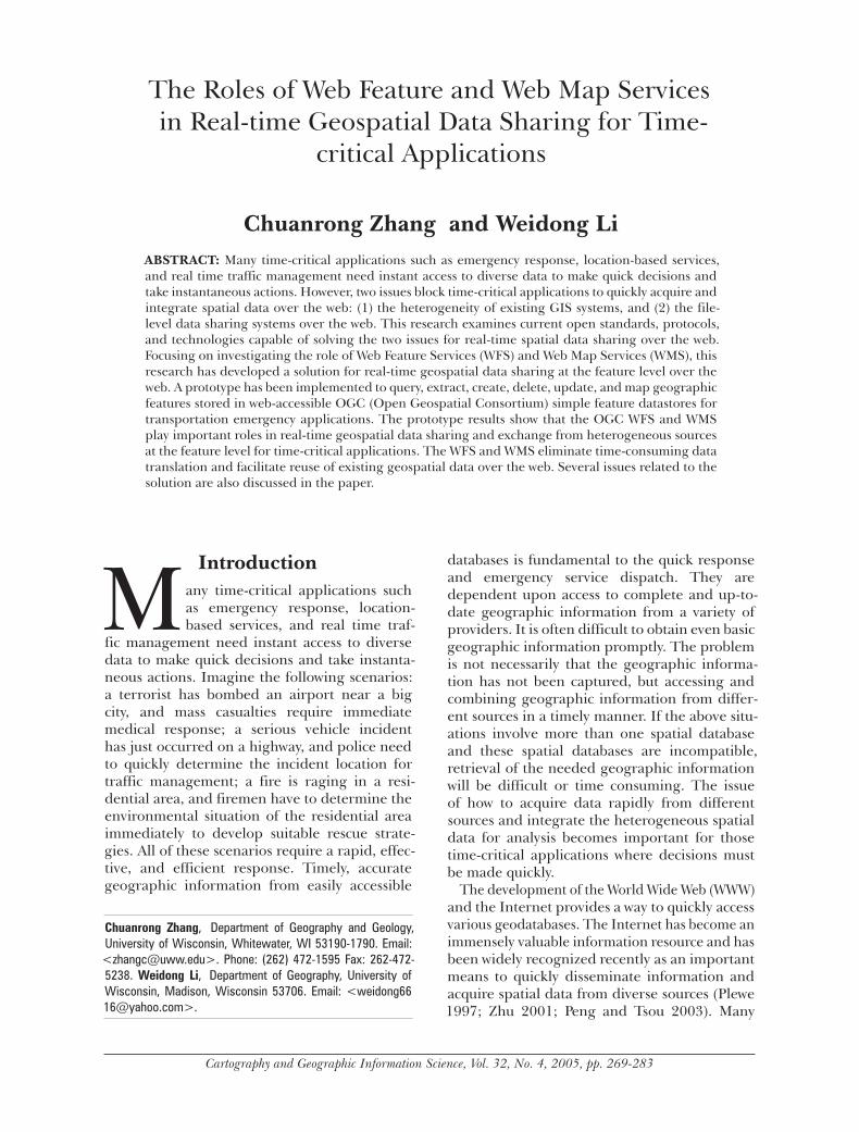
With the implemented prototype, users can search for and download feature-level spatial data over the web in real time. They can then query, extract, create, delete, update and map geographic fea-tures using WFS. Figure 9 provides an example of querying one route segment feature in GML format over the web by WFS. Figure 10 shows the corresponding SVG graphic map displayed by WMS. Figure 11 illustrates how to query and integrate several features in a small area from both UWM and UWW servers.
Discussion A framework of real-time geospatial data shar-ing for time-critical applications using OGC WFS and WMS was proposed in order to reduce duplication of efforts among agencies, make geographic data more accessible to the public, and increase the benefits of using available data. The results of our study show that the imple-mented prototype offers a number of advan-tages in facilitating data sharing over the web.
First, the framework supports multiple time-critical applications, by enabling access to hetero-geneous information by different programs on different platforms via the Internet, irrespective of the software these programs use and the data types they generate. Thus, an organization will not be locked into a single vendor because of a previous investment.
Figure 8. Integration of bus routes and bus stops data from two heterogeneous data sources through the web.

278 Cartography and Geographic Information Science Vol. 32, No. 4 279
Second, the approach allows spontaneous access to a feature in different datasets that may be located at different data servers and permits users to exchange data at the feature level. Current commercial Internet GIS programs do not have this capability. Spontaneous access allows time-critical applications to instantly access diverse remote data over the web. Sharing and exchanging data at the feature level in real time is especially important for these applications, because they can largely reduce the time spent on data acquisition and offer an emergency response team the ability to directly search for and access all feature-level information in a distributed Internet environment.
Third, this approach allows time-critical appli-cations to access various spatial data formats and services and therefore eliminate the time wasted on data conversion. It gives users the capability to publish and exchange data easily and dynamically in an open industry standard format on the web, thereby maximizing the re-use of geospatial data. It bridges the gaps among different data sources, vendors, databases, and formats. Databases based on this framework could be easily re-used in the future. Data developed for one application could be readily integrated with data developed for another application. Furthermore, this approach reduces users’ requirements for local data storage and cre-ates new opportunities for businesses that maintain online sources of data and information.
Fourth, this approach allows users and key decision makers to access the most accurate and up-to-date geospatial data over the web. Feature changes can be updated from one source to another by XLink without human intervention, and the approach has the potential to link geospatial data in a distributed environment. That is, geospatial data at one location can be related dynamically to data elements at another location, and an update at one database can be reflected automatically in another related database: an ultimate goal of data sharing.
Finally, this approach improves communica-tion among different departments and reduces the planning cycles for different departments to develop new programs. Spatial information cre-ated in one department can be available to others immediately, and all independent systems can communicate quickly and effectively, regardless of data formats.
While the approach has all these advantages, it is not devoid of limitations. The several important concerns are semantic interoperability, reliability, security, and performance issues. The proposed approach only leads to technical interoperability by adopting OGC web services and cannot resolve existing semantic problems. Different data produc-ers and service providers may develop different data schemes, and the same basic feature types may be named and described differently, lead-
Figure 9. Query of a one route segment in GML format over the web.

280 Cartography and Geographic Information Science Vol. 32, No. 4 281
ing to semantic heterogeneity. For example, one organization will use "house" and another will use "building" in reference to the same feature type. The semantic issue may be the most dif-ficult one to solve for data interoperability and has been discussed in recent literature (Egenhofer 1999; Smith and Mark 2001; Cruz et al. 2004). Much research has been conducted in GIS in recent years, attempting to find a suitable way, e.g., using ontology technologies, to solve the semantic issues (Fonseca et al. 2002; Bayer and Onsrud 2004; Hong 2004). The recent emergence of the Semantic Web core technology—Resources Description Framework (RDF) and Web Ontology Language (OWL)—may hold great promise to resolve the semantic interoperability problem existing in this proposed approach.
The second concern about the approach is the reliability of the distributed system. This should be increased by using OGC WFS and WMS, since a failure at one site may not lead to a failure of the entire other geographic information services (Worboys 1995; Tsou and Buttenfield 2002). Furthermore, redundancy in resources such as computers and data-files can improve the reli-ability of a distributed system (Hwang and Tseng 1993). However, as WFS and WMS are deployed
across different applications, reliable delivery of messages becomes a critical issue. This is because communications over the Internet and Intranets is inherently unreliable, due mainly because the underlying transport protocols such as HTTP do not offer any form of guaranteed or ordered delivery for SOAP messages. Unless web services communications are made reliable, time-critical applications will not be able to trust them for mis-sion-critical operations. It is important to ensure that user data exchanges are delivered in a reli-able fashion to the time-critical applications. The Web Services Reliability (WS-Reliability), being an approved OASIS standard, defines a method for open, reliable web services messaging—i.e., guaranteed delivery, duplicate message elimina-tion, and message ordering. This capability should be employed in WFS and WMS to allow a variety of systems to interoperate reliably.
Other concerns focus on the security and per-formance of WFS and WMS. The security issues involve authorization, which restricts access, and confidentiality, which is employed to protect XML messages exchanged over the web. To secure WFS and WMS, one can use the standard Secure Socket Layer and firewall based rules (Imamura et. al. 2004) at the transport level, while digital signa-
Figure 10. The corresponding SVG graphic map of the queried one-route segment feature.
280 Cartography and Geographic Information Science Vol. 32, No. 4 281
tures and/or encryption may be used to protect specific parts of an XML/SOAP message at the application level. In addition, the WS-Security Specification (Meier et. al. 2002; Wolter 2004), which provides a complete encryption system, may be employed to add more security features to WFS and WMS.
A major concern about the performance of WFS and WMS is related to the fact that large XML/GML messages have to be transferred between the ser-vice provider and the client. Three performance problems may emerge in WFS and WMS (OGC document 03-002r8, 2003) as a result of the pres-ent practice of encoding GML and other spatial data formats using plain-text XML: • Slow transfer of highly redundant and bulky
text in the XML structure over the web; • Unexpectedly high cost of lexically scanning
of XML messages (turning free text into tokens for internal processing); and
• High cost of converting text-encoded numeri-cal coordinate and observation values. The first performance problem may be resolved
by using general compression methods such as GZIP. The scanning cost and further space
reductions may be achieved by using a binary encoding method for the XML representation and changing slightly the method for specifying coordinate values.
Another concern with the performance of WFS and WMS is related to the Pull protocol they use. Currently, the Pull protocol requires that users send a request to the WFS and WMS servers every time they need information, and this creates a heavy burden on the network. The implementation of a Push protocol would eliminate unnecessary requests by allowing the server to recognize a change of information. Furthermore, the use of Multicast to deliver information to all users requiring the same information from WFS or WMS, would greatly increase performance; Singlecast delivers to each one of them separately. Web caching and using locks as efficiently as possible could also improve the performance of WFS and WMS.
ConclusionsThis research examines current open standards, protocols, and technologies that are capable of solving the issue of data integration and dis-
Figure 11. Query and integration of several features from both WFS servers.
282 Cartography and Geographic Information Science Vol. 32, No. 4 283
semination. A solution is proposed for searching, accessing, extracting, and visualizing network spatial data at the feature level in real time over the web, which originate from distributed sources with different GIS formats. A prototype system was implemented to test the proposed solution. Results show that OGC’s WFS and WMS may play important roles in real-time geospatial data sharing and exchange at the feature level from heterogeneous sources for time-critical applications. Users will be able to download only interested features of a data file instead of the whole file, and disseminate and update spatial data in a timely, accurate manner. In addition, testing showed that the framework eliminates time-consuming data conversion steps, reduces integration requirements and associated costs, and facilitates the re-use of existing geospatial data over the web. With WFS and WMS, individual organizations can access disparate data from multiple sources, regardless of vendor brands, formats, or platforms, and, consequently, realize complete data sharing. Thus, people at different departments may work together more efficiently and avoid duplication of efforts, making fast and more correct deci-sions. In spite of the advantages the solution has, several issues would benefit from further research, such as semantic interoperability, reli-ability, security, and performance.
ACKNOWLEDGEMENTWe thank Dr. Lynn Usery and anonymous reviewers for their constructive comments on the manuscript. The help from Dr. David J. Travis in revising the manuscript is greatly appreciated.
REFERENCESAnderson, G., and S. R. Moreno. 2003. Building web-
based spatial information solutions around open specifications and open source software. Transactions in GIS 7(4): 447-66.
Bayer, C. T. H., and H. Onsrud. 2004. Ontological development as appropriate precursor to land transfer system design. In: Proceedings of the Third International Conference on Geographic Information Science, Aldephi, Maryland, October 20-23. pp. 14-16.
Brodeur, J., Y. Bedard, G. Edwards, and B. Moulin. 2003. Revisiting the concept of geospatial data interoperability within the scope of human communication processes. Transactions in GIS 7(2): 242-65.
Choicki, J. 1999. Constraint-based interoperability of spatiotemporal databases. Geoinformatica 3(3): 211-43.
CÖMERT, C. 2004. Web services and national spatial data infrastructure (NSDI). In: Proceedings of Geo-
Imagery Bridging Continents, XXth ISPRS Congress, Istanbul, Turkey, Commission 4, July 12-23. [http://www.isprs.org/istanbul2004/comm4/papers/365.pdf; accessed September 4, 2005].
Cruz, I.F., W. Sunna, and A. Chaudhry. 2004. Semi-automatic ontology alignment for geospatial data integration. In: Third International Conference on Geo-graphic Information Science. Lecture Notes in Computer Science 3234: 67-80.
Di, L. 2004. Distributed geospatial information services—architectures, standards, and research issues. In: Proceedings of Geo-Imagery Bridging Continents, XXth ISPRS Congress, Istanbul, Turkey, Commission 2, July 12-23.[http://www.isprs.org/istanbul2004/comm2/papers/121.pdf; accessed September 4, 2005].
Egenhofer, M. J. 1999. Introduction: Theory and concepts. In: M. F. Goodchild, M. Egenhofer, R. Fegeas, and C. Kottman (eds), Interoperating Geo-graphic Information Systems. Norwell, Massachusetts: Kluwer. pp.1-4.
ESRI White Paper. 2003. Spatial data standards and GIS interoperability. [http://www.esri.com/library/whitepapers/pdfs/spatial-data-standards.pdf; accessed September 4, 2005].
Fonseca, F. T., M. J. Egenhofer, P. Agouris, and G., Câmara. 2002. Using ontologies for integrated geographic information systems. Transactions in GIS 6 (3): 231-57.
Geowise White Paper. 2005. Applying the UK eGovernment Interoperability Framework (eGIF) to geographic information (GI) services. [http://www.geowise.co.uk/downloads/whitepapers/GeoWise%20WP%20Applying%20eGIF%20to%20GI.pdf; accessed September 4, 2005].
Green, D. R. 1997. Cartography and the internet. The Cartographical Journal 34: 23-7.
Hong, I. 2004. Ontologies of landmarks for community wayfinding. In: Proceedings of the Third International Con-ference on Geographic Information Science, Aldephi, Mary-land, USA, October 20-23. pp. 130-33.
Hwang, G. J., and S. S. Tseng. 1993. A heuristic task assignment algorithm to maximize reliability of a distributed system. Reliability, IEEE Transactions on 42 (3): 408-15.
Imamura, T., Y. Nakamura, S. Makino, and K. Tamura. 2004. Implementation and performance of ws-security. International Journal of Web Services Research 1(1): 58-72.
Intergraph White Paper. 2005. Intergraph Mapping and Geospatial Solutions’ web services overview. [http:/ /www.intergraph.com/resource_fi les/literature/WP1057/WP1057_screen.pdf; accessed September 4, 2005].
Jia, W., Y. Chen, J. Gong, and A., Li. 2004. Web service based web feature service. In: Proceedings of Geo-Imagery Bridging Continents, XXth ISPRS Congress, Istanbul, Turkey, Commission 4, July12-23. [ http://www.isprs.org/istanbul2004/comm4/papers/334.pdf; accessed September 4, 2005].

282 Cartography and Geographic Information Science Vol. 32, No. 4 283
Kresse, W. 2004. Standardization of georaphic informa-tion. In: Proceedings of Geo-Imagery Bridging Continents, XXth ISPRS Congress, Istanbul, Turkey, Commission 2, July12-23. [http://www.isprs.org/istanbul2004/comm2/papers/132.pdf; accessed September 4, 2005].
Kottman, C. 1999. The Open GIS Consortium and progress toward interoperability in GIS. In: M.F. Goodchild, M. Egenhofer, R. Fegeas, and C. Kottman (eds), Interoperating Geographic Information Systems. Boston, Massachusetts: Kluwer. pp. 39-54.
MapInfo White Paper. 2003. Bringing GIS to the enterprise: Standards and interoperability. [http://www.mapinfo.co.uk/customer/download/Interop_White_Paper_UK.pdf; accessed September 4, 2005].
Meier, J.D., A. Mackman, M. Dunner and S. Vasireddy. 2002. Web services security [http://msdn.microsoft.com/library/default.asp?url=/library/en-us/dnnetsec/html/SecNetch10.asp; accessed September 4, 2005].
Open Geospatial Consortium (OGC). 1998. A request for technology in support of a web mapping technology testbed. The Open GIS Consortium Inc, US.
OGC Interoperability Program White Paper. 2001. [http://ip.opengis.org/ows/010526_OWSWhitepaper.doc. Accessed September 4, 2005].
OGC document 02-070. 2002. Styled layer de-scriptor implementation specification. [shttp://www.opengeospatial.org/specs/?page=specs; ac-cessed September 4, 2005].
OGC document 02-023r4. 2003. OpenGIS Geography Markup Language (GML) implementation specifica-tion, version 3.00, [http://www.opengeospatial.org/specs/?page=specs; accessed September 4, 2005].
OGC document 03-002r8. 2003. Binary-XML encoding specification, version 0.0.8. [http://www.opengeospatial.org/docs/03-002r8.pdf; accessed September 4, 2005].
OGC document 03-065r6. 2003. Web Coverage Service (WCS), Version 1.0.0. [http://www.opengeospatial.org/specs/?page=specs; accessed September 4, 2005].
OGC document 04-024. 2004. Web Map Service, Version 1.3. [http://www.opengeospatial.org/specs/?page=specs; accessed September 4, 2005].
OGC document 04-021r2. 2004. OpenGIS catalogue service specification. [http://www.opengeospatial.org/specs/?page=specs; accessed September 4, 2005].
OGC document 04-094. 2005. Web feature service implementation specification, version 1.1.0. [http://www.opengeospatial.org/specs/?page=specs; accessed September 4, 2005].
Peng, Z. R., and M. S. Tsou. 2003. Internet GIS: Distributed geographic information services for the internet and wireless networks. New York, New York: John Wiley & Sons, Inc.
Peng, Z. R., and C. Zhang. 2004a. The roles of geography markup language, scalable vector graphics, and web feature service specifications in the development of internet geographic information systems. Journal of Geographical Systems 6(2): 95-116.
Peng, Z. R., and C. Zhang. 2004b. GML, WFS, SVG, and the future of internet GIS. GIS@development 8(7): 29-32.
Peng, Z. R., 2005. A proposed framework for feature-level geospatial data sharing: A case study for transportation network data. International Journal of Geographic Information Sciences 19(4): 459-81.
Plewe, B. 1997. GIS online: Information retrieval, mapping, and the Internet. Santa Fe, New Mexico: OnWord Press.
Probst, F., F. Gibotti, and A. Pazos. 2004. Connecting ISO and OGC models to the semantic web. In: Proceedings of the Third International Conference on Geographic Information Science, Aldephi, Maryland, USA, October 20-23. pp. 181-4.
Safe Software White Paper. 2005. Web-based data distribution systems. [http://www.safe.com/solutions/white-papers/web-based-data-distribution.php. Accessed September 4, 2005].
Smith, B., and D. Mark. 2001. Geographic categories: An ontological investigation. International Journal of Geographic Information Science 15: 591-612.
Snowflake Software White Paper. 2005. Schema translation and semantics in data interoperability. [http://www.laser-scan.com/eurosdr/edelivery/pdf/5_2d_Paper_Curtis.pdf; accessed September 4, 2005].
Su, Y., J. Slottow, and A. Mozes. 2000. Distributing proprietary geographic data on the World Wide Web—UCLA GIS Database and Map Server. Computers and Geosciences 26: 741-9.
Tarnoff, P. J. 1998. Evolution or control. Traffic Technology International (February/March): 32-5.
Tsou, M.H., and B.P. Buttenfield. 2002. A dynamic architecture for distributed geographic information services. Transactions in GIS 6(4): 335-81.
Zhang, C., W. Li, M. Day, and Z.-R. Peng. 2003. GML-based interoperable geographical database. Cartography 32(2): 1-16.
Zhu, X. 2001. Developing web-based mapping applications through distributed object technology. Cartography and Geographic Information Science 28: 249-58.
Wolter, R. 2004. Xml web services basics. [http://msdn.microsoft.com/library/default.asp?url=/library/en-us/dnwebsrv/html/webservbasics.asp; accessed September 4, 2005].
Worboys, M. F. 1995. GIS: A computing perspective. London, U.K.: Taylor & Francis.

284 Cartography and Geographic Information Science