the reservoir structure plan 22 august,...
TRANSCRIPT

22 August, 2012T H E R E S E R V O I R S T R U C T U R E P L A N

2 Reservoir MAA DRAFT STRUCTURE PLAN
Glossary of TermsActive frontages
Active Frontages normally directly abut public spaces, and typically contain activities of a public nature located within a private building. The facades or frontages are normally highly visually and/or physically transparent, and commonly direct movement between the public and private realms on such frontages. Examples of active frontages would be shops and restaurants, but also “shopfront” presentations to swimming pools and libraries.
Activities Areas
Activities Areas are the traditional focus for services, employment and social interaction in cities and towns.
They are places where people shop, work, meet, relax and often live. Usually well served by public transport, they range in size and intensity of use from local neighbourhood strip shopping centres to traditional town centres and major regional malls
Business service uses
Land uses which help to serve the day to day operation of local businesses. Examples include banks, accountants, printers etc.
Civic space
Public spaces that are designed for a number of people to use at anyone time usually in an urban setting. These areas are generally paved and may contain landscaping such as trees. Examples include plazas, squares and malls.
Mixed use development
Good mixed use development involves the fine-grained mixing of compatible land uses in a balanced mix. Physically, it includes both vertical and horizontal mixes of use. No single use should dominate other uses, and residential land use should generally not exceed 60% of the land use.
Mid-block link
Pedestrian-only connections that are provided approximately mid-way along a street. Mid-block links are particularly useful on long streets where pedestrians can access car parking or other land uses behind the shopping strip.
Niche retail uses
Retail land uses which provide specific product offer or services which are targeted towards a particular customer segment. Such examples include arts supplies, jewellers or specialist food stores.
Passive surveillance
‘Eyes on the street’ provided by local people as they go about their daily activities – this can deter anti-social behaviour and make places ‘feel’ safer. Specifically, passive surveillance is best generated by residential uses overlooking the public realm, be this street or park.
Public spaces
Spaces that are publicly owned and which are intended for use by the public; and spaces that are privately owned but encourage public use free of any imposed rules or constraints on normal public behaviour.
Sense of place
Sense of place refers to the character and spirit of a particular location that make it special or unique. These characteristics can be the community interactions, the nature of the land uses, the character of buildings and landscaping.
Structure Planning
Structure planning is the process of developing a long-term planning framework to ensure integrated development of Activities Areas. Councils are required to undertake structure planning for all of their Central, Principal, Major and Specialised Activity Areas.
Source: Glossary of terms adopted from Activity Centre Design Guidelines. Published by the Victorian Government Department of Sustainability and Environment, January 2005 and additional terms provided by Tract Consultants
Residential Incremental Change
Residential areas where it is proposed that the current housing development patterns will continue within the existing planning scheme policies and controls.
Residential Intensification
Residential areas where it is proposed that buildings will be of a slightly higher density to provide for more housing with smaller front side and rear setbacks and additional height. These areas are confined to main road frontages in the Reservoir MAA.
Water Sensitive Urban Design (WSUD)
A sustainable water management approach that aims to provide water-quality treatment, flood management to reduce the pollution carried to our waterways and more sustainable urban landscapes.

3Reservoir MAA DRAFT STRUCTURE PLAN
1. IN
TRO
DU
CTI
ON
Contents
1 INTRODUCTION 4
1.1 Why a Structure Plan is needed 4
1.2 The process so far 4
1.3 How to use this Document 5
2 ABOUT THE RESERVOIR MAA 6
2.1 Context 6
2.2 Community profile 9
2.3 Key issues and opportunities 9
3 THE RESERVOIR MAA VISION 14
3.1 The Reservoir MAA Vision 14
3.2 Key Priority - The Central Heart 16
4 THE STRATEGIC RESPONSE 17
4.1 Businesses, activities and investment 17
4.2 Housing 18
4.3 Public spaces, streets and buildings 19
4.4 Moving around safely and efficiently 22
4.5 Sustainable local living 25
4.6 Community connections 26
5 PRECINCT PLANS 28
5.1 Introduction 28
5.2 Precinct 1: The Central Heart - A priority project for Reservoir 29
5.3 Precinct 2 - Reservoir Village 32
5.4 Precinct 3 - Broadway 34
5.5 Precinct 4 - High Street North 36
5.6 Precinct 5 - High Street South 37
5.7 Precinct 6 - Surrounding Residential 38
5.8 Residential Interface Treatment 40
6 IMPLEMENTATION 41
6.1 Monitoring and review 41
6.2 Priority Initiatives and Staging 41
6.3 Next steps 42
6.4 What’s already happening? 42
Report FiguresFigure 1: Project Process 5Figure 2: Reservoir Context Plan 7Figure 3: Local Context Plan 8Figure 4: Strategic Redevelopment Sites 11Figure 5: Reservoir MAA Framework Plan 15Figure 6: An artists impression of the Central Heart 16Figure 7: Public spaces, streets and buildings response 21Figure 8: Proposed road reconfiguration 23Figure 9: Moving around safely and efficiently plan 24Figure 10: The Reservoir MAA Precincts 28Figure 11: Central Heart Precinct Plan 30Figure 12: An artists impression of the Central Heart 31Figure 13: Reservoir Village Precinct Plan 33Figure 14: Broadway Precinct Plan 35Figure 15: High Street North Precinct Plan 36Figure 16: High Street South Precinct Plan 37Figure 18: Side and rear setbacks for four storey development 39Figure 17: Surrounding Residential Precinct Plan 39Figure 19: Setbacks to adjoining residential properties 40Figure 20: Setbacks to residential streets 40Figure 21: Priority Initiatives and Staging 41

1. Forecast.id Population forecasts at http://forecast2.id.com.au/Default.aspx?id=214&pg=5230
4 Reservoir MAA DRAFT STRUCTURE PLAN
This document outlines a 20 year plan for the renewal and revitalisation of the Reservoir Major Activities Area.
It sets out a vision for the Major Activities Area (MAA) and a series of strategies and initiatives required to achieve the vision.
It has been developed by the Darebin City Council with significant input from the community, businesses, government agencies and other stakeholders.
1.1 Why a Structure Plan is neededReservoir is identified under Victorian State Planning Policy as a Major Activities Area. The preparation of a Structure Plan is required to guide the future planning and development of the activities area up until 2030.
The population within the Reservoir MAA Structure Plan area is anticipated to grow and change over the period until 2030. An increase in population from 3,628 to 5,497 (an additional 1,869 people) is forecast, with an additional 794 dwellings expected to be constructed in the same period.1 Households will become smaller and the population will age.
These changes will have a number of implications for the future planning of Reservoir including:
• The character of Reservoir is likely to change in order to accommodate additional dwellings
• Shops, services and provision of public spaces will need to improve and change to serve the increased and changing population
• Housing types and services will need to respond to the greater proportion of elderly residents and smaller household sizes
The Structure Plan will provide a framework to guide the future growth of Reservoir in a logical and sustainable way and provide a guide for public and private investment in the MAA.
1.2 The process so farTo date the Draft Reservoir MAA Structure Plan has been developed with significant input from community and key stakeholders across four key stages (refer to Figure 1). Feedback from the engagement process has been integrated with evidence based research to develop the vision and more detailed initiatives in this document.
The following summarises the project stages:
Stage 1 - ‘Background Research and Issues Identification’ - Stakeholder engagement and research undertaken to gain an understanding of key issues affecting the future planning of Reservoir
Stage 2 - ‘Community Visioning and Place Essence’ - A vision was developed for the Reservoir MAA through a series of stakeholder, community and trader visioning workshops
Stage 3 - ‘Vision Scenarios’ - Various options and scenarios were developed for key sites within the Structure Plan area. Feedback from the community was provided on each of these scenarios
Stage 4 - ‘Structure Plan’ - The Draft Structure Plan was released for public comment and finalised to incorporate feedback
Stage 5 - ‘Implementation Plan’ (Future Stage) - An implementation plan will be developed to ensure key actions within the Structure Plan are realised in the short, medium and long term
1 INTRODUCTION

5Reservoir MAA DRAFT STRUCTURE PLAN
1. IN
TRO
DU
CTI
ON
1.3 How to use this documentThe Reservoir MAA Draft Structure Plan consists of the following sections:
1. Introduction
• Provides an overview of the document and project
2. About the Reservoir MAA
• A summary of the key issues affecting the future planning of the MAA
3. The Reservoir MAA Vision
• A vision for Reservoir developed in conjunction with the community and stakeholders
4. The Strategic Response
• The centre-wide plan for the MAA with objectives, strategies and actions relating to the following themes:
- Business, activities and investment - Housing - Public spaces, streets and buildings - Moving around safely and efficiently - Sustainable local living - Community connections
5. The Precinct Plans
• Details for the future structure and character of the six identified precincts:
- Precinct 1 - The Central Heart - Precinct 2 - Reservoir Village - Precinct 3 - Broadway - Precinct 4 - High Street North - Precinct 5 - High Street South - Precinct 7 - Surrounding Residential
6. Implementation
• An overview of the of the staged implementation of key priorities and projects
Stage 1 - Background Research and Issues Identification
Background and Issues Paper (September 2010)
Reservoir Strategic Transport Plan (June 2010)
Economic Analysis and Market Feasibility Study (June 2010)
Draft Reservoir Vision and Place Essence Paper (August 2010)
Small Wins Action Plan (August 2010)
Vision Scenarios Discussion Paper (December 2010)
Community Infrastructure Needs Assessment (September 2011)
Draft Structure Plan (June 2012)
Stage 2 - Community Visioning and Place Essence
Stage 3 - Vision Scenarios
Stage 4 - Structure Plan
• Community Visioning Workshop• Trader / Stakeholder Visioning Workshop• Council / Service Provider workshops• Community Reference Group input• Small Wins Action Plan
• Various stakeholder / agency workshops to test scenarios and vision
• Community Reference Group input
• Four week public comment period on ‘Vision Scenarios Discussion Paper’
• Discussion with ‘hard to reach’ groups
• In-centre interviews with residents and commuters
• Round table discussions
• Community workshop - Strategic directions for the Structure Plan
• Half day community event - Strategic directions and updated vision
• Four week public exhibition period for the Draft Structure Plan
COMMUNITY AND STAKEHOLDER ENGAGEMENT
PROJECT STAGE
PROJECT OUTPUTS
• Darebin Kite and Community Festival Listening Posts
• In-centre listening posts• Kitchen table discussions• Community Reference Group input• ‘Walking the beat’ - informal chats with
the community and traders• Community infrastructure focus groups• Transport interchange focus groups
Figure 1: Project Process

6 Reservoir MAA DRAFT STRUCTURE PLAN
2 ABOUT THE RESERVOIR MAA
2.1 Context2.1.1 History
Reservoir is documented as having a long connection with the Koori population, dating back nearly 40,000 years. Merri and Edgars creeks and adjoining parkland are considered to have provided ideal locations for food, water and shelter.
In the mid to late 19th century significant water infrastructure was constructed in Reservoir providing a reliable flow of fresh water to Melbourne. Reservoir, formerly known as Preston North gained it’s namesake from this history.
Reservoir saw substantial growth during the 1920s construction boom with the establishment of several shops in Edwardes Street and adjacent to the Reservoir Station. The development of the Broadway shopping strip lagged behind Edwardes Street because of the slower growth of housing east of the railway station.
2.1.2 Regional context
The Reservoir MAA is conveniently located 14 kilometres north of the CBD and approximately 10km south of Melbourne’s northern growth corridor. The South Morang rail line and major north-south arterial roads including Spring Street and High Street, run through the centre of Reservoir and provide direct access between Reservoir, the CBD and northern growth areas. Reservoir is effectively separated to the east and west of these major infrastructure elements.
Reservoir is situated amongst a network of other Activities Areas including the Northland Principal Activities Area (PAA) to the south east, Preston PAA directly south, Summerhill Village to the east and Campbellfield to the north west. These centres provide employment and shopping alternatives to the Reservoir MAA with the Preston PAA most likely to compete with Reservoir.
Specialist centres within the region include Latrobe University which is located 4km east of Reservoir and provides a major education and employment hub. Major industrial areas to the west, north and north west of the Centre also provide employment for the region and can easily be accessed from the Reservoir MAA.
Reservoir is located on a high point which necessitates a water supply role in the region. Edgars Creek in the west and Darebin Creek in the east provide significant topographical and open space features that contribute to defining the catchment of the Centre. The MAA will play an important role in linking these open space assets.
Reservoir Construction, Source: Darebin Historical Encyclopedia http://dhe.darebin-libraries.vic.gov.au/
Workers leaving Reservoir Station - 1920, Source: Darebin Historical Encyclopedia http://dhe.darebin-libraries.vic.gov.au/
Edwardes Street - 1930, Source: Darebin Historical Encyclopedia http://dhe.darebin-libraries.vic.gov.au/

7Reservoir MAA DRAFT STRUCTURE PLAN
2. A
BO
UT
THE
RES
ERV
OIR
MA
A
7
2.1.3 Local context
The Reservoir MAA is defined by two separated shopping areas – Reservoir Village and Broadway, located either side of the railway station and bus interchange. Major road infrastructure and the rail line create significant barriers for pedestrian, cycle and vehicle access between the shopping areas and into the central station precinct.
Reservoir station is located at the edge of Zone 1 on the South Morang rail line making it a popular destination for commuter car parking, which occupies a large proportion of the station precinct. Further south is Melbourne Water infrastructure and the reservoirs, which are located on a high point in the region.
Edwardes Lake Park in the west and T.W. Andrews Reserve / Darebin Ceek in the east anchor either end of the Reservoir MAA forming a green edge to the centre and providing major passive and active recreational assets for the community. A small reserve in the south west corner and the Yan-Yean pipe track provide other open spaces within the study area.
The MAA offers significant community facilities including the Reservoir Civic Centre, Reservoir Library, East Reservoir Neighbourhood House, the Easter Reservoir Senior Citizens Centre and Community Garden, the Reservoir Leisure Centre, the Oakhill Centre and two primary schools. The Civic Centre in Edwardes Street will further strengthen its role when the library is redeveloped within the Civic Centre site.
The MAA is performing relatively strongly with low vacancy rates within both Reservoir Village and Broadway. It provides a role as a location for weekly food shopping, business services and personal services.
Residential areas surrounding the central precincts are generally characterised by detached single storey dwellings interspersed with multi-unit and townhouse developments. A small pocket of industrial properties on Edwardes Street is located within the residential surrounds.
Figure 2: Reservoir Context Plan
Principal Activities AreaMajor Activities AreaParks and Open SpaceEmploymentTrain line and stationTram linePPTN
THE RESERVOIR
MAA
MERRI CREEK
EDGARS CREEK
DAREBIN CREEK
MELBOURNE CBD - 14km
NORTHERN GROWTH AREA - 10km

8 Reservoir MAA DRAFT STRUCTURE PLAN
Figure 3: Local Context Plan

9Reservoir MAA DRAFT STRUCTURE PLAN
2. A
BO
UT
THE
RES
ERV
OIR
MA
A
9
2.2 Community profileReservoir’s community is mixed in terms of age and culture which is a key defining aspect of the community. There is a strong sense of community in Reservoir, which is demonstrated through the willingness of many to participate in public life and events.
Key attributes of Reservoir’s community profile include:
• Reservoir’s population is getting older. Residents between 5 and 24 years have dropped, and the proportion of residents between 25 and 60 has significantly risen.
• The size of households in Reservoir are getting smaller with more people living alone. This is due to a number of factors, including the maturation of families that moved into Reservoir in the 1960’s and 1970’s as older children moved away leaving their parents to age in place.
• Reservoir has a diverse cultural population, which makes the community unique. Australian born residents make up 57.5% of the population and 34.3% born overseas with a large population of southern European and African born residents.
• Reservoir is generally ranked as disadvantaged on most indices in the Australian Bureau of Statistics (ABS) Socio-Economic Index for Areas (SEIFA). This index compares socio-economic characteristics of a community with the remainder of Victoria based upon income, education, employment, occupation and housing.
• Reservoir is marginally less affluent than the average Melbourne population. Overall, 9.4% of the population earned a high income and 49.9% earned a low income compared with 18.7% and 40.3% respectively for the Melbourne Statistical Division.
Structure planning for the Reservoir MAA will need to respond to these unique characteristics through future housing, land use and infrastructure provision.
2.3 Key issues and opportunities2.3.1 The future role of Reservoir
The Reservoir MAA currently fulfils a role as a neighbourhood centre providing weekly food shopping, business services and personal services. This existing role is likely to contract because of increasing competition from online retailing and larger regional centres.
Major revitalisation of the Reservoir MAA will need to be commercially led by delivering a substantial amount of retail floor area within the MAA. This will elevate Reservoir’s role within Darebin’s retail hierarchy and attract new visitors. It will also provide the necessary attraction for new residents to consider apartment living within the centre.
There are existing opportunities to increase the retail floor area within the MAA through expansion of exisitng supermarkets and redevelopment of underutilised sites such as the Council owned at-grade car parks.
A major opportunity for a retail land use could be provided within the physical centre of Reservoir if grade separation is implemented and the road network is re-configured, which will result in large, developable land parcels. This proposal is discussed as the ‘Central Heart’ in the subsequent chapters of the Draft Structure Plan.
The development of a strong retail offer within the Central Heart will impact on Broadway and Reservoir Village, however the precincts may respond by reinventing themselves over the longer-term to have a strong food / beverage / cafe / lifestyle / medium density housing focus.
Existing shops in Edwardes Street

10 Reservoir MAA DRAFT STRUCTURE PLAN
2.3.2 Connecting the two shopping areas
A key challenge identified through consultation and analysis is improving the integration of the two shopping areas - Reservoir Village and Broadway.
The confluence of major roads and rail result in a physical separation of the areas which spans a distance of approximately 150m. 58.1% of respondents to a 2008 structure plan survey indicated that they visit one centre and not the other.
Better integration of the two shopping areas could have multiple benefits in the overall role and function of the Reservoir MAA. It could enable the MAA to cater to a broader catchment and perform better with its established catchment because it would provide a greater retail and service offer.
There are several opportunities to improve integration including enhancing pedestrian and cycle access across Spring Street and High Street south, providing a high quality pedestrian environment through the station area with additional seating, and utilising elements to provide visual connections between the precincts such as lighting.
A longer term opportunity includes re-configuring the road network and lowering the rail line so that a new precinct is created in the centre of Reservoir. This precinct could become the ‘heart’ of Reservoir, providing a new public square and major land use opportunities.
Existing medium density development in the Reservoir MAA
2.3.3 Housing opportunities
The Reservoir MAA will see a significant increase in housing with an estimated increase in population of 1,869 people by 2030. In addition, the reduction in household sizes and the ageing population across Reservoir will require new forms of housing to be offered into the future.
Feedback from the community consultation has indicated that many are willing to accept greater intensification of housing however there needed to be improved open spaces and community facilities. Traffic and parking issues arising from additional housing were also raised.
The economic analysis indicates that the townhouse style of development is likely to continue as the most dominant form of housing within the Reservoir MAA for the next 10 years. Apartment development opportunities will be limited in the shorter term and are likely to be provided in Reservoir once the apartment market has matured in Coburg and Preston.
Apartment style development could be further incentivised by improving the amenity and lifestyle qualities of the centre. This could be achieved through additional hospitality uses, improvements to the existing retail offer, improved access to transport, and better streets and open spaces.
Key opportunities for additional housing will exist on large publicly owned sites such as Council car parks and commuter car parks, and within large residential and commercial allotments.
“Need to bring Reservoir Village and Broadway shops together.”
“Housing development must be tasteful, sustainable, aesthetically pleasing, welcoming and integrated with additional green space.”
11Reservoir MAA DRAFT STRUCTURE PLAN
2. A
BO
UT
THE
RES
ERV
OIR
MA
A
11
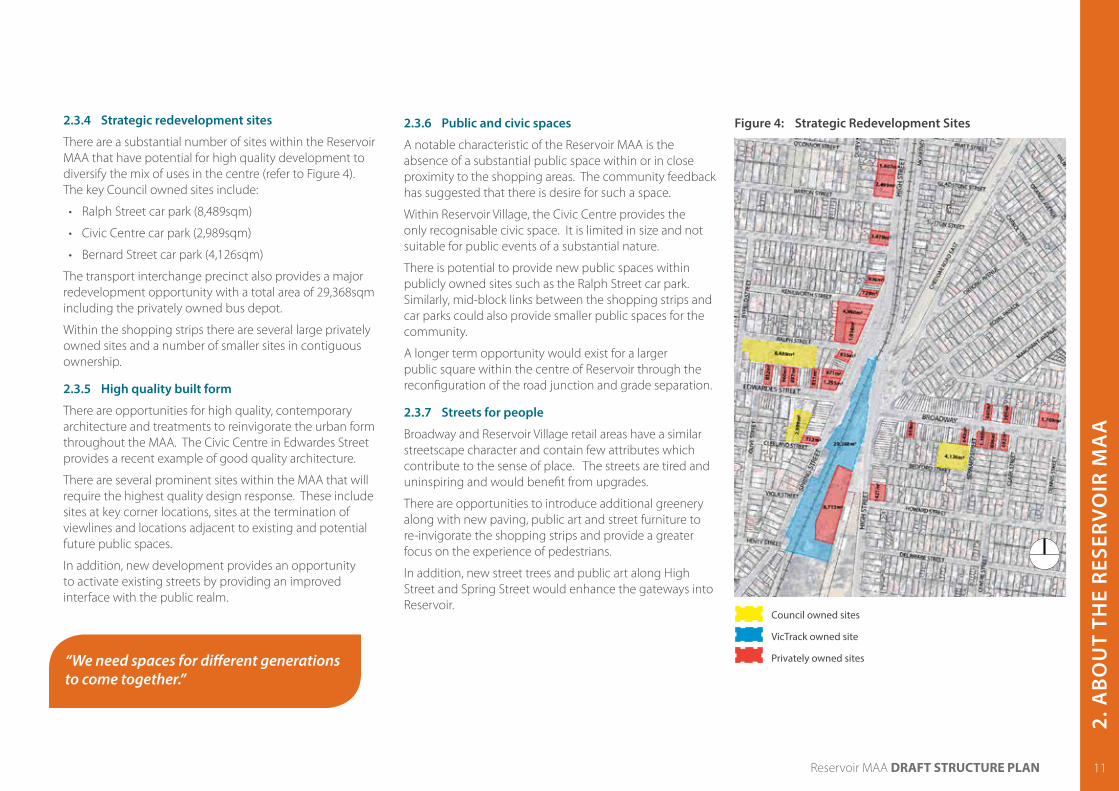
2.3.4 Strategic redevelopment sites
There are a substantial number of sites within the Reservoir MAA that have potential for high quality development to diversify the mix of uses in the centre (refer to Figure 4). The key Council owned sites include:
• Ralph Street car park (8,489sqm)
• Civic Centre car park (2,989sqm)
• Bernard Street car park (4,126sqm)
The transport interchange precinct also provides a major redevelopment opportunity with a total area of 29,368sqm including the privately owned bus depot.
Within the shopping strips there are several large privately owned sites and a number of smaller sites in contiguous ownership.
2.3.5 High quality built form
There are opportunities for high quality, contemporary architecture and treatments to reinvigorate the urban form throughout the MAA. The Civic Centre in Edwardes Street provides a recent example of good quality architecture.
There are several prominent sites within the MAA that will require the highest quality design response. These include sites at key corner locations, sites at the termination of viewlines and locations adjacent to existing and potential future public spaces.
In addition, new development provides an opportunity to activate existing streets by providing an improved interface with the public realm.
2.3.6 Public and civic spaces
A notable characteristic of the Reservoir MAA is the absence of a substantial public space within or in close proximity to the shopping areas. The community feedback has suggested that there is desire for such a space.
Within Reservoir Village, the Civic Centre provides the only recognisable civic space. It is limited in size and not suitable for public events of a substantial nature.
There is potential to provide new public spaces within publicly owned sites such as the Ralph Street car park. Similarly, mid-block links between the shopping strips and car parks could also provide smaller public spaces for the community.
A longer term opportunity would exist for a larger public square within the centre of Reservoir through the reconfiguration of the road junction and grade separation.
2.3.7 Streets for people
Broadway and Reservoir Village retail areas have a similar streetscape character and contain few attributes which contribute to the sense of place. The streets are tired and uninspiring and would benefit from upgrades.
There are opportunities to introduce additional greenery along with new paving, public art and street furniture to re-invigorate the shopping strips and provide a greater focus on the experience of pedestrians.
In addition, new street trees and public art along High Street and Spring Street would enhance the gateways into Reservoir.
“We need spaces for different generations to come together.”
Figure 4: Strategic Redevelopment Sites
Council owned sites
VicTrack owned site
Privately owned sites

12 Reservoir MAA DRAFT STRUCTURE PLAN
2.3.8 A connected open space network
The open space network in Reservoir is anchored by Edwardes Lake Park which provides a key passive and active recreational role for the centre. The Darebin Creek parklands provide a key node at the eastern extent of the study area.
There are opportunities to improve the existing open space network particularly Edwardes Lake Park to reinforce it as a major community hub. There is also potential for a new, ‘green’ open space closer to the town centre through the proposed reconfiguration of the road network.
Other initiatives for improving the open space network will be to enhance the linkages between open space assets, the town centre and surrounding residential areas. These linkages should be improved with street trees for shade, seating and high quality walking and cycling infrastructure.
2.3.9 Pedestrian and bicycle network improvements
The pedestrian and bicycle networks throughout the Reservoir MAA could be significantly improved so that the streets become vibrant and active places for business and socialising.
The pedestrian connection between Edwardes Street and Broadway is currently hindered by the physical barrier of the railway station, the large amount of road space and high volumes of traffic, and the poor condition of the public realm. The improvement of this link is critical in better integrating the shopping areas.
Elsewhere there are opportunities to improve pedestrian priority particularly within the shopping strips and along key residential streets.
Within Reservoir there are a number of on-road and off-road cycle paths which are important for getting to and around the centre. Of particular importance is the shared path along High Street, which connects to the St Georges Road trail further south but terminates near the station. There is potential to connect this path across the road junction so that it links into the shared path along the Yan-Yean pipe track.
Surveys by Booz and Company suggest that a substantial number of residents would be willing to shift from driving to walking or cycling, with 27% saying they would be willing to walk and 24% saying they would be willing to cycle. There are opportunities to enhance the walking and cycling networks so that this modal shift potential is realised.
2.3.10 Simplifying the road junction
The Reservoir MAA is characterised by the complex network of roads that converge at the rail crossing. This not only creates traffic conflicts and congestion but also provides negative impacts on the character function of the retail centre.
There is an opportunity to simplify the road network and reinforce Spring Street/High Street north as the major traffic route through the centre. This has to be considered in conjunction with grade separation of the rail line and roads, and existing freight routes through Reservoir.
A total reduction in through traffic is preferable through Reservoir in order to limit the impact of Spring Street / High Street North as a major pedestrian and cycle barrier into the interchange precinct and between the shops.
“Lots of green space, including community gardens.”
Opportunities to provide signalised pedestrian crossings on both sides of Edwardes Street and Broadway to provide better access into the station precinct

13Reservoir MAA DRAFT STRUCTURE PLAN
2. A
BO
UT
THE
RES
ERV
OIR
MA
A
13
2.3.11 Opportunities for sustainable local living
The community engagement has indicated a strong emphasis on sustainable local living in Reservoir.
These opportunities could be pursued by providing a centre where everything is easily accessed by walking and cycling or catching public transport. A focus on local food production will further enhance local living opportunities and strengthen the sense of community.
There are also opportunities to provide for renewable energy production in new developments. Similar opportunities exist to pursue Water Sensitive Urban Design techniques in the development of new public spaces and streets.
2.3.12 Community connections and infrastructure
There is a willingness for residents of Reservoir to participate in public life and contribute to shaping the future character of the place. This was demonstrated through the strong participation during the engagement phases and the positive ideas put forward.
Opportunities for the community to connect will be enhanced through improvements to public spaces, more events enabling people to participate, more vibrant land uses and additional community infrastructure.
The Civic Centre is a key focus for community infrastructure and will be further enhanced when the library is re-built within the Civic Centre site. Other community facilities, programs and services such as the East Reservoir Neighbourhood Renewal and aged care and disability services play an important role in the Reservoir MAA.
The analysis of community infrastructure within the MAA has indicated that there is an existing need for an early years hub which would incorporate child care, kindergarten, and maternal and child health services. Additional infrastructure such as community meeting rooms, elderly services and band rehearsal spaces will also be needed to cater to the changing population.
“You must have a mix of aged, young families, single people…the mix equals a balanced community.”
Opportunities for affordable living should also be pursued throughout Reservoir. Initiatives such as community gardens, farmers markets and food swap meets will help to strengthen the sense of community and provide access to local and affordable food produce.
The existing Civic Centre is highly valued and well utilised

14 Reservoir MAA DRAFT STRUCTURE PLAN
3 THE RESERVOIR MAA VISION
3.1 The Reservoir MAA VisionThe Vision provides a statement of the preferred future for the Reservoir MAA over the next 18 years. It has been developed through extensive public workshops and meetings that involved traders, residents, government agencies, local stakeholders, special interest groups and the project team.
The Reservoir MAA Framework Plan opposite shows how key elements of the vision will be achieved. Future initiatives that follow throughout the Structure Plan aim to achieve the Vision.
“In 2030 Reservoir will be a place without barriers that celebrates diversity, connectedness and participation.
Through replanning and renewed investment in its streets, businesses, infrastructure and housing – while keeping and honouring what already makes it great – Reservoir will reach its full potential.
Most importantly, Reservoir will finally have the welcoming central heart it deserves by redesigning the intersection that divided it for so long. A central heart to match its soul.
Throughout it all, the people of Reservoir will continue to lead and define opportunities for physical and social transformations and ensure Reservoir‘s cultural identity and landscape remain unique”.

15Reservoir MAA DRAFT STRUCTURE PLAN
3. T
HE
RES
ERV
OIR
MA
A V
ISIO
N
15
Figure 5: Reservoir MAA Framework Plan
Melbourne Water land
Edwardes Lake Park
T.W. Andrews Reserve
Cirspe Park
Robinson Park
Leisure Centre
SPRI
NG
STRE
ET1
2
3
4
5
6
6
EDWARDES STREET
BROADWAY
CHED
DAR R
OAD
HIG
H S
TREE
T
HIG
H S
TREE
T
Coles
Primary retail / residential mixed use
Retail / services / residential mixed use
Central Heart - Transport hub, major retail with residential, office and community uses
Office / services / residential mixed use
Residential intensification
Residential incremental change
Future ‘green’ open space
Existing public open space
Future public spaces - squares / plazas
Melbourne Water Land - potential for future restricted public access and use
Train station - grade separated
Precinct boundaries
Key pedestrian / cycle links
Future mid-block links
Existing / future land use anchors
Key redevelopment sites
Primary streetscape upgrades
Advocate for extension of 112 tram into Reservoir
Preferred through traffic route (Spring St / High St North)
Key gateways to be enhanced with additional greening / public art
2

16 Reservoir MAA DRAFT STRUCTURE PLAN
3.2 Key Priority - The Central HeartThe ‘Central Heart’ will be the new focus for Reservoir. It will be a place for the community to come together and celebrate the diversity of Reservoir through events, markets and gatherings. It will be a place of beautiful public spaces for all to enjoy, and provide opportunities for living, working and shopping in the heart of the action.
Major retail and commercial land uses within the precinct will drive the renewal of Reservoir by elevating its role in the region and attracting new visitors.
The ‘Central Heart’ will better connect Reservoir Village and Broadway, which will be achieved through undergrounding the train line, simplifying the road junction and providing easy and safe movement for pedestrians through the centre of Reservoir. The bus and rail interchange along with the potential Tram 112 extension, will be truly integrated within the precinct.
Council has already commenced work on this exciting project and is currently undertaking a feasibility study to determine the best options for grade separation and the configuration of roads and land uses. This study will form an important part of lobbying for government support of the project.
Because of the complexities of this project and the level of government support required, it is likely that the design and development of the Central Heart will be undertaken over the long term.
The key stages for delivering the Central Heart
Figure 6: An artists impression of the Central Heart - looking from the Edwardes Street / Spring Street intersection towards the new public square
This is how we will achieve the Central Heart:
• Build a business case for rail grade separation and lobby government with united community support
• Simplify the road network around the junction
• Separate the rail line from the roads by putting the train line underground
• Integrate bus, train and potential tram services into the Central Heart
• Provide improved amenity for pedestrians and cyclists through the ‘Central Heart’ to strengthen the connections between the shopping areas
• Connect Reservoir Village and Broadway with continuous land uses and public spaces
• Provide for major retail land uses within the Central Heart to drive the revitalisation of Reservoir supported by commercial and community uses and housing
• Create a new public square, which is surrounded by active uses such as retail, cafes, restaurants and community facilities
• Advocate for the extension of Tram 112 into the Central Heart
• Undertake additional studies to test key elements
• Provide beautification of the station area
• Implement pedestrian and cycle access improvements into the station area
• Implement Spring Street / High St Nth traffic priority
• Reconfigure road network with relocated level crossing
• Downgrade High St South to provide greater amenity for businesses
• Create new land parcels and develop those which are unaffected by grade separation or the long term master plan
• Provide open space and pedestrian / cycle improvements
• Undeground the rail line and create the public transport hub
• Create large development parcels
• Provide major retail anchors to lead revitalisation supported by commercial, community uses and housing
• Create a new public square and green spaces for the community to come together
• Enhance north south and east west pedestrian and cycle links
2012 2030Lobby for grade separation Advocate for extension of Tram Route 112 into Reservoir

4. T
HE
STR
ATEG
IC R
ESPO
NSE
17Reservoir MAA DRAFT STRUCTURE PLAN
4 THE STRATEGIC RESPONSEThe strategic response provides centre-wide objectives, strategies and actions which aim to achieve the Vision. Six themes are considered across the entire structure plan area so that it can be planned in a logical and sustainable way.
A. d
Objectives:
To consolidate Reservoir’s position as a desirable destination in Melbourne’s north to invest, shop, live, work and play
To facilitate long term investment by providing for businesses to start up, grow and mature in the MAA
To support a diversity of businesses to meet community needs now and into the future
To strengthen land use synergies and connections between Reservoir Village and Broadway
To support and encourage businesses to contribute positively to the management, attractiveness and vitality of the MAA
To encourage businesses to adapt to the changing role of the MAA
Strategies: • Improve the supermarket offer in Broadway and
Reservoir Village to meet the daily shopping needs of the community and better anchor the specialty retail
• Improve the visual and physical connections between Reservoir Village and Broadway and provide for a continuation of land uses through the Central Heart
• Encourage additional cafe / restaurant uses throughout the MAA which encourage activity through the day and night and enhance the lifestyle qualities
• Plan for extensive commercial floor area in the central heart to attract high order retail and other business activities to the centre
• Encourage site consolidation within the MAA to allow for medium and larger businesses whilst maintaining a fine-grain pattern of development to the street
• Provide opportunities for new businesses to flourish in the Reservoir MAA with affordable start up spaces in a range of sizes and locations catering to the diverse population
• Explore opportunities for effective and co-ordinated management of the commercial areas within the MAA
• Encourage and support businesses to improve the appearance of their shops to the street
• Provide for better co-ordination of skills, knowledge, ideas and resources between businesses, the community, residents and Council
Actions:A.1 Develop and implement a masterplan for the
Central Heart which provides for major retail and commercial investment within the precinct, and a continuity of land uses between Reservoir Village and Broadway
A.2 Develop planning controls to encourage the consolidation of allotments whilst ensuring a fine grain pattern of development to the street
A.3 Begin discussions with supermarket providers with the aim of attracting new supermarkets to the MAA
A.4 Develop a lighting strategy that provides a visual connection between Broadway and Reservoir Village and improves safety
4.1 Businesses, activities and investment
“We need a critical mass of shops in the Reservoir so the centre thrives.” - Community Event Participant
The vision seeks to provide renewal of the centre through new investment in businesses. This theme provides centre-wide initiatives for how this will be achieved through future land uses and activities.
A.5 Implement streetscape upgrades to Edwardes Street and Broadway that allow for outdoor dining to occur within footpaths and kerb extension areas
A.6 Implement a program of small low cost improvements to the commercial areas of the MAA such as weeding of garden beds, high pressure cleaning of footpaths
A.7 Develop a program to explore the benefits for co-ordinated management of the Reservoir MAA. The program should focus on branding, marketing and complementary role and functions of shopping areas
A.8 Support traders with skills, training and networking opportunities
A.9 Explore a shopfront improvement scheme including visual merchandising, training and painting of shopfronts

18 Reservoir MAA DRAFT STRUCTURE PLAN
“Lots of people need to be able to live in the immediate area to give it life in the day and at night.” - Community Event Participant
4.2 Housing
B. f
Objective:
To provide a range of housing types for people of all ages and circumstances
To provide a sufficient amount of housing within the Reservoir MAA to satisfy the expected population growth
To provide for additional passive surveillance, life on the streets and investment in the commercial areas of the Reservoir MAA
To focus higher density forms of housing in key redevelopment sites, above shops within the commercial areas, adjacent to open spaces and along main roads
Strategies: • Cater to the needs of the changing population in
Reservoir by providing broader housing choices for families, singles, older people and multi-generational families
• Provide an appropriate proportion of affordable housing within the redevelopment of key Council owned sites
• Provide additional retirement housing and aged care to cater to the needs of the aging population in Reservoir
• Focus residential development in key redevelopment sites such as the Central Heart and Ralph Street car park, and above shops within the commercial areas
• Locate higher density forms of housing along Edwardes Street, Broadway, High Street North, High Street South and Spring Street
• Provide high quality housing around Edwardes Lake Park which captures the high amenity and respond to the environmental sensitivities
• Encourage high quality housing outcomes through the redevelopment of existing residential areas within the MAA as currently facilitated through planning controls such as Rescode
• Encourage the consolidation of allotments throughout the Reservoir MAA to provide for greater efficiency in housing developments
Actions:B.1 Develop appropriate controls and policies to
focus housing in the key locations outlined in the strategies and reinforced in the Precinct Plans
B.2 Implement public realm, land use and access improvements identified throughout the Draft Structure Plan to attract housing investment in the Reservoir MAA
B.3 Develop masterplans for key council owned sites which provide for housing integrated with other uses
An example of the types of housing to be provided along main road frontages
An example of shoptop housing that could be provided within Reservoir Village and Broadway
Additional housing within the Reservoir MAA will result in additional people in the centre to drive investment and provide more life on the streets. This theme provides initiatives across the Reservoir MAA to plan for future housing.

4. T
HE
STR
ATEG
IC R
ESPO
NSE
19Reservoir MAA DRAFT STRUCTURE PLAN
C. fObjective:
To provide streets throughout the Reservoir MAA that are full of people, beautiful, green and create a strong sense of place
To provide a range of public and civic spaces that promote community gathering and interaction, and reflect Reservoir’s unique character
To enhance and better connect Reservoir’s parks and recreational facilities
To promote excellence in architectural quality across the Reservoir MAA
To provide buildings that contribute positively to adjoining public realm
Strategies: • Improve key retail streets in the Reservoir MAA
with high quality footpath surfaces, activation from adjoining buildings, additional greening and higher levels of safety for pedestrians
• Improve entries into the Reservoir MAA by providing additional planting, landscaping, public art and high quality built form along main roads
• Provide streetscape improvements to Spring Street and High Street South to minimise the impacts of vehicles on pedestrian comfort and safety
• Enhance key residential streets that connect into the town centre and to surrounding open spaces to encourage walking and promote healthy lifestyles
• Develop new public gathering places including a new public square within the Central Heart and a new public plaza within the Ralph Street car park laneway (refer to Precincts 1 and 2 for more detail)
• Provide public art throughout streets, parks and plazas to tell the story of the Reservoir MAA and provide additional animation and interest
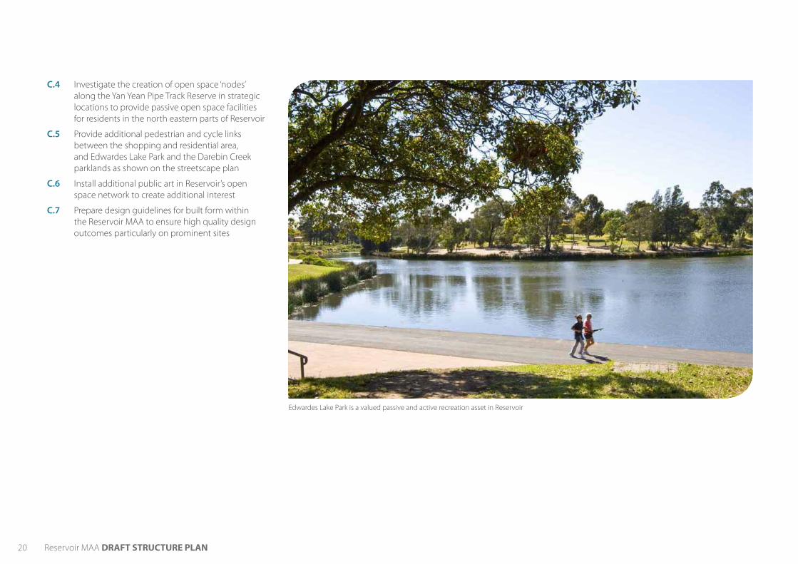
• Enhance Edwardes Lake Park as a significant open space area close to the activity centre
• Enhance the Yan-Yean Pipe Track linear park as a functional and attractive open space element in Reservoir
• Encourage excellence in building design both within commercial and residential areas so that development respond the characteristics of the site and its context
• Strengthen the sense of place and arrival in Reservoir by providing buildings of exemplar architectural quality on prominent sites and locations adjacent to existing and proposed public spaces
• Ensure buildings integrate with and contribute positively to the street life and provide for a continuous network of active frontages
• Encourage a fine-grain pattern of development in retail and commercial areas to provide additional variation and interest in the streets
• Protect heritage areas and buildings
Actions:C.1 Undertake streetscape upgrades to Edwardes Street
and Broadway (refer to Precinct 2 - Reservoir Village and Precinct 3 - Broadway for more details)
C.2 Provide additional street tree planting and public art along Spring Street and High Street to enhance the gateways into Reservoir
C.3 Further investigate opportunities for mid-block links within each of the shopping areas to create new public spaces and connections between the shops and car parks
Alfresco dining will create additional life in plazas and streets
Opportunities for new public squares and plazas incorporating public art
“Edwardes Lake Park is an important community asset, it could be a real hub for the community.” - Community Event Participant
4.3 Public spaces, streets and buildingsThe Reservoir MAA Vision seeks to provide renewal through improved streets and infrastructure. This theme provides initiatives across the Reservoir MAA to improve streets and public spaces, plan for new open spaces and ensure built form contributes positively to the character of Reservoir
20 Reservoir MAA DRAFT STRUCTURE PLAN
C.4 Investigate the creation of open space ‘nodes’ along the Yan Yean Pipe Track Reserve in strategic locations to provide passive open space facilities for residents in the north eastern parts of Reservoir
C.5 Provide additional pedestrian and cycle links between the shopping and residential area, and Edwardes Lake Park and the Darebin Creek parklands as shown on the streetscape plan
C.6 Install additional public art in Reservoir’s open space network to create additional interest
C.7 Prepare design guidelines for built form within the Reservoir MAA to ensure high quality design outcomes particularly on prominent sites
Edwardes Lake Park is a valued passive and active recreation asset in Reservoir

4. T
HE
STR
ATEG
IC R
ESPO
NSE
21Reservoir MAA DRAFT STRUCTURE PLAN
Melbourne Water land
Edwardes Lake Park
T.W. Andrews Reserve
Crispe Park
Robinson Park
Leisure Centre
Reservoir Primary School
EDWARDES STREET
BROADWAY
CHED
DAR R
OAD
SPRI
NG
STRE
ET
HIG
H S
TREE
T
HIG
H S
TREE
T
Civic Centre
Coles
Figure 7: Public spaces, streets and buildings response
Existing public open space
Potential future open space areas
Key future public space areas
Streetscape improvement priority areas
Secondary streetscape improvement area
Key gateways to be enhanced with additional greening / public art
Opportunity for water related educational park within Melbourne Water land
Major pedestrian / cycle connections
Prominent sites

22 Reservoir MAA DRAFT STRUCTURE PLAN
D. fObjective:
To encourage use of sustainable and active modes of transport for people of all abilities
To reinforce pedestrian and cycling priority through the Reservoir MAA
To establish Reservoir as the major public transport hub in the north with excellent connections to all surrounding areas and nodes
To provide a clear, logical and safe vehicle network within the Reservoir MAA without dominating the landscape or impinging on the desired priority and safety of other transport modes
To provide car parking that is efficiently designed, and easy to find and access with minimal disruption to pedestrians, cyclists and public transport
Strategies: • Provide a convenient, comfortable, safe and connected
walking network within the Reservoir MAA for pedestrians of all levels of mobility
• Develop cycling as a safe, convenient and enjoyable transport choice for residents and visitors commuting or recreating with a continuous network and adequate infrastructure and end of trip facilities
• Minimise disruptions to footpaths by providing servicing and loading from rear lanes
• Improve the public transport interchange to increase efficiency, provide a higher quality public realm and enhance its interface with adjoining uses
• Strengthen bus priority on key routes within the Reservoir MAA
• Enhance public transport connections between Reservoir and Latrobe University
• Simplify the road network around the junction of High Street, Spring Street, Cheddar Road and the rail line in order to create a safer and more logical network, and reinforce Spring Street / High Street north as the key traffic route through Reservoir
• Provide for rail and road grade separation as part of the road simplification and creation of the ‘Central Heart’
• Locate car parking to the rear of new developments or within a basement level and ensure buildings address the street with active frontages
• Ensure the redevelopment of existing at grade car parks does not significantly impact on the provision of car parking through the centre
• Better integrate commuter car parking into the shopping areas so that commuters can contribute to the local economy and add to the vitality of the area
Actions:D.1 Undertake an audit into the quality of the
pedestrian network in surrounding residential streets of the Reservoir MAA to ensure adequate shade, seating and even walking surfaces are provided along streets that connect to adjoining open space areas and the town centre
D.2 Install co-ordinated wayfinding signage in key locations to direct pedestrians to key features, shops, services, open space and recreational assets
D.3 Work with VicRoads and other agencies to reinforce the principal pedestrian network and VicRoads SmartRoads Network Operating Plan
D.4 Install on-road cycling lanes and off-street paths as shown in Figure 9 - Moving around safely and efficiently
D.5 Provide end of trip facilities for cyclists within the shopping areas and the station and ensure effective integration with public transport
4.4 Moving around safely and efficiently
“We need a better connecting road between Edwardes and Broadway, I mean a good path or pedestrian walk way.” - On-street interview
The Structure Plan seeks to create a connected Reservoir where pedestrians and cyclists have priority throughout and access to public transport is promoted and balanced with vehicle access. This theme outlines initiatives for achieving an integrated transport network.

4. T
HE
STR
ATEG
IC R
ESPO
NSE
23Reservoir MAA DRAFT STRUCTURE PLAN
Figure 8: Proposed road reconfiguration
Existing road network
Proposed road network
D.6 Investigate measures to improve east-west pedestrian and cycle access through the station precinct making it more convenient and safer to travel between Edwardes Street and Broadway, whilst considering impacts on bus movements
D.7 Develop options for the reconfiguration of the bus interchange as part of the Central Heart Masterplanning so that it better integrates with the train station, the future public square and community uses, and caters to the increased number of services
D.8 Provide bus priority along roads such as Edwardes St (eastbound from the pedestrian signals to Spring St), High Street South (northbound between the station and Spring Street) and High Street North (southbound from Leamington St to the railway crossing)
D.9 Support the bus route upgrades (Route 561) to enhance the connection to La Trobe University via the Reservoir MAA increasing operational hours for buses arriving into Reservoir Station
D.10 Continue to advocate for the extension of tram Route 112 from Gilbert Road, Regent to the Central Heart of Reservoir
D.11 Work with Public Transport Victoria to ensure bus timetables are co-ordinated with new train services – particularly to cater for fast connections from La Trobe University to Melbourne CBD and vice versa
D.12 Implement the simplification of the road network as outlined on the plan opposite. This project should seek to:
- Reinforce Spring Street / High Street North as the key traffic route through Reservoir and downgrade the role of High Street South for private vehicle movements
- Provide safe and direct cycle routes along major north-south and east-west streets
- Maintain the freight route through Reservoir along Broadway through to High Street North and along Spring Street through to High Street North whilst slowing average, free-flow vehicle speeds along the Broadway
- Investigate short term opportunities for implementing these changes through the potential relocation of the existing at grade crossing. If not feasible, implement in the longer term as part of grade separation and creation of the Central Heart
D.13 Develop shorter term measures for reinforcing Spring Street / High Street north as the preferred traffic route through the Reservoir MAA such as the review of traffic signals through the Reservoir junction
D.14 Investigate options for providing commuter parking in multi-level structures at the periphery of the shopping areas. This would ensure that commuters will walk past shops on the way to the car providing opportunities for shopping and additional activation of the streets. The structures should be carefully designed so that they do not become visual and phyisical barriers within the MAA
D.15 Undertake and audit of existing Council-owned car parks to ensure they have adequate directional signage, are well lit and can be safely accessed by pedestrians
D.16 Develop a good design guide for the design and layout of car parking
High Street South / High Street North - existing through traffic route
Spring Street / High Street North - preferred through traffic route
Downgrade traffic role of High Street south
Potential future link after grade separation

24 Reservoir MAA DRAFT STRUCTURE PLAN
Figure 9: Moving around safely and efficiently plan
Primary Pedestrian RoutesPrimary Pedestrian Priority AreaPrimary Bicycle RoutesSecondary Bicycle RoutesAdditional pedestrian crossingsPrimary bus routesPotential options for Tram Route 112 extension - to be investigatedInvestigate opportunity for commuter car parking nodesInvestigate opportunities for improvement to the transport interchange
Preferred through traffic route

4. T
HE
STR
ATEG
IC R
ESPO
NSE
25Reservoir MAA DRAFT STRUCTURE PLAN
E. fObjective:
To establish the Reservoir MAA as a leader in environmental sustainability, which is demonstrated through the design of new buildings and public spaces, and renewable energy generation
Strategies: • Provide housing, shops, services, open space, facilities
and public transport all within a highly walkable environment, which minimises the need to use cars for daily needs
• Promote renewable energy production within new / renovated public buildings and spaces and encourage renewable energy production within private developments
• Encourage new commercial and residential buildings to achieve a high standard of environmental sustainable design
• Enhance Reservoir’s strong links to food production through the enhancement of the East Reservoir Community Garden, establishment of new community gardens, a food park, planting of food street trees and public food events
• Protect existing biodiversity areas including Edwardes Lake Park and enhance opportunities for biodiversity through landscape treatments in streetscape and open space areas
• Provide for the re-use and treatment of water in new parks, streets and public squares
• Strengthen the physical and functional relationships between Reservoir’s water assets and the shops / public transport interchange
• Minimise the production of waste throughout the Reservoir MAA
Actions:
E.1 Investigate opportunities to demonstrate renewable energy initiatives within the redevelopment of public land
E.2 Continue to implement Darebin City Councils ESD Requirements for Council buildings
E.3 Encourage private development to be designed in accordance with sustainable design assessment tools such as Sustainable Tools for Environmental Performance Strategy (STEPS) and Sustainable Design Scorecard – Non Residential (SDS)
E.4 Create a ‘food park’ within the new open space located to the north of the ‘Central Heart’. The park will integrate community gardens along with food trees and herb gardens planted throughout. Investigate the potential for a food park within Edwardes Lake Park in the shorter term
E.5 Investigate the feasibility of a farmers market or food swaps or similar events in Reservoir
E.6 Work with Melbourne Water to develop demonstration projects which showcase leadership in water sensitive urban design through stormwater harvesting and redistrubition. This could occure within existing and future public spaces, key redevelopment sites, and within existing Melbourne Water land
E.7 Implement the Edwardes Lake Park Masterplan, which aims to improve its environmental qualities and biodiversity
E.8 Investigate the need for additional planning controls to protect the natural heritage qualities of Edwardes Lake Park and its surrounds
E.9 Install recycle bins throughout the commercial and civic areas of the Reservoir MAA
“I love the idea of supporting more veggie gardens, food sharing options, farmers market. Also more bike roads and walking paths .” - Community event participant
4.5 Sustainable local livingThe public engagement for the Structure Plan identified a strong passion in the community for sustainable living. This theme outlines initiatives to promote environmental sustainability throughout the Reservoir MAA

26 Reservoir MAA DRAFT STRUCTURE PLAN
4.6 Community Connections
F. fThe Vision describes Reservoir as a place that celebrates its diversity, connectedness and participation. This theme provides initiatives that promote a stronger sense of community and express Reservoir’s cultural diversity.
Objectives:
To provide civic, cultural and community facilities that cater to the needs of the existing and future populations and are accessible by all
To express the cultural diversity of Reservoir through land use, events, built form and the public realm
To encourage greater community participation in the future planning and revitalisation of the Reservoir MAA
Strategies: • Provide additional early year and maternal health
services within the Reservoir MAA
• Continue to support the provision of a new library in the Civic Centre
• Support the role of the East Reservoir Neighbourhood Renewal Program and provide complementary infrastructure throughout the MAA
• Provide additional community meeting spaces and Non-Government Organisation office accommodation throughout the MAA
• Provide flexible community spaces and small offices, which can be used for start up groups, non-government organisations, ‘green’ businesses and for events which create community cohesion
• Promote additional community events and festivals throughout the year to enhance community spirit in the area
• Pursue opportunities of public art throughout the Reservoir MAA which contributes to the local identity of the area
• Pursue cultural interpretation projects as part of the creation of new urban spaces within the Reservoir MAA, or redevelopment of existing spaces
• Continue to consult with members of the community on key projects in the Reservoir MAA to strengthen the sense of place and community ownership of the public realm
Actions:F.1 Investigate suitable locations for the creation of an
early years hub which is centrally located within the Reservoir MAA. The hub will incorporate child care, kindergarten, and maternal and child health services
F.2 Consider short term community use options for the existing library site to be pursued once the library is redeveloped within the Reservoir Civic Centre site
F.3 Work with Darebin Community Health in developing options to provide a new community health and wellbeing hub within the Ralph Street car park whilst ensuring the development provides for an efficient use of land
F.4 Investigate the opportunity for a multi-use facility for the aged and/or a new senior citizens centre in the Reservoir MAA
F.5 Explore the potential of Reservoir MAA to accommodate additional music rehearsal facilities (public and / or private) with a view to relocating existing local bands and orchestras such as the Darebin City Brass Band, Darebin Orchestra and Banda Bellini from their current premises
The Reservoir Civic Centre is a major focus for community infrastructure

4. T
HE
STR
ATEG
IC R
ESPO
NSE
27Reservoir MAA DRAFT STRUCTURE PLAN
F.6 Explore options for strengthening Edwardes Lake Park as a focus for the arts including upgrading the existing Bandstand and Boatshed, and continuing to enhance its function as a key location for large-scale community festivals
F.7 Utilise new spaces such as the public square and the new ‘Reservoir Park’ for public events and markets
“If we have denser housing we must have lots of community facilities and more outdoor space.”- Community Event Participant
“The suburb must cater for people who want to live their whole life-cycle in Reservoir.” - Community Event Participant

28 Reservoir MAA DRAFT STRUCTURE PLAN
5 PRECINCT PLANS
5.1 IntroductionThe aim of the Precincts (shown on Figure 10) is to focus on more detailed actions that help to achieve the Vision and integrate with the six themes contained in the Strategic Response. Six precincts have been delineated for the Reservoir MAA and are identified on the plan opposite:
• Precinct 1 - The Central Heart
• Precinct 2 - Reservoir Village
• Precinct 3 - Broadway
• Precinct 4 - High Street North
• Precinct 5 - High Street South
• Precinct 6 - Surrounding Residential
Figure 10: The Reservoir MAA Precincts
1
2
3
4
5
6
6
EDWARDES STREET
BROADWAY
CHED
DAR R
OAD
SPRI
NG
STRE
ET
HIG
H S
TREE
T
HIG
H S
TREE
T
Civic Centre Station
Coles

5. T
HE
PREC
INC
TS
29Reservoir MAA DRAFT STRUCTURE PLAN
ObjectiveTo create a major land use, public realm and transport focus in the physical centre of Reservoir which is highly accessible from surrounding areas
Strategies • Investigate simplifying the road network and the
creation of developable land parcels in the centre of the Reservoir MAA
• Investigation the feasibility for rail and road grade separation by undergrounding the rail line
• Provide a focus on major retail uses in the Central Heart that complement Reservoir Village and Broadway with a mix of community, office and residential land uses throughout
• Enhance the lifestyle qualities of the precinct to provide incentives for future housing by providing high quality public spaces, major retail land uses and hospitality uses
• Create a vibrant and central public square for Reservoir which is activated by surrounding land uses through the day and night
• Provide for a continuation of land uses through the Central Heart to better connect Reservoir Village and Broadway
• Provide for a highly accessible and efficient public transport interchange that integrates with surrounding land uses
• Enhance north-south and east-west walking and cycling links through the precinct
• Better integrate Melbourne Water land into the Reservoir MAA and improve public accessibility
P1.1 Prepare a masterplan for the Central Heart which aims to create a strong sense of place, enhances accessibility between Broadway and Reservoir Village and provides for the economic revitalisation of Reservoir through major retail and complementary land uses. The Masterplan should:
- Plan for simplification of the road network and undergrounding of the rail line around the Reservoir junction to create developable land parcels
- Investigate development options that allow for the Central Heart to be created in the short term without grade separation and the tram extension
- Provide a major retail use(s) to anchor specialty retail uses and other office / community uses throughout the precinct and is located to have a strong relationship to Reservoir Village and Broadway
- Provide for a continual flow of land use activity between Broadway and Edwardes Street by lining the public square with active uses such as cafes, restaurants and shops
- Provide for a high level of activity with a fine-grain pattern of subdivision at ground level supported by retail and hospitality uses
- Provide higher density housing above shops and other uses within the Central Heart to provide continual passive surveillance of new public spaces
- Provide higher density housing in the southern parts of the precinct which have strong connections back to the public square and transport interchange
- Investigate other land uses to be provided including an early years hub, music rehearsal space and office and commercial spaces for non-government organisations
The Central Heart is the new retail and community focus for Reservoir. It is the place where people come together to shop, enjoy community events or markets in the public square, eat or enjoy a coffee in the surrounding restaurants and cafes, catch the bus or train, or live above the shops. The simplification of the road junction and undergrounding of the rail line enable this exciting precinct to be created.
The Central Heart will help to connect Reservoir Village and Broadway by providing a flow of activity between the shopping areas through the public square. A focus on retail and other complementary business opportunities in the Central Heart will drive the revitalisation of Reservoir whilst complementing the existing shopping strips.
A new park will be provided at the northern edge of the precinct providing a much needed green space in the centre of Reservoir.
The reservoirs and adjoining land will be better integrated into the centre of Reservoir.
5.2 Precinct 1: The Central Heart - A priority project for Reservoir

30 Reservoir MAA DRAFT STRUCTURE PLAN
- Create a public square in the Central Heart, which is of a suitable size to hold major public events, activated by adjoining land uses with cafe / restaurants and alfresco dining, integrated with the transport interchange and provides a focus for future public art
- Provide built form throughout the precinct that is of exemplar architectural quality to reinforce the importance of the precinct in the Reservoir MAA
- Provide lower scale built form to the new public square in order to minimise overshadowing of the space and maintain a scale that is compatible with the pedestrian experience
- Ensure blank, unarticulated walls are minimised to surrounding streets particularly Spring Street and High Street south
- Avoid extensive internalised retail spaces - Provide a new open space area (‘Reservoir Park’)
immediately north of the Central Heart. This space will provide a passive recreation function, incorporate food production and showcase water sensitive urban design techniques
- Provide good access into and through the precinct particularly north south and east west pedestrian and cycle connections
- Provide a landscaped pedestrian / bicycle connection along the eastern side of the precinct adjacent to High Street south connecting the Melbourne Water land to the Yan-Yean Pipe Track open space
P1.2 Implement beautification and improvements to the arrival spaces around the station in the short term to provide additional landscaping which is durable and high quality, incorporate public art, and clearly delineate access for pedestrians
P1.3 Install lighting across the precinct in the shorter term which continues from Broadway to Edwardes Street
P1. fdsfFigure 11: Central Heart Precinct Plan
Central Heart - Transport hub, major retail with residential, office and community uses
Melbourne Water land - potential for future restricted public access and use
Future major retail land use anchors
Active frontages
Prominent sites requiring high quality design response
New public spaces - squares / plazas
Potential future green open spaces
Major pedestrian / cycle links
Secondary pedestrian / cycle links
Precinct boundary
N.B. Building heights, specific land uses, bus interchange and station location, linkages and public spaces to be determined and refined through future masterplanning process

5. T
HE
PREC
INC
TS
31Reservoir MAA DRAFT STRUCTURE PLAN
P1.4 Improve pedestrian priority at the existing signalised crossings into the precinct including allowing crossing from both sides of Edwardes Street and Broadway and providing greater signalising priority for pedestrians. This should consider impacts on bus movements
P1.5 Work with Melbourne Water to investigate options for controlled public access into the Reservoir sites and adjoining treed areas. This could seek to:
- Provide a new water technology and research facility accessible to the public
“Excellent ideas presented – underground rail station, improved cycling routes and green links and extension of tram!”
Figure 12: An artists impression of the Central Heart (looking from the Edwardes Street / Spring Street intersection)
- Integrate with a north-south spine of activity provided in the Central Heart
- Provide continual walking paths within and throughout the facilities which connect into existing / future networks
- Utilisation of the treed area immediately east of the rail line for passive open space uses and weekend markets or similar events.
- Maintain the security of existing sensitive water infrastructure

32 Reservoir MAA DRAFT STRUCTURE PLAN
5.3 Precinct 2 - Reservoir Village
Reservoir Village will strengthen its role as the major retail destination in Reservoir, with an improved supermarket offer and new land uses within the Ralph Street car park, which will catalyse the revitalisation of the precinct.
The Civic Centre and integrated redeveloped library will provide key community uses in the precinct with a strong connection into the new mixed use precinct in the Ralph Street car park.
Edwardes Street will be designed for people with generous footpath spaces, high quality and cohesive paving, landscaping and street furniture. A new public plaza within the Ralph Street car park laneway will provide an alternative address for businesses to capture a northern aspect in the precinct.
Streets will be activated through the day and night with people living above the shops and enjoying alfresco dining in the streets, plazas and public spaces.
P2. fdsf
Strategies • Provide for the activation of the Ralph Street car park
with a new mixed use development that provides a major land use anchor including community health services
• Support the expansion of the existing Coles Supermarket in order to provide a full-line supermarket option within the Reservoir MAA and improve the interface of the blank wall to Spring Street and Kenilworth Street
• Strengthen the mix of retail uses, cafes and restaurants along Edwardes Street and within the Ralph Street car park whilst providing opportunities for housing and offices on upper levels
• Continue to provide secondary retail, business service, and take-away food / restaurant roles for businesses along High Street and Spring Street
• Provide for the redevelopment of the library within the Civic Centre site whilst ensuring the new building space is adaptable for other uses in the long term and provides active frontages to Edwardes Street and the laneway to the east of the Civic Centre
• Provide opportunities for higher density housing above shops throughout the precinct
• Improve streetscapes throughout the precinct to provide additional comfort and amenity to pedestrians and cyclists
• Improve pedestrian links throughout the precinct to provide convenient and safe access between shops, car parks and public spaces
ActionsP2.1 Investigate future development scenarios for the
Ralph Street car park. The scenarios should seek to provide:
- Multi-level mixed use development with activated ground floor uses and residential / office / community uses above
- Support for the establishment of community health and wellbeing facility hub within the Ralph Street car park whilst ensuring the development provides for an efficient use of land
- A major land use within the site that anchors existing shops on Edwardes Street
- Activation of the existing laneway at the rear of the Edwardes Street shops with a new plaza space whilst maintaining access to existing properties for servicing
- Car parking located below or above buildings so that higher order land uses can be maximised
- A mid-block link into the car park site which aligns with the Civic Centre entrance and is activated at ground level and above
- A small public square or plaza space in the vicinity of the new mid-block link which is activated by adjoining ground level uses
- Exemplar quality built form throughout the site particularly buildings adjoining the new public spaces
- A scale of development along Ralph Street and Byfield Street that is compatible with existing housing
- Additional height within the central parts of the site which has minimal impact on existing residential properties and minimises shadowing of the proposed pedestrian plaza
- Clear access arrangements for vehicles, loading and pedestrians within the car park
- Options which consider the consolidation of the car park with adjoining properties
- Appropriate mechanisms for co-ordinating the funding and delivery of the redevelopment
- Enhace the pedestrian connection through the car park to Coles
P2.2 Work with Coles to explore options for the expansion of the existing supermarket and improve integration with the shopping strip by activating the Spring Street and Kenilworth Street facades
Objectives:
To strengthen the existing mix of retail, entertainment, service business, and medical uses throughout the precinct
To facilitate the redevelopment of key sites within the precinct to improve the overall amenity and appearance of the precinct
To encourage residential development above shops throughout the precinct
To provide high quality and durable streetscapes designed for people

5. T
HE
PREC
INC
TS
Built Form Precinct
Preferred building height (excluding basement)
2a • 3- 5 storeys • 3 storey frontage to Edwardes Street and
additional levels recessed by 3-5m from street frontage
• Residential Interface - Refer to Section 6.8: Figure 19
2b • 6- 8 storeys • Ralph Street car park site: Ralph Street
interface - Refer to Section 6.8: Figure 20 • 5 storey frontage to Spring Street with
additional levels recessed by 3-5m from street frontage
• Direct residential Interface - Refer to Section 6.8: Figure 19
2c • 2-4 storeys • Front setbacks of 3-5m • Side and rear setbacks in accordance with
ResCode and Section 5.7, Figure 18
Building Heights
33Reservoir MAA DRAFT STRUCTURE PLAN
P2.3 Undertake a streetscape upgrade to Edwardes Street. The upgrades should:
- Provide high quality and durable paving surfaces, a co-ordinated suite of street furniture and adequate lighting
- Provide additional street tree planting and low level landscaping
- Utilise kerb build outs to provide additional gathering spaces and locations for alfresco dining
- Provide additional mid-block crossing opportunities - Emphasise key gathering areas with public art
P2.4 Provide additional street tree planting and public art along Spring Street and High Street to enhance the entrances into the Reservoir MAA
P2.5 Provide streetscape upgrades to Spring Street and High Street in the longer term which aim to mitigate the impacts of traffic on the amenity of the public realm
P2.6 Provide regular cleaning of the footpath and weeding of planted areas to improve the overall appearance of the shopping strip in the shorter term
P2.7 Develop options for a mid-block link which connects the Ralph Street car park to Edwardes Street and the Civic Centre / future Library. The link should align with the Civic Centre / future Library and be of a sufficient width to enable landscaping and activation
P2.8 Support the ‘Revitalise Reservoir ‘project which proposes streetscape improvements to the laneway to the east of Civic Centre and encourage adjoining land uses to activate the laneway
P2.9 Implement traffic calming measures throughout the precinct with a focus on Edwardes Street, in order to improve pedestrian safety
P2.10 Provide raised pavements at intersecting side streets along Edwardes Street to provide clear right-of-way for pedestrians walking through, and shopping in Reservoir Village
EDWARDES ST
CLEELAND ST
RALPH ST
KENILWORTH ST
BYFI
ELD
ST
OLI
VE S
T
ASH
LEY
ST
SPRI
NG
ST
HIG
H S
T
Figure 13: Reservoir Village Precinct Plan
Retail / hospitality / commuity uses with residential / office above ground floor
Office / community uses / medical with residential above
Existing / Future major land use anchors
Active frontages
Building height and setback precincts
Prominent sites requiring high quality design response
Primary streetscape upgrade areas
Secondary streetscape upgrade areas
New public space areas
Proposed / improved pedestrian links
Major pedestrian / cycle links
Strategic redevelopment sites
Precinct boundary
2a2a
2a
2b
2c
2b
Explore options to integrate a major community health facilitiy within a mixed use development
Create a pedestrian plaza which is activated by adjoining land uses
Support the redevelopment of the library within the Civic Centre site

34 Reservoir MAA DRAFT STRUCTURE PLAN
5.4 Precinct 3 - Broadway
Broadway will strengthen its niche retail role whilst meeting the daily shopping needs of locals with a potential new supermarket in the redeveloped Bernard Street car park.
The street will be focused on people and this is reflected in the diverse retail uses, outdoor cafes and the quality and cohesiveness of the footpaths, street trees and furniture.
Housing opportunities are located above shops throughout the street providing more life in the precinct throughout the day and night.
P3. fdsf
Objectives
To strengthen the existing mix of retail, entertainment, service business, and medical uses throughout the precinct
To encourage residential development above shops throughout the precinct
To enhance the appearance and amenity of streets and key entrances within the precinct through high quality built form
To provide high quality and durable streetscapes designed for people
Strategies • Provide a supermarket within Broadway to service
the daily shopping needs of residents and provide an anchor for other specialty retail uses
• Strengthen the mix of retail, personal service, medical service and business service uses along Broadway
• Strengthen the destination and niche style retail uses along Broadway that are able to attract customers independent of other retail
• Support the continued role of Broadway as a location for start-up businesses
• Provide higher density housing above shops and business throughout the precinct
• Encourage the redevelopment of key sites to provide for a higher quality interface and active frontages at street level and enhance entrances into the precinct
• Improve streetscapes throughout to provide additional comfort and amenity to pedestrians and cyclists
• Improve pedestrian links throughout the precinct to provide convenient and safe access between shops, car parks and public spaces
ActionsP3.1 Develop a masterplan for the Bernard Street car
park which investigates options for a smaller format supermarket with residential uses above. The
supermarket should be connected to Broadway through a new mid-block link which is activated by adjoining uses
P3.2 Develop and implement strategies to further encourage niche style retail uses to locate in Broadway
P3.3 Undertake a streetscape upgrade to Broadway. The upgrades should:
- Provide high quality and durable paving surfaces, a co-ordinated suite of street furniture and adequate lighting
- Utilise kerb build outs to provide additional gathering spaces and locations for alfresco dining
- Provide additional mid-block crossing opportunities - Emphasise key gathering areas with public art - Providing additional street tree planting that
integrates with existing trees in the central median and low level landscaping
- Integrate public art at key locations
P3.4 Provide for a small public space through the development of a mid-block link between the Bernard Street car park and Broadway
P3.5 Investigate opportunities for a new mixed-use development site at the corner of Broadway and Cheddar Road. This would require the realignment of the roads as part of the Central Heart redevelopment
P3.6 Implement traffic calming measures along Broadway in order to improve pedestrian safety whilst ensuring bus movements are not impeded
P3.7 Explore the option of a commuter car parking node in the Bernard Street car park provided other uses can be incorporated into the carpark
P3.8 Provide raised pavements at intersecting side streets along Broadway to provide clear right-of-way for pedestrians walking through, and shopping in Broadway
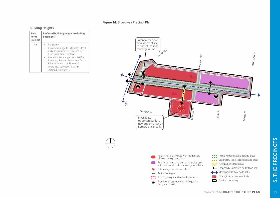
5. T
HE
PREC
INC
TS
Built Form Precinct
Preferred building height (excluding basement)
3a • 3- 5 storeys • 3 storey frontage to Edwardes Street
and additional levels recessed by 3-5m from street frontage
• Bernard Street car park site: Bedford Street and Bernard Street interface - Refer to Section 6.8: Figure 20
• Residential Interface - Refer to Section 6.8: Figure 19
Building Heights
35Reservoir MAA DRAFT STRUCTURE PLAN
Figure 14: Broadway Precinct Plan
Retail / hospitality uses with residential / office above ground floor
Retail / business and personal service uses with residential / office above ground floor
Future major land use anchor
Active frontages
Building height and setback precincts
Prominent sites requiring high quality design response
Primary streetscape upgrade areas
Secondary streetscape upgrade areas
New public space areas
Proposed / improved pedestrian links
Major pedestrian / cycle links
Strategic redevelopment sites
Precinct boundary
3a
3a
Potential for new development site as part of the road reconfiguration
Investigate opportunities for a new supermarket on Bernard St car park
BROADWAY
HIG
H S
T
BERN
ARD
ST
CLA
RK S
TBEDFORD ST
DEN
NIS
ST
WH
ITEL
AW S
T
MA
RCH
AN
T AV
EROYAL PDE

Built Form Precinct
Preferred building height (excluding basement)
4a • 2-4 storeys • 3m landscaped front setback to High
Street • Residential Interface - Refer to
Section 6.8: Figure 19
4b • 3- 5 storeys • 5 storey frontage to High Street • Residential Interface - Refer to
Section 6.8: Figure 19
Building Heights
36 Reservoir MAA DRAFT STRUCTURE PLAN
5.5 Precinct 4 - High Street North
High Street North fulfils an important role in the Reservoir MAA by providing a destination for business and personal services, and offices with housing provided on upper levels. The northern sections of the precinct provide additional opportunities for higher intensity forms of housing.
The generous lot sizes provide good opportunities for larger mixed use developments to be provided with minimal impacts on adjoining residential uses.
High quality built form and attractive streetscaping will enhance this key entry into the Reservoir MAA.
P4. fdsf
Objectives
To encourage redevelopment of properties throughout this precinct to provide multi-level mixed use and residential development that defines the northern entry into the Reservoir MAA
Strategies • Provide mixed use development south of Leamington
Street incorporating secondary retail, offices, business and personal services with housing on upper levels
• Provide higher density residential development north of Leamington Street
• Promote the precinct as a location for large business to establish
• Design new buildings to promote a human presence to the street with windows and customer service areas addressing the footpath
• Utilise large properties to accommodate a greater intensity of built form whilst managing the interface with adjoining residential areas
• Provide vehicle access from rear laneways or side street for corner lots
• Locate car parking to the rear of new developments or at a basement or rooftop level in order to provide a building address to the street
• Improve the streetscape along High Street to enhance the northern entry into the Reservoir MAA
• Improve access to businesses
ActionsP4.1 Implement additional street tree planting along
High Street to enhance the northern entry into the Reservoir MAA. This could include street tree planting in existing medians and the east side of High Street and the potential for street tree planting within existing footpaths
P4.2 Consider options for providing on street car parking along High Street in order to improve customer access to businesses in the precinct
P4.3 Develop a business attraction strategy for the precinct
Figure 15: High Street North Precinct Plan
Mixed use retail / office / business and personal services with housing on upper levels
Larger office uses / business services with housing on upper levels
Building height and setback precincts
Secondary streetscape upgrade areas
Major pedestrian / cycle links
Precinct boundary
KENILWORTH ST
LEAMINGTON ST
HIG
H S
T
BARTON ST
4a
4b

5. T
HE
PREC
INC
TS
Built Form Precinct
Preferred building height (excluding basement)
5a • 3- 5 storeys • 5 storey frontage to High Street • Direct Residential Interface - Refer to
Section 6.8: Figure 19
Building Heights
37Reservoir MAA DRAFT STRUCTURE PLAN
P5. fdsf
5.6 Precinct 5 - High Street South
High Street South will become a vibrant mixed use precinct providing a greater focus on pedestrian spaces and streetscaping through its reduced traffic role. Land uses will respond to these improvements providing alfresco dining opportunities along the street.
Housing opportunities are provided above shops and businesses throughout the precinct in close proximity to public transport and the new public square.
Figure 16: High Street South Precinct Plan
Objectives
To provide for a higher intensity of mixed use development throughout the precinct taking advantage of improved amenity as part of the future downgrading of High Street
Strategies • Provide mixed use development incorporating
secondary retail, offices, business and personal services with housing on upper levels
• Downgrade High Street through this precinct with reduced vehicle lanes as part of the development of the Central Heart providing additional space for pedestrians
• Provide alfresco dining opportunities closer to Broadway taking advantage of the widened footpaths
• Design new buildings to promote a greater human presence to the street with windows and customer service areas addressing the footpath
• Provide vehicle access from rear laneways or side street for corner lots
• Improve the streetscape along High Street to enhance the southern entry into the Reservoir MAA
ActionsP5.1 Reduce the traffic role of High Street through the
precinct in accordance with the junction road simplification
P5.2 Implement streetscape upgrade as part of the junction reconfiguration providing widened footpaths suitable for alfresco dining and additional street tree planting
P5.3 Consider the provision of permanent on-street car parking on the western side of High Street to improve visitor access to businesses as part of the reconfiguration of the road space
HIG
H S
TREE
T
BROADWAY
BEDFORD STREET
HOWARD STREET
Reduce road pavement and widen footpaths as part of road re-configuration
Mixed use retail / office / business and personal services with housing on upper levels
Building height and setback precincts
Active Frontages
Secondary streetscape upgrade areas
Major pedestrian / cycle links
Precinct boundary
5a

38 Reservoir MAA DRAFT STRUCTURE PLAN
5.7 Precinct 6 - Surrounding Residential
The surrounding residential precinct provides great opportunities for people to live close to the shops, services, public transport and Reservoir’s network of open spaces.
The incremental replacement of existing dwellings will continue to revitalise streets and deliver a diversity of housing types to suit a broad range of people. Higher density forms of housing will be provided along main road frontages and on larger infill sites.
Key residential access streets will provide the highest priority for pedestrians and cyclists with dedicated infrastructure, quality surfaces and street trees providing safe and enjoyable access to the shops, public transport and open spaces including Edwardes Lake Park and TW Andrews Reserve.
P6. fdsf
Objective
To encourage a greater diversity of high quality housing throughout the precinct
To improve connections into the shopping areas and Central Heart and to surrounding open spaces
Strategies • Provide for a greater intensification of residential uses
along main roads including Broadway, Edwardes Street and Spring Street
• Continue to support medical and community services that are located within the precinct and focused in areas along main roads close to the shopping strips and the station
• Support a greater diversity of housing within the balance of residential areas within existing planning scheme controls
• Enhance key streets connecting into the shopping strips and the Central Heart and connecting adjoining open space areas
• Enhance Edwardes Lake Park as a major recreational node for the Reservoir MAA
ActionsP6.1 Implement changes to the planning scheme to
enable a greater intensification of residential uses along Broadway, Edwardes Street and Spring Street
P6.2 Rezone the Industrial 3 Zone land at 117-153 Edwardes Street to residential uses to enable the development of higher density residential uses on these key sites
P6.3 Maintain existing planning control requirements in the balance of residential areas within the precinct and develop design guidelines to guide decision making and deliver higher amenity outcomes for all residents
P6.4 Provide priority walking conditions along key public walking routes through additional street tree planting for shade and beautification, even walking surfaces and pedestrian priority at intersections
P6.5 Strengthen Edwardes Lake Park as the key passive and active open space asset in the Reservoir MAA, by:
- Providing additional programming and public events within the park
- Better utilising existing buildings and structures such as the boatshed
- Installing the All Abilities Playspace - Upgrading the Leamington Street Skatepark - Implementing the Edwardes Lake Park Masterplan
to improve the landscape and environmental qualities
- Installing additional public art throughout the park - Providing high quality building design in residential
properties adjoining the park
P6.6 Work with the Reservoir Primary School with a focus on providing public access to the playing fields within the primary school grounds in order to improve open space access to the northern parts of the MAA

5. T
HE
PREC
INC
TS
Built Form Precinct
Preferred building height (excluding basement)
6a • Maintain existing planning requirements
6b • 2-4 storeys • Front setbacks of 3-5m • Side and rear setbacks in accordance
with ResCode and Figure 18
Building Heights
39Reservoir MAA DRAFT STRUCTURE PLAN
Figure 17: Surrounding Residential Precinct Plan
LEAMINGTON STREET
HENTY STREETHOWARD STREET
CUTHBERT ROADSTRATHM
ERTON STREET
GRI
FFIT
HS
STRE
ET
SPRING STREET
HIG
H S
TREE
T
HIG
H S
TREE
T
Edwardes Lake Park
EDWARDES STREET
Figure 18: Side and rear setbacks for four storey development Residential Incremental Change Area
Residential Intensification Area
Building height and setback precincts
Major Open Space Nodes
Major pedestrian / cycle links
Secondary pedestrian / cycle links
Precinct boundary
T.W. Andrews Reserve
Leisure Centre
BROADWAY
6a
6a
6a
6a
6a6b
6b
6b

40 Reservoir MAA DRAFT STRUCTURE PLAN
5.8 Residential interface treatmentThe following cross sections have been developed to provide guidance for designing the interface between residential areas and commercial properties. These envelopes will ensure that commercial buildings are appropriately scaled to minimise overshadowing and the visual impact of new buildings.
Each cross section should be read in conjunction with the preferred building height table for the relevant precinct.
Figure 19 applies to all commercial and residential interfaces where:
• A residential property directly abuts the rear or side of a commercial property
• A residential property abuts a laneway at the rear of a commercial property
Figure 20 applies to the Ralph Street car park site (Ralph Street interface) and the Bernard Street car park site (Bernard Street and Bedford Street), where new development will front to an existing residential street.
Figure 19: Setbacks to adjoining residential properties
Figure 20: Setbacks to residential streets
Site with rear lanewaySite with no laneway

6. IM
PLEM
ENTA
TIO
N
41Reservoir MAA DRAFT STRUCTURE PLAN
6 IMPLEMENTATION6.1 Monitoring and review As part of the implementation process, the City of Darebin will provide a progress report on the implementation of the Structure Plan. The Structure Plan review process will occur every five years and will provide analysis of:
• The appropriateness of the Vision
• The actions and projects that have been undertaken or underway
• The success of key actions or projects
• Consistency of all projects with the Vision for the Reservoir MAA
• Any blockages preventing successful implementation
• Housing market trends to assess whether forecasts and proposed housing initiatives are relevant
• Commercial market trends to assess whether proposed land uses are relevant
This process will allow Council to measure the success of the program and allocate future resources as necessary and allow for the implementation program to be adjusted to ensure the vision is being achieved.
6.2 Priority initiatives and stagingThe Structure Plan contains a number of priority projects, initiatives and programs that will be a focus for implementation. These projects will most effectively deliver renewal of the Reservoir MAA over the short, medium and long term.
A staged approach to implementation of these initiatives is required so that project funding and resources can be managed, and so that development can respond to changing market conditions.
Figure 21 outlines the priority initiatives and the the indicative timing for implementation. An implementation plan will be developed to provide additional detail on the timing, responsibilities, and next steps for these projects as well as other actions identified in the Structure Plan.
Figure 21: Priority Initiatives and Potential Staging
2012 2015 2020 2025 2030
Planning Scheme Amendment
Urban Design Guidelines
Appoint Place Manager
Ongoing management, marketing and advocacy for the Reservoir MAA
Master Plans of key public redevelopment sites
Broadway / Edwardes St Streetscape Upgrades
Open space nodes along Yan Yean Pipe Track
Public Square in the Central Heart
Food ParkGateway landscape improvments
Secondary streetscape upgrades
Library redevelopment
Additional community events - ongoing
Beautification of Reservoir Station
Wayfinding improvments
Improve pedestrian & cycle access into station
Bus priority implementation
New transport hubShort term measures for reinforcing preferred traffic route
Install cycle lanes and off-street paths & end of trip facilities
Ralph St car park Plaza & Mid-block link
Early Years Hub
Community facilities in the Central Heart
Community Health Hub in Ralph Street Car Park
Supermarket in Broadway - Bernard St car park
Mixed use development in Ralph St car park
Retail focus for the Central Heart
Undertake additional detailed investigations for Central Heart
Ongoing advocacy for undergrounding of railway line & extension of Tram route 112 into Reservoir
Ongoing retail, business and residential development throughout the MAA
Start the simplification of Reservoir Junction
Start the simplification of Reservoir Junction
Development on key sites unaffected by grade separation
Underground railway line
Mixed use development of sites within the Central Heart
Central public square, transport hub
Food park
Man
agem
ent
/ Stu
dies
/ St
atut
ory
Impl
emen
tatio
nPu
blic
Rea
lm
Impr
ovem
ents
Com
mun
ity
Infr
astr
uctu
reA
cces
s Im
prov
emet
nsCo
mm
erci
al
Dev
elop
men
tTh
e Ce
ntra
l Hea
rt
42 Reservoir MAA DRAFT STRUCTURE PLAN
6.3 Next stepsThe release of the Draft Structure Plan marks a significant milestone for the project. The steps that will follow are outlined below:
6.3.1 Implementation Plan
An implementation plan will be developed following the finalisation of the Structure Plan. The implementation plan will outline the steps required to implement each of the actions in this document including implementation responsibilities, priorities and timing. This will ensure that the aspirations of the vision will be realised through projects on the ground.
6.3.2 Appoint a Place Manager
Place management is crucial to the successful implementation of the Reservoir Structure Plan. The place manager role will bring many benefits by:
• Working closely with Council units and other stakeholders to achieve the integrated and efficient delivery of the Structure Plan initiatives
• Co-ordinating all communications about the progress of the implementation
• Delivering on development facilitation opportunities
• Delivering on the community development initiatives
A new initiative bid for a Place Manager will be put before Darebin City Council late in 2012/2013.
6.3.3 Planning Scheme Amendment
Once the final Structure Plan is adopted by Council, a planning scheme amendment will be prepared to implement aspects of the Structure Plan into the Darebin Planning Scheme. This will undergo an additional phase of consultation.
6.4 What’s already happening?Several projects have been undertaken in the Structure Plan area and are planned for future implementation. These include:
• Reservoir Library Renewal - A new library will be built within the Civic Centre site. The project is currently in a detailed planning stage
• Beautification of Reservoir Station - Works to beautify the station will commence in 2012
• Reservoir Rail grade Separation Study - Council has provided funding for a full financial feasibility study for this project as a priority for Council. Work on the project will commence late 2012
• All Abilities Playspace at Edwardes Lake Park - The first stage of construction will commence in late 2012