the relative contribution of atmospheric and oceanic uncertainty in tc intensity forecasts ryan d....
TRANSCRIPT

The Relative Contribution of Atmospheric and Oceanic
Uncertainty in TC Intensity Forecasts
Ryan D. TornUniversity at Albany, SUNY
World Weather Open Science Conference20 August 2014Montreal, Quebec

NHC Official Errors
• 3-4% reduction in TC track error per year at all lead times• Relatively small reduction in intensity forecasts at short lead
times, more so at longer lead times• Need to understand why intensity errors are not decreasing
National Hurricane Center

NHC Official Errors
National Hurricane Center

Intensity Factors
Courtesy National Hurricane Center
TC Environment
Surface Boundary

Large-Scale Sensitivity
Kaplan & DeMaria 2003

Intensity Factors
Courtesy National Hurricane Center
TC Environment
Surface Boundary Internal Processes

Van Sang et al. (2008)
Zhang and Tao (2013)
Moisture Exps.
Without Shear
With Shear

Motivation• Fundamental question of how predictable TC
intensity forecasts are given errors in model initial condition and formulation
• Not clear whether atmospheric and oceanic errors are complimentary to each other or orthogonal
• Has implications for designing tropical cyclone ensemble prediction systems
• Explore this using high-resolution ensemble forecasts that are characterized by different sources of variability

Data• Use Advanced Hurricane WRF (AHW), 2012 HFIP
retrospective configuration (Davis et al. 2008, 2010)– Initial conditions obtained from cycling ensemble Kalman
filter (EnKF) using Data Assim. Research Testbed (DART)
– Assimilates conventional data + dropsondes
– Forecast: 36/12/4 km resolution, 30 ensemble members
– 1D column ocean model (Pollard 1973), NCEP SST, HYCOM MLD

Ensemble Experiments• Atmosphere Only:
– Use 30 analysis members from ensemble data assimilation system for atmosphere
– Same ocean state for each member
• Ocean Only:– Use atmospheric analysis used in deterministic
AHW forecast– Ocean perturbations from climatology
• Atmosphere + Ocean– Use atmospheric states from Atmosphere Only– Use ocean states from Ocean Only

Ocean Perturbation• Ensemble ocean
initial conditions hard to come by
• Ensemble ocean perturbations obtained by sampling from a 2006-2011 climatology of SST and MLD fields
• Remove mean, scale SST so that individual locations have a 0.5 K standard deviation
• MLD values are scaled by the same value

Cases
Gustav (2008; 2) Erika (2009) Igor (2010; 3) Richard (2010) Maria (2011)Hanna (2008; 2) Fred (2009) Julia (2010; 2) Tomas (2010; 2) Ophelia (2011)Ike (2009; 3) Danielle (2010; 3) Karl (2010) Irene (2011; 2) Philippe (2011)Bill (2009; 2) Earl (2010; 2) Otto (2010) Katia (2011; 2) Rina (2011)

Overall Statistics
Maximum Wind Speed Minimum SLP

• Will measure growth of initial condition uncertainty via amplification factor

Amplification Factors
Atmosphere Only Ocean Only

Amplification Factors
Atmosphere Only

Case Comparison
Atmosphere Only Ocean Only

Case Comparison
Atmosphere Only Ocean Only

Case Comparison
Sea Surface Temperature 700 hPa Relative Humidity

Igor: 0000 UTC 9 Sept. 2010

• Study process that lead to forecast error growth by comparing the 10 most intense members against the 10 least intense members

Igor 0520 UTC 10 Sept.
Courtesy: NASA TRMM
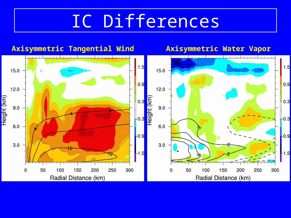
IC DifferencesAxisymmetric Tangential Wind Axisymmetric Water Vapor

Flux Differences

Flux Differences

F018 F036

Left of Shear Water Vapor

Summary and Future Work• Initial condition errors in the atmosphere translate into larger
intensity variability on short time scales, while ocean initial condition errors are associated with comparable intensity variability over longer lead times (5 days)
• Largest error growth rate for weak storms with small 34 knot wind radii and/or storms in environment with higher RH
• Igor forecasts most sensitive to initial tangential wind errors, with little initial sensitivity to moisture
• Intensification initially slowed by greater downdrafts that are later mitigated by surface fluxes and moistening from above
• Suggestive that knowledge of 3D wind field for sheared TCs may benefit forecasts (i.e., Doppler Radar)