the regulatory structure of new urbanism: the …
TRANSCRIPT

F:\TAB06\01Euclidean.rtf
THE REGULATORY STRUCTURE OF NEW URBANISM: The Evolution Away from Euclidean Zoning
by
Stephen T. Janik
AMERICAN COLLEGE OF REAL ESTATE LAWYERS
Spring 2002
Ball Janik LLP 101 SW Main Street
Suite 1100 Portland, Oregon 97204
(503) 228-2525 Fax (503) 295-1058
Copyright Ball Janik LLP 2002

F:\TAB06\01Euclidean.rtf 2

i F:\TAB06\01Euclidean.rtf
TABLE OF CONTENTS 1. Introduction..............................................................................................................................1
2. Urban Sprawl as the Result of Euclidian Zoning ....................................................................2
2.1 Village of Euclid v. Ambler Realty Company. ................................................................2
2.2 The Implications of Euclidian Zoning .............................................................................3
2.3 The Popularity and Spread of Euclidean Zoning.............................................................4
2.4 The Impact of Setbacks ...................................................................................................4
2.5 Emerging Problems with Euclidean Zoning....................................................................5
2.6 The Zoning Codes of the 1980s .......................................................................................7
3. The Debate Over Sprawl .........................................................................................................7
4. New Urbanism: Back to the Future ........................................................................................9
4.1 New Urbanism or TND Concepts....................................................................................9
4.2 An Example of a New Urbanism or TND Projects .......................................................11
4.3 New Urbanism or TND Land Use Regulations .............................................................12
4.4 Selected Examples of New Urbanism or TND Codes. ..................................................13
5. Conclusion.............................................................................................................................33

1 F:\TAB06\01Euclidean.rtf
THE REGULATORY STRUCTURE OF NEW URBANISM: The Evolution Away from Euclidean Zoning
By: Stephen T. Janik
Ball Janik LLP Portland, Oregon
1. Introduction
“The model of the human habitat dictated by zoning is a formless, soul- less, centerless, demoralizing mess. It bankrupts families and townships. It disables whole classes of decent, normal citizens. It ruins the air we breathe. It corrupts and deadens our spirit.”1
“Where there is no vision the people perish.” Book of Proverbs.2
New Urbanism has a vision of future development that is significantly different than the pattern of urban and suburban development that has occurred over the last 50 years. Proponents of New Urbanism believe that it will create more attractive neighborhoods, protect the environment, reduce auto dependence and traffic, save infrastructure costs, save farmland, save residents’ time and money, reduce air pollution, create a sense of community, create housing types that better match the contemporary demographics of society, and create opportunities for people with diverse economic resources to live together in neighborhoods.3 That is a lot to expect from a new theory of urban planning and design, but when you have a “vision,” you can almost see the future.
Critics of New Urbanism make numerous contentions. Sprawl is not bad. After all, that is where most Americans have lived for decades. There is no shortage of land and abundant farmland hardly needs protection. Shrinking house sizes and backyards are not what the market demands. Higher densities are claustrophobic, and privacy is more highly valued than communal open space. Bicycle commuting will work in third world countries but not here; narrow streets with bike lanes increase, not decrease, traffic congestion, and neighborhoods of “cute” townhouses and bungalows create an architectural monoculture like Disneyland.4 Underlying many of these critiques are the fundamental assumptions that the market knows best and that New Urbanism is simply excessive land use regulation.
This paper does not attempt to resolve the somewhat facetious (but not far from reality) debate summarized above occurring in numerous cities and towns across the country.
1 James Kunstler, Home from Nowhere, THE ATLANTIC MONTHLY, Vol. 278, No. 3, pp. 43-66 (September 1996). 2 This quotation is chiseled in six-foot letters on the 1929 City Hall in Camden, New Jersey, a troubled post-industrial city with considerable urban decay. 3 Oregon Dept. of Land Conservation and Development, Smart Development Primer, http://www.lcd.state.or.us/tgm/smart/primer.htm (last updated February 5, 2001). 4 For a lively critique of New Urbanism, see Michael Sorkin, Can New Urbanism Learn from Modernism’s Mistakes, METROPOLIS MAGAZINE, pp. 37-39 (August/September 1998).

2 F:\TAB06\01Euclidean.rtf
The resolution of the debate will be based on intuition, politics, some limited empirical data and experience.
Rather, the purpose of this paper is to analyze the land use regulatory structure that led to urban sprawl, understand the evolution and definition of New Urbanism, and analyze the land use regulations that create the legal foundation for New Urbanism.
2. Urban Sprawl as the Result of Euclidean Zoning
From the 1920s to the 1990s, cities and towns across America developed in a form that was based on Euclidean zoning. Whether people realized it or not, urban sprawl was a predictable result of a Euclidean zoning pattern. Almost as clearly, New Urbanism was a predictable counter response to the type of development that was based on Euclidean zoning.
2.1 Village of Euclid v. Ambler Realty Company
Village of Euclid v. Ambler Realty Company, 272 U.S. 365, 47 S. Ct. 114, 71 L. Ed. 303 (1926) represents the birth of comprehensive5 zoning in cities and towns across America. In that case, the owner of vacant land in the Village of Euclid sought an injunction, which the U.S. District Court had granted, to restrain the village from enforcing its newly-adopted zoning code. The Euclid code was quaintly simple as compared to today’s mind-numbingly complex zoning codes. The code divided the 12 to 14 square miles of Euclid into one of six “use” zones, one of three “height” zones, and one of four “area” or “density” zones. Any given parcel of land would be assigned one use zone, one height zone, and one area or density zone. The height zones set maximum heights, and the density zones regulated lot size, thereby establishing density. The use zones were of two types: the single-family zone which allowed only single-family dwellings, and all other zones ranging from U-2 for duplexes to U-6 for offensive uses like junkyards and industrial uses. The single-family dwelling zone was exclusionary because it prohibited all other uses. The remainder of the use zones were cumulative in that the U-6 zone, for example, allowed all of the less offensive uses in the U-1 to U-5 zones. Under this zoning scheme, if someone wanted to build a duplex in a U-6 zone next to the junk yard, they were free to do so.
The code was subject to several constitutional attacks including: (1) the scheme was an unnecessary exercise of the “police power;” (2) the zoning was arbitrary and not rational; and (3) the zoning interfered with the “natural and proper development of the land” which would obviously be guided by market forces.6
As we all know, the U.S. Supreme Court upheld the ordinance. The reasoning of the Court still sounds vital today:
“Until recent years, urban life was comparatively simple; but with the great increase and concentration of population, problems have developed, and constantly are developing, which require, and will
5 Comprehensive in this context is defined as a single code and zoning map that covers the entire municipal entity. 6 These same arguments are being raised today in political terms against ever-increasingly complex land use regulations.

3 F:\TAB06\01Euclidean.rtf
continue to require, additional restriction in respect of the use and occupation of private lands in urban communities. Regulations, the wisdom, necessity and validity of which, as applied to existing conditions, are so apparent that they are now uniformly sustained, a century ago, or even half a century ago, probably would have been rejected as arbitrary and oppressive. Such regulations are sustained, under the complex conditions of our day, for reasons analogous to those which justify traffic regulations, which, before the advent of automobiles and rapid transit street railways, would have been condemned as fatally arbitrary and unreasonable. And in this there is no inconsistency, for while the meaning of constitutional guaranties never varies, the scope of their application must expand or contract to meet the new and different conditions which are constantly coming within the field of their operation.”7
This same justification might be usable today by a court in upholding New Urbanism zoning as a valid exercise of the police power.
2.2 The Implications of Euclidian Zoning
It is ironic that the seminal zoning case came from the Village of Euclid because it is the Euclidean geometric implications of that case and its zoning scheme that have had such significant implications for the type of urban development it generated.
Euclidean zoning was a response to the industrialization of America. Uses that were ugly, produced smoke or noise had to be separated from more sensitive uses such as houses. Commercial uses, such as offices and retail became, over time, similarly offensive because of their need to accommodate parked cars and the attendant traffic. However logical this separationist theory appeared in the 1920s and in the succeeding decades, there were several implications that contributed to, if not produced, urban sprawl. 8
1. Homogeneity of Use Districts
The “exclusive” uses allowed in certain districts, and the fact that more offensive uses would drive out or dissuade less offensive uses in “cumulative” zones, meant that most zone districts would maintain uniform uses. While this certainly created 7 Village of Euclid, 272 U.S. at 386-387, 47 S. Ct. 114, 118 (1926). 8 “The practice of zoning started early in the twentieth century, at a time when industry had reached an enormous scale. The noisy, smelly, dirty operations of gigantic factories came to overshadow and oppress all other aspects of city life, and civic authorities decided that they had to be separated from everything else, especially residential neighborhoods. One could say that single-use zoning, as it came to be called, was a reasonable response to the social and economic experiment called industrialism. After the Second World War, however, that set of ideas was taken to an absurd extreme. Zoning itself began to overshadow all the historic elements of civic art and civic life. For instance, because the democratic masses of people used their cars to shop, and masses of cars required parking lots, shopping was declared an obnoxious industrial activity around which people shouldn’t be allowed to live. This tended to destroy age-old physical relationships between shopping and living, as embodied, say, in Main Street.” James Kunstler, Home From Nowhere, THE ATLANTIC MONTHLY, Vol. 278, No. 3, pp. 43-66 (September 1996).

4 F:\TAB06\01Euclidean.rtf
compatibility, it could also create a homogeneous environment with a lack of use diversity. With each district having a uniform height, the built environment would likely approximate the allowed height. Underdevelopment of a site would be more the exception than the rule. Again, the resultant built environment would appear visually homogenous if not monotonous.
2. Minimum Lot Sizes and Density Implications
By establishing a set of zones, each with a minimum lot size, geometric implications result. First, lots would tend to be rectangular and sized to the minimum lot size. Second, the minimum lot size would establish the overall density for a zone. If the minimum lot size was 10,000 square feet for residential use, then the result is 4 houses per acre. As growth occurred, an acre with four houses could not be further divided and, consequently, the next 4 houses would need another acre. Under this scenario, minimum lot size, together with the other Euclidean factors would lead to sprawl.
3. Transportation Implications
With exclusive zones for single-family residences, and with jobs segregated in other zones, the Euclidean zoning concept required commuting, and the mass production of automobiles made that commute relatively simple. If employment centers, retail stores and houses were mixed together in a neighborhood, commuting would be short and non-automotive means would be feasible. However, by separating the residential zones as far as possible from the “offensive” industries that offered jobs, distant commuting was inevitable.
2.3 The Popularity and Spread of Euclidean Zoning
Euclidean zoning was widely adopted by cities and towns throughout the nation, once it received U.S. Supreme Court approval. 9 Its spread was greatly enhanced by the U.S. Department of Commerce. The Department drafted and promulgated its Standard State Zoning Enabling Act (1926), model legislation which could be adopted by each state and thereby enable that states’ cities and towns to adopt zoning codes. The type of zoning code that was enabled by this legislation was Euclidean zoning. The Standard State Zoning Enabling Act was quickly adopted by the states, with 50 states adopting such enabling legislation within a few decades.10
2.4 The Impact of Setbacks
While not an issue in Village of Euclid, infra, Euclidean zoning included mandatory setbacks around structures. For example, every single-family house would have to be set back on its side yards by 10-20 feet from the property line, would have to be set back from the street by 20-40 feet, and have a rear yard setback of 20-50 feet from the property line. Setbacks had been legally required and judicially approved before Village of Euclid, infra,11 based upon the common sense notions that setbacks avoided overcrowding, afforded openness to
9 PATRICK J. ROHAN, ZONING AND LAND USE CONTROLS §30, at 71 (1999). 10 Id., (citing R. Anderson & B. Roswig, Planning, Zoning & Subdivision: A Summary of Statutory Law in the 50 States (1966)). 11 Village of Euclid v. Ambler Realty Co., 272 U.S. 365, 388, 47 S. Ct. 114, 118 (1926).
5 F:\TAB06\01Euclidean.rtf
fresh air and sunshine, facilitated privacy, created recreational space and helped reduce the spread of fires. In a developing United States with ample land to develop, few were concerned about the “efficiency” of land utilization in light of these common sense benefits. However, the implication of such setbacks was a relatively low “efficiency” in land utilization, and that meant more land needed to be utilized for development. Again, this further contributed to low density, sprawling development.
2.5 Emerging Problems with Euclidean Zoning
There was great simplicity to Euclidean zoning: a lot-by- lot approach to development, rectangular lots, homes separated from offensive job centers, retail all in one place, a grid pattern of streets, and homogeneity of uses in zones. As noted above, each of these features contributed to a development pattern that came to be labeled “sprawl.”
However, fairly early on, some commentators begin to voice concerns over the lack of flexibility and creativity in Euclidean zoning. Some of that concern arose when raw land had topographic constraints that conflicted with the regularity of Euclidean zoning. Others began to realize that the homogeneity of the zones was creating monotony. As the Rohan Treatise accurately reflected:
“By the late 1950s, planners and developers began to reach a consensus about the desirability of more innovative patterns of land development, particularly in urban renewal areas and in the suburbs. In urban renewal areas, those who were bulldozing slums in inner cities were not anxious to rebuild in the image of the old. Moreover, comprehensive plans for entire redevelopment project areas were ill-served by conventional lot areas and building bulk regulations. Similarly, in the suburbs, planners and developers became disenchanted with ‘cookie-cutter’ subdivisions marching to the horizon. In the eyes of these planners and developers, this pattern of development was protected and perpetuated by Euclidean zoning.”12
The concept that was developed to deal with the problems perceived in Euclidean zoning was “cluster development” or a “planned unit development.” The basic concept underlying both was to aggregate development in certain areas of a parcel, leave other areas undeveloped as common open space and suspend most of the rules about setbacks, minimum lot sizes, height limitations and density limitations. The notion was to regulate the maximum number of units or total square footage of development on a tract, but allow the developer greater flexibility in how that maximum amount of development would be located, organized and assembled on that tract.
The benefits of this type of development were summarized by the California Court of Appeals in a case challenging the legality of cluster development. In Orinda Homeowners Comm. v. Board of Supervisors, the court found several advantages to cluster
12 PATRICK J. ROHAN, ZONING AND LAND USE CONTROLS §12.01[2], p. 12-6 (1999).

6 F:\TAB06\01Euclidean.rtf
development: (1) it required less alteration of the existing topography; (2) it offered the opportunity for quality design; (3) it allowed for more commonly used open space by clustering development; (4) it allowed for a gradual transition to surrounding areas; and (5) it allowed unique features of the site to be respected and incorporated into the design.13
This type of zoning required authorizing or enabling legislation by the local government, and in the 1960s and 1970s numerous local governments were eager to adopt such legislation. The enabling legislation took numerous forms:
• By right, without discretionary review.
This code simply allows the maximum number of units to be clustered, usually with required amounts of open space, as a matter of right.
• Through a zone change.
This method requires that the developer prepare a PUD plan which includes the maximum development allowed in the existing zone, and then if the governing body approves of the PUD plan, the zoning is changed from, say, medium density single-family to a PUD zone, with the proposed plan imposed as a condition of approval.
An alternative is to rezone the parcel to a PUD zone, which then requires the developer to process its development plan through a separate “site plan review.”
• As an overlay zone.
This method provides that a PUD is a floating zone, available in certain of the traditional zones, when the governing body approves a site specific development plan for a tract within a traditional zone overlaid by a PUD zone.
• As a conditional use.
Under this method, certain traditional zones would allow a PUD as a conditional use with certain standards that must be addressed by the site-specific development plan.
While cluster development and PUDs addressed some of the rigidity and monotony of development under Euclidean zoning, there were a number of issues they did not address. First, most PUDs did not include a mixture of housing, retail and employment centers unless it was very large. Second, cluster development was still auto-dominated, with little attention to alternative modes of transportation. Third, there were social issues, such as accommodating low-income housing that were not addressed. In fact, PUDs became excellent opportunities for inner-directed, gated and walled-off enclaves from the larger urban 13 Orinda Homeowners Comm. v. Bd. of Supervisors, 11 Cal. App. 3d 768, 90 Cal. Rptr. 88 (1970).

7 F:\TAB06\01Euclidean.rtf
environment. Fourth, good design of the structures themselves was not addressed by PUD ordinances which focused on the quality of the site plan and how it respected the unique features of the tract being developed. These issues would be directly confronted in the 1990s by New Urbanism.
2.6 The Zoning Codes of the 1980s
It is fair to say that by the 1980s most municipal zoning codes had evolved from a simple 20 or 30 pages with a zoning map to complex codes of hundreds of pages and with more complicated zoning categories. This legally formidable code was generally prescriptive and legalistic. It was textual and not visual. It heaped layer upon layer of regulations on each site. It was a land use lawyer’s dream.
What had occurred was a continuing series of code drafting efforts to achieve greater flexibility than Euclidean zoning allowed and to find new regulations that would deal with the kinds of development that resulted from earlier codes. As lawyers became more facile and imaginative in interpreting simpler codes, new regulations were adopted to plug the loopholes. As one commentator summarized the situation:
“The only discernable thread that weaves through the fabric of land use control in the last decade of this century is, for the first time in eighty years, state and local governments are noticeably moving away from the constraints of traditional Euclidean zoning, opting for more innovative land use planning and control techniques.”14
3. The Debate Over Sprawl
In the 1970s, numerous commentators, legislators, public interest groups and citizens began criticizing the pattern of urban and suburban development that had resulted from the prior 50 years of zoning regulations based, with some modifications, on Euclidean zoning ordinances. These critics lamented the “sprawl” that had become the suburbs and lamented the problems that all of us are familiar with – lengthy commutes, air pollution, unsightly commercial corridors, balkanized residential communities and inferior suburban design.
Sprawl and its causes and effects became a subject of intense national and local political debate.15 In the 1970s and 1980s, anti-sprawl groups were formed, and the causes and effects of sprawl were hotly debated, while the development of sprawling communities continued. The U.S. Congress even got involved in the debate when the National Land Use Policy legislation was introduced but not passed.16 This reflected the growing national recognition that local governments and states needed to address the issue of urban sprawl. While national legislation did not pass, states began to consider and adopt sprawl-containing legislation
14 Patricia Salkin, Smart Growth at Century’s End: The State of the States, THE URBAN LAWYER, Vol. 31, No. 3, pp. 601-648 (Summer 1999). 15 Since the 1970s, there have been over 500 studies on the issue of sprawl. Burchell, et al., The Costs of Sprawl-Revisited, Transportation Research Board (1998). 16 Brian Ohm, Reforming Land Planning Legislation at the Dawn of the 21st Century: The Emerging Influence of Smart Growth and Livable Communities, THE URBAN LAWYER, Vol. 32, No. 2, p. 181 (Spring 2000).

8 F:\TAB06\01Euclidean.rtf
and programs. Perhaps the first state to legislate on this issue was Oregon. In 1973, Oregon passed legislation establishing a Land Conservation and Development Commission, enacted statewide land use goals which each local government must follow, and required comprehensive land use planning by each local government subject to the Commission’s review to determine if the local comprehensive met the statewide goals. The goals included the following directive:
Goal 3 Required preservation of farm land
Goal 4 Required preservation of timber land
Goal 11 Mandated the efficient provision of public services
Goal 14 Mandated an urban growth boundary to separate urban from resource land and required more intense development of land within the urban growth boundary
That debate continued into the 1990s and is perhaps best summarized by two studies conducted and published by major banks. In 1995, Bank of America published “Beyond Sprawl: New Patterns of Growth to Fit the New California.”17 That study concluded that sprawl type development has accelerated and resulted in “enormous” environmental, social and economic costs including:
• Loss of agricultural land and sensitive environmental areas
• Degraded air quality
• Overuse of water supplies
• Decline of central city neighborhoods and older suburbs
• Decline of farm communities
• Decrease in quality of life and a corresponding decrease in business retention
• Unnecessarily expensive suburban infrastructure systems
• Underutilized investments in older neighborhoods
The contrary view was set forth in “Preserving the American Dream,” published by Wells Fargo Bank.18 That report concluded that suburban development contributes to both economic growth and to the social objective of widespread home ownership. The report asserts that, based on scholarly research, the popularized negative effects of suburban housing are based on “half-truths, poorly understood facts and outright falsehoods.” The report contends that suburban
17 Bank of America, Beyond Sprawl: New Patterns of Growth to Fit the New California , San Francisco (1995). 18 Wells Fargo Bank, Preserving the American Dream: The Truth About Suburban Communities and Housing Choices, San Francisco (1996).

9 F:\TAB06\01Euclidean.rtf
development is not consuming significant farmlands and that suburban development does not increase infrastructure costs for low-density suburban areas.
While the debate over sprawl and its effects continued, and while new sprawling developments continued to be built, certain notable urban planners and architects began to outline a new vision for planning and development.
4. New Urbanism: Back to the Future
4.1 New Urbanism or TND Concepts
New Urbanism is an urban design philosophy that wants to return to the towns and neighborhoods of our grandparents, rejecting the homes of suburban parents and the suburbs created in the last 40 years around major metropolitan areas. New Urbanism rejects Euclidean zoning and relies on a more comprehensive, human-oriented urban design form coupled with significant architectural standards.
The philosophy of New Urbanism and its rejection of Euclidean zoning is well summarized in the following excerpt:
“Almost everywhere in the United States laws prohibit building the kinds of places that Americans themselves consider authentic and traditional. Laws prevent the building of places that human beings can feel good in and can afford to live in. Laws forbid us to build places that are worth caring about.
Is Main Street your idea of a nice business district? Sorry, your zoning laws won’t let you build it, or even extend it where it already exists. Is Elm Street your idea of a nice place to live – you know, houses with front porches on a tree-lined street? Sorry, Elm Street cannot be assembled under the rules of large- lot zoning and modern traffic engineering. All you can build where I live is another version of Los Angeles – the zoning laws say so.
This is not a gag. Our zoning laws are essentially a manual of instructions for creating the stuff of our communities. Most of these laws have been in place only since the Second World War. For the previous 300-odd years of American history we didn’t have zoning laws. We had a popular consensus about the right way to assemble a town or a city. Our best Main Streets and Elm Streets were created not by municipal ordinances but by cultural agreement. Everybody agreed that buildings on Main Street ought to be more than one story tall; that corner groceries were good to have in residential neighborhoods; that streets ought to intersect with other streets to facilitate movement; that sidewalks were necessary, and that orderly rows of trees planted along them made the sidewalks much more pleasant; that roofs should be pitched to shed rain and snow; that doors should be conspicuous, so that one

10 F:\TAB06\01Euclidean.rtf
could easily find the entrance to a building; that windows should be vertical, to dignify a house. Everybody agreed that communities needed different kinds of housing to meet the needs of different kinds of families and individuals, and the market was allowed to supply them. Our great-grandparents didn’t have to argue endlessly over these matters of civic design. Nor did they have to reinvent civic design every fifty years because no one could remember what had been agreed on.
* * * * *
What zoning produces is suburban sprawl, which must be understood as the product of a particular set of instructions. Its chief characteristics are the strict separation of human activities, mandatory driving to get from one activity to another, and huge supplies of free parking. After all, the basic idea of zoning is that every activity demands a separate zone of its own. For people to live around shopping would be harmful and indecent. Better not even to allow them within walking distance of it. They’ll need their cars to haul all that stuff home anyway. While we’re at it, let’s separate the homes by income gradients. Don’t let the $75,000-a-year families live near the $200,000-a-year families – they’ll bring down properties values – and for God’s sake don’t let a $25,000-a-year recent college graduate or a $19,000-a-year widowed grandmother on Social Security live near any of them. There goes the neighborhood! Now put all the workplaces in separate office “parks” or industrial “parks,” and make sure nobody can walk to them either. As for public squares, parks, and the like – forget it. We can’t afford them, because we spent all our funds paving the four- lane highways and collector roads and parking lots, and laying sewer and water lines out to the housing subdivisions, and hiring traffic cops to regulate the movement of people in their cars going back and forth among these segregated activities.”19
New Urbanism is also referred to as Traditional Neighborhood Development (“TND”) and it is sometimes referred to as Smart Growth, although the latter term usually encompasses a larger area growth management component. The basic tenants of New Urbanism or TDA are the following:20
1. The primary planning unit is a neighborhood. The aggregation of neighborhoods becomes a city.
19 James Kunstler, Home From Nowhere, THE ATLANTIC MONTHLY, Vol. 278, No. 3, pp. 43-66 (September 1996). 20 For a complete statement of the tenants of New Urbanism as articulated by the Congress for the New Urbanism, see its Charter at http://www.cnu.org.

11 F:\TAB06\01Euclidean.rtf
2. The secondary units of planning are corridors and districts. Corridors connect neighborhoods and can take the form of parks, travel corridors or a combination of these. Districts are streets where special activities (i.e., entertainment) receive special treatment.
3. The neighborhood is limited in size by an area with a diameter of about a 10-minute walk. Human scale is the standard of proportionate measurement for all features of the neighborhood.
4. The neighborhood is emphatically mixed use, providing a range of housing types for different income groups, retail activities, offices and even manufacturing. Residential apartments are permitted on top of retail or office uses.
5. The street is understood to be the pre-eminent form of public space. Buildings are disciplined in how they relate to the streets.
6. Streets are ranked in terms of their function in the neighborhood and designed to accommodate cars, but not at the expense of bikes and pedestrians. Narrow street widths are encouraged.21
7. Civic and public buildings are placed on preferential building sites.
8. Buildings define parks, squares and public open space, which are distributed throughout the neighborhood and appropriately designed.
9. Streets and buildings must be “pedestrian friendly.”
10. Buildings must receive quality design that complements and implements the above principles.
4.2 An Example of a New Urbanism or TND Projects
With such generalized and, perhaps to lawyers, vague, urban development concepts, it is useful to try to visualize the kind of development projects that result from the application of TND principles. One example is Fairview Village, located in a suburban area of Portland, Oregon. 22
Fairview Village is an 88-acre “neo-traditional village” in the City of Fairview, Oregon, a suburb on the eastern edge of Portland. The developer’s goal was to build a new village with a mix of uses to attain the feel of a traditional neighborhood. Phase one of the project will consist of 86 single-family small lots (avg. 5,500 square feet) priced from $140,000 21 Alan B. Cohen, Narrow Streets Database, a Congress for the New Urbanism Transportation Task Force Initiative (updated in June 2000) http://www.sonic.net/abcaia/narrow.htm. 22 Other examples of TND communities are: Courtside Village, a 70-acre project in Santa Rosa, California; Lowell Neighborhood, a 58-acre project Colorado Springs, Colorado; Orenco Station, a 190-acre project in suburban Portland, Oregon; The Town Center at Habersham, South Carolina; and Ion Village in Mount Pleasant, South Carolina. These are just a few examples.

12 F:\TAB06\01Euclidean.rtf
to $225,000. Subsequent phases will add 514 additional residences, including single- and multi-family homes, senior units above stores; 30,000-50,000 square feet of office space, more than 10 acres of commercial retail space; civic buildings; parks; and a central market square retail hub. The market square will be framed by 2- and 3-story buildings with restaurants, cafes and neighborhood stores to serve pedestrians. The project is served by two bus lines, one connecting to the regional light rail system. The streets are narrowed, and parking is reduced by 25% below normal ratios. Sidewalks are widened and enhanced by ornamental street lights and street furniture.23
4.3 New Urbanism or TND Land Use Regulations
The question then becomes, how do the New Urbanists plan to turn urban design concepts into projects like Fairview Village, and what are the features of the land use regulations that will make that happen?
There are several general observations about New Urbanism that provide some direction to the new land use regulations. First, these codes will be far less textual and far more visual and graphic. With New Urbanism’s emphasis on mixed use and neighborhood quality design, it is far easier to graphically depict what is desired than to try to describe it in code language.24 In fact, the inherent subjectivity in what the New Urbanists identify as good neighborhood design makes code language drafting a formidable challenge. Thus, these codes will be easier for architects to understand than for lawyers to interpret and argue over. In jurisdictions where land use regulations are held to some objective standard of legal clarity and uniformity, New Urbanism codes may be vulnerable.
Second, with its emphasis on the street as a public space, New Urbanism codes will classify streets by their function as a public space, not just as a traffic mover. Based upon those classifications, there will be requirements for narrower street widths, wider sidewalks, and potentially, parking. An example of such a classification scheme would be: boulevards, main streets, secondary urban streets, residential streets, lanes and alleys.
Third, because of New Urbanism’s focus on the interaction of all parts of the neighborhood, the lot-by- lot, more objective criteria of Euclidean zoning will be replaced with more subjective urban design principles.
Fourth, segregation of uses into separate zones will clearly not be required and, in fact, will not be permitted. To varying degrees, New Urbanism codes will encourage, if not demand, a mixture of different types of uses and within residential uses, a mix of different price levels of housing. However, New Urbanism codes will focus on how to best facilitate that mix, largely through design standards.
23 Oregon Dept. of Land Conservation and Development, Smart Development Showcase: Fairview, http://www.lcd.state.or.us/tgm/smart/fairview.htm (updated on February 5, 2001). 24 This was illustrated by a comment from the New Urbanist, James Kunstler: “An exemplary town planning code devised by Andres Duany, Elizabeth Plater Zyberk and others can be found in the Ninth Edition of Architectural Graphic Standards. The Code runs a brief fourteen pages. About 75 percent of the content is pictures – of street sections, blocks, building lots, building types, and street networks. Although it is generic, a code of similar brevity could easily be devised for localized conditions all over A merica.”

13 F:\TAB06\01Euclidean.rtf
Fifth, because New urbanism strives for places that not only function well but for places that are enjoyable to visually experience, there will be a greater emphasis on design guidelines in these codes. The emphasis on design is not only on site plan design, but also on building design. While design review guidelines have been applied in limited instances such as central cities, historic districts or thematic districts, New urbanism will require a form of design sophistication for all development.
Finally, because the New Urbanism codes may be less rigid and prescriptive, with a greater emphasis on the overall feel of the development, the interaction between the developer and the planning staff may be more interactive and iterative before the developer and staff are ready to take a specific site plan and design plans to the governing body.
4.4 Selected Examples of New Urbanism or TND Codes
This section can only provide an example of what TND or New Urbanism codes will (or do) look like. Obviously, there will be no “standard” code as was the case with the Standard State Zoning Enabling Act.
A good example of a TND or New Urbanism code is the City of Fairview Development Code, Title 19, November 2001, under which the Fairview Village project is being developed. In order to authorize this project, the City adopted a new set of zoning regulations built around a “village” concept. The following sections summarize the more detailed regulations that implemented these statements of intent and purpose.
“Chapter 19.110 Village General Provisions
19.110.010 Purpose. 19.110.020 Village Concept. 19.110.030 Area of Application. 19.110.040 Definitions. 19.110.050 Conflict Clause. 19.110.060 Phased Subdivision.
19.110.010 Purpose.
This section implements the policies of the Fairview village community plan by providing a mixture of single family, townhouse, and multifamily residential uses as well as retail/office, commercial and business park uses. These uses are located in the areas where suitable services and facilities are currently provided or can be provided as development occurs. In addition, this plan area allows for pedestrian oriented development with good connections via the sidewalks, trails and street system from residential areas to parks, schools, open spaces, retail and office uses. (City of Fairview, Development Code Ordinances 9-1994, §4; 9-1990 § 3.812)

14 F:\TAB06\01Euclidean.rtf
19.110.020 Village Concept.
This section describes the desired feel and texture of a mixed use community development. Fairview village is designed to be a functioning mixed use neighborhood with a range of housing types and commercial stores. Chapters 19.110 through 19.155 FMC are intended to implement this objective and to ensure a successful, livable neighborhood.
The village will provide a commercial core or downtown area to provide the daily necessities of nearby residents. The village main street should be architecturally unified with wide, landscaped, pedestrian friendly sidewalks. Retail and office buildings are brought to or near the sidewalks with parking located to the rear of the site. The design of the streets should slow the flow of automobile traffic and allow pedestrians to easily cross at intersections. Principal retail uses such as grocery anchors and hardware stores will have adequate parking and walkways that encourage pedestrian travel to the branch bank, dry cleaners, video store and other retail stores and residences. This commercial core will be located south of NE Halsey, a major bus route.
The commercial core is immediately surrounded by high density housing. Apartments and townhouses are located to ensure a two to five minute walk for basic necessities. This segment of the village, which will provide the fabric and feel of urban living, is intended to encourage a diminished reliance on the automobile for transport to basic services.
As the streets move away from the grid of the commercial core they begin to meld with the topography of the land and Fairview Creek. The housing becomes less dense with small and larger lot single family homes, all still within walking distance of the village center. A network of pedestrian ways and trails will provide easy access for everyone in the community. (City of Fairview, Development Code Ordinances 9-1994 § 4; 9-1990 § 3.812)”
Other illustrative examples of Fairview’s TND regulations are the following:
• Minimum densities are established for all forms of residential development (4,000-7,000 square foot lots for single family; 2,000 to 4,000 square feet for town houses; and a minimum of 20 units per net acre for apartments).
• Retail structures must extend to the sidewalk for at least 75% of their frontage or if less than 75% then the space between the sidewalk edge and the building must be “designed as an extension of the sidewalk and

15 F:\TAB06\01Euclidean.rtf
committed to active uses such as sidewalk cafes, vendor’s stands or developed as stopping places.”
• “Street trees are required along both sides of all collector streets and local streets within the village adjacent to new development and on at least one side of streets with a higher classification.”
• “Bicycle parking is required for all new development equal to at least 5% of required car parking stalls.”
• For non-residential uses, windows must occupy at least 50% of the length and 25% of the wall area for all non-residential uses.
• “Window trim . . . shall not be flush with exterior wall treatment. Windows shall be provided with an architectural surround at the jamb, head and sill.”
• “Hipped or gabled roofs are required.”
• For multifamily residential, the continuous horizontal distance of a building must not exceed 120 feet and for all building elevations visible from a street at least 60% shall contain porches, balconies, terraces, and/or windows.”
Examples of the highly visual and non-objective design standards are the following excerpts from the Traditional Neighborhood District Criteria Manual of City of Austin, Texas (1997).
“CHAPTER 1
Introduction
1.1 Purpose of TND Criteria Manual
This criteria manual contains the administrative rules for a Traditional Neighborhood District (TND) and includes supplemental information and illustrations on the standards for planning, architectural design, streets and streetscapes, open space, location of utilities, drainage, and landscaping,
The standards established in this criteria manual should be used by the private sector in planning and designing a TND. These standards will guide the review and approval of the TND Development Plan, subdivision plats, infrastructure construction plans, and plot plans.
1.2 Applicability of Other Criteria Manuals
All of the development criteria manuals apply to development with a TND except as otherwise provided by Chapter 13-9 of the Land Development Code or by this manual.

16 F:\TAB06\01Euclidean.rtf
CHAPTER 2
Development Criteria
2.1 Summary
A Traditional Neighborhood District has specific development characteristics that result in a compact, mixed-use, pedestrian oriented community. This section describes those characteristics and illustrates development patterns that may produce those characteristics.
Chapter 2
Development Criteria
2.2.1 Neighborhood Size
TND neighborhoods are limited in size to encourage pedestrian activity. The optimal size of a neighborhood is 1/4 to 1/3 of a mile from center to its edge, a distance equal to a 5 to 10 minute walk at an easy pace. Its limited area gathers the population within walking distance of many of its daily needs.

17 F:\TAB06\01Euclidean.rtf

18 F:\TAB06\01Euclidean.rtf
2.2.3 Mix of Land Uses and Diversity of Housing Types
A TND is structured to provide a balanced mix of residences, shops, workplaces, civic uses, and recreation within the neighborhood The integration of multiple land uses allows residents to meet more of their daily needs through shorter trips.
A variety of housing is provided in a TND. This includes single-family residential, duplex, townhomes, condominiums, and apartments. With a variety of housing types, the needs of varied age and income groups are more easily accommodated within a TND, and a greater diversity of residents is encouraged.

19 F:\TAB06\01Euclidean.rtf

20 F:\TAB06\01Euclidean.rtf

21 F:\TAB06\01Euclidean.rtf
2.2.4 Open Space
Formal and informal open space is located throughout a TND. The design of the neighborhood gives priority to open space. These spaces enhance community activity, identity, and civic pride. The neighborhood plan creates a hierarchy of useful open spaces: a formal square in the Neighborhood Center, parks and playgrounds throughout the neighborhood, and streets that promote walking and encourage informal meetings.

22 F:\TAB06\01Euclidean.rtf

23 F:\TAB06\01Euclidean.rtf

24 F:\TAB06\01Euclidean.rtf
2.2.6 Location of Buildings and Relationship Between Building Types
The private building is used to form a distinct street edge and define the border between the public space of the street and the private space of the individual lot. This helps to promote active streets, provides visual interest to the pedestrian in commercial areas, and encourages informal encounters between neighbors in residential areas.
The integration of varied land uses within a TND requires a common architectural vocabulary, The consistent use of compatible urban design and architectural elements helps to relate individual structures to other structures resulting in a coherent overall development pattern and streetscape.

25 F:\TAB06\01Euclidean.rtf

26 F:\TAB06\01Euclidean.rtf

27 F:\TAB06\01Euclidean.rtf

28 F:\TAB06\01Euclidean.rtf

29 F:\TAB06\01Euclidean.rtf
30 F:\TAB06\01Euclidean.rtf
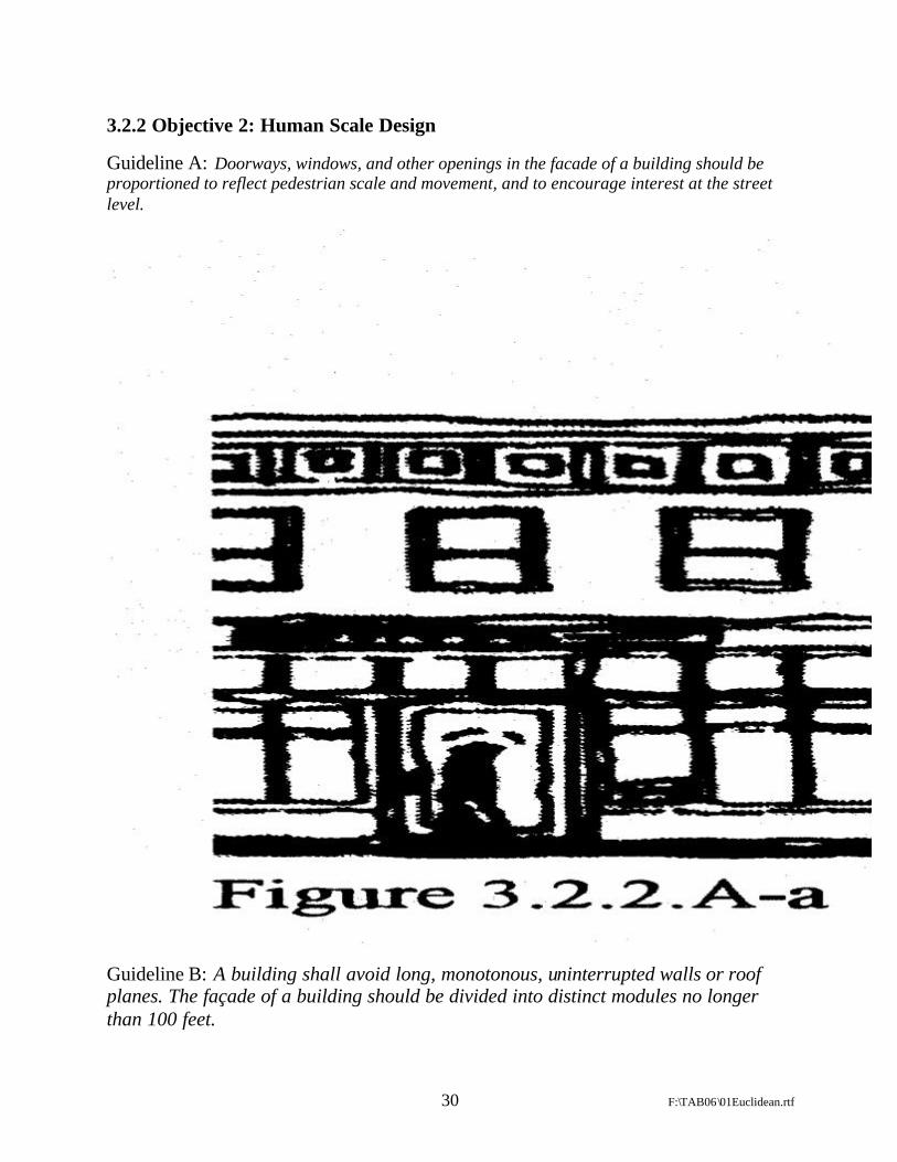
3.2.2 Objective 2: Human Scale Design
Guideline A: Doorways, windows, and other openings in the facade of a building should be proportioned to reflect pedestrian scale and movement, and to encourage interest at the street level.
Guideline B: A building shall avoid long, monotonous, uninterrupted walls or roof planes. The façade of a building should be divided into distinct modules no longer than 100 feet.

31 F:\TAB06\01Euclidean.rtf
3.2.5 Objective 5: Buildings that relate to and are oriented toward the street and surrounding buildings.
Guideline A: The structure must be located at the required setback line.

32 F:\TAB06\01Euclidean.rtf

33 F:\TAB06\01Euclidean.rtf
5. Conclusion
Despite the vision and enthusiasm of the proponents of TND or New Urbanism, it is by no means becoming the norm. The debate may be just beginning as more New Urbanism projects are being tested in the marketplace and are being tested over time. A fundamental shift away from decades of thick lawyerly drafted Euclidean codes will take a lot more than the New Urbanists’ successes of just the last decade. One New Urbanist assesses the current situation as follows:
“Replacing the crude idiocies of zoning with true civic art has proved to be a monumentally difficult task. It has been attempted in many places around the United States over the past fifteen years . . . They have succeeded in a few places. The status quo has remarkable staying power, no matter how miserable it makes people, including the local officials who support it and who have to live in the same junk environment as everybody else.”25
Perhaps an appropriate response to that assertion is that many people may not be as miserable in contemporary Euclidean suburbia as that author.
However, it is clear that real estate and land use lawyers need to understand the evolution of TND zoning and New Urbanism and its fundamental concepts so as to be prepared when New Urbanism knocks on your firm’s door.
25 James Kunstler, Home From Nowhere, THE ATLANTIC MONTHLY, Vol. 278, No. 3, pp. 43-66 (September 1996).