the project team would like to extend their appreciation...
TRANSCRIPT

The project team would like to extend their appreciation to the Stakeholder Working Group whose thoughtfulness, creativity and commitment to Jacksonville’s economic competitiveness and growing the region’s freight and logistics industry was invaluable to this process:
Stakeholder Working Group:
Project Team:
Jeff Sheffield, Executive Director, North Florida TPO Wanda Forrest, Transportation Planning Manager, North Florida TPO Marci Larson, Public Affairs Manager, North Florida TPO Rob Palmer, AICP, Project Manager, RS&H Fred Jones, AICP, Project Planner, RS&H Gary Sowell, PE, LEED AP BD+C, Rail Design Engineer, RS&H Wendy Peloquin, GISP, GIS Analyst, RS&H
Warren Alvarez Andrew Harrold James Andrews Curtis Hart James Bennett Ray Holt Dick Berry Tom Ingram Melody Bishop Tomas Jimenez James Boyle Doreen Joyner-Howard Tom Braddock David Kaufman Calvin Burney Joanne Kazmierski Jim Catlett Jim Kern Karin Charron Gene Lampp JJ Conners Steve Leggett Tony Cugno Todd Lindner Mark Curran Melissa Marcha-Lee Lad Daniels Wendell Massey Wyman Duggan Bob Molle Randy Edwards Karen Nasrallah Joel Embry David Pierce Larry Fineburg Ed Santiago Jim Gilmore Noah Silver Barbara Goodman Tim Shea Jim Green Bryan Smith Steve Grossman Lynette Smith TR Hainline Michael Stewart Kimberly Hair Joe Whitaker Terry Hall Kent Woolridge Ben Hakimian Henry Yokley

This Page Intentionally Left Blank.

Acknowledgments .............................................................................................................................................................. i
I. Project Purpose and Overall Study Goals .......................................................................................................... 1
II. Supporting Planning Initiatives and Economic Development Opportunities .............................................. 4
State: ................................................................................................................................................................................ 5
Regional: ......................................................................................................................................................................... 6
Local: ............................................................................................................................................................................... 8
Figure 3: Timeline of Key Freight and Logistics Activities ................................................................................ 11
Major Development Activity and Transportation Improvements ................................................................... 13
III. Study Process and Outreach ............................................................................................................................... 15
Stakeholder Working Group Themes ................................................................................................................... 16
IV. Rail Conceptual Layout and Design .............................................................................................................. 17
Design Principles ......................................................................................................................................................... 18
Right of Way Needs .................................................................................................................................................. 18
Connectivity and Spurs ............................................................................................................................................. 18
Crossings and Safety Issues ...................................................................................................................................... 18
V. Alignment Selection Process and Preferred Alignments .............................................................................. 19
Methodology ................................................................................................................................................................ 19
Tier 1 Analysis Results .............................................................................................................................................. 21
Tier 2 Analysis Results .............................................................................................................................................. 25
VI. Next Steps .......................................................................................................................................................... 27
Appendix A—Plans and Policy Review
Appendix B—Stakeholder Notification Letter
Appendix C—Evaluation Criteria Descriptions
Appendix D—Maps
Appendix E—Estimated Wetland Mitigation Requirements

This Page Intentionally Left Blank,
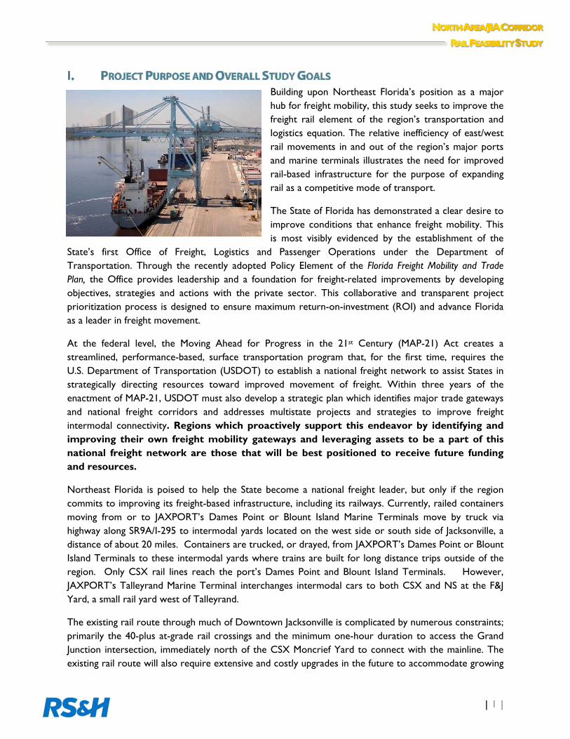
Building upon Northeast Florida’s position as a major hub for freight mobility, this study seeks to improve the freight rail element of the region’s transportation and logistics equation. The relative inefficiency of east/west rail movements in and out of the region’s major ports and marine terminals illustrates the need for improved rail-based infrastructure for the purpose of expanding rail as a competitive mode of transport.
The State of Florida has demonstrated a clear desire to improve conditions that enhance freight mobility. This is most visibly evidenced by the establishment of the
State’s first Office of Freight, Logistics and Passenger Operations under the Department of Transportation. Through the recently adopted Policy Element of the Florida Freight Mobility and Trade Plan, the Office provides leadership and a foundation for freight-related improvements by developing objectives, strategies and actions with the private sector. This collaborative and transparent project prioritization process is designed to ensure maximum return-on-investment (ROI) and advance Florida as a leader in freight movement.
At the federal level, the Moving Ahead for Progress in the 21st Century (MAP-21) Act creates a streamlined, performance-based, surface transportation program that, for the first time, requires the U.S. Department of Transportation (USDOT) to establish a national freight network to assist States in strategically directing resources toward improved movement of freight. Within three years of the enactment of MAP-21, USDOT must also develop a strategic plan which identifies major trade gateways and national freight corridors and addresses multistate projects and strategies to improve freight intermodal connectivity. Regions which proactively support this endeavor by identifying and improving their own freight mobility gateways and leveraging assets to be a part of this national freight network are those that will be best positioned to receive future funding and resources.
Northeast Florida is poised to help the State become a national freight leader, but only if the region commits to improving its freight-based infrastructure, including its railways. Currently, railed containers moving from or to JAXPORT’s Dames Point or Blount Island Marine Terminals move by truck via highway along SR9A/I-295 to intermodal yards located on the west side or south side of Jacksonville, a distance of about 20 miles. Containers are trucked, or drayed, from JAXPORT’s Dames Point or Blount Island Terminals to these intermodal yards where trains are built for long distance trips outside of the region. Only CSX rail lines reach the port’s Dames Point and Blount Island Terminals. However, JAXPORT’s Talleyrand Marine Terminal interchanges intermodal cars to both CSX and NS at the F&J Yard, a small rail yard west of Talleyrand.
The existing rail route through much of Downtown Jacksonville is complicated by numerous constraints; primarily the 40-plus at-grade rail crossings and the minimum one-hour duration to access the Grand Junction intersection, immediately north of the CSX Moncrief Yard to connect with the mainline. The existing rail route will also require extensive and costly upgrades in the future to accommodate growing
freight, particularly track and passing sidings to eliminate the existing speed restrictions of 15-25 miles per hour.
If the region does not develop competitive freight movement alternatives in the wake of increasing commodity flows, the subsequent increase in truck volumes will result in other externalities such as increased congestion and safety conflicts on area roadways, as well as escalating road maintenance costs. The region’s growing transportation and logistics industry sector may also lose out to other ports with more competitive and connected intermodal connectivity and rail access. Given the region’s collective efforts to capture additional import and export goods, especially in light of the Panama Canal expansion, improving intermodal infrastructure and efficiencies is a top priority and can help address these concerns.
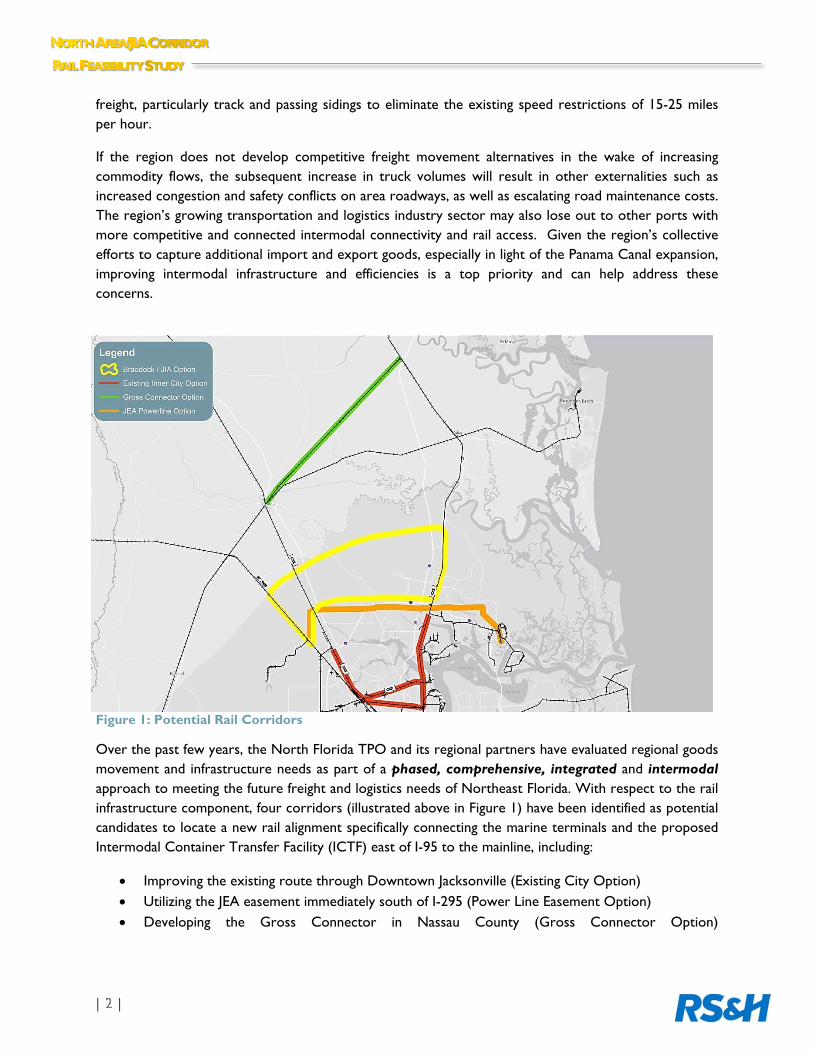
Figure 1: Potential Rail Corridors
Over the past few years, the North Florida TPO and its regional partners have evaluated regional goods movement and infrastructure needs as part of a phased, comprehensive, integrated and intermodal approach to meeting the future freight and logistics needs of Northeast Florida. With respect to the rail infrastructure component, four corridors (illustrated above in Figure 1) have been identified as potential candidates to locate a new rail alignment specifically connecting the marine terminals and the proposed Intermodal Container Transfer Facility (ICTF) east of I-95 to the mainline, including:
Improving the existing route through Downtown Jacksonville (Existing City Option) Utilizing the JEA easement immediately south of I-295 (Power Line Easement Option) Developing the Gross Connector in Nassau County (Gross Connector Option)
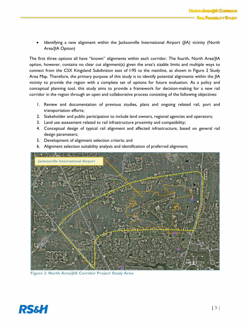
Identifying a new alignment within the Jacksonville International Airport (JIA) vicinity (North Area/JIA Option)
The first three options all have “known” alignments within each corridor. The fourth, North Area/JIA option, however, contains no clear cut alignment(s) given the area’s sizable limits and multiple ways to connect from the CSX Kingsland Subdivision east of I-95 to the mainline, as shown in Figure 2 Study Area Map. Therefore, the primary purpose of this study is to identify potential alignments within the JIA vicinity to provide the region with a complete set of options for future evaluation. As a policy and conceptual planning tool, this study aims to provide a framework for decision-making for a new rail corridor in the region through an open and collaborative process consisting of the following objectives:
1. Review and documentation of previous studies, plans and ongoing related rail, port and transportation efforts;
2. Stakeholder and public participation to include land owners, regional agencies and operators; 3. Land use assessment related to rail infrastructure proximity and compatibility; 4. Conceptual design of typical rail alignment and affected infrastructure, based on general rail
design parameters; 5. Development of alignment selection criteria; and 6. Alignment selection suitability analysis and identification of preferred alignment;
Figure 2: North Area/JIA Corridor Project Study Area
Jacksonville International Airport

Throughout the past decade, improving freight mobility has been a major focus of Northeast Florida planning and implementation. Major infrastructure initiatives and new policies and economic development activities demonstrate the region’s commitment to enhancing the transportation and logistics industry. In fact, there are a number of documented plans, programs and policy objectives which directly support rail infrastructure development as an overall freight mobility and economic development strategy for Florida and the region. Major highlights include:
St. Johns River harbor-deepening study (targeting a 47 foot depth from the current 40 foot) and correcting the Mile-Point deficiencies to ensure that Jacksonville can successfully accommodate the larger, Post-Panamax container ships
The development of the new ICTF will provide needed access to efficient rail-based transportation for shippers who currently use highway semi trailers and containers, and by attracting new distribution, manufacturing, and warehousing development to its vicinity, significantly decreasing the economic and environmental cost for draying trailers and containers between the Dames Point marine terminals and shippers’ and receivers’ facilities
Major policy and economic development activities such as the State’s Florida Trade and Logistics Study serves as a framework for Florida’s global business development, specifically identifying opportunities and strategies for the Florida to become a global trade hub
Improving the region’s rail infrastructure greatly positions Northeast Florida as the major gateway into the State and Nation. By leveraging the region’s assets and improving rail transportation to support the continued growth of the Port, the region can remain competitive in the global logistics marketplace and provide new jobs in the local economy.
The following provides a summary review of the many plans and efforts underway in order to provide a direct linkage between Northeast Florida’s freight activities (including this Feasibility Study) and State and Federal initiatives and resources:
Mile Point—To improve the flow of the St. Johns River at Mile Point – where the St. Johns River converges with the Intracoastal Waterway—the U.S. Army Corps of Engineers approved a project to modify the channel to allow container vessels to enter the harbor at more frequent intervals beyond high tide only.
This effort is critical for handling the port’s current cargo ships as well as strengthening the port’s ability to successfully compete for more post-Panamax ships in the future.
In January 2013, Governor Rick Scott announced a commitment of $38 million in state and local funding to complete the Mile Point project. This investment enables JaxPort to jump-start the final phase of fixing the navigational problems in the St. Johns River at Mile Point from its previously uncertain start date which was contingent on federal funding:
http://www.jaxport.com/sites/default/files/docs/mile-point-USACE-12-2011.pdf
STATE: Intermodal Systems Development Office of Freight, Logistics and Passenger Operations (FLP)
One of the first of its kind in the country, the Office of Freight, Logistics and Passenger Operations was established with the recognition of the significant role that freight mobility plays as an economic driver for Florida. This Office is designed as a tool to better connect, develop, and implement a freight planning process to maximize the use of existing facilities and integrate and coordinate the various modes of transportation, including the combined utilization of both government-owned and privately-owned resources.
The advancement of a new freight rail corridor in Northeast Florida is consistent with the objectives of the FLP Office, which established a Partnering Charter in 2012 with the Federal Highway Administration recognizing Florida as a “Freight Opportunity State”, will best position the region for future planning and project delivery resources to implement new rail and intermodal facilities.
HB 599 & the Florida Freight Mobility and Trade Plan
Approved on April 27, 2012 by signature of Governor Richard L. Scott, Florida House Bill 599 requires the Florida Department of Transportation to develop the Freight Mobility and Trade Plan. This Plan seeks to define policies and investments that will enhance Florida’s economic development efforts. The primary goals for this Plan are to:
Increase the flow of domestic and international trade through the State’s seaports and airports, including investments to recapture the cargo that is currently being shipped through ports outside Florida
Increase the development of intermodal logistics centers (ILCs) in the State, including specific strategies, policies and investments to capitalize on the State’s empty backhaul trucking and rail market
Increasing manufacturing industries in the State, including investments in transportation facilities that will promote the successful development and expansion of such industries
Increasing the implementation of compressed natural gas (CNG), liquefied natural gas (LNG) and propane energy policies to reduce transportation costs
This Plan supports the directive under MAP-21 that states develop freight plans that identify the trends, needs and issues, while appropriately guiding investment decisions to meet national freight goals.
A key component of the Freight Mobility and Trade Plan is its Investment Element. This Element will build upon the primary goals and policies outlined above by identifying specific needs, identifying criteria for State investments in freight and meeting the requirements of MAP-21. A series of stakeholder outreach activities designed to gain feedback regarding specific freight needs; the business perspective and how investments should be directed are being conducted across Florida from October 2013
through Plan dissemination in summer of 2014. The timeline shown in Figure 3 illustrates the key legislative and economic development activities as a framework for improving trade and logistics in the State and region.
REGIONAL: Future Rail Corridors Study
In August 2011, JaxPort, through the support of the North Florida TPO, conducted an evaluation of the development of an intermodal container transfer facility (ICTF) to serve its current and planned marine terminals at Dames Point and Blount Island. Critical to the development of this facility is viable rail access for containerized commodity flows. This study identified opportunities and constraints for potential future rail access alternatives to support JaxPort’s terminals. As a precursor to this Feasibility Study, this Corridors Study resulted in the identification of the four major rail corridors (as described in Section 1) as a solution for long-term rail access in the region’s pursuit of growing its transportation and logistics sector.
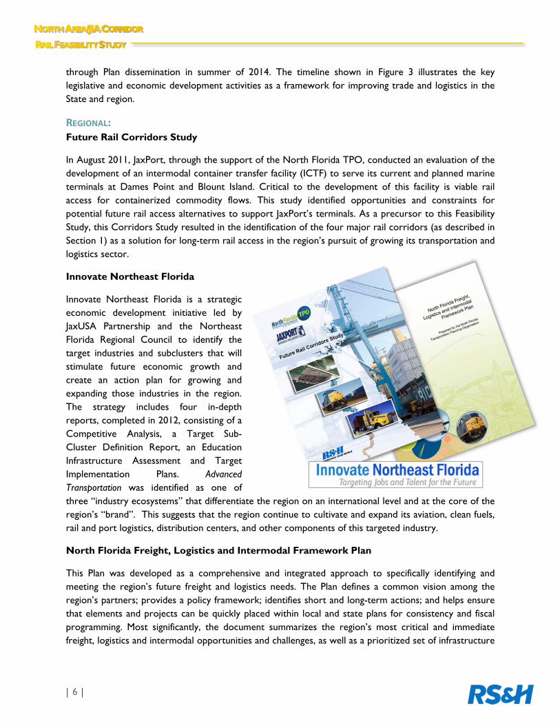
Innovate Northeast Florida
Innovate Northeast Florida is a strategic economic development initiative led by JaxUSA Partnership and the Northeast Florida Regional Council to identify the target industries and subclusters that will stimulate future economic growth and create an action plan for growing and expanding those industries in the region. The strategy includes four in-depth reports, completed in 2012, consisting of a Competitive Analysis, a Target Sub-Cluster Definition Report, an Education Infrastructure Assessment and Target Implementation Plans. Advanced Transportation was identified as one of three “industry ecosystems” that differentiate the region on an international level and at the core of the region’s “brand”. This suggests that the region continue to cultivate and expand its aviation, clean fuels, rail and port logistics, distribution centers, and other components of this targeted industry.
North Florida Freight, Logistics and Intermodal Framework Plan
This Plan was developed as a comprehensive and integrated approach to specifically identifying and meeting the region’s future freight and logistics needs. The Plan defines a common vision among the region’s partners; provides a policy framework; identifies short and long-term actions; and helps ensure that elements and projects can be quickly placed within local and state plans for consistency and fiscal programming. Most significantly, the document summarizes the region’s most critical and immediate freight, logistics and intermodal opportunities and challenges, as well as a prioritized set of infrastructure

needs. This includes the specific recommendation of further evaluating the Braddock/JIA option through this North Area/JIA Corridor Future Rail Feasibility Study.
North Florida Regional Transportation Commission (RTC)
The Regional Transportation Study Commission (RTSC) was launched in December 2010 and assembled representatives from the
seven-county region (Baker, Clay, Duval, Flagler, Nassau, Putnam and St. Johns) to evaluate the need for a new regional entity to develop and enhance multimodal transportation to improve the economic competitiveness and quality of life for the region. The final recommendations to establish the Regional Transportation Commission were submitted to the Florida Legislature by the RTSC in December 2012. Prior to the submittal of the final RTSC regional report, six counties, excluding Flagler, in the region passed resolutions indicating their support for and commitment to fund the Regional Transportation Commission. By the spring of 2013, legislation was passed unanimously by the State creating this new Commission. The Regional Transportation Commission will include the six counties: Baker, Clay, Duval, Nassau, Putnam and St. Johns. The Commission is tasked with developing a “Multimodal Regional Transportation Plan” as well as a strategy to fund the plan. It will also coordinate the regional transit options and advance strategic regional transportation projects focusing on coordinating regional transportation and creating the organizational framework to implement the plan. As adopted, freight and intermodal transportation projects are considered eligible for funding and support, including such projects as a new rail corridor. The Commission is funded through local contributions by each county and it will be governed by a nine-member board with representatives from each county.
JTA Commuter Rail Feasibility Study
As part of the Jacksonville Transportation Authority’s (JTA) ongoing future transit initiatives, a Commuter Rail Feasibility Study was conducted in 2009 which identified three candidate corridors for further evaluation and development. A North Corridor from Downtown Jacksonville to Yulee, FL was identified for future premium transit service and consists of proposed stations that could potentially connect directly with the Jacksonville International Airport. Potential alignments generated during this Feasibility Study may facilitate such a future passenger rail connection via the North Corridor.
LOCAL: North Jacksonville Marine Terminals Multimodal Impact Study
In 2005, JaxPort and Mitsui OSK Lines signed a long term lease agreement for the development of a new marine container terminal on a 158-acre site off Heckscher Drive at the Port’s Dames Point location. The new Mitsui terminal, operated by TraPac, was expected to handle significant increases of container volume over time. In 2007, the North Florida TPO and JaxPort partnered together to evaluate the multimodal impact of container traffic upon Strategic Intermodal System (SIS) facilities; and study the feasibility of a near-dock intermodal rail terminal.
The study consisted of data collection and mapping; data analysis and multimodal impact assessment; and recommendations. Additionally, JaxPort container volume growth was projected; a container routing methodology was developed to route the projected containers; a highway corridor assessment was performed; and a feasibility assessment of a near dock intermodal rail terminal was completed. Most significantly, this effort provided the impetus for the continued evaluation of long-term rail connectivity improvements.
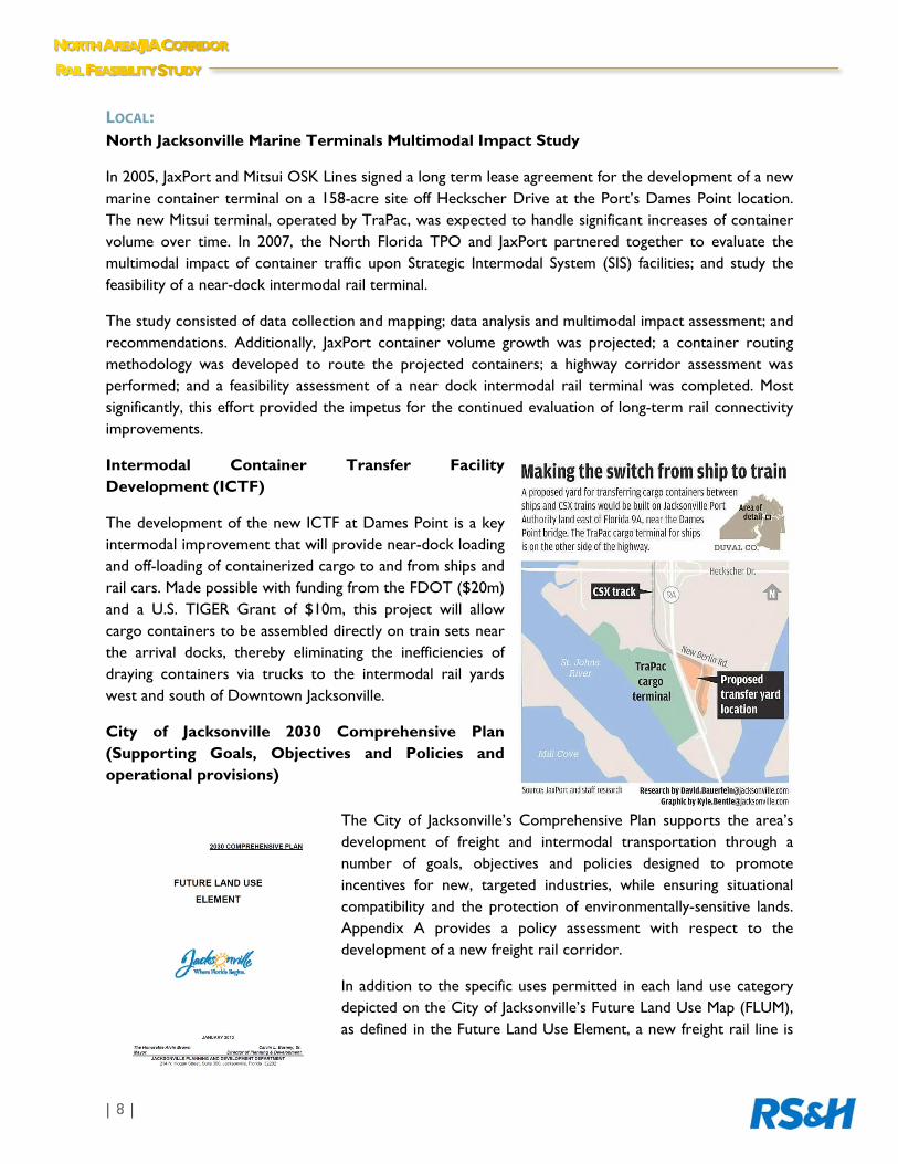
Intermodal Container Transfer Facility Development (ICTF)
The development of the new ICTF at Dames Point is a key intermodal improvement that will provide near-dock loading and off-loading of containerized cargo to and from ships and rail cars. Made possible with funding from the FDOT ($20m) and a U.S. TIGER Grant of $10m, this project will allow cargo containers to be assembled directly on train sets near the arrival docks, thereby eliminating the inefficiencies of draying containers via trucks to the intermodal rail yards west and south of Downtown Jacksonville.
City of Jacksonville 2030 Comprehensive Plan (Supporting Goals, Objectives and Policies and operational provisions)
The City of Jacksonville’s Comprehensive Plan supports the area’s development of freight and intermodal transportation through a number of goals, objectives and policies designed to promote incentives for new, targeted industries, while ensuring situational compatibility and the protection of environmentally-sensitive lands. Appendix A provides a policy assessment with respect to the development of a new freight rail corridor.
In addition to the specific uses permitted in each land use category depicted on the City of Jacksonville’s Future Land Use Map (FLUM), as defined in the Future Land Use Element, a new freight rail line is

considered an essential service similar to roadways, public and private community facilities, and parks and open space. Therefore, a new rail line is currently allowed by right in all of the City’s specified Development Areas and land use plan categories subject to standards and criteria in the land development regulations.
North Jacksonville Shared Vision and Master Plan
The 2003 North Jacksonville Shared Vision and Master Plan is the culmination of an extensive community visioning and planning process that articulates desired future growth and development for the residents and businesses of the City’s North Planning District. This Plan provides design and development guidelines as well as a master plan for future sustainable development for the District. Under City Ordinance 2003-1048-E, all development and redevelopment within the North Planning District shall be reviewed by the Planning and Development Department in accordance with the guidance and recommendations of the Shared Vision and Master Plan. With respect to a future rail corridor in the JIA vicinity, this plan also recognizes the area’s importance as a key distribution hub and specifically recommends the establishment of an “Airport Distribution District” for industrial-related uses.
“The concept for the Airport Distribution Center is to provide an area within the North Jacksonville Vision and Master Plan that will function primarily as a regional distribution center. This center should focus as a location for companies that combine flexible production systems, advanced technology, and high-speed transportation to compress the production cycle. To speed up commerce the uses in the Distribution Center should focus on air transportation, trucking, and freight providers. The clustering of time sensitive goods facilities around JIA should stimulate the further expansion of air cargo, air express, less-than-load (LTL) trucking, freight forwarders and third party logistics providers along major arteries leading into and out of this gateway airport.”
--North Jacksonville Shared Vision and Master Plan

This Page Intentionally Left Blank.
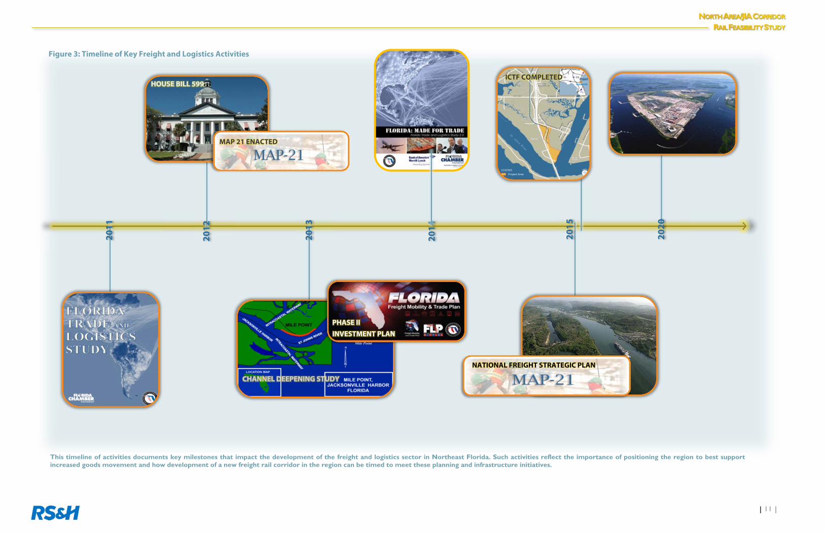
Figure 3: Timeline of Key Freight and Logistics Activities
2014
ICTF COMPLETED
2020
2011
2015
NATIONAL FREIGHT STRATEGIC PLAN
2013
CHANNEL DEEPENING STUDY
2012
HOUSE BILL 599
MAP 21 ENACTED
This timeline of activities documents key milestones that impact the development of the freight and logistics sector in Northeast Florida. Such activities reflect the importance of positioning the region to best supportincreased goods movement and how development of a new freight rail corridor in the region can be timed to meet these planning and infrastructure initiatives.
PHASE II INVESTMENT PLAN

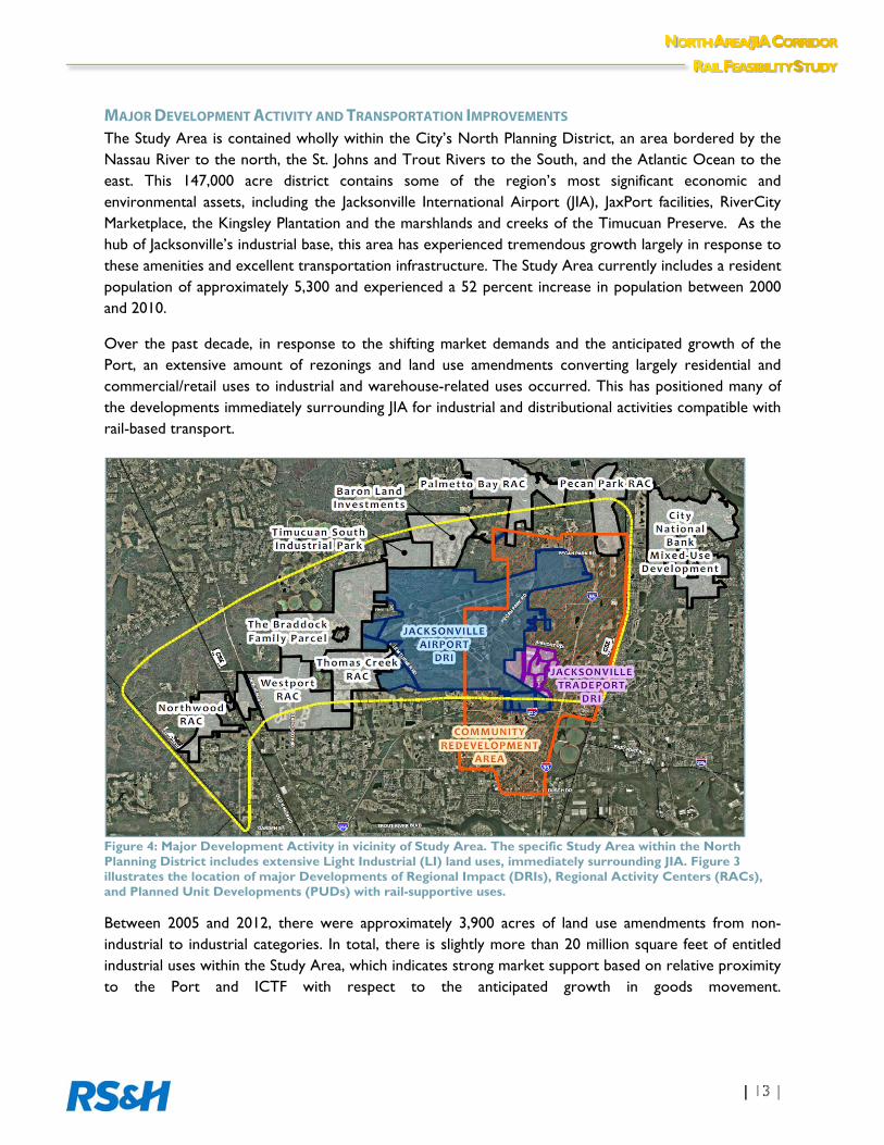
MAJOR DEVELOPMENT ACTIVITY AND TRANSPORTATION IMPROVEMENTS The Study Area is contained wholly within the City’s North Planning District, an area bordered by the Nassau River to the north, the St. Johns and Trout Rivers to the South, and the Atlantic Ocean to the east. This 147,000 acre district contains some of the region’s most significant economic and environmental assets, including the Jacksonville International Airport (JIA), JaxPort facilities, RiverCity Marketplace, the Kingsley Plantation and the marshlands and creeks of the Timucuan Preserve. As the hub of Jacksonville’s industrial base, this area has experienced tremendous growth largely in response to these amenities and excellent transportation infrastructure. The Study Area currently includes a resident population of approximately 5,300 and experienced a 52 percent increase in population between 2000 and 2010.
Over the past decade, in response to the shifting market demands and the anticipated growth of the Port, an extensive amount of rezonings and land use amendments converting largely residential and commercial/retail uses to industrial and warehouse-related uses occurred. This has positioned many of the developments immediately surrounding JIA for industrial and distributional activities compatible with rail-based transport.
Figure 4: Major Development Activity in vicinity of Study Area. The specific Study Area within the North Planning District includes extensive Light Industrial (LI) land uses, immediately surrounding JIA. Figure 3 illustrates the location of major Developments of Regional Impact (DRIs), Regional Activity Centers (RACs), and Planned Unit Developments (PUDs) with rail-supportive uses.
Between 2005 and 2012, there were approximately 3,900 acres of land use amendments from non-industrial to industrial categories. In total, there is slightly more than 20 million square feet of entitled industrial uses within the Study Area, which indicates strong market support based on relative proximity to the Port and ICTF with respect to the anticipated growth in goods movement.
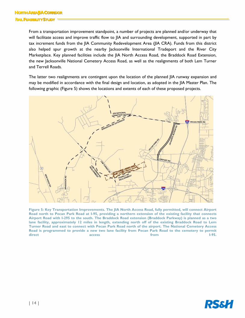
From a transportation improvement standpoint, a number of projects are planned and/or underway that will facilitate access and improve traffic flow to JIA and surrounding development, supported in part by tax increment funds from the JIA Community Redevelopment Area (JIA CRA). Funds from this district also helped spur growth at the nearby Jacksonville International Tradeport and the River City Marketplace. Key planned facilities include the JIA North Access Road, the Braddock Road Extension, the new Jacksonville National Cemetery Access Road, as well as the realignments of both Lem Turner and Terrell Roads.
The latter two realignments are contingent upon the location of the planned JIA runway expansion and may be modified in accordance with the final design and location, as adopted in the JIA Master Plan. The following graphic (Figure 5) shows the locations and extents of each of these proposed projects.
Figure 5: Key Transportation Improvements. The JIA North Access Road, fully permitted, will connect Airport Road north to Pecan Park Road at I-95, providing a northern extension of the existing facility that connects Airport Road with I-295 to the south. The Braddock Road extension (Braddock Parkway) is planned as a two lane facility, approximately 12 miles in length, extending north off of the existing Braddock Road to Lem Turner Road and east to connect with Pecan Park Road north of the airport. The National Cemetery Access Road is programmed to provide a new two lane facility from Pecan Park Road to the cemetery to permit direct access from I-95.
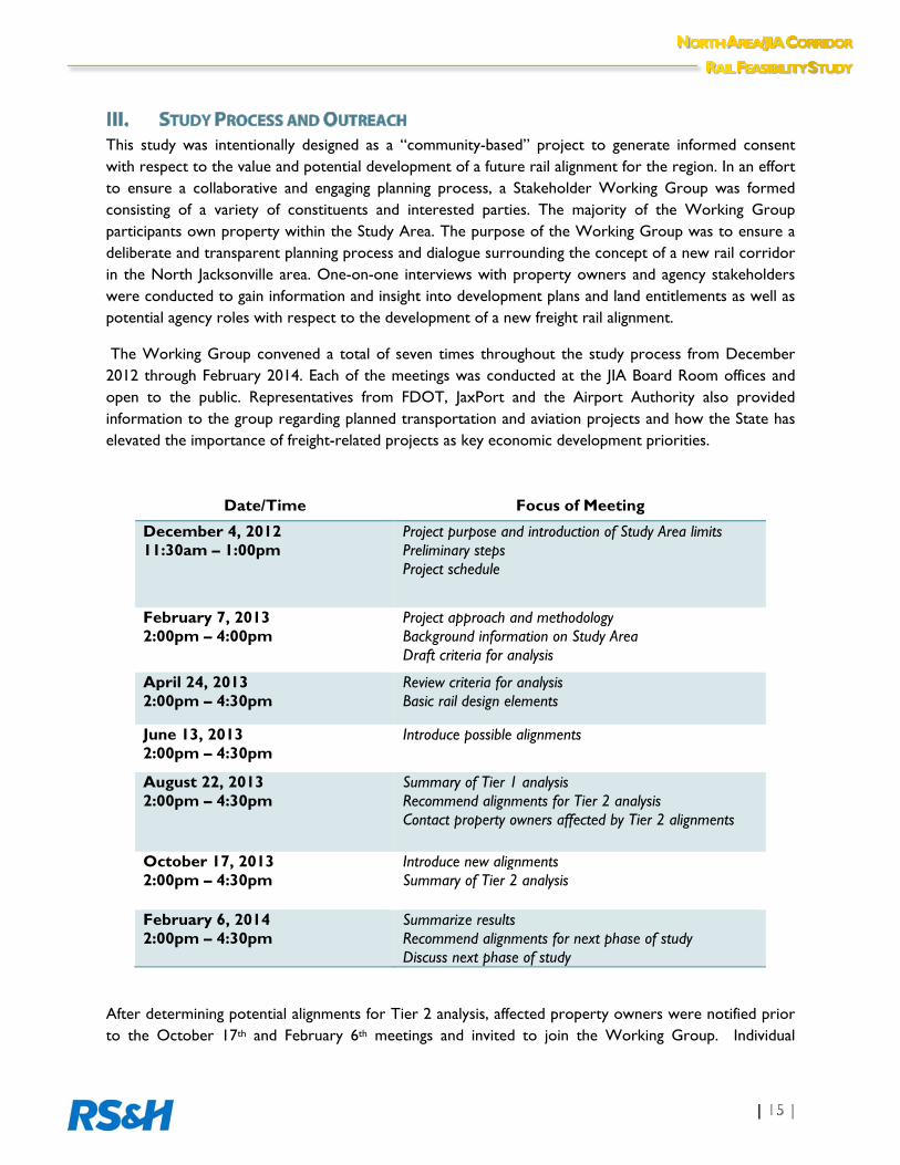
This study was intentionally designed as a “community-based” project to generate informed consent with respect to the value and potential development of a future rail alignment for the region. In an effort to ensure a collaborative and engaging planning process, a Stakeholder Working Group was formed consisting of a variety of constituents and interested parties. The majority of the Working Group participants own property within the Study Area. The purpose of the Working Group was to ensure a deliberate and transparent planning process and dialogue surrounding the concept of a new rail corridor in the North Jacksonville area. One-on-one interviews with property owners and agency stakeholders were conducted to gain information and insight into development plans and land entitlements as well as potential agency roles with respect to the development of a new freight rail alignment.
The Working Group convened a total of seven times throughout the study process from December 2012 through February 2014. Each of the meetings was conducted at the JIA Board Room offices and open to the public. Representatives from FDOT, JaxPort and the Airport Authority also provided information to the group regarding planned transportation and aviation projects and how the State has elevated the importance of freight-related projects as key economic development priorities.
After determining potential alignments for Tier 2 analysis, affected property owners were notified prior to the October 17th and February 6th meetings and invited to join the Working Group. Individual
Date/Time Focus of Meeting
December 4, 2012 11:30am – 1:00pm
Project purpose and introduction of Study Area limits Preliminary steps Project schedule
February 7, 2013 2:00pm – 4:00pm
Project approach and methodology Background information on Study Area Draft criteria for analysis
April 24, 2013 2:00pm – 4:30pm
Review criteria for analysis Basic rail design elements
June 13, 2013 2:00pm – 4:30pm
Introduce possible alignments
August 22, 2013 2:00pm – 4:30pm
Summary of Tier 1 analysis Recommend alignments for Tier 2 analysis Contact property owners affected by Tier 2 alignments
October 17, 2013 2:00pm – 4:30pm
Introduce new alignments Summary of Tier 2 analysis
February 6, 2014 2:00pm – 4:30pm
Summarize results Recommend alignments for next phase of study Discuss next phase of study
meetings to discuss the project and potential alignments were also held with property owners at their request. A list of the properties and copies of the project notification letters that were sent are provided in Appendix B. Physical mailing addresses used to send out the notification letters were obtained through the City of Jacksonville’s property records database.
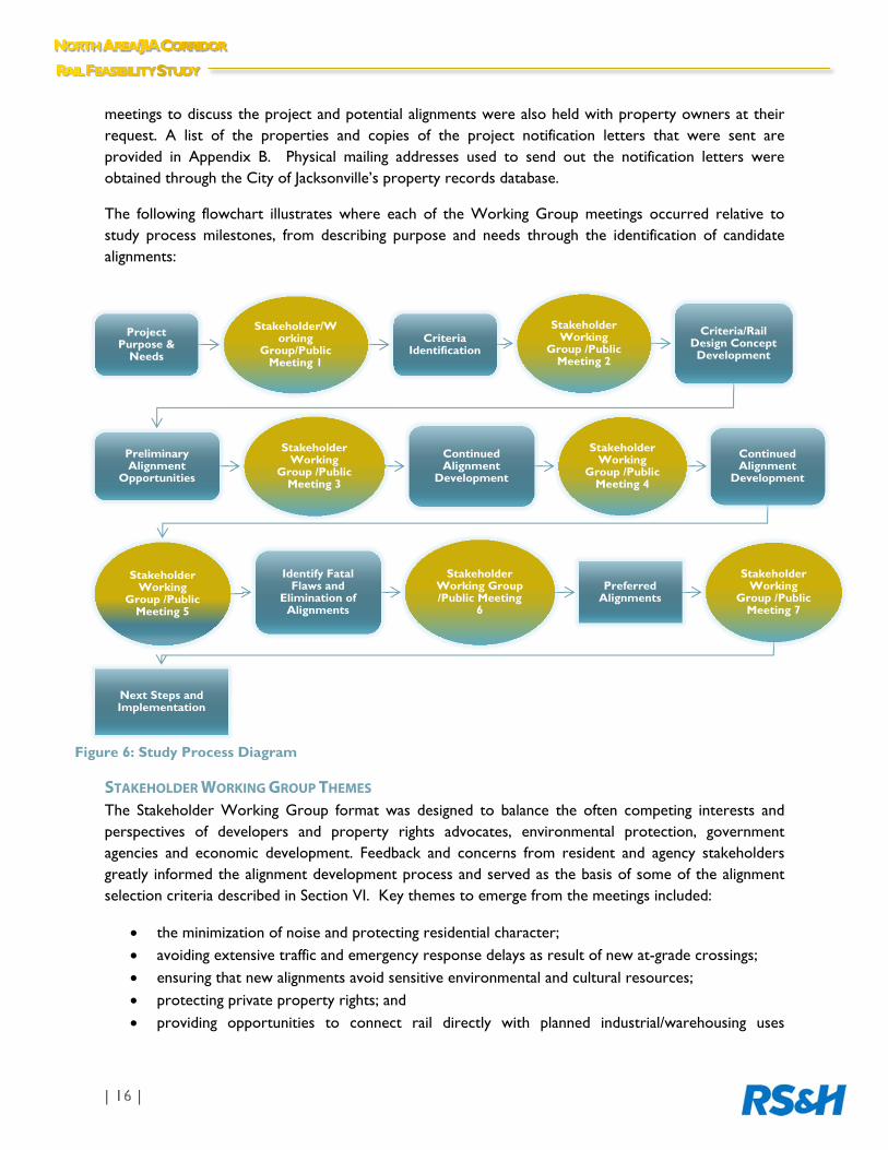
The following flowchart illustrates where each of the Working Group meetings occurred relative to study process milestones, from describing purpose and needs through the identification of candidate alignments:
STAKEHOLDER WORKING GROUP THEMES The Stakeholder Working Group format was designed to balance the often competing interests and perspectives of developers and property rights advocates, environmental protection, government agencies and economic development. Feedback and concerns from resident and agency stakeholders greatly informed the alignment development process and served as the basis of some of the alignment selection criteria described in Section VI. Key themes to emerge from the meetings included:
the minimization of noise and protecting residential character; avoiding extensive traffic and emergency response delays as result of new at-grade crossings; ensuring that new alignments avoid sensitive environmental and cultural resources; protecting private property rights; and providing opportunities to connect rail directly with planned industrial/warehousing uses
Project Purpose &
Needs
Stakeholder/Working
Group/Public Meeting 1
Criteria Identification
Stakeholder Working
Group /Public Meeting 2
Criteria/Rail Design Concept Development
Preliminary Alignment
Opportunities
Stakeholder Working
Group /Public Meeting 3
Continued Alignment
Development
Stakeholder Working
Group /Public Meeting 4
Continued Alignment
Development
Stakeholder Working
Group /Public Meeting 5
Identify Fatal Flaws and
Elimination of Alignments
Stakeholder Working Group /Public Meeting
6
Preferred Alignments
Stakeholder Working
Group /Public Meeting 7
Next Steps and Implementation
Figure 6: Study Process Diagram
As a feasibility-level analysis to locate potential alignment(s) for future consideration within the designated Study Area corridor, this study does not provide detailed engineering plans and profiles for a new rail alignment. This would only occur at a future phase following public endorsement and funding to advance a preferred alignment into preliminary design and engineering, through a federally-mandated Alternatives Analysis process. Rather, a series of 150’ buffers, designed to capture the maximum right-of-way needs for a future alignment, including anticipated curvature and other elements consistent with rail design, were developed. In this stage of the process, it is the intent to identify only general locations within the corridor that can best accommodate a future potential alignment(s) in accordance with community-supported criteria and methodology.
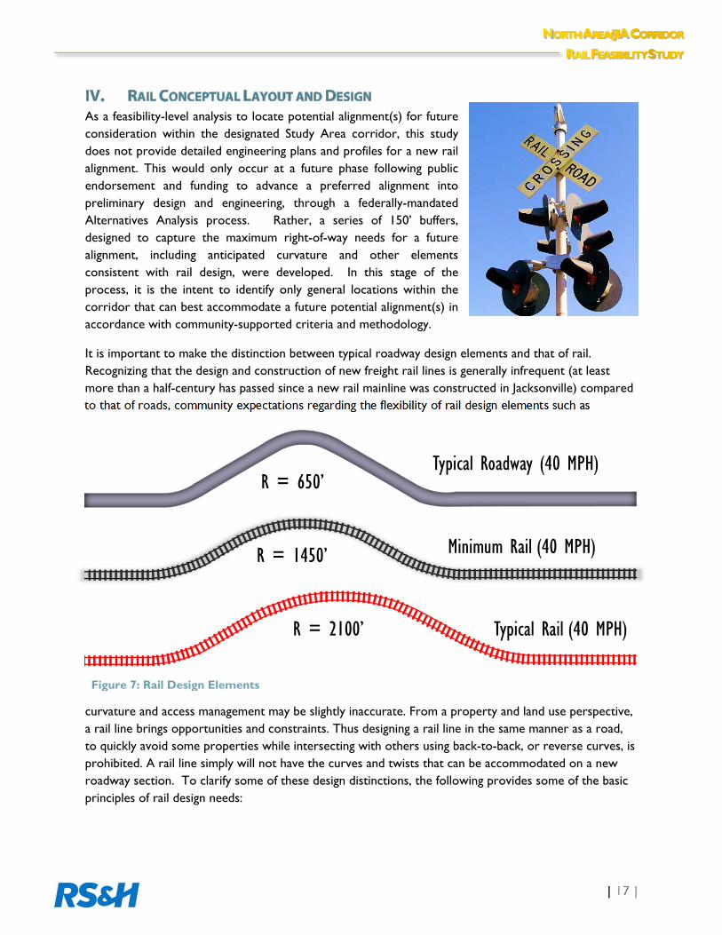
It is important to make the distinction between typical roadway design elements and that of rail. Recognizing that the design and construction of new freight rail lines is generally infrequent (at least more than a half-century has passed since a new rail mainline was constructed in Jacksonville) compared to that of roads, community expectations regarding the flexibility of rail design elements such as
curvature and access management may be slightly inaccurate. From a property and land use perspective, a rail line brings opportunities and constraints. Thus designing a rail line in the same manner as a road, to quickly avoid some properties while intersecting with others using back-to-back, or reverse curves, is prohibited. A rail line simply will not have the curves and twists that can be accommodated on a new roadway section. To clarify some of these design distinctions, the following provides some of the basic principles of rail design needs:
R = 650’
R = 1450’
R = 2100’
Typical Roadway (40 MPH)
Minimum Rail (40 MPH)
Typical Rail (40 MPH)
Figure 7: Rail Design Elements
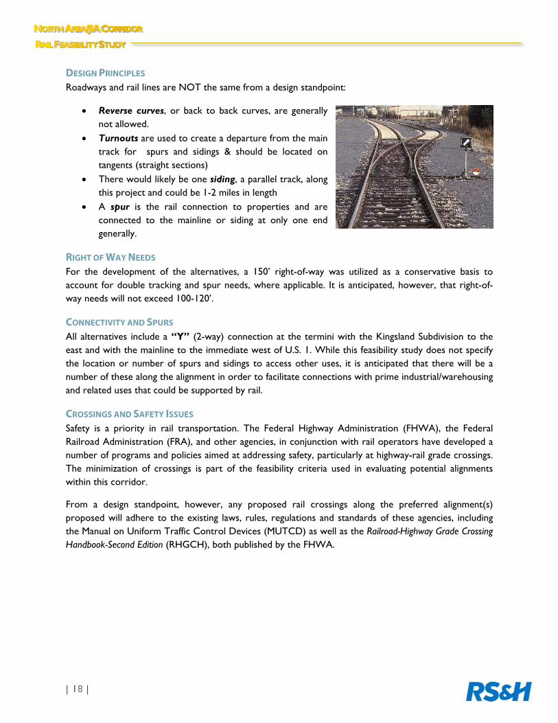
DESIGN PRINCIPLES Roadways and rail lines are NOT the same from a design standpoint:
Reverse curves, or back to back curves, are generally not allowed.
Turnouts are used to create a departure from the main track for spurs and sidings & should be located on tangents (straight sections)
There would likely be one siding, a parallel track, along this project and could be 1-2 miles in length
A spur is the rail connection to properties and are connected to the mainline or siding at only one end generally.
RIGHT OF WAY NEEDS For the development of the alternatives, a 150’ right-of-way was utilized as a conservative basis to account for double tracking and spur needs, where applicable. It is anticipated, however, that right-of-way needs will not exceed 100-120’.
CONNECTIVITY AND SPURS All alternatives include a “Y” (2-way) connection at the termini with the Kingsland Subdivision to the east and with the mainline to the immediate west of U.S. 1. While this feasibility study does not specify the location or number of spurs and sidings to access other uses, it is anticipated that there will be a number of these along the alignment in order to facilitate connections with prime industrial/warehousing and related uses that could be supported by rail.
CROSSINGS AND SAFETY ISSUES Safety is a priority in rail transportation. The Federal Highway Administration (FHWA), the Federal Railroad Administration (FRA), and other agencies, in conjunction with rail operators have developed a number of programs and policies aimed at addressing safety, particularly at highway-rail grade crossings. The minimization of crossings is part of the feasibility criteria used in evaluating potential alignments within this corridor.
From a design standpoint, however, any proposed rail crossings along the preferred alignment(s) proposed will adhere to the existing laws, rules, regulations and standards of these agencies, including the Manual on Uniform Traffic Control Devices (MUTCD) as well as the Railroad-Highway Grade Crossing Handbook-Second Edition (RHGCH), both published by the FHWA.

The identification and evaluation of potential alignments within this Study Area strikes a balance between minimum rail design standards and a range of stakeholder-driven criteria developed to address mobility, community, environmental and economic issues. These four major categories are designed to capture as best possible key quality of life factors that could be affected positively or negatively by the introduction of a new rail alignment in the Study Area.
Mobility measures reflect the extent to which a new alignment will preserve travel and safety, while potentially supporting new multimodal opportunities. Community measures are designed to ensure land use compatibility and cultural/historic resource preservation.
Environmental measures are designed to reduce impacts to sensitive environmental lands and floodplains. Identifying properties and uses that can best accommodate rail transport and promote economic development reflect the intent of economic measures. The potential for wetland mitigation costs are also part of the economic measure.
The resulting preferred alignments are based on a combination of a tiered screening process blending specific criteria with professional planning and engineering judgment to identify potential fatal flaws based largely on major environmental and infrastructure constraints.
METHODOLOGY Seventeen (17) preliminary, conceptual alignments were developed based solely on engineering feasibility, as described in Section V. In this case, each of these preliminary alignments were considered as “equal opportunity offenders” in that no single alignment was developed with consideration to specific environmental or property ownership concerns at the benefit or exclusion of other alignments. This provided a neutral, engineering-based starting point from which to begin the screening analysis.
The seventeen alignments are labeled according to their location within the Study Area, including the N-series (for northern section), M-series (for middle section), and S-series (for southern section), as shown in Figure 8. Many share portions of the same alignment with slight deviations in terms of curvature or shift in direction to enable connection to the “Y” termini with the Kingsland Subdivision or mainline.
The analysis of the preliminary alignments was broken down into two tiers. The initial screening, or Tier 1 analysis, was designed to illustrate major fatal flaws that would likely preclude the development of a particular alignment.
Tiered Evaluation Process Factors:
Mobility
Community
Environment
Economic

Given that most of the criteria used in the analysis is quantitative, this facilitated data integration with Geographic Information Systems-based (GIS) spatial analysis tools. Using GIS, the geometry of each preliminary rail alignment was overlaid on the geometry of the spatially-based evaluation criteria. The area where each rail alignment intersected with the measurable criteria was calculated to determine the amount of impact that alignment would have relative to the criteria thresholds. The amount of impact relative to the criteria thresholds was compared across each of the potential alignments.
The Tier 1 analysis provided a means to eliminate crossings with major wetlands and environmentally-sensitive lands, including such managed lands that are designated as part of Timucuan Ecological Preserve and/or the Thomas Creek Preserve, as well as conflicts with major planned projects of the JIA, specifically the newly proposed runway extension to the south of the Airport.. Some of the major criteria include the number of potential grade separations, the number of acres of potentially impacted wetlands and managed lands, as well as property use compatibility to minimize residential impacts.
Following the elimination of particular alignments from the fatal flaw analysis, the remaining alignments were then analyzed using the Tier 2 criteria and presented as information only. This criteria reflects the extent to which such factors as emergency response times could be impacted by the number of crossings, consistency with local government and area plans, the degree of existing residential proximity, as well as accessibility to rail-supportive uses (measured more specifically in the amount of acreage of entitled industrial land uses intersected by a proposed alignment). Wetland mitigation is also included to illustrate the amount of potential acres of wetlands that would likely require mitigation.
These “preferred” candidate alignments are those that will be advanced into a future alternative analysis planning study that will provide more detailed engineering analysis, including specific discussions with potential landowners.
Figure 8: Preliminary Conceptual Alignments within Study Area

TIER 1 ANALYSIS RESULTS Of the seventeen (17) preliminary alignments, the following twelve (12) alignments were eliminated based on Tier I analysis: N1, N2, M1, M1a, M2, M2a, M3, M3a, M5, M6, S1, and S2. Much of this reflected the amount of grade separations (roadway and railroad bridges/trestles) and at-grade crossings required, as was the case for M5, M6, S1 and S2 and the amount of managed lands, including the Timucuan Ecological and Historic Preserve and the Thomas Creek Conservation Area.
The following summarizes the Tier 1 results. A map series (identified as Maps 1-19) in Appendix D provides the graphical illustration of the analysis corresponding to the tiered evaluation criteria:
Potential Grade Separations-roadway and railroad bridge/trestles (Map 3)
Alignments with the least amount of roadway separation and railroad bridge/trestles are considered the most desirable from both a design and cost standpoint. The S1 and S2 alignments had the highest number (9) of these types of separations and were thus considered unfeasible.
Potential At-Grade Crossings (Map 3)
Alignments that have the least amount of at-grade crossings are the most desirable with respect to safety and the ability to reduce traffic and emergency response delays. Alignments M5, M6, S1, and S2 had at least four at-grade crossings, which represented the highest number of crossings and therefore not advanced into Tier 2.
Passenger Rail Connectivity to JIA (Map 9)
In 2008, the Jacksonville Transportation Authority (JTA) conducted the Commuter Rail Feasibility Study. The Working Group felt that the potential opportunity to have a dual purpose corridor that could accommodate future passenger rail traffic would be considered favorable. Given that the CSXT Kingsland rail was identified as a potential corridor and Airport Center Drive was identified as a potential regional rail station area in the Commuter Rail Study, a potential alignment may offer the future opportunity to support freight movement and connect passengers directly to JIA. For planning purposes, the project team determined that any alignments beyond ½ mile from Airport Center Drive would be excluded. The N1 and N2 alignments offered the least connectivity potential from a planning standpoint based on the recommendations of the Commuter Rail Feasibility Study.
Managed Lands (Map 4)
There are several managed lands within the Study Area for this project, the most significant of which are those contained by the Timucuan Ecological and Historic Preserve and the Thomas Creek Conservation Area. Due to their environmental significance, it is not feasible to build a new rail within these protected areas. The following shows the amounts of acres within the two managed areas that were impacted by the proposed alignments:
Thomas Creek Conservation Area (N1 – 45.63 acres, N2 – 45.63 acres, M1/M1a – 45.63 acres, M2/M2a – 37.41 acres, M3/M3a – 37.41 acres, M5 – 37.41 acres, S1 – 37.41 acres)
Timucuan Ecological and Historic Preserve (N1 – 1.74 acres, N2 – 1.89 acres).
As such these alignments were not advanced for Tier 2 screening.
Existing Property Use Compatibility (Map 5)
Recognizing the importance of minimizing the impacts to residential property use, as determined by the City of Jacksonville’s existing property use data, alignment S2 impacted the largest amount of residential property use acreage (6.03 acres) and was eliminated from further screening under Tier 2.
Rail Accessibility (Map 9)
Balancing the need to reduce impacts on environmentally-sensitive lands and incompatible uses with economic development objectives, the project team reviewed the major development activity surrounding JIA, including those projects with Multi-Use (MU) designations and extensive light industrial entitlements. Such development could present opportunities to connect with potential alignments to support manufacturing, warehousing and distribution-related activities served by rail. Alignments traversing projects with a higher amount of entitled industrial-related uses would be considered more favorable for further evaluation. Of the preliminary alignments, S1, M5, and M6 contained the lowest number (3) of major planned projects with industrial uses that the alignment runs adjacent to or through.
Table 1 provides the evaluation criteria under each of the four major categories and the results of the Tier 1 analysis. A more detailed definition and description of each of the evaluation criteria is included in Appendix C.
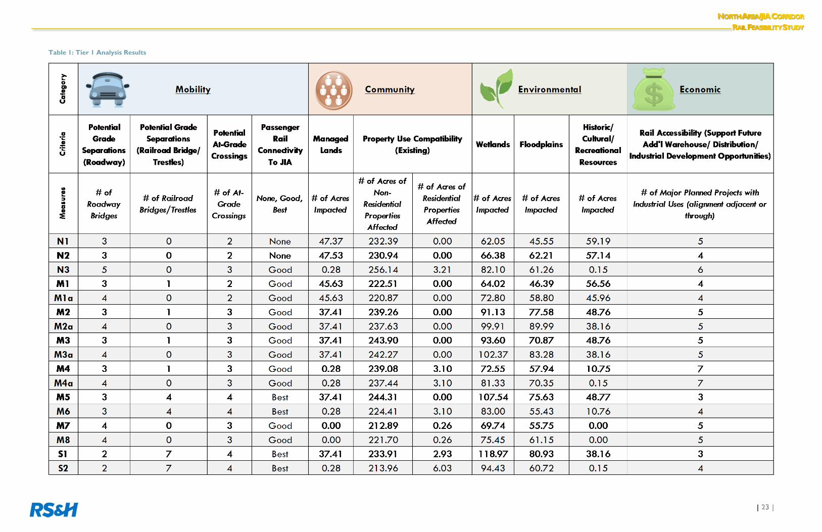
Table 1: Tier 1 Analysis Results


TIER 2 ANALYSIS RESULTS The Tier 2 Analysis was prepared for information only, with no prioritization of the remaining alignments. Based upon the need to do additional preliminary engineering and negotiations with affected landowners, it was determined that each of the remaining alignments would be advanced into a future Alternatives Analysis phase for final evaluation. Therefore, these are considered the “preferred” candidate alignments for that analysis. In addition, alignment M4 was removed as a candidate immediately following potential design conflicts with the I-95/Pecan Park interchange, which would most likely negatively impact the south interchange ramps, requiring costly reconstruction. Thus, the Tier 2 analysis was conducted on the remaining alignments: N3, M4a, M7, and M8 (each of these are shown individually as Maps 16-19 in Appendix D).
The Tier 2 evaluation criteria was designed to address in more detail some of the overall stakeholder concerns, and to a greater degree, the impacts of the potential alignments on adjacent properties and uses. Of particular concern was proximity to existing residential uses. Under Tier 1, the analysis was based solely on acreage impacts to those properties with a residentially-designated property use. In this scenario, the project team expanded the analysis to address the actual number of physical residences (whether occupied or not) that could be potentially affected by the remaining alignments within distances of 1/3, 2/3 and 1 mile. A series of detailed residential buffer maps (Maps 12-15) provided in Appendix D illustrates the existing number of residential structures within these distances in relation to the location of the remaining preferred alignments.
From an emergency response standpoint, the Tier 2 analysis carries over the number of at-grade separations from the Tier 1 Analysis to address the concerns of increased delays at potentially new signalized rail crossings. In this case, each of the alignments contains no more than three. The “Consistency with Plans” measure provides an additional qualitative policy focus, accounting for the
Figure 9: Tier 2 Remaining Preferred Alignments

extent to which the remaining, preferred alignments are generally supportive of the goals, objectives and policies of the Comprehensive Plan and other District and development plans and initiatives.
The Rail Accessibility criterion is also carried over from Tier 1, but in this case provides the actual number of impacted square feet versus the number of entitled projects as a whole. The wetland mitigation component provides the estimated number of credits (as measured in acres) likely required for appropriate compensation relative to the remaining alignments.
For the Tier 2 alignments, a range of 53 to 63 credits would be required. This number was determined using the Uniform Assessment Method (UMAM) without site inspection and only applies to permitted wetland mitigation banks which used UMAM as their assessment methodology to obtain a mitigation bank permit. Appendix E provides the cursory wetland assessment conducted for the Tier 2 alignments based on the National Wetland Inventory (NWI).
The results of the Tier 2 analysis are presented in Table 2 below:
Table 2: Tier 2 Analysis Results
The remaining, Tier 2 alignments (N3, M4a, M7 and M8) will be further evaluated through an Alternatives Analysis Planning Phase relative to existing conditions as well as additional engineering and cost considerations with the intent of identifying a single, preferred alignment within the North Area/JIA Corridor. This will allow the region to potentially evaluate this single option relative to the three other proposed corridors as originally proposed in the 2011 Future Rail Corridors study. It is anticipated that this next planning phase will be completed by the end of 2014. A continuation of the Working Group process is also contemplated for this next phase.
In the next phase of this effort, the project team and key agency stakeholders will work directly with property and landowners in the development of a new rail alignment.. Concurrently, more detailed engineering work will be necessary to accurately identify right of way needs, crossings and bridge/trestles, and the locations of sidings and turnouts.
It will be imperative for the community to have a set of well-defined options as a point of departure for potential implementation. The development of a new rail line for Northeast Florida will depend largely upon the necessary leadership, public funding and support, as well as the identification of private partners and investors, including most importantly, the rail carriers and operators as willing participants in this long-term infrastructure project.

This Page Intentionally Left Blank.
APPENDIX A—PLANS AND POLICY REVIEW
APPENDIX B—STAKEHOLDER NOTIFICATION LETTER

APPENDIX C—EVALUATION CRITERIA DESCRIPTIONS

APPENDIX D—MAPS

APPENDIX E—ESTIMATED WETLAND MITIGATION REQUIREMENTS

10748 Deerwood Park Blvd South Jacksonville, FL 32256 Phone: (904) 256-2500
www.rsandh.com