the power of geoint - esri · 2012-08-21 · esri homeland security conference, san diego, ca . 21...
TRANSCRIPT
Dennis Bowerman, National Geospatial-Intelligence Agency
The Power of GEOINT

ESRI Homeland Security Conference, San Diego, CA 21 July 2012
The Power of GEOINT Dennis Bowerman, NGA
Last updated: May 2012 Approved for Public Release – NGA Case #12-003

To provide timely, relevant, and accurate GEOINT in support of
national security. NGA is the lead federal agency responsible
for Geospatial Intelligence – or GEOINT Approved for Public Release – NGA Case #12-003
Warfighter Support
Homeland Security
Safety of Navigation
Strategic Intelligence
Humanitarian Support
Foundation Data
.
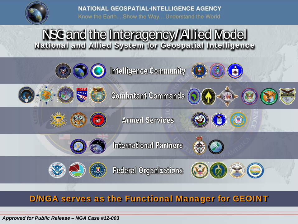
NSG and the Interagency/Allied Model National and Allied System for Geospatial Intelligence
D/NGA serves as the Functional Manager for GEOINT
Approved for Public Release – NGA Case #12-003

PUTTING the POWER of
Online, On-Demand Access
Approved for Public Release – NGA Case #12-003

Three – Tiered Service Model
Powerful Self-Service – Online
Proactive Assisted Service – Online and face-to-face
Responsive Full Service – Expert services that may
include embedded support
Approved for Public Release – NGA Case #12-003

8 Approved for Official Release – NGA Case 10-273 (updated)
Role in Readiness, Response & Recovery Operating Assumption
– Apply NGA’s GEOINT expertise -- critical for our traditional foreign intelligence mission-- to the Domestic Homeland mission & Disaster Support
Mission – To provide GEOINT needed to prepare for,
deter, prevent, and respond to terrorist threats and natural disasters
Key Business Areas – Disaster Readiness, Response, & Recovery – Support to Domestic Counterterrorism
Analysis & Ops. – Support to Foreign Counterintelligence
Analysis & Ops. – National Security Special Events (NSSE) – Special Security Events (SSE) – Domestic Geospatial Data Acquisition &
Integration

9
Homeland Security Infrastructure Program (HSIP) HSIP Gold 2012
• Compilation of 478 Vector layers comprised of Commercial, Federal and State level Acquisitions. • Delivers Common Operational Data to the GEOINT Analyst. • Total number of Users: 150.000 plus
• Acquire unclassified high-fidelity 1 meter elevation data over HSIP 133 major urban core areas of the U.S. – 5 year refresh schedule
LiDAR • Acquire unclassified high-resolution ortho-imagery (12 inch GSD or better) over HSIP 133 major urban areas of the U.S. – 2 to 4 year refresh schedule
Imagery
Approved for Official Release – NGA Case 11-366
Source: USGS
To aggressively capture, integrate and provide the Homeland Security, Homeland Defense and Emergency Preparedness, Response and Recovery community with common operational geospatially enabled data baseline - create a user defined operational picture to analyze threat, support critical infrastructure protection and expedite readiness, response and recovery in the event of a man-made or natural disaster.

Bottom Line – Up Front • IWG-Readiness, Response and Recovery is already Impacting Current Operations
10
Approved for Public Release – NGA Case 12-143
• “The work that your staff has already accomplished is totally changing and improving the tactical way we approach our work.” – Fred Endrikat, Chief, Urban Search and Rescue Branch, FEMA • “This is going to revolutionize what we do… We’ve never had this much information in the field.” – Rex Strickland III, Lieutenant, Fairfax County Fire & Rescue

GEOINT Product in Use
Haiti Earthquake Support Deepwater Horizon Support
Approved for Public Release – NGA Case 11-222
11

12
The Power of GEOINT
Approved for Public Release – NGA Case #12-003
Approved for Public Release – NGA Case #12-003