the potential use of drones in locust early warning and ... · pdf filelocust early warning...
TRANSCRIPT
Thepotentialuseofdronesinlocustearlywarningandpreventivecontrol
Conceptualprojectproposal
ExecutiveSummary
FoodandAgricultureOrganizationoftheUnitedNationsJune2016
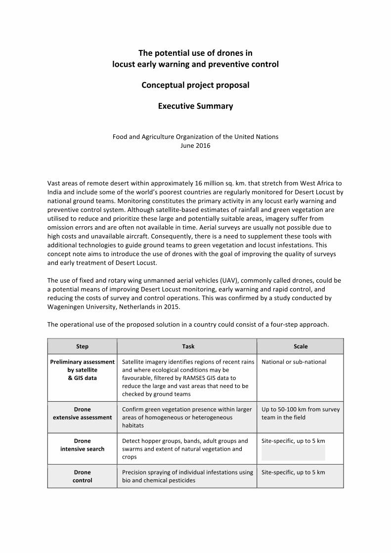
Vastareasofremotedesertwithinapproximately16millionsq.km.thatstretchfromWestAfricatoIndiaandincludesomeoftheworld’spoorestcountriesareregularlymonitoredforDesertLocustbynationalgroundteams.Monitoringconstitutestheprimaryactivityinanylocustearlywarningandpreventivecontrolsystem.Althoughsatellite-basedestimatesofrainfallandgreenvegetationareutilisedtoreduceandprioritizetheselargeandpotentiallysuitableareas,imagerysufferfromomissionerrorsandareoftennotavailableintime.Aerialsurveysareusuallynotpossibleduetohighcostsandunavailableaircraft.Consequently,thereisaneedtosupplementthesetoolswithadditionaltechnologiestoguidegroundteamstogreenvegetationandlocustinfestations.ThisconceptnoteaimstointroducetheuseofdroneswiththegoalofimprovingthequalityofsurveysandearlytreatmentofDesertLocust.Theuseoffixedandrotarywingunmannedaerialvehicles(UAV),commonlycalleddrones,couldbeapotentialmeansofimprovingDesertLocustmonitoring,earlywarningandrapidcontrol,andreducingthecostsofsurveyandcontroloperations.ThiswasconfirmedbyastudyconductedbyWageningenUniversity,Netherlandsin2015.Theoperationaluseoftheproposedsolutioninacountrycouldconsistofafour-stepapproach.
Step Task Scale
Preliminaryassessmentbysatellite&GISdata
Satelliteimageryidentifiesregionsofrecentrainsandwhereecologicalconditionsmaybefavourable,filteredbyRAMSESGISdatatoreducethelargeandvastareasthatneedtobecheckedbygroundteams
Nationalorsub-national
Droneextensiveassessment
Confirmgreenvegetationpresencewithinlargerareasofhomogeneousorheterogeneoushabitats
Upto50-100kmfromsurveyteaminthefield
Droneintensivesearch
Detecthoppergroups,bands,adultgroupsandswarmsandextentofnaturalvegetationandcrops
Site-specific,upto5km
Dronecontrol
Precisionsprayingofindividualinfestationsusingbioandchemicalpesticides
Site-specific,upto5km

Theproposedprojectaimstodevelopanewtooltoimprovelocustdetectionandcontrol.ThistoolwillbebasedondronetechnologyandwillhelptostrengthenthecurrentDesertLocustpreventivecontrolstrategy.Developmentwillfocusonprovidingacost-effectivesetofdrone-basedtoolstodetectpotentialbreedingareas,groupsoflocustsandprecisionspraying.Thisprojectisexpectedtobeimplementedinthreephaseswithinfouryears(2016-2019)andconsistofanumberofseparatecomponentstostreamlinedevelopmentandreducedelaysduetodependencies.
Description Available(USD)
External(USD)
Total(USD)
Phase1:Initialdevelopment(8/2016-7/2017) 168000 425000 593000
Activity1:Preliminaryfieldevaluation 25000 0 25000
Activity2:Prototypedesignanddevelopment 75000 425000 500000
Activity3:Prototypetestingandevaluation 68000 0 68000
Phase2:Finaldevelopment(8/2017-5/2018) 0 1925000 1925000
TotalResearch&Development 0 2350000 2518000
Phase3:Minimumdeploymentandtraining(6/2018-12/2019)(onedronesetineachfrontlinecountry) 0 2260000 2260000
Thetechnicalcomponentsoftheprojectwillbeaddressedinphases1and2.Component Developer(s) Phase1
(USD)Phase2(USD)
Drone HEMAV 85000 320000
Solarpower tbd 55000 215000
Sensor(s),datacollectionandon-boardprocessing tbd 85000 320000
GroundDataprocessingandeLocust3evolution HEMAV 95000 375000
Earthobservation FAO,ICTJA-CSIC 70000 265000
Controlandpesticideapplication UKInnovative 85000 320000
Theprimaryimpactsoftheprojectare:
• Teamscapableofcoveringlarge,insecureandinaccessibleareasinaneasierway• Earlierdetectionoflocustinfestations• Moreeffectiveandprecisecontroloperations• Safercontroloperationsformanandenvironment• Cost-effectivesolutionthatisaffordableandaccessibleforlocust-affectedcountries• Aneasytouseandeasytomaintainsolutionthatuseslocalmaterials

The potential use of drones in
locust early warning and preventive control
Conceptual project proposal
Commission for Controlling the Desert Locust in the Western Region (CLCPRO) and
Locusts and Transboundary Plant Pests and Diseases Group (AGPMM)
Food and Agriculture Organization of the United Nations
June 2016

1. Overview Vast areas of remote desert within approximately 16 million sq. km. that stretch from West Africa to India and include some of the world’s poorest countries are regularly monitored for Desert Locust by national ground teams. Similar activities are carried out in Caucasian and Central Asian countries as well as in Madagascar where it is difficult to survey in remote or inaccessible areas. Monitoring constitutes the primary activity in any locust early warning and preventive control system. Although satellitebased estimates of rainfall and green vegetation are utilised to reduce and prioritize these large and potentially suitable areas, imagery suffer from omission errors and are often not available in time. Aerial surveys are usually not possible due to high costs and unavailable aircraft. Consequently, there is a need to supplement these tools with additional technologies to guide ground teams to green vegetation and locust infestations. This concept note aims to introduce the use of drones with the goal of improving the quality of surveys and early treatment in the Western Region. 2. Introduction Desert Locust is considered as one of the most dangerous migratory pests in the world and can cause serious damage to agropastoral resources. It presents a threat to agriculture in a vast area of the world stretching from the Atlantic coast of West Africa through the Near East to the Indian subcontinent. Due to its migratory ability to traverse thousands of kilometres in a matter of weeks, Desert Locust is an international transboundary concern with major economic, social and environmental implications. The Desert Locust distribution area is divided into three regions: Western, Central and Eastern. The Western Region (WR) includes countries in West and Northwest Africa (Algeria, Burkina Faso, Libya, Mali, Mauritania, Morocco, Niger, Senegal, Chad and Tunisia). The 20032005 Desert Locust regional plague required control operations supported both by the countries concerned and the international community that treated nearly 13 million hectares. The cost of the regional plague was estimated at USD 570 million. Damage to agropastoral resources ranged from 30% to 100%, depending on type of crop. More than eight million people were directly affected by this crisis. The cost to bring the crisis to an end was equivalent to 170 years of preventive control in the region. This demonstrates the relevance and importance of the preventive control strategy and its effective implementation by the concerned countries and international partners in order to minimize costs as well as economic, social and environmental consequences. FAO has established three regional locust commissions for implementing the preventive control of Desert Locust: the Commission for Controlling the Desert Locust in the Western Region (CLCPRO), the Commission for Controlling the Desert Locust in the Central Region (CRC), and the Commission for Controlling the Desert Locust in SouthWest Asia. The three commissions
provide technical and financial support to implement a preventive control strategy that relies on strengthening national capacities in monitoring, control, training, planning and safety. Each commission works closely with its member countries and the FAO’s Desert Locust Information Service (DLIS), which monitors the global situation and provides early warning. In this way, countries have a greater ability to undertake a rapid and more effective control response. During the CLCPRO regional workshop on research held in November 2015, it was identified that drone technology has become sufficiently mature to be utilized in the fight against Desert Locust. Accordingly, the regional research plan (20162019) identified two activities related to drones:
1) implementation of the technology in pilot areas so as to learn and have first experiences; 2) development of dedicated technology aligned with the objectives of the project
presented in this document based on experiences and lessons learned from the first activity.
3. Project proposal 3.1 Background 3.1.1 Desert Locust preventive control The general purpose of preventive control is to reduce the risk and impact of Desert Locust invasions and thus contribute to the fight against hunger and poverty while safeguarding the environment. To achieve this goal, the preventive control strategy is based on three pillars:
∙ Early warning by improving monitoring and forecasting capacities that utilize the latest
technologies to delimit and prioritize survey areas, ensure reliable data collection and transmission in near real time, and provide timely and precise alerts;
∙ Rapid response implemented by a continuously welltrained, wellequipped and wellfinanced national locust control unit that utilizes contingency planning and standard methodologies for effective, timely and safe control operations;
∙ Operational research to address operational difficulties encountered by locust survey and control officers in the field and other challenges of implementing the preventive control strategy.
3.1.2 Challenges of Desert Locust preventive control The Desert Locust distribution area is vast, consisting of hundreds of thousands of km² of desert that is often remote, difficult to access and, more recently becoming increasingly unsafe. These factors have a significant impact on the ability to adequately detect and monitor all potential Desert Locust breeding areas. The necessary logistics are difficult to put into place and requires the mobilization of considerable financial resources in order to deploy survey teams on regular basis in the field and ensure a better coverage of high risk areas. The use of satellite imagery

helps to identify, delimit and prioritize areas that may contain locusts, but resolution may be insufficient to detect the thin annual grasses that locusts prefer, and imagery may arrive too late to be of use to national locust control units and survey teams. Even in the best case scenario, identified areas to be checked on the ground by survey teams can remain vast and difficult. Therefore, it is important to harness new technologies and develop complementary tools to further streamline Desert Locust monitoring and control operations. 3.1.3 UAVs The use of fixed and rotary wing unmanned aerial vehicles (UAV), commonly called drones, could be a potential means of improving Desert Locust monitoring, early warning and rapid control, and reducing the costs of survey and control operations. This was confirmed by a study conducted by Wageningen University, Netherlands in 2015. There are several potential scenarios for using drones at different spatial resolutions as indicated in the following matrix.
Areawide (up to 50100 km)
Sitespecific (up to 5 km)
Green vegetation Confirm green vegetation presence within larger areas of homogeneous or heterogeneous habitats
Confirm the extent of locaizedl areas of green vegetation in wadis, interdunes and plains
Breeding suitability Confirm larger areas that are favourable for breeding (moist sandy soil with green vegetation)
Confirm local areas that are favourable for breeding (moist sandy soil with green vegetation)
Locust detection Detect concentrated hopper and adult populations within larger areas
Detect hopper groups, bands, adult groups and swarms in natural vegetation and crops
Control operations Not applicable Precision spraying of individual infestations using bio and chemical pesticides

3.2 Project scope 3.2.1 Objective The proposed project aims to develop a new tool to improve locust detection and control. This tool will be based on drone technology and will help to strengthen the current Desert Locust preventive control strategy. Development will focus on providing a costeffective set of dronebased tools to detect potential breeding areas, groups of locusts and precision spraying. The project will address a number of issues as identified by the Wageningen study referred in the previous section that require additional investigation in order for drones to become operationally integrated into national Desert Locust monitoring and control programmes. FAO, specifically DLIS, CLCPRO and the other two regional locust commissions, will collaborate within a consortium of external partners such as HEMAV, ICTJACSIC and other potential European institutes in Netherlands, France and UK that can provide the required technical expertise. The main advantages of using drones are:
(1) Identify potential areas of locust development including insecure and inaccessible areas (2) Treat locust infestations in their early stages
3.2.2 Time frame This project is expected to be implemented within four years (20162019). This document presents the whole vision and focus on the first steps to be carried out in 20162017. 3.2.3 Expected outputs A solution will be developed that can be operated by field officers in locustaffected countries in their daybyday survey and control operations as part of early warning and preventive control. 3.2.4 Expected Impacts The primary impacts of the project are:
Teams capable of covering large, insecure and inaccessible areas in a easier way Earlier detection of locust infestations More effective and precise control operations Safer control operations for man and environment Costeffective solution that is affordable and accessible for locustaffected countries An easy to use and easy to maintain solution that uses local materials
3.2.5 Using UAVs in Desert Locust preventive control

The operational use of the proposed solution in a country could consist of a fourstep approach.
(1) Satellite remote sensing and RAMSES data. The latest satellite imagery would be analysed to identify regions or areas within a country where ecological conditions may be favourable for locusts, specifically, where recent rains have occurred and where green vegetation may be present. This initial filtering combined with data from the RAMSES GIS will help to reduce the large and vast areas that need to be checked by ground teams. A team equipped with drone(s) will then be deployed to this area to undertake surveys.
(2) Drone extensive (assessment) survey. A ground team will carry a small, portable longrange fixedwing drone with them during the survey. This drone should cover a transect of about 50100 km. The team will programme the route itinerary of the drone and launch it. The drone will capture and process information along the route using optical, multi/hyperspectral, thermal and/or other sensors to detect areas of green vegetation and moist soil as well as the presence of any sizeable hopper or adult concentrations (groups, bands, and swarms). Once the drone returns to the survey team, data will be transferred to eLocust3 (a tablet currently used for data acquisition by the teams and transmission by satellite ) and the team will either process it or use the 1
results to go directly to the areas of interest or change direction if the results of the flight do not indicate the presence of favorable conditions or Desert Locust.
(3) Drone intensive (search) survey. A ground team could also carry a small portable rotary drone with them during surveys to a specific location identified above or an area that may contain vegetation or locusts. The drone would help the team get a better idea of the ecological conditions and the locust situation by taking lowlevel images of the area to identify the presence of green vegetation and locusts. If the team stops in an infested area with green vegetation or crops, the drone could look in situ for locusts and also determine the size of the potentially infested area. If the location is less precise, then the team could launch the rotary drone to look for any signs of green vegetation or favourable breeding areas in a minimum of 5 km radius. The drone could also be used to collect information from areas that are not accessible to the ground team due to topography or insecurity.
(4) Drone control. A rotary drone could be used to undertake targeted control treatments of small infested areas (with conventional pesticides or biological techniques) and in areas that are difficult to access by ground teams.
1 http://www.fao.org/ag/locusts/en/activ/DLIS/eL3/index.html

3.2.6 Integration of drones with existing and new technologies It is expected that the use of drones will be integrated with existing tools as well as new technologies that are under development. The existing eLocust3 platform, should be used for
communicating with the drone, specifically for guiding it automatically rather than manually whenever possible,
automatic processing and manual viewing photos or videos of green vegetation and locusts, and
receiving related data (geolocation, vegetation and locust characteristics). A custom app should be developed to (a) reformat the survey results of the drone flights into easily understandable information that shows the location of green vegetation and locust infestations, (b) manage drone itineraries and navigation, and (c) undertake control operations. Additional devices can be necessary to be included in the operation such as antennas for longrange comms or battery chargers. Within the framework of a collaborative agreement between FAO and Google, several new tools are available to locustaffected countries that can assist in using remote sensing imagery to identify and prioritize potential areas of green vegetation and locusts much sooner than existing methods. Google’s Project Loon that hopes to provide Internet connectivity via balloons could potentially overcome some of the challenges of in situ data processing, depending on geographic coverage and bandwidth. If so, then collaborative efforts would be required to develop cloud processing of the data collected during drone surveys. 3.2.7 Project challenges Although this technology has been proven to be useful in different sectors and industries, some of them are technical, but there are other transversal challenges that shall be taken into account. Transversal challenges Legislation and use of drones in recipient countries The countries hosting Desert Locust gregarious areas do not have specific legislation concerning drones so far. The approach to be adopted by CLCPRO/FAO for the integration of drones will be based on a definition and explanation of the concept through meetings with the competent authorities and obtaining provisional authorization to test and conduct training sessions in order to operationalize this tool in locust control. This will also include issues related to customs and the importing of drones into locustaffected countries.

It is foreseen that after the first field tests and longterm implementation in certain areas, the potential of the solution and the pragmatism of the results obtained in countries such as Mauritania will ease the way to other more reticent countries. Security issues Different issues related with security have been identified such as the possibility of sabotage or interception. Security measures will be implemented when using drones. For this purpose, and in addition to the technologies that may apply, all the tests will be carried out avoiding conflict areas and in close collaboration with the national relevant authorities. For the first tests, arrangements will be made by CLCPRO secretariat in conjunction with Mauritania's national authority which has already expressed interest to evaluate this tool and to create the conditions for successful testing. Meteorological and Environmental Conditions Drones will be used under severe sand and temperature conditions. Although different laboratory tests will be carried out, it has been identified as a must to have a first set of onthefield experiences in real conditions. Training sessions Once the test phase is conclusive, training sessions on the use of drones will be conducted for master trainers and senior survey officers to familiarize them with drone use, maintenance in the field and data exploitation. Technical challenges In a first approach, the project will have at least six components: dronerelated developments (type and design), power supply (e.g. solar power), sensor with preprocessing hardware capabilities, data processing, Earth observation (satellite data and drone sensor definition), and control (sprayer, payload, operation). A multinational consortium overseen by FAO and funded by different donors is proposed to tackle all these issues in a coordinated way. Dronerelated developments As has been exposed along the document, the operational scenario will be a harsh environment: sand, extreme temperatures, and difficult access to spare parts or materials are challenges that shall be taken into account. In addition, the drone as a key element in this solution must integrate in a proper way the rest of the elements developed: sensors, pesticide applicators, etc.. The stakeholder proposed for this part is HEMAV.

Power supply There are two main challenges in the power supply area: i) increase in the flight endurance for example including solar power, and ii) have battery recharge system adapted to the missions in the desert. The stakeholders for this part are yet to be identified. Sensor The primary requirements in the sensor area is to determine the most appropriate and suitable sensors to detect (a) green vegetation presence within larger areas of homogeneous or heterogeneous habitats and larger areas that are favourable for breeding (moist sandy soil with green vegetation) as well as concentrated hopper and adult populations within these areas during the areawide fixed wing survey, and (b) the extent of localized areas of green vegetation in wadis, interdunes and plains and to confirm local areas that are favourable for breeding (moist sandy soil with green vegetation) as well as the presence of hopper groups, bands, adult groups and swarms in natural vegetation and crops during sitespecific surveys. The stakeholders for this part are yet to be identified although initial work has been undertaken by Wageningen University (Netherlands). Data processing This is without doubt the major technical challenge of the project. A combination of highefficient and light cognitive data processing can be implemented in the eLocust3 devices, but this will also include participation by the survey team, which will require appropriate training. At least during the first stages of the operational use of this technology the use of internet connection is not foreseen. The potential of the cloudcomputing for almostrealtime processing of large amounts of data should be considered at a later point. Other strategies shall be applied such as onboard data processing or reduced reliance on computerbased data processing and increased consideration of humanbased data processing (e.g. via the development of a new app for the tablet to help the team in this data processing). These solutions will be implemented in the short term as other technologies and initiatives such as satellite communications (SATCOM) and Google Loon Project evolve further. The stakeholder proposed for this part is HEMAV in collaboration with other potential stakeholders.
Earth observation coordination A comprehensive coordination is needed to optimize the logistics of the teams once the solution is implemented, propose data acquisition (i.e. sensor type selection) strategies and data processing. The stakeholders proposed for this part are FAO and ICTJACSIC. Control Precision spraying of locust infestations with drones will require a new strategy and methodology that incorporates appropriate spraying equipment and pesticide formulation. There are two primary challenges concerning this area: the payload that can be managed by the control drone and operation of the drone during control operations. Due to potential payload limitations, it is likely that drones will be implemented for spot treatment of individual infestations that could replace or supplement control operations currently carried out by handheld sprayers rather than largerscale operations carried out by vehicles and piloted aircraft. Various options for operating the drone during control operations ranging from manual to fully automated will need to be explored and tested. The potential stakeholder proposed for this part is UK Innovate. 3.3 Project activities In order to address the numerous challenges and issues of integrating drones into national locust programmes for survey and control, the project will consist of a number of separate components to streamline development and reduce delays due to dependencies. In this line, the planning will consist in three differentiated phases. 3.3.1 Phase 1: Initial development (1/8/2016 1/7/2017) Phase 1 will be devoted to verify the applicability of current technologies for the potential use of drones in survey and control operations. An initial field evaluation will be undertaken in Mauritania to identify the various issues and components that require further addressing in the remainder of the project in order to develop a prototype for eventual testing in the field. Activity 1: Preliminary field evaluation (1/8/2016 1/12/2016) Preparation of the field evaluation with different lab tests in sand and thermal conditions will be carried out to ensure that the drones are suitable for use in desert conditions. A oneweek field evaluation of the long range, short range and pesticide application components will be carried out in selected areas in Mauritania in early November 2016. The results be reviewed at a meeting at FAO/CLCPRO in Algiers on 1 December 2016 in order to determine the next steps for the further development of the various technical elements and components.

Deliverables:
Report of the field evaluation with technical and operational conclusions from the drone and national team perspectives;
Refined work plan to address the outstanding technical components that require further development;
Upgrade of the Drone for Desert Locust video with real field images. Responsible: HEMAV Estimated cost: USD 30 000 Estimated funding:
CLCPRO: Field evaluation USD 25 000
HEMAV 2
Field evaluation USD 5 000 Activity 2: Prototype design and development (1/1/2017 31/3/2017) Based on the first field evaluation, a prototype will be developed, including as many of the necessary components and elements as possible (solar power, sensors, data collection and processing, etc.). From this, a clearer idea should be obtained to identify technical areas where further development is required. At the end of this activity, a meeting will be held to review achievements and determine the next steps. Deliverables:
Preliminary studies in the different areas of development identified; Project plan prepared by the whole consortium; Prototype drone with first developments included.
Responsible: HEMAV Estimated cost: USD 500 000 Estimated funding:
CLCPRO USD 75 000 External (to be identified) USD 425 000
Activity 3: Prototype testing and evaluation (1/4/2017 30/6/2017) The prototype including as many components as possible will be evaluated under field conditions in Mauritania to validate operationality of the drone, flying parameters, power, sensors, data collection and processing. The details and timeframe of this activity will depend on the outcome of Activities 1 and 2. During this activity, one field team will be trained and
2 HEMAV has taken the commitment to find the required funding for this part of the activity

equipped with a prototype so that they can acquire hours of field work and identify maintenance and other special requirements in order to provide feedback to the developers. Deliverables:
Validation of the drone prototype Recommendations for the following development steps Training to the team(s) involved 3
Responsible: CLCPRO Estimated cost: USD 68 000 The total estimated cost of Phase 1 is USD 593 000. 3.3.2 Phase 2: Final development (1/7/2017 31/5/2018) This phase will focus on finalizing the prototype, including further testing and reiteration of the drone and the components. At the end of this phase, longrange, shortrange and control application drones will have been developed and ready for operational use in locustaffected countries. The estimated cost of this phase is USD 1.92 million, which will need to be sought from external sources. 3.3.3 Phase 3: Broad deployment and training (1/6/2018 31/12/2019) This phase would deploy at least one set of drones to each frontline country, starting first with 4
the Western Region. It includes field demonstrations to show countries the potential benefits of using drones for early warning and preventive control and training on the use and maintenance of the drones. The total number of drones that could be potentially deployed will depend on country interest, economic capacity to procure drones and security conditions in the country. But at the minimum, at least one set of drones will be deployed to each of the 17 frontline countries. The estimated cost of this phase is USD 2.26 million, which will need to be sought from external sources. 3.4 Project equipment All the equipment associated with the project will be owned and operated by the national authorities in the locustaffected countries. This equipment may consist on:
Per team One longrange early detection drone One shortrange early detection drone One precision pesticide applicator drone
3 Simulator and test drone shall be sent some weeks before the real training. 4 Longrange fixedwing, portable rotary drone and rotary drone for control treatments.

Software update for the eLocust3 Additional equipment (as necessary)
At national/FAO level Google technologybased screen to follow team actuations in real time
3.5 Project budget estimate An estimated budget of USD 2.5 million is proposed for the research and development of drones for Desert Locust early warning and preventive control.
Description Available
(USD) External (USD)
Total (USD)
Phase 1: Initial development 168 000 425 000 593 000
Activity 1: Preliminary field evaluation 25 000 0 25 000
Activity 2: Prototype design and development 75 000 425 000 500 000
Activity 3: Prototype testing and evaluation 68 000 0 68 000
Phase 2: Final development 0 1 925 000 1 925 000
Total Research & Development 0 2 350 000 2 518 000
Phase 3: Minimum deployment and training (one drone set in each frontline country ) 5 0 2 260 000 2 260 000
5 Deployment to 17 frontline countries: Algeria, Chad, Egypt, Eritrea, Ethiopia, India, Iran, Libya, Mali, Mauritania, Niger, Oman, Pakistan, Saudi Arabia, Somalia, Sudan, Yemen

Annex 1. Project components
Component Developer(s) Cost est. Phase 1 Activity 2 (USD)
Cost est. Phase 2 (USD)
Drone * HEMAV 85 000 320 000
Solar power tbd 55 000 215 000
Sensor(s), data collection and onboard processing
tbd 85 000 320 000
Ground Data processing and eLocust3 evolution
HEMAV 95 000 375 000
Earth observation FAO, ICTJACSIC 70 000 265 000
Control and pesticide application UK Innovative 85 000 320 000 * the drone component includes navigation, security, safety and logistic issues tbd = to be determined