the potential of laharic flows disaster along...
TRANSCRIPT

THE POTENTIAL OF LAHARIC FLOWS DISASTER
ALONG GENDOL AND OPAK RIVERS,
YOGYAKARTA, INDONESIA
Sugeng S Surjono1, Erlangga Wijaya
2, Andreas Yufianto
2, Arfian Firmansyah
2
1,2Department of Geological Engineering, Faculty of Engineering, Universitas Gadjah Mada,
Jalan Grafika, No. 2, Yogyakarta, 55281, Indonesia 1Email: [email protected]; [email protected]
Received: 29 November 2012
Abstract
Gendol River flows from the south slope of Merapi Volcano meets Opak River to form a wider
river, namely Opak River. In the upper stream of Opak and Gendol Rivers area, volcanic material
accumulated from the 2010 Merapi Volcano eruption that ready to flow downstream through both
rivers. The total amount of volcanic material in the Merapi’s peak area is predicted as much as 140
million cubic meters, part of it is distributed in the upper stream of both rivers. In the downstream
area, the Opak River flows nearby the great Prambanan Temple and across the main road of
Yogyakarta-Surakarta capital cities.
To know the laharic flow disaster potential of both rivers, collecting of primary data along the
river flows is needed in order to understand the characteristic and mechanism of laharic flows.
DEM analysis combined with ArcGIS 9.3 tools are applied to know the additional volume of
volcanic material after 2010 Merapi Volcano eruption. The triggering factor of laharic flows in the
study area including the runoff, soil water saturation rate, rainfall and soil water saturation time are
mathematically calculated based on data analysis on soil mechanics.
Based on the calculation of thickness and distribution in the Merapi Peak area, the mass
volcanic material that is ready to be transported as the laharic flows through Gendol and Opak
Rivers is around 14,745,496 m3. The volcanic material can transform into laharic flows by initial
runoff if the soil water saturation column reach at least 5.96 m. With the rainfall average in the
southern part of Merapi Volcano is 17.32 mm/day, that saturation value can be reached by 21.8
hours in the upper stream area and 17.67 hours in the lower part area. If the laharic flows occurred,
the damage would happen in villages along the rivers, Prambanan Temple, and Opak River’s
Bridge connecting Yogyakarta-Surakarta main road.
Keywords: Gendol-Opak Rivers, Laharic Flows, Water Saturation Column, Rainfall
Introduction
Gendol and Opak Rivers flow on the southern flank, with upper reaches on the peak of
Merapi Volcano. Both rivers flow southward and meet at the Ringinsari Village, become a
bigger stream known as the Opak River, flows and passes the Prambanan Temple Area and
the main road connecting Yogyakarta-Surakarta (Figure 1, insert Figure). The Merapi
Volcano (2,965 m) is well known as one of the most active volcano in the world, situated
at the border line between Central Java and Yogyakarta Special Provinces, Indonesia, with
a bell shape topography and the volcano’s peak coordinate of 7.542°S / 110.442°E [1].
Yogyakarta, the capital city of Yogyakarta Special Region, is located 30 km to the south of
Merapi Volcano, with dense population and settlements spread up to the Merapi slope at
the elevation of around 1,700 m high and just about 4 km to the mountain peak.
ASEAN Engineering Journal Part C, Vol 4 No 3, ISSN 2286-8150 p.16
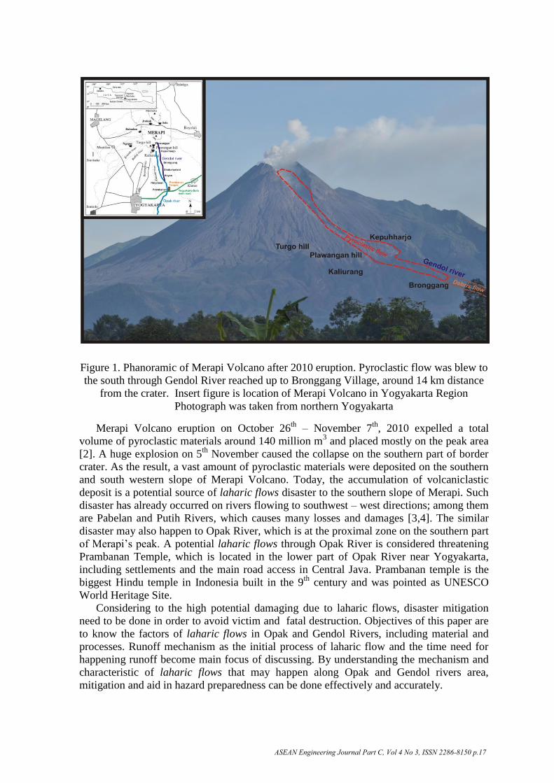
Figure 1. Phanoramic of Merapi Volcano after 2010 eruption. Pyroclastic flow was blew to
the south through Gendol River reached up to Bronggang Village, around 14 km distance
from the crater. Insert figure is location of Merapi Volcano in Yogyakarta Region
Photograph was taken from northern Yogyakarta
Merapi Volcano eruption on October 26th
– November 7th
, 2010 expelled a total
volume of pyroclastic materials around 140 million m3 and placed mostly on the peak area
[2]. A huge explosion on 5th
November caused the collapse on the southern part of border
crater. As the result, a vast amount of pyroclastic materials were deposited on the southern
and south western slope of Merapi Volcano. Today, the accumulation of volcaniclastic
deposit is a potential source of laharic flows disaster to the southern slope of Merapi. Such
disaster has already occurred on rivers flowing to southwest – west directions; among them
are Pabelan and Putih Rivers, which causes many losses and damages [3,4]. The similar
disaster may also happen to Opak River, which is at the proximal zone on the southern part
of Merapi’s peak. A potential laharic flows through Opak River is considered threatening
Prambanan Temple, which is located in the lower part of Opak River near Yogyakarta,
including settlements and the main road access in Central Java. Prambanan temple is the
biggest Hindu temple in Indonesia built in the 9th
century and was pointed as UNESCO
World Heritage Site.
Considering to the high potential damaging due to laharic flows, disaster mitigation
need to be done in order to avoid victim and fatal destruction. Objectives of this paper are
to know the factors of laharic flows in Opak and Gendol Rivers, including material and
processes. Runoff mechanism as the initial process of laharic flow and the time need for
happening runoff become main focus of discussing. By understanding the mechanism and
characteristic of laharic flows that may happen along Opak and Gendol rivers area,
mitigation and aid in hazard preparedness can be done effectively and accurately.
ASEAN Engineering Journal Part C, Vol 4 No 3, ISSN 2286-8150 p.17

Methods and Data
Focusing on the stream of Gendol and Opak Rivers, this research took place from the
upper stream to lower part, in Prambanan Temple area, near Yogyakarta-Surakarta main
road. This research initiated by collecting secondary data and theory on characteristics of
Merapi deposit, mechanism of laharic flows, and factors controlling the laharic flows
disaster on the Merapi’s flanks. Remote sensing interpretation was done utilizing satellite
image, DEM, and topographic map scale 1:10,000. DEM image analysis is used to know
the elevation changing in the research surrounding area. It was obtained from the previous
research conducted in proximal area of Merapi Volcano [5,6]. Data on rainfall and hazard
zone map of Merapi Volcano was obtained from BPPTK (Volcanological Technology
Research and Development Agency) Yogyakarta [2].
Primary field data was collected along Opak dan Gendol Streams, started from
Prambanan area (distal zone) up to Kepuhharjo Village (proximal zone). Data analysis was
performed both qualitatively and quantitatively. Result of those two analyses were
combined with secondary data in order to synthesize conclusion which is then used as a
basis of mitigation of laharic flows disaster. During data retrieval, checking of engineering
construction along the stream, such as sabo dam, artificial bank, bridges, and disaster area
were also carried out. Interview with local peoples around the streams was also conducted.
Laboratory analysis was conducted to obtain physical properties of volcaniclastic sediment
deposited by laharic flows. Samples were then grouped based on sampling locations.
Qualitative analysis was carried out by predicting laharic flows mechanism based on
sediment characteristic, river morphology, slope, and laharic deposit succession.
Quantitative analysis was performed by calculating volume of volcanic material which is
possibly become laharic source. Deposit thickness is known by comparing DEM before
and after the 2010 eruption, while coverage area of deposit is obtained from ArcGIS 9.3
calculation on upstream of Gendol River. Number of run-off needed to generate movement
volcanic material (Ro), saturation rate (V), total rainfall rate (T), Rainfall intensity (R,I)
and time required by deposit to saturated (t), were calculated based on soil mechanics data
of Merapi deposit in the proximal area. Those numbers can be formulated as follow:
R =
; R = I ; V = 90% x K x I ; t =
with: Ro = runoff ; R, I = rain intensity minimum ; T = total rainfall rate ; V= saturation rate ; D =
elevation difference ; K = infiltration coefficient ; A = laharic spread area ; t = time required
deposit to be saturated
Process and Product of Merapi Volcaniclastic Deposits
In 2010, Merapi Volcano has a great series of eruption, starting on October 26th
, followed
by several eruptions that gradually decrease in intensity and totally stop on December 3rd
.
The biggest eruption happened on November 5th
, which generated column eruption type.
Center of Volcanology and Geological Hazard Mitigation (PVMBG) estimates that the
material removed from the Merapi 2010 eruption is approximately 140 million m3
accumulated at the top and mostly distributed to the south and west of Merapi’s peak.
The characteristic of Merapi eruption is explosive, producing pyroclastic deposits at the
peak following with generating dome on top, flank collapse, and sometimes generates
pyroclastic flow and hot avalanche (nuee ardente). Huge eruption occurred at least once in
every 1000 years. The last major eruption before 2010 occurred in 1872 which was the
Vulcanian-subplinian eruptions type with VEI: 4 [7]. The authors referred the terminology
ASEAN Engineering Journal Part C, Vol 4 No 3, ISSN 2286-8150 p.18
of volcaniclastic deposit to all volcaniclastic products, formed during and after the volcanic
activity, which are: pyroclastic, resedimented volcaniclastic deposit (syn-eruptive product),
and volcanogenic sedimentary deposit (post eruptive product after weathering, erosion,
reworking and re-sedimentation) [8]
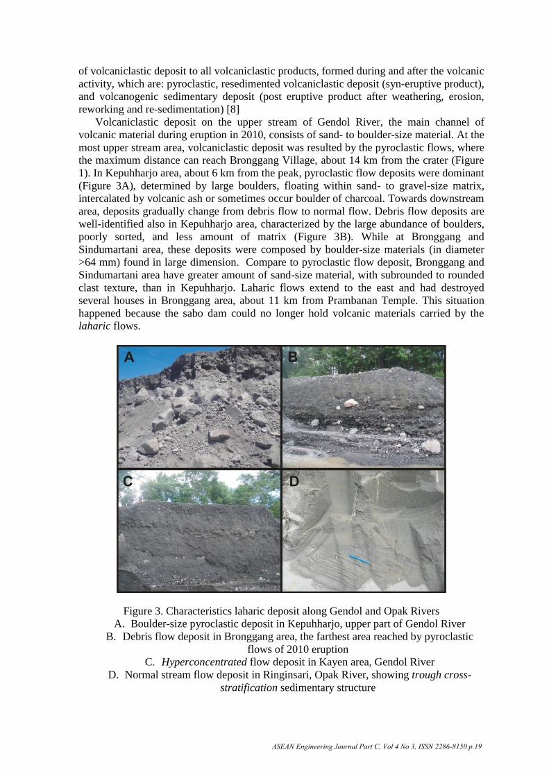
Volcaniclastic deposit on the upper stream of Gendol River, the main channel of
volcanic material during eruption in 2010, consists of sand- to boulder-size material. At the
most upper stream area, volcaniclastic deposit was resulted by the pyroclastic flows, where
the maximum distance can reach Bronggang Village, about 14 km from the crater (Figure
1). In Kepuhharjo area, about 6 km from the peak, pyroclastic flow deposits were dominant
(Figure 3A), determined by large boulders, floating within sand- to gravel-size matrix,
intercalated by volcanic ash or sometimes occur boulder of charcoal. Towards downstream
area, deposits gradually change from debris flow to normal flow. Debris flow deposits are
well-identified also in Kepuhharjo area, characterized by the large abundance of boulders,
poorly sorted, and less amount of matrix (Figure 3B). While at Bronggang and
Sindumartani area, these deposits were composed by boulder-size materials (in diameter
>64 mm) found in large dimension. Compare to pyroclastic flow deposit, Bronggang and
Sindumartani area have greater amount of sand-size material, with subrounded to rounded
clast texture, than in Kepuhharjo. Laharic flows extend to the east and had destroyed
several houses in Bronggang area, about 11 km from Prambanan Temple. This situation
happened because the sabo dam could no longer hold volcanic materials carried by the
laharic flows.
Figure 3. Characteristics laharic deposit along Gendol and Opak Rivers
A. Boulder-size pyroclastic deposit in Kepuhharjo, upper part of Gendol River
B. Debris flow deposit in Bronggang area, the farthest area reached by pyroclastic
flows of 2010 eruption
C. Hyperconcentrated flow deposit in Kayen area, Gendol River
D. Normal stream flow deposit in Ringinsari, Opak River, showing trough cross-
stratification sedimentary structure
ASEAN Engineering Journal Part C, Vol 4 No 3, ISSN 2286-8150 p.19

Further to the south, the laharic flow was dominated by hyperconcentrated flow,
indicated by floating boulder within fine-size matrix (Figure 3C). The granulometry
analysis for this samples mentioned that the grain size distribution is ranging from fine
grains (clay to coarse sand: 50%) to very coarse grain (granule to pebble: 50%), mixed
together and has very poorly sorted texture (Figure 2). Dilution process has higher
mobility to transport sediment resulting hyperconcentrated flow deposit further to distal
area [9]. Towards downstream area, the angle of slope is lower and river valley become
wider.
Figure 2. Grain-size distribution of Merapi deposit in the upper part of Gendol River,
indicate mixture of clay to gravel-size sediments
Gendol River flows to south direction and merged with Opak River in Ringinsari area,
5 km north of Prambanan Temple. Opak River is a typical parenial river with upper stream
at Krajan, Cangkringan, which is the proximal zone of Merapi. Characteristic of deposit in
the lower stream shows less laharic flows deposit, generally finer grain size, even at the
spill out flood area. In some higher elevation on the river bank, fluvial deposits indicated
normal flow with typical of trough cross-stratification (Figure 3D).
Terminology of lahar originally comes from Javanese language that was introduced
into scientific term by van Bemmelen in 1949 [10], referring to debris flow sedimentation
mechanism composed of volcanic material as well as deposits from that kind of flows. The
laharic flows is destructive if the flow contains huge volume of volcanic material. Along
the volcanic slope is where most intensive erosion and anything that blocks the flow will
be easily broke down [9]. In the case of laharic flows along rivers on the slopes of Merapi,
the vertical erosion rate can reach over 10 meters [4]. For the Merapi Volcano case, laharic flows are derived from different flank of
volcanoes, usually caused by long term heavy rainfall, mainly as pyroclastic deposits [9].
Three main factors that trigger laharic flow at Merapi are 1. millions cubic of pyroclastic
deposits resulted during 2-4 years interval, 2. high intensity of rainfall (average rate 40 mm
during 2 hours) during the rainy season from November to April, and 3. very dense
drainage pattern [9]. Empirical events of laharic flows generally occur a few minutes after
heavy rainfall.
The critical time of laharic flow initiation is when the runoff begins, in other word,
when the soil is water saturated and rain can no longer infiltrate into the soil. Toth [11]
mentioned that when rainfall (P) reach lithosphere, it will be transformed into
ASEAN Engineering Journal Part C, Vol 4 No 3, ISSN 2286-8150 p.20

evapotranspiration (ET), runoff (R) and infiltration (I), which is formulated into
P = ET + R + I. This empirical formula also proved that runoff may occur if there is no
infiltration (I=0) due to water saturated soil. Based on the laboratory soil mechanical
analysis for Merapi volcaniclastic deposit in study area, the runoff will happen if saturated
water zone thickness of deposit reach around 234.65 inch (5.96 m).
Time required for deposit to be saturated, both in upper stream and lower part, is
obtained by applying the equation mentioned in Methods and Data. Parameters of this
equation are: slope, rainfall rate, and area coverage. Slope itself is D/√A, where D is
elevation difference and A represents area. In this study, the slope is calculated from
topographic map of study area, with average value 38.75% on the upper stream and 19.9%
on the lower part. Infiltration Coefficient (K) equals 1 – C, where C represents runoff
coefficient, which is the sum of coefficient of several surface conditions C = Ct+Cs+Cv
[12]. Each several surface condition has its own value referring to the assessment in Table
1. The upper stream has empiric slope >20% categorized as mountainous and Ct = 0.26,
while slope on the lower part is <20% categorized as hilly and Ct = 0.16. As for soil
consists of sand and gravel with no vegetation covering on both area, value of Cs and Cv
are also same, 0.04 and 0.28, respectively. By substituting those numbers into the equation,
the value of K on the upper stream is 0.42 [1-(0.26+0.04+0.28) = 1 - 0.58] and 0.52 on the
lower part. Saturation rate (V) is formulated as V = 90% x K x I, where I is rain intensity
minimum. Based on the rainfall data in the Merapi area and surroundings [2], it is known
that average rainfall rate in the rainy season (October – April) is 17.32 mm/day, with
maximum rainfall can reach around 160 mm/day (Figure 4), therefor saturation rate on the
upper part is 6.55 (V = 90% x 0.42 x 17.32) and 8.10 on lower part.
Time required for deposit to be saturated (t) is water saturated soil (5,96 mm) divided
by its saturation rate (V). On the upper stream, (t) is reached in 0.91 day or 21.8 hours and
on the lower part needs only 0.73 day or 17.65 hours. A shorter to reach the time required
for deposit or soil to be saturated on the lower area is due to higher percentage of water
that infiltrates than run off.
Figure 4. Rainfall in several places flank of Merapi Volcano [2]
Laharic flows is the movement of mixtured rainfall and volcanic material which cause
erosion along the river. In this case, the erosion produces small channels that laharic flows
are accumulated into the Gendol River. Proximal area with steeper slope is relatively less
ASEAN Engineering Journal Part C, Vol 4 No 3, ISSN 2286-8150 p.21
stable and susceptible to landslides that could increase the amount of volcanic material into
the laharic flows. Lahar that initially was derived by the debris avalanche can be
undergone dilution by rain water, transformed into debris flow or hyperconcentrated flow
that has a higher level of mobilization, and therefore can be transported to further distance
[13]. The typical deep valley of Gendol River cause laharic flows become confined and
have further extension.
Table 1. Runoff Coefficient in Several Surface Conditions (Hassing, 1995 with
Modification)
Runoff coefficient C = Ct+Cs+Cv
Topography (Ct) Soil (Cs) Land cover (Cv)
Flat (1%) 0.03 Sand & gravel 0.04 Forest 0.04
Undulating (1-10%) 0.08 Sandy clays 0.08 Farmland 0.11
Hilly (10-20%) 0.16 Clay and Loam 0.16 Grassland 0.21
Mountainous
(>20%) 0.26 Stratified rocks 0.26 No Vegetation 0.28
In the valley, dilution is happened due to addition of water, resulting dilute streamflow
[14]. This dilution is reducing the ability of laharic flows to transport volcanic materials
and caused boulder-size material no longer can be transported [15]. Based on information
from local residents, the laharic flows in Ringinsari area could spill over into residential
areas because of its proximity (about 20 m) and the low elevation difference (about 1.5 m
above the river). Towards south, flows of mixture material were dominated by normal
streamflow, moving along Opak River through the Prambanan Temple. In general, fine-
size sediments transported by floating or suspension mechanism, while the coarse-size
material moves at the bottom of the river in traction, rolling and saltation mechanism [16].
This typical stream flow is less erosive, therefore the impact to Prambanan area is minor.
However, theoretically for the density flow, where it is possible to happen along Opak
River up to Prambanan area, sometimes large clast can also be transported floating within
matrix [17].
Threats of Laharic Flows Laharic flow in Merapi Volcano flank is generated by rainfall (rain triggered lahar) [18].
Apart from rainfall, morphology, slope, rivers morphology and characteristics of
volcanicalstic deposits are also need to be considered as factors that controls laharic flows
in Gendol – Opak Rivers. Morphology of Merapi Volcano is divided into 3 zones: the center of eruption,
proximal and distal zone. Study area only include proximal and distal zones of Merapi
where laharic flows able to generate. Based on the slope analysis, average of slope for
proximal zone is 38.75% and distal zone is 19.9%. In general, rivers morphology on the
proximal area are steeper as the result of dominant vertical erosion that the deposit is prone
to move and surface water runs faster, therefore laharic flow in this area is easy to be
generated. Volcanic material resulted by 2010 Merapi eruption itself is mostly loose to
semi consolidated, makes it easy to be eroded. Field investigation and DEM analysis on the
proximal area of Merapi, mentioned the volcaniclastic deposit that is potential as the
laharic flows source and transported into Gendol dan Opak Rivers is 1..799.971 m2
and
the volume is 14,745,496 m3 (Figure 5). The average thickness of deposit is 8.19 m,
calculated on the basis of elevation changes before and after 2010 Merapi eruptions
(Figure 5) in the summit area and along Gendol and Opak Rivers.
ASEAN Engineering Journal Part C, Vol 4 No 3, ISSN 2286-8150 p.22

Figure 5. Elevation changing map of Merapi before and after 2010 eruption [19]. Deep
blue to red on the color bar shows increasing elevation
Based on the discussion above, theoretically, the possibility of laharic flows in Gendol
and Opak Rivers can be predicted. Time required for soil to be water saturated, which is
obtained from the empirical formula, is basically the constant accumulative time, and
begins when the soil is in total dry condition. In a matter of fact, rainfall rate during rainy
season may experience fluctuation which required shorter time to reach water saturated
condition, also means that time to begin runoff is faster. Empirically, laharic flow might be
generated around 1-2 hours after the heavy rain started [2].
So far, the laharic flows from both rivers are still hold by the main channel, no report
has mentioned any laharic flows spilled out into the Prambanan area. Volcaniclastic
deposits in this area mainly resulted by debris sheet flow to normal flow that still held
within river valley. However, several circumstances must be considered concerning laharic
flows threat along Gendol-Opak River such as:
Reducing sediments or deposit filling trapped by sabo dam, which recently has
almost reached its maximum capacity. In several sections along the river, the
volume is significantly reduced as the river valley gradually become shallower.
This circumstance may cause laharic flows spilled out.
The collapse of Geger Boyo Peak on the south side due to November 5th
, 2010
eruption has caused an increasing volcaniclastic material, deposited to the southern
slope.
Periodically Merapi eruption in every 2-5 years contributes in the increase amount
of volcaniclastic material.
Sand mining activities [20] along Gendol and Opak Rivers caused looser deposit
along the river to be easily remobilize. It might generate debris flow or
hyperconcentrated flow in the lower zones and able to reach Prambanan Temple
area
ASEAN Engineering Journal Part C, Vol 4 No 3, ISSN 2286-8150 p.23

Turning points of Opak River near Prambanan Temple might be the potential point
where spill out of laharic flows occur. There are two river turning in this area; if the
spill out occur in the first turning point, the lahar can spill out to the southeast
direction toward the main Prambanan Temple area. If the spill out occur in the
second turning point, the lahar will spill out to the south through the main road of
Yogyakarta-Surakarta (Figure 6). Spill out may occur in this area due to the
capacity of the river channel is low and small in dimension. Moreover, the distance
between Opak River and Prambanan Temple is approximately only 85 meters with
elevation difference between river base and the temple is around 8.5 meters, and
vertical acreage is 72 square meter.
Bridge construction, that connects Yogyakarta-Surakarta main road, rest on the
middle of river valley, this condition gives a high risk of failure to the construction
when laharic flows reached and pass through under this bridge. The threat to the
bridge is due to erosion of bridge foundation or direct impact from boulder size
material strike.
Figure 6. Laharic outflow zone in Prambanan Temple site and main road of Solo-
Yogyakarta across Opak River
Prevention to Future Disaster
Several actions needed to be done for the geological disaster prevention along Opak
and Gendol Rivers are:
On the upper stream of Gendol River, reforestation can be carried out to lessen the
occurrence of initial erosion / initial runoff. In term of Actual Conservation Index,
forest has the highest value [21].
The Gendol River flow needs to be divided into several other rivers to lessen the
water debit. In case the laharic flows occurred, the volcaniclastic material
ASEAN Engineering Journal Part C, Vol 4 No 3, ISSN 2286-8150 p.24

deposition has already breakdown into several channel before reaching Prambanan
Temple.
Build a dam on the riverside to prevent lateral erosion and landslides. The purpose
of the dam is to keep the laharic flows still within the channel and prevent it
flowing into the inhabitants’ house.
Build of laharic disaster map along the river up to Prambanan temple to inform the
inhabitants about laharic flow range area.
Build an early warning system and prepare the evacuation for the sand miner to
facilitate the mobilization when the laharic flows occurred.
Re-build or repair the damage of sabo dam due to volcaniclastic material
accumulation.
There are several steps to decrease the possibility of laharic flows in the Prambanan
temple area. Firstly, strengthen and raise artificial bank in the eastern side
Prambanan Temple. Secondly, making new channel, straight to the south from
Jabang Bayi Dam to avoid turning point nearby Prambanan Temple and to add the
distance of the temple from river valley.
Conclusions
Laharic flow may occur when the effective runoff begins right after the water
saturated soil. The time required to start the runoff becomes shorter in the peak of
rainy season, where rain falls continuously.
The potential of laharic flows will be higher equivalent to the increasing of rain
intensity or volcaniclastic material due to periodically Merapi eruption.
The mitigation on laharic flows is needed to minimize the damaged that could
happen especially in the critical area such as on the Prambanan temple area and the
main road of Yogyakarta-Surakarta.
Acknowledgement
Acknowledgement to Dr Agung Setianto for sharing the topographic map of Merapi
Volcano and also for the continuous discussion on remote sensing methods. Saptono B
Samodra for in-depth discussion on laharic flows mechanism. Also to Nurakhmi Qadaryati
for the final touch of manuscript.
References
[1] P. Berthommier, G. Camus, M. Condomines, and P.M. Vincent, Le Merapi (Centre
Java): Elements De Chronologie d’un Strato-Volcan Andesitique, C.R. Acad. Sci.
Paris, 1990.
[2] BPPTK (Volcanological Technology Research and Development Agency), Internally
Files, unpublished, 2012.
[3] S.S. Surjono, and D.H. Amijaya, Sedimentological Geohazard by post 2010 eruption
laharic flow of Merapi Volcano, Indonesia, Abstract of 28th
IAS Meeting of
Sedimentology, Zaragoza 5th
-8th
July 2011, 2011.
[4] S.S. Surjono, and A. Yufianto, “Geodisaster: Laharic flows along Putih River, Central
Java, Indonesia”, Journal of Southeast Asian Applied Geology, Vol. 3, No. 2, pp. 103-
110 2011.
[5] Y.E. Rahanjani, Pemanfaatan Citra Digital Elevation Model (DEM) untuk Studi
Evolusi Geomorfologi Gunung Api Sebelum dan Setelah Erupsi Merapi 2010, Script
of Undergraduate Program at Geological Engineering Dept. UGM, unpublished, 2012.
ASEAN Engineering Journal Part C, Vol 4 No 3, ISSN 2286-8150 p.25

[6] A. Setianto, “Data collection for developing geographic information system of
dangerous risk area of Mount Merapi”, Proceeding of the 5th
AUN/SEED-Net
Regional Conference on Disaster Mitigation in ASEAN, Manila 06-07 September
2012, pp. 155-164, 2012.
[7] C.G. Newhall, and S. Self, “The volcanic explosivity index (VEI): an estimate of
explosive magnitude for historical volcanism”, Journal of Geophysical Research, Vol.
87 (C2), 1982.
[8] J. McPhie, M. Doyle, and R. Allen, Volvanic Textures : A Guide to the Interpretation
of Textures in Volcanic Rocks, CODES Key Center: Tasmania, 1993.
[9] F. Lavigne, and J.C. Thouret, “Sediment transportation and deposition by rain-
triggered lahars at Merapi Volcano, Central Java, Indonesia”, Geomorphology, Vol.
49, pp. 45-69, 2002.
[10] R.W. van Bemmelen, The Geology of Indonesia, Vol. 1A, Government Printing
Office, The Hague: Amsterdam, 1949.
[11] J. Toth, “Hydraulic continuity in large sedimentary basins”, Hydrogeology Journal,
Vol. 3, pp. 4-16, 1995.
[12] J.M. Hassing, “Hydrology in: Highway and traffic engineering developing countries”,
Thegesen: London, 1995.
[13] R.V. Fisher, and G.A. Smith, Sedimentation in Volcanic Setting, Society for
Sedimentary Geology: Oklahoma, 1991.
[14] K.M. Scott, Origin Behaviour and Sedimentology of Lahars and Lahars Runout Flows
in Toutle-Cowlitz River System, USGS Professional Papers: USA, 1988.
[15] G.A. Smith, Lahars: Volcano-Hydrologic Events and Deposition in The Debris Flow-
Hyperconcentrated Flow Continuum, SEPM: Albuquerque, 1987.
[16] G. Nichols, Sedimentology and Stratigraphy, 2nd
Ed., John Wiley & Sons, Chicester,
UK, pp. 419, 2009.
[17] F.J. Pettijohn, Sedimentary Rock, 3rd
Ed., Harper and Raw Publication., New York,
pp. 628, 1975.
[18] K.S. Rodolfo, and A. Tevfik, Rain-Lahar Generation and Sediment Delivery System
at Mayon Volcano Philippines, SEPM: Chicago, 1991.
[19] INGV (Istituto Nazionale di Geosifica e Vulcanologia-Sezione di Catania), 2011.
[20] A. Sumaryono, Managing the Mount Merapi Sediment, Center of River Basin
Organization and Management Small Publication Series, No. 37, Solo, 2011.
[21] G.A. Rismana, and Firmansyah, Evaluasi pemanfaatan ruang berdasarkan indeks
konservasi di sub DAS Cikapundung Hulu Provinsi Jawa Barat, Journal Lingkungan
dan Bencana Geologi, Vol. 2, pp. 49 – 66, 2011.
ASEAN Engineering Journal Part C, Vol 4 No 3, ISSN 2286-8150 p.26