the phytosociology of the natural vegetation occuring in
TRANSCRIPT

THE PHYTOSOCIOLOGY OF THE NATURAL VEGETATION
OCCURING IN THE CRADLE OF HUMANKIND WORLD HERITAGE
SITE, GAUTENG. SOUTH AFRICA
by
GARETH ELOFF
Submitted in accordance with the requirements for the degree of
MAGISTER TECHNOLOGAE
In the subject
NATURE CONSERVATION
at the
UNIVERSITY OF SOUTH AFRICA,
SUPERVISOR: PROF L.R. BROWN
CO SUPERVISOR: PROF G.J. BREDENKAMP
NOVEMBER 2010

ABSTRACT
The natural vegetation of the Cradle of Humankind World Heritage Site (COH WHS)
was classified using Braun-blanquet methodology. This identified 22 distinct plant
communities and 2 variants. Sampling took place over two growing seasons with a
total of 91 releves being compiled. A stratified random approach to sampling used
Land Types as a means of primary area stratification, with terrain position providing
the means for further refinement. The grassland comprised of 12 plant communities
and 2 variants and the woodland comprised of 10 plant communities. The
classification of the woodland areas included some bush clumps associated with the
entrances of caves which were also described independently in which seven distinct
plant communities were identified
A positive linear correlation exists between the size of the cave entrances and the
extent to which the surrounding woody vegetation extends. This suggests the
likelihood of cave entrance size influencing the surrounding vegetation.
KEYWORDS
Cradle of Humankind, World Heritage Site, Braun-blanquet, Land Type, TWINSPAN.

TABLE OF CONTENTS
CHAPTER 1: INTRODUCTION 1
1.1 World Heritage Site establishment 1
1.2 Management Authority establishment 3
1.3 The classification of vegetation 5
1.4 Aim and objectives 9
1.5 References 10
CHAPTER 2: STUDY AREA 17
2.1 Location, size, topography and vegetation 17
2.2 Geology 20
2.3 Land Types 22
2.4 Climate 24
2.5 Land Use 32
2.6 References 37
CHAPTER 3: METHODS AND MATERIALS 40
3.1 Approach 40
3.2 Distribution, number and size of sample plots 40
3.3 Sampling Methodology 42
3.4 Data analysis 47
3.5 References 49

CHAPTER 4: RESULTS AND DISCUSSION- GRASSLANDS 52
4.1 Introduction 52
4.2 Description of plant communities 53
4.3 References 75
CHAPTER 5: RESULTS AND DISCUSSION- WOODLANDS 76
5.1 Introduction 76
5.2 Description of plant communities 77
5.3 References 95
CHAPTER 6: RESULTS AND DISCUSSION- CAVE ENTRANCES 96
6.1 Introduction 96
6.2 Description of plant communities 97
6.3 The influence of cave entrance size on surrounding
vegetation 107
6.4 References 120
CHAPTER 7: CONCLUSION 122
7.1 Summary 122
7.2 Future Research 130
7.3 References 131
ACKNOWLEDGEMENTS 132

LIST OF FIGURES AND TABLES
Figure 2.1: Map showing location of COH WHS in Gauteng Province. 17
Figure 2.2: The COH WHS showing Slope classes as per Pfab (2001). 18
Figure 2.3: Acocks’ (1988) veld types occurring in the COH WHS. 19
Figure 2.4: Mucina and Rutherford’s (2006) vegetation types occurring in the
COH WHS. 19
Figure 2.5: Localized Lithology in the COH WHS. 20
Figure 2.6: Regional Geology of the COH WHS, after Jamison et al. (2005). 21
Figure 2.7: The Land Types occurring within the COH WHS. 22
Figure 2.8: Location of the two Vantage Pro II weather stations in the COH
WHS. 25
Figure 2.9: Temperatures at Amazingwe Station. 26
Figure 2.10: Temperatures at Sterkfontein Station. 26
Figure 2.11: Comparative temperatures of Amazingwe and Sterkfontein. 27
Figure 2.12: Rainfall measured at Amazingwe Station. 27
Figure 2.13: Rainfall measured at Sterkfontein Station. 28
Figure 2.14: Comparative rainfall measured at Amazingwe and Sterkfontein. 28
Figure 2.15: Comparative humidity recorded at Amazingwe and Sterkfontein. 29
Figure 2.16: Comparative Solar Radiation recorded at Amazingwe and
Sterkfontein. 29
Figure 2.17: Comparative average wind speeds recorded at Amazingwe
and Sterkfontein stations. 30

Figure 2.18: Percentage wind directions recorded at Amazingwe station. 31
Figure 2.19: Percentage wind directions recorded at Sterkfontein station. 31
Figure 2.20: Summary of Habitat Fragmentation and remaining areas of
Ecological integrity, after Cradle of Humankind (2003). 33
Figure 2.21: The ecological footprint for the COH WHS as calculated from
The QuickBird land-use classification results, after Cradle of
Humankind (2003). 34
Figure 2.22: The development footprint for the COH WHS as calculated
from the QuickBird land-use classification results, after Cradle
of Humankind (2003). 35
Figure 3.1: Diagrammatic representation of GIS based sample plot location
selection. 42
Figure 3.2: Location of caves selected for sampling, showing location within
the Malmani Dolomites. 45
Figure 6.1: The Extent of Woody Vegetation around the entrance of
Cave 1. 109
Figure 6.2: The Extent of Woody Vegetation around the entrance of
Cave 2. 110
Figure 6.3: The Extent of Woody Vegetation around the entrance of
Cave 3. 111
Figure 6.4: The Extent of Woody Vegetation around the entrance of
Cave 4. 112

Figure 6.5: The Extent of Woody Vegetation around the entrance of
Cave 5. 113
Figure 6.6: The Extent of Woody Vegetation around the entrance of
Cave 6. 114
Figure 6.7: The Extent of Woody Vegetation around the entrance of
Cave 7. 115
Figure 6.8: The Extent of Woody Vegetation around the entrance of
Cave 8. 116
Figure 6.9: The Extent of Woody Vegetation around the entrance of
Cave 9. 117
Figure 6.10: A Graphical Representation of the Relationship between Cave
Entrance size and the extent of Woody Plant occurrence. 119
Figure 7.1: Dendrogram showing habitat factors leading to the establishment
of grassland plant communities. 127
Figure 7.2: Dendrogram showing habitat factors leading to the establishment
of woodland plant communities. 128
Figure 7.3: Dendrogram showing habitat factors leading to the establishment
of cave entrance plant communities. 129
Table 3.1: The four slope classes used for the purposes of this study. 41
Table 3.2: Landforms according to MacVicar et al (1991). 43
Table 3.3: Soil clay percentage estimation scale. 43
Table 3.4: Braun-Blanquet cover abundance symbols and corresponding
values. 44

Table 4.1: A Phytosociological table of the Grassland Vegetation of the
COH WHS. 55
Table 5.1: A Phytosociological table of the Woodland Vegetation of the
COH WHS. 81
Table 6.1: A Phytosociological table of the Cave Entrance Vegetation of
the COH WHS 98
Table 6.2: Cave entrance sizes. 108
Table 6.3: The Mean Extent of Woody Vegetation Occurrence per Cave. 118

1
CHAPTER 1
INTRODUCTION
1.1 World Heritage Site Establishment
On 16th November 1972 at a General Conference of the United Nations
Educational, Scientific and Cultural Organisation (UNESCO) in Paris, the
need to identify and permanently protect the world's special areas was
recognized and the World Heritage Convention (WHC) was adopted. Founded
on the principle of international cooperation, the mission of the convention
was to encourage countries to sign the 1972 agreement and nominate cultural
and natural heritage sites within their national territory for possible inclusion
on the World Heritage List. The listing of Sites helps countries to safeguard
these unique and irreplaceable sites against the threats of changing social
and economic conditions and natural decay.
For the purposes of the WHC, the following conditions and definitions are
supplied for those „cultural‟ sites identified for potential listing:
Monuments: architectural works, works of monumental sculpture and
painting, elements or structures of an archaeological nature, inscriptions, cave
dwellings and combinations of features, which are of outstanding universal
value from the point of view of history, art or science;
Groups of buildings: groups of separate or connected buildings which,
because of their architecture, their homogeneity or their place in the
landscape, are of outstanding universal value from the point of view of history,
art or science;
Sites: works of man or the combined works of nature and man, and areas
including archaeological sites which are of outstanding universal value from
the historical, aesthetic, ethnological or anthropological point of view”.
Once a site is inscribed in the World Heritage List, it receives national and
international recognition, which when combined with a well-targeted marketing
strategy for a site, is likely to lead to an influx of tourists in the area which can

2
contribute to economic growth and increased employment opportunities for
the area and its people.
The capacity of a country to manage this potential change and the increase in
tourism in an area is one of the main criteria in the World Heritage Convention
(UNESCO World Heritage Convention, 1972).The South African government
signed the 1972 UNESCO World Heritage Convention in 1997, thereby
committing itself to the protection, preservation and promotion of the world‟s
natural and cultural heritage. This made South Africa eligible to nominate sites
of perceived unique international significance that are found within its borders.
During 1999 the National Department of Environmental Affairs and Tourism
(DEAT), the office of the Premier of Gauteng and the then Gauteng
Department of Agriculture, Conservation, Environment and Land Affairs
(DACEL), (thereafter known as GDACE- Gauteng Department of Agriculture,
Conservation and Environment, and who are now referred to as GDARD -
Gauteng Department of Agriculture and Rural Development) nominated the
fossil hominid sites of Sterkfontein, Swartkrans, Kromdraai and environments,
collectively known as the “Cradle of Humankind (COH)”, for inclusion into the
UNESCO List of World Heritage Sites, as a site of Cultural significance.
The Sterkfontein caves were originally discovered in the late-19th century, by
miners who through their daily activities found some fossils. These were
shown to various groups and eventually became known to different scientists.
In the 1930s the site began to be formally excavated, and within a couple of
years it had provided science with the first fully-matured Australopithecine-
„Ape Man‟ (Clarke 1998). Since this first discovery, more than 500 hominid
fossils have been found at the Sterkfontein site within the COH, making it the
most productive site of its kind in the world (Berger & Hilton-Barber 2004).
The COH has an incredible density of hominid (and other species) fossils, and
has been the site for some of the most important fossil discoveries since the
1940s including those of Mrs. Ples and Little Foot (Berger & Hilton-Barber
2004).
Notwithstanding the faunal fossil discoveries, fossil woods excavated from the
Sterkfontein Caves have also provided information on the vegetation of South

3
Africa during the Pliocene period (Bamford 1999), and the remnants of
fossilized photosynthetic cyanobacteria or stromatolites, provide information
on the importance of the area during the late Achaean age in terms of a
substantial increase in primary production and the resultant establishment of
an oxygen rich atmosphere some 2500-2600 million years ago (Knoll 1983).
Experts from the International Council of Museums and Sites (ICOMOS) and
the IUCN (International Union for the Conservation of Nature) evaluated the
site in January 1999, and recognizing this unique and rich fossil yield,
recommended its listing to the World Heritage Committee in July 1999. The
COH was inscribed on to the World Heritage List on 2 December 1999. In the
same month, the World Heritage Convention was drafted into South African
Legislation through the promulgation of the World Heritage Convention Act
(Act 49 of 1999).
1.2. Management Authority Establishment
In terms of Section 8 of the World Heritage Convention Act, (Act 49 of 1999)
the GDACE was appointed as the Management Authority over the Site
concerned which meant that it has certain obligations as listed in section 13(2)
which, unless otherwise prescribed by the Minister (defined by the Act to be
the Minister of Environmental Affairs and Tourism), include:
a) developing measures for the cultural and environmental protection and
sustainable development of, and related activities within, World
Heritage Sites, and ensuring the values of the WHC. are given effect
to;
b) to promote, manage, oversee, market and facilitate tourism and related
development in connection with World Heritage Sites in accordance
with applicable law, the WHC and the Operational Guidelines in such a
way that the cultural and ecological integrity are maintained;
c) to identify cultural and natural heritage that must be transmitted to
future generations;
d) to take effective and active measures for the protection, conservation
and presentation of the cultural and natural heritage;

4
e) to facilitate steps that encourage investment and innovation;
f) to facilitate programs that encourage job creation;
g) to take measures that ensure the values of the WHC are promoted;
h) to establish and implement the Integrated Management Plan;
i) to initiate steps regarding research, education, training, awareness
raising and capacity building; and
j) to liaise with, and be sensitive to, the needs of communities living in or
near the World Heritage Sites.
In mid 1999 this Authority developed and implemented a comprehensive
Integrated Environment and Conservation Management Plan following a
number of specialist studies, including studies on the archaeology and
palaeo-anthropology, geology, hydrology, ecology, land use and
infrastructure, state of the environment, tourism and marketing, stakeholder
participation and financial plans (Cradle of Humankind, 1999).
As per the legislative requirements of Article 29 of the Act (Act 49 of 1999),
this plan was aligned with the World Heritage Convention and Operational
Guidelines, as well as to other Development and Environmental Legislations
and Frameworks, both of a National and Local context, which could have an
influence over the Site. This plan would cover a period of years and require a
submission of a progress report to the Minister of Environmental Affairs, who
in turn would need to submit a report to the World Heritage Committee who
would be responsible for reporting activities at each of the ordinary sittings of
the General Conference of UNESCO. According to the requirements of this
report, a monitoring and evaluation component that addressed certain key
areas of ecological integrity and cultural heritage was implemented.
Although proclaimed as a site of cultural significance, the conservation of the
biodiversity (fauna and flora) of the entire site features as an integral
component of the mission statement for the Cradle of Humankind World
Heritage Site (COH WHS) (http://www.cradleofhumankind.co.za).
The Environment and Conservation component of this monitoring and
evaluation requirement would therefore require a key understanding of
baseline ecological information, of which the description of the natural
vegetation occurring in the COH WHS should be seen as an essential part.

5
1.3. The Classification of Vegetation
Vegetation is heterogeneous, consisting of numerous, relatively distinct plant
communities each with their own species composition, structure and relative
cover of each species respectively (Duigan & Bredenkamp 2003).
It is generally acknowledged that the rate at which these distinct plant
communities develop is dependent on the suitability of the environment for the
growth of the plant species present, and is affected by various biotic and
abiotic factors and processes (Tainton 1988; Roberts & Wuest 1999).
The spatial distribution of plant communities is not constant and can be seen
as a function of succession in response to various environmental factors (Peet
1993; Bridge & Johnson 2000). These include, but are not limited to edaphic
factors (Johnson 1992; Neal Stewart Jr. & Nilsen 1993; Zak et al. 2003;
Reddy et al. 2009 and Hutchings et al. 2003), topography (Riera et al.1998;
Dirnbock et al. 2002; Fernandez-Palacios & de Nicolas 1995), climate
(Fuhlendorf et al. 2001; Dunnett et al. 1998; Goward & Prince 1995; Lenihan
et al. 2003), fire (Turner et al. 1994 ; Kerfoot 1987) anthropogenic factors
(Kirkpatrick 1999) and herbivory (Adler et al. 2001) to name but a few.
Although there are numerous such factors and processes, there are certain of
them that can be highlighted when classifying and describing the relatively
distinct plant communities within especially Karst landscapes (Crowther
1982). Karst, named after the German name for Kras, refers to the region in
Slovinia where the first scientific research on this type of „dissolvable‟
landscape took place.
Karst landforms (including the fossil rich caverns of the COH WHS) are
generally the result of mildly acidic water solutions acting on soluble limestone
or dolostone bedrock.
This carbonic acid that forms these features is formed when rain passes
through the atmosphere picking up CO2 which dissolves in water particles in
the atmosphere. Once the rain reaches the ground, it passes through the soil
collecting even more CO2 (added to through respiration from plant rootstocks)
to form a weak carbonic acid solution H2O+CO2→H2CO3 (Brink & Partridge
1965).

6
A karst landscape, due primarily to the highly variable topography created
through the dissolving of rock, would therefore lend itself to the creation of
habitat and or environmental heterogeneity. This type of environmental
heterogeneity is a main contributing factor to the possibility of high plant
species densities being encountered (Goldblatt 1978).
Vegetation is a complex phenomenon which for various practical and
academic reasons deserves to be described and classified (Mucina 1997).
The classification of vegetation into relatively distinct units (plant communities)
allows specific management actions to be applied to each delineated unit
according to set objectives (Duigan & Bredenkamp 2003; Cleaver et al. 2005;
Brown & Bezuidenhout 2005). A thorough understanding of the natural
vegetation found in an area, both spatially and in terms of composition and
structure is essential in order to facilitate and implement the effective
ecological management of a landscape (Kent & Coker 1992; Van Rooyen et
al. 1981).
As plant communities represent ecosystems, the knowledge of these
communities and the understanding of the potentials of the associated
ecosystems allow for the successful management of those areas (Brown &
Brand 2004) especially as different ecosystems react differently to varying
management practices (Bredenkamp 1982 & Bezuidenhout 1993), and
exploitation by certain species (Brown et al. 2005).
Any alteration to the form and/or to the atmosphere or the overlying surface
and catchment area has repercussions throughout the ecosystem and could
be detrimental to the vegetation and associated sub-terrainean cave systems
to a greater or lesser degree. These include both surface and subsurface
activities, intentional or unintentional, and include the alteration of air and
water pathways and percolation into the subterranean system (Gamble 1980).
The understanding of vital karst ecosystem driving processes such as
groundwater recharge potential through the varying infiltration, runoff and
evapo-transpiration rates of each identified plant community are enhanced
through a detailed understanding of the extent and characteristics of each
plant community respectively.

7
It can therefore be seen that a thorough understanding of the surface
environment including the nature and extent of the different plant communities
is essential in the management of any karst area, but in particular the COH
which owes its World Heritage status to the wellbeing of its fossil bearing karst
caverns. An initial vegetation classification forms a baseline from which to
implement a monitoring and evaluation program that measures for and
mitigates against harmful change (Brown & Bredenkamp 1994). It is therefore
important that this baseline information is obtained for the COH to ensure
scientifically sound ecosystem management.
The planning of any biological monitoring requires as much biological
information as possible to be available before proceeding with the actual
monitoring actions themselves. This available information should be
responsible for determining the location and type of sampling sites and type of
sampling strategy to be implemented (Spellerberg 1993). An ecological
survey and phytosociological classification of the area can therefore add value
to the development planning of the site and as well as the ongoing
management thereof (Groves 2003).
Current levels of understanding of the vegetation of the COH WHS are limited
to regional classifications conducted on a broad scale such as those
undertaken by Acocks (1988), Low & Rebelo (1998), Mucina & Rutherford
(2006), Bredenkamp & Brown (2003), Grobler et al. (2006), Grobler et al.
(2002) and Bezuidenhout et. al (1994) or to classifications such as those
conducted over only one specific farm as in Coetzee (1974) and Siebert &
Siebert (2005).
Since the declaration of the Cradle of Humankind as a World Heritage Site, a
series of research, management, and analytical studies were commissioned
by the Gauteng Department of Agriculture, Conservation and Environment
(GDACE) with the common objective of providing the necessary mechanisms
and decision-support tools needed to contribute towards the overall vision for
the area. One such study, conducted in 2001 was a Land Use Master Plan
with the objective to provide a Zonation Plan to guide all future development
in the area. A follow-up study, with the objectives to verify the proposed
zones, to identify the land use patterns that are inconsistent with the zonation

8
policy, and to propose mechanisms for conversion to more supportive land
use patterns, was commissioned by GDACE (Cradle of Humankind 2001).
This master plan however lacked suitable detail and subsequently a Land-use
audit was commissioned. This audit therefore required the land-use of the
area to be mapped at a level of detail that would allow for accurate analytical
analysis of the existing zonation boundaries, existing land-use patterns and
inconsistencies with the preferred land-use patterns, as listed and described
by the previous studies completed (Cradle of Humankind 2003).
The boundaries of the identified zones were not reliably aligned to any
meaningful ecological parameters for example Land Type or Geology,
however a general indication of fragmentation, ecological and development
footprints in the COH WHS was facilitated. The obtaining of useful information
through the classifying and mapping of vegetation that are indeed aligned to
meaningful parameters by identifying individual units of vegetation and
arranging them in an orderly and meaningful will address this shortfall.
Classifying vegetation is often problematic and full of difficulties, primarily as a
result of the incorrect application of scale (Kuchler 1973). A description of the
vegetation of the entire COH WHS is presently lacking at a suitable scale.
Despite the importance of the Grassland biome having been highlighted
before in studies by inter alia Turner (1989), Fuls (1993) and Myburgh (1993),
very little of the Bankenveld veld type (Acocks 1988) of the North Western
Gauteng Province is protected within formal conservation areas (Edwards
1972; Siegfried 1989).
This is despite the increasing pressures placed upon it through agriculture
(Anon 1987), industry & mining (Bezuidenhout 1988) and invasive species
such as Acacia mearnsii, Pinus spp., Eucalyptus spp. and Campuloclinium
macrocephalum (Henderson et al. 1987). Bankenveld comprises
approximately 2 356 800 ha (Edwards 1972) of the 11 500 000 ha
(Department of Agriculture and Water Supply 1987) Highveld Region.
The fact that the Cradle of Humankind is a proclaimed World Heritage Site
means it is afforded some level of protection in terms of the World Heritage
Convention Act (Act 49 of 1999) and the National Environmental

9
Management: Protected Areas Act (Act 57 of 2003), placing emphasis on its
correct management in order to retain this valuable status.
It is clear that plant communities and their associated habitats should form the
basis of any scientifically based environmental management strategy for any
natural area. The need for a suitable vegetation classification as a precursor
to, and guiding principal behind, any long term monitoring and evaluation
program is essential (Brown & Bezuidenhout 2000). A Vegetative inventory
and plant community classification and description of the COH WHS for both
Management and record purposes is therefore required to support and
enhance local decision making capacity, policy formulation, sound land-use
planning and management practices in general (Tueller 1988; Fuls et al.
1992; Fuls 1993; Bezuidenhout 1993; Brown et al. 1996).
1.4. Aim and Objectives
This study aims to address the shortfalls in site specific baseline information
with regards to the distribution and description of the major plant communities
occurring within the COH WHS through the classification of the natural
vegetation on a floristic basis using Braun-Blanquet methodology on a
suitable, semi-detailed local scale (Bredenkamp 1975; Coetzee 1974; van
Rooyen 1984).
The objectives for this study are to:
classify and describe the natural vegetation of the COH WHS on a
suitably useful local scale
relate the different plant communities identified to Land Types
establish whether caves influence the composition and structure of the
vegetation surrounding the entrances of the caves.
It is envisaged that in doing so, suitable information would be generated from
which to initiate, guide and implement representative sampling as part of an
ecological monitoring and evaluation program as per UNESCO and COH
WHS management plan requirements.

10
1.5. REFERENCES
ACOCKS, J.P.H. 1988. Veld Types of South Africa. 3rd edn. Mem. Bot. Surv.
S. Afr.57:1-146, Government Printer, Pretoria.
ADLER, F.B.; RAFF, D.A. & LAUENROTH, W.K. 2001. The effect of grazing
on the spatial heterogeneity of vegetation. Oecologia 128: 465-479.
ANON. 1987. Agriculture in South Africa. 2nd Edition. Chris van Rensburg,
Johannesburg,
BAMFORD, M. 1999. Pliocene fossil woods from an early hominid cave
deposit, Sterkfontein, South Africa. South African Journal of Science 95: 231-
236.
BERGER. L.R. & HILTON-BARBER. 2004. A Field Guide to the Cradle of
Humankind; Sterkfontein, Swartkrans, Kromdraai and Environs World
Heritage Site. Struik Publishers, Cape Town.
BEZUIDENHOUT, H. 1993. Syntaxonomy and synecology of western
Transvaal grasslands, South Africa. Ph.d. Thesis. University of Pretoria,
Pretoria.
BEZUIDENHOUT, H. 1988. n Plantsosiologiese studie van die
Mooirivieropvanggebied, Transvaal. M.Sc. thesis, Potchefstroom University
for Christian Higher Education, Potchefstroom.
BEZUIDENHOUT, H; BREDENKAMP, G.J. & THERON, G.K. 1994. A
classification of the vegetation of the western Transvaal dolomite and chert
grassland, South Africa. South African Journal of Botany,1994. 60(3): 152-
161.
BREDENKAMP, G.J. 1975. n Plantsosiologiese studie van die
Suikerbosrandnatuurreservaat, Transvaal. M.Sc. thesis, University of Pretoria,
Pretoria.
BREDENKAMP, G.J. 1982. n Plantekologiese studie van die Manyeleti-
wildtuin. D.Sc. Thesis. University of Pretoria. Pretoria.

11
BREDENKAMP, G.J. & BROWN, L.R. 2003. A reappraisal of Acocks‟
Bankenveld: Origin & diversity of Vegetation Types. South African Journal of
Botany 69(1) 7-26.
BRIDGE, S.R.J. & JOHNSON, E.A. 2000. Geomorphic Principles of Terrain
Organization and Vegetation Gradients. Journal of Vegetation Science, 2000.
11(1): 57-70.
BRINK, A.B.A. & PARTRIDGE, T.C. 1965. Transvaal karst: some
considerations of development and morphology, with special reference to
sinkholes and subsidence on the far West Rand. South African Geogr. J. 47.
11-34.
BROWN, L.R. & BEZUIDENHOUT, H. 2000. The phytosociology of the De
Rust section of the Mountain Zebra National Park, Eastern Cape. Koedoe
43(1): 1-18.
BROWN, L.R. & BEZUIDENHOUT, H. 2005. A vegetation description and
classification of the farms Ingleside and Welgedacht on the Mountain Zebra
National Park, Eastern Cape. Koedoe 48(2): 23-42.
BROWN, L.R. & BRAND, M.E. 2004. Research in nature conservation and
tertiary education. Unpublished report. UNISA.
BROWN, L.R. & BREDENKAMP, G.J. 1994. The phytosociology of the
southern section of the Borakolalo Nature Reserve, South Africa. Koedoe 37:
59-72.
BROWN, L.R; BREDENKAMP, G.J. & VAN ROOYEN, N. 1996. The
phytosociology of the northern section of the Borakololo Nature Reserve.
Koedoe 39: 9-24.
BROWN, L.R; MARAIS, H. & BARRETT, L. 2005. Vegetation classification as
the basis for baboon management in the Bourke‟s Luck Section of the Blyde
Canyon Nature Reserve, Mpumalanga. Koedoe 48(2): 71-92.
CLARKE, R.J. 1998. First ever discovery of a well preserved skull and
associated skeleton of Australopithecus. South African Journal of Science 94:
460-463.

12
CLEAVER, G; BROWN, L.R. & BREDENKAMP, G.J. 2005. The
phytosociology of the Vermaaks, Marnewicks and Buffelsklip Valleys of the
Kammanassie Nature Reserve, Western Cape. Koedoe48(1): 1-16.
COETZEE, B.J. 1974. A Phytosociological classification of the vegetation of
the Jack Scott Nature Reserve. Bothalia 11: 329-347.
CRADLE OF HUMANKIND MGMT AUTHORITY. 1999. Integrated
Environment and Conservation Management Plan. Gauteng Dept. Agriculture,
Conservation and Environment, Johannesburg.
CRADLE OF HUMANKIND MGMT AUTHORITY. 2001. Land Use master
plan. Gauteng Dept. Agriculture, Conservation and Environment,
Johannesburg.
CRADLE OF HUMANKIND MGMT AUTHORITY. 2003. Land Use Audit
report. Gauteng Dept. Agriculture, Conservation and Environment,
Johannesburg.
CROWTHER, J. 1982. Ecological observations in a tropical karst terrain, West
Malaysia. I. Variations in topography, soils and vegetation. Journal of
Biogeography 9: 65-75.
DEPARTMENT OF AGRICULTURE AND WATER SUPPLY. 1987. Landbou
ontwikkelingsprogram: Hoeveldstreek 1986. Directorate Agricultural
Information, Government Printer, Pretoria.
DIRNBOCK, T; HOBBS, R.J; LAMBECK, R.J. & CACETTA, P.A. 2002.
Vegetation distribution in relation to topographically driven process in
southwestern Australia. Applied Vegetation Science 5: 147-158.
DUIGAN, P.S & BREDENKAMP, G.J. 2003. The Vegetation Classification of
Letamo Estates in North-Western Gauteng. Bsc. (Hons) Thesis. University of
Pretoria.
DUNNETT, N.P; WILLIS, R; HUNT, R. & GRIME, J.P. 1998. A 38-year study
of relations between weather and vegetation dynamics in road verges near
Bibury, Gloucestershire. Journal of Ecology 86: 610-623.

13
EDWARDS, D. 1972. Conservation areas in relation to Veld Types.
Unpublished ms. Bot. Res. Inst. Pretoria. (In press Kudu).
FERNANDEZ-PALACIOS, J.M. & NICOLAS, J.P. 1995. Altitudinal patterns of
vegetation variation on Tenerife. Journal of Vegetation Science 6: 183-190.
Opulus Press. Uppsala.
FUHLENDORF, S.D; BRISKE, D.D. & SMEINS, F.D. 2001. Herbaceous
vegetation change in variable rangeland environments: The relative
contribution of grazing and climate variability. Applied Vegetation Science 4:
177-188.
FULS, E.R. 1993. Vegetation ecology of the northern Orange Free State.
Ph.D. dissertation, University of Pretoria, Pretoria.
FULS, E.R; BREDENKAMP, G.J; & VAN ROOYEN, N.1992. The plant
communities of the undulating grassland of the Vredefort- Kroonstad- Lindley-
Heilbron area, northern Orange Free State. South African Journal of Botany
58: 224-230.
GAMBLE, F.M. 1980. Disturbance of underground wilderness in karst caves.
Intern. J. Environmental Studies.1981. Vol. 18. pp. 33-39.
GOLDBLATT, P. 1978. An analysis of the flora of Southern Africa: its
characteristics, relationships and origins. Ann Mo Bot Gard 65: 369-436.
GOWARD, S.N. & PRINCE, S.D. 1995. Transient effects of climate on
vegetation dynamics: satellite observations. Journal of Biogeography 22: 549-
563.
GROBLER, C.H; BREDENKAMP, G.J. & BROWN, L.R. 2006. Primary
grassland vegetation of open spaces in urban areas of Gauteng, South Africa.
South African Journal of Botany 72: 367-377.
GROBLER, C.H; BREDENKAMP, G.J. & BROWN, L.R. 2002. Natural
woodland vegetation and plant species richness of urban open spaces in
Gauteng. Koedoe 45(1): 19-34.

14
GROVES, C.R. 2003. Drafting a Conservation blueprint- a Practitioners guide
to Planning for Biodiversity. Island Press. Washington D.C.
HENDERSON, M; FOURIE, D.M.C; WELLS, M.J. & HENDERSON, L. 1987.
Declared weeds and alien invader plants in South Africa. Department of
Agriculture and Water Supply. Government Printer. Pretoria.
HUTCHINGS, M.J; JOHN, E.A. & WIJESINGHE, D.K. 2003. Toward
understanding the consequences of soil heterogeneity for plant populations
and communities. Ecology 84(9): 2322-2334.
JOHNSTON, M.H. 1992. Soil-vegetation relationships in a tabonuco forest
community in the Luquillo Mountains of Puerto Rico. Journal of Tropical
Ecology 8: 253-263.
KENT, M. & COKER, P. 1992. Vegetation description and Analysis – a
practical approach. John Wiley and Sons. Chinchester, England.
KERFOOT, O. 1987. The geology, physiography and vegetation of the
Witwatersrand floral region. In: Lowry, T.K.; Wright, S.(eds). The flora of the
Witwatersrand: the Monocotyledonae, vol 1. Witwatersrand University Press.
Johannesburg.
KIRKPATRICK, J.B. 1999. A continent transformed: Human impact on the
natural vegetation of Australia. Oxford University Press. Melbourne.
KNOLL, A.H. 1983. Africa and Precambrian biological evolution. Bothalia 14,
3&4: 329-336.
KUTCHLER, A.W. 1973. Problems in classifying and mapping vegetation for
ecological regionalization. Ecology 54(3): 512-523.
LENIHAN, J.M; DRAPEK, R; BACHELET, D. & NEILSON, R.P. 2003. Climate
change effects on vegetation distribution, carbon, and fire in California.
Ecological Applications 13(6): 1667-1681.
LOW, A.B. & REBELO, A.G. (ed.) 1998. Vegetation of South Africa, Lesotho
and Swaziland. 2nd ed. Dept Environmental Affairs and Tourism, Pretoria.

15
MUCINA, L. 1997. Classification of vegetation: Past, present and future.
Journal of Vegetation Science 8: 751-760.
MUCINA, L. & RUTHERFORD, M.C. (eds) 2006. The vegetation of South
Africa, Lesotho and Swaziland. Strelizia 19. South African National
Biodiversity Institute, Pretoria.
MYBURGH, W.J. 1993. Die fitososiologie van die suurgrasveld in die
Suidoos-Transvaalse Hoëveld. M.Sc. thesis, University of Pretoria, Pretoria.
NEAL STEWART Jr. C. & NILSEN, E.T. 1993. Association of Edaphic factors
and vegetation in several isolated Appalachian peat bogs. Bulletin of the
Torrey Botanical Club 120(2): 128-135.
PEET, R.K. 1992. Community Structure and Ecosystem function. In: Plant
Succession: Theory and prediction, (reds.) D.C. GLENN-LEWIS; R.K. PEET &
T.T. VEBLEN. Chapman and Hall, London.
REDDY, R.A; BALKWILL, K. & McCLELLAN, T. 2009. Plant species richness
and diversity of the serpentine areas on the Witwatersrand. Plant Ecol 201:
365-381.
RIERA, J.L; MAGNUSON, J.J; van de CASTLE, J.R. & MACKENZIE, M.D.
1998. Analysis of Large-Scale Spatial Heterogeneity in Vegetation Indices
among North American Landscapes. Ecosystems 1: 268-282.
ROBERTS, M.R. & WUEST, L.J. 1999. Plant Communities of New Brunswick
in relation to Environmental variation. Journal of Vegetation Science 10: 321-
334. Opulus Press. Upsala.
SIEBERT, F. & SIEBERT, S.J. 2005. Dolomitic vegetation of the Sterkfontein
caves World Heritage Site and its importance in the conservation of Rocky
Highveld Grassland. Koedoe 48(1): 17-31.
SIEGFRIED, W.R. 1989. Preservation of species in southern African nature
reserves. B.J. Huntley (ed.) Biotic Diversity in southern Africa: Concepts and
Conservation. Oxford University Press, Cape Town.

16
South Africa. 1999. World Heritage Convention Act 49 of 1999.Pretoria:
Government Printer.
South Africa. 2003. National Environment Management:Protected Areas Act
57 of 2003. Pretoria: Government Printer
SPELLERBERG. 1993. Planning the Monitoring. In: Monitoring In Practice.
Chapman and Hall. London.
TAINTON, N.M. 1988. Natural Grazing Lands and Their Ecology. In: Tainton
(ed). Veld and Pasture Management in South Africa. University of Natal
Press, Pietermaritzburg.
TUELLER, P.T. 1998.Vegetation science applications for rangeland analysis
and management. Dordrecht: Kluwer Academic Publishers.
TURNER, B.J. 1989. A phytosociological study of the south-eastern Transvaal
Highveld grasslands. M.Sc. thesis, University of Pretoria, Pretoria.
TURNER, M.G; HARGROVE, W.W; GARDNER, R.H. & ROMME, W.H. 1994.
Effects of fire on landscape heterogeneity in Yellowstone National Park,
Wyoming. Journal of Vegetation Science 5: 731-742.
UNITED NATIONS EDUCATION, SCIENTIFIC AND CULTURAL
ORGANIZATION. 1972. The Convention Concerning the Protection of the
World Cultural and Natural Heritage.
VAN ROOYEN, N. 1984. n Fenologiese studie van die plantegroei van die
Roodeplaatdam-natuurreservaat. D.Sc. dissertation, University of Pretoria,
Pretoria.
VAN ROOYEN, N; THERON, G.K. & GROBBELAAR, N. 1981. A floristic
description and structural analysis of the communities of Punda Milia-Pafuri-
Wambiya area in the Kruger National Park, Republic of South Africa. 1. The
hygrophilous communities. South African Journal of Botany47: 213-246.
ZAK, D.R; HOLMES, W.E; WHITE, D.C; PEACOCK, A.D. & TILMAN, D.
2003. Plant diversity, soil microbial communities, and ecosystem function: Are
there any links? Ecology 84(8): 2042-2050.

17
CHAPTER 2
STUDY AREA
2.1 . Location, size, vegetation and topography
The COH WHS and its surrounding buffer zone occupies a northeasterly
striking belt of land approximately 800 sq. kilometers, or 47 000 ha in size,
between Krugersdorp in the southwest and Hartebeespoort Dam in the
northeast. It is bounded by the Witwatersberg Range to the north and the
outcrop of the Johannesburg granite dome in the south. The majority of the
study site falls within the northwestern portion of the Gauteng Province
(Figure 2.1), whilst a small portion extends across the provincial boundary into
the Northwest Province. The study area is bounded by the latitudes 25°15‟ S
and 26°00‟S and the longitudes 27°15‟E and 27°45‟E.
Figure 2.1: Map showing location of COH WHS in Gauteng Province.
The landscape is described as hilly rolling country dissected by valleys,
located in the upper reaches of a zone forming the escarpment separating two
major natural regions, the Highveld (1500-1600m) in the south, from the

18
Bushveld in the North (1000-1100m). These two regions represent surfaces
pediplained by erosion cycles.
The Highveld zone corresponds more or less to the African Surface, which
started to develop after a continental uplift during the Cretaceous (Button
1973), whilst the Bushveld zone corresponds more or less to an area
dissected and lowered through subsequent erosion cycles (Partridge & Maud
1987). Aspect varies considerably due to the undulating topography with flat,
gentle, moderate and steep slope classes (Pfab 2001) being represented
throughout the site (Figure 2.2).
Figure 2.2: The COH WHS showing Slope classes as per Pfab (2001).
The vegetation across the study area is regionally accepted to coincide
largely with the Rocky Highveld Grassland within the Grassland Biome of
South Africa (Bredenkamp & Van Rooyen 1996) or the Bankenveld (Figure
2.3) as described by Acocks (1988). The refined Vegetation classification
according to Muncina & Rutherford (2006) now lists 5 vegetation types as
occurring within the borders of the COH WHS (Figure 2.4).

19
Figure 2.3: Acocks‟ (1988) veld types occurring in the COH WHS.
Rocky Highveld Grassland as described by Bredenkamp and Van Rooyen
(1996) is fairly rare in its natural state with over 65% of it being classed as
transformed. Development pressure and habitat fragmentation are
responsible for the same scenario being experienced across the Carletonville
Dolomitic Grassland, Egoli Granite Grassland, Soweto Highveld Grassland as
described by Muncina and Rutherford (2006) (GDARD-C-Plan).
Figure 2.4: Muncina and Rutherford‟s (2006) vegetation types occurring in the
COH WHS.

20
2.2 . Geology
The COH WHS is located in the Malmani Subgroup of late Archaean age (2,5-
2,6 billion years), which has been deposited in the intra-cratonic Transvaal
Basin (Button 1973). The lithology (Figure 2.5) consists essentially of shallow
marine stromatolitic dolostone with variable amounts of chert. The dolomite
mineral is typically rich in Fe and Mn (up to 3% combined). Its thickness
reaches 1450 m in the Sterkfontein area (Eriksson & Truswell, 1974). Based
on the abundance of chert, the subgroup has been subdivided into 6
formations, two of which are represented within the COH.
The Oaktree Formation (180m thick) represents the basal unit, characterised
by its very chert poor nature. The overlying unit, the Monte Christo Formation
(700 m thick) is rich in chert. It has thin but spectacular oolitic beds at its base.
The Sterkfontein Cave straddles the boundary between the two formations.
The strata dip about 30° to the NW (Wilkinson 1973).
Figure 2.5: Localized Lithology in the COH WHS.

21
Dolerite dykes and sills are numerous in the area. Large parts of the COH
WHS buffer zone extend over rocks of the Pretoria Group (Figure 2.6.)
in the north while some areas in the south and southeast are underlain by
Basement Granite and Greenstones. The Transvaal Supergroup and its basal
unit, the Black Reef Quartzite formation, rest on the basement lithologies of
the Johannesburg Dome as well as the Ventersdorp volcanics and sediments.
In the extreme south west of the area, the Black Reef rests upon the West
Rand Group of the Witwatersrand Supergroup which rims the western and
southern edge of the granite dominated Johannesburg Dome (Jamison et al.
2005).
Figure 2.6: Regional Geology of the COH WHS, after Jamison et al. (2005).
The Geology of the site is fairly complex in the Southern corner, and is
broadly described as mafic and ultramafic (Geological series 1986). The
metamorphic Greenstone belts contain green minerals which form
serpentinites, amphobolites and schists. Dolomites and chert from the
Dolomite series are found to the north of the Black reef quartzites just above
these greenstone belts. Shale and quartzite of the Timeball Hill stage of the

22
Pretoria series and the shale of the Daspoort stage of the Pretoria series
dominate the northern expanses of the study site.
2.3 . Land Types
Land types (Figure 2.7) are areas of uniform terrain form, soil pattern and
climate and can be shown at 1: 250 000 scale (Land Type Survey Staff 1984).
Bredenkamp & Theron (1978), Bezuidenhout (1993) and Bezuidenhout et al.
(1988) amongst others have demonstrated correlations between vegetation
communities and the contributing factors required to denote a Land Type,
thereby highlighting also the valuable role that Land Types can play in primary
stratification of study areas for vegetation surveying and sampling objectives.
Figure 2.7: The Land Types occurring within the COH WHS.
The different land types are denoted with a specific character or letter of the
alphabet e.g. A, B, F etc. where after each main group can be further
subdivided as indicated with a lower case character eg. a, b, c, etc. It may
happen that the same land type occurs more than once on the same map in
which case a numerical character is used to denote the specific number of

23
times that land type has already been encountered e.g. the eighteenth Fa
land type or Fa18.
The dominant soil profile of each land type was described and analyzed (Land
Type Survey Staff, 1984), providing sound indications of what soils can be
expected in which areas. The A Land Type is denoted by freely drained yellow
and red apedal soils without water tables. The Ab Land Type as found within
the Cradle of Humankind is said to have shallower soils <300mm and be
dominated by Hutton soil form (Land Type Survey Staff, 1984). The Ab Land
Type covers some 1605.26 hectares or 3.4% of the COH WHS.
The B Land Type has a plinthic catena but the upland duplex and margalitic
soils are rare. The Ba derivative is characterized by soils that are dystrophic
and/or mesotrophic red apedal in nature. The Hutton soil form is dominant
and it is strongly associated with the Ventersdorp Supergroup. The Bb
derivative has red soils that are not as widespread (Land Type Survey Staff,
1984). A Total of 6 893.3 hectares or 14.6% of the COH WHS comprises of
the B Land Type. (or 8 464.67 hectares when taking into account the
proposed extension to include the World Heritage Site Interpretation Centre
land at Maropeng.) The Bb Land Type covers 3 157.35 hectares or 6.7% and
the Ba Land Type covers 3735.95 hectares or 7.9% of the COH WHS.
The F Land Type refers to pedologically young landscapes that are not
predominantly rock and alluvial or Aeolian and in which the main soil forming
processes have been rock weathering (Land Type Survey Staff, 1984). The
formation of orthic topsoil horizons and clay illuviation have typically given rise
to lithocutanic horizons. The F Land Type is dominated by the Glenrosa and
Mispah soil forms. Both the Fa and Fb derivatives can be found in the COH
WHS. The Fa Land Type refers to those soils in which lime is rarely
encountered and the Glenrosa and Mispah soil forms are dominant and the
Hutton form is also present. The Fa Land Type is strongly associated with the
Chuniespoort Group of the Transvaal sequence. A total of 15738.14 hectares
or 33.48% of the COH WHS is comprised of the Fa Land Type. The Fb Land
Type refers to those soils in which lime regularly occurs within one or more
valley bottoms. The dominant soil forms are Glenrosa and Mispah with rocks
being prominent. The Fb Land Type is strongly associated with the

24
Witwatersrand Supergroup. A Total of 797.1 hectares or 1.69% of the COH
WHS is comprised of the Fb Land Type.
The I Land Type refers to miscellaneous land classes (Land Type Survey
Staff, 1984). The Ib Land Type indicates land types with exposed country
rock, stones or boulders that cover 60-80% of the area. This Land Type
consists of three terrain units, namely crests (20% of the area), midslopes
(75% of the area) and valley bottoms constituting the remaining 5% of the
area. Less than 20% of the area has slopes less than 8%. Local relief varies
from 300-900m. The slope range of crests varies between 2-6% with slope
length varying between 20-100m and soil rockiness approximates to 50%.
Midslopes slope range varies between 10-60% with slope length varying
between 100-1 000 m and soil Rockiness is estimated at 70%. Valley bottoms
slope range varies between 2-4% with slope length varying between 10-50 m.
Soil rockiness is estimated at 50% with stream beds comprising 10% of the
landscape. Soils are shallower than 900mm. The Ib Land Type is mostly
associated with the quartzites, conglomerates, shales and basalts of the Black
Reef Formation within the Transvaal Sequence (Land Type Survey Staff,
1984). A total of 20 902.29 hectares or 44.47% of the COH WHS is comprised
of the Ib Land Type.
2.4 . Climate
The majority of the study site corresponds with the description of that of
typical Highveld as described by Behr and Bredenkamp (1988) in that it falls
within a summer rainfall area with temperate summers and frosty winters.
Site specific climatological data was obtained through the automatic
measurements obtained by two Davis Vantage Pro II weather stations set to
record all major variables, namely, temperature, rainfall, humidity and solar
radiation on an hourly basis. As the study site is located on the transitional
zone between the highveld grassland and the more sourish mixed bushveld
(Acocks 1988), the placement of these stations (Figure 2.8) was done to
attempt to capture any north-south climatological gradient fluctuations.

25
Climate plays an important role in land and soil forming processes (Strahler
1975) as well as vegetation distribution (Acocks 1988).
One station was therefore installed in the south eastern corner of the COH
WHS at the Sterkfontein Caves, with the second one being installed at a
private Game Reserve, Amazingwe, in the north western corner of the COH
WHS, just south of the Hartebeespoort dam.
A full year cycle including all four seasons was thereby obtained for the period
January 2004 to January 2005. Any reference hereafter to months therefore
refers to them falling in the year 2004.
Figure 2.8: Location of the two Vantage Pro II weather stations in the COH
WHS.
Amazingwe recorded its highest temperature of 36.3 degrees Celsius in
October (Figure 2.9) with the lowest temperature being recorded in June at -
1.8 degrees Celsius.

26
Figure 2.9: Temperatures at Amazingwe Station.
Sterkfontein recorded its highest temperature of 36.3 degrees Celsius in
January (Figure 2.10) with its lowest temperature of -6 degrees Celsius being
recorded in June as well.
Figure 2.10: Temperatures at Sterkfontein Station.
When the mean monthly temperatures of Sterkfontein and Amazingwe
stations are compared with one another (Figure 2.11), indications are that a
higher mean temperature is consistently experienced in the Northern areas of
the COH WHS.
-5
0
5
10
15
20
25
30
35
40
Jan Feb Mar Apr May Jun Jul Aug Sep Oct Nov Dec Jan
Mean
Hi
Low
DEG
REE
SC
ELC
IUS
MONTHS
-10
-5
0
5
10
15
20
25
30
35
40
Jan Feb Mar Apr May Jun Jul Aug Sep Oct Nov Dec Jan
DEG
REE
S C
ELC
IUS
TEMPERATURE
Hi
Mean
Low
MONTHS

27
Figure 2.11: Comparative temperatures of Amazingwe and Sterkfontein.
Rainfall for the year during the field surveys (2004) amounted to 685.2mm in
the north (Amazingwe), and 781.7mm in the south (Sterkfontein).
The highest rainfall figures at Amazingwe were experienced during the
summer month of December (Figure 2.12).
Figure 2.12: Monthly rainfall measured at Amazingwe Station.
The highest rainfall figures at Sterkfontein were experienced during the
summer months of late February and early March (Figure 2.13).
0.00
5.00
10.00
15.00
20.00
25.00
Jan Feb Mar Apr May Jun Jul Aug Sep Oct Nov Dec Jan
DEG
REE
S C
ELC
IUS
COMPARATIVE MEAN MONTHLY TEMPERATURES
AMAZINGWE
STERKFONTEIN
MONTHS
0
50
100
150
200
250
Jan Feb Mar Apr May Jun Jul Aug Sep Oct Nov Dec Jan
mm
RAINFALL
MONTHS

28
Figure 2.13: Monthly rainfall measured at Sterkfontein Station.
When the rainfall figures of both stations are compared to one another (Figure
2.14), it is noticeable that the patterns are fairly similar with summer rainfall
patterns with the highest volumes measured between the months of
November to March.
Figure 2.14: Comparative rainfall measured at Amazingwe and Sterkfontein.
The highest humidity at Amazingwe was recorded in February at 74.64% with
the driest month being September when only 36.52% humidity was recorded.
Sterkfontein‟s highest humidity of 80.06% was also recorded in February, with
the driest month also being September where only 46.77% humidity was
recorded (Figure 2.15).
0
50
100
150
200
250
Jan Feb Mar Apr May Jun Jul Aug Sep Oct Nov Dec Jan
mm
RAINFALL
MONTHS
0.00
50.00
100.00
150.00
200.00
250.00
Jan
Feb
Mar
Ap
r
May Jun
Jul
Au
g
Sep
Oct
No
v
Dec Jan
mm
COMPARATIVE MEAN MONTHLY RAINFALL
AMAZINGWE
STERKFONTEIN
MONTHS

29
Figure 2.15: Comparative humidity recorded at Amazingwe and Sterkfontein.
The highest levels of solar radiation recorded fell within the months of June for
Amazingwe, and December for Sterkfontein (Figure 2.16), however the
anomalies of extremely high readings in June and low readings in May for
Amazingwe are likely due to equipment faults. What is of more relevance is
the trend of higher mean monthly readings being consistently recorded at the
Amazingwe station.
Figure 2.16: Comparative Solar Radiation recorded at Amazingwe and
Sterkfontein.
0.00
10.00
20.00
30.00
40.00
50.00
60.00
70.00
80.00
90.00
Jan
Feb
Mar
Ap
r
May Jun
Jul
Au
g
Sep
Oct
No
v
Dec Jan
%
COMPARATIVE MEAN HUMIDITY
AMAZINGWE
STERKFONTEIN
MONTHS
0
50000
100000
150000
200000
250000
Jan
Feb
Mar
Ap
r
May Jun
Jul
Au
g
Sep
Oct
No
v
Dec Jan
Kilo
jou
les
COMPARATIVE MEAN SOLAR RADIATION
AMAZINGWE
STERKFONTEIN
MONTHS

30
Wind at the Amazingwe station was recorded as having its highest mean
monthly speed in the month of November and the Sterkfontein station
recorded its highest mean monthly wind speeds during the month of August.
A Comparative summary (Figure 2.17) of monthly mean wind speeds indicate
consistently higher wind speeds being recorded at the Sterkfontein station. At
both stations, the highest average wind speeds were recorded in the month of
August.
Figure 2.17: Comparative average wind speeds recorded at Amazingwe
and Sterkfontein stations.
The majority of wind recorded at the Amazingwe station was found to be
Northerly wind (Figure 2.18).
0.00
1.00
2.00
3.00
4.00
5.00
6.00
7.00
8.00
9.00
KP
H
COMPARATIVE AVERAGE WIND SPEEDS
AMAZINGWE
STERKFONTEIN
MONTHS

31
Figure 2.18: Percentage wind directions recorded at Amazingwe station.
Although the highest percentage depicted Northerly winds, South easterly,
South south easterly, Westerly and North north westerly winds were also
prominent.
The majority of wind recorded at the Sterkfontein station (Figure 2.19) was
also found to be Northerly wind. Although, as with Amazingwe, the majority of
wind was found to be Northerly wind, North easterly winds were also found to
be prominent.
Figure 2.19: Percentage wind directions recorded at Sterkfontein station.
N14%
ESE5%
E4%
NNW8%
WNW4%
W9%S
4%SSE8%
SE10%
NE6%
ENE5%
NNE5%
NW6%
SSW2%
WSW7%
SW4%
N13%
ESE2% E
5%
NNW5%
WNW3%
W5%
S6%
SSE2%SE
1%
NE12%
ENE8%
NNE7%NW
5%
SSW8%
WSW7% SW
12%

32
Prevailing wind conditions in the landscape during different seasons have a
particular impact on the fire regime (Trollope et al. 2004) of the area, as well
as seed dispersal (Cain et al 2000; Jongejans & Schippers 1999) and
pollination (Honig et al 1992; Niklas 1987; Whitehead 1969) of certain of the
plant species occurring there. The combustion rate of a fire is positively
influenced by the rate of oxygen supplied to the fire (Brown & Davis 1973;
Cheney 1981) hence the influence of wind speed on fire behaviour. With an
increase in wind speed there is a greater rate of spread of fire and therefore
an increase in intensity (Brown & Davis 1973; Luke & McArthur 1978). This is
due primarily to wind causing the angle of flames to become more acute. With
an increase in wind velocity, the flames are forced into the unburnt areas in
the direction of the wind ahead of the fire front. This results in the efficient pre-
heating of the fuel and a greater rate of spread in surface head fires (Luke &
McArthur 1978; Cheney 1981). Fire in particular is known to effect plant
species diversity and vegetation dynamics throughout the Biomes occurring in
southern Africa (Bond et al. 2004), with fire characteristics such as wind-
influenced intensity, direction and fire type (Head or Back Burning fire)
effecting grass regrowth, re-seeding and bush damage on a localized scale
and on a fire-by-fire basis. Wind is the most dynamic variable influencing fire
behaviour (Trollope et al. 2004).
2.5. Land Use
The Land Use Audit commissioned by GDACE (Cradle of Humankind 2003)
calculated the ecological and development footprints throughout the COH
WHS using data from a high-resolution land-use classification spatial
database refined from QuickBird satellite images. Low intensity development
areas were not grouped into single polygons as part of this detailed mapping
done at a scale of 1:5 000 and better. Areas in-between the individual
buildings were therefore also mapped as ecological, and therefore regarded
as undisturbed in terms of the audit‟s objectives. These areas are however
highly fragmented in terms of natural habitats and species diversity and were
regarded as continuous units of development areas, rather than single

33
entities. Figure 2.20 shows the level of fragmentation for the entire COH WHS
as identified in the Land-use audit (2003).
Figure 2.20: Summary of Habitat Fragmentation and remaining areas of
Ecological integrity, after Cradle of Humankind (2003).
The overall undisturbed ecological habitat area for the COH was calculated as
67.68% or a little over two thirds. The Land use Audit staff calculated the
ecological footprint for the COH WHS using information from the spatial
database. Formal agriculture (cultivated, irrigated, planted grasslands and
plantation forestry) and areas developed were excluded from their
calculations. The percentages of each of these groupings were however
indicated (refer to small pie-chart in Figure 2.21). The ecological footprint is
based on the exact footprint of the area, ignoring habitat fragmentation.
Natural areas in-between areas already developed, especially smallholdings
and any other form of informal settlements, were therefore included as part of
their calculations.
Figure 2.21 indicates the percentage areas grouped according to Agriculture,
Developed and Ecological (small pie-chart), as well as the percentage and
area in hectares grouping of the ecology-related land-uses for the COH WHS
study area.

34
Figure 2.21: The ecological footprint for the COH WHS as calculated from the
QuickBird land-use classification results, after Cradle of
Humankind (2003).
Using the same approach, the development footprints for the COH WHS were
calculated. The figures are based on the exact areas occupied by individual
structures and habitat fragmentation was not taken into account. Various
formal structures are often associated with agricultural activities. These
structures are, however often not visible on a 1:10 000 mapping scale.
Agriculture (excluding grazing) was therefore regarded as „developed‟ and
included as part of the calculations.
Figure 2.22 shows the development footprint summary for the area developed
(2%) areas as calculated from the land-use classification results.
72%
13%
10%3% 1% 1%
Natural Grassland
Bushland, Bush Clumps
Shrubland & Low Fynbos
Thicket
Bare Rock & Soil (natural surfaces)
Wetlands
Degraded Thicket, Bushland, Bush Clumps &
High Fynbos
Dams
Degraded Natural Grassland
Forest (indigenous)
Bare Rock & Soil (soil erosion surfaces : dongas
/ gullies)
Ecological
92%
Developed
2%
Agricultural
6%

35
Figure 2.22: The development footprint for the COH WHS as calculated from
the QuickBird land-use classification results, after Cradle of
Humankind (2003).
As can be seen through this remote sensing exercise the majority of land
surface area within the COH WHS is not heavily impacted on and therefore
has the potential to fulfill a vital ecological role. Although 92% of land is
indicated as largely ecological (Figure 2.22), this figure also entailed the
inclusion of areas in between developed and impacted sites with known
ecologically hindering factors such as “Edge Effects” not being factored into
the calculations.
The figure of 67% as quoted in the habitat fragmentation portion, although
generous, is perhaps a little more representative when compared with ground
truthed observations.
These perceived natural areas are comprised mainly of natural grasslands
and bush clumps with lowland shrublands, dense thick bush, surface rock and
wetlands featuring prominently. The remaining 8 % of land was classed as
those areas utilized for agricultural practices with only 2% of that being
actively developed through activities such as the planting of pastures,
infrastructure and road construction etc. (Figure 2.22). The areas most
fragmented appear near the perimeter of the COH WHS especially in the
45%
13%
9%
7%
7%
5%
4%3% 2% 2% 1% 1%
Planted Grassland
Cultivated, temporary, commercial, irrigated
Road Infrastructure
Forest Plantations
Urban / Built-up : smallholdings - Natural Grassland
Cultivated, temporary, commercial, dryland / rainfed
Urban / Built-up : industrial / transport: light
Urban / Built-up : smallholdings - Thicket, bushland, bush
Mines & Quarries (underground / sub-surface mining)
Cultivated, permanent, commercial, dryland / rainfed
Clear Felled (Forest Plantations)
Cultivated, permanent, commercial, irrigated
Urban / Built-up : smallholdings - Shrubland & low fynbos
Urban / Built-up
Urban / Built-up : industrial / transport: heavy
Urban / Built-up : rural cluster
Urban / Built-up : residential, informal squatter camp
Urban / Built-up : smallholdings: Woodland
Urban / Built-up : commercial: mercantileEcological
92%
Developed
2%
Agricultural
6%

36
South and East of the study site. The core area of the COH WHS as can be
seen is still largely intact. This particular piece of Bankenveld is therefore
extremely valuable especially when considering the undisturbed nature of the
majority of the COH WHS and the fairly low impact associated development
taking place within its borders. This is of particular importance when looking at
the level of transformation being experienced in this veld type in the rest of the
country (Bredenkamp & Van Rooyen, 1996). A detailed phytosociological
inventory of the remaining areas of ecological integrity within the COH WHS
can therefore aid in the mitigation against any further negative development.

37
2.6. References
ACOCKS, J.P.H. 1988. Veld Types of South Africa. 3rd edn. Mem. Bot. Surv.
S. Afr.57:1-146, Government Printer, Pretoria.
BEHR, C.M. & BREDENKAMP, G.J. 1988. A phytosociological classification
of the Witwatersrand National Botanical Garden. South African Journal of
Botany 54: 525-533.
BEZUIDENHOUT, H. 1993. Syntaxonomy and synecology of western
Transvaal grasslands. Ph.D. Thesis. University of Pretoria. Pretoria.
BEZUIDENHOUT, H; BREDENKAMP, G.J. & ELSENBROEK, J.H. 1988. Die
plantegroei van die alkaligraniet en aangrensende kwartsiet in die
Vredefortkoepel, noordwes van Parys. S. Afr. Tydskr. Natuurwet. & Tegnol. 7:
4-9.
BOND, W.S; GELDENHUYS, C.J; EVERSON, T.M; EVERSON, C.S. &
CALVIN, M.F. 2004. Fire Ecology: Characteristics of some important Biomes
of Sub-Sahara Africa. 6-27p. In: Wildland Fire Management Handbook for
Sub-Sahara Africa. (GOLDAMMER, J.G. & de RONDE, C. eds.). Global Fire
Monitoring Centre (GFMC), 2004. 432 p.
BREDENKAMP, G.J. & THERON, G.K. 1978. A Synecological account of the
Suikerbosrand Nature Reserve I. The Phytosociology of the Witwatersrand
geological system. Bothalia 12: 513-329.
BREDENKAMP, G.J. & VAN ROOYEN, N. 1996. Rocky Highveld Grassland.
Pp. 39. In: LOW, A.B. and REBELO, A.G. (eds). Vegetation of South Africa,
Lesotho and Swaziland. Pretoria: Department of Environment and Tourism.
BROWN, A.A. & DAVIS, K.P. 1973. Forest fire control and use. McGraw Hill,
New York. 686 p.
BUTTON, A. 1973. The stratigraphic history of the Malmani Dolomite in the
eastern and northeastern Transvaal. Trans. Geol. Soc. South Africa 76, 229-
247.

38
CAIN, M.L; MILLIGAN, B.G; & STRAND, A.E. 2000. Long-distance seed
dispersal in plant populations. American Journal of Botany 87: 1217-1227.
CHENEY, N.P. 1981. Fire Behaviour. In: Fire and the Australian Biota.
(GILL,A.M.; GROVES, R.H. & NOLLE, I.R. eds.) 151-175 p. Australian Acad.
Sci. Canberra. 582 p.
CRADLE OF HUMANKIND MGMT AUTHORITY. 2003. Land Use Audit
report. Gauteng Dept. Agriculture, Conservation and Environment,
Johannesburg.
ERIKKSON, K.A. & TRUSWELL, J.F. 1974. Stratotypes from the Malmani
Subgroup north-west of Johannesburg, South Africa. Trans. Geol. Soc. South
Africa 77, 211-222.
GEOLOGICAL SERIES. 1986. 2626 West Rand. Prepared by the Department
of Mineral and Energy Affairs, Pretoria. 1:250 000. Government Printer,
Pretoria.
HONIG, M.A; LINDER, H.P. & BOND, W.J. 1992. Efficacy of wind pollination:
Pollen load size and natural Microgametophyte populations in wind-pollinated
Staberoha banksii (Restionaceae). American Journal of Botany 79(4): 443-
448.
JAMISON, A.A; VAN NIEKERK, E. & VILJOEN, M.J. 2005. Bedding-parallel
shear & sinistral wrench faulting influencing location and formation of caves in
the Cradle of Humankind, Gauteng, South Africa. Unpubl. IUCN Karst
Working Group Document.
JONGEJANS, E. & SCHIPPERS, P. 1999. Modelling seed dispersal by wind
in herbaceous species. Oikos 87(2): 362-372.
LAND TYPE SURVEY STAFF. 1984. Land Types of the maps 2626 West
Rand and 2726 Kroonstad. Mem. Agric. Nat. resour. S. Afr. 4:1-441.
LUKE, R.H. & McARTHUR, A.G. 1978. Bushfires in Australia. Australian Gov.
Publ. Serv. Canberra. 359 p.

39
MUNCINA, L. & RUTHERFORD, M.C. (eds) 2006. The vegetation of South
Africa, Lesotho and Swaziland. Strelitzia 19. South African National
Biodiversity Institute, Pretoria.
NIKLAS, K.J. 1987. Pollen capture and wind induced movement of compact
and diffuse grass panicles: Implications for pollen efficiency. American Journal
of Botany. 74(1): 74-89.
PARTRIDGE, T.C. & MAUD, R.R. 1987. Geomorphic evolution of southern
Africa since the Mesozoic. South African Journal of Geology 90: 179-208.
PFAB, M.F. 2001. Departmental Policy: development guidelines for ridges. A
report prepared for the Department of Agriculture, Conservation, Environment
and Land Affairs in the Directorate of Nature Conservation.
STRAHLER, A.N. 1975. Physical Geography. 4th edn. John Wiley and Sons,
New York.
TROLLOPE, S.W; de RONDE, C. & GELDENHUYS, C.J. 2004. Fire
Behaviour. 27-59p. In: Wildland Fire Management Handbook for Sub-Sahara
Africa. (GOLDAMMER, J.G. & de RONDE, C. eds.). Global Fire Monitoring
Centre (GFMC), 2004. 432 p.
WHITEHEAD, D.R. 1969. Wind pollination in angiosperms: Evolutionary and
Environmental considerations. Evolution 23 (1): 28-35.
WILKINSON, M.J. 1973. Sterkfontein Cave System: evolution of a karst form.
Unpublished M.A. thesis, University of the Witwatersrand, Johannesburg.

40
CHAPTER 3
METHODS AND MATERIALS
3.1. Approach
The collection of data should never be isolated from the aims and objectives
and methods of analysis (Jongman et al.1987). With this as a guiding
principal, the following considerations as prescribed by Kent & Coker (1992)
were made, namely, the purpose of the survey; the scale of the study; the
overall habitat type; and the resources available. Werger (1973) added that
there are three essential requirements that any vegetation ecology study
should meet. The Zurich-Montpellier method (Braun-Blanquet 1932) as used
for this study satisfies all three, namely, (i) it is scientifically sound, (ii) it fulfills
the necessity of the classification at an appropriate scale and (iii) it is the most
efficient and versatile amongst comparable approaches.
3.2. Distribution, number and size of sample plots
A stratified random approach to sample site placement was used
(Bredenkamp 1982; Bezuidenhout 1993; Brown & Bredenkamp 1994). Land
types were used as the primary unit of stratification (Bezuidenhout 1993), with
terrain types being used to further refine the stratification. Land types (Land
Type Survey Staff 1984) were digitized into ArcGis (Geographic Information
System) shape files and a secondary layer depicting slope classes was
created and over-laid.
Slope was calculated as the percentage of the ratio of vertical change to
horizontal change and was calculated with the aid of contours and intervals,
and thereafter they were converted to degrees (Table 3.1). These were
subsequently verified in the field with the aid of a clinometer.

41
Table 3.1: The four slope classes used for the purposes of this study.
Classes Flat (f) Gentle (g) Moderate (m) Steep (s)
Slope (deg.) 0-2 2-5 5-7 7-90
Optimal plot sizes suggested by Bezuidenhout & Bredenkamp (1990) were
deemed to be 16 m² for grassland vegetation and 100 m² for woodland
vegetation. For this study a total of 91 sample plots of 100m² were placed
throughout the study area. Square plots were selected as they would also
meet the sampling objectives outlined in Kent & Coker (1992).
The total number of plots selected is dependent on many factors, however the
end result must be an adequate representation of the vegetation concerned
(Bredenkamp 1982).The number of plots per slope class within each Land
Type was allocated on a pro-rata basis (Bezuidenhout 1993: Coetzee 1974).
The exact positioning of each plot was positioned subjectively but in such a
way that it was an accurate representation of the surrounding vegetation
(Werger 1973). As the exact boundaries of each Land type and slope class
within each Land type are difficult to ascertain in the field, a GIS based
approach was employed (Figure 3.1). The latitudinal and longitudinal co-
ordinates for the centroid of each selected slope class per land type polygon,
as well as the distance measurement to the nearest boundary concerned was
measured from the selected shape file/s. This provided the means to directly
travel to the middle of each selected unit of stratification in the field, using a
GPS, and thereafter know the radial distance within which to place the
representative plot (should one be found) whilst still being certain that the
desired Land type was being sampled. Samples falling within the steep slope
class were specifically placed to provide adequate representation of all major
aspects, namely, North, South, East and West to account for expected
topographic vegetative variation (Bridge & Johnson 2000; Dirnbock et al.
2002).

42
Figure 3.1: Diagrammatic representation of GIS based sample plot location
selection.
3.3. Sampling Methodology
3.3.1. General Sampling
Both floristic and physiognomic characteristics were recorded for purposes of
this study. The structural physiognomy of each species encountered was
grouped into broad classes based on height and growth form, namely tree
(woody plants taller than 2m), shrub (woody plants from 0 to 2m), grass or
forb (herbaceous non grass species).

43
Habitat factors such as terrain types (landform), aspect, slope, surface rock %
and estimated soil clay percentage were also determined at each site.
Landform (Table 3.2) was based on the terrain morphology units as in Land
Type Survey Staff (1984).
Table 3.2: Landforms according to Land Type Survey Staff (1984)
Classes: 1 2 3 4 5
Landform: Crest Scarp Midslope Footslope Valley
Soil texture was estimated (Table 3.3) whereby a small amount of soil was
obtained from the A-horizon and wetted. This was then rolled in the palm and
the ability to form a “sausage” and bend without breaking was used to
estimate the approximate clay percentage of the sample (Foth et al. 1978).
Table 3.3: Soil clay percentage estimation scale.
Class 1-Sand 2-Loamy
sand
3-Sandy
loam
4- Sandy
clay
loam
5-Sandy
clay
6- Clay
Clay % 0-6 6-10 10-20 20-35 35-55 >55
An estimation of the rockiness on the soil surface was estimated and
expressed as a percentage rocks and/or stones covering the total sample
plot.
Floristic data collection entailed the placement of the 10m x 10m sample plots
in the desired representative location and the identification according to
standards implied in Gibbs Russell et al. (1985) of all plant species rooted
within the plot (Bredenkamp 1982).
Where possible, species were identified and recorded on site, but where
immediate identification was not possible, specimens were collected for later
identification with keys (Bromilow 2001, Van Wyk & Malan 1998; Van
Oudtshoorn 1999).

44
Taxon names conform to Germishuizen & Meyer (2003). Each plant species
recorded was assigned a cover-abundance value (Mueller-Dombois &
Ellenberg 1974, Werger 1974) according to the Braun-Blanquet scale (Table
3.4). At each plot, additional factors e.g. land use and or practices occurring
on the land in which the sample plot was placed was also noted.
Table 3.4: Braun-Blanquet cover abundance symbols and corresponding
values (Mueller-Dombois & Ellenberg 1974)
Classes Description
r One or few individuals (very rare) with less than 1% cover of total
plot.
+ Occasional occurrence and less than 1% coverage of total plot.
1 Abundant but with very low cover, or less abundant with higher
cover. 1-5% coverage of total plot.
2a 5% to 12.5% coverage irrespective of total number of individuals.
2b 12.5%to 25% coverage irrespective of total number of individuals.
3 25%to 50% coverage irrespective of total number of individuals.
4 50% to 75% coverage irrespective of total number of individuals.
5 75% to 100% cover irrespective of the total number of individuals.

45
3.3.2 Cave Entrance Vegetation Sampling
Cave entrances surveyed were selected from a database of known cave
localities administered by the G.D.A.R.D. Caves known to have experienced
minimal impact and disturbance in, on and around them, and of varying
entrance size diameters were selected. Caves of each entrance size group
were, where possible, selected to represent various aspects. Due to the
naturally occurring geological dip of 30 degrees Northwest in the cave forming
dolomites (Wilkinson 1973), dissolution that causes the formation of caves
predominately occurs on the Southerly and Northerly facing slopes due to this
dip and the resultant gravitationally aided flow of water. Caves on all other
aspects are largely under represented as a result.
A total of nine caves were ultimately selected (Figure 3.2), comprising of three
South facing, two West Southwest facing, one Southeast facing, two flat areas
and one North Northeast facing entrances. Cave entrance specific data
collection was facilitated as in those plots through the rest of the study area,
by placing out 10m X 10m plots, over or as close to the entrance of each cave
entrance surveyed. The sampling methodology as used for all other non-cave
sites above (Section 3.3.1) was repeated.
Figure 3.2: Location of caves selected for sampling, showing location within
the Malmani Dolomites.

46
In addition to this however, four belt transects measuring 25m in length and
2m in width were also set out per cave to gather data on the woody species
encountered as these would form the basis of measuring the effect of caves
on the surrounding vegetation. They were placed over the cave entrance in
the form of a cross with the centre point being the cave entrance. The “legs”
of these transects extended up slope, down slope and contoured to the left
and right.
A Tape measure was set out from the edge of the cave entrance so that the
distance from the entrance to the tree or shrub encountered along this
transect could be recorded. The species, height and canopy cover were
recorded. Structural terminology is according to Edwards (1983). The woody
stratum was divided into two height classes namely the lower height class (0-
2m) and the upper height class (>2m).
Data on the radial variation of the herbaceous component from the cave
entrances outwards was collected through a modified version of the Step
Point method described by Mentis (1981). A rope with knots tied at 1m
intervals was extended through the middle of the belt transects sampled
during the application of the Belt transect method. Using these knots as
reference points, “hits” and “misses” were recorded and the species under, or
closest to the knot (If no direct hit) was recorded. This data could as part of a
later refinement or further study be used to supplement the data on the woody
species used for this study.A combined data sheet was drawn up for both the
latter methods. Columns for species, height, diameter and distance from the
cave entrance were used for the woody component in the belt transect
method and species, distance from cave entrance and hits or misses were
used for the herbaceous component.
The diameter of the cave entrance was measured by extending a tape
measure across the widest part of the entrance. The sizes of the cave
entrances varied between less than 1m and 10m.

47
3.4. Data analysis
All vegetative data was captured in the Turboveg database that placed the
plant species data in a matrix of columns for each plot and rows for each of
the plant species (Hennekens & Schaminee 2001). This system, developed
originally in the Netherlands, was accepted as the standard computer
package for the European Vegetation Survey in 1994 and as such is well
tested and deemed suitable for purposes of this study.
The data was then exported into the JUICE program (Lubomír 2002), a
multifunctional editor of phytosociological tables from where the objective
statistical classification technique, two-way indicator species analysis,
TWINSPAN (Hill 1979), was used to derive a first approximation of the floristic
data. The results obtained through the TWINSPAN analysis were further
refined through the application of Braun-Blanquet procedures. This meant that
plant species found only in particular relevés were grouped together and the
plant species with a wide distribution across many relevés were placed in a
group towards the lower end of the table. These groupings formed the basis
of the description of the plant communities identified in this study. A
separation of the table between those vegetation communities shown to have
a distinct affinity to typical grassland and those to woodlands was then
undertaken with the cave specific sites also later separated to facilitate
adequate plant community descriptions. Using the resulting phytosociological
tables and the habitat information gathered during the sampling procedure,
the different plant communities were identified and described (Brown &
Bezuidenhout 2005). In calculating the effect of Cave Entrance size on the
surrounding vegetation, a basic correlation analysis was used. This entailed
determining whether there was indeed a correlation between the cave
entrance size and the distance from each cave that woody plants were
measured. To do this, the mean of the extent of woody vegetation from each
cave entrance was calculated taking into account the upslope, downslope, left
and right contours. This mean extent for each cave was graphically plotted
against cave entrance sizes.

48
The correlation between cave entrance size and this mean extent of woody
vegetation was calculated thereafter using the following equation to
statistically determine the strength of any possible correlation whereby any
positive answer would indicate a positive correlation and any negative answer
would indicate a negative correlation:
r = n∑ xy – (∑x)(∑y)
n(∑x²) – (∑x)² n(∑y²) – (∑y)²
The strength of the correlation would be indicated through the proximity of the
answer to the numbers -1 (Strong Negative Correlation) or 1 (Strong Positive
Correlation).
The measured distances from each cave entrance to each identified woody
plant species encountered along each transect were then used to construct a
profile diagram per cave to visually illustrate this relationship.

49
3.5. References
BEZUIDENHOUT, H. 1993. Syntaxonomy and synecology of the western
Transvaal grasslands, South Africa. Ph.D. thesis. University of Pretoria,
Pretoria.
BEZUIDENHOUT, H. & BREDENKAMP, G.J. 1990. A recognaissance survey
of the dolomitic region in the Potchefstroom-Ventersdorp-Randfontein area,
South Africa. Phytocoenologia 18: 387-403.
BRAUN-BLANQUET, J. 1932. Plant sociology. Transl. by Fuller, G.D. and
Conard, H.S. McGraw-Hill, New York.
BRIDGE, S.R.J. & JOHNSON, E.A. 2000. Geomorphic principles of terrain
organization and vegetation gradients. Journal of Vegetation Science 11:1.
57-70.
BROMILOW, C. 2001. Problem plants of South Africa. Second edition. Briza
Publishers, Pretoria.
BREDENKAMP, G.J. 1982. „n Plantekologiese studie van die Manyeleti-
wildtuin. D.Sc. thesis. University of Pretoria, Pretoria.
BROWN, L.R. & BEZUIDENHOUT, H. 2005. A vegetation description and
classification of the farms Ingleside and Welgedacht on the Mountain Zebra
National Park, Eastern Cape. Koedoe 48(2): 23-42.
BROWN, L.R. & BREDENKAMP, G.J. 1994. The phytosociology of the
southern section of the Borakolalo Nature Reserve, South Africa. Koedoe 37:
59-72.
COETZEE, B.J. 1974. A Phytosociological classification of the vegetation of
the Jack Scott Nature Reserve. Bothalia 11: 329-347.
DIRNBOCK, T; HOBBS, R.J; LAMBECK, R.J. & CACETTA, P.A. 2002.
Vegetation distribution in relation to topographically driven processes in
southwestern Australia. Applied vegetation Science. 5:1. 147-158.
EDWARDS, D. 1983. A broad-scale structural classification of vegetation for
practical purposes. Bothalia 14: 705-712.

50
FOTH, H.D; WITHEE, L.V., JACOBS, H.S. & THIEN, S.J. 1978. Laboratory
manual for introductory: Soil Science. 4th edn. WM,C Brown Company
Publishers, Dubuque, Iowa.
GERMISHUIZEN, G. & MEYER, N.L. (eds). 2003. Plants of southern Africa:
an annotated checklist. Strelitzia 14. National Botanical Institute, Pretoria.
GIBBS-RUSSELL, G.E; WELMAN, W.G., REID, C; VAN ROOY, J. &
SMOOK, L. 1985. List of species of southern African plants. 2nd edn. Part 1.
Mem. Bot. Surv. S. Afr. 51: 1-152.
HENNEKENS, S. M. & SCHAMINEE, J. H. J. 2001. TURBOVEG, a
comprehensive data base management system for vegetation data. Journ.
Veg. Science. 12: 589-591.
HILL, M. O. 1979. TWINSPAN- A fortran program for arranging multivariate
data in an ordered two-way table classification of individuals and attributes.
Cornell University, New York.
JONGMAN, R.H.G; ter BRAAK, C.J.G. & van TONGEREN, O.F.R. 1987. Data
analysis in community and landscape ecology. Pudoc, Wageningen.
KENT, M & COKER, P. 1992. Vegetation description and Analysis – a
practical approach. John Wiley and Sons. Chinchister, England.
LUBOMÍR, T. 2002. JUICE, software for vegetation classification. Journal of
Vegetation Science 13: 451-453.
MUELLER-DOMBOIS, D. & ELLENBERG, H. 1974. Aims and methods of
vegetation ecology. Wiley, New York.
VAN OUTSHOORN, F. 1999. Guide to the grasses of Southern Africa. Briza
Publishers, Pretoria.
VAN WYK, A.E., & MALAN, S.J. 1998. Field guide to the wildflowers of the
Highveld. 2nd edn. Struik Publishers, Cape Town.
WERGER, M.J.A. 1973. Phytosociology of the upper Orange River Valley,
South Africa. Ph.D. dissertation, University of Nijmegen, Nijmegen.

51
WERGER, M. J. A. 1974. The concepts and techniques applied in the Zurich-
Montpellier method of vegetation survey. Bothalia 11 (3): 309-323.
WILKINSON, M.J. 1973. Sterkfontein Cave System: evolution of a karst form.
Unpublished M.A. thesis, University of the Witwatersrand, Johannesburg.

52
CHAPTER 4
RESULTS AND DISCUSSION- GRASSLANDS
4.1. Introduction
An analysis of high resolution Quickbird satellite images as part of a Land-use
audit (Cradle of Humankind 2003) suggested that 72% of the open areas of
the COH WHS, or some 31000 hectares is comprised of natural grassland.
Whilst this provides at least a basic idea of the vegetative composition of the
landscape it does not provide detail as to the ecological integrity, successional
stage or physical state of the plant communities located therein. Landscape
heterogeneity and climatic variation within the study area have caused a
number of habitats to occur within the COH WHS, with twelve grassland plant
communities with two variants being recognized as a result.
The grasses Brachiaria serrata, Themeda triandra, Setaria sphacelata,
Schizachyrium sanguineum and Trachypogon spicatus (Species Group Y,
Table 4.1) feature prominently throughout the grassland portion of the study
site together with the herbs Chaetacanthus costatus and Bewsia biflora albeit
not quite as prominently.
The data analysis and subsequent rearrangement of species in the resultant
grasslands table (Table 4.1) produced the following hierarchically arranged
plant communities diagnosed according to the various Species Groups:
1. Loudetia simplex–Diheteropogon amplectens Grassland.
1.1 Pittosporum viridiflorum–Englerophytum magalismontanum Bush
Clumps.
1.2 Monocymbium ceresiiforme–Schizachyrium sanguineum
Grassland.
1.3 Protea caffra–Themeda triandra Woodland.
1.4 Setaria sphacelata–Pentanisia angustifolia Grassland.
2. Eustachys paspaloides–Sporobolus pectinatus Grassland.
3. Hyparrhenia hirta–Vernonia oligocephala Grassland.
3.1 Hyparrhenia hirta–Ziziphus zeyheriana Grassland.

53
3.1.1 Hypoxis hemerocallidea Variant.
3.1.2 Acacia caffra Variant.
3.2 Hyparrhenia hirta–Digitaria eriantha Grassland.
3.3 Hyparrhenia hirta–Elephantorrhiza elephantina Grassland.
3.4 Hyparrhenia hirta–Cyperus rupestris Grassland.
3.5 Hyparrhenia hirta–Trachyandra asperata Grassland.
4.2. Description of the Plant Communities
In the descriptions of the different plant communities, all species groups refer
to those defined in table 4.1.
1. Loudetia simplex–Diheteropogon amplectens Grassland.
This Major Grassland community is fairly widespread across the central,
eastern and southeastern regions of the study area at mainly higher altitudes
with varying aspects, but predominantly on crests, scarps and mid-slopes with
steeper gradients greater than 7 degrees, although also found to occur on
gentler slopes and flat areas as well, albeit less frequently, along dryer, well
drained bottomlands. The landscape is undulating with trees being largely
absent or with very low cover (5%-30%) when they do indeed occur.
Scattered chert outcrops are found throughout the area falling within the Ib
and Fa Land types corresponding largely with the Dolomites of the Malmani
group. Soil surface rock is generally low, (between 2 and 30%) but increasing
to around 80% in some of the instances where the community occurs in these
chert rich areas, and up to 60% where located in the Timeball Hill and
Hospital Hill shales associated with the Ba Land type that borders the Fa
Land type. Soil depths are shallow and range between 50mm and 150mm
with low clay content (6-10%), whilst soil depths of between 250 mm and
1000mm where encountered on the bottomlands. Grass cover is high, up to
90% where the surface rock is lowest, and growing up to 1.5m in height, with
forbs having cover values ranging from 10-40% and reaching heights of 1m.
Species characteristic for this major community (Species Group D) include the
grasses Urelytrum agropyroides, Loudetia simplex and Andropogon
schirensis, as well as the forbs Parinari capensis and Pentanisia angustifolia.

54
The vegetation is dominated by the grasses Brachiaria serrata,
Diheteropogon amplectens, Eragrostis racemosa and Schizachyrium
sanguineum (Species Group Y) with the forbs Chaetacanthus costatus
(Species Group Y), Senecio venosus and Pollichia campestris (Species
Group Q) also featuring prominently.
This community shows an affinity to the Loudetio simplicis-
Diheteropogonetum amplectentis as described by Bezuidenhout et al. (1994)
and is affiliated to four sub communities namely the Pittosporum viridiflorum –
Englerophytum magalismontanum Bush Clump community, the
Monocymbium ceresiiforme – Schizachyrium sanguineum Rocky Grassland
community, the Protea caffra – Themeda triandra Open Woodland community
and the Setaria sphacelata – Pentanisia angustifolia Grassland community.

55
TABLE 4.1: A Phytosociological table of the Grassland Vegetation of the COH WHSCommunity Number | | | |
| | | | | | | | | | |
| | | | | | | | | | | |
| | | | | | | | | | | |
Releve Number | 4 4 | 2 2 3 3 3 3 1 1 3 3 | 4 4 4 7 7 7 8 8 8 | 1 1 2 2 | 1 1 2 2 2 | 2 2 7 | 5 5 5 5 5 5 6 6 7 7 | 5 7 7 | 3 4 5 | 6 6 6 | 6 6 6 6 |
| 0 1 | 8 9 0 1 2 3 1 3 4 5 | 2 3 4 7 8 9 0 1 2 | 2 6 7 9 0 8 5 6 | 1 4 5 8 2 7 0 1 4 | 2 3 3 | 1 3 5 6 7 9 0 2 2 4 | 4 5 6 | 6 9 0 | 4 5 6 | 1 8 3 7 |
Species Group A
Indigofera melanadenia | + + | | | + | | | | | | | |
Cymbopogon pospischili | + + | + | | | | | | | | | |
Pittosporum viridiflora | a | | | | | | | | | | |
Cussonia paniculata | 1 | | | | | | + + | | | | |
Searsia magalismontana | + | | | | | | | | | | |
Englerophytum magalismontanum| + | | | | | | | | | | |
Adiantum capillus-venosa | + | | | | | | | | | | |
Mundulea sericea | + | | | | | | | | | | |
Senecio othonniflorus | + | | | | | | | | | | |
Chaetacanthus setiger | + | | | | | | | | | | |
Acalypha villicaulis | + | | | | | | | | | | |
Cynodon hirsutus | + | | | | | | | | | | |Protea gaguedi | + | | | | | | | | | | |
Species Group B
Panicum natalense | 1 | 1 1 1 1 a + + | | a 1 + a | + | | | | 1 | | |
Monocymbium ceresiiforme | + | a 1 a b 1 1 | 1 + | + + | | | | + | | | |
Acrotome hispida | + | a a 1 1 + 1 | | r + | | | + | | | | |
Chrysopogon serrulatus | | 1 1 1 1 | | a 1 | | | | | | | |
Kohautia caespitosa | | + + + + | | | + | | | | | | |
Indigofera setiflora | | + 1 1 | | | | | | | | | |
Seriphium plumosum | | 1 1 | | | | | | + | | | |
Thecacoris trichogyne | | 1 1 | + | | | | | | | | |
Bulbostylis burchellii | | 1 + | | | | | | | | | |
Cucumis zeyheri | | 1 + | | | | | | | | | |
Polygala hottentotta | | 1 + | | | | | | | | | |Becium angustifolium | | 1 + | | | | | | | | | |
Species Group C
Thesium utile | + | | + 1 1 + + + + | + | | | | | | | |
Tricholaena monachne | | | 1 + + 1 + | | | | 1 | | + + | | r |
Protea caffra | b 1 | r | 1 a + b 3 | | | | 1 + | | | | |
Dicoma anomala | | r + + 1 | + + + + + | 1 | 1 | + | + + + + + | + | + | | |
Felicia muricata | | 1 1 + | + + + + | | + | + | + + + | | | | |
Ectadiopsis oblongifolia | | | + + + 1 | + | | | + | | | | |
Chamaecrista comosa | + | | + + + + | + + | r r | r | | + | | | |
Lotononis eriantha | | | r + + + | r | a | | | | | | |
Alloteropsis semialata | | | + a | r | | | | | | | |
Aster peglerae | | + | + a | | r | r | + | + + | + | | |
Psammotropha myriantha | | | + + | | | | | | | | |Protea welwitschii | | | a | | | | | | | | |
3.5
3
3.1.1 3.1.2
3.1 3.2 3.3 3.4
1 2
1.1 1.2 1.3 1.4

56
Species Group D
Parinari capensis | 1 | + + 1 a + 1 1 | 1 + a 1 a 1 1 | + 1 + 1 1 | 1 | | | | 1 | | |
Urelytrum agropyroides | + | + 1 + 1 1 | + + + + + + + | + b + + | + | | + + | | + | | |
Pentanisia angustifolia | + | 1 + + 1 r 1 | + + + + + | r a + + a | | + + | + + 1 + 1 | + 1 + | + + + | | |
Loudetia simplex | + | a r a a r b a | a + a | a 1 | + 1 | | | | | | |Andropogon schirensis | | a a b 3 | 1 a 1 1 1 | + a | | | | 1 | 1 a | + | + |
Species Group E
Eustachys paspaloides | | | + | + + + | 1 1 a + 1 1 1 1 | + | + + | | | | |
Cucumis zeyheri | | + | | + + | + r 1 + + + r a | 1 1 | + | | + | | |
Trichoneura grandiglum | | | + | + r + | + + + + a | 1 | + | | | | |
Triraphis andropogonois | | | | 1 | + b a a | | + | | | | |
Cyperus obtusiflorus | | + | | + | + + 1 + | | | | | | |
Melinis repens | | | | | 1 + r + | + + | + | | | r | + |
Euphorbia trichadenia | | | | r | r r r + | r | | | | | |
Ozoroa paniculosa | | | + + | 1 | 1 + + | | | | | | |
Aristida diffusa | | + + | | + | + + + | | | r | r | r r | 1 |
Lotononis foliosa | | + r | | + | r + + | + | + + | | | | |
Zanthoxylum capense | + | 1 | | | + 1 1 | | | | | | |
Aristida congesta s congesta | | 1 | | + | + + 1 | 1 | | | | | |
Dichapetalum cymosum | | | | 1 | + + | | | | | | |
Digitaria monodactyla | | 1 | | 1 | + + | | | | + | | |Ipomoea crassipes | | r | | | + + | 1 | | + | | | |
Species Group F
Xerophyta retinervis | | r 1 | + + + | + + 1 + 1 | r 1 + + + + | | | | | | |
Ruellia cordata | | + | | + + a + | 1 1 1 1 | | + | | | | |
Searsia rigida | | | | 1 1 | + 1 b 1 1 | | | | | | + |
Ursinia nana | | | | + + + | + + + + | | | | | | |
Chamaesyce inaequilate | | | | + + | + + + 1 | r r | | | | | |
Jamesbrittenia aurantiaca | | | + | + 1 | r + 1 | | + + | | | r r | + |
Pogonarthria squarrosa | | 1 1 | + | 1 + | + + 1 | | | | | | |
Gnidia sericocephala | | | | + 1 + | + + | | | | | | |
Bidens bipinnata | | + | | 1 + r | + | | | | | | |
Jamesbrittenia burkeana | | | 1 | + + | 1 + | | | | | | |
Richardia brasiliensis | | + r | | + + | + + | + | r + | r | | | |
Kalanchoe thyrsiflora | | | | + + | + + | | | | | | |
Diospyros lycioides | | | | + 1 | + | | + | | | | |
Dianthus mooiensis | r | | + | 1 + r | | | | | | | |
Rhoicissus tridentata | | | | + + | 1 | | | | | | |Ipomoea transvaalensis | | | | 1 | 1 | 1 | | | | | |
Species Group G
Sporobolus pectinatus | | | 1 + + + | b a 1 1 | 1 1 b + + + a | | | | | | |
Phyllanthus parvulus | | | + + + | + + r | + + + + + + | | + | | | | |
Cyanotis speciosa | | + | + + + | + + + + | + + + 1 | | | | + | | |
Oldenlandia herbacea | | + | + + + | r + + | + + 1 + | | | | | | |
Sonchus nanus | | r + | + + | + + | + + | | + + | | + | | |Vernonia natalensis | | | + + + | r + + | | | + | + a | + | | |

57
Species Group H
Hypoxis hemerocallidea | | | | | | + + + | | | r | | |
Hermannia transvaalensis | | | | | | 1 + | | | | | |
Microchloa caffra | | | | | 1 + | + 1 | | | | | |
Senecio rhomboideus | | | | | | r r | | | | | |
Zornia linearis | | | | | | + + | | | | | |
Phyllobolus congestus | | r + | | | | 1 | | | | | |Helichrysum acutatum | | + | | | | 1 | + | | | | |
Species Group I
Lantana rugosa | | | + + | | | | + + + + + + + | | | | |
Acacia caffra | | | + + | | | | a + a + b | | | | |
Euclea crispa | | | | | | | a 1 + + + | | | | |
Lotononis calycina | | | | | + | | 1 + + + | | | | |
Searsia zeyheri | 1 | | + + | + 1 | + 1 | | + + + + 1 | | | | |
Ipomoea bathycolpos | | | | | 1 | | + + + | | | | |
Indigastrum burkeanum | | | | + | | | + + + | | | | |
Vangueria infausta | | | | | | | a + | | | | |
Indigofera hedyantha | | | + | | | | + 1 | | | | |
Hibiscus lunarifolius | | | | | | | + + | | | | |
Clematis brachiata | | | | | | | + + | | | | |
Nesaea schinzii | | | | | | | + + | | | | + |
Gerbera viridifolia | | | | | | | + + | | | | |Ximenia caffra | | | | | | | + + | | | | |
Species Group J
Ziziphus zeyheriana | | | | | | 1 a | 1 a 1 + + a 1 a 1 | | | | 1 1 |
Corchorus confusus | | | | | + | + r + | + + + + + + + | + | | | |
Lippia javanica | 1 | + | | + | 1 | r + | + + + + | + | | | |
Hebenstretia angolensis | | 1 | + + | + + + | r | + | + + + + | | + | | |
Ipomoea ommaneyi | + | | | | | + | + + | | | | |
Convolvulus sagitatus | | | | | | | + + | | | | |Gomphocarpus fruticosus | | | | | | + | + | | | | |
Species Group K
Pellaea calomelanos | + + | 1 1 | + + + + + | + + 1 1 1 | + + 1 1 + + + | + | + + + | | | | |
Aristida transvaalens | | + + a + | 1 + | | r + + + + + + | + + | + | | | | |
Dicoma zeyheri | | + + 1 r | + + + | + + | + | 1 | + + + + + | | | | |Tephrosia longipes | + + | r | + + + | + | + | | + + + | | + + | r | |
Species Group L
Aloe greatheadii | | | | r 1 + + + + 1 | + 1 r + + a 1 | 1 + | + + + 1 + + + + | | r | | |
Crabbea hirsuta | | | | + | 1 r + | + 1 | + | | | | |Searsia pyroides | | | | 1 | r | + | 1 | | | | |
Species Group M
Digitaria eriantha | | a | + | + | + + 1 | | + | 3 a | | | |
Conyza bonariensis | | | | r | | | | + + | | r r | |Nidorella anomala | | + | + | + | | | + | 1 | | | |

58
Species Group N
Conyza podocephala | | | | 1 | | 1 + + | + + + + + + + | + + | | | |
Helichrysum coriaceum | | | + | + | c | | + + + 1 + + | + + | | | |
Eragrostis curvula | | + | + + | | 1 1 1 | 1 | + + + | + + 1 | | 1 | 1 + |
Solanum panduriforme | + | | | | | + | + + + + | + + | | | |Aristitida conges s barbicollis | | | + | | | + | + + | + | | r r | |
Species Group O
Elephantorrhiza elephantina | | | + + | | a | | | + | 3 1 | | |
Raphionacme hirsuta | | | | r | + + | | | | + + | | |
Gnidia gymnostachya | | | | | | | | | + + | | |
Digitaria diagonalis | | | + + | | | | a | | 4 | | |
Cyperus rotundus | | | | | | | | | b | | |Pearsonia sessilifolia | | | + + | + | | + | | | 1 | | |
Species Group P
Helichrysum nudifolium | + | + + r | + | | r | 1 | + + + + + 1 1 + 1 | + + + | + | | |
Indigofera filipes | + | | 1 + + + + + + | | | | + + 1 1 | a 1 | + 1 | | |
Chlorophytum cooperi | | + | + + | + + r | + | 1 | + + + + | + | a + | | |
Chlorophytum fascicula | | | + | | + | + | + + + | + | 1 r + | | |
Hypericum aethiopicum | | | + | + | | | + + + | + | + + | | |
Gerbera piloselloides | | | + + + | | | + | + + + | + | 1 | | |
Senecio coronatus | + | r | + | r r | + r | | + + + | + | + | | |
Polygala amatymbica | | + | | | | | + + | + | + | | |Gnidia capitata | | a r | 1 | | | | + + | + | + | | |
Species Group Q
Senecio venosus | + | + 1 1 + + 1 + + | + + + + + + + | 1 + 1 + + + + | a 1 1 + + | + + | + + + + + + + + | + + + | a 1 + | | |
Melinis nerviglumis | + + | + + 1 1 a a + + | + + + + + + + + + | + + + + | + 1 1 1 + | + | + + + + + + + + + | | + 1 + | | |
Pollichia campestris | r | + 1 + 1 + 1 1 | + + + + + + + | + 1 r + + | + + + + | + + | + + + + + + | + + | r + + | | |
Crabbea angustifolia | | + + r + 1 | + | 1 1 + 1 | + + 1 + + | + + | + + + + + + + + + + | + | 1 + + | | |
Helichrysum dasymallum | | + + r | + + + + + + | + + + + + | + + + + r | r r | + + + + + + + | + | + | | |
Sphenostylis angustifolia | + | 1 + r a | + + + + + + | + + + + a | + r r | + + | + + + + + | + | r + | | |
Athrixia elata | 1 + | 1 1 + | 1 + + | + + 1 + a | | | a 1 a + + + + + + | + + | | | |
Kohautia amatymbica | | + + | + + + + + + + | + + r r | + + + | + | + + + + | + | + + | | |
Justicia anagalloides | + | r + 1 + | + + | + 1 1 | 1 1 1 + + | | + + | | + + + | | |
Becium obovatum | | 1 + + | + 1 + + | + + | + | 1 | + + + + + 1 + | + 1 | | | |
Nidorella hottentotica | + | + + + | + + + + + | + + + | + | r | + + | + | + | | |
Senecio pentactinus | | 1 | + + + + + | + | + + | | + + + 1 | a + | | | |Limeum viscosum | | + | + | + + | + + + | + | + + | | | | |
Species Group R
Bulbostylis burchellii | | | + + + + + + + | + + + + + | + + + + + + | | + + + + | + + | + + | | |
Ledebouria revoluta | | r | + + | + + + + | 1 + + 1 + + + | + + | + + + + + + + | | + + | r r | r |
Helichrysum cephaloide | | | + + + + + + + + | + | a + + r | + | + + + + + + | + | + | | r + r |Asparagus suaveolens | r | | + + | r + r + + | + + + + + | + | + + + | | + | | |

59
Species Group S
Vernonia oligocephala | | 1 | + | r + 1 | 1 + + | + 1 1 | + 1 1 1 + | + 1 | 1 + + | | |
Sonchus dregeanus | | + + | | + 1 + + + | r r + + | + | + + + + + + | + | + + | | |
Scabiosa columbaria | | | | + + + + | 1 + | 1 + + | + + + + + + + | + + | | r | |
Rhynchosia monophylla | | | | 1 + 1 | + r + a | + + | + + | | + + | | |Hypoxis rigidula | + | 1 | | r a 1 | + + | | | 1 + | b | | |
Species Group T
Cyperus rupestris | | | | | | | | | | + + + | r |
Polygala uncinata | | | + | | | | | | | r r r | + |
Aristida canescens | | | | | | | | | | + + | |
Tephrosia capensis | | | | | | | | | | + r | |
Hypoxis acuminata | | | | | | | | | | r + | r |Eragrostis plana | | | | | | | | | | + | + |
Species Group U
Trachyandra asperata | | | | | | | | | | r | + + + |
Eragrostis capensis | | | | | | | + | + | | r | r r r |
Geigeria burkei | | r | | + r | | | | | | r | r r |
Senecio consanguineus | | | | | | | | | + | | r r |Setaria incrassata | | | | | | | | | | | b |
Species Group V
Helichrysum rugulosum | | + + 1 + | | + + + + | | 1 1 1 | + + + + + + + 1 | + 1 + | 1 + + | + | + + + + |
Hyparrhenia hirta | + | | + + | + | | a + | + + + + + | 1 + a | + | 1 r | 1 1 + |Cymbopogon excavatus | | + + | + 1 + 1 | | + | + | + + + | + + + | + | 1 r r | 1 + |
Species Group W
Acalypha angustata | | | a | | | | a + | + | b | r | a + 1 |Cynodon dactylon | | + + | | | + | | + + | 1 + | + | r r | + + 1 |
Species Group X
Elionurus muticus | r | r + r | 1 + + + + + + | + r r + + | + 1 1 1 + + + + | 1 1 1 | + + + + + + | + + | 1 + + | 1 1 r | a + b 1 |
Heteropogon contortus | | 1 1 | + + 1 + + | + a + + 1 | + 1 + 1 1 1 + | a 1 | + + 1 1 1 a a + + | + | + | a r | + 1 |
Hermannia depressa | | | + + + | + + 1 | 1 1 1 1 + | a + | + + + + 1 + + + 1 + | + + | + + 1 | + + + | + |
Eragrostis chloromelas | | 1 1 | + | a + | 1 a a 1 1 1 1 1 1 | 1 a b | + a + | 1 | + | + 1 + | 1 1 1 b |Andropogon chinensis | | 1 b b | 1 a + 1 1 + | b 1 | a b | 1 | + + 1 1 | | 1 1 | | + |
Species Group Y
Brachiaria serrata | + + | a 3 b b a 1 a 1 1 a | + 1 1 1 + a a | b b 3 b a 1 1 a | a + a 1 + 1 1 1 a | a 1 1 | + + + 1 1 1 1 1 1 | + a | 1 + + | a a | 1 + 1 a |
Diheteropogo amplecten | 1 + | 4 3 4 4 3 a + 1 a | 1 + 1 + + 1 1 + + | a b 1 a a a 1 3 | + 1 + a + 1 1 | + | + 1 1 + 1 + + + + + | | + + + | + a | r 1 |
Themeda triandra | 1 1 | 1 1 a a 1 1 a 1 | a 1 b a a 1 1 b | + + + + 1 1 | b + 1 + 1 1 | 1 1 a | + a a + b a a a 1 | a 1 | 1 1 | r a 1 | r r + |
Eragrostis racemosa | 1 + | 1 a 1 1 b a a a a a | r + + + a 1 + 1 + | + 1 a 1 a 1 a | 1 1 1 | a 1 a | + + 1 1 | + + | + + + | r + + | + 1 |
Setaria sphacelata | + a | + 1 + a | 1 + + + | 3 4 4 b a b a a | b a b 3 3 3 b a 1 | 1 1 | + + 1 1 + + + a | + | 1 1 + | 1 + | 3 + 1 |
Schizachyriu sanguineu | a 1 | 3 a a a 1 1 b b b | a 1 1 + a + + | + + + 1 1 3 a | r + + 1 a a | a | 1 1 a 1 + 1 a | | + 1 | + | |
Trachypogon spicatus | + | a 3 a + 3 3 | + + | + 1 1 a 1 | a + 1 a a | a a + | a a b 1 b b b 1 a | a + + | + + | + | r + + a |
Chaetacanthus costatus | + | + + + r r 1 1 | + + 1 + + + | + 1 1 + + | + + | + 1 + | + + + + + + + + + | + + | + + + | + + | |Bewsia biflora | + | + 1 1 | + + 1 1 1 | 1 r 1 1 | + + a a 1 | + | 1 + + + + | | + + + | r | + + |

60
1.1 Pittosporum viridiflorum–Englerophytum magalismontanum Bush
Clumps.
This community is centrally located within the study site, on southern and easterly
crest and mid-slopes underlain by dolomite where chert rich rocky outcrops dominate
the undulating landscape within the Ib Land type. Surface rock covers up to 80% of
the soil surface and the slope is generally steeper at 20-26 degrees. Soils are
generally between 100mm and 200mm deep with relatively low clay content (6-10%)
and a sandy consistency. Tree cover varies between 10-20% with heights of 3-4m.
being reached in some instances. The shrub layer covers approximately 5-15% of
the community up to a height of 1.5m. Grasses cover between 30 and 60 percent of
the area depending on the percentage rock cover, and reach a height of 1.2m. Forbs
account for between 10 and 40 percent of the vegetative cover of this community
and grow to a height of 1m.
Species characteristic of this community (Species Group A) include the climax grass
Cymbopogon pospischili (van Outshoorn. 1999) and the creeping grass Cynodon
hirsutus as well as the dwarf shrublet Searsia magalismontana. The shrubs
Englerophytum magalismontanum, Acalypha villicaulis, Protea gaguedi and
Mundulea sericea and the trees Cussonia paniculata and Pittosporum viridiflorum
forming part of this diagnostic species group attest to the rockiness of the habitat
supporting this community. Forbs forming part of the diagnostic species grouping
include Indigofera melanadenia and Chaetacanthus cf. setiger that also prefer rocky
sloped habitats (van Wyk & Malan. 1997).
Prominent grasses found in this community include the fire climax grasses Themeda
triandra (often growing alongside the diagnostic species Cymbopogon pospischili)
and Diheteropogon amplectens as well as Setaria sphacelata and Schizachyrium
sanguineum (Species Group Y). The presence of the climax grasses (van
Outshoorn. 1999) Melinis nerviglumis (Species Group Q) and Brachiaria serrata
(Species Group Y) suggests that the veld in which this community occurs is largely
undisturbed.
The tree Protea caffra (Species Group C), whilst not diagnostic, features prominently
in this community, with the highest densities and coverage occurring on the Southern
slopes.

61
1.2 Monocymbium ceresiiforme–Schizachyrium sanguineum Rocky
Grassland.
This community is located in the central, non fragmented areas of the study site
where elevations are highest and the landscape takes on the appearance of gently
rolling rocky grassland with isolated bush clumps only occurring amongst scattered
large rock outcrops. This community is underlain by the Malmani Dolomites and
Timeball Hill Shales of the Fa and Ib Land Types respectively. Slope consists mainly
of flat to gentle gradients of between 1 and 4 degrees, but occasionally measured at
a moderate 14 degrees across a scarp. Soil surface rock is relatively low at between
2- 30% but increasing to 60% where the slope gradient is steepest along scarps. The
tree layer is absent from this community with shrubs only rarely encountered with
cover values of up to only 5% being recorded. The grass layer has between 70-90%
cover and reaches heights of 1.5m, whilst the forbs have between 15-30% cover and
reach heights of 0.5m. Due to the largely flat nature of landscape, aspect was largely
non-differential, however when gradients became moderate, this community was
found more frequently on the easterly and westerly aspects. Soils remained shallow
(100mm) with relatively low clay content (6-10%), however where the community
was found to occur within shallow depressions in the landscape a soil texture class
of up to 3 was recorded, perhaps mimicking the characteristics of bottomlands to a
certain degree.
Characteristic species of this community include the grasses Panicum natalense,
Monocymbium ceresiiforme and Chrysopogon serrulatus, together with the forbs
Acrotome hispida, Kohautia caespitosa and Thecacoris trichogyne as well as the
differential species Indigofera setiflora, Becium angustifolium and Polygala
hottentota (Species Group B).
The vegetation throughout this community is dominated by the grasses
Schizachyrium sanguineum, Diheteropogon amplectens, Brachiaria serrata and
Eragrostis racemosa (Species Group Y).
Other grasses present that are also prominent include Themeda triandra,
Trachypogon spicatus (Species Group Y), Melinis nerviglumis (Species group Q),
Loudetia simplex (Species Group D) and Urelytrum agropyroides (Species Group D).

62
The forbs Parinari capensis, Pentanisia angustifolia (Species Group D), together with
Senecio venosus, Pollichia campestris (Species Group Q) and Chaetacanthus
costatus (Species Group Y), whilst not dominant, are nonetheless prominent within
this community.
The presence of the species Monocymbium ceresiiforme (Species Group B),
Loudetia simplex (Species Group D), Panicum natalense (Species Group B),
Themeda triandra (Species Group Y) and Cyanotis speciosa (Species Group G)
indicates an affinity to the Drakensberg vegetation that together with Bewsia biflora
(Species Group Y) and Eragrostis racemosa (Species Group Y) are not dissimilar to
the Diheteropogon amplectens-Monocymbium ceresiiforme grassland as described
by Brown et al. 2005 or the Monocymbium ceresiiforme-Loudetia simplex grassland
as described by Bredenkamp & Brown 2003.
1.3 Protea caffra–Themeda triandra Open Woodland
This community is found on the moderate to steep southern and south-westerly
slopes of between 5 and 26 degrees within the chert rich dolomites of the Ib Land
Type such as those within the Jack Scott Nature reserve, the steep south facing
slopes of the Timeball Hill shales of the Ba Land Type such as those on the Mogales
Gate property and the steep north easterly facing slopes of the quartzite ridges along
the Protea Ridge (Kings Kloof) area located to the south west of the study site. Less
rocky well drained steep scarps with a northern aspect particularly near the northern
border between the Fa and Ib Land types within the Malmani dolomites also contain
representations of this community. Soil surface rock is generally high with
percentages of between 30- 70% being measured.
Soil is generally loamy sand however sandy loam soils were encountered on the
plots located in the Ba Land type.
Vegetation cover comprises of forb, grass, shrub and tree layers, with maximum
heights of 1m, 1.5m, 2m and 3m being recorded for each specific growth form class
respectively.

63
Differences in species specific growth forms (maximum height and individual plant
cover) within especially the Proteaceae were observed in terms of terrain position
and aspect with individuals reaching 3m in height and maximum cover values of 30%
within specifically southern aspects in the Ib Land type underlain by the cherty
dolomites, 3m in height and up to 50% cover along the very steep north-eastern
aspects of the Ib Land type underlain by the Hospital Hill quartzites and only
reaching shrub status in the Ba Land type with maximum heights of 1-2m and 15%
cover being attained there.
Characteristic species (Species Group C) of this community include the evergreen
tree species Protea caffra, the grass species Tricholaena monachne that prefers this
type of mixed bushveld habitat on sandy soils (van Outshoorn, 1999) and the forbs
Thesium utile, Dicoma anomala, Felicia muricata, Ectadiopsis oblongifolia,
Chamaecrista comosa, Lotononis eriantha, Alloteropsis semialata and Aster
peglerae.
The dwarf deciduous shrublet, Parinari capensis (Species Group D) together with the
forbs Pellaea calomelanos (Species group K), Indigofera filipes (Species Group P),
Senecio venosus, Pollichia campestris, Helichrysum dasymallum, Sphenostylis
angustifolia, Kohautia amatymbica (Species Group Q), Bulbostylis burchellii,
Helichrysum cephaloideum (Species Group R), Chaetacanthus costatus (Species
Group Y) and the grasses Urelytrum agropyroides, Andropogon schirensis (Species
Group D), Melinis nerviglumis (Species Group Q), Elionurus muticus, Andropogon
chinensis (Species Group X), Brachiaria serrata, Diheteropogon amplectens,
Themeda triandra and Schizachyrium sanguineum (Species Group Y) feature
prominently within this community.
A study conducted by Coetzee (1974) on the vegetation of the Jack Scott Nature
Reserve differentiated variants of evergreen Protea caffra savanna within the
grasslands of the area and correlated these variants to the various aspects and
gradients associated with the geology, and in particular the Chert, Shale and
Quartzite found there.
The presence of the forbs Alloteropsis semialata (Species Group C) as found in
releves 77 and 78, Bulbostylis burchellii (Species Group R) as found in releves 42;
43; 44; 77; 78; 80; 82 and Rhynchosia totta (Species Group Z) as found in releve 79

64
show similarities to Coetzee (1974)‟s “Protea caffra Evergreen Savanna on very
steep south facing chert slopes; Protea caffra-Bulbostylis burchellii Savanna and
Ecotonal Protea caffra-Rhynchosia totta Savanna” respectively.
1.4 Setaria sphacelata–Pentanisia angustifolia Grassland.
This community is centrally located within the study site and is found mainly on the
dolomitic areas low in chert occurring exclusively in the Fa Land type. Soil surface
rock is moderate at between 5 -45% at the gentler slope gradients but increases to
between 40-60% where slope gradients are steep (between 13 and 23 degrees).
Drainage lines and or floodplains are often encountered below the midslopes and
plateaus where this community is found. Rock sheets are occasionally present just
below the soil surface with soil depths in these cases being limited to around 200mm
and less, otherwise soil is deeper at 250mm and greater. Soils are regarded as
loamy sand. Westerly and south westerly aspects occur on the higher lying areas
along plateaus and midslopes, but occasionally also on the high altitude
bottomlands.
The vegetation has a rocky mountain grassland structure with the tree and shrub
layers being virtually absent and the grasses dominating with cover values
exceeding 80% and reaching heights of 1m. The forb layer is fairly underrepresented
with low cover values of between 10-30% being recorded and maximum heights of
0.5m being reached.
As there is no characteristic Species Group for this community, it can be
characterized by the presence of those species listed in Species Group D, in the
absence of those species listed in Species Groups A, B and C respectively.
The grass Setaria sphacelata (Species Group Y) dominates this community together
with Brachiaria serrata, Eragrostis racemosa and Diheteropogon amplectens with
Schizachyrium sanguineum also featuring prominently. Sporobolus pectinatus
(Species Group G) features in those sections of the community where rock sheets
occur.

65
The succulent forb Aloe greatheadii (Species Group L), Bulbostylis burchellii
(Species Group R), Athrixia elata, Senecio venosus (Species Group Q), Xerophyta
retinervis (Species Group F) and Parinari capensis (Species Group D) feature
prominently throughout the majority of the area in which this community is found.
The grass Panicum natalense (Species Group B) features prominently where slope
gradients increased and together with Themeda triandra (Species Group Y) were
found to occur in areas that had been subjected to recent burning. Accessibility,
together with the fairly palatable nature of the species within this community resulted
in signs of heavy grazing being observed in patches. The 100% presence and high
average cover of the climax grass (van Outshoorn, 1999) Brachiaria serrata (Species
Group Y) is indicative of the veld still being in good condition.
2. Eustachys paspaloides–Sporobolus pectinatus Grassland.
This community occurs throughout the Malmani dolomites of the Fa Land type on flat
to gentle slopes never exceeding 15 degrees but mostly less than 10 degrees. It is
usually found on plateaus (Crests and Scarps). Aspect does not appear to be a
limiting factor to its distribution in all likelihood due to the terrain position (Terrain
positions 1 & 2). Soil surface rock is variable, but remains high at between 30-70%,
with extensive rock sheets common. Soils are shallow (less than 250mm) and well
drained and can be described as loamy sand.
The vegetation has a typical short rocky mountain grassland appearance with the
tree layer being virtually absent from this community and only visible in association
with large rock outcrops within the landscape, and with a retarded growth form.
Shrubs account for around 2% of the vegetative cover and reach a maximum height
of 1.2m. The grass layer dominates the vegetation with cover values of between 65-
85% recorded, reaching heights of 1.2m. The forb layer accounts for between 10-
75% of the vegetative cover but mainly accounts for less than 40% cover except in
one releve. Maximum forb height is largely restricted to below 0.5m.
Characteristic species for this community (Species Group E) include the highly
palatable climax grass Eustachys paspaloides, the sublimax grass Trichoneura
grandiglumis, the unpalatable grasses Triraphis andropogonoides and Melinis
66
repens (van Outshoorn, 1999), the forbs Cucumis zeyheri and Cyperus obtusiflorus
and the shrubs Zanthoxylum capense and Ozoroa paniculosa.
Additional species that feature prominently within this community include the shrub
Searsia rigida (Species Group F) and the grass Sporobolus pectinatus (Species
Group G) that are strongly associated with the rock sheets prevalent throughout the
area (van Outshoorn, 1999), the forbs Xerophyta retinervis, Ruellia cordata,
Chamaesyce aurantiaca (Species Group F), Phyllanthus parvulus (Species Group
G), Pellaea calomelanos (Species Group K), Aloe greatheadii (Species Group L),
Senecio venosus, Crabbea angustifolia, Justicia anagalloides (Species Group Q),
Bulbostylis burchellii, Ledebouria revoluta, Asparagus suaveolens (Species Group
R) and the grasses Setaria sphacelata (that dominates the community) with
Brachiaria serrata, Diheteropogon amplectens and Themeda triandra (Species
Group Y) , Eragrostis chloromelas, Heteropogon contortus, Elionurus muticus
(Species Group X) and Aristida transvaalensis (Species Group K).
The array of species representing different successional stages present suggest a
highly heterogeneous landscape, however the prevalence of the readily overgrazed
Eustachys paspaloides (Species Group E) in high cover values suggest that this is a
natural phenomenon emphasizing the conservation value of this plant community
particularly for Biodiversity related objectives.
3. Hyparrhenia hirta–Vernonia oligocephala Grassland.
This major community is found mostly on the non dolomitic areas of the study site on
slopes that are located on the flat to gentle slope classes (0-9 degrees), where
surface rock is low to very low (Between 5-40%). Surface rock percentages of up to
70% were however recorded on the steeper slopes (13-21 degrees) where the
community occurred on andesite. Soils generally are classed as loamy sand when
originating on quartzite, shale and basalt, however sandy loam soils were present,
particularly on the steeper andesite areas with higher surface rock percentages, but
remain moderate to shallow (<550mm.) and well drained. Aspect did not appear to
be a limiting factor to this communities‟ distribution as it occurred on all aspects with
a flat to gentle gradient, on midslopes, lower lying plateaus, as well as bottomlands.

67
The vegetation is dominated by tall grassland species comprising of a high
percentage forb cover of between 40-60%, with a tree layer only present on the
steep rocky slopes. Whilst this community occurs in the Ab, Ba and Bb land types,
anthropogenic influences, either current or historical, appear to be a common factor,
with evidence of grazing, burning and or cultivation being the common denominator.
The perennial herb Helichrysum rugulosum, together with the grasses Hyparrhenia
hirta and Cymbopogon excavatus (Species Group V) are characteristic for this
community.
The forbs Pentanisia angustifolia (Species Group D), Helichrysum nudifolium
(Species Group P), Senecio venosus, Crabbea angustifolia, Sphenostylis
angustifolia and Kohautia amatymbica (Species Group Q), Vernonia oligocephala,
Sonchus dregeanus (Species Group S), Hermannia depressa (Species Group X)
and Chaetacanthus costatus (Species Group Y) together with the grasses Elionurus
muticus and Heteropogon contortus (Species Group X) and Brachiaria serrata,
Themeda triandra, Setaria sphacelata and Trachypogon spicatus (Species Group Y)
feature prominently throughout this community.
The high cover values for Themeda triandra (Species Group Y) and Elionurus
muticus (Species Group X) together with the characteristic species Hyparrhenia hirta
(Species Group V) confirm the anthropogenic influence on this community through
the application of both fire and grazing to a greater or lesser degree.
This major plant community is divided into five sub-communities:
3.1 Hyparrhenia hirta–Ziziphus zeyheriana Grassland.
This sub community occurs on the areas of the study site falling within the Ib and Ba
Land types situated on andesite in the north and arenite/gneiss in the south, as well
as occasionally on previously cultivated, very flat areas within the Fa Land type just
north of the Black Reef respectively. On the andesite sites, this sub community
occurs on those areas with steeper slopes (6-20 degrees) and where percentage soil
surface rockiness is higher at between 20 and 70% whilst on the arenite/gneiss
areas, slope is flat to gentle at between 1 and 7 degrees and the percentage soil
surface rock is much lower at 5%. On the areas associated with the old cultivated

68
lands just north of the Black Reef, where the geology begins to convert to dolomites,
percentage soil surface rock is moderate to low at 10 to 25% whilst slope remains
flat at two degrees and less. Soil are generally shallow (<250mm) and well drained,
largely corresponding with the loamy sand description, with slightly deeper sandy
loam soil (250-350mm) found on the andesite and transitional dolomite areas.
The vegetation largely has the appearance of tall open grassland, with scattered
trees and shrubs mainly occurring where the community is associated with the
rockier areas occurring on andesite. In these areas, these trees only attain maximum
heights of 4-5m with 30% cover, whilst the shrub layer has only between 2-30%
cover reaching maximum heights of 1.5m. The grass layer remains dominant
however with 50-80% cover values recorded and attaining heights of 1.2m. Forbs
still feature prominently in terms of species variety, albeit with a relatively low
percentage cover (40-60%) and reaching maximum heights of only 1m.
This sub community is characterised by those species occurring in Species Group J,
including the shrubs Ziziphus zeyheriana, Lippea javanica and Hebenstretia
angolensis together with the forb Corchorus confuses, with the forbs Ipomoea
ommaneyi and Convolvulus sagittatus var. also featuring as diagnostic species albeit
not as prominently.
The forbs Dicoma anomala (Species Group C), Pentanisia angustifolia (Species
Group D), Dicoma zeyheri (Species group K), Conyza podocephala (Species group
N), Helichrysum nudifolium (Species Group P), Helichrysum rugulosum (Species
Group V), Senecio venosus, Pollichia campestris, Crabbea angustifolia, Becium
obovatum (Species group Q), Vernonia oligocephala, Scabiosa columbaria (Species
Group S) and Hermannia depressa (Species Group X), together with the grasses
Brachiaria serrata, Diheteropogon amplectens, Themeda triandra and Trachypogon
spicatus (Species Group Y) as well as the succulent forbs Aloe greatheadii (Species
Group L) and Ledebouria revolute (Species Group R) feature prominently throughout
this community.
The prominence and presence of the Increaser grasses (van Outshoorn, 1999)
Cymbopogon excavatus, Hyparrhenia hirta (Species Group V), Elionurus muticus
and Heteropogon contortus (Species group X) attest to the previously disturbed
nature of this community.

69
Two variants are found within this Sub-community, namely the Hypoxis
hemerocallidea variant and the Acacia caffra variant.
3.1.1 Hypoxis hemerocallidea Variant.
This variant is found on the flat areas (Less than 2 degrees) of the Fa Land type, in
the areas with relatively low percentage surface rock cover (10-25%) at the point
where the dominant geology transitions from the Black Reef formations to the
Malmani dolomites, as well as the flat slopes of the Bb land type that are underlain
by arenite and shale that also have low percentage soil surface rock at less than 5%.
Soils are gravelly and well drained, conforming largely to the loamy sand category
and are shallow (<250mm). This variant shows no distinct affinity to any particular
aspect due to the flat slopes on which it is found, thereby rendering aspect largely
inconsequential, as is terrain position, with this variant occurring on both plateaus
and foot slopes alike, although the plateaus themselves are low lying.
The vegetation presents as an open grassland, albeit marginally shorter with
maximum grass height reaching only 1m. Trees are largely absent, or restricted to
growth forms that place them in the shrub category at less than 2m in height, with
trees and shrubs together only accounting for less than 10% cover. Grasses and
forbs share cover values of around 50% each with the forb layer however displaying
a high variety of species with on average 34 forb species being recorded at each
site.
This variant is diagnosed by the presence of those species listed in Species Group H
and includes the perennial herb Hypoxis hemerocallidea, the creeping herb
Hermannia transvaalensis and the forb Zornia linearis and the grass Microchloa
caffra.
Prominent forbs found in this variant include Conyza podocephala (Species Group
N), Helichrysum rugulosum (Species Group V), Vernonia oligocephala, Scabiosa
columbaria (Species Group S) and Chaetacanthus costatus (Species Group Y),
whilst prominent grasses include Elionurus muticus, Eragrostis chloromelas (Species
Group X), Brachiaria serrata, Themeda triandra, Eragrostis racemosa and
Trachypogon spicatus (Species Group Y).

70
3.1.2 Acacia caffra Variant.
This variant is found on the deeper soils (350mm) underlain by the andesites of the
Ib Land type in the North of the study site, as well as the areas to the south east of
the study site that occur on soils derived from the migmatites of the Bb Land type,
along scarps and midslopes.
When found on the Ib Land type, this variant occurs on mostly gentle to steep slopes
(3 – 21 degrees) where the % soil surface rock is relatively high at between 10% and
70%, with the majority of sites found to contain above 40% soil surface rock. When
found on the migmatites of the Bb Land type however, this variant occurs on the
gentler slopes (3 - 7 degrees) where % soil surface rock is below 5%. In all cases,
soils correspond largely to the Sandy loam soil description.
The vegetation has a well represented tree layer, covering between 5 – 30% of the
area and reaching up to 5m in height particularly on the Northern and Eastern slopes
of the areas falling within the Ib Land type, however no distinct affinity to any one
aspect is evident as this variant is found on South and West facing slopes as well,
albeit that the tree layer does not grow to quite as high in these instances. Shrubs
are also well represented, with between 5 – 30% of the area being covered by them,
reaching heights of 1.5m. 50 – 70% of the area is covered by the grass layer with 40
– 60% forb coverage occurring as well.
This variant is characterised by the presence of those species listed in Species
Group I, and include the shrubs Lantana rugosa and Searsia zeyheri, and the trees
Acacia caffra and Euclea crispa. The forbs Lotononis calycina, Ipomoea
bathycolpos, Indigastrum burkeanum, Indigofera hedyantha, Hibiscus lunarifolius,
Clematis brachiata and Gerbera viridifolia, as well as the shrubs Vangueria infausta,
Nesaea schinzii and Ximenia caffra are also characteristic, albeit that they do not
feature as prominently.
The grasses Themeda triandra and Trachypogon spicatus (Species Group Y)
dominate the grass layer, with Brachiaria serrata and Diheteropogon amplectens
also featuring prominently.
Ziziphus zeyheriana (Species Group J) features prominently in the shrub layer, with
prominently featuring forbs including Corchorus confuses (Species Group J), Aloe

71
greatheadii (Species Group L), Helichrysum nudifolium (Species Group P), Crabbea
angustifolia (Species Group Q), Hermannia depressa (Species Group X) and
Chaetacanthus costatus (Species Group Y).
3.2 Hyparrhenia hirta–Digitaria eriantha Grassland.
This sub-community occurs on the flat to very flat (<2 degrees) low lying slopes of
the Ba and Ib Land types to the north and west of the study site where the soils are
derived from the Timeball hill arenites and Hekpoort andesites respectively. Soils
conform largely to the sandy loam soil class and are relatively deep (>400mm). Soil
surface rock is very low and estimated to be less than 5%.
The tree layer is absent from this sub-community, with the shrub layer only occurring
at heights below 800mm and covering less than 2% surface area. The grass layer
dominates this sub-community with 60% coverage and heights of 1.2m being
reached, whilst the forb layer has a 40% coverage reaching maximum heights of 1m.
Characteristic species for this sub-community include the grass Digitaria eriantha
and the forbs Conyza bonariensis and Nidorella anomala (Species Group M).
Other species that also feature prominently include the grasses Eragrostis curvula
(Species Group N), Hyparrhenia hirta (Species Group V) and Trachypogon spicatus
(Species Group Y) as well as the forbs Pentanisia angustifolia (Species Group D)
and Helichrysum nudifolium (Species Group P).
The presence of the grasses Cymbopogon excavatus and Hyparrhenia hirta
(Species Group V) attest to the anthropogenic influences on this community as
verified by the grazing regime observed in the field where large numbers of cattle
were currently, or had recently been grazing in the area.
3.3 Hyparrhenia hirta–Elephantorrhiza elephantina Grassland
This sub-community occurs on the moderate (5 - 7 degrees) northerly and north
westerly midslopes of the Black reef and Hospital hill formations found on the Ib and
Ab Land types respectively. Percentage soil surface rock is moderate to low, with

72
between 10 – 30% soil surface rock being recorded. Soils are shallow (<300mm),
sandy and well drained, originating from the underlying quartzites, with soil
corresponding with the Loamy sand soil description.
The tree layer is absent from this sub community, with the grass layer dominating the
vegetation with between 70 – 80% coverage and heights of 1.2m being reached.
Forbs account for between 20 – 60% coverage below a maximum height of 0.5m,
with shrubs covering less than 10% of the area, reaching a maximum height of only
0.4m.
Characteristic species found in this sub community (Species Group O), include the
shrublet Elephantorrhiza elephantina, the decumbent perennial herb Raphionacme
hirsuta and the forb Gnidia gymnostachya. The grass Digitaria diagonalis and the
forbs Cyperus rotundus and Pearsonia sessilifolia, whilst also characteristic, do not
feature prominently in this sub community.
Dominant species within this sub community include the grasses Elionurus muticus
(Species Group X), Brachiaria serrata, Diheteropogon amplectens, Eragrostis
racemosa and Setaria sphacelata (Species Group Y) and the forbs Pentanisia
angustifolia (Species Group D), Helichrysum rugulosum (Species Group V), Senecio
venosus, Crabbea angustifolia and Justicia anagalloides (Species Group Q),
Vernonia oligocephala (Species Group S), Hermannia depressa (Species Group X),
Chaetacanthus costatus and Bewsia biflora (Species Group Y).
The grasses Andropogon schirensis (Species Group D), Andropogon chinensis
(Species Group X), Themeda triandra and Schizachyrium sanguineum (Species
Group Y) also feature prominently throughout this sub community.
Recent fire and moderate grazing was also found to have occurred in this sub
community, with the presence and prominence of the fire climax grass (van
Outshoorn, 1999) Themeda triandra (Species Group Y) attesting to this.

73
3.4 Hyparrhenia hirta–Cyperus rupestris Grassland.
This sub community occurs on mostly northern and westerly midslopes of the Ab
land type where the soils are shallower (300 – 350mm) and are underlain by the
Greenstone belts (Serpentines, amphibolites and schists) of the Swazian Erathem.
Percentage soil surface rock measures at between 30 – 50%, often with thin rock
sheets on or near the soil surface with moisture present in the soil. Soil corresponds
with the Sandy loam to Sandy clay loam soil descriptions.
The tree and shrub layers are absent from this community, with the grass layer
dominating the landscape with between 50 – 60% coverage recorded with maximum
growth heights measured at 1.2m. Forbs account for between 35 – 40% cover,
reaching maximum growth heights of 0.8m.
This sub community is characterised by the presence of those species listed in
Species Group T, and include the moisture preferring forbs (van Wyk & Malan, 1998)
Cyperus rupestris and Hypoxis acuminate and the grass Eragrostis plana. The grass
Aristida canescens, and the forbs Polygala uncinata and Tephrosia capensis are
also characteristic.
The grasses Eragrostis curvula (Species Group N), Hyparrhenia hirta, Cymbopogon
excavatus (Species Group V), Elionurus muticus, Eragrostis chloromelas (Species
Group X), Brachiaria serrata, Themeda triandra, Diheteropogon amplectens and
Setaria sphacelata (Species Group Y), although not characteristic, do feature
prominently throughout this sub community.
3.5 Hyparrhenia hirta–Trachyandra asperata Grassland.
This sub community occurs on the gentle (3 - 6 degrees) mostly southern and
easterly midslopes of the Ab land type where the soils, whilst still shallow, are slightly
deeper than encountered in the Hyparrhenia hirta–Cyperus rupestris Grassland sub
community with depths of between 350– 450mm occurring.

74
The underlying geology consists of the Greenstone belts (Serpentines, amphibolites
and schists) of the Swazian Erathem, with percentage soil surface rock being low at
between 15 – 30%, with moisture present in the soil. Soils are characterized as
Sandy loam.
The tree layer is absent from this community, with shrubs accounting for only 10%
coverage at maximum heights of 1m. The grass layer dominates the vegetation, with
60% coverage and maximum growth heights of 1.2m being reached. Forbs reach a
maximum height of 1m and cover between 30 – 40% of the area.
Species diagnostic of this sub community are listed in Species Group U, and include
the moisture loving grass-like perennial herb Trachyandra asperata (van Wyk &
Malan, 1998) and the grass Setaria incrassata. The forbs Senecio consanguineus
and Geigeria burkei, together with the grass Eragrostis capensis, whilst
characteristic, are not prominent.
Species that feature prominently in this sub community include the shrublets
Ziziphus zeyheriana (Species Group J) and Acalypha angustata (Species Group W),
the grasses Eragrostis curvula (Species Group N), Hyparrhenia hirta, Cymbopogon
excavatus (Species Group V), Cynodon dactylon (Species Group W), Elionurus
muticus, Eragrostis chloromelas (Species Group X), Brachiaria serrata, Setaria
sphacelata and Trachypogon spicatus (Species Group Y) and the forb Helichrysum
rugulosum (Species Group V).
Evidence of previous disturbance exists, and is attested to by the high cover values
of certain species known to increase in overgrazed and disturbed areas (van
Outshoorn, 1999) and these include the grass Elionurus muticus (Species group X).

75
4.3. References
BEZUIDENHOUT, H.; BREDENKAMP, G.J. & THERON, G.K. 1994. A classification
of the vegetation of the western Transvaal dolomite and chert grassland, South
Africa. South African Journal of Botany,1994. 60(3): 152-161.
BREDENKAMP, G.J. & BROWN, L.R. 2003. A reappraisal of Acocks‟ Bankenveld:
Origin & diversity of Vegetation Types. South African Journal of Botany 69(1) 7-26.
BROWN, L.R.; MARAIS, H. & BARRETT, L. 2005. Vegetation classification as the
basis for baboon management in the Bourke‟s Luck Section of the Blyde Canyon
Nature Reserve, Mpumalanga. Koedoe 48(2): 71-92.
COETZEE, B.J. 1974. A Phytosociological classification of the vegetation of the Jack
Scott Nature Reserve. Bothalia 11: 329-347.
CRADLE OF HUMANKIND MGMT AUTHORITY. 2003. Land Use Audit report.
Gauteng Dept. Agriculture, Conservation and Environment, Johannesburg.
EDWARDS, D. 1983. A broad scale structural classification of vegetation for
practical purposes. Bothalia 14, (3&4): 705-712.
VAN OUTSHOORN, F. 1999. Guide to the grasses of Southern Africa. Briza
Publishers, Pretoria.
VAN WYK, A.E., & MALAN, S.J. 1998. Field guide to the wildflowers of the Highveld.
2nd edn. Struik Publishers, Cape Town.
76
CHAPTER 5
RESULTS AND DISCUSSION- WOODLANDS
5.1. Introduction
An analysis of high resolution Quickbird satellite images as part of a Land-use audit
(Cradle of Humankind 2003) suggested that 28% of the open areas of the COH
WHS, or some 12107 hectares was comprised of natural open and dense woodlands
of various forms. Whilst this provides at least a basic idea of the vegetative
composition of the landscape it does not provide detail as to the ecological integrity,
successional stage or physical state of the plant communities located therein.
Landscape heterogeneity and climatic variation within the study area have caused a
number of habitats to occur within the COH WHS, with ten woodland plant
communities being identified as a result
The trees Celtis africana, Rhoicissus tridentata, Searsia pyroides, Euclea crispa and
Diospyros lycioides (Species Group T) feature prominently throughout the woodland
section of the study area together with the forbs Bidens pilosa and Tagetes minuta.
The data analysis and subsequent rearrangement of species in the resultant
woodlands table (Table 5.1) produced the following hierarchically arranged plant
communities diagnosed according to the various Species Groups.
1. Zanthoxylum capense–Diheteropogon amplectens Woodland.
1.1 Ozoroa paniculosa–Anthephora pubescens Bush Clumps.
1.2 Searsia zeyheri–Trachypogon spicatus Shrubveld.
2. Acacia caffra–Combretum molle Bushveld.
3. Acacia karroo–Teucrium trifidum Thornveld.

77
4. Cussonia paniculata–Celtis africana Bush Clumps.
4.1 Olea europaea subsp africana–Diospyros whyteana Bush Clumps.
4.2 Cussonia paniculata–Combretum erythrophyllum Bush Clumps.
5. Ficus cordatum– Pappea capensis Bush Clumps.
6. Acacia ataxacantha–Celtis africana Bush Clumps.
5.2. Description of the Plant Communities
In the descriptions of the different plant communities, all species groups refer to
those defined in table 5.1. Plant communities 5 and 6 are represented by one releve
each. These communities are small pockets within the study area that did not allow
for more than one sampling plot to be placed within them. They do however form
distinct separate communities that warrant their inlclusion in the classification.
1. Zanthoxylum capense–Diheteropogon amplectens Woodland.
This major plant community is found on the steep (10 – 25 degrees) north, south,
east and west facing midslopes of the Fa and Ib Land types located centrally within
the study site. The areas where this community occurs in the Ib Land type are
underlain by the Andesites of the Hekpoort group from the Vaalian Erathem, whilst
the areas falling within the Fa land type are underlain by the Malmani Dolomites,
also of the Vaalian Erathem. Soil forms are variable, however they remain shallow
(150 - 350mm) and well drained with Loamy sand soil prevailing. Percentage soil
surface rock is high at between 50 – 80%, often with large boulders and rock piles
and or chert rock outcrops present.
The vegetative composition of this major community has a well defined tree, shrub,
grass and forb layer, with trees accounting for between 40 – 80% coverage, shrubs
between 10 – 40% coverage, grasses between 40 -60% coverage and forbs
between 15 – 40% coverage.

78
Maximum heights reached for the tree layer is 10m, with shrubs reaching 2m,
grasses reaching 1.2m and forbs reaching 1.2m as well. The species listed in
Species Group C are characteristic for this community, and include the grasses
Diheteropogon amplectens, Brachiaria serrata, the differential species Fingerhuthia
africana and Sporobolus pectinatus, as well as the shrublet Searsia rigida, and the
forbs Ruellia cordata, Phyllanthus parvulus, Bulbostylis burchellii, Hermannia
depressa, Jamesbrittenia aurantiaca, Cucumis zeyheri, Crabbea angustifolia,
Scabiosa columbaria and Ipomoea transvaalensis.
The trees Zanthoxylum capense (Species Group R), Cussonia paniculosa (Species
Group N), Celtis africana, Rhoicissus tridentata and Diospyros lycioides (Species
Group T), together with the grasses Elionurus muticus (Species Group L), Setaria
sphacelata and Eragrostis chloromelas (Species Group O), Eustachys paspaloides
and Heteropogon contortus (Species Group R) and the forbs Vernonia oligocephala
and Ledebouria revoluta (Species Group L), Pellaea calomelanos and Aloe
greatheadii (Species Group R) as well as Bidens pilosa (Species Group T) all feature
prominently throughout this major community.
This major community can be further sub divided into two sub communities, namely
the Ozoroa paniculosa–Anthephora pubescens Bush Clump sub community
scattered on North-facing slopes, and the Searsia zeyheri–Trachypogon spicatus
Shrubveld sub community. The prominence of certain species such as Searsia
pyroides, Celtis africana and Diospyros lycioides (Species Group T) suggest that this
community shows an affinity to the Grewio flavae–Rhoion pyroidis all.nov. as
described by Bredenkamp et. al. (1994), with the presence of the characteristic grass
species Fingerhuthia Africana (Species Group C) perhaps suggesting a preference
for this community to occur on those dolomitic areas rich in limestone (van
Outshoorn, 1999).

79
1.1 Ozoroa paniculosa–Anthephora pubescens Bush Clumps
This sub community can be found centrally within the study area on the mostly steep
(14 – 23 degrees) north facing midslopes of the Fa Land type that are underlain by
the Malmani Dolomites. Soils are shallow (150 – 350mm) and covered with a high
percentage surface rock at between 40 – 80% and have a relatively low clay content
(6-10%) corresponding with the loamy sand soil class description.
The vegetation of this sub community can be broadly described as a mixed
woodland, occurring as isolated bush clumps amongst large rocks within a limestone
rich rocky grassland context. The tree layer, whilst prominent, accounts for only 5 –
40% coverage and reaches heights of between 2 - 5m. Shrubs reach heights of
between 1.5 - 2m and account for between 10 - 20% of the vegetative cover. The
grass layer accounts for 60% of the vegetative cover and reaches heights of 1m,
with the forb layer experiencing fairly low cover values of just 15% and reaching
heights of 0.5m.
This sub community can be characterised through the presence of those species
listed in Species Group A, and these include the evergreen tree Ozoroa paniculosa,
the differential grass species Anthephora pubescens, Microchloa caffra and
Stipagrostis uniplumis and the forbs Kalanchoe thyrsiflora, Cyanotis speciosa and
Xerophyta retinervis. The characteristic forb species Jamesbrittenia burkeana is also
differential. The tree Euclea natalensis, the grasses Schizachyrium sanguineum and
Triraphis andropogonoides as well as the forbs Rhynchosia monophylla and Limeum
viscosum do not feature prominently, but remain characteristic of this sub community
where they do indeed occur.
The trees Zanthoxylum capense (Species Group R), Celtis africana, Rhoicissus
tridentata, Searsia pyroides and Diospyros lycioides (Species Group T), together
with the shrub Searsia rigida (Species Group C), the grasses Fingerhuthia africana
(Species Group C), Melinis nerviglumis (Species Group E), Elionurus muticus
(Species Group L), Setaria sphacelata and Eragrostis chloromelas (Species Group
O) and Eustachys paspaloides and Heteropogon contortus (Species Group R) as
well as the forbs Phyllanthus parvulus (Species Group C), Vernonia oligocephala
(Species Group E), Ledebouria revoluta (Species Group L) and Pellaea calomelanos

80
and Aloe greatheadii (Species Group R), whilst not characteristic, do indeed feature
prominently throughout this sub community.
It was observed that, whilst the genus Euclea is present in both sub communities of
the major Zanthoxylum capense–Diheteropogon amplectens Woodland, the Ozoroa
paniculosa–Anthephora pubescens Bush Clump sub community contains only
Euclea natalensis, whilst the Searsia zeyheri–Trachypogon spicatus Shrubveld
contains only Euclea crispa. The higher cover values for Fingerhuthia africana
(Species Group C) within the Ozoroa paniculosa–Anthephora pubescens Bush
Clump sub community could suggest that there is a potentially higher limestone
content in the soil which could be acting as a differentiating habitat factor together
with the topographical variation in aspect, and is as such, perhaps better suited for
the propagation and persistence of Euclea natalensis over Euclea crispa. This is
however untested and would require further investigation.

81
TABLE 5.1 A Phytosociological table of the Woodland Vegetation of the COH WHS
Community Number | | | | | 5 | 6 |
| | | | | | | | |
| | | | | | | | |
Releve Number | 1 2 | 1 1 5 8 8 8 | 4 4 4 5 3 4 | 3 1 6 7 7 | 8 8 8 | 9 9 | 8 | 3 |
| 3 4 7 | 5 9 8 7 3 8 | 6 7 8 2 9 5 | 8 6 9 0 1 | 4 5 6 | 0 1 | 9 | 7 |
Species group A
Ozoroa paniculosa | a b b | a . . . . | . . . + + . | . . . . . | 1 + . | . . | . | . |
Kalanchoe thyrsiflora | + + + | . . . . . | . . . . . . | . r . . . | . . + | . . | + | . |
Anthephora pubescens | . a b | . . . . . | . . . . . . | . . . . . | . . . | . . | . | . |
Acalypha villicaulis | . 1 + | . . . . . | . . . 1 . . | . . . . . | . . . | . . | . | . |
Microchloa caffra | + + . | . . . . . | . . . . . . | . . . . . | . . . | . . | . | . |
Cyanotis speciosa | + . + | . . . + . . | . . . . . . | . . . . . | . 1 . | . . | . | . |
James brittenia burkeana | + . + | . . . . . | . . . . . . | . . . . . | . . . | . . | . | . |
Xerophyta retinervis | + . + | . . . 1 . . | . . . . + . | . . . . . | . . . | . . | + | . |
Stipagrostis uniplumis | . . 3 | . . . . . | . . . . . . | . . . . . | . . . | . . | . | . |
Euclea natalensis | b . . | . . . . . | . . . . . . | r . . . . | . . . | . . | . | . |
Schizachyrium sanguineum | . 1 . | . . . + . | . . + . . . | . . . . . | . . . | . . | . | . |
Rhynchosia monophylla | . 1 . | . . . . . | . . . . . . | . . . . . | . + . | . . | . | . |
Triraphis andropogonoides | . 1 . | . + . . . | . . . . . . | . . . . . | . . . | . . | . | . |
Limeum viscosum | . . 1 | . . . . . | + . . . . + | . . . . . | . + . | + . | . | . |
Species group B
Trachypogon spicatus | . . . | a 3 b a 1 | . . . . . . | . . . . . | . . . | . . | . | . |
Gymnosporia heterophylla | 1 . . | . 1 a + a 1 | . . . . . . | . . . . + | 1 . + | 1 1 | . | . |
Indigofera cryptantha | . . . | 1 b + . . | . . . . . . | . + . . . | . . . | . . | . | . |
Lotononis eriantha | . . . | r . . + + | . . . . . . | . . . . . | . . . | . . | . | . |
Eragrostis racemosa | . . . | . 1 . + . . | . . . . . + | . . . . . | . . . | . . | + | . |
Xerophyta viscosa | . . . | . . . + 1 | . . . . . . | . . . . . | . . . | . . | . | . |
Indigofera zeyheri | . . . | . . . 1 . + | . . . . . . | . . . . . | . . . | . . | . | . |
Phymaspermum athanasioides| . . . | . . . + . + | . . . . . . | . . . . . | . . . | . . | . | . |
Felicia muricata | . . . | + . + . . | . . . . . . | . . . . . | . . . | . . | . | . |
Cyperus obtusiflorus | . . . | + + . . . | . . . . . . | . . . . . | . . . | . . | . | . |
Sphenostylis angustifolia | . . . | + + . . . | . . . . . . | . + . . . | . . . | . . | . | . |
Stipagrostis zeyheri | . . . | + . . . + | . . . . . . | . . . . . | . . . | . . | . | . |
Lippia rehmannii | . . . | a . . . . | . . . . . . | . . . . . | . . . | . . | . | . |
Halleria lucida | . . . | . . . . a | . . . . . . | . . . . . | . . . | . . | . | . |
Andropogon chinensis | . . . | 1 . . . . | . . . . . . | . . . . . | . . . | + . | . | . |
Pentanisia angustifolia | . . . | 1 . . . . | . . . . . . | . . . . . | . + . | . . | . | . |
Tritonia nelsonii | . . . | . 1 . . . | . . . . . . | . . . . . | . . . | . . | . | . |
Aristida transvaalensis | + . . | . 1 . . . | . . . . . . | . . . . . | . + . | . . | . | . |
Ximenia caffra | . . . | . . . 1 . | . . . . . . | . . . . . | . . . | . . | . | . |
2 3 4
4.1 4.2
1
1.1 1.2

82
Species group C
Ruellia cordata | + + . | 1 1 . + + + | . . . . + . | . . . . . | . . . | . . | . | . |
Diheteropogon amplectens| . 3 . | . 1 1 1 1 | . . . . . . | . . . . . | . + . | . . | . | . |
Brachiaria serrata | . . 1 | + + . 1 + | . . + . . . | . . + . . | . + . | + . | . | . |
Phyllanthus parvulus | + + + | + + . . . | . . . . + . | . . . . . | . + . | . . | + | . |
Bulbostylis burchellii | + . + | r + . . + | . . . . . + | . . . . . | . + . | . . | + | . |
Searsia rigida | a . 1 | 1 1 . . . | . . . . . . | . . . . . | . . . | + . | . | . |
Sporobolus pectinatus | + . . | 1 b . + . . | . . . . . . | . . . . . | . . . | . . | . | . |
Hermannia depressa | . + . | + 1 + . . | . . . + . . | . . r . r | + . . | . . | . | . |
Fingerhuthia africana | + . a | 1 . . . . | . . . . . . | . . . . . | . . . | . . | . | . |
James brittenia aurantiaca | . . + | 1 . . . + | . . . . . . | . . . . . | . . . | . . | . | . |
Cucumis zeyheri | . + . | + . . + . | . . . . . . | 1 . . . . | . . . | . . | . | . |
Crabbea angustifolia | . . + | + . + . . | . . . + . . | . . . . . | . . . | . . | . | . |
Scabiosa columbaria | . + . | . + . + . . | . . . . . . | . . . . . | . . + | . . | . | . |
Ipomoea transvaalensis | . . + | 1 . . . . | . . . . . . | . . . . . | . . . | . . | . | . |
Species group D
Lantana rugosa | + . . | + . . . . | + + + + + . | + + . . . | . . . | + . | . | . |
Acacia caffra | . . . | . . 1 . . | b a a b a . | . . . + . | . . . | . . | . | . |
Combretum molle | . . . | . . . 1 . | 1 . . 1 b b | . . . . . | . . . | 1 . | + | . |
Vangueria infausta | . . . | . . . . . | . 1 1 . . . | . . . . . | . 1 . | . . | . | . |
Solanum giganteum | . . . | . . . . . | + . + . . + | . . . . . | . . . | . . | . | . |
Hermannia floribunda | . . . | . . . . . | + . . . . + | . . . . . | . . . | . . | . | . |
Cyperus esculentus | . . . | . . . . . | . + . . . + | . . . . . | . . . | . . | . | . |
Species group E
Athrixia elata | . . . | 1 + + + + | . + . + . . | . . . . . | . . . | + . | . | . |
Ziziphus mucronata | . . . | . . a . 1 | 1 . . 1 . . | + . . . + | . . + | . . | + | . |
Senecio inornatus | . . . | . . + 1 . + | . . + . . . | . . . . . | . . . | . . | . | . |
Hypoxis rigidula | . . . | . . + + . | . + . + . . | . . . . . | . + . | + . | . | . |
Oxalis depressa | . . . | . + . + . | . + + . . . | . . r . . | . . . | . . | . | . |
Protea caffra | . . . | . 1 . . . | . a . . . . | . . . . . | . . . | . . | . | . |
Gymnosporia polyacantha | . . . | . . . 1 . | . . a . . . | + . . . . | . . . | 1 . | . | . |
Species group F
Vernonia oligocephala | . + a | + 1 + 1 1 + | . . + + . . | . 1 . . . | . . . | . . | . | . |
Melinis nerviglumis | + + . | 1 r + r . | . . + + . + | . 1 . . . | . . . | . . | . | . |
Searsia leptodictya | 1 . . | . . + . . | . . + + . . | + 1 . . . | a . . | . . | . | . |

83
Species group G
Acacia karroo | . . . | . . . . . | . . . . . . | b 4 b b 4 | . . . | . . | . | . |
Teucrium trifidum | . . . | . . . . . | . . . + . . | b 1 + a 1 | . . . | . . | . | + |
Oxalis corniculata | . . . | . . . . . | . . . . . . | + . r r + | . . . | . . | . | . |
Verbena brasiliensis | . . . | . . . . . | . . . . . . | . . + 1 + | . + . | . . | . | . |
Eragrostis plana | . . . | . . . . . | . . . . . . | . . r r + | . . . | . . | . | . |
Paspalum dilatatum | . . . | . . . . . | . . . . . . | . . r r r | . . . | . . | . | . |
Asparagus laricinus | . . . | . . . . . | . . . . . . | . . . + a | . . . | . . | . | . |
Ziziphus zeyheriana | . . . | . . . . . | . . . . . . | . . + + . | . . . | . . | . | . |
Solanum elaeagnifolium | . . . | . . . . . | . . . . . . | . . r + . | . . . | . . | . | . |
Hypoxis acuminata | . . . | . . . . . | . . . . . . | . . r + . | . . . | . . | . | . |
Olea europa subs. Africana | . . . | . . . 3 . . | . . . . . . | a . . . . | . . . | . . | . | . |
Salvia runcinata | . . . | . . . . . | . . . . . . | 1 . . . . | + . . | . . | . | . |
Species group H
Themeda triandra | . . . | b a b 1 1 | . 1 1 a 1 + | 3 a . . . | . + . | + . | . | . |
Searsia zeyheri | . . . | a a + 3 3 a | + 1 1 + 1 . | . 1 . . . | . . . | . . | . | . |
Asparagus suaveolens | . . . | . + + 1 + + | + + + + + . | 1 . 1 . . | . . . | . . | . | . |
Eragrostis curvula | . . . | . . . 1 + | 1 . . + 1 . | b . r . + | . 1 + | + . | . | . |
Species group I
Digitaria eriantha | . . . | . . . . . | 1 . + . + + | . . . + + | . . . | . + | . | . |
Cymbopogon plurinodis | . . . | . . . . + | + + . . . + | . . r . + | . . . | + . | . | . |
Helichrysum rugulosum | . . . | . . . . . | . + + . . . | . . + 1 . | . . + | + . | . | . |
Solanum panduriforme | . . . | . . . . . | . . . + 1 . | a . . . . | . . . | . . | . | . |
Species group J
Diospyros whyteana | . . . | . . . . . | . . . . . . | . + . . . | . a 1 | . . | . | . |
Adiantum capillus-venestris | . . . | . . . + + | . . . . . . | . . . . . | . 1 + | . . | + | . |
Searsia dentata | . . . | . . + . . | . . . . . . | . . . . . | . + 1 | . . | . | . |
Hyparrhenia tamba | . . . | . . . . + | . . . . . . | . . . . . | . 1 . | . . | . | . |
Richardia brasiliensis | . . . | . . . . . | . . . . . . | . . . . . | + + . | . . | . | . |
Solanum incanum | . . . | . . . . . | . . . . . . | . . . . . | + r . | . . | . | . |
Thecacoris trichogyne | . . . | . . . . . | . . . . . . | . . . . . | + . . | . . | . | . |
Hermannia transvaalensis | . . . | . . . . . | . . . . . . | . . . . . | + . . | . . | . | . |
Scadoxus cyrtanthiflora | . . . | . . . . . | . . . . . . | . . . . . | . + + | . . | . | . |
Helichrysum caespititium | . . . | . . . . . | . . . . . . | . . . . . | . . + | . . | . | . |
Mimulus gracilis | . . . | . . . . . | . . . . . . | . . . . . | . . + | . . | . | . |
Species group K
Cynodon dactylon | . . . | . . . . . | . . . . . . | a . . 1 . | 1 1 1 | . 1 | + | . |
Hyparrhenia hirta | . . . | . . . . . | . . . + . . | . . 1 1 + | 1 + . | . . | . | . |
Melinis repens | + . + | . . . . + | . . . . 1 . | . . + + . | r + + | . . | . | . |
Conyza podocephala | . . . | . . . . . | . . . + . . | + . + + + | + . . | + . | . | . |
Species group L |
Elionurus muticus | 1 + 1 | r + + b + | . . + + . . | . 1 1 + + | + . . | . . | . | . |
Ledebouria revoluta | + r 1 | + + . + r + | . + . + + . | 1 . . r + | + + . | . . | + | . |
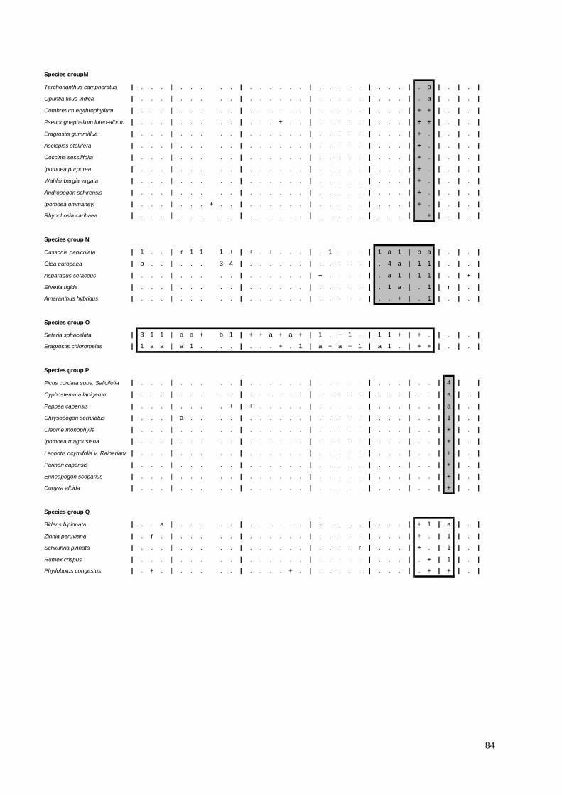
84
Species groupM
Tarchonanthus camphoratus | . . . | . . . . . | . . . . . . | . . . . . | . . . | . b | . | . |
Opuntia ficus-indica | . . . | . . . . . | . . . . . . | . . . . . | . . . | . a | . | . |
Combretum erythrophyllum | . . . | . . . . . | . . . . . . | . . . . . | . . . | + + | . | . |
Pseudognaphalium luteo-album | . . . | . . . . . | . . . + . . | . . . . . | . . . | + + | . | . |
Eragrostis gummiflua | . . . | . . . . . | . . . . . . | . . . . . | . . . | + . | . | . |
Asclepias stellifera | . . . | . . . . . | . . . . . . | . . . . . | . . . | + . | . | . |
Coccinia sessilifolia | . . . | . . . . . | . . . . . . | . . . . . | . . . | + . | . | . |
Ipomoea purpurea | . . . | . . . . . | . . . . . . | . . . . . | . . . | + . | . | . |
Wahlenbergia virgata | . . . | . . . . . | . . . . . . | . . . . . | . . . | + . | . | . |
Andropogon schirensis | . . . | . . . . . | . . . . . . | . . . . . | . . . | + . | . | . |
Ipomoea ommaneyi | . . . | . . . + . . | . . . . . . | . . . . . | . . . | + . | . | . |
Rhynchosia caribaea | . . . | . . . . . | . . . . . . | . . . . . | . . . | . + | . | . |
Species group N
Cussonia paniculata | 1 . . | r 1 1 1 + | + . + . . . | . 1 . . . | 1 a 1 | b a | . | . |
Olea europaea | b . . | . . . 3 4 | . . . . . . | . . . . . | . 4 a | 1 1 | . | . |
Asparagus setaceus | . . . | . . . . . | . . . . . . | + . . . . | . a 1 | 1 1 | . | + |
Ehretia rigida | . . . | . . . . . | . . . . . . | . . . . . | . 1 a | . 1 | r | . |
Amaranthus hybridus | . . . | . . . . . | . . . . . . | . . . . . | . . + | . 1 | . | . |
Species group O
Setaria sphacelata | 3 1 1 | a a + b 1 | + + a + a + | 1 . + 1 . | 1 1 + | + . | . | . |
Eragrostis chloromelas | 1 a a | a 1 . . . | . . . + . 1 | a + a + 1 | a 1 . | + + | . | . |
Species group P
Ficus cordata subs. Salicifolia | . . . | . . . . . | . . . . . . | . . . . . | . . . | . . | 4 | |
Cyphostemma lanigerum | . . . | . . . . . | . . . . . . | . . . . . | . . . | . . | a | . |
Pappea capensis | . . . | . . . . + | + . . . . . | . . . . . | . . . | . . | a | . |
Chrysopogon serrulatus | . . . | a . . . . | . . . . . . | . . . . . | . . . | . . | 1 | . |
Cleome monophylla | . . . | . . . . . | . . . . . . | . . . . . | . . . | . . | + | . |
Ipomoea magnusiana | . . . | . . . . . | . . . . . . | . . . . . | . . . | . . | + | . |
Leonotis ocymifolia v. Raineriana | . . . | . . . . . | . . . . . . | . . . . . | . . . | . . | + | . |
Parinari capensis | . . . | . . . . . | . . . . . . | . . . . . | . . . | . . | + | . |
Enneapogon scoparius | . . . | . . . . . | . . . . . . | . . . . . | . . . | . . | + | . |
Conyza albida | . . . | . . . . . | . . . . . . | . . . . . | . . . | . . | + | . |
Species group Q
Bidens bipinnata | . . a | . . . . . | . . . . . . | + . . . . | . . . | + 1 | a | . |
Zinnia peruviana | . r . | . . . . . | . . . . . . | . . . . . | . . . | + . | 1 | . |
Schkuhria pinnata | . . . | . . . . . | . . . . . . | . . . . r | . . . | + . | 1 | . |
Rumex crispus | . . . | . . . . . | . . . . . . | . . . . . | . . . | . + | 1 | . |
Phyllobolus congestus | . + . | . . . . . | . . . . + . | . . . . . | . . . | . + | + | . |

85
Species group R |
Zanthoxylum capense | 1 . 1 | 1 1 + + 1 + | + . a + . . | . 1 . . . | . + 1 | 1 . | 1 | . |
Pellaea calomelanos | + + 1 | . + + + + + | + + . + + + | . . . . . | + + + | + + | + | . |
Searsia lancea | . 1 . | . . . . a | + . b . . . | 1 a . . . | r + . | . 3 | 1 | . |
Dombeya rotundifolia | . a . | . . . . . | a . . . b 1 | . 3 . . . | . . 1 | . 1 | 1 | . |
Eustachys paspaloides | 1 b a | 1 . . 1 1 | + . r . a . | . . . r . | + 1 + | + + | . | . |
Heteropogon contortus | . 1 1 | + . 1 1 a | 1 . + 1 a . | . . + + + | . . . | . + | + | . |
Aloe greatheadii | 1 + 1 | 1 a 1 . . | + + + + . . | 1 r . . . | . 1 + | + + | . | . |
Lippia javanica | 1 . . | . . 1 a + | + + + . 1 + | . + . . . | . . . | . . | 1 | . |
Species group S
Acacia ataxacantha | . . . | . . . . . | . . . . . . | . . . . . | . . . | . . | . | b |
Priva cordifolia | . . . | . . . . . | . . . . . . | . . . . . | . . . | . . | . | b |
Hypoestes forskaolii | . . . | . . . . . | . . . . . . | . . . . . | . . . | . . | . | a |
Commelina benghalensis | . . . | . . . . . | . . . . . . | . . . . . | . . . | . . | . | + |
Cuscuta campestris | . . . | . . . . . | . . . . . . | . . . . . | . . . | . . | . | + |
Cyperus species | . . . | . . . . . | . . . . . . | . . . . . | . . . | . . | . | + |
Species group T
Celtis africana | b 1 1 | + . . a a a | . . + . . . | r 1 . . + | 4 b 4 | a 1 | 1 | 3 |
Rhoicissus tridentata | b 1 . | . a 1 + 1 . | . . . . . . | 1 . . . . | 1 1 a | 1 1 | + | . |
Searsia pyroides | a . a | . a . . . | 1 1 1 . . 1 | a . 1 1 + | a . + | a . | . | + |
Bidens pilosa | . 1 . | + . + + . | + . . + . . | . a . . . | a a a | a 1 | 1 | . |
Euclea crispa | . . . | . 1 + . . | 1 1 . 1 . . | . a . . . | 1 1 1 | + a | a | a |
Tagetes minuta | + . . | . . . . 1 | + . . . . . | . . . r . | 3 a a | a a | a | 1 |
Diospyros lycioides | b a . | . 1 + 1 . | . . . . . . | a a . . + | . . . | 1 + | 1 | 1 |
1.2 Searsia zeyheri – Trachypogon spicatus Open Shrubveld.
This sub community is mostly found on the steep (9 – 25 degrees) scarp and
midslopes (Terrain forms 2 and 3) of the Fa and Ib land types underlain by the
Malmani Dolomites of the Vaalian Erathem and the Andesites of the Hekpoort group
also from the Vaalian Erathem respectively. Aspect is variable, but never north
facing, mainly with a southerly, westerly or west southwest orientation. Soil are
shallow (150 – 350mm) and covered with a high percentage surface rock at between
40 – 80% , often in the form of Chert or Dolomite outcrops near cave systems and
have a relatively low clay content (6-10%) corresponding with the loamy sand soil
class description.
This community has the appearance of bush clump “islands” within a typical Rocky
grassland landscape. There is a well established tree layer, with heights of up to
10m and up to 80% coverage being reached.

86
Shrubs account for between 5 – 40% coverage and reach heights of between 1.5 –
2m. The grass layer is less prevalent than in the Ozoroa paniculosa–Anthephora
pubescens Bush Clump sub community, however the forb layer is more prominent.
Grasses reach maximum heights of 1.2m and account for between 30 – 60% cover,
whilst forbs reach maximum heights of 1.2m and account for between 20 – 40% of
the vegetative cover.
This sub community is characterised by the presence of those species occurring in
Species Group B. These include the trees Gymnosporia heterophylla, and the non
prominent Ximenia caffra, which is however differential. The characteristic shrubs
Phymaspermum athanasioides (found especially amongst the summit rocks of
scarps), Lippia rehmannii and Halleria lucida, whist not prominent throughout this
sub community, are differential. The differential grass species Trachypogon spicatus
and the forb Indigofera cryptantha feature prominently as characteristic species
(Species Group B). The non prominent grass Stipagrostis zeyheri is also differential
with the grasses Eragrostis racemosa, Andropogon chinensis and Aristida
transvaalensis featuring as non prominent characteristic species. There are
numerous forbs that are both characteristic and differential, and these include
Lotononis eriantha, Xerophyta viscosa, Indigofera zeyheri, Felicia muricata, Cyperus
obtusiflorus (especially around cave entrances) and Tritonia nelsonii. The forbs
Sphenostylis angustifolia and Pentanisia angustifolia, whilst neither prominent nor
differential, remain characteristic.
Non characteristic species that do however feature prominently throughout this sub
community include the trees Cussonia paniculata (Species Group N), Zanthoxylum
capense (Species Group R) and Diospyros lycioides, Celtis africana and Rhoicissus
tridentata (Species Group T) as well as the shrubs Searsia zeyheri and Asparagus
suaveolens (Species Group H). Prominently featuring forbs include Ruellia cordata
(Species Group C), Athrixia elata (Species Group F), Vernonia oligocephala
(Species Group E) and Pellaea calomelanos (Species Group R). The grasses
Diheteropogon amplectens, Brachiaria serrata and Sporobolus pectinatus (Species
Group C), as well as Themeda triandra (Species Group H), Elionurus muticus
(Species Group L) and Eustachys paspaloides and Heteropogon contortus (Species
Group R) also feature prominently throughout this sub community.

87
2. Acacia caffra–Combretum molle Rocky Bushveld.
This community occurs on the steep to very steep (11 – 35 degrees) scarps and
midslopes of the Ib Land type situated to the North and South of the study area, as
well as in isolated instances on the steep slopes (19 – 21 degrees) of the Bb land
type amongst large boulders in the East of the study area. The Ib Land type in the
North of the study area is underlain by the Andesites of the Vaalian Erathem that are
part of the Pretoria Group, whilst the Ib Land type in the South of the study area
(which corresponds with the geographical landmark, the “Zwartkop”) is also
underlain by Andesite, however in this instance from the Randian Erathem from the
Ventersdorp Supergroup. The eastern edge of the “Zwartkop”, as well as the area to
the east of it corresponding to the Ba Land Type is underlain with Gneiss of the
Halfway House Granites. This major community is found on all aspects and % soil
surface rock is high at between 50 – 90%. Soil is largely shallow (150 – 350mm) and
well drained, corresponding largely with the Loamy sand soil description.
The vegetation is dominated by the tree layer, with cover values of between 50 –
90% occurring. The height of the tree layer ranges from 4 – 6m. Shrubs vary
between 1.2 – 2m in height and comprise between 30 – 60 % of the vegetative cover
of this community. The grass layer reaches heights of 1.2m and ranges between 40
– 60% cover with forbs covering between 15 – 55% of this community and reaching
heights of up to 0.5m.
This community is characterised by the presence of species from Species Group D,
and include the trees Acacia caffra and Combretum molle, the shrub Lantana rugosa
and the forbs Solanum giganteum, Hermannia floribunda and Cyperus esculentus.
The tree Dombeya rotundifolia (Species Group R) together with the shrubs Searsia
zeyheri (Species Group H) and Lippia javanica (Species Group R), the grasses
Themeda triandra (Species Group H) and Setaria sphacelata (Species Group O) and
the forb Pellaea calomelanos (Species Group R), whilst not characteristic, do indeed
feature prominently throughout this community.
3. Acacia karroo–Teucrium trifidum Thornveld.
This major community is found on the mostly west facing moderate (10 – 14
degrees) low lying midslopes of the Ab Land type in the south of the study area, as

88
well as in certain west facing bottomlands of the Ib Land type to the north west of the
study site. Percentage soil surface rock is low at below 20%, with soil depths being
regarded as moderately deep at between 450 – 500mm and are classed as sandy
clay loam soils and are distinctively red in colour and appear to be associated with
diabase dykes.
This woodland plant community is dominated by woody plants that are in total
responsible for over 60% coverage, with the tree stratum reaching heights of
between 2 – 10m and covering 30 – 40% of the area and the shrub layer covering
50% of the area and reaching heights of 2m. Grasses reach maximum heights of 1m
and cover 30% of the area, with forbs reaching maximum heights of 0.8m and
covering 34% of the area.
This major community is characterised by the presence of those species listed in
Species Group G. These include the dominant tree Acacia karroo and shrublet
Teucrium trifidum. The less prominent dwarf shrubs Ziziphus zeyheriana and
Asparagus laricinus, together with the forbs Oxalis corniculata, Verbena brasilliensis,
Salvia runcinata, Solanum elaeagnifolium, Paspalum dilatatum and the tree Olea
europaea subsp. africana are also characteristic although they do not feature
prominently throughout this community.
The tree Searsia pyroides (Species Group T), the shrub Asparagus suaveolens
(Species Group H), the grasses Hyparrhenia hirta, Cynodon dactylon (Species
Group K), Elionurus muticus (Species Group L), Eragrostis chloromelas (Species
Group O) and Heteropogon contortus (Species Group R) as well as the forb Conyza
podocephala (Species Group K) all feature prominently throughout this community.
The relatively fertile soils and higher moisture retention due in part to the diabase
dyke acting as a barrier appear to translate into a higher palatability of available
graze and browse placing additional pressure on this plant community through
excessive utilization by wildlife. This plant community is similar to the Acacia karroo–
Teucrium trifidum short closed woodland community as described by Duigan (2003).

89
4. Cussonia paniculata–Celtis africana Bush Clumps.
This major plant community occurs on the higher lying south facing crests, scarps
and midslopes of the Fa land type that are underlain by the Malmani Dolomites of
the Chuniespoort group from the Vaalian Erathem. Slopes vary with flat to gentle
slopes (1 – 9 degrees) occurring when this community is located on the crests and
scarps, with moderate to steep slopes (10 – 20 degrees) being encountered when
this community is located on midslopes. Percentage soil surface rock is high at
between 60 – 80%, comprised mainly of large rock outcrops around cave entrances.
Soil is shallow (50 – 150mm) and well drained and correspond to the loamy sand soil
description.
The vegetation around these caves presents as an open to dense woodland with the
woody plants dominating in terms of both cover and variety with the grass layer
being largely underrepresented. The forb layer, although higher in cover than the
grass layer, generally has very low species diversity. Trees account for between 80 –
100% of the vegetative cover and reach heights of between 8 and 15m. Shrubs
account for between 30 - 50% of the cover and reach heights of 2m. Grasses reach
maximum heights of 1m and cover between 5 – 30% of the area whilst forbs cover
between 40 – 70% of the area and reach maximum heights of 1m as well.
The trees Cussonia paniculata, Olea europaea and Ehretia rigida together with the
shrub Asparagus setaceus and exotic forb Amaranthus hybridus are all characteristic
species for this major community and are listed in Species Group N.
This community is dominated by the trees Celtis africana and Rhoicissus tridentata
(Species Group T), together with the forbs Bidens pilosa and Tagetes minuta
(Species Group T).
Additional species that feature prominently throughout this community include the
trees Gymnosporia buxiifolia (Species Group B), Zanthoxylum capense (Species
Group R), and Euclea crispa (Species Group T), the grasses Eragrostis chloromelas
(Species Group H), Cynodon dactylon (Species Group K), Setaria sphacelata,
Eragrostis chloromelas (Species Group O) and Eustachys paspaloides (Species
Group R) and the forbs Pellaea calomelanos and Aloe greatheadii (Species Group
R).

90
Caves are often used as permanent and temporary dwellings by many terrestrial
mammals, and a result trampling around these entrances often occurs. This natural
disturbance is attested to through the prominent presence of Amaranthus hybridus
(Species Group N), Cynodon dactylon (Species Group K) and the introduced weeds
Tagetes minuta and Bidens pilosa (Species Group T). Two sub communities can be
recognized within this major community, namely the Olea europaea subsp Africana-
Diospyros whyteana Bush Clump sub community and the Cussonia paniculata–
Combretum erythrophyllum Bush Clump sub community.
4.1 Olea europaea subsp. africana–Diospyros whyteana Bush Clumps.
This sub community occurs on the flat to gentle (1 – 9 degrees) higher lying south
facing crests and scarps of the Fa land type that are underlain by the Malmani
Dolomites of the Chuniespoort group from the Vaalian Erathem. Percentage soil
surface rock is high at between 60 – 70%, comprised mainly of large rock outcrops
around cave entrances. Soil is shallow (50 – 150mm) and well drained and
corresponds to the loamy sand soil description.
The vegetation of this sub community is described as open to dense woodland with
the woody plants dominating in terms of both cover and variety with the grass layer
being largely underrepresented.
The forb layer, although higher in cover than the grass layer, generally still has a low
species diversity. Trees account for between 80 – 100% of the vegetative cover and
reach heights of between 9 and 15m. Shrubs account for between 30 - 50% of the
cover and reach heights of 2m. Grasses reach maximum heights of 1m and cover
between 5 – 30% of the area whilst forbs cover between 40 – 70% of the area and
reach maximum heights of 1m as well.
This sub community is characterised through the presence of those species listed in
Species Group J. These include the trees Diospyros whyteana and Searsia dentata,
along with the grass Hyparrhenia tamba and the forbs Adiantum capillus-veneris,
Richardia brasiliensis, Solanum incanum and Scadoxus cyrtanthiflorus.

91
The vegetation is dominated by the trees Olea europaea, Cussonia paniculata
(Species Group N), Celtis africana and Rhoicissus tridentata (Species Group T) and
the forbs Bidens pilosa and Tagetes minuta (Species Group T).
The tree Euclea crispa (Species Group T), the grasses Setaria sphacelata (Species
Group O) and Cynodon dactylon (Species Group K) and the forb Pellaea
calomelanos (Species Group R) all feature prominently throughout this community.
4.2 Cussonia paniculata–Combretum erythrophyllum Bush Clumps.
This sub community occurs on the moderate to steep (10 – 15 degrees) higher lying
south facing scarps and midslopes of the Fa land type that are underlain by the
Malmani Dolomites of the Chuniespoort group from the Vaalian Erathem.
Percentage soil surface rock is high at between 70 - 80%, comprised mainly of large
rock outcrops and boulders around cave entrances. Soil is shallow (50 – 150mm)
and well drained and corresponds with the loamy sand soil description.
The vegetation of this sub community is described as open to dense woodland with
the woody plants dominating in terms of both cover and variety with the grass layer
being largely underrepresented. The forb layer, although higher in cover than the
grass layer, generally still has a low species diversity. Trees account for between 80
– 100% of the vegetative cover and reach heights of between 8 and 10m.
Shrubs account for between 30 - 40% of the cover and reach heights of 2m. Grasses
reach maximum heights of 1m and cover between 10 – 15% of the area whilst forbs
cover between 50 – 60% of the area and reach maximum heights of 1m as well.
This sub community is characterised through the presence of the trees
Tarchonanthus camphoratus and Combretum erythrophyllum, the grasses Eragrostis
gummiflua and Andropogon schirensis and the forbs Pseudognaphaleum
luteoalbum, Asclepias stellifera, Coccinia sicifolia, Ipomoea purpurea, Wahlenbergia
virgata, Ipomoea ommaneyi and Rhynchosia caribaea, all of which are listed in the
characteristic Species Group M.

92
This sub community is dominated by the trees Cussonia paniculata (Species Group
N) and Celtis africana (Species Group T), together with the forbs Tagetes minuta
and Bidens pilosa (Species Group T).
Prominent species within this community include the trees Gymnosporia heterophylla
(Species Group B), Olea europaea (Species Group N), Searsia lancea (Species
Group R), Rhoicissus tridentata, Euclea crispa and Diospyros lycioides (Species
Group T) and the shrub Asparagus setaceus (Species Group N).
5. Ficus cordatum–Pappea capensis Bush Clumps.
This community occurs on the steep (greater than 15 degrees) north easterly facing
cliffs along the midslopes of the Ib Land type located centrally within the study area,
just south of the interface between the Malmani Dolomites and the Shales of the
Timeball Hill sequence of the Pretoria Group. Percentage soil surface rock cover is
high (80%) and consists largely of Chert rich rock outcrops and exposed Dolomite,
often around cave entrances. Soil is moderately shallow (150 – 300mm) and well
drained and corresponds to the loamy sand soil description. The area is underlain by
the Malmani Dolomites of the Chuniespoort group from the Vaalian Erathem.
The tree stratum dominates this plant community with 85% coverage and reaches
heights of 10m.
Shrubs account for 30% coverage and reach maximum heights of 2m with grasses
and forbs covering 10% and 40% of the area respectively, with both reaching a
maximum height of 1m.
This community is characterised through the presence of those species listed in
Species Group P. These include the trees Ficus cordata subsp. salicifolia,
Cyphostemma lanigerum and Pappea capensis, the shrubs Leonotis ocymifolia v.
raineriana and Parinari capensis , the grasses Chrysopogon serrulatus and
Enneapogon scoparius and the forbs Cleome monophylla, Ipomoea magnusiana and
Conyza albida.
This community is dominated by the tree Euclea crispa (Species Group T) and the
forbs Bidens bipinnata (Species Group Q) and Tagetes minuta (Species Group T).

93
Species that feature prominently throughout this community include the trees
Zanthoxylum capense, Searsia lancea, Dombeya rotundifolia (Species Group R),
Celtis africana and Diospyros lycioides (Species Group T), the aromatic shrub Lippia
javanica (Species Group R) and the forbs Zinnia peruviana, Rumex crispus,
Schkuhria pinnata (Species Group Q) and Bidens pilosa (Species Group T).
6. Acacia ataxacantha – Celtis africana Bush Clumps.
This community is found on the very steep (greater than 25 degrees) drainage line
that extends into a riverine area along a south facing crest and midslope interface in
the Ib Land type in the far east of the study area (Mogales Gate). This community is
underlain by the Shales of the Vaalian Erathem from the Pretoria Group, not far
north of the interface between the Pretoria Group‟s Shales and Andesites.
Percentage soil surface rock is very low (Less than 5%) with moderately deep (450 –
500mm) and moist sandy clay loam soils (Soil texture class 4) present along the
drainage line.
The vegetation is dominated by the tree layer. Trees cover between 90 – 100% of
the area and reach maximum heights of 18m. The shrub and grass layers are
virtually absent with each only covering 5% of the area and reaching maximum
heights of 1m and 0.3m respectively. There is a well established forb layer which,
although lacking in diversity, accounts for 90% coverage, reaching a maximum
height of 0.3m.
This community is characterised through the presence of those species listed in
Species Group S, which include the tree Acacia ataxacantha, the shrub Priva
cordifolia and the forbs Hypoestes forskaolii, Commelina benghalensis, Cuscuta
campestris and Cyperus sp.
This community is dominated by the trees Celtis africana (Species Group T) and
Acacia ataxacantha (Species Group S) with Euclea crispa, Diospyros lycioides
(Species Group T) and the forb Tagetes minuta (Species Group T) featuring
prominently.

94
This community shows an affinity to the Acacio ataxacanthae-Celtidetum africanae
association as described by Mathews (1991), a community characteristic of valley
bottoms and protected areas on valley sides.

95
5.3. References
BEZUIDENHOUT, H.; BREDENKAMP, G.J. & THERON, G.K. 1994. A classification
of the vegetation of the western Transvaal dolomite and chert grassland, South
Africa. South African Journal of Botany, 1994. 60(3): 152-161.
BREDENKAMP, G.J. & BROWN, L.R. 2003. A reappraisal of Acocks‟ Bankenveld:
Origin & diversity of Vegetation Types. South African Journal of Botany 69(1) 7-26.
BROWN, L.R.; MARAIS, H. & BARRETT, L. 2005. Vegetation classification as the
basis for baboon management in the Bourke‟s Luck Section of the Blyde Canyon
Nature Reserve, Mpumalanga. Koedoe 48(2): 71-92.
COETZEE, B.J. 1974. A Phytosociological classification of the vegetation of the Jack
Scott Nature Reserve. Bothalia 11: 329-347.
CRADLE OF HUMANKIND MGMT AUTHORITY. 2003. Land Use Audit report.
Gauteng Dept. Agriculture, Conservation and Environment, Johannesburg.
DUIGAN, P.S & BREDENKAMP, G.J. 2003. The Vegetation Classification of Letamo
Estates in North-Western Gauteng. BSc. (Hons) Thesis. University of Pretoria.
EDWARDS, D. 1983. A broad scale structural classification of vegetation for
practical purposes. Bothalia 14, (3&4): 705-712.
MATHEWS, W.S. 1991. Phytosociology of the North-eastern Mountain sourveld.
M.Sc. Dissertation. University of Pretoria. Pretoria.
PALGRAVE, K.C. 2002. Trees of Southern Africa. 3rd edn. Struik Publishers, Cape
Town.
VAN OUTSHOORN, F. 1999. Guide to the grasses of Southern Africa. Briza
Publishers, Pretoria.
VAN WYK, A.E. & MALAN, S.J. 1998. Field guide to the wildflowers of the Highveld.
2nd edn. Struik Publishers, Cape Town.
VAN WYK, A.E. & VAN WYK, P. 1997. Field guide to the trees of Southern Africa.
Struik Publishers, Cape Town.

96
CHAPTER 6
RESULTS AND DISCUSSION- CAVES
6.1. Introduction
During field assessments as part of a study to describe the woody vegetation of the
natural areas of the COH WHS, it was noticed that the vegetative composition
around caves had a distinctly different appearance than that of the surrounding
landscape.
Whilst it is well documented that surface features and land use practices surrounding
caves have a marked influence on the underground functioning of that cave system
(Gamble 1980), it was questioned whether the opposite could also be true? Could
caves also influence surface features such as vegetative structure and functioning,
and if so, to what degree?
The surveying of the bio inventory of caves within the Gauteng Province during 2005
and 2006 as conducted by GDACE added well over 240 caves to a database, the
overwhelming majority of which are located within the boundaries of the COH WHS.
The total contribution that these caves have on the surrounding vegetation should
they indeed be found to influence vegetative structure and composition, would
therefore be seen to be quite substantial.
Limited sample plots were placed within selected caves due to accessibility
constraints and availability thus resulting in some under-sampling. The classification
nonetheless still resulted in 7 distinct and different cave entrance zone plant
communities being identified that are easily recognizable in the field.
The trees Celtis africana, Rhoicissus tridentata, and Zanthoxylum capense (Species
Group Z) feature prominently throughout the caves zone vegetation of the study site
together with the forb Pellaea calomelanos.

97
A data analysis and subsequent rearrangement of species in the resultant caves
entrance vegetation table (Table 6.1) produced the following hierarchically arranged
plant communities characterised according to the various Species Groups.
1. Olea europaea subsp. africana–Searsia zeyheri Woodland.
1.1 Searsia zeyheri–Gerbera viridifolia Bush Clumps.
1.2 Searsia zeyheri–Elionurus muticus Woodland.
2. Celtis africana– Tagetes minuta Major woodland community.
2.1 Celtis africana–Cussonia paniculata Bush Clumps.
2.2 Euclea crispa – Cussonia paniculata Woodland.
2.3 Ficus cordata subsp. salicifolia–Euclea crispa Woodland.
6.2. Description of the Plant Communities
In the descriptions of the different plant communities, all species groups refer to
those defined in table 6.1.
1. Olea europaea subsp. africana–Searsia zeyheri Woodland.
This plant community occurs around the cave entrances found on the Chert rich
Malmani Dolomites that coincide with the Ib Land type that are centrally located
within the study area. This community is found mainly on scarps where slopes are
generally steep (9 – 20 degrees) and orientated in a southerly to west south westerly
direction with percentage soil surface rock ranging from 70 – 80%. Soil is shallow
(300 – 400mm) and freely drained and corresponds to the Loamy sand soil
description.

98
TABLE 6.1: A Phytosociological table of the Cave Entrance Vegetation of the COH WHS
Community | |
| 1.1 | | | | 2.3 |
| | | | | |
Releve No. | 5 | 1 6 | 2 3 4 | 8 9 | 7 |
SPECIES GROUP A
Searsia zeyheri | 3 | 3 a | . . . | . . | . |
Trachypogon spicatus | 1 | a 1 | . . . | . . | . |
Heteropogon contortus | + | 1 a | . . . | . + | + |
Diheteropogon amplectens | 1 | 1 1 | . + . | . . | . |
Brachiaria serrata | 1 | 1 + | . + . | + . | . |
Vernonia oligocephala | 1 | 1 + | . . . | . . | . |
Xerophyta viscosa | 1 | + 1 | . . . | . . | . |
Athrixia elata | 1 | + + | . . . | + . | . |
Asparagus suaveolens | 1 | + + | . . . | . . | . |
Lotononis eriantha | + | + + | . . . | . . | . |
Ruellia cordata | + | + + | . . . | . . | . |
Aristida meridionalis | 1 | 1 . | . . . | . . | . |
Helichrysum cephaloideum | 1 | + . | . + . | . . | . |
Indigofera zeyheri | 1 | . + | . . . | . . | . |
Senecio inornatus | 1 | . + | . . . | . . | . |
Rubia horrida | + | + . | . . . | . . | . |
Stachys natalensis | + | + . | . . . | . . | . |
Indigofera melanadenia | + | . + | . . . | . . | . |
Phymaspermum athanasioides | + | . + | . . . | . . | . |
Becium obovatum | + | r + | . . . | . . | . |
SPECIES GROUP B
Gerbera viridifolia | 1 | . . | . . . | . . | . |
Sporobolus pectinatus | + | . . | . . . | . . | . |
Tristachya rehmannii | + | . . | . . . | . . | . |
Acrotome angustifolia | + | . . | . . . | . . | . |
Stipagrostis uniplumis v. Neesii | + | . . | . . . | . . | . |
Loudetia simplex | + | . . | . . . | . . | . |
Aristida diffusa | + | . . | . . . | . . | . |
Xerophyta retinervis | + | . . | . . . | . . | + |
Ipomoea ommaneyi | + | . . | . . . | + . | . |
Convolvulus sagitattus subs. Sagitattus | + | . . | . . . | . . | . |
Chaetacanthus costatus | + | . . | . . . | . . | . |
Helichrysum dasymallum | + | + . | . . . | . . | . |
Nidorella hottentotica | + | . . | . . . | . . | . |
Ledebouria ovatifolia | + | . . | . . . | . . | . |
Rhynchosia totta | + | + . | . . . | . . | . |
Senecio affinis | + | . . | . . . | . . | . |
Chironia palustris | + | . . | . . . | . . | . |
Bewsia biflora | + | . . | + . . | . . | . |
Scabiosa columbaria | + | . . | . . + | . . | . |
Elephantorrhiza elephantina | + | . . | . . . | . . | . |
Eragrostis capensis | + | . . | . . . | . . | . |
1 2
1.2 2.1 2.2

99
SPECIES GROUP C
Elionurus muticus | . | b + | + . . | . . | . |
Lippia javanica | . | a + | . . . | . . | 1 |
Halleria lucida | . | . a | . . . | . . | . |
Ximenia caffra | . | 1 . | . . . | . . | . |
SPECIES GROUP D
Dovyalis zeyheri | . | 1 + | . 1 + | . . | . |
Eragrostis curvula | . | 1 + | . 1 + | + . | . |
Adiantum capillus-venestris | . | + + | . 1 + | . . | + |
SPECIES GROUP E
Setaria sphacelata | 1 | b 1 | 1 1 + | + . | . |
Themeda triandra | b | 1 1 | . + . | + . | . |
Ledebouria revoluta | + | r + | + + . | . . | + |
Pollichia campestris | + | . + | + + . | . . | + |
Hypoxis rigidula | + | + . | . + . | + . | . |
SPECIES GROUP F
Olea europaea | 3 | 3 4 | . 4 a | 1 1 | . |
Gymnosporia heterophylla | + | a 1 | 1 . + | 1 1 | . |
SPECIES GROUP G
Cussonia paniculata | . | 1 + | 1 a 1 | b a | . |
Eustachys paspaloides | . | 1 1 | + 1 + | + + | . |
Gymnosporia polyacantha | . | 1 . | . . . | 1 . | . |
SPECIES GROUP H
Tagetes minuta | . | . 1 | 3 a a | a a | a |
Bidens pilosa | . | + . | a a a | a 1 | 1 |
Euclea crispa | . | . . | 1 1 1 | + a | a |
Rhus lancea | . | . a | r + . | . 3 | 1 |
Ehretia rigida | . | . . | . 1 a | . 1 | r |
Cynodon dactylon | . | . . | 1 1 1 | . 1 | + |
SPECIES GROUP I
Diospyros whyteana | . | . . | . a 1 | . . | . |
Searsia leptodictya | . | . . | a . . | . . | . |
Ozoroa paniculosa | . | . . | 1 + . | . . | . |
Hyparrhenia hirta | . | . . | 1 + . | . . | . |
Searsia dentata | . | . . | . + 1 | . . | . |
Melinis repens | . | . + | r + + | . . | . |
Scadoxus cyrtanthiflora | . | . . | . + + | . . | . |
Richardia brasiliensis | . | . . | + + . | . . | . |
Grewia occidentalis | . | . . | . . 1 | . . | . |
Hibiscus aethiopicus | . | . . | . . 1 | . . | . |
Vangueria infausta | . | . . | . 1 . | . . | . |
Hyparrhenia tamba | . | . + | . 1 . | . . | . |
Panicum maximum | . | . . | . . 1 | . . | . |
Aloe transvaalensis | . | . . | + . . | . . | . |
Conyza podocephala | . | . . | + . . | + . | . |
Cyanotis speciosa | + | . . | . 1 . | . . | . |

100
SPECIES GROUP J
Eragrostis chloromelas | . | . . | a 1 . | + + | . |
Asparagus setaceus | . | . . | . a 1 | 1 1 | . |
Searsia pyroides | . | . . | a . + | a . | . |
Acokanthera oppositifolia | . | . . | . a 1 | . 1 | . |
Aloe greatheadii | . | . . | . 1 + | + + | . |
Rhamnus prinoides | . | . . | 1 . . | 1 . | . |
SPECIES GROUP K
Bidens bipinnata | . | . . | . . . | + 1 | a |
Diospyros lycioides | . | 1 . | . . . | 1 + | 1 |
Dombeya rotundifolia | . | . . | . . 1 | . 1 | 1 |
Rumex crispus | . | . . | . . . | . + | 1 |
Schkuhria pinnata | . | . . | . . . | + . | 1 |
Combretum molle | . | 1 . | . . . | 1 . | + |
SPECIES GROUP L
Tarchonanthus camphoratus | . | . . | . . . | . b | . |
Opuntia ficus-indica | . | . . | . . . | . a | . |
Combretum erythrophyllum | . | . . | . . . | + + | . |
Pseudognaphalium luteo-album | . | . . | . . . | + + | . |
Calpurnia villosa | . | . . | . . . | . 1 | . |
Asclepias stellifera | . | . . | . . . | + . | . |
Coccinia sessilifolia | . | . . | . . . | + . | . |
Ipomoea purpurea | . | . . | . . . | + . | . |
Wahlenbergia virgata | . | . . | . . . | + . | . |
Rhynchosia caribaea | . | . . | . . . | . + | . |
SPECIES GROUP M
Ficus cordata subs. Salicifolia | . | . . | . . . | . . | 4 |
Cyphostemma lanigerum | . | . . | . . . | . . | a |
Pappea capensis | . | . + | . . . | . . | a |
Chrysopogon serrulatus | . | . . | . . . | . . | 1 |
Plectranthus madagascarensis | . | . . | . . . | . . | 1 |
Setaria lindenbergiana | . | . . | . . . | . . | 1 |
Cleome monophylla | . | . . | . . . | . . | + |
Ipomoea magnusiana | . | . . | . . . | . . | + |
Leonotis ocymifolia v. Raineriana | . | . . | . . . | . . | + |
Ziziphus mucronata | . | . 1 | . . + | . . | + |
Parinari capensis | . | . . | . . . | . . | + |
Kalanchoe thyrsiflora | . | . . | . . + | . . | + |
Grewia flava | . | . . | . . . | . . | + |
Eragrostis racemosa | + | . . | . . . | . . | + |
Hibiscus trionum | . | . . | . . . | . . | r |
SPECIES GROUP N
Celtis africana | a | a a | 4 b 4 | a 1 | 1 |
Rhoicissus tridentate | + | 1 . | 1 1 a | 1 1 | + |
Zanthoxylum capense | + | 1 + | . + 1 | 1 . | 1 |
Pellaea calomelanos | + | + + | + + + | + + | + |
Oxalis tetraphylla | + | . . | . + . | . . | + |

101
The vegetation of this community is dominated by the tree layer, with individuals
attaining heights of between 5 – 10m. The tree coverage is variable but moderate,
with percentage coverage varying between 30 – 80%. Shrubs reach maximum
heights of 2m and cover between 30 – 40% of the area with the grass layer covering
between 30 – 50% of the area and reaching a height of 1.2m. Forbs account for
between 20 – 40% coverage and reach maximum heights of 1.2m.
This major plant community is characterised through the presence of those species
listed in Species Group A which include the tree Searsia zeyheri, the shrubs
Asparagus suaveolens and Phymaspermum athanasioides as well as the grasses
Trachypogon spicatus, Heteropogon contortus, Diheteropogon amplectens,
Brachiaria serrata and Aristida meridionalis and the forbs Vernonia oligocephala,
Xerophyta viscose, Athrixia elata, Lotononis eriantha, Ruellia cordata, Helichrysum
cephaloideum, Indigofera zeyheri, Senecio inornatus, Rubia horrida, Stachys
natalensis, Indigofera melanadenia and Becium obovatum.
This community is dominated by the trees Olea europaea (Species Group E) and
Celtis africana (Species Group N), with the grasses Setaria sphacelata and
Themeda triandra featuring prominently throughout this community.
Two sub communities are found within this major plant community, namely the
Searsia zeyheri–Gerbera viridifolia Bush Clump sub community and the Searsia
zeyheri–Elionurus muticus Woodland sub community.
1.1 Searsia zeyheri–Gerbera viridifolia Bush Clumps.
This sub community occurs around the caves of the steep (greater than 10 degrees)
south facing midslopes of the Ib Land type in the centre of the study area that lie on
top of the Malmani Dolomites of the Chuniespoort Sub Group from the Vaalian
Erathem. Percentage soil surface rock is high at 80%, consisting mainly of large rock
outcrops. Soil is shallow (300 – 400mm) and freely drained and corresponds to the
Loamy sand soil description.

102
The vegetation of this sub community has well defined tree, shrub, grass and forb
layers, with the highest coverage occurring within the grass and forb layers
respectively. Trees cover 30% of the area and reach maximum heights of 6m.
Shrubs reach maximum a height of 2m and cover 30% of the area as well. Grasses
account for 50% coverage and reach heights of 1m, with forbs covering 40% of the
area and reaching maximum heights of 1m.
This sub community is characterised through the presence of those species listed in
Species Group B. These include the shrublet Elephantorrhiza elephantina, the
grasses Sporobolus pectinatus, Tristachya rehmannii, Stipagrostis uniplumis v.
neesii, Loudetia simplex, Aristida diffusa and Eragrostis capensis as well as the forbs
Gerbera viridifolia, Acrotome angustifolia, Xerophyta retinervis, Ipomoea ommaneyi,
Convolvulus sagittatus subsp sagittatus, Chaetacanthus costatus, Helichrysum
dasymallum, Nidorella hottentotica, Ledebouria ovatifolia, Rhynchosia totta, Senecio
affinis, Chironia palustris, Bewsia biflora and Scabiosa columbaria.
This sub community is dominated by the trees Searsia zeyheri (Species Group A),
Olea europaea (Species Group E) and Celtis africana (Species Group N) and the
grass Themeda triandra (Species Group F) with the shrub Asparagus suaveolens
(Species Group A) and the grasses Setaria sphacelata (Species Group F),
Trachypogon spicatus, Diheteropogon amplectens, Brachiaria serrata and Aristida
meridionalis (Species Group A) all featuring prominently throughout.
1.2 Searsia zeyheri–Elionurus muticus Woodland.
This sub community occurs around the caves of the moderate to steep (10 - 20
degrees) west southwest facing scarps of the Ib Land type in the Centre of the study
area that lie on top of the Malmani Dolomites of the Chuniespoort Sub Group from
the Vaalian Erathem. Percentage soil surface rock is moderately high at 70 – 75%,
consisting mainly of large rock outcrops. Soil is shallow (300 – 400mm) and freely
drained and correspond to the Loamy sand soil description.

103
Trees dominate the vegetation, with the tree layer covering between 60 – 80% of the
area and reaching maximum heights of 10m. Shrubs cover between 30 – 40% of the
area and reach 2m in height with grasses covering 30% of the area and reaching
heights of 1.2m. Forbs reach maximum heights of 1.2m as well, but account for only
20% of the coverage.
Species characteristic for this sub community (Species Group C) include the
differential trees Ximenia caffra and Halleria lucida, with the shrub Lippia javanica
and the grass Elionurus muticus.
The vegetation of this sub community is dominated by the trees Olea europaea,
Gymnosporia buxiifolia (Species Group E) and Celtis africana (Species Group N)
and the shrub Searsia zeyheri (Species Group A). The grasses Trachypogon
spicatus, Heteropogon contortus, Diheteropogon amplectens (Species Group A),
Setaria sphacelata, Themeda triandra (Species Group F) and Eustachys
paspaloides (Species Group G) all feature prominently throughout this sub
community.
2. Celtis africana–Tagetes minuta Woodland.
This community occurs around the caves found on the southerly orientated flat (1 – 2
degrees) crests and the moderate to steep (7 – 19 degrees) scarps and midslopes
of the Fa Land type underlain by the Malmani Dolomites of the Chuniespoort Sub
Group from the Vaalian Erathem, as well as the very steep (23 degrees) northerly
orientated midslopes of the Ib Land type that is also underlain by the same Malmani
Dolomites. Percentage soil surface rock is moderately high at between 60 – 80%,
consisting mainly of large rock outcrops. Soil is very shallow at between 50 – 150mm
and corresponds to the Loamy sand soil description.
The vegetation has a well defined tree, shrub, grass and forb layer with the trees
dominating in terms of both cover values and height. Trees cover between 80 –
100% of the area and attain maximum heights of between 8 and 15m.

104
Shrubs reach heights of 2m and cover between 20 – 50% of the area with the grass
layer covering between 5 and 30% of the area and reaching maximum heights of
1m. Forbs account for between 40 – 70% cover and reach heights of 1m.
This community is characterised through the presence of the trees Euclea crispa and
Searsia lancea, the deciduous shrub Ehretia rigida, the grass Cynodon dactylon and
the forbs Tagetes minuta and Bidens pilosa (Species Group H).
The vegetation is dominated by the trees Celtis africana, Rhoicissus tridentata
(Species Group N) and Euclea crispa (Species Group H) and the forbs Bidens pilosa
and Tagetes minuta (Species Group H), with Pellaea calomelanos (Species Group
N) featuring prominently throughout this community.
There are three sub communities that can be distinguished within this plant
community, namely the Celtis africana–Cussonia paniculata Bush Clumps, the
Euclea crispa–Cussonia paniculata Woodland and the Ficus cordata subs.
salicifolia–Euclea crispa Rocky Woodland.
2.1 Celtis africana–Cussonia paniculata Bush Clumps.
This sub community occurs around the caves of the flat and gentle (1 – 7 degrees)
southerly orientated crests and scarps of the Fa Land type in the centre of the study
area that lies on top of the Malmani Dolomites of the Chuniespoort Sub Group from
the Vaalian Erathem. Percentage soil surface rock is moderate at 60 – 70%,
consisting mainly of rock outcrops and loose boulders. Soil is shallow (150 –
250mm) and freely drained and corresponds to the Loamy sand soil description.
The vegetation is dominated by the tree layer which reaches heights of between 9 –
15m and covers between 80 – 100% of the area. Area coverage by shrubs ranges
between 20 – 50% with individuals reaching maximum heights of 2m. Grasses cover
between 5 – 30% of the area and reach heights of 1m, whilst forbs reach heights of
between 0.5 – 1m and cover between 40 – 70% of the area.

105
This sub community is characterised through the presence of those species listed in
Species Group I. These include the trees Diospyros whyteana, Searsia leptodictya
and Ozoroa paniculosa as well as the shrubs Searsia dentata, and the less
prominent Grewia occidentalis and Vangueria infausta, all of which are considered
as differential species for this sub community amongst the cave entrance vegetation
communities. The grasses Hyparrhenia hirta, Melinis repens, Hyparrhenia tamba
and Panicum maximum as well as the forbs Scadoxus cyrtanthiflorus, Richardia
brasiliensis, Hibiscus aethiopicus, Aloe transvaalensis, Conyza podocephala and
Cyanotis speciosa are also all considered characteristic, albeit that they are not
dominant.
The vegetation is dominated by the trees Celtis africana, Rhoicissus tridentata
(Species Group N), Olea europaea (Species Group E) and the forbs Tagetes minuta
and Bidens pilosa (Species Group H). The trees Cussonia paniculata (Species
Group G) and Euclea crispa (Species Group H) together with the grass Cynodon
dactylon (Species Group H) all feature prominently throughout this sub community.
The presence of certain moisture loving species such as Hyparrhenia tamba,
Panicum maximum and Scadoxus cyrtanthiflorus (Species Group I) on these high
lying areas surrounding caves that are nowhere near any discernable water body or
soils with high moisture content could suggest that the caves themselves are
responsible for “exhaling” moisture rich air from deep underground during the well
known phenomenon known as cave breathing whereby temperature differentials
between the internal cave environment and outside cause air to be either drawn into
or pushed out of the cave.
2.2 Euclea crispa–Cussonia paniculata Woodland.
This sub community occurs around the caves of the moderate to steep (9 - 20
degrees) south facing scarps and midslopes of the Fa Land type in the centre of the
study area that are underlain with the Malmani Dolomites of the Chuniespoort Sub
Group from the Vaalian Erathem.

106
Percentage soil surface rock is moderately high at 70 – 80%, consisting mainly of
large rock outcrops. Soil is shallow (100 – 250mm) and freely drained and
corresponds to the Loamy sand soil description.
The vegetation is dominated by a tall, well established tree stratum which covers
between 80 – 100% of the community and reaches heights of between 8 – 10m.
Shrubs cover between 30 – 40% of the area and reach a maximum height of 2m with
grasses accounting for between 10 – 15% coverage and reaching heights of 1m.
The forb layer covers between 50 – 60% of the area and reaches a maximum height
of 1m.
The species belonging to Species Group L are diagnostic for this sub community and
they include the trees Tarchonanthus camphoratus and Combretum erythrophylla as
well as the forbs Asclepias stellifera, Pseudognaphaleum luteoalbum, Culpurnia
villosa, Coccinia sessifolia, Wahlenbergia virgata, Rhynchosia caribaea and the
exotic Opuntia ficus-indica and Ipomoea purpurea.
The tree Cussonia paniculata (Species Group G) and the forb Tagetes minuta
(Species Group H) dominate the vegetation of this sub community, with the trees
Olea europaea, Maytenus heterophylla (Species Group E), Celtis africana and
Rhoicissus tridentata (Species Group N), the shrub Asparagus setaceus (Species
Group J), and the forb Bidens pilosa (Species Group H) all featuring prominently
throughout this sub community.
The presence of the moisture preferring tree Combretum erythrophylla and forb
Pseudognaphaleum luteoalbum (Species group L) could once again indicate that the
caves themselves are responsible for “Exhaling” moisture rich air from deep
underground as there is no nearby water body or moisture rich soils. This could be
occurring during the well known phenomenon termed cave breathing, whereby
temperature differentials between the internal cave environment and outside cause
air to be either drawn into or pushed out of the cave.

107
2.3 Ficus cordata subsp. salicifolia–Euclea crispa Woodland
This sub community occurs around the caves located on the very steep (23 degrees)
northerly orientated midslopes of the Ib Land type that is underlain by the Malmani
Dolomites of the Chuniespoort Sub Group from the Vaalian Erathem. Percentage
soil surface rock is high at 80%, consisting mainly of large rock outcrops and Chert
boulders. Soils are very shallow at between 50 – 150mm and correspond to the
Loamy sand soil description.
The vegetation comprises well established tree, shrub, grass and forb strata with the
tree stratum dominating. Trees cover 85% of the sub community and reach heights
of 10m with shrubs covering 30% of the area and reaching maximum heights of 2m.
The grass stratum reaches heights of 1m and covers 10% of the area with the forbs
covering 40% of the area and also reaching maximum heights of 1m.
This sub community is characterised through the presence of the trees Ficus cordata
subsp. salicifolia, Pappea capensis, Parinari capensis and Ziziphus mucronata, the
shrubs Plectranthus madagascariensis var. ramosa, Leonotis ocymifolia v. raineriana
and Grewia flava, the grasses Chrysopogon serrulatus, Setaria lindenbergiana and
Eragrostis racemosa as well as the forbs Cyphostemma lanigerum, Cleome
monophylla, Ipomoea magnusiana, Kalanchoe thyrsiflora and Hibiscus trionum.
The vegetation of this sub community is dominated by the trees Ficus cordata s.
salicifolia, Pappea capensis (Species Group M) and Euclea crispa (Species Group
H) as well as the bushy perennial Cyphostemma lanigerum (Species Group M). The
trees Searsia lancea (Species Group H), Diospyros lycioides, Dombeya rotundifolia
(Species Group K), Celtis africana and Zanthoxylum capense (Species Group N) are
all prominent species within this sub community.
6.3. The Influence of Cave entrance size on the surrounding Vegetation
From the nine cave entrances sampled, entrance diameters ranging from 0.5m to
10m (Table 6.2) were encountered and incorporated into the analysis of influence.

108
Whilst it is understood that subterrainean systems are incredibly complex (Gamble,
1980), with many variables involved that influence their functioning, such as
underground void volume, cave type (Sack Type or Open), depth of cave etc., only
entrance size was used for purposes of this study and purposes of comparison.
Profile diagrams drawn from the belt transects placed out from the centre of each
cave entrance along the left and right contours as well as the upslope and
downslope, appear to suggest that the areas closest to the cave entrances generally
have a higher density and maximum height of woody vegetation. The woody plants
at cave entrances also appear to have much larger canopies than those further away
from the cave entrances.
Table 6.2: Cave entrance sizes.
Cave
number
Cave entrance
size (m)
1 1.5
2 1
3 6
4 2
5 0.5
6 2.5
7 10
8 1.5
9 3.5
The entrance to Cave 1, measuring 1.5m in diameter is located within the Searsia
zeyheri–Elionurus muticus Woodland. The extent of woody plant occurrence,
diminishing with increased distance from the cave entrance is illustrated in Figure
6.1.

109
Height (m)
Height (m)
Height (m)
Height (m)
Figure 6.1: The Extent of Woody Vegetation around the entrance of Cave 1.
UPSLOPE
Distance From Cave Entrance
DOWNSLOPE
Distance From Cave Entrance
RIGHT CONTOUR
Distance From Cave Entrance
LEFT CONTOUR
Distance From Cave Entrance
0
2
4
6
8
0 5 10 15 20
0
2
4
6
8
10
0 5 10 15 20
0
2
4
6
8
10
12
0 5 10 15 20 25 30
0
1
2
3
4
5
0 5 10 15
The entrance to Cave 2, measuring 1m in diameter is located within the Celtis
africana–Cussonia paniculata Bush Clumps. The extent of woody plant occurrence,
diminishing with increased distance from the cave entrance is illustrated in Figure
6.2.

110
Height (m)
Height (m)
Height (m)
Height (m)
Figure 6.2: The Extent of Woody Vegetation around the entrance of Cave 2.
UPSLOPE
Distance From Cave Entrance
DOWNSLOPE
Distance From Cave Entrance
RIGHT CONTOUR
Distance From Cave Entrance
LEFT CONTOUR
Distance From Cave Entrance
0
5
10
15
0 2 4 6 8
0
2
4
6
8
0 5 10 15 20
0
0.5
1
1.5
2
0 5 10 15
0
2
4
6
8
0 2 4 6
The entrance to Cave 3, measuring 6m in diameter is also located within the Celtis
africana–Cussonia paniculata Bush Clumps. The extent of woody plant occurrence,
diminishing with increased distance from the cave entrance is illustrated in Figure
6.3.

111
Height (m)
Height (m)
Height (m)
Height (m)
Figure 6.3: The Extent of Woody Vegetation around the entrance of Cave 3.
UPSLOPE
Distance From Cave Entrance
DOWNSLOPE
Distance From Cave Entrance
RIGHT CONTOUR
Distance From Cave Entrance
LEFT CONTOUR
Distance From Cave Entrance
0
5
10
0 5 10 15
0
5
10
15
0 2 4 6 8
0
5
10
15
0 10 20 30
0
2
4
6
8
0 5 10 15 20
The entrance to Cave 4, measuring 2m in diameter is also located within the Celtis
africana–Cussonia paniculata Bush Clumps. The extent of woody plant occurrence,
diminishing with increased distance from the cave entrance is illustrated in Figure
6.4.
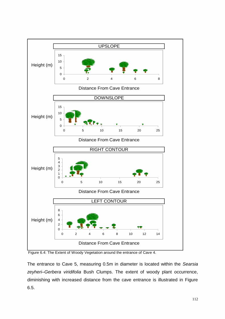
112
Height (m)
Height (m)
Height (m)
Height (m)
Figure 6.4: The Extent of Woody Vegetation around the entrance of Cave 4.
UPSLOPE
Distance From Cave Entrance
DOWNSLOPE
Distance From Cave Entrance
RIGHT CONTOUR
Distance From Cave Entrance
LEFT CONTOUR
Distance From Cave Entrance
0
5
10
15
0 2 4 6 8
0
5
10
15
0 5 10 15 20 25
0
1
2
3
4
5
0 5 10 15 20 25
0
2
4
6
8
0 2 4 6 8 10 12 14
The entrance to Cave 5, measuring 0.5m in diameter is located within the Searsia
zeyheri–Gerbera viridifolia Bush Clumps. The extent of woody plant occurrence,
diminishing with increased distance from the cave entrance is illustrated in Figure
6.5.

113
Height (m)
Height (m)
Height (m)
Height (m)
Figure 6.5 The Extent of Woody Vegetation around the entrance of Cave 5.
UPSLOPE
Distance From Cave Entrance
DOWNSLOPE
Distance From Cave Entrance
RIGHT CONTOUR
Distance From Cave Entrance
LEFT CONTOUR
Distance From Cave Entrance
0
2
4
6
8
0 5 10 15 20 25
0
0.5
1
1.5
2
2.5
0 5 10 15 20
0
0.5
1
1.5
2
2.5
0 0.5 1 1.5 2 2.5
0
0.5
1
1.5
0 2 4 6 8 10 12 14
The entrance to Cave 6, measuring 2.5m in diameter is located within the Searsia
zeyheri–Elionurus muticus Woodland. The extent of woody plant occurrence,
diminishing with increased distance from the cave entrance is illustrated in Figure
6.6.

114
Height (m)
Height (m)
Height (m)
Height (m)
Figure 6.6 The Extent of Woody Vegetation around the entrance of Cave 6.
UPSLOPE
Distance From Cave Entrance
DOWNSLOPE
Distance From Cave Entrance
RIGHT CONTOUR
Distance From Cave Entrance
LEFT CONTOUR
Distance From Cave Entrance
0
5
10
0 5 10 15 20
0
1
2
3
4
0 5 10 15
0
5
10
15
0 5 10 15 20
0
1
2
3
4
0 5 10 15 20 25
The entrance to Cave 7, measuring 10m in diameter is located within the Ficus
cordata subsp. salicifolia–Euclea crispa Woodland. The extent of woody plant
occurrence, diminishing with increased distance from the cave entrance is illustrated
in Figure 6.7.

115
Height (m)
Height (m)
Height (m)
Height (m)
Figure 6.7 The Extent of Woody Vegetation around the entrance of Cave 7.
RIGHT CONTOUR
Distance From Cave Entrance
LEFT CONTOUR
Distance From Cave Entrance
UPSLOPE
Distance From Cave Entrance
DOWNSLOPE
Distance From Cave Entrance
0
5
10
15
0 5 10 15 20 25
0
5
10
15
0 5 10 15 20 25
0
2
4
6
8
0 5 10 15 20 25
0
2
4
6
8
0 5 10 15 20
The entrance to Cave 8, measuring 1.5m in diameter is located within the Euclea
crispa–Cussonia paniculata Woodland. The extent of woody plant occurrence,
diminishing with increased distance from the cave entrance is illustrated in Figure
6.8.

116
Height (m)
Height (m)
Height (m)
Height (m)
Figure 6.8 The Extent of Woody Vegetation around the entrance of Cave 8.
RIGHT CONTOUR
Distance From Cave Entrance
LEFT CONTOUR
Distance From Cave Entrance
UPSLOPE
Distance From Cave Entrance
DOWNSLOPE
Distance From Cave Entrance
0
24
68
10
0 5 10 15
0
24
68
10
0 5 10 15 20 25
02468
0 2 4 6 8
0
2
4
6
8
10
0 5 10 15 20
The entrance to Cave 9, measuring 3.5m in diameter is also located within the
Euclea crispa– ussonia paniculata Woodland. The extent of woody plant occurrence,
diminishing with increased distance from the cave entrance is illustrated in Figure
6.9.
117
Height (m)
Height (m)
Height (m)
Height (m)
Figure 6.9 The Extent of Woody Vegetation around the entrance of Cave 9.
RIGHT CONTOUR
Distance From Cave Entrance
LEFT CONTOUR
Distance From Cave Entrance
UPSLOPE
Distance From Cave Entrance
DOWNSLOPE
Distance From Cave Entrance
0
2
4
6
8
0 10 20 30
0
2
4
6
0 5 10 15 20
0
2
4
6
0 5 10 15 20 25
0
5
10
0 5 10 15 20
For purposes of this initial comparative analysis between cave entrance size and the
extent to which this influences the surrounding vegetation, the extent to which woody
vegetation was still encountered from each respective cave entrance was accepted
as an indicator of influence.

118
The last woody plant encountered within 20m of the previous woody plant was taken
to be the final extent, that is to say that if only herbaceous plants were encountered
from a woody plant last measured at 7m for example up until the next encountered
only at 30m away, the maximum distance considered for that cave would remain 7m.
In order to obtain at least a basic statistical means of verification of influence of cave
entrance size on the surrounding vegetation, the mean linear extent of woody
vegetation occurrence from each cave entrance (obtained whereby the Upslope,
Downslope, Left Contour and Right Contour distances were averaged) was
calculated (Table 6.3) and thereafter correlated (Pearson product moment
correlation coefficient) against the cave entrance sizes.
Table 6.3: The Mean Extent of Woody Vegetation Occurrence per Cave.
This basic correlation analysis between the mean measurement of woody vegetation
extent and cave entrance size yielded a result of r= 0,633418. This verifies
statistically that there is a fairly strong positive linear correlation between the size of
the cave entrances and the distance to which the woody vegetation surrounding
Cave
Cave
Entrance
Size (m)
Upslope
(m)
Downslope
(m)
Contour
(L) (m)
Contour
(R) (m)
Mean
(m)
1 1.5 16 15 14 25 17.5
2 1 6 19 13 5 10.75
3 6 7 13 24 15 14.75
4 2 7 21 22 12 15.5
5 0.5 20 18 1 12 12.75
6 2.5 18 13 0 21 17.33333
7 10 23 23 23 16 21.25
8 1.5 14 21 7 17 14.75
9 3.5 25 17 22 19 20.75

119
these cave entrances extends, suggesting the likelihood of a positive influence of
cave entrance size on the surrounding vegetation. The smaller cave entrances
therefore coincided with the lowest mean extent of woody vegetation occurrence
from cave entrances and the larger cave entrance sizes coincided with the highest
extent of woody vegetation occurrence from cave entrances (Figure 6.3). For
example, cave 2 with an entrance diameter of only 1 meter was found to coincide
with woody vegetation that extended for an average of 10.75 meters whilst cave 7
with an entrance diameter of 10 meters was found to coincide with woody vegetation
that extended for an average of 21.25 meters.
This relationship of influence is further illustrated in figure 6.10 wherein the mean
extent of woody vegetation occurrence (x-axis) is plotted against each of the 9 cave
entrance size diameters (y-axis), with the trend line clearly indicating the relationship
whereby the extent to which Woody vegetation is encountered increases with an
increase in cave entrance size.
Figure 6.10: A Graphical Representation of the Relationship between Cave Entrance
size and the extent of Woody Plant occurrence.

120
6.4. References
BEZUIDENHOUT, H.; BREDENKAMP, G.J. & THERON, G.K. 1994. A classification
of the vegetation of the western Transvaal dolomite and chert grassland, South
Africa. South African Journal of Botany, 1994. 60(3): 152-161.
BREDENKAMP, G.J. & BROWN, L.R. 2003. A reappraisal of Acocks‟ Bankenveld:
Origin & diversity of Vegetation Types. South African Journal of Botany 69(1) 7-26.
BROWN, L.R.; MARAIS, H. & BARRETT, L. 2005. Vegetation classification as the
basis for baboon management in the Bourke‟s Luck Section of the Blyde Canyon
Nature Reserve, Mpumalanga. Koedoe 48(2): 71-92.
COETZEE, B.J. 1974. A Phytosociological classification of the vegetation of the Jack
Scott Nature Reserve. Bothalia 11: 329-347.
CRADLE OF HUMANKIND MGMT AUTHORITY. 2003. Land Use Audit report.
Gauteng Dept. Agriculture, Conservation and Environment, Johannesburg.
DUIGAN, P.S & BREDENKAMP, G.J. 2003. The Vegetation Classification of Letamo
Estates in North-Western Gauteng. Bsc. (Hons) Thesis. University of Pretoria.
EDWARDS, D. 1983. A broad scale structural classification of vegetation for
practical purposes. Bothalia 14, (3&4): 705-712.
GAMBLE, F.M. 1980. Disturbance of underground wilderness in karst caves. Intern.
J. Environmental Studies.1981. Vol. 18. pp. 33-39.
MATTHEWS, W.S. 1991. Phytosociology of the North-eastern Mountain sourveld. M.
Sc. Dissertation. University of Pretoria. Pretoria.
PALGRAVE, K.C. 2002. Trees of Southern Africa. 3rd edn. Struik Publishers, Cape
Town.
VAN OUTSHOORN, F. 1999. Guide to the grasses of Southern Africa. Briza
Publishers, Pretoria.
VAN WYK, A.E. & MALAN, S.J. 1998. Field guide to the wildflowers of the Highveld.
2nd edn. Struik Publishers, Cape Town.

121
VAN WYK, A.E. & VAN WYK, P. 1997. Field guide to the trees of Southern Africa.
Struik Publishers, Cape Town.

122
CHAPTER 7
CONCLUSIONS
7.1. Summary
The classification of vegetation into relatively homogenous units or plant
communities remains the fundamental requirement in the application of resource
management practices to any given area as these communities represent
ecosystems. Each ecosystem has its own unique thresholds and tolerances. Habitat
factors play an important role in the determination of where these communities will
persist and conversely where they will be restricted.
Anthropogenic influence, as well as abiotic processes such as fire and climate can
further diversify the landscape, thereby adding to the segregating effect that naturally
occurring structural environmental factors (geology, soil and topography etc.) already
have on the spatial location of plant communities. The degree to which this
segregation is investigated, and the associated plant communities are described is
directly proportional to the required management associated objectives for the area
thereby requiring the correct application of scale into any floristic assessment
undertaken.
The objectives of this study, namely to classify and describe the natural vegetation of
the COH WHS on a suitably useful local scale, to relate the different plant
communities identified to Land Types and to establish whether caves influence the
composition and structure of the vegetation surrounding the entrances of the caves
were successfully met.
Sampling through the application of the habitat stratification method as described by
Bezuidenhout (1993) that originally used Land Types as a primary method of
stratification further refined using terrain units was successfully used, albeit that it
was adapted further through the application of modern GIS and GPS techniques to
aid with in-field sample site placement. The resultant stratified random approach to
sampling (Werger 1973) ensured statistical acceptability.

123
The use of the numerical classification technique TWINSPAN (Hill. 1979) as a first
approximation of the vegetation units, followed by further refinement using Braun-
blanquet procedures as previously used by Fuls (1993), Coetzee (1993) and
Bezuidenhout (1993) proved to be highly successful, with twenty nine plant
communities and two variants being identified in the COH WHS. The described plant
communities can be easily recognised in the field, with the resultant ecological units
being regarded as scientifically sound and therefore useful in any land use planning
exercise. They should form the first point for departure in the establishment of a long
term monitoring and evaluation program as required in terms of World Heritage Site
reporting mechanisms.
Within the grassland communities a total of 12 plant communities were identified with
2 variants. The spatial distribution of the major communities is largely associated
with the location of various abiotic factors linked to land types, namely geology and
soil, as well as topography linked to altitudinal differences. Secondary associated
finer scale abiotic factors such as aspect, slope (degrees), soil depth, clay content
and percentage surface rock differentiate between and spatial locations of the sub
communities and associations within these communities (Figure 7.1).
The grassland communities of the COH WHS remain largely intact in those areas not
negatively impacted on through anthropogenic activities such as agriculture (Anon
1987). Agricultural activities are, and were, largely opportunistically applied, with
water and ease of access proving to both be limiting factors in its application
throughout the landscape (In addition to the fundamental requirements of
appropriate soil chemistry and climate). The high degree of difficulty associated with
ploughing in the relatively rocky soils associated with the majority of the grassland
areas within the COH WHS, could be a significant contributing factor to the relatively
intact status observed in the field, with mainly only grazing having been put into
practice. Those areas more readily associated with ease of access and reliable
water, namely the flat sloped bottomlands particularly in the non dolomitic areas
show a distinct anthropogenic influence (either directly as with ploughing or indirectly
such as with an unnatural fire regime) within the species composition of the plant
communities found there.

124
The significantly under conserved nature of Bankenveld (Edwards 1972; Siegfried
1989) exponentially increases the importance of those communities within the COH
WHS that are representative of Bankenveld and that remain largely intact, namely
the Loudetia simplex – Diheteropogon amplectens Grassland community and the
Eustachys paspaloides – Sporobolus pectinatus Grassland community and their
associated sub communities. In contrast to being regarded as areas with lower
conservation potential, those anthropogenically influenced grassland communities,
namely the Hyparrhenia hirta – Vernonia oligocephala Grassland community and its
associated sub communities should rather be regarded as areas for potential
restoration and areas set aside for the continuation of successional processes that
also contribute to an increase in Biodiversity.
Despite the obvious threat that urbanization and development pose towards
grasslands, alien invasive species and the incorrect application of fire are potential
contributors to the destruction of these ecosystems and their associated processes.
Many of the alien invasive species commonly associated with the grasslands of the
Highveld are nowadays regarded as being naturalized and include the forbs, Zinnia
peruviana, Bidens spp. and Verbena brasiliensis for example. Of far greater concern
are those species able to invade pristine as well as disturbed areas for example
Campuloclinium macrocephalum. This plant is largely regarded as one of the
greatest threats to grassland biodiversity at present (South African National
Biodiversity Institute website). Wind is an agent of dispersal of many of these alien
invasive species, with the wind speeds and direction at the time of seeding (Late
Summer) providing a valuable management insight into possible monitoring sites
and areas for intervention due to being able to predict the direction and possible rate
of spread. This would suggest that ongoing monitoring into the dispersal of in
particular Campuloclinium macrocephalum needs to be implemented as a
colonization of the pristine Bankenveld within the COH WHS is likely to take place
from a north easterly direction heading south and west.
Whilst it is well documented that grasslands are fire dependent, anthropogenically
induced accidental fire as a threat would also require monitoring, with the highest
degree of flammability of the vegetation being used to predict possible ignitions
thereby inform management interventions. These unnatural fires would be most
likely when the vegetation and atmosphere is driest and when natural ignition

125
(lightning) is unlikely, usually late winter and before the first spring showers. This
time logically coincides with those months of the lowest rainfall, namely June, July
and August. During these months, the dominant wind directions would suggest that
fire could spread in a Southerly direction in the Northern sector of the COH WHS and
in a northerly direction in the southern sector of the COH WHS. Theoretically this
suggests a very high likelihood of the entire COH WHS being exposed to yearly
burns if there is no formal intervention. The establishment of a Fire Protection
Association should be regarded as an essential management action for this area,
particularly when considering that the areas most likely to result in an unnatural
ignition point, namely those areas with the highest human habitation, occur on the
perimeter of the COH WHS along the northern border (Hartebeespoort area) in the
northern sector and the south western border in the southern sector.
In the woodland areas, 10 plant communities were identified (Chapter 5), all of which
are spatially arranged throughout the landscape in response to the presence of
certain abiotic factors, in particular rock cover (size and % surface rock) aspect and
slope (Figure 7.2). The classification of the woodland plant communities included the
bush clumps associated with the entrances of caves. The increase in percentage soil
surface rock linked also to the size of the rocks (also a common occurrence around
cave entrances) appears to show an affinity towards an increase in woodland
communities. Increased shading and moisture retention could be contributing factors
towards this, however a more likely scenario would appear to be the sheltering from
or the minimising of the intensity of fires that are a yearly event throughout the COH
WHS. Alien invasive species that are prevalent in the woodland areas of the COH
WHS are dominated by those species that are fruit producing and are encountered
where birds and or primates are found to roost or congregate. Fortunately these
invasive aliens are not cryptic and can be controlled when encountered. The lack of
ease of access afforded the woodland areas of the COH WHS has resulted in the
limited exposure of these areas to formal agriculture and therefore aided in their
preservation in a natural state. In areas where the grasslands have been negatively
impacted by fire or agriculture, “artificial” woodlands often occur, however these are
easily identified due to the complete dominance of only a single woody species,
often with most individuals belonging to the same age class. The inclusion of these
successional woodlands should form part of a restoration plan for the COH WHS.
126
The cave entrance vegetation communities (Chapter 6) consists of seven plant
communities that are spatially distributed in response to the various abiotic habitat
factors as shown in the cave entrance vegetation dendrogram (Figure 7.3). The
presence or absence of chert in large quantities within the geology of the cave
entrances appears to be the main differentiating factor between the major plant
communities and this appears to be linked to Land Type. Aspect and the degree of
rockiness appear to differentiate between the various sub communities. The degree
of rockiness of the cave entrances is often as a result of artificially created rock piles
that are present as a result of the Lime mining industry that developed in support of
the gold mining activities in the late 1800‟s and early 1900‟s. The conservation value
of the cave entrance vegetation is unquestionable even if these woodlands are
present only as a result of artificial rock piles in some instances. Cave entrance
Woodlands assist in having a regulating effect on the subterrainean ecosystems
through shading and therefore cooling the entrance zones of the caves. These caves
are themselves refuges for many endangered and endemic cave dwelling species or
“Trogolobites”.
As can be seen, the thorough understanding of the natural vegetation occurring
within the COH WHS remains the foundation upon which informed management
decisions should be based and as such this phytosociological classification of the
plant communities should be seen as an integral part and departure point from which
to implement any management strategy. A justification for the ongoing protection of
the COH as not only a World Heritage Site of cultural significance, but also as a vital
component in the conservation of „Bankenveld‟ and sub terrainean ecosystems
associated with karst landscapes could thereby be accomplished.

127
GRASSLAND VEGETATION
DOLOMITE, SHALE or
QUARTZITE
(1)
Ib, Fa, Ba Land Types
Soils 100-1000mm Deep
Moderate to Steep Slopes
<70% Rock
Southern Slopes
5-26 deg. Slope
South Facing
30-70% Rock
Soil Texture 2,3
Terrain Form 2,3
1.3
Westerly Slopes
<23 deg. Slope
WesterlyAspect
5-60% Rock
Soil Texture 2
Terrain Form 2,3
1.4
>80% Rock
20-26 deg. Slope
South & East Aspect
80% Rock
Soil Texture 2
Terrain Form 3
1.1
Flat Slopes
High Altitude
1-4 deg. Slope
Variable Aspect
2-30% Rock
Soil Texture 2,3
Terrain Form 1,2
1.2
(2)
Fa Land Type
Soils < 250mm Deep
<15 deg. Slope
Variable Aspect
30-70% Rock with Rock Sheets
Soil Texture 2
Terrain Form 1,2
2
NON-DOLOMITE
Ab, Ba, Bb Land Types
Andesite/ Arenite
Deep Soils
>400mm Deep
<2 deg. Slope
Variable Aspect
<5% Rock
Soil Texture 3
Terrain Form 3,4
3.2
Shallow Soils
<250mm Deep
(3.1)
2-20 deg. Slope
Anthropogenic Influence
Variable Aspect
5-70% Rock
Soil Texture 2,3
Terrain Form 3,4
Lower % Rock <25%
Soil Texture 2
Flat Slope
Terrain 1,4
3.1.1
Higher % Rock <70%
Soil Texture 3
Gentle to Moderate Slope
Terrain 2,3
3.1.2
Quartzite
5-7 deg. Slope
Northerly Aspect
10-30% Rock
Soil Texture 2
Terrain Form 3
3.3
Greenstones:
Serpentine, Amphibolite & Schist
Seepage areas & drainage lines
1-5 deg. Slope
20-40% Rock
1-3 deg. Slope
North & West Aspects
30-50% Rock
Soil Texture 3,4
Terrain 3
Soils 300-350mm Deep
3.4
3-6 deg. Slope
South & East Aspects
15-30% Rock
Soil Texture 3
Terrain 3
Soils 350-400mm Deep
3.5
Figure 7.1 Dendrogram showing habitat factors leading to the establishment of grassland plant
communities

128
WOODLAND VEGETATION
NON DOLOMITE AREAS
SHALLOW SOILS
HIGHER % SOIL SURFACE ROCK
(2)
Steep Slope (11-35 deg.)
All Aspects
Terrain Form 2 and 3
Ib, Ba and Bb Land Types
Shallow Soils (150-350mm.)
Soil Texture 2 and 3
50-90% Soil Surface Rock
Andesite (Ib and Bb Land Types)
Gneiss (Ba Land Type
Ib Land Type
Andesite
11-30 deg. slope
Terrain Form 3
Shallow Soils (200-250mm.)
Soil Texture 2
30-70% Soil Surface Rock
2.1
Bb Land Type
Gneiss
19-21 deg. Slope
Terrain Form 2
North Facing
Moderate Soils (350mm.)
Soil Texture 3
60% Soil Surface Rock
Large Boulders
2.2
Ib Land Type
Andesite
20 deg. Slope
Terrain Form 2
East Facing
Shallow Soils
(300mm.)
Soil Texture 3
80% Soil Surface Rock
2.3
Ib Land Type
Andesite
28-35 deg. Slope
Terrain Form 2 and 3
West Facing
Shallow to Moderate Soils (300-350mm.)
Soil Texture 2
90% Soil Surface Rock
2.4
DEEPER SOILS
LOWER % SOIL SURFACE ROCK
Very Steep Slopes (>25 deg.)
South Facing
Terrain Form 2 and 3
I b Land Type
Deep Soils (450-500mm.)
Soil Texture 4
<5% Soil Surface Rock
Shale
Along Drainage Lines
6
Moderate Slope (10-14 deg.)
West Facing
Terrain Form 3 and 4
Ab and Ib Land Types
Deep Soils (450-500mm.)
Soil Texture 4
<20% Soil Surface Rock
Diabase Dykes
3
DOLOMITE AREAS
(4)
Flat to Steep Slopes (1-20 deg.)
South Facing
Terrain Form 1,2 and 3
Cave Entrances
Fa Land Type
Shallow Soils (50-150mm.)
Soil Texture 2
60-80% Soil Surface Rock
Large Rock Outcrops
Dolomite
Flat Slopes (1-9 deg.)
South Facing
Terrain Form 1 and 2
Shallow Soil (50-150mm.)
Soil Texture 2
60-70% Soil Surface Rock
4.1
Moderate to Steep Slopes (10-15 deg.)
South Facing
Terrain Form 2 and 3
Shallow Soil (50-150mm.)
Soil Texture 2
70-80% Soil Surface Rock
4.2
Steep Slopes (>15 deg.)
North Easterly Facing
Terrain Form 3
Cave Entrances
Ib Land Type
Shallow Soils (150-300mm.)
Soil Texture 2
80% Soil Surface Rock
Dolomite
5
VARIABLE AREAS
(1)
Steep Slope (10-25 deg.)
All Aspects
Terrain Form 3
Fa and Ib Land Types
Shallow Soils (150-350mm.)
Soil Texture 2
50-80% Soil Surface Rock
Large Boulders and Chert outcrops
Andesite (Ib Land Type)
Dolomite (Fa Land Type)
Fa Land Type
Steep Slopes (14-23 deg.)
North Facing
Limestone Rich
Terrain Form 3
Shallow Soils (150-350mm.)
Soil Texture 2
40-80% Soil Surface Rock
Dolomite- Non Cave Entrance
1.1
Fa and Ib Land Types
Steep Slopes ((9-25 deg.)
Never North Facing
Terrain Form 2 and 3
Shallow Soils (150-350mm.)
Soil Texture 2
40-80% Soil Surface Rock
Dolomite or Andesite
1.2
Figure 7.2 Dendrogram showing habitat factors leading to the establishment of woodland plant
communities

129
CAVE ENTRANCE VEGETATION
Ib Land Type
(1)
Shallow Soils (300-400mm.)
Southerly Orientated
Steep Slopes (9-20 deg.)
Terrain Form 2 and 3
Soil Texture 2
70-80% Soil Surface Rock
Chert Rich Dolomite
South Facing
Steep Slopes (>10 deg.)
Terrain Form 3
Shallow Soil (300-400mm.)
Soil Texture 2
80% Soil Surface Rock
1.1
West South West Facing
Moderate to Steep Slopes (10-20 deg.)
Terrain Form 2
Shallow Soil (300-400mm.)
Soil Texture 2
70-75% Soil Surface Rock
1.2
(2)
Very Shallow Soils (50-150mm.)
North Facing Slopes
Very Steep Slope (>20 deg.)
Soil Texture 2
Large Rock Outcrops
Dolomite
80% Soil Surface Rock
2.3
Fa Land Type
(2)
Very Shallow Soils (50-150mm.)
South Facing Slopes
Variable slope (Flat-Steep)
Terrain Form 1,2 and 3
Soil Texture 2
60-80% Soil Surface Rock
Large Rock Outcrops
Dolomite
Flat Slope (1-7 deg.)
60-70% Soil Surface Rock
Terrain Form 1 and 2
Shallow Soils (150-250mm.)
Loose Boulders and Rock Outcrops
2.1
Moderate to Steep Slope (9-20deg.)
70-80% Soil Surface Rock
Terrain Form 2 and 3
Shallow Soils (50-250mm.)
Large Rock Outcrops
2.2
Figure 7.3 Dendrogram showing habitat factors leading to the establishment of cave entrance
plant communities

130
7.2. Future research
In addition to the diagnostic plant species listed in the refined
phytosociological tables in chapters 4, 5 and 6, numerous “companion
species” (Kent and Coker 1992.) were omitted for simplification purposes due
to the fact that they occur at low cover abundances across a wide distribution
range throughout the study area. Whilst not essentially required for any
syntaxonomical aspect of this study, these additional species together with
those diagnostic species in the tables shown attest to the high species
richness of the area and could form part of later floristic analyses into the
various families, genera and species found to occur within the COH WHS.
The compilation of a botanical species list and identification of Red Data
species should be a consideration into future research outputs. Whilst a
strong positive linear correlation was shown to exist between the size of cave
entrances and the extent to which the woody vegetation was found to persist
from the cave itself (possibly due to the small sample size (n=9)), the
statistical significance thereof remains untested. The exact nature and
mechanisms of this relationship, as well as the statistical significance thereof
also requires further investigation, as there are still other possible correlating
factors for this relationship, for example subterranean void size and
associated air moisture content of the cave etc.
With all of the baseline vegetation work now available, its incorporation into an
overarching and legally required Management Plan for this World Heritage
Site should be undertaken. Follow up refinement of the data available should
be consolidated into a “Bioregional Management Plan” as allowed for in the
National Environmental Management: Biodiversity Act in an attempt to secure
further protection of this highly valuable Karst ecosystem.

131
7.3. References
ANON. 1987. Agriculture in South Africa. 2nd Edition. Chris van Rensburg,
Johannesburg.
BEZUIDENHOUT, H. 1993. Syntaxonomy and synecology of western
Transvaal grasslands, South Africa. Ph.d. Thesis. University of Pretoria,
Pretoria.
COETZEE, J.P. 1993. Phytosociology of the Ba and Ib land types in the
Pretoria-Witbank-Heidelberg area. MSc. Thesis, University of Pretoria,
Pretoria.
EDWARDS, D. 1972. Conservation areas in relation to Veld Types.
Unpublished ms. Bot. Res. Inst. Pretoria. (In press Kudu).
FULS, E.R. 1993. Vegetation ecology of the northern Orange Free State.
Ph.D. dissertation, University of Pretoria, Pretoria.
HENDERSON, M.; FOURIE, D.M.C.; WELLS, M.J., & HENDERSON, L. 1987.
Declared weeds and alien invader plants in South Africa. Department of
Agriculture and Water Supply. Government Printer. Pretoria.
HILL, M. O. 1979. TWINSPAN- A fortran program for arranging multivariate
data in an ordered two-way table classification of individuals and attributes.
Cornell University, New York.
KENT, M. & COKER, P. 1992. Vegetation description and Analysis – a
practical approach. John Wiley and Sons. Chinchester, England.
SIEGFRIED, W.R. 1989. Preservation of species in southern African nature
reserves. B.J. Huntley (ed.) Biotic Diversity in southern Africa: Concepts and
Conservation. Oxford University Press, Cape Town.
WERGER, M.J.A. 1973. Phytosociology of the upper Orange River Valley,
South Africa. Ph.D. dissertation, University of Nijmegen, Nigmegen.

132
Acknowledgements
My supervisor Professor L.R. Brown and co-supervisor Professor G.J.
Bredenkamp are thanked for their ongoing guidance and leadership, with
additional thanks extended to:
The Gauteng Department of Agriculture and Rural Development for affording
me the opportunity to conduct the required field work.
The landowners and managers in the Cradle of Humankind for their
accommodating nature especially:-
Mr. Hennie Visser
The Nash family.
Mr. Benji Liebman
Mr. Mark Reed
Mr. Stephan du Toit.
Mr. Gavin Doyle
Mr. Ed Hern
Mr. Frank Wessels
Mr. Willem Pretorius and Magales Gate Reserve.
Mr. John McLarren and Kloofzicht Lodge.
Mr. Alex Richter and Aloe Ridge.
Mr. Peter van der Merwe
Mr. Willie Joubert
Mr. Manie van Aaswegen.

133
A special acknowledgement of thanks is extended to Mr. Patrick Duigan for
his support and assistance in the field, as well as to Mrs. Lorrain Mills for her
assistance in the identification of some of the plant species and Ms. Pita
Compaan for her assistance in the compilation of GIS maps. Mrs. Lindi Eloff is
especially thanked for her ongoing support and understanding, as well as her
ongoing assistance in the field and the home, especially as the hours grew
longer and the patience shorter.