the philosophy of sustainable spatial development
TRANSCRIPT

1
Globalisation has brought on more and more challenges for our economic, social and spatial development. We are confronting questions about how to increase the competitiveness of the economy, improve the living conditions for our population and preserve our natural resources at the same time. The question about sustainable development is still in the core of our interest as it represents a dynamic balance, which must be achieved in each particular area. Such principle of understanding the relationship between development and conservation had already been incorporated in the Slovenian spatial planning operations decades ago, which the present text also illustrates.
»Development is continuing on Slovene territory and it is going to radically transform the country’s appearance. In the more than thousands years of its existence this has never happened in such a short period of time. On the one hand, a generation of farmers witness a disappearing of the vast countryside, and on the other the basic structure of the productive land is changing due to the modernization of agriculture. Forest cover is increasing and as a result we are approaching top position in Europe. As a result of a continuing trend in settlement, the expansion of cities and villages in correlation with an increase in the transportation network and energy devices, new capacities for relaxation, sport and tourism are opening up. All of this demands on space and again raises the question on how to make a decision about the values reflecting how our ancestors created these values on their own over centuries of inhabiting their own territory. There is quite a lot of knowledge about this as well as instruments that would ensure proper use. However, it is becoming more and more apparent that is insufficient to only have knowledge about what is right and how to dispose of this knowledge to transform into reality and then define by laws. The different impulses are also necessary. These stem from a developed social consciousness, which is capable of analysing material and ethical values and according to precedence adequately classify them. It seems that the formation of a consciousness about the importance of the environment is one of the key factors that is going to take part in the decision making about the future development of our territory and the fate of our material heritage. A developed consciousness is what we are going to need the most because it is the most reliable guide, which extends to the comprehensive assessments, gives precedence to historical-development over this very moment, long-term over-short term and when necessary, it also renounces the material world. The coastal area of the Slovene region of Primorska, we should first provide a basic program of activities and use, which originates from spatial characteristics. The port, which is the window to the world certainly falls into this category as well as the fleet of vessels, further sea fishing, a sober portioned outof tourism activities, salt production and of course agriculture, with its authentic Mediterranean specialities and cultures, which also give the region a distinct feature. Finally, the most significant part is that the coast enables Slovenes and others, especially the youth during their time of exploration, to experience the sea and its incomprehensible extensiveness, where it meets the sky at the horizon. This is why an accessible coastline is necessary. Connecting, integrated spatial planning, should enable the integration and moving of the activities to the warm coastal area, which depends on the sea and top-level activities – fishing, maritime traffic, recreation, schools, research institutes, financial institutions, information technology, communication and computers – and placing human settlement, agriculture and other activities in the hinterland.«
The Philosophy of Sustainable
Spatial Development
(From the book Slovenske krajine (Slovene Territory), author Dušan Ogrin, DZS, Ljubljana 1989; selected and adapted by B. Kontić)

2 3
CAMP (Coastal Area Management Programme) is a programme within the framework of MAP (Mediterra-nean Action Plan), which is directed towards sustainable management of the coastal area and incorporates environmental protection with development planning.
Two types of projects had been implemented within the framework of CAMP Slovenia: Individual ones, dealing with the selected issues and horizontal ones, which have the task of connecting all activities into an integral process.
INDIVIDUAL PROJECTS:• Conception of Spatial Development of South Primorska• Detailed Conception of Coastal Strip Spatial Arrangements • Management of Protected areas (of nature)• Regional Strategy for the Sustainable Tourism Development• Regional Programme of Environmental and Water Resources Protection• Sensitivity Maps of the Slovenian Coast
HORIZONTAL PROJECTS:• System and Prospective Sustainability Analysis • Regional spatial information system• Programme of Public Participation, Training and promotion
For the most part CAMP Slovenia is aimed at spatial planning and issues that are related to it. The main project within the framework of the program is the preparation of a spatial development draft for South Primorska, which is also one of the most important projects within the regional development programme for South Primorska.
The Conception for Spatial Development of South Primorska is a fundamental strategic document on spatial planning, which will have an effect on the features of future spatial development in the region, as the aim of sustainable development defines the spatial integration of important national and regional strategies and programs. Special attention was given to spatial planning arrangement for the narrow coastal strip, management of protected areas and the protection of water resources.
Contemporary methodologies and tools for spatial planning were also tested within the framework of the project, including the strategicenvironmental impact assessment, scenario planning and an evaluation for the capacity of the environment for tourism development with an emphasis on public participation and promoting of the project to the public.
CAMP Slovenia
Introduction
The CAMP Slovenia Program
Detailed conception of coastal strip spatial arrangement
The threat analysis due to the possible industrial accidents (within the framework of preparing a new spatial plan for the municipality of Koper)
Targeted research project: Incorporation of the Port of Koper into the framework of sustainable development of the Coast-Karst region
The Integrated spatial-planning arrangement for the Port of Koper
Public participation in development planning
Selected examples of integrated spatial planning on the Slovene coastline
4 5
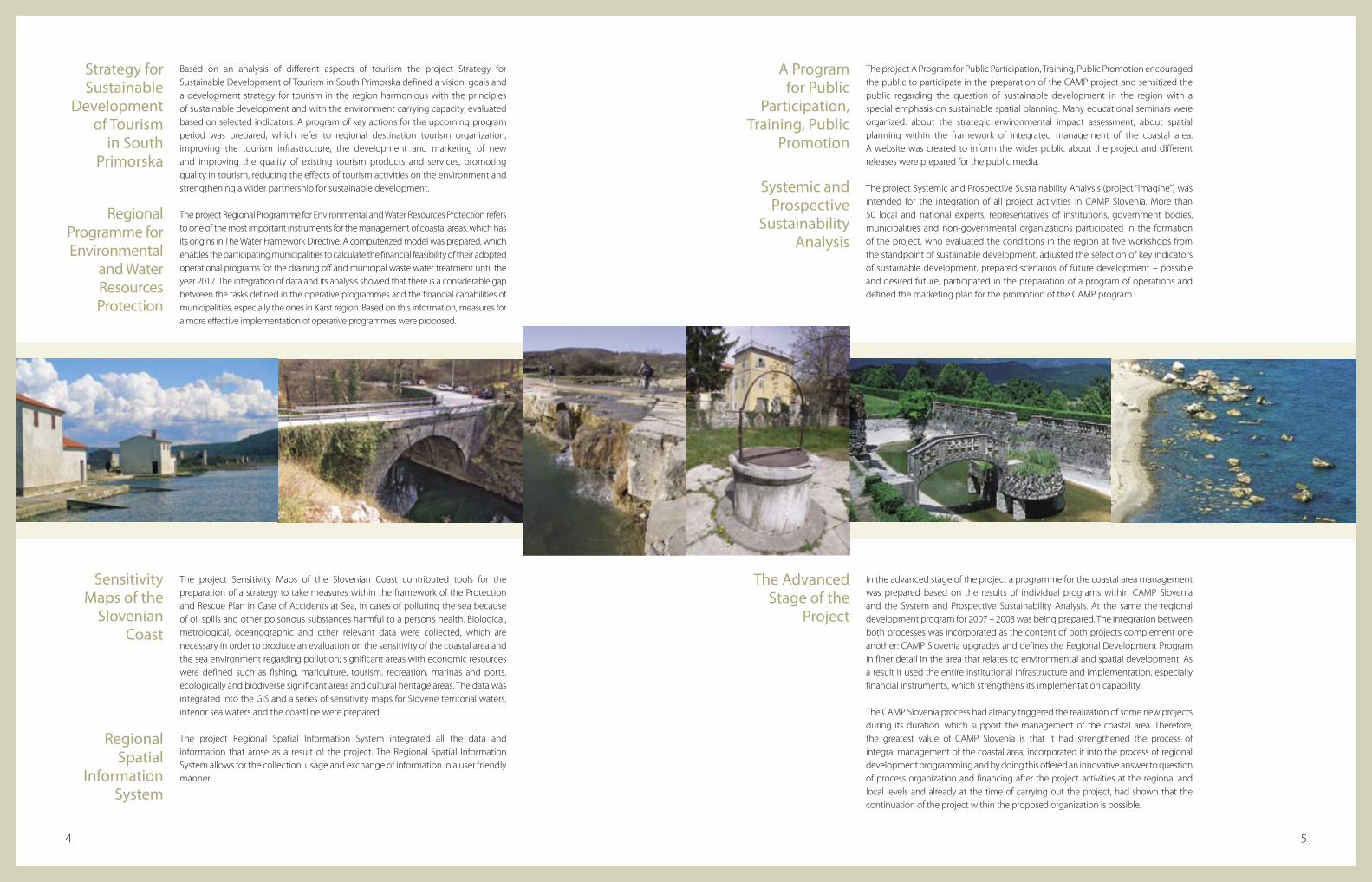
Based on an analysis of different aspects of tourism the project Strategy for Sustainable Development of Tourism in South Primorska defined a vision, goals and a development strategy for tourism in the region harmonious with the principles of sustainable development and with the environment carrying capacity, evaluated based on selected indicators. A program of key actions for the upcoming program period was prepared, which refer to regional destination tourism organization, improving the tourism infrastructure, the development and marketing of new and improving the quality of existing tourism products and services, promoting quality in tourism, reducing the effects of tourism activities on the environment and strengthening a wider partnership for sustainable development.
The project Regional Programme for Environmental and Water Resources Protection refers to one of the most important instruments for the management of coastal areas, which has its origins in The Water Framework Directive. A computerized model was prepared, which enables the participating municipalities to calculate the financial feasibility of their adopted operational programs for the draining off and municipal waste water treatment until the year 2017. The integration of data and its analysis showed that there is a considerable gap between the tasks defined in the operative programmes and the financial capabilities of municipalities, especially the ones in Karst region. Based on this information, measures for a more effective implementation of operative programmes were proposed.
The project A Program for Public Participation, Training, Public Promotion encouraged the public to participate in the preparation of the CAMP project and sensitized the public regarding the question of sustainable development in the region with a special emphasis on sustainable spatial planning. Many educational seminars were organized: about the strategic environmental impact assessment, about spatial planning within the framework of integrated management of the coastal area. A website was created to inform the wider public about the project and different releases were prepared for the public media.
The project Systemic and Prospective Sustainability Analysis (project “Imagine”) was intended for the integration of all project activities in CAMP Slovenia. More than 50 local and national experts, representatives of institutions, government bodies, municipalities and non-governmental organizations participated in the formation of the project, who evaluated the conditions in the region at five workshops from the standpoint of sustainable development, adjusted the selection of key indicators of sustainable development, prepared scenarios of future development – possible and desired future, participated in the preparation of a program of operations and defined the marketing plan for the promotion of the CAMP program.
The project Sensitivity Maps of the Slovenian Coast contributed tools for the preparation of a strategy to take measures within the framework of the Protection and Rescue Plan in Case of Accidents at Sea, in cases of polluting the sea because of oil spills and other poisonous substances harmful to a person’s health. Biological, metrological, oceanographic and other relevant data were collected, which are necessary in order to produce an evaluation on the sensitivity of the coastal area and the sea environment regarding pollution; significant areas with economic resources were defined such as fishing, mariculture, tourism, recreation, marinas and ports, ecologically and biodiverse significant areas and cultural heritage areas. The data was integrated into the GIS and a series of sensitivity maps for Slovene territorial waters, interior sea waters and the coastline were prepared.
The project Regional Spatial Information System integrated all the data and information that arose as a result of the project. The Regional Spatial Information System allows for the collection, usage and exchange of information in a user friendly manner.
In the advanced stage of the project a programme for the coastal area management was prepared based on the results of individual programs within CAMP Slovenia and the System and Prospective Sustainability Analysis. At the same the regional development program for 2007 – 2003 was being prepared. The integration between both processes was incorporated as the content of both projects complement one another: CAMP Slovenia upgrades and defines the Regional Development Program in finer detail in the area that relates to environmental and spatial development. As a result it used the entire institutional infrastructure and implementation, especially financial instruments, which strengthens its implementation capability.
The CAMP Slovenia process had already triggered the realization of some new projects during its duration, which support the management of the coastal area. Therefore, the greatest value of CAMP Slovenia is that it had strengthened the process of integral management of the coastal area, incorporated it into the process of regional development programming and by doing this offered an innovative answer to question of process organization and financing after the project activities at the regional and local levels and already at the time of carrying out the project, had shown that the continuation of the project within the proposed organization is possible.
Strategy for Sustainable
Development of Tourism
in South Primorska
Regional Programme for Environmental
and Water Resources Protection
Sensitivity Maps of the
Slovenian Coast
Regional Spatial
Information System
A Program for Public
Participation, Training, Public
Promotion
Systemic and Prospective
Sustainability Analysis
The Advanced Stage of the
Project

6 7
A Vision, Strategy and Management Program for the Coastal Area of Slovenia
5. A rich cultural heritage has been modernized and adequately protected as it is successfully integrated into developmental processes. Reconstructed historical cities and village centres offer developed tourism services and attractive accommodation capacities have been developed in the countryside.
6. The public utility infrastructure, especially the draining off of water and waste water treatment, for managing waste and the supply of quality drinking water has been developed and supports sustainable development, as innovative methods of managing natural resources have been implemented.
7. The quality of the sea environment has been improved as the biological-chemical conditions of the sea are better.
CAMP Slovenija
The vision of development in 2015:1. The University of Primorska with its university
infrastructure, whereby facilities are distributed between Slovene Istra and The Karst – Brkini, is internationally recognized and is known as a progressive force in the region, as it is integrated in the regional economic environment and is a strong generator of economic development.
2. The motor of development includes innovations in all areas of social life: economic, in the public sector, in the area of culture and protecting the environment. University of Primorska, the sphere of scientific research and supportive structures play a key role here.
3. Slovene Istra – the coast and the Karst-Brkini subregion are well known throughout the world as a tourist destination for active holidays. The
8. The ecologically problematic economic activities have been restructured.
9. A sustainable mobility mode has been implemented harmonized with the demands of the local population and primary economic activities. Public transport is efficient and user friendly. An attractive infrastructure for sustainable mobility has been implemented. Maritime traffic plays an important role.
10. Spatial development ensures a more balanced distribution of settlement in the region. The environment, biodiversity and cultural heritage areas and outstanding landscapes are safe from urbanization and are intended for future generations to enjoy. Spatial pressures found directly along the coastal strip have been effectively controlled.
The vision originates from the analytical phase
of the project, which was prepared at the level
of individual CAMP Slovenia projects, especially
the project Spatial Development Draft for South
Primorska and Detailed Conception of Coastal
Strip Spatial Arrangements and at the level
of a System and Prospective Sustainability
Analysis; based on the data gathered from a core
project group, existing trends and taking into
consideration the viewpoints of key stakeholders
as well as expert spatial scenarios defined in the
Detailed Spatial Development of the Coastal Strip.
The vision of development, which expresses the
desired conditions for the region in 2015 can be
transformed into the following slogan:
tourism infrastructure is well adjusted to the natural environment and cultural heritage of the region being attractive and well organized. An important part of the local economy is based on sustainable tourism and organic production of local agricultural products. Protected areas are an important generator of development for the region, especially in the rural hinterland in connection with tourism.
4. The biodiversity, natural environment and cultural heritage have been effectively preserved and modernized. Values regarding the natural environment are adequately protected and managed. Sustainable development of cultural and natural treasures from the region has been enabled: the protected Sečovlje Salt Pans, the regional park of Snežnik, Lipica with its world renowned Lipizzaner horses and the Škocjanske jame Caves.
» The spatial development of South Primorska supports sustainable welfare, equitable distribution of rewards benefits, high quality standard of living and in addition it also protects and strengthens the natural, spatial and cultural goods. «

The strategy originates from the establishment of major problems and deficiencies of the current condition and defined vision or situation, which would have to be achieved by the year 2015.
Major problems and deficiencies:
• The concentration of settlement and activity on the limited coastal strip is explicit, which causes spatial conflicts and the degradation of the natural environment, ecosystems, cultural heritage, outstanding landscapes, and other undesirable phenomena;
• The public utility infrastructure for draining off water and waste water treatment, treatment of municipal waste and the supply of drinking water has not been completed yet, which puts a burden on natural resources, especially the water and the natural environment and threatens biodiversity;
• As a result of the over burdening caused by traffic, problems are arising such as traffic jams, flooding of traffic, air pollution, the degradation of space and a huge consumption of natural resources. The public transport system is poorly developed as well as the local road system in remote parts of the region;
• Settlement is uneven and in remote parts of the region villages are becoming empty;
• Tourism, except for the coastal strip, is under-developed and the potential, especially in the hinterland of Slovene Istra, the Karst and Brkini has not yet been utilized;
• Co-operation between municipalities in the area of development programming and spatial planning is insufficient;
• The carriers of development and political decision making have very poor awareness about the long-term environmental impacts of developmental intentions, which makes the optimization of decision making regarding development difficult; the influence of the local population is too weak;
• As a result of the smallness on the coastline and development pressures at the same time, the degradation of the sea and coastal ecosystem and landscape quality is occurring.
The program for the management of the coastal area is based on the following horizontal elements of the strategy:
• Stimulating the role of innovation at all levels of future development;
• Implementation of a flow of information at the cross-border, national and regional – local levels;
• Strengthening of the administrative structure and co-ordinating mechanisms at the regional level and between the national and regional level;
• Strengthening of the informing and public participation;
• Strengthening the role of the scientific research spheres.
• Strengthen the sustainability of the development of key activities, especially tourism and traffic;
• Reduce the pressures on the environment, especially on water and the air;
• Improve the protection of cultural heritage, natural values and the preservation of biodiversity;
• Ensure sustainable spatial development for greater competition and a higher quality of living in the region, especially with the concentration of urban potentials and more balanced urban development in the region.
Key strategic directives:
8 9

Detailed Conception of Coastal Strip Spatial Arrangement
Liberal ScenarioIt takes into consideration the views on the attractiveness of developing various activities in the area to the greatest extent and does not take into consideration the vulnerability of spatial structures and the need to conserve the natural protected areas, cultural heritage, cultural landscape and the sea. It does not even take into consideration legally protected areas and encroaches upon it from the attractiveness of the area for the development of activities point of view. It foresees the loosening up of regulations for the distribution of activities within the area in accordance to the developmental pressures and the interests of individual investors.
It was prepared in order to clearly illustrate the summarized consequences of the approach, when we would gradually begin to discontinue the protection regimes and as a result of the current enormous interest and pressure for urbanization, especially for the construction of apartment buildings, the construction along the coastal strip has been enabled.
Moderate ScenarioIt tries to find a synergy between the aspects of the attractiveness and vulnerability of the area and balance the environmental, economic and social viewpoints. It develops the spatial potentials in such a manner, as not to endanger the loss of irreplaceable natural resources and the contact between the sea and coast; with this the scenario enables the long term protection of all resources. As a rule it does not encroach in the protected area, upon the landscape areas with high quality it encroach only gently and does not implement a more dense construction of the rest of the area,
The coastal strip is developing in accordance to the principles of sustainable spatial, sea and coastal development; the activities in the coastal area do not compete with each other regarding the use of the coast, however they complement each other in recognizable harmony thus contributing to the development of the wider and narrower area. Activities that do not put a strain on the environment, make a profit in the long term and are also economically sustainable are being positioned within the coastal strip. The settlement and activities, which are not connected to the use of the sea, are directed from the coastal strip to the hinterland with the aim of putting less of a burden on the coastal strip. Settlement is allowed at the coast only in areas of the existing settlement structure.
The proposed scenarios were analyzed and given an evaluation regarding their impacts on the area. With regards to the evaluation according to the criteria given it is obvious that the moderate scenario enables the realization of the vision and achievement of the goals for spatial development along the coastal strip.
The purpose of the project was to examine future potential and establish which developmental scenario could enable the achie-vement of the vision for spatial development of the coastal strip by taking into consideration the fundamental principles and general developmental starting points.
More detailed scenarios at the expert level were produced, which referred to the spatial arrangement of the coastal strip: ecological scenario, liberal scenario and moderate scenario. The mentioned scenarios are valuable especially from the standpoint of directing spatial development in the area of three coastal municipalities, as they are part of a basic expert study, which will be very useful for the preparation of their new spatial plans.
Ecological ScenarioIt takes into consideration the views of the area vulnerability to the greatest possible extent and does not take into consideration the views on the attractiveness of developing various activities in the area. It tackles the protected areas and also incorporates into them the landscape areas of better quality. The majority of the coastline is sensitive and required protection; spatial caesuras are suggested in the areas of the existing uses, which occupy the coast today. Existing corridors are being preserved or additional new ones are being implemented as significant ecological axes between the Piran hinterland and the Sečovlje Salt Pans. The Natura 2000 areas will certainly have to be given special attention to in the future.
11

12 13
An analysis of the threat due to possible industrial accidents was included by the Municipality of Koper in the preparation of a new spatial plan. The approach follows the requirements of Council Directive 96/82/EC on the control of major accident hazards involving dangerous substances (Seveso Directive II).
The illustrated example refers to the Municipality of Koper and the Port of Koper. The analysis of a threat to the environment due to extraordinary circumstances involving dangerous substances is one of the tasks for the optimization of preventive safety precautions within the framework of spatial planning. With the addition of these validated analyses regarding the attractiveness of an area and the vulnerability of the environment as a basic expertise for decisions-making on the development of an area, the incorporation of industrial risk into the integrated land use planning is achieved.
In the operative sense it is necessary to prepare the threat analysis with a map (illustration based on the GIS system).
One of the examples of incidents for the Port of Koper is the emission of ammonia into the air from terminal freezers for fruit during the refilling of the refrigeration system.
The Analysis of a Threat Due
to Possible Industrial
Accidents
Incorporation of the threat analysis in the procedure of
spatial planning
A unified illustration of the results of vulnerability and the threat to water as a result of the emission of dangerous substances in the Municipality of Koper.
The threat to the environment at the Port of Koper because of the emission of ammonia into to the air
Schematic illustration of the transfer of results for risk evaluation into the threat analysis and GIS
ANALYSIS OF THE ATTRACTIVNESS OF
THE AREA
ENVIRONMENTAL VULNERABILITY
ANALYSIS
ENVIRONMENTAL THREAT ANALYSIS
(INDEX OF THREAT)
There is a higher level of threat due to emissions into the air in areas with higher population density (old city centre). This means that within the framework of spatial planning, it will be necessary to move the cold store for fruit to another location in the Port or reconstruct it so that the ammonia is no longer used as a substance for cooling.
A legend for the interpretation of threat:
Colour Level of threat demarcation
5 - high
4 – medium to high
3 - medium
2 – low to medium
1- negligible
(within the framework of preparing a new spatial plan for the
Municipality of Koper)
SPATIAL PLANNING

14 15
Incorporation of the Port of Koper
into the Framework of Sustainable
Development for the Coast-Karst region
A schematic illustration of the concept of the monitoring
method for the contributions of the Port of Koper to the
sustainable development of the Coastal-Karst region.
A simulation of changes in the port area due to rise in the sea level for 1m.The current condition in the port area – sea level at 0 m. The expenditures for environmental protection at the Port of Koper for the period 2000–2006.
The documents of the European Union TINA report (Transport Infrastructure Needs Assessment) also explicitly state it as one of the V entrance points of the Pan-European corridors with a link to the maritime traffic corridor and in connection to stimulating cargo transport modes and nodes. In a relatively small area, there is an abundance of mobilizing social activities, which can result in high synergetic effects with adequate implementation and management and on the other hand can cause great social and environmental conflicts. Some of these can already be recognized today, for example:
• The Slovene coast is an area where various economic and social interests interact very intensively;
• In a limited area meet developmental needs and interests, which originate from the living function, the traffic function in connection with the needs of the port itself and international passenger and cargo transit, from agriculture, which stems from the more and more profitable wine making and olive industries, from the tourism industry, which on the one hand puts a burden on the environment by putting pressure on the traffic and living structure and on the other hand it needs an adequate natural environment quality and a specific cultural offer.
The percentage of separately collected waste products in 2006
The Port of Koper is of great significance to connecting Slovenia to the world as it functions as our window to the world. It is of central importance to Koper, as the city is developing into a significant intersection of maritime traffic and sea port at the national and international levels.
INTERNATIONAL PORT OF KOPER
SUSTAINABLE DEVELOPMENT GOALS AT THE LEVELS:
• MOK• CO-CITIES ANKARAN,
IZOLA, KOPER, PIRAN• HINTERLAND OF
THE COASTAL-KARST REGION
VISION OF DEVELOPMENT
FORMAL, DIRECT CONTRIBUTIONS
INFORMAL, INDIRECT CONTRIBUTIONS
600.000
500.000
400.000
300.000
200.000
100.000
0
13.687IN
000
SLO
VEN
IAN
TO
LARS
YEAR
2000 2001 2002 2003 2004 2005 2006
215.091
501.600
25.329
57.03147.79818.787
Wood packaging ............................................ 4 %
Steel tape ............................................................. 3 %
Iron .......................................................................... 1 %
PVC foil .................................................................. 5 %
Dung ....................................................................... 1 %
Biological waste (by Luka Koper d.d.) ... 9 %
Mixed waste .....................................................22 %
Paper .....................................................................12 %
Wood and sawdust .....................................43 %
TA R G E T E D R E S E A R C H P R O J E C T
FOCUS OF THE RESEARCH PROJECT

16 17
Since the aim of all modern societies is to achieve high quality of living for its citizens, it is also necessary to combine the care in ensuring high quality of living and international competitive economic potential on the Slovene coast as a care for the long term protection of a qualitative environment, health, good social relations, security and democracy. As a result the assessment on the port’s development includes the following viewpoints:
• The increase of existing and implementation of new economic activities;• Demographic changes, which will cause an increase in the need for services (e.g.
healthcare services and services for the elderly) and an increase in the demand for quality living environment and recreation (relaxation along the coast);
• Migrations, which will change the social and cultural structure and increase the need for various, cultural, educational and religious services etc.,
• The development and the need for activities that are connected to intermodal centres: logistics, information and financial services, banking and trade;
• Other services that attract a large exchange of people (restaurant and hotel industry, tourism, retail stores, the entertainment industry, gambling) and can be problematic for the local populations from the standpoint of the quality in their standard of living;
• An increase in the need for infrastructure (all forms of transportation);• An increase in the need for new construction of buildings;• An increase in the flow of people and substances, which cause an increase in the
consumption of substances or burdens (pressures) on the environment;• An increase in the need for natural resources (e.g. water and natural energy resources).
The goal of the project, which will conclude at the end of 2008, is to transparently illustrate the contributions of the Port of Koper to the sustainable development of the Coastal-Karst region and balanced regional development. In addition, the idea how it is possible to integrate environmental protection measures into sector policies and integrate the operation for achieving sustainable development, will be illustrated.
The actual use of agriculture land in the Municipality of Koper – it was established that the port does not have impact on the reduction in the size of agricultural land in the coastal area in the last period.
Fiel
ds a
nd k
itche
n ga
rden
s
Vine
yard
Inte
nsiv
e or
char
ds
Exte
nsiv
e or
char
ds
Oliv
e pl
anta
tions
Oth
er p
erm
anen
t pl
anta
tions
Inte
nsiv
e m
eado
ws
Moo
r mea
dow
s
Exte
nsiv
e m
eado
ws
Ove
rgro
wn
agric
ultu
ral l
and
Fore
st tr
ees
plan
tant
ions
Mix
ed la
ndus
e:
agic
ultu
ral/f
ores
t
Fore
st
Urb
aniz
ed la
nd
Reed
s
Oth
er s
wam
py la
nd
Dry
bar
e la
nd a
nd la
nd
with
spec
ial l
and
cove
r
Bare
land
wito
ut
spec
ial l
and
cove
r
Wat
er
18000
16000
14000
12000
10000
8000
6000
4000
2000
0
-2000
2002
2005
Alteration

18
Over a period of three decades from 1968 to 1998 terminals for petroleum products, chemicals, oil, wood, bauxite, containers, scattered cargo, silos for wheat, warehouses for cotton, cattle terminals and a terminal for automobiles were constructed.
In addition to development activities, The Port of Koper took a systematic approach to dealing with the environment and adapting to the EU standards. The collection of separated waste products and processing is performed at the Port of Koper, a monitoring system was implemented and in 2004 because of the need to ensure adequate environmental standards the terminal for scattered cargo was reconstructed and was named the European Energy Terminal.
At the end of 2005 ship cargo had already exceeded 13 million tonnes. In comparing the current extent of development at the Port of Koper with what was planned in 2006, the port is somewhere at the half way of its spatial development. Operational coasts were constructed with a length of 3.134 m and with 25 berths, a covered warehouses with an area of 300 000 m² and organized open warehouses with an area of 950.000 m², which had represented approximately two thirds of the current planned operational coasts and organized warehouse surface areas in the hinterland.
In 2006 the Ministry of Transport submitted a proposal for the preparation of a national spatial plan for the integrated spatial arrangement of the port for international public transport, which would include cargo and passenger activities and other activities connected directly to the port; an emphasis on designing the contact areas with the cities of Koper and Ankaran and the wider area, including solutions for extenuating harmful impacts on the environment, and defining the border capacities for the further development of the port’s capacity.
The Integrated Spatial
Plannning Arrangement of
the Port of Koper
The European documents speak about stimulating intermodal transport chains, where ports have the most important or key roles. The Port of Koper is the biggest cargo transport mode and node in Slovenia, which links the maritime traffic corridor with the V. Pan-European corridor. As a result of the greater re-directing of goods from the land highway system to the maritime traffic highway it is necessary to ensure timely and consistent growth of a commercial port in Koper.
The Port of Koper has been developing for already fifty years in the the Bay of Koper between the north coast of the old town centre, the mouth of the Rižana River and Polje Bay near Ankaran. Construction of the port began back in 1957, when the digging up of the seabed began on the coast north of the city. In 1967, with the construction of the railway line Koper - Prešnica, the Port of Koper was incorporated into the European Railway System.
19
Source: OJ RS, no. 76/04
Spatial Development Strategy of Slovenia
The Port of Koper is of essential importance for Koper, the Coastal-Karst regions and Slovenia, which has been explicitly stated in the European Union’s documents (TINA – Transport Infrastructure Needs Assessment report) as one of the entrance points of the V. Pan-European corridor with a link to the maritime traffic corridor.
International/national transport node
Main transport direction
Maritime transport route
Road ring of regional significance
Road ring along the border

In October 2006, there was a public, open and one level competition with the purpose to acquire expert studies for the comprehensive solution of urban development for the Port of Koper with an emphasis on the problem solving of coexisting with other activities, which are already present in the area or they are going to still develop in the future.
Nine groups of authors participated in the competition whereby a commission made an evaluation based on the criteria that was outlined in the competition application.
In November, the Ministry of the Environment and Spatial Planning outsourced a multi-parameter model for evaluation, which would be used by the competition commission according to the needs for their own work. The requirements for the model included the following:
• It shall enables a transparent evaluation of competition solutions on the basis of the following criteria: functional criterion, environmental criterion, design criterion, urban economics, possibility of technical realization, phases of the solution, applicability;
• It shall adapt to the holistic assessment of alternatives;
• It shall enable clear reporting of the results of the evaluation.
A multi-parameter model DEX (Decision Expert) of evaluation was used.
From the nine submitted solutions (working denotations from 051 to 059) solution 052 was evaluated as the best and then 057, 054 and 058 were close and share third place, 056 and 059 have some creative ideas or proposals, while 053, 051 and 055 were inadequate according to functionality and/or technical realization.
The competition concluded in March 2007. Based on the acquired evaluations, supported by the computerized methods of evaluation, the commission had awarded first prize to the following group of authors: Marco Venturi, Lučka Ažman Momirski, Samo Oblak, Tjaša Pečnik, Marko Stanovnik, Jure Šuštar and consultant Mario Marri.
The solution that was awarded first prize included a special urbanistic and architectural effort intended to conceptualize the connective area of the urban city centre of Koper and the port, where a port for bigger passenger ships is constructed. The existing warehouse is reconstructed into a passenger terminal building. The accompanying program is intended for the public and at the same time it contributes to the city-forming.
Integrating the wider area is enabled by a connecting route between the historical city centre of Koper and the new tourism area near Ankaran. The route runs partially along the border of the Port of Koper, partially through the port area and part of it is raised to a certain height, which enables the opening up of new viewpoints.
The port is conceptualized as a green port, which will give the port a distinguished look within the wider area. The green system incorporates the current green surface, planting greenery around existing and newly constructed warehouses, a contact area to the Škocjan Bay natural reserve, growing green of the car parks at the truck terminal, a green barrier at the third pier and shaping a new landscape on the Ankaran side.
The current entrance into the port is preserved as the work entrance and a substitute entrance. The new entrance is attached to the road connecting, the Port of Koper with the highway network. An energy park is conceptualized near the new entrance with accompanying buildings, which ensures the partial self-supply of electrical energy to the port and at the same time it is the educational and training centre of the port. Buildings for accompanying activities are also foreseen at the second level entrance into the Port of Koper, which are also accessible to the public via a connecting path.
Presentation of the results of the competition proposals evaluation
Comparison of the competition solutions 054 and 058 make it evident that solution 054 was better regarding the holistic criterion, while solution 058 was somewhat better from the standpoint of functionality.
First award solution: situation overview – ground plan
South – north perspective (with green roofs)
2120
First award solution: foot and cycling paths
054
Functionality Buildings
Economy Environmental protection
Holistic evaluation
3
3
058
Functionality Buildings
Economy Environmental protection
Holistic evaluation
4
3
4
30
25
20
15
10
5
0
-5
-10
-15
-20Suggested solutions
Evaluation of suggested solutions
Poin
ts
051 052 053 054 055 056 057 058 059

22 23
The intention of the programme is to stimulate a balanced regional development in the areas of economy, spatial development and social services. This should help in reducing the differences in development amongst the regions, prevent the formation of new regions with bigger developmental problems, prevent a brain drain and emigration, contributes to the protection of the environment, cultural heritage and other activities for the good of the public. The programme was conceptualized and adopted on the basis of broad public and stakeholders’ participation and discussions held in the workshops.
The central authorities in the region are Regional Council, The Regional Development Council and The Regional Development Agency (RDA). The Regional Council consists of the mayors from eight municipalities of South Primorska: Divača, Hrpelje-Kozina, Ilirska Bistrica, Izola, Komen, Koper, Piran and Sežana. The Regional Council performs many tasks. Amongst other things it adopts the RDP and confirms its implementation plan, confirms the criteria for priority regional development projects, presents the region and co-operates with regions in other countries. The Regional Council has a president and vice-president who rotate every year according the alphabetical order of the municipalities. The Regional Development Council for the South Primorska region consists of 20 members: eight municipality representatives, eight representatives from the economy and one representative of the Italian National Community, management representatives of the protected areas, trade unions and non-governmental organisations.
Public Participation in
Development Planning
The regional development program of South Primorska (hereinafter as RDP) for the period from 2007–2013 is a joint project of eight municipalities of South Primorska, which included the regions of Slovene Istra (municipalities of Izola, Koper and Piran), the Karst (municipalities of Divača, Hrpelje-Kozina, Komen and Sežana) and Brkini (municipality of Ilirska Bistrica). The major developmental tasks, priority regional programmes, cross-border co-operation programmes, the development of the Slovene minority abroad and the autochthonous Italian national community in Slovenia are defined.
An increase in the length of piers with pools at the head of the piers and covering up the current location of scattered cargo are foreseen. Besides the terminal at the new third pier, a dividing lane is foreseen – with a green embankment, the construction of a military pier, a sports park and municipal mooring berths and watershed areas with wetlands and shell dunes by the pier of St. Katarina. The displacement of Rižana River on an estuary of a relieving channel is also planned. As a result access to the Rižana River will once again be enabled; it is currently blocked because it is located within the enclosed area of the Port of Koper.
Three alternatives of spatial development are proposed in the awarded solution: minimum, balanced and maximum. At the conclusion of the competition a recommendation was made to committer to continue the planning and creation of an expert studies for the proposed 2 phase on the bases of awarded first place solution.
Authors of first award solution: Marco Venturi, Lučka Ažman Momirski, Samo Oblak, Tjaša Pečnik, Marko Stanovnik, Jure Šuštar and consultant Mario Marri.

24
Spatial planning is a process, which includes the formation of spatial planning documents from visions and strategies to implementation plans. Within the framework of this process, the contents, actors and the space are interconnected with one another, which represent a framework for reconciliation of the competition and sustainability aspects.
Spatial planning in Slovenia originates from a tradition of connecting spatial, environmental, social and economic viewpoints. It has exceeded different developmental phases. It was the part of the so-called integrated social planning, which in addition to the spatial viewpoint also included the social and economic viewpoints as well. The disintegration of social planning brought more emphasis on sector planning and in the last while the modernization of the spatial planning system has been taking place, so it will be able to give fast and effective proposals for the solutions of different demands and needs of society. Through these processes we acquired knowledge for which we think are important for the continuing process of strengthening of the spatial dimensions and spatial planning at all levels, from national to local level and also to international level. These are:
Firstly: The spatial planning can contribute important tools for solving different developmental challenges, with which we are being confronted with at the European level or in the individual countries all down to development at the local level, such as for e.g. adapting to climate change, ensuring reliable and sustainable natural energy supplies, controlling the impacts of demographic changes in spatial development, preserving cultural and natural resources, being in command of the unplanned expansion of urban areas and last but not least being in command of the pressures of developmental activities in coastal areas.
Secondly: Territorial co-operation in the area of spatial planning amongst states opens up new possibilities for sustainable spatial development in the EU and the implementation of its strategic orientation.
Thirdly: The horizontal and vertical coherence of policies, especially policies which can have spatial impacts, contribute to their greater efficiency, which also leads to better decision making about the development of the particular area.
Therefore spatial planning must offer:• transparency in planning and decision making procedures,• the comprehensive treatment of the problems including the spatial, environmental,
social economic and financial viewpoints and • the incorporation of all relevant partners, including the sectors, civil society and
the public, based on co-operation amongst partners already in the early stages of planning.
An Application for Spatial Planning
for Solving Developmental
Challenges
We are convinced that this content is key for the strengthening of spatial planning at the transnational, cross-border, national, regional or local levels and can contribute to sustainable spatial development in Europe.