the occurrence and seismic expression of volcanic ash beds...
TRANSCRIPT

810 Gulf Coast Association of Geological Societies Transactions, Volume 55, 2005
The Occurrence and Seismic Expression of Volcanic Ash Beds in the Gulf of Mexico
Totten, M.W.;1 Jurik, M.A.;2 and Hanan, M.A.3 1Dept. of Geology, Kansas State University, Manhattan, Kansas 665062ExxonMobil, Houston, Texas 77210 3Dept. of Geology & Geophysics, University of New Orleans, New Orleans, Louisiana 70148
AbstractVolcanic ash beds within the Green Canyon, Ewing Bank, and southern Ship Shoal offshore
areas of the northern Gulf of Mexico (GOM) have been encountered in numerous oil and gaswells. The Yellowstone Huckleberry Ridge ash (2.06 Ma) is the source for many of these ash-richintervals. This study describes six Plio-Pleistocene occurrences of volcanic ash identified basedupon log and seismic signatures, and confirmed with samples. Inverted SP and GR curves concur-rent with a decreasing downward density trend through the ash-bearing interval mark a well-established ash log signature. The low densities observed at ash-filled channel bases contrasts withthe higher densities of underlying sediments. As a result of the inherent contrasting densities, alarge acoustic impedance contrast is observed in synthetic seismograms generated from densityand sonic logs of these ash-bearing intervals. Correlation of the synthetically generated seismicresponse with available 3D seismic facilitates mapping of corresponding seismic amplitude events.We interpret these ash deposits as occurring within higher-order depositional features withinupper-slope amalgamated channel complexes.
A model of transport has been inferred from previously documented outcrops of continen-tal ash deposits and the occurrence of the same genetically related material in the deep-waterGOM. As a result of the Yellowstone eruptions, volcanic ashes were deposited over a broad area ofthe continent. Fluvial processes transported these sediments to the continental shelf of the GOM.During the Gelasian 1 stage lowstand the ashes from the Huckleberry Ridge eruption were re-worked, both from continental deposits and the GOM shelf, and incorporated into upper-slopechannels of the deep Gulf Basin.
Introduction
Volcanic ash-rich beds within Plio-Pleistocene age sediments have been reported in numerouswells drilled offshore Louisiana. Ongoing studies at the University of New Orleans have determined themost likely source of many of these volcanic-rich intervals to be major eruptions which occurred in theSnake River-Yellowstone Plateau (Hanan et al., 1998). Multiple super-volcanic eruptions have occurredon this plateau over the last 15 million years (Fig. 1). One of the most pervasive of the ash-bearing inter-vals in the Gulf of Mexico is coeval with the Huckleberry Ridge eruption from Yellowstone dated at2.059 +/-.004 million years ago (Lanphere et al., 2002). The Huckleberry Ridge eruption is estimated tohave spewed over 8.2 million cubic feet of silica-rich ash over a broad area that encompassed much ofthe continental United States. It is exposed at the surface in several localities in the mid-Continent (Izettand Wilcox, 1982), and has chemical and petrographic characteristics similar to the GOM ash deposits(Totten, 2001). The precise geographical limits of the primary Huckleberry Ridge ash-fall are notknown, but many of the mid-continent ashes appear to be fluvial deposits of reworked material (VanFleet et al., 1999).

Totten et al.
811
Figure 1. Track of the Yellowstone Hotspot across the Snake River Plain/Yellowstone plateau.Major calderas over the last 15 million years are shown, including the Huckleberry Ridge (HR)caldera. (from Anders et al., in press).
Several occurrences of Huckleberry Ridge aged ash beds are located within wells drilled withinthe Ship Shoal, Ewing Bank and Green Canyon areas, based upon age dates obtained from paleontolog-ical markers. In addition, petrographic studies of volcanic glass shards using Pb-isotopic signaturesfrom within these intervals correlate to those of Huckleberry Ridge samples taken from the caldera inYellowstone (Hanan et al., 1998). The distribution of ash-bearing intervals is not uniform. Many wellshave intervals several hundred feet thick with a significant (>20%) component of glass shards. Otherwells do not have a significant ash component. Rather and Totten (1999) reported at least a backgroundlevel (<1%) of glass shards within the interval coeval with the Huckleberry Ridge eruption in 12 wellsin the Green Canyon area of the GOM. While the occurrence of such ash beds has been reported in aca-demic and industry reports, there has been little to no documentation of the identification techniquesthat may be incorporated to predict these beds using subsurface and geophysical data.
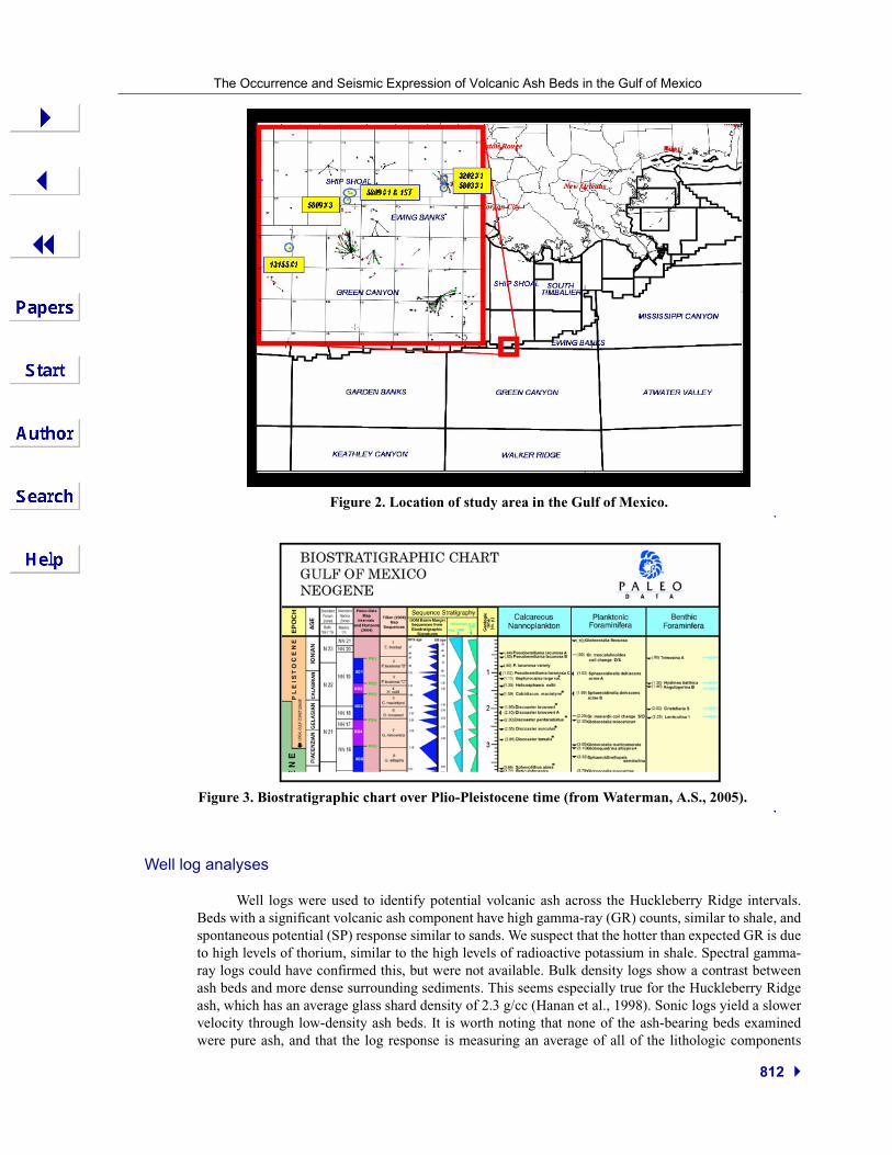
The purpose of this study is to identify and map the distribution of volcanic ash-rich beds in anumber of Pliocene and Pleistocene sections within Ewing Bank, Ship Shoal and Green Canyon OCSareas (Fig. 2). These offshore Louisiana areas were chosen based on previous work (Hanan et al., 1998;Rather and Totten, 1999), which confirmed ash beds of the proper age. Well data and 3D seismic sur-veys over the area were provided by ExxonMobil, Western Geco, and Diamond Geophysical.
Methods
Paleontological age bracketing
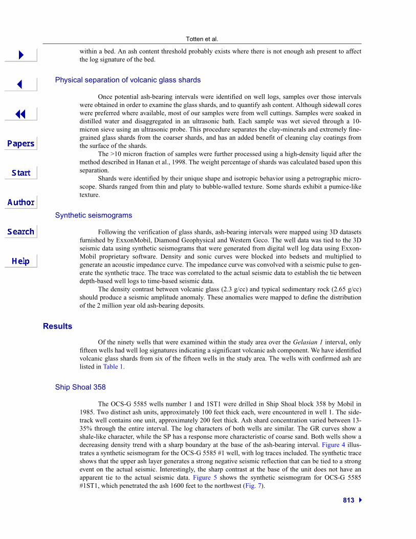
Paleomarkers in wells were used to bracket the range in depths that contain sediments coevalwith Huckleberry Ridge eruption. The most common upper marker was the last appearance datum(LAD) of the Discoaster brouweri nannofossil, which dates to 1.95 Ma. Several common paleontologi-cal markers were used to define the lowest depth of interest, including the nannofossil Discoasterpentaradiatus (2.3Ma), the foraminifera Globorotalia miocenica (2.3Ma), and the foraminifera Margin-ulinopsis lacrimata/Lenticulina 1 (2.25 Ma). Ages of paleomarkers are from Berggren et al. (1995).These markers define the sequence associated with the Gelasian 1 stage. Approximately 90 wells wereexamined in this manner, with thickness ranging between 200 to several thousand feet which bracket theage equivalent section to the Huckleberry Ridge eruption (Fig. 3).
The Occurrence and Seismic Expression of Volcanic Ash Beds in the Gulf of Mexico
812
Figure 2. Location of study area in the Gulf of Mexico.
Figure 3. Biostratigraphic chart over Plio-Pleistocene time (from Waterman, A.S., 2005).
Well log analyses
Well logs were used to identify potential volcanic ash across the Huckleberry Ridge intervals.Beds with a significant volcanic ash component have high gamma-ray (GR) counts, similar to shale, andspontaneous potential (SP) response similar to sands. We suspect that the hotter than expected GR is dueto high levels of thorium, similar to the high levels of radioactive potassium in shale. Spectral gamma-ray logs could have confirmed this, but were not available. Bulk density logs show a contrast betweenash beds and more dense surrounding sediments. This seems especially true for the Huckleberry Ridgeash, which has an average glass shard density of 2.3 g/cc (Hanan et al., 1998). Sonic logs yield a slowervelocity through low-density ash beds. It is worth noting that none of the ash-bearing beds examinedwere pure ash, and that the log response is measuring an average of all of the lithologic components
Totten et al.
813
within a bed. An ash content threshold probably exists where there is not enough ash present to affectthe log signature of the bed.
Physical separation of volcanic glass shards
Once potential ash-bearing intervals were identified on well logs, samples over those intervalswere obtained in order to examine the glass shards, and to quantify ash content. Although sidewall coreswere preferred where available, most of our samples were from well cuttings. Samples were soaked indistilled water and disaggregated in an ultrasonic bath. Each sample was wet sieved through a 10-micron sieve using an ultrasonic probe. This procedure separates the clay-minerals and extremely fine-grained glass shards from the coarser shards, and has an added benefit of cleaning clay coatings fromthe surface of the shards.
The >10 micron fraction of samples were further processed using a high-density liquid after themethod described in Hanan et al., 1998. The weight percentage of shards was calculated based upon thisseparation.
Shards were identified by their unique shape and isotropic behavior using a petrographic micro-scope. Shards ranged from thin and platy to bubble-walled texture. Some shards exhibit a pumice-liketexture.
Synthetic seismograms
Following the verification of glass shards, ash-bearing intervals were mapped using 3D datasetsfurnished by ExxonMobil, Diamond Geophysical and Western Geco. The well data was tied to the 3Dseismic data using synthetic seismograms that were generated from digital well log data using Exxon-Mobil proprietary software. Density and sonic curves were blocked into bedsets and multiplied togenerate an acoustic impedance curve. The impedance curve was convolved with a seismic pulse to gen-erate the synthetic trace. The trace was correlated to the actual seismic data to establish the tie betweendepth-based well logs to time-based seismic data.
The density contrast between volcanic glass (2.3 g/cc) and typical sedimentary rock (2.65 g/cc)should produce a seismic amplitude anomaly. These anomalies were mapped to define the distributionof the 2 million year old ash-bearing deposits.
Results
Of the ninety wells that were examined within the study area over the Gelasian 1 interval, onlyfifteen wells had well log signatures indicating a significant volcanic ash component. We have identifiedvolcanic glass shards from six of the fifteen wells in the study area. The wells with confirmed ash arelisted in Table 1.
Ship Shoal 358
The OCS-G 5585 wells number 1 and 1ST1 were drilled in Ship Shoal block 358 by Mobil in1985. Two distinct ash units, approximately 100 feet thick each, were encountered in well 1. The side-track well contains one unit, approximately 200 feet thick. Ash shard concentration varied between 13-35% through the entire interval. The log characters of both wells are similar. The GR curves show ashale-like character, while the SP has a response more characteristic of coarse sand. Both wells show adecreasing density trend with a sharp boundary at the base of the ash-bearing interval. Figure 4 illus-trates a synthetic seismogram for the OCS-G 5585 #1 well, with log traces included. The synthetic traceshows that the upper ash layer generates a strong negative seismic reflection that can be tied to a strongevent on the actual seismic. Interestingly, the sharp contrast at the base of the unit does not have anapparent tie to the actual seismic data. Figure 5 shows the synthetic seismogram for OCS-G 5585#1ST1, which penetrated the ash 1600 feet to the northwest (Fig. 7).
The Occurrence and Seismic Expression of Volcanic Ash Beds in the Gulf of Mexico
814
Table 1. Wells with confirmed Huckleberry Ridge ash occurrence within study area.
OCS well# Block Operator Top of Ash (ft)
5585 #1 SS 358 Mobil 7,800
5585#1ST SS 358 Mobil 7,750
5809 #3 EB 944 Mobil 7,700
5803 #1 EB 947 Shell 8,100
3202 #1 EB 947 Pennzoil 7,800
13155 #1 GC 16 Unocal 10,500
Figure 4. Synthetic seismogram forMobil OCS-G 5585 #1 in Ship Shoal358. Base of two separate ash units gen-erate an acoustic response.
Figure 5. Synthetic seismogram forMobil OCS-G 5585 #1 sidetrack in ShipShoal 358. Base of ash unit generates amore subtle acoustic response than inwell #1.

Totten et al.
815
Figure 6. Seismic section of area of interest in Ship Shoal 358. Both ash units are seen in well #1,but converge into one unit in the sidetrack well. Ash interval occurs within larger, amalgamatedchannels.
Figure 7. Amplitude extraction of amalgamated channel complex in Ship Shoal 358/Ewing Bank944. Three wells with ash occurrence are within this amplitude.

The Occurrence and Seismic Expression of Volcanic Ash Beds in the Gulf of Mexico
816
Figure 6 is a seismic section with the ash-rich units interpreted based upon ties with the syntheticseismic. The distribution of the ash-rich unit is shown in Figure 7, a seismic amplitude map extractedfrom the 3D dataset. The ash-rich deposits are interpreted as minor units within an amalgamated chan-nel complex, based on log response, and amplitude distribution. Multiple stacked channel featuresappear within the channel, and the ash-beds are not a continuous, mappable seismic reflector. The OCS-G 5585 #1ST1 well is on the flank of the amplitude map compared to the OCS-G 5585 #1 well. This isconsistent with the more poorly developed log response in the sidetrack well.
Ewing Bank 944
Mobil drilled the OCS-G 5809 #3 in Ewing Bank 944. This well encountered two separate ashunits correlative to the ash seen in OCS-G 5585 #1 well in Ship Shoal block 358, located 2,600 feet tothe northeast (Fig. 7).
Ewing Bank 947
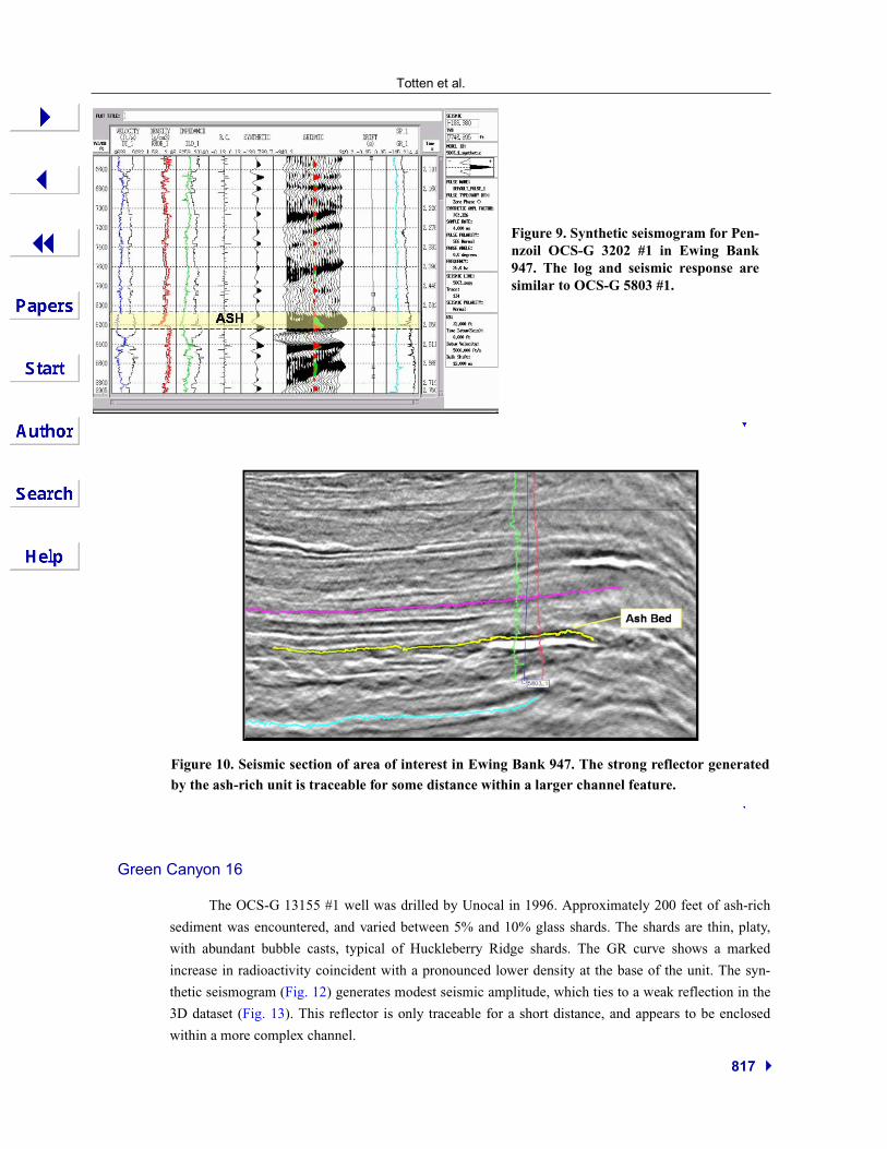
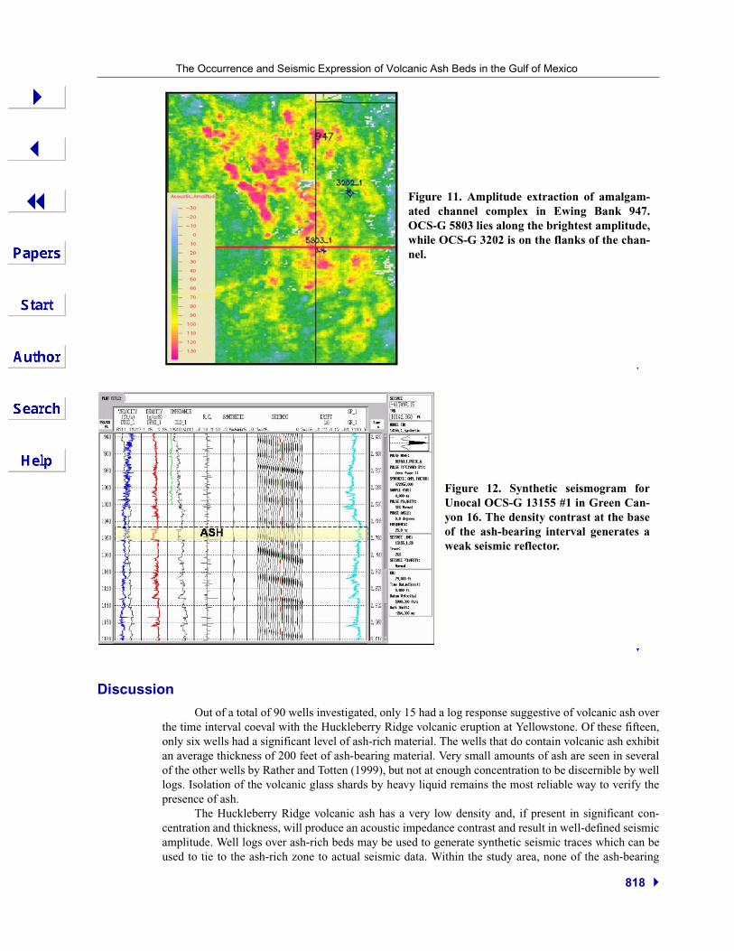
OCS-G 5803 #1 was drilled by Shell in Ewing Bank block 947. This well contains a 200 footthick interval that ranged between 5% to 30% glass shards (Rather 1999), and was assigned to the Huck-leberry Ridge eruption by Hanan et al. (1998) based on Pb-isotope signatures. The syntheticseismogram for OCS-G 5803 #1 is shown in Figure 8. The large density contrast at the base of the ash-bearing interval produces a peak associated with a large positive impedance contrast.
OCS-G 3202 #1 was drilled in 1975 by Pennzoil, also in Ewing Bank block 947. The syntheticseismogram (Fig. 9) for this well produced a similar strong peak which ties to the same seismic reflectoras the OCS-G 5803 #1 well.
The large impedance contrast between the base of the ash unit and the underlying beds in thisarea ties to a well-defined, continuous reflector that is traceable for some distance on the seismic section(Fig. 10). The amplitude extraction of this seismic tie outlines a channel feature. Both wells penetratedthe ash layer in areas slightly below the maximum amplitude (Fig. 11).
Figure 8. Synthetic seismogram forShell OCS-G 5803 #1 in Ewing Bank947. Sharp density contrast at the baseof the ash-rich interval produces astrong acoustic response, which has agood tie with the seismic dataset.
Totten et al.
817
Figure 10. Seismic section of area of interest in Ewing Bank 947. The strong reflector generatedby the ash-rich unit is traceable for some distance within a larger channel feature.
Green Canyon 16
The OCS-G 13155 #1 well was drilled by Unocal in 1996. Approximately 200 feet of ash-rich
sediment was encountered, and varied between 5% and 10% glass shards. The shards are thin, platy,
with abundant bubble casts, typical of Huckleberry Ridge shards. The GR curve shows a marked
increase in radioactivity coincident with a pronounced lower density at the base of the unit. The syn-
thetic seismogram (Fig. 12) generates modest seismic amplitude, which ties to a weak reflection in the
3D dataset (Fig. 13). This reflector is only traceable for a short distance, and appears to be enclosed
within a more complex channel.
Figure 9. Synthetic seismogram for Pen-nzoil OCS-G 3202 #1 in Ewing Bank947. The log and seismic response aresimilar to OCS-G 5803 #1.
The Occurrence and Seismic Expression of Volcanic Ash Beds in the Gulf of Mexico
818
Discussion
Out of a total of 90 wells investigated, only 15 had a log response suggestive of volcanic ash overthe time interval coeval with the Huckleberry Ridge volcanic eruption at Yellowstone. Of these fifteen,only six wells had a significant level of ash-rich material. The wells that do contain volcanic ash exhibitan average thickness of 200 feet of ash-bearing material. Very small amounts of ash are seen in severalof the other wells by Rather and Totten (1999), but not at enough concentration to be discernible by welllogs. Isolation of the volcanic glass shards by heavy liquid remains the most reliable way to verify thepresence of ash.
The Huckleberry Ridge volcanic ash has a very low density and, if present in significant con-centration and thickness, will produce an acoustic impedance contrast and result in well-defined seismicamplitude. Well logs over ash-rich beds may be used to generate synthetic seismic traces which can beused to tie to the ash-rich zone to actual seismic data. Within the study area, none of the ash-bearing
Figure 11. Amplitude extraction of amalgam-ated channel complex in Ewing Bank 947.OCS-G 5803 lies along the brightest amplitude,while OCS-G 3202 is on the flanks of the chan-nel.
Figure 12. Synthetic seismogram forUnocal OCS-G 13155 #1 in Green Can-yon 16. The density contrast at the baseof the ash-bearing interval generates aweak seismic reflector.

Totten et al.
819
units are traceable over much distance on seismic, suggesting that the ash was a localized deposit withinmore complex channel deposits. Considering the extremely large nature of the Huckleberry eruption,this gives insight into the mechanism of sediment transport from the continent to the GOM.
The total time interval between the paleomarkers used in this study is 350,000 years, whichplaces an upper limit on the time required to transport the ash from Yellowstone to the study area in theGOM. The date of the Huckleberry Ridge eruption is well dated at 2.059 (+/- .004) million years in age.Assuming the age of the upper paleomarker is correct (1.95Ma), no more than 109,000 years wererequired to deposit the initial air-fall ash, rework and transport the ash along the Mississippi drainagearea to the Gulf of Mexico shelf, and rework and deposit the ash as a component of slope turbiditeswithin the ShipShoal/ Ewing Bank/Green Canyon area. This time interval of ash deposition might havebeen much shorter. More detailed paleontology might further resolve this. In either case it represents avery narrow time window for deep-water ash deposition.
Sequence stratigraphic framework of ash beds
Each of the ash beds recognized in this study display a channel-like log signature. These channelfeatures do not form extensive, laterally continuous reflections. They are locally bright reflectionswithin a generally chaotic complex. They occur as minor, higher order channels within larger, amalgam-ated channel complexes which correspond to the Gelasian 1 stage sequence. They are interpreted torepresent higher order stratigraphic features within these complexes. They identify the active sedimentpathways within the channel during deposition of the ash, presumably a short time after eruption of theHuckleberry Ridge Ash 2.06 million years ago.
Conclusions
Huckleberry Ridge ash beds erupted from the Yellowstone Plateau occur in Plio-Pleistocenedeposits in the Green Canyon, Ewing Bank, and Ship Shoal areas of the Gulf of Mexico. These ash-richdeposits contribute to a low-density interval when compared to typical sediments in the Gulf. The den-sity contrast creates an acoustic impedance contrast, which generates a seismic amplitude response.Synthetic seismograms generated from well logs may be used to tie ash-bearing intervals to the seismicdataset.
The ash-bearing intervals are recognizable on seismic, but are not traceable over large distances.They occur as locally bright reflections within a more complex sequence of channel deposits. We inter-pret these ash deposits as higher-order features within upper-slope amalgamated channel complexes.This also explains the sporadic occurrence of the ash.
Figure 13. Seismic section of area ofinterest in Green Canyon 16. The reflec-tor tied by the synthetic to the ash-richunit is only traceable a short distance,and appears to occur within an amal-gamated channel complex.

The Occurrence and Seismic Expression of Volcanic Ash Beds in the Gulf of Mexico
820
The generally thick (200 ft) intervals of ash-bearing deposits, and the sporadic nature of their dis-tribution, suggests that the ash has been reworked from a previous deposit prior to deposition withinchannels as upper-slope turbidites. The ash might have been reworked from previous deposits on theshelf, or from terrigenous deposits on the continent. They are not widespread ash layers like those oftenused for tephrochronology. They certainly may be used as time-markers when found.
The amount of time necessary to deposit the initial Huckleberry Ridge ash fall, transport it to theGulf of Mexico, and finally rework the ash into the locally thick but sporadic deposits found in the studyarea is constrained by this study. Assuming the age of the upper paleomarker Discoaster brouweri isaccurate, the maximum time interval between eruption and final deposition is 109,000 years. High-reso-lution paleontology using a more diverse assemblage could further constrain this interval.
ReferencesAnders, M.H., Saltzman, J., and Hemming, S.R., in press, Neogene ash correlations in eastern Idaho and Wyoming:
Implications for Yellowstone Hotspot-related volcanism and tectonic activity: in Bonnichen, W., McCurry,M., and White, C., eds., Tectonic and magmatic evolution of the Snake River Plain Volcanic Province, IdahoDivision of Mines and Geology, Retrieved March 31, 2005, from http:/www.ldeo.Columbia.edu/~manders/SRP_erupt.html
Berggren, W.A., Kent, D.V., Aubry, M., and Hardenbol, J., 1995, Geochronology, time scales and global strati-graphic correlation: SEPM Special Publication No. 54, 386 pp.
Hanan, M.A., Totten, M.W., Hanan, B.B., and Kratochvil, T., 1998, Improved regional ties to global geochronologyusing Pb-Isotope signatures of volcanic glass shards from deep water Gulf of Mexico ash beds: Gulf CoastAssociation of Geological Societies Transactions, v. 48, p. 95-106.
Izett, G.A., and Wilcox, R.E., 1982, Map showing localities and inferred distributions of the Huckleberry Ridge,Mesa Falls, and Lava Creek Ash Beds (Pearlette Family Ash Beds) of Pliocene and Pleistocene age in thewestern United States and Southern Canada: U. S. Geological Survey, Miscellaneous Investigations SeriesMap I-1325.
Lanphere, M.A., Champion, D.E., Christiansen, R.L., Izett, G.A., and Obradovich, J.D., 2002, Revised ages fortuffs of the Yellowstone Plateau volcanic field: Assignment of the Huckleberry Ridge Tuff to a new geo-magnetic polarity event: Geological Society of America Bulletin, v. 114, p. 559-568.
Rather, M.A., 1999, The occurrence and diagenesis of Plio-Pleistocene volcanic ash within the Ewing Banks andGreen canyon areas, offshore Louisiana: unpublished Masters Thesis, University of New Orleans, NewOrleans, LA, 86 pp.
Rather, M.A., and Totten, M.W., 1999, The pervasive presence of low concentrations of volcanic ash in shale sedi-ments, offshore Louisiana, coeval with the Yellowstone Huckleberry Ridge eruption: Geological Society ofAmerica abstracts with programs, v. 30, p. A160.
Totten, M.W., 2001, Mechanisms for the widespread distribution of volcanic ash beds in the Gulf of Mexico: Geo-logical Society of America abstracts with programs, v. 33, p. A74.
Van Fleet, J.S., Totten, M.W., and Hanan, M.A., 1999, Investigation of the Pleistocene ashes of Kansas; Identifica-tion based upon chemical characteristics: Geological Society of America abstracts with programs, v. 30, p.A55.
Waterman, A.S., 2005, Biostratigraphic chart, Gulf of Mexico, Neogene: retrieved from http://www.paleo-data.com/downloads/pdistratchart_neogene0409.pdf.