the nsw surveyors’ monthly magazine • … · registered surveyors and civil/structural...
TRANSCRIPT

THE NSW SURVEYORS’ MONTHLY MAGAZINE • WWW.SURVEYORS.ORG.AU
No: 52, Issue 5 JuNe 2013Print Post APProved: PP255003/06031
Footprints surveyors on the opera House construction
FeET surveyors’ Fee estimation tool goes online
EISSI Award Winnernational Arboretum, Canberra
Canberra100th Anniversary
Scrivener selecting the site of Australia’s Capital City
All material, opinions and reports published in this magazine are for the interest of members. No endorsement by the Institution of Surveyors, New South Wales, Incorporated, is given or implied by their publication.
Regular Features 4 President’s Report
6 Administration Manager’s Report
7 Editor’s Report
8 Secretary’s Report
9 Surveyor’s Quiz
31 Looking Back
32 Footprints
34 Membership Connect
35 NSW Government Gazette
36 2013 Calendar of Events
37 Conferences and Seminars
37 Classifieds
EISSI Awards 2012 11 National Arboretum Visitor’s Centre, Canberra
Canberra Centenary 16 Charles Robert Scrivener
17 The Centenary of Canberra
The Profession 19 FeET Goes Online
Reports 21 Cumberland Group News
23 SSSI Report
University News 26 Student success at USQ
Obituaries 28 John Stuart Allman
29 John Philip Dynes
Letters 30 Letters to the Editor
QUOTE CORNER
“When life knocks you down, try to
land on your back. Because if you
can look up, you can get up.”
~Les Brown~
CONTENTS
11
Cover: National Arboretum Visitor’s Centre under construction, the subject of this month’s article by EISSI award winner Daniel Rowsell of Clarke and Di Pauli Surveyors.
17
The Association of Consulting Surveyors NSW and the Institution of Surveyors NSW have organized another Awards Evening at the Hilton Sydney to celebrate the NSW EISSI AWARDS 2013 on Saturday, 7 September 2013.
Be part of the celebrations as finalists and awards are announced showcasing the wide range of activities undertaken by Surveyors and Spatial Scientists in NSW.
Lucky Door Prize:Dinner for 2 in Glass Brasserie for value up to $150.00
To be drawn from registrations received before the 23 Aug 2013.
Discounted Accommodation: A discounted rate of $299 for a Hilton King Guest room is available to all attendees (subject to availability).
For reservations, please phone Lauren at 02 9265 6046 or email: [email protected].
Booking Code: GEISS
For further enquiries or Awards Registration Form:ACS NSW on (02) 9267 9728 or visit on-line at www.acsnsw.com.au or www.surveyors.org.au
nsw excellence in surveying & spatial information awards 2013
awards evening invitation
Master of Ceremony: Peter Berner is without doubt one of Australia’s most popular and respected entertainers and standup comedians. Peter started his career as a stand up comic in 1988 and since this time has performed locally and internationally, as well as writing and performing solo comedy shows in Festivals in Australia and the UK.
His intelligent humour has set him apart as one performer who can comfortably straddle comedy styles as disparate as satire, observational and reactive with ease – leaving audiences in hysterics.
The Usual Suspects: Boasting a phenomenal, all-star line-up of Sydney’s most in-demand session musicians, The Usual Suspects guarantee an unparalleled entertainment experience that will have every audience member up and dancing.
The NSW EISSI AWARDS 2013 would like to thank our sponsors
Platinum
Gold
Silver
Bronze
BURTON & FIELDs u r v e y i n g & l a n d d e v e l o p m e n t
w a t e r s e r v i c i n g c o o r d i n a t o r s
REGISTERED SURVEYORS AND CIVIL/STRUCTURAL ENGINEERS
PROUD SPONSOR OF THE SIR THOMAS MITCHELL AWARD 2013
Azimuth • June 2013 • 5 4 • www.surveyors.org.au
President’s rePortPresident’s rePort
This month’s President’s report has a communication theme. The first item is my address to the surveyors receiving their Certificates of Competencies for registration at the Institution office on the 12 April. It is an important event for the candidates and the Institution goes to a lot of effort to make the occasion special for them and their families. The second is part of an email by me that was published in Column 8 of the Sydney Morning Herald on 29 April. For those unfamiliar with Column 8, it is a column in the paper where readers write in about topics of interest. Topics that are quirky or esoteric often feature. The third is an analysis of the Institution’s first webinar on 17 April.
ADDRESS to SuRVEyoRS RECEIVINg CERtIfICAtE of ComPEtENCy foR REgIStRAtIoN
Address to surveyors receiving their registration certificates at the Institution office in front of their families and Institution guests.
First of all on behalf of the Institution let me congratulate you all on passing your registration. All the surveyors here appreciate what an achievement that is. You have now joined an elite club of professionals in the spatial industry. You have now proved to yourself and your peers that in terms of surveying skills you have one tripod leg firmly planted in the ground.
As with all professions the learning does not stop here. You will need to continue to develop your skills and to keep up with emerging technologies, legislation and procedures to effectively carry out the tasks that society will expect of you. In this regard it is imperative that you are a member of a learned professional body. This will give you access to continual professional development and a network of contacts within the industry that will enable you to mature and improve your skill level. The Institution wants to be an essential element of your development as a professional surveyor. This will enable you to plant your second tripod leg firmly.
As professionals you will need to maintain the highest ethical standards. Society and your peers will expect your conduct to be based upon integrity, social justice and competence. Your responsibilities for the rights and welfare of the community need to come before your own interests and other fellow professionals. You will need to always be mindful of acting in fairness and honesty towards clients, employers and colleagues. By maintaining these standards you can plant your third tripod leg firmly.
So with your tripod firmly set up on knowledge, professional association and ethics you will be able to confidently and accurately measure forward.
At this point I would like to give you some advice. Take this opportunity to gain as broad a range of experiences that you can. At this stage of your career don’t get locked into being too narrowly focused. Always think about new and inventive ways of undertaking your work. Perhaps it might involve becoming familiar with GIS software, or perhaps undertaking aerial photography using toy planes, or using existing LiDAR data for your projects. There are so many new technologies and sophisticated software packages available to make surveying a continuing challenging and exciting career.
The other piece of advice that I would like to give you is to continue to develop your communication skills. You will notice that all advertised jobs of any substance mention something like “must have good communication skills”. I was on an interview panel recently and one of the applicants simply wrote “I have excellent communication skills” and nothing more. This person was culled before the interviews. In my opinion, as a whole, surveyors, like scientists and engineers, have traditionally not excelled in this area. Think of yourself as being part of a team, develop your negotiation skills, take opportunities to give professional presentations, and take the time to network and promote the profession of surveying.
■ 12d Model faster • smarter • more powerful Civil Design, Terrain Modelling and Survey
■ ■ ■ ■ ■ ■ ■ ■ ■ ■ ■ ■ ■ ■ ■ ■ ■
■ CPD approved training
Extra Dimension Solutions02 9452 6771 exds.com.au
smarter by design
ePlan readyPhotos auto-attach to surveyed pointsFinished drawing editorScale features by field attribute (trees etc)Conformance and QA reportingField notes as attributes for GISFull symbology with reduction Full RTA linestyle and symbol librariesLot creation and labelling toolsGeodetic Transformations (inc zone to zone)Control Adjustment (inc Least Squares)Helmert adjustment — 2D or 3DFull Volumetrics suiteDesign Suite for Road / Rail / Civil workSite design & regradingMap underground services in 3DSetout Road / Rail / Civil works
Welcome to the June 2013 Azimuth
“The single biggest problem
in communicating is the
illusion that it has taken
place”
– George Bernard Shaw
You have obtained your registration at a time when your professional services are very much in demand. It has been forecast that demand for your services will continue to increase without a corresponding increase in supply. By the financial year 2018 / 19 it has been forecast that this shortage will put $30 billion in construction work and approximately 15000 private dwellings at risk. So the future from your point of view is very bright indeed.
So let me finish by once again congratulating you on your achievement and wear the badge of “registered surveyor” proudly.
ColumN 8 SEgmENt IN SyDNEy moRNINg HERAlD oN 29 APRIl
I submitted an email in response to a previous Column 8 segment that asked the question whether co-ordinates would change with continental drift and whether a fudge factor existed to work out the change. Below is the piece as reported in the column:
On a less contentious subject, regarding last week’s question about whether GPSs adjust for continental drift, Graeme Stewart, the president of the Institution of Surveyors NSW, and who better?, says, “Yes if you use the international co-ordinate system. In Australia we tend to be a bit tricky and use a local co-ordinate system that doesn’t change with time. There is a fudge factor (surveyors prefer the more glamorous term ‘datum transformation’) you can apply to convert between the two systems.”
I consider pieces such as this as being one small part of the jigsaw in promoting the profession of surveying to the wider community.
INStItutIoN’S fIRSt WEbINAR oN 17 APRIlThe topic for the Institution’s first webinar was on the
Surveyor General’s Direction no.9 detailing techniques for the use of GNSS in cadastral surveys. Doug Kinlyside and Dick Ellis of Land & Property Information graciously agreed to present the webinar. Interest in the event was much greater than expected with 80 registered to take part. Unfortunately the event did not run as smoothly as expected as the service providers system struggled to cope with the number of participants. This resulted in the PowerPoint slides being out of phase with the presentation. Despite these difficulties the majority of participants considered the event useful and informative. All the participants who completed a questionnaire at the end of the webinar stated that they would participate in future events. z
Graeme Stewart,
President ISNSW
Azimuth • June 2013 • 7 PROUD SPONSOR OF THE SIR THOMAS MITCHELL AWARD 20136 • www.surveyors.org.au
AdministrAtion mAnAger’s rePort editor’s rePort
there has been a lot of activity around and about Canberra lately, as this year is, of course, the centenary of our national capital.
A number of conferences and seminars have been held in Canberra so far this year, including the APAS conference (reported in the May edition of Azimuth) and the Surveying and Spatial Sciences Conference. This month John Brock reports on the Surveying and Spatial Sciences Conference and reflects on his experiences of working in the capital and possibly commits some kind of heresy in suggesting that Scrivener’s plan room hut may have been used for some less salubrious purposes!
Also this month is a tribute to Charles Scrivener, the man primarily known for his efforts in helping to locate the site of the national capital (and perhaps secondarily known for his epic moustache!) And this month’s EISSI award article is also Canberra themed, describing the challenging construction survey work required for the National Arboretum Visitor’s Centre.
I’ve been getting plenty of emails lately. Mostly these have been related the introduction of the interactive PDF Azimuth available on the ISNSW website, and able to be accessed through the link emailed out to each member. The response has been very positive, however some members are having trouble opening and operating the electronic file. We haven’t offered instructions on how to operate the interactive PDF, as it varies depending on which web browser you use. If you have trouble, please persevere and try it again next month, the electronic Azimuth is a work in progress and hopefully will continue to evolve and become
more user friendly. If you do have recurring problems, please contact Linda at ISNSW headquarters to help you sort them out.
Most of the other emails I have received in the last month have been in relation to my declaration of my fondness for my HP 42 calculator, as reported in last month’s editor’s report. Many respondents seemed surprised that I was still using the original calculator, when free apps for your smartphones are available as a substitute. It made me think I had failed to take this important step into the modern technological age. I was also informed that a lot of the young surveyors don’t even use calculators, they just upload files into the total station or GPS and work from that. Possibly the calculator is going the way of the plumb bob, the field bag and field notes. This may be a step forward into the new age of surveying, but in the meantime, I’m happy to plod along with my old faithful HP 42.
See you next time z
Paul Davis-Raiss, Editor-in-Chief
2013 NSW ExcEllENcE iN SurvEyiNg & Spatial iNformatioN aWardSClosing date for submissions is Monday 8 July, Judging takes place on 12 July.
Each year this event gets bigger and better and 2013 will be no exception with some new and exciting additions to the night. Tickets sell fast so make sure you book your table early.
Registration form is in this month’s Azimuth.
Early Bird Fee: Closes Friday 26th July. The Early Bird Fee is $1,800.00 for a table of 10 (with naming rights).
Lucky Door Prize: Registrations received before the 23rd August will go in the draw to win a dinner for two in the Hilton Hotel’s Glass Brasserie (valued up to $150.00).
Discounted Accommodation: A discounted rate of $299.00 for a Hilton King Guest Room is available to all attendees (subject to availability). Please contact Lauren (02) 9265 6046 or email: [email protected]. Booking Code: GEISS.
Master of Ceremony: This year our Master of Ceremony will be Peter Berner. Peter is without doubt one of Australia’s most popular entertainers and standup comic and with his intelligent humour and quick wit is guaranteed to have his audience in hysterics.
THIS IS AN URGENT REMINDER – EVEN THOUGH THE CLOSING DATE HAS BEEN PASSED - IT’S NOT TOO LATE TO GET AN ENTRY IN.
tWIlIgHt SEmINARS ComINg uP:Wednesday 12th June: “The New Australian Standard in Subsurface Utility Information and
its Real World Application” Presenters: Mark Gordon and Chris Arnison, Roads and Maritime Services. You will find a Registration Form in this edition of the Azimuth.
48tH AnnUAL institUtion goLF dAY! don’t miss it !!!the 48th Annual institution golf day will be held again this year at the Ryde-Parramatta
Golf Club on Thursday 8th August. This was a great event in 2012 so start organising your teams today.
Great prizes to be won on the day. Registration form is in this month’s Azimuth. z
Terina Sawyer,Administration Manager
To place an advertisement in the Azimuth please contact Terina Sawyer for a Media Kit on (02) 9264 2076 or email: [email protected].
Azimuth • June 2013 • 9 PROUD SPONSOR OF THE SIR THOMAS MITCHELL AWARD 20138 • www.surveyors.org.au
seCretArY’s rePort
Summary of the Minutes of the ISNSW Board Meeting5th April 2013
sUrveYor’s qUiz
Surveyor’s Quiz compiled by Michael Spiteri
President Graeme Stewart commenced the meeting at 10:05am.
Apologies Received: Grahame Wallis (Immediate Past President), Philip Hayward (President Elect), Jason Hay (Murray Group), Paul Swan (TAFE), Karl Bretreger (University of Newcastle), Gaby Van Wyk (SSSI NSW)
No Conflicts of Interest were declared.
Treasurer’s Report – Mathew Hynes (Honorary Treasurer) – Finances of ISNSW are still on track. Discussed funding on new website which is to come from the reserves, tabled initial thoughts regarding 2013-2014 budget.
Membership Report – Vicki Tester (Honorary Secretary)
Welcome the following new members:
• Ali Fuah Salim Almagbile – Student Membership
• Vito Zec – Student Membership
A membership status application and a membership re-instatement were approved and unfortunately a member was struck off for non-payment of fees. Membership is still strong with the total number of members sitting at 1334.
Administration Manager’s Report - Terina Sawyer (Administration Manager)-
Numerous matters discussed including:
• EISSI Award 2013 – The Registration form will be available in the June Azimuth together with a double page advertisement, the early bird rate will only apply to bookings made before the end of July.
Policy and Governance Matters
Various Matters under consideration including:
• Continued review of policy and governance documents:
- the following reviewed policy was adopted; P23 – Reimbursement of Expenses incurred by Members.
All adopted policies can now be found in the members section of the ISNSW website.
• AIBS re RICS issue – ISNSW has received correspondence advising that RICS has taken out copyright on the name ‘Chartered Surveyor’ within Australia.
Throughout the afternoon session of the Board Meeting the various reports of the Sub-Committees, Regional and Special Interests Groups and Co-Operating Associations were presented.
Matters reported on included:
Website – After much deliberation, and interview of the top three companies, it has been decide to employ SiteSuite to create the new ISNSW website, with the aim to have it up and running by the end of June. Information is still being added to the current website with video footage from ADS 2013 currently being uploaded to the members section.
Azimuth – Azimuth has gone digital with much positive feedback, though it will still be circulated in its usual hard copy format. On members 2013/2014 registration forms members will be given the option to only receive Azimuth in digital format.
The meeting concluded at 4:45pm.
For a more extensive review of the above ISNSW Board Meeting, copies of the ratified minutes are available through the ISNSW Office. z
Vicki Tester,Honorary Secretary ISNSW
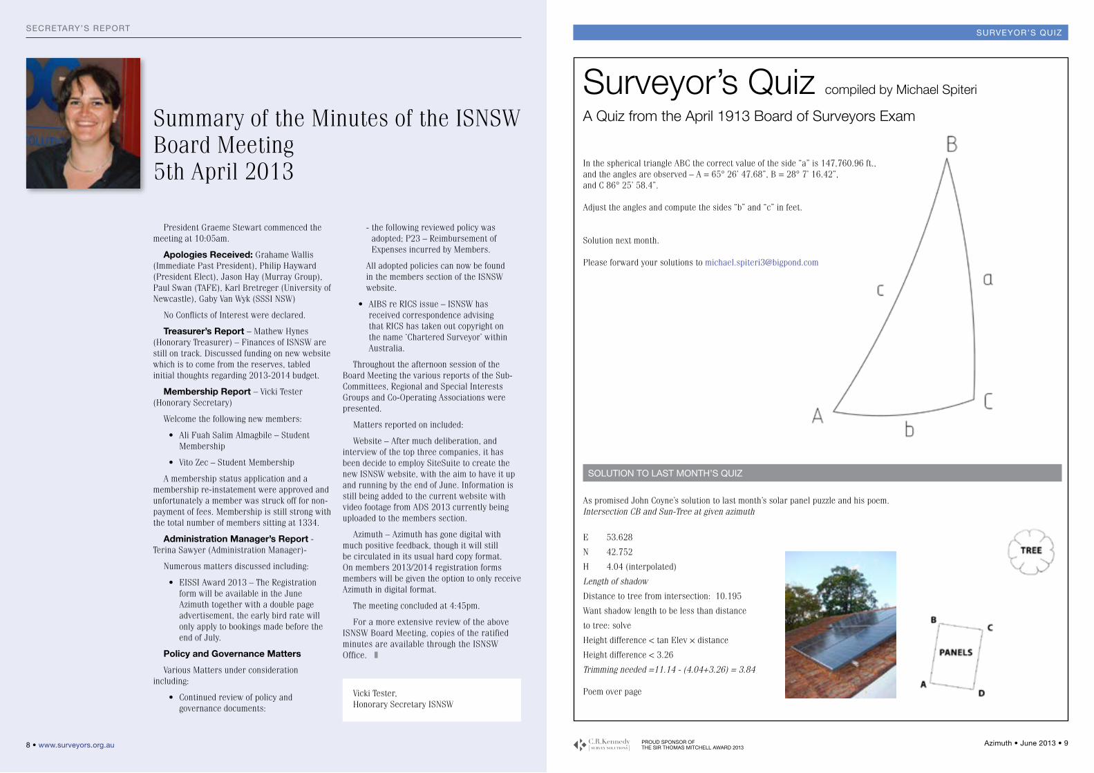
As promised John Coyne’s solution to last month’s solar panel puzzle and his poem.Intersection CB and Sun-Tree at given azimuth
E 53.628
N 42.752
H 4.04 (interpolated)
Length of shadow
Distance to tree from intersection: 10.195
Want shadow length to be less than distance
to tree: solve
Height difference < tan Elev × distance
Height difference < 3.26
Trimming needed =11.14 - (4.04+3.26) = 3.84
Poem over page
soLUtion to LAst montH’s qUiz
In the spherical triangle ABC the correct value of the side “a” is 147,760.96 ft., and the angles are observed – A = 65° 26’ 47.68”, B = 28° 7’ 16.42”, and C 86° 25’ 58.4”.
Adjust the angles and compute the sides “b” and “c” in feet.
Solution next month.
Please forward your solutions to [email protected]
A Quiz from the April 1913 Board of Surveyors Exam
10 • www.surveyors.org.au PROUD SPONSOR OF THE SIR THOMAS MITCHELL AWARD 2013
Azimuth • June 2013 • 11
eissi AWArds 2012sUrveYor’s qUiz
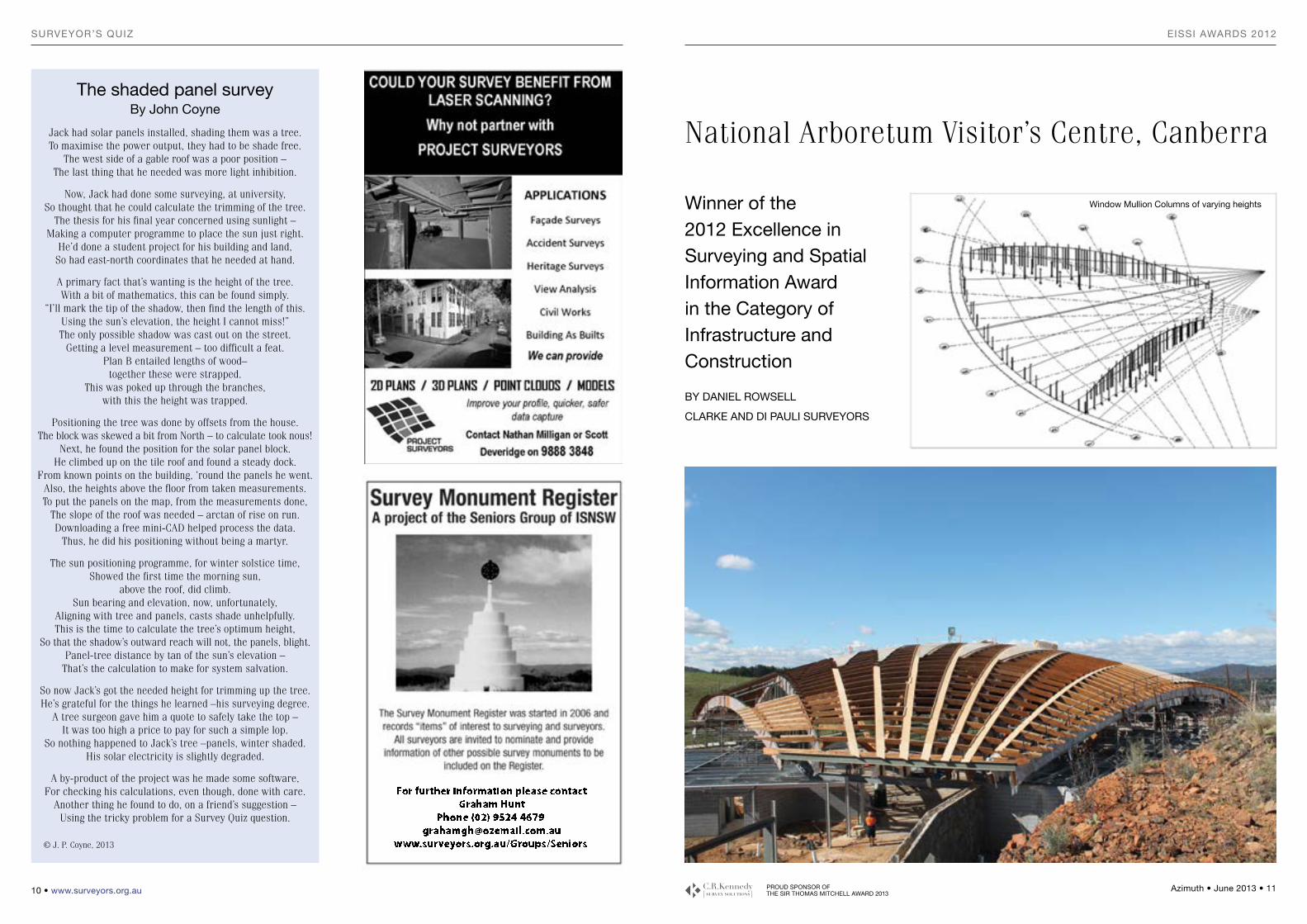
Winner of the 2012 Excellence in Surveying and Spatial Information Award in the Category of Infrastructure and Construction
by DANIEl RoWSEll
ClARkE AND DI PAulI SuRVEyoRS
the shaded panel surveyby John Coyne
Jack had solar panels installed, shading them was a tree.To maximise the power output, they had to be shade free.
The west side of a gable roof was a poor position –The last thing that he needed was more light inhibition.
Now, Jack had done some surveying, at university,So thought that he could calculate the trimming of the tree.
The thesis for his final year concerned using sunlight –Making a computer programme to place the sun just right.
He’d done a student project for his building and land,So had east-north coordinates that he needed at hand.
A primary fact that’s wanting is the height of the tree.With a bit of mathematics, this can be found simply.
“I’ll mark the tip of the shadow, then find the length of this.Using the sun’s elevation, the height I cannot miss!”The only possible shadow was cast out on the street.
Getting a level measurement – too difficult a feat.Plan B entailed lengths of wood– together these were strapped.
This was poked up through the branches, with this the height was trapped.
Positioning the tree was done by offsets from the house.The block was skewed a bit from North – to calculate took nous!
Next, he found the position for the solar panel block.He climbed up on the tile roof and found a steady dock.
From known points on the building, ‘round the panels he went.Also, the heights above the floor from taken measurements.To put the panels on the map, from the measurements done,
The slope of the roof was needed – arctan of rise on run.Downloading a free mini-CAD helped process the data.
Thus, he did his positioning without being a martyr.
The sun positioning programme, for winter solstice time,Showed the first time the morning sun,
above the roof, did climb.Sun bearing and elevation, now, unfortunately,
Aligning with tree and panels, casts shade unhelpfully.This is the time to calculate the tree’s optimum height,
So that the shadow’s outward reach will not, the panels, blight.Panel-tree distance by tan of the sun’s elevation –
That’s the calculation to make for system salvation.
So now Jack’s got the needed height for trimming up the tree.He’s grateful for the things he learned –his surveying degree.
A tree surgeon gave him a quote to safely take the top –It was too high a price to pay for such a simple lop.
So nothing happened to Jack’s tree –panels, winter shaded.His solar electricity is slightly degraded.
A by-product of the project was he made some software,For checking his calculations, even though, done with care.
Another thing he found to do, on a friend’s suggestion –Using the tricky problem for a Survey Quiz question.
© J. P. Coyne, 2013
National Arboretum Visitor’s Centre, Canberra
Window mullion Columns of varying heights
For further information please contactGraham Hunt
Phone (02) 9524 4679 [email protected]
www.surveyors.org.au/Groups/Seniors
PROUD SPONSOR OF THE SIR THOMAS MITCHELL AWARD 2013
Azimuth • June 2013 • 13 12 • www.surveyors.org.au
eissi AWArds 2012eissi AWArds 2012
SuRVEy bRIEfBecause of the 3-dimensional
complexity of internal and roof design, it was recognised at the very beginning that surveying was going to play a major role in the construction of this building.
Clarke & Di Pauli’s brief was:• to keep construction activity moving
at all times by efficiently managing all survey activities, because construction of virtually all structural elements was totally reliant on set-out by our surveyors.
• to assess the numerous architectural, civil and structural engineering plans for consistency and sufficiency of information and to allow adequate time for issues to be resolved with minimal delays.
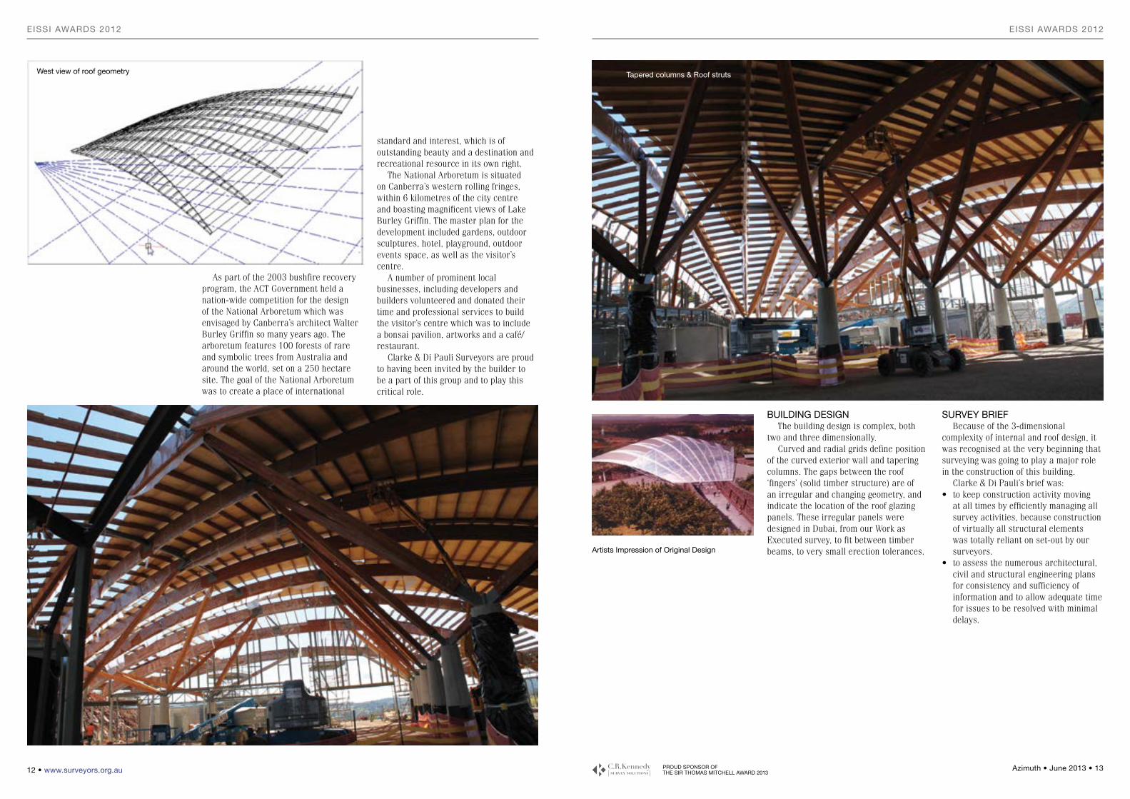
buIlDINg DESIgNThe building design is complex, both
two and three dimensionally.Curved and radial grids define position
of the curved exterior wall and tapering columns. The gaps between the roof ‘fingers’ (solid timber structure) are of an irregular and changing geometry, and indicate the location of the roof glazing panels. These irregular panels were designed in Dubai, from our Work as Executed survey, to fit between timber beams, to very small erection tolerances.
z
standard and interest, which is of outstanding beauty and a destination and recreational resource in its own right.
The National Arboretum is situated on Canberra’s western rolling fringes, within 6 kilometres of the city centre and boasting magnificent views of Lake Burley Griffin. The master plan for the development included gardens, outdoor sculptures, hotel, playground, outdoor events space, as well as the visitor’s centre.
A number of prominent local businesses, including developers and builders volunteered and donated their time and professional services to build the visitor’s centre which was to include a bonsai pavilion, artworks and a café/restaurant.
Clarke & Di Pauli Surveyors are proud to having been invited by the builder to be a part of this group and to play this critical role.
As part of the 2003 bushfire recovery program, the ACT Government held a nation-wide competition for the design of the National Arboretum which was envisaged by Canberra’s architect Walter Burley Griffin so many years ago. The arboretum features 100 forests of rare and symbolic trees from Australia and around the world, set on a 250 hectare site. The goal of the National Arboretum was to create a place of international
West view of roof geometry
Artists Impression of original Design
tapered columns & Roof struts

PROUD SPONSOR OF THE SIR THOMAS MITCHELL AWARD 2013
Azimuth • June 2013 • 15 14 • www.surveyors.org.au
eissi AWArds 2012eissi AWArds 2012
construction of the building to progress rapidly.
Our 3-dimensional Work-as-executed survey of HD plates on top of precast columns was critical for designers to accurately design the column struts holding up the roof.
SuCCESSful ComPlEtIoN of SuRVEy bRIEf
Clarke & Di Pauli Surveyors have managed to complete the above brief with satisfaction and great success. The key outcome that we were able to achieve was to maintain the spatial integrity of the design and structural accuracy and reliability of all construction works on the existing site.
This gave the builder surety and confidence in progressing from one step of construction activity to another and confidence that the design jigsaw is going to fall accurately into place without costly delays. z
in his GeoCivil survey software. The routine automated this 3D reduction as well as the QA checks using redundant observations and the calculation of the final 3D coordinate of each point. As a result, we were also able to provide an automatic coordinate comparison (diff E, N, RL) of the actual position of ‘set out’ points, as compared to the design, for each point.
SPAtIAl ComPoNENt of tHE PRoJECt
As surveyors we were entrusted to assist with and report on the accuracy of the constructed structural elements. The spatial component of this project was extremely critical for the jigsaw to fall into place.
We had to assess and manipulate spatial data from 3D AutoCAD models of various designs and translate that to usable marks on the ground, on top of columns and above the roof, allowing
limitations, it was decided to survey the 450 ‘set out’ points by intersecting observations from three strategic survey control stations.
This was done by observing sets of angles with a Leica 1200 total station (horizontal and vertical). Direct distances where visible were also measured to a mini-prism, for the purposes of gross checks and redundant observations.
We recognised immediately that to reduce observations of such volume, from three different stations, as well as to compute a final easting, northing and reduced level of each point required a survey reduction routine that most software packages would not have as standard. We designed a procedure that we wanted to employ in the field and this set the parameters of the reduction, checking and calculations process.
We approached Mr Ken Toleman of GeoComp Consulting and he was very quick in writing such a reduction routine
To achieve physical access and line of sighting to critical points, we had to;• do height safety training to be able to
walk on top of the roof structure using harnesses,
• use scissor lifts to reach tops of columns
• strategically establish elaborate survey control around the site for remote surveys, using Leica 1200 total stations and sets of angles, levelled and adjusted by least squares.
StRAtEgIC APPRoACHES to PRoblEm SolVINg
A project of this complexity and the size of the survey component presented us with varying logistical and procedural challenges that had to be solved and managed.
The high expectations and requirements by the client and by various consultants was significant relative to timing. The expectation was that the field survey would commence quickly and that the data flow would be immediate. Combined with the complexity of the survey scope, the project certainly created management challenges.
We had to stand back and come up with efficient strategies, firstly to manage our resources and secondly to devise innovative procedures and field and office solutions to ensure an efficient and seamless flow of data from the field to office and then on to the waiting client and other professions.
To assist us in managing these challenges we had to adapt some of our existing Quality Assurance procedures (ISO9001: 2008) and also create new ones for field and office calculations.
uSE of INNoVAtIVE tECHNology AND lAtERAl tHINkINg
Tried and true construction surveying techniques were predominantly used for this project.
Leica GMP 104 monitoring targets were used for remote monitoring of the roof with increasing roof load.
A hold-point on the roof construction was an accurate, 3-dimensional Work-as-executed survey of some 450 critical ‘set out’ points (visible nails/targets, placed in strategic locations by glaziers) used for the roof glazing.
This survey was later sent to Dubai for final geometric design and for cutting of all glazing panels.
Because of visibility and other site
SuRVEy SCoPETypically on other construction sites,
grids would be set out as a base to allow other trades to work from. However in this situation, this practice would be of very little use. Instead, every structural element had to be calculated and set out, quite a few of which required complicated and intricate survey calculations and highly accurate set out.
The survey scope included calculations and survey for:• bulk excavation• detail pad and footing excavation• survey of very irregular surfaces
including down into excavated footing pads and determination of complicated volumes having crossing and overlapping cut/fill areas.
• depth of underlying rock shelf • internal and external hydraulics• re-enforcing steel for walls and
columns• holding down bolts• precast and mullion columns• radial and curved grids• highly accurate Work-as-Executed
survey on window mullions for design of vertical glazing
• high accuracy Work-as-executed survey of HD plates on top of precast columns
• hardwood roof rafters• grid set on top of columns• accurate and periodic monitoring
survey of the roof structure, to monitor increase in roof load
• accurate Work-as-executed survey of critical roof glazing set out points for design in Dubai and for cutting, to fit seamlessly in between the ‘fingers’.
SItE loCAtIoN, ACCESS REquIREmENtS AND logIStICS
The site was cut into the side of a hill. The accuracy of different structural elements was paramount in them all fitting together like a glove.
Critical elements requiring accurate positioning, such as the base of the struts on top of columns, the ends of struts underneath the roof and ‘finger’ roof geometry, proved to be the most difficult to access both physically and to see from survey control.
The terrain did not offer many opportunities for good positioning of survey control, and visibility of elements from survey control was extremely limited and proved very challenging.
PROUD SPONSOR OF THE SIR THOMAS MITCHELL AWARD 2013
Azimuth • June 2013 • 17 16 • www.surveyors.org.au
CAnBerrA CentenArYCAnBerrA CentenArY
immediately gained employment under articles to the best surveyor I have ever been fortunate enough to know and work under, Mr. Ian Reginald Moreton Clarke, otherwise known as “Bill.” Half of my work was within the ACT which although suffering extremes of temperature was nevertheless most enjoyable. I even trialled in three games, two of which were against First Grade sides Manly and Western Suburbs, with the Queanbeyan Blues coached by the renowned Don Furner, then eventually played with the Navy base rugby league side HMAS Harman which was fantastic.
From all of this nostalgia you may be able to garner that I have an inherent love for our Federal Capital which I have since discovered is world famous as one of the most picturesque and spectacular planned cities from the Garden City Movement of the early Twentieth Century.
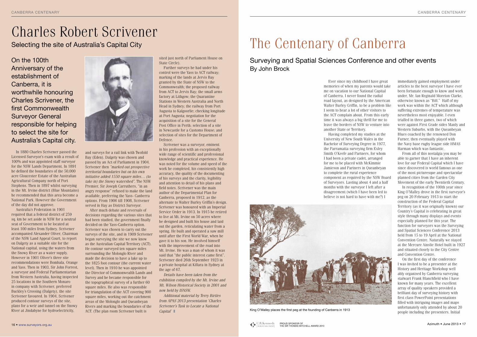
In recognition of the 100th year since King O’Malley drove in the first surveyor’s peg on 20 February 1913 to start the construction of the Federal Capital Territory (as it was originally known) our Country’s Capital is celebrating in great style through many displays and events especially planned for this year. The function for surveyors was the Surveying and Spatial Sciences Conference 2013 held from 15 to 19 April at the National Convention Centre. Naturally we stayed at the Mercure Ainslie Hotel built in 1927 and situated closely to the City Centre and Convention Centre.
On the first day of the conference I was invited to be a presenter at the History and Heritage Workshop well ably organised by Canberra surveying stalwart Frank Blanchfield who I have known for many years. The excellent array of quality speakers provided a brilliant day of surveying history with first class PowerPoint presentations filled with intriguing images and maps unfortunately only attended by about 20 people including the presenters. Initial
Ever since my childhood I have great memories of when my parents would take me on vacation to our National Capital of Canberra. I never found the radial road layout, as designed by the American Walter Burley Griffin, to be a problem like I seem to hear a lot of other visitors to the ACT complain about. From this early time it was always a big thrill for me to leave the borders of NSW to venture into another State or Territory.
Having completed my studies at the University of New South Wales in the Bachelor of Surveying Degree in 1977, the Parramatta surveying firm Exley Smith O’Keefe and Partners, for whom I had been a private cadet, arranged for me to be placed with McKimmie Jamieson and Partners in Queanbeyan to complete the rural experience component as required by the NSW Board of Surveyors. Lasting about 4 and a half months with the surveyor I left after a disagreement (which I have been led to believe is not hard to have with me?) I
sited just north of Parliament House on State Circle).
Further surveys he had under his control were the Yass to ACT railway; marking of the lands at Jervis Bay granted by the State of NSW to the Commonwealth; the proposed railway from ACT to Jervis Bay; the small arms factory at Lithgow; the Quarantine Stations in Western Australia and North Head in Sydney; the railway from Port Augusta to Kalgoorlie; checking longitude at Port Augusta; negotiation for the acquisition of a site for the General Post Office in Perth; selection of a site in Newcastle for a Customs House; and selection of sites for the Department of Defence.
Scrivener was a surveyor, eminent in his profession with an exceptionally wide range of scientific and professional knowledge and practical experience. He was noted for the volume and speed of the work he completed, his consistently high accuracy, the quality of the documenting of his surveys and the clarity, legibility and attention to detail of his plans and field notes. Scrivener was the main author of the Departmental Plan for Canberra, proposed in 1912, as the alternate to Walter Burley Griffin’s design. Scrivener was honoured with an Imperial Service Order in 1913. In 1915 he retired to live at Mt. Irvine on 50 acres where he designed and built his house and laid out the garden, reticulating water from a spring. He built and operated a saw mill until after the First World War, when he gave it to his son. He involved himself with the improvement of the road into Mt. Irvine. He was a man of whom it was said that “the public interest came first”. Scrivener died 26th September 1923 in a private hospital at Killara in Sydney at the age of 67.
Details have been taken from the exhibition compiled by the Mt. Irvine and Mt. Wilson Historical Society in 2001 and now held by ISNSW.
Additional material by Terry Birtles from APAS 2013 presentation ‘Charles Scrivener’s Task to Locate a National Capital’ z
on the 100th Anniversary of the establishment of Canberra, it is worthwhile honouring Charles Scrivener, the first Commonwealth Surveyor general responsible for helping to select the site for Australia’s Capital city.
In 1880 Charles Scrivener passed the Licensed Surveyor’s exam with a result of 100% and was appointed staff surveyor for the NSW Lands Department. In 1891 he defined the boundaries of the 50,000 acre Gloucester Estate of the Australian Agricultural Company north of Port Stephens. Then in 1897 whilst surveying in the Mt. Irvine district (Blue Mountains) he recommended that this area become a National Park. However the Government of the day did not approve.
Australia’s Federation in 1901 required that a federal district of 259 sq. km be set aside in NSW for a neutral seat of Government to be located at least 100 miles from Sydney. Scrivener accompanied Alexander Oliver, Chairman of the NSW Land Appeal Court, to report on Dalgety as a suitable site for the National capital, using the waters from the Snowy River as a water supply. However in 1901 Oliver’s three site recommendations were Bombala, Orange and Yass. Then in 1903, Sir John Forrest, a surveyor and Federal Parliamentarian from Western Australia, having inspected 25 locations in the Southern Monaro in company with Scrivener, preferred Buckley’s Crossing (Dalgety), the site Scrivener favoured. In 1904, Scrivener produced contour surveys of the site, plans for a weir and tunnel on the Snowy River at Jindabyne for hydroelectricity,
and surveys for a rail link with Twofold Bay (Eden). Dalgety was chosen and passed by an Act of Parliament in 1904. Scrivener then “marked out prospective territorial boundaries but on his own initiative added 1550 square miles… (to take in) the Snowy watershed”. The NSW Premier, Sir Joseph Carruthers, “in an angry response” refused to make the land available, preferring the Yass- Canberra options. From 1906 till 1908, Scrivener served in Hay as District Surveyor.
After much debate and reversals of decisions regarding the various sites that had been studied, the government finally decided on the Yass-Canberra option. Scrivener was chosen to carry out the surveys of the site, and in 1909 Scrivener began surveying the site we now know as the Australian Capital Territory (ACT). He contour surveyed ten square miles surrounding the Molonglo River and made the decision to have a lake up to the 1825 foot contour (the current water level). Then in 1910 he was appointed the Director of Commonwealth Lands and Survey and he became responsible for the topographical survey of a further 60 square miles. He also was responsible for triangulation of the ACT covering 900 square miles, working out the catchment areas of the Molonglo and Queanbeyan Rivers and marking the boundaries of the ACT. (The plan room Scrivener built is
Charles Robert ScrivenerSelecting the site of Australia’s Capital City The Centenary of Canberra
king o’malley places the first peg at the founding of Canberra in 1913
Surveying and Spatial Sciences Conference and other eventsby John brock
PROUD SPONSOR OF THE SIR THOMAS MITCHELL AWARD 2013
Azimuth • June 2013 • 19 18 • www.surveyors.org.au
the professionCAnBerrA CentenArY
ACS NSW updates Surveyors’ fee Estimation tool
In 2013 Association of Consulting Surveyors (ACS) NSW is once again leading the effort to keep surveyors informed and aware as to current market conditions for the surveying industry. The overall aim of this drive is to boost the confidence of the profession as a whole in its knowledge of what constitutes a charge-out fee that is not only fair and reasonable to the public but feasible and sustainable for those running a survey practice.
This initiative is comprised of various projects such as the data collation and analysis of hourly rates and salary figures across the profession, along with the reinvention of the Surveyors’ Fee Estimation Tool (FeET). This system is based upon the “Guide for Survey Fees” as published by the Institution of Surveyors from 1997 – 2007 which proposed that survey fees should be estimated based upon a combination of:• suggested piecework figures• salary rates and time estimates• overhead costs• risk margins• profit margins• and specialised equipment rates
in Surveyors Park within sight of the new Parliament House during which tall tales and true of surveying life in the ACT were delivered to an appreciative crowd on a beautiful Canberra morning.
During the conference we took the opportunity to visit historic Blundell’s Cottage and two terrific exhibits in the National Library and National Archives which are quite close to each other between Old Parliament House and Lake Burley Griffin. Until the 9 June you will be able to view “The Dream of a Century: The Griffins in Australia’s Capital” at the National Library of Australia to see plans, maps and items associated with the architectural pursuits of the American designing couple while they were in the ACT, USA and India. Then to show us the competition pitted against the Griffins in the quest to design our Nation’s Capital we travelled a short distance to the impressive National Archives of Australia to inspect the amazing exhibition “Design 29: Creating a Capital” which displayed some of the alternative proposals for our No. One City with some impressive artwork and spectacular designs, even one with a distinct replica of the Sydney Harbour Bridge before it became fashionable. For all of those curious for a look at this fascinating set of plans and documents the exhibition will be on until 8 September.
Whatever you enjoy I am sure that you can find plenty of things to see and do in Canberra in 2013 in whatever level of accommodation suits you. From the Australian War Memorial and Old Parliament House to New Parliament House and the National Museum of Australia (of which I am a Foundation Friend) there are many great places to visit free of charge including the Royal Mint and hundreds of hectares of parks and nature reserves. Just for the surveyors, most of whom do not deny themselves the odd ale, please find your way to King O’Malley’s Centenary Pub and make a toast to the man who introduced Prohibition into Canberra during its formative years as I postulate that the concrete bunker style building in Surveyors Park with the iron door called Scrivener’s Hut would have been more likely to be used for storage of prescription only refreshments rather than rolls of plans during this period of enforced abstinence !?! z
day Frank then had a bus to take us on a Scrivener Tour of Canberra which concluded at the spot determined by the Young Surveyors Group to be EXACTLY where King O’Malley had placed that first peg just over 100 years before. In attendance to witness the ceremonial replacement of this mark was even the daughter of the surveyor Percy Sheaffe who can be seen in the right of the 1913 snap as King O’Malley belts the marker into the ground. Utilising Percy’s original field notes it would appear that this “first” peg was actually strategically placed under the professional guidance of surveyor Sheaffe in a position relative to the calculated radial line as designed in the lay out for the city. However the final deliberations of Frank’s young surveyors will become available in the near future so keep your eyes out for the ultimate result.
Attendance at the Welcome Reception on Tuesday night and Young Surveyors Cocktail Party the following evening were most convivial and an opportunity to catch up with old friends not seen in eleven years since I have not attended a SSSI Conference since it took over from the Institution of Surveyors Australia in 2002. Finishing off our commitment with this next event Kerima-Gae and I attended a great Scrivener Breakfast on Thursday
talker was ACT historian Matt Higgins (not the Queensland surveyor!) who is an expert on the borderlines of the ACT. Not only did he take us through the history of the border survey itself he also showed us some images of survey reference trees which have since been lost in prior bushfires. Following Terry Birtles’ authoritative biography of the legendary principle surveyor of the ACT Charles Robert Scrivener I revealed those earliest explorers and surveyors who were instrumental in opening up the Limestone Plains among which were Throsby, Meehan, Hoddle and Dixon. I also related the amazing tale of a replica Port City designed by Henry Ferdinand Halloran near the ACT Jervis Bay Territory called Pacific City which was scarcely occupied due to the non-fulfilment of the plan to extend the railway line far enough south to service the proposed seaside metropolis. Other speakers were Adrian Cummins on McDouall Stuart, Lindsay Perry on Matthew Flinders and the Naming of Australia, a brilliant project to create a giant map of the Early Navigators of Bass Strait headed by Greg Eccleston, Finding Burke and Wills Plant Camp by Frank Leahy and finally Canning Stock Route Surveys by the great nephew of A.W. Canning himself James Canning from Melbourne. To top off a wonderful
FeET Goes Online
John brock and frank blanchfield at the ceremony for the replacement of king o’malley’s peg
20 • www.surveyors.org.au
the profession rePorts
Azimuth • June 2013 • 21 ProUd sPonsor oF tHe sir tHomAs mitCHeLL AWArd 2013
On the evening of 8 May 2013 the Cumberland Group held another successful meeting at the Parramatta Workers Club with 66 surveyors attending. Chairman Mark Gordon took the reins back from Narelle Underwood for this meeting following his absence from our first 2013 meeting due to ill health.
While the members enjoyed a sumptuous buffet Mark kicked off the meeting by inviting Bob Hanna to the microphone to deliver his usual informative report on the activities of the Seniors Group. The activities of this Group are wide and varied. Bob enlightened us on the relocation of the original 1815 Bathurst flagstaff and then outlined the challenges of the Seniors Group’s work on a new interpretive signboard about the life of William Lawson in this the 200th anniversary year of the crossing of the Blue Mountains. The Cumberland Group’s 50th Anniversary seminar to be held at the Carrington Hotel in Katoomba on 2-3 November this year will also focus on the crossing of the Blue Mountains and the work of surveyor George Evans.
Ian Iredale then addressed the meeting seeking support for the Surveying Spectaculars (or Math in Surveying Days) held at Bicentennial Park. The first Surveying Spectacular was held in 2008 with 180 students attending aided by 45 volunteer surveyors. Initially an annual event, interest by schools is now so high that three Surveying Spectaculars will be held this year. While Ian has managed to get enough volunteer surveyors for the first Surveying Spectacular held on 17 May 2013, he desperately needs more support from surveyors in the form of new volunteers for the two following events to be held later in the year. Please consider doing something for your profession and volunteer to help Ian educate today’s school students in the wonders of surveying. Ian can be contacted by email: [email protected]
Due to the impending birth of Narelle Underwood’s baby, Mark Gordon presented Narelle’s ISNSW report. He then presented a report about the activities of BOSSI and followed that up with highlights of matters considered at SMIC. These included the ACS commissioned report by BIS Shrapnel, Determining the Future Demand, Supply and Skills Gap for Surveying and Geospatial Professionals, and
Cumberland Group News
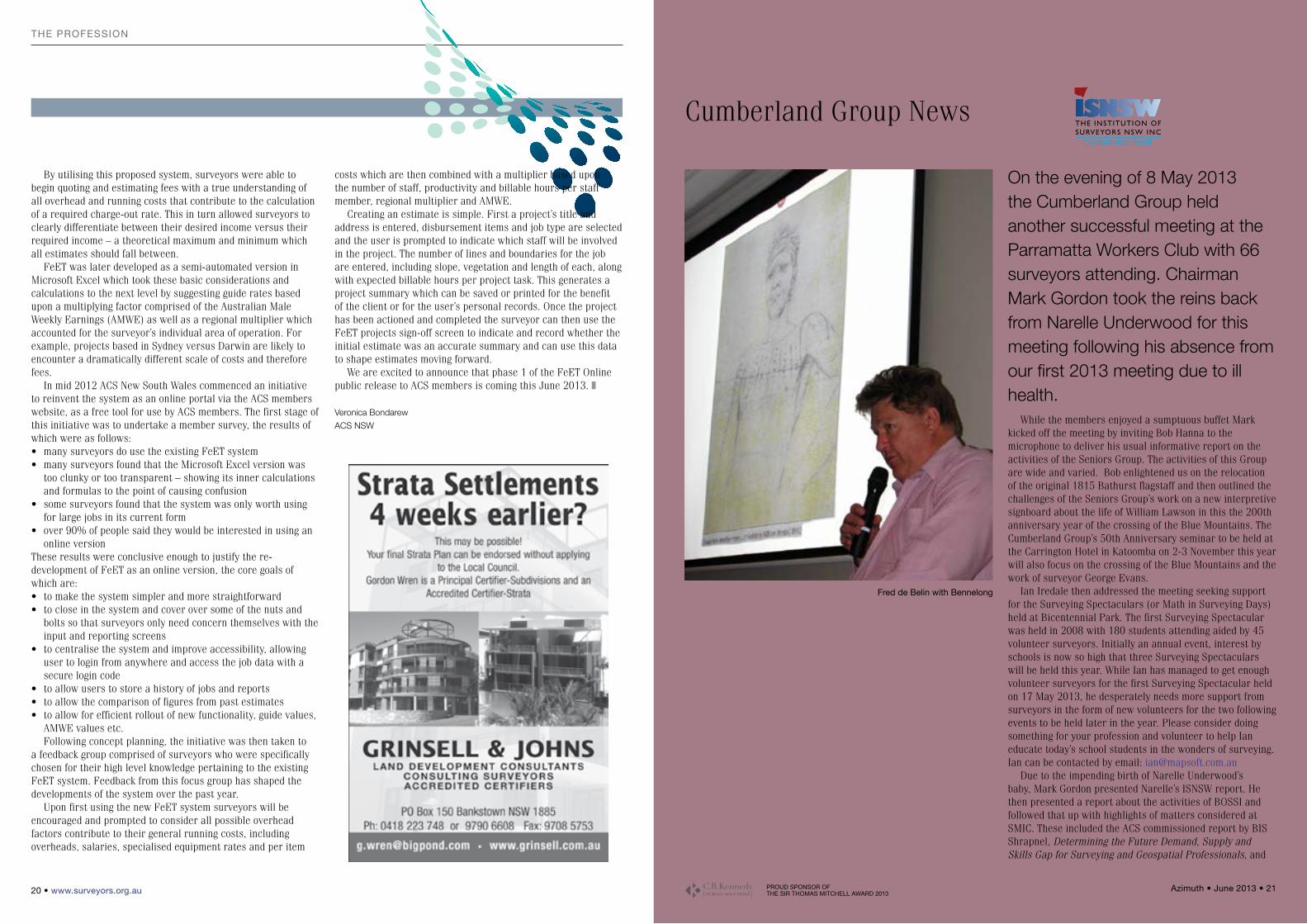
fred de belin with bennelong
By utilising this proposed system, surveyors were able to begin quoting and estimating fees with a true understanding of all overhead and running costs that contribute to the calculation of a required charge-out rate. This in turn allowed surveyors to clearly differentiate between their desired income versus their required income – a theoretical maximum and minimum which all estimates should fall between.
FeET was later developed as a semi-automated version in Microsoft Excel which took these basic considerations and calculations to the next level by suggesting guide rates based upon a multiplying factor comprised of the Australian Male Weekly Earnings (AMWE) as well as a regional multiplier which accounted for the surveyor’s individual area of operation. For example, projects based in Sydney versus Darwin are likely to encounter a dramatically different scale of costs and therefore fees.
In mid 2012 ACS New South Wales commenced an initiative to reinvent the system as an online portal via the ACS members website, as a free tool for use by ACS members. The first stage of this initiative was to undertake a member survey, the results of which were as follows:• many surveyors do use the existing FeET system• many surveyors found that the Microsoft Excel version was
too clunky or too transparent – showing its inner calculations and formulas to the point of causing confusion
• some surveyors found that the system was only worth using for large jobs in its current form
• over 90% of people said they would be interested in using an online version
These results were conclusive enough to justify the re-development of FeET as an online version, the core goals of which are:• to make the system simpler and more straightforward• to close in the system and cover over some of the nuts and
bolts so that surveyors only need concern themselves with the input and reporting screens
• to centralise the system and improve accessibility, allowing user to login from anywhere and access the job data with a secure login code
• to allow users to store a history of jobs and reports• to allow the comparison of figures from past estimates• to allow for efficient rollout of new functionality, guide values,
AMWE values etc.Following concept planning, the initiative was then taken to
a feedback group comprised of surveyors who were specifically chosen for their high level knowledge pertaining to the existing FeET system. Feedback from this focus group has shaped the developments of the system over the past year.
Upon first using the new FeET system surveyors will be encouraged and prompted to consider all possible overhead factors contribute to their general running costs, including overheads, salaries, specialised equipment rates and per item
costs which are then combined with a multiplier based upon the number of staff, productivity and billable hours per staff member, regional multiplier and AMWE.
Creating an estimate is simple. First a project’s title and address is entered, disbursement items and job type are selected and the user is prompted to indicate which staff will be involved in the project. The number of lines and boundaries for the job are entered, including slope, vegetation and length of each, along with expected billable hours per project task. This generates a project summary which can be saved or printed for the benefit of the client or for the user’s personal records. Once the project has been actioned and completed the surveyor can then use the FeET projects sign-off screen to indicate and record whether the initial estimate was an accurate summary and can use this data to shape estimates moving forward.
We are excited to announce that phase 1 of the FeET Online public release to ACS members is coming this June 2013. z
Veronica Bondarew
ACS NSW
THE INSTITUTION OFSURVEYORS NSW INC
CUMBERLAND GROUP
PROUD SPONSOR OF THE SIR THOMAS MITCHELL AWARD 2013
Azimuth • June 2013 • 23 22 • www.surveyors.org.au
rePorts
the consultations and considerations by Geoscience Australia on a dynamic Datum for Australia.
Our first advertised speaker for the evening was Ian Harper from GeoData Australia with a presentation on why changes in digital database technology together with cadastral modelling will challenge the future of surveyors. Ian pointed out that in the past survey plans modelled the cadastre and surveyors were necessary to locate boundaries. He used examples to demonstrate that the resultant historical cadastre will be modelled more effectively in a digital database. These examples included his firm’s cadastral modelling along the route of the North West Rail Link, the Circular Quay to Kensington Light Rail route and a ‘whole of state’ integration project in Tasmania.
Ian pointed out that with accurate measurement tools more freely available there is already a perception that anyone will be able to identify their boundaries with a GNSS device. That perception, he said, was countered by the current Torrens system of governance which requires a Registered Surveyor for boundary definition and validation.
Ian discussed how the digital environment can provide considerable efficiencies in survey and land administration and how critical it is that the survey profession must be foremost in the transition from measurement-based systems of the past to the position-based systems of the future. Accuracy and data integrity in the database, he said, will be the key to those efficiencies.
Ian’s presentation was a powerful reminder of the opportunities presented by cadastral modelling to all surveyors in order to remain relevant in a world of integrated data management systems.
The second advertised presentation for the evening was Finding Bennelong? Surveying Solves a 200-Year-Old Mystery by Fred de Belin, Manager Survey at City of Ryde Council.
Fred’s presentation was a fine example of how surveying techniques can be used to help solve long standing mysteries. When the First Fleet arrived in Sydney in January 1788, Woollarawarre Bennelong was about 25 years old. Bennelong, as he became known, developed a good command of English and went on to play a very important role in communications between the indigenous population and the early European settlers. The site of the Sydney Opera House, Bennelong Point, is named in his honour.
In 2010 Dr Peter Mitchell prepared a report to City of Ryde Council’s Heritage Advisory Committee regarding his search of historical documents aimed at locating Bennelong’s grave. Dr Mitchell requested that Council’s surveyors look at his findings and evidence to confirm his conclusion as to his location of the grave site.
Enter Fred de Belin and his survey team. Fred’s starting point was a photograph uncovered by Dr Mitchell and taken around 1900 which shows what appears to be an old simple gravesite surrounded by stones on the property of James Squire at Putney on the Parramatta River. The foreground, mid ground and background of the photograph provide markers which could be used to locate the position of the camera and hence the gravesite itself.
Fred explained to the meeting how the identification of the surrounding sites and markers in the photograph followed by intersecting sight lines and calculation of distances and ratios led to the positioning of the grave site in the present built
environment. Fred used other validation from circumstantial evidence and reasonable deduction using current photo images. The later use of ground penetrating radar at the site identified by Fred was inconclusive, finding no bones or artefacts such as axe heads or breast plates but it did disclose that the earth below the surface had certainly been disturbed in that area consistent with a grave.
So is the location identified by Dr Mitchell and refined by Fred de Belin using survey techniques, the grave-site of Bennelong? Fred had clearly formed his own view but left it to us, on analysis of the data he provided, to form our own opinion. Whichever way, it is certain that Bennelong is buried in the vicinity and the publicity in Sydney newspapers and the general public interest generated was priceless.
Mark Gordon on behalf of the members thanked both Ian and Fred for their time and contribution to another successful meeting of the Cumberland Group of Surveyors.
Future Cumberland Group meetings for the year are as follows. Please note the new date for the previously advertised October meeting which has been moved forward to Wednesday 11 September 2013.
• 19July2013(LandDevelopmentSeminar)• 11September2013(GeneralMeeting)• 2-3November2013(Special50thAnniversaryEvent)z
Warren Thomas
Publicity Officer
Cumberland Group of Surveyors
rePorts
Report
NSW Chair ReportThere were a number of points that
stood out for me during the recent SSSC conference. I believe discussion on some of these topics should continue and the spatial practitioners should become proactive in implementing the lessons learnt by others. I want to revisit a few of these, and challenge spatial practitioners to discourse.
First, it seems that the Silo approach to spatial data management is alive and well. Some presentations happily discussed new projects that were silo based, and defended the decision for this approach - although not admitting that they were SILO’s of course. The majority though understands the importance of Enterprise Solutions. Many people now “get it”, but struggle with the realities of non-open technologies and the pervasiveness of proprietary systems that makes a completely holistic approach to Enterprise solutions difficult. Although the broader application software platforms are generally capable of delivering open, integrated solutions, there are many factors that make this a difficult and almost impossible target. Often the decision makers are simply driven by the bottom line or external pressures, while the spatial practitioners are simply not capable of defining good business cases to drive true enterprise solutions.
Something else I found interesting is the developments around dynamic datums. It would seem that at first glance here in Australia, with a really stable continental drift, there is little or no need for something as complex as a dynamic datum. Spatial practitioners in New Zealand of course will have a completely different opinion. In reality, spatial practitioners have to deal with dynamic data all the time. Perhaps working with dynamic datums will have more advantages than disadvantages. I will certainly watch this space.
Something really encouraging for me was the way in which spatial practitioners showed interest and participated across disciplines. I truly hope that this will continue. Let’s learn from one another. We will all benefit.
Gaby van Wyk
SSSI NSW Region Chair
Contact:
NSW Regional Executive Officer, Kelly Rischmiller
Chair, Gabriel van Wyk at [email protected]
Upcoming Events
WEbINAR – gISP–AP CERtIfICAtIoN
In the Spatial Information & Cartography Commission expertise is acknowledged under the internationally-recognised Geographic Information Systems Professional (Asia Pacific) (GISP-AP) Certification. Endorsement under this Certification informs the general public and other professionals that your skills and expertise in spatial information and cartography are recognised at SSSI’s highest level.
This webinar is an introduction and “How to” Guide to getting SSSI certification. • Lots of essential information provided
about the philosophy and background of the certification process.
• At the end of the presentation there will be an opportunity to raise questions regarding your own contribution to the industry and what counts towards your certification.
• Following on from this webinar there will be a NSW GISP-AP Application Workshops held in Sydney CBD on the 9th July 2013.
Presenter: Heidi BrownHeidi Brown has certified and, 5 years
later, re-certified through the SSSI GISP-AP Program. She can help you understand the application process & walk you
through the differences between CPD, CTP, EDUC & Experience Points. Pointing out the areas you need to pay particular attention to, as you build your application for GISP-AP Certification.Date: Tuesday, 18th June 2013 Time: 1 to 2pm AEDT (NSW, ACT, VIC, TAS, QLD), 12:30 to 1:30pm ACST (SA, NT), 11 to 12pm AWST (WA) Where: Webinar, Online Cost: SSSI Members FREE, ISNSW Members (Alliance Rate) FREE, Non-Members $30 CPD: 1 SSSI CPD Point, 1 Survey Practice CPD Point (BOSSI) Registration: Please visit http://www.sssi.org.au/Events/1/grid-view.html for more information and details on how to register Cannot Attend Webinar: If you cannot attend the webinar at this time but would still like to view it, please register for the event and you will receive a recording of the webinar.
gISP–AP CERtIfCAtIoN APPlICAtIoN WoRkSHoPS
In the Spatial Information & Cartography Commission expertise is acknowledged under the internationally-recognised Geographic Information Systems Professional (Asia Pacific) (GISP-AP) Certification. Endorsement under this Certification informs the general public and other professionals that your skills and expertise in spatial information and cartography are recognised at SSSI’s highest level.
WHyFollowing on from the GISP–AP
Certification Webinar held on the 18th June, this event is being held in response to a number of questions from people interested in GISP-AP Certification and expressions of interest in receiving some help with the application process.
The purpose of the event is to work with a small number of active applicants to help them get themselves ready to submit an application to become a GISP-AP.
PROUD SPONSOR OF THE SIR THOMAS MITCHELL AWARD 2013
Azimuth • June 2013 • 25 24 • www.surveyors.org.au
rePortsrePorts
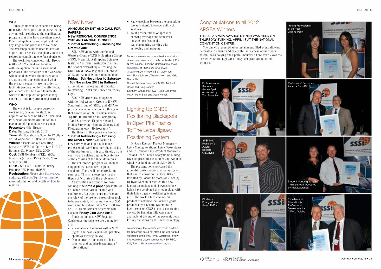
Congratulations to all 2012 APSEA WinnerstHE 2012 APSEA AWARDS DINNER WAS HElD oN tHuRSDAy EVENINg, APRIl 18 At tHE NAtIoNAl CoNVENtIoN CENtRE.
The dinner presented an entertainment filled event allowing delegates to unwind and celebrate the success of their peers within the Surveying and Spatial Industry. There were 7 awards presented on the night and a huge congratulations to the winners.
• Show overlaps between the specialties (commissions), interoperability of systems
• Joint presentations of speakers showing overlaps and teamwork between professionals, e.g. engineering working with surveying and mapping.
For more information or to submit your abstract
please send an e-mail to Kelly Rischmiller (SSSI
NSW Regional Executive Officer) at reo.nsw@
sssi.org.au or Phone: 02 8005 0972
Organising Committee: SSSI - Gaby Van
Wyk, Ross Johnson, Warwick Hehir and Kelly
Rischmiller
Central Western Group of ISNSW - Michael
Spiteri and Craig Jaques
Southern Group of ISNSW - Greg Goodman
MSIA - Hank Staal and Doug Herrick
Lighting Up GNSS Positioning Blackspots In Open Pits Thanks To The Leica Jigsaw Positioning System
Dr Ryan Keenan, Project Manager – Leica Mining Solutions, Leica Geosystems and Dr Brendon Lilly -Product Manager - Jps and J2drill Leica Geosystems Mining Division presented this lunchtime webinar which was held on the 1st May 2013.
The presentation showcased the ground-breaking radio positioning system that can be considered a ‘local GNSS” invented by Locata Corporation (Locata). Dr Ryan Keenan presented this new Locata technology and showcased how Leica have combined this technology with their Leica Jigsaw Positioning System (Jps), the world’s first commercial product to combine the Locata signals produced by a Locata system into a high-precision GNSS+Locata positioning device. Dr Brendon Lilly was made available at the end of the presentations for any questions on this new technology.
A recording of the webinar was made available
for those who could not attend the webinar but
registered at the time. If you would like to view
this recording please contact the NSW REO,
Kelly Rischmiller at [email protected]
NSW NewsANNOUNCEMENT AND CALL FOR PAPERSNSW REGIONAL CONFERENCE 2013 AND ANNUAL DINNER“Spatial Networking - Crossing the Great Divide”
SSSI NSW along with the Central Western Group of ISNSW, Southern Group of ISNSW and MSIA (Mapping Sciences Institute Australia) invite you to attend the Spatial Networking – Crossing the Great Divide NSW Regional Conference 2013 and Annual Dinner, to be held on Friday, 15th November to Saturday, 16th November 2013 in Bathurst at the Mount Panorama Pit Complex. Networking Drinks and Dinner on Friday night.
SSSI NSW are working together with Central Western Group of ISNSW, Southern Group of ISNSW and MSIA to provide a regional conference this year that covers all of SSSI’s commissions “Spatial Information and Cartography ∙ Land Surveying ∙ Engineering and Mining Surveying ∙ Remote Sensing and Photogrammetry ∙ Hydrography”.
The theme of this year’s conference “Spatial Networking – Crossing the Great Divide” will focus on how surveying and spatial science professionals work together, the crossing of the professions. It is also timely as this year we are celebrating the bicentenary of the crossing of the Blue Mountains.
The conference program will include only plenary sessions with guest speakers. There will be no break-out sessions. This is in keeping with the theme of “crossing of the professions”.
An invitation is extended to those wishing to submit a paper, presentation or poster presentation for this year’s conference. Abstracts must provide an overview of the project, research or topic to be presented, with a maximum of 300 words and be submitted in Microsoft Word or PDF. Submission of Abstracts will close on Friday 21st June 2013.
Being as this is a NSW Regional Conference the talks we are aiming for are:• Regional or urban focus within NSW
(eg with relevant legislation, practice, spatial/surveying policy)
• Demonstrate / application of best practice and standards (Australia / international)
WHAtParticipants will be expected to bring
their GISP-AP Application paperwork and any material relating to the certification program that they have questions about. Potential applicants and applicants at any stage of the process are welcome. The workshop could be used to start an application, or work through any concerns related to completing one for submission.
The workshop convener, Heidi Brown, is GISP-AP Certified and familiar with the application and assessment processes. The structure of the workshop will depend on where the participants are at in their applications and what the primary concerns are. In order to facilitate preparation for the afternoon, participants will be asked to indicate where in the application process they currently think they are at registration.
WHoThe event is for people currently
working on, or about to start, an application to become GISP-AP Certified. Participant numbers are limited to a maximum of 8 people per workshop.Presenter: Heidi BrownDate: Tuesday, 9th July 2013 Time: AM Workshop: 9:30am to 12:30pm or PM Workshop: 1:30pm to 4:30pm Where: Association of Consulting Surveyors NSW Inc. Suite 4, Level 10, 99 Bathurst St, Sydney, NSW 2000 Cost: SSSI Members FREE, ISNSW Members (Alliance Rate) FREE, Non-Members $40 CPD: 2 SSSI CPD Points, 2 Survey Practice CPD Points (BOSSI) Registration: Please visit http://www.sssi.org.au/Events/1/grid-view.html for more information and details on how to register.
young Professional of the year - Joanne Poon
Professional of the year - James Spath (Accepted by tom brownlie)
Professional Eminence Award - Chris Rizos
SSSI 2012 President’s Award - bernard o’Sullivan
Student - undergraduate - Phillip Nixon (Accepted by Nick lawrence)
Student - Postgraduate - Jacob Delfos
Excellence in Education & Professional Development - Clifford ogleby

PROUD SPONSOR OF THE SIR THOMAS MITCHELL AWARD 2013
Azimuth • June 2013 • 27 26 • www.surveyors.org.au
UniversitY neWsUniversitY neWs
reference tree at the corner of a property when undertaking a rural boundary definition and getting out the dark glass for a sun observation. The surveyor now has the option to either put in two marks to undertake GPS observations, or they can undertake a sun observation. By taking a single GPS reading and using the ATR of the instrument and the sun as a reference point, the time taken for solar observations is significantly reduced and results in a faster and increased level of accuracy in azimuth determination - to the delight of the rural cadastral surveyor.
The University of Southern Queensland congratulates Phillip Nixon on his achievements and his continued success in the NSW surveying profession.
As an aside, those intending to enrol into USQ surveying programs through http://www.qtac.edu.au are advised that applications close on July 1st for semester 2 enrolment.
Shane Simmons
Senior lecturer, program coordinator Surveying
and Spatial Science, USQ
GPS observed time and position.”The hypothesis of the project
was to develop a method to get the Automatic Target Recognition on a total station to track the sun and test the accuracy that could be obtained taking solar observations in this manner in comparison to GPS observations. As a by-product of the project Phillip wrote a program for taking solar observations, reducing the observations based upon a GPS observation and location to a single point and obtaining the azimuth for a line. The basic flow of the technique, and it’s interface with the total station and accessories is that the sun is sighted through the lens and filter and is recorded by the ATR, the horizontal circle records the observed bearing and the time using its onboard clock. The values are sent to the sun azimuth program which uses GPS time to obtain a time correction rather than the traditional stopwatch for the time and altitude method and the geoid file to compute the deflection of the vertical and calculate the azimuth of a line.
Many a rural cadastral surveyor will fondly remember finding a solitary
Student Award (Regional & National) is conferred on a student who has undertaken a research project in the course of their studies that contributes to the surveying and spatial science profession. Students eligible to nominate for the award include final year undergraduates and graduates including Honours, Graduate Certificate/Diploma, Vocational and Educational Training (e.g. TAFE, Polytechnics) and Masters by coursework.
Earlier, Phillip had been awarded the University Student Project of the Year at the NSW Excellence in Surveying and Spatial Information Awards 2012, and the Undergraduate/Graduate Project Award (QSEA), the Clem Jones Medal, at the 7th Annual Queensland Spatial Excellence
This represents an extraordinary achievement for a project that many rural cadastral surveyors would appreciate wholeheartedly, especially given that the project is at the lower 2 unit project range competing against projects from 1 unit to 4 unit duration. It takes an extraordinary project at the undergraduate level to win this award against post-graduate student projects at the coursework graduate certificate, graduate diploma and Masters level.
The annual Asia-Pacific Spatial Excellence Awards are the only awards for the Asia-Pacific region that recognise the achievements of both individuals and organisations engaged in the surveying and spatial information industry at the national level. The Undergraduate
Awards. This was the first time for a student to receive both state awards and highlights the growing recognition of the excellence of spatial science graduates at USQ and the increased awareness of the USQ brand in NSW.
Phillip, whilst in his final year at USQ was a University Medallist, which is the university’s most prestigious under-graduate award and is awarded to a small number of graduates each year whose academic performance has been consistently of the highest order, the Spatial Science and Surveying Institute Qld Centenary Prize donated by the Surveying and Spatial Science Institute, Australia, Queensland Division, for the graduating external student who demonstrates the highest level of proficiency in practical and academic work and a sincere interest in the profession, and also the Aurecon Prize for the best Bachelor of Spatial Science seminar presentation and project.
In one of the more innovative student projects, Phillip’s project was titled “Using sun observations to set an azimuth by combining and comparing Automatic Target Recognition in a Total Station with
Student success at USQ
2012 Clem Jones medal Winner Phillip Nixon (centre). Presented by geoff Wright (left) and Dell townsend (right) representing the Clem Jones group of Companies.
Outstanding University of Southern Queensland (USQ) Bachelor of Spatial Science (Surveying) graduate, Phillip Nixon, was recently awarded the Undergraduate Student Project at the annual Asia-Pacific Spatial Excellence Awards on top of receiving two ‘outstanding student project’ awards at the state level.
The Association is entirely dependent upon voluntary financial contributions to cover the cost of operating. These contributions have to date come primarily from the Institution, together with several small grants, donations and legacies from members and the estates of members. Any donation would be gratefully received.The objects of the Association include:• To counsel, help and advise any member of the
Institution of Surveyors New South Wales Inc. in need or distress to overcome health and/or professional problems.
• To offer advice, guidance and, in circumstances considered by the Directors to be special, financial assistance by way of grants, loans or payments:
(i) to the family, surviving spouse and/or dependants of any
member of the Institution of Surveyors, New South Wales who dies;
(ii) to the family, spouse and/or dependants of any member of the Institution of Surveyors, New South Wales, who is incapacitated and who, as a result, is incapable in the opinion of the Directors, or managing the affairs and welfare of himself or herself or his or her family, surviving spouse or dependants.
In order for the Benevolent Association to provide assistance when needed, the Benevolent Association needs to be informed of the circumstances that may warrant such assistance. In this regard ISNSW members are asked to provide such information to:- ISNSW Benevolent Association Ltd, SecretaryPhone (02) 9264 2076 or [email protected]
The Institution of Surveyors NSW Benevolent Association Ltd
(A Company Limited by Guarantee Formed for Charitable Purposes)

PROUD SPONSOR OF THE SIR THOMAS MITCHELL AWARD 2013
Azimuth • June 2013 • 29 28 • www.surveyors.org.au
oBitUArYoBitUArY
the Philippines by John Allman and he has advised the relevant Australian National and State Departments, Indonesia, Thailand and Namibia on National Adjustments.
John Allman’s funeral was held on 30 April at Port Macquarie, and was attended by his wife Betty, their 4 children and 11 grandchildren, as well many friends, both local and from Sydney. In a special tribute, all of his fellow 1962 BSurv graduates (Tony Robinson, Ron Benjamin, Brian Kent and Jimmy Sheaves) as well as two from that year’s BE (Civil) graduating class, attended. Bill Kearsley attended to represent his colleagues from the School at UNSW.
and direction to a series of small targets set at the intersection of the framework members in concentric circles around the dish. The angles had been predetermined from a fixed height of instrument setting and corrections were made by adjustment by the bolts and nuts by spanner.
“My eventual prime project came in 1970 when I was appointed Resident Surveyor at Kingsford Smith Airport during the construction of the present International Terminal and the extension of the main runway into Botany Bay. All told this project took just over 4 years and involved a staff of up to 6 surveyors and technicians. On completion of the project my field days ended when I was given a managerial job at the Australian Survey Office in Sydney where I spent my years until retirement as Supervising Surveyor for NSW.”
Phil was elected a Fellow of the Institution in 1976 and President of ISNSW for the years 1978 – 1979. One of the many achievements during his Presidency was the purchase of the third floor unit at 363 Pitt Street, being ISNSW’s first purchase of real estate.
In 1999 Phil wrote a fascinating book “Leyburn’s Liberators” documenting the history of this hitherto little known unit of the RAAF. The forward of the book says in part – “Little has been known publicly about the activities of the RAAFs 200 Special Duties Flight which was a top secret unit in the last year of WW2 clandestinely dropping personnel from ‘Z’ Special Unit behind enemy lines in Borneo and Timor”. The book can be found in the ISNSW library and is well worth a read.
He retired from surveying in 1984 after an interesting and satisfying career of 36 odd years and was made an Emeritus Fellow of the Institution in 1993. Phil continued as a member of the Seniors Group and to encourage and promote the heritage of the profession.
Phil had always called his houses “The Azimuth” as he said it represents the beginning. He had left his last “The Azimuth” at Gloucester and was living in the Penguin Nursing Home at Foster before he died on 3 April 2013. He was 87 years old.
Commonwealth Reconstruction Training Scheme course in surveying. This I was fortunate enough to secure and with one year spent passing the Leaving Certificate and four years articled to Mr Wal Lewis and Dick Langford I returned to my employment with the Commonwealth as a Registered Surveyor in 1952.
“During our articles with Wal Lewis it was mandatory that we joined the Institution of Surveyors as a student member and I was upgraded to Member in June 1952 following my registration. My career commenced as a Land Surveyor Grade 1 on a salary of 334 pounds per annum with the Department of the Interior doing fieldwork in the Sydney area as well as elsewhere in NSW. Surveys involved the whole gamut of land held by Federal authorities including post offices, aerodromes, military establishments, naval depots, aviation beacons, meteorological stations, radio beacons and all manner of offices and establishments held by Federal authorities. One of my earliest and oddest jobs was checking the sphericality of the Parks Radio Telescope dish after it was set in place on its mountings. This involved setting my theodolite in the centre of the dish in its horizontal position and observing angles of elevation
John Allman passed as away on Wednesday 24th April 2013. John (born 1930) formerly an Associate Professor at UNSW School of Surveying, was instrumental in the establishment of the Geodetic Network Adjustment of Australia, 1984-1994.
A short biography from the School’s history reads:
Before his retirement in 1989, Associate Professor John Allman had single-handedly performed the computational adjustment of all precise terrestrial observations, VLBI observations and Satellite Doppler observations across Australia since the 1860s. The computation required the application of 10 years research into the Method of Least Squares and the Solution of Very Large Systems of Equations. The collection and validation of the data set from the National and State Departments took 5 years. The adjustment was known as AGD84 and was carried out on a classically defined geodetic datum and was accepted as the foundation for all mapping in Australia.
John Allman’s work literally ‘put Australia on the map’ and was recognised in 1984 when he was invested as a Member of the Order of Australia (AM) for services to Science specifically Surveying and Mapping.
After his retirement he carried out a second adjustment, known as GDA94 (and still in use), which incorporated the new high accuracy GPS baselines, the previous data set and all new precise survey observations and using a geocentric datum. The results of this adjustment were gazetted to provide from 1st January 2000 the framework for all surveys throughout Australia.
The techniques developed during the research have been applied in the Adjustments of Papua New Guinea and
Phil Dynes commenced working life as a PMG telegram messenger at 15 years of age. By the time he was old enough to enlist in WW2 he had completed 2 years in morse code telegraphy.
Phil was looking forward to service as aircrew in the RAAF particularly as a navigator...(was this the first signs of a future surveyor?). An early training accident resulted in the loss of sight in one eye. So his aircrew ambitions were gone but he was accepted into the RAAF for non flying duties. With this background in early 1945, he was posted to No 200 Special Duties Flight based at Leyburn, Queensland. 200 Flight operated the 4 engine Liberator Bombers dropping equipment and special forces personnel into the South East Asian area.
Phil displayed a gift in telegraphy that led to him being involved in decoding intercepted Japanese signals. He never spoke much of this but some 5-6 years ago he was awarded, by the British Government, a limited issue medal recognising his links with the Blechley Park British WW2 code breaking organisation.
Phil describes how he entered the surveying profession after the war: “While at Leyburn a party of surveyors were surveying the Toowoomba – Goondiwindi road which passed through the campsite. The war had ended and as they approached the camp I became interested in their activities and spent some time with them. They had a buckboard vehicle and the surveyor had a collar and tie and leather leggings out in the middle of nowhere. His two chainman, who were quite skilful with the axe, addressed him as ‘Sir’. Of course he was measuring and looking through his theodolite and making notes in his field book and often referring to the many plans he had in his vehicle. This intrigued me no end as before my eye injury I had been hoping to be a navigator in the air force. I spent time with them watching them use their calculating machine on endless calculations and plans–it was too much, my future was assured.
“Needless to say when I was demobilised I had one goal – a
obituaryJohn Stuart Allman, the man who put Australia on the map
obituaryJohn Philip Dynes 1925 - 2013
Phil at Narrabri Radio telescope, for which he supervised the original surveying of the site in the 1960s.
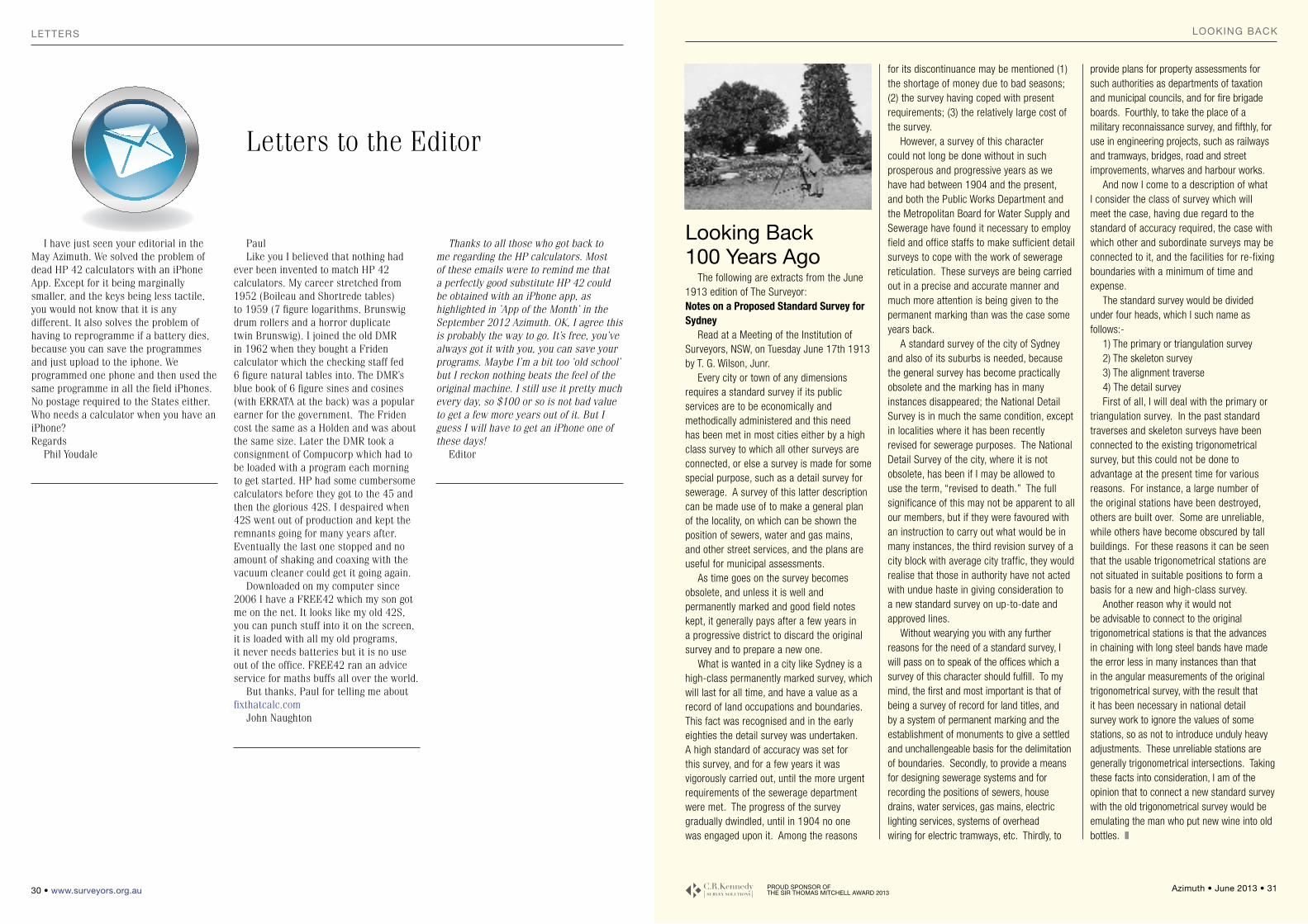
30 • www.surveyors.org.au
Letters
Thanks to all those who got back to me regarding the HP calculators. Most of these emails were to remind me that a perfectly good substitute HP 42 could be obtained with an iPhone app, as highlighted in ’App of the Month’ in the September 2012 Azimuth. OK, I agree this is probably the way to go. It’s free, you’ve always got it with you, you can save your programs. Maybe I’m a bit too ‘old school’ but I reckon nothing beats the feel of the original machine. I still use it pretty much every day, so $100 or so is not bad value to get a few more years out of it. But I guess I will have to get an iPhone one of these days!
Editor
PaulLike you I believed that nothing had
ever been invented to match HP 42 calculators. My career stretched from 1952 (Boileau and Shortrede tables) to 1959 (7 figure logarithms, Brunswig drum rollers and a horror duplicate twin Brunswig). I joined the old DMR in 1962 when they bought a Friden calculator which the checking staff fed 6 figure natural tables into. The DMR’s blue book of 6 figure sines and cosines (with ERRATA at the back) was a popular earner for the government. The Friden cost the same as a Holden and was about the same size. Later the DMR took a consignment of Compucorp which had to be loaded with a program each morning to get started. HP had some cumbersome calculators before they got to the 45 and then the glorious 42S. I despaired when 42S went out of production and kept the remnants going for many years after. Eventually the last one stopped and no amount of shaking and coaxing with the vacuum cleaner could get it going again.
Downloaded on my computer since 2006 I have a FREE42 which my son got me on the net. It looks like my old 42S, you can punch stuff into it on the screen, it is loaded with all my old programs, it never needs batteries but it is no use out of the office. FREE42 ran an advice service for maths buffs all over the world.
But thanks, Paul for telling me about fixthatcalc.com
John Naughton
I have just seen your editorial in the May Azimuth. We solved the problem of dead HP 42 calculators with an iPhone App. Except for it being marginally smaller, and the keys being less tactile, you would not know that it is any different. It also solves the problem of having to reprogramme if a battery dies, because you can save the programmes and just upload to the iphone. We programmed one phone and then used the same programme in all the field iPhones. No postage required to the States either. Who needs a calculator when you have an iPhone? Regards
Phil Youdale
looking back100 years Ago
The following are extracts from the June 1913 edition of The Surveyor:Notes on a Proposed Standard Survey for Sydney
Read at a Meeting of the Institution of Surveyors, NSW, on Tuesday June 17th 1913 by T. G. Wilson, Junr.
Every city or town of any dimensions requires a standard survey if its public services are to be economically and methodically administered and this need has been met in most cities either by a high class survey to which all other surveys are connected, or else a survey is made for some special purpose, such as a detail survey for sewerage. A survey of this latter description can be made use of to make a general plan of the locality, on which can be shown the position of sewers, water and gas mains, and other street services, and the plans are useful for municipal assessments.
As time goes on the survey becomes obsolete, and unless it is well and permanently marked and good field notes kept, it generally pays after a few years in a progressive district to discard the original survey and to prepare a new one.
What is wanted in a city like Sydney is a high-class permanently marked survey, which will last for all time, and have a value as a record of land occupations and boundaries. This fact was recognised and in the early eighties the detail survey was undertaken. A high standard of accuracy was set for this survey, and for a few years it was vigorously carried out, until the more urgent requirements of the sewerage department were met. The progress of the survey gradually dwindled, until in 1904 no one was engaged upon it. Among the reasons
for its discontinuance may be mentioned (1) the shortage of money due to bad seasons; (2) the survey having coped with present requirements; (3) the relatively large cost of the survey.
However, a survey of this character could not long be done without in such prosperous and progressive years as we have had between 1904 and the present, and both the Public Works Department and the Metropolitan Board for Water Supply and Sewerage have found it necessary to employ field and office staffs to make sufficient detail surveys to cope with the work of sewerage reticulation. These surveys are being carried out in a precise and accurate manner and much more attention is being given to the permanent marking than was the case some years back.
A standard survey of the city of Sydney and also of its suburbs is needed, because the general survey has become practically obsolete and the marking has in many instances disappeared; the National Detail Survey is in much the same condition, except in localities where it has been recently revised for sewerage purposes. The National Detail Survey of the city, where it is not obsolete, has been if I may be allowed to use the term, “revised to death.” The full significance of this may not be apparent to all our members, but if they were favoured with an instruction to carry out what would be in many instances, the third revision survey of a city block with average city traffic, they would realise that those in authority have not acted with undue haste in giving consideration to a new standard survey on up-to-date and approved lines.
Without wearying you with any further reasons for the need of a standard survey, I will pass on to speak of the offices which a survey of this character should fulfill. To my mind, the first and most important is that of being a survey of record for land titles, and by a system of permanent marking and the establishment of monuments to give a settled and unchallengeable basis for the delimitation of boundaries. Secondly, to provide a means for designing sewerage systems and for recording the positions of sewers, house drains, water services, gas mains, electric lighting services, systems of overhead wiring for electric tramways, etc. Thirdly, to
provide plans for property assessments for such authorities as departments of taxation and municipal councils, and for fire brigade boards. Fourthly, to take the place of a military reconnaissance survey, and fifthly, for use in engineering projects, such as railways and tramways, bridges, road and street improvements, wharves and harbour works.
And now I come to a description of what I consider the class of survey which will meet the case, having due regard to the standard of accuracy required, the case with which other and subordinate surveys may be connected to it, and the facilities for re-fixing boundaries with a minimum of time and expense.
The standard survey would be divided under four heads, which I such name as follows:-
1) The primary or triangulation survey2) The skeleton survey3) The alignment traverse4) The detail surveyFirst of all, I will deal with the primary or
triangulation survey. In the past standard traverses and skeleton surveys have been connected to the existing trigonometrical survey, but this could not be done to advantage at the present time for various reasons. For instance, a large number of the original stations have been destroyed, others are built over. Some are unreliable, while others have become obscured by tall buildings. For these reasons it can be seen that the usable trigonometrical stations are not situated in suitable positions to form a basis for a new and high-class survey.
Another reason why it would not be advisable to connect to the original trigonometrical stations is that the advances in chaining with long steel bands have made the error less in many instances than that in the angular measurements of the original trigonometrical survey, with the result that it has been necessary in national detail survey work to ignore the values of some stations, so as not to introduce unduly heavy adjustments. These unreliable stations are generally trigonometrical intersections. Taking these facts into consideration, I am of the opinion that to connect a new standard survey with the old trigonometrical survey would be emulating the man who put new wine into old bottles. z
Looking BACk
Azimuth • June 2013 • 31 ProUd sPonsor oF tHe sir tHomAs mitCHeLL AWArd 2013
Letters to the Editor
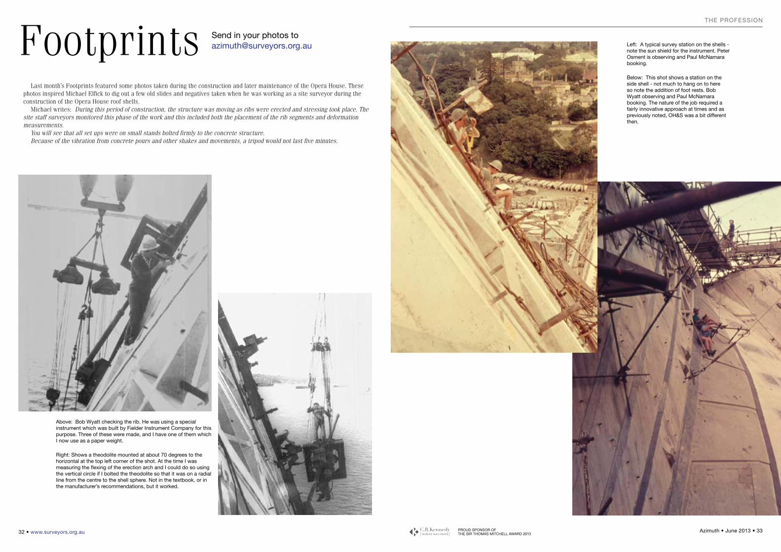
PROUD SPONSOR OF THE SIR THOMAS MITCHELL AWARD 2013
Azimuth • June 2013 • 33 32 • www.surveyors.org.au
the profession
Last month’s Footprints featured some photos taken during the construction and later maintenance of the Opera House. These photos inspired Michael Elfick to dig out a few old slides and negatives taken when he was working as a site surveyor during the construction of the Opera House roof shells.
Michael writes: During this period of construction, the structure was moving as ribs were erected and stressing took place. The site staff surveyors monitored this phase of the work and this included both the placement of the rib segments and deformation measurements.
You will see that all set ups were on small stands bolted firmly to the concrete structure.Because of the vibration from concrete pours and other shakes and movements, a tripod would not last five minutes.
Footprints send in your photos to [email protected]
Above: bob Wyatt checking the rib. He was using a special instrument which was built by fielder Instrument Company for this purpose. three of these were made, and I have one of them which I now use as a paper weight.
Right: Shows a theodolite mounted at about 70 degrees to the horizontal at the top left corner of the shot. At the time I was measuring the flexing of the erection arch and I could do so using the vertical circle if I bolted the theodolite so that it was on a radial line from the centre to the shell sphere. Not in the textbook, or in the manufacturer’s recommendations, but it worked.
left: A typical survey station on the shells - note the sun shield for the instrument. Peter osment is observing and Paul mcNamara booking.
below: this shot shows a station on the side shell - not much to hang on to here so note the addition of foot rests. bob Wyatt observing and Paul mcNamara booking. the nature of the job required a fairly innovative approach at times and as previously noted, oH&S was a bit different then.
the profession
ProUd sPonsor oF tHe sir tHomAs mitCHeLL AWArd 2013
Azimuth • June 2013 • 35
gAzettestHe ProFession
34 • www.surveyors.org.au
g.g.12tH APRIl 2013The following instruments were officially notified on the NSW legislation website:• Cessnock Local Environmental Plan 2011 (Amendment No 3)• Holroyd Local Environmental Plan 2013• Hunters Hill Local Environmental Plan 2012 (Amend No 1)• Manly Local Environmental Plan 2013• Shellharbour Local Environmental Plan 2013• State Environmental Planning Policy (Sydney Region Growth
Centres) Amendment (The Hills Growth Centre Precincts) 2013
• Sydney Local Environmental Plan 2012 (Amendment No 1)The following species were listed as a vulnerable species under the Threatened Species Conservation Act 1995:• Falco subniger G.R. Gray, 1843 – Black Falcon
g.g. 19tH APRIl 2013The following items were listed on the State Heritage Register:• Tocal College – C.B. Alexander Campus and Movable
Collection, 815 Tocal Road, TocalThe following address locality boundaries are proposed to be amended:• Address locality boundary between Figtree and Unanderra in
the Wollongong Local Government AreaThe following local government area boundaries were amended:• Boundary between Gunnedah Shire, Liverpool Plains Shire
and Warrumbungle Shire
g.g. 26tH APRIl 2013The following instruments were officially notified on the NSW legislation website:• Albury Local Environmental Plan 2010 (Amendment No 8)• Liverpool Local Environmental Plan 2008 (Amendment No 25)• Tenterfield Local Environmental Plan 2013The following address locality boundaries are proposed to be amended:• Address locality boundary between Lake Cathie and Lake
Innes in the Port Macquarie Hastings Local Government AreaThe following local government area boundaries were amended:• Boundary between Young Shire and Weddin ShirePursuant to the provisions of the Surveying and Spatial Information Act 2002, the undermentioned persons have been registered as Land Surveyors in New South Wales from the dates shown.Name Address Effective DateHAWKE, PO Box 160 8 April 2013Aaron Michael Liverpool 1871
Pursuant to the provisions of the Surveying and Spatial Information Act 2002, the undermentioned persons have been registered as Mining Surveyors (Unrestricted) in New South Wales from the dates shown.Name Address Effective DateNIXON, 5 Burgundy StreetChristopher Muswellbrook 2333 3 April 2013Samuel ROLPH, 17 Wynyard Street 8 April 2013David Gordon Singleton 2330
Pursuant to the provisions of the Surveying and Spatial Information Act 2002, the undermentioned persons have been registered as Mining Surveyor (Unrestricted) in New South Wales under the Mutual Recognition Act 1992, from the dates shown.Name Address Effective DateBROWN, PO Box 474 10 April 2013Matthew David Mudgee 2850
g.g. 3RD mAy 2013The following instruments were officially notified on the NSW legislation website:• Gosford Local Environmental Plan No 480• The Hills Local Environmental Plan 2012 (Amendment No 2)• Woollahra Local Environmental Plan 1995 (Amendment No
74)The following address locality boundaries are proposed to be amended:• Address locality boundary between Banora Point and Tweed
Heads South in the Tweed Local Government Area
From the NSW Government Gazette
STUDENT MEMBERSHIP
Robert DickerComments: After a 30+ year career as an airline pilot, based both in Australia and Hong Kong, I decided to retire from long haul flying and take a new path in life.
Over my years in aviation I had developed an interest in mapping, navigation and GIS so I enrolled at my alma mater, the University of NSW, at the school of Surveying and Geospatial Engineering (My previous degree was in Architecture).I’m now half way through my third year; the mental stimulation has been fantastic, as well as a challenge, so now I’m wondering where this might take me when I finish!
Simon ErginelAge: 30Career: Studying a Cert III of Surveying & Spatial Information Services at TAFE Sydney Institute.Areas of Interests: Cadastral, Mining, Geodetic/GPS, Spatial
Information, Hydrographic, Mapping, Town Planning.Future: In the immediate future I am looking forward to completing my studies and continuing on with the Diploma of Surveying. During my studies I aim to gain broad exposure and experience within the spatial field. My long term goals are to study a Bachelor of Spatial Science and become a registered Surveyor. I would ideally like to find a position that enables me to apply different aspects of my knowledge of surveying, planning and property development utilising my Degree in Property Development & Planning I acquired during my time in the UK.
CORPORATE MEMBERSHIP
Peter CormickComments: At a young 64 years of age I am now returning to the fold, thanks to the welcome influence of an Institution elder, Alan Shephard. Areas of Interests: My
interests have always included mathematics and physics - and literature. Career: My career in surveying started relatively late, in my thirties, but through the first class tuition and guidance from Wally Wassermann, Laurie McDonald and Claude King, and later Allan Mail and Peter Mayberry (my marginally younger Master Surveyor), I managed to get up to speed. I look forward to the company of fellow surveyors and the pleasures of leisurely-paced surveying, especially in the bush.
Michael FullerCareer: This is my 40th year in the profession, I have worked in the UK, North Africa and Thailand.I have been in Australia 32 years and for the past 18 years have
been run my own Survey Engineering Practice.I believe surveying is one of the best careers someone could choose, it has taken me around the world to work in some very interesting places with plenty of tales to tell.Areas of Interests: Apart from work my interests are my Family, soccer, golf, fishing, weekend drives, motor sport.Future: As for the future I would like a younger Partner to help run the practice to allow me to improve on the golf handicap.
membership Connect
THE INSTITUTION
OF SURVEyORS
NSW IS PLEASED
TO WELCOME AND
CONGRATULATE
THE FOLLOWING
MEMBERS ADMITTED
ON 3RD MAy 2013

PROUD SPONSOR OF THE SIR THOMAS MITCHELL AWARD 2013
Azimuth • June 2013 • 37 36 • www.surveyors.org.au
ConFerenCes & seminArs
Classifieds LOOKING FOR WORK
Surveying Student James Rostirolla, from Ultimo TAFE NSW is looking for a casual assistant position in the Illawarra area.Email: [email protected]
FREE TRIAL
Many Surveyors use BricsCAD. Download a free trial at www.bricsys.com
Conferences & SeminarsFIG REFERENCE FRAME IN PRACTICE TECHNICAL SEMINAR - LSC21-22 June 2013Philippine International Convention Centre - Vicente Sotto, Pasay City.Mikael Lilje, [email protected] Rob Sarib, [email protected]
2ND ExPLORATION & MAPPING IN MINING CONFERENCE16-18 July 2013Four Points by Sheraton Perth, Western Australiawww.explorationandmapping.com
IGARSS 201321 - 26 July 2013 IEEE International Geoscience and Remote Sensing Symposium Melbourne, Australiawww.igarss2013.org
GIS IN MINING & ExPLORATION CONFERENCE 2013 31 July – 01 August, 2013 Duxton Hotel, Perth, Western Australiahttp://www.gisinmining.com.au
18TH ANNUAL GEOSPATIAL SOLUTIONS CONFERENCE (GITA 2013) 5 - 7 August 2013 Brisbane Convention and Exhibition Centre, Queensland, Australia.www.gitaconference.org.au
FIG 5TH INTERNATIONAL LADM (LAND ADMINISTRATION DOMAIN MODEL) WORKSHOP25 September, 2013Kuala Lumpur, Malaysia, (in conjunction with ISG 2013)www.isoladm.org
19TH INTERGEO 8 -10 October 2013 Essen, Germany www.intergeo.de
19TH APAS CONFERENCE 201431th March to 2nd April 2014Pokolbin, Hunter Valley, NSW
2013 CALendAr oF events
DATE EVENT CODE ORGANISATION ACTIVITY/FUNCTION/MEETING LOCATION
CPD POINTS
MINING CAD SUR Total
June 2013
7The Institution of Surveyors
NSW Committee Meeting L4, 162 Goulburn St Surry Hills
19The Institution of Surveyors
NSW Twilight Seminar L4, 162 Goulburn St Surry Hills TBA
28 Southern Group Seminar The Goulburn ClubGoulburn
July 2013
5The Institution of Surveyors
NSW Committee Meeting L4, 162 Goulburn St Surry Hills
19 Cumberland Group Development Seminar Liverpool Catholic Club TBA
24The Institution of Surveyors
NSW Twilight Seminar L4, 162 Goulburn St Surry Hills TBA
AUgUst 2013
2 The Institution of Surveyors NSW Committee Meeting L4, 162 Goulburn St Surry Hills
6 Seniors Group Lunch 12:00pm Quarterly Meeting 1pm
Lunch: Crown Hotel Sydney Corner of Goulburn St
& Elizabeth St Meeting: L4, 162 Goulburn St
Surry Hills
8The Institution of Surveyors
NSW Annual Golf Day Ryde-Parramatta Golf Club
21The Institution of Surveyors
NSW Twilight Seminar L4, 162 Goulburn St Surry Hills TBA
sePtemBer 2013
6 The Institution of Surveyors NSW Committee Meeting L4, 162 Goulburn St
Surry Hills
7The Institution of Surveyors
NSW Inc/Association of Consulting Surveyors
NSW Awards for Excellence in Surveying
& Spatial Information 2013
Hilton, Sydney
11 Cumberland Group General Meeting Parramatta Workers Club TBA
18The Institution of Surveyors
NSW Twilight Seminar L4, 162 Goulburn St Surry Hills TBA
oCtoBer 2013
4 The Institution of Surveyors NSW Committee Meeting L4, 162 Goulburn St
Surry Hills
23The Institution of Surveyors
NSW Twilight Seminar L4, 162 Goulburn St Surry Hills TBA
novemBer 2013
1 The Institution of Surveyors NSW Committee Meeting L4, 162 Goulburn St
Surry Hills
2-3 Cumberland Group
50th Anniversary Celebration and Blue
Mountains History Seminar
Carrington Hotel Katoomba TBA
6 Seniors GroupLunch 12:00pm
Quarterly Meeting & AGM 1pm
Lunch: Crown Hotel Sydney Corner of
Goulburn St & Elizabeth St Meeting: L4, 162 Goulburn St
Surry Hills
20The Institution of Surveyors
NSW Twilight Seminar L4, 162 Goulburn St Surry Hills TBA
deCemBer 2013
6 The Institution of Surveyors NSW Committee Meeting L4, 162 Goulburn St
Surry Hills

THE INSTITUTION OFSURVEYORS NSW INC
Head officeLevel 4, 162 goulburn street, surry Hills, nsW 2000Po Box 104, darlinghurst nsW 1300Phone: (02) 9264 2076Fax: (02) 9261 [email protected] www.surveyors.org.au
PatronHer excellencyProfessor marie Bashir AC Cvogovernor of new south Wales
Presidentgraeme stewartPhone: (02) 9264 [email protected]
President ElectPhilip HaywardPhone: 0418 416 [email protected]
Past Presidentgrahame WallisPhone: (02) 9264 [email protected]
Honorary Secretaryvictoria testerPhone: (02) 9264 [email protected]
Honorary Treasurermatt HynesPhone: 0408 084 [email protected]
Administration Managerterina sawyer(02) 9264 [email protected]
Elected ISNSW Directorsmichael LockleyPhone: (02) 9879 [email protected]
dr. Bill kearsley Phone: (02) 9385 4188 [email protected]
Jonathan KeenPhone (02) 9544 [email protected]
John BrockPhone: 02 9633 [email protected]
GROUP REPRESENTATIVESCumberlandJohn BrockPhone: 02 9633 [email protected] Southernrobert van der zypen(02) 4296 [email protected]
North Coastmichael Lamont Phone: (02) 6651 [email protected]
Sydney Northvictoria testerPhone: (02) 9630 7955 [email protected]
MurrayJason Hay Phone: (02) 6051 1300 [email protected]
Hunter Manningtony ProustPhone: (02) 4940 4200 [email protected]
Central Westernmark ButtsworthPhone: 02 6331 [email protected]
St George SutherlandPeter vandergraafPhone: 02 8234 8300 [email protected]
Senior Surveyorsmichael rutlidgePhone: 0410 770 [email protected]
Young Surveyorsnarelle UnderwoodPhone: (02) 8837 [email protected]
Engineering and Mining Surveyorsnorm mannPhone: (02) 8808 [email protected]
CO-OPERATING ASSOCIATIONS REPRESENTATIVESAssociation of Public Authority surveyors and staff surveyors Association – graeme stewartAssociation of Consulting surveyors – murray Learmontmain roads surveyors Association – narelle UnderwoodCountry surveyors Association – Paul rowlandsonProfessional surveyors occupational Association – michael Lamontsurveying and spatial sciences institute – gaby van Wyk
University Representativekarl BretregerPhone: (02) 4921 6051 [email protected]
TAFE Representative Paul swan Phone: (02) 9217 5161 [email protected]
Nominees to the Board ofSurveying & Spatial Informationmark gordonPat mcnamaraBob Harrison
Azimuth MagazineEditorPaul davis-raissPhone: (02) 4296 [email protected]
Advertisingterina sawyer(02) 9264 [email protected]
Art Directoreli kitcheneclair marketingPhone: 0419 489 [email protected]
PrinterJon GallimoreBee PrintmailPhone: (02) 9437 [email protected]
PositionPartners_IBC_AzimuthFeb2013.indd 1 11/01/13 12:50 PM

Leica Viva TS15 – DREAM MACHINE.
Surveyors have dreamed of an instrument that works like this. Making your visions become reality, faster, more accurately.Now, the fastest imaging total station is here. The Leica Viva TS15 incorporates an advanced image sensor to further boost total station productivity. And with unique functionality, total station images can be captured,
enhanced with sketching and linked to any point of interest. With Leica Viva TS15 the addition of advanced imaging functionality and the Leica SmartWorx Viva easy-to-use onboard software makes the fastest total station even faster! Welcome to Leica Viva – let us inspire you
CRK26348AZ
www.crkennedy.com.au/survey
... let us inspire you
Leica Viva TS15Your vision of the FastestImaging Total Station
2 8 0 C O W A R D S T R E E T M A S C O T N E W S O U T H W A L E S 2 0 2 0 • 02 9552 8370 • nswsur [email protected]