the national woodland owner survey database: database
TRANSCRIPT

Forest ServiceU.S. DEPARTMENT OF AGRICULTURE
Northern Research Station Unnumbered publication December 2020
The National Woodland Owner Survey Database: Database Description and Users’ Guide, Version 1.0
Jesse Caputo, Brett J. Butler, Emma M. Sass

NOTE: NWOS data are confidential and must be handled using appropriate protocols, including storing any downloaded data on USDA computers or encrypted external media (e.g., flash drives, CDs). Accessing NWOS data without proper credentials is strictly forbidden.
The use of trade or firm names in this publication is for reader information and does not imply endorsement by the U.S. Department of Agriculture of any product or service.
USDA is an equal opportunity provider, employer, and lender.

1
The National Woodland Owner Survey Database (NWOS-DB): Database Description and Users' Guide, Version 1.0
December 2020
Jesse Caputo, Brett J. Butler, Emma M. Sass
JESSE CAPUTO, USDA Forest Service, Northern Research Station, and the Family Forest Research Center.
BRETT J. BUTLER, USDA Forest Service, Northern Research Station and the Family Forest Research Center.
EMMA M. SASS, University of Massachusetts Amherst, Department of Environmental Conservation and the Family Forest Research Center.
For additional questions or comments, contact Jesse Caputo, [email protected].
ABSTRACT
The National Woodland Owners Survey (NWOS) is part of the U.S. Department of Agriculture, Forest Service, Forest Inventory and Analysis program. This document describes the National Woodland Owners Survey Database (NWOS-DB), the official repository for NWOS data. In addition to explanations of the purpose and usage of the database, documentation of the table structure and logic are provided. Examples are presented for using the nwos R package to download and manipulate data. The database contains raw questionnaire responses and sample-level data. Access to these data require appropriate USDA credentials and access protocols.
Keywords: National Woodland Owner Survey, Forest Inventory and Analysis, database guide, users' guide

2
Preface
The National Woodland Owner Survey (NWOS) is one of the primary elements of the USDA Forest Service, Forest Inventory and Analysis (FIA) program. The objectives of the survey are to increase our understanding of private forest landowners, including their number, their objectives, and their past and future activities. In the past, the NWOS was implemented on a periodic or cyclic basis. As of 2019, it is being implemented on an annual basis across the entire United States.
The Forest Service provides the public with published estimates of NWOS results aggregated by State and region as well as nationwide (Butler et al. 2016; Butler et al., in press). In addition to these aggregated results, the Forest Service grants access to the raw data to certain employees as well as those with appropriate data-protection agreements in place. The data are not publicly available due to the confidential nature of survey responses as well as the presence of personally identifiable information (PII). This report describes the database in which these data are stored, including the logic and structure among the constituent tables. Additionally, this document provides guidance on how data can be accessed and manipulated using a custom package for the R statistical language (R Core Team 2019).
Acknowledgments
The following people contributed to this document: Mark Hatfield, USDA Forest Service, Northern Research Station; Brian Cordova, Department of Geoscience, University of Nevada-Las Vegas; Sarah Butler, Family Forest Research Center, University of Massachusetts Amherst; Jaketon Hewes, Family Forest Research Center, University of Massachusetts Amherst; and Amanda Robillard, Family Forest Research Center, University of Massachusetts Amherst.
The format for this report—as well as phrasing and terminology—was adopted largely from Burrill et al. (2018). This work was conducted largely by the Family Forest Research Center, a joint venture between the USDA Forest Service and the University of Massachusetts Amherst. Funding was provided by the USDA Forest Service, Northern Research Station (16-JV-11242305-041).
NWOS Database Description and Users’ Guide, Version 1.0

3
Section 1
Introduction
Purpose of This Guide
This guide is intended to serve as the official guide to the National Woodland Owner Survey database (NWOS-DB). It serves two broad purposes. The first is to provide guidance for the access, use, and interpretation of data by those with access privileges. At present time, this is limited to some USDA employees and a small number of research partners with appropriate data-protection agreements in place. The second purpose is to provide transparency and reference for those interested in the operational and statistical methodology underlying the NWOS (Butler and Caputo, in review; Butler et al., in press)
This guide has four sections. This section provides a general introduction to the NWOS and NWOS-DB. It provides a brief summary of the place of the NWOS within the larger FIA program. It also provides an overview of the design philosophy behind NWOS-DB as well as the broader system of data and tools within which it functions. Section 2 provides a brief overview of the NWOS sample and the process of survey implementation. In a fundamental sense, these define the types of data that are stored in the database. Section 3 describes the tables that constitute the database, their functions, and the conceptual logic that links them together. The final section provides guidance on accessing NWOS data using the nwos R package (Butler and Caputo 2019). It is hoped that it provides sufficient guidance for a user to access NWOS data in a standardized and convenient format, given basic familiarity with R usage and syntax.
The names of tables and table fields (i.e., columns or attributes) are by convention capitalized in this report (e.g., PLOT_OWNER or OWNCD). In most cases, the association of a given field with a given table is clear given the verbal context (e.g., "In the SAMPLE table, the field NWOS_STUDY is used for…"). Where the association needs to be made explicit, the report uses a naming convention consisting of the table name followed by the field name, separated by a period (e.g., PLOT_OWNER.OWNCD).
The National Woodland Owner Survey(s)
The NWOS is part of the USDA Forest Service, Forest Inventory and Analysis (FIA) program. It is one of the three primary components of the program, along with the Timber Products Output (TPO) survey and the core FIA plot-based forest inventory. The purpose of TPO is to provide estimates of wood products production; the survey is administered to primary wood products manufacturers and is designed to elicit the type and quantity of wood products produced as well as other attributes (Coulston et al. 2018). The plot-based forest inventory (sometimes referred to generically as "the" FIA sample) at its most basic conception consists of a national network of ground plots that are used to estimate "the extent, condition, volume, growth, and depletions of
NWOS Database Description and Users’ Guide, Version 1.0

4
timber" (Burrill et al. 2018) across the entire United States, including affiliated territories (e.g., the Pacific Islands). The NWOS was developed to complement these other two components. Its intended purpose is to better understand the self-reported motivations, activities, intentions, and demographics of private U.S. forest landowners. The primary instruments of the NWOS are landowner questionnaires.
The main module1 of the NWOS (called the “base” or “rural’ NWOS) has historically been tied to the network of FIA ground plots (excluding U.S. territories). The NWOS population of interest is private forest landowners and the survey sample frame is derived from the subset of FIA plots that are both forested and privately owned, as determined by the plot-based inventory. Contact information associated with these FIA points is used to develop the NWOS mailing list. This approach has a number of advantages, including the adoption of a rigorous, pre-existing sample and the ability to link questionnaire responses back to measures of physical attributes of the land. When necessary to achieve adequate sample sizes, this base sample was intensified using a complementary methodology (a more detailed description of the NWOS sampling methodology can be found in Section 2 or Westfall et al., in review).
In recent history, FIA—including the NWOS—has been expanding its purview beyond rural forests. A network of Urban FIA ground plots (similar to the standard network of rural ground plots) has been established in multiple cities to assess urban tree cover and forest resources. Subsequently, an urban version of the NWOS module (the Urban National Landowner Survey) was piloted in multiple cities before being implemented fully in six cities in 2019 and 2020. This module is aimed at understanding the values, activities, and perspective of the private owners of urban green space.
The Urban National Landowners Survey is only the first of several new modules of the NWOS that are in various stages of development. In 2019, a pilot test of the NWOS was administered to large corporate ownerships, defined as ownerships owning more than 45,000 acres (Caputo et al. 2017). This marked the first time that a separate, custom survey instrument was created for a specific sub-group of the NWOS sampling frame. In the past, a single, generalized instrument was administered to family, corporate, nonprofit, and other private ownerships alike. There is interest in creating customized survey instruments for each group. Currently, surveys are being discussed or developed for island territories and tribal ownerships. In the future, similar efforts for other private forest ownerships, nonforest (i.e., "all-lands") ownerships, or even public ownerships may be undertaken. NWOS-DB is being developed as a common repository for all surveys falling under the NWOS banner.
1 A survey “module” is also referred to more generally as a ”survey,“ or as a “study” within portions of the NWOS database and associated literature.
NWOS Database Description and Users’ Guide, Version 1.0

5
The NWOS Database
In this report, the word "database" refers to a group of multiple, interlinked tables with a common theme and common function within the FIA's production space, an Oracle® instance (Oracle 12c.2) hosted on Forest Service servers. The NWOS database (NWOS-DB) consists of a group of tables belonging to a single schema (or user), FS_NWOS, within the FIA production space. Oracle is a relational database system, accessible through SQL (standard query language).
When designing any database structure, a primary consideration is the degree of normalization that will be pursued. Normalization is a foundational database concept that refers very generally to how disaggregated (or decomposed) data are among multiple tables. In a highly normalized database, one would generally find a greater number of (relatively simpler) tables with very specific logic relating them. This allows for reduced redundancy, reduced storage requirements, more optimized performance, and often greater flexibility in the types of data that can be accommodated. There is a tradeoff, however, between normalization and the overall accessibility of the underlying data. Highly normalized databases often require complex relations among tables, and users may find it very difficult to write concise, intuitive queries that correctly return the data the user requires. Views are one way to resolve this tradeoff. Views are essentially pre-established queries that run on-the-fly and that can be referenced like tables (without any redundancy in data storage). Views are often written by the database managers or creators and can be seen as official, “approved” queries with the correct relations accounted for properly. Users can query views directly, often using simple, intuitive queries, while having some degree of assurance that their queries are correct, while the database retains a more normalized underlying table structure.
The NWOS database was deliberately designed to have only a moderate degree of normalization. This main rationale behind this choice was the desire to create a simpler, more accessible structure for querying. Having only a few tables with simple and intuitive relations makes it easy to write queries that correctly return the data the user requires. Secondly, NWOS-DB is quite small and streamlined by industry standards and will likely remain so for the foreseeable future. The performance and storage benefits of further normalization do not outweigh the concomitant increase in complexity and loss of accessibility in any meaningful way. For similar reasons, NWOS-DB does not contain any built-in views. While this is partly because of the simple underlying table structure, it is largely because the database was designed to be primarily accessed not through an SQL client, but through an R package containing a few simple, standardized functions. These functions provide many of the same benefits of database views. They allow users a simple, intuitive mechanism to download the data they want, with joins correctly and automatically made in the background (more on the package below).
NWOS-DB is to be considered a work in progress and must remain responsive and flexible as the needs of the program evolve and as additional surveys and survey instruments are developed. As the total amount and diversity of data increase, it is likely that additional normalization and
NWOS Database Description and Users’ Guide, Version 1.0
6
the inclusion of views will be adopted. These will improve performance and flexibility, while remaining compatible with a model in which an R package is used as the primary front end and point of access. The tradeoff between normalization and simplicity will be continually assessed over time.
The raw NWOS data are not available publicly due to confidentiality concerns and the presence of personally identifiable information (PII). Access requires a Forest Service Oracle username with basic connection privileges. This username must also be granted an appropriate role within NWOS-DB. There are two such roles, Admin and Analyst. The Admin role has full read and write privileges to all tables. This role is primarily intended for those directly involved in the uploading, cleaning, and management of NWOS data. The Analyst role, on the other hand, has only read (i.e., select) privileges and is intended for researchers and users of NWOS data. The Analyst role is sufficient for accessing raw data using the R package (see below and Section 4 for step-by-step directions).
The Database "Ecosystem"
As mentioned above, the database can be directly accessed through an SQL client (such as PL/SQL or SQL*Plus). Users with either the Admin or Analyst role will be able to run select queries on one or more tables. Users with the Admin role will also be able to update, insert, or delete records through the client. There are certain limitations to accessing the data this way. One is that it is possible to relate tables incorrectly because of the absence of views –, resulting in datasets that may be mismatched to a user's purpose. The second is that only “raw” data are stored in the database itself. Weights, imputation sets, and other data sources used for making population-level estimates and analyses are stored outside the database. These data sources, along with tools for accessing, analyzing, and managing NWOS data, comprise a larger NWOS "ecosystem" (Figure 1).
Within this ecosystem, the preferred method for accessing the database (particularly for users with the Analyst role) is through the nwos R package. This package, freely available through GitHub (https://github.com/familyforestresearchcenter/nwos), allows an authenticated user to access the raw plot-level, sample-level, and questionnaire-level NWOS data. These are downloaded to a user's computer in the form of a custom R object (of type “nwos.object”), which also contains sample weights, imputation sets, and metadata. Additional functions allow users the abilities to generate custom “wide” or “long” datasets, generate metadata tables, run population-level estimates, or complete datasets (i.e., append weights and imputed values) for statistical analyses. There are also functions for exporting datasets, accessing the complete and up-to-date database catalog, and other purposes. For users with the Admin role, the package also contains functions for inserting, updating, and deleting data in the database. Section 4 provides additional information on using the nwos package to access the database, including step-by-step guidance on many of the key functions.
NWOS Database Description and Users’ Guide, Version 1.0

7
Figure 1.—Relationships among elements in the NWOS-DB "ecosystem." Data are accessed directly through a database client (e.g., PL/SQL, SQL*Plus) or by using the nwos R package. The database is updated, in turn, through the use of the same package, through the client, or through implementation scripts stored on the Forest Service network. A repository on the internal Forest Service GitHub contains a copy of these implementation scripts as well as the scripts and tools defining the database. Linkages to NIMS, UNIMS, and other FIA databases can be made directly from within the Oracle production space. Solid lines refer to transfer of data. Dashed lines refer to transfer of scripts/code.
The nwos package accesses a number of data tables other than those stored in the database itself. These are stored on the Forest Service network2, accessible to employees and credentialed cooperators, along with a large library of additional scripts used in the implementation of the NWOS (e.g., scripts for drawing the sample, cleaning addresses, generating mailing lists, and
2 Many of these are likely to be transferred to new tables in a future version of NWOS-DB. The goal is for all tabular data to be stored within the database itself.
NWOS Database Description and Users’ Guide, Version 1.0

8
logging returns). This library can also be found in a repository on the Forest Service's internal3 GitHub (https://code.fs.usda.gov/forest-service/FS_NWOS). This repository also contains the scripts used to define, create, and update the database in the Oracle production space, as well as an up-to-date version of this guide.
NWOS-DB can be directly joined to tables in other FIA databases (NIMS, UNIMS, etc.) from within the Oracle production space. These are an important part of the NWOS-DB ecosystem, allowing rich analysis that includes both social (e.g., ownership attributes) and biophysical (e.g., tree inventory) data. See Section 3 for more about these linkages.
3 This is a private repository; the associated hyperlink is only accessible to those on a Forest Service network and possessing a Forest Service Github account.
NWOS Database Description and Users’ Guide, Version 1.0
9
Section 2
NWOS Sampling and Implementation
The primary sampling unit of the base NWOS is a zero-dimensional sample point (Westfall et al., in review). These points are derived from two different sources: FIA field plots and augmented/intensified sampling points. The FIA field plots, often called Phase 2 or P2 plots from the three-phase sample design adopted by FIA (Bechtold and Patterson 2005), are distributed nationwide using a hybrid of random and systematic sampling approaches. First, a hexagonal sample frame is established across the United States. Within each cell of this grid, a single sample point is located randomly. At each point, a measurement plot is established. Each measurement plot contains one or more condition classes, defined by a discrete combination of land use, forest type (if forested), ownership group, and other condition class variables (see Bechtold and Patterson 2005 for a complete description of the FIA sampling design). To determine the land use of a given condition class, FIA has established the following definition of forest: "Land that has at least 10 percent canopy cover by live tally trees of any size or has had at least 10 percent canopy cover of live tally species in the past, based on the presence of stumps, snags, or other evidence. To qualify, the area must be at least 1.0 acre in size and 120.0 feet wide" (USDA Forest Service 2016).
The nucleus of the NWOS sample is derived from the measurement (i.e., P2) plots. These are stratified by the land use and ownership group of the first condition, which is conventionally located at the center of the measurement plot. The main stratum of interest consists of those plots that are determined to be forested and privately owned. Since only the attributes of the plot center are relevant to the NWOS, each sample plot is in effect no more than a sample point. For the sake of consistency, then, the term sample point will be used in the remainder of this report. Similar sampling designs have been adopted for Urban FIA (and consequently, the Urban National Landowners Survey), albeit with different sampling intensities (i.e., different grid sizes) and condition class definitions.
In 1999, FIA switched its sampling methodology from a periodic one to an annual one, in which a subset of plots (i.e., a panel) is measured each year such that any individual year or group of years within a cycle constitutes an independent sample. Starting in 2019, an annual sampling methodology was established for the NWOS, using P2 data from 2 years prior as the core of the sample. For periodic surveys (2018 and earlier), the NWOS sample has been organized around a survey “cycle”, a period of 5 or fewer years that constitutes an independent sample. At least initially, annual NWOS surveys are also being organized around a 5-year survey cycle for operational reasons, even though each year or group of years also constitutes an independent sample.
In addition to those points derived from FIA field plots, the NWOS sample also contains augmented and/or intensified points. These refer to additional sets of sample points that are generated exclusively for the NWOS (i.e., they are not associated with any ground plots) to
NWOS Database Description and Users’ Guide, Version 1.0

10
increase the sample size. Augmented points are generated to increase the base sample to an adequate size; intensified sample points are generated for additional purposes, including implementation of custom versions of the base instrument. The terms intensified points and intensification will be used hereafter to refer to both. The process of intensifying the sample frame is similar to the process for locating the original FIA sample points. A hexagonal grid with smaller cell size is overlaid on the initial FIA grid, and one point is located randomly in each empty (i.e., not containing a P2 point) cell. These additional points are iteratively added to the sample until the desired intensity is achieved.
The secondary sampling unit for the NWOS is the ownership: a group of one or more owners that jointly own land. Ownerships may be associated with more than one sample point but will receive only one survey for a given survey spatial unit (i.e., city for the Urban National Landowners Survey or State for the base NWOS). Therefore, the sample contains fewer unique ownerships than sample points. Points derived from P2 plots are already associated with owner names and contact information; in the case of intensified points, these are derived from commercial data vendors. Ownerships may be part of the sample for multiple cities/States. Each ownership sampled4 is mailed two copies of the questionnaire according the Tailored Design Method (Dillman et al. 2014), with an option to respond to a web-based version. A given ownership may only receive a single copy of the questionnaire if they answer quickly enough (and consequently are removed from the second mailing), or more than two if they request an additional copy or opt to submit the electronic version later in the process. A subset of nonrespondents is also contacted for a phone interview, primarily for post-hoc nonresponse assessment. More information on the implementation of the NWOS, including information on weighting and estimation procedures, can be found in Butler and Caputo (in review) and Butler et al. (in press).
4 The term “sample” has more than one meaning in this report. It refers in a strict sense to the entire set of sample points and ownerships (regardless of land use and ownership). It also refers in a more general sense to the substrata of interest, those landowners who actually received questionnaires (e.g., for base NWOS, private owners of forested land). The name of the SAMPLE table (see Section 3) is predicated on this second meaning.
NWOS Database Description and Users’ Guide, Version 1.0

11
Section 3
Database Structure
This section provides information about the structure of NWOS-DB. The database catalog includes detailed descriptions of all fields in each table and is accessible in an up-to-date format through the nwos R package (see Section 4). A description of the database catalog is included in the appendix of this document. Each field (also known as a column or attribute) and its description are listed in these documents. For those fields that are coded, a list of the codes and their meanings are also included.
Each table includes one primary key titled “CN” (for sequence number). Foreign keys reference the primary key of the table to which they join (e.g., PLOT_OWNER_CN, SAMPLE_CN). Keys are character fields and consist of a concatenation of a three-digit code (which is a table prefix) and a unique number. For example, a value of CN = “RES1” is interpreted as the first record in the RESPONSE table. These table-specific prefixes are listed in Table 1. Keys for each table are also described in the catalog.
Table 1. Table-specific primary key prefixes in NWOS-DB. Each value of a table's primary key consists of the appropriate prefix followed by a unique number.
Table Prefix PLOT_OWNER PLT OWNER OWN SAMPLE SAM CONTACTS CON RESPONSE RES QUEST_METADATA QMD QUEST QST QUEST_TEXT TXT MODIFICATIONS MOD NOTES NOT TABLES TAB FIELDS FLD CODES COD
Table Descriptions
NWOS Database Description and Users’ Guide, Version 1.0

12
There are 13 data tables in the database in two table groups: administrative tables (five tables), and survey tables (eight tables). The latter contain data pertaining to the sampling frame, survey organization, and questionnaires. Administrative tables contain database-level metadata as well as notes and modification records for the entire database. All tables belong to the FS_NWOS schema in the Forest Service production space. Figures 2 and 3 illustrate the relationships among these tables.
The eight survey tables are as follows:
• PLOT_OWNER table—contains one record for each sample point in an NWOS study. Each record contains point-level attributes (e.g., coordinates, land use) as well as the original (unedited) ownership information for that point. This table contains all sample points for all studies. As such, data originate from multiple sources, including other FIA databases and commercial ownership data products (for intensified points). Where data for P2 (and urban) points originate from other FIA databases in the production space (e.g., NIMS, UNIMS), it is possible to directly link these tables to the PLOT_OWNER table. PLOT_OWNER contains a number of foreign keys to facilitate these joins. These keys are what make it possible to link NWOS survey responses back to plot and condition-level FIA data, including tree inventory data. More information on these keys is contained in the database catalog. More information on the tables to which these keys join can be found in Burrill et al. 2018. Despite the presence of foreign keys linking the PLOT_OWNER table to plot, condition, and ownership tables elsewhere in the production space, copies of the raw data from these tables are stored directly in PLOT_OWNER. This redundancy was deliberate, as it makes it possible to fully analyze NWOS data without joining to tables outside of FS_NWOS. This is useful if an NWOS user is unfamiliar with these tables or does not have sufficient privileges to access them. This also means that a locked-down version of the primary NWOS sample is maintained, even if the original data are dropped or altered for any reason. Finally, it allows for a consistent format for the storage of data originating from within and without FIA in the same table.
• OWNER table—contains one record for each unique ownership associated with one or more valid sample points in PLOT_OWNER. Owner-level attributes such as owner type, industrial status, and whether an ownership should be contacted, are stored in this table. Names and address fields in this table are cleaned and formatted to appear on mailing labels (raw, point-level versions of these fields are stored in PLOT_OWNER). Where names and contact information are incomplete or unknown, the OWNER table contains a dummy record containing null data. This is necessary because the OWNER table is the link between the sample points (contained in PLOT_OWNER) and the SAMPLE table (see below). Thus, all valid sample points are associated with an ownership, even if the details of that ownership are unknown and cannot be surveyed. Where the same
NWOS Database Description and Users’ Guide, Version 1.0

13
ownership is associated with plots in more than one study or study unit5, there may be separate OWNER records for each.
• SAMPLE table—contains one record for each unique ownership in the sample of a given study, year/cycle and spatial unit (e.g., State). For example, in the base NWOS, there is a record in SAMPLE for each unique ownership in each State that owns one or more private, forested plots in that State. By joining the SAMPLE table with the cleaned contact information in OWNER and filtering out the ownerships that should not be contacted or for whom there is no contact information, it is possible to generate a mailing list for sending questionnaires.
• CONTACTS table—records the occurrence and progress of official contacts with survey recipients. This includes phone calls, emails, and letters. The mailing and receiving of survey instruments (the most numerous form of contact) are recorded in the RESPONSE table (below).
• RESPONSE table—contains one record for every survey instrument sent or administered to an ownership as part of a given sample. In most cases, there will be at least two records (i.e., two survey instruments) associated with each ownership. In some cases, there will be only one (if the first is returned before the second batch is mailed) or more than two, if an ownership responds to a phone or web-based instrument. Each record contains information about the mode of the instrument, the dates sent or administered, and the dates received. Additional fields record whether an instrument prompted a valid response and, if not, the type of nonresponse (e.g., undeliverable, refusal). By joining the RESPONSE table to the SAMPLE table, it is possible to calculate response and cooperation rates for a study (see Butler et al., in press).
• QUEST_METADATA table—contains one record for each unique question asked in one or more survey instruments. This table contains the text of the questions, their type (e.g., open-ended, check box, text box.), possible responses, and response units. Additional fields contain the questions' allowable range, data type (e.g., numerical, character), whether they are part of a check box grouping, and whether they are dependent (i.e., skip-pattern) questions. Although the QUEST_METADATA table is partly intended to be a reference guide for interpreting survey results, it also serves a central role in the processes of data cleaning and logic checks (Butler et al., in press). By comparing each question response to the fields in QUEST_METADATA, implementation scripts automatically identify and (in some cases) correct responses that are out of range or that demonstrate illogical dependencies (e.g., skip-pattern errors). There is an inherent many-to-many relationship between survey instruments and survey questions (i.e., an instrument contains many questions and a question may appear in more than one instrument). By joining the QUEST_METADATA table to the RESPONSE table on an
5 Study unit refers generally to a spatial unit within which an independent sample has been established. In the case of NWOS, the study unit is the State. In the case of the urban survey, the study unit is the city.
NWOS Database Description and Users’ Guide, Version 1.0

14
instrument's identifier field, it is possible to identify all of the questions that were contained in the instrument or instruments administered to an ownership in a given sample.
• QUEST table—contains one record for each individual response to a question in a survey instrument. The QUEST table contains what is usually meant when a user refers monolithically to 'the' NWOS data, the actual response values from returned questionnaires. For a number of reasons, however, this table should not be queried and analyzed independently of other tables. The QUEST table is one of the larger tables in the database and a deliberate choice was made to pursue a greater degree of normalization with this table than with many others. The table itself contains mostly foreign keys and a single field containing response values. It is necessary to join this table to QUEST_METADATA to determine the meaning of response codes, identify appropriate data types, etc. The QUEST table also contains the responses to all returned questionnaires, regardless of study, cycle, or sample unit. Furthermore, valid and invalid (or incomplete) surveys are stored alike (see Butler et al. in press for more about what constitutes a valid survey). To query only the valid responses associated with a particular study, it is necessary to join QUEST to RESPONSE and SAMPLE. Making this join correctly is one of the primary functions of the nwos R package (see Section 4), the recommended means of accessing the QUEST table.
• QUEST_TEXT table—contains text of comment/text fields in questionnaires. To reduce the size of the QUEST table, responses to open-ended text and comment fields are not stored in the QUEST table. Instead, these values are recoded on a binary scale indicating whether a response was provided by the respondent. Where responses were provided, the actual text of the response is stored in the QUEST_TEXT table. This improves the efficiency of working with the QUEST table, particularly as data in the comment field are rarely used. The same structural relations that exist between the QUEST table and the SAMPLE and RESPONSE tables also exist between these tables and QUEST_TEXT.
The five administrative tables are as follows:
• MODIFICATIONS table—records details of modifications to individual table cells or groups of cells. These records include the date of the modification(s), a description of the modification(s) (including reasons for making them), the names of any scripts that were used, and the new and old values of the cell or cells. The modifications table can be joined to any other table, using two fields, one referencing the table modified and the other referencing the record-level CN. Where modifications refer to individual cells, records usually contain non-null values referencing the tables, records, and fields that were modified, as well as non-null values for the old and new (i.e., modified) data. In these cases, the MODIFICATIONS table can be used to roll back modifications to an earlier state. Where modification records refer more broadly to modifications across multiple tables, records, or fields, many of these attributes will be left null.
NWOS Database Description and Users’ Guide, Version 1.0

15
• NOTES table—contains notes on records in all tables. Notes can be recorded for any record in any table, using a two-field key (similar to the MODIFICATIONS table, above). Consequently, notes can be joined directly to their associated records in a query.
• TABLES table—contains one record for every table in the database. This metadata table stores the name, type (survey vs. administrative), and description of every table in the database.
• FIELDS table—contains one record for every field in every table in the database. This metadata table contains the name, description, and Oracle data type [e.g., NUMBER(22), VARCHAR(255)] of every field in every table in the database.
• CODES table—contains one record for every code in every coded field in the database, with the important exception of the coded response values contained in the QUEST table. These are contained in the QUEST_METADATA table (see above). The TABLES, FIELDS, and CODES tables are joined and queried to generate the database catalog (see Section 4).
In addition to these 13 data tables, the database also includes 13 update tables. There is one update table corresponding to each of the data tables; each is named using the convention of the name of the corresponding data table followed by the phrase “_UPDATE” (e.g., SAMPLE_UPDATE, NOTES_UPDATE). The update tables are identical in structure to the data tables, but do not normally contain any data. They are used to load, drop, and alter records as part of routine data management.
NWOS Database Description and Users’ Guide, Version 1.0

16
Figure 2.—Relationships among NWOS-DB survey tables. The figure shows primary keys (underlined), foreign keys (identified with a tilde), and a subset of additional fields.
NWOS Database Description and Users’ Guide, Version 1.0

17
Figure 3.—Relationships among NWOS-DB administrative tables. The figure shows primary keys (underlined), foreign keys (identified with a tilde), and a subset of additional fields are shown. The MODIFICATIONS and NOTES tables can be joined to any other tables, including survey tables, through the RECORD and TABLE_CN fields.
NWOS Database Description and Users’ Guide, Version 1.0

18
Section 4
Accessing NWOS-DB
NWOS-DB can be queried using a database client and SQL (standard query language) scripts. For administrative users, this is often a useful and necessary means of access, particularly for special-purpose or infrequent tasks. For the average user, however, a more reliable method is to use to the nwos R package (Butler and Caputo 2019). This R package contains a number of standardized functions for downloading, manipulating, and analyzing NWOS data in a straightforward and consistent manner.
To use the full capacity of the package, the user must have access to a USDA computer that has been mapped to the internal Forest Service network (i.e., T drive), with read permissions for the NWOS folder space. The computer must be configured with the correct DSN (data source name) for the Forest Service production space (i.e., Oracle instance). In addition to the base R installation, the user will need the “RODBC” (Ripley and Lapsley 2019) and “devtools” (Wickham et al. 2019) packages. Finally, it is necessary for the user to have connection privileges to the Forest Service production space and to have been assigned a role within NWOS-DB. With these in place, the user should be able to connect to the production space from a desktop installation of R (R Core Team 2019). The remainder of this chapter is written from the perspective of a user with the Analyst role. Note: NWOS data are confidential and must be handled using appropriate protocols, including storing any downloaded data on USDA computers or encrypted external media (e.g., flash drives, CDs). Accessing NWOS data without proper credentials is strictly forbidden.
Installing the nwos Package
The first step is to install the nwos package. This is available as a public repository on GitHub. Start R and run:
devtools::install_github('familyforestresearchcenter/nwos', build_vignettes=T)
This should install the package, including a number of vignettes (a long-form guide to using an R package). These can be viewed using the command:
browseVignettes(package='nwos')
One vignette (nwos-db-guide) consists of a current version of this guide, which may be updated periodically. Another ('get-NWOS-data') follows the examples in the remainder of this chapter closely.
NWOS Database Description and Users’ Guide, Version 1.0

19
Downloading and Preparing NWOS Data
The primary function for downloading data is get_nwos(). This function creates and passes a query to NWOS-DB to obtain the raw questionnaire results for a particular study and cycle. This query joins the QUEST, SAMPLE, and RESPONSE tables and filters them by study and cycle variables. For example:
library(nwos)
quest <- get_nwos(cycle='2018', study='base')
will download the raw responses for the 2018 base survey. Additional “states”6 and “questions” parameters can be used to limit the download to a narrower slice of the data (improving transfer speed). For example:
quest <- get_nwos(cycle='2018', study='base', states=c('44'), questions=c('AC_WOOD', 'AC_LAND'))
would retrieve data for two questions (AC_WOOD and AC_LAND) and only for the State of Rhode Island (statecd = 44). The function get_nwos() returns an “nwos.object” object, a type of list object containing several different datasets in individual 'slots.' These include slots for the raw response data, sample-level data, and metadata. If weights and imputations for the study of interest have already been calculated (see Butler et al., in press), these will also be included in additional slots. The nwos.object is of limited utility to most users in its raw form. A number of helper functions, which can be used to transform the raw object into more usable forms, are included in the package. One of the most powerful of these is nwos_wide(). This function creates an R dataframe in a wide format suitable for most common types of data analysis. Here, wide format means a format in which every row corresponds to one respondent's questionnaire and every column corresponds to either a question or an attribute of the respondent. Survey weights are included and imputed values can also be inserted. For example, the command:
qwide <- nwos_wide(quest, imputations='1')
will return a wide table with all null values (i.e., nonresponse) replaced with the values of the first imputation set. As part of the base survey, five imputation sets were created (see Butler et al., in press, for more on imputation). In addition to the numbers 1 through 5, the imputations parameter can be set to "none", in which case no imputed values will be inserted and
6 The name of the “states” parameter is derived from the STATECD_NWOS field in the PLOT_OWNER and SAMPLE tables. Both refer more broadly to study units where these are other than State (e.g., cities for the urban NWOS).
NWOS Database Description and Users’ Guide, Version 1.0

20
unanswered questions will appear as null values (i.e., “-1”) – and "random", in which case of the five imputation sets will be randomly selected.
The wide table will, in most cases, have a large number of columns (more than 250 in the case of base NWOS). Many of these are coded and a large number have names that may not be intuitive to a new user. A useful function, therefore, is nwos_wide_metadata(). This function, when applied to the original “nwos.object” object, will generate a dataframe containing all the metadata that relate to the wide format. This includes a description of each column, the data type for each column, the factor levels for the coded responses, and other attributes. The DATA_TYPE and UNITS_FACTORS columns are particularly important because the question columns in the wide table are generated as character fields, with categorical questions also being coded.
qwmd <- nwos_wide_metadata(quest)
The wide format contains one record for every valid, returned survey and one column for every question and every piece of metadata.
For other purposes, including certain plotting and statistical functions, a long table may be preferred. This is a table where each question—not each questionnaire—is represented by an individual row. A long table (and corresponding metadata table) can be generated by the following code:
qlong <- nwos_long(quest, imputations='1')
qlmd <- nwos_long_metadata(quest)
In addition to the raw response data, an analyst will sometimes need access to the raw point-level data. This data can be retrieved using the get_nwos_plots() function:
plots <- get_nwos_plots(cycle='2018', study='base')
The function will return an "nwos.plots.object" object. As with an "nwos.object" object, this is a custom list object with multiple slots. In this case there are two slots, one containing raw point-level data and one containing sample/response-level data. As before, the raw list object is of limited utility in terms of analysis. Here, we will use the nwos_plots_complete() function:
plcomp <- nwos_plots_complete(plots)
This returns a dataframe with a single row for each sample point in the sample, along with point-level land and ownership attributes. The dataframe also includes sample-level attributes, such as strata and response category (for calculating response and cooperation rate). For those points that are associated with a valid response, there will be a non-null value in the RESPONSE_CN field. This is particularly useful as it can be used to join response data to the point data. One common use for this is to attach sample point coordinates to survey responses for spatial analysis:
NWOS Database Description and Users’ Guide, Version 1.0

21
quest.coord <- merge(x=plcomp, y=qwide, by.x='RESPONSE_CN', by.y='CN')
Other Functions
In addition to functions for retrieving data and preparing it for analysis, the 'nwos' package contains a number of functions for use and analysis of data. There are a number of functions for making population-level estimates, calculating response and cooperation rates, and other purposes. For users with the Admin role, there are functions for loading, altering, and deleting records to and from the database. You can use the help() function to access a menu with a list of functions and links to the documentation for each:
help(package='nwos')
One function that may be useful to readers of this document is the get_nwos_db_catalog() function. This function will render a current, up-to-date copy of the database catalog on the user’s hard drive. The catalog is generated as an HTML file, readable in any web browser or text editor. This catalog lists all the tables, fields, and codes relevant to the database, equivalent to the information in the appendix. As the database evolves and changes, however, it is useful to be able to periodically generate an up-to-date version.
get_nwos_db_catalog(dir='C:/my_nwos_analyses', file='NWOS_DB_catalog')
Finally, many users will want to be able to export quest data in other formats to use with software other than R. Fortunately, prepared response data (both long and wide formats), “completed” plot tables, and individual slots of nwos.objects and nwos.plot.objects all take the form of regular R dataframes and can be exported in a number of formats using standard R functions. Additionally, the nwos_export() function can be used to export response data as text in any of the wide, long, or full formats:
nwos_export(quest, dir='C:/my_nwos_analyses', format='wide', imputations='1')
This will export a copy of the formatted response data in the listed directory as a CSV file, along with a copy of the corresponding metadata (also in CSV). This provides the user with the fundamental data necessary to begin analysis elsewhere. The nwos_export() function will pass the 'imputations' parameter through any format.
NWOS Database Description and Users’ Guide, Version 1.0
22
Literature Cited
Bechtold, W.A.; Patterson, P.L. 2005. The enhanced Forest Inventory and Analysis program—national sampling design and estimation procedures. Gen. Tech. Rep. SRS-80. Asheville, NC: U.S. Department of Agriculture, Forest Service, Southern Research Station. 85 p. https://doi.org/10.2737/SRS-GTR-80.
Burrill, E.A.; Wilson, A.M.; Turner, J.A.; Pugh, S.A.; Menlove, J. [et al.]. 2018. The Forest Inventory and Analysis Database: database description and user guide version 8.0 for Phase 2. Washington, DC: U.S. Department of Agriculture, Forest Service. 946 p. http://www.fia.fs.fed.us/library/database-documentation/
Butler, B.J.; Caputo, J. 2019. nwos: An R package for working with USDA Forest Service, National Woodland Owner Survey data version 1.0. https://github.com/familyforestresearchcenter/nwos
Butler, B.J.; Caputo, J. In review. Weighting for the U.S. Forest Service, National Woodland Owner Survey. USDA Forest Service, Northern Research Station.
Butler, B.J.; Butler, S.M.; Caputo, J.; Dias, J.; Robillard, A.; Sass, E. In press. Family Forest Ownerships of the United States, 2018: Results from the USDA Forest Service, National Woodland Owner Survey. Madison, WI: U.S. Department of Agriculture, Forest Service, Northern Research Station. https://doi.org/10.2737/NRS-GTR-199.
Butler, B.J.; Hewes, J.H.; Dickinson, B.J.; Andrejczyk, K.; Butler, S.M.; Markowski-Lindsay, M. 2016. USDA Forest Service National Woodland Owner Survey: National, regional, andstate statistics for family forest and woodland ownerships with 10+ acres, 2011-2013. Res.Bull. NRS-99. Newtown Square, PA: U.S. Department of Agriculture, Forest Service,Northern Research Station. 39 p. https://doi.org/10.2737/NRS-RB-99.
Caputo, J.; Butler, B.J.; Hartsell, A.J. 2017. How large is large? Identifying large corporate ownerships in FIA datasets. Res. Paper NRS-29. Newtown Square, PA: U.S. Department of Agriculture, Forest Service, Northern Research Station. https://doi.org/10.2737/NRS-RP-29.
Coulston, J.W.; Westfall, J.A.; Wear, D.N.; Edgar, C.B.; Prisley, S.P. [et al.] 2018. Annual monitoring of US timber production: rationale and design. Forest Science. 64(5): 533–543. https://doi.org/10.1093/forsci/fxy010 .
Dillman, D.A.; Smyth, J.D.; Christian, L.M. 2014. Internet, phone, mail, and mixed-mode surveys: the tailored design method. 4th ed. Hoboken, NJ: Wiley & Sons. 528 p.
R Core Team. 2019. R: A language and environment for statistical computing. Vienna, Austria: R Foundation for Statistical Computing. https://www.R-project.org/.
NWOS Database Description and Users’ Guide, Version 1.0

23
Ripley, B.; Lapsley, M. 2019. RODBC: ODBC database access. R package version 1.3-16. https://CRAN.R-project.org/package=RODBC.
USDA Forest Service. 2016. Forest Inventory and Analysis glossary. Washington, DC: U.S. Department of Agriculture, Forest Service. www.nrs.fs.fed.us/fia/data-tools/State-reports/glossary/default.asp.
Wickham, H.; Hester, J.; Chang, W. 2019. devtools: Tools to make developing R packages easier. R package version 2.2.1. https://CRAN.R-project.org/package=devtools .
NWOS Database Description and Users’ Guide, Version 1.0

24
Appendix
The following is an itemized catalog of tables, fields, keys, and codes in NWOS-DB. General descriptions of these tables are included in Section 3 of this document. A current version of this catalog is accessible using the nwos R package (see Section 4). Tables include for each column/field, that column’s name, a description, and the Oracle data type (and maximum character length) of the field.
Plot Owner table. Oracle table name is FS_NWOS.PLOT_OWNER.
Column name Descriptive name Oracle data type 1 CN Sequence number VARCHAR2(255) 2 PLT_CN PLOT sequence number VARCHAR2(255) 3 COND_CN COND sequence number VARCHAR2(255) 4 OWN_CN OWNER sequence number VARCHAR2(255) 5 STATECD State code VARCHAR2(255) 6 STATECD_NWOS State code, NWOS adjusted VARCHAR2(255) 7 UNITCD Survey unit NUMBER(22) 8 COUNTYCD County code NUMBER(22) 9 PLOT Plot number NUMBER(22) 10 INVYR Inventory year NUMBER(22) 11 PREV_INVYR Inventory year of previous
plot record NUMBER(22)
12 LATITUDE Latitude BINARY_DOUBLE(8) 13 LONGITUDE Longitude BINARY_DOUBLE(8) 14 P2PANEL Phase 2 panel NUMBER(22) 15 INTENSITY Plot intensity NUMBER(22) 16 CONDID Condition ID NUMBER(22) 17 COND_STATUS_CD Condition status code NUMBER(22) 18 COND_ST_REASON Nonsampled reason code NUMBER(22) 19 NONFOREST_LAND_USE_CD Land use code for nonforest
conditions NUMBER(22)
20 OWNCD Owner class code NUMBER(22) 21 OWNCD_NWOS Owner class code, NWOS
adjusted NUMBER(22)
22 OWNGRPCD Owner group code NUMBER(22) 23 OWNSUBCD Owner sub-class code NUMBER(22) 24 FORINDCD Forest industry code NUMBER(22) 25 PSDS_CN FIA study sequence number BINARY_DOUBLE(8) 26 STUDY_NAME FIA study name VARCHAR2(255) 27 OWNERID Owner ID VARCHAR2(255) 28 OWNER_CN Owner sequence number VARCHAR2(255) 29 CONDLIST_SRS Condition list NUMBER(22)
NWOS Database Description and Users’ Guide, Version 1.0

25
30 INDUSTRIALCD Industrial private forest owner code
NUMBER(22)
31 MILLCD Mill code NUMBER(22) 32 TIMOREITCD TIMO / REIT code NUMBER(22) 33 COMPANY Company VARCHAR2(255) 34 FIRST_NM First name VARCHAR2(255) 35 LAST_NM Last name VARCHAR2(255) 36 ADDRESS1 First address line VARCHAR2(255) 37 ADDRESS2 Second address line VARCHAR2(255) 38 ADDRESS3 Third address line VARCHAR2(255) 39 CITY City VARCHAR2(255) 40 OWNER_STATEAB State abbreviation VARCHAR2(255) 41 ZIP_CD Zip code VARCHAR2(255) 42 PROVINCE Canadian province VARCHAR2(255) 43 COUNTRY Country VARCHAR2(255) 44 PHONE1 Phone number 1 VARCHAR2(255) 45 PHONE1_EXT Phone number 1 extension NUMBER(22) 46 PHONE1_TYPE_CD Phone number 1 type code VARCHAR2(255) 47 PHONE2 Phone number 2 VARCHAR2(255) 48 PHONE2_EXT Phone number 2 extension NUMBER(22) 49 PHONE2_TYPE_CD Phone number 2 type code VARCHAR2(255) 50 EMAIL Email address VARCHAR2(255) 51 COMPANY_PNWRS Company VARCHAR2(255) 52 JOB_TITLE_PNWRS Job title of company contact VARCHAR2(255) 53 OWNER_ATTN_PNWRS Mailing label attention line VARCHAR2(255) 54 AGENCY Public agency VARCHAR2(255) 55 MANAGEMENT_UNIT Agency or company
management unit VARCHAR2(255)
56 OWNER_TYPE_CD Owner type code VARCHAR2(255) 57 CONTACT_NAME Contact name VARCHAR2(255) 58 CONTACT_METHOD_CD How contact was made VARCHAR2(255) 59 NOTES Notes on ownership VARCHAR2(255) 60 NWOS_CYCLE NWOS cycle NUMBER(22) 61 NWOSYR NWOS survey year NUMBER(22) 62 ORIGIN Record source VARCHAR2(255) 63 ORIGIN_DETAILS Details of record source VARCHAR2(255) 64 ORIGIN_OTHER_REASON Record source information VARCHAR2(255) 65 PARCEL_AC Plot parcel acreage BINARY_DOUBLE(8) 66 PARCEL_WOOD_AC Plot parcel woodland
acreage BINARY_DOUBLE(8)
67 CREATED_BY Name of individual who created record
VARCHAR2(255)
68 CREATED_DATE Date of record creation DATE
NWOS Database Description and Users’ Guide, Version 1.0

26
Type of key Column(s) order Tables to link Primary (CN) N/A Foreign (OWNER_CN) PLOT_OWNER to OWNER
NOTE: Many of the fields in the plot owner table correspond to similar or identical fields in tables outside of the FS_NWOS schema. More information on some of these fields can be found in Burrill et al. 2018.
1. CN Sequence number. A unique sequence number used to identify a plot owner record.
2. PLT_CN Plot sequence number. For FIA field-based points, this is the corresponding sequence number from the PLOT table in NIMS/FIADB (Burrill et al. 2018) or UNIMS. For intensified points, this is a point-specific unique identification (id) that is generated from the NWOS intensification procedure.
3. COND_CN Condition sequence number. For FIA field-based points7, this is the corresponding sequence number from the Condition table in NIMS/FIADB (Burrill et al. 2018) or UNIMS.
4. OWN_CN Owner sequence number. For FIA field-based points, this is the corresponding sequence number from the Owner table in NIMS/FIADB (Burrill et al. 2018) or UNIMS. For intensified points, this is the owner-specific id field from the commercial vendor.
5. STATECD State code. Bureau of the Census Federal Information Processing Standards (FIPS) two-digit code for each State. Other geographies (cities, etc.) have unique NWOS-specific identifiers. Refer to Burrill et al. 2018 for more information.
6. STATECD_NWOS State code, NWOS adjusted. This variable identifies those States that are split into multiple geographies (e.g., 48.1 and 48.2 for east and west Texas).
7. UNITCD Survey unit. FIA survey unit identification. Survey units are usually groups of counties within each State. For periodic inventories, survey units may be made up of lands of particular owners (for P2 plots). Refer to Burrill et al. 2018 for more information.
8. COUNTYCD County code. The identification number for a county, parish, watershed, borough, or similar governmental unit in a State. FIPS codes from the Bureau of the Census are used (for P2 plots). Refer to Burrill et al. 2018 for more information.
7 Many variables are identified as being relevant to field-based (e.g., P2) plots only. For intensified points, these fields will generally be null.
NWOS Database Description and Users’ Guide, Version 1.0

27
9. PLOT Plot number. An identifier for a plot (for field plots).
10. INVYR Inventory year. The year that best represents when the inventory data were collected (for field plots). Refer to Burrill et al. 2018 for more information.
11. PREV_INVYR Inventory year of previous plot record. The year that best represents when inventory data were last collected on this plot (for field plots).
12. LATITUDE Latitude. The latitude of the point in decimal degrees according to the NAD83 datum (EPSG:4269).
13. LONGITUDE Longitude. The longitude of the point in decimal degrees according to the NAD83 datum (EPSG:4269).
14. P2PANEL Phase 2 panel. For P2 plots, the value for P2PANEL ranges from 1 to 7 for annual inventories and is null for periodic inventories. A panel is a sample in which the same elements are measured on two or more occasions. Panels can be used to independently sample the population. For intensified points, panels are assigned randomly as part of the NWOS intensified procedure.
15. INTENSITY Plot intensity. For P2 plots, a code used to identify sampling intensity relative to a base grid of slightly more than 5,900 acres. At INTENSITY = 1, a single plot is located within each unit of the base grid.
16. CONDID Condition class id. This is a unique identifying number assigned to each condition on a plot. Only the first condition (CONDID=1) for each field plot is included in the NWOS sample (for field plots).
17. COND_STATUS_CD Condition status code. A code indicating the basic land cover. See Burrill et al. 2018 for more detail.
Code Description 1 Forest land 2 Nonforest land 3 Noncensus water 4 Census water 5 Nonsampled
18. COND_ST_REASON Nonsampled reason code. A code indicating the reason a condition class was not sampled (for field plots). See Burrill et al. 2018 for more detail.
NWOS Database Description and Users’ Guide, Version 1.0

28
Code Description 01 Outside U.S. boundary 02 Denied access area 03 Hazardous situation 05 Lost data 06 Lost plot 07 Wrong location 08 Skipped visit 09 Dropped intensified plot 10 Other 11 Ocean
19. NONFOREST_LAND_USE_CODELand use code for nonforest conditions. This field is currently null for all points otherthan points associated with urban studies.
Code Description 100 Agricultural land 120 Pasture 130 Idle farmland 200 Rangeland 300 Developed 311 Residential 312 Multi-family residential 313 Institutional 314 Commercial 316 Cemetery 320 Rights-of-way 322 Utility 330 Recreation 331 Park 332 Golf courses 420 Wetland 900 Water 910 Nonsampled
20. OWNCDOwner class code. A code indicating the class in which the landowner (at the time of thephysical inventory) belongs.
Code Description 0 Undifferentiated public 11 National Forest System
NWOS Database Description and Users’ Guide, Version 1.0

29
12 National Grassland 13 Other Forest Service 21 National Park Service 22 Bureau of Land Management 23 Fish and Wildlife Service 24 Department of Defense/Energy 25 Other Federal 31 State 32 Local (county, municipal, etc.) 33 Other non-Federal public 41 Corporate 42 Nongovernmental conservation/natural resources
organization 43 Unincorporated local partnership/association/club 44 Native American 45 Individual, family
21. OWNCD_NWOS
Owner class code, NWOS adjusted. OWNCD as corrected as part of the NWOS cleaning procedures.
22. OWNGRPCD Owner group code. A broader group of landowner classes (field plots). See Burrill et al. 2018.
23. OWNSUBCD Owner sub-class code. An optional variable providing more resolution to OWNCDCD. Currently null.
24. FORINDCD Forest industry code. For P2 points, a code indicating whether the landowner owns and operates a primary wood-processing plant in any commercial operation that conducts the primary processing of wood on a regular and continuing basis.
25. PSDS_CN FIA study sequence number. For P2 points, this is the corresponding sequence number from the generic plot-tagging (i.e., study) table in NIMS.
26. STUDY_NAME FIA study name. A study can refer to any group of plots that constitute a valid sample and which can be analyzed together. For P2 plots, the study is listed as “P2”. For other points, this field is left null.
27. OWNERID Owner identification. An identification field carried over from NIMS.
28. OWNER_CN Owner sequence number. Foreign key linking the plot owner record to the owner record.
NWOS Database Description and Users’ Guide, Version 1.0

30
29. CONDLIST_SRSCondition list. A string containing all of the condition numbers associated with thisowner.
30. INDUSTRIALCDIndustrial private forest owner code. A code designating whether an owner is a largecorporate owner.
31. MILLCDMill code.
32. TIMOREITCDTIMO/REIT code. A code designating whether an ownership is a Timber InvestmentManagement Organization (TIMO) or Real Estate Investment Trust (REIT).
33. COMPANYCompany. Contact information for the ownership associated with the point.
34. FIRST_NMFirst name. Contact information for the ownership associated with the point.
35. LAST_NMLast name. Contact information for the ownership associated with the point.
36. ADDRESS1First address line. Contact information for the ownership associated with the point.
37. ADDRESS2Second address line. Contact information for the ownership associated with the point.
38. ADDRESS3Third address line. Contact information for the ownership associated with the point.
39. CITYCity. Contact information for the ownership associated with the point.
40. OWNER_STATEABState abbreviation. Contact information for the ownership associated with the point.
41. ZIP_CDZip code. Contact information for the ownership associated with the point.
42. PROVINCECanadian province. Contact information for the ownership associated with the point.
43. COUNTRYCountry. Contact information for the ownership associated with the point.
44. PHONE1Phone number 1. Contact information for the ownership associated with the point.
45. PHONE1_EXTPhone number 1 extension. Contact information for the ownership associated with thepoint.
46. PHONE1_TYPE_CDPhone number 1 type code. Contact information for the ownership associated with thepoint.
47. PHONE2Phone number 2. Contact information for the ownership associated with the point.
NWOS Database Description and Users’ Guide, Version 1.0

31
48. PHONE2_EXT Phone number 2 extension. Contact information for the ownership associated with the point.
49. PHONE2_TYPE_CD Phone number 2 type code. Contact information for the ownership associated with the point.
50. EMAIL Email address. Contact information for the ownership associated with the point.
51. COMPANY_PNWRS Company. Additional contact information for points measured by FIA-PNWRS.
52. JOB_TITLE_PNWRS Job title of company contact. Additional contact information for points measured by FIA-PNWRS.
53. OWNER_ATTN_PNWRS Attention line for mailing label. Additional contact information for points measured by FIA-PNWRS.
54. AGENCY Public agency.
55. MANAGEMENT_UNIT Agency or company management unit.
56. OWNER_TYPE_CD Owner type code.
57. CONTACT_NAME Contact name.
58. CONTACT_METHOD_CD How contact was made. A variable indicating how the original contact was made (phone, in person, email, etc.)
59. NOTES Notes on ownership.
60. NWOS_CYCLE NWOS cycle.
61. NWOSYR NWOS survey year.
62. ORIGIN Record source. Variable identifying whether record was derived from base FIA plots, urban FIA plots, or other source.
63. ORIGIN_DETAILS Details of record source.
64. ORIGIN_OTHER_REASON Record source information. Where ORIGIN = other, this variable provided further information regarding the intention behind acquiring the record.
65. PARCEL_AC Plot parcel acreage. The acreage of the parcel that contains this sample point.
NWOS Database Description and Users’ Guide, Version 1.0

32
66. PARCEL_WOOD_AC Plot parcel woodland acreage. The wooded acreage of the parcel that contains this sample point.
67. CREATED_BY Name of individual who created record. The employee or associate who created the record.
68. CREATED_DATE Date of record creation. The date the record was created. Date will be in the format of DD-MON-YYYY.
NWOS Database Description and Users’ Guide, Version 1.0

33
Owner table (Oracle table name is FS_NWOS.OWNER)
Column name Descriptive name Oracle data type 1 CN Sequence number VARCHAR2(255) 2 OWNCD_NWOS Owner code, NWOS adjusted NUMBER(22) 3 INDUSTRIALCD_NWOS Industrial private forest owner
code, NWOS adjusted NUMBER(22)
4 MAILSTATUS A variable designating whether an ownership should be contacted or not
NUMBER(22)
5 COMPANY Company VARCHAR2(255) 6 FIRST_NM First name VARCHAR2(255) 7 LAST_NM Last name VARCHAR2(255) 8 FIRST_LABEL_LINE First line of mailing label VARCHAR2(255) 9 ADDRESS1 First address line VARCHAR2(255) 10 ADDRESS2 Second address line VARCHAR2(255) 11 ADDRESS3 Third address line VARCHAR2(255) 12 CITY City VARCHAR2(255) 13 STATEAB State abbreviation VARCHAR2(255) 14 ZIP_CD Address, zip code VARCHAR2(255) 15 PROVINCE Address, Canadian province VARCHAR2(255) 16 COUNTRY Address, country VARCHAR2(255) 17 PHONE1 Phone number 1 VARCHAR2(255) 18 PHONE1_EXT Phone number 1 extension NUMBER(22) 19 PHONE1_TYPE_CD Phone number 1 type code VARCHAR2(255) 20 PHONE2 Phone number 2 VARCHAR2(255) 21 PHONE2_EXT Phone number 2 extension NUMBER(22) 22 PHONE2_TYPE_CD Phone number 2 type code VARCHAR2(255) 23 EMAIL Email address VARCHAR2(255) 24 AGENCY Public agency VARCHAR2(255) 25 MANAGEMENT_UNIT Agency or company management
unit VARCHAR2(255)
26 OWNER_TYPE_CD Owner type code VARCHAR2(255) 27 CONTACT_NAME Contact name VARCHAR2(255) 28 CONTACT_METHOD_CD How contact was made VARCHAR2(255) 29 CREATED_BY Name of individual who created
record VARCHAR2(255)
30 CREATED_DATE Date of record creation DATE
Type of key Column(s) order Tables to link Primary (CN) N/A
1. CN Sequence number. A unique sequence number used to identify an owner record.
NWOS Database Description and Users’ Guide, Version 1.0

34
2. OWNCD_NWOS Owner class code, NWOS adjusted. A code indicating the class in which the landowner (at the time of the physical inventory) belongs.
Code Description 0 Undifferentiated public 11 National Forest System 12 National Grassland 13 Other Forest Service 21 National Park Service 22 Bureau of Land Management 23 Fish and Wildlife Service 24 Department of Defense/Energy 25 Other Federal 31 State 32 Local (county, municipal, etc.) 33 Other non-Federal public 41 Corporate 42 Nongovernmental conservation/natural resources
organization 43 Unincorporated local partnership/association/club 44 Native American (Indian) 45 Individual, family
3. INDUSTRIALCD_NWOS
Industrial private forest owner code, NWOS adjusted. A binary code designating whether an owner is a large corporate owner (1) or not (0). Large corporate owners are defined as those owning an estimated 45,000 acres or more, nationally.
4. MAILSTATUS A variable designating whether an ownership should be contacted or not.
Code Description 1 contact -2 do not contact (dead/refusal) -3 bad address
5. COMPANY
Company. 6. FIRST_NM
First name. 7. LAST_NM
Last name.
NWOS Database Description and Users’ Guide, Version 1.0
35
8. FIRST_LABEL_LINE First line of mailing label. The ownership's name and/or company, formatted for the first line of a standard mailing label.
9. ADDRESS1 First address line.
10. ADDRESS2 Second address line.
11. ADDRESS3 Third address line.
12. CITY City.
13. OWNER_STATEAB State abbreviation.
14. ZIP_CD Zip code.
15. PROVINCE Canadian province.
16. COUNTRY Country.
17. PHONE1 Phone number 1.
18. PHONE1_EXT Phone number 1 extension.
19. PHONE1_TYPE_CD Phone number 1 type code.
20. PHONE2 Phone number 2.
21. PHONE2_EXT Phone number 2 extension.
22. PHONE2_TYPE_CD Phone number 2 type code.
23. EMAIL Email address.
24. AGENCY Public agency.
25. MANAGEMENT_UNIT Agency or company management unit.
26. OWNER_TYPE_CD Owner type code.
27. CONTACT_NAME Contact name.
NWOS Database Description and Users’ Guide, Version 1.0

36
28. CONTACT_METHOD_CD How contact was made. A variable indicating how the original contact was made (phone, in person, email, etc.)
29. CREATED_BY Name of individual who created record. The employee or associate who created the record.
30. CREATED_DATE Date of record creation. The date the record was created. Date will be in the format of DD-MON-YYYY.
NWOS Database Description and Users’ Guide, Version 1.0

37
Sample table (Oracle table name is FS_NWOS.SAMPLE)
Column name Descriptive name Oracle data type 1 CN Sequence number VARCHAR2(255) 2 NWOS_CYCLE NWOS cycle NUMBER(22) 3 NWOSYR NWOS survey year NUMBER(22) 4 STATECD_NWOS State code, NWOS adjusted VARCHAR2(255) 5 NWOS_STUDY Name of NWOS study to which sample is
assigned VARCHAR2(255)
6 OWNER_CN Owner sequence number VARCHAR2(255) 7 CREATED_BY Name of individual who created record VARCHAR2(255) 8 CREATED_DATE Date of record creation DATE
Type of key Column(s) order Tables to link Primary (CN) N/A Unique (NWOS_STUDY,
NWOS_CYCLE, STATECD_NWOS, OWNER_CN)
N/A
Foreign (OWNER_CN) SAMPLE to OWNER
1. CN Sequence number. A unique sequence number used to identify a sample record.
2. NWOS_CYCLE NWOS cycle. The final year of the (nominal or actual) 5-year cycle for this sample unit.
3. NWOSYR NWOS survey year. The measurement year for this sample unit.
4. STATECD_NWOS State code, NWOS adjusted. A unique identifier for each spatial survey unit (cities and other spatial units as well as State). At the State level, the code corresponds to the FIPS code, with some States broken into multiple units (designated by a period followed by an integer.
5. NWOS_STUDY Name of NWOS study to which sample is assigned. The study of which the sample unit is a part.
6. OWNER_CN Owner sequence number. Foreign key linking the sample unit record to the ownership record.
7. CREATED_BY Name of individual who created record. The employee or associate who created the record.
NWOS Database Description and Users’ Guide, Version 1.0

38
8. CREATED_DATE Date of record creation. The date the record was created. Date will be in the format of DD-MON-YYYY.
NWOS Database Description and Users’ Guide, Version 1.0
39
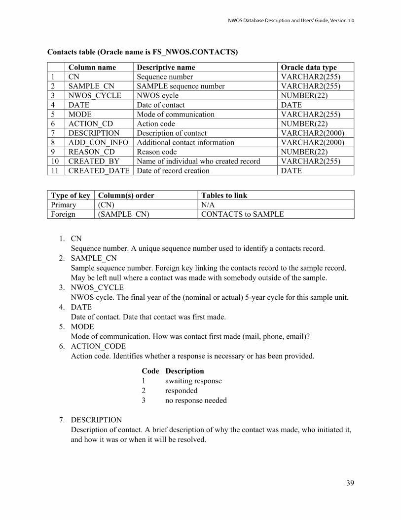
Contacts table (Oracle name is FS_NWOS.CONTACTS)
Column name Descriptive name Oracle data type 1 CN Sequence number VARCHAR2(255) 2 SAMPLE_CN SAMPLE sequence number VARCHAR2(255) 3 NWOS_CYCLE NWOS cycle NUMBER(22) 4 DATE Date of contact DATE 5 MODE Mode of communication VARCHAR2(255) 6 ACTION_CD Action code NUMBER(22) 7 DESCRIPTION Description of contact VARCHAR2(2000) 8 ADD_CON_INFO Additional contact information VARCHAR2(2000) 9 REASON_CD Reason code NUMBER(22) 10 CREATED_BY Name of individual who created record VARCHAR2(255) 11 CREATED_DATE Date of record creation DATE
Type of key Column(s) order Tables to link Primary (CN) N/A Foreign (SAMPLE_CN) CONTACTS to SAMPLE
1. CN Sequence number. A unique sequence number used to identify a contacts record.
2. SAMPLE_CN Sample sequence number. Foreign key linking the contacts record to the sample record. May be left null where a contact was made with somebody outside of the sample.
3. NWOS_CYCLE NWOS cycle. The final year of the (nominal or actual) 5-year cycle for this sample unit.
4. DATE Date of contact. Date that contact was first made.
5. MODE Mode of communication. How was contact first made (mail, phone, email)?
6. ACTION_CODE Action code. Identifies whether a response is necessary or has been provided.
Code Description 1 awaiting response 2 responded 3 no response needed
7. DESCRIPTION Description of contact. A brief description of why the contact was made, who initiated it, and how it was or when it will be resolved.
NWOS Database Description and Users’ Guide, Version 1.0

40
8. ADD_CON_INFORMATION Additional contact information. Updated or alternative names, addresses, and other contact information.
9. REASON_CODE Reason code. A code indicating why the contact was made.
Code Description 1 question regarding NWOS 2 request removal from survey 3 requests new survey 4 would like to see results from NWOS
10. CREATED_BY Name of individual who created record. The employee or associate who created the record.
11. CREATED_DATE Date of record creation. The date the record was created. Date will be in the format of DD-MON-YYYY.
NWOS Database Description and Users’ Guide, Version 1.0

41
Response table (Oracle table name is FS_NWOS.RESPONSE)
Column name Descriptive name Oracle data type 1 CN Sequence number VARCHAR2(255) 2 SAMPLE_CN Sample sequence number VARCHAR2(255) 3 INSTRUMENT_TYPE Type of survey instrument VARCHAR2(255) 4 INSTRUMENT Instrument code VARCHAR2(255) 5 INSTRUMENT_NUMBER Instrument number VARCHAR2(255) 6 DATE_SENT Date instrument mailed DATE 7 DATE_RETURNED Date instrument returned or
completed DATE
8 RESPONSE_CD Response code VARCHAR2(255) 9 NONRESPONSE_REASON Reason response was not returned
or deemed invalid VARCHAR2(255)
10 CREATED_BY Name of individual who created record
VARCHAR2(255)
11 CREATED_DATE Date of record creation DATE
Type of key Column(s) order Tables to link Primary (CN) N/A Foreign (SAMPLE_CN) RESPONSE to SAMPLE
1. CN Sequence number. A unique sequence number used to identify a response record.
2. SAMPLE_CN Sample sequence number. Foreign key linking the response record to the sample record.
3. INSTRUMENT_TYPE Type of survey instrument. Describes the survey mode associated with a response record (mail, phone, web, etc.).
4. INSTRUMENT Instrument code. An identifier for a particular instrument manifested within a particular mode.
5. INSTRUMENT_NUMBER Instrument number. A unique identification number for an individual questionnaire, principally used for paper surveys, on which it is printed in numeric and barcode form. This is the number that is used to identify surveys as part of scanning and optical character recognition (OCR) processes. Previously called QUESTNUM.
6. DATE_SENT Date instrument mailed. The date on which a survey is mailed or sent.
7. DATE_RETURNED Date instrument returned or complete. The date on which a survey is returned (paper) or completed (phone or internet).
NWOS Database Description and Users’ Guide, Version 1.0

42
8. RESPONSE_CD Response code. A code identifying whether a survey was returned or completed and whether that return was valid or invalid.
Code Description 0 nonresponse 1 response -2 invalid response
9. NONRESPONSE_REASON Reason response was not returned or invalid. A code identifying the reason a survey was not returned (RESPONSE_CD=0) or is invalid (RESPONSE_CD=-2).
Code Description 1 nonresponse, no survey returned 2 undeliverable 3 survey returned null or incomplete 4 survey appears to have been completed by someone else 5 deceased 6 refusal to participate 7 does not own minimum acreage of woodland 8 no land owned or land sold 9 not part of the sample (public land, FIA nonforest, etc.) 10 owner was previously determined to be deceased or had
previously asked not to be contacted 11 insufficient data to mail 12 multiple surveys returned 13 wooded acreage was left null 14 excessive discrepancy between expected (i.e., point count)
and reported acreage 15 survey administered for nonresponse analysis
10. CREATED_BY Name of individual who created record. The employee or associate who created the record.
11. CREATED_DATE Date of record creation. The date the record was created. Date will be in the format of DD-MON-YYYY.
NWOS Database Description and Users’ Guide, Version 1.0

43
Quest metadata table (Oracle table name is FS_NWOS.QUEST_METADATA)
Column name Descriptive name Oracle data type 1 CN Sequence number VARCHAR2(255) 2 QUESTION_NAME Question name VARCHAR2(255) 3 QUESTION_TEXT Text of question VARCHAR2(2000) 4 DATA_TYPE Data type of question response VARCHAR2(255) 5 RANGE Acceptable response range VARCHAR2(255) 6 UNITS_FACTORS A string containing units or a factor key VARCHAR2(2000) 7 ITEM_TYPE Type of survey item VARCHAR2(255) 8 CHECK_GROUP Grouping variable for check bank
questions VARCHAR2(255)
9 SKIP_ROOT For skip-pattern questions, CN of question root
VARCHAR2(255)
10 SKIP_TRIGGER A vector of responses to SKIP_ROOT that trigger skip
VARCHAR2(255)
11 INST_LIST A string containing a list of instrument codes that contain this question
VARCHAR2(2000)
12 CREATED_BY Name of individual who created record VARCHAR2(255) 13 CREATED_DATE Date of record creation DATE
Type of key Column(s) order Tables to link Primary (CN) N/A
1. CN Sequence number. A unique sequence number used to identify a quest metadata record.
2. QUESTION_NAME Question name. The short name of the question.
3. QUESTION_TEXT Text of question. The text that appears in the survey instrument.
4. DATA_TYPE Data type of question response. Types included numeric and character.
5. RANGE Acceptable response range. For continuous and categorical questions, the range of valid responses for the question.
6. UNITS_FACTORS A string containing units or a factor key. A string containing either the units appropriate to the question (continuous variables) or else a verbal description of the factor levels (categorical variables).
7. ITEM_TYPE Type of survey item. A code identifying broad types of survey items (i.e., questions).
Code Description 1 check one (including Likert scales)
NWOS Database Description and Users’ Guide, Version 1.0

44
2 check all that apply 3 open-ended 4 text
8. CHECK_GROUP Grouping variable for check bank questions. An identifier for individual check bank items (ITEM_TYPE = 2) that belong to the same question.
9. SKIP_ROOT For skip-pattern questions, CN of question root. If an individual item is a dependent question in a skip-pattern relationship, this field identifies the CN of the root question in the same relationship.
10. SKIP_TRIGGER A vector of responses to SKIP_ROOT that trigger skip. A string containing all of the valid responses to the root question that would trigger a skip of the current questions.
11. INST_LIST A string containing the instrument identification (id) of all the instruments that contain this question. A semicolon-delimited string containing the ids. (RESPONSE.INSTRUMENT) of all instruments that contain this question.
12. CREATED_BY Name of individual who created record. The employee or associate who created the record.
13. CREATED_DATE Date of record creation. The date the record was created. Date will be in the format of DD-MON-YYYY.
NWOS Database Description and Users’ Guide, Version 1.0

45
Quest table (Oracle table name is FS_NWOS.QUEST)
Column name Descriptive name Oracle data type 1 CN Sequence number VARCHAR2(255) 2 INSTRUMENT_NUMBER Instrument number VARCHAR2(255) 3 RESPONSE_CN Response sequence number VARCHAR2(255) 4 METADATA_CN Metadata sequence number VARCHAR2(255) 5 QUEST_NAME Question name (annotation) VARCHAR2(255) 6 RESPONSE_VALUE Response to question VARCHAR2(255) 7 CREATED_BY Name of individual who created record VARCHAR2(255) 8 CREATED_DATE Date of record creation DATE
Type of key Column(s) order Tables to link Primary (CN) N/A Unique (RESPONSE_CN,
METADATA_CN) N/A
Foreign (RESPONSE_CN) QUEST to RESPONSE (METADATA_CN) QUEST to QUEST_METADATA
1. CN Sequence number. A unique sequence number used to identify a quest record.
2. INSTRUMENT_NUMBER Instrument number. The instrument number (RESPONSE.INSTRUMENT_NUMBER) containing this question response. Previously called QUESTNUM.
3. RESPONSE_CN Response sequence number. Foreign key linking the quest record to the response record.
4. METADATA_CN Quest metadata sequence number. Foreign key linking the quest record to the quest metadata record.
5. QUEST_NAME Question name. The short name of the question. (QUEST_METADATA.QUESTION_NAME). This matches the name found in the annotated version of the survey instrument.
6. RESPONSE_VALUE The response to the question. Nonresponse is coded as -1; skips due to skip-pattern logic are coded as -2. Open-ended comment and text fields as coded with a 1 if text was provided by the response or 0 if the field was left null.
7. CREATED_BY Name of individual who created record. The employee or associate who created the record.
8. CREATED_DATE The date the record was created. Date will be in the format of DD-MON-YYYY.
NWOS Database Description and Users’ Guide, Version 1.0

46
Quest text table (Oracle table name is FS_NWOS.QUEST_TEXT)
Column name Descriptive name Oracle data type 1 CN Sequence number VARCHAR2(255) 2 INSTRUMENT_NUMBER Instrument number VARCHAR2(255) 3 RESPONSE_CN RESPONSE sequence number VARCHAR2(255) 4 METADATA_CN QUEST_METADATA sequence
number VARCHAR2(255)
5 QUEST_CN QUEST sequence number VARCHAR2(255) 6 QUEST_NAME Question name VARCHAR2(255) 7 TEXT Response text VARCHAR2(2000) 8 CREATED_BY Name of individual who created
record VARCHAR2(255)
9 CREATED_DATE Date of record creation DATE
Type of key Column(s) order Tables to link Primary (CN) N/A Unique (RESPONSE_CN,
METADATA_CN) N/A
Foreign (RESPONSE_CN) QUEST to RESPONSE (METADATA_CN) QUEST to QUEST_METADATA (QUEST_CN) QUEST_TEXT to QUEST
1. CN Sequence number. A unique sequence number used to identify a quest text record.
2. INSTRUMENT_NUMBER Instrument number. The instrument number (RESPONSE.INSTRUMENT_NUMBER) containing this question response. Previously called QUESTNUM.
3. RESPONSE_CN Response sequence number. Foreign key linking the quest record to the response record.
4. METADATA_CN Quest metadata sequence number. Foreign key linking the quest record to the quest metadata record.
5. QUEST_CN Quest sequence number. The foreign key linking the quest text record to the quest record.
6. QUEST_NAME Question name. The short name of the question.(QUEST_METADATA.QUESTION_NAME). This matches the name found in the annotated version of the survey instrument.
7. TEXT Response text. The verbatim response to an open-ended comment or text field.
NWOS Database Description and Users’ Guide, Version 1.0
47
8. CREATED_BY Name of individual who created record. The employee or associate who created the record.
9. CREATED_DATE Date of record creation. The date the record was created. Date will be in the format of DD-MON-YYYY.
NWOS Database Description and Users’ Guide, Version 1.0

48
Modifications table (Oracle table name is FS_NWOS.MODIFICATIONS)
Column name Descriptive name Oracle data type 1 CN Sequence number VARCHAR2(255) 2 MOD_DATE Date of modification DATE 3 TABLE Name of table modified VARCHAR2(255) 4 RECORD Name of record modified VARCHAR2(255) 5 FIELD Name of field modified VARCHAR2(255) 6 NEW_DATUM Value of new datum VARCHAR2(255) 7 OLD_DATUM Value of old datum VARCHAR2(255) 8 DESCRIPTION Description of modification VARCHAR2(2000) 9 SCRIPT File name of script or query file used VARCHAR2(255) 10 CREATED_BY Name of individual who created record VARCHAR2(255) 11 CREATED_DATE Date of record creation DATE
Type of key Column(s) order Tables to link Primary (CN) N/A
1. CN Sequence number. A unique sequence number used to identify a modification’s record.
2. MOD_DATE Date of modification. The date that the record was modified.
3. TABLE Name of table modified. The table in which one or more cells were modified.
4. RECORD Name of record modified. The CN of the record that was modified. If more than one record were modified, this field is left null.
5. FIELD Name of field modified. The field name of the record or records that were modified. If records in more than one field were modified, this field is left null.
6. NEW_DATUM Value of new datum. The new (i.e., modified) value of the record or records. If the new value is null, the string “NULL” is recorded. If more than one record are modified and the new values are not identical, this field is left null.
7. OLD_DATUM Value of old datum. The original (i.e., unmodified) value of the record or records. If the original value was null, the string “NULL’” is recorded. If more than one record are modified and the old values are not identical, this field is left null.
8. DESCRIPTION Description of modification. A brief description of what was modified as well as the context for the modification.
9. SCRIPT File name of script or query file used. A string containing the file of the script that was
NWOS Database Description and Users’ Guide, Version 1.0
49
used to make the modification (if applicable). Scripts themselves are contained on the USDA Forest Service T drive.
10. CREATED_BY Name of individual who created record. The employee or associate who created the record.
11. CREATED_DATE Date of record creation. The date the record was created. Date will be in the format of DD-MON-YYYY.
NWOS Database Description and Users’ Guide, Version 1.0

50
Notes table (Oracle table name is FS_NWOS.NOTES)
Column name Descriptive name Oracle data type 1 CN Sequence number VARCHAR2(255) 2 TABLE Name of table VARCHAR2(255) 3 TABLE_CN CN of record in table which is being noted VARCHAR2(255) 4 NOTES Notes on record VARCHAR2(2000) 5 CREATED_BY Name of individual who created record VARCHAR2(255) 6 CREATED_DATE Date of record creation DATE
Type of key Column(s) order Tables to link Primary (CN) N/A
1. CN Sequence number. A unique sequence number used to identify a note’s record.
2. TABLE Name of table. The table containing the record to which a note is being attached.
3. TABLE_CN CN of record in table which is being noted. The sequence number of the record in the table to which a note is being attached.
4. NOTES Notes on record. The text of the note that is being attached to a record in a table.
5. CREATED_BY Name of individual who created record. The employee or associate who created the record.
6. CREATED_DATE Date of record creation. The date the record was created. Date will be in the format of DD-MON-YYYY.
NWOS Database Description and Users’ Guide, Version 1.0

51
Tables table (Oracle table name is FS_NWOS.TABLES)
Column name Descriptive name Oracle data type 1 CN Sequence number VARCHAR2(255) 2 TABLE_NAME Table name VARCHAR2(255) 3 DESCRIPTION Description of table VARCHAR2(2000) 4 TYPE Type of table VARCHAR2(255) 5 CREATED_BY Name of individual who created record VARCHAR2(255) 6 CREATED_DATE Date of record creation DATE
Type of key Column(s) order Tables to link Primary (CN) N/A
1. CNSequence number. A unique sequence number used to identify a table’s record.
2. TABLE_NAMETable name. The name of a table in the FS_NWOS schema.
3. DESCRIPTIONDescription of table. A brief description of the table and its purpose within theFS_NWOS schema.
4. TYPEType of table. The table group containing the table.
5. CREATED_BYName of individual who created record. The employee or associate who created therecord.
6. CREATED_DATEDate of record creation. The date the record was created. Date will be in the format ofDD-MON-YYYY.
NWOS Database Description and Users’ Guide, Version 1.0
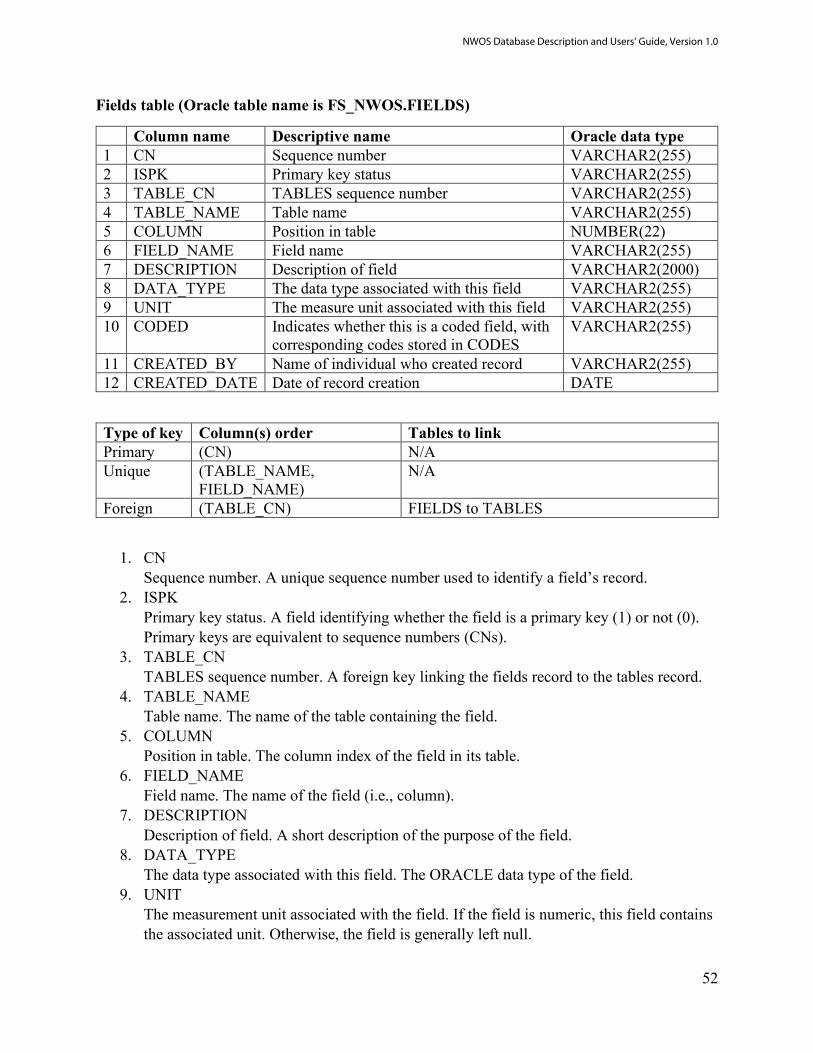
52
Fields table (Oracle table name is FS_NWOS.FIELDS)
Column name Descriptive name Oracle data type 1 CN Sequence number VARCHAR2(255) 2 ISPK Primary key status VARCHAR2(255) 3 TABLE_CN TABLES sequence number VARCHAR2(255) 4 TABLE_NAME Table name VARCHAR2(255) 5 COLUMN Position in table NUMBER(22) 6 FIELD_NAME Field name VARCHAR2(255) 7 DESCRIPTION Description of field VARCHAR2(2000) 8 DATA_TYPE The data type associated with this field VARCHAR2(255) 9 UNIT The measure unit associated with this field VARCHAR2(255) 10 CODED Indicates whether this is a coded field, with
corresponding codes stored in CODES VARCHAR2(255)
11 CREATED_BY Name of individual who created record VARCHAR2(255) 12 CREATED_DATE Date of record creation DATE
Type of key Column(s) order Tables to link Primary (CN) N/A Unique (TABLE_NAME,
FIELD_NAME) N/A
Foreign (TABLE_CN) FIELDS to TABLES
1. CNSequence number. A unique sequence number used to identify a field’s record.
2. ISPKPrimary key status. A field identifying whether the field is a primary key (1) or not (0).Primary keys are equivalent to sequence numbers (CNs).
3. TABLE_CNTABLES sequence number. A foreign key linking the fields record to the tables record.
4. TABLE_NAMETable name. The name of the table containing the field.
5. COLUMNPosition in table. The column index of the field in its table.
6. FIELD_NAMEField name. The name of the field (i.e., column).
7. DESCRIPTIONDescription of field. A short description of the purpose of the field.
8. DATA_TYPEThe data type associated with this field. The ORACLE data type of the field.
9. UNITThe measurement unit associated with the field. If the field is numeric, this field containsthe associated unit. Otherwise, the field is generally left null.
NWOS Database Description and Users’ Guide, Version 1.0

53
10. CODEDIndicates whether this is a coded field. Corresponding codes are stored in the CODEStable. This specifically does not include the field QUEST.RESPONSE_VALUE, whichhas codes that vary depending on the value of QUEST.METADATA_CN. Codes for thisfield are included in the QUEST_METADATA table.
11. CREATED_BYName of individual who created record. The employee or associate who created therecord.
12. CREATED_DATEDate of record creation. The date the record was created. Date will be in the format ofDD-MON-YYYY.
NWOS Database Description and Users’ Guide, Version 1.0

54
Codes table (Oracle table name is FS_NWOS.CODES)
Column name Descriptive name Oracle data type 1 CN Sequence number VARCHAR2(255) 2 TABLE_CN TABLES sequence number VARCHAR2(255) 3 TABLE_NAME Table name VARCHAR2(255) 4 FIELD_CN FIELDS sequence number VARCHAR2(255) 5 FIELD_NAME Field name VARCHAR2(255) 6 CODE Code value VARCHAR2(255) 7 MEANING Meaning of code VARCHAR2(2000) 8 CREATED_BY Name of individual who created record VARCHAR2(255) 9 CREATED_DATE Date of record creation DATE
Type of key Column(s) order Tables to link Primary (CN) N/A Unique (TABLE_NAME,
FIELD_NAME, CODE) N/A
Foreign (TABLE_CN) CODES to TABLES (FIELD_CN) CODES to FIELDS
1. CNSequence number. A unique sequence number used to identify a code’s record.
2. TABLE_CNTABLES sequence number. The foreign key linking the code’s record to the table’srecord.
3. TABLE_NAMETable name. The name of the table containing the coded field.
4. FIELD_CNFIELDS sequence number. The foreign key linking the code’s record to the fields record.
5. FIELD_NAMEField name. The name of the coded field.
6. CODECode value. This is the actual value that is stored in the coded field.
7. MEANINGMeaning of code. This is the conceptual meaning of the code that is stored in the codedfield.
8. CREATED_BYName of individual who created record. The employee or associate who created therecord.
9. CREATED_DATEDate of record creation. The date the record was created. Date will be in the format ofDD-MON-YYYY.
NWOS Database Description and Users’ Guide, Version 1.0