the national risk index
TRANSCRIPT

The National Risk Index
A New Tool to Communicate and Interpret Community Risk
Nathan MontagueABS ConsultingJune 21, 2018

• What is the NRI?
• How was it developed?
• What are the components?
• How can I use the NRI site?
• What is the purpose and vision?
Overview

What is the National Risk Index?

NRI Components

Social Vulnerability (SoVI)

Community Resilience (BRIC)

Built Environment (Hazus GBS)

Natural Hazard Incidence

Natural HazardsHazard Source
Avalanche CO Avalanche Information Center
Coastal Flood NOAA National Weather Service, Storm Events Database, and Coastal sea level rise
Cold Wave NOAA North American Climate Extremes Monitoring, National Weather Service, and
Storm Events Database
Drought National Drought Mitigation Center
Earthquake National Earthquake Hazards Reduction Program
Hail NOAA Storm Prediction Center and Storm Events Database
Heat Wave NOAA North American Climate Extremes Monitoring and Storm Events Database
Hurricane NOAA National Hurricane Center and Storm Events Database, Hazus Wind Probabilistic
Geodatabase
Ice Storm U.S. Army Corps of Engineers
Hazard Source
Landslide U.S. Geological Survey
Lightning NOAA Severe Weather Data Inventory, Storm Events Database, and National Center for
Environmental Information
Riverine Flood FEMA Special Flood Hazard Exposure Mapand National Flood Hazard Layer
Snowstorm/Blizzard NOAA Storm Events Database and NationalOperating Hydrologic Remote Sensing
Center
Strong Wind NOAA Storm Prediction Center and Storm Events Database
Tornado NOAA Storm Prediction Center and Storm Events Database
Tsnuami/Seiche NOAA National Center for Environmental Information, individual state sponsored datasets from HI, CA, OR, WA, and AK
Volcano UN Office for Disaster Risk Reduction
Wildfire U.S. Geological Survey and U.S. Forest Service

Composite Risk Index & Equation
Preliminary Future
� 𝐻𝐻𝐻𝐻𝐻𝐻𝐻𝐻𝐻𝐻𝐻𝐻 × 𝐸𝐸𝐸𝐸𝐸𝐸𝐸𝐸𝐸𝐸𝐸𝐸𝐻𝐻𝐸𝐸 × 𝑃𝑃𝑃𝑃𝑃𝐸𝐸𝑃𝑃𝑃𝑃𝐻𝐻𝑃𝑃 𝑉𝑉𝐸𝐸𝑃𝑃𝑉𝑉𝐸𝐸𝐻𝐻𝐻𝐻𝑉𝑉𝑃𝑃𝑃𝑃𝑉𝑉𝑃𝑃 ×
𝑆𝑆𝐸𝐸𝑃𝑃𝑃𝑃𝐻𝐻𝑃𝑃 𝑉𝑉𝐸𝐸𝑃𝑃𝑉𝑉𝐸𝐸𝐻𝐻𝐻𝐻𝑉𝑉𝑃𝑃𝑃𝑃𝑃𝑃𝑉𝑉𝑃𝑃 ×1
𝑅𝑅𝐸𝐸𝐸𝐸𝑃𝑃𝑃𝑃𝑃𝑃𝐸𝐸𝑉𝑉𝑃𝑃𝐸𝐸 = 𝑁𝑁𝐻𝐻𝑉𝑉𝑃𝑃𝐸𝐸𝑉𝑉𝐻𝐻𝑃𝑃 𝑅𝑅𝑃𝑃𝐸𝐸𝑅𝑅 𝐼𝐼𝑉𝑉𝐻𝐻𝐸𝐸𝐸𝐸

How was the NRI developed?
Pre-NRI Issues:
1) Decentralized data2) Data at local scale3) Not easily viewed on a
map4) One risk displayed5) If multivariate, then
independent of each other
NRI Solution:
1) Centralized risk data2) National scale3) Intuitive map display4) Individual & multivariate5) Risk Index combines risks

NRI Contributors

NRI Contributors
Academia
Local Government
Regional Government
Federal Government
State Government
Non-ProfitPrivate
FEMA

Identify hazard types
& dataset sourcesDesign & develop a
National Risk Index tool
Data Analytics
Working Group
Natural Hazards
Vulnerability and
Resilience
Data Analytics
NRI Working Groups

How does the NRI site function & communicate risk?


Multiple Location Comparison Report

Multiple Location Comparison Report

Single Location Report
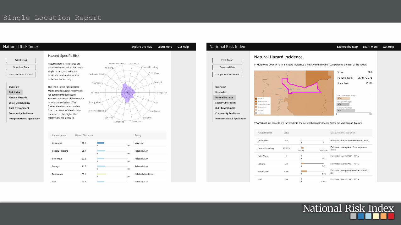
Single Location Report

Single Location Report

• Enhance Hazard Mitigation Plans
• General public risk awareness and engagement
• Support FEMA RiskMAP and THIRA
• Inform long term community recovery
• Integrate into programmatic outreach (NFIP)
• Hazard mitigation grant program application and
prioritization
• Natural hazards and resilience research
• Targeted investment of federal risk reduction programs
• Baseline risk assessment for highlighting areas that could benefit from
more detailed analysis
Vision for how the NRI can be used

• Late summer 2018• Fema.gov URL• Methodology reports available• Data download• Links to data source• Official NRI email for support
Additional release info
