the lake chad deep drilling project (chadrill) – targeting ... · region of central northern...
TRANSCRIPT
Sci. Dril., 24, 71–78, 2018https://doi.org/10.5194/sd-24-71-2018© Author(s) 2018. This work is distributed underthe Creative Commons Attribution 4.0 License.
Workshop
Reports
The Lake CHAd Deep DRILLing project (CHADRILL) –targeting ∼ 10 million years of environmental
and climate change in AfricaFlorence Sylvestre1, Mathieu Schuster2, Hendrik Vogel3, Moussa Abdheramane4, Daniel Ariztegui5,Ulrich Salzmann6, Antje Schwalb7, Nicolas Waldmann8, and the ICDP CHADRILL Consortium*
1Aix-Marseille Université, CNRS, IRD, Collège de France, INRA, CEREGE,Europôle de l’Arbois, 13545 Aix-en-Provence, France
2Université de Strasbourg, CNRS, Institut Physique du Globe de Strasbourg,1 rue Blessig, 67084 Strasbourg, France
3University of Bern, Institute of Geological Sciences & OCCR, Baltzerstr. 1+3, Bern 3012, Switzerland4Université de N’Djamena, Faculté des Sciences Exactes et Appliquées, Route de Farcha, N’Djamena, Tchad
5University of Geneva, Department of Earth Sciences, rue des Maraichers 13, Geneva 1205, Switzerland6University of Northumbria, Department of Geography and Environmental Sciences, 2 Ellison Place,
Newcastle upon Tyne, NE1 8ST, UK7Technische Universtät Braunschweig, Institute of Geosystems and Bioindication,
Langer Kamp 19c, Braunschweig 38114, Germany8University of Haifa, Department of Marine Geosciences, Mt. Carmel, Haifa, Israel
*A full list of authors and their affiliations appears at the end of the paper.
Correspondence: Florence Sylvestre ([email protected])
Received: 14 November 2017 – Revised: 29 January 2018 – Accepted: 2 February 2018 – Published: 22 October 2018
Abstract. At present, Lake Chad (∼ 13◦′ N, ∼ 14◦ E) is a shallow freshwater lake located in the Sahel/Sahararegion of central northern Africa. The lake is primarily fed by the Chari–Logone river system draining a∼ 600 000 km2 watershed in tropical Africa. Discharge is strongly controlled by the annual passage of the in-tertropical convergence zone (ITCZ) and monsoon circulation leading to a peak in rainfall during boreal summer.During recent decades, a large number of studies have been carried out in the Lake Chad Basin (LCB). Theyhave mostly focused on a patchwork of exposed lake sediments and outcrops once inhabited by early hominids.A dataset generated from a 673 m long geotechnical borehole drilled in 1973, along with outcrop and seismicreflection studies, reveal several hundred metres of Miocene–Pleistocene lacustrine deposits.
CHADRILL aims to recover a sedimentary core spanning the Miocene–Pleistocene sediment succession ofLake Chad through deep drilling. This record will provide significant insights into the modulation of orbitallyforced changes in northern African hydroclimate under different climate boundary conditions such as high CO2and absence of Northern Hemisphere ice sheets. These investigations will also help unravel both the age and theorigin of the lake and its current desert surrounding. The LCB is very rich in early hominid fossils (Australop-ithecus bahrelghazali; Sahelanthropus tchadensis) of Late Miocene age. Thus, retrieving a sediment core fromthis basin will provide the most continuous climatic and environmental record with which to compare hominidmigrations across northern Africa and has major implications for understanding human evolution. Furthermore,due to its dramatic and episodically changing water levels and associated depositional modes, Lake Chad’s sed-iments resemble maybe an analogue for lake systems that were once present on Mars. Consequently, the studyof the subsurface biosphere contained in these sediments has the potential to shed light on microbial biodiversitypresent in this type of depositional environment.
We propose to drill a total of∼ 1800 m of poorly to semi-consolidated lacustrine, fluvial, and eolian sedimentsdown to bedrock at a single on-shore site close to the shoreline of present-day Lake Chad. We propose to locate
Published by Copernicus Publications on behalf of the IODP and the ICDP.

72 F. Sylvestre et al.: The Lake CHAd Deep DRILLing Project (CHADRILL)
our drilling operations on-shore close to the site where the geotechnical Bol borehole (13◦28′ N, 14◦44′ E) wasdrilled in 1973. This is for two main reasons: (1) nowhere else in the Chad Basin do we have such detailedinformation about the lithologies to be drilled; and (2) the Bol site is close to the depocentre of the Chad Basinand therefore likely to provide the stratigraphically most continuous sequence.
1 Introduction
Covering almost 8 % of the continent, the Lake Chad Basin(LCB) is the largest endhoreic drainage basin in Africa(2.5×10⁶ km2) and one of the largest intracratonic basins onEarth (Fig. 1). Formation of accommodation space startedduring the Cenozoic (Burke, 1976) with nearly continuousdeposition of terrestrial/lacustrine sediments since ∼ 10 Myr(Lebatard et al., 2008; Schuster et al., 2009). Today’s LakeChad is a terminal and highly variable shallow freshwaterlake (∼ 3 m deep, measured in 2012) with a strong S-to-Nconductivity gradient (50 to 700 µS cm−1; Bouchez et al.,2016). The annual invigoration of the northern African mon-soon system and migration of the intertropical convergencezone (ITCZ) results in a short rainy season from June to Oc-tober and a pronounced dry season for the rest of the year.During recent decades, the lake level varied by up to 4 m,with a highstand in the 1960s, a prolonged lowstand in the1970s, and a recovery phase since the beginning of the 2000s,thus emphasizing that lake-level changes reflect regionalchanges in rainfall (Lebel and Abdou, 2009). The latter to-gether with its location at the interface of the African trop-ics and subtropics make the LCB sediment record a promis-ing target to trace back changes in moisture variability innorthern Africa under very different climate boundary condi-tions. Reconstructing the region’s moisture variability sincethe Miocene would provide a very detailed picture of the en-vironmental response to climate states with high atmosphericgreenhouse gas (GHG) concentrations and limited North-ern Hemisphere ice-sheet extent. This includes fundamentalinsights into the strength of modulation of orbitally forcedchanges in monsoon intensity and the effect of changes inITCZ shifts/expansion under climate conditions common tothe pre-Pleistocene. In addition, providing a glimpse into pe-riods when both GHG concentrations and orbital parameterswere similar to today will allow us to better constrain theimpact of possible near-future climate states on the regionalenvironment and societies. Such a study is timely given theenormous importance of today’s lake as a freshwater andfood source for ∼ 47 million people (Lemoalle and Magrin,2014) and the region’s recent history of conflict.
With the discovery of several hominin remains associatedwith a rich fauna (Brunet et al., 1995, 2002), the LCB hasbeen recognized as one of the cradles of humanity. Homininremains, from the LCB and elsewhere in northern Africa(Hublin et al., 2017), demonstrate that the emergence of hu-mans was not restricted to the East African Rift region. These
discoveries not only raise important questions about the ori-gin of humankind, but also strengthen the debate concerningthe environmental triggers, such as precipitation variability,which may have impacted human evolution (Blome et al.,2012; Shultz and Maslin, 2013). A spatially better resolvedpicture of climate forced changes in environmental condi-tions and habitability in regions outside the rift valley istherefore required to elucidate their role in the evolution ofmodern humans. Until recently, it was considered that the Sa-hara was a natural obstacle to human migration, with the Nileas the only optimal corridor allowing northwards passagefrom the African tropics. Nevertheless, some studies showthat the Sahara was probably not a continuous barrier andthat both animals and humans may have populated the regionduring past humid phases known as Green Sahara Episodes(Larrasoaña et al., 2013). Other evidence even suggests a po-tential link between the Mediterranean Sea and the LCB viathe ancient Esohabi River system in Libya, emphasizing thecentral Sahara as an alternative potential route for hominindispersal (Griffin, 2006; Osborne et al., 2008; Drake et al.,2010).
The role of climate in the evolution and dispersal of ho-minid ancestors was probably amplified during the Tortonian(11.6–7.2 Myr), when shrinkage of the Tethys is thought tohave been the main driver for the increasing aridity of Africaand formation of the Sahara (Zhang et al., 2014). As a conse-quence, the sensitivity of the African monsoon system to or-bital forcing increased, making it the predominant driver forthe cyclic expansion and contraction of the Sahara (Tuenteret al., 2003). However, there are some outstanding questionsthat are still debated, such as the timing of the formationof the Sahara. Both marine (Atlantic Ocean, Ruddiman andJanecek, 1989; Mediterranean Sea, Rose et al., 2016) andcontinental records (Chad Basin; Schuster et al., 2006) sug-gest a Late Miocene timing (close to the end of the Tortonianat 7 Myr), whereas other authors suggest that evidence priorto the onset of Northern Hemisphere glaciations at ∼ 3 Ma(Swezey, 1999) is insufficient to support such a proposition.
Previous studies propose that the LCB was the source ofthe Esohabi River, a paleoriver system flowing northwardfrom the southern Libyan desert down to the MediterraneanSea during the Late Miocene (Griffin, 2006; Ghoneim et al.,2012). Although this river no longer flows today, climatemodels suggest that enhanced monsoonal rains in northernAfrica fed it, and that it was roughly equivalent in size andmagnitude to the present-day Nile (Gladstone et al., 2007).The freshwater flux influenced not only the immediate envi-
Sci. Dril., 24, 71–78, 2018 www.sci-dril.net/24/71/2018/
F. Sylvestre et al.: The Lake CHAd Deep DRILLing Project (CHADRILL) 73
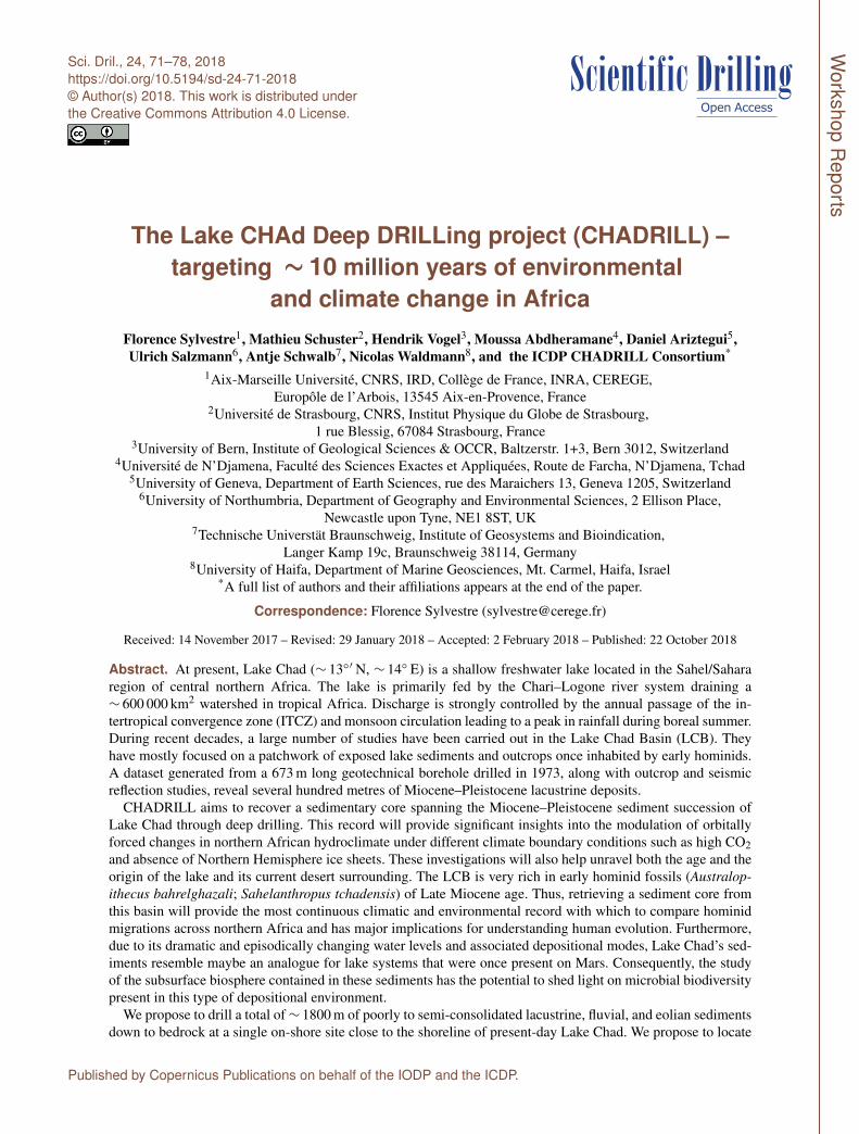
Figure 1. (a) Political map of Africa showing the Lake Chad hydrological basin. (b) SRTM map of the region surrounding Lake Chad. Theshaded blue area marks the extension of the mega Lake Chad during the Holocene with an area of 34× 104 km2. The principal populatedtowns are marked by red squares. The blue circle indicates the location of the previous core (LT10-2011) and the red star the borehole atBol. (c) Picture of fishermen from Lake Chad. (d) Diatomite-dominated sequences deposited during previous transgressive episodes of LakeChad currently outcropping in the Djourab region (see Fig. 1b for the location). The sediments date back to Holocene diatomites (Schusteret al., 2009). (e) Sediments of Mars (Rover pictures). Landsat images show the extension of the lake in 1963 (f), 1987 (g), and 2003 (h).
ronmental conditions of the Mediterranean region, but alsomay have been a driver of Mediterranean–Atlantic exchangeand hence North Atlantic thermohaline circulation (Brydenand Kinder, 1991). Consequently, the record preserved inLake Chad has implications for a climate system that spanshalf the globe, and is a critical transfer mechanism for water,salt, heat and nutrients from the equatorial to polar latitudes.
Our vision to obtain long sedimentary records from theLCB will also assess the dynamics of intracontinental basins
through time and space. Sediments outcropping around LakeChad show intriguing similarities to those discovered by theongoing Curiosity Mars mission (Fig. 1e). This striking simi-larity makes the LCB a promising analogue for similar fresh-water systems that were once present on Mars. Studying thesubsurface biosphere in combination with in-depth investi-gation of associated diagenetic processes has the potentialto provide valuable insights into the present query of earlylife on Earth and other planets. The strategy that NASA
www.sci-dril.net/24/71/2018/ Sci. Dril., 24, 71–78, 2018
74 F. Sylvestre et al.: The Lake CHAd Deep DRILLing Project (CHADRILL)
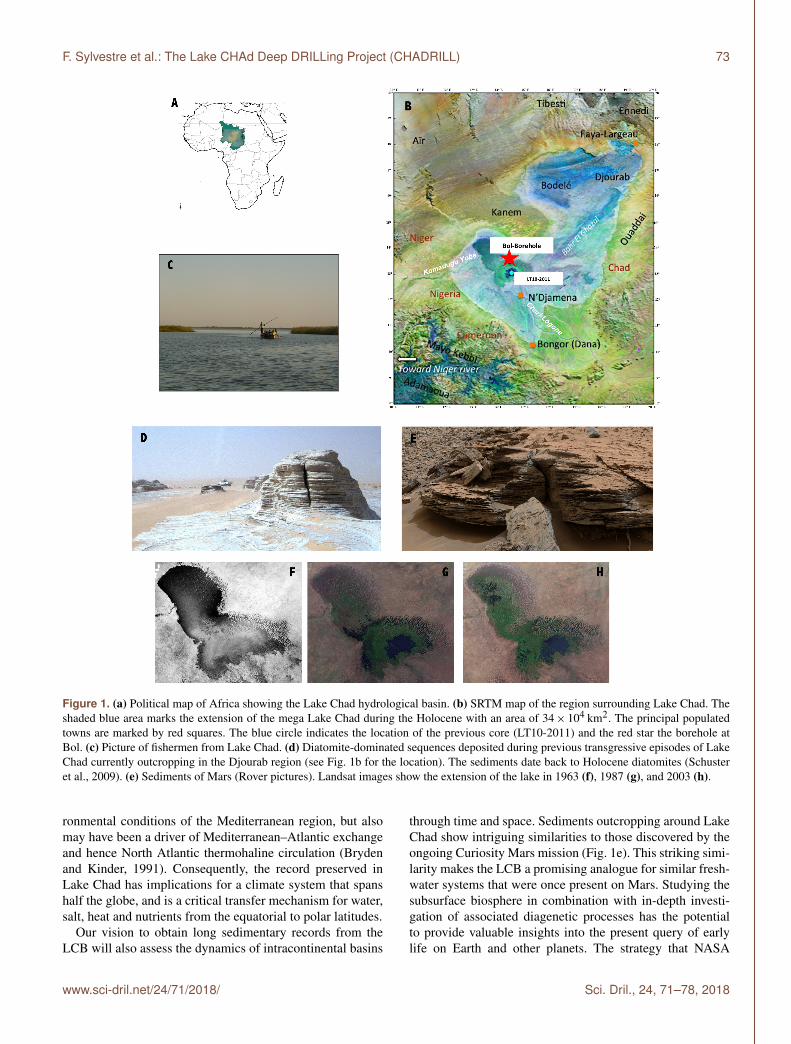
Figure 2. Synthetic and interpretative N–S geological transect across the Chad Basin showing the lateral extent and thickness of palaeo-LakeChad beds (modified from Moussa, 2010).
will use during the already scheduled missions looking forsigns of extra-terrestrial life will put special emphasis on mi-crobially influenced sedimentary structures. These kinds ofstructures can be potentially recognized in the Lake Chadcores and compared to those identified with the new genera-tion of instruments that will be sent to Mars in 2020. Amongthem a Close-UP Imager called CLUPI has been developedat the Space Exploration Institute (Space-X) of Neuchâtel,Switzerland, and will look at the subsurface of Mars throughcoring (Tomaso Bontognali, personal communication, 2017).
2 Workshop structure and outcomes
In view of the enormous opportunity for a scientific drillingproject to investigate the sedimentary record of the LCB,an ICDP-sponsored workshop was organized in Aix-en-Provence from 21 to 23 September 2016. Overall, 51 sci-entists and government officials from 11 countries (Belgium,Cameroon, Chad, France, Germany, Israel, Nigeria, Spain,Switzerland, UK and USA) participated in the discussion thatframed the scientific objectives as well as challenges asso-ciated with the technical and logistical aspects of an ICDPdrilling project in the LCB.
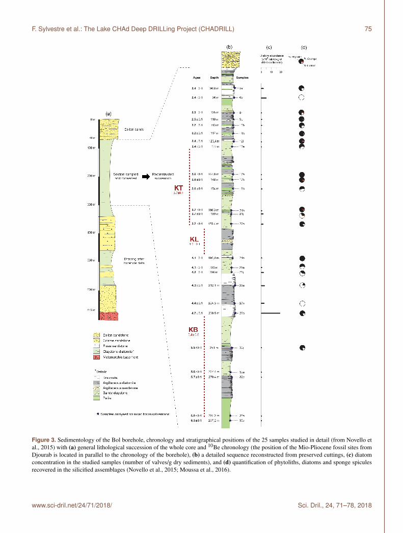
The workshop commenced with a full day of presentationson the key science themes, results from ongoing and previ-ous research in the LCB, as well as broader overview talkson the northern African climate evolution since the Mioceneand the associated responses of the biosphere. Participantspaid particular attention to the presentations on sedimento-logical, chronological, and paleoenvironmental datasets ob-tained from a 673 m deep geotechnical borehole that reachedbedrock at an on-shore site close to the city of Bol on thenorth-eastern shore of Lake Chad (Figs. 1 and 2), consid-
ered the depocentre of the LCB (Burke, 1976). Datasets ob-tained from core cuttings and drill logs emphasize the pres-ence of ∼ 600 m thick Miocene to Early Pleistocene de-posits composed of fine-grained terrestrial deposits belowa ∼ 70 m thick succession of Late Pleistocene dune sands(Fig. 3). Deposits in the succession between∼ 70 and 300 m,where core cuttings are available, comprise fine-grainedmuds, diatomaceous oozes, and diatomites with structuresranging from massive to finely laminated (Moussa et al.,2016). Authigenic 10Be burial dating (Lebatard et al., 2010)along with biostratigraphic constraints (Novello et al., 2015)place this succession between 6.3 Myr (∼ 300 m depth) and2.4 Myr (∼ 90 m depth). These deposits thus represent nearlycontinuous sedimentation in a lacustrine setting similar to to-day’s Lake Chad. Chronological as well as detailed litholog-ical information is not available from the lower succession(∼ 300–673 m) due to the lack of core cuttings. However,drill logs from the lower succession suggest that fine-grainedlacustrine muds and diatomaceous oozes, though more oftenintercalated with more extensive sand-sized deposits, prevail(Moussa et al., 2016).
Other stratigraphic information from exploration bore-holes in Chad and Nigeria indicates either more condensedlacustrine successions or depositional environments with astronger influence of deltaic processes (especially to thesouth). Outcrop studies undertaken in the northern ChadBasin emphasize the stronger influence of deflation at poten-tial drill sites. The deep structure of the Chad Basin (i.e. loca-tion of the basement and thickness of sedimentary infill), syn-thesized in Servant-Vildary (1973), Burke (1976) and Ser-vant (1983), is, notably, based on the geophysical character-ization (e.g. gravimetry, isostacy) produced by Louis (1970)as well as on available data from exploration boreholes. To-
Sci. Dril., 24, 71–78, 2018 www.sci-dril.net/24/71/2018/
F. Sylvestre et al.: The Lake CHAd Deep DRILLing Project (CHADRILL) 75
Figure 3. Sedimentology of the Bol borehole, chronology and stratigraphical positions of the 25 samples studied in detail (from Novello etal., 2015) with (a) general lithological succession of the whole core and 10Be chronology (the position of the Mio-Pliocene fossil sites fromDjourab is located in parallel to the chronology of the borehole), (b) a detailed sequence reconstructed from preserved cuttings, (c) diatomconcentration in the studied samples (number of valves/g dry sediments), and (d) quantification of phytoliths, diatoms and sponge spiculesrecovered in the silicified assemblages (Novello et al., 2015; Moussa et al., 2016).
www.sci-dril.net/24/71/2018/ Sci. Dril., 24, 71–78, 2018

76 F. Sylvestre et al.: The Lake CHAd Deep DRILLing Project (CHADRILL)
gether, these data suggest that the thickest accumulation ofsediment occurred in the vicinity of present-day Lake Chad.There, the infill of the basin is documented by several shal-low to deep boreholes (Roche, 1973; Servant, 1983). Amongthe seven deep boreholes published by Servant (1983; seeFig. 13), the one done in Bol shows the thickest sedimentarysuccession.
Based on these data and recent studies on core cuttingsfrom the Bol exploration borehole (Novello et al., 2015;Moussa et al., 2016), the participants targeted the Bol siteas the most promising location for obtaining a long and morecontinuous record from the LCB. This decision, based on thescientific value of the site, was strongly supported by Cha-dian government officials, who emphasized the site’s accessi-bility and local infrastructure suitable for hosting a scientificdrilling operation.
The second day was dedicated to topical break-out groupdiscussions targeting the main thematic and disciplinary as-pects and aimed at developing detailed scientific objectivesand strategies capable of reaching major research goals. Inaddition, discussions elaborated the scientific working pro-gramme, and identified synergies between different groups,proxies, and analytic methodologies to be applied to reachthe research goals. During the final day’s morning session,funding strategies were developed, responsibilities were al-lotted, and a timeline for reaching milestones towards the re-alization of a comprehensive scientific drilling programme inthe LCB was established. We also intensively discussed se-curity in the field, which constitutes one of the greatest chal-lenges for CHADRILL drilling operations. Because of ourstrong support by the Chadian authorities, we will be ableto determine the best window for planning and executing theCHADRILL drilling operation. Last, but not least, one im-portant aspect of the CHADRILL project is capacity buildingand the societal benefits of the proposed work. We dedicateda plan for involving students for Chad and the countries bor-dering the lake in our programme. Moreover, the first avenuefor education and outreach is communicating knowledge togovernment authorities and other stakeholders (public andprivate). Lake Chad is central to the economic developmentof the region. This drilling project will contribute to a betterunderstanding of water-resource availability, which is essen-tial for long-term economic development and stability in theregion.
As a result of the break-out group discussions, the work-shop participants formulated what would be the major sci-entific objectives of a CHADRILL scientific drilling pro-gramme. In summary, long sediment drill cores from theLCB will allow us to:
– document the mechanisms by which orbital forc-ing, continental ice-sheet volume/extent, and chang-ing atmospheric CO2 concentration influence northernAfrican climate and environment;
– identify the climatic context that shaped environmentalconditions favourable for human dispersal into northernAfrica;
– identify the depositional context of the early stages ofbasin formation and explore the possible link to theMediterranean Sea;
– provide valuable information on the origin of the Saharaand the evolution of ecological diversity across multiplevegetation zones;
– explore the limit of the deep biosphere and the factorscontrolling the abundance and activity of microbes inthe sediments;
– and put recent hydrological changes in Lake Chad intothe context of its long-term evolution with a view toevaluating its sustainability and that of the societies itsupports.
In order to meet these objectives, drilling will be performedat a location close to the site where the geotechnical boreholewas drilled in the 1970s. The primary target of CHADRILLoperations would be to recover a complete succession of thelacustrine deposits present between ∼ 70 and 300 m depth.Secondary targets will focus on the recovery of sedimentsfrom the lower (∼ 300–670 m depth) succession of more het-erogeneous lacustrine deposits, and upper (0–70 m depth)dune sands. The envisaged CHADRILL research programmewould thus complement previously accomplished and up-coming ICDP co-sponsored lake-drilling projects on theAfrican continent and help to complete the vision of a denseglobal network of continental paleoclimate records that elu-cidate how climatic change altered the environment on localto regional scales. A CHADRILL record would furthermoreform an excellent tandem with the envisioned recovery ofpalaeoclimate records from Lake Tanganyika. Both recordsare proposed to extend timescales back to the Miocene, northand south of the Equator, thus offering unprecedented insightinto the climatically and geodynamically driven ecosystemevolution of the continent.
Data availability. No data sets were used in this article.
Team list. Olusegun Adeaga (Nigeria, University of Lagos), DaveAhounta (Chad, CNRD), Mike Akaegbobi Izuchukwu (Nige-ria, University of Ibadan), Likius Andossa (Chad, University ofN’Djamena), Daniel Ariztegui (Switzerland, University of Geneva),Simon Armitage (United Kingdom, University of London), Lau-rent Augustin (France, CNRS/INSU/DT), Doris Barboni (France,CEREGE), Edouard Bard (France, CEREGE), Melissa Berke(USA, University of Notre Dame), Camille Bouchez (France,CEREGE), Didier Bourlès (France, CEREGE), Charles Bristow(United Kingdom, University of London), Eric Brown (USA,University of Minnesota Duluth), Christopher Campisano (USA,
Sci. Dril., 24, 71–78, 2018 www.sci-dril.net/24/71/2018/

F. Sylvestre et al.: The Lake CHAd Deep DRILLing Project (CHADRILL) 77
Arizona State University), Françoise Chalié (France, CEREGE),Leon Clarke (United Kingdom, Manchester Metropolitan Uni-versity), Camille Contoux (France, CEREGE), Martine Couapel(France, CEREGE), Doriane Delanghe (France, CEREGE), PierreDeschamps (France, CEREGE), Jean-Claude Doumnang (Chad,University of N’Djamena), Rachel Flecker (United Kingdom, Bris-tol), Uli Harms (Germany, Potsdam), Jonathan Holmes (UnitedKingdom, University College London), Reuben Ikhane Phillips(Nigeria, Olabisi Onabanjo University), Moussa Isseini (Chad,University of N’Djamena), Guillaume Jouve (France, CEREGE),Juan Larrasoana (Spain, Inst. Geológico y Minero de España),Anne-Elisabeth Lebatard (France, CEREGE), Suzanne Leroy(France, CEREGE), Youssouf Mahamoud (Chad, CNRD), Ab-dheramane Moussa (Chad, University of N’Djamena), DennisNielson (USA, DOSECC), François Nguetsop (Cameroon, Uni-versity of Tchang), Reginald C. Njokuocha (Nigeria, Univer-sity of Nigeria), Anders Noren (USA, University of Minnesota),Naomi Porat (Israel, Geological Survey of Israel), Poulin Chloé(France, CEREGE), Ulrich Salzmann (United Kingdom, Northum-bria University), Lisa Schüler-Goldbach (Germany, Göttingen Uni-versity), Mathieu Schuster (France, IPGS – University of Stras-bourg), Florence Sylvestre (France, CEREGE), Kazuyo Tachikawa(France, CEREGE), Nicolas Thouveny (France, CEREGE), Ben-jamin Tutolo (United Kingdom, University of Oxford), Dirk Ver-schuren (Belgium, University of Ghent), Laurence Vidal (France,CEREGE), Finn Viehberg (Germany, University of Cologne), Hen-drik Vogel (Switzerland, University of Bern), and Nicolas Wald-mann (Israel, University of Haifa)
Competing interests. The authors declare that they have no con-flict of interest.
Acknowledgements. The CHADRILL science team thanks theICDP for supporting the planning workshop that aided in formulat-ing and designing our envisaged research and drilling programme.We would also like to thank an anonymous reviewer and AndyCohen for their constructive reviews that greatly improved thisworkshop report.
Edited by: Thomas WiersbergReviewed by: Andrew S. Cohen and one anonymous referee
References
Blome, M. W., Cohen, A. S., Tryon, C. A., Brooks, A. S., andRussell, J.: The environmental context for the origins of mod-ern human diversity: a synthesis of regional variability in Africanclimate 150,000–30,000 years ago, J. Hum. Evol., 62, 563–592,2012.
Bouchez, C., Goncalves, J., Deschamps, P., Vallet-Coulomb,C., Hamelin, B., Doumnang, J.-C., and Sylvestre, F.: Hy-drological, chemical, and isotopic budgets of Lake Chad: aquantitative assessment of evaporation, transpiration and in-filtration fluxes, Hydrol. Earth Syst. Sci., 20, 1599–1619,https://doi.org/10.5194/hess-20-1599-2016, 2016.
Brunet, M., Beauvilain, A., Coppens, Y., Heintz, E., Moutaye, A.H., and Pilbeam, D.: The first australopithecine 2500 kilometreswest of the Rift Valley (Chad), Nature, 378, 273–275, 1995.
Brunet, M., Guy, F., Pilbeam, D., Mackaye, H. T., Likius, A.,Ahounta, D., Beauvilain, A., Blondel, C., Bocherens, H., Bois-serie, J. R., De Bonis, L., Coppens, Y., Dejax, J., Denys, C.,Duringer, P., Eisenmann, V. R., Fanone, G., Fronty, P., Geraads,D., Lehmann, T., Lihoreau, F., Louchart, A., Mahamat, A., Mer-ceron, G., Mouchelin, G., Otero, O., Campomanes, P. P., DeLeon, M. P., Rage, J. C., Sapanet, M., Schuster, M., Sudre, J.,Tassy, P., Valentin, X., Vignaud, P., Viriot, L., Zazzo, A., andZollikofer, C.: A new hominid from the Upper Miocene of Chad,central Africa, Nature, 418, 145–151, 2002.
Bryden, H. L. and Kinder, T. H.: Steady 2-layer exchange throughthe strait of gibraltar, Deep-Sea Res Pt. 1, 38, S445–S463, 1991.
Burke, K.: The Chad Basin: an active intra-continental basin,Tectonophysics, 36, 197–206, 1976.
Drake, N. A., Blench, R. M., Armitage, S. J., Bristow, C. S., andWhite, K. H.: Ancient watercourses and biogeography of the Sa-hara explain the peopling of the desert, P. Natl. Acad. Sci. USA,108, 458–462, 2010.
Ghoneim, E., Benedetti, M., and El-Baz, F.: An integrated remotesensing and GIS analysis of the Kufrah Paleoriver, Eastern Sa-hara, Geomorphology, 139, 242–257, 2012.
Gladstone, R., Flecker, R., Valdes, P., Lunt, D., and Markwick,P.: The Mediterranean hydrologic budget from a Late Mioceneglobal climate simulation, Palaeogeogr. Palaeocl., 251, 254–267,https://doi.org/10.1016/j.palaeo.2007.03.050, 2007.
Griffin, D. L.: The late Neogene Sahabi rivers of the Sahara andtheir climatic and environmental implications for the Chad Basin,J. Geol. Soc. London, 163, 905–921, 2006.
Hublin, J. J., Ben-Ncer, A., Bailey, S. E., Freidline, S. E., Neubauer,S., Skinner, M. M., Bergmann, I., Le Cabec, A., Benazzi, S., Har-vati, K., and Gunz, P.: New fossils from Jebel Irhoud, Moroccoand the pan-African origin of Homo sapiens, Nature, 546, 289–292, 2017.
Larrasoaña, J. C., Roberts, A. P., and Rohling, E. J.: Dynamics ofGreen Sahara periods and their role in Hominin evolution, PLoSOne, 8, e76514, https://doi.org/10.1371/journal.pone.0076514,2013.
Lebatard, A.-E., Bourlès, D. L., Duringer, P., Jolivet, M., Braucher,R., Carcaillet, J., Schuster, Arnaud, N., Monié, P., Lihoreau, F.,Likius, A., Mackaye, Hassan, T., Vignaud, P., and Brunet, M.:Cosmogenic nuclide dating of Sahelanthropus tchadensis andAustralopithecus bahrelghazali: Mio-Pliocene hominids fromChad, P. Natl. Acad. Sci. USA, 105, 3226–3231, 2008.
Lebatard, A.-E., Bourlès, D. L., Braucher, R., Arnold, M., Duringer,P., Jolivet, M., Moussa, A., Deschamps, P., Roquin, C., Car-caillet, J., Schuster, M., Lihoreau, F., Likius, A., Mackaye, H.T., Vignaud, P., and Brunet, M.: Application of the authigenic10Be/9Be dating method to continental sediments: Reconstruc-tion of the Mio-Pleistocene sedimentary sequence in the earlyhominid fossiliferous areas of the northern Chad Basin, EarthPlanet. Sc. Lett., 297, 57–70, 2010.
Lebel, T. and Abdou, A.: Recent trends in the Central and WesternSahel rainfall regime (1990–2007), J. Hydrol., 375, 52–64, 2009.
Lemoalle, J. (dir.) and Magrin, G. (dir.): Le développement du LacTchad : situation actuelle et futurs possibles : expertise collé-giale réalisée par l’IRD à la demande de la Commission du
www.sci-dril.net/24/71/2018/ Sci. Dril., 24, 71–78, 2018

78 F. Sylvestre et al.: The Lake CHAd Deep DRILLing Project (CHADRILL)
Lac Tchad, Contributions intégrales des experts, Marseille, IRD,1633–9924, 79–92, Expertise Collégiale; 1633–9924, ISBN 978-2-7099-1836-7, 2014.
Louis, P.: Contribution géophysique à la connaissance géologiquedu Lac Tchad, Mem. O.R.S.T.O.M., 42, 311 pp., 1970.
Moussa, A.: Les series sédimentaires fluviatiles, lacustres et éoli-ennes du bassin du Tchad depuis le Miocène terminal, Ph.D the-sis, Université de Strasbourg, 249 pp., 2010.
Moussa, A., Novello, A., Lebatard, A. E., Decarreau, A., Fontaine,C., Barboni, D., Sylvestre, F., Bourlès, D. L., Paillès, C., Buchet,G., Duringer, P., Ghienne, J. F., Maley, J., Mazur, J. C., Roquin,C., Schuster, M., Vignaud, P., and Brunet, M.: Lake Chadsedimentation and environments during the late Miocene andPliocene: New evidence from mineralogy and chemistry of theBol core sediments, J. Afr. Earth Sci., 118, 192–204, 2016.
Novello, A., Lebatard, A.-E., Moussa Abderamane, Barboni, D.,Sylvestre, F., Bourlès, D. L., Paillès, C., Buchet, G., Decarreau,A., Duringer, P., Ghienne, J.-F., Maley, J., Mazur, J.-C., Roquin,C., Schuster, M., and Vignaud, P.: Micro-botanical investigationson a new 10Be/9Be dating lacustrine record from Chad: new in-sight on the Mio-Pliocene paleoenvironmental changes in Cen-tral Africa, Palaeogeogr. Palaeocl., 430, 85–103, 2015.
Osborne, A. H., Vace, D., Rohling, E. J., Rogerson, M., and Fello,N.: A humid corridor across the Sahara for the migration of earlymodern humans out of Africa 120,000 years ago, P. Natl. Acad.Sci. USA, 43, 16444–16447, 2008.
Roche, M. A.: Traçage naturel salin et isotopique des eaux du sys-tème hydrologique du lac Tchad, Ph.D Thesis, ORSTOM, Paris,France, 398 pp., 1973.
Rose, C., Polissar, P. J., Tierney, J. E., Filley, T., and deMeno-cal, P. B.: Changes in northeast African hydrology and veg-etation associated with Pliocene-Pleistocene sapropel cycles,Philosophical Transactions Royal Society B, 371, 20150243,https://doi.org/10.1098/rstb.2015.0243, 2016.
Ruddiman, W. F. and Janecek, T. R.: Pliocene-Pleistocene bio-genic and terrigenous fluxes at equatorial Atlantic Sites 662, 663,and 664, in: Proceedings of the Ocean Drilling Program, Sci-entific Results, edited by: Ruddiman, W., Sarnthein, M., et al.,College Station, TX (Ocean Drilling Program), 108, 211–240,https://doi.org/10.2973/odp.proc.sr.108.165.1989, 1989.
Schuster, M., Duringer, P., Ghienne, J. F., Vignaud, P., Mackaye,H. T., Likius, A., and Brunet, M.: The age of the Sahara Desert,Science, 311, 821–821, 2006.
Schuster, M., Duringer, P., Ghienne, J. F., Roquin, C., Sepulchre,P., Moussa, A., Lebatard, A.-E., Mackaye, H. T., Likius, A., Vig-naud, P., and Brunet, M.: Chad Basin: Paleoenvironments of theSahara since the Late Miocene, Comptes Rendus Geosciences,341, 612–620, 2009.
Servant, M.: Séquences continentales et variations climatiques :évolution du bassin du Tchad au Cénozoïque supérieur, Travauxet Documents ORSTOM, Paris, France, 573 pp., 1983.
Servant-Vildary, S.: Stratigraphie et néotectonique du Plio-Pléistocène ancien du Tchad d’après l’étude des diatomites, C.R. Acad. Sc. Paris, 276, 2633–2636, 1973.
Shultz, S. and Maslin, M. A.: Early human speciation, brain expan-sion and dispersal influenced by African climate pulses, PLoSONE, 8, e76750, https://doi.org/10.1371/journal.pone.0076750,2013.
Swezey, C. A.: A very old Sahara, Science, 286, 243–247, 1999.Tuenter, E., Weber, S. L., Hilgen, F. J., and Lourens, L. J.: The re-
sponse of the African summer monsoon to remote and localforc-ing due to precession and obliquity, Global Planet. Change, 36,219–235, 2003.
Zhang, Z., Ramstein, G., Schuster, M., Li, C., Contoux, C., andYan, Q.: Aridification of the Sahara desert caused by TethysSea shrinkage during the late Miocene, Nature, 513, 401–404,https://doi.org/10.1038/nature13705, 2014.
Sci. Dril., 24, 71–78, 2018 www.sci-dril.net/24/71/2018/