the iron age iii of urmia lake basin in the light of new
TRANSCRIPT

Intl. J. Humanities (2017) Vol. 24 (3) (1-13)
1
The Iron Age III of Urmia Lake Basin in the Light of New Research
Ali Binandeh1, Behruz Khanmohamadi2, Kumars Hajimohamadi3
Received: 2017/5/13 Accepted: 2018/5/16
Abstract Bari Castle is located on the western side of Urmia Lake. The castle enclosed with stony walls measuring several meters high, encompasses a widespread area. It was used in the first millennium BC considering the castle’s architectural features and potsherd remains found on its surface. For almost 150 years, from the middle of the 9th century to the end of the 8th century, the Urartian areas in Iran did not witness any attack from Assyrians. It was only during the reign of Sargon II, clashes erupted between Urartu and Assyria. The reason was that Urartu interfered more and more in the affairs of the kingdom of Mannea, which Assyria considered a tributary. The first half of the 7th century is when Mannaean seized the power in that area. It was the time which saw the expansion of Mannean more than ever, especially its dominance on the Urmia plain, hence; the Bari castle was of the Mannaean Empire. Keywords: Bari Fortress, Iron III, Triangle Ware, Urmia Lake, Mannaean.
_______________________________________________________________ 1. Assistant Professor of Archaeology, Faculty of Art, Bu-Ali Sina University, Hamedan, Iran, [email protected] (Corresponding Author). 2. MA in Archaeology, Center for Archaeological Research CHO West Azerbaidjan, Urmia, Iran. 3. MA in Archaeology, Center for Archaeological Research CHO West Azerbaidjan, Urmia, Iran.

The Iron Age III of Urmia Lake …______________ Intl. J. Humanities (2017) Vol. 24 (3)
2
Introduction The construction of enclosed habitation with various designs and plans had been commenced from 3000 BCE in Iran. There are examples of such castles in Bolourabad, located on the northern edge of Ghare Ziaeddin. Generally, fortress is an important sub-class of Iranian architecture but little studies have been done on the subject due to some problems. Although, design and building of these kinds of architecture built almost on arduous and uneven land in a wide scale. Although most of these castles have been destroyed, historical literature indicates many of them, especially in northwestern Iran. The presence of castles and defensive structures in the northwest of Iran are largely due to its geographical and mountainous conditions. Always, key principles of such castles were higher walls, ramparts and watch towers in order to deal with invading forces although, valleys and downhill did not require much enforced and solid construction. Several ancient castles around Urmia, such as Bardouk, Dam Dam, Ghoushchi, Bardeh Sour, Kazem Dashi, Bakhshi, Esmaeil Aqa, Koan Mesh and Mirdavoud indicate the significance of the region. Archaeological Studies in Urmia Lack Basin Western Azerbaijan encompasses a widespread area of northwestern Iran. Urmia Lake is located on the east, in an area between Western Azerbaijan and Eastern Azerbaijan. It has an outstanding topographical status because of its proximity to Nakhjovan on the north, the Anatolian plateau on the south and north of Mesopotamia.
In 1973, Swiny collected different pottery sherds during his survey of west and northwestern Iran sites (Swiny, 1975). Haftvan, located at the northwest of Urmia Lake, has been excavated several times since 1968 (Burney 1970, 1972, 1973).
Yanic Tepe, located at the eastern side of Urmia Lake, were excavated under the leadership of Charles Burney several times in 1960, 1961 and 1962. The area was also surveyed by a team of Pennsylvania University under Robert Dyson (Dyson, 1956), an Italian Archaeological team under Pecorella and Salvini (Pecorella and Salvini, 1984). Soecki surveyed the region, too (Soecki, 1999). In recent years, Iranian archeologists such as Khatebshahedi (Khatebshahedi, 2006), Bahman Kargar (Kargar, 2004; Binandeh and Kargar, 2008; Kargar and Binandeh, 2009), Reza Heidari (Heidari 2007) also carried out some excavations.
The most serious archeological project performed in the Lake Urmia basin, up to the present, is the Hasanlu project. Hasanlu is located in the south of Lake Urmia near a village with the same name. In 1963, it was briefly excavated by Stein; and later by Hakemi and Raad. However, fundamental excavations supervised by Dyson between 1956 and 1974. Hasanlu excavated sites include Dalma (Hamlin, 1975), Hasanlu (Dyson, 1989), Hajji Firouz (Vigot, 1983), Dinkha (Muscarella, 1974), Agrab Tepe (Muscarella, 1973), Pisdeli (Dyson and Yong, 1960), Dinkha (Muscarella, 1968, 1974), Se Gridan (Muscarella, 1971a, 2003), and Qalatgah (Muscarella, 1971b).

Binandeh, A and Others _______________________ Intl. J. Humanities (2017) Vol. 24 (3): (1-13)
3
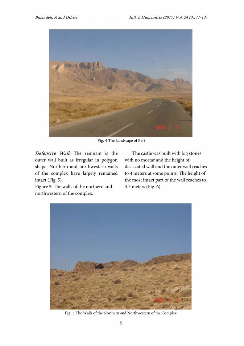
The Landscape of Bari The site is situated in modern West Azerbaijan Province, in the district of Urmia, near the village of Bari, at an
elevation of 1750 meters. The coordinates of the site are 38° 01' 30" longitude and 45° 05' 49" latitude (Fig. 1-2).
Fig. 1 Location of Bari in Northwest of Iran
Qezel Geyh,Wareh and Gara Geni are
three isolated peaks lie in the mountainous area between Urmia and Salmas, which overlook a gorge through which the Zola Chaei river is flowing. The site has been built on a rocky ridge overlooking the eastern Plain of Urmia and the banks of the Bari valley, hence; has an advantage from a military point of view. On the western ridge, there lies Urmia Lake. On its eastern flank, the defensive Bari fortress is located.
The Site Description Bari Castle has been built on the western heights of Urmia Lake with a view on the most important passageway in northwest of Iran. This passageway connects Urmia Plain to Salmas Plain and then, to Caucasia. Shapour Relief found on this passageway indicates its significance at that time.
The castle, with a large dimension of about 450x600 meters, was built at the highest point irregularly and almost triangular in shape, based on the mountain topography (Fig. 3).

The Iron Age III of Urmia Lake …______________ Intl. J. Humanities (2017) Vol. 24 (3)
4
Fig. 2 Position of Bari (Google Earth Satellite Image with Places of Interest Marked).
Fig. 3 Topography and Plan of Bari
The location of the castle is difficult
to assess and topographically (Fig. 4), its southern and eastern sides are on the glacis and accessible. There are some traces of cutting off stones and using them for defensive foundation. Remnants
of the castle wall are scattered and are the most penetrable point. The northern and western sides are cliff and quite arduous. On these parts, the wall remained with several layers of ruined stones visible on the sharp rocky edge.
Binandeh, A and Others _______________________ Intl. J. Humanities (2017) Vol. 24 (3): (1-13)
5
Fig. 4 The Landscape of Bari
Defensive Wall: The remnant is the outer wall built as irregular in polygon shape. Northern and northwestern walls of the complex have largely remained intact (Fig. 5). Figure 5: The walls of the northern and northwestern of the complex.
The castle was built with big stones with no mortar and the height of desiccated wall and the outer wall reaches to 4 meters at some points. The height of the most intact part of the wall reaches to 4.5 meters (Fig. 6).
Fig. 5 The Walls of the Northern and Northwestern of the Complex.

The Iron Age III of Urmia Lake …______________ Intl. J. Humanities (2017) Vol. 24 (3)
6
Fig. 6 Outer Wall Reaches to 4m at Some Points
The wall thickness varies at different points. On the northern side, it is between 2m and 2.5m and even lesser. The wall constitutes several layers of rubbles in all directions. Apart from rubbles, its composition and components include gravels as well as small and large rocks arranged in rows as layers (Fig. 7). The length of the remaining wall on the northern side is about 600 meters (Fig. 8). On the eastern side, the ruins are observed as well and the only remainder includes stony rows. For enforcement purposes, certain gaps were created into the wall and the thickness of some rocky points and cliff and longitude supports were increased in order to prevent impulsion and destruction of the rampart (Fig. 9). Across and underneath the walls, some canals are provided to determined spaces to transfer excessive rain water to outer area (Fig. 10). Entry Point: Considering the extensive destruction of the fortress, its entry point
could not be identified certainly. It is very likely a glacis, natural and topography of the location, and also the glacis of the southern and eastern sides was the entryway. The scattered remains of the stony wall and the most penetrable of the castle is located at this eastern and southern sides, that is a place located at the glacis of the mountain slope, and traces of natural rocks for the defensive wall foundation are observed in this part. Architectural Units: Traces of individual and continuous architectural units are in both northern and northeastern sides. Considering a long wall, extending over the north and northeastern side, is on a parallel with the main wall. It seems that all units have been enclosed inside another complex, but the destruction volume and the accumulation of rubbles make them too difficult to make the precise determination of form and plan. Thickness of these places varies from 2 to 2.40 meters. Small rocks and gravel are also used between the layers of stones.

Binandeh, A and Others _______________________ Intl. J. Humanities (2017) Vol. 24 (3): (1-13)
7
Fig. 7 Composition, Components of the Wall
Fig. 8 The Wall Remnants on the Northern Side.

The Iron Age III of Urmia Lake …______________ Intl. J. Humanities (2017) Vol. 24 (3)
8
Fig. 9 Eastern Side of the Wall
Fig. 10 Canal to Transfer Excessive Rain Water to Outer Area.

Intl. J. Humanities (2017) Vol. 24 (3) (1-13)
9
Pottery Sherds Potteries are among the most important cultural data obtained from Bari Castle (Fig. 11). There are various pottery sherds scattered around the castle and on its surface. Some of them are related to the Islamic period. Some pieces are burnish. This type was found in various regions, especially from the Urartian site such as Hasanlu, Zanbi and Esmaiel Aqa Castle in the Urmia region. Pottery sherds included common ware, fine ware, burnish ware and 2 painted sherds. The
pottery from Bari is comparable to Iron Age III sites like Kul Tarikeh (Rezvani and Roustaei, 2007), Hasanlu IIIB (Dyson, 1999), Zendan-i- Suleiman (Boehmer, 1988; Thomalsky, 2006), Ziwiye (Young, 1965; Motamedi, 1977) and Qalaichi (Mollazadeh, 2008). The only patterns painted on the edges and necks of two pieces of this group are geometrical design and brown-colored patterns which are painted continuously on the surface of pottery sherds. Around the site there are different pottery pieces that belonged to Islamic period.
Fig. 11 Pottery Sherds from Bari
Discussion and Conclusion Bari Castle is among the most important ancient castles of the Urmia region and belongs to the first millennium BC. The high and solid walls of the castles were used during various periods and regarding the architectural style and similarities with the other neighboring Urartian castles such as Zanbil Castle and Esmaiel Aqa Castle. Later, during the
Islamic era, this place was used again due to it special position, solidity and aristocracy and probably, it had been repaired and reconstructed by newcomers. Islamic single-colored glossy pottery sherds, in blue or green color, indicate that the castle once belonged to Ilkhanid and probably, Seljuk.
Here, the significant point is that some pottery sherds with triangle design
The Iron Age III of Urmia Lake …______________ Intl. J. Humanities (2017) Vol. 24 (3)
10
(triangle ware), has been found among other types. The term triangle ware was used by Dyson to describe patterned pottery of Hasanlu IIIB (Dyson, 1958). Although such potteries have rarely found at ancient sites, they are important for chronology of the northwestern sites. Other researchers used this term to describe different forms of pottery ware. These pottery ware have been found in widespread geographical area in west and northwest of Iran, east of Turkey, Caucasia, and also in Afghanistan and Pakistan.
In the early 8th century, Hasanlu was abandoned after an attack. Later, new constructions were made in a section of the old wall. This is the period of the triangle ware with combination of a fine levigated fabric, a highly polished surface and basic color of tan or buff, decorated usually with plum-brown or dark brown painted hanging triangle designs (Dyson, 1999). Later, Dyson put triangle ware in Hasanlu III and classified them into two groups of classic and non-classic (Dyson, 1999). Swiny, who widely surveyed Iran’s northwest, suggested that these potteries belong to the Iron Age III and their sources are Bokan and Sup Tepeh (Swiny, 1975). Regarding the abundance of such pottery in the south of Urmia Lake and findings in Hasanlu, Ziwiye and Qaltgah, Swiny concludes that pottery can be categorized in Mannaean potteries type (Swiny, 1975). Also, the potteries from Bari are very similar to painted pottery from Qalaichi, that described by Mollazadeh (Mollazadeh, 2008).
Kroll believes that these potteries prevailed in post-Urartian period because there were no patterned potteries in Bastam at that time (Kroll, 1975). Later,
he generalized his conclusion to the northwest of Iran as whole and suggested that the chronology of pottery of places he had ascribed belonged to the Achaemenid period (Kroll, 1976, 2004). The evidence of the Achaemenid settlement in eastern Turkey and to publish the sherds from two sites, Altin Tepe and Cimin Tepe II collected by Burney during his survey in 1955 (Summers, 1993, 85).
For identifying the Achaemenid sites, three criteria are proposed: 1- inscription, 2- architecture, 3- pottery (Summers, 1993, 85). In northwestern Iran, especially the Urmia Lake basin, evidence is very limited. Although a number of sites such as Kul Tepe I (Abei et al., 2014) and Hasanlu IIIA (Dyson, 1999) have been attributed to this period. The fact is that most of these attributes are based on pottery sherds, which of course is debatable. So far, the evidence of architecture and inscriptions from this period that shows that it is certainly related Achaemenid has not been discovered. So, we do not have a good understanding of the Achaemenid period in the northwest of Iran.
Such sherds probably prevailed between 700-500 BC. Now, considering the fact that such sherds have been found in the north of Urmia Plain, some arising questions need wide researches. If we accept that such pottery sherds are among the Mannaean type, then how can we justify the attendance of Mannaean people in the north of Urmia Plain and Bari Castle?
The kingdom of Urartu eventually expanded into an empire that engulfed the entire Eastern Anatolia, Armenia and

Binandeh, A and Others _______________________ Intl. J. Humanities (2017) Vol. 24 (3): (1-13)
11
the northwestern of Iran around Lake Urmia.
For almost 150 years, from the middle of the 9th till the end of the 8th century, the Urartian areas in Iran were not attacked any more by Assyria. It was only during the reign of Sargon II of Assyria that Urartu and Assyria clashed in Iran again. The reason was that Urartu interfered more and more in the affairs of the kingdom of Mannea, which Assyria considered a tributary (Kroll, 2011). In 714 BC, Sargon II conducted a major military campaign across the Zagros Mountains into western Iran. It was the eighth campaign of his reign, and the fourth into Iran (Muscarella, 1986). In fact, we learn from other sources that the Urartians ruled in the area, south of Lake Urmia until Sargon’s eighth campaign
(714 BC) (Salvini, 2009:501) that resulted in the defeat of Urartians and end of their dominance on eastern, southern and western regions of Urmia. They just dominated the north of Urmia Lake, and by far, any Urartian epigraphy has not found in this place after the year 714 BC (Khatibshahidi, 2006). The construction style of Bari is closely comparable to Mannaean forts such as Jan Aqa (Binandeh and Kargar, 2008), Qal’e Bardine (Hasanzadeh, 2009) and Jowšātū (Mollazadeh, 2015).
The first half of the 7th century is when Mannaean seized the power in that area. It was the time which saw the expansion of Mannean more than ever, especially its dominance on the Urmia plain, hence; the Bari castle was of the Mannaean Empire.
References [1] Abedi, A., Shahidi, H.K., Chataigner, C., Niknami, K., Eskandari, N., Kazempour, M., Pirmohammadi, A., Hosseinzadeh, J. and Ebrahimi, G., (2014). Excavation at Kul Tepe (Hadishahr), North-Western Iran, 2010: First Preliminary Report. Ancient Near Eastern Studies, 51: 33-165. [2] Binandeh A, Kargar B., (2008). Ghour Ghaleh Jan Aqa: a Mannaean Fortress in North-Western Iran. Antiquity 82. http://antiquity.ac.uk/ProjGall/315.html. [3] Boehmer R., (1986). Ritzverzierte Keramik aus dem mannäischen (?) Bereich. Archaeologische Mitteilungen aus Iran 19: 95-99. [4] Burney C., (1970). Excavations at Haftavān Tepe 1968: First Preliminary Report. Iran: 157-71. [5] Burney C., (1972). Excavations at Haftavān Tepe 1969: Second Preliminary Report. Iran: 127-42.
[6] Burney C., (1973). Excavations at Haftavān Tepe 1971: Third Preliminary Report. Iran: 153-72. [7] Burney C., (1961). Excavations at Yanik Tepe, North-West Iran. Iraq 23: 138-53. [8] Burney C., (1962). The Excavations at Yanik Tepe, Azerbaijan, 1961 Second Preliminary Report. In Iraq: 134-52. [9] Burney C., (1964). The Excavations at Yanik Tepe, Azerbaijan, 1962: Third Preliminary Report. Iraq 26: 54-61. [10] Dyson Jr. RH., (1956). Pennsylvania Survey in Iran. Archaeology 9: 284-85. [11] Dyson Jr RH. (1999). Triangle-Festoon Ware Reconsidered. Iranica antiqua 34: 115-44. [12] Dyson Jr RH. (1989). Rediscovering Hasanlu. Expedition 31: 3-11. [13] Dyson Jr RH. (1999). The Achaemenid Painted Pottery of Hasanlu IIIA. Anatolian Studies 49: 101-10.
The Iron Age III of Urmia Lake …______________ Intl. J. Humanities (2017) Vol. 24 (3)
12
[14] Hamlin C., (1975). Dalma Tepe. Iran 13: 111-27. [15] Dyson Jr RH. Young TC. (1960). The Solduz Valley, Iran: Pisdeli Tepe. Antiquity 34: 19-28. [16] Hassanzadeh Y., (2009). Qale Bardine, a Mannaean Local Chiefdom in the Bukan Area, North- Western Iran. Archäologische Mitteilungen aus Iran und Turan 41: 269-82. [17] Kargar B, Binandeh A., (2009). A Preliminary Report of Excavations at Rabat Tepe, Northwestern Iran. Iranica Antiqua 44: 113-29. [18] Khatib-Shahidi H., (2010). Recent Investigations at Hasanlu and Reconsideration of its Upper Strata. The International Journal of Humanities 13: 17-29. [19] Mollazadeh K., (2008). The Pottery from the Mannean Site of Qalaichi, Bukan (nW-Iran). Iranica Antiqua 43: 107-25. [20] Mollazaeh K., (2015). Study and Dating of the Jowšātū Fort: The Largest Mannean Fortress in Northwestern Iran? International Journal of the Society of Iranian Archaeologists 1(2): 53-70. [21] Motamedi N. Proceedings of Iranian Architecture and City Building Congress, Shiraz, Iran: 320-57. Tehran: Iranian Cultural Heritage Organization (in Persian) 1997. [22] Muscarella OW., (1968). Excavations at Dinkha Tepe, 1966. Bulletin of the Metropolitan Museum of Art 27: 187-96. [23] Muscarella OW., (1971). Qalatgah: an Urartian Site in Northwestern Iran. Expedition 13: 44-49.
[24] Muscarella OW., (1973). Excavations at Agrab Tepe, Iran. Metropolitan Museum Journal 8: 47-76. [25] Muscarella OW., (1974). The Iron Age at Dinkha Tepe, Iran. Metropolitan Museum Journal 9: 35-90. [26] Muscarella OW., (1986). The Location of Ulhu and Uiše in Sargon II’s Eighth Campaign, 714 BC. Journal of Field Archaeology 13: 465-75. [27] Pecorella PE, Salvini M., (1984). Tra lo Zagros e l' Urmia: ricerche storiche ed Archeologiche nell; Azerbaigian iraniano. Edizioni dell; Ateneo. [28] Rezvani H, Roustaei K., (2007). A Preliminary Report on Two Seasons of Excavations at Kul Tarike Cemetery, Kurdestan, Iran. Iranica Antiqua 42: 139-84. [29] Salvini, M., (2009). The Eastern Provinces of Urartu and the Beginning of History in Iranian Azerbeijan. Saglamtimur, Altan Çilingiroglu’na Armagan: 497-512. [30] Summers, G.D., (1993). Archaeological Evidence for the Achaemenid period in Eastern Turkey. Anatolian Studies, 43: 85-108. [31] Swiny S., (1975). Survey in North-West Iran, 1971. East and West 25: 77-97. [32] Thomalsky J., (2006). Die Eisenzeitliche Keramik von Zendan-e Suleiman in Iranisch Azarbaijan. Archäologische Mitteilungen aus Iran und Turan 38: 219-89. [33] Voight, M.M., (1983). Haji Firouz Tepe the Neolithic Settlement. The University Museum, University of Pennsylvania. [34] Young TC. , (1965). A comparative Ceramic Chronology for Western Iran, 1500-500 BC. Iran 3: 53-85.

Binandeh, A and Others _______________________ Intl. J. Humanities (2017) Vol. 24 (3): (1-13)
13
یاچه ارومیه در پرتو مطالعات جدید ۀحوض ٣عصر آهن در
٣محمدی، کیومرث حاج٢محمدی، بهروز خان١علی بیننده
یافت: ٢۶/٢/١٣٩٧ تاریخ پذیرش: ٢٣/٢/١٣٩۶تاریخ در
چکیده
این قلعه بر .ارومیه، قلعه باری در غرب دریاچه شناسایی شددر مطالعات اخیر باستان شناسی در حوضه دریاچه ضخامت و تاسیسات العبور قرار گرفته و بقایای آن شامل دیوارهای مرتفع با چندین مترفراز ارتفاعات صعب
دهد که های قلعه نشان میویژگی وابسته، وسعت محوطه، ساختارمستحکم، ضخامت و طول برج و بارو و دیگربرخوردار بوده و مردمان زیادی را در خود جای داده بادانی از اهمیت سوق الجیشی و استراتژیک خاصیدر زمان آ
خارجی و بنا های داخلی و و استحفاظی آن هنوز قابل شناسایی و است. علاوه بر این بقایای معماری حصارگسترده نسبتبهبی بر حضور قلعه اسماعیل آقا در نزدیکی باری دلیل خو پیگردی است. وجود قلعه زنبیل و
دهد که این محوطه به نیمه اول قرن عات سفالی و شیوه معماری نشان میمطالعه قط .اورارتوها در منطقه داردگیرند و بر این مصادف با زمانی است که اورارتوها ضعیف شده و ماناها در منطقه قدرت می تعلق دارد و مپ هفتم .کننداتی در منطقه ایجاد میافزایند و تاسیسخود می قلمرو
.سفال مثلثی، حوضه دریاچه ارومیه ،٣: باری، عصر آهن کلیدی هایواژه
_____________________________________________________________________________ (نویسندۀ مسئول). [email protected] .دانشگاه بوعلی سینا، همدان، ایران ، دانشکدۀ هنر،شناسیباستان استادیار. ١ ، ایران.ارومیه، شناسی سازمان میراث فرهنگی و گردشگریکارشناسی ارشد باستان. ٢ ، ایران.ارومیه، شناسی سازمان میراث فرهنگی و گردشگری. کارشناسی ارشد باستان٣