the intra-sudetic basin – a record of sedimentary and...
TRANSCRIPT

GeoLines 16 (2003)164 GeoLines 16 (2003) 165
Introduction to the field tripLate Palaeozoic Sedimentation in the Intra-Sudetic Basin (Western Sudetes, SW Poland)Leszek Kurowski
The Intra-Sudetic Basin, situated at the northern margin of the Bohemian Massif in the West Sudetes, represents one of the larger intramontane throughs widespread along the Variscan belt of Europe (Fig. 1). It is filled with the Lower Carboniferous to Lower Permian volcano-sedimentary succession. The total thickness of the basin fill attains 12,000 metres (Fig. 2). The Intra-Sudetic Basin constitutes a large fault-bounded synclino-rial structure, 70 km long and 35 km wide, which extends in the WNW-ESE direction. The basin is framed by various crystalline basement units of the Variscan consolidation and by another Late Palaeozoic sedimentary basins. The basin fill suc-cession is overlain by the Lower Triassic continental and Upper Cretaceous shallow-marine deposits.
Development of the Intra-Sudetic Basin was initiated at the beginning of Early Carboniferous as an intramontane depression bounded by tectonically active margins (Teisseyre 1968). Its NW part was framed by the Góry Kaczawskie and Rudawy Janowickie metamorphic complexes and, hypotheti-cal, “Southern Massif”, which were rapidly uplifted and eroded during the Early Carboniferous. Since the Late Tournaisian to Middle Visean the basin was filled with non-marine, clastic deposits mainly comprising coarse-grained conglomerates and sedimentary breccias. This part of the Lower Carboniferous molasse sequence of 5 km thick was formerly referred to as
"Older Culm” (Dathe, 1892; Teisseyre, 1975). It represents de-posits of transverse alluvial fans developed along active fault scarps bounding the basin. Alluvial fans grew centripetally towards the axial fluvial belt with easterly inclined paleoslope (Teisseyre 1968, 1975; Dziedzic and Teisseyre 1990). The Up-per Tournaisian – Middle Visean succession shows a distinct cyclic organisation (Teisseyre 1968, 1975). It comprises sev-eral megacyclothems which are distinguished as individual lithostratigraphic units: Ciechanowice, Stare Bogaczowice and Lubomin Formations (Stop 1).
During the Late Visean a marine transgression invaded westwards along the northern margin of the Intra-Sudetic Basin (Dathe, 1892; Żakowa, 1963).
The western part of the basin was occupied by a shallow marine embayment passing southward into extensive fluvial/deltaic system. At the same time, the eastern part of the basin
was submerged, in contrast, by a relatively deeper sea. The Upper Visean sedimentary succession is referred to as the Szczawno Formation (formerly "Younger Culm”) (Stop 2). Its thickness increases gradually from 600 m in vicinities of Wałbrzych (most probably not complete stratigraphic interval) to approximately 2 000 metres in the western part of the basin. The succession includes fossiliferous shales containing brack-ish marine fauna (Żakowa, 1963).
Tectonic uplift of the eastern and southern basin borders led, at the turn of the Early and Late Carboniferous, to rearrange-ment of the Intra-Sudetic Basin and its depositional system. In consequence of a marine regression, the consecutive Upper Carboniferous to Lower Permian sedimentary successions accumulated in continental settings. The Upper Carboniferous succession consists of few individual fining upwards mega-cyclothems, typical of alluvial environment. The succession attains up to 2000 metres in thickness and is, predominantly, of coal-bearing character.
The Early Namurian Wałbrzych Formation consists of quartz arenites and minor conglomerates interpreted to rep-resent an upper delta-plain facies association which evolved into a meandering alluvial plain association (Nemec, 1984). Northward directed paleocurrent indicators show a distinct fan-like arrangement were related to northward propagation of allu-vial-deltaic system. The Wałbrzych Formation is approximately 300 metres thick and contains some 30 coal seams.
The Biały Kamień Formation comprises up to 400 metres of the Upper Namurian to Lower Westphalian (Gothan and Gropp 1933) conglomerates and sandstones. Sedimentation was domi-nated by in-channel processes (Kurowski, 1998). Braided style of channel pattern evolved upwards into a meandring channel system of an upper delta plain. Paleocurrent indicators, in vi-cinities of Wałbrzych, point to the NNW-directed transport of clastic material which was derived from the easterly and south-erly located source areas.
The Biały Kamień Formation grades upwards into fine-clastics and sandstones of the Žacler Formation (Westphal A-C), which contains numerous coal seams (Fig. 2, compare also Tab. 1). This up to 900 metres thick succession represents diverse in-channel and overbank facies associations of an ex-tensive alluvial plain. The paleocurrent indicators suggest the N and NW-directed transport of the clastic material derived from the S and SE margins of the basin.
The Žacler Formation is conformably overlain by the monotonous succession of the Glinik Formation (Westphal D – Stephan). The latter represents a 600 m thick sequence
The Intra-Sudetic Basin – a Record of Sedimentary and Volcanic Processes in Late – to Post-Orogenic Tectonic SettingMarek AWDANKIEWICZ1, Leszek KUROWSKI1, Krzysztof MASTALERZ2 and Paweł RACZYŃSKI2
1 Institute of Geological Sciences, University of Wrocław, pl. Maksa Borna 9, 50-204 Wrocław, Poland2 14076 – 115th Ave., Surrey, B.C., V3R 2P6, Canada

GeoLines 16 (2003)166 GeoLines 16 (2003) 167
Fig. 1. Simplified geological map of the Intra-Sudetic Basin (after Sawicki, 1995; modified) with outline map of the Bohemian Massif (after Franke, 1989, modified) to show its location (ISB). Ruled – crystalline domains, crosses – Variscan granites, blank – sedimentary basins; ISB – Intra-Sudetic Basin.

GeoLines 16 (2003)166 GeoLines 16 (2003) 167
of transitional character between coal-bearing Namurian to Westphalian successions and barren Stephanian and Lower Permian sediments. The Glinik Formation consists of pink to yellow sandstones and fine conglomerates interlayered with red mudstones. They represent deposits of braided channels and restricted overbank areas.
The Late Stephanian sedimentation in the Intra-Sudetic Basin produced up to 400 m thick, finning upwards sequence of the Ludwikowice Formation (Fig. 2, Tab. 1). This sedimentary
succession comprises mostly red sandstones and conglomer-ates, which accumulated in alluvial-fluvial settings. Coarse- to medium-grained sediments grade upwards into mudstones and claystones, which include thin intercalations of bitumi-nous limestones. This uppermost portion of the Ludwikowice Formation resulted from sedimentation in lacrustine environ-ments.
The Autunian sediments of the Intra-Sudetic Basin are simi-lar in many respects to the underlying Ludwikowice Formation. They comprise two successive megacyclothems: the Krajanów and Słupiec Formations (Fig. 2, Tab. 1) (Stop 5), which col-lectively attain up to 900 m in thickness. Both finning upwards cyclothems comprise clastic deposits of alluvial fan, fluvial and lacustrine environments (Kurowski 2001). Sedimentation took place in the NW-SE elongated paleovalleys which were fed in clastics by the axial NW-sloping fluvial systems and transverse, marginal alluvial fans.
Intense tectonic activity during the Saxonian led to the significant uplift of the southern and southeastern frames of the Intra-Sudetic Basin and resulted in a diversified relief (land-scape rejuvenation). Elevated margins of the basin became sub-jects to effective erosion. Sedimentation took place in elongated valleys bounded by fault-related steep slopes. The valley floors were occupied by fluvial plains dominated by accumulation in braided-type channels. The axial fluvial belts were effectively fed in coarse-clastic material by transverse, mass-flow-domi-nated alluvial fans. The Saxonian period of sedimentation in the Intra-Sudetic Basin resulted in 100 to 400 metres thick succes-sion of predominantly red-coloured, coarse-clastic conglomer-ates of the Radków Formation (Fig. 2, Tab. 1).
Carboniferous and permian volcanism in the intra-sudetic basinMarek Awdankiewicz
The Carboniferous and Permian development of the ISB has been associated with three stages of volcanic activity during: 1) the latest Tournaisian/earliest Visean, 2) the late Westphalian and Stephanian, and 3) the early Permian, the latter correspond-ing to the climax of volcanism. Recent studies in the Polish part of the basin (Awdankiewicz et al., 1998; Awdankiewicz, 1998, 1999 a, b and references therein) show that geochemical and petrographic characteristics of the volcanic rocks changed with time, the location of volcanic centres was strongly controlled by tectonics, and the volcanic activity and sedimentary proc-esses were closely interrelated.
Geochemistry and petrogenesis
The volcanic succession of the Intra-Sudetic Basin can be sub-divided into the older, calc-alkaline suite, emplaced in the early and late Carboniferous, and the younger, mildly alkaline suite, erupted in the late Carboniferous and early Permian times (Figs. 3, 4, 5). The calc-alkaline suite comprises mostly rhyo-
Fig. 2. Stratigraphic scheme for Carboniferous and Permian of Intra-Sudetic Basin (Nemec et al., 1982; Odin et al., 1982).

GeoLines 16 (2003)168 GeoLines 16 (2003) 169
STRATIGRAPHY
CZECH PART POLISH PARTFormation Member Formation Member
Lower Triassic Bohdašin “Buntsandstein”Thuringian BohuslaviceSaxonian Trutnov Radków
Chełmsko Slaskie
WambierzyceUpper
Autunian
Lower
Słupiec
Walchia Shale
Building Sandstone
Broumov
Martinkovice
Olivĕtin
Nowa Ruda
Chvaleč
Bečkov
Verneřovice
KrajanówUpper Anthracosia Shale
Stephanian
LudwikowiceLower Anthracosia Shale
GlinikOdolov Jivka
Svatoňovice
WestphalianŽacleř
Petrovice
Ždarky-Dul
Lampertice
Żacler
Upper Coal-Bearing
Middle - Barren
Lower Coal-BearingNamurian Biały Kamień
Wałbrzych Upper
Visean Middle
Lower
Błażków SzczawnoLubominBogaczowice
Upper Tournaisian Ciechanowice
Tab. 1. Carboniferous, Permian and Triassic deposits of the Intra-Sudetic Basin - lithostratigraphic nomenclature of the Polish (Nemec et al., 1982) and Czech part (Tasler, 1979).
GeoLines 16 (2003)168 GeoLines 16 (2003) 169
dacites with minor andesites and basaltic andesites. These rocks show convergent plate margin-like geochemical characteristics (Fig. 5). The mildly alkaline suite comprises, in a decreasing volumetric abundance, rhyolitic tuffs, rhyolites, trachyandesites and basaltic trachyandesites. These rocks are largely character-ised by within-plate geochemical features, with some gradation towards convergent plate margin affinities (Fig. 5).
Geochemical data suggest that parental magmas of both volcanic suites originated from similar, garnet-free mantle sources at relatively shallow depths (within the subcontinental lithospheric mantle ?), but at variable degrees of partial melting, lower for the mildly alkaline suite. Convergent plate margin-like signatures of the volcanic rocks may either be inherited form the mantle sources of magmas or may reflect crustal con-
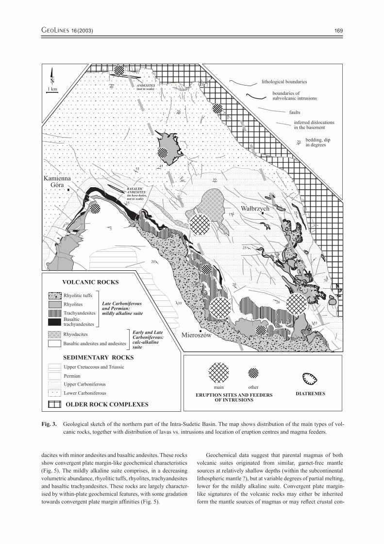
Fig. 3. Geological sketch of the northern part of the Intra-Sudetic Basin. The map shows distribution of the main types of vol-canic rocks, together with distribution of lavas vs. intrusions and location of eruption centres and magma feeders.

GeoLines 16 (2003)170 GeoLines 16 (2003) 171
tamination of the ascending and fractionating magmas. Both suites comprise moderately to strongly evolved rock types. The major and trace element variation can largely be modelled as a closed system fractional crystallisation of variable mineral assemblages, equivalent to the observed phenocryst phases: mainly plagioclase, pyroxenes and olivine, with hornblende and biotite in the calc-alkaline suite, and with K-feldspar in the mildly alkaline suite. Trace element patterns of the more evolved rocks were also strongly influenced by fractionation of such accessory minerals as spinels, ilmenite, apatite, zircon and others. Both geochemical and petrographic evidence (e.g.
resorbed quartz phenocrysts with reaction rims, complexly zoned and sieve-textured plagioclase phenocrysts) suggest also that assimilation of crustal rocks and magma mixing processes might have been influential.
Considering the regional geological context, the geochemi-cal characteristics of the volcanic suites of the Intra-Sudetic Basin can hardly be interpreted as resulting from a changing geodynamic regime, e.g. from an active continental margin in the Carboniferous to a within-plate extensional setting in the Permian. Apparently, the volcanic rocks were related to a late/post-orogenic setting and their geochemistry reflects rather
Fig. 4. Classification of the volcanic rocks of the Intra-Sudetic Basin. A – the total alkali-silica (TAS) diagram (Le Maitre et al., 1989). B – the Zr/TiO2 – Nb/Y plot (Winchester and Floyd, 1977).

GeoLines 16 (2003)170 GeoLines 16 (2003) 171
the source characteristics (e.g. a metasomatic enrichment pre-ceding volcanism) and variable differentiation processes (e.g. crustal contamination) of the primary magmas. Similar geo-chemical variation is typical of many volcanic suites emplaced in extensional settings adjacent to former active continental margins (e.g. the Basin and Range Province of the USA).
Volcanic centres, subvolcanic intrusions and the interrelationships of volcanism, tectonics and sedimentation.
The earliest volcanism in the Intra-Sudetic Basin occurred near its northern margin and the successive Carboniferous and Permian volcanic centres shifted SE-wards with time, consist-ently with depositional centres of the basin (Fig. 3). The loca-tion of magma feeders and volcanoes can be tentatively linked with basin margins and, in most cases, intrabasinal elevations
and their boundary faults (NNW-SSE to NW-SE aligned in the Polish part of the basin). The emplacement style of the magmas was strongly influenced by palaeogeographic controls: the magmas intruded into thicker accumulations of sedimentary rocks within intrabasinal troughs and erupted through thinner sequences on the intrabasinal elevations. In general, effusive to extrusive activity was typical to the northern and western parts of the basin where lava-dominated, composite volcanic centres were created. In the eastern part of the basin the most evolved acidic magmas erupted explosively with the formation of a maar belt (late Carboniferous) and ca. 10 km in diameter cal-dera (Permian), with subsequent emplacement of subvolcanic intrusions in both cases.
The volcanic activity affected sedimentary processes. Volcanic edifices related to major eruptions represented topo-graphic highs subjected to substantial erosion, with the largest supply of volcanogenic debris into the basin following the most voluminous rhyolitic eruptions in the Permian times. On the other hand, the caldera in the eastern part of the basin was an intrabasinal depositional centre.
Contrasting development of Permian volcanic activity in the east and west of the Intra-Sudetic Basin
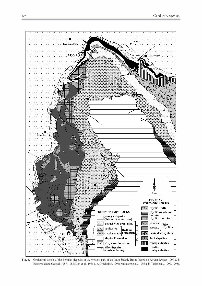
During the field trip three volcanic complexes related to the Per-mian climax of volcanic activity will be visited: Kamienna Góra Basaltic Trachyandesites (Stop 3), Góry Krucze Rhyolites (Stop 4) and Tłumaczów Trachyandesites (Stop 5). All the com-plexes belong to the Słupiec Formation (see previous chapters). In the area of the Permian depositional centre of the Intra-Sudetic Basin near Nowa Ruda, the Słupiec Formation is thickest and most completely developed. In contrast, the western part of the Formation near Kamienna Góra and Lubawka, which accumu-lated away from the depositional centre over an intrabasinal elevation, is characterised by a hiatus at its base, lower total thickness, lack of some lithostratigraphic members and transgres-sive development of younger members. Volcanic rocks within the Słupiec Formation also show a different development in the east and west. In the east the volcanic rocks are subordinate relative to sedimentary rocks, and they comprise tuffs (largely ignimbrites) and several rhyolitic and trachyandesitic intrusions, including the Tłumaczów Trachyandesites. In the west the volcanic rocks strongly prevail over sedimentary rocks and comprise basic/intermediate and rhyolitic lavas, including the Kamienna Góra Basaltic Trachyandesites and the Góry Krucze Rhyolites.
The Kamienna Góra Basaltic Trachyandesites (Awdan-kiewicz 1997, 1999 a, Awdankiewicz et al., 1998) crop out in the western part of the Intra-Sudetic Basin in the lowermost part of the Słupiec Formation (Fig. 6). This volcanic rock complex is interpreted as a small shield volcano formed due to effusive eruptions of basic/intermediate lavas (SiO2 content around 52 %). The vent area of the volcano was located SE of Kamienna Góra, in the area now covered with younger de-posits. The volcano possibly represented a very flat cone with a basal diameter of ca. 10–12 km and a height of ca. 100 m. The total volume of erupted lavas can be roughly estimated at
Fig. 5. Geochemical variation of selected trace elements in the volcanic rocks of the Intra-Sudetic Basin. A – Zr-Ti plot (Pearce, 1982). Symbols as in Fig. 1. B – MORB-normalised trace element patterns of the basaltic andesites and the basaltic trachyandesites (normalisation after Pearce, 1983).
GeoLines 16 (2003)172 GeoLines 16 (2003) 173
Fig. 6. Geological sketch of the Permian deposits in the western part of the Intra-Sudetic Basin (based on Awdankiewicz, 1999 a, b; Bossowski and Czerski, 1987, 1988; Don et al., 1981 a, b, Grocholski, 1994; Mastalerz et al., 1995 a, b; Tasler et al., 1990, 1995).
GeoLines 16 (2003)172 GeoLines 16 (2003) 173
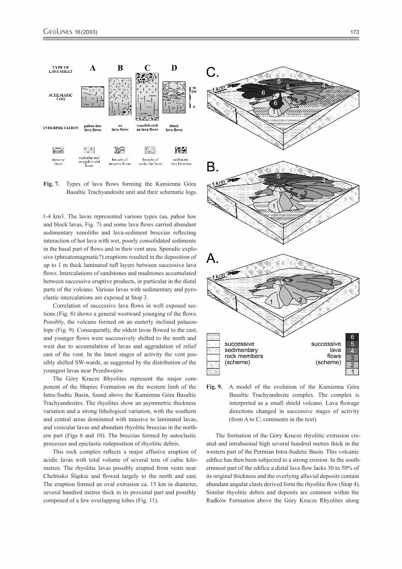
1-4 km3. The lavas represented various types (aa, pahoe hoe and block lavas, Fig. 7) and some lava flows carried abundant sedimentary xenoliths and lava-sediment breccias reflecting interaction of hot lava with wet, poorly consolidated sediments in the basal part of flows and in their vent area. Sporadic explo-sive (phreatomagmatic?) eruptions resulted in the deposition of up to 1 m thick laminated tuff layers between successive lava flows. Intercalations of sandstones and mudstones accumulated between successive eruptive products, in particular in the distal parts of the volcano. Various lavas with sedimentary and pyro-clastic intercalations are exposed at Stop 3.
Correlation of successive lava flows in well exposed sec-tions (Fig. 8) shows a general westward younging of the flows. Possibly, the volcano formed on an easterly inclined palaeos-lope (Fig. 9). Consequently, the oldest lavas flowed to the east, and younger flows were successively shifted to the north and west due to accumulation of lavas and aggradation of relief east of the vent. In the latest stages of activity the vent pos-sibly shifted SW-wards, as suggested by the distribution of the youngest lavas near Przedwojów.
The Góry Krucze Rhyolites represent the major com-ponent of the Słupiec Formation on the western limb of the Intra-Sudtic Basin, found above the Kamienna Góra Basaltic Trachyandesites. The rhyolites show an asymmetric thickness variation and a strong lithological variation, with the southern and central areas dominated with massive to laminated lavas, and vesicular lavas and abundant rhyolitic breccias in the north-ern part (Figs 6 and 10). The breccias formed by autoclastic processes and epiclastic redeposition of rhyolitic debris.
This rock complex reflects a major effusive eruption of acidic lavas with total volume of several tens of cubic kilo-metres. The rhyolitic lavas possibly erupted from vents near Chełmsko Śląskie and flowed largely to the north and east. The eruption formed an oval extrusion ca. 15 km in diameter, several hundred metres thick in its proximal part and possibly composed of a few overlapping lobes (Fig. 11).
The formation of the Góry Krucze rhyolitic extrusion cre-ated and intrabasinal high several hundred metres thick in the western part of the Permian Intra-Sudetic Basin. This volcanic edifice has then been subjected to a strong erosion. In the south-ernmost part of the edifice a distal lava flow lacks 30 to 50% of its original thickness and the overlying alluvial deposits contain abundant angular clasts derived form the rhyolitic flow (Stop 4). Similar rhyolitic debris and deposits are common within the Radków Formation above the Góry Krucze Rhyolites along
Fig. 7. Types of lava flows forming the Kamienna Góra Basaltic Trachyandesite unit and their schematic logs.
Fig. 9. A model of the evolution of the Kamienna Góra Basaltic Trachyandesite complex. The complex is interpreted as a small shield volcano. Lava flowage directions changed in successive stages of activity (from A to C; comments in the text).

GeoLines 16 (2003)174 GeoLines 16 (2003) 175
Fig.
8.
Logs
of t
he K
amie
nna
Gór
a B
asal
tic T
rach
yand
esite
s, co
rrel
atio
n of
lava
flow
s and
loca
tion
of th
e ve
nt a
rea
of th
e vo
lcan
o.
GeoLines 16 (2003)174 GeoLines 16 (2003) 175
Fig. 10. A schematic S-N section of the Góry Krucze Rhyo-lite unit.
Fig. 11. A possible reconstruction of the Góry Krucze rhy-olitic edifice at a mature stage of its development. At its northern periphery the rhyolitic lavas partly buried the older trachyandesitic shield volcano (the Kamienna Góra Basaltic Trachyandesites).
Stop 1. Miszkowice; Natural Outcrop Northwestwards from the Village (Fig. 12).Stratigraphy: Lubomin Formation, Visean.Leader: Krzysztof Mastalerz and Leszek Kurowski
A complex of very coarse-grained, sedimentary breccias and associated deposits is exposed along the 500 metres long bluff. The breccias form thick to very thick beds, which dip towards NE at an angle of 25–30°. The beds show usually flat lower surfaces with no signs of erosive relief. The deposits are very poorly sorted and contain abundant matrix. The matrix-sup-ported grain framework predominates. Common is bimodal
grain size distribution (diamicts). All the components of the grain framework are angular and/or sub-angular. The largest clasts attain 1 metre in diameter. The matrix consists of a sand-mud-granule mixture. There occur a few moulds of large "tree" trunks locally. The deposits do not usually show any evidence of internal organization. Subhorizontal parallel orientation of elongated clasts appears in a few beds. Some of the beds dis-
the whole western limb of the Intra-Sudetic Basin, indicating a substantial erosion of the whole rhyolitic edifice.
A different sequence of Permian volcanic events is recorded in the Słupiec Formation in the eastern part of the Intra-Sudetic Basin. In that area volcanism started with a major ignimbrite-forming eruption (ca. 50 km3 dense rock equivalent?) with the formation of pyroclastic deposits over 300 m thick in places. It is suggested that the eruption created a 10 km wide caldera in the Broumov-Nowa Ruda area, which subsequently acted as a depositional centre of the basin (Awdankiewicz, 1998, 1999 a). Younger activity included emplacement of numerous rhyolitic and trachyandesitic laccoliths and sills into sedimentary strata below the pyroclastic deposits along the caldera margin near Rybnica Leśna, Głuszyca, Świerki and Tłumaczów (Stop 5). The Permian volcanism in the Intra-Sudetic Basin ceased after the eruptions of intracaldera basic lavas and acidic pyroclastic deposits near Šonov.
GeoLines 16 (2003)176 GeoLines 16 (2003) 177
play indistinct inverse-to-normal coarse-tail grading. Gneissic rocks, greenstones and amphibolites are the dominant litholo-gies of the clasts.
The moderately thick bedded, finer-grained breccias occur subordinately. They show relatively better sorting. Discoidal and/or elongated clasts are imbricated in places. Some beds dis-play indistinct, channel-like erosive basal contacts. A few thin beds of sandstone to granule-grade conglomerates accompany these breccias. These deposits are moderately to well sorted and can be classified as subgraywackes and lithic arenites. They show indistinct parallel horizontal- and low angle cross stratification.
Most of the beds resulted from gravity flow transport and deposition. The matrix-supported, thick-bedded breccias are
related to powerful debris flows. However, the low content of clay-grade particles within these sediments points against the classic model of the cohesive debris flow deposits. Thus, it is doubtful that cohesion was the dominant clast support mecha-nism in these flows. Most flows resulted in sheet-like bed forms and the erosive features are confined to solitary, shallow scoures. The beds of sand- to granule-grade deposits resulted, most probably, from high-concentration fluidal flows. It was also suggested that some beds have been formed under the up-per flow regime conditions as inferred from the antidune-type backset stratification (Teisseyre, 1977).
The sediments exposed nearby Miszkowice accumulated in a proximal zone of an alluvial fan, which was attached to the western marginal fault of the Intra-Sudetic Basin. The very
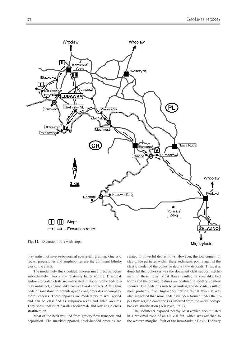
Fig. 12. Excursion route with stops.
GeoLines 16 (2003)176 GeoLines 16 (2003) 177
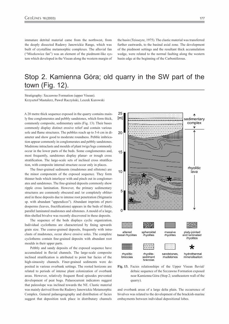
A 20 metre thick sequence exposed in the quarry contains main-ly fine conglomerates and pebbly sandstones, which form thick, commonly composite, sedimentary units (Fig. 13). Their bases commonly display distinct erosive relief and contain various sole and flame structures. The pebbles reach up to 5-6 cm in di-ameter and show good to moderate roundness. Pebble imbrica-tion appear commonly in conglomerates and pebbly sandstones. Mudstone intraclasts and moulds of plant twigs/logs commonly occur in the lower parts of the beds. Some conglomerates and, most frequently, sandstones display planar- or trough cross stratification. The large-scale sets of inclined cross stratifica-tion, with composite internal structure occur only in places.
The finer-grained sediments (mudstones and siltstone) are the minor components of the exposed sequence. They form thinner beds which interlayer with and pinch out in conglomer-ates and sandstones. The fine-grained deposits commonly show ripple cross lamination. However, the primary sedimentary structures are commonly obscured and /or completely obliter-ated in these deposits due to intense root penetration (Stigmaria sp. with abundant "appendices"). Abundant imprints of pteri-dosperms (leaves, fructifications) appears in the beds of thinly, parallel laminated mudstones and siltstones. A mould of a large, thin-shelled bivalve was recently discovered in these deposits.
The sequence of the beds displays cyclic organization. Individual cyclothems are characterized by fining upwards grain size. The coarse-grained deposits, frequently with intra-clasts of mudstones, occur above erosive soles. The complete cyclothems contain fine-grained deposits with abundant root moulds in their upper parts.
Pebbly and sandy deposits of the exposed sequence have accumulated in fluvial channels. The large-scale composite inclined stratification is attributed to point bar facies of the high-sinuosity channels. Finer-grained sediments were de-posited in various overbank settings. The rooted horizons are related to periods of intense plant colonization of overbank areas. However, relatively frequent flood episodes prevented development of peat bogs. Palaeocurrent indicators suggest that paleoslope was inclined towards the NE. Clastic material was mainly derived from the Rudawy Janowickie Metamorphic Complex. General palaeogeography and distribution of facies suggest that deposition took place in distributary channels
and overbank areas of a large delta plain. The occurrence of bivalves was related to the development of the brackish-marine embayments between individual depositional lobes.
Stop 2. Kamienna Góra; old quarry in the SW part of the town (Fig. 12).Stratigraphy: Szczawno Formation (upper Visean).Krzysztof Mastalerz, Paweł Raczyński, Leszek Kurowski
Fig. 13. Facies relationships of the Upper Visean fluvial/deltaic sequence of the Szczawno Formation exposed near Kamienna Góra (Stop 2; southeastern wall of the quarry).
immature detrital material came from the northwest, from the deeply dissected Rudawy Janowickie Range, which was built of crystalline metamorphic complexes. The alluvial fan (“Miszkowice fan”) was an element of the piedmont-like sys-tem which developed in the Visean along the western margin of
the basin (Teisseyre, 1975). The clastic material was transferred further eastwards, to the basinal axial zone. The development of the piedmont settings and the resultant thick accumulation wedge, were related to the normal faulting along the western basin edge at the beginning of the Carboniferous.

GeoLines 16 (2003)178 GeoLines 16 (2003) 179
Locality 3 comprises three abandoned quarries located on the southern slopes of Łysina Hill near Czadrówek, on the SE pe-ripheries of Kamienna Góra (Figs 6 and 12). The volcanic rocks exposed there are distinguished as the Kamienna Góra Basaltic Trachyandesites and represent the lowermost member of the Słupiec Formation in that part of the Intra-Sudetic Basin. The geology, petrography and geochemistry of these volcanic rocks are characterised in detail in Awdankiewicz (1997, 1999 a, b) and Awdankiewicz et al. (1998).
The volcanogenic sequence at locality 3 (Figs 14 and 15) is ca. 30-40 m thick and dips gently to the SE. The sequence con-sists of three successive lava horizons with sandstones and tuffs interbedded between the two lowermost lava flows (Fig. 16). The most complete section can be observed in northernmost of the three quarries.
The lowermost lava flow is ca. 8-10 m thick and consist of massive lavas in its lower part grading upwards into vesicular lavas and breccias of vesicular lavas. The top of the flow is uneven and cracked. Above, nearly 1.5 m thick sequence of sedimentary and pyroclastic rocks is found, including:
· 20–40 cm thick brown, poorly consolidated, laminated sand-stones composed largely of vesicular basaltic trachyandesite clasts,
· a 1.5 cm thick layer of green sandstone devoid of volcano-genic clasts,
· ca. 100 cm thick brown and white, laminated tuffs. Lamination is lacking adjacent to the overlying breccias and in places the tuffs are cut by clastic dykes of green sandstones.
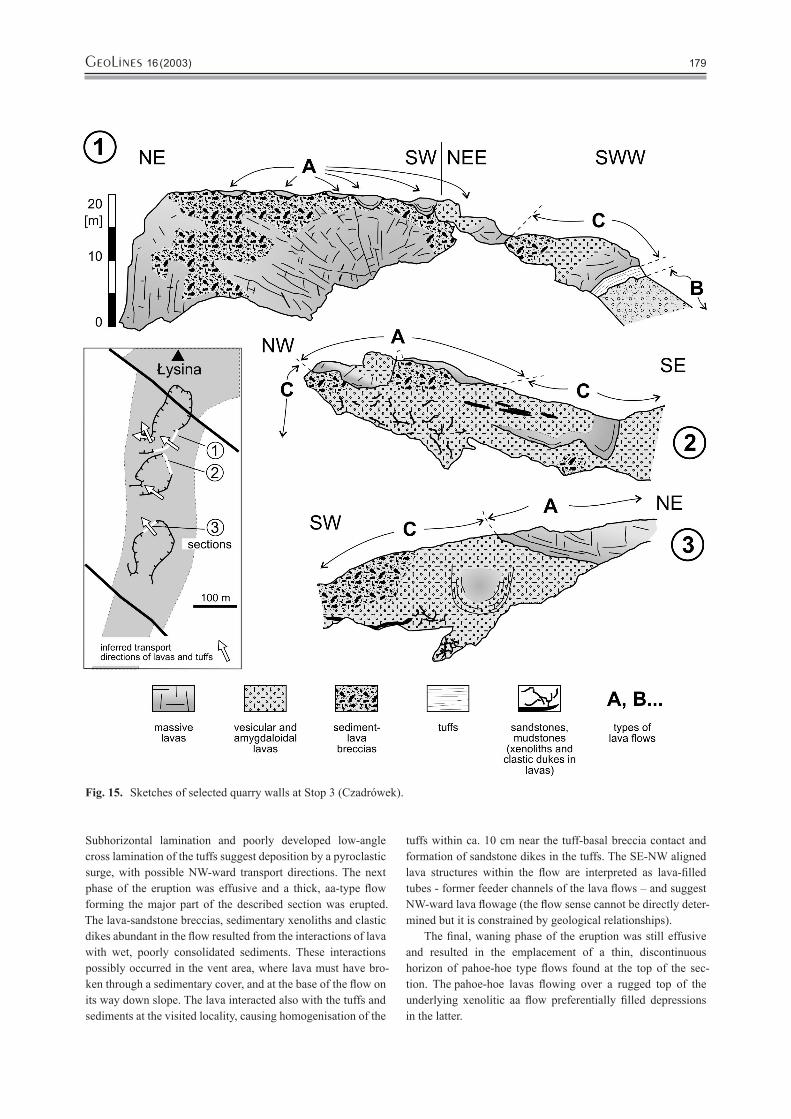
The main part of the section represents a 25 m thick lava flow of a complex structure. Its inner portion consists of mas-sive lavas grading upwards into vesicular to amygdaloidal lavas, and the outer parts are composed of lava-sandstone brec-cias. The basal breccias are 20–100 cm thick, and the top brec-cias are 5–10 m thick. In general, the breccias consist of lava blocks in a sedimentary matrix, or the opposite, and a strong variation of clast sizes, shapes and arrangement is observed. In places the lavas host sedimentary rafts up to 0.5×8 m large as well as numerous clastic dykes (Fig. 17). In the upper part of the described flow specific forms of lava are locally found. These are oval in shape with a diameter of 5 to 20 m and con-sist of massive lavas mantled by vesicular lavas. The largest one in the northern quarry shows radial and concentric joints (Fig. 15, section 1), and another one in the southern quarry shows U-shaped platy joints along the margins (Fig. 15, sec-tion 3). These forms, best exposed on NE-SW trending quarry walls, are interpreted as diagonal sections of NW-SE aligned lava-filled tubes.
The uppermost part of the described section comprises a discontinuous horizon of several 1–5 m thick flows composed of massive to vesicular lavas. The bases of the flows are sharp and uneven, reflecting the morphology of their basement. These lavas possibly form aligned lobes with a variable, wind-ing orientation.
The rock succession at locality 4 is interpreted as a se-quence of lavas with minor pyroclastic and sedimentary rocks accumulated in a proximal part of a small shield volcano. Location of the eruptive centre of the volcano within 1–2 km E-SE of the locality (Fig. 8) is inferred from indirect geological relationships within the Kamienna Góra Basaltic Trachyndesite unit, and it is consistent with transport directions of tuffs and lavas inferred from structures at this locality (see below). The sedimentary rock found within the sequence and as various xenoliths within the flow (in breccias, as rafts and clastic dikes) are tentatively interpreted as alluvial deposits equivalent to the Walchia shales of the Słupiec Formation.
The described sequence formed due to essentially two eruptions separated with a relatively long quiescence period. The first eruption was effusive and resulted in the emplacement of aa-type lava flow forming the lowermost part of the section. These lavas were subjected to a prolonged subaerial exposure and weathering. Redeposition of loose lava fragments resulted in accumulation of the overlying brown, poorly consolidated volcanogenic sandstones composed of the local material. The following thin layer of green sandstones represents an “exter-nal” alluvial deposit, lacking the local volcanic debris.
The second eruption started with an explosive (freatomag-matic?) phase with the deposition of the laminated tuffs.
Stop 3. Czadrówek near Kamienna Góra; Abandonned Quarries on the Southern Slopes of Łysina Hill (Fig. 12)Stratigraphy: Słupiec Formation, Kamienna Góra Basaltic TrachyandesitesLeader: Marek Awdankiewicz
Fig. 14. A log of the volcano-sedimentary succession at local-ity 3 (Czadrówek).
GeoLines 16 (2003)178 GeoLines 16 (2003) 179
Subhorizontal lamination and poorly developed low-angle cross lamination of the tuffs suggest deposition by a pyroclastic surge, with possible NW-ward transport directions. The next phase of the eruption was effusive and a thick, aa-type flow forming the major part of the described section was erupted. The lava-sandstone breccias, sedimentary xenoliths and clastic dikes abundant in the flow resulted from the interactions of lava with wet, poorly consolidated sediments. These interactions possibly occurred in the vent area, where lava must have bro-ken through a sedimentary cover, and at the base of the flow on its way down slope. The lava interacted also with the tuffs and sediments at the visited locality, causing homogenisation of the
tuffs within ca. 10 cm near the tuff-basal breccia contact and formation of sandstone dikes in the tuffs. The SE-NW aligned lava structures within the flow are interpreted as lava-filled tubes - former feeder channels of the lava flows – and suggest NW-ward lava flowage (the flow sense cannot be directly deter-mined but it is constrained by geological relationships).
The final, waning phase of the eruption was still effusive and resulted in the emplacement of a thin, discontinuous horizon of pahoe-hoe type flows found at the top of the sec-tion. The pahoe-hoe lavas flowing over a rugged top of the underlying xenolitic aa flow preferentially filled depressions in the latter.
Fig. 15. Sketches of selected quarry walls at Stop 3 (Czadrówek).

GeoLines 16 (2003)180 GeoLines 16 (2003) 181
The volcanic rocks exposed at Stop 4 are distinguished as the Góry Krucze Rhyolites and represent the main rock unit of the Słupiec Formation in that part of the Intra-Sudetic Basin. The rhyolites are unconformably overlain by sedimentary rocks of the lowermost part of the Radków Formation. The contact of these two formations is well exposed (Awdankiewicz et al., 1998).
The volcano-sedimentary sequence at locality 4 (Fig. 18) is ca. 25 m thick and dips gently to the north-east and east. The lower 20 m represents a rhyolitic lava flow which consist of two lithologically and structurally distinctive parts. The lower part of the flow, 5-10 m thick, consists mainly of strongly al-tered, brown and greenish, laminated lavas with sparse feldspar phenocrysts. Macroscopically these rocks resemble a poorly consolidated mudstone, and preliminary XRD and DTA deter-minations suggest alkali feldspars and smectite-type mineral as the main components. The upper part of the lava flow, ca. 10 m thick, is composed of pink-coloured, massive to laminated, sparsely porphyrytic rhyolites with prismatic and platy joints.
The boundaries of the lower, altered rhyolites with the up-per, fresh rhyolites, are sharp, but in a transitional zone these two lithologies interdigitate (Fig. 18). Other lithologies found in the boundary zone are spheroidal rhyolites (containing abun-dant spherical structures up to 5 cm in diameter) and vesicular rhyolites. Well developed flow folds are characteristic of the lower to middle part of the rhyolitic flow (Fig. 19), and are less common in its upper part. Autoclastic breccias composed of angular rhyolite clasts are observed locally. In addition, hydro-
Stop 4. Okrzeszyn; Abandonned Quarry North of the Okrze-szyn Village (Figs. 6 and 12)Strarigraphy: Słupiec Formation, Góry Krucze Rhyolites.Leader: Marek Awdankiewicz
Fig. 16. Basaltic trachyandesite lavas with ca. 1.3–1.5 thick intercalation of sandstones and tuffs. The photo-graphs shows the interval from ca. 5 to 12 m from the log in Fig. 14.
Fig.17. Sandstone xenoliths (light, with platy joints) in massive to vesicular basaltic trachyandesites (dark). Largest xenoliths, up to ca. 1 m in diameter, can bee seen near the centre and in the lower right parts of the photograph. Thin clastic dykes and trails of aligned small xenoliths are found between the large xenoliths (e.g. left of the hammer).
Fig. 18. A log of the rhyolitic lavas and the overlying sedi-mentary rock at Stop 1 (Okrzeszyn).

GeoLines 16 (2003)180 GeoLines 16 (2003) 181
thermal mineralisation (calcite, barite, malachite) is found as veins and breccia cement in the lower part of the flow.
The rhyolites are overlain by a 5 m thick complex of brown to green rhyolitic breccias, sandstones and mudstones (Fig. 20). The breccias form a lensoidal bed ca. 2 m thick and 50 m wide which seems to fill a wide, shallow depression within the rhy-olitic flow. The breccias consist of angular rhyolite clasts up to 10 cm long set in a sandy to muddy matrix and show a chaotic structure, and in places subhorizontal lamination, imbrication of rhyolite clasts and cross lamination. The sequence above, ca. 4 m thick, consists mainly of laminated sandstones and mud-stones with a 0.5 m thick breccia bed.
The volcano-sedimentary sequence at locality 4 documents effusive rhyolitic volcanism and subsequent processes of ero-sion and sedimentation at the southern edge of the Góry Krucze rhyolitic extrusion.
The rhyolitic lava flow at locality 4 shows many features typical of acidic lavas worldwide, including flow lamination and folds, autoclastic breccias and, in particular, a vertical lithological variation. A characteristic feature of many rhyolitic lava flows are glassy, obsidian margins mantling “stony”, crys-talline interior. This zonal structure apparently develops due
to a faster cooling of flow margins. At the visited locality the strongly altered “mudstone-like” rhyolite in the lower part of the section is interpreted as a basal glassy (obsidian) layer of the flow, devitrified, decomposed and replaced with alkali feld-spars and clay minerals due to weathering and/or hydrothermal processes. The fresh rhyolites (including the spherolidal vari-ety) found above represent the interior of the lava flow, formed at a slower cooling rate. Apparently, the upper glassy layer of the flow is lacking here. This, together with abundant local rhyolitic debris in the overlying deposits indicate that the upper part of the flow (the whole glassy layer and partly the crystal-line layer, representing 30-50 % of the original flow thickness ?) was removed by erosion.
The sedimentary complex above the rhyolites is tentatively interpreted (Awdankiewicz et al., 1998) as an alluvial deposit, composed of interbedded channel deposits (breccias) and over-bank deposits (sandstones, mudstones), with poorly developed soil horizons in places. The depositional structures suggest the NE-ward transport. The clastic material of the deposits is large-ly local and derives from the underlying rhyolites, as indicated by lack of rounding and petrographic features of the clasts.
Fig. 19. A layer of platy-jointed, flow-folded, and locally au-tobrecciated rhyolite within strongly altered obsidian in the lower part of the lava flow at Okrzeszyn.
Fig. 20. Eroded top of the rhyolitic lava flow at Okrzeszyn overlain by breccias, sandstones and mudstones.
GeoLines 16 (2003)182 GeoLines 16 (2003) 183
Stop 5. Tłumaczów; Quarry of Trachyandesites (Fig. 12).Stratigraphy: Słupiec Formation (Building Sandstone member); Tłumaczów Trachyandesites (Rotliegend).Leader: Krzysztof Mastalerz, Paweł Raczyński, Leszek Kurowski and Marek Awankiewicz
The quarry pit exposes a few tens of metres thick section of vol-canic rocks and associated siliciclastic deposits. The volcanic rocks, of trachyandesitic composition, form a shallow-level subvolcanic intrusion (laccolith?). The contacts of this body are generally conformable with bedding in enveloping deposits. However, distinct disturbances occur locally in the surrounding sedimentary strata. The sedimentary rocks show evidence of a weak thermal alteration and brecciation along the contacts with volcanic rocks.
The sedimentary rocks exposed in the quarry comprise reddish-brown fine clastics and sandstones. Ripple cross lamination is the dominant primary structure in these rocks. The upper surfaces of the beds commonly display wave ripple morphology. Some sediments reveal parallel horizontal lamina-tion. Mud-crack polygons and raindrop imprints are commonly found on the lamination surfaces. The primary structures are commonly obliterated due to bioturbation and/or cementation.
Numerous imprints of the Walchia twigs and fructifications constitute the most common record of fossil organisms. There were also discovered footprints of reptiles and/or amphibians preserved in these deposits.
Sediments exposed in the quarry have accumulated on a mud-sand flat closely related to the shore of a shallow, most probably, ephemeral lake. The water level in the lake varied frequently and its oscillations are well documented by the close association of the structures of subaerial exposure (mud cracks, raindrop imprints, footprints and trackways) and wave ripples. The development of the flat onshore plain was, most probably, related to accumulation of the clastic material derived from the SE. The local shoreline was directed from the NNE to SSW as inferred from the wave ripple orientation. The fresh, unconsoli-dated sediments were, most probably, subsequently invaded by the thick, sill-like intrusion of basaltoids.
ReferencesAWDANKIEWICZ M., 1997. Permian basaltic volcanism
in the central part of the Intra-Sudetic Basin, SW Poland. [in Polish, English summary]. Acta Univ. Wrat. No 1917, Prace Geol. Mineral. LV, 43-70.
AWDANKIEWICZ M., 1998. Permskie tufy ryolitowe niecki śródsudeckiej: geologia, petrologia, geochemia. [in Polish only]. Prace Specjalne PTMin, 11, 51-53.
AWDANKIEWICZ M., 1999 a. Volcanism in a late Variscan intramontane trough: Carboniferous and Permian volcanic centres of the Intra-Sudetic Basin, SW Poland. Geologia Sudetica, 32,1, 13-47.
AWDANKIEWICZ M., 1999 b. Volcanism in a late Variscan intramontane trough: the petrology and geochemistry of the Carboniferous and Permian volcanic rocks of the Intra-Sudetic Basin, SW Poland. Geologia Sudetica, 32, 2, 83-111.
AWDANKIEWICZ M., ŚLIWIŃSKI W. and WOJEWODA J., 1998. Perm i kreda zachodniej części niecki środsudeckiej. [in Polish only]. In: J. WOJEWODA (Editor), Ekologiczne aspekty sedymentologii. Materiały VII Krajowego Spotka-nia Sedymentologów, Wojcieszów, 2-4 lipca 1998, 35-74.
BOSSOWSKI A. and CZERSKI M., 1987. Szczegółowa mapa geologiczna Sudetów 1:25,000, arkusz Boguszów. Wydawnictwa Geologiczne, Warszawa.
BOSSOWSKI A. and CZERSKI M., 1988. Objaśnienia do szczegółowej mapy geologicznej Sudetów 1:25,000, arkusz Boguszów. [in Polish only]. Wydawnictwa Geologiczne, Warszawa, 93 pp.
DATHE E., 1892. Geologische Beschreibung der Umgebung von Salzbrunn. Abh. König. Preuss. Geol. Landesanst., Neue Folge, 13, 1-157.
DON J., JERZYKIEWICZ T., TEISSEYRE A. K. and WOJ-CIECHOWSKA I., 1981 a. Szczegółowa mapa geologicz-na Sudetów 1:25,000, arkusz Lubawka. Wydawnictwa Geologiczne, Warszawa.
DON J., JERZYKIEWICZ T., TEISSEYRE A. K. and WOJ-CIECHOWSKA I., 1981, b. Objaśnienia do szczegółowej mapy geologicznej Sudetów 1:25,000, arkusz Lubawka. [in Polish only]. Wydawnictwa Geologiczne, Warszawa, 89 pp.
DZIEDZIC K. and TEISSEYRE A. K., 1990. The Hercynian mollase and younger deposits in the Intra-Sudetic Basin, SW Poland. N. Jb. Geol. Paläont. Abh., 197, 285-305.
FRANKE W. 1989. Tectonostratigraphic units in the Variscan belt of central Europe. Geol. Soc. Am., Spec. Papers, 230, 67-90.
GROCHOLSKI A. (ed.), 1994. Profile głębokich otworów wiert-niczych Państwowego Instytutu Geologicznego. Zeszyt 79. Lubawka IG 1. [in Polish only]. Państwowy Instytut Geolo-giczny, Warszawa, 66 pp.
GOTHAN W. and GROPP W., 1933. Paläobotanisch – stratig-raphische Untersuchungen im niederschlesischen Karbon. Z. Berg. Hütt. u. Salinenw, 81, Berlin, 88-96.
IRVINE T.N. and BARAGAR W.R.A.,1971. A guide to the che-mical classification of the common volcanic rocks. Can. J. Earth Sci., 8, 523-548.
KUNO H., 1966. Lateral variation of basalt magma types across continental margins and island arcs. Bull. Volcanol., 29, 195-222.
KUROWSKI L., 1998. Fluvial sedimentology of the Biały Ka-mień Formation (Upper Carboniferous, Sudetes, Poland). Geol. Sudetica, 31, 69-77.

GeoLines 16 (2003)182 GeoLines 16 (2003) 183
KUROWSKI L., 2001. Fluvial Sedimentation of the Słupiec Formation (Middle Lower Permian) in the Nowa Ruda Area (Intra-Sudetic Basin, Sudetes, SW Poland). Geolines. 13, 86-87.
LE MAITRE R.W., BATEMAN P., DUDEK A., KELLER J., LAMEYRE J., LE BAS M.J., SABINE P.A., SCHMIDT R., SORENSEN H., STREICKEISEN A., WOOLEY A.R. and ZANETTIN B., 1989. A classification of igneous rocks and glossary of terms. Recommendations of the International Union of Geological Sciences Subcomission on the System-atics of Igneous Rocks. Blackwell, Oxford, 193 pp.
MASTALERZ K., AWDANKIEWICZ M. and CYMERMAN Z., 1995 a. Szczegółowa mapa geologiczna Sudetów 1:25,000, ar-kusz Kamienna Góra. Wydawnictwa. Geologiczne, Warszawa.
MASTALERZ K., AWDANKIEWICZ M. and CYMERMAN Z., 1995 b. Objaśnienia do szczegółowej mapy geologicznej Sudetów 1:25,000, arkusz Kamienna Góra. [in Polish only]. Wydawnictwa Geologiczne, Warszawa, 65 pp.
NEMEC W., 1984. Wałbrzych beds (Lower Namurian) in the Wałbrzych Basin: an alluvial sedimentation in coal-basin. Geol. Sudetica, 19 (2), 7-73.
NEMEC W., PORĘBSKI S.J. and TEISSEYRE A.K., 1982. Explanatory notes to the lithotectonic molasse profile of the Intra-Sudetic Basin, Polish part. Veroff. Zentralinst. Phys Erde. AdW. DDR, Potsdam, 66, 267-278.
ODIN G.S., CURRY D., GALE N. and KENNEDY W.J., 1982. The Phanerozoic time scale in 1981. In: G. S. ODIN (Editor), Numerical Dating in Stratigraphy, John Wiley, New York, pp. 957-960.
PEARCE J. A., 1982. Trace element characteristics of lavas from destructive plate boundaries. In: R.S. THORPE (Editor):
Andesites: orogenic andesites and related rocks. Chichester, Wiley, 525-548.
PEARCE J.A., 1983. Role of the subcontinental lithosphere in magma genesis at active continental margins. In: C.J. HAW-KESWORTH and M.J. NORRY (Editors), Continental ba-salts and mantle xenoliths. Shiva, Nantwich, 230-249.
SAWICKI L., (Ed.), 1995. Geological map of Lower Silesia with adjacent Czech and German territories (without Quater-nary deposits) 1:100,000. Państwowy Instytut Geologiczny, Warszawa.
TASLER R., 1979. Geologie ceske casti vnitrosudetske panve. Ustredni ustav geologicky, Praha, pp. 292.,
TASLER R., (ed.), 1990. Geologicka mapa CR. List 03-42 Trutnov. Ústredni ústav geologický.
TASLER R., (ed.), 1995. Geologicka mapa CR. List 04-31 Mezimestí. Ústredni ústav geologický.
TEISSEYRE A.K., 1968. The Lower Carboniferous of the Intra-Sudetic Basin; Sedimentary petrology and basin analysis. Geol. Sudetica, 4, 221-298.
TEISSEYRE A.K., 1975. Sedimentology and Paleogeography of the Kulm alluvial fans in the western Intra-Sudetic Basin (Central Sudetes, SW Poland). Geol. Sudetica, 9(2), 7-135.
TEISSEYRE A. K., 1977. Outcrop of breccia in Miszkowice (Middle Sudetes) as a munument of nature. Acta Univ. Wratisl., Prace Geol.-Miner., 6, 183-205.
WINCHESTER J. A. and FLOYD P. A., 1977. Geochemical discrimination of different magma series and their dif-ferentiation products using immobile elements. Chemical Geology, 20, 325-343.
ŻAKOWA H., 1963. Stratygrafia karbonu dolnego w Sudetach. Kwart. Geol., 7(1), 73-94.