the indigenous architecture of kwazulu-natal
TRANSCRIPT

THE INDIGENOUS ARCHITECTURE OF KWAZULU-NATAL
In the Late 20th Century
DUMISANI MHLABA
December 2009

DECLARATION
Submitted in fulfilment of the requirements for the degree
of Master of Architecture (Research), in the Post-Graduate Programme
in Architecture, University of KwaZulu-Natal,
South Africa..
I declare that this dissertation is my own unaided work. All citations, references and
borrowed ideas have been duly acknowledged. I confirm that an external editor was not
used. It is being submitted for the degree of Master of Architecture (Research) in the
Faculty of Humanities, Development and Social Science, University of KwaZulu-Natal,
South Africa. None of the present work has been submitted previously for any degree or
examination in any other University
Dumisani Mhlaba
December 2009

i
ABSTRACT
Studies on a variety of facets of the subject of indigenous African architecture
have increasingly received the interest of many post-colonial researchers, in
search for indigenous African identity in the international world of architecture.
One of the challenges that provoked this project is that not many, if any, of
those studies in this subject have attempted to find out where the indigenous
traditional architecture of the African people can place itself in modern
architecture today and what role it could play in the development of our
contemporary modern built environment. This study seeks to identify the
primary problem and attempt to find answers to certain key questions.
One of the problem areas identified in general observations and literature
review is the perception that the architecture of the indigenous people of
KwaZulu-Natal belongs to itself only, and is not fit to participate in the
development of the contemporary urban physical environment other than as a
facility for tourism. What makes up the traditional architecture of amaZulu has
been understood to be underdeveloped primitive construction materials only.
For this reason, studies on the indigenous architecture of KwaZulu-Natal have
been done primarily for historical records. A generally acknowledged factor in
the development of some prevailing unfortunate perceptions in this subject is
the ideology of European supremacy over every sector of life of the indigenes
of the African continent. It is such ideological perception that questioned
international wisdom in African indigenous architecture and suppressed it from
global participation so far.
This study investigates the rich cultural forces that directed the history of the
indigenous architecture of this region. It also investigates historical socio-
economic factors that have influenced the direction of evolution of the
traditional architecture of the indigenes of KwaZulu-Natal. From the latter, one
would question the gap between the sophisticated indigenous artwork found in
the informal trade of the province and the struggling state of architecture
found in the rural built environments of the same people.

ii
Given that the indigenous people of KwaZulu-Natal today include several
groups of abeNguni that merged into a nation over the history of the province,
this study acknowledges the diversity of those various groups, and further
searches for its global worth.

iii
To
All those people and families who welcomed me into their homes, gave their
time and shared many of their values during the making of this project.
To them go my heartfelt thanks.

iv
ACKNOWLEDGEMENTS
It only took a God-given strength and vision to run this full race through all
odds.
My effort and struggles through the fieldwork and this dissertation would not
have seen this success without the patient support of my household. Tsholo, I
cannot thank you enough for filling my space when our children missed a
father as I was stuck in this project for so long. Nkosikazi, you have me for life.
I thank Dumisani Mdakane for his assistance and sharing such unique
experiences during the fieldwork. Awuphumanga inqina likamabuyaze.
My interest in this subject of study was triggered by Professor Ambrose
Adebayo when I was his undergraduate student. Prof, thank you for hanging
around and making sure that you witness its beginnings, its winding journey
and its ultimate completion. I can imagine the celebration in your heart.
Thanks also to Professor Pitika Ntuli for fuelling my early attempts into the
study. I would not have done without the many hours locked in his office
inspiring me with the charisma that has marked his career and persona
worldwide.
I owe gratitude to Professors Walter Peters and Rodney Harber for their
valuable attempts to supervise the difficult early stages of this project. Thanks
to Professor Franco Frescura for, finally, taking it through to this successful
end with the depth of knowledge he demonstrated in this particular subject.
I also thank all staff members in the School of Architecture, Planning and
Housing for support and understanding when the thrust of this project
manifested on my academic duties.
Special gratitude goes to all my informants throughout the province for their
hospitality, trust and openness with information in my fieldwork.

v
TABLE OF CONTENTS
Pages
Abstract i Acknowledgement iv.
Introduction 1 Background 1 Research Methodology 7 Resume 12 Chapter 1 Setting the Framework 14
A Definition of Indigenous Architecture in the African Context 14
Perceptions around the state of Indigenous Architecture Today 16 Determinism 18
Chapter 2 A Brief Historical Background of amaZulu 22 Southbound Spread and Settlement on the East Coast 22
The Germination of the Zulu kingdom 24
Chapter 3 Culture and the Indigenous Architecture of kwaZulu-Natal 26
Indigenous Social Organizarion in the Culture of amaZulu 27 Social Organization of a Household 27 Culture in the Physical Planning of Buildings and
Homesteads 28
Chapter 4 Field Research 29 South: KwaKhambule, EMvenyane Settlement 30 OShabeni Settlement 35 KwaMsomi, KwaDweshula Settlement 40 EMbo Settlements, South Coast 49
KwaNgcobo, eNgilanyoni Settlement 51 KwaMabhida, eMbuthweni Settlement 62 EGulube Settlement 66
Central EMbo, Cato Ridge 67 UKhahlamba: Loskop Settlements (UKhahlamba Central) 68
KwaNdlovu, eNyezane Settlement 70 KwaMbhele, eNyezane Settlement 74
Woodfort Settlements, Bergville (UKhahlamba North) 80 KwaHlatshwayo 82 KwaMiya 86 Inland:

vi
KwaMazibuko, eNtinini Settlement, eBabanango 89 North:
KwaMaphumulo Settlements 94 KwaMzimela, KwaNdaba settlement 96
KwaMchunu, KwaNongoma 101 KwaTembe, KwaTembe Settlement (KwaNgwanase) 106
Chapter 5 The Establishment and Development of a Traditional Indigenous Homestead 113
Cultural and Social Organization of a Typical Household 113 Cultural Organization of Sacred Spaces 115
Chapter 6 Typical Homestead Layout Patterns 119 Circular Panning Concept 119 Organic Planning Concept 121 Rectilinear Planning Concept 122 Primary Zones 124 Orientation 125 The Metamorphosis of a Homestead 126
Chapter 7 Settlement Development Models in KwaZulu-Natal 127 Radial/Centrifugal Model 127 Circular/Centripetal Model 129
Chapter 8 A Typological Analysis of the Traditional Buildings of KwaZulu-Natal 131
Building Forms 131 Traditional Colours 138
Chapter 9 Building Construction 140 Construction Methods and Materials 140
Chapter 10 Influences 147 External Cultural Influences 147 Chapter 11 Conclusions 150 Social and Geographical Definitions of Zulu Architecture 150 Influences on Architecture 150 The Role of Determinants in the Development of Indigenous Architecture of KwaZulu-Natal 152
What would be regarded as the Indigenous Architecture of KwaZulu-Natal 153 The Direction of Evolution in the Architecture of Indigenous Heritage in KwaZulu-Natal 155
Bibliography 157
Appendices 161

1
INTRODUCTION
Background
In the recorded history of Southern African architecture, various writers have
emerged with various definitions and interpretations of what could be
regarded as ‘indigenous’, or African architecture. Rudolfski (1977) has defined
it as self-built architecture, whereas Bourgeois (1983) has preferred to focus
on its more spectacular and visual components. On the other hand, Laugier
(1977) believed that all the important lessons of architecture were inherently
present in ‘the humble hut’, while Frescura (1986) has identified rural
architecture as governed by a series of codes and visual rules which reflect
the cultural values of its builders. These contrast starkly with the structural
Darwinism of the 1940s and 50s which limited the architecture of the rural
people to a product of environmental and economic factors (Forde 1934). In
more recent times the interdisciplinary works of Rapoport (1969), Papanek
(1985) and Huffmann (1982) have pointed, through an analysis of indigenous
architecture, to a wider interpretation of the built environment which is multi
dimensional, and which is embedded in spiritual and cultural values.
Whichever the approach, this study acknowledges that the architecture of the
indigenous African people of KwaZulu-Natal has, so far not played any role in
the development of the contemporary built environment, other than that of a
catalyst for tourist trade and a showcase of economic and racial class.
Despite the presence of this sizeable body of internationally based literature,
the number of studies done since the 1980s on the indigenous architecture of
southern Africa is relatively small. These include Derborah Whelan (2001),
Peter Rich (1995), Jeff Guy (1982), Omer-Cooper (1978), Martin Hall
(1981,1984), Huffman (1982) and Frescura (1981,1984,1985).
This project is primarily concerned with the architectural practices of a people
and a region. There has, thus, been a temptation to adopt a structuralist
approach to its explanation. However, the data provided by the people

2
themselves during the course of the field work has presented a strong case
for viewing the built environment in a strong cultural sense. Since the
nineteenth century the political affairs of the region have been dominated by a
strong Zulu presence which, despite many surviving clan loyalties, has
become synonymous with abeNguni of the region. In many ways, therefore,
the broad identity of the indigenous people of KwaZulu-Natal has been
identified by many observers as being interchangeable with that of amaZulu.
Although this is plainly incorrect, the resultant stereotype that has emerged
has tended to identify the people of KwaZulu-Natal as being amaZulu.
This research project does not seek to define these differing political identities
but will, wherever possible, define the differing clan loyalties expressed by the
people themselves in individual case studies.
Because the survey has also tended to focus upon one particular region, it
has been found difficult to arrive at a wider definition of what constitutes
‘indigenous’ in architecture. For the purpose of this study, a more
comprehensive title of this dissertation could very well have been the self-built
architecture and settlements of abeNguni living in the rural areas of KwaZulu-
Natal.
I believe that indigenous architecture contains all the essential elements of
building culture as to constitute, in a microcosm, the social, cultural, technical
and gender values of its builders. As such, the indigenous architecture
represents a series of texts that are open to be read by whosoever is privy to
its codes and meanings. As such, then, all indigenous architecture, and
indeed, all architecture is open to different cultural reading dependent upon
the context from which these are taken. The indigenous architecture of
KwaZulu-Natal is one such text and is constituted of a number of subtext,
each of which contributes to its larger meaning. Through this research I have
set out to document, analyse and, ultimately, interpret the indigenous
architecture of the KwaZulu-Natal region. Through this, I hope to demonstrate
that architecture is not merely a text that will find equal reading in a number of
cultures, but that its readings are strictly bound to the values, beliefs and

3
cultural practices of its builders. I also hope that this work will succeed in
unlocking the indigenous architecture of this region from the ‘museum‘
framework, particularly for this current generation of African people who are
actively seeking to rediscover themselves.
My interest in this project is deeply embedded in my own family and cultural
background as a Nguni-speaking resident of KwaZulu-Natal. Even as a child
living my formative years through an era when apartheid was beginning to
impose itself upon the people of South Africa, I was aware of the manner in
which white totalitarian ideology was seeking to deny the value inherent in a
traditional black society. For many black families such as mine the
maintenance of such values became a form of resistance to racial oppression.
Like many of my contemporaries, the words of Steve Biko and Black
Consciousness movement gave my generation a sense of pride in things
black and things African. Thus, when the veil of apartheid began to be lifted
after 1990 we began to use the new found freedom to question many of the
foundations of our educational systems and the premises upon which our
brave new democracy was going to be based. When I began my architectural
studies at university in 1992 I found that most, if not all, of my education was
deeply embedded in liberal British systems whose values often unconsciously
reflected the opinions of a long gone colonial system. Despite the influence of
such teachers, Denis Claude, Brian Kearney and Rodney Harber, in the
courses they taught, they made efforts to integrate western European and
African traditions, but were seldom based entirely upon African values. One
exception was Ambrose Adebayo’s African experience which shed completely
new light on what was possible.
I quickly also discovered that, despite their works, such authors as Walton,
Frescura, Huffman and Hall expressed an Africanist viewpoint, though
translated through western European perceptions. As such, the information
was correct, but the nuances were lacking. In many ways, therefore, this
research project represents my own personal attempt to tackle the subject,
primarily from an African viewpoint.

4
This does not mean to say that western thought and ideology has not played a
part in my own thinking. Although time has exposed some serious
shortcomings in the work of Walton, he was, nonetheless, a pioneer in the
standards and values of subsequent generations. His clear and incisive
drawings of South African indigenous architecture made an enormous impact
on the mind of a young architectural student and allowed me to perceive the
architecture of my people as worthy of study. Frescura took this process
further and I found his revisionist approach towards the origins of indigenous
architecture (1986), the nature of their decorations and the cosmology of rural
settlements exploded many of the ‘white’ myths surrounding the architecture
of my people. Huffman brought the archaeological legitimacy and a creative
interpretation of spatial planning which reinterpreted the history and nature of
the kingdom of Mapungubwe.
Internationally, design philosophers such as Papanek and Rapoport
reinforced many of the teachings, locally, of the Black Consciousness
movement and made us see that the solutions to many local problems could
be found in our own value structures free of the bounds of neo-colonialism.
Most importantly, though, their work was also indicative of a wider cross-
disciplinary approach to the interpretation of architecture, which was no longer
limited to western Europe or even Africa, but started to include researchers
from a wide range of national backgrounds. The papers which arose from a
number of “House Form and Culture” conferences held in Lawrence, Phoenix,
Albuquerque and Seattle which introduced North American and European
scholars to research being done in China, Indonesia, the Middle East, the
Pacific Islands and, of course, Africa. The resultant understanding of
indigenous architecture was not only a cause of pride among African scholars,
but also gave Africa an awareness of her status and standing in the larger
context of world scholarship.
Despite the presence of a growing cultural and economic boycott against
apartheid during the 1980s, this richness of influence available through books
and international publications gave added impetus to the “House Form and

5
Culture” movement in South Africa, predominantly the liberal English-speaking
universities such as Wits, Cape Town and, of course, Natal where I studied.
What was lacking, however, was the strength of a good theoretical grounding
which, traditionally, South African architectural schools have failed to offer.
One, of course, has to differentiate between architectural theory offered by
design schools which tends to emphasize the work of practising architects,
and social theory, which is the product of wider thinking on the part of
economists, social scientists and political theorists. In more recent times the
role played by architects in the support of undemocratic political movements
has come under increasing focus, and the realization has grown that there
can be no architecture and, indeed, no creative work in isolation of its social
context.
Initially, it is probably true to state that much of my thinking as a young
architectural student was influenced by structuralist theory. Structuralism was,
probably, the major single philosophy that dominated architecture during the
immediate post-war years, although, in architectural terms, its roots can be
traced back to the German analysis of art which developed during the 19th
century. A typical example is Banister Fletcher, whose tome on architectural
history in all the seventeen additions dominated the teaching of architectural
history during my formative years. Structuralism seeks to give sense to
cultural origins and, thus, tends to reduce architecture to a series of basic
forms and typologies which are intellectually satisfying but do little to explain
basic social conditions. In the context of African architecture one such author
was Susan Denyer (1978) and, although Frescura (1981) also included a
morphology of his work, it had an implied historical continuity which took it
beyond the field of a simple typology. Nonetheless, few architectural studies
done by students during the 1980s and 90s were considered to be complete
without a structuralist chart.
Another theoretical base which was popular during my student days, which I
found difficult to overcome, was that of modernism. Although modernism, as a
theory, has little substance that can be credited the status of philosophy, it
has, nonetheless, come to represent a mode of thought that sees objects,

6
ideas and action possible independent of any context, whether this be
historical, cultural or social. Modernism holds that creative ideas are possible
without reference to origin. The importance of such thinking in the South
African context was self-evident to those like me who lived through the height
of apartheid repression, when modernist intellectuals sought to create a
national revisionist history independent of the reality of racist policy.
Fortunately, this was balanced by the work of Marxist revisionist historians
such as Charles van Onselen (1982), Luli Kalinikos (1987) and, most
important in the context of KwaZulu-Natal, Jeff Guy (1982), who sought to
place the actions of imperialists, colonialists and capitalists as part of a wider
struggle between classes.
In terms of my own thinking, I began to see the traditional architecture of
KwaZulu-Natal in the context of a wider social struggle against the forces of
colonialism and apartheid. Its repercussions were evident in such areas as
rural settlements, where poverty stifled the technological advancement of the
indigenous architecture and curtailed cultural practices such as lobola and
polygamy, all of which had deep implications for rural indigenous architecture.
Most importantly, though, the creation of apartheid ‘Bantustans’ promoted
rural poverty, brought about rural overgrazing, impoverishment of formerly
productive agricultural lands and brought about reduction in cattle holding.
This last point is important because, as an architect, I have found it difficult to
ignore those examples of human misery which I encountered, without these
overcoming the sense of this research. Ultimately I had to, deliberately,
forefront the objectives of an architectural research project, in the belief that
architecture was but one aspect of the larger picture, and that those aspects
of rural poverty which I encountered would be handled by researchers better
equipped to examine this problem.
Another aspect of modernism which was not consistent with its practice lay in
the claims of its practitioners, that their buildings took into account local
cultural practices and climatic conditions. Despite the claims of propagandists

7
such as Kultermann (1969), it is my experience that modernism reduces
cultural differences to the level of decorative motiefs and ignores the more
important symbolism of space and structure. Through my own work, in time, I
began to gain an understanding of the principles of post structuralism and
post modernism. Contrary to modernist philosophy, architectural form, space
and decoration are not the result of original thought, but are largely influenced
by historical processes and cosmological beliefs, which go back hundreds and
perhaps thousands of years. It has become evident through this research that
in indigenous architecture no object, space, or action is value free. Indeed, all
of these are the result of value structures which guide the establishment of a
settlement, its forms and orientation, and the location of its constituent parts
according to a value system which identifies its builders as surely as any
fingerprint.
Research Methodology
Field research was conducted between 2004 and 2008. Though about 80% of
the fieldwork was done in 2004, the sites were revisited between 2007 and
2008 to confirm the validity of the data and to deepen my understanding of
those case studies.
Unfortunately, the scope of such research extends beyond the needs of a
masters research programme and, although I believe that my research has
sensitized me to many of these issues, regrettably few have found expression
in this manuscript. Readers will find that much of the data gathered during the
course of the fieldwork has been grouped in a way which can best be
described as structuralist. This has been done in the cause of expediency.
Wherever possible, though, explanations of a cultural and cosmological nature
have been included in my text.
This research has been conducted amongst people who live in rural areas
formerly known under Apartheid as homelands, whose income is
predominantly drawn from employment in nearby farms, supplemented by
family members working in urban areas. Despite the presence of notable

8
industrial elements in the architecture of the homesteads, most people
interviewed followed traditionalist values such as ancestral worship, keeping
of small herds of animals and the practice of ‘lobola’.
For the purpose of the study, sampling was limited to the rural settlements of
KwaZulu-Natal, given that those are the current geographical locations of the
indigenous abeNguni. The province was divided into four main regions of
fieldwork (Map1) with their sub regions as shown in a table form on
Appendix A.
Map1: KwaZulu-Natal Fieldwork Map showing subdivision of the province into sub regions for the survey

9
Fieldwork followed a preliminary survey which, with the assistance of experts
in the field and others conversant with the local conditions, enabled
identification of key areas for my initial field research.
The selection of sub-regions was done according to predominance of
indigenous rural settlements in the region. A random selection of samples was
carried out in those settlements. This was done by, firstly, making a brief
general observation of the settlement and, then, picking a typical sample that
represented the settlement in terms of size and traditional expression of the
architecture of the particular region. However, some of the surveys were
limited to general observations of certain settlements.
Map 2: KwaZulu-Natal Fieldwork Map (Produced by GIS Division, School of Environmental Sciences, University of KZN)

10
A total of thirty samples were studied. The analysis of these samples led itself
to classifications with regard to their cultural types, and physical complexity.
This process has reduced the case studies presented, in detail, in this
document to sixteen, as representative of the following classification:
Large polygamous households
Large monogamous households
Medium sized households
Small single parented households
Small fully parented households
Settlements in general
Various data collection methods were used for specific information relevant to
the objective of the study. Those included general observations, structured but
informal interviews, photography, measuring, sketching and recording of
notes. Any form of formal data collection like questionnaires and structured
interviews were avoided. Geographical locations of some samples were
recorded with the aid of a Global Positioning System (GPS). The information
sought to be obtained included cultural traditions that influence the local built
environment, socio economic status of the sample and its environs, and
construction materials and methods. Appendix B is a table that shows all the
sites visited and the data collection method applied to each.
My social background played a significant role in the fieldwork with regard to
language of communication and cultural awareness. For instance, entering a
home openly carrying recorders and cameras would have opened a large
credibility gap, enough perhaps to block their hospitality and openness. All
those facilities would come out one by one along the process of the case
study. I had to make sure that I was part of the local society in my approach.
At no stage in my recorded fieldwork would I attempt to call the householders
or any elder by their first names. Culturally, a surname is enough and,
throughout the rest of an interview, I normally used their clan names such as
Mapholoba (for Ngcobo). Expressions and gestures are some of those

11
buttons that would naturally unlock their trust and hospitality. Though informal,
care was taken to ensure that conversations lead to the target information.
With all, and more of these tools I was never faced with any need to consult
any Induna (local chief) for permission in my entire field work throughout the
province.
The above research approach has advantaged me with ongoing relationships
with some of the households such as kwaNgcobo in Ngilanyoni, kwaMbhele in
Nyezane and a few more. The cooperative responses were largely influenced
by meeting a young fellow from a university who genuinely seeks to learn the
wisdom of his people in cultures and architecture. Most parents would make
sure that I have something to say to their youth for inspiration.
This research also advantaged me with experiences my generation needs
desperately. One of the informative mistakes I made was in the homestead of
kwaTembe, where I and my assistant simply walked into the premises of the
most respected homestead of the village and were turned back to use another
entrance way which was for visitors. We were led to a tree, with seats,
specially dedicated to guests. Fortunately, the householder was available and
fascinated to talk to these young men whose innocent naivety was plain to
read. Maybe we would not have dared to enter those premises had we been
aware of his status in the community. On the other hand, kwaNgcobo in
Ngilanyoni had allowed us to use the informal entrance, but explained the
different entrance ways along our conversations.
Presentation of the fieldwork, in this document, does not represent any
cultural order. Neither does it represent the route of the fieldwork. Instead it is
arranged according to geographical regions and sub regions, from the furthest
end of the south coast to the north end of the province.
South Africa has, for many generations, been in a state of transition. As a
result, the terms of reference of one generation or one group of people have
shown the capability of becoming an insult to the other. Being black and a
child of the eighties places me in the privileged position of being able to ignore

12
some of the historical debates and contextualize my research firmly within the
political ambit of a post apartheid South Africa. Nonetheless, the changing
nature of language and terminology has made it difficult for me to ignore some
issues.
During the course of writing up this report, a number of challenges arose
relating to linguistic interpretation. Zulu speakers are fully cognisant of the fact
that when one refers to the Zulu people one uses the term amaZulu. Their
place of residence is known as KwaZulu and their language is known as
isiZulu. For the sake of linguistic correctness, I have chosen to use these
terms over those prevalent in English. This also means that I did not use the
Anglisism of “the amaZulu” as this represents a duplication of words and only
make reference to “amaZulu”.
The absence of a dedicated section for definition of terminology is covered by
a definition or translation of each isiZulu word or expression used along the
text in the document. However, the definition are not repeated in subsequent
use of such word or expression.
Resume
This document is made up of five primary sections. The first part is a chapter
that contains the theoretical framework of this dissertation, which sets various
authors in a dialogue with their diversity of theoretical approaches to
interpretations of the indigenous architecture of KwaZulu-Natal and the rest of
the continent, including applied terminology therein. This section also
highlights prevailing perceptions as manifested in the applications of what is
understood by designers as the traditional or indigenous architecture of
KwaZulu-Natal.
The second part is in two chapters that provide a concise historical
background of the indigenous people of KwaZulu-Natal and cultural
determinants of their architecture

13
The third part is a chapter that contains a detailed analysis of the data
collected in the fieldwork. The analysis of each sample acknowledges its
physical, social and cultural context. The analysis includes the spatial
planning of the homestead and the architectural expression and construction
of the buildings. This section also provides a further selection of samples
which are analyzed in terms of their establishment and growth patterns and
stages.
The fourth part of this document is in six chapters which provide an
interpretation of the research findings. This is where differences and
similarities are identified from the data analysis done in the previous chapter,
and draws contours that link the entire province of KwaZulu-Natal. This has
been done in order to establish the existence of typical traditional architecture
that represents the indigenes of the province of KwaZulu-Natal. This part also
acknowledges internal and external influences on the people of this region
and, hence, their built environment.
The last chapter draws from the theoretical framework, historical background,
fieldwork analysis and the interpretation of the research findings to establish
conclusions and recommendations.
Sketches and picture illustrations are numbered according to chapter numbers
for ease of referencing. A detailed list of case studies is included as
appendices A and B at the end of the document in a form of tables.

14
CHAPTER 1
SETTING THE FRAMEWORK
INTRODUCTION
Indigenous architecture of KwaZulu-Natal falls within the broader subject of
African architecture, one that has been acknowledged but with several
reservations by many, both in academia and practice. It will be useful, in this
discussion, to begin with a dissection of the subject, with particular regard to
prevailing perceptions, interpretations and the terminology that composes it.
This chapter draws in various analyses from previous studies by others to this
discussion to contribute with arguments that inform this study.
A DEFINITION OF INDIGENOUS ARCHITECTURE IN THE AFRICAN CONTEXT
One of the arguments, which even this particular study was met with by some
academics and practitioners, is that one cannot speak of ‘architecture’ as
African. It is only European. Appropriate terms would be ‘dwellings’, ‘huts’,
‘beehives’, etc. Often not even the word ‘building’. Such perceptions are a
reflection of the ideological interpretations of whatever is African.
Whelan echoes: “For years, academic establishments have perpetuated the
cliché that Zulu architecture is the grass dome: the beehive hut, indlu, or
iqhugwana… From recent perambulations around the province of KwaZulu-
Natal, I would argue that this is not necessarily so…”(Whelan,2001). The New
Oxford Dictionary of English defines architecture as “the art or practice of
designing and construction of buildings…”(Pearsall, 1998). This definition
acknowledges that no matter how much or less sophisticated a building, it
certainly came through conception by some person and was taken further to
construction and realization. In his comprehensive definition of the term,
Oliver draws attention to the historical Greek and Latin meanings of the word
‘architecture’ which emphasizes on a ‘chief or master builder’ (Oliver,1997).

15
Such a definition does not limit the chief builder’s art to a profession. The
latter only makes it successful to limit architecture to a Eurocentric definition.
Denyer acknowledges this challenge: “The myth of darkest Africa is persistent
and there are still many people who find it hard to accept that the traditional
buildings of the continent merit more than passing consideration. One only
has to consider for a moment the vocabulary used to refer to them to realize
that even for those who know and respect other aspects of African culture it is
hard to avoid being drawn into a web of selective and distorted perception. …”
(Denyer, 1978).
As pointed out earlier, the focus of this study is on the indigenous architecture
of the province. The New Oxford Dictionary of English defines indigenous as
“originating or occurring naturally in a particular place; native…” (Pearsall,
1998). This, therefore, suggests that the indigenous architecture of KwaZulu-
Natal referred to in this study has to do with the architectural concepts and
construction techniques that germinate locally, and evolve as a response to
environmental factors, social circumstances and external influences, more to
what Oliver defines as vernacular architecture (Oliver, 1997). Such
architecture reflects the unique social and cultural identity of the indigenes of
the environment.
The socio-political history of South Africa and the rest of the continent has
developed a nomenclature and perceptions that are exclusive to the African
context. For example, ‘indigenous’, on the one hand, tends to be limited to
rural built environments while, on the other, the economic state of rural
indigenous communities across the continent historically associates their
vernacular architecture with poverty. That has led to a general understanding
of ‘rural’ as referring to an underdeveloped poor African community, with the
exception of the rich white farmer’s house away from town.
Giving various definitions of a homestead, The New Oxford Dictionary of
English acknowledges an exclusively South African definition, that is “… a hut
or cluster of huts occupied by one family or clan, standing alone or as part of a

16
traditional African village” (Pearsall, 1998). This, in other social contexts, is
generally considered as a house.
Whelan reinforces the argument: “… the beehive dome (iqhugwana) was once
rather the architecture of a particular clan, and a regional vernacular of an
area…” (Whelan,2001).
Hall claims that archaelogical studies have produced evidence that the
ethnographic model of a Zulu homestead did exist but in specific regions and
in a particular period. He points out that archaeology discovered that there
were sites in other regions with different architecture in terms of spatial
organization, form, technology and orientation in certain periods in history,
which are not acknowledged by ethnographers, such as the clusters of sites in
the upper White uMfolozi River in prehistoric Iron Age (Hall, 1984).
Hall concludes his argument by suggesting that “… If archaeology and
anthropology are to contribute to the new perspective of African history, the
ethnographic stereotypes, such as the model of the Zulu homestead, must be
accepted as myths” (Hall, 1984).
PERCEPTIONS ON THE STATE OF INDIGENOUS ARCHITECTURE TODAY
This part of the discussion is approached from two perspectives. That is,
where, on the one hand, one finds indigenous African architecture viewed
without evolution while, on the other, some authors promote a contrary
approach.
Whelan’s academic conservative concern warns: “The threat of indigenous
vernacular traditions disappearing at the expense of development is visible on
the horizon. Regional planning initiatives are pressured to deliver houses and
services on a large scale, which would be severely detrimental to the
continuance of a vernacular architectural tradition.The architectural culture,

17
although currently dynamic, is at risk, and thus begs for documentation.”
(Whelan, 2001).
It is true that evolution is unavoidable.
The challenge is how the indigenous
African architectural heritage can be
conserved, beyond documentation,
without tempering with its natural
trends of evolution. Designers have
often responded by introducing to their
buildings elements that express
underdevelopment and poverty in the
name of African indigenous or
traditional elements, such as primitive
crude timber, mud, grass, etc. Those
elements are drawn in without any
consideration of
evolution as indicated by Hall: “… Perhaps the most significant problem with
the static ethnographic analogy, however, is that it makes the identification of
change impossible…” (Hall,1984) This is a challenge that goes back to one’s
understanding of the terms ‘indigenous’, ‘traditional’, ‘rural’, ‘vernacular’, etc.
Hall continues to directly criticize Kuper’s rigid approach to his examination of
‘Southern Bantu’ architecture (1980, 1982), which shows little interest in the
problem of change through time. Kuper focuses on structural principles of
social organization and generalizes those as standard determinants of spatial
organization for all Nguni homesteads. Hall criticizes that such was done with
no reference to time frames. “… Kuper would seem to share with earlier
ethnographers a belief in the ethnographic present, and implies in this and
other statements that the oppositions discerned apply irrespective of time. …It
is not in fact surprising that Kuper can find a timeless set of oppositions as,
Pic.1.1. Attempts to Africanize Modern Architecture in KwaZulu-Natal

18
certainly in the case of the Zulu, he makes use of a body of ethnography that
assumed time to be irrelevant and did not therefore look for change.”
(Hall,1984).
Hall argues about the role of colonial ideology on ethnohistorical and
archaeological researches in Southern Africa. His argument, in several ways,
acknowledges the persisting existence of the European supremacy ideology
that has affected the ethnohistorical and archaeological studies, particularly in
colonized countries. “…In those countries where the archaeology of the
colonized is mostly practiced by descendants of the colonizers, the study of
the past must have a political dimension” (Hall,1984). Hall identifies one of the
shortcomings in research where the ‘ethnographic present’ is used to shape
the past, instead of the opposite.
Hall further raises a strong argument against the popular ethnographic study
of the architecture of a Zulu homestead. He kindles an argument between
ethnography and archaeology. According to Hall, the ethnographic model of a
Zulu homestead is weakened by lack of history, time changes and geographic
position. “...It follows that the concept of the ‘ethnographic present’ not only
has little value, but can be actively misleading. Any characterization of a
standard form involves the suppression of variation. When such a model is
presented without reference to its time of existence or area of distribution, the
situation is particularly dangerous. …” (Hall,1984).
DETERMINISM
Rapoport raises a critical argument in his discussion about determinants of
house form. His primary argument is that house form is determined neither by
shelter (climate), technology (materials and construction methods), site
(landscape and orientation), defense nor economics. Though he does
acknowledge the existence of these factors, he emphasizes culture and
religion as the primary determinant of house form. “…Because building a
house is a cultural phenomenon, its form and organization are greatly

19
influenced by the cultural milieu to which it belongs” (Rapoport,1969).
Rapoport’s theory seems to be so globally standardized that it tends to
dismiss the contextual reality of the full spectrum of determining factors that
are sought to be identified in this study, particularly in this part of world. His
emphasis begins to loose coherence when he substantiates his argument by
focusing on spatial organization, which is a complete deviation from the
subject of house form.
Frescura’s statement: “The generating force behind rural architecture is the
need for cheap durable shelter” (Frescura,1981) acknowledges this
relationship between ‘rural’ and economy in the South African context, as
pointed out earlier in this chapter. Contrary to Rapoport’s theory, Frescura
introduces an economic factor as a primary determinant for rural architecture,
which fits well in the general perception of what Indigenous African
architecture is.
Frescura further identifies a second determinant of form, which appears to be
influenced by the ‘form-follows-function’ modernist theory. His argument,
though, does not dismiss Rapoport’s limited emphasis on architectural
determinism. Frescura’s emphasized functional approach to form, however,
gets narrowed to the modern rectangular and square furnishing, where one
could argue that such furnishing is an intervention of imported functional
concepts on indigenous concept of building form, hence the mismatch.
“…Thus we find that though the rural dwelling begins to make concessions to
the demands of modern furnishing, it is unwilling to make radical departures
from the basic traditional house form” (Frescura,1981).
Fig.1.1. Modern furniture in a traditional circular plan and adaptation with a polygonal plan

20
The Italian renaissance architects of the 15th and 16th centuries, like Alberti
and Vitruvius, among others, introduced a religious dimension of planning
and form. It was a paradigm that criticized classical architecture whose
apparatus of formal expression was equally used for ‘sacred, profane and
domestic buildings” (Wittkower, 1962). Modern buildings of the late 20th
century have adopted the classical attitude criticized by those renaissance
architects.
In his analysis of Alberti’s principles of sacred architecture, Wittkower (1962)
points out: “Alberti’s survey of desirable shapes for temples- his synonym for
churches- begins with a eulogy of the circle. Nature herself, he declares,
enjoys the round form above all others as is proved by her own creations
such as the globe, the stars, the trees, animals and their nests, and many
other things”. According to Alberti “…the circle and its centre are here
regarded as symbols of God” (Wittkower, 1962).
According to Vitruvius, the
proportions of the human
figure, which should be
reflected in the proportions of
temples, are proof of the
harmony and perfection of a
human body; how an ideal
man perfectly fits in a circle
with extended hands and feet
(Wittkower, 1962).
The Italian renaissance
religious or cultural attachment
to humanism laid its emphasis
on control of proportions in the
design of the architectural
expression of, particularly, their worship buildings. On the other hand,
without any traceable cross pollination of design philosophies, the functional
Fig.1.2.Ideal man in circle and square by Da Vinci (Hersey, GL, 1976)

21
concept of indigenous worship buildings of KwaZulu-Natal is based on a
similar human figure, but with a strong emphasis on spatial planning only,
and no pronounced influence on form and expression. This concept is
extensively detailed and displays a convincing degree of cultural originality.
22
CHAPTER 2
A BRIEF HISTORICAL BACKGROUND OF AMAZULU
INTRODUCTION
The architecture of a built environment is a physical expression of its social
environment. It is the narration of the evolution of its people in terms of their
political and socio-economic history. The interpretation of the built
environment of this region is, therefore, an interpretation of the people
themselves.
For better contextual clarity of focus on the study of the indigenous
architecture of KwaZulu-Natal, an understanding of the name ‘Zulu/amaZulu’,
which is geographically and socially key to the subject, is fundamental. This
section provides a concise socio-political background of amaZulu as a nation.
SOUTHBOUND SPREAD AND SETTLEMENT ON THE EAST COAST
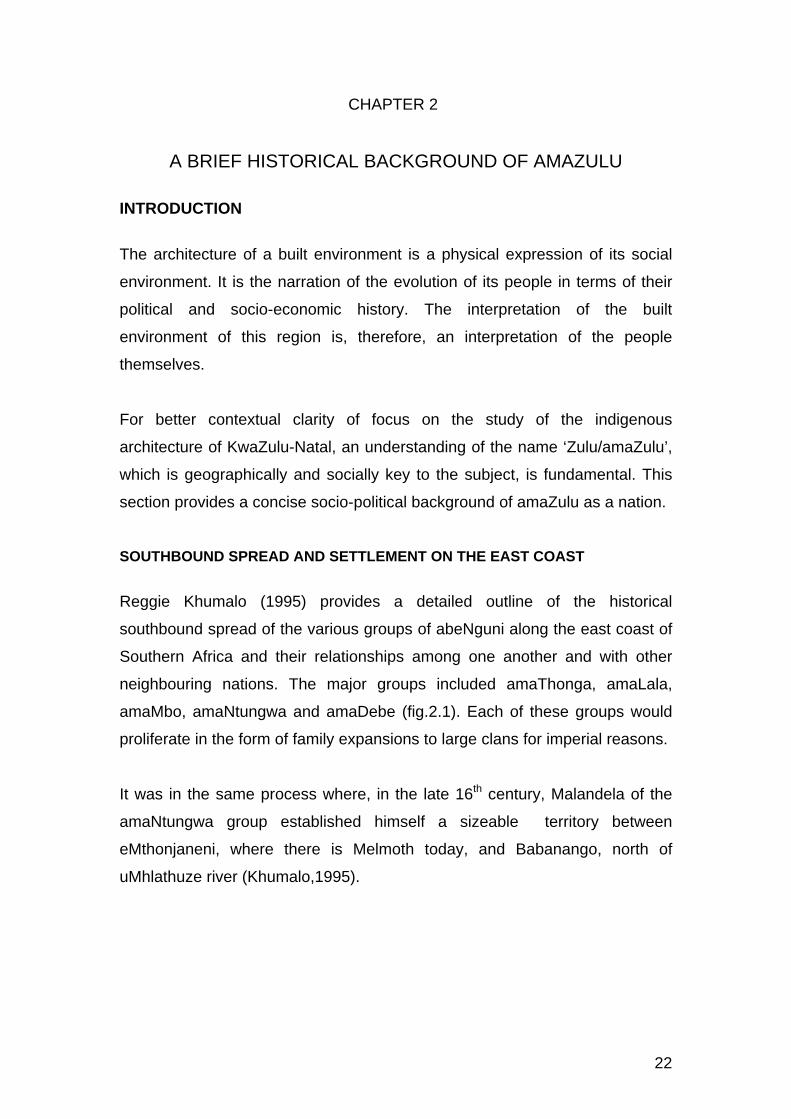
Reggie Khumalo (1995) provides a detailed outline of the historical
southbound spread of the various groups of abeNguni along the east coast of
Southern Africa and their relationships among one another and with other
neighbouring nations. The major groups included amaThonga, amaLala,
amaMbo, amaNtungwa and amaDebe (fig.2.1). Each of these groups would
proliferate in the form of family expansions to large clans for imperial reasons.
It was in the same process where, in the late 16th century, Malandela of the
amaNtungwa group established himself a sizeable territory between
eMthonjaneni, where there is Melmoth today, and Babanango, north of
uMhlathuze river (Khumalo,1995).

23
The nomadic spread of abeNguni is traceable through the belt of indigenous
Nguni settlements along the east coast of southern Africa from the southern
parts of today’s Mpumalanga province through to the Eastern and Western
Cape. A person who is familiar with the languages of isiSwati, isiNdebele,
isiZulu and isiXhosa, will easily learn that they are almost one language, that
is, isiNguni. IsiSwati, in Swaziland, is the oldest language that represents
more of the original version of isiNguni. As abeNguni spread further south the
language evolved with the influences of the Khoi and San people that already
existed in those parts of the sub continent.
The original Nguni language is said to be characterized by a softer tongue as
notable in isiSwati which is the oldest in the group. Geographically, the
amaNdebele remained in what the colonist named Southern Transvaal. With
their proximity to the baPedi (Northern Sotho) their language has incorporated
some Northern seSotho words to almost half of the language and some
elements of isiZulu. The language of isiZulu developed a relatively heavy
accent with the Khoi and San clicks ie ‘c’, ‘q’, ‘x’. AmaXhosa, further down
Fig.2.1. Early southward spread of AbeNguni along the East Coast (RS Khumalo,1995)

24
south and south-west, have an even heavier accent but with similar Khoi and
San clicks adopted by amaZulu. Each of the above languages developed a
name after the leader that shaped its group into a kingdom, like isiSwati after
king Mswati and isiZulu after king Zulu.
THE GERMINATION OF THE ZULU KINGDOM
AmaZulu fall under the amaNtungwa branch of abeNguni. The genealogy of
amaZulu traces its history back to the 13th century where Mnguni, a son of
Gumede, assumed strong leadership to his father’s fast growing family that
grew into the five clans mentioned earlier in this chapter, and named it after
himself. At that point of southward migration abeNguni had already taken
shape as a nation in the former Southern Transvaal.
It was at the turn of the 17th century when Zulu, the younger son of Malandela,
further consolidated his father’s group and engulfed surrounding small
territories of his immediate ancestors to a defined kingdom under his name.
All subsequent kings’ missions were focused on sustaining the already
defined small nation called amaZulu. The development of this empire reached
its peak in the late 18th and 19th century, particularly under the rulership of
King Shaka, son of King Senzangakhona, where most surrounding abeNguni
empires were drawn in, some peacefully while some through conquest, to
what eventually became the world known kingdom of KwaZulu, which bears
the identity of the current province of KwaZulu-Natal. A much detailed history
of the Zulu kingdom is covered by Khumalo in his book ‘Umqulu’ (1995).
Worth highlighting in this summary is that King Shaka’s primary mission went
beyond just sustaining the kingdom of kwaZulu. His mission was to expand
the kingdom to the entire southern Africa. He had realized that national power
was, by far, insufficient within the limited territory of the existing kwaZulu
kingdom. Therefore his priority, at that stage, was the building and
capacitation of a nation to be one of the imperial nations of the world.
Unfortunately his nation building approach, marked with responses like
Mfecane (Frescura, 1985) was impatiently too tough to be understood at that

25
time, until at his assassination, where his last words were: “… you will never
rule this nation, it will be ruled by the birds of the sky (foreigners)… ”
(Msimang,1982).
Nevertheless, that element of imperialism planted by King Shaka is prevalent
to a noticeable degree in the self esteem and social behavior of amaZulu even
to this day. As indicated earlier, the imperial power of the kwaZulu kingdom
has represented all the various abeNguni who live in the geographical
environment and speaking the same language of amaZulu, including
amaMbo, amaLala and amaDebe. Though there is a degree of integration of
these groups today, a person who is familiar with their various dialects is able
to identify them with their tongue. Similarly, in their various historical
geographical settlements one may be able to identify certain architectural
languages that mark their identities.
Given the above background, when one talks of Zulu architecture it needs to
be clear as to whether one refers to the architecture of the historical clan of
amaZulu, north of uThukela, which still bears its unique identity to date, or the
architecture of the indigenes of the overall resultant colony of KwaZulu in the
current KwaZulu-Natal with its diversity of regional identities.
Frescura (1985) provides an extensive history of the region in the context of
the Southern African subcontinent, though this historical record tends to leave
an ignorant reader with a picture of unprecedented chaos on the planet;
ignorant in the sense of the historical depth of the nation itself. This is so until
the intervention of the historical records of, among others, Msimang (1982)
and Khumalo (1995), whose materials tend to reveal the spirit behind the
unchangeable identity and self worth of the Zulu speaking people throughout
the world, even as victims of Mfecane (Difaqane).

26
CHAPTER 3
CULTURE AND THE INDIGENOUS ARCHITECTURE OF KWAZULU-NATAL
INTRODUCTION
There are various definitions of ‘culture’ that exists in the society. While some
of the interpretations of this aspect are based on specific disciplines, some are
merely based on perceptions.
According to the Conceptual Dictionary, “…a culture refers to a group of
people who live similar lives; people who have similar common sense ‘recipe’
for living” (Craig,Griesel,Witz, 1994). An anthroplogical definition of culture,
according to the Conceptual Dictionary, refers to “…shared practices,
meanings or ideas and beliefs of a group of people” (Craig,Griesel,Witz,
1994). These are practices and belief systems that organize and define the
particular group of people.
In the context of South Africa, cultures of amaZulu, today, have become a
cocktail of genuine cultures and circumstantial behavior. Social behavior, in
this context, involves to a great extent, historical factors like response to
poverty on the one hand and social effects of European supremacy on the
other. This is opposed to the limited ideological belief that the social
organization and the architecture of African people is only shaped by some
set of myths and religious beliefs and nothing beyond. This argument does not
ignore the fact that culture is a living phenomenon that evolves with time.
This chapter pays attention to the anthropological cultures of amaZulu that are
still manifest in the social organization and, hence, the architecture of this
particular group.

27
INDIGENOUS SOCIAL ORGANIZATION IN THE CULTURES OF AMAZULU
Social organization in the indigenous communities of KwaZulu-Natal has been
founded on acknowledgement of the elements of nature as the anchor for
human existence. That is a typical African attitude to social organization.
For instance, naming of times of the day, weeks and months of the year is
directed by the behavior of the sun, the moon and the earth; not as worshiped
gods but as drivers of nature. This has, to a great extent influenced naming of
places and even persons. Social behavior and, hence, traditions and customs
are a reflection of this attitude.
Generally, cultures of abeNguni are developed within the framework of holistic
existence of humans and their natural environs. It is believed that nature
exists in a circular relationship. That is, every element of nature exists for the
other to complete the phenomenon called life. Ngubane points out: “For
centuries Africans have had this vision of a spiritual continuum within which
the dead and the living, natural objects, spirits, divinities, the individual, clan
and tribe, animals, plants, minerals and humans form an unbroken
hierarchical unit of spiritual forces” (Ngubane, 2004).
SOCIAL ORGANIZATION OF A HOUSEHOLD
The acknowledgement of the circularity of life manifests in the recognition of
the different stages growth and genders of individual members of a
household, particularly in terms of hierarchy, including those that have passed
on to eternal ancestral status which is the most spiritually revered part of the
household.
Each member of the family, traditionally male, carries an independent status
assumed in the hierarchy of the household. That is the status on which he
develops the identity of his future generations. The initial householder remains
the core of the identity of all generations under his genealogy. Praises of a
person are not only about attributes, but one always has to mention names of

28
the entire chain of ancestors, and their attributes, to the head of the clan no
matter how long the list.
The first born is second in charge in the hierarchy of the household after the
head. Responsibilities are distributed according to genders. The eldest son
takes charge of assets and security issues of the household. The eldest
daughter assumes organizational and welfare responsibilities, second to the
queen of the household. When the parents pass on, the eldest son assumes
the position of the householder, often even from outside the home premises.
He also takes care of cultural affairs that keep the identity of the household.
The rule over households of all sons remains under their father as long as he
lives, no matter how far from home.
CULTURE IN THE PHYSICAL PLANNING OF BUILDINGS AND HOMESTEADS
Planning of all functional spaces is less directed by their functions, relative to
the modern movement, but more by the cultures that make the identity of the
people. The historical organization of spaces in the use of the traditional cone-
on-cylinder has kept the building form indispensable. A detailed analysis of
cultural organization of internal spaces will be discussed later in this
document.
Traditionally, the kraal is circular. The sacredness of umsamo, found in a
building, is also seen in isibaya (byre) of the householder. A detailed analysis
of isibaya is also discussed later in this document.
The positioning of each member of the household in the planning of the
homestead, and genders in the functioning of certain individual buildings, is
influenced by the attitude outlined earlier in this chapter.

29
CHAPTER 4
FIELD RESEARCH
INTRODUCTION
The following fieldwork analysis focuses, primarily, on aspects that address
the main research question. That is, aspects that have a potential to lead to
some clearly definable indigenous architecture that typifies, particularly in the
rural built environment of the province of KwaZulu-Natal.
While acknowledging that the detail and scope of field work for this purpose
can stretch even much farther, the focus of this particular exercise is
consciously limited to the geographical, socio-cultural and physical (built
environment) context of each selected sample. Each of these aspects is taken
further into the individual samples as a factor that influences the placement of
the homestead and its layout in the site, social sustainability of the life in the
nature of the homestead and responses to technical challenges in terms of
contemporary demands in building construction.
Though the format of this chapter is constant through all samples, the layout
of the analysis is specific to the size and amount of information each sample
offers.
A family name is used for a sample name. Each sample name is further
crowned with its clan name and a short praise where possible, which is
traditional in all abeNguni tribes.

30
KWAKHAMBULE, EMVENYANE SETTLEMENT Lat: S30 32 45.8 Long: E29 04 14.6 Elev: 1 493m
Physical Context
UMvenyane is a rural underdeveloped settlement south of Cedarville, a small
town to the west end of the south coast of KwaZulu-Natal. UMvenyane is
situated to the south of uMzimvubu river, by the border between the Eastern
Cape and KwaZulu-Natal. UMvenyane was formerly part of the Eastern Cape
province (previously known as the Transkei) but with recent changes of
political boundaries, it is within the province of KwaZulu-Natal.
Most parts of uMvenyane settlement are generally on gentle slopes, while
some are on almost flat land and some on very steep slopes. The Khambule
house sits on a steep sloped part of the settlement. The placement of the
house on the site required major earthworks to create a platform for the
buildings.
UMvenyane has extreme climatic conditions. Average maximum daily
temperature is 40°C in summer and winter average minimum temperature is -
8°C, with frequent mists. Average annual rain is 7.5mm, attributed for the
thick shrubs and grasslands that characterize the sub region.
Pic. 4.1. Khambule homestead. UMvenyane settlement in the background

31
Social and Cultural Factors
Owing to the geographical location of the settlement, as indicated earlier, the
social identity of the community of uMvenyane has been under stress, in that
most of the people are making positive efforts to adjust to the Zulu identity
they were politically shifted into, while some resist it by all means. According
to Mrs Khambule, the community of uMvenyane is pleased with the shift since
KwaZulu-Natal seems to be relatively ahead with health, education and other
infrastructural facilities development.
The spoken language in the family, much as in the rest of the community, is a
mixture of isiXhosa/ isiMpondo and isiZulu.
The Khambule homestead houses a small young family of four members, that
is, a single mother and her three young children aged between seven and
thirteen. No details were discussed about the husband. From the general
conversation, it appeared that Mrs Khambule’s formal education was not
beyond primary school level. She does not have a stable source of income.
Her primary means for survival is cultivation of various crops in the different
seasons, for family consumption and selling. This is the predominant means
for survival in the area. Throughout uMvenyane settlement there is a sparse
scattering of small livestock byres. Those houses with byres supply the rest
with manure for their fields.
The religious lifestyle of the Khambule family is of Christian faith. One of the
rooms was dedicated to Christian worship meetings. Their Christian religion
does not appear to have had any unique influence on the physical planning
and appearance of the homestead.
The historical culture maintains territorial separation of spaces for certain
activities and family members; though there are relatively less complexities in
the cultural features of the house.

32
General Layout of the Homestead
On the day of the survey the homestead of kwaKhambule consisted of three
freestanding buildings, that is, two thatched cone-on-cylinders and one
corrugated iron roof sheeted (hipped roof) rectangular buildings. A fourth
freestanding building of cubic form was at its early stage of construction. The
Fig.4.1. Khambule homestead layout

33
buildings are arranged in a rectilinear circle-cube-circle style. Asked about the
layout of the buildings, Mrs Khambule explained: ”The rectangular block
serves as fire breaker between the thatched huts, in case of fire.” “…this is
our traditional way of building, as you can see all around”.
Every building and external space has dedicated primary function. As a
Christian family, the first building, to the right of the house, is used for worship
and as a visitors sitting room. This is the side of the homestead where the
formal entrance is positioned (fig.4.1). The two roomed rectangular building is
the householder’s territory. The second cone-on-cylinder building is idladla
(kitchen), used as the family communal place where they socialize around the
fire. This is also where the children remain to sleep after socializing with their
mother in the evening. However, as a single parent, the mother sometimes
sleeps with the children in her two-roomed main building. Directly in front of
the main building in the zone of izala (fruits and vegetable area) is a fowl run
where, in homesteads with cattle, isibaya (byre) would be positioned. It was
not clear what the second rectangular building under construction would be
used for. However, of utmost interest in this particular case study was the
physical layout of buildings in the site.
The general layout of the entire house maintains the traditional hierarchy of
primary zones A, B and C (fig.4.1) ie, insimu (crop field), izala, igceke,
respectively.
Though this rectilinear layout appears to be traditional in the uMvenyane
settlement, it appears to be the only best site planning solution on this
particular landscape, as one long platform was easily cut along the contour of
the steep landscape. Frontage of all the buildings is downslope, all adopting a
similar technical response to surface rainwater flow.

34
Architecture
The homestead consists of a combination of two building types. That is, two
traditional cone-on-cylinder building forms flanking a hipped roofed
rectangular building in a rectilinear arrangement as discussed above. Those
are the only building forms that make up the entire settlement.
In the entire settlement there was no trace of iqhugwana (grass dome)
construction historically linked to the amaZulu. The architecture, generally,
has an ordered combination of freestanding thatched cone-on-cylinder with
metal roof sheeted cubic buildings. The colour order of buildings in this
settlement is similar to that of neighbouring settlements in the rural Eastern
Cape. Primary colours of walls noted in uMvenyane are, predominantly, light
blue and cream white umcako (limewash) with a black band at the base. The
older the roof thatch, the more pronounced the expression of a black base
with black cap. It was also noted that commercial and public buildings in the
area have roof tiles and sheets painted to match the ambient colour tradition.
Roof sheeting to domestic buildings are, generally, left unpainted.
All the buildings in kwaKhambule are built with plastered and light blue lime-
washed mud blocks, made on site out of the subsoil from the cutting and
levelling of platforms on the sloping site, all trimmed with the traditional black
band at the base (pic.4.1) , “…to protect the light colour of the walls from
unsightly mud splashes caused by rain”, Mrs Khambule explained. A cement
apron is cast around the base of the building which, in addition to prevention
of mud splashes, prevents direct penetration of rain water to the base of the
building leading to structural failure. For roof construction, treated timber is
bought from local factories. All the cone-on- cylinder buildings are roofed with
thatch on the traditional ‘spider web’ cone roof timber structure. Thatching
grass is readily available locally.

35
OSHABENI SETTLEMENT (unnamed homestead) Lat:S30 37 51.0 Long:E30 21 37.9 Elev: 417m
This is one of two neighbouring settlements, oShabeni and kwaPhungashe,
that were observed from the streets. The objective was to identify any notable
architectural character of identity, in relation to surrounding settlements
already studied and any traceable influence they may have on subsequent
settlements still to be studied. This particular homestead was observed
relatively closer from outside its premises.
Physical Context
OShabeni and kwaPhungashe are two neighbouring settlements along
uMzimkhulu river to the north-west just outside Port Shepstone on the far
south coast of KwaZulu-Natal.
The environment has evergreen medium thick indigenous forests. It has
typical humid coastal weathers, with an average annual rain of 8mm. Average
lowest daily temperature is 5°C and average highest daily temperature is
28°C.
Homesteads are located in varied topographic conditions. The selected
homestead is a small cluster that sits on a gentle slope. Most of the
homesteads, however, are positioned on low hillocks.
Pic.4.2. Unnamed homestead, oShabeni

36
Social and Cultural Factors
Households in these settlements are generally small scale and relatively less
complex. Observing the general appearance of the buildings, infrastructure
and other community facilities, it is notable that the community is
underdeveloped and poor. Means for daily living is sourced from domestic
scale livestock and, predominantly, crop farming.
The medium size unnamed homestead that was more closely observed,
showed horns of a beast fixed above the door of one of the thatch roofed huts
(pic.4.2) which is commonly a sign of ancestral worship. Though it was a
feature seen in most of the houses, it may not be a full representation of the
whole community in the area. The typical spreading of freestanding individual
buildings in this homestead reflects the culture of territorial dedication of
spaces to members of the household and certain activities within a
homestead.
General Layout of the Homestead
The selected homestead shown in (pic.4.2. & fig.4.2. sits on a gentle sloped
hillock, which required only minor levelling for placement of all the buildings on
the site, accommodating any possible future growth. A bull horn on the roof
edge above the door of one of the thatched cone-on-cylinder buildings
identifies it as the oldest in the homestead, dedicated to the household
ancestor. This suggests that the two thatched huts were the earliest in the
development of the homestead.
Two types of homestead layouts were observed in this sub region, that is,
rectilinear and organic planning. All rooms are free standing. Though the
layout of this homestead is organic, each building appears to be carefully
placed in relation to others; the metal roof sheeted ones acting as fire
breakers to the thatched ones. Igceke is traditionally the open social space at
the front of the house, that is, interface between the house and izala, then
insimu. In this homestead all doors are facing the road, away from igceke,

37
shielding it away from the public. This open social space has an outdoor
fireplace at the centre and a fowl run at the far end.
A freestanding pit toilet of rusty corrugated iron sheets, with some sheets
falling off, is situated between izala and insimu, on the side of the cluster of
buildings. There is, however, a legible hierarchy of the traditional connection
of external spaces, ie insimu, izala, igceke (A, B and C, respectively) and the
cluster of buildings (fig.4.2).
Fig.4.2. Homestead layout – Unnamed, oShabeni

38
ARCHITECTURE
This is one built environment in the southern part of the province that displays
a wider range of architectural explorations, ranging from late historical to
modern. It appears to be an adopted tradition in this sub region that the
architectural composition of almost every homestead is a combination of a
number of influences. KwaPhungashe displays an evolution to an even more
developed, semi urban level. This homestead is a combination of two building
types. That is, two cubic forms with corrugated iron flat roofs and three of the
traditional cone-on-cylinder type. One of the cone-on-cylinder buildings
appears to be relatively recent, roofed with flat metal sheets.
The introduction of metal roof sheeting is attributed to, partly, the scarcity and
maintenance problems of the traditional thatch material, while, on the other
hand, there appears to be and interest in exploring an alternative roofing
material. It is interesting to note that, while the rectangular buildings easily
used the conventional roof sheets, the curvature and tapering shape of the
roof cone of the huts responded to the corrugations of the material with
difficulties; particularly at junctions between two sheets. Flat sheets are used
as the only solution, to this problem. Success in the technical manipulation of
the material could not be closely studied in this particular house. A major
setback apparent is the lifespan of the metal sheets given that the settlements
are coastal. Rust has uncontrollably attacked every roof of this nature in the
area.
Another development observed in some homesteads in the area is a
composite roof with thatch on the upper part and metal sheeting on the lower
part of the hut roof. No technical reason was found, in the survey, for such a
combination. It appears to be just a regional style. Notable common elements
to all these roof styles are the ‘spiderweb’ timber roof structure and the design
of the apex cap.
Some in the neighbourhood are beginning to stretch the cone-on-cylinder
further to a polygonal shaped drum roofed with galvanized corrugated iron or

39
concrete tiles, on a concrete block circular wall, making the typology modern.
In this development roof junctions are successfully handled.
The colour coding of buildings recorded in the South-Western sub region is
noticeable, though relatively less vibrant.

40
KWAMSOMI, KWADWESHULA SETTLEMENT Lat:S30 34 17.0 Long:E30 17 36.9 Elev:474m
Physical Context
KwaDweshula is a settlement outside Port Shepstone on the far south coast
of KwaZulu-Natal, just after kwaPhungashe to the west, away from Port
Shepstone.
The geographical environment is characterized by the coastal evergreen
medium thick indigenous forests, high hills, river valleys and humid weather.
Houses sit on steep hillsides and, predominantly, on spurs.
The particular sample selected, Msomi House, sits on an open spur
overlooking the main road across a deep valley. There are some houses,
though, that are still located in the comfort of scary thick bushes.
Pic.4.3. KwaMsomi homestead: kwaDweshula settlement

41
Social and Cultural Factors
The land of kwaDeshula is occupied by uMvozana clan under the current King
Zwengu. The community of kwaDweshula and surroundings still has fresh
memories of the 1981 feudes among some local clans and their kings both
north and south along the uMzimkhulu river.
The householder (usokhaya) of the selected homestead, Mr Msomi, leads a
monogamous household with four children, ranging between early teen age
and mid twenties. Mr Msomi’s highest formal education was at primary school
level. He has a history of casual employment, predominantly in building
construction, where he picked up basic construction skills. Struggling to make
living due to unemployment, he started a chicken selling business on his
premises about a year ago. Otherwise they have no livestock, and this is a
socio economic state that prevails predominantly in the area.
Though the Msomi family believes in ancestors, they also have some degree
of Christian faith. The culture of their lifestyle is, therefore, not grounded on a
strong religious belief.
General Layout of the Homestead
The layout of all the buildings appears to be a successful response to the
topography of the site, without major earthworks for platforms. The back of the
house is relatively very steep and unusable, except for a small footpath that
negotiates access to and from other houses at the bottom of the hill. It
appears that the landscape influenced the progression of the development of
the homestead to assume the rectilinear layout recorded as predominant in
uMvenyane.
The main approach to the house is at the west, top end of the ridge where the
main gate (isango) is. Relative to all other homesteads observed and
recorded in this study, the first born son is placed at the rear most end of the
homestead while his parents remain at the approach end facing isango.

42
Fig.4.3, 4.4, 4.5, 4.7, 4.8 show the traditional spatial relationships of insimu,
izala, igceke and the buildings (izindlu), indicated as A, B and C respectively.
The fowl run appears to be positioned in a strategic commercial point, while it
also fulfils its traditional relationship with the new master bed room.
It is also worth noting the traditional independence of room spaces in the new
composite building, in that it does not have interconnections among the rooms
that compose it. All doors open to the outside into the veranda.
The Establishment and Development of the Homestead
On arrival as a young family in the area in 1975, the Msomis erected their first
freestanding thatched mud block cone-on-cylinder shown on fig.4.3, serving a
Fig. 4.3. The first building in the Msomi homestead

43
multi-purpose function, but mainly as a bed room for the couple. That stage
of establishment did not include isibaya which, traditionally, would form part of
the core of a homestead establishment in the province.
The second building (fig.4.4) was another freestanding room but bigger and
cubic in form, serving as a multi-purpose room. It functioned as a bed room for
the first two children and a family communal room which, traditionally,
included a kitchen. Both buildings, together, are the first phase of the growth
of the homestead.
Fig.4.4. First extension as the family begins to grow

44
As a popular style in small scale homesteads observed in most parts of the
province, the first two buildings suggest another freestanding cone-on-cylinder
to follow, assuming the traditional rectilinear ‘circle-cube-circle’ style that
prevails in the region (fig.4.6).
One that followed, instead, was hexagonal in form, forming part of a
composite modern building that housed an additional bed room for children, a
bed room for visitors, a formal lounge and a master bed room (fig.4.7 &
Fig.4.5. Projection for possible further extension
Fig.4.6. Traditional ‘circle-cube-circle’ concept

45
pic.4.3). As the master bed room moved into the new building, the former
master bed room was allocated to their firstborn son.
Fig.4.7. Addition of a composite modern building that maintains the traditional concept shown in fig.4.6.

46
When Mr Msomi began to struggle finding employment for income, he placed
a fowl run down the slope at the north front end of the homestead (fig.4.8). On
the visit a new cone-on-cylinder kitchen had just been completed at the front
central position of the homestead. It was not made clear what the new use of
the former kitchen would be.
Fig.4.8. Addition of kitchen and fowl run as the final phase of the development

47
It was noted that from the establishment of the homestead the allocation of
spaces have been evolving along with its physical growth. Due to the site
constraints noted earlier on, it did not seem likely that the homestead would
develop any further.
Architecture
The character of the settlement of kwaDweshula appears to be similar, to
some degree, to oShadeni in terms of density relative to kwaPhungashe
which appears to assume a modern character. However, kwaDweshula has a
few houses that stretch their architectural exploration with a similar attitude to
kwaPhungashe.
With the experience he gained from his involvements with building
contractors, the entire development was designed and built by Mr Msomi
himself. All the buildings face north, primarily because of the uncomfortable
south winds that prevail in the area.
Well placed on the ridge of the spur, the Msomi house uniquely showcases
the hybridized composition of the architecture noted in oShadeni and
kwaPhungashe settlements. The layout of buildings in the site reflects the
progression of development of the house as, outlined earlier, from historical to
modern buildings.
The religious mediocrity of this selected, Msomi, family is also suggested by
the flexibility of their architectural expressions of the buildings, in that, there
are no expressed elements or physical symbols of religion in the architecture
of the house, like the typical beast horns recorded in some of the homesteads
in oShadeni settlement.
The Msomi homestead is a marriage of two traditions of architecture, that is,
the initial freestanding individual buildings, followed by a modernized
composite type and concluded with another freestanding hut, as the last
phase, all tied together with the style of colour coding recorded throughout the

48
Southern part of the province. As outlined earlier, the entire composition
maintains the ‘circle-cube-circle’ tradition, a concept that has become popular
to small scale homesteads in the entire south and some other parts of the
province.
All walls are constructed with textured concrete blocks except for the initial
building, which was built with mud, reinforced with local timber laths. Since the
1981 local clan wars, where many thatch roofed buildings in the area were
burned down, metal sheeting has become traditional. That change was also,
to some extent, influenced by the growing scarcity of thatching grass, resulting
in commercialization of the material. Parts of the sheeting have been replaced
with time as rust persistently attacks the roof, particularly on the cone-on-
cylinder buildings. The new roofing concept maintained the traditional
‘spiderweb’ timber structure. The freestanding cubic building was flat roofed
with corrugated iron sheets. The new composite building is roofed with
conventional modern concrete tiles.

49
EMBO SETTLEMENTS, SOUTH COAST
A. Physical Context
EMbo is one of the environments in KwaZulu-Natal with underdeveloped rural
settlements. It consists of various settlements that flank uLovu river in the
south coast of KwaZulu-Natal. Settlements along the southern flank of the
river stretch further south to as far as uMkhomazi river. The general
topography of the environment ranges between vast gentle slopes and
dramatic hills, cliffs and valleys. Settlements in EMbo include eMbuthweni,
eGulube, eMpofana and eNgilanyoni. Of these, only two representative
samples were selected for the purpose of the study. That is, kwaNgcobo
homestead in eNgilanyoni which is the oldest settlement in eMbo, and one
small homestead of the Mabhida family in eMbuthweni the most recent of the
eMbo settlements.
EMbo is characterized by evergreen short and medium tall forests, with the
typical humid climate of the south coast. It has an average annual rain of
10mm, average lowest daily temperature of 11°C and an average highest
daily temperature of 26°C.
B. Social Background of Embo
EMbo is one part of the south coast with a complex historical background and
heritage that has thrived to this day. It has, since post King Shaka’s death,
been the land of the Mkhizes, a clan known as the Khabazelas of Gcwabe.
After Gwcabe died in Swaziland, his son, Zihlandlo, continued serving under
King Shaka. After the assassination of the king by his brothers, Dingane and
Mhlangana with the help of his right hand man, Mbopha; a project directed by
the king’s aunt, Mkabayi, Zihlandlo fled with fear and settled in eNkandla. That
is where the clan began to take shape. After the death of his father, Zihlandlo,
Singela took the clan down south to a vast unoccupied land which he named
eMbo, where he established an empire. A detailed history, to date, and
cultures of the Khabazelas cannot be covered in this document.

50
The clan grew, with time, to a maturing nation with successions of few further
kings, as they got more settled in the land. IMbo is currently divided into three
political sub territories, with their kings, along uLovu river. Those are,
respectively, kings LangalaseMbo, Kusakusa and Moyeni. All the three kings
still consider themselves as joint leaders of the one nation of Mkhize.
The empire of amaMbo further expanded to the north, across uMlazi river
where another sizeable settlement, also called eMbo, exists today in Cato
Ridge. The latter shares similar characteristics in cultures and architecture

51
KWANGCOBO, ENGILANYONI SETTLEMENT, EMBO Lat:S30 04 27.5 Long:E30 34 03.6 Elev: 650m
Physical Context
ENgilanyoni is on the south eastern part of eMbo. It is located between uLovu
and uMkhomazi rivers. ENgilanyoni is the oldest settlement in eMbo, where
king Singela of the Mkhizes first settled. Homesteads sit on, predominantly,
vast gentle slope landscapes. This is an area with relatively more matured
and large homesteads.
Social and Cultural Factors
The Ngcobo (Mapholoba) family has settled in this site since late nineteenth
century during the reign of king Singela of the Khabazela (Mkhize) clan.
This household has the strong typical culture of interdependent individuality of
household members and territorial zoning of spaces for certain activities.
Conversations with the informants revealed also a strong belief in ancestral
worship in the family.
The structure of the Ngcobo family is predominantly monogamous, except for
the second of the three sons, who married a second wife. There is a strong
Pic. 4.4. Ngcobo homestead: eNgilanyoni settlement

52
hierarchical order in the family such that even the position of each sub family
cluster in the premises is strongly influenced by the cultural hierarchy of the
household structure. A sub family cluster is named after the maiden name of
the wife.
The current eldership of the Ngcobo homestead is constituted by, mainly,
three brothers in the family and one of their three sisters, who never got
married. All these sub families live happily on the same premises. “The culture
developed and maintained by elders of this clan is the constitution that guides
our discipline and relations within and without these premises”, the second
wife of the second brother stated. Currently, the homestead has 49 family
members living in it, excluding those female members who got married and
left the homestead. The current structure of the household is as follows: The
elder brother has one wife with two sons and three daughters, all of whom
have a further total of four children. The second brother has two wives. His
first wife has two sons and four daughters, all of whom have a total of four
children. His second wife has one son and three daughters, all of whom have
a total of five children. The third brother has one wife with five sons and three
daughters, who gave birth to a total of two children. Their sister, mentioned
earlier, has become a permanent member of the homestead.
The Ngcobo family’s history of contemporary education has never gone
beyond primary school level. The family attributes that, mainly, to affordability
of high school levels and beyond, though indirectly confessing some degree of
lack of awareness and orientation to education. Married women in this
homestead are housewives, while husbands are workers in farms around the
area.
There is a strong belief in ancestral worship in the Ngcobo family, though
there is no physical symbol of the religion in the architectural expression of the
buildings.

53
General Layout of The Homestead
Though not the largest, the Ngcobo family was selected as one of the typical
large homesteads of eNgilanyoni. The Ngcobo homestead sits on a wide
open, gentle sloping site. The cluster is surrounded by crop fields and grazing
lands, for domestic consumption.
Fig. 4.9. Ngcobo homestead layout

54
The Ngcobo family is currently housed in a total of twenty four buildings
(fig.4.9). The layout of the homestead is organic, unlike those in Gulube
settlement across and to the north of uLovu river and some parts of
eMbuthweni, south of the river, which have linear layouts. This is a typical
layout in the entire Ngilanyoni, which, in addition to the typical sizes of
homesteads, marks it as the oldest settlement in eMbo. The layout does not
seem to be influenced by the ‘fire breaker’ concept noted in most parts of the
south coast and uKhahlamba, due to the metal roof sheeting on almost all the
buildings.
The Ngcobo homestead has a more complex igceke (C) than other smaller
homesteads of similar type and those that are linear, where there is one
defined open space in front of a cluster. Though each cluster has a dedicated
igceke, each forms an integral part of whole igceke of the entire complex,
referred to as amagceke/amabala (in plural). The izala belt (B), in front of
initial usokhaya’s cluster, has isibaya which is administered by the eldest
brother for the whole family, with a fruit garden directly in front of his cluster.
The outskirts of the homestead are crop fields (A), apportioned for each sub
family. A cross section of the homestead maintains the typical hierarchy of
spatial zones, that is, insimu, izala, igceke and izindlu.
Pic.4.5 shows how this typical homestead layouts influence settlement pattern
in the neighbouring Mpofana, though with relatively small homesteads.
Pic.4.5. EMpofana part settlement

55
Establishment and Development Of The Homestead
When the Ngcobo homestead was initially established, the public gravel road
on the east as shown in fig.4.9 had not existed. The entrance way form the
road into the homestead is, therefore, not used as a formal entrance (isango).
It is the entrance way from the west end of the homestead that is considered
formal. When there are formal/ cultural events, only the west entrance is used.
The development of the Ngcobo homestead radiated from the central initial
cluster of five free standing buildings (cluster 1) which were occupied by the
parents. As sons and daughters grew up they were placed in their own
freestanding huts (amalawu), properly positioned to allow for a radial
expansion to what the homestead looks like today and even further.
Fig.4.10. Initial homestead layout

56
The oldest hut in the initial cluster still remains the main central communal
building for the homestead, also used as the main idladla/ixhiba. It was
dedicated and kept as a sacred place where the ancestor’s spirit still exists.
The first born son was positioned by the main entrance way (cluster 2),
thereby assuming the role of taking charge of every visitor entering the
premises.
Fig.4.11. First expansion with first born son’s cluster established

57
The second born son was placed just behind the eldest, where his first wife’s
(uNdlunkulu’s) cluster was developed (cluster 3). That was the only member
of the family who introduced a polygamous character in the homestead. His
second wife was also allocated with a cluster (4).
Fig.4.12. A third cluster develops for the first born’s first wife

58
The last born son was placed at the rear end of the homestead (cluster 4).
One of their sisters who was unmarried was placed almost at the centre of the
homestead as cluster 6 (fig.4.14), as a delicate part of the family, between the
two younger brothers and behind the parents (cluster 1). This position also
allowed her privacy when visited by her lover as he, by culture, would
approach her room through the back of the homestead. Her position became
intermediate between the two wives (clusters 3 & 4) of the middle brother.
This is a typical social role of a sister in such a setting, where all omakoti
Fig.4.13 A fourth cluster develops for the first born’s second wife

59
(brides) take advantage of her as their mediator in the family. They would do
all they could to win her favour.
After the passing away of the parents the family gave cluster 4 the privileged
responsibility for part of the initial cluster. The rest of cluster 1 is now used as
central stores.
Fig.4.14. A fifth cluster develops for the last born son and a hut for their unmarried sister

60
As highlighted in the above developments, the establishment of each cluster
is marked with a kitchen and a courtyard in its front, which contributes to the
complexity of amagceke.
Architecture
The Ngcobo homestead, much as the rest of eNgilanyoni settlement, has a
pronounced character of the typical architecture recorded throughout the
south coast. That is, architecture characterized by freestanding individual
rooms of, predominantly, the cone-on-cylinder type.
In this homestead only two of the
twenty four buildings are flat
roofed rectangular type, recently
introduced. The latter also adopted
the local traditional colour scheme.
In this homestead it was explained
that the black band is meant to
prevent unsightly mud splashes at the base in case of rain (pic.4.6).
Buildings in this homestead, generally, have no aprons except a few with
cement aprons economically done at about 150mm wide which, to some
extent, has contributed to the mortality of the buildings.
Walls are built with mud, reinforced
with laths (izintungo) of ubhici, a
durable local indigenous wood
(fig.4.15). When a building is no longer
needed it is left to disintegrate naturally
into the ground. In order to maintain
the established order in the layout of
the Ngcobo homestead, every aged or
collapsing building gets rebuilt in
Pic. 4.6. Ngcobo homestead : Typical building
Fig.4.15. Stone infill with internal and external plaster

61
precisely the same position, while
new ones are also erected as
need arises.
All buildings in kwaNgcobo were
originally thatch roofed cone-on-
cylinders. The roofing was
changed, with time, to flat metal
sheets nailed to the traditional
‘spiderweb’ timber structure, as an
attempt to respond to maintenance
and fire problems of thatch.
It was expressed that the flat metal
roof sheeting has come with even
worse problems, such as leakages
at junctions and nail points, rust
(pic.4.8) and unbearable thermal
performance. For this reason,
three recent replacements of
collapsed buildings have gone
back to thatch roofs.
It was also noted that some of the
cone-on-cylinder buildings in the
Embo settlements have used a
combination of thatch and flat or
corrugated iron sheets in their
roofing (pic.4.9 & fig.4.16), a style
also noted in oShadeni and
kwaPhungashe. The upper half of
the cone is thatched and the lower
has the sheeting tucked under the
thatch.
Pic.4.8. Failing flat metal roof sheeting
Pic.4.7. Building abandoned to collapse, exposing timber reinforcement in the mud wall
Pic.4.9. Typical hybrid roof with thatch and corrugated metal sheeting
Fig.4.16. Detail of typical hybrid roof with thatch and metal sheeting

62
KWAMABHIDA, EMBUTHWENI SETTLEMENT Lat:S30 03 10.4 Long:E30 31 21.8 Elev:448m
Physical Context
EMbuthweni is situated on the southern flank of uLovu river, between
iNgilanyoni to the east and eGulube to the west along the river. In this part of
the settlement houses are relatively small and sit on steep landscapes.
Social and Cultural Factors
The Mabhida family arrived to settle in eMbuthweni as recently as in 1993,
from eMbumbulu, where the rest of the Mabhida clan exists. It is a young
monogamous household of five members so far. On the day of the visit Mr
Mabhida was sitting with some visiting friends, which necessitated asking for
the householder. “He’s not around, I’m only the son”, he responded. “Who is
in charge in his absence?”, the next question followed. “I am in charge at the
moment as the old man is at home in uMbumbulu”. It was not just a play of
words, but his true cultural position, which he innocently expected to be
understood by this Zulu speaking fellow, that the house was only an extension
of his father’s territory. Mr Mabhida regards the house as a distant cluster of
his father’s homestead, in a traditional sense.
Mrs Mabhida is a housewife, while her husband owns and drives a taxi, the
only source of income for the family. They do not have any livestock beyond
the small pig sty at the bottom end of izala. Mrs Mabhida’s formal education
Pic.4.10. Mabhida homestead: eMbuthweni settlement
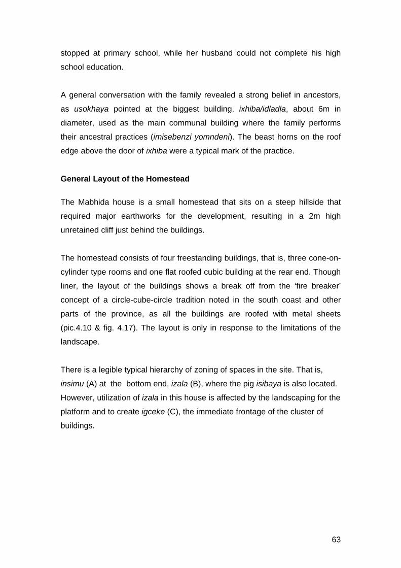
63
stopped at primary school, while her husband could not complete his high
school education.
A general conversation with the family revealed a strong belief in ancestors,
as usokhaya pointed at the biggest building, ixhiba/idladla, about 6m in
diameter, used as the main communal building where the family performs
their ancestral practices (imisebenzi yomndeni). The beast horns on the roof
edge above the door of ixhiba were a typical mark of the practice.
General Layout of the Homestead
The Mabhida house is a small homestead that sits on a steep hillside that
required major earthworks for the development, resulting in a 2m high
unretained cliff just behind the buildings.
The homestead consists of four freestanding buildings, that is, three cone-on-
cylinder type rooms and one flat roofed cubic building at the rear end. Though
liner, the layout of the buildings shows a break off from the ‘fire breaker’
concept of a circle-cube-circle tradition noted in the south coast and other
parts of the province, as all the buildings are roofed with metal sheets
(pic.4.10 & fig. 4.17). The layout is only in response to the limitations of the
landscape.
There is a legible typical hierarchy of zoning of spaces in the site. That is,
insimu (A) at the bottom end, izala (B), where the pig isibaya is also located.
However, utilization of izala in this house is affected by the landscaping for the
platform and to create igceke (C), the immediate frontage of the cluster of
buildings.

64
Establishment and Development of the Homestead
On arrival, the young Mabhida family erected their first cone-on-cylinder, used
as a multipurpose room. When the homestead began to grow physically, it
radiated sideways. The second building, a bed room, followed leaving the first
building used as a kitchen (idladla or ixhiba). The kitchen was dedicated to
ancestors as the sacred place where imisebenzi (rituals) of the household are
held. A general store room also followed to the north of idladla, by the main
entrance. As their young children began to grow independent they were
placed at the rear end of the homestead behind the master bed room. For a
reason untold, the front most building is a store room. Along the entrance
driveway towards the house is a pit toilet built with corrugated iron sheets, a
location different from most including the house recorded in oShadeni. All
buildings face down slope, not for solar orientation, but in response to surface
rainwater (pic.4.10)
Fig.4.17. Mabhida homestead: Site layout

65
Given the site limitations and the socio economic status of kwaMabhida
household indicated earlier, it appeared unlikely that the homestead would
continue with the radial mode of physical development discussed in the next
chapter.
Architecture
The architecture of the Mabhida homestead is comprised of an unstructured
combination of two forms of free standing buildings. Of the four, three are the
traditional cone-on-cylinder type and one is a flat roofed cubic form. All the
cone-on-cylinder buildings are roofed with flat metal sheeting nailed to the
traditional ‘spiderweb’ timber roof structure. The kitchen roof, which is the
oldest building, begins to rust. Walls of all the buildings in the Mabhida
homestead are built with mud reinforced with timber laths. Earth for wall
construction was obtained from the earthworks as they were levelling the site.
The cone-on cylinder buildings are planned out of the traditional perfect cross
concept in terms of relationship between doors and windows and the spatial
organization.
In response to questions about the prevalent colour system on the buildings in
this homestead, it was simply said: “these are colours everyone uses in this
area…”.The same question received a similar response, randomly, from
people along the road through eMbuthweni. It was generally regarded as a
traditional style of colours in the area, beyond the technical reasons
mentioned in uMvenyane and eNgilanyoni.

66
EGULUBE SETTLEMENT
This settlement was observed from the road. Focus was on the general
layouts of homesteads and the expression of its architecture on the
landscape.
Physical Context
Gulube is a settlement on the north west end of the built environment of eMbo
at the upper end of uLovu river. Pic.4.11 shows a view of eGulube form
eMbuthweni across the river. It is a relatively recent settlement, with houses
sitting on a steep landscape.
General Homesteads Layouts
Homesteads in this part of eMbo are relatively small. Layouts of these
homesteads vary between organic and linear arrangement of the typical
freestanding individual rooms along contours of the landscapes.
Pic.4.11. Part of eGulube settlement on the foreground and eMbuthweni further across the uLovu River

67
EMBO, CATO RIDGE
Physical Context
It was indicated earlier in the social background of eMbo that the empire of
amaMbo expanded to the north, across uMlazi river where the small town,
Cato Ridge if found. This part of eMbo has a number of settlements spreading
between the N3 national highway and uMngeni river on the western outskirts
of eThekwini, towards Pietermaritzburg. EMbo is located on a physical
landscape that is popular for its splendid hills commonly known as the ‘Valley
of Thousand Hills’.
Architecture
Pic.4.12 shows a typical built environment that shows a relationship of
architectural character between eMbo of the south and eMbo of the north.
This architectural expression has had a strong influence on all the rural
settlements of Cato Ridge.
Pic.4.12. Typical eMbo architecture in Cato Ridge
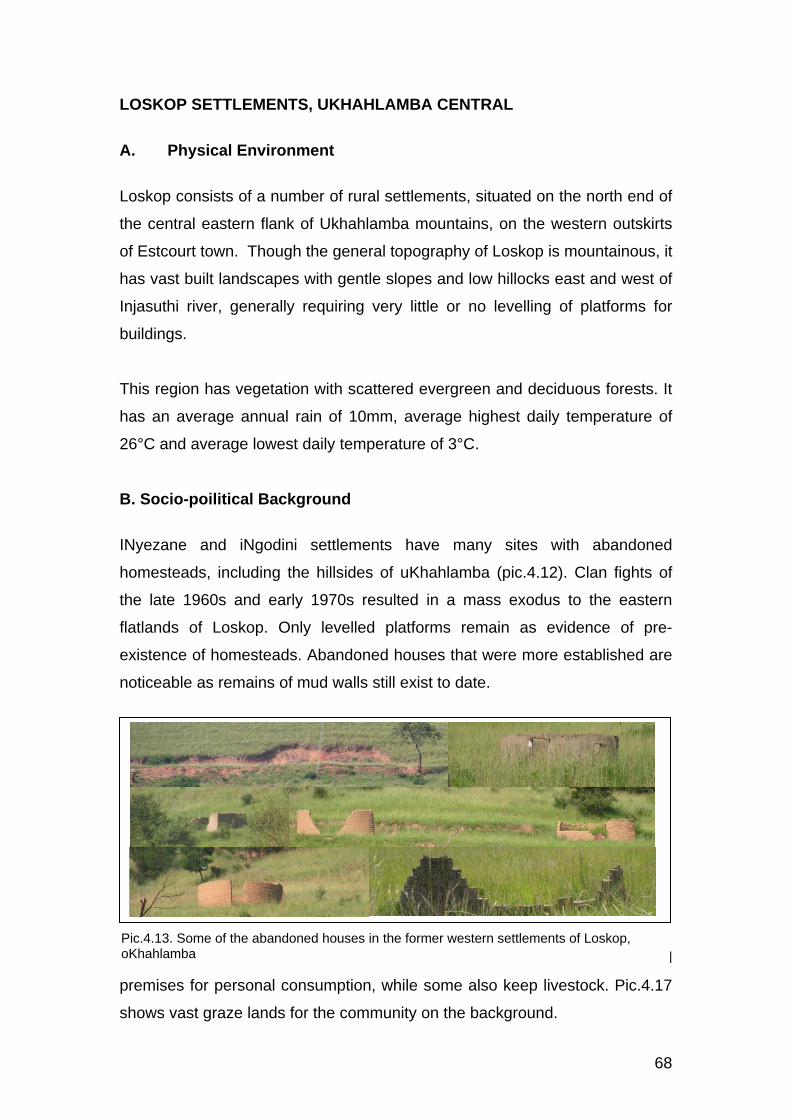
68
LOSKOP SETTLEMENTS, UKHAHLAMBA CENTRAL
A. Physical Environment
Loskop consists of a number of rural settlements, situated on the north end of
the central eastern flank of Ukhahlamba mountains, on the western outskirts
of Estcourt town. Though the general topography of Loskop is mountainous, it
has vast built landscapes with gentle slopes and low hillocks east and west of
Injasuthi river, generally requiring very little or no levelling of platforms for
buildings.
This region has vegetation with scattered evergreen and deciduous forests. It
has an average annual rain of 10mm, average highest daily temperature of
26°C and average lowest daily temperature of 3°C.
B. Socio-poilitical Background
INyezane and iNgodini settlements have many sites with abandoned
homesteads, including the hillsides of uKhahlamba (pic.4.12). Clan fights of
the late 1960s and early 1970s resulted in a mass exodus to the eastern
flatlands of Loskop. Only levelled platforms remain as evidence of pre-
existence of homesteads. Abandoned houses that were more established are
noticeable as remains of mud walls still exist to date.
The community, generally, practices crop farming within individual homestead
premises for personal consumption, while some also keep livestock. Pic.4.17
shows vast graze lands for the community on the background.
Pic.4.13. Some of the abandoned houses in the former western settlements of Loskop, oKhahlamba

69
C. Architecture
Generally, the architecture of Loskop, particularly, eNyezane and eNgodini
consists of a mixture of building types. That is, dome-on cylinder, cone-on-
cylinder, flat or low mono pitch roofed cube, low double pitch cube with gable
end, hip roofed cubic forms and (fig.4.18). A typical homestead is a
combination of some or all these forms.
The regional identity of the cone-on-cylinder buildings in these settlements is
on their apexes. Two types of apexes exist, that is, the metal type
predominantly found in Umsinga (pic.4.14) and their unique local one woven
with grass (pic.4.15).
Pic.4.14. Umsinga type of Apex
Fig.4.18. Typical building types in eNyezane
Pic.4.15. Typical Losokp apex, eNyezane

70
KWANDLOVU, ENYEZANE SETTLEMENT Lat:S28 58 27.2 Long: E29 34 57.3 Elev: 1 132m
Physical Context
The Ndlovu homestead is situated at the north end of iNyezane; a part which
is a later expansion of the settlement, with relatively small homesteads in a
grid pattern. The landscape gets gradually steeper towards the Injasuthi river.
The Ndlovu homestead sits on a relatively gentle slope, needing no platforms
for buildings.
Social and Cultural Factors
The Ndlovu homestead consists of a small young monogamous family of five
members. The immediate history of the family is also monogamous. The
household entirely depends on the father who is a low income worker in
Estcourt, for living. His income is complemented with summer cultivation of
crops within the premises by his wife, for family consumption. General
communication in the conversation with Mrs Ndlovu suggested that their level
of exposure to contemporary education is low which, apparently, applies to
their surrounding community.
There is physical evidence of ancestral worship in the in the household. The
late grandparents’ building is marked with goat horns on the roof just above
the entrance door (pic.4.16), to acknowledge their immortality as great grand
parents in the household.
Pic.4.16. Ndlovu house

71
Homestead Layout
The Ndlovu family maintains the historical tradition of territorial separation of
spaces for certain activities and family members. This is also reflected in the
use of each building and its internal spaces. The cone-on-cylinder building at
the east end of the homestead is regarded as the ‘great house’ as it belongs
to the first generation that occupied the homestead (fig.4.19). It is currently
used by their great grand children. The building at the west end belongs to the
grandparents who also passed on. It is currently used as the family communal
room, thereby maintaining the grandparents’ spiritual presence in the daily
social activities of the family. It is also used as ixhiba/idladla, where the
cooking fire place is taken advantage of in cold winters. According to Mrs
Ndlovu, occupying the building that sits between the two huts gives them, as
the current householders, a sense of protection by ancestors from both sides
while, on the other hand, makes them feel in charge of both buildings that
flank them.
In the kwaNdlovu homestead the children were positioned at the front while
the kitchen is at the rear end of the homestead. According to the survey such
an arrangement is not traditional. A suspected reason for this arrangement is
that the children had to be in the great house which, unfortunately, happened
to be at the front.
The development of this part of iNyezane came with a proliferation of a new
typology of homesteads, ie a rectilinear arrangement of a ‘circle-cube-circle’
model of freestanding buildings (pic.4.16), one that was recorded as a
predominant layout concept in the southern part of the province.
However, it was stated in this homestead that the layout was adopted as
response to the burning of homesteads as indicated earlier. The metal roofed
cubic building in the middle serves as fire breaker between the two thatch
roofed huts. Relative to most of the same in the south coast, the middle
building does not have even a window opening to the sides of the thatched
huts, practically serving as fire barrier.

72
It was indicated that future expansion of the homestead would maintain the
same rhythm, which developed to a traditional style of architectural
expression. Mud blocks, made on site, are stacked at the edge of igceke on
the foreground for the intended extension, though progress is slow as the
husband spends much of his time away at work. The sequence of
developmental stages of the homestead was not recorded in the survey.
The site layout of the homestead maintains the traditional zoning of spatial
order marked as A, B and C. That is, insimu, izala and igceke respectively.
Fig.4.19. Ndlovu homestead layout

73
Architecture
All the buildings in the Ndlovu homestead face north, down slope, to prevent
rain water flowing into the buildings. The planning of the cone-on-cylinder
buildings maintain the traditional perfect cross in their internal spatial
relationships, and the doors and windows.
All buildings in the homestead are built with mud blocks coded with an earthy
coloured finish (umcako), a traditional style of finishes in the area (pic.4.16).
No technical nor cultural reason was attached to the colour coding. Each
building is trimmed with a raised apron at the base, with same finish as the
walls. The aprons are both for structural protection against dampness at the
base and for sitting around the building. Roofs of the cone-on-cylinder
buildings are thatched on the traditional spider-web timber structure, from
umtholo local tree. These huts have roofs pitched as shallow as about 30°.
The rectangular building is flat roofed with corrugated iron sheeting on treated
gumpole rafters and purlins. According to Mrs Ndlovu, it was felt that the latter
building was relatively costly to construct, given the family’s income.

74
KWAMBHELE, ENYEZANE SETTLEMENT Lat: S28 59 26.0 Long:E29 34 53.7 Elev:1 170m
Physical Context
The Mbhele homestead sits on a fairly gentle slope down to the east. The
landscape requires minimum levelling for buildings.
Social and Cultural Factors
The Mbhele house is one of the oldest homesteads in Loskop. It is situated in
the older and more matured part of iNyezane, where homesteads have grown
large and more established. The Mbheles, in particular, have grown to be the
largest, matured and most complex clan ever studied in this survey. Only one
third, the nucleus of the entire Mbhele clan village, was selected for the study.
The selected homestead has significant basic similarities with the Ngcobo
homestead recorded earlier in the south coast, though the complexities are
somewhat different.
The entire clan of kwaMbhele radiates from a monogamous household with
five sons and one daughter, all of whom head monogamous sub families. The
selected homestead houses the initial (parents’) cluster, the first and the
second born sons’ sub families and their sister. It consists of a total of thirteen
household members. The last three sons broke off to establish their individual
homesteads of almost similar size and complexity in sites adjacent to the main
house to create a complex of homesteads.
Pic.4.17. Mbhele homestead

75
The Mbheles developed a unique tradition that breaks necessity for perpetual
further physical expansion of the complex, in response limitations of land, to
avoid possible undesired scattering of the clan. In the selected homestead,
when the initial parents passed on, the eldest son of their first born inherited
their cluster, thereby restarting the cycle.
The only informants in this survey were the two housewives with their
husbands’ sister. Husbands spend most of their times at work for basic living.
As a result, much of household responsibilities such as ploughing, harvesting,
construction, child minding and livestock have shifted to their wives and
children. Each of the Mbhele homesteads has a dedicated crop field and
shared livestock grazing pastures. Farming activities are small in scale, mainly
for household consumption. It was also noted that privileges of contemporary
formal education are only enjoyed by their children, some of whom are just
about to go to high school.
This household has the strong typical culture of interdependent individuality of
household members and territorial zoning of spaces for certain activities.
Conversations with the informants revealed also a strong belief in ancestral
worship in the family.
Homestead Layout
The homestead of kwaMbhele have layout principles much similar to those of
kwaNgcobo of eNgilanyoni in the south, one of the main characteristics being
that it, generally, has an organic layout. That is, the freestanding buildings
appear to be placed randomly on the site, while each follows specific cultural
or traditional principles that guide its placement. The third born son’s cluster
intervened with a linear character; the ‘circle-cube-circle’ fire breaker concept
recorded at kwaNdlovu nearby. That, as recent layout concept in the province,
suggests that the third born son’s cluster was one of the recent developments
in the complex. All the subfamily clusters were strategically positioned to meet
all cultural aspects of the growth of the homestead.

76
Each established subfamily cluster consists of ixhiba/idladla (kitchen) which
defines its independence as a territory. The initial idladla remains the central
communal facility that ties the rest of the homestead. Though not as clearly
defined as in the kwaNgcobo homestead, each idladla has a cleared outside
space for outdoor cooking and subfamily gathering. The second born son’s
cluster further built a screen to create an enclosed courtyard (iguma) for such
purpose.
The homestead has maintained the traditional primary zoning noted in all
previously recorded homesteads (fig.4.20). Izala (B), where a central
vegetable garden and fruit trees are traditionally placed, serves as interface
between insimu (A) and igceke (C).
Fig.4.20. KwaMbhele homestead layout

77
Common to homesteads with organic pattern, the igceke of a cluster is an
integral part of the network of the negative spaces among all the clusters of
the homestead, collectively called amagceke/amabala (in plural).
Establishment and Development of the Mbhele Homestead
The establishment of the homestead of kwaMbhele began with a cluster of
four free standing thatched cone-on-cylinder buildings (cluster 1) with isibaya
(cattle byre) directly in front (fig.4.20).
When their first born son grew independent his ilawu was erected by the
formal entrance gate. When he got married his territory developed to an
independent cluster for his subfamily. The independence of his cluster was
marked with the erection of a kitchen, which applied to the rest of the
homestead.
The second born son’s cluster (3) was positioned on the left hand side of the
parents cluster. Their unmarried daughter (4) was positioned at the back
between her two brothers, a typical traditional position for a daughter. Much
similar to kwaNgcobo in the South Coast, the positioning of the daughter
allowed her privacy when visited by her lover as he, by culture, would
approach her hut through the back of the homestead. As a permanent
member of the homestead, the daughter further built a kitchen which,
traditionally, marks an independent cluster. Central to the whole homestead
are two stores. The rectangular one is a granary (isilulu/inqolobane). The
grass dome (iqhugwana) is used for general storage.
Isibaya is positioned in zone B, in the central front of the homestead, but more
towards the first born son. The second born son of cluster 2 has his ilawu
even much closer to the entrance gate and isibaya, assuming a role of both a
guard and asset manager. This appears to be a germination of another
cluster. It is the second born son’s ilawu or potential cluster because the first
born son had to occupy the late grandparents’ cluster.

78
Architecture
The architecture of the Mbhele homestead is consists of a mixture of building
types. That is, two dome-on-cylinders, several cone-on-cylinders, flat and hip
roofed cubes and a low pitch cube with gable ends. Though the homestead
has, predominantly, cone-on-cylinder buildings, later developments have
introduced few cubic forms. The two existing grass domes were initially
erected directly on the ground and later, due to attack by termites and aging,
raised onto mud walled cylinders.
Of note is the iqhugwana used for a kitchen (pic.4.18). Its entrance area
(isithumbanja) is screened with a 1.8m high wall (iguma) to prevent direct
wind blowing into the building, which is hazardous when there is indoor
cooking fire. The iguma space is also used for outdoor cooking.
All buildings face downslope, specifically for rainwater control. Solar
orientation gets disregarded by the good thermal performance of the building
materials of, particularly the cone-on-cylinder, and the small sizes of
Pic.4.18. KwaMbhele: Iqhugwana showing iguma

79
openings. It is significant to note that, much as in the rest of the uKhahlamba
sub region, all cone-on-cylinder buildings are still strictly thatch roofed, relative
to those recorded in the south coast. The roof structure for the hut is the
traditional timber ‘spiderweb’. The few new cubic buildings are roofed with
corrugated iron sheeting. Most of the cone-on-cylinder buildings have timber
reinforced mud walls, while some, including the recent cubic buildings are built
with mud blocks.
All buildings in this homestead are finished with earthy coloured umcako, a
slurry of a selection of coloured soils, quarried locally, mixed with cement for
improved waterproofing. That has become a women’s task, as they enjoy the
art of wall decoration. Decorations do not have sharp colour contrasts, the
same attitude as in the general colour coding of buildings.

80
WOODFORD SETTLEMENT, BERGVILLE, UKHAHLAMBA NORTH
A. Physical Environment
Bergville is situated on the north end of uKhahlamba mountains. The built
environment of Bergville is predominantly rural settlements, spreading from
the eastern flat lands of Hambrook and Woodford to the hills up uKhahlamba
where kwaMiya and eMangwaneni exist. Relative to Loskop, Bergville is
mountainous.
The selected samples Hlatshwayo and Miya houses are in Woodford, an
underdeveloped rural settlement on a vast flatland just north of Bergville town,
across the Little Thukela river. This is the closest settlement to the small town.
Woodford is a relatively densely populated settlement with a grid pattern of
urban character.
Similar to Loskop, the vegetation of this environment has scattered evergreen,
deciduous forests and grasslands. It has an average annual rain of 10mm,
average highest daily temperature of 26°C and average lowest daily
temperature of 3°C.
B. Social Context
Socializing with young boys and girls from different families on the streets, it
was somewhat ironical to notice that almost all those spoken to, had a high
level of fluency in English, within such a poor and underdeveloped
environment, relative to all other similar environments observed in this study.
Ironical in the sense that, in South African terms, it is generally perceived that
fluency in English is the yardstick for literacy and middle class socio economic
background.
The entire settlement has no sign of any sort and scale of farming, apparently
due to sizes of sites. Reasons for the few homesteads in larger sites were not
investigated.

81
C. Architecture
Among all the rural settlements of uKhahlamba, Woodford has the widest
range of typologies of building forms recorded in the province of KwaZulu-
Natal (fig.4.21). Those include the traditional thatch roofed cone-on-cylinder,
grass dome, double pitch thatched cubic form with gabled ends, thatched ‘t’-
plan cottage with a hipped roof small veranda, locally called ‘iheyisi’ (borrowed
from Dutch ‘huis’), corrugated iron flat roofed cubic forms locally called ‘uplati’
(plaat dak), a traditional double pitch roofed modern house and a thatch
roofed oval form. The latter is a recent intervention from Lesotho, just behind
uKhahlamba.
The above hybridized homestead tradition began spread to most new rural
surroundings of uMnambithi and Colenso.
Fig.4.21. Range of building types in Bergville

82
KWAHLATSHWAYO
Social and Cultural Factors
Elderly people were not in the house during the survey. Only two young boys
were playing in the igceke, the third and fourth born sons of the family. Those
were enough to provide the basic information needed for the purpose of the
survey.
Pic.4.19. KwaHlatshwayo homestead
Pic.4.20. Iqhugwana in KwaHlatshwayo homestead and a neighboring homestead on the background

83
The Hlatshwayo homestead is headed by a single mother of five boys aged
between 2 and 16, at various school levels. Nothing was said about her
source of income as it was indicated that she was unemployed. Her two elder
sons do part-time jobs during weekends and school holidays. Within the
premises, the family lives with the mother’s younger sister with her two
daughters, one of whom works in eThekwini.
There is no physical sign of ancestral worship in the Hlatshwayo family.
General Layout of the Homestead
KwaHlatshwayo homestead represents a unique intervention to the traditional
grouping of subfamilies into clusters within small premises. It is a type where a
family group may occupy one modern type cubic building with internal
subdivision of rooms allocated to individual members and other activities.
Fig.4.22. KwaHlatshwayo homestead layout

84
This complex is divided into two major domains (fig.4.22) The main domain is
occupied by a single mother with her five sons. It consists of one main
building that includes a master bed room, one bed room for her sons, a living
room and a kitchen. The main domain also has a freestanding grass dome
that was formerly used as a kitchen. As seen on (pic.4.19), the main building
shows projections of blockwork for further extension on the east facing wall.
The second domain is occupied by her younger sister with two daughters.
This cluster consists of three freestanding cubic buildings, the first being the
master bed room and the second including a kitchen and a bed room for the
two daughters. A third freestanding cubic building was under construction on
the day of the visit, at the north east end of the complex. This new room
belongs to the elder daughter who has reached a stage of independence.
The site is fully occupied with buildings such that the complex does not have
the traditional zoning of insimu, izala and igceke. Both clusters share a
common central igceke.
KwaHlatshwayo homestead is situated at the street corner of the urban grid
block of sites. Neighbouring sites share boundaries, typical of a traditional
urban setting.
Architecture
The Hlatshwayo homestead consists of a combination of three building types.
Two modern type flat roofed cubic forms with internal partitions, one low
double pitch roofed cubic form and a grass dome raised on a short mud
walled cylinder, about 600mm high. The dome (pic.4.20) was initially used as
a kitchen, but currently not used at all and was beginning to show signs of
disintegration at the time of the visit.
All the three existing rectangular buildings are built with mud blocks made on
site. The blocks are laid with cement mortar joints. The new room under
construction is built with concrete block, as some can be seen stacked on site

85
(pic.4.19). It is traditional in the environment to leave walls unpainted. Those
few that are painted have the earthy colours of the midlands and the north
coast.
All the four cubic buildings in kwaHlatshwayo used the conventional modern
steel window frames with glass panes. All the rectangular buildings are roofed
with corrugated iron. Stone weights are placed on the roofs to prevent lifting in
case of strong winds. This tradition is predominantly found in the highveld.

86
KWAMIYA
Social and Cultural Factors
On the visit to the Miya family it was only Mrs Miya, her two daughters and her
visiting sister from within Woodford. The husband was away for work in
Pietermaritzburg. Some architectural attraction from the street suggested the
visit into the Miya house which, responding to particular questions about the
buildings, almost all explanations had to do with ancestors.
Mr Miya, the householder (usokhaya), was born by his father’s first wife, but
raised by a step mother after early death of his mother. Both his father and
step mother also died of age and were buried in KwaMiya, a village to the
north western hills of Bergville. The new building, under construction
(pic.4.21), is a new house for all the three ancestors. As soon as the building
is completed their spirits will be fetched ceremoniously to their new home.
General Layout of the Homestead
This homestead has a layout characteristic of Bergville, particularly
Woodford, as analysed in the homestead of kwaHlatshwayo close by.
Of interest in this homestead is the internal layout of oval shaped building
(fig.4.23). Room 1 is the main room where the father will live with his first wife,
while room 2 is for his second wife. Though the three will all be under one
Pic.4.21. KwaMiya homestead

87
roof, the partitioning and separate entrances observe the culture of
independent territories. The same typology is used by others with varying
internal spatial layouts to suit specific uses.
Architecture
The Miya homestead has a combination of three building types (pic.4.20).
That is, the gable ended thatch roofed cubic form, two corrugated iron flat
roofed modern houses and an oval building under construction. The oval
building is a recent development of the traditional cone-on-cylinder that has
gained popularity in the area. It is said the Bergville people got this oval type
from LeSotho (pic.4.22), though in LeSotho the buildings are traditionally
stone walled. The interest of this study in kwaMiya homestead is focused on
the latter type.
This unique building type is a literal combination of two cone-on-cylinders, or
one laterally stretched and partitioned to suit the intended purpose (fig.4.23).
Stretched in that the small side windows still remain in the same position as
on a single traditional cylinder form.
Pic.4.22. LeSotho stone walled oval shaped building
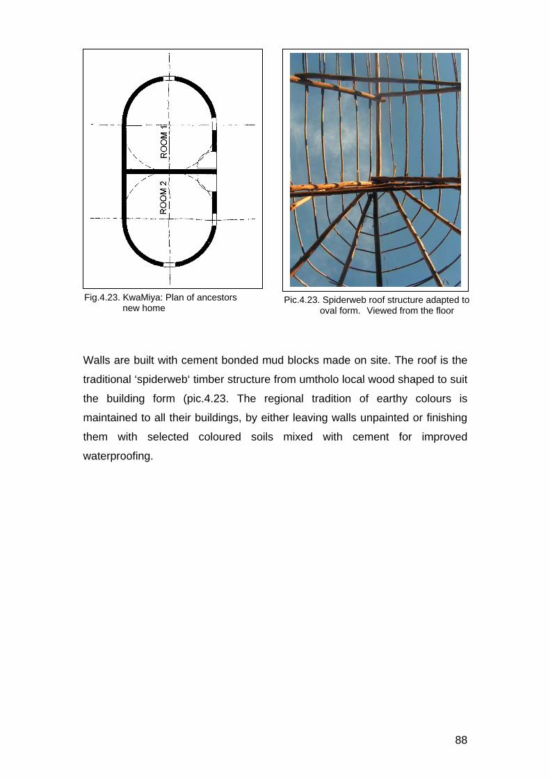
88
Walls are built with cement bonded mud blocks made on site. The roof is the
traditional ‘spiderweb‘ timber structure from umtholo local wood shaped to suit
the building form (pic.4.23. The regional tradition of earthy colours is
maintained to all their buildings, by either leaving walls unpainted or finishing
them with selected coloured soils mixed with cement for improved
waterproofing.
Fig.4.23. KwaMiya: Plan of ancestors new home
Pic.4.23. Spiderweb roof structure adapted to oval form. Viewed from the floor

89
KWAMAZIBUKO, ENTININI SETTLEMENT, EBABANANGO
Physical Context
Babanango is a rural settlement east central inland of KwaZulu-Natal,
between uMhlathuzi river to the south and White Umfolozi river to the north.
The landscape is, generally, characterized by low hillocks and shallow valleys
with gentle slopes to almost flat lands. It is a sub-arid environment,
predominantly semi-deciduous shrubland. The Mazibuko homestead sits on
one of the gentle sloping landscapes of eNtinini. The environment has vast
patches of grazing lands for livestock.
Climatic conditions of eBabanango have an average highest daily temperature
of 20°C, average lowest daily temperature of 8°C and average annual rain of
10mm.
Social and Cultural Factors
The Mazibuko household is single-parented by a mother of two sons and
three daughters. Her husband, the son of the initial householders, died. No
detailed information was obtained regarding his death nor any existence of his
brothers or sisters.
The mother, Mrs Mazibuko, did not have the privilege of contemporary formal
education at all. All five children are in primary and high schools. The
Pic.4.24. KwaMazibuko homestead, eNtinini

90
householder does not have a formal source of income. The family lives on
small scale subsistence farming, with both livestock and summer crops.
One of the two oldest buildings that were occupied by the late grandparents
were been kept sacred for ancestral worship.
The Mazibuko homestead maintains the typical characteristics of territorial
independence and privacy of certain activities and individual members of the
household noted in all the homesteads recorded in this study. The numerical
growth of the family is echoed by the numerical growth of its dwellings.
Individuals and groups of family members are orderly positioned in clusters,
as shown in fig.4.24.
General Layout of the Homestead The Mazibuko homestead sits on a gentle slope requiring minimum levelling
for buildings. The site is large enough to accommodate a large homestead
with domestic scale crop and livestock. The Mazibuko homestead is one of
the very few physically large indigenous homestead developments in the
immediate surroundings of eNtinini. It was difficult in the discussion to find the
actual age of the homestead. The two front most cone-on-cylinder buildings in
cluster 1 (fig.4.24) are said to be the oldest and dedicated to the ancestors,
one of which was erected in 1984, which may not necessarily represent the
true age of the homestead, owing to the typical tradition of reconstruction of
buildings as they collapse with age.
Though its architecture is typical in the sub region, the layout of buildings in
the Mazibuko homestead is quite unique. All the twelve buildings are placed in
two rectilinear rows. Construction of the thirteenth building had only started at
the north-east end of the front row on the day of the visit. The layout pattern is
not influenced by the landscape. While rectilinear, the homestead follows the
tradition of radial growth recorded in other homesteads of similar scale like
kwaNgcobo in the south.
The entire homestead has all door openings facing south-east, downslope, in
response to rainwater. This orientation disregards the corridor between the

91
two rows of buildings. The negative space between the rows suggests a chain
of communal social activities, where buildings or rooms within a cluster would
face each other and communicate across the corridor.
Each domain has a dedicated kitchen (idladla/ixhiba), while cluster 1 also has
the communal idladla and a bathroom for the entire household. The position of
isibaya marks the core of the establishment of the homestead, as it sits just in
front of the initial cluster. The two food stores were positioned in the vicinity of
the first born son’s domain, who eventually became the head of the
household.
Fig.4.24. KwaMazibuko: Homestead layout plan

92
The hierarchy of zones in the Mazibuko homestead much similar to those
recorded in all other homesteads in the province, that is, insimu (A), izala (B)
with isibaya and inqolobane/isilulu (fruits and vegetable garden and harvest
store) and igceke (C).
Establishment and Development of the Homestead
The development of the homestead started in cluster 1. The first born son was
placed in his ilawu by the main entrance, where a new cluster began to grow
(cluster 2). His children were placed at the far end of rear row (cluster 3). In
the layout of this cluster, the boys domain is placed at the rear most end,
embracing the girls domain between itself and the kitchen of the cluster.
Cluster 4, visitors domain, was at its early stage of development, positioned at
the far end of the front row of buildings, in front of the children’s cluster.
Much like kwaNgcobo in the south, the establishment and early development
stages of this homestead assumed the radial concept of growth discussed in
detail in the next chapter. The fencing of the site suggests that the complex
would turn to the circular or centripetal mode of growth recorded in the initial
homestead of the kwaMbhele clan in uKhahlamba, a model also expatiated in
the next chapter.
Architecture
Typical of eNtinini and most parts of eBabanango, the composition of the
Mazibuko homestead has grown more hybridized with time. Of the twelve
buildings, only three remain the historical cone-on-cylinder typology (fig.4.24).
The rest of the homestead consists of mud block cubic forms with the
thatched hipped roofs recorded in the northern parts of Ukhahlamba flowing
eastward to the outskirts of uMnambithi and Colenso. Only the two recent
cubic forms in the Mazibuko homestead have flat roofs with corrugated iron
sheeting, one of which is a parapet (highveld) type.

93
Buildings are, predominantly, constructed with mud walls and thatch roofs on
the traditional spiderweb timber roof structure. Mud blocks are made with soil
from within the site. Grass and timber are also obtainable locally. Two recently
built rooms of cubic forms have introduced corrugated iron roof sheeting, one
of which has walls of concrete blocks and cemented floors, the visitors bed
room. It was expressed that these new building materials are a very
expensive way of building. All other buildings have floors treated with cow
dung obtained from isibaya in the homestead. There is a strict adherence to
the tradition of earthy colours used in the surrounding environment. Walls are
either plastered and unpainted or left unplastered.

94
KWAMAPHUMULO SETTLEMENTS
Physical Context
KwaMaphumulo is a rural settlement south of uThukela river along the north
coast of KwaZulu-Natal.
The general topography of the environment includes, predominantly, dramatic
hills, cliffs and valleys. KwaMaphumulo is characterized by evergreen medium
tall forests, with a typical humid coastal climate.
Social Background of Kwamaphumulo
KwaMaphumulo is one of the geographical environments with major historical
significance in the early development of the kingdom of KwaZulu. One of the
significant historical icons of the place is King Cetshwayo’s palace called
KwaDukuza, where the town Stanger is today and that is where his grave has
been conserved to date.
The environment is characterized by poverty, semi-illiteracy in terms of
modern education and lack of physical and social development infrastructure.
The social environment of KwaMaphumulo have characteristics typical of
KwaZulu, both north and south of uThukela, with regard to traditions,
language dialect and, hence, their architecture.
Typical Homestead Layouts
KwaMaphumulo consists of settlements that represent the unique historical
model of the Zulu clan in their homestead layouts. There are specific
principles that identify this type of planning.
A traditional homestead has freestanding single building units placed in a
circular arrangement around a large central court which houses household
assets including granaries and livestock. Placement of these buildings and
activities vary according to the type and complexity of the household, each of

95
which applies spatial principles that are relevant to it. In the case of a royal
setting, for example, the central area is so large that it is also used for the
king’s imbizo (public addresses and other public activities).
Establishment and Development of a Typical Homestead In
KwaMaphumulo
The typical ordinary homestead observed in kwaMaphumulo has
characteristics similar to those studied in most parts of the province, though
the homesteads do not all necessarily look the alike.
The homestead initiates on a spur, most commonly for surveillance reasons.
The first building is placed facing isibaya downslope. The uniqueness of this
model is in that subsequent buildings are placed in an arrangement that
eventually embrace isibaya (pic.4.25 & fig.4.25). There are, however, some
homesteads that have their buildings arranged organically, but still embracing
isibaya.

96
KWAMZIMELA HOMESTEAD, KWANDABA SETTLEMENT, KWAMAPHUMULO
Phyisical Context
The homestead of KwaMzimela (Pic.4.25) sits on a spur in KwaNdaba, one of
the settlements of KwaMaphumulo. This settlement consists of homesteads,
predominantly, of similar type. The homesteads are sparsely distributed on a
hilly terrain which is covered by evergreen medium dense indigenous forests.
Establishment and Development of Kwamzimela Homestead General Layout
Much like most of the large and medium scale homesteads studied in the
province, the homestead of KwaMzimela (fig.4.25) initiated with the main
cone-on-cylinder building facing down the slope on a spur. This first building
served as an all-purpose space, sufficient for the monogamous couple at its
initial stage. The building was built together with isibaya directly in front of it.
A general store followed shortly as the couple got more established with
livestock and domestic crop farming. This building was, initially, a thatched
cone-on cylinder and, when it collapsed, it was rebuilt as a cubic building
lately used as a master bed room and living room for hosting visitors. When
Pic.4.25. KwaMzimela homestead, KwaNdaba

97
the couple started having children, an additional cone-on-cylinder unit was
built to be used as a kitchen (idladla), where the children are left to sleep after
the traditional evening story telling. At the age of independence, their first
born son was provided with his unit (ilawu) on the right hemisphere of the
homestead by the formal entrance. This is a cultural position reserved for
such purpose. At this stage the first born son has assumed a senior position
in the household, that of a prince. The second born child is a girl. No provision
was made for her in these premises. She remained in the kitchen, as means
Fig.4.25. KwaMzimela: Homestead layout plan

98
to set her mind towards marriage and exit the house. Both the second and
last born sons were placed in the left hemisphere of the homestead, as they
are called amakhohlo (those belonging to the left) by culture. The last born
son was placed next to the parents’ (main) building, followed by their second
born son below. The latter is positioned as an assistant to the eldest son in
status. Culturally, only in case the prince dies prematurely, will the second
born son takes the position over, otherwise the status only flows through the
lineage of the first prince.
All the units (amalawu) are placed with an expectation that they will develop
into clusters as the sons grow to establish their own families. That will be the
expansion of the homestead. When the first householders pass on with age
their building is kept as a sacred building where they are worshiped as
ancestors. Alternatively, the third generation first born son of the lineage of
their prince occupies the main building, to restart the cycle.
At the bottom of the right hemisphere just outside the formal entrance is a
place for ash disposal. This is a cultural place for family cleansing and peace
making. Below the ash place is a pit latrine provided by the government
through the Water and Sanitation Programme. Its position has no cultural
trace. The positioning of all the buildings is such that they eventually embrace
the central space where isibaya is located for security. For this reason, all
buildings open directly to this central space.
The homestead has two entrances. That is, a secondary entrance
approaches from the top and a formal one from the bottom, used by visitors
and for formal cultural activities. This is where the prince is located. Much like
all similar homesteads studied in the province, there is no fencing around the
premises.
This layout does not follow any gender related principle. It is only about the
cultural status of the individual members of the household.

99
The Layout of Isibaya in KwaMzimela
The function of isibaya is not limited to the keeping of livestock as generally
understood. The main entrance faces downslope directly opposite the main
building. This entrance is such that cattle enter and exit isibaya through the
surveillance of the prince unit. The cultural use of this facility is strictly limited
to men in their hierarchy, where they gather to discuss formal issues of the
household (ibandla).
The internal spatial layout of isibaya is symmetrical. The right hemisphere is
used by elderly men and the left is used by young men. At the umsamo
position is a calf pen (amankonyana) by which is a milking post. At the centre
of isibaya is a storage built underground for preservation of maize
(isangcobe/upata). On our second visit to the house it was rainy. It was
demonstrated how watertight dry cow dung is even under heavy rain
conditions. The watertightness and thermal qualities of the cow dung are the
perfect conditions for the preservation of the maize for up to a year. The dried
cow dung behaves like a spongy soft carpet for comfortable performance of
cultural activities in the isibaya.
The Architecture of Kwamzimela Homestead
The architecture of the kwaMzimela homestead, much as the surrounding
neighbourhood, is characterized by a combination of building typologies, that
is, the traditional thatched cone-on-cylinder, cone-on-cylinders with the recent
exploration of different metal roof sheeting types, polygon with thatched roof
and a gabled cubic form with metal roof sheets.
Buildings of this environment have the characteristics of the north traditional
earthy colours with some intervention of the traditional colouring of the south,
though it is notable that the colour coding is not as maturely developed as that
of the south, in that, one can see that the mud splash problems at the base is
still unresolved.

100
All buildings are structurally framed with umkhaya, umnqawe and
umthombothi local wood. Isibaya, is also built out of this combination of wood.
Mud walls are reinforced with izintungo (laths) of local wood.
Of note in pic.4.27 is the bracing of the spiderweb roof structure at the apex
where insika has been cut off. Conventionally, insika is used to hang bare
maize, where the smoke from the fire below develops a protective coating that
preserves it as seed for the next sowing season. In the case of the
kwaMzimela kitchen, the bracings are used for the same purpose.
Much like the technological development trends of the south, the buildings in
this sub region show explorations of various metal roof sheeting techniques
(pic. 4.26).
Among the several challenges similar to those observed in the south
(kwaNgcobo), a notable shortcoming of the metal roof sheeting is its inability
to breathe, which keeps smoke trapped inside the building causing a health
hazard.
Pic.4.26. Kitchen building with flat metal roof sheets
Pic.4.27. Smoke effect on kitchen roof interior

101
KWAMCHUNU, KWANONGOMA
Lat: S28 06 51.1 Long: E31 31 39.5 Elev: 260m
Physical Context
KwaNongoma is an indigenous rural settlement situated in the north-eastern
part of kwaZulu-Natal, to the north of Umfolozi Omnyama (Black Umfolozi)
river. The physical character of kwaNongoma ranges from fairly mountainous
to vast gentle sloping landscapes. It is a mild sub arid environment with semi
deciduous thick forests and shrubs.
Climatic conditions of kwaNongoma is characterized by an average annual
rainfall of 7mm, average highest daily temperature of 27°C and average
lowest daily temperature of 13°C.
The selected homestead, Mchunu (Macingwane), is situated at the south-
eastern foot of Mosi mountain, on a fairly steep slope that required terracing of
the site platforms for placement of the building.
Social and Cultural Factors
KwaNongoma carries the majestic history of the kingdom of kwaZulu, a status
attributed to, particularly, the nineteenth and twentieth century kings of the
Pic.4.28. KwaMchunu homestead, KwaNongoma

102
Zulu nation such as King Solomon, king Cyprian and the current King
Zwelithini respectively. Five of King Zwelithini’s both new and inherited
palaces in kwaNongoma are kwaKhangelamankengana, kwaLinduZulu,
eNyokeni, kwaDlamahlahla and kwaKhethomthandayo. These exclude
palaces outside kwaNongoma.
Despite the above status, kwaNongoma is also one of the underdeveloped
environments in KwaZulu-Natal, both physically and socio-economically.
The Mchunu homestead is one of the matured households in the area. It is a
monogamous household from its history. The initial householders died and left
their two sons growing their families within the premises, headed by the eldest
brother. Their late parents are now acknowledged and worshiped as the
ancestors of the household. The above family structure upholds the traditional
role and hierarchy of each family member.
Both of the Mchunu brothers, with their wives, never had a privilege of
contemporary education. Most of their children are in primary and high
schools. However, the family is relatively wealthy. Within the premises there is
a conventional grocery store which belongs to the family, as a central source
of income. The performance of the store was not assessed in this study. The
family also practices domestic scale livestock and crop subsistence farming.
General Layout of the Homestead
The layout of the dwellings is much similar to the homestead of kwaMazibuko
in Babanango. Freestanding buildings are placed in two main rectilinear rows,
on terraced platforms along the contours (fig.4.26). The linear layout of the
homestead and the corridor between the two rows do not have any cultural
nor functional significance. Neither is it influenced by the ‘fire breaker’ concept
noted in the small homesteads like kwaKhambule in uMvenyane, kwaMsomi
in kwaDweshula and kwaNdlovu in uKhahlamba central. This arrangement is
mainly in response to the landscape. All doors open to the east down slope.

103
A rectangular shaped byre (Isibaya) is located in the traditional izala, zone B,
just in front of cluster 1, as old as the cluster itself. Both the isibaya and the
grocery shop located in the insimu (zone A) are communal assets of the
family, centrally controlled by the family’s eldest brother.
Fig.4.26. KwaMchunu homestead Layout

104
The hierarchy of spatial zoning in the site progresses from public, ie A,B and
C (insimu, izala and igceke respectively), with the grocery shop closer to the
road, to the most private zone at the dwellings.
Establishment and Development of the Homestead
The birth of the Macingwane homestead was in the middle of the site where
building 1a remains to date (fig.4.26). It was stated in the survey that this
building was erected in 1966. Much like kwaMazibuko, its growth radiates
sideways in a rectilinear pattern.
When the two sons grew up their amalawu were positioned on both sides of
their parents’ cluster. Like all the other homesteads of similar scale recorded
throughout the province, the eldest son (cluster 2) was placed by the entrance
of the homestead, whose first born son was placed centrally (cluster 2b)
behind his ancestors’ cluster. The latter cluster was in the process of its
establishment at the time of the visit, with a newly built kitchen. No cultural or
traditional reason was given for its placement.
Owing to the limited size of the site and the nature of the landscape, any
futher growth would, likely, assume the centripetal direction discussed in the
next chapter.
Architecture
The architecture of kwaMchunu homestead, much as the surrounding
neighbourhood, is predominantly characterized by the traditional thatched
cone-on-cylinder typology. There is, however, some intervention of corrugated
iron flat roofed cubic forms.
All buildings are structurally framed with uMkhaya and uMthombothi local
wood. Isibaya, built out of this combination wood, has survived since the
establishment of the homestead to date. Relative to those of the south, cone-
105
on-cylider buildings in this region have completely thatched spiderweb roofs.
A local ugagane tree is predominantly used for izintungo (laths) for roofs and
for reinforcement of mud walls.
A selection of various coloured soils is used for the traditional earthy colours
of the region (pic.4.28). Oxides are sometimes used where necessary for
decorations. Floors are predominantly finished and maintained with a
selection of local soils or cow dung.

106
KWATEMBE, KWATEMBE SETTLEMENT, KANGWANASE Lat: S27 00 42.4 Long:E32 19 23.1 Elev: 142 ft 43m)
Physical Context
KwaTembe is a rural settlement in kwaNgwanase at the furthest north end of
KwaZulu-Natal along the coast, by the south political border of Mozambique
and east political border of Swaziland. KwaTembe has a physical landscape
typical of Maputaland, though not as evenly flat as kwaMhlabuyalingana,
further south, with deep loose fine sand. As a result, roadways and pathways
are difficult to manoeuvre. The flatness of the landscape and the deep fine
sand suggests that Maputaland was once a sea bed.
Maputaland is characterized by evergreen indigenous tall thick forests. It has
a generally hot humid summer coastal climate with an average annual rainfall
of 11mm. The average highest daily temperature is 25° C and the average
daily lowest temperature is 12° C.
Pic.4.29. KwaTembe homestead: Newly built lath-woven cone-on cylinder replacing the collapsing reed-walled hut seen in the background (dedicated to ancestors)

107
Social and Cultural Factors
The Zulu speaking people of the northern part of Maputaland have an accent
unique from the rest of the KwaZulu-Natal province, influenced by both their
neighbouring amaSwati and amaTsonga. Their cultures, as a result, are also
much hybridized. The major factor is that most men marry women from the
two nations, predominantly Mozambique. Indigenous people of kwaZulu often
use the expression: “Induku enhle igawulwa ezizweni”, (a stick from a foreign
tree is most beautiful and valued). Historically men therefore, took pride in
imported women from other ethnic groups for wives.
The selected homestead of the Tembe family is a member of a clan that grew
to a fairly large village of kwaTembe. It is a relatively small monogamous
household of seven members. The size of the household is exaggerated by
the ancestral and medical practices of the householders. The husband and
the wife are individually powerful and trusted traditional doctors and leaders of
ancestral religion. Each of them practices with direct connection with his or
her ancestors. The household, therefore, has two separate cores defined with
courts. Both domains, however, operate harmoniously as a family with one
head, traditionally the husband.
Both householders of the Tembe homestead have never had contemporary
formal education. The family is sustained by the ancestral and medical
services to their community, which is also a source of the growth of their
livestock. The Tembe household upholds the typical order of hierarchy of a
family structure. This is well expressed in the physical planning of the
homestead.

108
General Layout of the Homestead
Most homesteads in the kwaTembe settlement have taken advantage of the
dense indigenous forests for definition of premises. At the establishment of
the homestead only unwanted trees are cleared, leaving the thick indigenous
vegetation to define the edges of the premises, without having to use modern
fencing systems.
Fig.4.27. KwaTembe homestead layout

109
Positioning of specific buildings does not follow any rigid pattern (fig.4.27). It
only takes close attention to notice that the spatial organization of this
homestead is of a remarkable standard relative to any of the homesteads of
its scale recorded in this study. For instance, the zoning and hierarchy of
precincts and the physical relationships among spaces and buildings are at a
high level of definition.
The complex has three well defined primary domains of various sizes and
status. That is, the husband’s medical and ancestral practices domain, the
wife’s medical and ancestral practices domain (B) and the family dwelling
domain (C). Each domain is defined by free standing buildings organically
placed around a central open court.
Though there is a number of accesses into the complex, the formal entrance
is the one leading to the husband’s court which, traditionally, is the main
domain. The main court (A) consists of a large tree under which ceremonial
gatherings are held. Next to the large tree is a smaller tree with built-in
wooden seats, serving as the reception area for a visitor. Isibaya is placed
directly in line with the master’s living room across the court, a position that
emphasizes the status of the main domain. All buildings and spaces for the
family members and the husband’s ancestral facilities open directly to the
main court.
The wife’s domain, to the north, also has a central court (B) with a large tree.
The court space has a fire place for outdoor cooking. It is mainly used for
family social activities. Unlike the husband’s court, it is only defined by
buildings used for the wife’s ancestral activities and patients’ accommodation.
All these buildings open directly into the open court. Centrally, between courts
A and B are the kitchen (idladla) and the harvest store (isilulu/inqolobane). For
some reason untold, their last born daughter’s room is also in this central
zone.
The core family domain (C) is comprised by the master bed room, their first
and last born sons’ and second born daughter’s bed rooms with their small

110
central open court. The position of the first born son’s room is, typically, that of
a head of the domain, suggesting that this could be the reason for the
placement of the second born son by the formal entrance which is,
traditionally, the first born son’s position.
Architecture
The architecture of
kwaNgwanase and the rest of
kwaMhlabuyalingana is
characterized, predominantly, by
exposed timber frame with
reeds infill, internally plastered
with termite mound soil owing to
its durable plastering quality
(fig.4.28, pic.4.30). Cone- on-
cylinder buildings have ribbed
thatched roofs. A disadvantage
of the reed walling system is
that termites feed on the dry
reeds, and the rest of the timber
falls victim (pic.4.31).
However, there are some
sparse interventions of concrete
block walling. Cubic buildings
are roofed with corrugated iron
sheets (pic.4.32).
The architecture of the
kwaTembe homestead is a
composition of two major types
of buildings. All buildings with
functions related to ancestors
Fig.4.28. Detail section through Reed infill with plastered interior
Pic.4.30. Exposed timber structure with reed infill and ribbed thatch

111
are either the historical grass
dome or the traditional thatched
cone-on-cylinder. On the day of
the survey the only dome in the
homestead had collapsed and
rebuilt in a form of a reed-walled
cone-on-cylinder which, too,
was already abandoned to
disintegrate, replaced with a
newly built cone-on-cylinder
(pic.4.29). All buildings built for
dwelling purposes are cubic in
form with corrugated iron flat
roofs. The functional identities of
the two building forms are very
distinct.
The architecture of this
homestead is, typical of
Maputaland, characterized by
walls of exposed reeds with
wooden frame structure.
In kwaTembe the style that
stands out, is the exposed
basket type walling system
(uphico) of woven
izintingo/izintungo from
isimunywana local tree (pic.4.33
& fig.4.29). In this type the
interior is plastered up to about
600mm below roof level to allow
for adequate cross ventilation
and natural lighting while
Pic.4.31. Bottom of a reed wall eaten away by termites
Pic.4.32. Interventions of cubic forms and concrete block masonry walls
Pic.4.33. Lath-woven wall detail elevation

112
allowing for maximum privacy
inside the building. All thatched
roofs are ribbed, a style that was
only noted from the north of
Umfolozi River along the north
coast, including eHluhluwe,
oBonjeni, eMbazwana, up to the
north end of Maputaland. These
architectural elements are
predominant in both Swaziland
and Mozambique, suggesting a
strong influence on this part of
the province.
Orientation of all the buildings is neither influenced by landscape nor climatic
elements. Since the sandy topsoil poses no threat of possible rain water
flowing into buildings, all doors comfortably open towards the central
courtyards. The thick forest also serves as natural thermal cushion on the
landscape. These conditions, therefore, have allowed planning to be more
functional than responding to climatic and other physical factors.
Fig.4.29. Cross section of a typical Basket type construction
113
CHAPTER 5
THE ESTABLISHMENT AND DEVELOPMENT OF A
TRADITIONAL INDIGENOUS HOMESTEAD
INTRODUCTION
From the fieldwork it is notable that the establishment and development of a
typical Zulu homestead is largely informed by the cultural and social
organization of its household.
This chapter discusses those cultural and social aspects, in brief, and their
manifestation on the establishment and development of a typical indigenous
homestead.
CULTURAL AND SOCIAL ORGANIZATION OF A TYPICAL HOUSEHOLD
From this field research it was found that, although most geographical
divisions coincided with clan boundaries, enough instances of geographical
overlaps existed as to make the identification of a geographical site with
regional culture, almost impossible to sustain.
A notable unifying characteristic of all the households studied in the province
is the recognition of privacy and independency of individual members, usually
as one passes teenage, while tied in the order of hierarchy within the family
structure. This is the strongest determinant to the placement of each building
in the homestead.
Traditionally, a first born son is next to his father in leadership status and he
is, therefore, expected to assume the role of his father, as the householder,
after he has passed on. However, the initiator of the homestead remains the
core of the identity of the clan as idlozi, even after their death. The domain of
the first born son is generally associated with responsibility, such as
management of the household assets and receiving formal visitors. He is

114
usually positioned by the main entrance of the homestead. The youngest is
placed at the rear most end, while an unmarried daughter is placed in a well
protected position among her brothers but accessible from the back of the
complex by her lover. These findings were constant in large homesteads
across the province like, for example, kwaNgcobo eNgilanyoni, kwaMbhele
eNyezane, kwaMazibuko eBabanango and kwaMchunu kwaNongoma.
Clusters that compose a homestead are named after the maiden names of the
different wives that occupy them like kwaMaCele, kwaMaNdlovu, etc. The
identity and autonomy of a cluster is assumed as soon as a dedicated kitchen
is built for the wife who occupies it. This is an identity that differentiates a
cluster from ilawu (young man’s room).
Of the twenty seven households that were surveyed, only five had husbands
present at the time of the survey. Those were self employed householders. In
the rest of the households, husbands are out for work in the towns and cities.
Their wives have, therefore, taken over weekday chores such as management
of assets, ploughing, construction and other responsibilities that were
traditionally carried out by men before the era of migrant labour. The general
management and different role playing in households have, since, been
affected in several ways which cannot be discussed in this document.
All the rural communities surveyed had the poorest economic lifestyle in terms
of national standards. All the large homesteads that were analysed had an
average of 15 cows and a few poultry. All the small houses that were visited
had no isibaya at all. Older settlements still have grazing lands for their herds.
While all homesteads have crop fields within their living premises, some of the
older and larger households are still privileged with large crop fields outside
their living premises. Both crop and livestock farming are generally for
household consumption.
In the survey it was noted that indigenous rural areas of KwaZulu-Natal range
between extreme ancestral and Christian religions at various levels. In the
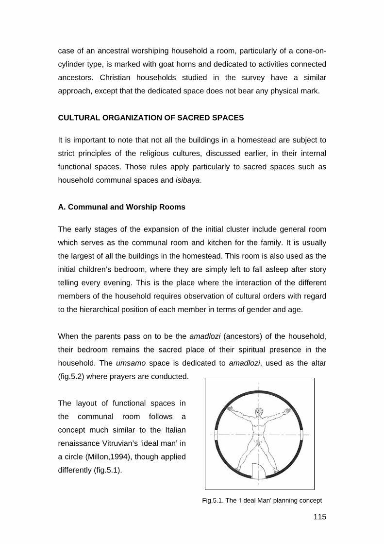
115
case of an ancestral worshiping household a room, particularly of a cone-on-
cylinder type, is marked with goat horns and dedicated to activities connected
ancestors. Christian households studied in the survey have a similar
approach, except that the dedicated space does not bear any physical mark.
CULTURAL ORGANIZATION OF SACRED SPACES
It is important to note that not all the buildings in a homestead are subject to
strict principles of the religious cultures, discussed earlier, in their internal
functional spaces. Those rules apply particularly to sacred spaces such as
household communal spaces and isibaya.
A. Communal and Worship Rooms
The early stages of the expansion of the initial cluster include general room
which serves as the communal room and kitchen for the family. It is usually
the largest of all the buildings in the homestead. This room is also used as the
initial children’s bedroom, where they are simply left to fall asleep after story
telling every evening. This is the place where the interaction of the different
members of the household requires observation of cultural orders with regard
to the hierarchical position of each member in terms of gender and age.
When the parents pass on to be the amadlozi (ancestors) of the household,
their bedroom remains the sacred place of their spiritual presence in the
household. The umsamo space is dedicated to amadlozi, used as the altar
(fig.5.2) where prayers are conducted.
The layout of functional spaces in
the communal room follows a
concept much similar to the Italian
renaissance Vitruvian’s ‘ideal man’ in
a circle (Millon,1994), though applied
differently (fig.5.1).
Fig.5.1. The ‘I deal Man’ planning concept

116
The internal spatial layout is, to a
great extent, influenced by the
symmetrical floor plan of the room.
Detailed arrangements of the
functional spaces in those primary
zones are in accordance with the
hierarchical order of the household.
The room has five major zones, ie,
the entrance area (isithumbanja), the
centre with insika (post) and iziko,
the male and female zones, and
umsamo (altar).
It is customary that females sit on
the left side of the imaginary ‘ideal man’, behind the door. Their sitting
arrangement is such that elderly women sit more towards umsamo in the
hierarchical of their seniority.
Males sit on the right side of the ‘ideal man’ in the hierarchical order of their
seniority, with the exception of uSokhaya (the householder), who sits closest
to the entrance for surveillance purposes, with his watch dogs just outside the
entrance area (esithumbanjeni). Some householders prefer a special private
door so that he does not use the same entrance with females, in case some
are in ritually unclean conditions like menstrual periods.
Umsamo is the most sacred spiritual part of the entire homestead,
representing the head of the human figure. It is where the family rituals are
performed. When a member of the family dies, the coffin is placed in this
sacred place as for transition before he/she is finally buried to join the
ancestors.
The central post (insika) is at the umbilical point of the imaginary human
figure, where the setting out of the building is centred. In the genital position
Fig.5.1. The ‘Ideal Man’ planning concept
Fig.5.2. Basic interior layout of a typical communal room

117
of the human figure is the fire place, around which the family gathers in the
evenings and cold weathers. It is also where central food preparation is done
for the household. The significance of the position of the fireplace, both as a
food preparation place and as associated with the genital part of the human
figure, has to do with reproduction. The growth and stability of the household
is viewed as both in biological reproduction for numerical expansion and the
nourishment of a physical body. As a fireplace for thermal warmth, it is the
social focal point of the household. Since the aspects of reproduction and
cooking or feeding are associated with mothers, the fire place is dedicated for
use by females only. In cases where the fire needs to be increased it must
only expand towards the female hemisphere of the room.
B. Isibaya
Fig.5.3. A sacred use of Isibaya

118
The layout of isibaya follows the same spatial concept as the communal room,
though the similarity is only limited to umsamo at the head of the imaginary
‘ideal man’, in relation to its entrance. When the householder passes on, he is
buried in the umsamo position, which becomes one of the most sacred places
in the homestead. This is the only grave that sits within the byre. When his
wife follows on, she is buried next to him but just outside the byre (fig.5.3).
In the case where isibaya has to continue to house cattle and certain cultural
activities, the grave gets isolated within. In the much often cases where his
sons have their individual byres, each one takes his share according to the
old man’s distribution of his will. His isibaya is then kept as his sacred grave
premises in the homestead.
As the homestead grows further, one finds more than one sacred space
dedicated to the various generations of ancestors. However, the initial
ancestor remains the core in the homestead.

119
CHAPTER 6
TYPICAL HOMESTEAD LAYOUT PATTERNS
INTRODUCTION
Chapter 4 of this document uncovers one primary principle of spatial planning
of a traditional homestead which successfully characterizes the indigenous
architecture of KwaZulu-Natal. This planning principle manifests consistently
in the different layout types across all the sub regions of the province.
This chapter outlines the various homestead layout types identified in the
fieldwork, that is, Circular, Organic and Rectilinear layout, demonstrating the
common traditional principle that distinguishes them as the indigenous
architecture of KwaZulu-Natal.
CIRCULAR PLANNING CONCEPT
Fig.6.1. Circular planning concept of KwaZulu
Calf Pen
Undergroundfood storage
E S
O K
U D
L A
AMAGCEKE(C)
IZALA(B)
Ent
ranc
e
way
E S
O K
H O
H L
O
INSIMU(A)
IZALA(B)
Isibaya
Emlotheni(ash place)
Main
Iba
ndl
a(Y
oung
Men)
I
band
la(E
lder
ly M
en)

120
This is the well known and widely
documented historical homestead layout
concept of kwaZulu, where buildings are
placed in a circular arrangement around
isibaya (fig.6.1). This type still exists in
the rural settlements of the historical
kwaZulu, though not as geometrically
circular as the popular royal homesteads.
This model is commonly regarded as the Zulu homestead, representing the
province of the current KwaZulu-Natal. On the contrary, this study has
uncovered that this type represents the architecture of the historical kwaZulu
in the surroundings of uThukela river, where it still exists.
Historically, there has been a distinction between a royal and an ordinary
homestead layout. A palace was planned in a perfectly closed circular layout
with rigid royal functional and cultural planning principles (6.3), whereas, the
ordinary homestead followed the same traditional concept of a central space
surrounded by freestanding buildings, but the planning principles were
relatively relaxed and the homestead did not have to be a completely closed
circle.
Frescura’s (1985) comparative analysis of Southern African settlement
patterns records that Khoi traditional homestead layout were circular, with
treasured household assets placed in the centre of the homestead and
surrounded by free standing building units.
Fig.6.2. Typical Homestead
Fig.6.3. King Cetshwayo’s palace (Frescura, 1981)

121
This suggests that the traditional
circular homestead layout found in this
region is attributable to one of the
strong influences of the KhoiSans who
existed before the settlement of
abeNguni. In the Zulu version, this
planning concept was modified by the
Nguni cultural organization of a
household and the social order of the
times. Another distinct characteristic of
this model is the relationship of the
main building, which is normally the first of all buildings in the establishment
of the complex, with isibaya (fig.6.1). The position of a prince is, culturally, at
the bottom end of the right hemisphere.
ORGANIC PLANNING CONCEPT
Fig.6.4. Khoi homestead (Frescura, 1985)
Fig.6.5. A typical organic layout of a homestead
Isibaya
Main
IZALA(B) IZALA(B)
INSIMU(A)
AMAGCEKE(C)

122
This is a planning concept that is well expressed in the larger and older
homesteads, like kwaNgcobo in eNgilanyoni, kwaMbhele in Loskop and
kwaTembe in Maputaland, among others. Such homesteads are usually
established on gentle sloping and almost flat lands where the complexes are
laid out with little or no topographic limitations. Individual buildings, therefore,
spread freely and randomly in the site. However, this is the type that has
successfully showcased the complex cultural principles of planning.
This concept displays two of the major cultural principles of planning that
were noted in the Zulu circular model. The main building sits directly
symmetrically with isibaya. The prince of the family is also placed by the
formal entrance into the complex overlooking isibaya, though without a
definition of a hemisphere as noted in the circular concept.
RECTILINEAR PLANNING CONCEPT
Though the rectilinear layout pattern is found in some of the large
homesteads like kwaMchunu in kwaNongoma and kwaMazibuko in
Fig.6.6. A typical rectilinear layout in a large homestead
Main
IsibayaIZALA(B) IZALA(B)
INSIMU(A)
IGCEKE(C)

123
eBabanango, it appears to have given in to the dramatic growth of smaller
and younger settlements that have spread on steep hilly landscapes of the
province that developed, allegedly due to loss and scarcity of comfortable
settlement land which is, predominantly, occupied by commercial farmers.
This model appears to have introduced a planning solution to those sites with
such topographic conditions, homesteads like kwaKhambule in uMvenyane,
kwaMsomi in kwaDweshula, homesteads of eGulube in Embo and kwaNdlovu
in Loskop, have assumed a rectilinear layout of a hybrid composition of a
‘circle-cube-circle’ rhythm pattern (fig.6.7) along the contour of the slope. That
was a development of a new
typology that cannot expand
physically, as households have
grown poorer and smaller. These
settlements are denser than the
older ones. It could not be
established in the survey as to
which part of the province
pioneered this typology.
Beyond the technical origins of this typology, it has generally won the interest
of most parts of the province as a style. It was interesting to note how Msomi
in kwaDweshula has synthesized this style with modern architecture (pic.4.3,
fig.4.8).
It was noted that this model also bears both characteristics that were identified
in both the circular and the organic planning models. The first, main, building
is placed directly symmetrical to isibaya. The prince of the household is
placed by the entrance way into the complex overlooking isibaya rest of the
homestead, though without a definition of a hemisphere as noted in the
circular concept. This placement is considered to be position of responsibility.
Fig.6.7. A typical ‘cube-circle-circle’ concept of rectilinear homestead layout

124
PRIMARY ZONES
All the various models and sizes of homesteads covered in this survey follow
the same ABC functional hierarchy (fig.6.8) of layout of primary zones in the
site as detailed in chapter 4. That is, insimu, izala and igceke conseculively.
The application of this principle varies from one homestead or regional
environment to another in terms of layout patterns and sizes. Izala is the
interface belt between insimu (crop field) and igceke/amagceke, the social
and circulation spaces in the immediate surroundings of the buildings. Zone
C, where buildings sit, is always at the upper end in case of a sloping site with
insimu at the lower end. Izala comprises vegetable and fruit gardens and
isibaya. Placement of individual buildings or clusters in the amagceke zone
follows the hierarchical order of the household, which does not necessarily
dictate a rigid layout pattern of the units in the homestead.
For instance, the homesteads of kwaMchunu in kwaNongoma, kwaTembe in
Maputaland, kwaMbhele in Loskop, kwaNgcobo in eNgilanyoni and many
others, have applied the same cultural planning principles while the physical
layout patterns are completely different from each other. However, some of
the notable physical characteristics that link them all, except a negligible few
in the province, is the placement of a first born son’s domain by the formal
entrance.
KwaHlatshwayo homestead in Bergville (fig.4.22) demonstrates the strength
of the traditional planning principles. The homestead consists, predominantly,
Fig.6.8. Section showing typical site zoning

125
of modern partitioned cubic buildings, but the spatial zoning in the premises
follows the principles of the traditional homestead that consists of clusters of
freestanding individual buildings recorded in kwaNgcobo, kwaMbhele,
kwaMchunu and others.
There are three distinct layout patterns noted in the province. That is, circular,
organic and rectilinear layouts.
ORIENTATION
Orientation of the buildings, predominantly in the rectilinear type of homestead
layout, is in response more to landscape than to the sun as opposed to
modern buildings, the difference being that the thermal behaviour of these
traditional buildings is relatively well balanced. All buildings face downslope to
prevent rain water from running into the building. This is even at the expense
of available opportunities for positive manipulation of those negative spaces.
The kwaMazibuko complex in eNtinini settlement (fig.4.24) and kwaMchunu in
kwaNongoma (fig.4.26) are the best examples, where the layout of buildings
is in two parallel rectilinear rows that face one direction downslope, leaving a
dead corridor in between.
Homesteads with a circular type of layout such as those found in the historical
kwaZulu settlements have all buildings opening doors to the central space,
even as the homestead sits on a sloping spur. This principle involves
adaptation of the landscape to create platforms for the individual buildings and
to control rain water.
The same principle of orientation is notable in the kwaTembe complex
(fig.4.27) in the far north coast, where the terrain is flat and the homestead
layout is organic. All buildings have doors facing communal outdoor spaces,
forming pockets of clusters in a hierarchical order. The principle of orientation
of all the buildings in this setup is not influenced by any climatic factor but
based on functions only.

126
THE METAMORPHOSIS OF A HOMESTEAD
It was noted in the study that the establishment of a traditional isiZulu
household begins with a dwelling for the young householders which usually
serves a multipurpose function. The next building is a kitchen which is used as
a family social space, where children also sleep as the family begins to grow.
The initial cluster also includes a granary (isilulu) and isibaya directly in front
within the izala zone. When a son grows independent, ilawu (a freestanding
room) is built for him, with a potential of developing a cluster when he gets
married. The markable budding of a typical homestead starts with sons
flanking or spreading around the core cluster occupied by the parents. Girls
are no priority in the system as they are not considered permanent members
of the household, except where it is established that she is settled in the
house, like in the case of kwaNgcobo of eNgilanyoni.
Fig.6.9. shows a typical physical growth of a homestead informed by the
cultural background discussed earlier in this chapter.
Fig.6.9. Diagramatic Model of the early stages of Homestead development
STAGE 1
Parents
STAGE 2
Son 1STAGE 3
Son 2
SUBSEQUENT
SonSUBSEQUENT
Daughter SUBSEQUENT
Son
Isibaya
Formal Entrance
Insimu

127
CHAPTER 7
SETTLEMENT DEVELOPMENT MODELS IN KWAZULU-NATAL
INTRODUCTION
The large historical indigenous settlements seen in KwaZulu-Natal resulted
from developments of single units of homesteads that grew in various ways.
Two typical growth patterns of homesteads were noted in the study. That is,
radial or centrifugal and circular or centripetal. These two models are
discussed in detail below
RADIAL/CENTRIFUGAL MODEL
Fig.7.1 illustrates the components of a residential complex represented as
follows: Core: Initial householder
Cluster 1: 1st born son
Cluster 1A: 1st grandson
Cluster 1B: 2nd grandson
Cluster 2: 2nd born son (this position is usually occupied by daughter)
Cluster 3: 3rd born son
Cluster 4: 4th born son
Etc
As sons develop clusters of sub families within the household, they radiate
and spread around their parents cluster. After the death of the initial
householders their huts are given functions that will keep them connected with
the family as amadlozi of the entire eventual clan; functions such as family
communal or sacred worship room. The kitchen remains central for the
homestead, even while each cluster has its private dedicated kitchen.
The room dedicated to amadlozi is usually identified with goat horns above
the entrance. That remains in the life time of the homestead. When that
building starts aging and collapses, it gets rebuilt, so that its value and
existence is immortal. When the homestead is deemed saturated, a new

128
homestead is developed as a further expansion of the household (fig.7.1).
This direction of expansion continues as long as land is available.
This is the type of expansion recorded in the kwaMbhele clan in Loskop. The
initiator of the homestead remains the core of its identity to all extents of its
Fig.7.1. Diagramatic Model of a Radial / Centrifugal Homestead growth

129
growth in terms of its name and cultures. Expansions of this nature are
attributed for the historical developments of massive clan villages, like those in
the Central Ukhahlamba area (emaHlutshini, kwaMkhize, kwaDlamini, etc)
and the villages of eNquthu (kwaZondi, kwaMncube, kwaMazibuko,etc), in
which case the initial head of the clan becomes king of the growing tribe, with
a well defined system of his succession. This concept saw the radical
expansion of a small family within a Nguni clan expanding to a tribe that was
able to pull other neighbouring Nguni families and clans into itself to the
eventual imperial amaZulu nation.
CIRCULAR/CENTRIPETAL MODEL
The establishment and early stages of the growth of this model is similar to
the radial type. The numbering of clusters in the illustration of this model is
therefore similar to the numbering used in fig.7.1.
Households with circular growth, like kwaNgcobo in eNgilanyoni, are usually
influenced by limited land for physical expansion. Its physical growth is,
therefore, only limited to its current premises and cannot spread outward to a
large clan (fig.7.2)
Fig.7.2. Diagramatic Model of a Circular / Centripetal Homestead growth

130
In a circular model, when the householders pass away, their cluster is
inherited by a second or third subsequent generation, following an established
system of succession. For example, the household of kwaNgcobo of
eNgilanyoni gave the significant part of the parents cluster to the second wife
of the second born son. In the selected homestead of kwaMbhele of
eNyezane, the late parents cluster was fully inherited by the eldest grandson
from their first born son, to restart a perpetual cycle. One of their rooms gets
dedicated to those late grandparents who have become amadlozi. When the
building ages it is rebuilt to maintain the ever existence of amdlozi in the
household. The latter arrangement is the commonest practice among
amaZulu across the province.
Such a natural development of a settlement result in an organic type of a
layout, relative to the colonial grid patterns found in urban settlements where
land has to be highly economized.
Pic.7.1. shows a typical South Coast rural settlement that results from any of
the above two models of homestead development.
Smaller households that were studied in this survey are structured much like
the initial cluster of a germinating homestead. In dense settlements like
uMvenyane, kwaDweshula, eMbuthweni and some of the recent settlements
along uKhahlamba and inland, households naturally assume a centripetal
direction of growth, owing to economic and land limitations for physical
expansion.
Pic.7.1. Typical South Coast Settlement

131
CHAPTER 8
A TYPOLOGICAL ANALYSIS OF THE TRADITIONAL BUILDINGS OF KWAZULU-NATAL
INTRODUCTION
Through all the indigenous rural settlements surveyed in the province it was
noted that architectural typologies are distinctly regionalized.
Frescura (1981) provides a well structured analysis of all the rural indigenous
building types of southern Africa and their historical evolution. This chapter
takes advantage of such an analysis but limiting it within KwaZulu-Natal.
BUILDING FORMS
As a result of this fieldwork it also became evident that, although there was a
predominance of certain dwelling forms in specific regions, those were not
clear enough to create either regional or cultural stereotypes. Unlike the work
of Frescura (1985), which presumes a historical time line to dwelling forms, it
was found that transitions between one dwelling form and the next were not
evolutionary but often took place within the same homestead and within a
relatively short space of time. This means that any historical transition which
may have taken place before 1994 must now be considered obsolete and that
the iconography of indigenous architecture has now focused upon the building
of ‘stable’ dwelling forms rather than the existence of traditional nuances. On
the other hand, much effort seems to be placed, in more recent times by
indigenous rural builders, upon the creation of hybrid building forms. This
proved to be an important finding in the structuring of this document as
opposed to the reports of others researchers (Waltons,1967; Frescura, 1981).
No regional stereotyping could be drawn, particularly with regard to form. The
reasons for this are manifold and can, probably, be laid at door of increasing
urbanization. This appears to have been accompanied by a reduction in the
number of building forms that are being built today in the rural countryside.

132
This turned out to be an important point in the structuring of this research, as
the apparent loss of certain forms and technologies has inevitably influenced
the concomitant issue of indigenous identities
This study has identified ten basic building forms that spread in the province
as shown in fig.8.1. While some of these forms are found in specific regions
only, most of these forms are common throughout the province. Each region
handles these common forms uniquely, thereby defining its geographic
identity in colours, roofs and layouts.
Compositions of indigenous
homesteads across the
province have developed a
traditional combination of
most of these forms within
one complex. The historical
grass dome (amaqhugwana)
is almost extinct across the
province. Attempts to
resuscitate this building type
were noticed particularly in most of the settlements of the northern parts of
the western region (oKhahlamba) though, generally, for their antiquity more
than functional purposes.
Fig.8.1. Basic Building Forms in KwaZulu-Natal
Fig.8.2. Historical grass dome

133
Southern Regions South West Region
Traditional forms in the homesteads of the western part of the south coast
region are fully thatched cone-on-cylinders and cubic forms with gable-end
double pitched and hipped roof types. The cubic forms are only roofed with
corrugated iron sheeting.
South Coast Region
The south coast has appeared to be the most active in the exploration of
forms and materials. This is one part of the province that has, to a great
extent, introduced a gradual intervention of metal sheeting to the cone-on-
cylinder forms towards the north end of the region. This intervention initially
presents as hybrid roofs and gradually replaces the thatch completely (pic.4.9
and fig. 8.4).
Fig.8.3. Building forms of the Southern regions

134
Though this came as an exploration of the modern material merited for its
relative response to fire, it has become a traditional style of the region. The
south coast region has also explored the development of their cone-on-
cylinders to polygonal forms with improved solutions to their metal roof
sheeting problems. Such explorations further led to successful use of
concrete roof tiling. This is the region that developed the traditional ‘circle-
cube-circle’ concept further by merging the three components into one hybrid
building, replacing the cone-on-cylinder with the pyramid-on- polygon.
These developments are at peak towards the north end of the south coast
region, fading off in the Umbumbulu rural settlements, just outside Umlazi and
KwaMakhutha townships, south of the eThekwini city.
Fig.8.6. Hybrid type: South Coast
Fig.8.4. Introduction of flat metal roof sheeting: South Coast
Fig.8.5. Pyramid-on-polygon type: South Coast

135
West (Ukhahlamba) Region
The western region, along uKhahlamba, is characterized by sparse existence
of thatched raised domes, cone-on-cylinders, cubic forms with a range of roof
types (fig.8.7). There is some introduction of thatch to some of the cubic
forms.
The southern part of this region has
further developed the uMsinga type
of roof apex to the creatively woven
type shown in fig.8.8. The north end
of uKhahlamba, has recently
introduced an oval-shaped or double
cone-on-cylinder form which,
apparently has been imported from
Lesotho, west beyond Ukhahlamba.
Walls are built with mud blocks,
though the baSotho version has stone walls. This is the only sub region
characterized by a typology of this kind in the province.
Fig.8.8. Roof Apex: Loskop
Fig.8.7. Building forms of uKhahlamba

136
North Region
The north coast is characterized by a sparse spread of thatched raised
domes, thatched cone-on-cylinders and cubic forms with corrugated iron roofs
of mono-pitch, gable-end double pitch and hipped style.
The architecture of this region is unique in the construction of the cone-on-
cylinder forms. The indigenous construction materials are used in a manner
that displays the artistic building methods used. The cone-on-cylinder forms
of KwaMhlabuyalingana and further to the north and north-west borders of
Maputaland are constructed such that they maintain their natural expression,
with exposed timber frame and reed infill or woven lathing (izintungo) to
Fig.8.10. Reed infill type with ribbed thatched roof
Fig.8.11. Maputaland Basket type with ribbed thatched roof
Fig.8.9. Building forms of the North Region

137
express like a basket. These are only plastered and finished internally
(fig.8.10 & 8.11.).
Unlike the South Coast, the cone-on-cylinder buildings in this region are fully
thatched. A unique character in this region is the ribbed thatch, which does
not exist in any other region in the province. This character also marks the
identity of the region which is distinctly notable from the settlements of
kwaMaphumulo and across uThukela river up to the north east end of the
province of KwaZulu-Natal.
Generally, in all the homesteads observed in this study, the room dedicated to
worship is, traditionally, the cone-on-cylinder type only. This suggests that a
traditional cone-on-cylinder has developed a religious value, because the
typology is attached to a generation of ancestors that lived in it before the
intervention of cubic forms. In Christian families like the Khambule, in
uMvenyane, the worship room is also a cone-on-cylinder type but does not
bear any physical mark. This prayer room has also leaped into townships,
where one finds a freestanding cone-on-cylinder room at the back of a
modern family size cubic building (pic.8.1). The movement of this typology is
also gradually creeping into the formerly white suburbs, as indigenous black
people of middle and high income are migrating from townships into those
suburbs along with their cultures.
Pic.8.1. Unnamed: Cone-on-cylinder worship room in an urban setting

138
REGIONAL TRADITIONAL COLOURS
Pic.8.2. & 8.3. below show a striking contrast between the traditional colours
of the southern and the northern regions. In their differences, each of these
traditional colours depicts the people’s relationship with their natural
environment as they make their buildings communicate with the landscape in
their unique ways.
Settlements from the south-west end of the province through the south coast
to the immediate peripheral rural settlements south of eThekwini city are
characterized by walls limewashed in white, light blue, cream or other colours
close to white, trimmed with a black band at the bottom. This unique colour
scheme is also applied to the modernized traditional buildings like kwaMsomi
in kwaDweshula (Pic.4.3) and in the uMvenyane settlement in the south-west
end of the province (pic.4.1). This is a traditional colour style that imposes a
contrasting colour that presents a decorative expression of the settlement
landscape.
In the settlements along uKhahlamba and eastward to the midlands of
kwaZulu, the mud walls are either left unpainted or finished with a careful
selection of local coloured soils that maintain the traditional earthy colour
effect which blends with the natural colours of the surrounding landscape
(pic.8.3). The same tradition is notable in the south end of the north region.
The north region, particularly, in the KwaMhlabuyalingana area and further to
the northern borders of the province, shows an attitude to the natural
Pic.8.1. Unnamed: Cone-on-cylinder worship room in an urban setting
Pic.8.2. Embo, Mpofana settlement: Typical colours of the South Coast
Pic.8.3. Hluhluwe: Typical colours of the Midlands, uKhahlamba and North Coast

139
landscape similar to the uKhahlamba and midlands settlements. The
uniqueness of this part of the region is in the innovative use of the
construction materials, which introduces an artistic expression of their natural
colours in their blending with the natural environs. Pic.8.4. shows a spread of
the various colour styles through all the regions of the province. These styles
have given each region a unique identity in its architecture.
SOUTH NORTH AND MIDLANDS
South west: EMvenyane settlement
UKhahlamba: ENyezane- individual homestead
South Coast: EMkhomazi (EVishavisha) - Individual Homestead
North Coast: EHluhluwe, KwaNtombigezile settlement
Far South: KwaDweshula- Individual Homestead
Inner North Coast: EBabanango– Individual Homestead
South Coast: EMbo- Individual Homestead
Inner North Coast: KwaNongoma- Individual Homestead
South Coast: Embo– Mpofana Settlement
Midlands: EMnambithi- Roseboom settlement
Pic.8.4. A spread of regional colours across the province of KwaZulu-Natal

140
CHAPTER 9
BUILDING CONSTRUCTION
INTRODUCTION
Various construction materials and methods have been explored in the history
of the indigenous buildings of the various parts of the province. This analysis
limits itself to the construction of those buildings that were recorded in the
fieldwork of this study.
It was noted in the study throughout the province that, generally, successful
explorations of certain construction materials intended to resolve specific
problems, developed to be traditional styles of those particular places. This
was noted in the fieldwork when most respondents could not explain, in their
generation, why certain buildings were built to look the way they were, but just
regarded them as a style.
This chapter provides a general analysis of the technical aspects of building
construction with regard to, firstly, response to elements such as fire and
climatic conditions and, secondly, construction techniques of the basic
components that play a role in the identity of the architecture of this part of the
world.
CONSTRUCTION METHODS AND MATERIALS
A. Setting Out
In setting out a building, particularly of a
circular form, a peg is nailed into the
central point of the building to be built. A
string woven with a choice of grass, like
ilala, or umsasane tree bark, is then tied
to the peg form which the radius of the Fig.9.1. Setting out of a circular building

141
building is marked. The marked radius represents the exterior of the wall
(fig.9.1).
B. Wall Construction
All parts of the province have introduced mud blocks bonded with cement
mortar for improved durability. There is also some sparse prevalence of
modern concrete blocks in those houses that afford them. Use of these blocks
does not affect the architectural typology of those buildings. However,
vernacular walling systems still continues to exist.
The mud walls of circular buildings are
reinforced with izintungo of ugagane,
ubhici or isimunywana tree. The most
common development of reinforced walls
is where the structure is framed with
timber posts of umkhaya, umthombothi,
umtholo or isinqawe tree and izintungo
to form a cage for stone infill (fig.9.3). The
types of timber vary from one region to
another as discussed in chapter 4 of this
document. The reinforcement ties the
cylinder together thereby preventing any
possible outward thrust of the cone roof
from collapsing the building. This walling
system is common in all the parts of the
province.
The use of colour in the south region came
along with the challenge of mud splashes
causing an unpleasant appearance of the
building at the base (pic.9.1). The problem
was even worsened by the absence of
Fig.9.3. Stone infill with internal and external plaster
Fig.9.2. Mud wall reinforced with timber
Pic.9.1. South Coast building with unprotected base showing mud splashes

142
rainwater gutters, as the metal roof
sheeting became the material used. A
dark coloured band was introduced at
the base, as seen in pic.9.2. This
concept has become the traditional
colour style of the south.
The introduction of aprons around the
base of the building acts as flashing to
protect foundations from being
weakened by rain water (fig.9.4 &
pic.4.16). This is a concept used in all
the regions of the province, but
predominantly in the north. In some
cases the apron is in a form of a raised
stoep which also provides seating
around the building.
A unique walling system that is
predominant in the far north region is
one with an exposed timber frame,
usually of umnqawe thorn tree and
izintungo of ugagane or isimunywane
tree with reed (umhlanga) wall cladding
(fig.9.5). The wall is plastered internally
with termite mound soil (isiduli) and
finished with umcako, a slurry of
specials selections of local soils for the
purpose.. The challenge encountered
in this walling system is the termite
attack at the bottom of the building
(pic.9.3). Most noted buildings of this
type fail from the base.
Fig.9.5. Cross section of a Reed wall with Exposed timber frame
Pic.9.2. Dark coloured band used to counter effects of mud splashes
Fig.9.4. Raised apron to form stoep
Pic.9.3. Bottom of a reed wall eaten away by termites

143
One of the main reasons behind the
extinction of the traditional grass dome
was the rotting effect of rainwater at the
base of the building. The dome was, thus,
raised on a cylinder. The introduction of
solid walls in the construction of raised
domes and cone-on-cylinders has, on the
one hand, improved the acoustic
behaviour of walls relative to the grass or
reed infill and the basket type walls while,
on the other, the thermal fly wheel (heat flow) in these solid walls reduces
their relative thermal advantages. However, where thatch roofs are used
together with solid walls, the thermal difference tends to be negligible.
The acoustic properties of the grass or
reed infill and the basket wall types are
further improved with the introduction of
internal plaster while keeping the
unfinished natural expression of its
exterior, particularly in the far north.
(fig.9.5). The basket type wall of the far
north region (fig.9.7) has made even
further improvements to the thermal
quality of the walling system. The
interior of the room is plastered up to
about 500mm below eaves. The
unplastered band is woven in such a
louvered manner that view from outside
is difficult or impossible while it allows
easy view from inside.
The main purpose of this horizontal band is to let cool air into the building
through the upper level which will only sinks and cools the rest of the room,
as the warm air rises and escapes.
Fig.9.7. Cross section of a typical Basket type construction
Fig.9.6. Grass Dome raised on a mud wall cylinder

144
C. Roof Construction
The roofs of the rectangular and square buildings are constructed with
gumpole trusses and purlins. Most of these roof structures have even
developed to the conventional modern pine trusses. Of interest in this study is
the construction of the frame and cladding of the cone roof of the traditional
cone-on-cylinder type of buildings.
All the three versions of roofs to the
cone-on-cylinder that exists across the
province use the one ‘spiderweb’ timber
frame concept (pic.9.4). Types of timber
used vary with regions as indicated
earlier. The cone roof structure is
engineered in relation to the cylinder
such that its self weight, which tends to
collapse from the apex and force its
bottom sideways (fig.9.8), is held tight
with a timber ring beam that sits on the
top of the cylinder, also acting as a wall
plate. The woven reinforcement in the
walls also resists such forces. The
weight of the roof is transferred directly
through the timber posts to the ground,
so there are no point loads to cause
cracks on the weak mud walls. During
construction the roof frame is held in
place with a central post fixed at the
apex while it is tightly fixed to the
cylinder frame for lateral stability. The
central post may then be removed as
lateral stability of the frame no longer
depends on it. Where the post has to be
Pic.9.4. Typical ‘spiderweb’ timber roof frame of a traditional cone-on- cylinder building
Pic.9.5. Interior of finished cone roof
Fig.9.8. Stabilization of structural frame
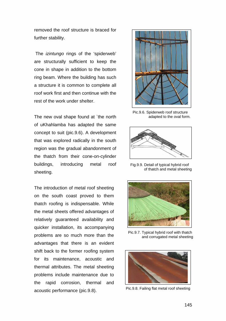
145
removed the roof structure is braced for
further stability.
The izintungo rings of the ‘spiderweb’
are structurally sufficient to keep the
cone in shape in addition to the bottom
ring beam. Where the building has such
a structure it is common to complete all
roof work first and then continue with the
rest of the work under shelter.
The new oval shape found at `the north
of uKhahlamba has adapted the same
concept to suit (pic.9.6). A development
that was explored radically in the south
region was the gradual abandonment of
the thatch from their cone-on-cylinder
buildings, introducing metal roof
sheeting.
The introduction of metal roof sheeting
on the south coast proved to them
thatch roofing is indispensable. While
the metal sheets offered advantages of
relatively guaranteed availability and
quicker installation, its accompanying
problems are so much more than the
advantages that there is an evident
shift back to the former roofing system
for its maintenance, acoustic and
thermal attributes. The metal sheeting
problems include maintenance due to
the rapid corrosion, thermal and
acoustic performance (pic.9.8).
Fig.9.9. Detail of typical hybrid roof of thatch and metal sheeting
Pic.9.8. Failing flat metal roof sheeting
Pic.9.6. Spiderweb roof structure adapted to the oval form.
Pic.9.7. Typical hybrid roof with thatch and corrugated metal sheeting

146
The first major challenge was the adaptation of the corrugated nature of the
sheets to the curvature of the building form, which led to the use of flat sheets
and their subsequent problems.
All the above problems revolve around costs, in that, for the material to give
the required performance, there must be added costs for handling thermal
and accoustic performance, with specialized skills. All these are in addition to
the costs of the materials themselves, given the state of economy in those
rural environment. A shift back to thatch thus becomes the nearest best
option.
In response to the vulnerability of the
thatch roofing material, a new homestead
concept intervened. Instead of
abandoning the thatch material, a
freestanding cubic building roofed with
corrugated iron sheets was introduced as
a fire barrier between two traditional
thatch roofed buildings. This concept
proved successful in preventing the
spread of fire which, previously, would
consume the entire homestead. This
concept mainly takes advantage of the
merits of the metal sheeting.
Fig.9.10. ‘Circle-cube-circle’ as fire barrier concept
Fig.9.11. ‘Circle-cube-circle’ concept Elevation

147
CHAPTER 10
INFLUENCES
INTRODUCTION
In the fieldwork analysis it was noted that the architecture of KwaZulu-Natal is
generally influenced by certain physical, social and economic factors from
within and without the province. Influences of neighbouring ethnic groups
outside KwaZulu-Natal reflect not only in the built environment, but also in
other social practices and even more pronounced in the regional dialects of
isiZulu language.
EXTERNAL CULTURAL INFLUENCES
It was acknowledged earlier in this document that the evolution of the
languages spoken by abeNguni demonstrates a very strong influence of the
KhoiSans. It was further acknowledged that the principles of layout of the
historical kwaZulu homestead reflects a similar strength of KhoiSan influence
on architecture of the region.
The indigenous rural settlements of the far south coast and the south western
sub regions of the province have a high degree of mixed cultural traditions
and language influenced by both baSotho and, most predominantly,
amaXhosa of the former and Transkei. The architectural expression of the
built environment presents a strong influence of, particularly, the Xhosa
traditional colour coding. This influence has spread northwards along the
coast, fading at the south and west edge of eThekwini. However, the style has
undergone sub regional adaptations along its northward flow. The South
Coast is, thus, the largest part of the province with such a pronounced
constant regional identity.

148
The northern part of uKhahlamba region is located at the interface of
KwaZulu-Natal, Lesotho and the Orange Free State. The social character of
this part of the province is less typical Zulu than the midlands. The spoken
language, even down to the central sub region, has some elements of
seSotho of the Orange Free State and Lesotho, much like the Zulu language
of Gauteng. The north end of uKhahlamba is the only part of the province to
actively introduce the Lesotho oval typology. Indigenous rural settlements
further north of Bergville, such as eMangwaneni, kwaMiya, etc spread to the
hills of the Drakensberg to the border of Lesotho, thereby subjecting the sub
region to baSotho influences on their languages, social practices and
architecture. The baSotho oval typology is traditionally built with stone
masonry. UKhahlamba north sub region has adapted the typology to cement
bonded mud block walls, as the materials available locally. The typology
spreads eastward to the rural settlements in and around eMnambithi and
Estcourt.
In like manner, indigenous rural settlements further north along the coast of
KwaZulu-Natal like eJozini along Ubombo mountains, Phongola and
Maputaland are subjected to influences of Swaziland and Mozambique
languages and social practices. People of Jozini and Phongola, for instance,
speak isiZulu more towards isiSwati of Swaziland. Similarly, settlements
further north of Maputaland like kwaNgwanase, kwaNdaba and kwaTembe
speak isiZulu with an accent of Tsonga language in Mozambique. These
influences include architecture as well. The basket type of cone-on-cylinder
and the ribbed thatched roofs of kwaTembe and kwaNdaba in Maputaland are
typologies similar to those found in Mozambique.
One of the strongest catalysts of all the above influences is intermarriages.
Zulu men have historically upheld the value of marrying women from other
clans or nations. In the Tembe family discussed in chapter 4, for instance, the
wife was given provision for her ancestral and other related practices from her
home in Mozambique. Such provision influenced the cultural customs of the
household and, hence, the physical layout of the complex.

149
A common typology found in the composition of almost all indigenous rural
settlements across the province of KwaZulu-Natal, and the rest of South
Africa, is the flat or hip roofed cubic form that exists in the northern parts of
the continent. This is also an evidence of the existence of Europeans in the
country. The south coast took the evolution even further and explored modern
technology within their vernacular typologies with walling and roofing systems.
Their adventures were only impaired by the economic standards dictated by
those systems given the economic status skills levels of indigenous rural
societies in South Africa and the rest of the continent. European influence is
also manifest in the vernacular language and other social spheres of the Zulu
speaking people at all levels.
The unsuccessful attempts to introduce modern construction materials, as
recorded in the larger part of the south, demonstrate the role of the economic
factor in the evolution of the indigenous architecture of the rural environments
in the province.
The above analysis, therefore, suggests that the development of the
indigenous rural architecture of KwaZulu-Natal, thus far, is a synthesis of
various cultural and architectural elements, both from within and without the
province, and socio economic factors in the community.

150
CHAPTER 11
CONCLUSIONS
INTRODUCTION As indicated earlier in this document, the purpose of this study is to find an
objective definition of the indigenous architecture of KwaZulu-Natal and to
explore elements that qualify the indigenous rural architecture of KwaZulu-
Natal as representative of contemporary indigenous architecture of the
province as it exists today. A diversity of interpretations of the indigenous
architecture of amaZulu and Africa in general, coupled with an empirical study
across the province, was explored extensively to inform the discussion at this
end of the document.
SOCIAL AND GEOGRAPHICAL DEFINITIONS OF ZULU ARCHITECTURE Arguments by many, some of which were highlighted in chapter 2 of this
document, have suggested that the architecture of the ancient amaZulu clan
and its immediate neighbours has often been confused with the wide range of
types of architecture of abeNguni that has existed and developed across the
province known today as KwaZulu-Natal. In this study, perambulations across
the province have revealed that there is a diversity of regional architectural
identities that represent the various historical groups of abeNguni.
The architecture of the historical Zulu clan can, therefore, not represent the
architecture of the province as it has generally been perceived. It is one
among the several abeNguni types that has contributed significantly to the
historical architecture of the province.
INFLUENCES ON ARCHITECTURE
The evolution of any social environment is a natural response to certain
factors either from within or without the society itself. Architecture is a physical

151
expression of the milestones that mark particular eras in the metamorphosis
of a social environment.
The ‘circle-cube-circle’ layout style identified in the uKhahlamba region
(chapter 4), for instance, was an architectural response to local wars, which
developed to a popular style that has grown to cover a large part of KwaZulu-
Natal, with regional architectural identities. This development is a result of
response to internal factors of social evolution.
It was established in this study that there are also external influences that
have played a significant role in the development of identities in the diverse
regional styles that exist in the province, as detailed in chapters 4 and 5 of this
document. The architecture of the indigenous rural settlements south of
eThekwini, for instance, has characteristics of the neighbouring Eastern Cape.
That has made the region unique from the rest of the province. It was also
established that the architecture of uKhahlamba, and most parts of the
Midlands indigenous rural settlements, have some characteristics that show
influence from the neighbouring Lesotho. Furthermore, the architectural
identity of the indigenous rural settlements in KwaMhlabuyalingana
(Maputaland) have characteristics of the architecture of both Mozambique and
Swaziland. The settlement of European communities in all parts South Africa,
since the 17th century, has also contributed significantly with architectural
elements that produced a unique local identity, particularly in the context of
poverty in the rural settlements.
The above traces of influences are attributed to social and economic
interactions with communities outside the province itself. This develops an
argument that the introduction of cubic building forms, as witnessed in all the
indigenous rural settlements in the province, the introduction of certain
European styles by some, and use of modern materials, are by no means a
response different from those influences of social and economic interactions
with Lesotho, Mozambique, Swaziland and others, much as the various
abeNguni groups shared local influences among themselves to what one sees
today. This opposes the prevailing unfortunate perception that attributes the

152
transmutations seen in the indigenous architecture of the province to African
inferiority, particularly where cubic forms and modern materials are explored,
much like the Lesotho oval form found in uKhahlamba, among other
influences.
It has been established in this study that the adoption of a cubic form in the
indigenous rural settlements has introduced a type of homesteads with a
unique character, one that combines different types of forms while maintaining
unique identities of the various regions.
The above trace of influences discovered in the indigenous rural built
environment owes a significant role in the development of contemporary
urban architecture in the province for a unique local identity. This is a crucial
exercise for the post colonial and post apartheid generation of scholars and
practitioners in this area of architecture
THE ROLE OF DETERMINANTS IN THE DEVELOPMENTS OF
INDIGENOUS ARCHITECTURE OF KWAZULU-NATAL
From the fieldwork analysis of this study it was established that the power of
culture in the indigenous architecture of KwaZulu-Natal manifests itself more
in the planning of internal spaces of certain buildings, and in the layouts of old
homesteads where, at initiation, land was not a challenge. As vast rural land
was taken over by farmers, rural settlements became limited to unproductive
hilly landscapes where homesteads could hardly expand to more than three
buildings if cultural planning systems had to be applied. Under such
circumstances so far, culture has only remained strong in the planning of
internal spaces. It has to be emphasized that, according to the findings of this
study, cultural principles of internal spatial planning in the indigenous
architecture of KwaZulu-Natal apply to sacred buildings only. This finding
opposes the prevailing interpretation that generalizes the application of the
planning principles to all buildings in a homestead.

153
The historical developments of the round form of buildings, paralleled with
cultural developments of spatial planning principles in certain buildings,
developed a spiritual attachment to the particular type of a building,
embedded beyond any external architectural influence seen in the
composition of a traditional homestead in KwaZulu-Natal. As a result, one
finds a freestanding modern cone-on-cylinder worship room in the backyard of
an urban dwelling as indigenous rural people flow into urban settlements. It is
in the worship room where the cultural spatial planning principles are strongly
maintained.
It has been acknowledged earlier in this document that the recent architectural
transmutation seen in the rural indigenous settlements of the province have
characteristics symptomatic of poverty. Explorations of modern construction
materials have hardly been successful owing to the cost of achieving desired
technical performance, expression and maintenance, given the state of
economy in those environments. This takes a primary attribute for the failure
of indigenous African architecture to find its space in the first world. The
ideology that marks African identity in architecture with underdeveloped
construction materials is quite unfortunate. The glorification of first world
modern buildings with such elements in the name of ‘traditional’ or ‘contextual’
architecture, as illustrated in chapter 2, is merely a celebration of the historical
impoverishment of the indigenous African people, unless architects are naive.
WHAT WOULD BE REGARDED AS THE INDIGENOUS ARCHITECTURE
OF KWAZULU-NATAL TODAY
From the findings of this study, it is established that the indigenous
architecture of KwaZulu-Natal is the architecture that germinates within the
region, gets further developed by the indigenes of the region such that it
represents its unique local identity to the world. The study also reveals that
the indigenous architecture of KwaZulu-Natal has, historically, been put
together and further developed by a synthesis of internal and external
influences.

154
Perceptions that limit the indigenous architecture of KwaZulu-Natal to ancient
times only is most unfortunate. Such perceptions have, unfortunately, derailed
the direction of its metamorphosis with economic and social suppression such
that it has no place in the development of the modern built environment
beyond tourist facilities.
It has been established in this study that the development of construction
materials and techniques has been unsuccessful, owing to colonial economic
disconnection of African architecture from the world. This resulted in the
underdevelopment of modern expression of form. The identity of the
contemporary architecture of abeNguni, in general, remains richer in spatial
planning than form. However, the cone-on-cylinder, as a building form, has
been conserved through generations owing to its religious value, because the
typology is attached to a generation of ancestors that lived in it before the
intervention of cubic forms. The movement of this typology is also gradually
creeping into the formerly white suburbs, as indigenous black people of
middle and high income are migrating from townships into those suburbs
along with their cultures. Therefore, limiting the identity of indigenous African
architecture to the cone-on-cylinder today is most inaccurate, as this form has
only remained as a historical legend along the evolution of all aspects of
architecture with time.
The analysis of homestead layout patterns in chapter 6 of this document
identifies commonalities across the three major layout models, that is, the
circular, organic and rectilinear planning concepts that exist in the province,
with spatial planning principles characteristic of the architecture of the
indigenous people of KwaZulu-Natal. The wealth of these planning principles
is in the social and cultural principles that govern the use of space uncovered
in chapter 5 of this document. This is one of the most critical explorations and
findings of this study. The successful study of cultural and functional spaces
and their detailed analysis, the metamorphosis of a homestead based on
those cultural principles and the establishment of homestead development
and growth models in chapter 7 are the pride of this project.

155
THE DIRECTION OF EVOLUTION IN THE ARCHITECTURE OF
INDIGENOUS HERITAGE IN KWAZULU-NATAL
Two instances were recorded in the fieldwork, where people would refer to
their type of local architecture as just traditional, ignorant of its actual origin. It
is unfortunate that architects, both in research and practice have a much
similar approach to the interpretation of the indigenous architecture of
amaZulu in the province, in spite of their level of education in the field. Hence,
one still finds such attempts as indicated in chapter 1 of this document, where
contemporary buildings designed with good objectives of indigenous African
identity battling to place African architecture on the global contemporary world
of architecture.
From the arguments highlighted in the historical case studies in this
document, it is generally acknowledged that documented research in this
particular area of study were largely founded on the ideology of European
supremacy. Hence, almost none of them have displayed any interest in the
promotion and development of indigenous African architecture to the
contemporary modern world, both in architectural education and practice.
This, then, poses a challenge for accelerated production of transformed and
objectively researched material in this particular subject.
Studies in African architecture today has to shift from basic research and be
geared towards the advancement of relevant contemporary architecture. This
is a missing approach in research so far. Missing in that, researchers in the
subject have, so far, been stuck in the structuralist analysis of the indigenous
architecture of the various regions of the continent for the joy of mere
historical recordings.
The radical metamorphosis of the indigenous architecture recorded in most
rural settlements, more expressly in the South Coast, presents one of the
demonstrations of human evolution as a law of nature. The law of nature
subjects all humans to evolution from a sperm cell through to the oldest age of
growth and, further, to death. This evolution is in every aspect of human life,

156
and every product of human creation follows the same law. The
metamorphosis recorded in this document suggests that this law of human
evolution disputes the general perception that Africa would not have seen
world class contemporary architecture until the intervention of Europe. It is
generally acknowledged that the role that Europe played was to disconnect
Africa from world advancement in all possible aspects. Today Europe has, in
turn, appeared as a mentor for the development of the African people and
their environment. If this is true, it is worth acknowledging that the
architecture of the indigenous people of KwaZulu-Natal owes to accelerate the
rediscovery of its centuries long lost track of evolution.
While the investigations and findings of this study are sufficient for the
objectives of this project, it arises that its completeness would be
accomplished successfully with research on the foundational history of the
region in the context of Africa in greater depth and detail and, therefore, its
space in the world of contemporary architecture. Such an extent could not be
covered within the parameters of this dissertation.
However, I consider this project successful within its limits, in that, all parts
and stages of the study achieved a successful development of an argument
built on independent hands-on investigations that covered all parts of the
province of KwaZulu-Natal.

157
BIBLIOGRAPHY
ANDERSEN, KB (1978) “African Traditional Architecture”- A Study of the
Housing and Settlement Patterns of Rural Kenya, Nairobi:
Oxford University Press
ATKINSON,R (1998) “The Life Story Interview” - Qualitative Research
Method, Sage, London: Series 44,
BENNETT, DR (1987) “A Guide to the History and Architecture of Durban”,
Durban: City Council
BIERMANN, B (1977) “An African Village” - A case Study: Housing People,
Johannessburg: Donker
BIZZELL,J (2002) “Blueprints In Black And White”- The Built Environment
Professions in South Africa: an Outline History, Cowies Hill:
Solo Collective
BOURGEOIS, (1983) “Spectactular Veracular” – A New Appreciation of
Traditional Desert Architecture, Salt Lake City: Peregrine Books
BRYANT, AT (1949) “The Zulu People” – as they were before the white man
Came, Pietermaritzburg: Shuter and Shooter
CALLINICOS,L (1987) “Working Life 1886-1940” – Factories, Townships and
Popular Culture on the Rand, Ohio: University Press
CLAUDE, D (1997) “Traditional Architecture”. Beyond the Usual Borders:
Maputaland, Durban: KZ-NIA Journal, Issue 2, Vol.22, (2-3)
CRAIG, AP; GRIESEL,H; Witz, LD, “Conceptual Dictionary”, Cape Town:
Juta & Co Ltd
DENYER,S (1978) ”African Architecture"-An Historical and Geographical
Perspective, London: Heinemann
DE JAGER, EJ (1964) “Settlement Types of the Nguni and Sotho Tribes”, Fort
Hare Papers, 3 (19-30)
FORDE, CD (1934) “Habitat, Economy and Society”, London: Methuen,
FRESCURA, F (1981) “Rural shelter in Southern Africa”, A Survey of the
Architecture, House forms and Constructional Methods of the
Black Rural Peoples of Southern Africa,Johannesburg: Ravan
Press,
FRESCURA, F (1984) “Homesteads and Hierarchies”- A survey of the value

158
systems and spatial distributions inherent in the Architecture
of African settlements, Johannesburg: University of the
Witwatersrand
FRESCURA, F (1985) “Major Developments in the Rural Indigenous
Architecture of Southern Africa” - of the Post-Difaqane Period,
Johannesburg: University of Witwatersrand
GRIESEL, H (1994) “Conceptual Dictionary”, Durban: Juta & Co Ltd in
Associaton with University of Natal
GOVERNMENT OF THE UNION OF SOUTH AFRICA (1927) “Native
Administrative Act No.38 of 1927”, Pretoria: Government Printer
GUY, J (1982) “The Destruction of the Zulu Kingdom”, Johanesburg: Ravan
Press
HALL, M (1981) “Settlement Patterns in the Iron Age of Zululand”, An
Ecological Interpretation, Cambridge Monographs in African
Archaeological Bulletin, 33: 107-112
HALL, M (1984) “The Myth of the Zulu Homestead” - Archaeology and
Ethnography, Africa Vol.54
HALL, M (1984) “The Burden of Tribalism” - The Social Context of Southern
African Iron Age Studies, American Antiquity Vol.49(3), 455-467
HARDIE,G (1981) “The Architect and the Third World- A Stranger in a Strange
Land”. Not published
HERSEY, GL (1976) “Pythagorean Palaces” – Magic and Architecture in the
Italian Renaissance, Ithaca and London: Conell University
Press
HUFFMAN,T(1982) “Archaeology and Ethnohistory of the African Iron Age
Annual Review of Anthropology, 11, pg 133-150
KEARNEY, B (1973) “Architecture in Natal” 1824-1893, Balkema, Cape Town:
(1974)“The Veranda House” Lantern Vol.XXIII,No.3 March,46-48
KHUMALO, RS (1995) “Uphoko”, Umqulu 1, Pietermaritzburg: Reach Out
Publishers,
KRIGE, AT (1950) “The Social Systems of the Zulus”, Pietermaritzburg:
Shuter and Shooter,
KULTERMANN,U (1969) “New Directions in African Architecture”, London:
Studio.Vista

159
LAUGIER, M (1977) “An Essay on Architecture”, Los Angeles: Hennessey &
Ingalls Inc,
MANNING, J (2004) “Racism in Three Dimensions”-South African Architecture
and the Ideology of White Superiority, Social Identities Vol.10,
No.4 November, Carfax Publishing
MILLON, HA (1994) “Italian Renaissance Architecture”- From Brunelleschi to
Michelangelo, London: Thames and Hudson
MSIMANG, CT (1975) “Kusadliwa Ngoludala”, Pietermaritzburg: Shuter and
Shooter
NGUBANE, S (2004) “Traditional Practices on Burial Systems with special
reference to the Zulu People of South Africa”, Indilinga, African
Journal of Indigenous Knowledge Systems, Volume 3, No.2
OLIVER, P (1997) “Encyclopedia of Vernacular Architecture of the World”,
Vol.1. Theories and Principles, Cambridge: Cambridge
University Press
OMER-COOPER,JD (1978) “The Zulu Aftermath” -A Nineteenth Century
Revolution in Bantu Africa, London: Longman
PAPANEK,V (1985) “Design for the Real World”, London: Thames & Johnson,
PATTON,MQ (2002) “Qualitative Research and Evaluation Methods”,
3rdedition. Calif, Sage: Thousad Oaks
PEARSALL, J (1998) “The New Oxford Dictionary of English”, Oxford:
Clarendon Press
RICH, P (1995) “Pride of the Ndebele”, Architectural Review, The March
RAPOPORT,A(1969) “House, Form and Culture”, Engelwood Cliffs, NJ,
Prentice Hall Society”, Cape Town: University of Cape Town
Press
RITTER, EA (1955) “Shaka Zulu”, London: Longman
RODNEY, W (1972) “How Europe underdeveloped Africa”, London: Bogle
L’ouverture Publications,
SAMUELSON, HL (1926) “Zululand” – Its Traditions, Legends, Customs and
Folk-Lore, Durban: Griggs
STANDARD ENCYCLOPAEDIA OF SOUTHERN AFRICA (1970), NASOU,
Cape Town
TRACEY, H (1948) “Zulu Paradox”, Johannesburg: Silver Leaf Press

160
TZONIS,A; LEFAIVRE ,L (2003)”Critical Regionalism” - Architecture and
Identity in a Globalised World, Munich: Prestel
VALE, LJ (1992) “Architecture, Power and National Identity”, New Haven:
Yale University Press
VAN ONSELEN,C (1982) “Studies in the Social and Economic History of
Witwatersrand, 1886-1914”, New Neneveh, London: Longman
WHEELAN, D (2001) ”The Recent Transmutation of the Indigenous
Vernacular Architecture of the people at KwaMthembu and
KwaMchunu, Msinga District, KwaZulu-Natal, South Africa”.
Pietermarizburg: University of Natal
WITTKOWER, R (1962) “Architectural Principles in the Age of Humanism”,
London: Alec Tiranti
WOLFGANG, W (1978) “The Nomadic Alternative”- Modes and Models of
Interaction in the African-Asian deserts and steppes, The
Hague: Mouton

161
Appendix A
REGIONS SUB REGIONS
South Far South : Between Umtavuna and Mthwalume rivers along
the Indian ocean
South West: From East Griqualand to Lotheni/uMkhomazi
river
South Coast: Between Mthwalume and Umlazi river (towards
Inland of the South Coast)
Central Central: Between UMlazi and UMngeni rivers to the west of
Durban city.
Ukhahlamba UKhahlamba north: Between Little Mooi river and Little
Tugela river (including Bergville)
UKhahlamba central:Between Lotheni/uMkhomazi and Mooi
Rivers
Inland Central inland: Between uMngeni and uThukela rivers
North inland: Between uThukela and White uMfolozi rivers
North North: Between uMngeni and White Umfolozi rivers,
Hluhluwe: Between Hluhluwe and Msunduzi rivers
Subdivision of the Province of KwaZulu-Natal into Fieldwork sub regions

162
Appendix B
SUB REGION SETTLEMENT SAMPLE METHOD South West: Cedarville
EMvenyane Small single parented All
South Coast: Far South
Oshadeni Small household Observation, Photographs
KwaDweshula Medium size household All KwaPhungashe General
settlement Observation, Photographs
South Coast: EMbo
ENgilanyoni Small household All Large polygamy Household
All
Central: Cato Ridge (EMbo)
KwaXimba General settlement Observation Photographs
UKhahlamba North: Loskop
ENgodini Medium size household All ENyezane Large monogamous
household All
Small household All
UKhahlamba Ctrl: ELotheni & Midlands
Lower Lotheni General settlement Observation, Photographs
EMnambithi General settlement Observation, Photographs
Central Inland Pomeroy Medium size household Observation, Photographs
Tugela Ferry General settlement Observation Ladysmith General settlement Observation
Photographs North inland KwaNongoma Large monogamy All
EBabanango Large single parented household
All
EMsinga Settlements:Zondi, Mchunu,Mazibuko
Observation, Photographs
North Coast: KwaMaphumulo Medium size household All
KwaNtombigezile (EHluhluwe)
Medium size household Observation, Photographs
KwaMcabuzela (EHluhluwe)
General settlement
Observation Photographs
EMthekwini (EHluhluwe)
General settlement
Observation, Photographs
ENgonyamaneni (EHluhluwe)
General settlement Observation, Photographs
Far North: KwaMhlabuya-lingana
EMbazwana
Small household All Medium size household All
KwaNgwanase: KwaNdaba/ Tembe
Large monogamous household
All
All settlements covered in the survey